Embed Size (px)
Citation preview

Polk County Natural Hazards Mitigation Plan: Flood Page 6-1
Section 6:
Flood Why are Floods a Threat to Polk County?............ ......................................... 2
History of Flooding in Polk County .................................................. 2 Repetitive Flood Losses in Polk County ........................................... 4 What Factors Create Flood Risk ..................................................... 5 Floodplain Terminology ................................................................. 7 Characteristics of Flooding in Polk County ....................................... 9 What is the Effect of Development on Floods?.................................. 9 How Are Flood-Prone Areas Identified? ......................................... 10
Flood Hazard Assessment ................................................................ 12 Hazard Identification ................................................................... 12 Vulnerability Assessment............................................................. 12 Risk Analysis ............................................................................. 12
Community Flood Issues .................................................................. 13 What is Susceptible to Damage During a Flood Event?.................... 13
Mitigation Plan Goals and Existing Activities ........................................ 16 Existing Mitigation Activities ......................................................... 16
Flood Mitigation Action Items............................................................. 18
Short-term (ST) Flood Action Items ...................................................................... 19
Long-term (LT) Flood Action Items ....................................................................... 21
Flood Mitigation Resources ............................................................... 24 County Resources ...................................................................... 24 State Resources......................................................................... 25 Regional Resources.................................................................... 27 Federal Resources ..................................................................... 27 Additional Resources .................................................................. 30
Polk County Natural Hazards Mitigation Plan: Flood Page 6-2
Why are Floods a Threat to Polk County? Floods are common events in Oregon and usually fall into one of four categories: flash floods, rain-on-snow floods, snowmelt floods and debris flow floods1. Any of these floods can be extremely dangerous and destructive, damaging property and crops and resulting in injury or death. Flood effects may disrupt communities for months and the financial costs of addressing damaged infrastructure can be great.
Floods in Western Oregon have historically occurred during winter months when upper atmosphere winds blow from the southwest. These winds, originating above the Pacific Ocean near the equator, form a “subtropical jet stream” that is a deep and wide mass of warm moist air. Sometimes referred to as the Pineapple Express, the warm air mass will drop above average amounts of rain and melt snow on the west facing slopes of the Cascades Mountains. This combination can create rain-on-snow floods in the Willamette Valley. In fact, this type of event was behind the February 1996 flood that caused severe flooding throughout the Willamette Valley, including Polk County where the Luckiamute River at Suver crested at 33 feet and the Willamette River at Salem crested at 35 feet.2
The 1996 floods caused a statewide loss of $400 million in damages, as 26 major rivers rose to flood stage. More than 100 Red Cross and Salvation Army shelters were opened, and 23,000 residents fled their homes. Seven casualties were reported, and 50 people were injured. An estimated 1,700 Oregonians lost their jobs due to flooding, and the Small Business Association (SBA) loaned Oregon businesses over $40.5 million to assist with recovery efforts.3
Although this flood was a large-scale disaster, it was not unprecedented. During the Christmas Flood of 1964, over $157 million in damage was done, and 20 Oregonians lost their lives.4
Residents in Polk County share a statewide concern about flood issues. According to the National Flood Insurance Program (NFIP), Oregon has 256 flood-prone communities within the 36 counties of the state. Although all of the counties in the state are vulnerable to flooding events, the risk of loss is much more pronounced in some counties than others.
As of September 2002, Oregon had 26,273 NFIP policies with an annual premium total of $11,999,383 – 21.422 for single-family dwellings, 1,023 for two to four-family structures; 1,820 for other residential; and 2,008 for nonresidential. The average premium for all building types was $457. For residential, the average premium was $408 and for nonresidential is $1,051.
History of Flooding in Polk County The Willamette River basin has a long history of flooding. Many mid-Willamette Valley residents may be familiar with the legendary floods of the 19th Century when the largest flood on record on the Willamette River occurred in 1861. Since then, however, the construction of dams
Polk County Natural Hazards Mitigation Plan: Flood Page 6-3
in the 1940s and 1950s changed the pattern of flooding significantly. Polk County has seen two major floods and three lesser floods during the last 35 years. One of the most memorable floods during this time period, the “Christmas” flood of 1964, was rated "approximately a 100 year flood" by FEMA and was probably the most damaging in Oregon’s history.5
December-January 1964 The “Christmas” flood of 1964 was the largest flood to occur since the major dam construction on the upper Willamette. This flood occurred as a result of two storms, one on December 19, 1964 and the other on January 31, 1965. These storms brought record-breaking rainfall, which exacerbated near record early season snow depths. The flooding caused hundreds of landslides, bridges and roads washed out, houses were damaged or destroyed, and thousands of people were forced to evacuate their homes. Governor Mark Hatfield declared the entire State an emergency disaster area, and called the flooding, "the worst disaster ever to hit the state."6
Monetary loss due to sedimentation and other damages to agricultural lands resulting from the 1964 flood amounted to approximately $355,000 (1964 dollars) in Polk County.7
January 1974 Heavy snow and freezing rain, and a series of mild storms caused snowmelt and rapid runoff in mid-January 1974. Nine counties in Oregon were declared disaster areas, including Polk County. Several roads were closed due to high water and damage to bridges and stream banks from the storms and flooding cost and estimated $575,000. This figure did not include damage to homes, pastures, livestock or crops.8
January 1987 In a 24-hour period between January 31 and February 1, 1987 three and a half inches of rain fell on the Dallas area. The heavy rains caused the Willamette and Luckiamute Rivers and Rickreall Creek to swell their banks causing mudslides and damaging homes and highways. Two hundred and sixty five residents of Rickreall lost power and 20 experienced water outages. The erosion of a stream bank that caused a tree to fall and break a water main caused the disruption in water supply.9
February 1996 Residents of Polk County experienced more than one flood during 1996. In February 1996, a combination of snow-pack, warm temperatures, and record-breaking rains caused streams to rise to all-time flood record levels.10 Much of the reason for the record flood levels was that in 1996, Mt. Laurel, fifteen miles northwest of Falls City received a record breaking 17 feet of rain, more than any other location in Oregon’s recorded history. Much of this rainfall flowed into the Luckiamute River and eventually Rickreall Creek where flooding occurred.11
Polk County Natural Hazards Mitigation Plan: Flood Page 6-4
This event caused nearly $3 million in damages within Polk County and resulted in one flood related death. The Willamette River rose from 14 to 34 feet in Independence forcing dozens of residents to evacuate their homes. Edgewater Street in Salem was flooded and a highway to the coast was closed because of rockslides.12
November 1996 The Willamette Valley region was hard hit again by rains and flooding in November of 1996. Once again, Polk County escaped the storms relatively unscathed, with the exception of a 70-foot section of Parker road near Independence that was wiped out by a torrent of floodwaters, which left a 15-foot deep hole. Four motorists drove vehicles, including a semi-truck, into the hole. There were no deaths, but one motorist was severely injured.13
January 1997 The flood event that began in December 1996 and continued to January 5, 1997, prompted County Commissioners to declare a state of emergency and caused approximately $250,000 of damage to the county. The Willamette River rose to 28.8 feet and the Luckiamute River rose to 27.8 feet, both nearly one foot above flood stage.14 Two hundred and fifty Dallas residents lost power. Flooding and high water closed many county roads, especially in the Monmouth/Independence area. In Independence, the bandstand in Riverview Park was submerged.15
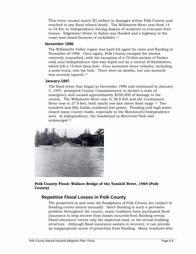
Polk County Flood: Wallace Bridge of the Yamhill River, 1964 (Polk County)
Repetitive Flood Losses in Polk County The properties in and near the floodplains of Polk County are subject to flooding events almost annually. Since flooding is such a pervasive problem throughout the county, many residents have purchased flood insurance to help recover from losses incurred from flooding events. Flood insurance covers only the improved land, or the actual building structure. Although flood insurance assists in recovery, it can provide an inappropriate sense of protection from flooding. Many residents who
Polk County Natural Hazards Mitigation Plan: Flood Page 6-5
have experienced flood damage tend to rebuild in the same vulnerable areas, only to be flooded again. These properties are termed repetitive loss properties, and are very troublesome because they continue to expose lives and valuable property to the flooding hazard. Local governments as well as federal agencies such as FEMA recognize this pitfall in floodplain insurance, and attempt to remove the risk from repetitive loss of properties through projects such as acquiring land and relocating the home, or by elevating the structure.
Continued repetitive loss claims from flood events lead to an increased amount of damage caused by floods, higher insurance rates, and contribute to the rising cost of taxpayer funded disaster relief for flood victims.16 Polk County residents have received approximately $4,200 in repetitive loss payments.17
In Polk County, there were three documented repetitive loss properties. Two of the properties were not located in the floodplain, but were located near enough to Rickreall Creek that due to the creek’s banks eroding, the dwellings were significantly damaged. The property owners were compensated for abandoning their property, which is now used as parkland in the City of Dallas. The third property along Mill Creek repeatedly flooded. The county assisted the property owners in replacing the dwelling located in the floodplain with a manufactured dwelling located outside of the Mill Creek floodplain.18
What Factors Create Flood Risk Flooding occurs when climate (or weather patterns), geology, and hydrology combine to create conditions where water flows outside of its usual course. In Polk County, geography and climate combine to create chronic seasonal flooding conditions.
Precipitation Because Polk County spans a wide range of climatic and geologic regions, there is considerable variation in precipitation, with elevation being the largest factor in precipitation totals. Elevation in Polk County ranges from 3,725 feet on Laurel Mountain to 125 feet on the Willamette River floodplain. As is typical for the west side of the Cascades, precipitation is not spread evenly over the calendar year but falls during the winter and spring months in a water year that runs from October to May or June. Likewise, there is a corresponding precipitation range with an approximately 150 inches per year falling on the Coast Range to 40 inches in the lower elevations of the county.19 Map 2 in Section 2 shows precipitation throughout Polk County.
The amount of precipitation is not the only factor that influences peak flows. They are also influenced by withdrawals for irritation and drinking water, stream and wetland modifications, changes in land use and water-related technology, and the removal of vegetation.20 These factors not only affect the amount of water present in streams, but also the rate of release of water into streams during a storm.
Polk County Natural Hazards Mitigation Plan: Flood Page 6-6
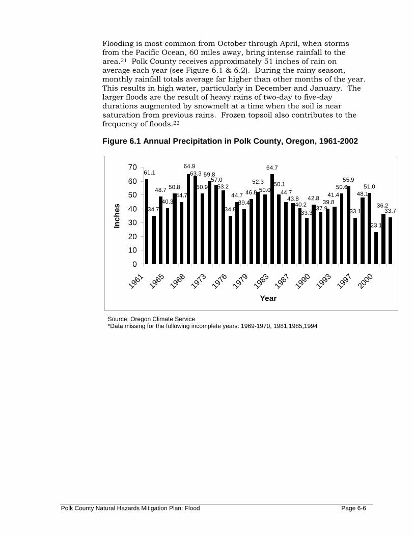
Flooding is most common from October through April, when storms from the Pacific Ocean, 60 miles away, bring intense rainfall to the area.21 Polk County receives approximately 51 inches of rain on average each year (see Figure 6.1 & 6.2). During the rainy season, monthly rainfall totals average far higher than other months of the year. This results in high water, particularly in December and January. The larger floods are the result of heavy rains of two-day to five-day durations augmented by snowmelt at a time when the soil is near saturation from previous rains. Frozen topsoil also contributes to the frequency of floods.22
Figure 6.1 Annual Precipitation in Polk County, Ore gon, 1961-2002
34.7
48.7
40.3
50.844.7
50.9
59.8
34.8
44.739.4
46.842.8
50.655.9
33.1
51.0
23.1
33.7
64.764.9
36.2
48.139.8
41.4
37.933.3
43.840.2
44.750.152.3
50.0
57.053.2
63.361.1
0
10
20
30
40
50
60
70
1961
1965
1968
1973
1976
1979
1983
1987
1990
1993
1997
2000
Year
Inch
es
Source: Oregon Climate Service *Data missing for the following incomplete years: 1969-1970, 1981,1985,1994

Polk County Natural Hazards Mitigation Plan: Flood Page 6-7
Figure 6.2 Average Monthly Precipitation Salem, OR 2002
3.84
0.470.98
0.020.071.221.35
1.77
4.473.54
8.93
11.2
0
2
4
6
8
10
12
Jan
Feb Mar AprMay Ju
n Jul
Aug Sep Oct NovDec
Year
Inch
es
Oregon Climate Service, Zone 2 Climate Data Archives. Webpage: http://www.ocs.orst.edu/
Geography Polk County is located in the Mid-Willamette Valley in northwest Oregon. It is comprised of 735 square miles and extends west from the Willamette River, to the crest of the Coast Range. The eastern part of the county sits on the main valley floor and on an alluvial floodplain. Polk County has a modified marine climate that varies widely from east to west.
Floodplain Terminology Floodplain
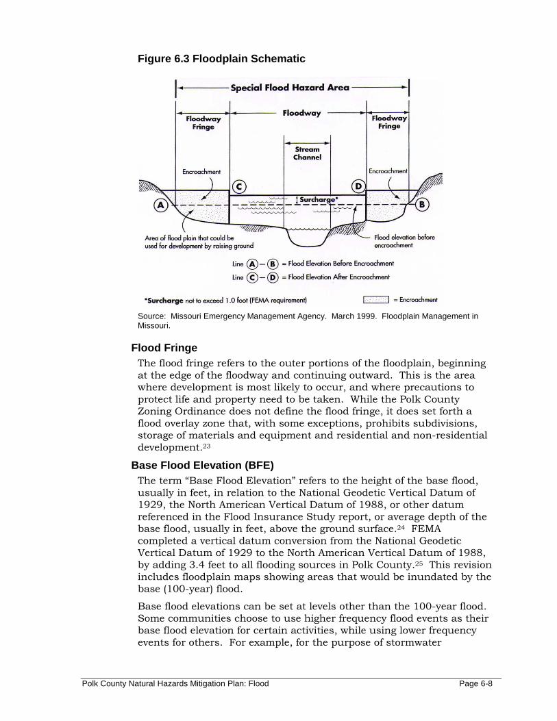
A floodplain is a land area adjacent to a river, stream, lake, estuary, or other water body that is subject to flooding (see Figure 6.3). This area, if left undisturbed, acts to store excess floodwater. The floodplain is made up of two sections: the floodway and the flood fringe.
Floodway The floodway is one of two main sections that make up the floodplain. Unlike floodplains, floodways do not reflect a recognizable geologic feature and are defined for regulatory purposes by the National Flood Insurance Program (NFIP) as “the channel of a river or other watercourse and adjacent land areas that must be reserved in order to discharge the base flood without cumulatively increasing the water surface elevation more than one foot.” The floodway carries the bulk of the floodwater downstream and is usually the area where water velocities and forces are the greatest. NFIP regulations require that the floodway be kept open and free from development or other structures that would obstruct or divert flood flows onto other properties.
Floodways are not mapped for all rivers and streams but are generally mapped in developed areas.
Polk County Natural Hazards Mitigation Plan: Flood Page 6-8
Figure 6.3 Floodplain Schematic
Source: Missouri Emergency Management Agency. March 1999. Floodplain Management in Missouri.
Flood Fringe The flood fringe refers to the outer portions of the floodplain, beginning at the edge of the floodway and continuing outward. This is the area where development is most likely to occur, and where precautions to protect life and property need to be taken. While the Polk County Zoning Ordinance does not define the flood fringe, it does set forth a flood overlay zone that, with some exceptions, prohibits subdivisions, storage of materials and equipment and residential and non-residential development.23
Base Flood Elevation (BFE) The term “Base Flood Elevation” refers to the height of the base flood, usually in feet, in relation to the National Geodetic Vertical Datum of 1929, the North American Vertical Datum of 1988, or other datum referenced in the Flood Insurance Study report, or average depth of the base flood, usually in feet, above the ground surface.24 FEMA completed a vertical datum conversion from the National Geodetic Vertical Datum of 1929 to the North American Vertical Datum of 1988, by adding 3.4 feet to all flooding sources in Polk County.25 This revision includes floodplain maps showing areas that would be inundated by the base (100-year) flood.
Base flood elevations can be set at levels other than the 100-year flood. Some communities choose to use higher frequency flood events as their base flood elevation for certain activities, while using lower frequency events for others. For example, for the purpose of stormwater
Polk County Natural Hazards Mitigation Plan: Flood Page 6-9
management, a 25-year flood event might serve as the base flood elevation, while the 500-year flood event may serve as base flood elevation for the tie down of manufactured homes. The regulations of the NFIP focus on development in the 100-year floodplain.26
Characteristics of Flooding in Polk County Two types of flooding primarily affect Polk County: urban flooding and riverine flooding (see descriptions below). In addition, any low-lying area has the potential to flood. The flooding of developed areas may occur when the amount of water generated from rainfall and runoff exceeds a stormwater system's (ditch or sewer) capability to remove it.27
Urban Flooding As land is converted from fields or woodlands to roads and parking lots, it loses its ability to absorb rainfall. Urbanization of the watershed changes the hydrologic systems of the basin. Heavy rainfall collects and flows faster on impervious concrete and asphalt surfaces. The water moves from the clouds, to the ground, and into streams at a much faster rate in urban areas. Adding these elements to the hydrological systems can result in floodwaters that rise very rapidly and peak with violent force.
A large portion of urban areas has a high concentration of impermeable surfaces that either collect water, or concentrate the flow of water in unnatural channels. During periods of urban flooding, streets can become swift moving rivers and basements can fill with water. Storm drains often back up with vegetative debris causing additional localized flooding.
Riverine Flooding Riverine flooding is the over-bank flooding of rivers and streams. The natural processes of riverine flooding add sediment and nutrients to fertile floodplain areas. Flooding in large river systems typically results from large-scale weather systems that generate prolonged rainfall over a wide geographic area, causing flooding in hundreds of smaller streams, which then drain into the major rivers.28 Map 4 shows the river subbasins within Polk County.
Shallow area flooding is a special type of riverine flooding. FEMA defines shallow flood hazards as areas that are inundated by the 100-year flood with flood depths of only one to three feet. These areas are generally flooded by low velocity sheet flows of water.
What is the Effect of Development on Floods? When structures or fill are placed in the floodway, water is displaced. Development raises the base flood elevation by forcing the river to compensate for the flow space obstructed by the inserted structures and/or fill. When structures or materials are added to the floodway, and no fill is removed to compensate, serious problems can arise. Floodwaters may expand beyond historic floodplain areas. As a result,
Polk County Natural Hazards Mitigation Plan: Flood Page 6-10
other existing floodplain areas may experience floodwaters that rise above historic levels.
Local governments must manage development in floodplains and flood ways to assure minimization of any encroachments in the floodway or floodplain. This can be by cut-and-fill balance and other methods to prevent the rise of pre-development flood levels. Displacement of only a few inches of water can mean the difference between no structural damage occurring in a given flood event and the inundation of many homes, businesses, and other facilities. Careful attention must be paid to development that occurs within the floodway to ensure that structures are prepared to withstand base flood events without exacerbating flood levels.
How Are Flood-Prone Areas Identified? Flood maps and Flood Insurance Studies are often used to identify flood-prone areas. The National Flood Insurance Program (NFIP) was established in 1968 as a means of providing low-cost flood insurance to the nation’s flood-prone communities. The NFIP also reduces flood losses through regulations that focus on building codes and “sound floodplain management.”29 In Polk County, the NFIP and related building code regulations went into effect in 1974. NFIP regulations (44 Code of Federal Regulations (CFR) Chapter 1, Section 60.3) require that all new construction in floodplains must be elevated at or above base flood level. The Oregon Building Code requires new construction to be elevated to one foot above the base flood elevation.
Communities participating in the NFIP may adopt regulations that are more stringent than those contained in 44 CFR 60.3, but not less stringent.30 In Polk County, all homes and other buildings legally constructed in the floodplain after January 1974 must be mitigated to NFIP standards with the first floor being elevated at least one foot above base flood level, or in the case of non-residential buildings, flood proofed to at least one foot above the base flood level.
FIRM Maps and Flood Insurance Studies Floodplain maps are the basis for implementing floodplain regulations and for delineating flood insurance purchase requirements. A Flood Insurance Rate Map (FIRM) is the official map produced by the Federal Emergency Management Agency (FEMA), which delineates Special Flood Hazard Areas or floodplains where National Flood Insurance Program regulations apply. The maps are also used by insurance agents and mortgage lenders to determine if flood insurance is required and what insurance rates should apply.
Water surface elevations are combined with topographic data to develop FIRMs. These maps illustrate areas that would be inundated during a 100-year flood, floodway areas, and elevations marking the 100-year-flood level. In some cases they also include base flood elevations (BFE) and areas located within the 500-year floodplain.
Polk County Natural Hazards Mitigation Plan: Flood Page 6-11
Flood Insurance Studies and FIRMs produced for the National Flood Insurance Program (NFIP) provide assessments of the probability of flooding at a given location. FEMA conducted many Flood Insurance Studies in the late 1970s and early 1980s. These studies and maps represent flood risk at the point in time when FEMA completed the studies. FEMA flood maps are not entirely accurate. These studies and maps represent flood risk at the point in time when FEMA completed the studies, and do not incorporate planning for floodplain changes in the future due to new development. Although FEMA is considering changing that policy, it is optional for local communities. Artificial and natural changes to the environment have changed the course of many of the rivers in the county, as well as their associated floodplain boundaries.31
FEMA provided Polk County with a preliminary Flood Insurance Study (FIS) and preliminary Flood Insurance Rate Maps (FIRMs) dated February 17, 2005 for Ash Creek and the North Fork Ash Creek, and an overflow channel of Ash Creek. The county is reviewing the report and maps, and will be meeting with FEMA in April 2005.
Revised Flood Insurance Rate Maps (FIRM) will be used by lending institutions and insurance agents in determining who must purchase flood insurance and in determining the cost of the insurance. Polk County and the cities of Dallas, Falls City, Independence and Monmouth will use the maps for floodplain management and permitting purposes.
Flood Mapping Methods and Techniques Although many communities rely exclusively on FIRM’s to characterize the risk of flooding in their area, there are some flood-prone areas that are not mapped but remain susceptible to flooding. These areas include locations next to small creeks, local drainage areas, and areas susceptible to artificially caused flooding.
In order to address this lack of data, many jurisdictions have taken efforts to develop more localized flood hazard maps. One method that has been employed by some jurisdictions includes using high-water marks from flood events or aerial photos, in conjunction with the FEMA maps, to better reflect the true flood risk.
The use of GIS (Geographic Information System) is becoming an important tool for flood hazard mapping. FIRM maps can be imported directly into GIS, which allows for GIS analysis of flood hazard areas. Communities find it particularly useful to overlay flood hazard areas on tax assessment parcel maps. This allows a community to evaluate the flood hazard risk for a specific parcel during review of a development request. Coordination between FEMA and local planning jurisdictions is the key to making a strong connection with GIS technology for the purpose of flood hazard mapping.
FEMA and the Environmental Systems Research Institute (ESRI), a private company, have formed a partnership to provide multi-hazard maps and information to the public via the Internet. ESRI produces

Polk County Natural Hazards Mitigation Plan: Flood Page 6-12
GIS software, including ArcView© and ArcInfo©. The ESRI Web site has information on GIS technology and downloadable maps. The hazards maps provided on the ESRI site are intended to assist communities in evaluating geographic information about natural hazards. Flood information for most Oregon communities is available on the ESRI Web site. Visit http://www.esri.com for more information.
Flood Hazard Assessment Hazard Identification
Hazard identification is the first phase of flood-hazard assessment. Identification is the process of estimating: (1) the geographic extent of the floodplain (i.e., the area at risk from flooding); (2) the intensity of the flooding that can be expected in specific areas of the floodplain; and (3) the probability of occurrence of flood events. This process usually results in the creation of a floodplain map. Floodplain maps provide detailed information that can assist jurisdictions in making policies and land-use decisions. Map 5 shows 100-year floodplains within Polk County.
Vulnerability Assessment Vulnerability assessment is the second phase of flood hazard assessment. It combines the floodplain boundary, generated through hazard identification, with an inventory of the property within the floodplain. It identifies the number of properties at risk from flooding, and the dollar value of the property at risk. Floodplain data for Polk County can be used to conduct a preliminary vulnerability assessment for flood and drainage hazard areas.
Risk Analysis Risk analysis is the third and most advanced phase of a hazard assessment. As such, it builds upon the hazard identification and vulnerability assessment.
A flood risk analysis for Polk County should include two components:
(1) The amount of loss to both property and life that may result from a flood event (defined through the vulnerability assessment); and,
(2) The number of flood events expected to occur over time. Within the broad components of a risk analysis, it is possible to predict the severity of damage from a range of events. For example, a risk analysis can be conducted for both 25-year (smaller storm) floodplains (Drainage Hazard Areas), and 100-year (larger storm) floodplains. Over time, the Drainage Hazard Areas will flood more often than areas within a 100-year floodplain, exposing properties in Drainage Hazard Areas to a greater risk of flood damage. Depending on the impacts resulting from a 25-year flood event versus a 100-year flood event, however, and the amount of life and property exposed to the different hazard events, the level of risk may vary.
Polk County Natural Hazards Mitigation Plan: Flood Page 6-13
Flow velocity models can assist in predicting the amount of damage expected from different magnitudes of flood events. The data used to develop these models is based on hydrological analysis of landscape features. Changes in the landscape, often associated with human development, can alter the flow velocity and the severity of damage that can be expected from a flood event. GIS technology and flow velocity models make it possible to map the damage that can be expected from both flood events over time. It is also possible to pinpoint the effects of certain flood events on individual properties.
Community Flood Issues What is Susceptible to Damage During a Flood Event?
The largest impact on communities from flood events is the loss of life and property. During certain years, property losses resulting from flood damage are extensive. Development in the floodplains of Polk County will continue to be at risk from flooding because flood damage occurs on a regular basis throughout the county.
Property loss from floods strikes both private and public property. Public sector impacts e.g., impacts to water and sewer systems, roads, etc. statewide resulted in approximately two-thirds of the damage from the 1996 flood events.32
Property loss Resulting from Flooding Events The type of property damage caused by flood events depends on the depth and velocity of the floodwaters. Faster moving floodwaters can wash buildings off their foundations and sweep cars downstream. Pipelines, bridges, and other infrastructure can be damaged when high waters combine with flood debris. Extensive damage can be caused by basement flooding and landslide damage related to soil saturation from flood events. Seepage into basements or daylight basements is common during flood events, not only in or near floodplains, but also on hillsides and other areas that are far removed from floodplains.33 Water saturating materials susceptible to loss e.g., wood, insulation, wallboard, fabric, furnishings, floor coverings, and appliances cause most flood damage.
Manufactured Homes Statewide, the 1996 floods destroyed 156 housing units. Of those units, 61 percent were manufactured homes and trailers.34 Many older manufactured home parks are located in floodplain areas. Manufactured homes have a lower level of structural stability than “site-built” homes. A site-built home’s foundation and building frame are put together on site as opposed to manufactured homes which are pre-fabricated off site. Manufactured homes in floodplain zones must be anchored to provide additional structural stability during flood events. Due to confusion in the late 1980’s resulting from multiple changes in NFIP regulations, there are some communities that do not actively enforce anchoring requirements. Lack of enforcement of

Polk County Natural Hazards Mitigation Plan: Flood Page 6-14
manufactured home construction standards in floodplains can contribute to severe damages from flood events.35
Business/Industry Flood events impact businesses by damaging property and by interrupting business. Flood events can cut off customer access to a business as well as close a business for repairs. A quick response to the needs of businesses affected by flood events can help a community maintain economic vitality in the face of flood damage. Responses to business damages can include funding to assist owners in elevating or relocating flood-prone business structures.36
Public Infrastructure Publicly owned facilities are a key component of daily life for all citizens of the county. Damage to public water and sewer systems, transportation networks, flood control facilities, emergency facilities, and offices can hinder the ability of the government to deliver services. Government can take action to reduce risk to public infrastructure from flood events, as well as adopt public policy that reduces risk to private property from flood events.
There are a variety of drinking water and wastewater service providers throughout the county. During flooding events, the infrastructure that supports the water service providers in the county can be damaged and sometimes destroyed.
Power transmission can also be disrupted during a flood because when debris piles up around structures, the power poles sometimes collapse and cause power outages.37
Buildings and Roads In the wake of the 1996 flood events, damage to public buildings statewide represented 34 percent of total public losses.38 Of particular importance during flood events are facilities located in flood hazard areas that are critical to government response and recovery activities.
During natural hazard events, or any type of emergency or disaster, dependable road connections are critical for providing emergency services. Roads systems in Polk County are maintained by multiple jurisdictions. Federal, state, county, and city governments all have a stake in protecting roads from flood damage. Road networks often traverse floodplain and floodway areas. Transportation agencies responsible for road maintenance are typically aware of roads at risk from flooding.
Bridges There are 121 bridges maintained by Polk County.39 A complete inventory of county bridges is available at the County Public Works Department.40
Bridges are key points of concern during flood events for two primary reasons:
Polk County Natural Hazards Mitigation Plan: Flood Page 6-15
(1) They are often important links in road networks, crossing water courses or other significant natural features; and,
(2) They can be obstructions in watercourses, inhibiting the flow of water during flood events.
Stormwater System Local drainage problems are common throughout the region. Some communities have drainage master plans, and local public works staff and water control districts are often aware of local drainage threats. The problems are often present where open ditches enter culverts or go underground into storm sewers. In addition, high water tables in some areas can mean wet crawl spaces, yards, and basements as a result of storms because the accumulated water does not drain quickly into a stream or storm sewer. Filled ditches and swales near buildings can inhibit or prevent the flow of water and compound these problems. Inadequate maintenance, especially following leaf accumulation in the fall, can also contribute to the flood hazard in urban areas.41
Floods and Natural Systems Maintaining and restoring natural systems help mitigate the impact of flood events on the built environment. High water can be beneficial to the natural processes within a floodplain, and can benefit riparian areas.
Riparian Areas Riparian areas are important transitional areas, which link water and land ecosystems. Vegetation in riparian areas is dependent on stream processes, such as flooding, and often is composed of plants that require large amounts of water such as willow and cottonwood trees. Healthy vegetation in riparian buffers can reduce streamside erosion.42 During flood events, high water can cause significant erosion. Well-managed riparian areas can reduce the amount of erosion and help to protect water quality during flood events.
Wetlands Many floodplain and stream-associated wetlands absorb and store stormwater flows, which reduces flood velocities and stream bank erosion. Preserving these wetlands reduces flood damage and the need for expensive flood control devices such as levees. When the storms are over, many wetlands augment summer stream flows by slowly releasing the stored water back to the stream system.43 Wetlands are highly effective at removing nitrogen, phosphorous, heavy metals, and other pollutants from water. For this reason, artificial wetlands are often constructed for cleaning stormwater runoff and for tertiary treatment (polishing) of wastewater. Wetlands bordering streams and rivers and those that intercept runoff from fields and roads provide this valuable service free of charge.44
Polk County Natural Hazards Mitigation Plan: Flood Page 6-16
Mitigation Plan Goals and Existing Activities Existing Mitigation Activities
County Programs Flood mitigation activities listed here include current mitigation programs and activities that are being implemented by Polk County agencies or organizations.
Polk County Codes, Ordinances and Regulations
Polk County uses building codes, zoning ordinances, and various planning strategies to address the Oregon Land Use Planning Goal 7, which aims at restricting development in areas of known hazards, and applying the appropriate safeguards.
- Mitigation Requirements: Dwellings shall have the top of the lowest floor, including basement, elevated one (1) foot above base flood elevation and the bottom of the lowest habitable floor constructed a minimum of two (2) feet above grade. Developers must complete a Floodplain Development Permit Application as outlined in Chapter 178 of the Polk County Zoning Ordinance (PCZO).
o Affected Properties: All development in the floodplain.
- Mitigation Requirements: Greenway Management Overlay Zone (PCZO Chapter 173), Significant Resource Areas Overlay Zone (PCZO Chapter 182).
o Affected Properties: Development in areas that could be prone to flooding, and/or within riparian areas and wetlands.
Polk County Public Works, Placement of “High Water” Signs
Appropriately placed “High Water” warn motorists of flooding on roadways and adjacent right-of-way. Posting signs provides motorists and opportunity to find alternative routes of travel before they encounter a flooded road, or before their vehicle is disabled in the high water.
Polk County Public Works maintains 51 “high water” signs throughout the county – 32 permanent and 19 temporary signs. Nineteen of the signs are posted within the Yamhill River Basin; eighteen signs are posted within the Luckiamute River Basin; nine are posted within the Rickreall Creek Basin; and the county maintains four “high water” signs within the (mainstem of the) Willamette Basin.
Regional Programs Flood Management Projects. Flood management structures can assist in regulating flood levels by adjusting water flows upstream of flood-prone areas. There are a total of 59 dams in Polk County registered with the Oregon Water Resources Department holding millions of gallons of water in reservoirs. The largest reservoirs in Polk

Polk County Natural Hazards Mitigation Plan: Flood Page 6-17
County include the following, none of which are primarily used for flood management:
- Mercer Reservoir (City of Dallas, OR) – 1,550 acre feet usable storage (Rickreall Creek)
- DeRaeve Dam #1(private) – 325 acre feet storage (Ash Creek Swale)
- Morgan Brothers Reservoir (USFWS) – 310 acre feet storage (Basket Slough)
State Programs State of Oregon Floodplain and Floodway Removal/Fil l Law
The Oregon Removal/Fill Law, ORS 196.795-990, which is administered by the Oregon Department of State Lands, requires a permit for activities that would remove or fill 50 cubic yards or more of material in waters of the state (e.g., streams, lakes, wetlands).
Oregon’s Wetlands Protection Program Oregon’s Wetlands Program was created in 1989 to integrate federal and state rules concerning wetlands protection with the Oregon Land Use Planning Program. The Wetlands Program has a mandate to work closely with local governments and the Department of State Lands (DSL) to improve land use planning approaches to wetlands conservation. A Local Wetlands Inventory (LWI) is one component of that program. DSL also develops technical manuals, conducts wetlands workshops for planners, and works directly with local governments on wetlands planning tasks.
Oregon Wetlands Joint Venture The Oregon Wetlands Joint Venture is a coalition of private conservation, waterfowl, fisheries, and agriculture organizations working with government agencies to protect and restore important wetland habitats.45
Federal Programs National Weather Service
The National Weather Service provides flood watches, warnings, and informational statements for rivers throughout Polk County. http://www.nws.noaa.gov
National Resources Conservation Service (NRCS), US Department of Agriculture
NRCS provides a suite of federal programs designed to assist state and local governments and landowners in mitigating the impacts of flood events. The Watershed Surveys and Planning Program and the Small Watershed Program provide technical and financial assistance to help participants solve natural resource and related economic problems on a watershed basis. The Wetlands Reserve Program and the Flood Risk Reduction Program provide financial incentives to landowners to put aside land that is either a wetland resource, or that experiences frequent flooding. The Emergency Watershed Protection Program (EWP)

Polk County Natural Hazards Mitigation Plan: Flood Page 6-18
provides technical and financial assistance to clearing debris from clogged waterways, restoring vegetation, and stabilizing riverbanks. The measures taken under EWP must be environmentally and economically sound and generally benefit more than one property.
Federal Emergency Management Agency (FEMA) Programs The Federal Emergency Management Agency (FEMA) resulted from the consolidation of five federal agencies that were dealing with different types of emergencies. Since then, many states and local jurisdictions have accepted this approach and changed the names of their organizations to include the words "emergency management." FEMA provides maps of flood hazard areas, various publications related to flood mitigation, funding for flood mitigation projects, and technical assistance.
http://www.fema.gov
National Flood Insurance Program (NFIP) Flood insurance is available to citizens in communities that adopt and implement NFIP siting and building standards. The standards are applied to development that occurs within a delineated floodplain, a drainage hazard area, and areas subject to inundation during a base flood event, and properties within 250 feet of a floodplain boundary. Oregon’s Department of Land Conservation and Development is the state’s NFIP-coordinating agency.
The Community Rating System (CRS) The Community Rating System (CRS) recognizes community floodplain management efforts that go beyond the minimum requirements of the NFIP. Property owners within cities receive reduced NFIP flood insurance premiums if their city implements floodplain management practices that qualify for a CRS rating. Polk County’s CRS rating as of December 2001 is ‘8’. For further information on the CRS, visit FEMA’s website at http://www.fema.gov/nfip/crs.htm.
Mitigation Plan Goals The mitigation plan goals addressed by each action item are identified as a means for monitoring and evaluating how well the mitigation plan is achieving its goals following implementation.
The plan goals help to guide the direction of future activities aimed at reducing risk and preventing loss from natural hazards. The goals listed here serve as checkpoints as agencies and organizations begin implementing mitigation action items.
Goal #1: PUBLIC EDUCATION AND AWARENESS
Provide public information and education/awareness to all residents of the county concerning natural hazard areas and mitigation efforts.
Goal #2: PREVENTIVE AND IMPLEMENTATION
Polk County Natural Hazards Mitigation Plan: Flood Page 6-19
Develop and implement activities to protect human life, commerce, property and natural systems.
Goal #3: COLLABORATION AND COORDINATION
Strengthen hazard mitigation by increasing collaboration and coordination among citizens, public agencies, non-profit organizations, businesses, and industry.
Goal #4: FUNDING AND PARTNERSHIPS
Seek partnerships in funding and resources for future mitigation efforts.
Goal #5: EMERGENCY OPERATIONS
Coordinate and integrate natural hazard mitigation activities, where appropriate, with emergency operations plans and procedures.
Goal #6: NATURAL RESOURCES UTILIZATION
Link land use planning, development criteria, codes, and natural resources and watershed planning with natural hazard mitigation.
Flood Mitigation Action Items The Polk County Natural Hazards Mitigation Plan Steering Committee formulated the following mitigation action items. Additional action items were formulated through interviews with local stakeholders. Refinement of the Plan’s action items occurred through discussions with the mitigation plan steering committee and through an open house at which the county received comments from the public.
The flood mitigation action items provide direction on specific activities that organizations and residents in Polk County can undertake to reduce risk and prevent loss from flood events. Each action item is followed by ideas for implementation, which can be used by the steering committee and local decision makers in pursuing strategies for implementation.
This section lists action items identified to reduce the risk from flood impacts in Polk County. These action items are designed to meet the mitigation plan goals.
Short-term (ST) Flood Action Items
Short-term flood action items include general mitigation activities that agencies are capable of implementing during the next two years, given their existing resources and authorities.
ST-FL #1: Develop and implement better flood warning systems.
Polk County Natural Hazards Mitigation Plan: Flood Page 6-20
Ideas for Implementation
- Coordinate with appropriate organizations to evaluate the need for more stream gauges that are tied into National Weather Service flood forecasting activities;
- Distribute information regarding flooding to the general public efficiently; and
- Obtain and install more accurate precipitation stations; and
- Take steps towards becoming a National Weather Service “Storm Ready” community.
Coordinating Organization: Emergency Management – Hazard Mitigation Team, Public Works
Internal Partner: Planning External Partners: Watershed councils, cities, OSU Extension
Service, USGS, WRD, DSL, OEM, BLM, USACE, private river gauges
Timeline: 1 to 2 years Plan Goals Addressed: Preventive & Implementation; Collaboration &
Coordination; Funding & Partnerships; Emergency Operations
ST-FL #2: Conduct workshops periodically for target audiences on National Flood Insurance Programs, mitigation activities, and potential assistance from FEMA’s Flood Mitigation Assistance and Hazard Mitigation Grant Programs.
Ideas for Implementation
- Include information about the financial aspects of building (and rebuilding) in the floodplain;
- Present information on how other communities have addressed building in the floodplain; and
- Selected audiences can include: realtors, lending institutions, surveyors, engineers, and government agencies.
Coordinating Organization: Emergency Management – Hazard Mitigation Team
Internal Partner: Community Development External Partners: Watershed councils, Polk SWCD, Ash Creek
Water Control District, Realtor’s Board (Oregon Association of Realtors), DLCD,OEM, FEMA
Timeline: On-going
Polk County Natural Hazards Mitigation Plan: Flood Page 6-21
Plan Goals Addressed: Public Education & Awareness; Preventive & Implementation; Funding & Partnerships
ST-FL #3: Continue to coordinate with appropriate agencies, and maintain an inventory of all aggregate operations adjacent to or within the floodplain.
Coordinating Organization: Community Development Internal Partners: GIS, Public Works External Partner: DOGAMI, Watershed Councils, USACE,
ODFW, DEQ, DSL, Aggregate Industries Timeline: On-going
Plan Goals Addressed: Preventive & Implementation; Funding & Partnerships
Long-term (LT) Flood Action Items
Long-term flood action items include general mitigation activities that are likely to take more than two years to implement and may require new or additional resources and/or authorities.
LT-FL #1: Seek funding to update the Flood Insurance Rate Maps (FIRM) for Polk County as funding becomes available.
Ideas for Implementation
- Work with FEMA on specific areas to update as funding becomes available; and
- Suggest to FEMA to incorporate ‘ground-truthing’ models with updates to FIRM.
Coordinating Organization: Community Development Internal Partners: GIS, Public Works External Partners: DLCD, FEMA, cities
Timeline: 3 to 5 years Plan Goals Addressed: Preventive & Implementation; Collaboration &
Coordination; Funding & Partnerships
LT-FL #2: Enhance data and mapping for floodplain information within Polk County.
Ideas for Implementation
- Apply for FEMA’s cooperative technical partnership using the two-foot contour interval floodplain mapping data acquired by Polk County GIS;
Polk County Natural Hazards Mitigation Plan: Flood Page 6-22
- Maintain existing elevation reference marks and survey any new information concerning flooding reference marks;
- Identify and map areas where flood probability/frequency can be economically reduced or eliminated.
- Identify local water systems, both municipal and those of rural community providers, that could be at risk during flood events.
- Maintain maps of covered streams and creeks;
- Identify mapped culverts that historically create flooding problems and target them for replacement;
- Prepare an inventory of rural drainage problems;
- Coordinate with local agencies and organizations to obtain flood data and mapping resources; and
- Integrate the Capital Improvement Plan process with GIS.
Coordinating Organization: Outside UGB: Community Development, Public Works, Cities Inside UGB: Cities
Internal Partners: Emergency Management – Hazard Mitigation Team, GIS
External Partners: NRCS, Polk SWCD, FEMA, Watershed Councils, Oregon Association of Water Utilities (OAWU), Water Associations
Timeline: 3 to 5 years (as funding allows) Plan Goals Addressed: Preventive & Implementation; Collaboration &
Coordination
LT-FL #3: Identify surface water drainage obstructions for all parts of unincorporated Polk County.
Ideas for Implementation
- Prepare an inventory of culverts that historically create flooding problems and target them for replacement; and
- Prepare an inventory of major drainage problems, and identify causes and potential mitigation actions for drainage problem areas.
Coordinating Organization: Public Works Internal Partners: Planning, GIS External Partners: Cities, NRCS, Polk SWCD, Watershed
Councils Timeline: On-going
Plan Goals Addressed: Preventive & Implementation
LT-FL #4: Reduce flooding events by using stormwater best management practices (BMP).
Polk County Natural Hazards Mitigation Plan: Flood Page 6-23
Ideas for Implementation
- Support development and land management practices that improve upon existing infiltration systems and provide infiltration of water rather than creating stormwater runoff and increasing hydrologic impacts;
- Encourage practices that reduce sedimentation in drainage ways;
- Continue maintenance on stormwater systems to increase capacity;
- Verify storm drain separation from sanitary sewer lines; and
- Consider stormwater detention/retention facilities where necessary
Coordinating Organization: Public Works Internal Partner: GIS.
External Partners: NRCS, Polk SWCD, Water Control Districts, Confederated Tribes of Grand Ronde, Watershed Councils
Timeline: 3 to 5 years Plan Goals Addressed: Preventive & Implementation
LT-FL #5: Investigate grant-funding programs to assist the cities of Monmouth and Independence in their joint project to create a multi-use trail alongside Ash Creek
Ideas for Implementation
- Investigate grant-funding programs at the state, local, federal and private level for ways to fund this project, which would provide local residents a hands-on understanding of Ash Creek’s hydrologic cycles.
Coordinating Partners: Cities of Monmouth and Independence, County
External Partners: Watershed Councils, FEMA, DEQ, ODFW, NRCS, Polk SWCD, Ash Creek Water Control District; ODOT
Timeline: 1 to 2 years Plan Goals Addressed: Public Education & Awareness; Preventive &
Implementation; Funding & Partnerships
LT-FL #6: Mitigate repetitive flood loss properties.
Ideas for Implementation
- Elevate dwellings on repetitive flood-loss properties above the mean base flood elevation;
- Acquire the property when purchasing the property from the property owner is more feasible than repetitive reparations following flood loss;
Polk County Natural Hazards Mitigation Plan: Flood Page 6-24
- Relocate dwellings and other affected structures outside of the flood plain.
Coordinating Partners: Cities in Polk County, Polk County Internal Partner: County Tax Assessor External Partners: FEMA, OEM
Timeline: On-going Plan Goals Addressed: Preventive & Implementation; Funding &
Partnerships
Flood Mitigation Resources The following resource directory lists the resources and programs that can assist county communities and organizations. The resource directory provides contact information for local, county, regional, state and federal programs that deal with natural hazards.
County Resources Watershed Councils
Luckiamute Watershed (WS) Council
Contact: Eve Montanaro, Coordinator 345 N Monmouth Avenue Western Oregon University Monmouth, OR 97631 Phone: 503-838-8804 Facsimile: 503-838-8222 Email: [email protected]
Rickreall, Glen and Gibson Creeks WS Council
Contact: Charles Redon 580 Main Street Suite A Dallas, OR 97338 Phone: 503-623-9680 (x 112) Facsimile: 503-623-6335
Water Control Districts
Ash Creek Water Control District
Contact: Todd Whitaker Phone: 503-838-4033 Email: [email protected]
Polk Soil & Water Conservation District 580 Main Street, Suite A Dallas, OR 97338 Phone: 503-623-9680 Facsimile: 503-623-6335 Email: mailto:[email protected] Website: http://polkswcd.org/

Polk County Natural Hazards Mitigation Plan: Flood Page 6-25
State Resources Oregon’s Wetlands Protection Program Oregon’s Wetlands Program was created in 1989 to integrate federal and state rules concerning wetlands protection with the Oregon Land Use Planning Program. The Wetlands Program has a mandate to work closely with local governments and the Department of State Lands (DSL) to improve the land use planning approaches to wetlands conservation. A Local Wetlands Inventory (LWI) is one component of that program. DSL also develops technical manuals and works directly with local governments on wetlands planning tasks.
Contact: Department of State Lands Website: http://statelands.dsl.state.or.us/
Oregon Wetlands Joint Venture The Oregon Wetlands Joint Venture is a coalition of private conservation, waterfowl, fisheries, and agriculture organizations working with government agencies to protect and restore important wetland habitats.
Contact: Oregon Wetlands Joint Venture Website: http://wetlands.dfw.state.or.us/
Department of Land Conservation and Development (DL CD) DLCD administers the state’s Land Use Planning Program. The program is based on 19 Statewide Planning Goals, including Goal 7, Areas Subject to Natural Disasters and Hazards, with stream flooding as one of its major focus. DLCD serves as the federally designated agency to coordinate floodplain management in Oregon. DLCD also conduct various landslide related mitigation activities. In order to help local governments address natural hazards effectively, DLCD provides technical assistance such as conducting workshops, reviewing local land use plan amendments, and working interactively with other agencies.
Contact: Natural Hazards Program Manager, DLCD Address: 635 Capitol St. NE, Suite 200, Salem, OR 97301-2540 Phone: 503-373-0050 Fax: 503-378-6033 Website: http://www.lcd.state.or.us/hazards.html Oregon Floodplain Coordinator : 503-373-0050 ext. 255
Oregon State Police (OSP)-Office of Emergency Manag ement (OEM) OEM administers FEMA’s Hazard Mitigation Grant Program, which provides post-disaster monies for acquisition, elevation, relocation, and demolition of structures located in the floodplain. OEM also administers FEMA’s Flood Mitigation Assistance Program. This program provides assistance for NFIP-insured structures only. OEM also helps local jurisdictions to develop hazard mitigation plans. OEM is heavily involved in flood damage assessment and works mainly with disaster recovery and hazard mitigation programs. OEM provides training for local governments through workshops on recovery and

Polk County Natural Hazards Mitigation Plan: Flood Page 6-26
mitigation. OEM also helps implement and manage federal disaster recovery programs.
Contact: Office of Emergency Management Address: 3225 State Street, Salem OR 97301 Phone: 503-378-2911 Fax: 503-373-7833 Website: http://www.osp.state.or.us/oem/ OEM Hazard Mitigation Officer: 503-378-2911 ext. 22247
Oregon Department of Fish and Wildlife (ODFW) ODFW’s mission is to protect and enhance Oregon ’s fish and wildlife and their habitats for use and enjoyment by present and future generations. ODFW regulates stream activity and engages in stream enhancement activities.
Contact: ODFW Address: 3406 Cherry Ave NE, Salem OR 97303 Phone: 503-947-6000 Website: http://www.dfw.state.or.us/ Email: [email protected]
Oregon Department of State Lands (DSL) DSL is a regulatory agency, responsible for administration of Oregon's Removal-Fill Law. This law is intended to protect, conserve, and make the best use of the state's water resources. It generally requires a permit from DSL to remove, fill, or alter more than 50 cubic yards of material within the bed or banks of waters of the state. Exceptions are in state scenic waterways and areas designated essential salmon habitat, where a permit is required for all in-stream activity, regardless of size. DSL and the US Army Corps of Engineers may issue these permits jointly.
Contact: Department of State Lands Address: 775 Summer Street NE, Suite 100, Salem, OR 97301-1279 Phone: 503-378-3805 Fax: 503-378-4844 Website: http://statelands.dsl.state.or.us/ Assistant Director: 503-378-3805, ext. 279 Western Region Manager: 503-378-3805, ext. 244
Oregon Water Resources Department (WRD) The WRD’s mission is to serve the public by practicing and promoting wise long-term water management. The WRD provides services through 19 watermaster offices throughout the state. In addition, five regional offices provide services based on geographic regions. The Department's main administration is performed from the central office in Salem.
Contact: Water Resources Department Address : 775 Summer St NE, Salem, OR 97301-1271 Phone: 503-986-0900 Website: http://www.wrd.state.or.us/index.shtml http://www.co.washington.or.us/dptmts/wtr_mstr
OSU Watershed Extension Program
Polk County Natural Hazards Mitigation Plan: Flood Page 6-27
The OSU Watershed Extension Program’s mission is to increase the capacity of Oregon watershed groups and communities for conserving, improving, protecting, and sustaining watershed functions and values. Increasing capacity is achieved through research-based education, skill-building projects, and new partnerships among residents, local organizations, businesses, agencies, and educational institutions.
Contact: Watershed Extension Program, Central Staff Tara Nierenberg, Statewide Program Coordinator
Address : Oregon State University, Watershed Extension 307 Ballard Hall, Corvallis, OR 97331-3604
Phone: 541-737-8715 Email: [email protected] Website: http://seagrant.oregonstate.edu/wsep
Regional Resources
Northwest Regional Floodplain Managers Association (NORFMA)
NORFMA is a nonprofit organization for regional networking and support
on issues of environmental quality, economic sustainability, and scientific
discovery on a watershed basis. The Association provides a channel for
regional communication and cooperation in Oregon, Washington, Idaho,
British Columbia and Alaska. NORFMA promotes educational programs
on floodplain and watershed management topics, increases public
awareness of the value and function of floodplains, and encourages
government involvement in programs to reduce flood damages and to
protect, manage, and restore floodplains.
The NORFMA website is a resource for floodplains, fisheries, and river
engineering information for the Northwest. This site provides technical
information, articles, and Internet links in the field of floodplain and
fisheries management.
Contact: Christine Valentine, MFIP Coordinator – Oregon Regional Rep. Address: Department of Land Conservation and Development (DLCD) 635 Capitol Street NE, Suite 150, Salem, OR 97301 Phone: 503-373-0050 ext. 250 Fax: 503-378-5518 Website: http://www.norfma.org
Federal Resources Federal Emergency Management Agency (FEMA) FEMA provides maps of flood hazard areas, various publications related to flood mitigation, funding for flood mitigation projects, and technical assistance. FEMA also operates the National Flood Insurance Program (NFIP). FEMA's mission is “to reduce loss of life and property and protect the nation's critical infrastructure from all types of hazards through a comprehensive, risk-based, emergency management program of mitigation, preparedness, response and recovery”. FEMA Region X serves the northwestern states of Alaska, Idaho, Oregon, and Washington.
Contact: FEMA, Federal Regional Center, Region 10
Polk County Natural Hazards Mitigation Plan: Flood Page 6-28
Address: 228th St. SW, Bothell, WA 98021-9796 Phone: 425-487-4678 Website: http://www.fema.gov To obtain FEMA publications: Phone: 1-800-480-2520 To obtain FEMA maps: Contact: Map Service Center Address: P.O. Box 1038, Jessup, Maryland 20794-1038 Phone: 1-800-358-9616 Fax: 1-800-358-9620
The National Flood Insurance Program The National Flood Insurance Program (NFIP) Website is a subsection of the Federal Emergency Management Agency (FEMA) site (http://www.fema.gov). The NFIP information is intended for both the general public and the many organizations and agencies participating in the program. It includes information about the NFIP and other flood disaster assistance available from the Federal Government. It also provides access to the newly revised NFIP booklet: Answers to Questions about the National Flood Insurance Program.
Contact: The National Flood Insurance Program Phone: 888-FLOOD29 or 800-427-5593 Website: http://www.fema.gov/nfip
United States Geological Survey (USGS) The USGS website provides current stream flow conditions at USGS gauging stations in Oregon and throughout the Pacific Northwest. The Oregon USGS office is responsible for water-resources investigations for Oregon and part of southern Washington. Their office cooperates with more than 40 local, state, and federal agencies in Oregon. Cooperative activities include water-resources data collection and interpretive water-availability and water-quality studies.
Contact: USGS Oregon District Office Address: 10615 S.E. Cherry Blossom Dr., Portland, OR 97216 Phone: 503-251-3200 Fax: 503-251-3470 Website: http://oregon.usgs.gov Email: [email protected]
USGS Water Resources This web page offers current US water news; extensive current (including real-time) and historical water data; numerous fact sheets and other publications; various technical resources; descriptions of ongoing water survey programs; local water information; and connections to other sources of water information.
Contact: USGS Water Resources Phone: 503-251-3200 Website: http://water.usgs.gov or http://water.usgs.gov/public/realtime.html Email : [email protected]

Polk County Natural Hazards Mitigation Plan: Flood Page 6-29
Bureau of Reclamation The mission of the Bureau of Reclamation is to manage, develop, and protect water and related resources in an environmentally and economically sound manner in the interest of the American public.
Contact: Bureau of Reclamation, Pacific Northwest Region Address: 1150 N. Curtis Road, Boise, ID 83706-1234 Phone: 208-378-5021 Website: http://www.usbr.gov/pn
Army Corps of Engineers The Corps of Engineers administers a permit program to ensure that the nation’s waterways are used in the public interest. Any person, firm, or agency planning to work in waters of the United States must first obtain a permit from the Army Corps of Engineers. In Oregon, joint permits may be issued with the Department of State Lands. The Corps is responsible for the protection and development of the nation’s water resources, including navigation, flood control, energy production through hydropower management, water supply storage and recreation.
Contact: US Army Corps of Engineers-Portland District, Floodplain Information Branch
Address: 333 SW First Ave, Portland, OR 97204 Phone: 503-808-5150 Fax: 503-808-4875 Website: http://www.nwp.usace.army.mil/
National Resources Conservation Service (NRCS), US Department of Agriculture (USDA) NRCS provides a suite of federal programs designed to assist state and local governments, and landowners in mitigating the impacts of flood events. The Watershed Surveys and Planning Program and the Small Watershed Program provide technical and financial assistance to help participants solve natural resource and related economic problems on a watershed basis. The Wetlands Reserve Program and the Flood Risk Reduction Program provide financial incentives to landowners to put aside land that is either a wetland resource or experiences frequent flooding. The Emergency Watershed Protection Program (EWP) provides technical and financial assistance for clearing debris from clogged waterways, restoring vegetation, and stabilizing riverbanks. The measures taken under the EWP must be environmentally and economically sound and generally benefit more that one property.
Contact : USDA-NRCS, Dallas Service Center Address : 580 Main Street, Suite A, Dallas OR 97338-1911 Phone : 503-623-2396 ext. 105 Fax: 503-623-6335 Website : http://www.or.nrcs.usda.gov
National Weather Service, Portland Bureau The National Weather Service provides flood watches, warnings, and informational statements for rivers in Polk County. The NWS is the sole United States official voice for issuing warnings during life threatening weather situations. The majority of Polk

Polk County Natural Hazards Mitigation Plan: Flood Page 6-30
County are within the NWS “Central Willamette Valley” region. The western portions of the county, which includes areas around Falls City, Pedee, and Airlie, are within the “Central Coast Range” region. The NWS Portland office provides river level information online and by phone.
Contact: National Weather Service, Portland Bureau Address: 5241 NE 122nd Avenue, P.O. Box 2946, Portland, OR 97208-2946 Phone : 503-326-2340 Fax: 503-808-4875 Website : http://www.nws.noaa.gov/Portland/public_hydro/
StormReady, National Weather Service StormReady is a nationwide community preparedness program that uses a grassroots approach to help communities develop plans to handles all types of severe weather – from tornadoes to tsunamis. The program encourages communities to take a new, proactive approach to improving local hazards operations by providing emergency managers with clear-cut guidelines on how to improve their weather operations.
Contact: StormReady, National Weather Service Phone: 503-261-9247 Email: [email protected] Website: http://www.stormready.noaa.gov/
Office of Hydrology, National Weather Service The National Weather Service's Office of Hydrology (OH) and its Hydrological Information Center offer information on floods and other aquatic disasters. This site offers current and historical data including an archive of past flood summaries, information on current hydrologic conditions, water supply outlooks, an Automated Local Flood Warning Systems Handbook, Natural Disaster Survey Reports, and other scientific publications on hydrology and flooding.
Contact: Office of Hydrology, National Weather Service Website: http://www.nws.noaa.gov/oh or http://www.nws.noaa.gov/oh/hic/
Additional Resources The Association of State Floodplain Managers
The Association of State Floodplain Managers is an organization of professionals involved in floodplain management, flood hazard mitigation, the National Flood Insurance Program, and flood preparedness, warning, and recovery. ASFPM fosters communication among those responsible for flood hazard activities, provides technical advice to governments and other entities about proposed actions or policies that will affect flood hazards, and encourages flood hazard research, education, and training. The ASFPM Web site includes information on how to become a member, the organization's constitution and bylaws, directories of officers and committees, a publications list, information on upcoming conferences, a history of the association, and other useful information and Internet links.
Contact: The Association of State Floodplain Managers Address: 2809 Fish Hatchery Road, Madison, WI 53713 Phone: 608-274-0123
Polk County Natural Hazards Mitigation Plan: Flood Page 6-31
Website: http://www.floods.org
The Floodplain Management Association The Floodplain Management website was established by the Floodplain Management Association (FMA) to serve the entire floodplain management community. It includes full-text articles, a calendar of upcoming events, a list of positions available, an index of publications available free or at nominal cost, a list of associations, a list of firms and consultants in floodplain management, an index of newsletters dealing with flood issues (with hypertext links if available), a section on the basics of floodplain management, a list of frequently asked questions (FAQs) about the Website, and, of course, a copious catalog of Web links.
Contact: Floodplain Management Association Website: http://www.floodplain.org Email : [email protected]
Insurance Services Offices, Inc. (ISO) The Building Code Effectiveness Grading Schedule (BCEGS), developed and operated by the Insurance Services Offices, Inc. (ISO) assesses the building codes in effect in a community and how the community enforces them, with special emphasis on mitigation of losses from natural disasters. In BCEGS, each community is assigned a grade of 1 (best) to 10 (no recognized program), with two ratings for each jurisdiction, commercial and residential. Coordinating floodplain management with local building codes has advantages with regard to permits, inspections, other developments such as grading, post-flood inspections, application of floodplain management requirements, special certifications, construction quality and modifications to existing buildings. Polk County has a BCEGS classification of 3/3 and receives credit for this rating under FEMA’s CRS program.
Contact: Insurance Services Offices, Inc. (ISO) Government Relations Office
Address: 388 Market Street, Suite 750, San Francisco, CA 94111-5314 Phone: 415-434-4599 or 1-800-888-4476 Fax: 415-398-8064 Website: http://www.iso.com/ Email: mailto:[email protected]%20
FEMA’s List of Flood Related Websites This site contains a long list of flood related Internet sites from “American Heritage Rivers” to “The Weather Channel,” and is a good starting point for flood information on the Internet.
Contact: Federal Emergency Management Agency. Phone: 800-480-2520 Website: http://www.fema.gov/nfip/related.htm
Polk County Natural Hazards Mitigation Plan: Flood Page 6-32
Publications Planning for Natural Hazards: The Oregon Technical Resource Guide, Department of Land Conservation and Development (July 2000).
Produced by the Community Planning Workshop for the Department of Land Conservation and Development, this is a natural hazards planning and mitigation resource for Oregon cities and counties. It provides hazard-specific resources and plan evaluation tools. The document was written for local government employees and officials. The Technical Resource Guide includes a natural hazards comprehensive plan review, a hazard mitigation legal issues guide, and five hazard-specific technical resource guides, including: flooding, wildfires, landslides, coastal hazards, and earthquakes. This document is available online. You can also write, call, or fax to obtain this document:
Contact: Natural Hazards Program Manager, Department of Land Conservation and Development
Address: 635 Capitol St. NE, Suite 200, Salem, OR 97301-2540 Phone: 503-373-0050 Fax: 503-378-6033 Website: http://www.lcd.state.or.us/hazards.html
NFIP Community Rating System Coordinator’s Manual. FEMA/NFIP. Indianapolis, IN.
This informative brochure explains how the Community Rating System works and what the benefits are to communities. It explains in detail the CRS point system, and what activities communities can pursue to earn points. These points then add up to the “rating” for the community, and flood insurance premium discounts are calculated based upon that “rating.” The brochure also provides a table on the percent discount realized for each rating (1-10). Instructions on how to apply to be a CRS community are also included.
Contact: NFIP Community Rating System Phone: 1-800-480-2520 or 317-848-2898 Website: http://www.fema.gov/nfip/crs.htm
Floodplain Management: A Local Floodplain Administrator’s Guide to the
NFIP. FEMA-Region 10. Bothell, WA.
This document discusses floodplain processes and terminology. It contains floodplain management and mitigation strategies, as well as information on the NFIP, CRS, Community Assistance Visits, and floodplain development standards.
Contact: National Flood Insurance Program Phone: 1-800-480-2520 Website: http://www.fema.gov/nfip/
Polk County Natural Hazards Mitigation Plan: Flood Page 6-33
Morris, Marya. Subdivision Design in Flood Hazard Areas. PAS 473. Chicago, IL: APA. 1997.
This report explains planning techniques that minimize problems in a flood hazard area. Includes selected ordinances and policies.
Contact: American Planning Association, Planners Book Service Address: 122 S. Michigan Ave., Suite 1600, Chicago, IL 60603 Phone: 312-786-6344 Fax: 312-431-9985 Website: www.planning.org
Flood Hazard Mitigation Planning: A Community Guide, (June 1997), Massachusetts Department of Environmental Management.
This informative guide offers a ten-step process for successful flood hazard mitigation. Steps include: map hazards, determine potential damage areas, take an inventory of facilities in the flood zone, determine what is or is not being done about flooding, identify gaps in protection, brainstorm alternatives and actions, determine feasible actions, coordinate with others, prioritize actions, develop strategies for implementation, and adopt and monitor the plan.
Contact: Massachusetts Flood Hazard Management Program Phone: 617-626-1250 Website: http://www.magnet.state.ma.us/dem/programs/mitigate
Reducing Losses in High Risk Flood Hazard Areas: A Guidebook for Local
Officials, (February 1987), FEMA-116.
This guidebook offers a table on actions that communities can take to reduce flood losses. It also offers a table with sources for floodplain mapping assistance for the various types of flooding hazards. There is information on various types of flood hazards with regard to existing mitigation efforts and options for action (policy and programs, mapping, regulatory, non-regulatory). Types of flooding which are covered include alluvial fan, areas behind levees, areas below unsafe dams, coastal flooding, flash floods, fluctuating lake level floods, ground failure triggered by earthquakes, ice jam flooding, and mudslides.
Contact: Federal Emergency Management Agency Phone: 1-800-480-2520 Website: http://www.fema.gov
Oregon Model Flood Damage Prevention Ordinance, (January 1999), FEMA/DLCD.
This is an example of how to write an ordinance that complies with NFIP/FEMA standards. Communities can simply adopt this ordinance, word for word, filling in the blanks specific to their community or jurisdiction.
Contact: Department of Land Conservation and Development Phone: 503-373-0050
Polk County Natural Hazards Mitigation Plan: Flood Page 6-34
Website: http://www.lcd.state.or.us/hazards.html
Flood – Endnotes
1 Taylor, George and Raymond Hatton. 1999. The Oregon Weather Book: A
State of Extremes. Corvallis, OR: Oregon State University Press.
2 Id.
Flood Endnotes 3 Interagency Hazard Mitigation Team, State Hazard Mitigation Plan. 2000. Oregon Emergency Management. 4 Id.
5 Marion County Emergency Management. Available on the World Wide Web
(http://www.publicworks.co.marion.or.us/emergencymanagement/).
6 Carlson, Kathleen. “Christmas Week Flood Brings Major Flooding, December
1964.” Salem Online History Project,
<http://www.salemhistory.net/home.htm>.
7 Polk County. 2001. Polk County Hazard Mitigation Plan.
8 Itemizer Observer. January 23, 1974: vol. 99 no. 44, page 1.
9 “Polk Recovers from Weather Beating.” Itemizer Observer: February 4, 1987.
10 Taylor, George and Raymond Hatton. 1999. The Oregon Weather Book: A
State of Extremes. Corvallis, OR: Oregon State University Press.
11 Itemizer Observer. January 15, 1997: Page 20a.
12 Itemizer Observer. February 7, 1996: Page 13a.
13 Itemizer Observer. November 27, 1996: Page 1.
14 Itemizer Observer. January 8, 1997.
15 Itemizer Observer. January 1, 1997: Page 7a.
16 National Flood Insurance Program. Available on the World Wide Web http://www.fema.gov/nfip. Accessed April 2002.
17 Oregon Office of Emergency Management.
18 Clemens, Gene. Polk County Community Development Director. Personal
Interview. February 14, 2005.
19 U.S.D.A - Natural Resources Conservation Service. 1982. Soil Survey Report
of Polk County Oregon. Washington, D.C: U.S. Government Printing Office.
Available on the World Wide Web
(http://www.or.nrcs.usda.gov/pnw_soil/oregon/or053.html)
20 Yamhill Basin Council. June 2001. Chehalem Watershed Assessment.
21 Interagency Hazard Mitigation Team. 2000. State Hazard Mitigation Plan. Oregon State Police, Oregon Emergency Management.
Polk County Natural Hazards Mitigation Plan: Flood Page 6-35
22 Taylor , George and Chris Hannan. 1999. The Climate of Oregon. Corvallis, OR: Oregon State University Press.
23 Polk County Zoning Ordinance, Section 178 (Flood Overlay Zone), subsection
178.040(A)-(C2). Available on the World Wide Web
(http://www.co.polk.or.us/ComDev/ZoningOrd.asp
24 Federal Emergency Management Agency. June 2003. Available on the
World Wide Web (http://www.fema.gov/fhm/fq_term.shtm#frequt4).
25 Atkinson, Denise. FEMA. Personal Interview. April 5, 2005.
26 Department of Land Conservation and Development. July 2000. Planning for Natural Hazards: The Oregon Technical Resource Guide, Ch. 4. 27 G&E Engineering Systems Report 32.07.01, Revision 0. September 23, 1998. All Hazard Mitigation Plan. Clackamas County, Oregon. 28 Department of Land Conservation and Development. July 2000. Planning for Natural Hazards: The Oregon Technical Resource Guide, Ch. 4. 29 FEMA, Region 10. Floodplain Management: a Local Administrator’s Guide to the National Flood Insurance Program. 30 Id. 31 G&E Engineering Systems Report 32.07.01, Revision 0. September 23, 1998. All Hazard Mitigation Plan. Clackamas County, Oregon. 32 Interagency Hazard Mitigation Team. State Hazard Mitigation Plan. 2000. Oregon State Police, Oregon Emergency Management. 33 Id.
34 Id. 35 Id. 36 Id.
37 Ernie Eichhorn, Bonneville Power Administration, Chemawa District. Telephone interview November 10, 2004.
38 Id.
39 James, Brenda. Polk County Public Works. Personal interview. February
16, 2005.
40 Id.
41 Metro. June 1999. Regional Hazard Mitigation Policy and Planning Guide. Portland, OR: Metro.
42 Tualatin River Watershed Council. February 2001. Available on the World
Wide Web (http://www.trwc.org/). 43 Oregon Department of State Lands. May 2001. Wetlands Functions and
Assessment. Available on the World Wide Web
(http://statelands.dsl.state.or.us/fact5.pdf). 44 Id. 45 Oregon Wetlands Joint Venture. May 2001. Available on the World Wide
Web (http://www.dfw.state.or.us/ODFwhtml/Wetlands/about.htm).