Embed Size (px)
Citation preview
Final Report August 2005
Weston Solutions, Inc. 5-1
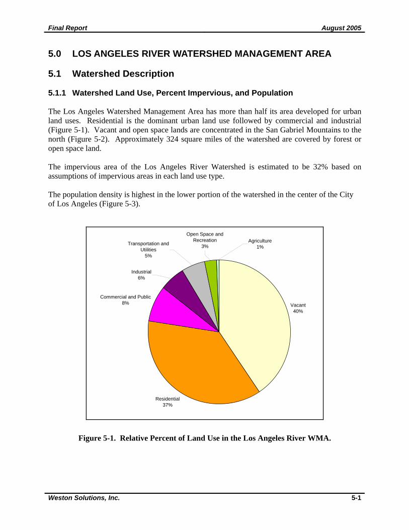
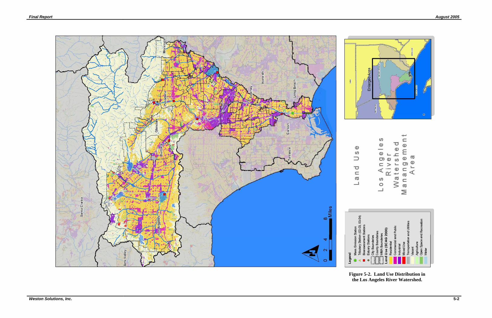
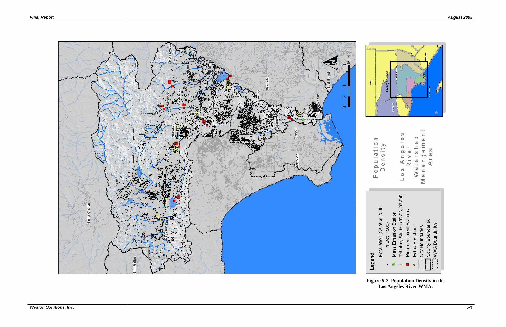
5.0 LOS ANGELES RIVER WATERSHED MANAGEMENT AREA 5.1 Watershed Description 5.1.1 Watershed Land Use, Percent Impervious, and Population The Los Angeles Watershed Management Area has more than half its area developed for urban land uses. Residential is the dominant urban land use followed by commercial and industrial (Figure 5-1). Vacant and open space lands are concentrated in the San Gabriel Mountains to the north (Figure 5-2). Approximately 324 square miles of the watershed are covered by forest or open space land. The impervious area of the Los Angeles River Watershed is estimated to be 32% based on assumptions of impervious areas in each land use type. The population density is highest in the lower portion of the watershed in the center of the City of Los Angeles (Figure 5-3).
Vacant40%
Residential37%
Commercial and Public8%
Industrial6%
Transportation and Utilities
5%
Open Space and Recreation
3%Agriculture
1%
Figure 5-1. Relative Percent of Land Use in the Los Angeles River WMA.
Final Report August 2005
Weston Solutions, Inc. 5-2
Figure 5-2. Land Use Distribution in the Los Angeles River Watershed.
Final Report August 2005
Weston Solutions, Inc. 5-3
Figure 5-3. Population Density in the Los Angeles River WMA.
Final Report August 2005
Weston Solutions, Inc. 5-4
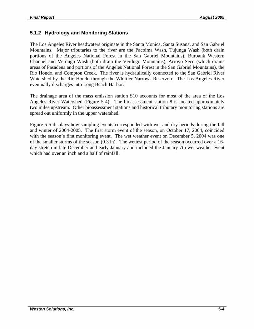
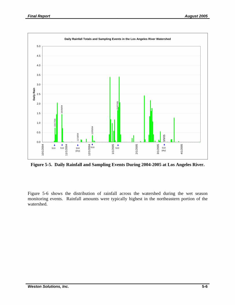
5.1.2 Hydrology and Monitoring Stations The Los Angeles River headwaters originate in the Santa Monica, Santa Susana, and San Gabriel Mountains. Major tributaries to the river are the Pacoima Wash, Tujunga Wash (both drain portions of the Angeles National Forest in the San Gabriel Mountains), Burbank Western Channel and Verdugo Wash (both drain the Verdugo Mountains), Arroyo Seco (which drains areas of Pasadena and portions of the Angeles National Forest in the San Gabriel Mountains), the Rio Hondo, and Compton Creek. The river is hydraulically connected to the San Gabriel River Watershed by the Rio Hondo through the Whittier Narrows Reservoir. The Los Angeles River eventually discharges into Long Beach Harbor. The drainage area of the mass emission station S10 accounts for most of the area of the Los Angeles River Watershed (Figure 5-4). The bioassessment station 8 is located approximately two miles upstream. Other bioassessment stations and historical tributary monitoring stations are spread out uniformly in the upper watershed. Figure 5-5 displays how sampling events corresponded with wet and dry periods during the fall and winter of 2004-2005. The first storm event of the season, on October 17, 2004, coincided with the season’s first monitoring event. The wet weather event on December 5, 2004 was one of the smaller storms of the season (0.3 in). The wettest period of the season occurred over a 16-day stretch in late December and early January and included the January 7th wet weather event which had over an inch and a half of rainfall.
Final Report August 2005
Weston Solutions, Inc. 5-5
Figure 5-4. Watershed Hydrology and Monitoring Stations in the Los Angeles
River Watershed.
Final Report August 2005
Weston Solutions, Inc. 5-6
Daily Rainfall Totals and Sampling Events in the Los Angeles River Watershed
01/0
7/05
11/1
6/04 12
/05/
04
10/1
7/04
10/2
6/04
0.0
0.5
1.0
1.5
2.0
2.5
3.0
3.5
4.0
4.5
5.010
/1/2
004
11/1
/200
4
12/1
/200
4
1/1/
2005
2/1/
2005
3/1/
2005
4/1/
2005
Dai
ly R
ain
S10 S10(Dry)
S10 S10 S10 S10(dry)
3/9/
05
Figure 5-5. Daily Rainfall and Sampling Events During 2004-2005 at Los Angeles River.
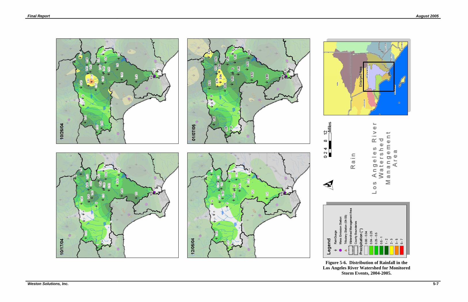
Figure 5-6 shows the distribution of rainfall across the watershed during the wet season monitoring events. Rainfall amounts were typically highest in the northeastern portion of the watershed.
Final Report August 2005
Weston Solutions, Inc. 5-7
Figure 5-6. Distribution of Rainfall in the Los Angeles River Watershed for Monitored
Storm Events, 2004-2005.
Final Report August 2005
Weston Solutions, Inc. 5-8
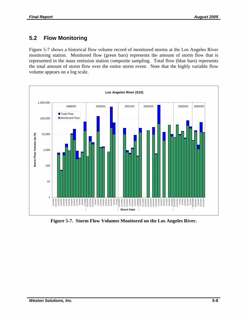
5.2 Flow Monitoring Figure 5-7 shows a historical flow volume record of monitored storms at the Los Angeles River monitoring station. Monitored flow (green bars) represents the amount of storm flow that is represented in the mass emission station composite sampling. Total flow (blue bars) represents the total amount of storm flow over the entire storm event. Note that the highly variable flow volume appears on a log scale.
Los Angeles River (S10)
1
10
100
1,000
10,000
100,000
1,000,000
11/8
/199
912
/31/
1999
1/25
/200
01/
30/2
000
2/10
/200
02/
12/2
000
2/16
/200
02/
20/2
000
2/23
/200
02/
27/2
000
3/5/
2000
3/8/
2000
4/17
/200
010
/12/
2000
10/2
6/20
0010
/29/
2000
1/8/
2001
1/10
/200
11/
24/2
001
1/26
/200
12/
10/2
001
2/19
/200
12/
24/2
001
3/4/
2001
4/7/
2001
11/1
2/20
0111
/21/
2001
11/2
4/20
0111
/29/
2001
12/3
/200
112
/20/
2001
1/28
/200
23/
19/2
002
11/8
/200
211
/11/
2002
12/1
5/20
0212
/16/
2002
12/2
0/20
0212
/22/
2002
12/2
9/20
022/
11/2
003
2/25
/200
32/
26/2
003
2/27
/200
33/
15/2
003
4/14
/200
310
/31/
2003
12/2
5/20
031/
1/20
042/
2/20
042/
18/2
004
2/21
/200
43/
1/20
0410
/17/
2004
10/2
6/20
0412
/5/2
004
12/2
7/20
0412
/31/
2004
Storm Date
Stor
m F
low
Vol
ume
(ac-
ft)
Total FlowMonitored Flow
1999/00 2000/01 2001/02 2002/03 2003/04 2004/05
Figure 5-7. Storm Flow Volumes Monitored on the Los Angeles River.
Final Report August 2005
Weston Solutions, Inc. 5-9
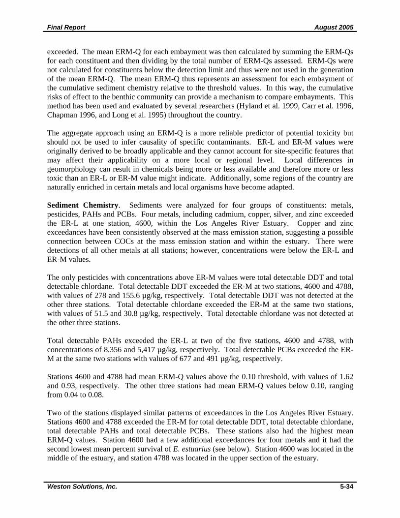
5.3 Core Stormwater Monitoring Summary 5.3.1 Mass Emissions At the Los Angeles River mass emission site, samples were collected during four wet weather events and two dry weather events in 2004-2005. Sampling occurred during storms on October 17 and 26, December 5, 2004 and January 7, 2005. The dry weather samples were collected on November 16, 2004 and March 17, 2005. The results from these sampling events are discussed in Section 5.3.1.1 and presented in Appendix C, Table 3 (values above WQOs are highlighted). This discussion presents the results based on groups of constituents (general chemistry, nutrients, bacterial indicators, metals, semi-volatiles and PCBs, and pesticides and herbicides). Wet weather data for each group of constituents are reviewed and presented first, followed by a brief comparison of the dry weather results. Section 5.3.1.2 presents a summary of the historical data collected at this station and trend analyses performed on the water quality data. Section 5.3.1.3 lists the constituents of concern for this drainage. 5.3.1.1 2004-2005 Results
Cyanide was the only general chemistry constituent that frequently exceeded WQOs (Appendix C, Table 3). Cyanide was above the 0.004 mg/L Ocean Plan standard in all wet and dry weather samples. The pH of one dry weather sample was more basic than the Basin Plan criteria allows, potentially a result of high photosynthesis due to attached algae. The remaining general water chemistry constituents complied with WQOs. Comparing stormwater samples, maximum concentrations of major ions occurred during the first storm of the season, corresponding with the maximum measured TDS value; however, minerals and TDS were even greater in the dry weather samples, likely due to the lack of rainfall for 18 days prior to sampling. Turbidity, TSS and VSS also had maximum concentrations associated with the first storm of the season and were significantly lower in the dry weather sample. Relatively higher turbidity and TSS values are expected during the wet season as storms transport sediment and other solid particles to the Los Angeles River and generate high channel flow that also entrain such material. All nutrients were detected in at least one storm event and the two dry weather events. Only nitrate-N and nitrite-N have established WQOs. Nitrite-N was not detected in three of the four stormwater samples and was detected at levels below the WQO on December 5, 2004. Nitrite-N exceeded the Basin Plan criterion in one dry weather sample with a level of 1.36 mg/L. Indicator bacteria densities were above WQOs in all four stormwater samples. Total coliform ranged from 500,000 to 5,000,000 MPN/100mL, fecal coliform ranged from 50,000 to 500,000 MPN/100mL and enterococcus ranged from 220,000 to 500,000 MPN/100mL in storm samples. Dry weather samples had significantly lower bacterial densities and all indicators exceeded water quality objectives during one of the dry weather events. Enterococcus exceeded criteria on November 16, 2004 with a value of 500 MPN/100mL and fecal and total coliform exceeded objectives on March 17, 2005 with a value of 16,000 MPN/100mL. In general, peak concentrations of all metals occurred during the first two wet weather sampling events, corresponding to high TSS concentrations. Similar to other watersheds throughout the Los Angeles Region, total aluminum, total and dissolved copper, total lead and total zinc
Final Report August 2005
Weston Solutions, Inc. 5-10
consistently exceeded WQOs. Total aluminum, copper, lead, and zinc concentrations were above the WQO in all four stormwater samples. Dissolved copper concentrations exceeded water quality objectives in all four stormwater samples while dissolved lead and zinc each exceeded WQOs during one storm event. Total copper was the only metal that exceeded objectives during both dry weather events. Several metals were not detected in any samples collected during wet or dry weather, including dissolved aluminum, beryllium, dissolved cadmium, hexavalent chromium, dissolved manganese, mercury, dissolved silver and thallium. Selenium was not detected in any of the wet weather samples; however detectable concentrations of total and dissolved selenium were detected in the dry weather sample. Total silver was detected in one wet weather sample. Only two semi-volatile organic constituents were detected in any of the samples collected at the Los Angeles River. Bis (2-Ethylhexl) phthalate was detected during the last dry weather event with a concentration of 24.30 µg/L and 4-metholphenol was detected during the first storm event with a concentration of 3.0 µg/L. Only one pesticide, diazinon, was detected in any of the samples. Diazinon was measured at or below the Basin Plan WQO in three stormwater samples and one dry weather sample. No other semi-volatile organics, PCBs, pesticides or herbicides were detected in any of the samples. 5.3.1.2 Historical Review
Table 5-1 presents annual means for the constituents that were monitored from 1995 to 2005 with the appropriate water quality objectives. Each observation was compared to the lowest applicable WQO from the Basin Plan, Ocean Plan, or the California Toxic Rule (CTR) and those above the WQO were highlighted. Water quality objectives for metals are hardness dependent. Metal concentrations were determined using a mean hardness value; however, individual events show specific hardness for that particular event. Therefore, results for individual events may show different results that may be less than water quality objectives. Individual events for each year are presented in the annual reports. The yellow-highlighted cells in Table 5-1 indicate that a constituent’s detection limit is greater than the WQO. For statistical analyses, one-half the detection limit is used in place of a non-detect result. Therefore, annual means generated from values highlighted in yellow may be misrepresentative of actual concentrations. Table 5-1 suggests that total mercury and total thallium have consistently exceeded WQOs; however, since the detection limits are greater than WQOs, actual concentrations could not be determined. In addition, the Ocean Plan was developed for the protection of marine resources and applies specifically to discharges to the ocean and not to discharges to enclosed bays, estuaries or inland waters. The Ocean Plan criteria were intended for ocean water samples representative of the discharge area after initial dilution has been completed (SWRCB 2001). Therefore, applying the Ocean Plan criteria to stormwater samples collected upstream of the Los Angeles River mouth and interpreting these results should be done with caution. Concentrations for these constituents were not considered as exceedances.
Final Report August 2005
Weston Solutions, Inc. 5-11
Table 5-1. Annual Mean Concentration for Constituents Measured at the Los Angeles River Mass Emission Site, 1995 to 2005.
Constituent Units Lowest WQO1 1995-96 1996-97 1997-98 1998-99 1999-00 2000-01 2001-02 2002-03 2003-04 2004-05
Frequency Ratio
Mean Exceedance
Ratio2 General
Alkalinity mg/l 42.9 31.8 30.2 73.1 39.2 56.3 56.4 97.8 87.6 78.4 0.0 Bicarbonate mg/l 42.9 31.8 30.2 73.1 47.9 68.6 68.7 93.3 0.0 BOD mg/l 37.1 44.9 23.4 43.0 9.2 7.4 18.1 60.5 44.7 29.6 0.0 Calcium mg/l 19.6 15.5 17.0 45.5 18.0 27.5 20.3 25.2 0.0 Carbonate mg/l 1 1 14 0.0 Chloride mg/l 150 13.7 11.5 9.2 35.1 14.3 30.8 19.9 61.8 55.4 31.0 0.0 0.2 COD mg/l 19.30 107.87 174.97 55.06 36.10 69.83 130.26 89.58 90.96 50.39 0.0 Cyanide mg/l 0.004 0.01 0.03 0.01 0.03 0.04 0.26 1.0 15.2 Dissolved Oxygen mg/l 5 8.4 8.4 7.8 0.0 0.6 Fluoride mg/l 2.2 0.23 0.11 0.10 0.21 0.17 0.21 0.19 0.35 0.27 0.24 0.0 0.1 Hardness mg/l 65 52 51 173 63 98 82 159 128 85 0.0 Magnesium mg/l 3.87 3.15 3.51 14.43 4.37 9.44 7.68 5.43 0.0 MBAS mg/l 0.04 0.07 0.11 0.18 0.09 0.12 0.18 0.0 Oil and Grease mg/l 4.94 2.45 1.38 1.90 2.44 2.86 5.55 4.05 3.10 2.10 0.0 pH 6.5/8.5 7.30 7.01 6.83 7.43 6.89 6.93 7.18 8.12 6.94 7.16 0.0 Potassium mg/l 3.85 3.94 3.63 4.42 3.16 5.88 5.06 5.69 0.0 Sodium mg/l 14.36 10.63 11.47 34.20 15.03 28.16 23.66 30.34 0.0 Specific Conductance umhos/cm 216 173 154 429 202 330 270 627 501 300 0.0 Sulfate mg/l 350 27.85 18.08 16.62 63.74 23.01 38.18 25.34 73.44 61.12 39.98 0.0 0.1 Total Dissolved Solids mg/l 1500 144 121 95 278 121 198 181 406 315 199 0.0 0.1 Total Organic Carbon mg/l 12.09 20.24 9.46 7.52 8.27 16.02 18.74 10.84 16.70 14.49 0.0 Total Phenols mg/l 0.05 0.05 0.05 0.05 1.96 0.0 Total Suspended Solids mg/l 498 295 550 230 333 244 362 271 365 376 0.0 Turbidity ntu 225 105 34 190 107 139 97 113 57 25 52 0.0 0.4 Volatile Suspended Solids mg/l 57.5 68.0 90.9 43.8 61.1 53.8 76.4 23.3 77.2 59.4 0.0
Nutrients Ammonia mg/l 0.65 0.56 1.09 0.23 0.18 1.16 1.10 1.26 0.0 Dissolved Phosphorus mg/l 0.29 0.30 0.66 0.38 0.30 0.43 0.45 0.40 0.53 0.23 0.0 Kjeldahl-N mg/l 2.22 4.12 4.38 3.24 2.37 3.02 5.06 4.30 2.42 4.08 0.0 NH3-N mg/l 0.54 0.47 0.91 0.19 0.14 0.96 0.90 1.33 0.60 1.03 0.0 Nitrate mg/l 11.93 5.47 2.96 2.39 3.46 3.86 2.60 7.38 10.57 5.83 0.0 Nitrate-N mg/l 10 2.70 1.24 0.66 0.55 0.78 0.89 0.62 1.67 2.43 1.36 0.0 0.1 Nitrite-N mg/l 1 0.14 0.10 0.11 0.30 0.13 0.29 0.27 0.45 0.44 0.31 0.0 0.3 Total Phosphorus mg/l 0.34 0.99 0.85 0.48 0.41 0.49 0.63 0.51 2.13 0.42 0.0
Indicator Bacteria Fecal Coliform mpn/100ml 400 3,860,000 102,250 2,751,125 110,540 392,922 1,365,714 831,250 373,687 347,646 190,034 1.0 2581 Enterococcus mpn/100ml 104 1,220,002 51,600 71,260 558,857 864,250 105,133 102,340 248,100 1.0 3872 Fecal Streptococcus mpn/100ml 3,060,002 272,500 530,000 94,800 262,600 3,260,286 864,250 245,200 195,740 288,100 0.0 Total Coliform mpn/100ml 10,000 5,000,002 835,000 3,061,250 260,400 1,608,889 2,057,143 1,785,000 745,417 592,046 1,600,260 1.0 175
Metals Dissolved Aluminum ug/l 2858 74 339 79 50 50 50 50 0.0 Dissolved Antimony ug/l 2.50 1.54 0.93 1.25 1.62 0.0
Final Report August 2005
Weston Solutions, Inc. 5-12
Table 5-1. Annual Mean Concentration for Constituents Measured at the Los Angeles River Mass Emission Site, 1995 to 2005.
Constituent Units Lowest WQO1 1995-96 1996-97 1997-98 1998-99 1999-00 2000-01 2001-02 2002-03 2003-04 2004-05
Frequency Ratio
Mean Exceedance
Ratio2 Dissolved Arsenic ug/l 2.50 2.04 2.39 1.79 1.92 0.0 Dissolved Barium ug/l 7.75 59.28 49.08 26.5 30.13 31.06 27.54 0.0 Dissolved Berylium ug/l 0.5 0.5 0.5 0.5 0.5 0.0 Dissolved Boron ug/l 184 236 90 154 177 298 0.0 Dissolved Cadmium ug/l 1.4-3.4 3.3 0.5 0.5 0.5 0.5 0.5 0.2 0.6 Dissolved Chromium ug/l 38-102.5 2.38 9.85 3.26 2.04 2.89 4.59 1.26 0.0 0.1 Dissolved Chromium +6 ug/l 5 5 5 5 5 0.0 Dissolved Copper ug/l 5.1-14.3 10.13 4.63 69.47 8.01 5.76 8.24 12.11 7.84 7.96 7.99 0.4 2.3 Dissolved Iron ug/l 193 155 4338 654 191 235 327 193 178 152 0.0 Dissolved Lead ug/l 1.2-4.5 50.25 2.63 127.94 3.20 2.50 3.25 2.30 2.27 2.71 0.8 16.3 Dissolved Manganese ug/l 231.7 50 62.6 50 0.0 Dissolved Mercury ug/l 0.5 0.5 0.5 0.5 0.5 0.0 Dissolved Nickel ug/l 29.7-82.8 4.63 2.13 16.65 3.03 4.48 6.30 7.93 5.91 6.34 6.10 0.0 0.2 Dissolved Selenium ug/l 2.50 2.50 2.69 2.08 2.57 0.0 Dissolved Silver ug/l 0.50 0.50 0.50 0.50 0.50 0.0 Dissolved Thallium ug/l 2.50 2.50 2.50 2.50 2.50 0.0 Dissolved Zinc ug/l 66.8-186.4 57.50 40.00 416.5 42.00 46.55 50.36 40.57 54.94 47.70 0.1 1.1 Total Aluminum ug/l 1000 1993 11004 1483 503 575 65 97 2992 2378 0.6 2.3 Total Antimony ug/l 6 2.50 1.58 0.97 2.40 2.17 0.0 0.3 Total Arsenic ug/l 32 2.13 5.66 3.71 2.50 1.62 2.77 2.78 2.27 0.0 0.1 Total Barium ug/l 58.25 184.49 84.12 38.17 40.08 33.44 76.54 0.0 Total Beryllium ug/l 4 0.50 0.50 0.50 0.50 0.50 0.0 0.1 Total Boron ug/l 69 271 281 128 181 203 856 0.0 Total Cadmium ug/l 1.5-3.8 3.79 0.98 0.59 2.60 0.49 1.34 0.64 0.3 0.7 Total Chromium ug/l 50 37.00 10.38 31.06 8.40 4.56 3.21 7.37 15.71 7.91 0.0 0.3 Total Chromium +6 ug/l 5.00 5.00 5.00 0.0 Total Copper ug/l 5.3-14.9 49.0 44.1 100.3 20.3 12.5 16.4 27.1 15.2 72.1 36.8 1.0 5.5 Total Iron ug/l 3713 2796 19142 2164 443 1039 546 357 5925 5678 0.0 Total Lead ug/l 1.4-6.4 62.1 45.7 258.1 8.3 9.1 10.2 4.4 4.2 215.9 29.9 0.9 32.9 Total Manganese ug/l 97.25 140.75 355.40 154.80 79.36 181.52 120.16 0.0 Total Mercury ug/l 0.16 0.50 0.50 0.50 0.50 0.50 1.0 3.1 Total Nickel ug/l 29.7-82.9 22.13 12.58 27.21 5.98 6.00 8.13 36.5 11.72 13.46 11.24 0.0 0.4 Total Selenium ug/l 60 3.38 2.35 2.50 2.50 2.69 2.32 2.57 0.0 0.0 Total Silver ug/l 2.8 0.91 0.50 0.50 0.50 0.98 0.54 0.0 0.2 Total Thallium ug/l 2 2.50 2.50 2.50 2.50 2.50 1.0 1.3 Total Zinc ug/l 68.3-190.6 181 203 573 126 44 66 85 57 274 127 0.5 2.0
Pesticides Diazinon ug/l 0.08 0.01 0.01 0.01 0.07 0.01 0.05 0.0 0.3 Prometryn ug/l 1 1 1 0.0 1 WQO for metals are hardness dependent and were based on minimum hardness by year. 2Mean Exceedance Ratio calculated using annual mean concentrations reported up to four significant figures. Ratio shown may not exactly equal ratio of mean values shown in table due to rounding of presented means. Blue = WQO Exceedances; Yellow = DL above WQO; Orange = Frequency ratio > 0.5, Mean exceedance > 1.0.
Final Report August 2005
Weston Solutions, Inc. 5-13
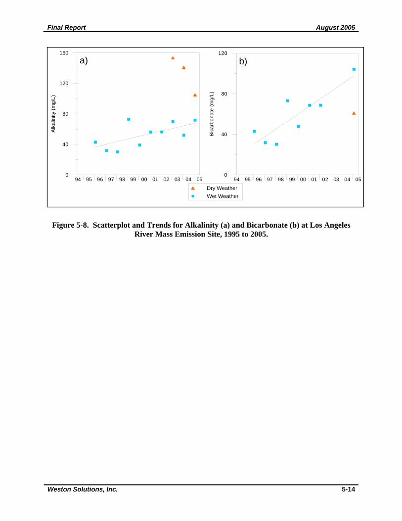
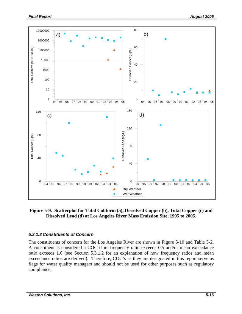
Table 5-1 also presents frequency and mean magnitude of exceedance ratios for each constituent. The frequency ratio was determined by dividing the total number of years a constituent was analyzed into the number of times the mean value of a constituent exceeded the WQO. The mean magnitude of exceedance was determined by dividing the WQO for a constituent into the constituents mean value for each year, then calculating the average magnitude of exceedance. A frequency ratio greater than 0.5 (50%) and a mean exceedance ratio greater than 1.0 were used as the criteria for determining whether a given parameter should be considered as a COC. Blue highlighted cells in Table 5-1 represent exceedances of water quality objectives; yellow cells represent constituents in which the detection limits were above water quality objectives and were not considered exceedances; orange cells represent a frequency ratio greater than 0.5 (50% exceedance) and a mean exceedance ratio greater than 1.0. Water quality at the mass emission site in the Los Angeles River during 2004-2005 is consistent with results documented since the 1995-1996 monitoring season. Annual mean concentrations of cyanide, indicator bacteria, total aluminum, total copper, total and dissolved lead and total zinc have regularly exceeded WQOs (Table 5-1). Annual means of cyanide have exceeded the WQO in 1998-1999 and every year since 2000. Indicator bacteria has exceeded objectives during all monitoring years (enterococcus was not analyzed for in 1996-1997 and 1997-1998). Total copper exceeded objectives all ten years and total lead exceeded during nine years. Annual mean concentrations of dissolved lead exceeded the WQO during seven years while total aluminum and total zinc exceeded objectives during five years. Other metals, such as dissolved copper and zinc, and cadmium exceeded WQOs less frequently. Dissolved copper and zinc have exceeded water quality objectives in 40% and 10% of the monitoring years, respectively. The annual mean concentration of total cadmium exceeded WQO during two years, while the annual mean concentration of dissolved cadmium exceeded objectives during one year. Regression analyses were performed on the water quality data collected since 1995-1996 to determine if any of the constituents had a significantly increasing or decreasing trend. Only concentrations of bicarbonate and by association, alkalinity, were shown to have an increasing trend (Figure 5-8a-b). Alkalinity increases when levels of hydroxide, carbonate or bicarbonate increase. Increasing urbanization may also result in higher alkalinities. Sources of bicarbonate include natural geologic formations or the decomposition of organic matter. All other constituents tended to have either consistent concentrations or random variations in concentrations with no discernable trends. Figure 5-9a-d are scatterplots for some of the constituents that tend to exceed WQOs in Los Angeles River. None of the constituents were observed to have a decreasing trend.
Final Report August 2005
Weston Solutions, Inc. 5-14
Figure 5-8. Scatterplot and Trends for Alkalinity (a) and Bicarbonate (b) at Los Angeles River Mass Emission Site, 1995 to 2005.
94 95 96 97 98 99 00 01 02 03 04 050
40
80
120
160Al
kalin
ity (m
g/L)
a)
94 95 96 97 98 99 00 01 02 03 04 050
40
80
120
Bic
arbo
nate
(mg/
L)
b)
Dry WeatherWet Weather
Final Report August 2005
Weston Solutions, Inc. 5-15
Figure 5-9. Scatterplot for Total Coliform (a), Dissolved Copper (b), Total Copper (c) and Dissolved Lead (d) at Los Angeles River Mass Emission Site, 1995 to 2005.
5.3.1.3 Constituents of Concern
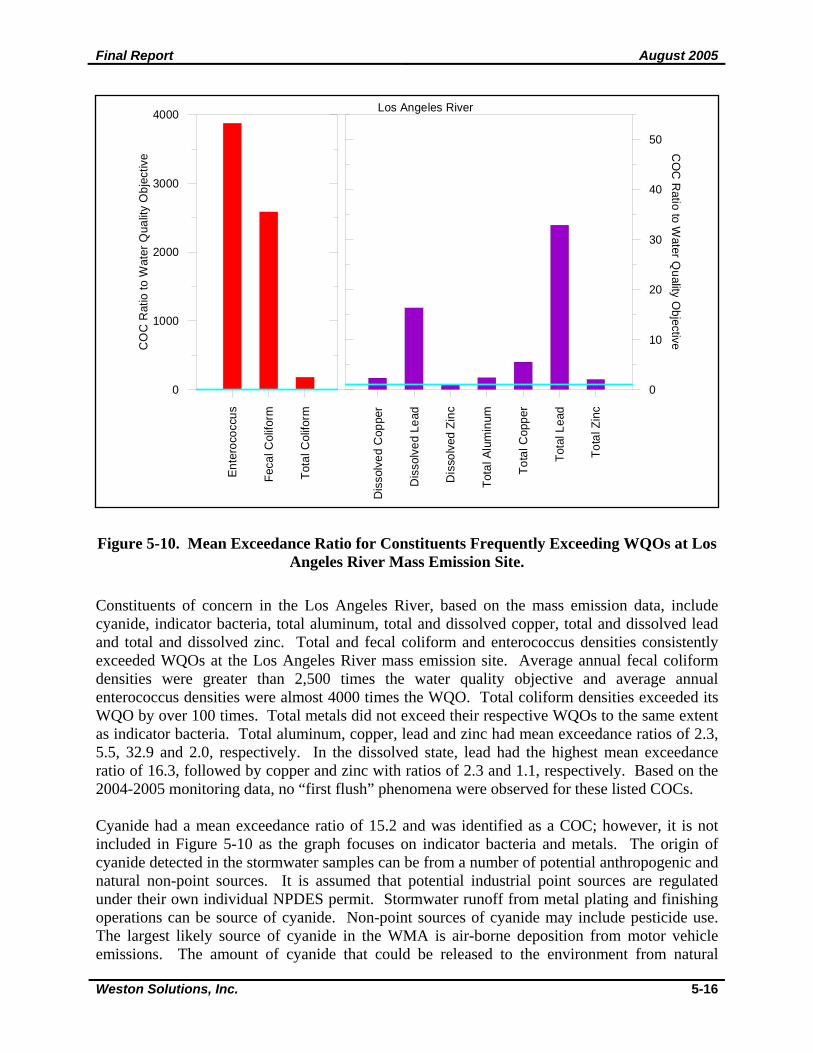
The constituents of concern for the Los Angeles River are shown in Figure 5-10 and Table 5-2. A constituent is considered a COC if its frequency ratio exceeds 0.5 and/or mean exceedance ratio exceeds 1.0 (see Section 5.3.1.2 for an explanation of how frequency ratios and mean exceedance ratios are derived). Therefore, COC’s as they are designated in this report serve as flags for water quality managers and should not be used for other purposes such as regulatory compliance.
94 95 96 97 98 99 00 01 02 03 04 051
10
100
1000
10000
100000
1000000
10000000To
tal C
olifo
rm (M
PN
/100
ml)
a)
94 95 96 97 98 99 00 01 02 03 04 050
20
40
60
80
Dis
solv
ed C
oppe
r (ug
/L)
b)
94 95 96 97 98 99 00 01 02 03 04 050
40
80
120
Tota
l Cop
per (
ug/L
)
c)
94 95 96 97 98 99 00 01 02 03 04 050
40
80
120
160
Dis
solv
ed L
ead
(ug/
L)
d)
Dry Weather
Wet Weather
Final Report August 2005
Weston Solutions, Inc. 5-16
Figure 5-10. Mean Exceedance Ratio for Constituents Frequently Exceeding WQOs at Los Angeles River Mass Emission Site.
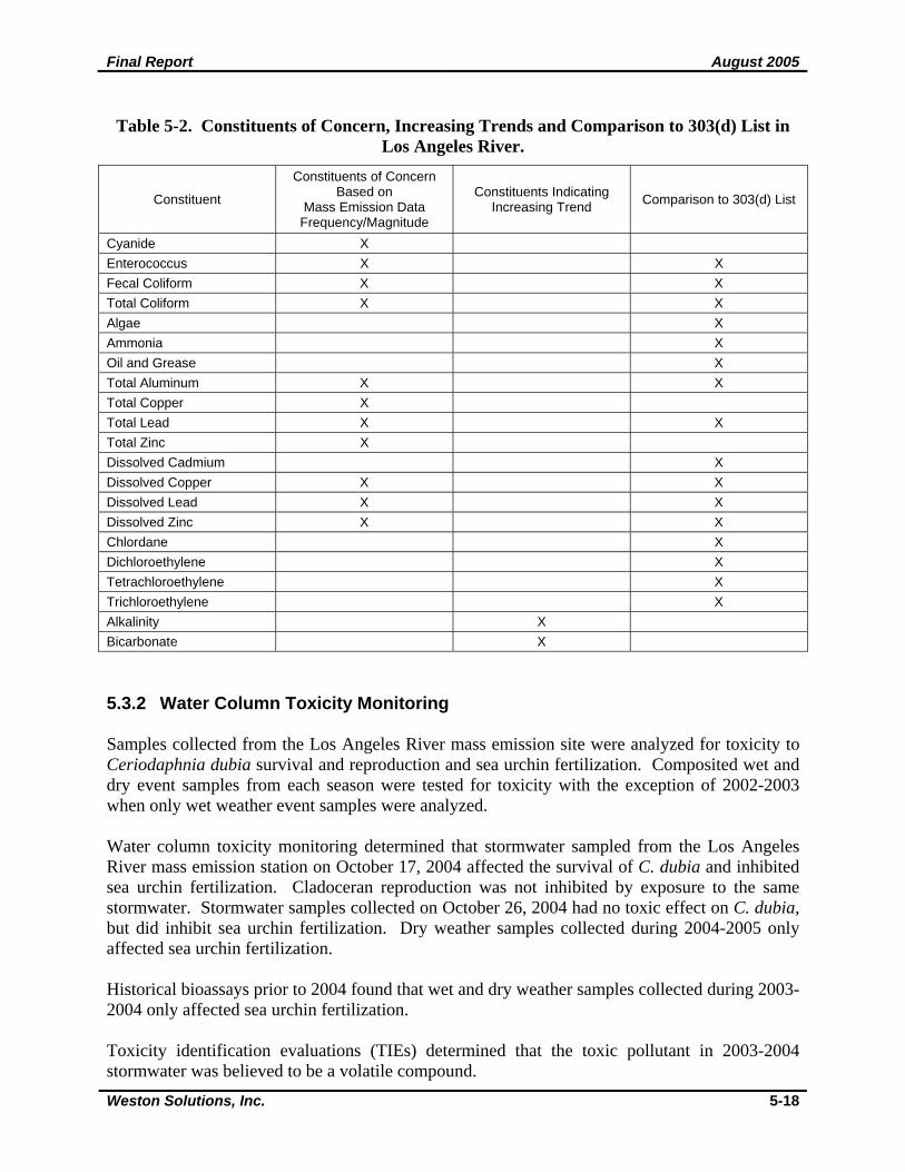
Constituents of concern in the Los Angeles River, based on the mass emission data, include cyanide, indicator bacteria, total aluminum, total and dissolved copper, total and dissolved lead and total and dissolved zinc. Total and fecal coliform and enterococcus densities consistently exceeded WQOs at the Los Angeles River mass emission site. Average annual fecal coliform densities were greater than 2,500 times the water quality objective and average annual enterococcus densities were almost 4000 times the WQO. Total coliform densities exceeded its WQO by over 100 times. Total metals did not exceed their respective WQOs to the same extent as indicator bacteria. Total aluminum, copper, lead and zinc had mean exceedance ratios of 2.3, 5.5, 32.9 and 2.0, respectively. In the dissolved state, lead had the highest mean exceedance ratio of 16.3, followed by copper and zinc with ratios of 2.3 and 1.1, respectively. Based on the 2004-2005 monitoring data, no “first flush” phenomena were observed for these listed COCs. Cyanide had a mean exceedance ratio of 15.2 and was identified as a COC; however, it is not included in Figure 5-10 as the graph focuses on indicator bacteria and metals. The origin of cyanide detected in the stormwater samples can be from a number of potential anthropogenic and natural non-point sources. It is assumed that potential industrial point sources are regulated under their own individual NPDES permit. Stormwater runoff from metal plating and finishing operations can be source of cyanide. Non-point sources of cyanide may include pesticide use. The largest likely source of cyanide in the WMA is air-borne deposition from motor vehicle emissions. The amount of cyanide that could be released to the environment from natural
Ente
roco
ccus
Feca
l Col
iform
Tota
l Col
iform
Dis
solv
ed C
oppe
r
Dis
solv
ed L
ead
Dis
solv
ed Z
inc
Tota
l Alu
min
um
Tota
l Cop
per
Tota
l Lea
d
Tota
l Zin
c
0
1000
2000
3000
4000
CO
C R
atio
to W
ater
Qua
lity
Obj
ectiv
e
0
10
20
30
40
50C
OC
Ratio to W
ater Quality O
bjective
Los Angeles River
Final Report August 2005
Weston Solutions, Inc. 5-17
sources is comparatively low. Potential natural sources of cyanide include incomplete combustion from forest fires, decomposition of plant material and fungi. Water concentrations of cyanide tend to breakdown within days, but may bind to organic matter in sediments carried by stormwater and remain more persistent (www.eco-usa.net, www.dsf.health.state.pa, www.cynaidecode.org, www.npi.gov). Total mercury and total thallium have exceeded water quality objectives consistently since 2000 (Table 5-1). However, it should be noted that the detection limits for these constituents are greater than the WQOs. Therefore, these constituents were not identified as COCs because actual values could not be determined. Alkalinity and bicarbonate were shown to have increasing trends over the period of record. However, these constituents were not considered as COCs. The increasing concentration of each of these parameters is likely due to other sources which should be investigated. The increase in alkalinity decreases the bioavailability of metals in stormwater. Table 5-2 summarizes the constituents of concern identified by the mass emission data and compares them to the pollutants on the 303(d) list for the Los Angeles River. Constituents indicating increasing trends are also shown in Table 5-2. The first column of Table 5-2 lists constituents of concern as determined from the integrated data set of annual mean values; the second column lists constituents that show an increasing trend (Figure 5-8a-b) even though concentrations may be below water quality objectives; and the third column is presented for comparison purposes and provides constituents that are 303(d) listed. The Los Angeles River is 303(d) listed for numerous constituents along several different reaches. These constituents include metals (total aluminum, total lead, dissolved cadmium, dissolved copper, dissolved lead and dissolved zinc), nutrients (ammonia and algae), coliforms, oil and grease, and organics (dichloroethylene, tetrachloroethylene, trichloroethylene and chlordane) (Table 5-2). Qualitative parameters such as odor and scum are 303(d) listed for Los Angeles River as well. Water quality monitoring at the Los Angeles River mass emission station supports the listing of some of these constituents. Based on the monitoring results from the mass emission station all indicator bacteria, total aluminum, total lead, and dissolved copper, lead and zinc have been identified as constituents of concern. Alternatively, dissolved cadmium is on the 303(d) list, however the annual mean concentration only exceeded the WQO during the 1997-1998 monitoring year. Cyanide, total copper and zinc are not included on the 303(d) list; however, they were identified as COC’s based on annual mean exceedances.
Final Report August 2005
Weston Solutions, Inc. 5-18
Table 5-2. Constituents of Concern, Increasing Trends and Comparison to 303(d) List in Los Angeles River.
Constituent
Constituents of Concern Based on
Mass Emission Data Frequency/Magnitude
Constituents Indicating Increasing Trend Comparison to 303(d) List
Cyanide X Enterococcus X X Fecal Coliform X X Total Coliform X X Algae X Ammonia X Oil and Grease X Total Aluminum X X Total Copper X Total Lead X X Total Zinc X Dissolved Cadmium X Dissolved Copper X X Dissolved Lead X X Dissolved Zinc X X Chlordane X Dichloroethylene X Tetrachloroethylene X Trichloroethylene X Alkalinity X Bicarbonate X 5.3.2 Water Column Toxicity Monitoring Samples collected from the Los Angeles River mass emission site were analyzed for toxicity to Ceriodaphnia dubia survival and reproduction and sea urchin fertilization. Composited wet and dry event samples from each season were tested for toxicity with the exception of 2002-2003 when only wet weather event samples were analyzed. Water column toxicity monitoring determined that stormwater sampled from the Los Angeles River mass emission station on October 17, 2004 affected the survival of C. dubia and inhibited sea urchin fertilization. Cladoceran reproduction was not inhibited by exposure to the same stormwater. Stormwater samples collected on October 26, 2004 had no toxic effect on C. dubia, but did inhibit sea urchin fertilization. Dry weather samples collected during 2004-2005 only affected sea urchin fertilization. Historical bioassays prior to 2004 found that wet and dry weather samples collected during 2003-2004 only affected sea urchin fertilization. Toxicity identification evaluations (TIEs) determined that the toxic pollutant in 2003-2004 stormwater was believed to be a volatile compound.
Final Report August 2005
Weston Solutions, Inc. 5-19
Further discussion of toxicity results and inter-relationships on a cross-watershed basis is presented in Section 10. Due to the limited data-set on a watershed basis, the inter-relationship discussion is presented on regional basis in Section 10. Correlations between toxicity results with COC are discussed in section 10 using the results from all the watersheds. 5.3.3 Tributary Monitoring Six tributaries in the Los Angeles River watershed were monitored during five storms and one dry weather event in 2002-2003 and four storms and two dry events in 2003-2004. Of these monitoring events, all but two storm events coincided with sampling at the mass emission station. Moving from downstream to upstream, these stations are identified as Rio Hondo Channel, Arroyo Seco Channel, Verdugo Wash, Burbank Western Channel, Aliso Creek and Bull Creek. During each monitoring period, certain constituents exceeded WQOs. In general, bacteria levels during the wet and dry season of each year consistently exceeded applicable standards at each tributary. Metals also frequently exceeded applicable criteria at most tributaries. Constituents measured during the two monitoring periods that exceeded WQOs are described by tributary in more detail below. 5.3.3.1 Aliso Creek
All conventional parameters were below WQOs with the exception of cyanide during one storm event on October 31, 2003. Total and fecal coliforms and enterococcus exceeded WQOs during all storm events and enterococcus exceeded criteria during all dry weather events. Total and fecal coliforms were below objectives during one dry weather event on January 13, 2004. During the wet season, total coliform levels ranged from 50,000 to 500,000 MPN/100mL, fecal coliforms ranged from 11,000 to 110,000 MPN/100mL, and enterococcus ranged from 5,000 to 500,000 MPN/100mL. Dry season bacteria densities were generally lower. Total coliforms ranged from 5,000 to 50,000 MPN/100mL, fecal coliforms ranged from 200-500 MPN/100mL, and enterococcus ranged from 1,300 to 5,000 MPN/100mL. All general constituents and nutrients were below respective water quality objectives during all sampling events. Two metals, including copper and zinc, exceeded WQOs during some of the sampling events. Total copper exceedances occurred during six out of eight storm samples and all three dry weather events. Total zinc concentrations exceeded objectives during four storm events. Dissolved copper concentrations exceeded WQOs during six storm events and one dry weather event. Dissolved zinc concentrations exceeded criteria during only one storm event. Diazinon levels exceeded the WQO during four of nine storm events. No other pesticides were detected in any storm or dry weather samples. Although other tributaries also contribute, stormwater from Aliso Creek delivers some constituents of concern to the Los Angeles River mass emission station. When bacteria levels exceeded WQO criteria at Aliso Creek, fecal and total coliforms and enterococcus levels were
Final Report August 2005
Weston Solutions, Inc. 5-20
also exceeded at the mass emission station. Likewise, metal exceedances at Aliso Creek and the mass emission station coincided six times for total copper and three times for total zinc. In addition, diazinon levels exceeded the standard at Aliso Creek and the mass emission station on February 11, 2003. 5.3.3.2 Bull Creek
Conventional parameters were below the WQOs with the exception of one pH measurement (8.51) during a dry season event on April 30, 2003. The high pH value may have been the result of high photosynthesis by attached algae, as dissolved oxygen levels also peaked on this date. Total and fecal coliforms and enterococcus exceeded applicable criteria during all sampling events except one dry season event on April 30, 2003 for total and fecal coliforms and one dry season event on January 13, 2004 for enterococcus. During the wet season, total coliform levels ranged from 24,000 to 1,700,000 MPN/100mL, fecal coliforms ranged from 5,000 to 140,000 MPN/100mL, and enterococcus ranged from 17,000 to 400,000 MPN/100mL. Dry season bacteria densities were generally lower. Total coliforms ranged from 1,100 to 130,000 MPN/100mL, fecal coliforms ranged from 80 to 17,000 MPN/100mL, and enterococcus densities ranged from 70 to 8,000 MPN/100mL. General parameters, with the exception of turbidity, were below the WQOs. The majority of stormwater samples exceeded the applicable WQO. Values ranged from 24.2 NTU to 4920 NTU. One dry season sample on January 13, 2004 also exceeded the WQOs. Although the sample was collected after a prolonged dry period, turbidities in Bull Creek on this date (666 NTUs) most likely still reflected the large and extended storm event that occurred earlier in January. All other general constituents and nutrients were below water quality objectives during all events. Only four metals, including aluminum, copper, lead, and zinc, exceeded water quality objectives during some of the storm events. Total aluminum, total and dissolved copper, total lead, and total zinc exceedances only occurred during the first storm of the season in 2002-2003, indicating metals may have accumulated on impervious surfaces during the dry period preceding the storm. During 2003-2004, total copper exceeded objectives during three storm events while total aluminum and total zinc exceeded the WQO during two storm events. Concentrations during dry season events from both monitoring periods complied with applicable criteria. Diazinon concentrations only exceeded the WQO during one storm event on February 11, 2003. Diazinon was detected during four other storm events and one dry weather event; however, levels were below water quality objectives. No other pesticides were detected in any storm or dry weather samples. Tributary monitoring determined that stormwater from Bull Creek delivers some constituents of concern to the Los Angeles River mass emission station. For instance, on April 30, 2003, pH levels in excess of the standard in Bull Creek may have contributed to the exceedance in the Los Angeles River. Exceedances of fecal and total coliforms and enterococcus WQOs also regularly coincided at the two stations. Bull Creek also contributed to total copper and zinc exceedances at the mass emission station, but the incident rate (approximately 33 percent) was lower than other tributaries. A total aluminum exceedance also coincided with the only date (October 31, 2003) that a total aluminum exceedance was recorded at the Los Angeles River. In addition,
Final Report August 2005
Weston Solutions, Inc. 5-21
diazinon levels exceeded the standard at Bull Creek and the mass emission station on February 11, 2003. 5.3.3.3 Burbank Western System
Conventional constituents fell below WQO standards with the exception of cyanide levels during three storms and one dissolved oxygen value (3.72 mg/L) during a storm on December 16, 2002. Low DO values were also recorded at other Los Angeles River tributaries on December 16, 2002; however, a possible cause of these low values on this date is unknown, as other indicators do not provide a explanation (i.e., BOD and COD values on this date were below the average for the monitoring period). Total and fecal coliforms and enterococcus exceeded WQOs during all sampling events except one dry season event on January 13, 2004. During the wet season, total coliform levels ranged from 80,000 to 500,000 MPN/100mL, fecal coliforms ranged from 800 to 130,000 MPN/100mL, and enterococcus ranged from 14,000 to 170,000 MPN/100mL. Dry season bacteria values were generally lower. Total coliforms ranged from 130 to 800,000 MPN/100mL, fecal coliforms ranged from 80 to 50,000 MPN/100mL, and enterococcus ranged from 20 to 14,000 MPN/100mL. Nitrite-N exceeded the applicable standard during one storm event on February 25, 2003. No other nutrients exceeded objectives during the two sampling years. Five metals, including aluminum, copper, lead, silver and zinc exceeded water quality objectives. Total copper exceeded objectives during all sampling events in 2002-2003 and 2003-2004. Dissolved copper exceeded criteria during all but three storm events and one dry weather event. Total zinc exceeded the WQO during four storm events and two dry weather events while dissolved zinc exceeded criteria during three storm events. Total and dissolved lead exceeded WQOs during two storm events while total aluminum and silver each exceeded objectives only during one storm event. Diazinon exceeded the WQO during one storm event on February 11, 2003. Concentrations were detected during two other storms and one dry weather event; however, levels were below water quality criteria. No other pesticides were detected in any storm or dry season samples. Tributary monitoring determined that stormwater from the Burbank Western System contributed to exceedances of some constituents of concern at the Los Angeles River mass emission station. Exceedances of fecal and total coliforms and enterococcus WQOs regularly coincided at the tributary and mass emission stations. Exceedances of total copper and zinc and dissolved copper at Burbank matched those at the mass emission station on nearly every occasion. In addition, diazinon levels exceeded the standard at Burbank Western and the mass emission station on February 11, 2003. 5.3.3.4 Verdugo Wash
Conventional constituents were below WQOs with the exception of cyanide levels during three storm samples.
Final Report August 2005
Weston Solutions, Inc. 5-22
Total and fecal coliforms and enterococcus exceeded WQOs during all sampling events except one dry season event on January 13, 2004 for total and fecal coliform. During the wet season, total coliform levels ranged from 13,000 to 900,000 MPN/100mL, fecal coliforms ranged from 11,000 to 500,000 MPN/100mL, and enterococcus ranged from 24,000 to 1,400,000 MPN/100mL. Dry season bacteria values were generally lower. Total coliforms ranged from 500 to 240,000 MPN/100mL, fecal coliforms ranged from 80 to 500 MPN/100mL, and enterococcus ranged from 1,700 to 8,000 MPN/100mL. General parameters, with the exception of turbidity, met applicable criteria. Turbidity concentrations above water quality criteria during four storm events during 2002-2003. Values ranged from 437.5 to 1740 NTU. Five metals, including aluminum, copper, lead, nickel, and zinc, exceeded the applicable WQOs during some of the storm events. Total copper concentrations exceeded criteria during all but one storm event. Dissolved copper exceeded the WQO during three storm events. Total lead exceeded objectives during five storm events while dissolved lead only exceeded during two storms. Total aluminum exceeded the WQO during four storms and total zinc exceeded criteria during three storms. Total nickel and dissolved zinc only exceeded objectives during one storm event. Diazinon concentrations only exceeded the WQO during one storm on November 8, 2002. Diazinon was detected in six other storm samples; however, concentrations were below objectives. No other pesticides were detected in any storm or dry season samples. Tributary monitoring determined that stormwater from Verdugo Wash delivers some constituents of concern to the Los Angeles River mass emission station. Exceedances of fecal and total coliforms and enterococcus WQOs regularly coincided at the two stations. Verdugo Wash contributed to total aluminum, copper, lead, and zinc and dissolved copper exceedances in the Los Angeles River. Of these metals, copper exceedances at Verdugo Wash coincided most frequently with exceedances at the mass emission station. Although rarely occurring at the mass emission station, total aluminum and lead exceedances coincided with the only dates these metal exceedances were recorded at the Los Angeles River. 5.3.3.5 Arroyo Seco Channel
Cyanide exceeded objectives during three storm events and one dry weather event. One dissolved oxygen value (4.32 mg/L) during a storm on March 15, 2003 and one pH measurement during a dry season event on April 30, 2003 exceeded applicable criteria. The cause of the low DO value is unknown (i.e., BOD and COD values on this date were also low). The high pH value may have been the result of a high rate of photosynthesis by attached algae, as dissolved oxygen levels on this date were the highest recorded during 2002-2003. Total and fecal coliforms and enterococcus exceeded WQOs during all sampling events except one dry season event on April 30, 2003 for total and fecal coliform. During the wet season, total coliform levels ranged from 130,000 to 800,000 MPN/100mL, fecal coliforms ranged from 17,000 to 300,000 MPN/100mL, and enterococcus ranged from 5,000 to 300,000 MPN/100mL. Dry season bacteria values were generally lower. Total coliforms ranged from 1,700 to 11,000
Final Report August 2005
Weston Solutions, Inc. 5-23
MPN/100mL, fecal coliforms ranged from 300 to 1,700 MPN/100mL, and enterococcus ranged from 170 to 5,000 MPN/100mL. General chemistry parameters, with the exception of turbidity, were below the applicable WQOs. Turbidity results from the February 2, 2004 storm event and the January 13, 2004 dry season event exceeded water quality objectives. The dry season exceedance was likely due to turbidity lingering from the season’s wettest period that occurred earlier in January. Nitrite-N exceeded the applicable standard during a storm on November 8, 2002. No other nutrients exceeded criteria during the two monitoring years. Four metals, including aluminum, copper, lead, and zinc, exceeded water quality objectives. Total copper exceeded objectives during all but two storm events and one dry weather event. Total zinc exceeded criteria during four storm events and total lead and total aluminum exceeded objectives during two storm events. Dissolved copper and zinc only exceeded objectives during one storm event. Diazinon exceeded water quality criteria during two storm events on November 8, 2002 and February 25, 2003. Concentrations were detected during five other storm events and one dry weather event; however, concentrations were below the WQO. No other pesticides were detected during any storm or dry weather event. Tributary monitoring determined that stormwater from the Arroyo Seco Channel may have contributed to exceedances of some constituents of concern at the Los Angeles River mass emission station. On April 30, 2003, pH levels above the standard in Arroyo Seco may have contributed to the exceedance in the Los Angeles River. Exceedances of fecal and total coliforms and enterococcus WQOs also regularly coincided at the two stations. Exceedances of total copper at Arroyo Seco coincided with those at the mass emission station on almost every sampling date; total lead and zinc exceedances coincided on nearly half. A total aluminum exceedance also occurred on the only date (October 31, 2003) that a total aluminum exceedance was recorded at the Los Angeles River. 5.3.3.6 Rio Hondo Channel
Cyanide exceeded water quality objectives during four storm events and three dry weather events. One pH measurement during a dry season event on April 30, 2003 exceeded the Basin Plan criteria and one pH measurement during a dry season event on January 13, 2004 was below applicable water quality criteria. The high pH value may have been the result of a high rate of photosynthesis by attached algae, as dissolved oxygen measurements over the two monitoring periods peaked on this date. Total and fecal coliforms and enterococcus exceeded WQOs during all sampling events except one dry season event on April 30, 2003 and on January 13, 2004 for total coliform. During the wet season, total coliform levels ranged from 130,000 to 1,300,000 MPN/100mL, fecal coliforms ranged from 17,000 to 500,000 MPN/100mL, and enterococcus ranged from 13,000 to 300,000 MPN/100mL. Dry season bacteria values were generally lower. Total coliforms ranged from 2,300 to 50,000 MPN/100mL, fecal coliforms ranged from 40 to 50,000 MPN/100mL, and enterococcus ranged from 40 to 2,400 MPN/100mL.
Final Report August 2005
Weston Solutions, Inc. 5-24
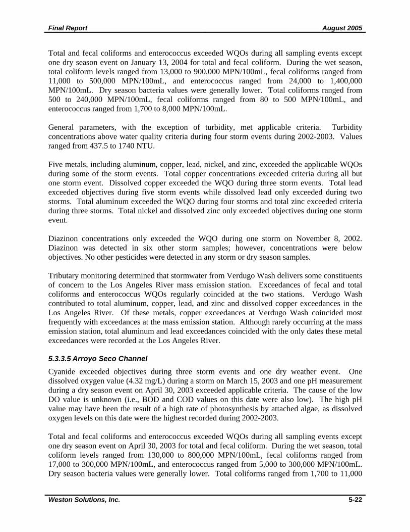
General parameters, with the exception of turbidity, met WQOs. Turbidity levels exceeded objectives during two storm events on November 8, 2002 and December 16, 2002. Four metals, including arsenic, copper, lead, and zinc, exceeded water quality objectives. Total copper exceeded objectives during all but two storm events and two dry weather events while dissolved copper exceeded the WQO during one storm event and two dry weather events. Total zinc exceeded the standard during four storms and a dry season event on October 28, 2003. Total lead exceeded objectives during two storm events. Total arsenic and dissolved lead each exceeded the WQO during one storm event. Diazinon exceeded the WQO during three storm events. Concentrations were detected during two other storm events, however concentrations were below objectives. No other pesticides were detected during any storm or dry weather event. Tributary monitoring determined that stormwater from the Rio Hondo Channel may have contributed to exceedances of some constituents of concern at the Los Angeles River mass emission station. On April 30, 2003, pH levels in Rio Hondo above the standard may have contributed to the pH exceedance in the Los Angeles River. Exceedances of fecal and total coliforms and enterococcus WQOs also regularly coincided at the two stations. Exceedances of total and dissolved copper at Rio Hondo coincided with the majority of exceedances at the mass emission station; total zinc and lead exceedances also coincided, but less frequently. In addition, diazinon levels exceeded the standard at Rio Hondo and the mass emission station on February 11, 2003. 5.3.4 Trash Monitoring Trash monitoring surveys were conducted during the 2002-2003 and 2003-2004 storm seasons. Nine storm events were monitored during 2002-2003 and eight events were monitored during 2003-2004. The sampling results for anthropogenic trash for each year are summarized below. Photos for four storm events, including the first storm, are provided in Appendix D, Figures 9-12. 2002-2003 Sampling Results The first storm event of the season, November 7, 2002, produced the most trash, contributing 42.2% of the total amount collected during the entire season. Commercial land use was the largest contributor during the first storm of the season producing 40% of the total, followed by industrial land use which contributed 36% (Figure 5-11). Open space/parks, high density single family residential and low density single family residential contributed 12%, 9%, and 3%, respectively.
Final Report August 2005
Weston Solutions, Inc. 5-25
Figure 5-11. Percent totals for anthropogenic trash per land use collected in the Los
Angeles River Watershed for the 2002-2003 first storm event.
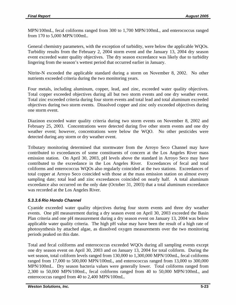
Based on the total amount of trash collected during the entire 2002-2003 storm season, the largest contributors were industrial and commercial land uses producing 46%, and 34%, respectively, (Figure 5-12). Open space/parks and high density single family residential each contributed 9%, while low density single family residential produced only 2%.
Figure 5-12. Percent totals for anthropogenic trash per land use collected in the Los Angeles River Watershed for the 2002-2003 storm season.
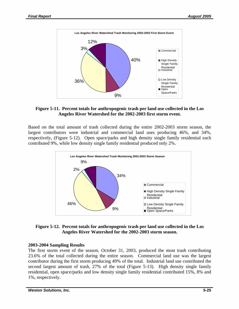
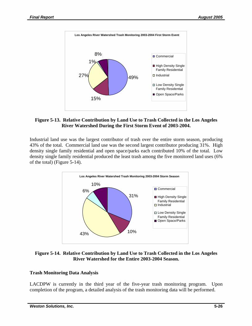
2003-2004 Sampling Results The first storm event of the season, October 31, 2003, produced the most trash contributing 23.6% of the total collected during the entire season. Commercial land use was the largest contributor during the first storm producing 49% of the total. Industrial land use contributed the second largest amount of trash, 27% of the total (Figure 5-13). High density single family residential, open space/parks and low density single family residential contributed 15%, 8% and 1%, respectively.
Los Angeles River Watershed Trash Monitoring 2002-2003 First Storm Event
40%
9%
36%
3%12%
Commercial
High Density Single Family ResidentialIndustrial
Low Density Single Family ResidentialOpenSpace/Parks
Los Angeles River Watershed Trash Monitoring 2002-2003 Storm Season
34%
9%46%
2% 9%
Commercial
High Density Single FamilyResidentialIndustrial
Low Density Single Family ResidentialOpen Space/Parks
Final Report August 2005
Weston Solutions, Inc. 5-26
Figure 5-13. Relative Contribution by Land Use to Trash Collected in the Los Angeles River Watershed During the First Storm Event of 2003-2004.
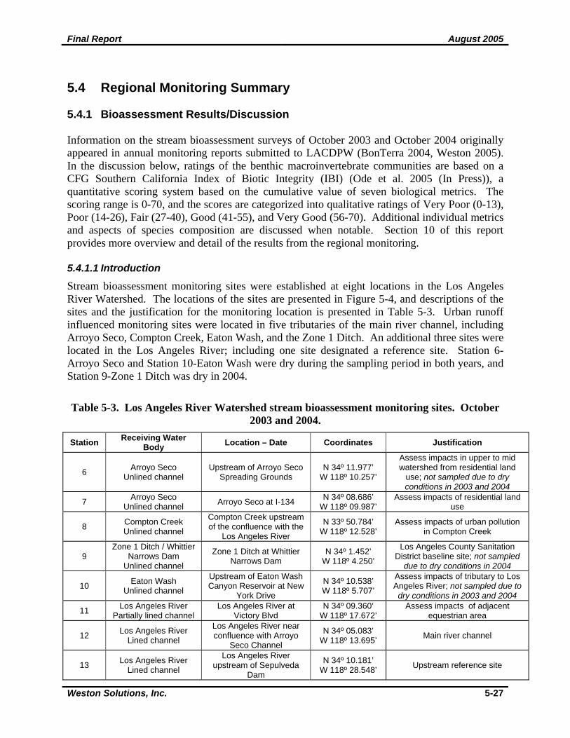
Industrial land use was the largest contributor of trash over the entire storm season, producing 43% of the total. Commercial land use was the second largest contributor producing 31%. High density single family residential and open space/parks each contributed 10% of the total. Low density single family residential produced the least trash among the five monitored land uses (6% of the total) (Figure 5-14).
Figure 5-14. Relative Contribution by Land Use to Trash Collected in the Los Angeles River Watershed for the Entire 2003-2004 Season.
Trash Monitoring Data Analysis LACDPW is currently in the third year of the five-year trash monitoring program. Upon completion of the program, a detailed analysis of the trash monitoring data will be performed.
Los Angeles River Watershed Trash Monitoring 2003-2004 First Storm Event
49%
15%
27%
1% 8% Commercial
High Density Single Family Residential Industrial
Low Density Single Family Residential Open Space/Parks
Los Angeles River Watershed Trash Monitoring 2003-2004 Storm Season
31%
10%43%
6%10%
Commercial
High Density SingleFamily Residential Industrial
Low Density SingleFamily Residential Open Space/Parks
Final Report August 2005
Weston Solutions, Inc. 5-27
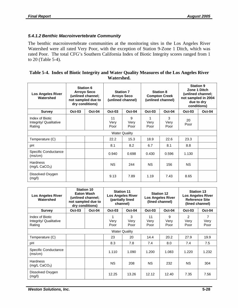
5.4 Regional Monitoring Summary 5.4.1 Bioassessment Results/Discussion Information on the stream bioassessment surveys of October 2003 and October 2004 originally appeared in annual monitoring reports submitted to LACDPW (BonTerra 2004, Weston 2005). In the discussion below, ratings of the benthic macroinvertebrate communities are based on a CFG Southern California Index of Biotic Integrity (IBI) (Ode et al. 2005 (In Press)), a quantitative scoring system based on the cumulative value of seven biological metrics. The scoring range is 0-70, and the scores are categorized into qualitative ratings of Very Poor (0-13), Poor (14-26), Fair (27-40), Good (41-55), and Very Good (56-70). Additional individual metrics and aspects of species composition are discussed when notable. Section 10 of this report provides more overview and detail of the results from the regional monitoring. 5.4.1.1 Introduction
Stream bioassessment monitoring sites were established at eight locations in the Los Angeles River Watershed. The locations of the sites are presented in Figure 5-4, and descriptions of the sites and the justification for the monitoring location is presented in Table 5-3. Urban runoff influenced monitoring sites were located in five tributaries of the main river channel, including Arroyo Seco, Compton Creek, Eaton Wash, and the Zone 1 Ditch. An additional three sites were located in the Los Angeles River; including one site designated a reference site. Station 6-Arroyo Seco and Station 10-Eaton Wash were dry during the sampling period in both years, and Station 9-Zone 1 Ditch was dry in 2004.
Table 5-3. Los Angeles River Watershed stream bioassessment monitoring sites. October 2003 and 2004.
Station Receiving Water Body Location – Date Coordinates Justification
6 Arroyo Seco Unlined channel
Upstream of Arroyo Seco Spreading Grounds
N 34º 11.977’ W 118º 10.257’
Assess impacts in upper to mid watershed from residential land
use; not sampled due to dry conditions in 2003 and 2004
7 Arroyo Seco Unlined channel Arroyo Seco at I-134 N 34º 08.686’
W 118º 09.987’ Assess impacts of residential land
use
8 Compton Creek Unlined channel
Compton Creek upstream of the confluence with the
Los Angeles River
N 33º 50.784’ W 118º 12.528’
Assess impacts of urban pollution in Compton Creek
9 Zone 1 Ditch / Whittier
Narrows Dam Unlined channel
Zone 1 Ditch at Whittier Narrows Dam
N 34º 1.452’ W 118º 4.250’
Los Angeles County Sanitation District baseline site; not sampled
due to dry conditions in 2004
10 Eaton Wash Unlined channel
Upstream of Eaton Wash Canyon Reservoir at New
York Drive
N 34º 10.538’ W 118º 5.707’
Assess impacts of tributary to Los Angeles River; not sampled due to dry conditions in 2003 and 2004
11 Los Angeles River Partially lined channel
Los Angeles River at Victory Blvd
N 34º 09.360’ W 118º 17.672’
Assess impacts of adjacent equestrian area
12 Los Angeles River Lined channel
Los Angeles River near confluence with Arroyo
Seco Channel
N 34º 05.083’ W 118º 13.695’ Main river channel
13 Los Angeles River Lined channel
Los Angeles River upstream of Sepulveda
Dam
N 34º 10.181’ W 118º 28.548’ Upstream reference site
Final Report August 2005
Weston Solutions, Inc. 5-28
5.4.1.2 Benthic Macroinvertebrate Community
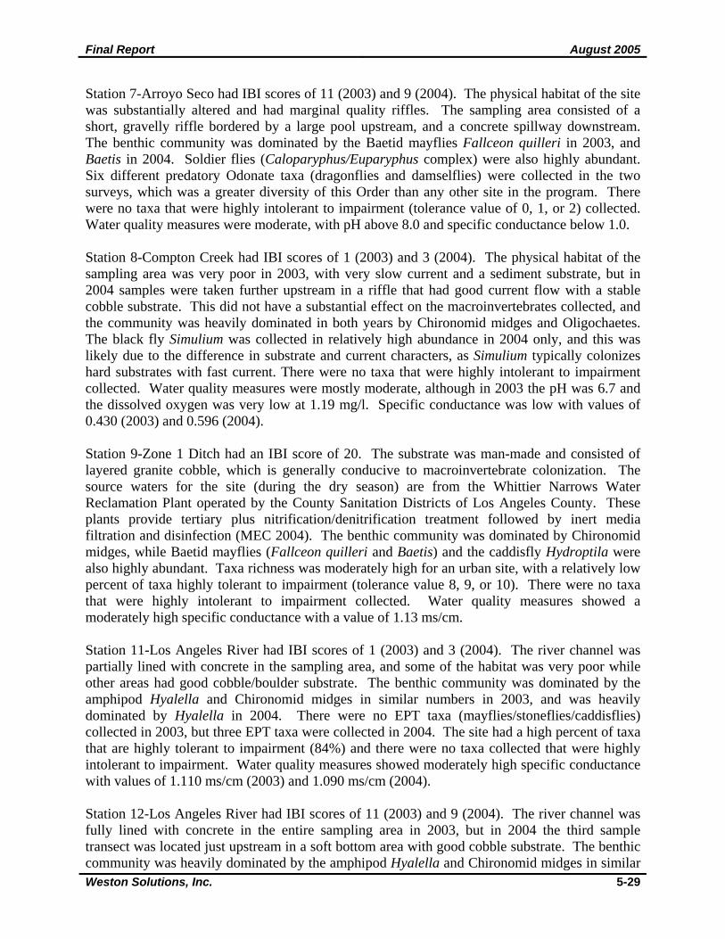
The benthic macroinvertebrate communities at the monitoring sites in the Los Angeles River Watershed were all rated Very Poor, with the exception of Station 9-Zone 1 Ditch, which was rated Poor. The total CFG’s Southern California Index of Biotic Integrity scores ranged from 1 to 20 (Table 5-4).
Table 5-4. Index of Biotic Integrity and Water Quality Measures of the Los Angeles River Watershed.
Los Angeles River Watershed
Station 6 Arroyo Seco
(unlined channel; not sampled due to
dry conditions)
Station 7 Arroyo Seco
(unlined channel)
Station 8 Compton Creek
(unlined channel)
Station 9 Zone 1 Ditch
(unlined channel; not sampled in 2004
due to dry conditions)
Survey Oct-03 Oct-04 Oct-03 Oct-04 Oct-03 Oct-04 Oct-03 Oct-04
Index of Biotic Integrity/ Qualitative Rating
11
Very Poor
9 Very Poor
1 Very Poor
3 Very Poor
20 Poor
Water Quality
Temperature (C) 22.2 15.3 18.9 22.6 23.3
pH 8.1 8.2 6.7 8.1 8.8
Specific Conductance (ms/cm) 0.940 0.698 0.430 0.596 1.130
Hardness (mg/L CaCO3)
NS 244 NS 156 NS
Dissolved Oxygen (mg/l) 9.13 7.89 1.19 7.43 8.65
Los Angeles River Watershed
Station 10 Eaton Wash
(unlined channel; not sampled due to
dry conditions)
Station 11 Los Angeles River
(partially lined channel)
Station 12 Los Angeles River
(lined channel)
Station 13 Los Angeles River
Reference Site (lined channel)
Survey Oct-03 Oct-04 Oct-03 Oct-04 Oct-03 Oct-04 Oct-03 Oct-04
Index of Biotic Integrity/ Qualitative Rating
1
Very Poor
3 Very Poor
11 Very Poor
9 Very Poor
2 Very Poor
7 Very Poor
Water Quality Temperature (C) 23 20 14.4 20.2 27.9 19.9
pH 8.3 7.8 7.4 8.0 7.4 7.5
Specific Conductance (ms/cm) 1.110 1.090 1.200 1.083 1.220 1.232
Hardness (mg/L CaCO3)
NS 208 NS 232 NS 304
Dissolved Oxygen (mg/l) 12.25 13.26 12.12 12.40 7.35 7.56
Final Report August 2005
Weston Solutions, Inc. 5-29
Station 7-Arroyo Seco had IBI scores of 11 (2003) and 9 (2004). The physical habitat of the site was substantially altered and had marginal quality riffles. The sampling area consisted of a short, gravelly riffle bordered by a large pool upstream, and a concrete spillway downstream. The benthic community was dominated by the Baetid mayflies Fallceon quilleri in 2003, and Baetis in 2004. Soldier flies (Caloparyphus/Euparyphus complex) were also highly abundant. Six different predatory Odonate taxa (dragonflies and damselflies) were collected in the two surveys, which was a greater diversity of this Order than any other site in the program. There were no taxa that were highly intolerant to impairment (tolerance value of 0, 1, or 2) collected. Water quality measures were moderate, with pH above 8.0 and specific conductance below 1.0. Station 8-Compton Creek had IBI scores of 1 (2003) and 3 (2004). The physical habitat of the sampling area was very poor in 2003, with very slow current and a sediment substrate, but in 2004 samples were taken further upstream in a riffle that had good current flow with a stable cobble substrate. This did not have a substantial effect on the macroinvertebrates collected, and the community was heavily dominated in both years by Chironomid midges and Oligochaetes. The black fly Simulium was collected in relatively high abundance in 2004 only, and this was likely due to the difference in substrate and current characters, as Simulium typically colonizes hard substrates with fast current. There were no taxa that were highly intolerant to impairment collected. Water quality measures were mostly moderate, although in 2003 the pH was 6.7 and the dissolved oxygen was very low at 1.19 mg/l. Specific conductance was low with values of 0.430 (2003) and 0.596 (2004). Station 9-Zone 1 Ditch had an IBI score of 20. The substrate was man-made and consisted of layered granite cobble, which is generally conducive to macroinvertebrate colonization. The source waters for the site (during the dry season) are from the Whittier Narrows Water Reclamation Plant operated by the County Sanitation Districts of Los Angeles County. These plants provide tertiary plus nitrification/denitrification treatment followed by inert media filtration and disinfection (MEC 2004). The benthic community was dominated by Chironomid midges, while Baetid mayflies (Fallceon quilleri and Baetis) and the caddisfly Hydroptila were also highly abundant. Taxa richness was moderately high for an urban site, with a relatively low percent of taxa highly tolerant to impairment (tolerance value 8, 9, or 10). There were no taxa that were highly intolerant to impairment collected. Water quality measures showed a moderately high specific conductance with a value of 1.13 ms/cm. Station 11-Los Angeles River had IBI scores of 1 (2003) and 3 (2004). The river channel was partially lined with concrete in the sampling area, and some of the habitat was very poor while other areas had good cobble/boulder substrate. The benthic community was dominated by the amphipod Hyalella and Chironomid midges in similar numbers in 2003, and was heavily dominated by Hyalella in 2004. There were no EPT taxa (mayflies/stoneflies/caddisflies) collected in 2003, but three EPT taxa were collected in 2004. The site had a high percent of taxa that are highly tolerant to impairment (84%) and there were no taxa collected that were highly intolerant to impairment. Water quality measures showed moderately high specific conductance with values of 1.110 ms/cm (2003) and 1.090 ms/cm (2004). Station 12-Los Angeles River had IBI scores of 11 (2003) and 9 (2004). The river channel was fully lined with concrete in the entire sampling area in 2003, but in 2004 the third sample transect was located just upstream in a soft bottom area with good cobble substrate. The benthic community was heavily dominated by the amphipod Hyalella and Chironomid midges in similar
Final Report August 2005
Weston Solutions, Inc. 5-30
numbers in both survey years. The Baetid mayflies Baetis and Fallceon quilleri, as well as flatworms were collected in moderate numbers. Taxa richness was the lowest of the Los Angeles River Watershed sites, and there were no taxa collected that were highly intolerant to impairment. Water quality measures (except temperature) were similar to Station 11, and showed moderately high specific conductance, with values of 1.200 ms/cm (2003) and 1.083 ms/cm (2004). Station 13-Los Angeles River, a designated reference site, had IBI scores of 2 (2003) and 7 (2004). The river channel was lined with a concrete/rip rap mix with some loose cobble in the sampling area. The benthic community was heavily dominated by Chironomid midges in 2003, and there was an even mix of Chironomids and Hyalella in 2004. Oligochaetes and Ostracods were abundant in 2003, and the Baetid mayflies Baetis and Fallceon quilleri were abundant in 2004. Taxa richness was relatively low, and there were no taxa collected that were highly intolerant to impairment. Water quality measures were similar to Stations 11 and 12, and showed moderately high specific conductance with values of 1.220 ms/cm (2003) and 1.232 ms/cm (2004). 5.4.1.3 Relationship of Bioassessment to Constituents of Concern
Data from the mass emissions stations, summarized in Section 5.3, were used to identify possible relationships between constituents of concern and impacts to the benthic macroinvertebrate communities. Additional impairments identified in the 303(d) listing were not considered here due to a lack of available recent data. All of the mass emissions monitoring stations in the Los Angeles River Watershed recorded very high levels of bacteria (total and fecal coliform, and enterococcus) and while bacteria themselves likely did not directly impact the benthic community, they generally indicate other water quality issues such as elevated fine organic matter or nutrients that could degrade the system. Bioassessment Station 7-Arroyo Seco was located upstream of the Arroyo Seco tributary mass emissions station TS05 (Figure 5-4). Since the bioassessment site was located upstream of TS05 as well as a majority of the city of Pasadena, the TS05 data likely represent significant amounts of runoff from the watershed that did not affect the Arroyo Seco bioassessment site. The benthic community in Arroyo Seco was rated Very Poor, and the physical habitat of the sampling area was also poor. Several constituents at the TS05 station exceeded water quality objectives. Metals that exceeded WQOs included total aluminum, copper, lead, and zinc and dissolved copper and zinc (Appendix F, Table 2). High concentrations of heavy metals have long been known to negatively impact macroinvertebrate communities (e.g., Winner et al. 1980). Cyanide and diazinon also exceeded WQOs. Bioassessment Station 8-Compton Creek was located upstream of the Los Angeles River mass emissions station S10 (Figure 5-4). Since the bioassessment site was located upstream of S10 in a tributary to the main channel of the Los Angeles River, mass emissions data likely represent large areas of the watershed that did not affect the Compton Creek bioassessment site. The benthic community in Compton Creek was rated Very Poor, and the physical habitat of the sampling area was poor in 2003 and fair in 2004. Several constituents in the Los Angeles River exceeded water quality objectives. Metals that exceeded WQOs included total aluminum and total and dissolved copper, lead, and zinc. Cyanide, total dissolved solids, and oil and grease frequently exceeded water quality objectives.
Final Report August 2005
Weston Solutions, Inc. 5-31
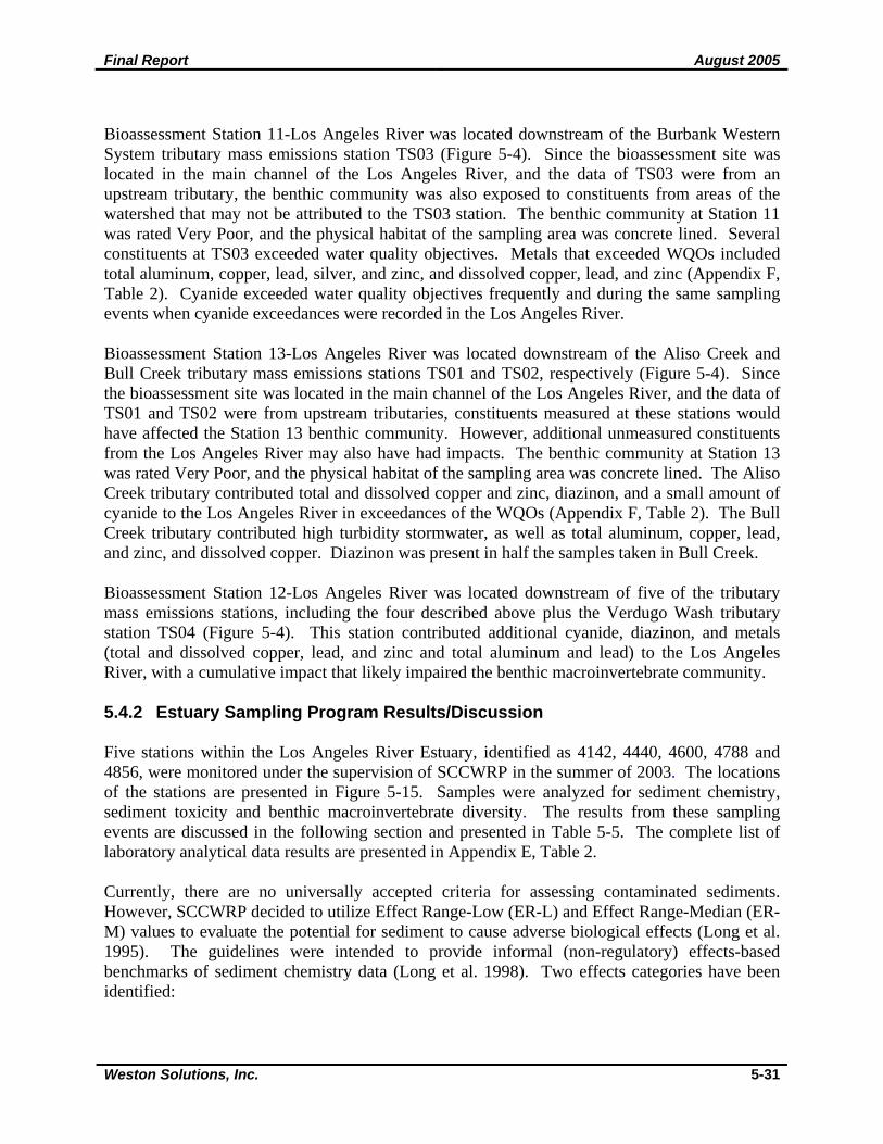
Bioassessment Station 11-Los Angeles River was located downstream of the Burbank Western System tributary mass emissions station TS03 (Figure 5-4). Since the bioassessment site was located in the main channel of the Los Angeles River, and the data of TS03 were from an upstream tributary, the benthic community was also exposed to constituents from areas of the watershed that may not be attributed to the TS03 station. The benthic community at Station 11 was rated Very Poor, and the physical habitat of the sampling area was concrete lined. Several constituents at TS03 exceeded water quality objectives. Metals that exceeded WQOs included total aluminum, copper, lead, silver, and zinc, and dissolved copper, lead, and zinc (Appendix F, Table 2). Cyanide exceeded water quality objectives frequently and during the same sampling events when cyanide exceedances were recorded in the Los Angeles River. Bioassessment Station 13-Los Angeles River was located downstream of the Aliso Creek and Bull Creek tributary mass emissions stations TS01 and TS02, respectively (Figure 5-4). Since the bioassessment site was located in the main channel of the Los Angeles River, and the data of TS01 and TS02 were from upstream tributaries, constituents measured at these stations would have affected the Station 13 benthic community. However, additional unmeasured constituents from the Los Angeles River may also have had impacts. The benthic community at Station 13 was rated Very Poor, and the physical habitat of the sampling area was concrete lined. The Aliso Creek tributary contributed total and dissolved copper and zinc, diazinon, and a small amount of cyanide to the Los Angeles River in exceedances of the WQOs (Appendix F, Table 2). The Bull Creek tributary contributed high turbidity stormwater, as well as total aluminum, copper, lead, and zinc, and dissolved copper. Diazinon was present in half the samples taken in Bull Creek. Bioassessment Station 12-Los Angeles River was located downstream of five of the tributary mass emissions stations, including the four described above plus the Verdugo Wash tributary station TS04 (Figure 5-4). This station contributed additional cyanide, diazinon, and metals (total and dissolved copper, lead, and zinc and total aluminum and lead) to the Los Angeles River, with a cumulative impact that likely impaired the benthic macroinvertebrate community. 5.4.2 Estuary Sampling Program Results/Discussion Five stations within the Los Angeles River Estuary, identified as 4142, 4440, 4600, 4788 and 4856, were monitored under the supervision of SCCWRP in the summer of 2003. The locations of the stations are presented in Figure 5-15. Samples were analyzed for sediment chemistry, sediment toxicity and benthic macroinvertebrate diversity. The results from these sampling events are discussed in the following section and presented in Table 5-5. The complete list of laboratory analytical data results are presented in Appendix E, Table 2. Currently, there are no universally accepted criteria for assessing contaminated sediments. However, SCCWRP decided to utilize Effect Range-Low (ER-L) and Effect Range-Median (ER-M) values to evaluate the potential for sediment to cause adverse biological effects (Long et al. 1995). The guidelines were intended to provide informal (non-regulatory) effects-based benchmarks of sediment chemistry data (Long et al. 1998). Two effects categories have been identified:
Final Report August 2005
Weston Solutions, Inc. 5-32
Figure 5-15. Los Angeles River Estuary Sampling Stations.
Final Report August 2005
Weston Solutions, Inc. 5-33
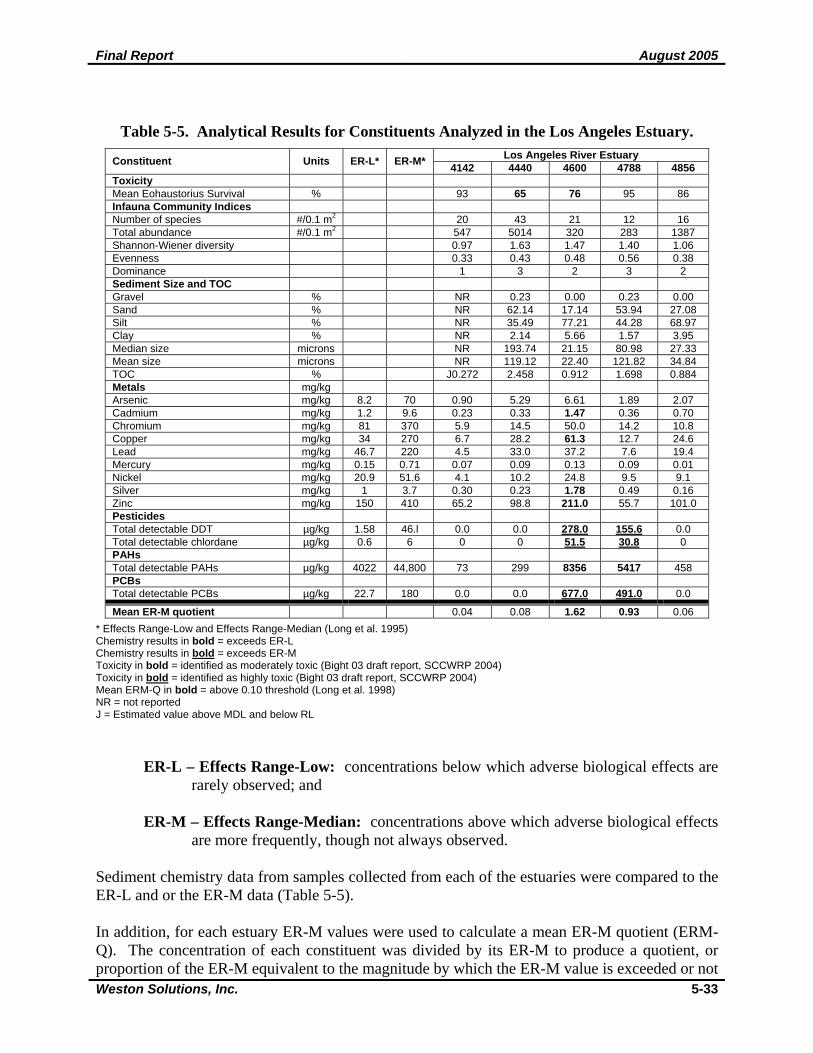
Table 5-5. Analytical Results for Constituents Analyzed in the Los Angeles Estuary. Los Angeles River Estuary Constituent Units ER-L* ER-M* 4142 4440 4600 4788 4856
Toxicity Mean Eohaustorius Survival % 93 65 76 95 86 Infauna Community Indices Number of species #/0.1 m2 20 43 21 12 16 Total abundance #/0.1 m2 547 5014 320 283 1387 Shannon-Wiener diversity 0.97 1.63 1.47 1.40 1.06 Evenness 0.33 0.43 0.48 0.56 0.38 Dominance 1 3 2 3 2 Sediment Size and TOC Gravel % NR 0.23 0.00 0.23 0.00 Sand % NR 62.14 17.14 53.94 27.08 Silt % NR 35.49 77.21 44.28 68.97 Clay % NR 2.14 5.66 1.57 3.95 Median size microns NR 193.74 21.15 80.98 27.33 Mean size microns NR 119.12 22.40 121.82 34.84 TOC % J0.272 2.458 0.912 1.698 0.884 Metals mg/kg Arsenic mg/kg 8.2 70 0.90 5.29 6.61 1.89 2.07 Cadmium mg/kg 1.2 9.6 0.23 0.33 1.47 0.36 0.70 Chromium mg/kg 81 370 5.9 14.5 50.0 14.2 10.8 Copper mg/kg 34 270 6.7 28.2 61.3 12.7 24.6 Lead mg/kg 46.7 220 4.5 33.0 37.2 7.6 19.4 Mercury mg/kg 0.15 0.71 0.07 0.09 0.13 0.09 0.01 Nickel mg/kg 20.9 51.6 4.1 10.2 24.8 9.5 9.1 Silver mg/kg 1 3.7 0.30 0.23 1.78 0.49 0.16 Zinc mg/kg 150 410 65.2 98.8 211.0 55.7 101.0 Pesticides Total detectable DDT µg/kg 1.58 46.l 0.0 0.0 278.0 155.6 0.0 Total detectable chlordane µg/kg 0.6 6 0 0 51.5 30.8 0 PAHs Total detectable PAHs µg/kg 4022 44,800 73 299 8356 5417 458 PCBs Total detectable PCBs µg/kg 22.7 180 0.0 0.0 677.0 491.0 0.0
Mean ER-M quotient 0.04 0.08 1.62 0.93 0.06 * Effects Range-Low and Effects Range-Median (Long et al. 1995) Chemistry results in bold = exceeds ER-L Chemistry results in bold = exceeds ER-M Toxicity in bold = identified as moderately toxic (Bight 03 draft report, SCCWRP 2004) Toxicity in bold = identified as highly toxic (Bight 03 draft report, SCCWRP 2004) Mean ERM-Q in bold = above 0.10 threshold (Long et al. 1998) NR = not reported J = Estimated value above MDL and below RL
ER-L – Effects Range-Low: concentrations below which adverse biological effects are rarely observed; and
ER-M – Effects Range-Median: concentrations above which adverse biological effects
are more frequently, though not always observed. Sediment chemistry data from samples collected from each of the estuaries were compared to the ER-L and or the ER-M data (Table 5-5). In addition, for each estuary ER-M values were used to calculate a mean ER-M quotient (ERM-Q). The concentration of each constituent was divided by its ER-M to produce a quotient, or proportion of the ER-M equivalent to the magnitude by which the ER-M value is exceeded or not
Final Report August 2005
Weston Solutions, Inc. 5-34
exceeded. The mean ERM-Q for each embayment was then calculated by summing the ERM-Qs for each constituent and then dividing by the total number of ERM-Qs assessed. ERM-Qs were not calculated for constituents below the detection limit and thus were not used in the generation of the mean ERM-Q. The mean ERM-Q thus represents an assessment for each embayment of the cumulative sediment chemistry relative to the threshold values. In this way, the cumulative risks of effect to the benthic community can provide a mechanism to compare embayments. This method has been used and evaluated by several researchers (Hyland et al. 1999, Carr et al. 1996, Chapman 1996, and Long et al. 1995) throughout the country. The aggregate approach using an ERM-Q is a more reliable predictor of potential toxicity but should not be used to infer causality of specific contaminants. ER-L and ER-M values were originally derived to be broadly applicable and they cannot account for site-specific features that may affect their applicability on a more local or regional level. Local differences in geomorphology can result in chemicals being more or less available and therefore more or less toxic than an ER-L or ER-M value might indicate. Additionally, some regions of the country are naturally enriched in certain metals and local organisms have become adapted. Sediment Chemistry. Sediments were analyzed for four groups of constituents: metals, pesticides, PAHs and PCBs. Four metals, including cadmium, copper, silver, and zinc exceeded the ER-L at one station, 4600, within the Los Angeles River Estuary. Copper and zinc exceedances have been consistently observed at the mass emission station, suggesting a possible connection between COCs at the mass emission station and within the estuary. There were detections of all other metals at all stations; however, concentrations were below the ER-L and ER-M values. The only pesticides with concentrations above ER-M values were total detectable DDT and total detectable chlordane. Total detectable DDT exceeded the ER-M at two stations, 4600 and 4788, with values of 278 and 155.6 µg/kg, respectively. Total detectable DDT was not detected at the other three stations. Total detectable chlordane exceeded the ER-M at the same two stations, with values of 51.5 and 30.8 µg/kg, respectively. Total detectable chlordane was not detected at the other three stations. Total detectable PAHs exceeded the ER-L at two of the five stations, 4600 and 4788, with concentrations of 8,356 and 5,417 µg/kg, respectively. Total detectable PCBs exceeded the ER-M at the same two stations with values of 677 and 491 µg/kg, respectively. Stations 4600 and 4788 had mean ERM-Q values above the 0.10 threshold, with values of 1.62 and 0.93, respectively. The other three stations had mean ERM-Q values below 0.10, ranging from 0.04 to 0.08. Two of the stations displayed similar patterns of exceedances in the Los Angeles River Estuary. Stations 4600 and 4788 exceeded the ER-M for total detectable DDT, total detectable chlordane, total detectable PAHs and total detectable PCBs. These stations also had the highest mean ERM-Q values. Station 4600 had a few additional exceedances for four metals and it had the second lowest mean percent survival of E. estuarius (see below). Station 4600 was located in the middle of the estuary, and station 4788 was located in the upper section of the estuary.
Final Report August 2005
Weston Solutions, Inc. 5-35
Sediment Toxicity. The mean percent survival of the test organism, E. estuarius, exposed to Los Angeles River Estuary sediments ranged from 65 to 95%. Percent survival was the lowest at stations 4440 and 4600 with values of 65% and 76%, respectively. These values suggest that the Los Angeles River Estuary sediments in these areas are highly toxic to the test organisms (Bight 03 draft report, SCCWRP 2004). The mean percent survival of E. estuarius at stations 4142, 4788 and 4856 were 93%, 95% and 86%, respectively, suggesting that the sediments in these areas were not toxic to the test organisms. Benthic Community Structure. Total abundance ranged from 283 to 5014 organisms/0.1m2 and the total number of species ranged from 12 to 43 organisms/0.1m2. Total abundance and total number of species were greatest at Station 4440 and lowest at station 4788. Species diversity was highest at station 4440 and lowest at station 4142. Evenness values ranged from 0.33 at station 4142 to 0.56 at station 4788. Dominance values ranged from 1 to 3. Sediment Size. Sand and silt were the dominant sediment constituents at four of the stations (data was not reported for station 4142). Sand dominated the sediment composition at stations 4440 and 4788, followed by silt. Sediments at stations 4600 and 4856 were dominated by silt, followed by sand. Median grain size ranged from 21.15 to 193.74 microns. Station 4440 had the largest median grain size and the highest TOC content (2.46%). 5.5 Conclusions Water quality monitoring at the mass emission site in the Los Angeles River has identified several constituents that persistently exceeded WQOs during the past ten years. These COCs include cyanide, indicator bacteria, copper, lead and zinc. Other metals, such as aluminum and cadmium sporadically exceeded WQOs during the same time period. Regression analyses showed that alkalinity and bicarbonate were the only two constituents with increasing trends over the period of record. Water quality results at the tributary monitoring sites are summarized in Figure 5-16. Figure 5-16 displays wet and dry season sampling dates that the Los Angeles River and its tributaries were monitored congruently and lists some constituents of concern that exceeded applicable standards at the mass emission station. If tributaries exceeded the standard on a common sampling date, they are listed in the table as well. The table shows that cyanide, bacteria, total copper, and total lead exceeded WQOs on nearly every monitoring date and that the exceedances occurred at most, if not all tributaries. The Burbank Western System and the Rio Hondo Channel were the tributaries that were associated most frequently with the cyanide exceedances. The Verdugo Wash and Rio Hondo were associated with the majority of these exceedances that involved metals. These results are further summarized on Figures 5-17 and 5-18 which represent the magnitude of exceedance of the WQO for bacteriological indicators and selected metals, respectively.
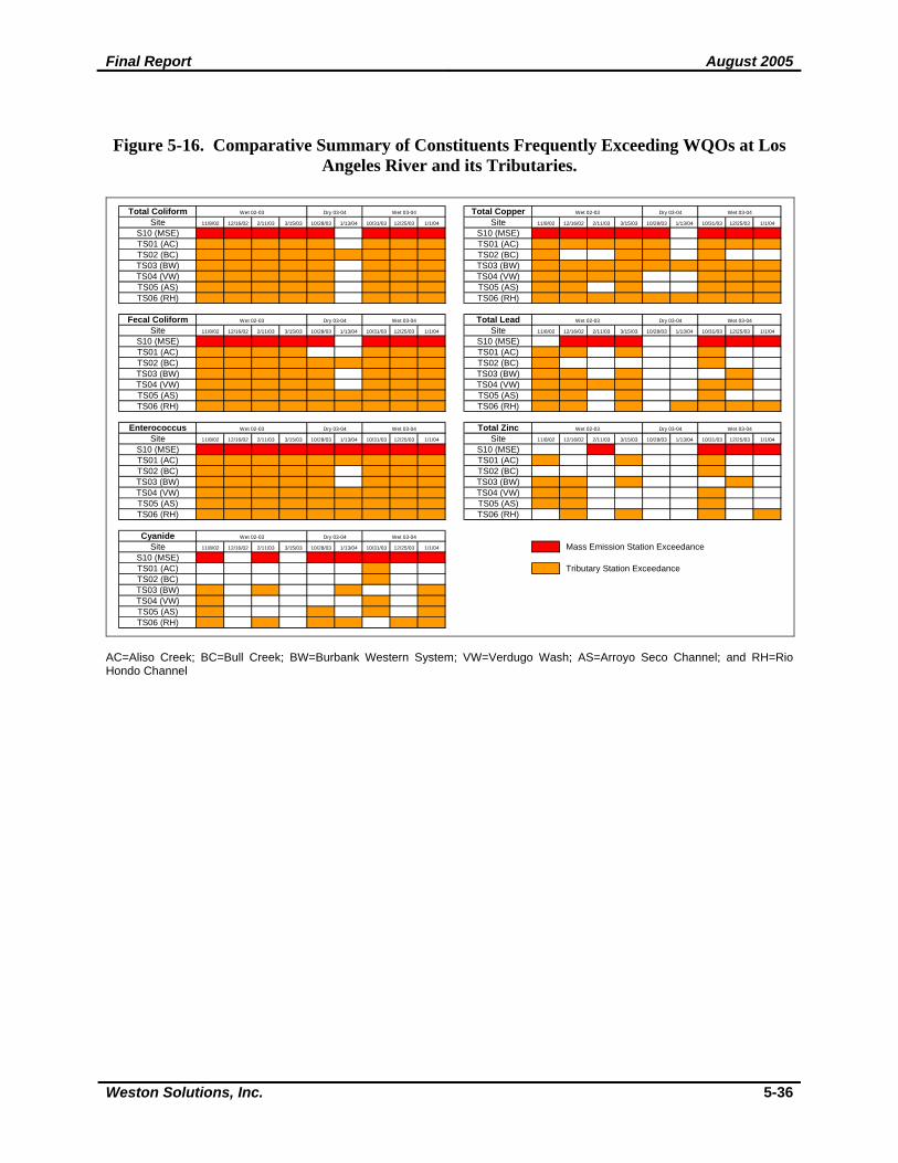
Final Report August 2005
Weston Solutions, Inc. 5-36
Figure 5-16. Comparative Summary of Constituents Frequently Exceeding WQOs at Los Angeles River and its Tributaries.
Total Coliform Total CopperSite 11/8/02 12/16/02 2/11/03 3/15/03 10/28/03 1/13/04 10/31/03 12/25/03 1/1/04 Site 11/8/02 12/16/02 2/11/03 3/15/03 10/28/03 1/13/04 10/31/03 12/25/03 1/1/04
S10 (MSE) 1 1 1 1 1 0 1 1 1 S10 (MSE) 1 1 1 1 1 0 1 1 1
TS01 (AC) 1 1 1 1 1 0 1 1 1 TS01 (AC) 1 1 1 1 1 0 1 1 1
TS02 (BC) 1 1 1 1 1 1 1 1 1 TS02 (BC) 1 0 0 1 1 0 1 0 0
TS03 (BW) 1 1 1 1 1 0 1 1 1 TS03 (BW) 1 1 1 1 1 1 1 1 1
TS04 (VW) 1 1 1 1 1 0 1 1 1 TS04 (VW) 1 1 1 1 0 0 1 1 1
TS05 (AS) 1 1 1 1 1 0 1 1 1 TS05 (AS) 1 1 0 1 0 0 1 1 1
TS06 (RH) 1 1 1 1 1 0 1 1 1 TS06 (RH) 1 1 1 1 1 1 1 1 1
Fecal Coliform Total LeadSite 11/8/02 12/16/02 2/11/03 3/15/03 10/28/03 1/13/04 10/31/03 12/25/03 1/1/04 Site 11/8/02 12/16/02 2/11/03 3/15/03 10/28/03 1/13/04 10/31/03 12/25/03 1/1/04
S10 (MSE) 1 1 1 1 1 0 1 1 1 S10 (MSE) 0 1 1 1 0 0 1 1 1
TS01 (AC) 1 1 1 1 0 0 1 1 1 TS01 (AC) 1 1 0 1 0 0 1 0 0
TS02 (BC) 1 1 1 1 1 1 1 1 1 TS02 (BC) 1 0 0 0 0 0 1 0 0
TS03 (BW) 1 1 1 1 1 0 1 1 1 TS03 (BW) 1 1 0 1 0 0 0 1 0
TS04 (VW) 1 1 1 1 1 0 1 1 1 TS04 (VW) 1 1 1 1 0 0 1 1 0
TS05 (AS) 1 1 1 1 1 1 1 1 1 TS05 (AS) 1 1 0 1 0 0 1 0 0
TS06 (RH) 1 1 1 1 1 1 1 1 1 TS06 (RH) 1 1 0 1 0 1 1 1 1
Enterococcus Total ZincSite 11/8/02 12/16/02 2/11/03 3/15/03 10/28/03 1/13/04 10/31/03 12/25/03 1/1/04 Site 11/8/02 12/16/02 2/11/03 3/15/03 10/28/03 1/13/04 10/31/03 12/25/03 1/1/04
S10 (MSE) 1 1 1 1 1 1 1 1 1 S10 (MSE) 0 0 1 0 0 0 1 1 1
TS01 (AC) 1 1 1 1 1 1 1 1 1 TS01 (AC) 1 0 0 1 0 0 1 0 0
TS02 (BC) 1 1 1 1 1 0 1 1 1 TS02 (BC) 0 0 0 0 0 0 1 0 0
TS03 (BW) 1 1 1 1 1 0 1 1 1 TS03 (BW) 1 1 0 1 0 0 0 1 0
TS04 (VW) 1 1 1 1 1 1 1 1 1 TS04 (VW) 1 1 0 0 0 0 1 0 0
TS05 (AS) 1 1 1 1 1 1 1 1 1 TS05 (AS) 1 1 0 0 0 0 1 0 0
TS06 (RH) 1 1 1 1 1 1 1 1 1 TS06 (RH) 0 1 0 1 0 0 1 0 1
CyanideSite 11/8/02 12/16/02 2/11/03 3/15/03 10/28/03 1/13/04 10/31/03 12/25/03 1/1/04 Mass Emission Station Exceedance
S10 (MSE) 1 0 1 0 1 1 1 1 1
TS01 (AC) 0 0 0 0 0 0 1 0 0 Tributary Station ExceedanceTS02 (BC) 0 0 0 0 0 0 1 0 0
TS03 (BW) 1 0 1 0 0 1 0 0 1
TS04 (VW) 1 0 0 0 0 0 1 0 1
TS05 (AS) 1 0 0 0 1 0 1 0 1
TS06 (RH) 1 0 1 0 1 1 0 1 1
Wet 02-03 Dry 03-04 Wet 03-04
Wet 02-03 Dry 03-04 Wet 03-04
Wet 02-03 Dry 03-04 Wet 03-04
Wet 02-03 Dry 03-04 Wet 03-04
Wet 02-03 Dry 03-04 Wet 03-04
Wet 02-03 Dry 03-04 Wet 03-04
Wet 02-03 Dry 03-04 Wet 03-04
AC=Aliso Creek; BC=Bull Creek; BW=Burbank Western System; VW=Verdugo Wash; AS=Arroyo Seco Channel; and RH=Rio Hondo Channel
Final Report August 2005
Weston Solutions, Inc. 5-37
Figure 5-17. Summary of Magnitude of Exceedance of Water Quality Objectives for
Bacteriological Indicators at the Los Angeles River Tributary Stations.
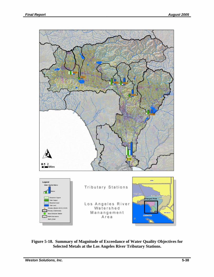
Final Report August 2005
Weston Solutions, Inc. 5-38
Figure 5-18. Summary of Magnitude of Exceedance of Water Quality Objectives for
Selected Metals at the Los Angeles River Tributary Stations.
Final Report August 2005
Weston Solutions, Inc. 5-39
The magnitude of exceedance (Water Quality Ratios) for bacteriological indicators for the tributary stations is compared to the mass emission station on Figure 5-17. The magnitude of exceedance is presented at each of the tributary stations based on the ratio of the mean concentrations for all the sampling events to date, to the applicable water quality objective. For bacteriological indicators, the magnitude of exceedance of the WQO is similar for all the tributaries and the mass emission station. No one or set of tributaries appear to be a primary source of bacterial indicator exceedances based on concentration. Comparisons of the loadings from each tributary are presented in Conclusions Section (Section 12) of this report. Figure 5-18 presents the magnitude of exceedance (Water Quality Ratios) for the selected metals at the tributary stations and the mass emission station. The metals shown include dissolved copper, total copper, total zinc and total lead. These metals were selected because they were consistently detected at concentrations above the WQO in many of the tributaries and the mass emission station. The magnitude of exceedance is presented at each of the tributary stations based on the ratio of the mean concentrations for all the sampling events to date, to the applicable water quality objective. For these metals, the magnitude of exceedance of the WQO is relatively lower at the furthest upstream locations of Aliso Creek and Bull Creek stations compared to downstream tributaries. Exceedances of the WQO for the selected metals was greatest at the mass emissions station which is located well downstream of any of the tributary stations, and therefore receives the greatest amount of overall contributions. The tributary stations that had higher magnitude of exceedances are located at relatively larger subwatersheds with a significant proportion of the watershed urbanized. Comparisons of the loadings from each tributary are presented in Conclusions Section (Section 12) of this report. Trash monitoring during the 2002-2003 and 2003-2004 storm seasons identified the amounts of trash flowing into the storm drain system by contributing land use in the Los Angeles River Watershed. For both seasons, the first storm event of the season produced the most amount of trash. Commercial land use was largest contributor of trash, followed by industrial for the first storm of both storm seasons. Based on results for each storm season, industrial land use was the largest contributor of trash, followed by commercial land use. Low density single family produced the least amount of trash during both storm seasons. Stream bioassessment monitoring surveys were conducted in October 2003 and October 2004. Bioassessment monitoring sites were located at eight monitoring reaches in the Los Angeles River Watershed to assess biological integrity and to detect biological trends and responses to pollution in receiving waters throughout the region. Three of the sites were located in the main channel of the Los Angeles River, and five of the sites were located in tributaries, including Arroyo Seco, Compton Creek, Eaton Wash, and the Zone 1 Ditch. Two of the sites, Station 6-Arroyo Seco and Station 10 Eaton Wash were dry in both of the survey years, and one site, Station 9-Zone 1 Ditch, was dry in 2004. The benthic macroinvertebrate communities of all of the sites in the Los Angeles River Watershed had Index of Biotic Integrity scores between 1 and 20, and quality ratings of Very Poor and Poor. Station 9-Zone 1 Ditch was the highest rated site in the Watershed, and was the only site rated Poor. Station 13-Los Angeles River, which was designated as an upstream reference site, had IBI scores of 2 and 7 and was rated Very Poor.
Final Report August 2005
Weston Solutions, Inc. 5-40
The Los Angeles River Estuary was monitored to estimate the extent and magnitude of ecological change in the SCB and to determine the mass balance of pollutants that currently reside within the SCB. Sediments from five stations within the estuary were analyzed for chemistry, toxicity and benthic macroinvertebrate diversity. The results of the chemistry assessment indicated that four metals were detected above ER-L values at one station. Total detectable PAHs exceeded the ER-L at two stations, and total detectable DDT, total detectable chlordane and total detectable PCBs exceeded the ER-M at two stations within the estuary. These two stations had mean ERM-Q values above the 0.10 threshold. Sediment toxicity was determined to be highly toxic to the test organisms at these two stations.