Embed Size (px)
Citation preview

4.8-1 UC Davis Crystal Lake Alumni Camp Draft EIR
SECTION 4.8
CULTURAL RESOURCES
4.8.1 INTRODUCTION
This section focuses on cultural resources in relation to the project and its action alternatives. It discusses
the affected environment and potential environmental impacts as they relate to the project. It offers an
analysis of potential impacts for the project, a list of mitigation measures that may be implemented to
avoid or offset potential impacts, and an analysis of potential cumulative effects to cultural resources.
Information and analysis presented in this section is based on a records and literature review, site survey,
and site visits conducted from Fall 2012 through Summer 2015.
Cultural resources may be defined as any building, structure, object or location of past human activity,
occupation or use that may be identified through documentary evidence, archaeological inventory, or
oral history. Cultural resources may include archaeological sites, traditional properties, and/or structures
within the built environment.
In response to the Notice of Preparation of this EIR, comments were received and additional follow-up is
continuing with the United Auburn Indian Community (UAIC) of the Auburn Rancheria. The UAIC has
expressed interest in preserving archaeological resources at the project site and additional research
regarding the identified resources and the potential for other resources to be identified at the project site.
4.8.1.1 Study Area
For cultural resources considerations, the study area includes all lands that will be used to develop the
proposed project, including the 210-acre project site and the Crystal Lake Road. The off-site areas under
consideration include land along the Crystal Lake access road and surrounding areas that could be
visited by guests to the proposed UC Davis alumni camp.
4.8.1.2 Information Sources
Existing conditions within the proposed project site as they relate to known and previously undiscovered
cultural resources were determined with the following data collection methods:
An archival and record search was conducted at the North Central Information Center of the
California Historical Resources Information System at California State University, Sacramento;
A review of archival materials for Placer County on file at the Sierra and Central Valley Division
of Pacific Legacy, Inc., located in El Dorado Hills, California was examined;
4.8 Cultural Resources
4.8-2 UC Davis Crystal Lake Alumni Camp Draft EIR
A search of the Sacred Lands File maintained by the Native American Heritage Commission was
undertaken;
An intensive, pedestrian archaeological survey of the 210-acre project site was conducted during
Summer 2014; and
Meetings with the United Auburn Indian Community (UAIC) were held during Summer 2015 to
consult and gather information regarding UAIC concerns about the project, the presence of
Native American cultural resources within the project site, and mitigation measures that could be
implemented to reduce potential impacts to less than significant levels per §15064.5 of State
CEQA Guidelines.
4.8.2 ENVIRONMENTAL SETTING
A summary discussion of the environmental and cultural setting (the prehistoric and historical cultural
background of the proposed project area), is presented in the following sections so that the contexts for
known and previously undiscovered cultural resources within the project area may be better understood.
These contexts are presented in three sections, beginning with a summary of the natural environment
within and surrounding the project site. That is followed by brief review of Native American
ethnographic and prehistoric archaeological contexts for the region. Finally, a summary of the historical
period occupation and use of the proposed project area and surrounding region is offered.
4.8.2.1 Natural Environmental Setting
The approximately 210-acre Crystal Lake property and the two-mile long access road from Interstate 80
are located on the west slope of the Sierra Nevada approximately 13 miles from the crest of the mountain
range at approximately 6,000 feet above sea level. The topography of the property and nearby areas
consist of steep mountain peaks with areas of open granite outcroppings. This is a mid-level elevation
zone of the Sierra Nevada, between the high country of the Sierra Nevada Batholith (granitic) and the
deeply eroded Mehrten formation of the Rubicon River canyon. Precipitation (rain and snow) falls
primarily between the months of November and April, which flows into streams, rivers, and lakes. The
habitat is Sierran Montane Forest (Kuchler 1997) and corresponding classifications include Sierran
Steppe-Mixed Forest-Coniferous Forest Province (USDA Forest Service 1997) and Yellow Pine Belt (Storer
and Usinger 1970). The forest canopy is dominated by white fir (Abies concolor) and scattered sugar pine
(Pinus lambertiana), cedar (Calocedrus decurrens), ponderosa pine (Pinus ponderosa), and Douglas fir
(Pseudotsuga menziesii). The understory includes Manzanita (Arctostaphylos sp.), ceanothus (Ceanothus
velutinus), and mountain whitethorn (Ceanothus cordulatus). Herbaceous plants including sedges (Carex

4.8 Cultural Resources
4.8-3 UC Davis Crystal Lake Alumni Camp Draft EIR
sp.), willow (Salix sp.), and annual grasses and forbs are typically found in wet meadow areas (Mayer
and Laundenslayer 1988).
The flora of the Sierra Nevada and the composition and distribution of its vegetation associations have
changed profoundly during the historic period. Timber harvest, livestock grazing, fire suppression,
mining, hydroelectric development, water impoundment, the growth of towns, and expansion of
transportation corridors has had pronounced effects on the region’s vegetation. As a result,
contemporary vegetation often contains few of the native plant species that characterized the landscape
prehistorically.
Mammal species found in the region include: mountain lion, bob cat, black bear, mule deer, coyote, red
fox, marten, long-tailed weasel, short-tailed weasel, mink, yellow-bellied marmot, porcupine, western
spotted skunk, hare, bushy-tailed woodrat, northern flying squirrel, golden-mantled ground squirrel,
chipmunk, mountain pocket gopher, and various voles, shrews, and bats (Zeiner et al. 1990a).
A variety of bird species also inhabit this area, including: golden eagle, northern goshawk, red tailed
hawk, great gray owl, spotted owl, blue grouse, common raven, black backed woodpecker, steller jay,
and mountain chickadee (Storer and Usinger 1970; Zeiner et al. 1990b).
Fish found in the South Fork American River include rainbow and brown trout, Sacramento sucker,
California roach, and speckled dace (USDA Forest Service 1993).
4.8.2.2 Cultural Setting
Ethnographic Background
The Project lies within the ethnographic territory of two indigenous Native American groups, the Hill
Nisenan (Southern Maidu) and Washoe. The crest of the Sierra Nevada served as a dividing line between
their territories, with the Nisenan to the west and Washoe to the east. Linguistically distinct groups, their
territories overlapped in the Crystal Lake area. Primary sources on Nisenan ethnography include Beals
(1933), Gifford (1927), Kroeber (1925), and Littlejohn (1928), and the principal secondary source is Wilson
and Towne (1978). Ethnographic sources on Washoe culture include Barrett (1917), d’Azevedo (1963,
1986:466-498), Downs (1966), Freed (1966), Kroeber (1925:569-573), Lowie (1939), Nevers (1976), and Price
(1980).
Tribal boundaries were more fluid than rigorously defined, with the Nisenan and Washoe interacting
through trade and exchange and marriage partnerships. These groups shared similar traditional lifeways
characterized by seasonal movements and residency, subsistence regimes and technology, and social
structure. Traditionally, they were hunter-gatherers. Their seasonal strategy of mobility foraging and
organized collecting resulted in an assortment of settlement patterns that now are manifest in a variety of

4.8 Cultural Resources
4.8-4 UC Davis Crystal Lake Alumni Camp Draft EIR
archaeological sites. Because Crystal Lake is nearly 2,000 feet above the snow line, the area may have
been used primarily for summer hunting and collecting by the Nisenan and Washoe. The distribution of
archaeological sites throughout the regional area suggests that this area was traversed and occupied at
least seasonally to procure resources (faunal, vegetal) important in the subsistence of the Nisenan and
Washoe. The region also served as a travel corridor linking the Great Basin with California groups in the
exchange of various subsistence and wealth items including obsidian, shell beads, acorns, and pine nuts
(e.g., Davis 1961). Washoe groups entered deep into Nisenan territory, all the way to the modern cities of
Colfax and Grass Valley, during annual acorn gathering and trading expeditions (Nevers 1976).
The material culture of the Nisenan and Washoe is similar to that characterizing other Sierran groups.
Flaked stone and groundstone tools included arrow and spear points, arrow straighteners, scrapers,
knives, pestles, and mortars. Stone technology used a variety of materials, including local metavolcanics,
cherts, and tuff, and obsidian and basalt acquired through trade and exchange with neighboring groups.
Bedrock mortars and portable mortars were used along with pestles for grinding plant foods. The acorn
from the black oak was particularly prized, but other nuts, seeds, and plant foods (buckeye, pine nuts,
berries), as well as mineral and animal products (meat, fish) were also ground in mortars for subsistence,
medicinal, and other needs. The technology for processing acorn was similar among the Nisenan and
Washoe. Various types of baskets (twined and coiled) were made and used for assorted functions (e.g.,
storage, cooking, and for show) along with nets, ropes, and snares, all used for capturing small game and
fishing (Littlejohn 1928; Wilson and Towne 1978).
Archaeological Background
The prehistory of the project area is regarded in terms of northern Sierra Nevada and Lake Tahoe Basin
archaeological chronologies, which postulate more than 8,000 years of occupation throughout the region.
An initial cultural chronology for the Sierra Nevada was developed by Heizer and Elsasser (1953) and
defined two archaeological complexes, the Martis Complex and Kings Beach Complex, as temporally and
spatially distinct. Martis Complex traits were generally recognized by basalt flaked stone, large projectile
points, and handstones and millingstones, and appeared to reflect an economic focus on hunting and
seed-gathering. In contrast, the later King’s Beach Complex was characterized by obsidian and chert
flaked stone, bedrock mortars, and small, light, side-notched projectile points, reflecting an economic
emphasis on fish, piñon nuts, seeds, and some hunting. The King’s Beach Complex is usually ascribed to
the late prehistoric Washoe, and has suggested beginning dates of ca. 1000 B.P. CA-PLA-9 on the north
shore of Lake Tahoe is a type site for the Kings Beach Complex. Elston (1971) and Elston et al. (1994)
refined this chronology by subdividing the Martis Complex to provide a cultural continuum between the
Martis Complex and the historic Washoe and ultimately recognizing six phases commencing at ca.
10,000-8000 B.P.

4.8 Cultural Resources
4.8-5 UC Davis Crystal Lake Alumni Camp Draft EIR
A recently proposed cultural chronology for the western Sierra by Jackson and Ballard (1999) was
formulated using a large database of Bodie Hills obsidian hydration data derived from 125 site
investigations in the American River Watershed. This served as the basis for a new cultural-historical
framework which addresses correlations between obsidian hydration patterns, cultural material changes,
and paleoclimatic changes. Jackson and Ballard (1999) defined the Sierra Pattern to characterize
occupations of the American River Watershed for the time-period spanning the mid- to late Holocene.
This cultural-historical taxonomy is summarized below, as it provides the framework for archaeological
interpretation at Crystal Lake. Only the most relevant periods of the taxonomy are discussed, as
occupations prior to ca. 7000 B.P. are generally not documented in the study region.
Early Sierran Period. Beginning ca. 3200 B.P, this period is marked by dart points, millingslabs, and
handstones in the western Sierra. Mortar and pestle use is uncommon during this period. Prime
locations served as seasonal base camps for Early Sierran land use. Use of these prime locations
(abundant freshwater and nearby plant resources at logistically advantageous locations) may have
provided small and extended families regular and abundant resources available within a few hours walk
of base camps. Jackson and Ballard (1999:246-247) suggest an increased focus and reliance on acorns and
deer during the closing centuries of the Early Sierran Period, primarily with milling slabs and
handstones. This timing places the beginnings of an acorn based economy at 2000 B.P., generally
consistent with other regional findings.
Middle Sierran Period. This proposed period witnessed the introduction and widespread adoption of
the bow and arrow, a California-based projectile point series (Gunther Series), the first extensive use of
mortar and pestle technology in the American River Watershed, and extensive use of the landscape. A
sharp decrease in obsidian use may indicate a disruption in the exchange of obsidian from east to west.
By the end of the Middle Sierran Period, acorn exploitation is associated with a technological tool
assemblage that includes boulder and bedrock mortars, pitted stones, and the use of handstones as
pestles, along with their use on millingslabs.
Late Sierran Period. The Late Sierran Period is characterized by a widespread, intensive, and specialized
use of the western slope of the Sierra. Acorn use was intensive and the black oak was favored. There
appears to have been a reduced focus on seeds, exploitation of both large and small fauna (e.g., rabbits,
deer), year-round occupation of the western Sierra at sites below 3000-3500 ft. elevation, and habitual use
of mid- and high-elevation Sierran sites during summer months. Inception of the Late Sierran Period is
proposed at ca. 600 B.P., and it terminated at the middle of the nineteenth century. The Late Sierran
Period witnessed the introduction of Desert Series projectile points, of which the Desert Side-notched
appears to be most common in the western Sierra. The use of Gunther Series points appears to
discontinue abruptly.

4.8 Cultural Resources
4.8-6 UC Davis Crystal Lake Alumni Camp Draft EIR
Historical Background
Contact between Europeans and California Native Americans occurred as early as 1542 with the coastal
explorations of Juan Rodriguez Cabrillo (Erlandson and Bartoy 1995). However, the historic period
within California did not truly begin until the Spanish expanded their frontier northward into Alta
California in the eighteenth century. During the Spanish Period (AD 1542-1821), the project location at
Crystal Lake was north and east of Spanish explorations and settlements. Although there were several
Spanish expeditions into the northern California interior, including those by Moraga (1808) and Arguello-
Ordaz (1823), there were no Spanish expeditions that reached modern Nevada County (Beck and Haase
1974:18).
During the Mexican Period (1821-1848), the frontier expanded north into the Sacramento Valley, but non-
native settlement did not extend into the High Sierras. The closest Mexican land grants were in Yuba and
Butte counties, southwest of the Crystal Lake project area (Beck and Haase 1974:24). During 1830-1841,
Hudson Bay trappers may have passed Crystal Lake (in its original natural form). At that time trappers
crossed the High Sierra via Donner Pass while traveling the route of the California Emigrant Trail, which
led to Johnson’s Rancho in Yuba County (Hoover et al. 1990:538). John C. Fremont traversed the Sierra
Nevada in the winter of 1844, becoming the first Euroamerican to document the Lake Tahoe region. Later
that year, the Stephens-Townsend-Murphy emigrant party followed the Truckee River to its outlet into
Lake Tahoe. Being the first wagon train to cross the Sierra Nevada during the expansion of the American
West, they pioneered the first route at or near what was later named Donner Pass in 1844.
During the 1840s, relations between the Mexican and United States governments became increasingly
strained as the U.S. Government continued to expand its territory westward. These political stresses
erupted in the Mexican-American War, which lasted from 1846-1848. The war ended with the 1848
signing of the Treaty of Guadalupe Hidalgo, which transferred Mexican lands, including California, to
U.S. control.
At the close of the war in 1848, James Marshall discovered gold on the American River and the California
Gold Rush began. The discovery of gold brought tens of thousands of gold-seekers from around the
world, and those prospectors pushed further into the California interior than the Mexican Period settlers
who preceded them. The wealth and expanding population of California spurred its speedy ratification
as a state in 1850 (Hoover et al. 1990). Nevada County was settled by non-native immigrants during the
Gold Rush period (1840s-1850s) as prospectors discovered gold in rivers and creeks in the region. Several
mining towns were established including Grass Valley and Nevada City. Nevada County was formed in
1851 (Hoover et al. 1990:239).

4.8 Cultural Resources
4.8-7 UC Davis Crystal Lake Alumni Camp Draft EIR
The California Gold Rush and, a decade later, the discovery of the Comstock Lode in Virginia City drew
thousands of fortune seekers into the region. This rush of people necessitated new transportation routes
over the passes, including stage and freight roads to carry people and goods, and the construction of
water flumes and narrow gauge railroads to transport lumber.
Transportation routes through the Sierra Nevada were restricted by topography and specifically by the
limited number of navigable passes through the mountains. As a result, transportation corridors
established during the early historic period (and during prehistory) still remain in the same locations,
evolving over time in response to changes in transportation systems. One such transportation corridor
crosses at Donner Pass, through which passed the Truckee Route of the California Emigrant Trail. The
California Emigrant Trail stretched from Missouri to California and Oregon. It was one of the primary
overland routes for the largest mass migration in human history (NPS 2015). During the 1840s and 1850s,
more than 250,000 immigrants traveled the California Emigrant Trail to settle in California. As the trail
approached the Nevada desert and Sierra Nevada mountains it split into numerous individual routes.
These included the Truckee Route, which followed the Truckee River Valley through Donner Pass and
then by the Crystal Lake area, and eventually leading into north-central California where it ended at
Johnson’s Ranch near Yuba City. The first immigrant party to use the route was the Murphy-Townsend-
Stevens party in 1844-1845. They were soon followed by the disastrous Donner-Reed party in 1846-1847
(Hoover et al. 1990:239-240). Many more immigrant parties followed as the route became established.
During the 1850s and 1860s, the development of settlements, mines, and ranches throughout the region
spurred the construction of wagon roads to transport supplies, ores, and people. One such wagon road
was the Dutch Flat to Donner Lake Wagon Toll Road, which passed near Crystal Lake (BLM 1867a;
Environmental Stewardship and Sustainability 2015:10). This freight wagon road was built in 1864 by
railroad interests and others to bring supplies to the mines and railroad construction crews (Central
Pacific Railroad Photographic History Museum 2009a:230-234; Rayner 2008:61). The road roughly
paralleled the earlier California Emigrant Trail (General Land Office 1867a). During the 1915-1930 time-
period, the advent of automobile travel prompted the construction of the Lincoln Highway (now
Interstate 80), which approximately followed the alignment of the Dutch Flat wagon road and California
Emigrant Trail past Crystal Lake (Environmental Stewardship and Sustainability 2015:10).
In conjunction with the wagon road system, a national railroad system was established during the 1860s
which also followed the transportation corridor through Donner Pass. In 1861, Charles Crocker, Leland
Stanford, Mark Hopkins Jr., and C.P. Huntington created the Central Pacific Railroad Company.
Employing thousands of Irish and Chinese workers, Central Pacific constructed the western segment of
the Transcontinental Railroad, which spanned California and Utah. Central Pacific Railroad construction
started in 1863 and crossed the Sierras between 1865 and 1868. In 1869, this segment met Union Pacific

4.8 Cultural Resources
4.8-8 UC Davis Crystal Lake Alumni Camp Draft EIR
Railroad’s eastern segment at Promontory Point in Utah (Hoover et al. 1990; Rayner 2008:103). The
Transcontinental Railroad was instrumental in economic and business development on a local, state, and
national scale. In 1885, the Southern Pacific leased land from the Central Pacific Railroad, finally merging
with it in 1955 (Fickwirth 1992:1440; Union Pacific 2015). As the economy became more established
during the 1860s, enterprises became more diversified. The mining and transportation industries that
dominated the early boom years made room for agricultural pursuits. Cattle ranching, dairying, grain
farming, logging, and a burgeoning recreation industry became important staples in the Lake Tahoe area
economy, all of which continue in some form to the present day.
Cattle ranching and dairy farming began in the region in the 1850s, becoming one of the most important
industries in the county by the 1870s. To ensure adequate year-round forage for livestock, dairy farmers
and ranchers transferred their herds into high mountain pastures for the summer and returned them to
lower elevation foothills for winter. This pattern of moving stock was especially well developed for dairy
herds, whereby cows were bred to calve in the spring months, resulting in an abundant milk supply for
the summer months spent in the high country.
The turn of the century brought changes in the way stock farmers conducted business. After the forest
system was created in 1906, grazing limitations were set in public lands. The industry was again
impacted by technological improvements in dairying during the 1920s, while changes in transportation
were brought by the introduction of the automobile and refrigerated railroad cars (a.k.a. reefers). These
later changes resulted in the consolidation of local interests to serve much larger regions and the slow
demise of the small local dairy. Some families adapted by diversifying their interests, switching to the
less labor-intensive beef cattle industry, or selling off portions of their large land holdings. Families
involved in stock raising, however, continue the pattern of transhumance today, albeit via trucks.
The demand for water for gold mining, agriculture, and railroad steam engines led to the development of
numerous and increasingly complex water storage and conveyance systems across California. These
systems included ditches, canals, flumes, reservoirs and dams, irrigation districts, and major
hydroelectric systems. During the Gold Rush and subsequent hydraulic mining era, miners and
companies built hundreds of miles of canals and reservoirs. As the state economy shifted to increased
agriculture and ranching, canals and ditches were repurposed for irrigation systems. The 1887 Wright
Act promoted the creation of irrigation districts in the 1880s and 1890s to settle riparian water right
disputes. By the 1920s and 1930s, larger scale irrigation and water projects were being envisioned which
resulted in the California Aqueduct and large reservoir projects (JRP and Caltrans 2000).
Throughout the mid- and late twentieth century and into modern times, the project vicinity continued to
be used for recreation, transportation (railroad and automobile), and logging. The area remains a major

4.8 Cultural Resources
4.8-9 UC Davis Crystal Lake Alumni Camp Draft EIR
transportation corridor to the present day. The rail line to the east and north of the property is currently
operated by Union Pacific, which merged with Southern Pacific in 1996 (Union Pacific 2015). The
archaeological remains of a historic era railroad work camp (P-29-583), which is within the property, may
have been occupied between the 1930s and 1950s. Interstate 80, formerly the Lincoln Highway, continues
to serve as one of the main roadways through the central Sierras. The property was owned by the railroad
until around 1985 when the land was transferred to private ownership and used as a vacation residence.
This recreational use has continued to the present day. In the 1990s, a vacation residence known as the
“Existing Lake House” was constructed on the northwest shore of the lake. Other facilities including a
caretaker house (ca. 1994) pump house (ca. 1994) and a tennis court (ca. 1994) were built around the same
time (Environmental Stewardship and Sustainability 2015:9-10). In 2014, UCD purchased the Crystal
Lake property to develop the lands for an alumni camp, environmental education center, and conference
center.
4.8.3 REGULATORY CONSIDERATIONS
4.8.3.1 State of California
State historic preservation regulations affecting the Project include the statutes and guidelines contained
in CEQA (Public Resources Code §20183.2 and §21084.1 and §15064.5 of the State CEQA Guidelines).
CEQA requires lead agencies to carefully consider the potential effects of a project on historical resources.
An “historical resource” includes, but is not limited to, any object, building, structure, site, area, place,
record or manuscript, which is historically or archaeologically significant (Public Resources Code
§5020.1).
Advice on procedures to identify such resources, evaluate their importance and estimate potential effects
is given in several agency publications such as the series produced by the Governor’s Office of Planning
and Research (OPR). The technical advice series produced by OPR strongly recommends that Native
American concerns and the concerns of other interested persons and corporate entities, including, but not
limited to, museums, historical commissions, associates and societies be solicited as part of the process of
cultural resources inventory. In addition, California law protects Native American burials, skeletal
remains and associated grave goods regardless of the antiquity and provides for the sensitive treatment
and disposition of those remains.
California Register of Historical Resources
In 1992, the California Governor signed Assembly Bill (AB) 2881 into law, establishing the California
Register of Historical Resources. The California Register of Historical Resources is an authoritative guide
in California used by State and local agencies, private groups, and citizens to identify the State’s historical
resources and to indicate what properties are to be protected, to the extent prudent and feasible, from
4.8 Cultural Resources
4.8-10 UC Davis Crystal Lake Alumni Camp Draft EIR
substantial adverse change. The criteria for eligibility for the California Register of Historical Resources
are based upon National Register of Historic Places criteria. Certain resources are determined by the
statute to be included on the California Register of Historical Resources, including California properties
formally determined eligible for, or listed in, the National Register of Historic Places, State Landmarks,
and State Points of Interest. Section 15064.5 of the State CEQA Guidelines specifies criteria for evaluating
the significance or importance of cultural resources, including:
The resource is associated with events that have made a contribution to the broad patterns of
California history;
The resource is associated with the lives of important persons from our past;
The resource embodies the distinctive characteristics of a type, period, region or method of
construction, or represents the work of an important individual or possesses high artistic values;
or
The resource has yielded, or may be likely to yield, important information in prehistory or
history.
The State Office of Historic Preservation (OHP) has broad authority under Federal and State law for the
implementation of historic preservation programs in the State of California. The State Historic
Preservation Officer (SHPO) makes determinations of eligibility for listing on the National Register of
Historic Places and the California Register of Historical Resources.
The significance of a resource is required to be determined prior to analysis of the level of significance of
project activities. The steps required to be implemented to determine significance in order to comply with
State CEQA Guidelines are:
Identify cultural resources;
Evaluate the significance of the cultural resources based on established thresholds of significance;
Evaluate the effects of a project on all cultural resources; and
Develop and implement measures to mitigate the effects of the project on significant cultural
resources.
Sections 6253, 6254, and 6254.10 of the California Code authorize state agencies to exclude archaeological
site information from public disclosure under the Public Records Act. In addition, the California Public
Records Act (CPRA; Government Code §6250 et. seq.) and California's open meeting laws (The Brown
Act, Government Code §54950 et. seq.) protect the confidentiality of Native American cultural place
information. The CPRA (as amended, 2005) contains two exemptions that aid in the protection of records
relating to Native American cultural places by permitting any state or local agency to deny a CPRA
request and withhold from public disclosure:
4.8 Cultural Resources
4.8-11 UC Davis Crystal Lake Alumni Camp Draft EIR
"records of Native American graves, cemeteries, and sacred places and records of Native
American places, features, and objects described in §5097.9 and §5097.993 of the Public Resources
Code maintained by, or in the possession of, the Native American Heritage Commission, another
state agency, or a local agency" (GC §6254(r)); and
"records that relate to archaeological site information and reports maintained by, or in the
possession of, the Department of Parks and Recreation, the State Historical Resources
Commission, the State Lands Commission, another state agency, or a local agency, including the
records that the agency obtains through a consultation process between a California Native
American tribe and a state or local agency" (GC §6254.10).
Likewise, the Information Centers of the California Historical Resources Information System maintained
by the Office of Historic Preservation prohibit public dissemination of records search and site location
information. In compliance with these requirements, and those of the Code of Ethics of the Society for
California Archaeology and the Register of Professional Archaeologists, the locations of cultural resources
are considered restricted information with highly restricted distribution and are not publicly accessible.
Because of these confidentiality concerns, certain resources described in this EIR are not specifically
identified with detailed location information or information that could be used to deduce the likely
location of certain resources.
Any project site located on non-Federal land in California is also required to comply with State laws
pertaining to the inadvertent discovery of Native American human remains.
California Health and Safety Code §7050.5, §7051, and §7054
These sections collectively address the illegality of interference with human burial remains, as well as the
disposition of Native American burials in archaeological sites. The law protects such remains from
disturbance, vandalism, or inadvertent destruction, and establishes procedures to be implemented if
Native American skeletal remains are discovered during construction of a project, including the
treatment of remains prior to, during, and after evaluation, and reburial procedures.
Paleontological Resources
Paleontological resources include fossil remains, their respective fossil sites, and the fossil-bearing strata
and associated specimen data and corresponding geologic and geographic site data. In California,
paleontological resources are protected by State CEQA Guidelines Appendix 4.5c, which addresses
impacts on fossil sites; California Administrative Code Title 14, §5097.5.
4.8.4 METHODS OF ANALYSIS
4.8.4.1 Records and Literature Search
A cultural resources records search was requested and obtained from the North Central Information
Center (NCIC) of the California Historical Resources Information System (CHRIS) at California State

4.8 Cultural Resources
4.8-12 UC Davis Crystal Lake Alumni Camp Draft EIR
University, Sacramento on November 19, 2012. The CHRIS maintains a wide range of documents and
materials relating to historical resources. As used herein, "cultural resources" comprise buildings,
structures, objects, historic and archeological sites, landscapes, districts, and all manner of properties
associated with past human activities. Cultural resources in the CHRIS inventory include known
resources resulting from previous surveys and studies conducted in the past. Known resources
include those that have and those that have not undergone formal evaluation by federal, state, or local
government agencies with respect to their historical significance. The records search included the
following information sources:
OHP Historic Property Data File (2012);
Determination of Eligibility (2012);
NRHP/CRHR listings (2008 & updates);
California Inventory of Historic Resources (1976);
California State Historical Landmarks (1996);
Points of Historic Interest (1992);
Caltrans Bridge Inventory; and
Historic Maps (1867 GLO Plat, 1885-87 Colfax Sheet, and 1955 USGS Cisco Grove Quadrangle.
The NCIC record search revealed that nine cultural resources studies have been conducted within a
quarter-mile radius of the project area, the earliest in 1949, and that eight archaeological sites are
previously recorded sites within the project area. The previously recorded cultural resources within the
project area and ¼ mile radius are listed in Table 4.8-1.

4.8 Cultural Resources
4.8-13 UC Davis Crystal Lake Alumni Camp Draft EIR
Table 4.8-1.
Previously Recorded Cultural Resources within ¼ Mile Radius of the Project Area.
Primary Trinomial Description (based on original site records) Relation to
Project Area
n/a CA-PLA-828 6 Bedrock mortars, Petroglyphs, milling feature; basalt flakes,
3 basalt projectile points
Outside
n/a CA-PLA-2100 Granitic boulder with 2-3 petroglyph elements Outside
P-29-583 CA-NEV-525H 3 historic structure foundations and trash scatter Within
P-29-732 CA-NEV-701H Segment of Donner Emigrant Trail Within
P-29-1373 CA-NEV-917 (Duck
Pond)
Petroglyph site-2 bedrock milling features.; lithic scatter; 2
basalt projectile points; 1 bas core
Within
P-29-2152 CA-NEV-1377/H Petroglyph site (9) panels-47 elements recorded; basalt
projectile point; historic component - trash scatter-rock quarry
Within
P-29-2153 CA-NEV-1484 Petroglyph site (1) Within
P-29-2154 CA-NEV-1485 Petroglyph site (1) Within
P-29-2155 CA-NEV-1378 Petroglyph site (2) 7 elements Outside
P-29-2514 CA-NEV-1570/H Lithic scatter, ground stone, basalt projectile point, granitic
boulder-2 petroglyph elements
Outside
P-29-2515 CA-NEV-1571/H 4 granitic boulders – 13 petroglyphs elements; basalt flake Outside
P-29-2517 CA-NEV-1573H Habitation site; hearths, stonewall, artifact scatter – (Possible
Chinese association)
Outside
P-29-2518 CA-NEV-1574H Smithing area, 2 rock foundations, old road. Outside
P-29-2519 CA-NEV-1575H Trash scatter w/n right-of-way; glass 1880-1916 Outside
P-29-682 n/a Basalt chippage scattered on northwest shore of Crystal Lake Within
P-29-731 n/a ~50’ long concrete dam (1920) Within
P-29-2720 n/a Highway segment (Old US 40) Outside
P-29-613 CA-NEV-555-H First Transcontinental Railroad segment Outside
In July 2014, the California Native American Heritage Commission (NAHC) was asked to review its
Sacred Lands File. The NAHC reported that their review failed to indicate the presence of any Native
American cultural resources in the immediate project area.
4.8.4.2 Archaeological Inventory Survey
A pedestrian archaeological survey of the entire Crystal Lake parcel (210 acres) was conducted during the
spring of 2014 by two professional archaeologists who meet the Secretary of the Interior’s Professional
Qualification Standards. The survey involved traversing the parcel on foot at regularly spaced intervals
no larger than 15 meters in order to identify unknown archaeological sites and relocate previously
recorded sites. Discovered archaeological sites were recorded on standard California Department of
Parks and Recreation (DPR 523) forms, including primary records and archaeological site records, and
site mapping using GPS technology. Site record updates were prepared for previously recorded sites to
report their current conditions.

4.8 Cultural Resources
4.8-14 UC Davis Crystal Lake Alumni Camp Draft EIR
4.8.5 EXISTING CONDITIONS
4.8.5.1 Archaeological Inventory Survey Results Within the Proposed Project Site
Table 4.8-2 summarizes the cultural resources identified within the project site, followed by more
detailed descriptions of each property.
Table 4.8-2.
Summary of Archaeological Sites Recorded in the Property.
Primary Trinomial Type Description
P-29-583 CA-NEV-525H Historical Historic era railroad camp with collapsed structures, structural
foundations, refuse dump, dirt road segments, water storage
features, and artifact scatter. Recorded in 1987 and updated in
1994. Relocated in 2014 field survey. The site record update
documents additional features and revised site boundaries based
on GPS mapping.
P-29-682 None Prehistoric The reported location of a small lithic scatter. Original site record
dated 2000 provides minimal information and did not locate the
site in the field. Not relocated during 2014 field survey.
P-29-731 None Historical Historic era concrete dam on Crystal Lake with 1920 date stamp.
An actively used dam to retain the water of Crystal Lake. Recorded
in 1994. Relocated in 2014 field survey. Updated site record
confirms the location based on GPS mapping. Site description and
condition are unchanged from 1994 site record.
P-29-732 CA-NEV-701H Historical Historic era linear resource representing the portion of the Donner
Emigrant Trail that extends through the property. Six contiguous
segments of the trail within the property were recorded in 1994. All
segments relocated in 2014 field survey. Updated site record
provides GPS mapped locations for each segment and confirms the
site description and condition.
P-29-1373 CA-NEV-917 Prehistoric Petroglyph site at perennial pond (Duck Pond) with four
petroglyphs, 2 bedrock milling features, and basalt lithic scatter.
Recorded in 2002. Relocated in 2014 field survey. Updated site
record documents new findings including surface lithic tools.
P-29-2152 CA-NEV-1377/H Prehistoric Large petroglyph site on east shore of Crystal Lake. Includes nine
petroglyph panels with 47 elements, sparse lithic scatter, an
historical rock quarry and surface artifacts. Recorded in 2002.
Relocated in 2014 field survey. Updated site record confirms 2002
site record description and provides GPS mapped site boundaries.
P-29-2153 CA-NEV-1484 Prehistoric A single petroglyph on prominent ridge line. Recorded in 2002.
Relocated in 2014 field survey. Site description and condition are
unchanged from 2002 site record.
P-29-2154 CA-NEV-1485 Prehistoric A single petroglyph on low granitic outcrop. Recorded in 2002.
Relocated in 2014 field survey. Site description and condition are
unchanged from 2002 site record.
PL-01 None Historical Segment of abandoned historic era utility line through the
property. Includes standing wooden power poles, crossbeams with
aqua colored insulators, and iron anchors. Newly recorded during
2014 field survey.
4.8 Cultural Resources
4.8-15 UC Davis Crystal Lake Alumni Camp Draft EIR
P-29-583 (CA-NEV-525H). This large historical archaeological site with numerous features and
widespread artifact scatter is interpreted as the remains of a historic era railroad camp. The site is located
on the northeast project boundary near the Southern Pacific railroad and I-80 corridor. Originally
recorded in 1987 and updated in 1994, the site was relocated during the 2014 field survey. The new site
record documents 11 features, some updated from previous recordings and others newly identified. The
features classify as: structural remains marked by earthen pads, concrete footings and walls, and/or
stacked rock walls (F1, F3, F4, F5); a concrete basin for water catchment (F6); a high density refuse
deposit/trash scatter with cans, metal, and colored glass (F9); a concrete-lined water storage tank (F11);
earthen depressions with milled lumber and corrugated metal (F12); two dirt road segments, one with
upright railroad ties as gate posts (F13, F14); and a rock lined earthen depression (possible privy) with
assorted artifacts (colored glass, iron, cans), suggesting that a subsurface deposit is present (F15). The site
surface contains a wide variety of artifacts including metal pieces and objects, ceramics, colored glass
(brown, aqua, blue), and various tin cans including sanitary types and older hole-in-top cans with
matchstick and knife cut openings. Also present are graniteware basin pieces, sheet metal, milled wood,
barrel hoops and stays, and surface deposits of slag (coal klinker). Sizeable materials include railroad
ties, a cast iron stove (incinerator), bedsprings, and abandoned auto parts. A higher density of artifacts
(metal, ceramics, and glass) is recorded as Artifact Concentration 1. Temporally diagnostic artifacts
include: amethyst glass (ca. 1870s-1930s) (Lockhart 2006); a 1947 auto license plate on a 1940s era car; steel
flat-top beer cans (ca. 1935-1960s) (Maxwell 1993:96); floral decal decorated ceramic tableware (twentieth
century) (Majewski and O’Brien 1987:146-147); hole-in-top (vent-hole) cans (1900-1990) (Rock 1987:21;
Simonis 1990); an Owens-Illinois makers mark (ca. 1932, 1942 or 1952) (Toulouse 1972:403) and twentieth
century milk bottle finish. The diagnostic artifacts indicate a date range of 1930s-1960s. An abandoned
overhead utility line site extends through the site and is separately recorded as historical archaeological
site PL-01 in the cultural resources inventory.
The general condition of the site appears good and not vandalized. Although deteriorating, the features
are within their original locations and retain a sense of setting. Minor impacts include a buried fiber optic
line and newly excavated earthen ditch along the eastern site boundary. The site is located at the east end
of the Crystal Lake access road and is gated at the property boundary near the railroad tracks. The access
road goes through a peripheral portion of P-29-583, but site features and artifacts are not readily visible
from the road. The site location is nearly 0.25 miles east of the proposed camp development.
The associated railroad is currently known as the Southern Pacific, but it was the Central Pacific until it
became part of Southern Pacific in 1899 (Fickwirth 1992:144). In 1861, Charles Crocker, Leland Stanford,
Mark Hopkins Jr., and C. P. Huntington created the Central Pacific Railroad Company (Central Pacific).
In 1862, the Pacific Railroad Act of 1862 provided federal authorization to build a railroad and telegraph

4.8 Cultural Resources
4.8-16 UC Davis Crystal Lake Alumni Camp Draft EIR
line from Missouri to the Pacific Ocean (Central Pacific Railroad Photographic History Museum 2009b).
The Central Pacific started construction in Sacramento in 1863 and the route passed by the Crystal Lake
project area ca. 1867 (BLM 1867a; Central Pacific Railroad Photographic History Museum 2009a:246).
Employing thousands of Irish and Chinese workers, Central Pacific constructed the western segment of
the Transcontinental Railroad, which spanned California and Utah. In 1869, this segment met Union
Pacific Railroad’s eastern segment at Promontory Point, Utah (Hoover et al. 1990; Rayner 2008:103).
The 1938 Colfax and 1955 Emigrant Gap topographic quadrangles show structures along the railroad
alignment near P-29-583. These structures may represent a Crystal Lake railroad station/maintenance
facility or community by as early as 1938 (USGS 1938, 1955). No structures are shown on the 1902 Colfax
quadrangle (USGS 1902), indicating that a station or work camp was not present at that time. The four
largest features are depicted on the 1955 USGS Cisco Grove topographic map, suggesting that they were
standing structures 60 years ago.
A Southern Pacific Railroad history prepared by Signor (2003) identifies a train station at Crystal Lake.
The book includes a photo of a wood frame building called the "staff office" directly on the railroad
tracks. The notation states that the Crystal Lake station was frequently referred to as "Siberia" because of
its remote location and that the second story held quarters for the operators. The recorded portion of P-
29-583 within the project area is west of the railroad tracks and none of the archaeological features are
consistent with such a large two-story building. As such, the staff office from 1905 depicted by Signor
(2003) is not located within the recorded boundaries of P-29-583. The site location away from the tracks,
nature of the archaeological assemblage, and historical information indicate that the recorded portion of
P-29-583 within the property does not date to as early as 1905. Although the Crystal Lake train station on
the railroad tracks was established in 1905, available information suggests that the work camp recorded
as historic site P-29-583 was not established until the 1930s to mid-twentieth century.
Significance Evaluation. The material assemblage at P-29-583 and close proximity to the nearby railroad
tracks is consistent with the site representing the remains of a work camp that housed nearby railroad
workers. The proximity of the site to the railroad, archival, and artifact data indicate that the site may be
a railroad maintenance camp dating from the early (ca. 1930s) to mid-twentieth century. The Southern
Pacific railroad is active with a daily use rate of approximately 20 trains. Being an historic era railroad
camp, the site exhibits an association with the railroad that is still present. The surface of P-29-583
contains a wide variety of artifacts, some of which possess diagnostic criteria as to time and function. The
relatively dense and large archaeological assemblage implies that the site has data to offer regarding
important research themes, such as: camp function, design and conditions; household composition and
lifeways; labor organization and management policy; and immigration and ethnicity in a twentieth
century work camp (Caltrans 2013:158-168). The recommendation that the site appears to be California

4.8 Cultural Resources
4.8-17 UC Davis Crystal Lake Alumni Camp Draft EIR
Register eligible for its important research value is provisioned on the assumption that it holds certain
characteristics that can be confirmed only through further research. Further research could precisely
determine the date of site occupation and associated functions and might involve the following: (1)
archival research focused on the lifeways of railroad work camps and specifics about the history of this
camp, its organization, and worker identity; (2) comprehensive detailed surface recording of artifact
deposits and features; (3) and subsurface excavation to determine the presence or absence of cultural
deposits. Accordingly, the site is recommended eligible under California Register Criterion 4.
P-29-682 (No State Trinomial). This prehistoric site is described on the original 2000 site record as a
small (30 meter diameter) lithic scatter of basalt flaked stone debitage. The information on the site record
was reported as part of a university graduate study, but the site location and description were not field
verified at that time. The site record provides a vague location for the site on the north shore of Crystal
Lake and states that the site was destroyed during the historic period when a large hotel existed at the
lake. The site was not relocated during the 2014 field survey. The site location depicted on the 2000 site
record is just north of the lake near the Crystal Lake access road. The 2014 field survey involved an
intensive search of the reported site area using narrow transects (1-meter-wide) and close examination of
the mineral ground surface, but no artifacts or evidence of the site were found. A site record update from
the 2014 fieldwork documents the results. The reported site location is near the south border of the
proposed camp development.
Significance Evaluation. No evidence of this reported prehistoric site has been found in the project area.
The site was documented on a 2000 site record based on hearsay rather than fieldwork and there is no
assurance that the site location or description are accurate. If the site ever existed at the reported location,
then it may have been destroyed during the historic era construction of the Crystal Lake Hotel, as stated
on the 2000 site record. However, the 2014 field survey found no archaeological materials or potential
cultural deposits to indicate the presence of the site at the reported location or surrounding area. As
such, this reported site lacks a confirmed location, integrity of place, and archaeological assemblage that
may be useful to address important research issues in regional prehistory. Therefore, the site is
recommended not eligible for the California Register under any of the criteria.
P-29-731 (No State Trinomial). This historical site is a concrete dam on the northeast side of Crystal Lake
with 1920 stamp date. The site was originally recorded in 1994 as an historical archaeological site and
was updated during the 2014 field survey. The dam is still in use and holds back the water of Crystal
Lake. It is constructed of poured aggregate concrete and measures approximately 295 feet long. The 1920
date stamp is imprinted into the concrete surface at the north end of the dam. The north end leads to the
Crystal Lake access road, which in this area coincides with the route of the historic era Donner Emigrant

4.8 Cultural Resources
4.8-18 UC Davis Crystal Lake Alumni Camp Draft EIR
Trail (P-29-732). On the south side of the dam is a large prehistoric/historical site with petroglyph panels
and historic era rock quarry (P-29-2152).
The exposed surface of the dam is decaying and there are areas of missing concrete. Wooden planks have
been installed along the top and provide some stability to the dam surface. One could walk across the
dam, although a rock lined foot trail is established along the base just to the east (land side).
Miscellaneous materials from the dam construction including wire railing and metal poles are broken off
and scattered along the east side of the dam. The dam is not visible from the nearby Crystal Lake access
road. The location of the dam is about 200 feet southeast of the proposed camp development.
Archival research indicates that Crystal Lake was originally a small, natural lake likely used for livestock,
recreation, and steam engines during the nineteenth century. The lake was part of a 1869 federal land
grant to Ethan Shipley Foss, who built the Crystal Lake Hotel on the north shore by 1867 (Bean 1867:327;
BLM 1867a, 1867b). The hotel acted as a lodging stop for the railroad and wagon road travelers until it
burned in the 1890s (Environmental Stewardship and Sustainability 2015:9). An 1867 advertisement for
the adjacent hotel described it as a “resort for Pleasure Seekers” and offered rental boats (Bean 1867:327).
Little is known about the history of the dams at Crystal Lake. During the late nineteenth century, a dam
was built to elevate the lake surface level for increased storage capacity. The original dam may also have
been constructed to expand the lake resort business potential, as the advertisement suggests, or it may
have been used for watering livestock or railroad functions. In 1920, the current concrete dam replaced
the original dam, and further elevated the surface level of the lake (Environmental Stewardship and
Sustainability 2015:9-10). The second dam is depicted at the north end of the lake on the 1938 Colfax
topographic quadrangle (USGS 1938).
Significance Evaluation. The site represents the contemporary use of a historic era resource of the built
environment. Archival data indicate that the dam was constructed during the 1920s. However, the site
lacks an association because it is not known by whom or for what purpose the dam was constructed. As
such, the site does not appear to be associated with events that have made a contribution to broad
patterns of California history, or have an association with important historical individuals. It is a small,
simple, concrete dam that does not appear to embody distinctive characteristics of a type, period, region,
or method of construction. The dam itself, and any construction related artifacts associated with it, are
not likely to yield important information about the history of the area. While additional archival research
may reveal an association for the dam and details of its construction, based on current available
information, the site does not appear to be eligible for the California Register under any of the criteria.
P-29-732 (CA-NEV-701H). This historical site represents the route of an historic era trail or road
through the property. Six contiguous segments of the route within the property were recorded in 1994

4.8 Cultural Resources
4.8-19 UC Davis Crystal Lake Alumni Camp Draft EIR
based on historical research and fieldwork. The route is interpreted as the Donner Emigrant Trail. All six
segments were relocated during the 2014 field survey. The trail route enters the property from the east,
extends west across the north side of Crystal Lake, turns south along the west side of the lake, and
continues south beyond the property boundary. Most portions of the site are characterized by an open
linear trail/road averaging about 15 ft wide and forming a visible clearing through the forest. Other
portions are incorporated into the actively used Crystal Lake access road that extends through the
property. No artifacts have been identified in direct association with the site. The trail segments were
identified during the 2014 fieldwork based on the 1994 site record descriptions, historical maps, and
determining the most likely corresponding route through the property. Descriptions of each segment are
provided below.
Segment A is the portion that enters the property from the east near historical site P-29-583 (railroad work
camp). It is a visible linear clearing through the forest. An underground utility line with signage has been
established along the route and large boulders have been placed to prevent vehicle access. Segment B is a
short connecting section now destroyed by the Crystal Lake access road. Segment C is relatively intact
and extends westerly through the woods between the access road and north side of the lake. An
overturned automobile with rusted frame is visible at the west end of the segment, near the historical
dam on Crystal Lake (P-31-731). Segment D is the section along the north side of the lake. This segment is
maintained as an actively used dirt road. The west end terminates within the developed grounds of the
Crystal Lake Lodge, at which point the route becomes imperceptible. Segment E is the connecting section
along the west side of the lake. This portion of the route crosses large granitic bedrock exposures that
characterize the area. As such, Segment E has low archaeological visibility. Segment E is the only portion
of the site that was not GPS mapped during the 2014 field survey. The route was instead digitized using
historical map data. It conjoins with Segment F, which represents a two-forked split in the trail at the
north end of Raccoon Lake in the southwest corner of the property. The split in the road is depicted on
the 1891 USGS Colfax topographic map, which shows the primary route heading southwest and
continuing a long distance beyond the property boundary, and a short spur road off the primary route
that heads south along the west side of Raccoon Lake. The long fork that extends southwest follows the
modern-day Crystal Lake access road. Although this is the primary route of the historical trail, no
archaeological evidence of the trail was observed during the 2014 field survey (e.g., no artifacts, trail ruts,
etc.), likely because the route is now incorporated into the access road. The short spur road (east fork
from the split) that heads south was identified during the 2014 field survey. It is a well-defined linear
trail/road feature through the forest below (east) of Crystal Lake Road. At the south end are two upright
wooden gate posts and a trail identification tag on a nearby tree. This section of the trail is among the best
preserved portions of the site within the property. Later in time the spur road became the dirt road that

4.8 Cultural Resources
4.8-20 UC Davis Crystal Lake Alumni Camp Draft EIR
leads south from the property towards Kelly Lake, as depicted on the 1955 USGS Cisco Grove
topographic map.
Segment D is the closest portion of the site to the proposed camp development. Segment D essentially
follows the access road just south of the proposed development and extends a short distance into the
Crystal Lake Lodge landscape, where it transitions into the archaeologically indiscernible Segment E.
Segments D and E retain among the least integrity of all the trail sections. The poor integrity is due to
impacts resulting from contemporary use as a vehicular road and because the trail route is no longer
verifiable or accurately known.
The California Emigrant Trail, which stretched from Missouri to California and Oregon, was an
important transportation route for the largest mass migration in human history (NPS 2015). During the
1840s and 1850s, over 250,000 immigrants traveled this trail to settle in California. As the trail
approached the Nevada desert and Sierra Nevada Mountains it split into numerous individual routes.
One of these routes was the Truckee Route, or the Truckee Trail of the California Emigrant Trail. This
route followed the Truckee River Valley through Donner Pass, past Crystal Lake, and into north-central
California, terminating at Johnson's Ranch. This was an important route for immigrants to California.
The first immigrant party to use the route was the Murphy-Townsend-Stevens party in 1844-45, followed
by the tragic Donner-Reed party in 1846-1847 (Hoover et al. 1990:239-240). The Truckee Route was the
first major transportation route through this corridor and laid the groundwork for wagon roads, the
Central Pacific Railroad, and ultimately Interstate 80.
The 1867 GLO plat map for Township 17 North, Range 12 East depicts The “Ole Emigrant Trail” passing
along the north side of Crystal Lake in the southwest section of Section 24 (BLM 1867a). The trail
intersects with the Dutch Flat-Donner Lake Road approximately two miles west of Crystal Lake. This
route was established during the 1890s as an unnamed road, as depicted on the Colfax USGS quadrangle
(USGS 1891, 1892, 1894, 1898, 1902) along nearly the same route as the “Old Emigrant Road.” By 1938,
the road alignment immediately adjacent and west of Crystal Lake is the same. The road's east end
terminated at structures which appear to be within the railroad work camp recorded as historical
archaeological site P-29-583 in the inventory. It appears to have been cut off by the work camp, railroad,
and Lincoln Highway. The 1955 map, however, depicts the unnamed route as crossing the railroad and
highway (USGS 1955). The historic map data clearly show that, within the Crystal Lake property, the
Truckee Route of the California Emigrant Trail has largely remained the same, although it has continued
to be used as a road through time.
Significance Evaluation. The six recorded segments of P-29-732 (CA-NEV-701H) in the project area are
within the designated route of the California National Historic Trail of the National Trails System (NPS

4.8 Cultural Resources
4.8-21 UC Davis Crystal Lake Alumni Camp Draft EIR
2015a:Map 4; 2015b). The trail segments are more specifically part of the Truckee Route of the California
Emigrant Trail. This trail was an important route in the early and mid-nineteenth century westward
migration to California and development of transportation. Because the trail segments are associated
with this important historical event, the site is recommended eligible for listing on the CRHR under
Criterion 1. The Truckee Route has associations with significant individuals, including the Murphy-
Townsend Party and Donner-Reed Party; however, the trail segments within the project area do not
exhibit a direct association, and as such, may not be contributing to the site eligibility under Criterion 2.
All but one of the segments has been altered by ongoing uses or modern activities (e.g., active vehicular
use, road maintenance and grading, buried utility lines, boulder barriers, erosion). Only a portion of
Segment F (the eastern fork near Raccoon Lake) is in good condition and retains the character of a
nineteenth century wagon road. However, even this short section does not exhibit the distinctive
characteristics of an historic era wagon road, given the lack of wagon ruts, wear grooves in bedrock, or
rust staining. Based on these characteristics, none of the segments of the recorded trail site within the
project area appear eligible under Criterion 3. No artifacts dating to the time-period of use as an
emigrant trail (1840s-1850s) have been found in association with the recorded trail segments. However,
additional field investigation such as metal detection and aerial excavation could reveal artifacts along
the trail segments. If present, these artifact scatters may have sufficient data potential for one or more of
the segments to be eligible for listing on the California Register under Criterion 4.
P-29-1373 (CA-NEV-917). The site contains four extremely faint petroglyph elements on a level
bedrock outcrop. Also present are two bedrock milling features (F1 and F2), a possible toolstone source
locality (F3), and a low density surface scatter of basalt flaked stone debitage and tools. The site was
recorded in 2002 and relocated during the 2014 field survey. New findings from 2014 include the possible
toolstone source (F3) in the northern site area. This represents a small area (3 meter diameter) with
quality toolstone, particularly quartzite. The feature may represent a source location of local toolstone for
stone tool manufacture. Some of the quartzite rocks have breaks, possibly from intentional flaking and
reduction, rather than natural spalls. Five surface stone tools are recorded. These represent two basalt
projectile point fragments (neither classifiable) and three cores (two basalt, and one quartzite). Most of the
tools and debitage are in the northern site area where there is visible mineral soil, beyond the granite
bedrock that otherwise covers the site surface. Debitage density is very low (1 flake: 4 m2 maximum).
A single petroglyph panel contains the four elements recorded at the site. The elements include a
teardrop shape with appendages, two zigzags, and an extremely faint wavy line. The elements are
pecked through the surface patination to a lighter colored base interior and classify as Style 7-High Sierra
Abstract/Representational in Payen's (1966:64-66) classification system. During a site visit on August 3,
2015 members of United Auburn Indian Community suggested that the petroglyph elements reflect

4.8 Cultural Resources
4.8-22 UC Davis Crystal Lake Alumni Camp Draft EIR
Native American cultural astronomy. The two milling features (F1 and F2) are very shallow milling
slicks, each about 20 cm in diameter. Each has smooth polish from wear and lighter patination than the
surrounding bedrock surface.
The site condition is good and appears unchanged from the 2002 site record. There are no signs of
vandalism. The petroglyph panel has sustained some deterioration from natural weathering and
exfoliation and has several surface fractures and small fissures. The petroglyph elements are extremely
faint and just barely perceptible. The site location is relatively remote, being situated within forested and
rocky terrain in the southeast property. There are no trails or established routes to the site area. The site
location is an estimated 0.4 miles southeast of the proposed camp development.
The site stands out among the prehistoric sites identified in the project area by having the greatest variety
of cultural constituents, including milling features, petroglyph panel, potential toolstone quarry source,
and a flaked stone assemblage that includes functionally diagnostic artifacts (projectile point fragments
and cores). Such an assemblage clearly reflects site occupation and habitation, which is not so apparent at
the other prehistoric sites in the property given the apparent lack of subsistence-like tools (milling
features, flaked stone, etc.). Although temporally diagnostic artifacts are few, the assemblage of unaltered
rock features and surface artifact scatter reflects repeated site use and potential for cultural deposits.
Chronological data including formed tools (projectile points, obsidian for hydration analysis) and organic
materials suitable for radiocarbon dating may be present in subsurface contexts. The site retains integrity
in terms of setting within a forested landscape with glaciated bedrock adjacent to a perennial pond.
Significance Evaluation. The site P-29-1373 is considered eligible for the California Register under
Criteria 3 and 4 because it possesses high artistic and aesthetic values representative of a cultural group
and appears to retain the data potential necessary to address research issues important to an
understanding of regional prehistory. Although surface artifact density is relatively low, the variety of
cultural materials at the site suggests that a subsurface deposit may be present. The greatest possibility
for cultural deposits is in the northern site area where there is sufficient soil development and the highest
surface artifact density. The site retains good integrity and conveys a strong semblance of prehistoric
setting. The material inventory, potential for subsurface deposits, and site integrity indicate that the site
contains the data potentials that could be used to address research topics in regional archaeology
including cultural chronology, site distribution patterns, rock art, and lithic reduction strategies. Native
American consultation has revealed that the site is of important research interest, particularly in terms of
ethno-astronomy and cosmology. No information has been offered through Native American
consultation to indicate that the site is associated with any particular historic events or person, and this
precludes eligibility under the other California Register criteria (1 and 2).

4.8 Cultural Resources
4.8-23 UC Davis Crystal Lake Alumni Camp Draft EIR
P-29-2152 (CA-NEV-1377/H). This large prehistoric petroglyph site with historical component is
distributed over a glaciated rock dome along the eastern shore of Crystal Lake. The site was recorded in
2002 and relocated in 2014 during the field survey of the property. Nine petroglyph panels containing
approximately 47 elements are recorded. The historical component consists of a sparse surface scatter of
artifacts and a rock quarry. The historical artifacts are mostly in the northern site area near but not within
the rock quarry. These include a few ceramic fragments, broken pieces of glass (purple, green, brown,
colorless), corrugated metal, and a church-key opened can. The rock quarry is an area roughly measuring
30 ft x 40 ft that has been excavated as a quarry to a depth of about 3 ft. The remaining rock in the quarry
consists of cobble-sized angular basalt. The presence of the church-key opened can indicates that some of
the refuse was deposited around or after 1935, when the church-key was first patented (United States
Patent Office 1935). The rock quarry and historical trash scatter are located in close proximity to the
historic period Crystal Lake Dam (P-29-731) although there is no definitive association between them. The
dam is located immediately north of the rock quarry and site boundary.
The 2002 site record provides detailed drawings of each petroglyph panel and rock art symbol at the site.
The 2014 fieldwork confirmed the accuracy and completeness of the 2002 site record data and provides
updated photographs of the petroglyph panels, site overviews, and site boundary mapping using GPS
equipment. A wide variety of petroglyph elements is present. Some are complex and distinctive.
Examples include concentric circles, wavy lines, ovals, bear tracks, "C" and "D" shapes, and rayed circles.
All of the elements are pecked through the surface patiniation to a lighter colored rock interior. Some
elements are more heavily pecked than others and are more distinct. Petroglyph elements and traditions
in California and the Great Basin are variously interpreted by researchers (cf. Clewlow 1978; Coyote Man
1973; Payen 1966; Steward 1929; Whitley 2000). The elements at P-29-2152, like those at the other
petroglyph sites in the project area, are characteristic of the Style 7-High Sierra Abstract/Representational
in the classification system developed by Payen (1966:64-66). Sites with this rock art style often display
complex and dense panels placed on expanses of glacially polished bedrock and occur only in the
northern portion of the Sierra Nevada at high elevations. An interpretation offered by members of the
United Auburn Indian Community during a site visit on August 3, 2015 is that the petroglyph panels and
elements are associated with Native American cultural astronomy. Panel 1 at the north end of the site is
the largest and most elaborate panel and contains approximately 30 elements.
The 2014 fieldwork did not identify new features or artifacts at the site and essentially upholds the 2002
site record in terms of site location, condition, and cultural constituents. The only discrepancy regards the
presence of a flaked stone scatter consisting of two basalt tools. The 2002 site record provides the location
of these artifacts in the general site area (one outside the recorded site boundaries), but neither was
relocated during the 2014 fieldwork. These were described as a possible projectile point fragment

4.8 Cultural Resources
4.8-24 UC Davis Crystal Lake Alumni Camp Draft EIR
(Artifact 1) and a complete contracting stem projectile point (Artifact 2). There are few areas with
sufficient soil development for cultural deposits given the location on glacially polished bedrock.
The site condition is good. There are no conspicuous impacts. Modern camp fire rings have been
observed within the site boundaries for years, as reported on the 2002 site record and witnessed during a
site visit in 2015, but there are no clear signs of vandalism. The 2002 site record suggests that a Forest
Service camp ground may have been located along the north shore of Crystal Lake in the site vicinity. The
petroglyph panels have sustained some natural deterioration and the elements range in visibility from
moderately distinct to extremely faint. The rock quarry is adjacent to Petroglyph Panel 1 and there is a
possibility that petroglyphs were destroyed by this activity, as many of the nearby rock surfaces are
heavily scratched and scraped. The site is easily accessible and highly visible, owning to the open
glaciated dome and prominent location on the lake across (east) of Crystal Lake Lodge. An informal trail
goes thru the western site area near Petroglyph Panels 1 and 2. The trail-head is off the Crystal Lake
access road, approximately 100 meters north of the site. The site is located an estimated 1,000 ft southeast
of the proposed camp development.
The site is located in an area that has been used historically since at least the 1840s. The variety of historic
period land uses have included construction and use of transportation routes (California Emigrant Trail,
Dutch Flat Donner Lake Wagon Road, Central Pacific Railroad, and Interstate 80), late nineteenth and
early twentieth century lake development, and lodging and recreation with the opening of the Crystal
Lake House in the late nineteenth century. Much of this activity occurred at or around the north end of
the lake or outside the project area. None of the historic GLO plat maps or USGS topographic maps
(BLM 1867a; USGS 1891, 1892, 1894, 1898, 1902, 1938, 1955, 1973) reviewed depict a quarry at the site
location. Thus, aside from the few diagnostic artifacts, the rock quarry cannot be dated to a particular
time-period and cannot be associated with any of the historic period activities.
Significance Evaluation. Evaluation of prehistoric-historical archaeological site P-29-2152 regards the
prehistoric and historical components separately. The prehistoric component is considered eligible for
the California Register under Criteria 3 and 4 because it possesses high artistic and aesthetic values
representative of a cultural group and contains information important to the understanding of prehistory.
The historical component does not appear to meet any of the eligibility criteria.
The prehistoric component includes the largest number and variety of petroglyph elements of any
petroglyph site in the project area. The other sites each contain between one to four elements. Prehistoric
artifacts are few, and are represented only by two previously reported basalt flaked stone tools, neither
relocated during the 2014 fieldwork. The depositional setting is primarily glacially polished bedrock with
few areas of sufficient soil development that may contain cultural deposits. The data potentials of the site

4.8 Cultural Resources
4.8-25 UC Davis Crystal Lake Alumni Camp Draft EIR
would be expanded if future research recovers temporally diagnostic materials from intact subsurface
cultural deposits to assist in determining the time-period of prehistoric cultural use. Based on available
data, it is not possible to accurately determine the chronology of site use. The petroglyph panels are the
primary cultural constituent of the prehistoric component. Although similar glyphs in the High Sierra
are often ascribed to the late prehistoric period, such as the Martis Archaeological Complex (Foster et al.
1998), an accurate means of dating petroglyphs is still pending and requires considerable scientific study
and research (cf. Gilreath 2003:286).
The site P-29-2152 retains a strong sense of prehistoric setting and integrity. It is among several
petroglyph sites recorded in the vicinity of Crystal Lake (both within and outside the property) that
indicate importance for the area in the past. Native American consultation has identified their interest in
the site for ethno-astronomy and cosmology research. The material inventory, potential for subsurface
deposits, and site integrity indicate that the site contains the data potentials that could be used to address
research topics in regional archaeology including cultural chronology, site distribution patterns, rock art,
and lithic reduction strategies. No information has been offered through Native American consultation
to indicate that the site is associated with any particular historic events or person, and this precludes
eligibility under the other California Register criteria (1 and 2).
The historic period component consists of a rock quarry and sparse surface refuse scatter. Despite its
proximity to a number of other historic period sites, neither the quarry or artifact scatter can be
definitively associated with an historic event or land use. The historic period scatter that is part of P-29-
2152 has few diagnostic materials, although those that are present suggest a ca. 1935 or later date. This
date is consistent with the occupation of the railroad work camp (P-29-583), which may indicate an
association between the artifact scatter and that camp; however, none of the quarried rock appears to
have been used in camp features. The site is located in close proximity to the 1920s Crystal Lake Dam,
but there is no evidence that the quarried rock was used in the dam construction. It is possible that it was
used to form a rubble core of the dam that is now covered with concrete. Also, it may be that the rock
was quarried to use as ballast in transportation routes such as the railroad or other local roads, even
though there is no definitive evidence based on available data. The lack of association for the historical
component of P-29-2152 as well as the low density and non-diagnostic nature of the artifact scatter
indicates that the historical component is not eligible for listing on the California Register under any of
the criteria.
P-29-2153 (CA-NEV-1484). This isolated prehistoric petroglyph site is situated at the northern end of a
prominent rock ridge overlooking the South Yuba River canyon. The location provides a panoramic view
of the canyon and surrounding mountain peaks. A single petroglyph element is the only cultural feature
and there are no associated artifacts. The site was recorded in 2002 and relocated during the 2014 field

4.8 Cultural Resources
4.8-26 UC Davis Crystal Lake Alumni Camp Draft EIR
survey. The 2014 fieldwork reported no new findings. The 2002 site record data are confirmed as accurate
and complete. The petroglyph element is very faint, but consists of an oval with an interior crossbar and
three appendages at one end, resembling a water bug. The shape is lightly pecked through the surface
patination to a lighter colored base interior. The element classifies as Style 7-High Sierra
Abstract/Representational in Payen's (1966:64-66) system; this includes such glyphs at high elevations on
glacially polished bedrock in the northern Sierra Nevada. The UAIC has not visited the site, but has
conveyed their belief that the site represents a location of Native American cultural astronomy.
The site is in excellent condition and there are no signs of vandalism. The setting is high above the I-80
highway corridor and Southern Pacific Railroad. The audible and visual impacts from these facilities
diminish the natural ambiance of the site's dramatic setting. The petroglyph panel has sustained some
minor natural deterioration, but is in comparatively good condition. The bedrock surface is solid without
many fractures. The lack of artifacts and depositional setting on exposed glaciated bedrock without soil
development indicates low potential for cultural deposits. The temporal range of site use cannot be
determined given the absence of diagnostic artifacts, organic materials suitable for radiometric analysis,
or even recent materials. It is not possible to accurate date the petroglyph based on current scientific
methods (cf. Gilreath 2007). The assemblage is composed of an isolated petroglyph element which may be
the result of a single event or visit at the site. There is no information to indicate that the site was
repeatedly used. The site is located in a remote portion of the southeast property and is not easily
reached due to rugged terrain. The site is not detectable to the untrained eye because of the lack of
surface artifacts and features and the extremely faint appearance of the petroglyph element. The site
location is at least 0.5 miles southeast of the proposed camp development.
Significance Evaluation. The site P-29-2153 is considered eligible for the California Register under
Criteria 3 and 4 because it possesses high artistic and aesthetic values representative of a cultural group
and contains information important to the understanding of prehistory. The site is one of several
petroglyph sites that have been discovered and recorded in the Crystal Lake vicinity, both within the
project area and surrounding region. This concentration of sites suggests a high level of significance for
the area in the past. Native American consultation has revealed that the site is of important research
interest to the community, particularly in terms of ethno-astronomy and cosmology. Although there is
low potential for cultural deposits, future research may elucidate the temporal range of site use. This
data potential may be sufficient for the site to contribute important information to regional archaeological
research in terms of prehistoric, ethno-historic, or even historic era cultural processes. The site does not
appear to be eligible under the other criteria. No information has been acquired from Native American
consultation to indicate that the site is associated with any particular historic events or persons, and as
such, the site is recommended not eligible under Criteria 1 and 2.

4.8 Cultural Resources
4.8-27 UC Davis Crystal Lake Alumni Camp Draft EIR
P-29-2154 (CA-NEV-1485). This small prehistoric petroglyph site is situated on the northwest slope of a
small rocky knoll west of Crystal Lake. A single isolated petroglyph element is the only feature of the site
and there are no associated artifacts. The site was recorded in 2002 and relocated in 2014 during the field
survey of the property. The 2014 fieldwork confirmed the 2002 site record data in terms of accuracy and
detail. The petroglyph element is a short (23 cm) zigzag line. The element classifies as Style 7-High Sierra
Abstract/Representational in Payen's (1966:64-66) classification system. Members of United Auburn
Indian Community visited the site on August 3, 2015. A suggested interpretation was that the element
represents a mountain ridge. It was noticed that the element is similar to the ridge line that is visible from
the site, across Crystal Lake to the east and towards the large petroglyph site P-29-2152. The UACI has
included this petroglyph site, like all the other petroglyph sites in the property, as reflecting Native
American cultural astronomy.
The site is in moderately good condition and there are no changes from the 2002 site record description.
The site has sustained some impacts which affect the semblance of prehistoric setting, but not the
petroglyph panel. A utility line formerly crossed over the site as evidenced by two abandoned poles on
the ground and broken glass insulators in the area. A nearby tree has been cut down. The gravel
driveway to the Crystal Lake Lodge is about 50 meters north of the site, although direct view is obscured
by thick forest trees. The bedrock outcrop containing the petroglyph element is fractured and there are
limited areas of smooth surface suitable for rock art. The petroglyph element is faded but readily visible.
The site is not conspicuous to the untrained observer. The lack of surface artifacts and features and
presence of one small petroglyph element suggest that visitors passing through the area would not notice
the site. The site location is approximately 0.2 miles south of the proposed camp development.
The site reflects a potential single cultural use event, in which the petroglyph element was created. There
are no materials to indicate repeated use or multiple site visits, which may be evidenced by additional
features or artifact scatters. The outcrop with the petroglyph element is surrounded by soil consisting of
light brown loam with high gravel and sand content. Close inspection of the soil found no evidence of
buried artifacts that may be associated with the site. Given the lack of diagnostic materials, it is not
possible to determine the temporal range of site use. The site is attributed to the prehistoric period based
on context and the petroglyph element.
Significance Evaluation. The site P-29-2154 is considered eligible for the California Register under
Criteria 3 and 4 because it possesses high artistic and aesthetic values representative of a cultural group
and contains information important to the understanding of prehistory. The site location is within a
regional concentration of petroglyph sites (recorded within the property and surrounding area) that
conveys a high level of significance for the area in the past. Native American consultation has identified
important interest in the site for ethno-astronomy and cosmology research. Undetected cultural deposits

4.8 Cultural Resources
4.8-28 UC Davis Crystal Lake Alumni Camp Draft EIR
may be present in soils along the periphery of the outcrop with the petroglyph panel. If temporally
diagnostic materials are recovered from subsurface contexts, then the chronology of site use can be
established, and this strengthens the site's potential to contribute information important to an
understanding of prehistory or history. Although site integrity is compromised by modern impacts
including a utility line and tree cutting, and the semblance of prehistoric setting is affected by visual and
auditory impacts due to the close proximity of the Crystal Lake Lodge and driveway, the site appears to
retain the data potentials necessary for eligibility under Criterion 4. The site does not appear to be eligible
under the other criteria. No information has been acquired from Native American consultation to indicate
that the site is associated with any particular historic events or persons, and this precludes eligibility
under Criteria 1 and 2.
PL-01 (temporary designation). This newly identified historical site represents a section of abandoned
overhead utility line that extends through the project area, paralleling the northeast property boundary
near the Southern Pacific Railroad and I-80 highway corridor. The recorded segment within the property
measures about 0.4 miles long. The utility line continues north and south beyond the property boundary.
The southern portion goes through historical site P-29-583 (railroad work camp). The line was
constructed across rugged mountainous terrain that characterizes the area high above the I-80 highway
corridor. The line is not in use, but the wooden poles are still standing. The cross beams have wooden
pegs and glass insulators in place (aqua and colorless). Artifacts and debris are scattered on the ground
below the line in certain places. The materials primarily include broken glass insulators, milled wood
cross beams and poles, iron hardware, and guy wires. Iron anchors are embedded into the granite
bedrock at strategic points along the line. The site location is remote and nearly 0.3 miles from the
proposed camp development.
In 1862, the Pacific Railroad Act of 1862 provided federal authorization to build a railroad line and
telegraph line from Missouri to the Pacific Ocean (Central Pacific Railroad Photographic History Museum
2009b). The resulting 1869 Transcontinental Railroad was paralleled by the first transcontinental
telegraph line. The PL-01 utility line is located in the vicinity of the railroad line and it may follow the
original early alignment. As such, the PL-01 utility line could be associated with a major achievement in
long distance communication systems. Alternatively, it may be one of several later identified utility lines
that either cross or are associated with the historic railroad camp (P-29-583). A manufacturing mark on
some of the wooden poles, “F. B. Marska Cedar Co./1953/30-2/WC-C/Sandpoint Idaho,” indicates that the
poles were likely replaced in the 1950s; however, the alignment may approximate a more historic era line.
The Bureau of Land Management’s historical land document index items indicates that in 1927 and 1939,
part of the northeast quarter of Section 24 (Township 17 North, Range 12 East) was withdrawn for a
possible power-related project, plausibly a transmission line; in addition, a right-of-way for a telephone
4.8 Cultural Resources
4.8-29 UC Davis Crystal Lake Alumni Camp Draft EIR
and /or telegraph line was authorized in June 1942 through Sections 24, 27, and 28 (BLM 2015:3). Both of
these utility-related authorizations are located near PL-01, but neither of these mid-twentieth century
utility lines appears to be part of a significant transmission line.
Significance Evaluation. The portion of historic period utility line (PL-01) within the property parallels
the Southern Pacific railroad. The original construction date of the utility line is unknown, but archival
research indicates that it could date to the late 1920s. The twentieth century alignment may have
replaced an earlier nineteenth century telegraph line that was installed as part of the Transcontinental
Railroad. The standing wooden poles date to the 1950s, and as such, indicate that the utility line was
modified during the 1950s. Since then, the line was abandoned after an unknown period of use. If
further research identifies that PL-01 is associated with the nineteenth century telegraph line, then the site
may be eligible under Criterion 1 for contributing to our understanding of the development of
transportation and communication. Because none of the original line is present within the property, the
site is not eligible under any of the other CRHP criteria. The significance of later period utilities is less
certain and additional research may be required to determine associations and significance.
4.8.5.2 Consultation: United Auburn Indian Community
On June 12, 2015, UC Davis notified the United Auburn Indian Community of the Auburn Rancheria
(UAIC), the Washoe Tribe of Nevada and California, and the Shingle Springs Band of Miwok Indians ,
about the proposed project, provided background information and invited them to consult with the
campus on the proposed project.
The UAIC requested further consultation on the proposed project, a records search at the UAIC offices,
and a site visit have since occurred. On August 21, the UAIC provided a letter signed by Chairman Gene
Whitehouse, dated August 18th and included in Appendix 1.0, requesting certain actions in relation to the
proposed project. UC Davis has met with UAIC, reviewed the contents of the letter, and proposed
mitigations detailed below in response to the request.
4.8.6 IMPACTS AND MITIGATION MEASURES
4.8.6.1 Criteria of Adverse Effect
Cultural resources consist of buildings, structures, objects, or archeological sites. Each of these entities
may have historic, architectural, archaeological, cultural, or scientific importance. Section 15064.5(b) of
State CEQA Guidelines defines a “substantial adverse change” as physical demolition, destruction,
relocation or alteration of the resource or its immediate surroundings such that the significance of an
historical resource would be materially impaired. The significance of an historical resource is considered
to be materially impaired if a project:

4.8 Cultural Resources
4.8-30 UC Davis Crystal Lake Alumni Camp Draft EIR
demolishes or materially alters in an adverse manner those physical characteristics of an cultural
resource (historic or archaeological) that convey its historical significance and that justify its
inclusion in, or eligibility for, the California Register of Historical Resources; or
demolishes or materially alters in an adverse manner those physical characteristics that account
for its inclusion in a local register of historical resources pursuant to §5020.1(k) of the Public
Resources Code or its identification in an historical resources survey meeting the requirements of
§5024.1(g) of the Public Resources Code, unless the public agency reviewing the effects of the
project establishes by a preponderance of evidence that the resource is not historically or
culturally significant; or
demolishes or materially alters in an adverse manner those physical characteristics of an
historical resource that convey its historical significance and that justify its eligibility for inclusion
on the California Register of Historical Resources as determined by a lead agency for purposes of
CEQA.
Directly or indirectly destroy a unique paleontological resource or site or unique geological
feature (no such features were found during sites visits and no impacts would occur); or
Disturb any human remains, including those interred outside of formal cemeteries.
4.8.6.2 Project Impacts and Mitigation Measures
Potential project impacts may result from implementation of the proposed project. This section identifies
potential cultural resource impacts in two general categories, Construction Related Impacts (CRI) that
may result from development of the proposed project, and Operations-Related Impacts (ORI). The
potential impacts related to these two categories and mitigation measures to reduce those potential
impacts to a less than significant level per §15064.5 of State CEQA Guidelines are discussed in the
following pages. Table 4.8-3 offers site-specific summaries of impacts, followed by more detailed impact
assessments and mitigation measures.
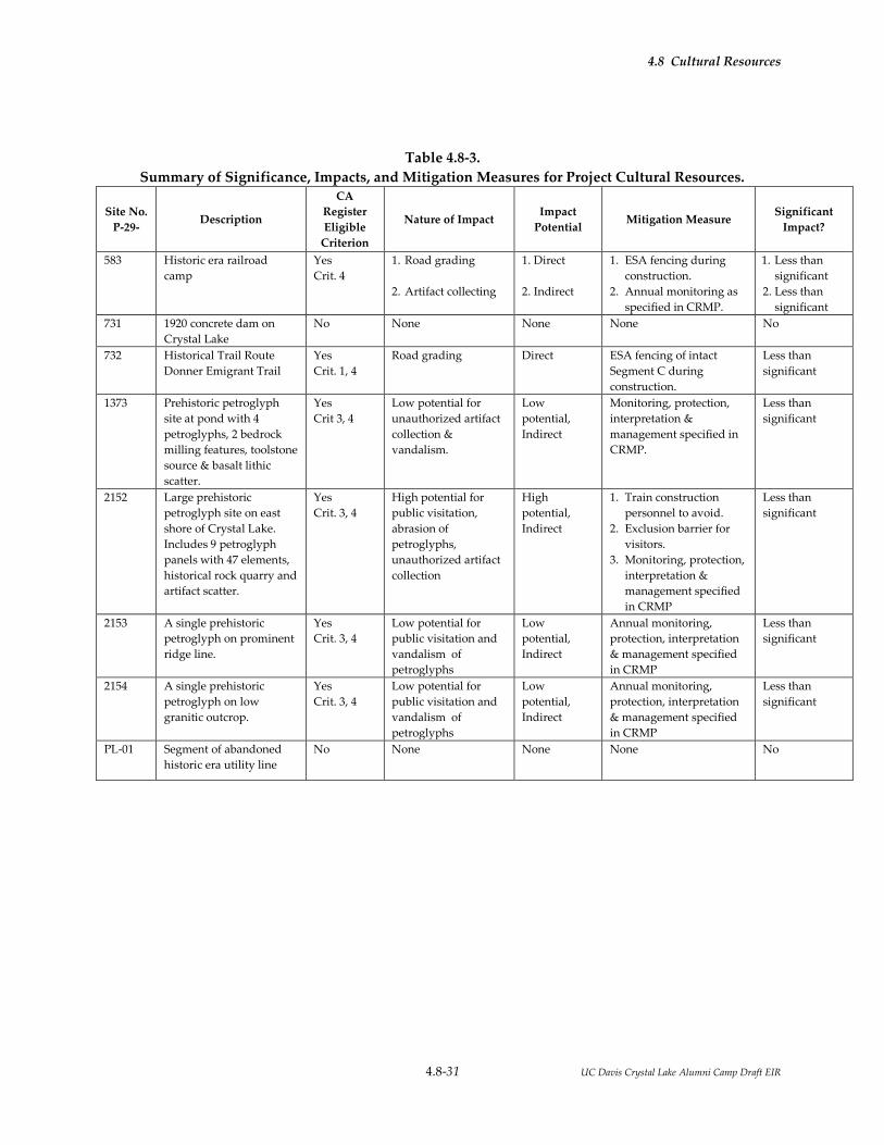
4.8 Cultural Resources
4.8-31 UC Davis Crystal Lake Alumni Camp Draft EIR
Table 4.8-3.
Summary of Significance, Impacts, and Mitigation Measures for Project Cultural Resources.
Site No.
P-29- Description
CA
Register
Eligible
Criterion
Nature of Impact Impact
Potential Mitigation Measure
Significant
Impact?
583 Historic era railroad
camp
Yes
Crit. 4
1. Road grading
2. Artifact collecting
1. Direct
2. Indirect
1. ESA fencing during
construction.
2. Annual monitoring as
specified in CRMP.
1. Less than
significant
2. Less than
significant
731 1920 concrete dam on
Crystal Lake
No None None None No
732 Historical Trail Route
Donner Emigrant Trail
Yes
Crit. 1, 4
Road grading Direct ESA fencing of intact
Segment C during
construction.
Less than
significant
1373 Prehistoric petroglyph
site at pond with 4
petroglyphs, 2 bedrock
milling features, toolstone
source & basalt lithic
scatter.
Yes
Crit 3, 4
Low potential for
unauthorized artifact
collection &
vandalism.
Low
potential,
Indirect
Monitoring, protection,
interpretation &
management specified in
CRMP.
Less than
significant
2152 Large prehistoric
petroglyph site on east
shore of Crystal Lake.
Includes 9 petroglyph
panels with 47 elements,
historical rock quarry and
artifact scatter.
Yes
Crit. 3, 4
High potential for
public visitation,
abrasion of
petroglyphs,
unauthorized artifact
collection
High
potential,
Indirect
1. Train construction
personnel to avoid.
2. Exclusion barrier for
visitors.
3. Monitoring, protection,
interpretation &
management specified
in CRMP
Less than
significant
2153 A single prehistoric
petroglyph on prominent
ridge line.
Yes
Crit. 3, 4
Low potential for
public visitation and
vandalism of
petroglyphs
Low
potential,
Indirect
Annual monitoring,
protection, interpretation
& management specified
in CRMP
Less than
significant
2154 A single prehistoric
petroglyph on low
granitic outcrop.
Yes
Crit. 3, 4
Low potential for
public visitation and
vandalism of
petroglyphs
Low
potential,
Indirect
Annual monitoring,
protection, interpretation
& management specified
in CRMP
Less than
significant
PL-01 Segment of abandoned
historic era utility line
No None None None No
4.8 Cultural Resources
4.8-32 UC Davis Crystal Lake Alumni Camp Draft EIR
Following are potential impacts grouped by type, as they apply to one or more historical resources within
the project site, followed by mitigation measures that will be applied to reduce impacts to less than
significant levels.
Construction-Related Impacts
Camp and Lodge Area
Impact CUL-1: Impacts from construction activities on identified or previously unidentified
cultural resources (Significant; Less than Significant with Mitigation)
As planned, construction of the proposed project will not directly impact any identified significant
cultural resources (i.e., California Register eligible sites). Potential impacts may result from construction
impacts to previously unidentified resources that were obscured and undiscovered during prior
archaeological surveys particularly within the camp and lodge areas, where most ground-disturbing
activities are planned. In addition, impacts may result from construction contractors straying outside the
construction areas and prehistoric archaeological resources may also be exposed to unauthorized artifact
collection during the construction phase of the project. The potential impact would be significant.
Mitigation Measure CUL-1a: Initial Archaeological Monitoring. Qualified professional
archaeologists will monitor initial ground clearing and construction trenching for
utilities in search of significant cultural resources. Native American monitors will be
included at their discretion and by scheduled appointment during archaeological
monitoring activities.
Mitigation Measure CUL-1b: Prehistoric Cultural Resource Evaluation and Data Recovery. If
previously unidentified cultural resources are identified during construction
monitoring, construction at and within 30 meters of the find will be suspended. UC
Davis will retain a qualified archaeologist to evaluate the new discovery according to
State CEQA Guidelines for their significance and potential eligibility to be listed on the
California Register of Historical Resources. In the case of a prehistoric archaeological
site, evaluation may be completed by examining existing records and reports, detailed
recording, and/or through excavation to determine the data potential and California
Register eligibility of the site. Native American monitors will be included at their
discretion and by scheduled appointment during archaeological evaluation fieldwork
activities. Resources determined not eligible for the California Register of Historical
Resources by UC Davis require no further management.

4.8 Cultural Resources
4.8-33 UC Davis Crystal Lake Alumni Camp Draft EIR
If the discovered resource is found to be eligible for the CRHR, avoidance is the
preferred mitigation measure. If avoidance is not possible, however, alternative
mitigation measures for a prehistoric archaeological site that is California Register
eligible under Criterion 4 for its scientific research value may include detailed
recording, excavation, detailed analysis, and/or further research depending on the
nature and type of the resource to recover the important scientific value residing in the
site. Native American monitors will be included at their discretion and by scheduled
appointment during archaeological data recovery fieldwork activities. Excavated
materials would be curated at an appropriate facility, to be identified by the lead
agency. Data recovery would be implemented to reduce impacts to less than
significant levels per §15064.5 of State CEQA Guidelines.
Mitigation Measure CUL-1c: Extended Archaeological Monitoring. Archaeological
monitoring of construction beyond the initial monitoring of utility trenching in the
Camp and Lodge Area will occur if and only if previously unidentified cultural
resources are discovered during the initial monitoring. If additional cultural resources
are discovered, those resources will be subject to the same procedures of evaluation
and data recovery mitigation if they are found to be CRHR eligible. These procedures
will reduce impacts to less than significant levels per §15064.5 of State CEQA
Guidelines.
Mitigation Measure CUL-1d: Discovery of Human Remains. In the unlikely event that human
remains are encountered during ground disturbing activities, all work within a 30
meter vicinity of the find will be halted immediately, and UC Davis and the Nevada
County Coroner will be notified. If the remains are determined to be Native American,
the Native American Heritage Commission will be notified within 24 hours as required
by Public Resources Code §5097.94 and §5097.98. The Native American Heritage
Commission will notify the designated Most Likely Descendant(s), who will in turn
provide recommendations for the treatment of the remains within 48 hours of being
granted access to the find.
Mitigation Measure CUL-1e: Construction Personnel Training. Construction supervisory
personnel will be notified of the general existence of cultural resources within the
Crystal Lake property and construction personnel will be required to keep equipment
and activities within specified construction areas only. Prior to construction activities,
a qualified archeologist will conduct an awareness and identification training for
construction personnel to stress the importance of preserving and avoiding impacts to

4.8 Cultural Resources
4.8-34 UC Davis Crystal Lake Alumni Camp Draft EIR
prehistoric archaeological resources, and train those personnel on the identification of
archaeological materials so that they may recognize previously unidentified
archaeological materials if they are unearthed during construction and notify UC Davis
and its designated professional archaeologist.
Significance after Mitigation: The impact from CUL-1 would be reduced to a less-than-significant level.
Impact CUL-2: Impacts from construction activities at identified historic period sites have the
potential to impact historic period archaeological resources (Significant; Less
than Significant with Mitigation)
Construction activities could indirectly impact historic period archaeological resources. Sites at risk
include Segments C and D of P-29-732 (CA-NEV-701H), the Donner Emigrant Trail, if the area outside the
camp and lodge area construction zone is breached by heavy equipment, and P-29-583 (CA-NEV-525H),
a historic era railroad camp, from heavy equipment impacts and unauthorized artifact collection. The
potential impact would be significant.
Mitigation Measure CUL-2a: Exclusion Barrier. An exclusion barrier (e.g., temporary, four-foot tall,
orange plastic mesh barrier fencing) will be installed in a north-south direction from
the south edge of Crystal Lake Road near the dam to the north to the Crystal Lake
property boundary. This exclusion barrier will clearly alert and exclude all
construction personnel from areas east of the Camp and Lodge Area, prohibiting access
by both equipment and personnel. This exclusion barrier will be inspected by
archaeologists to ensure that all cultural materials are avoided and excluded from
construction areas. The exclusion barrier will include signs that identify all areas
outside the barrier as prohibited from access, except for emergency access/evacuation.
Mitigation Measure CUL-2b: Mapping of Construction Exclusion Areas. All exclusion zones for cultural
resources within the project site will be shown on construction maps that alert
construction personnel that these areas are exclusion zones that may not be breached or
accessed except during emergencies. Vegetation management can occur if an on-site
archaeologist monitoring the proposed activity determines that the activities would
occur outside of the cultural resources site.
Significance after Mitigation: The impact from CUL-2 would be reduced to a less-than-significant level.
4.8 Cultural Resources
4.8-35 UC Davis Crystal Lake Alumni Camp Draft EIR
Petroglyph and Other Non-Construction Areas
Impact CUL-3: Impacts from construction activities have the potential to impact CRHR
eligible Native American petroglyph sites (Significant; Less than Significant
with Mitigation)
Construction activities from the proposed project have the potential to impact CRHR eligible Native
American petroglyph sites by heavy equipment and unauthorized foot traffic damage on petroglyph
elements and artifact collection by construction personnel at Sites P-29-1373 and P-2152, and foot traffic
damage at Sites P-29-2153 and P-29-2154. The potential impact would be significant.
Mitigation Measure CUL-3a: Exclusion During Construction. An extension of the exclusion barrier
shall be installed along the south edge of Crystal Lake Road as it traverses the north
side of Crystal Lake. This extension will join the exclusion barrier as it crosses the road
at the east edge of the Camp and Lodge Area (see Mitigation Measure CUL-2a). The
barrier will be installed to clearly alert and exclude construction personnel from all
petroglyph/archaeological site areas. The exclusion barrier along the south edge of
Crystal Lake Road will extend west to the southern turn in the road and thence be
installed along the east edge of Crystal Lake Road to the southern property boundary.
This barrier will exclude construction equipment and personnel from all petroglyph
and prehistoric archaeological sites, as well as CRHR eligible historic era archaeological
sites within the Crystal Lake property for the duration of construction. The exclusion
barrier in total will extend approximately 1000 meters. This exclusion barrier will be
inspected by archaeologists to ensure that all cultural materials are avoided and
excluded from construction areas. The exclusion barrier will include signs that identify
all areas outside the barrier as prohibited from access. Vegetation management can
occur if an on-site archaeologist monitoring the proposed activity determines that the
activities would occur outside of the cultural resources site.
Significance after Mitigation: The impact from CUL-3 would be reduced to a less-than-significant level.
Submerged Area within Crystal Lake
Impact CUL-4: Impacts of construction within Crystal Lake on previously unidentified
cultural resources (Significant; Less than Significant with Mitigation)
The project could result in potential impacts from construction within Crystal Lake on previously
unidentified cultural resources. The construction of a recreational beach along the north shore or

4.8 Cultural Resources
4.8-36 UC Davis Crystal Lake Alumni Camp Draft EIR
expansion of the existing beach adjacent to the Crystal Lake Lodge with heavy equipment has the
potential to impact previously unknown prehistoric archaeological resources near the current lakeshore
of Crystal Lake that may have been inundated and submerged when the dam was constructed in 1920.
The potential impact would be significant.
Mitigation Measure CUL-4a: Cultural Resource Survey. When Crystal Lake is drawn down for the
construction of a recreational beach, UC Davis will retain the services of a qualified
professional archaeologist to conduct an intensive pedestrian survey of the exposed
lake bottom in search of previously unknown prehistoric archaeological resources.
Native American monitors will be included at their discretion and by scheduled
appointment during cultural resource survey fieldwork activities.
Mitigation Measure CUL-4b: Prehistoric Cultural Resource Evaluation and Data Recovery. If
previously unknown prehistoric archaeological resources are discovered during the
cultural resources survey of the exposed lake bottom, UC Davis will retain the services
of a qualified professional archaeologist to determine if the resource(s) qualify as
CRHR eligible in a manner consistent with Mitigation Measure CUL-1a. Native
American monitors will be included at their discretion and by scheduled appointment
during archaeological evaluation fieldwork activities.
If the discovered resource is found to be eligible for the CRHR, avoidance is the
preferred mitigation measure. If avoidance is not possible, alternative mitigation
measures for a prehistoric archaeological site that is California Register eligible under
Criterion 4 for its scientific research value may include detailed recording, excavation,
and detailed analysis and/or further research, depending on the nature and type of the
resource to recover the important scientific value residing in the site. Native American
monitors will be included at their discretion and by scheduled appointment during
archaeological data recovery fieldwork activities. Excavated materials would be
curated at an appropriate facility, to be identified by the lead agency. Data recovery
would be implemented to reduce impacts to less than significant levels per §15064.5 of
State CEQA Guidelines.
Mitigation Measure CUL-4c: Protection of CRHR Eligible Sites. Any and all portions of prehistoric
archaeological sites and features found in the draw down portion of Crystal Lake for
which avoidance is possible will be protected by exclusion barriers, signing, and
informing construction supervisory personnel of the need for protection during
construction of the recreational beach. This exclusion barrier will be installed by

4.8 Cultural Resources
4.8-37 UC Davis Crystal Lake Alumni Camp Draft EIR
archaeologists to ensure that all cultural materials are avoided and excluded from
construction areas. Protection measures will reduce impacts to less than significant
levels per §15064.5 of State CEQA Guidelines.
Mitigation Measure CUL-4d: Modify Exclusion Barrier. A segment of the continuous exclusion barrier
that prohibits access to all property south and east of Crystal Lake Road, as described
in Mitigation Measures CUL-3a, will be modified to allow access by construction
personnel and equipment for the limited areas subject to the development of a
recreational beach. The exclusion barrier will be modified so that exclusion remains for
areas west and east of Crystal Lake that are not subject to beach development.
Significance after Mitigation: The impact from CUL-4 would be reduced to a less-than-significant level.
Operation-Related Impacts
Impacts and mitigation measures related to potential impacts resulting from the operation of the Crystal
Lake Alumni Camp and event are described below.
Petroglyph and Other Native American Archaeological Sites
Impact CUL-5: Impacts from increased visitation during camp operation on petroglyph sites
(Significant; Less than Significant with Mitigation)
Visitation and use of the area after the proposed project is developed will increase substantially to a peak
period total of approximately 470 people. Without protective measures, visitors are likely to walk on
bedrock petroglyphs, particularly those at large and easily accessible P-29-2152, resulting in abrasion and
gradual damage/wear that will diminish the visibility of the petroglyphs degrading the integrity of the
petroglyphs and obscuring the possible relationships and meanings of the petroglyphs to the
environment.
Mitigation Measure CUL-5a Cultural Resources Management Plan. UC Davis will develop and
implement a Cultural Resources Management Plan (CRMP) to ensure the long-term
monitoring and protection of Native American petroglyph elements and other Native
American archaeological deposits. The CRMP will provide specific detail to a variety of
monitoring and protective measures that will include the following key elements.
i. Public exclusion from all petroglyph and other archaeological sites until
the CRMP is completed and implemented. Temporary exclusion barriers
(e.g., temporary, four-foot tall, orange plastic mesh barrier fencing)

4.8 Cultural Resources
4.8-38 UC Davis Crystal Lake Alumni Camp Draft EIR
installed for exclusion of construction personnel and equipment will
remain in place until the CRMP is developed and executed.
ii. A key element of the CRMP will be a plan for prohibiting direct contact
with petroglyphs at easily accessible and visible petroglyph site P-29-
2152. Access will be controlled by the development and installation of
permanent barriers that allow viewing of the petroglyphs without direct
contact (further described in the educational program provision, below).
iii. Restricted access to petroglyph site P-29-2152 by swimmers, canoers, and
kayakers on Crystal Lake.
iv. Collection of initial baseline documentation on the present condition of
petroglyphs and Native American archaeological deposits. Baseline
documentation, including high-resolution photography, will allow
repeat photographs (on an annual basis) to gauge the condition and
threats to these resources.
v. Surface collection of artifacts at Native American sites P-29-2152 and P-
29-1373. The CRMP will describe a program of systematic surface
collection to record and collect artifacts visible on the surface of these
two sites to prevent unauthorized artifact collection by visitors. The
CRMP will describe the appropriate disposition of surface collected
artifacts.
vi. The CRMP will include a plan for incorporating Native American
archaeological sites into the educational program for visitors.
Educational information and media will be enhanced by the collection of
additional data on traditional Native American use of the Crystal Lake
property and general region. UC Davis will acquire these data by
sponsoring the following:
o Native American Survey. UC Davis will sponsor a visit to the
Crystal Lake property by knowledgeable Native Americans from
tribal organizations whose members are ancestral to the project area
(Maidu, Konkow, Miwok, Washoe). A Native American Survey may
identify locations and resource areas used by ancestral groups that
may not have an archaeological manifestation.

4.8 Cultural Resources
4.8-39 UC Davis Crystal Lake Alumni Camp Draft EIR
o Oral History and Ethnographic Research. Additional information on
Native American use of the area will be obtained by UC Davis
sponsorship of ethnographic research, including (if possible) oral
histories from knowledgeable individuals with ties to the project
area.
o Permanent physical barriers will be installed to protect the
petroglyphs at Site P-29-2152. The barriers will be designed to be
compatible with the environment and nature of Native American
use of the area. These barriers will prevent visitors from walking on
accessible petroglyphs while maintaining the ability for visitors to
view and appreciate the petroglyphs, consistent with the educational
objectives of the camp and environmental education center.
o Interpretive Media. Information obtained from existing regional
archaeological studies, ethnographic research, oral history, and
Native American Survey will be used to develop interpretive
information for visitors to the UC Davis Crystal Lake Alumni Camp.
The CRMP will describe the nature of interpretive media, which may
include some combination of the following: signage at petroglyph
site P-29-2152; brochures; photographs displayed at the Lodge;
archaeological materials collected from the surfaces of P-29-2152 and
P-29-1373 securely displayed at the lodge and/or used in interpretive
lectures; and lectures and guided tours by docents.
vii. Long-Term Monitoring. The CRMP will describe a program of monitoring the
condition of Native American archaeological sites to determine whether visitor
impacts occur. If impacts resulting from operation of the facility are
documented, additional protective and/or treatment measures will be
implemented. The monitoring program will include the following elements:
o Annual photo-monitoring to provide comparative data on the
condition of the petroglyph elements and other Native American
archaeological deposits. The CRMP will identify specific photo-
monitoring stations, aspects, time of year, lighting conditions, and
any special filters or treatment of digital images to enhance
petroglyph images.

4.8 Cultural Resources
4.8-40 UC Davis Crystal Lake Alumni Camp Draft EIR
o Annual visual inspection of archaeological site features and surfaces
for signs of vandalism and unauthorized digging or collection of
artifacts.
o A description of further treatment options should operation-related
impacts be observed. Such options may include additional exclusion
barriers to petroglyph sites, electronic monitoring devices (e.g., trail
cameras), mapping and additional surface collection of artifacts
threatened by unauthorized collection, archaeological excavation,
and placement of ground cover that obscures surface archaeological
evidence.
Significance after Mitigation: The impact from CUL-5 would be reduced to a less-than-significant level.
Impact CUL-6: Impacts from increased visitation during camp operation on historic era
railroad work camp (Significant; Less than Significant with Mitigation)
The proposed project will greatly increase public visitation that may result in damage to historic era Site
P-29-523, a railroad work camp. The influx of visitors may also result in vandalism and unauthorized
artifact collecting. The impact would be significant.
Mitigation Measure CUL-6a. Annual Monitoring. Protocols for the annual monitoring of Site P-29-523
will be included and coordinated with the CRMP for Native American archaeological
resources. Qualified Professional Archaeologists will monitor the site for evidence of
unauthorized artifact collection and vandalism.
Mitigation Measure CUL-6b. Data Recovery. If unauthorized artifact collecting and/or vandalism is
documented by systematic annual monitoring, UC Davis will sponsor a program of
data recovery at the site by professional historical archaeologists. Archaeological
materials will be mapped and systematically collected for study and reporting. A
discard policy will be developed for common historical materials after they are
inventoried. Historical materials that are unique, have ongoing research value, or
public interpretive value will be curated at an appropriate facility identified by UC
Davis. Data recovery would be implemented to reduce impacts to less than significant
levels per §15064.5 of State CEQA Guidelines.

4.8 Cultural Resources
4.8-41 UC Davis Crystal Lake Alumni Camp Draft EIR
Significance after Mitigation: The impact from CUL-6 would be reduced to a less-than-significant level.
Impact CUL-7: The proposed project will create new sources of light and glare that has the
potential to reduce visibility of the night sky for the study of possible ethno-
astronomical relationships.
Mitigation Measure CUL-7. Lighting Control. Section 4.3 of this EIR addresses visual impacts of the
project, including night-time lighting. Mitigation measures (AES-4a-c) described in
Section 4.3 include: building materials that are textured, non-reflective exterior
surfaces, dark colors, and non-reflective (non-mirrored) glass; installation of outdoor
directional lighting with shielded and cut-off type light fixtures to minimize glare and
prohibit upward directed lighting; extinguishing outdoor lights when not in use; and
use of motion sensors and bi-level lighting fixtures to minimize light use. These
measures will reduce impacts to less than significant levels per §15064.5 of State CEQA
Guidelines.
Significance after Mitigation: The impact from CUL-7 would be reduced to a less-than-significant level.
4.8.6.3 Cumulative Impacts and Mitigation Measures
Cumulative Impact CUL-1: Development of the proposed project would make a cumulatively
considerable contribution to cumulative damage to and loss of the resource
base of unique archaeological and historical resources (including
archaeological sites and historic buildings and structures) in Nevada and
Placer Counties (Significant; Significant and Unavoidable)
Any disturbance of to a project site soils carries the potential to result in impacts to archaeological
resources. Development of the proposed project and other development in Placer and Nevada counties
over time would be anticipated to result in some impacts to historical resources and unique
archaeological resources. These impacts may be significant if a significant resource is disturbed or
destroyed. Project cultural resources protocols, as stipulated in the mitigation measures above, will
minimize the impact of development under the proposed project on unique archaeological resources and
historical resources because the campus will carry out a continuing program of archaeological
investigation, which will in most cases enable the campus to avoid or preserve unique archaeological
resources and historical resources, and will appropriately recover data from and document resources that
cannot be preserved in place. While data recovery is acknowledged to be destructive of the physical

4.8 Cultural Resources
4.8-42 UC Davis Crystal Lake Alumni Camp Draft EIR
resource, investigations to date have been successful in preserving at least part of each discovered site, in
reducing physical impacts through project modification, and in recovering substantial new archaeological
and cultural information. Because the proposed mitigation program is expected to prevent or mitigate
damage to unique archaeological resources and historical resources, the mitigation program is considered
to have reduced the impacts to less-than-significant levels.
While the University has policies and programs in place that are expected to be effective in protecting the
significant resource base, the University has no authority over the programs and actions of other
agencies, and cannot ensure that the actions of other agencies will not result in unmitigated impacts to
unique archaeological resources and historical resources. Over time, despite preservation policies in
place, some unique archaeological resources and historical resources in Placer and Nevada counties could
be damaged or destroyed. There may be instances elsewhere in the region, as also may occur on the
campus, in which there would be impacts to an exceptionally significant historical resource that cannot
fully be mitigated by data recovery or documentation. While the proposed project would make only a
minimal contribution to these impacts, any such impact would contribute to a cumulative regional
impact, and the impact would be cumulatively significant. Because there are no measures that can fully
mitigate this impact, and because the University cannot guarantee implementation by other agencies of
measures to protect historical resources and unique archaeological resources, the impact is considered
significant and unavoidable.
Significance after Mitigation: The impact from Cumulative Impact CUL-1 would be significant and
unavoidable
4.8.7 REFERENCES
Barrett, Samuel A. 1917. The Washo Indians. Milwaukee Public Museum Bulletin 2(1).
Beals, R. L. 1933. Ethnology of the Nisenan. University of California Publications in American Archaeology
and Ethnology 31 (6):335-414. Berkeley.
Davis, J. T. 1961. Trade Routes and Economic Exchange Among the Indians of California. University of
California Archaeological Survey Reports 54, Berkeley.
Bean, Edwin F. 1867. Bean’s History and Directory of Nevada County, California. Daily Gazette Book and Job
Office, Nevada. Accessed in August 2015 at https://archive.org/details/beanshistorydire00bean.
Beck, W. A., and Y. D. Haase. 1974 . Historical Atlas of California. University of Oklahoma, Norman.

4.8 Cultural Resources
4.8-43 UC Davis Crystal Lake Alumni Camp Draft EIR
Bureau of Land Management . 1867a. General Land Office (GLO) Survey Plat for Township 17 North,
Range 12 East. Accessed in August 2015 at
http://www.glorecords.blm.gov/results/default.aspx?searchCriteria=type=survey|stCA|cty=057|twp_nr=
17|twp_dir=N|rng_nr=12|rng_dir=E|m=21.
1867b. GLO Land Patent Records for Section 24, Township 17 North, Range 12 East. Accessed in August
2015 at
http://www.glorecords.blm.gov/results/default.aspx?searchCriteria=type=patent|st=CA|cty=057|twp_nr
=17|twp_dir=N|rng_nr=12|rng_dir=E|sec=24|m=21|sp=true|sw=true|sadv=false.
2015. Land Records Search, T 17 North, R 12 East. California Land Records. Bureau of Land
Management. Accessed in August 2015 at
http://www.glorecords.blm.gov/search/default.aspx?searchTabIndex=0& searchByTypeIndex=2.
California Department of Transportation (Caltrans). 2013. Work Camps: Historic Context and Archaeological
Research Design for Agricultural Properties in California. Division of Environmental Analysis, California
Department of Transportation, Sacramento.
Central Pacific Railroad Photographic History Museum. 2009a. Chapter 6, Building the Central Pacific
Rail Road of California. In, The Governor: The Life and Legacy of Leland Stanford, Norman E. Tutorow, 2004,
Arthur C. Clark Company. Accessed in August 2015 at
http://www.cprr.org/Museum/Stanford_Tutorow_files/Stanford_Tutorow_Ch6.pdf.
2009b. Pacific Railroad Acts. Accessed in August 2015 at
http://www.cprr.org/Museum/Pacific_Railroad_Acts.html.
Clewlow, C. W. Prehistoric Rock Art. In California, edited by R. F. Heizer, pp. 619-625. Handbook of
North American Indians, Vol. 8., W.C. Sturtevant, general editor. Smithsonian Institution, Washington,
D.C.
Coyote Man (author). 1973. Sun, Moon, and Stars: Part One of the Trilogy Old People of the New World.
Brother William Press, Berkeley.
d’Azevedo, W. L. 1963. The Washo Indians of Nevada and California. University of Utah Anthropological
Papers 67, Salt Lake City.
d’Azevedo, W. L. 1986. Washoe. In Great Basin, edited by W.L. d’Azevedo, pp. 466-498. Handbook of
North American Indians, Vol. 11, W.C. Sturtevant, general editor. Smithsonian Institution, Washington,
D.C.
Downs, James F. 1966. The Two Worlds of the Washo, An Indian Tribe of California and Nevada. Holt, Rinehart,
and Winston. New York.
Elston, R. G. 1971. A Contribution to Washo Archaeology. Nevada Archaeological Survey Research Paper 2,
University of Nevada, Reno.
Elston, R. G., S. Stornetta, D. P. Dugas, and P. Mires. 1994. Beyond the Blue Roof; An Archaeological Survey on
Mt. Rose Fan and Northern Steamboat Hills. Intermountain Research, Silver City. Submitted to Toiyabe
National Forest, Reno.

4.8 Cultural Resources
4.8-44 UC Davis Crystal Lake Alumni Camp Draft EIR
Environmental Stewardship and Sustainability. 2015. UC Davis Crystal Lake Family Alumni Camp and
Environmental Education Center Initial Study. Accessed in August 2015 at
http://sustainability.ucdavis.edu/local_resources/docs/onlinedocs/Crystal%20Lake/IS%20Crystal%20Lake
%20Alumni%20Camp.pdf.
Erlandson, J. M., and K. Bartoy. 1995. Cabrillo, the Chumash, and Old World Diseases. Journal of
California and Great Basin Anthropology 17(2):153-173.
Fickwirth, Alvin A. 1992. California Railroads: An Encyclopedia of Cable Car, Common Carrier, Horsecar,
Industrial Interurban, Logging, Monorail, Motor Road, Short Lines, Streetcar, Switching and Terminal Railroads
in California (1851-1992). Golden West Books, San Marino.
Foster, Daniel G., John Betts, and Linda Sandelin. 1998. The Association of Style 7 Rock Art and the
Martis Complex in the Northern Sierra Nevada of California. California Department of Forestry and Fire
Protection, Sacramento.
Freed, S. A. 1966. Washo Habitation Sites in the Lake Tahoe Area. University of California Archaeological
Survey Report 66: 73-83.
Gifford, E. W. 1927. Southern Maidu Religious Ceremonies. American Anthropologist 29(3):214-257.
Gilreath, Amy J. 2007. Rock Art in the Golden State: Pictographs and Petroglyphs, Portable and
Panoramic. In California Prehistory: Colonization, Culture, and Complexity, pp. 173-290, Terry L. Jones and
Kathryn A. Klar, editors. AltaMira Press, Plymouth, UK.
Heizer, R. F., and A. B. Elsasser 1953. Some Archaeological Sites and Cultures of the Central Sierra
Nevada. University of California Archaeological Survey Reports 21: 1-42. Berkeley.
Hoover, M., H. Rensch, E. Rensch, W. Abeloe, and D. Kyle. 1990. Historic Spots in California. Fourth
edition, Stanford University Press, Stanford.
Jackson, R. J., and H. S. Ballard 1999. Once Upon a Micron, A Story of Archaeological Site CA-ELD-145 Near
Camino, El Dorado County, California. Pacific Legacy, Inc., Cameron Park. Submitted to the California
Department of Transportation, District 10, Stockton.
JRP Historical Consulting, LLC, and California Department of Transportation (Caltrans) . 2000. Water
Conveyance Systems in California: Historic Context Development and Evaluation Procedures. California
Department of Transportation, Sacramento.
Kroeber, A. L. 1925. Handbook of the Indians of California. Bureau of American Ethnology Bulletin 78.
Washington D.C. Reprinted in 1976 by Dover Publications, Inc., New York.
Kuchler, A. V. 1977. Map of the Natural Vegetation of California. Department of Geography, University
of Kansas, Lawrence.
Littlejohn, H. W. 1928. Nisenan Geography. Manuscript in Bancroft Library, University of California,
Berkeley.

4.8 Cultural Resources
4.8-45 UC Davis Crystal Lake Alumni Camp Draft EIR
Lockhart, B. 2006. The Color Purple: Dating Solarized Amethyst Container Glass. Historical Archaeology 40
(2):45-56.
Lowie, R. H. 1939. Ethnographic Notes on the Washo. University of California Publications in American
Archaeology and Ethnology 36:301-352. Berkeley.
Majewski, Teresita and Michael J. O’Brien. 1987. The Uses and Misuses of Nineteenth-Century English
and American Ceramics in Archaeological Analysis. Advances in Archaeological Method and Theory, 11:87-
209.
Maxwell, D. B. S. 1993. Beer Cans: A Guide for the Archaeologist. Historical Archaeology 27(1):95-113.
Mayer, K. E., and W. F. Laudenslayer, Jr. (editors) 1988. A Guide to Wildlife Habitats of California.
California Department of Forestry and Fire Protection, Sacramento.
National Park Service (NPS) 2015a. 4-Trails Feasibility Study – The California Trail Study Routes.
Accessed in August 2015 at http://www.nps.gov/cali/learn/management/feasibility-study.htm.
2015b. California Trail, National Historic Trail. Accessed in August 2015 at
http://www.nps.gov/cali/planyourvisit/upload/CALImap1-web.pdf.
Nevers, Jo Anne. 1976. Wa She Shu: A Washo Tribal History. Inter-Tribal Council of Nevada, Reno.
Payen, Louise A. 1966. Prehistoric Rock Art in the Northern Sierra Nevada, California. Unpublished
Master's thesis, Department of Anthropology, California State University, Sacramento.
Price, J. A. 1980. The Washoe Indians: History, Life Cycle, Religion, Technology, Economy and Modern
Life. Nevada State Museum Occasional Papers, No. 4. Carson City.
Rayner, R. 2008. The Associates, Four Capitalists who Created California. W.W. Norton & Company, New
York.
Rock, J. 1987. A Brief Commentary on Cans. Coyote Press, Salinas.
Signor, John R. 2003. Donner Pass Southern Pacific Sierra Crossing. (1985, fifth printing 2003). Golden West
Books, San Marino.
Simonis, D. 1990. Milk Can Typology for Dating Historical Sites. Manuscript on file, Bureau of Land
Management, Kingman Resource Area, Kingman.
Steward, Julian H. 1929. Petroglyphs of California and Adjoining States. University of California
Publications in American Archaeology and Ethnology 24(2).
Storer, Tracy I., and Robert L. Usinger. 1970. Sierra Nevada Natural History. University of California Press,
Berkeley.

4.8 Cultural Resources
4.8-46 UC Davis Crystal Lake Alumni Camp Draft EIR
Union Pacific. 2015. Southern Pacific Railroad. Accessed in August 2015 at
https://www.up.com/aboutup/special_trains/heritage/southern_pacific/index.htm.
United States Patent Office. 1935. Patent for “Container Opener” US 1996550 A. Accessed in August 2015
at http://www.google.com/patents/US1996550.
USDA Forest Service 1993. Draft Environmental Impact Statement: Cleveland Fire Area Recovery Project.
Document on file with the USDA Forest Service, Eldorado National Forest, Placerville.
USDA Forest Service 1997. Ecological Subregions of California: Section and Subsection Descriptions.
Compiled by S. R. Miles and C. B. Goudey. USDA Forest Service, Pacific Southwest Region, San
Francisco.
Whitley, D. S. 2000. The Art of the Shaman: Rock Art of California. University of Utah Press, Salt Lake City.
Wilson, N., L., and A. H. Towne. 1978. Nisenan. In Handbook of North American Indians: Vol. 8: California.
Robert F. Heizer, editor. Smithsonian Institution, Washington D.C.
Zeiner, David C., William F. Laudenslayer, Jr., Kenneth E. Mayer, and Marshall White. 1990a. California's
Wildlife, Volume III, Mammals. California State Wildlife Habitat Relationship System, State of California,
The Resources Agency, California Department of Fish and Game, Sacramento.
Zeiner, David C., William F. Laudenslayer, Jr., Kenneth E. Mayer, and Marshall White. 1990b. California's
Wildlife, Volume II: Birds. California State Wildlife Habitat Relationship System, State of California, The
Resources Agency, California Department of Fish and Game, Sacramento.

4.9-1 UC Davis Crystal Lake Alumni Camp
SECTION 4.9
GEOLOGY, SOILS, AND SEISMICITY
4.9.1 INTRODUCTION
This section identifies existing conditions; describes the regulatory setting for geology, soils, and
seismicity in the study area; and analyzes the potential for the proposed project to affect these resources
and for the proposed project to be impacted by these resources. Information presented in the discussion
and used for the subsequent analysis was drawn primarily from the following sources.
Regional geologic maps and fault maps prepared by the California Department of Conservation's
California Geological Survey (formerly the Division of Mines and Geology) and the U.S. Geological
Survey (USGS).
Soils information made available by the California Soil Resource Laboratory at the University of
California, Davis, based on soil mapping by the Natural Resources Conservation Service (NRCS).
Volume II, “Background Data and Analysis” of the Nevada County General Plan.
Comments received in response to the Notice of Preparation (NOP) are provided in Appendix 1.0. Public
and agency comments related to geology, soils, and seismicity received in response to the NOP are
summarized below.
Concern regarding septic system capacity and adequacy of soils.
Potential safety to humans and water quality impacts of septic systems.
4.9.2 ENVIRONMENTAL SETTING
4.9.2.1 Study Area
The approximate 210-acre study area is located on the west slope of the Sierra Nevada, near the Sierra
Nevada crest, within the South Yuba River watershed in the southeastern portion of Nevada County. It is
located to the south of Interstate 80 and is accessed from the Yuba Gap exit (Figures 3-1 and 3-2). The
study area is within projected Section 24, Township 17 North and Range 12 East, MDB&M, and is on the
Cisco Grove 7.5-minute USGS topographic quadrangle. Crystal Lake is located at an elevation of 5,877
feet above mean sea level (msl).

4.9 Geology, Soils, and Seismicity
4.9-2 UC Davis Crystal Lake Alumni Camp
4.9.2.2 Geology
Regional Geologic Framework
The study area is in the Sierra Nevada geomorphic province, which is a linear, tilted fault block almost
400 miles long that extends from northern Butte County to the Mohave Desert. In stark contrast to its
steep eastern slope, its western slope is gentle. This western slope is deeply incised by rivers and bedrock
disappears beneath the sediments of the Central Valley. The upper elevation Sierra Nevada is comprised
of massive granites shaped by glaciation, such as is seen in Yosemite. Lower in the Sierra Nevada is the
northwest-trending Mother Lode, which is made up of metamorphic rock containing gold-bearing veins.
The Sierra Nevada disappears to the north beneath the Cenozoic volcanic rock of the Cascade Ranges
(California Geological Survey 2002:2).
Study Area Geology
The study area has been mapped at a regional scale by a number of geologists (Jennings 1977; Stanford
Geological Survey 1955; Saucedo and Wagner 1992). According to these maps, there are four main
geologic units in the study area: granitic and granodioritic rocks, diorite, Miocene-Pliocene intrusive
rocks, and ultramafic rocks. Granitic and granodioritic rocks underlie most of the study area, including
all areas to the north of Crystal Lake. South of the lake, the study area is underlain by diorite, while the
remaining western and eastern edges of the study area are underlain by Miocene-Pliocene intrusive rocks
and ultramafic bedrock, respectively.
The description of these units below is from Saucedo and Wagner (1992). The locations of these units are
shown in Figure 4.9-1.
Granite and Granodiorite Rocks (KJgr): Mesozoic age; granodiorite, diorite, monzonite, quartz
porphyrite, schistose granodiorite, granulite, alaskite, and undifferentiated plutonic rocks.
Diorite (Jdi): Mesozoic age; diorite.
Miocene-Pliocene Intrusive Rocks (MPv): Cenozoic age; intrusive andesite and basalt.
Ultramafic Rocks (Jum): Mesozoic age; largely serpentinized, including minor talc schist,
amphibole schist, chlorite schist, and soapstone.
Although not mapped, small amounts of Quaternary alluvium (alluvial or stream deposits of Quaternary
age (either Pleistocene age [i.e., greater than 11,000 years old] or Holocene age [i.e., younger than 11,000
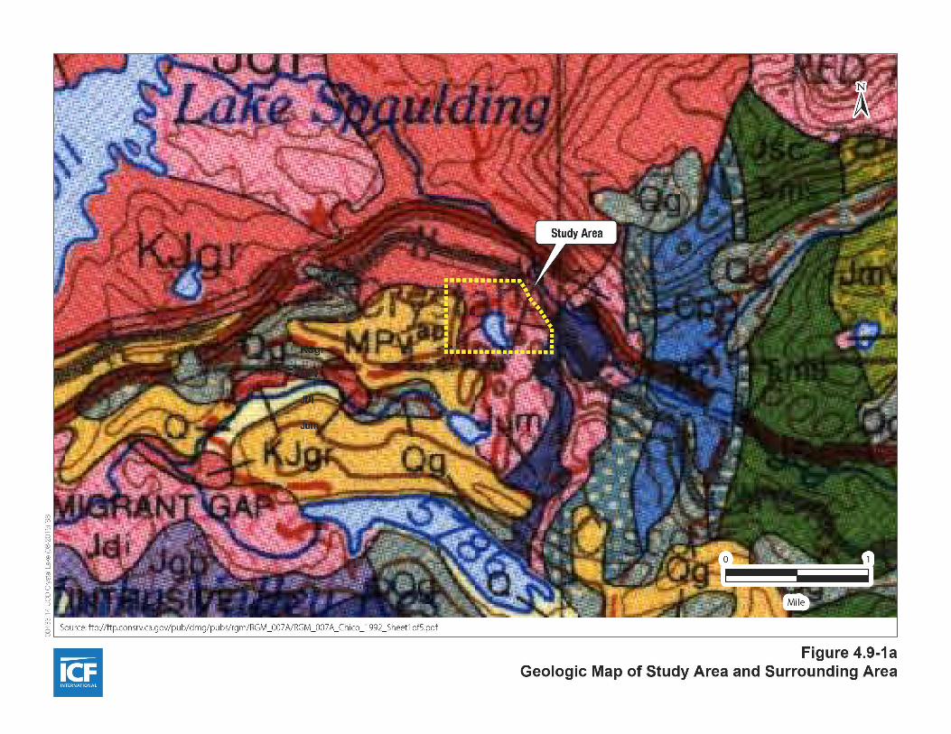
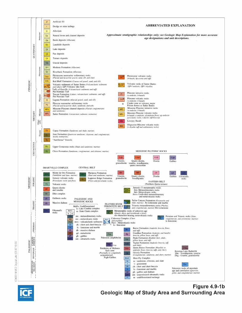

4.9 Geology, Soils, and Seismicity
4.9-5 UC Davis Crystal Lake Alumni Camp
years old]) occur along the various drainageways in the study area, based on ICF International field
observations.
Study Area Topography
Within the 210-acre study area, the topography is highly variable with gently sloping areas near the north
side of Crystal Lake and steeper slopes near the granite outcroppings on the southeast side of the study
area. The study area is generally bowl shaped with the approximate 13-acre Crystal Lake near the middle,
receiving runoff from large portions of the study area that drain toward the lake. The peripheral portions
of the property generally slope away from the central part of the study area, with surface drainage
flowing onto adjacent properties. The outfall of Crystal Lake is located at the northeast corner of the lake,
with the natural streambed blocked by a concrete dam constructed in the 1920s.
4.9.2.3 Soils
Surface Soils
The soils in the study area have been mapped by the U.S. Department of Agriculture, Soil Conservation
Service (now the NRCS). The soil survey data are available through the California Soil Resource
Laboratory at UC Davis (California Soil Resource Laboratory 2015). The soil map units in the study area
are shown on Figure 4.9-2.
According to the soil survey, there are ten soil map units that occupy the study area.
Meiss-Waca complex, 2 to 30 percent slopes (MKE), which covers a small area of the
southwestern portion and less than 1 percent of the study area.
Rock outcrop, metamorphic-Tinker-Cryumbrepts, wet complex, 2 to 30 percent slopes (MMRE),
which covers a majority of the areas around Crystal Lake and roughly 24 percent of the study
area.
Rock outcrop, metamorphic-Tinker-Cryumbrepts, wet complex, 30 to 75 percent slopes (MMRG),
which covers a large area in the southern portion and roughly 13 percent of the study area.
Rock outcrop, granitic-Tinker complex, 30 to 75 percent slopes (RRG), which covers the
northwestern portion and roughly 7 percent of the study area.

§̈¦80
§̈¦80
WDF
TAE
MMRG
MMRG
RSG
WW
TAF
PTE
PTE
W
TAF
MKE W
MCG
WDE
W
RRG
TAE
MMRE
MKF
WTAE
MMRE
TBE
Figure 4.9-2Soil Map Units in the Study Area
Path:
K:\Pr
ojects
_1\U
C_Da
vis\00
286_
14_C
rystal
_Lak
e\map
doc\F
igures
\Fig_
4_9_
2_So
ils_20
1508
13A.m
xd; U
ser: 1
9393
; Date
: 8/20
/2015
0 1,000500Feet
´Sources: Soil Map Units, California Soil Resource Laboratory 2015Aerial, ESRI 2014
Study AreaMKE Meiss-Waca complex, 2 to 30 percent
slopes TAE Tallac very gravelly sandy loam, 2 to 30 percent slopes
MMRERock outcrop, metamorphic-Tinker-Cryumbrepts, wet complex, 2 to 30 percent slopes
TBE Tallac-Cryumbrepts, wet complex, 2 to 30 percent slopes
MMRGRock outcrop, metamorphic-Tinker-Cryumbrepts, wet complex, 30 to 75 percent slopes
WDE Waca-Meiss complex, 2 to 30 percent slopes
RRG Rock outcrop, granitic-Tinker complex, 30 to 75 percent slopes WDF Waca-Meiss complex, 30 to 50
percent slopes
RSGRock outcrop, granitic-Tinker-Cryumbrepts, wet complex, 30 to 75 percent slopes
W open water

4.9 Geology, Soils, and Seismicity
4.9-7 UC Davis Crystal Lake Alumni Camp
Rock outcrop, granitic-Tinker-Cryumbrepts, wet complex, 30 to 75 percent slopes (RSG), which
covers the northeastern portion and roughly 3 percent of the study area.
Tallac very gravelly sandy loam, 2 to 30 percent slopes (TAE), which covers a small area of the
southwestern portion and less than 1 percent of the study area.
Tallac-Cryumbrepts, wet complex, 2 to 30 percent slopes (TBE), which covers a majority of the
area north of Crystal Lake and roughly 35 percent of the study area.
Waca-Meiss complex, 2 to 30 percent slopes (WDE), which covers a small area of the
southwestern portion and roughly 4 percent of the study area.
Waca-Meiss complex, 30 to 50 percent slopes (WDF), which covers a sizeable area of the western
portion and roughly 6 percent of the study area.
Water, which covers roughly 9 percent of the study area.
The Meiss soils in the Meiss-Waca complex, 2 to 30 percent slopes soil map unit are moderately shallow
(19–23 inches to lithic bedrock) and somewhat excessively drained. Parent material is residual materials
weathered from andesite. Typically, the surface layer is sandy loam about 9 inches thick. The subsoil
between 9 and 19 inches is gravelly sandy loam. Unweathered bedrock occurs at a depth below 19 inches.
The erosion hazard is moderate. The wind erodibility group1 is 5. The Waca soils are moderately deep
(32–36 inches to lithic bedrock) and well drained. Parent material is residuum weathered from acidic tuff
and mudflow deposits derived from andesite. Typically, the surface layer is gravelly sandy loam about 12
inches thick. The subsoil between 12 and 32 inches is very gravelly sandy loam. Weathered bedrock
occurs at a depth below 32 inches. The erosion hazard is moderate. The wind erodibility group is 6.
(California Soil Resource Laboratory 2015.)
The Rock outcrop, metamorphic soils in the Rock outcrop, metamorphic-Tinker-Cryumbrepts, wet
complex, 2 to 30 percent slopes soil map unit are very shallow (0–4 inches to lithic bedrock) and
excessively drained. Typically, the surface layer is unweathered bedrock 0–10 inches thick, overlying
lithic bedrock. The erosion hazard is not rated, but presumably moderate. No applicable wind erodibility
group applies, but the Rock outcrop soils are presumably not readily susceptible to wind erosion. The
1 Wind erodibility groups are made up of soils that have similar properties affecting their susceptibility to wind
erosion in cultivated areas. The soils assigned to group 1 are the most susceptible to wind erosion, and those
assigned to group 8 are the least susceptible. (California Soil Resource Laboratory 2015.)
4.9 Geology, Soils, and Seismicity
4.9-8 UC Davis Crystal Lake Alumni Camp
Tinker soils are deep (33 to 45 inches to a duripan) and well drained. Parent material is glaciofluvial
deposits. Typically, the surface layer is cobbly loam about 21 inches thick. The subsoil between 21 and 33
inches is very cobbly sandy loam. Cemented, very cobbly coarse sandy loam and very cobbly coarse
sandy loam occurs at a depth below 33 inches. The erosion hazard is moderate. The wind erodibility
group is 6. The Cryumbrepts, wet soils are very deep (more than 80 inches) and poorly drained. Parent
material is alluvium. (California Soil Resource Laboratory 2015.)
The soils in the Rock outcrop, metamorphic-Tinker-Cryumbrepts, wet complex, 30 to 75 percent slopes
soil map unit are similar to the soils in the Rock outcrop, metamorphic soils in the Rock outcrop,
metamorphic-Tinker-Cryumbrepts, wet complex, 2 to 30 percent slopes soil map unit. However, for the
Tinker soils, the erosion hazard is very severe. (California Soil Resource Laboratory 2015.)
The Rock outcrop, granitic soils in the Rock outcrop, granitic-Tinker complex, 30 to 75 percent slopes soil
map unit are very shallow (0–4 inches to lithic bedrock) and excessively drained. Typically, the surface
layer is unweathered bedrock 0–10 inches thick, overlying lithic bedrock. The erosion hazard is not rated,
but presumably moderate. No applicable wind erodibility group applies, but the Rock outcrop soils are
presumably not readily susceptible to wind erosion. The Tinker soils are deep (33 to 45 inches to duripan)
and well drained. Parent material is glaciofluvial deposits. Typically, the surface layer is cobbly loam
about 21 inches thick. The subsoil between 21 and 33 inches is very cobbly sandy loam. Cemented, very
cobbly coarse sandy loam and very cobbly coarse sandy loam occurs at a depth below 33 inches. The
erosion hazard is very severe. The wind erodibility group is 6. (California Soil Resource Laboratory 2015.)
The soils of the Rock outcrop, granitic-Tinker-Cryumbrepts, wet complex, 30 to 75 percent slopes soil
map unit are similar to the soils in the Rock outcrop, granitic-Tinker complex, 30 to 75 percent slopes soil
map unit. However, they include Cryumbrepts, wet soils which are described above. (California Soil
Resource Laboratory 2015.)
The Tallac very gravelly sandy loam, 2 to 30 percent slopes soil map unit is deep (41 to 60 inches to
duripan) and moderately well drained. Parent material is glaciofluvial deposits. Typically, the surface
layer is very gravelly sandy loam about 26 inches thick. The subsoil between 16 and 22 inches is very
cobbly coarse sandy loam. Extremely gravelly coarse sandy loam and cemented soils occur at depths
below 22 inches. The erosion hazard is moderate. The wind erodibility group is 6. (California Soil
Resource Laboratory 2015.)
The soils of the Tallac-Cryumbrepts, wet complex, 2 to 30 percent slopes soil map unit are similar to the
soils of the Tallac very gravelly sandy loam, 2 to 30 percent slopes soil map. However, they include
Cryumbrepts, wet soils which are described above. (California Soil Resource Laboratory 2015.)

4.9 Geology, Soils, and Seismicity
4.9-9 UC Davis Crystal Lake Alumni Camp
The Waca and Meiss soils of the Waca-Meiss complex, 2 to 30 percent slopes soil map unit are similar to
those described above for the Meiss-Waca complex, 2 to 30 percent slopes soil map unit—only the percent
composition differs.
The Waca and Meiss soils of the Waca-Meiss complex, 30 to 50 percent slopes soil map unit are similar to
those described above for the Waca-Meiss complex, 2 to 30 percent slopes soil map unit. However, their
erosion hazard is severe.
Linear extensibility is used to determine the shrink-swell potential of soils. The shrink-swell potential is
low if the soil has a linear extensibility of less than 3 percent; moderate if 3 to 6 percent; high if 6 to 9
percent; and very high if more than 9 percent. If the linear extensibility is more than 3, shrinking and
swelling can cause damage to buildings, roads, and other structures and to plant roots. The linear
extensibility percentage for all soils is less than 3 percent, thus indicating a low shrink-swell potential for
the soils in the study area.
In summary, excluding Water, portions of four of the nine soil map units have a severe or very severe
erosion hazard; however, these soil map units occur outside the projected limits of project disturbance.
Shrink-swell potential is low, based on linear extensibility values.
Subsurface Conditions
No subsurface exploration program has yet been conducted within the study area.
Soil Corrosion Potential
No corrosivity testing, which typically consists of soil pH, resistivity, sulfate, and chloride content tests,
has yet been conducted within the study area.
4.9.2.4 Seismicity and Faults
Primary Seismic Hazards
Surface Rupture and Faulting
The purpose of the Alquist-Priolo Earthquake Fault Zoning Act (Alquist-Priolo Act) (see Section 4.9.3.2) is
to regulate development near active faults to mitigate the hazard of surface rupture. Faults in an Alquist-
Priolo Earthquake Fault Zone are typically active faults. As defined under the Alquist-Priolo Act, an

4.9 Geology, Soils, and Seismicity
4.9-10 UC Davis Crystal Lake Alumni Camp
active fault2 is one that has had surface displacement within the Holocene epoch (the last 11,000 years); a
late Quaternary fault is a fault that has undergone displacement during the past 700,000 years; a Quaternary
fault (age undifferentiated) is one that has had surface displacement at some point during Quaternary time
(the last 1.6 million years); and a pre-Quaternary fault is one that has had surface displacement before the
Quaternary period.
The study area is not identified as being located in an Alquist-Priolo Earthquake Fault Zone (Bryant and
Hart 2007). There is no evidence of recent (i.e., Holocene) faulting within the study area and no active
faults are mapped at or near the study area (California Geological Survey 2010; USGS 2015). Furthermore,
review of aerial photographs does not indicate the presence of lineaments or other features that would
suggest the presence of recent faulting on or trending toward the study area. The nearest mapped active
and late Quaternary faults pertinent to the study area are shown in Figure 4.9-3.
Numerous faults and/or fault zones were identified as potential seismic sources within a 50-mile radius
of the study area. Those expected to have the greatest impact due to their proximity to the study area are
the Mohawk Valley fault3, the Polaris fault, and the North and West Tahoe faults (active faults/fault
zones exhibiting Holocene fault displacement); and the lineaments associated with the Dog Valley fault
(active faults along which historic displacement has occurred). It is located approximately 25 miles to the
north, a distance unlikely to affect the study area with respect to surface fault rupture. Consequently, the
study area is not likely to be affected by surface fault rupture.
Ground-Shaking Hazard
The intensity of ground shaking that occurs as a result of an earthquake is partly related to the size of the
earthquake, its distance from the subject location, and the response of the geologic materials in the area.
As a rule, the greater the energy released from the fault rupture (the earthquake magnitude) and the closer
the fault rupture (epicenter) to the site, the greater the intensity of ground shaking. Geologic and soil units
comprising unconsolidated, clay-free sands and silts can reach unstable conditions during ground
2 Two types of active faults are recognized—active faults along which historic (last 200 years) displacement has
occurred, and active faults exhibiting Holocene fault displacement (during past 11,700 years) without historic
record.
3 A recent study (Kreemer and Hammond unpublished) uses the term Mohawk Valley fault zone (MVFZ) for the
entire ~100 km long fault zone between roughly the town of Truckee and 40°N (south of Lake Almanor), where
many faults and lineaments have been recognized. The USGS Quaternary Fault and Fold database (USGS 2015)
only recognizes a small portion of it as the MVFZ and has it divided into the Mohawk Valley section (fault #25a)
and the Sierra Valley section (fault #25b). The many late Quaternary faults and lineaments between Lake Tahoe
and the southern tip of USGS fault #25b have been recognized and named as the Sierra Nevada fault zone (Olig
et al. 2005b as cited in Kreemer and Hammond unpublished) and renamed as the Truckee fault zone (Olig et al.
2005a as cited in Kreemer and Hammond unpublished). These naming conventions are not currently shown on
the California Geological Survey 2010 or USGS 2015 maps.

Dog Va
lley fau
lt
Polaris fault
North
Taho
e fau
lt
Dollar Point fault
Dewitt fault
Mohawk Valley fault
Rescue fault
Haskins Valley faultWest Tahoe fault
Path:
K:\Pr
ojects
_1\U
C_Da
vis\00
286_
14_C
rystal
_Lak
e\map
doc\F
igures
\Fig_
4_9_
3_Fa
ult_2
0150
813.m
xd; U
ser: 1
9393
; Date
: 8/20
/2015
0 2010Miles
´Source: FAM (preliminary) DOC, 2010; NBMG/USGS, 2014
Figure 4.9-3Faults in the Study Area Region
LegendFaults
Active fault (Holocene faultdisplacement [during past 11,700 years] without historic record)
Active fault (fault along which historic [last 200 years] displacement has occurred)
Late Quaternary fault(fault displacement during last 700,000 years)Quaternary fault(age undifferentiated)
Study Area

4.9 Geology, Soils, and Seismicity
4.9-12 UC Davis Crystal Lake Alumni Camp
shaking, which can result in extensive damage to structures built on such soils (see Liquefaction and
Associated Hazards). When various earthquake scenarios are considered, ground-shaking intensities will
reflect both the effects of strong ground accelerations and the consequences of ground failure.
Earthquake magnitude is generally expressed in the Richter Magnitude Scale or as moment magnitude.
The scale used in the Richter Magnitude Scale is logarithmic so that each successively higher Richter
magnitude reflects an increase in the energy of an earthquake of about 31.5 times. Moment magnitude is
the estimation of an earthquake magnitude by using seismic moment, which is a measure of an
earthquake size, utilizing the factors of rock rigidity, amount of slip, and area of rupture. Earthquake
energy is most intense at the fault epicenter; the farther an area from an earthquake epicenter, the less
likely that ground shaking will occur there.
Ground shaking is described using two methods: ground acceleration as a fraction of the acceleration of
gravity, expressed in units of “g,” and the Modified Mercalli scale, which is a more descriptive method
involving 12 levels of intensity denoted by Roman numerals. Earthquake intensity is typically expressed
using the Modified Mercalli Intensity (MMI) scale, with values ranging from I to XII (Table 4.9-1).
According to Volume II, “Background Data and Analysis” of the Nevada County General Plan (Nevada
County 1995), the study area is located in a region of low seismic activity that corresponds to a probable
maximum intensity between VI and VII on the MMI scale.
Table 4.9-1
Modified Mercalli Intensity Scale
Modified Mercalli
Intensity Description
I Not felt except by a very few under especially favorable conditions.
II Felt only by a few persons at rest, especially on upper floors of buildings.
III Felt quite noticeably by persons indoors, especially on upper floors of buildings. Many
people do not recognize it as an earthquake. Standing motor cars may rock slightly.
Vibrations similar to the passing of a truck. Duration estimated.
IV Felt indoors by many, outdoors by few during the day. At night, some awakened.
Dishes, windows, doors disturbed; walls make cracking sound. Sensation like heavy
truck striking building. Standing motor cars rocked noticeably.
V Felt by nearly everyone; many awakened. Some dishes, windows broken. Unstable
objects overturned. Pendulum clocks may stop.
VI Felt by all, many frightened. Some heavy furniture moved; a few instances of fallen
plaster. Damage slight.
VII Damage negligible in buildings of good design and construction; slight to moderate in
well-built ordinary structures; considerable damage in poorly built or badly designed
structures; some chimneys broken.

4.9 Geology, Soils, and Seismicity
4.9-13 UC Davis Crystal Lake Alumni Camp
Modified Mercalli
Intensity Description
VIII Damage slight in specially designed structures; considerable damage in ordinary
substantial buildings with partial collapse. Damage great in poorly built structures. Fall
of chimneys, factory stacks, columns, monuments, walls. Heavy furniture overturned.
IX Damage considerable in specially designed structures; well-designed frame structures
thrown out of plumb. Damage great in substantial buildings, with partial collapse.
Buildings shifted off foundations.
X Some well-built wooden structures destroyed; most masonry and frame structures
destroyed with foundations. Rails bent.
XI Few, if any (masonry) structures remain standing. Bridges destroyed. Rails bent greatly.
XII Damage total. Lines of sight and level are distorted. Objects thrown into the air.
Source: USGS 1989.
The study area is in a region of California characterized by low historical seismic activity and low
ground-shaking hazard. Based on a probabilistic seismic hazard map depicting the peak horizontal
ground acceleration values exceeded at a 2 percent probability in 50 years (U.S Geological Survey 2014),
the probable peak horizontal ground acceleration values in the study area range from 0.3 to 0.4g, where
one g equals the force of gravity, thus indicating that the ground-shaking hazard in the project site is low
to moderate. Farther to the east, the ground-shaking hazard increases, coinciding with the increase in
abundance of associated faults and fault complexes. Based on the proximity of nearby faults, the most
severe ground motion would most likely be expected to occur if there were to be significant activity along
the southern extension of the Mohawk Valley fault or the faults in the vicinity of Truckee.
Secondary Seismic Hazards
Liquefaction and Associated Hazards
Liquefaction is a phenomenon in which the strength and stiffness of unconsolidated sediments are
reduced by earthquake shaking or other rapid loading. Poorly consolidated, water-saturated fine sands
and silts having low plasticity and, when located within 40 feet of the ground surface, are typically
considered to be the most susceptible to liquefaction. Soils and sediments that are not water-saturated
and that consist of coarser or finer materials are generally less susceptible to liquefaction. Geologic age
also influences the potential for liquefaction. Sediments deposited within the most recent millennia are
generally more susceptible to liquefaction than older Holocene sediments; Pleistocene sediments are even
more resistant; and pre-Pleistocene sediments are generally immune to liquefaction (California
Geological Survey 2008).

4.9 Geology, Soils, and Seismicity
4.9-14 UC Davis Crystal Lake Alumni Camp
Based on the shallow soils, geologic age of the earth materials, the average relative density of the surface
and subsurface bedrock, the presumed absence of a permanently elevated groundwater table, and low
anticipated ground-shaking hazard for the study area, the potential for liquefaction, dynamic
compaction, or seismically induced settlement or bearing loss is considered low. However, liquefaction
hazard has not been comprehensively evaluated study area–wide, and no site specific-information is
available.
Seismically Induced and Static Slope Failures
As described above, the topography of the study area is highly variable, with gently sloping areas near
the north side of Crystal Lake and steeper slopes near the granite outcroppings on the southeast side of
the study area. The slopes on the study area were observed to have adequate vegetation on the slope
faces, appropriate drainage away from the slope faces (no significant areas of ponding), and no apparent
tension cracks or slump blocks in the slope faces or at the head of the slopes. No indications of slope
instability, such as seeps or springs, were observed. Additionally, due to the presumed absence of a
permanently elevated groundwater table, the relatively low seismicity of the area, and the relative
density of the bedrock, the potential for seismically induced slope instability is considered negligible.
Static slope failure hazard is deemed low due to the same reasons as described above.
However, these hazards have not been comprehensively evaluated study area–wide, and no site specific-
information is available.
4.9.2.5 Other Hazards
Several other geologic and seismic hazards (land subsidence, volcanic activity, tsunami, and mudflow)
that could be experienced in the larger region are unlikely to affect the study area. These hazards are not
likely to affect the proposed project and, therefore, are not discussed in this EIR. Seiche hazard is address
in Section 4.12, Hydrology and Water Quality.
4.9.3 REGULATORY CONSIDERATIONS
4.9.3.1 Federal
Clean Water Act 402/National Pollutant Discharge Elimination System
The Clean Water Act (CWA) is discussed in detail in Section 4.12, Hydrology and Water Quality. However,
because CWA Section 402 is directly relevant to excavation, additional information is provided below.

4.9 Geology, Soils, and Seismicity
4.9-15 UC Davis Crystal Lake Alumni Camp
Section 402 mandates that certain types of construction activity comply with the requirements of the U.S.
Environmental Protection Agency’s (EPA’s) National Pollutant Discharge Elimination System (NPDES)
program. EPA has delegated to the State Water Resources Control Board (State Water Board) the
authority for the NPDES program in California, where it is implemented by the state’s nine Regional
Water Quality Control Boards (Regional Water Boards). Construction activities disturbing 1 acre or more
must obtain coverage under the state’s General Permit for Storm Water Discharges Associated with
Construction and Land Disturbance Activities (General Construction Permit) (see Construction Activities
Storm Water Construction General Permit, below). General Construction Permit applicants are required to
prepare a notice of intent (NOI) and a stormwater pollution prevention plan (SWPPP) and implement
and maintain best management practices (BMPs) to avoid adverse effects on receiving water quality as a
result of construction activities, including earthwork.
Because the proposed project would result in the disturbance of an area of 1 acre or more, the project
applicant would need to obtain coverage under the General Construction Permit.
U.S. Geological Survey National Landslide Hazard Program
To fulfill the requirements of Public Law 106-113, USGS created the National Landslide Hazards Program
to reduce long-term losses from landslide hazards by improving understanding of the causes of ground
failure and suggesting mitigation strategies. The Federal Emergency Management Agency (FEMA) is the
responsible agency for the long-term management of natural hazards.
4.9.3.2 State
Alquist-Priolo Earthquake Fault Zoning Act
California’s Alquist-Priolo Earthquake Fault Zoning Act (Alquist-Priolo Act) (Public Resources Code
[PRC] 2621 et seq.), originally enacted in 1972 as the Alquist-Priolo Special Studies Zones Act and
renamed in 1994, is intended to reduce the risk to life and property from surface fault rupture during
earthquakes. The Alquist-Priolo Act prohibits the location of most types of structures intended for human
occupancy across the traces of active faults and strictly regulates construction in the corridors along
active faults (earthquake fault zones). It also defines criteria for identifying active faults, giving legal
weight to terms such as active, and establishes a process for reviewing building proposals in and adjacent
to earthquake fault zones.
Under the Alquist-Priolo Act, faults are zoned and construction along or across them is strictly regulated
if they are sufficiently active and well-defined. A fault is considered sufficiently active if one or more of
its segments or strands show evidence of surface displacement during the Holocene time (defined for

4.9 Geology, Soils, and Seismicity
4.9-16 UC Davis Crystal Lake Alumni Camp
purposes of the Alquist‐Priolo Act as referring to approximately the last 11,000 years). A fault is
considered well-defined if its trace can be clearly identified by a trained geologist at the ground surface or
in the shallow subsurface, using standard professional techniques, criteria, and judgment (Bryant and
Hart 2007).
Seismic Hazards Mapping Act
Like the Alquist-Priolo Act, the Seismic Hazards Mapping Act of 1990 (PRC 2690–2699.6) is intended to
reduce damage resulting from earthquakes. While the Alquist-Priolo Act addresses surface fault rupture,
the Seismic Hazards Mapping Act addresses other earthquake-related hazards, including strong ground
shaking, liquefaction, and seismically induced landslides. Its provisions are similar in concept to those of
the Alquist-Priolo Act: the state is charged with identifying and mapping areas at risk of strong ground
shaking, liquefaction, landslides, and other corollary hazards, and cities and counties are required to
regulate development within mapped seismic hazard zones.
Under the Seismic Hazards Mapping Act, permit review is the primary mechanism for local regulation of
development. Specifically, cities and counties are prohibited from issuing development permits for sites
in Seismic Hazard Zones until appropriate site-specific geologic or geotechnical investigations have been
carried out, and measures to reduce potential damage have been incorporated into the development
plans. Geotechnical investigations conducted within Seismic Hazard Zones must incorporate standards
specified by California Geological Survey Special Publication 117a, Guidelines for Evaluating and Mitigating
Seismic Hazards (California Geological Survey 2008).
Construction Activities Storm Water Construction General Permit (Order No. 2009-
0009-DWQ, as amended by 2010-0014-DWQ and 2012-006-DWQ)
Dischargers whose projects disturb 1 or more acres of soil, or whose projects disturb less than 1 acre but
are part of a larger common plan of development that in total disturbs 1 or more acres, are required to
obtain coverage under the General Construction Permit. Construction activity subject to this permit
includes clearing, grading, and disturbances to the ground such as stockpiling or excavation, but does not
include regular maintenance activities performed to restore the original line, grade, or capacity of the
facility.
Coverage under the General Construction Permit is obtained by submitting permit registration
documents to the State Water Board that include a risk level assessment and a site-specific SWPPP
identifying an effective combination of erosion control, sediment control, and non-stormwater BMPs.
Post-construction stormwater detention measures may also be required. The General Construction Permit
requires that the SWPPP define a program of regular inspections of the BMPs and, in some cases,

4.9 Geology, Soils, and Seismicity
4.9-17 UC Davis Crystal Lake Alumni Camp
sampling of water quality parameters. The Central Valley Water Board administers the NPDES
stormwater permit program in western Nevada County.
2013 California Building Standards Code
The state’s minimum standards for structural design and construction are given in the California
Building Standards Code (CBSC) (24 California Code of Regulations). The CBSC is based on the 2012
International Building Code (IBC), which is used widely throughout United States (generally adopted on
a state-by-state or district-by-district basis) and has been modified for California conditions with
numerous, more detailed or more stringent regulations. The CBSC requires that “classification of the soil
at each building site will be determined when required by the building official” and that “the
classification will be based on observation and any necessary test of the materials disclosed by borings or
excavations.” In addition, the CBSC states that “the soil classification and design-bearing capacity will be
shown on the (building) plans, unless the foundation conforms to specified requirements.” The CBSC
provides standards for various aspects of construction, including excavation, grading, and earthwork
construction; fills and embankments; expansive soils; foundation investigations; and liquefaction
potential and soil strength loss. In accordance with California law, certain aspects of the project would be
required to comply with all provisions of the CBSC.
4.9.3.3 Local
University of California Seismic Safety Policy
Issues related to geologic hazards and soils conditions—ranging from seismic safety to the stability of
cuts and fills and the potential for foundation damage as a result of expansive soils—are addressed
through the building codes, which are adopted at the local jurisdiction (city or county) level and enforced
through the building permit review process. The University of California is exempt from the requirement
for local jurisdiction building permits but has adopted and self-enforces the California Building
Standards Code (24 California Code of Regulations) for all new construction. The University of California
also has a Seismic Safety Policy (UC Davis 2014) that specifically addresses the design and rehabilitation
of structures and facilities.
Design and construction of University of California projects follows the current (2013) CBSC, which is
based on the 2012 IBC but among other modifications includes more stringent provisions for seismic
design of structures. Like its predecessor the Uniform Building Code, the IBC was developed to provide a
uniform, widely applicable set of minimum standards to ensure building safety.

4.9 Geology, Soils, and Seismicity
4.9-18 UC Davis Crystal Lake Alumni Camp
The CBSC includes a number of provisions relevant to geologic hazards and practice, including
stipulation of projects for which a site-specific geotechnical investigation must be conducted. Key sections
of the code include those listed below.
Chapter 18, Soils and Foundations. Chapter 18 contains minimum requirements for design,
construction, and water- or damp-proofing of foundations, including geotechnical and structural to
ensure adequate support for the loads transferred from the structure above, and requirements for
soils investigation and site preparation prior to foundation installation.
Chapter 16, Structural Design. Chapter 16 prescribes minimum structural loading requirements for
buildings and structural components, including minimum design loads and allowable design
approaches. Because structural design must address site-specific conditions, Chapter 16 provides
regionally based criteria for seismic loads, as well as rainfall, snow, and wind loads, all of which can
vary greatly depending on location. The seismic design standards in Chapter 16 are not intended to
avoid all earthquake damage, but instead focus on ensuring that the design earthquake is a
survivable event, by preventing major structural damage under design earthquake conditions.
Appendix J, Grading. Appendix J provides standards for grading (excavation and fill placement) to
ensure the short- and long-term stability of cut and fill slopes. Appendix J is based on codes
originally developed in the 1960s and tested and improved through decades of implementation in
jurisdictions throughout the western United States.
The guiding principle (Policy) of the UC Seismic Safety Policy is as follows.
The University shall lease, license, acquire, build, maintain, repair and rehabilitate buildings and
other facilities to provide an acceptable level of earthquake safety for students, employees, and the
public who occupy those buildings and other facilities, to the maximum extent feasible by present
earthquake engineering practice and University resources, at all locations where University
operations and activities occur within the United States. Feasibility shall be determined by
weighing practicality and the cost of protective measures against severity and probability of injury
resulting from seismic occurrences.
The University of California Seismic Safety Policy requires that the
design and construction of buildings on University premises shall comply, at a minimum, with
the current seismic provisions of CBC for new or existing buildings as appropriate. All aspects of
the structural design for each individual building of a UC project shall be under the responsible
charge of one licensed, registered Professional Engineer or Structural Engineer that serves as the
EOR for the structural design of the project through completion of construction.

4.9 Geology, Soils, and Seismicity
4.9-19 UC Davis Crystal Lake Alumni Camp
The Seismic Safety Policy states that any geotechnical investigation conducted for a project is to include
consideration of the seismically induced site failure hazards, including liquefaction, differential
settlement, lateral spreading, land sliding, and surface faulting.
The Seismic Safety Policy also establishes a system-wide program for the abatement of seismic hazards in
existing buildings and facilities. Abatement is to include:
identification, temporary and permanent correction of potential earthquake falling, sliding, or
rupturing hazards such as, but not limited to, interior and exterior building elements, utilities,
equipment, fixtures, furnishings, and other contents that could be dislodged, fall, overturn, slide,
or rupture during a seismic disturbance.
Grading, Erosion, and Sediment Control Ordinances
Although not applicable to the proposed project, the following Nevada County development regulations
relating to hydrology and water quality provide context for comparing the development standards that
would be required on nearby properties and for understanding the water quality protection goals of
Nevada County. Article 19, “Grading,” Chapter V, “Buildings,” of Title 3, “Land Use and Development
Code” of the Nevada County Code (Nevada County 2015) describes the required permits, required
setbacks, drainage considerations, and erosion control procedures for buildings. Storm drainage and
design standards not otherwise specified in Article 19 shall comply with Article 5, “Storm Drainage,”
Chapter XVII “Road Standards,” of Title 3, “Land Use and Development Code” of the Nevada County
Code.
As described in Chapter 4.12, Hydrology and Water Quality, under the requirements of the Central Valley
Water Board, the project would be required to comply with design, construction, and maintenance
requirements of the Central Valley Water Board (i.e., Construction General Permit, waste discharge
requirements for dewatering) for surface water quality and stormwater pollution prevention.
Nevada County Design Standards
The County’s Comprehensive Site Development Standards identify the basic requirements for site
development in the County, including standards to mitigate the impact of development on the following
environmentally sensitive resources related to geology, soils, and seismicity.
Earthquake faults.
Avalanche hazards.
Steep slopes (30+ percent).

4.9 Geology, Soils, and Seismicity
4.9-20 UC Davis Crystal Lake Alumni Camp
Areas with high erosion potential.
The County’s Comprehensive Site Development Standards are described under Division 4.3, “Resource
Standards,” Article 4, “Comprehensive Site Development Standards,” Chapter II, “Zoning Regulations,”
of Title 3, “Land Use and Development Code” of the Nevada County Code (Nevada County 2015a).
Nevada County General Plan
The proposed project is located on a University of California property that is owned or controlled by The
Regents of the University of California. As a state entity, the University is exempted by the state
constitution from compliance with local land use regulations, including general plans and zoning.
However, the University seeks to develop its property in a manner that minimizes potential land use
conflicts with the policies and plans of local jurisdictions to the extent feasible. Although not applicable to
the proposed project, the following Nevada County General Plan (Nevada County 2015b) policies related
to geology, soils, and seismicity provide context for comparing the development standards that would be
required on nearby properties and for understanding the land development goals of Nevada County.
Open Space Element
GOAL 6.1
Encourage that land use patterns and site development reflect open space values.
Objective 6.2
Implement development standards that incorporate open space values.
Policy 6.9
Development standards for project design, grading, construction and use, established
through the Comprehensive Site Development Standards, shall be used in project review
of all discretionary project permits to determine open space requirements for each
project.
These standards shall provide for consideration of non-disturbance of, and open space
setbacks from identified sensitive environmental, biological, or cultural resources, e.g.
100-year floodplains, wetlands, slopes in excess of 30% (excepting access across slopes up
to 30%), lakes, ponds, significant historic or archaeological sites/resources, critical
wildlife areas, minimization of land disturbance, consistency with the landforms and

4.9 Geology, Soils, and Seismicity
4.9-21 UC Davis Crystal Lake Alumni Camp
aesthetic context of the site, temporary and permanent erosion and sedimentation
controls, and vegetation retention, replacement and enhancement.
Safety Element
GOAL GH-10.2
Minimize injury and property damage due to geologic and seismic hazards.
Policy GH-10.2.1
Ensure that new construction meets current structural and safety standards.
Policy GH-10.2.2
Continue to cooperate with the State Department of Conservation – California Geological Survey,
the State Office of Emergency Services and other appropriate federal, state and local agencies and
incorporate the most current data concerning the following as the basis for the County's Site
Development Standards, and project site plan review:
a. geologic hazards; and
b. seismic hazard data for sensitive land uses such as schools, medical facilities, high-density
residential uses, and intensive commercial uses.
The project review shall consider the need to mitigate development in such areas in accordance
with federal, state and local standards.
As part of the project site review process, require sufficient soils and geologic investigations to
identify and evaluate the various geologic and seismic hazards that may exist for all proposed
development, including subdivisions. Such investigations shall be required within an area
determined to be seismically active by the State Department of Conservation – California
Geological Survey, or within an area having potential geologic hazards, including slope
instability and excessive erosion.
Policy GH-10.2.1.3
Carry out the requirements of the California Building Code, particularly with regard to seismic
design.

4.9 Geology, Soils, and Seismicity
4.9-22 UC Davis Crystal Lake Alumni Camp
Policy GH-10.2.1.4
Require that underground utility lines, particularly water and natural gas mains, be designed to
withstand seismic forces.
Soils Element
GOAL 12.1
Minimize adverse impacts of grading activities, loss of soils and soil productivity.
Objective 12.1
Minimize earth movement and disturbance.
Policy 12.1
Enforce Grading Ordinance provisions for erosion control on all new development
projects by adopting provisions for ongoing monitoring of project grading. Project site
inspection shall be required prior to initial site disturbance and grading to ensure all
necessary control measures, including proper staking and tree protection measures, are
in place. The installation, maintenance, and performance of erosion and sedimentation
control measures shall be monitored by County or District staff (or their designee) and
completely funded by a project applicant. All County projects shall comply with this
policy.
Objective 12.2
Minimize erosion due to road construction and maintenance.
Policy 12.4
Require erosion control measures as an element of all County contracts, discretionary
projects, and ministerial projects.

4.9 Geology, Soils, and Seismicity
4.9-23 UC Davis Crystal Lake Alumni Camp
4.9.4 IMPACTS AND MITIGATION MEASURES
4.9.4.1 Significance Criteria
The significance criteria listed below are derived from Appendix G of the State CEQA Guidelines. For the
purpose of this EIR, geology, soils, and seismicity impacts would be significant if implementation of the
proposed project would:
Expose people or structures to potential substantial adverse effects, including the risk of loss, injury,
or death involving:
Rupture of a known earthquake fault, as delineated on the most recent Alquist-Priolo Earthquake
Fault Zoning Map issued by the State Geologist for the area, or based on other substantial
evidence of a known fault (refer to CGS Special Publication 42).
Strong seismic ground shaking.
Seismic-related ground failure, including liquefaction.
Landslides.
Result in substantial soil erosion or the loss of topsoil.
Be located on a geologic unit or soil that is unstable, or that would become unstable as a result of the
project, and potentially result in on-site or offsite landslide, lateral spreading, subsidence,
liquefaction, or collapse.
Be located on expansive soil, as defined in the California Building Code, creating substantial risks to
life or property.
Have soils incapable of adequately supporting the use of septic tanks or alternative wastewater
disposal systems where sewers are not available for the disposal of wastewater.
4.9.4.3 Methodology
Impacts related to geology, soils, and seismicity were assessed based on available data (maps, soil
surveys), and professional judgment. This analysis focuses on the proposed project’s potential to result in
the risk of personal injury, loss of life, and damage to property as a result of existing geologic conditions
within the study area.
4.9 Geology, Soils, and Seismicity
4.9-24 UC Davis Crystal Lake Alumni Camp
The geology, soils, and seismicity impact analysis assumes that the project applicant would conform to
the latest NPDES requirements, University of California Seismic Safety Policy, and other relevant
standards and ordinances. The analysis also assumes that, per a requirement of the CBSC, geotechnical
analyses would be performed in the study area. Site-specific, design-level geotechnical investigations
would be performed to evaluate the potential for the presence of soft and/or loose soils, unstable slopes,
surface fault rupture, ground shaking, liquefaction hazard, slope stability, and expansive soils. Site-
specific analyses will occur prior to final design.
4.9.4.4 Project Impacts and Mitigation Measures
Proposed Project
Impact GEO-1: Expose people or structures to potential substantial adverse effects, including
the risk of loss, injury, or death involving rupture of a known earthquake
fault, as delineated on the most recent Alquist-Priolo Earthquake Fault Zoning
Map issued by the State Geologist for the area or based on other substantial
evidence of a known fault (No Impact)
The study area is not identified as being within an Alquist-Priolo Fault Zone (Bryant and Hart 2007).
There is no evidence of recent (i.e., Holocene) faulting within the study area and no active faults are
mapped to cut at or near the study area (California Geological Survey 2010; USGS 2015). Furthermore,
review of aerial photographs does not indicate the presence of lineaments or other features that would
suggest the presence of recent faulting on or trending toward the study area. Accordingly, the study area
is not subject to surface rupture hazard. There would be no impact.
Mitigation Measure(s): No mitigation measures are required.
Impact GEO-2: Expose people or structures to potential substantial adverse effects, including
the risk of loss, injury, or death involving strong seismic ground shaking;
seismic-related ground failure, including liquefaction; and landslides
(Significant; Less than Significant with Mitigation)
The ground-shaking hazard in the study area is low. In addition to the low hazard of ground shaking and
related hazards, potential impacts associated with ground shaking would be minimized because UC
Davis would be required to implement CBSC and University of California Seismic Safety Policy
standards into the project design for applicable features to minimize the potential fault rupture and
ground-shaking hazards on associated project features. Structures must be designed to meet the
regulations and standards associated with the CBSC and University of California Seismic Safety Policy

4.9 Geology, Soils, and Seismicity
4.9-25 UC Davis Crystal Lake Alumni Camp
standards. The geotechnical study, a requirement of the CBSC as discussed below, would be developed
prior to construction activities and the seismic design parameters will be based on the building codes in
effect at that time.
Nonetheless, while liquefaction and related hazards (including seismically-induced landslides) are
considered low, a large earthquake on a nearby fault could cause minor ground shaking in the vicinity of
the study area, potentially resulting in an increased risk of structural loss, injury, or death. In addition,
liquefaction hazard has not been comprehensively evaluated in the study area, no site specific-
information is available for the study area, and the depth to the water table at the study area is unknown.
Thus there may be some potential for liquefaction at the site, and structural damage and the associated
life and safety hazard could rise to the level of a significant impact. Implementation of Mitigation
Measure GEO-2 would reduce impacts consistent with the prevailing geotechnical engineering standard
of care; residual impacts, if any, would be less than significant.
Mitigation Measure GEO-2: Incorporate findings and recommendations from the site-specific
geotechnical investigation to mitigate any effects caused by strong seismic ground
shaking, seismic-related ground failure, and expansive soils
A site-specific, design-level geotechnical investigation will be conducted during the design phase for the
project. This investigation will be conducted by a licensed geotechnical engineer and include a seismic
evaluation of ground acceleration under the design event, as well as relevant soil conditions at the site
(including the potential for soil expansion). Engineered fill material and placement, as well as slope
configuration, grading recommendations, and erosion control procedures will be included in the
investigation. Geotechnical recommendations will subsequently be incorporated into the foundation and
building design.
Significance after Mitigation: With implementation of Mitigation Measure GEO-2, which would require
implementation of the recommendations of a geotechnical investigation, impacts related to strong seismic
ground shaking and seismic-related ground failure would be reduced to a less-than-significant level.
Impact GEO-3: Result in substantial soil erosion or the loss of topsoil (Less than Significant)
Grading, excavation, and removal of vegetation cover associated with construction could temporarily
increase erosion, runoff, and sedimentation. Construction activities also could result in soil compaction
and wind erosion effects that could adversely affect soils and reduce the revegetation potential at the
construction and staging areas.

4.9 Geology, Soils, and Seismicity
4.9-26 UC Davis Crystal Lake Alumni Camp
However, as required by General Construction Permit, a SWPPP would be developed by a Qualified
SWPPP Developer (QSD) and implemented before and during construction. The SWPPP would be kept
onsite during construction activity and made available upon request to representatives of the Central
Valley Water Board. The SWPPP would identify pollutant sources that may affect the quality of
stormwater associated with construction activity and specify BMPs to reduce pollutants in stormwater
discharges during and after construction. Therefore, the SWPPP would include a description of potential
pollutants, the management of dredged sediments, and hazardous materials present on the site during
construction (including vehicle and equipment fuels). The SWPPP also would include details of how the
erosion and sediment control practices (i.e., BMPs) would be implemented. Implementation of the
SWPPP would comply with state and federal water quality regulations.
This impact would be less than significant.
Please also see Impact WQ-1, Impact WQ-4, and Impact WQ-7 in Section 4.12, Hydrology and Water
Quality, for the effects of project-related soil erosion on water quality, both short- and long-term.
Mitigation Measure(s): No mitigation measures are required.
Impact GEO-4: Be located on a geologic unit or soil that is unstable or that would become
unstable as a result of the project and potentially result in an onsite or offsite
landslide, lateral spreading, subsidence, liquefaction, or collapse (Significant;
Less than Significant with Mitigation)
The slopes on the study area were observed to have adequate vegetation on the slope face, appropriate
drainage away from the slope face, and no apparent tension cracks or slump blocks in the slope face or at
the head of the slope. No other indications of slope instability such as seeps or springs were observed.
However, while the geologic units appear to be stable, hazards associated with geological instability have
not been comprehensively evaluated in the study area, and no site specific-information is available. Thus
there may be some potential for geological instability at the site, and potential structural damage and the
associated life and safety hazard could rise to the level of a significant impact. As noted in Impact GEO-2,
a geotechnical investigation would be prepared for the project. Recommendations and measures from
this investigation, as described in Mitigation Measure GEO-2, would ensure that impacts related to
unstable geologic units and associated hazards would be reduced to a less-than-significant level.
Mitigation Measure GEO-2: Incorporate findings and recommendations from the site-specific
geotechnical investigation to mitigate potential effects caused by strong seismic
ground shaking, seismic-related ground failure, and expansive soils
4.9 Geology, Soils, and Seismicity
4.9-27 UC Davis Crystal Lake Alumni Camp
Significance after Mitigation: With implementation of Mitigation Measure GEO-2, which would require
implementation of the recommendations of a geotechnical investigation, impacts related to unstable
geologic units and associated hazards would be reduced to a less-than-significant level.
Impact GEO-5: Be located on expansive soil, as defined in Section 1803.5.3 of the 2013 CBSC,
creating substantial risks to life or property (Less than Significant)
Expansive soils have the potential to compromise the structural integrity of project features, which would
be a significant impact. However, the linear extensibility percentage for all soils is less than 3 percent,
thus indicating a low shrink-swell potential for the soils in the study area. In addition, the CBSC includes
detailed provisions to ensure that foundation design is appropriate to site conditions. It also limits the
characteristics of materials that are acceptable for use as fill, ensuring against reuse of inappropriate site
soils as fill. With adherence to the CBSC, as required by the University of California for all new
construction, expansive soils would be addressed consistent with the current engineering standard of
care.
This impact would be less than significant.
Mitigation Measure(s): No mitigation measures are required.
Impact GEO-6: Have soils incapable of adequately supporting the use of septic tanks or
alternative wastewater disposal systems in areas where sewers are not
available for the disposal of wastewater (Less than Significant)
This impact is discussed under Impact WQ-7 in Section 4.12, Hydrology and Water Quality.
Mitigation Measure(s): No mitigation measures are required.
4.9.4.5 Cumulative Impacts and Mitigation Measures
Cumulative Impact GEO-1: Contribute to a cumulative impact on local geologic, soils, and seismic
conditions in the study area (Less than Significant)
The cumulative impact context for evaluation of potential geology, soils, and seismicity impacts includes
the development proposed under the proposed project only. There is no anticipated development in the
areas adjacent to the study area that has the potential to impact the local geologic, soils, and seismic
conditions or act in combination with the proposed project. The proposed project would comply with
CBSC and University of California Seismic Safety Policy standards, as well as state and federal water
quality regulations and therefore the proposed project’s contribution to any cumulative effect on local

4.9 Geology, Soils, and Seismicity
4.9-28 UC Davis Crystal Lake Alumni Camp
geologic, soils, and seismic conditions. All long-term project impacts would be reduced to a less-than-
significant level through adherence to permit requirements, Low Impact Development, and BMP
installation. Compliance with these existing permit requirements has been determined to adequately
address cumulative impacts by the regulating agencies. Cumulative impacts on local geologic, soils, and
seismic conditions from the proposed project are considered less than significant.
4.9.5 REFERENCES
Bryant, W. A. and E. W. Hart. 2007. Fault-Rupture Hazard Zones in California: Alquist-Priolo Earthquake Fault
Zoning Act with index to earthquake fault zone maps. Special Publication 42. Interim Revision.
California Geological Survey. Sacramento, CA.
California Geological Survey. 2002. California Geomorphic Provinces. Available:
http://www.consrv.ca.gov/CGS/information/publications/cgs_notes/note_36/note_36.pdf.
Accessed: August 18, 2015.
California Geological Survey. 2008. Guidelines for Evaluating and Mitigating Seismic Hazards in California.
Special Publication 117a. Sacramento, CA.
California Geological Survey. 2010. 2010 Fault Activity Map of California. California Geological Survey,
Geologic Data Map No. 6. Compilation and Interpretation by: Charles W. Jennings and William
A. Bryant. Graphics by: Milind Patel, Ellen Sander, Jim Thompson, Barbara Wanish and Milton
Fonseca. Available: http://www.quake.ca.gov/gmaps/FAM/faultactivitymap.html. Accessed:
August 17, 2015.
California Soil Resource Laboratory. 2015. SoilWeb Earth. University of California, Davis. Available:
http://casoilresource.lawr.ucdavis.edu/soilweb-apps/. Accessed: August 18, 2015.
Jennings, C. W. 1977. Geologic Map of California. Geologic Data Map No. 2. California Division of Mines
and Geology. Sacramento, CA.
Kreemer, C. and Hammond, W. C. Unpublished Technical Report. Geodetic Constraints on the Slip Rate
of the Mohawk Valley Fault Zone, California. Nevada Bureau of Mines and Geology. Award
number: 08HQGR0027.
Nevada County. 1995. Nevada County General Plan, Volume II: Background Data and Analysis.
Nevada County. 2015a. Nevada County Codes. Last updated: February 22, 2012. Available:
http://www.mynevadacounty.com/nc/countycounsel/Pages/County-Codes.aspx. Accessed:
August 11, 2015.
Nevada County. 2015b. General Plan. Last updated: January 26, 2012. Available:
http://www.mynevadacounty.com/nc/cda/planning/Pages/Nevada-County-General-Plan.aspx.
Accessed: August 11, 2015.

4.9 Geology, Soils, and Seismicity
4.9-29 UC Davis Crystal Lake Alumni Camp
Saucedo, G. J. and Wagner, D. L. 1992. Geologic Map of the Chico Quadrangle. (Regional Geologic Map
No. 7A, scale 1:250000.) Sacramento, CA: California Division of Mines and Geology.
Stanford Geological Survey. 1955. Geologic map of the Cisco-Yuba Gap area, California. Scale 1:48,000.
Stanford University. Unpublished.
UC Davis. 2014. Seismic Safety Policy. Available: http://policy.ucop.edu/doc/3100156/SeismicSaftey.
Accessed: August 24, 2015.
U.S. Geological Survey (USGS). 1989. The Modified Mercalli Intensity Scale. Abridged from The Severity
of an Earthquake. U.S. Geological Survey General Interest Publication. U.S. Government Printing
Office: 1989-288-913. Available: http://pubs.usgs.gov/gip/earthq4/severitygip.html. Accessed:
August 17, 2015.
U.S Geological Survey (USGS). 2014. Seismic Hazard Maps and Data. Available:
http://earthquake.usgs.gov/hazards/products/. Accessed: August 17, 2015.
U.S. Geological Survey (USGS). 2015. Quaternary Fault and Fold Database of the United States. Available:
http://earthquake.usgs.gov/hazards/qfaults/. Accessed: August 17, 2015.

4.10-1 UC Davis Crystal Lake Alumni Camp
SECTION 4.10
GREENHOUSE GAS EMISSIONS
4.10.1 INTRODUCTION
This section discusses the existing global, national, and statewide conditions related to greenhouse gases
(GHG) and global climate change and evaluates the potential impacts on global climate from the
implementation of the proposed project. The section also provides discussion of the applicable federal,
state, regional, and local agencies that regulate, monitor, and control GHG emissions. Copies of the
modeling runs to estimate GHG emissions associated with the proposed project and supporting technical
data are found in Appendix 4.2 of this EIR.
No comments related to GHG emissions were received in response to the Notice of Preparation (NOP)
issued for this EIR. Scoping comments submitted in response to the NOP are provided in Appendix 1.
4.10.2 ENVIRONMENTAL SETTING
4.10.2.1 Study Area
The project site is rural area of forested land in Nevada County at an elevation of approximately 6,000
feet. Emissions sources at the project site currently consist of water and building heating associated with
the two residential units on the property.
4.10.2.2 Background
Global climate change refers to any significant change in climate measurements, such as temperature,
precipitation, or wind, lasting for an extended period (i.e., decades or longer) (US EPA 2008a). Climate
change may result from:
natural factors, such as changes in the sun’s intensity or slow changes in the Earth’s orbit around the
sun;
natural processes within the climate system (e.g., changes in ocean circulation, reduction in sunlight
from the addition of GHG and other gases to the atmosphere from volcanic eruptions); and
human activities that change the atmosphere’s composition (e.g., through burning fossil fuels) and
the land surface (e.g., deforestation, reforestation, urbanization, desertification).
The primary effect of global climate change has been a rise in the average global tropospheric
temperature of 0.2 degree Celsius per decade, determined from meteorological measurements worldwide

4.10 Greenhouse Gas Emissions
4.10-2 UC Davis Crystal Lake Alumni Camp Draft EIR
between 1990 and 2005. Climate change modeling using 2000 emission rates shows that further warming
is likely to occur, which would induce further changes in the global climate system during the current
century (IPCC 2007). Changes to the global climate system and ecosystems, and to California, could
include:
declining sea ice and mountain snowpack levels, thereby increasing sea levels and sea surface
evaporation rates with a corresponding increase in tropospheric water vapor due to the atmosphere’s
ability to hold more water vapor at higher temperatures (IPCC 2007);
rising average global sea levels primarily due to thermal expansion and the melting of glaciers, ice
caps, and the Greenland and Antarctic ice sheets (model-based projections of global average sea level
rise at the end of the 21st century (2090–2099) range from 0.18 meter to 0.59 meter or 0.59 foot to 1.94
feet) (IPCC 2007);
changing weather patterns, including changes to precipitation, ocean salinity, and wind patterns, and
more energetic aspects of extreme weather including droughts, heavy precipitation, heat waves,
extreme cold, and the intensity of tropical cyclones (IPCC 2007);
declining Sierra snowpack levels, which account for approximately half of the surface water storage
in California, by 70 percent to as much as 90 percent over the next 100 years (Cal EPA 2006);
increasing the number of days conducive to ozone formation by 25 to 85 percent (depending on the
future temperature scenario) in high ozone areas located in the Southern California area and the San
Joaquin Valley by the end of the 21st century (Cal EPA 2006);
increasing the potential for erosion of California’s coastlines and sea water intrusion into the
Sacramento and San Joaquin Delta and associated levee systems due to the rise in sea level
(California EPA 2006);
increasing pest infestation, making California more susceptible to forest fires (Cal EPA 2006);
increasing the demand for electricity by 1 to 3 percent by 2020 due to rising temperatures resulting in
hundreds of millions of dollars in extra expenditures (Cal EPA 2006); and
summer warming projections in the first 30 years of the 21st century ranging from about 0.5 to
2 degrees Celsius (°C) (0.9 to 3.6 °F) and by the last 30 years of the 21st century, from about 1.5 to 5.8
°C (2.7 to 10.5 °F) (Cal EPA 2006).
The natural process through which heat is retained in the troposphere1 is called the “greenhouse effect.”
The greenhouse effect traps heat in the troposphere through a threefold process as follows: (1) short-wave
radiation in the form of visible light emitted by the Sun is absorbed by the Earth as heat; (2) long-wave
radiation re-emitted by the Earth; and (3) GHGs in the upper atmosphere absorbing or trapping the
1 The troposphere is the bottom layer of the atmosphere, which varies in height from the Earth’s surface to 10 to
12 kilometers).

4.10 Greenhouse Gas Emissions
4.10-3 UC Davis Crystal Lake Alumni Camp Draft EIR
long-wave radiation and re-emitting it back towards the Earth and into space. This third process is the
focus of current climate change actions.
While water vapor and carbon dioxide (CO2) are the most abundant GHGs, other trace GHGs have a
greater ability to absorb and re-radiate long-wave radiation. To gauge the potency of GHGs, scientists
have established a Global Warming Potential (GWP) for each GHG based on its ability to absorb and
re-emit long-wave radiation over a specific time period. The GWP of a gas is determined using CO2 as the
reference gas, which has a GWP of 1 over 100 years (IPCC 1996).2 For example, a gas with a GWP of 10 is
10 times more potent than CO2 over 100 years. The use of GWP allows GHG emissions to be reported
using CO2 as a baseline. The sum of each GHG multiplied by its associated GWP is referred to as “carbon
dioxide equivalents” (CO2e). This essentially means that 1 metric ton of a GHG with a GWP of 10 has the
same climate change impacts as 10 metric tons of CO2.
4.10.2.3 Greenhouse Gases
State law defines GHGs to include the following compounds:
Carbon Dioxide (CO2). Carbon dioxide primarily is generated by fossil fuel combustion from
stationary and mobile sources. Due to the emergence of industrial facilities and mobile sources over
the past 250 years, the concentration of carbon dioxide in the atmosphere has increased 35 percent
(US EPA 2008b). Carbon dioxide is the most widely emitted GHG and is the reference gas (GWP of 1)
for determining the GWP of other GHGs. In 2004, 82.8 percent of California’s GHG emissions were
carbon dioxide (California Energy Commission 2007).
Methane (CH4). Methane is emitted from biogenic sources (i.e., resulting from the activity of living
organisms), incomplete combustion in forest fires, landfills, manure management, and leaks in
natural gas pipelines. In the United States, the top three sources of methane are landfills, natural gas
systems, and enteric fermentation (US EPA n.d.[a). Methane is the primary component of natural gas,
which is used for space and water heating, steam production, and power generation. The GWP of
methane is 21.
Nitrous Oxide (N2O). Nitrous oxide is produced by natural and human-related sources. Primary
human-related sources include agricultural soil management, animal manure management, sewage
treatment, mobile and stationary combustion of fossil fuel, adipic acid production, and nitric acid
production. The GWP of nitrous oxide is 310.
Hydrofluorocarbons (HFCs). HFCs typically are used as refrigerants in both stationary refrigeration
and mobile air conditioning. The use of HFCs for cooling and foam-blowing is growing particularly
as the continued phase-out of chlorofluorocarbons (CFCs) and hydrochlorofluorocarbons (HCFCs)
gains momentum. The GWP of HFCs ranges from 140 for HFC-152a to 6,300 for HFC-236fa.
2 All Global Warming Potentials are given as 100-year values.

4.10 Greenhouse Gas Emissions
4.10-4 UC Davis Crystal Lake Alumni Camp Draft EIR
Perfluorocarbons (PFCs). Perfluorocarbons are compounds consisting of carbon and fluorine. They
are primarily created as a byproduct of aluminum production and semiconductor manufacturing.
Perfluorocarbons are potent GHGs with a GWP several thousand times that of carbon dioxide,
depending on the specific PFC. Another area of concern regarding PFCs is their long atmospheric
lifetime (up to 50,000 years) (Energy Information Administration 2007). The GWPs of PFCs range
from 5,700 to 11,900.
Sulfur Hexafluoride (SF6). Sulfur hexafluoride is a colorless, odorless, nontoxic, nonflammable gas. It
is most commonly used as an electrical insulator in high voltage equipment that transmits and
distributes electricity. Sulfur hexafluoride is the most potent GHG that has been evaluated by the
Intergovernmental Panel on Climate Change with a GWP of 23,900. However, its global warming
contribution is not as high as the GWP would indicate due to its low mixing ratio, as compared to
carbon dioxide (4 parts per trillion [ppt] in 1990 versus 365 parts per million [ppm] of CO2) (US EPA
n.d.[b]).
4.10.2.4 Contributions to Greenhouse Gas Emissions
Global
Worldwide anthropogenic (man-made) GHG emissions are tracked for industrialized nations (referred to
as Annex I) and developing nations (referred to as Non-Annex I). Man-made GHG emissions for Annex I
nations are available through 2007. Man-made GHG emissions for Non-Annex I nations are available
through 2005. The sum of these emissions totaled approximately 42,133 million metric tons of CO2
equivalents (MMTCO2E).3 It should be noted that global emissions inventory data are not all from the
same year and may vary depending on the source of the emissions inventory data.4 The top five countries
and the European Union accounted for approximately 55 percent of the total global GHG emissions
according to the most recently available data (See Table 4.10-1, Top Five GHG Producer Countries and
the European Union [Annual]). The GHG emissions in more recent years may differ from the inventories
presented in Table 4.10-1; however, the data is representative of currently available global inventory
data.
3 The CO2 equivalent emissions commonly are expressed as “million metric tons of carbon dioxide equivalent
(MMTCO2E).” The carbon dioxide equivalent for a gas is derived by multiplying the tons of the gas by the
associated GWP, such that MMTCO2E = (million metric tons of a GHG) x (GWP of the GHG). For example, the
GWP for methane is 21. This means that the emission of one million metric tons of methane is equivalent to the
emission of 21 million metric tons of CO2.
4 The global emissions are the sum of Annex I and non-Annex I countries, without counting Land-Use, Land-Use
Change and Forestry (LULUCF). For countries without 2005 data, the UNFCCC data for the most recent year
were used. United Nations Framework Convention on Climate Change, “Annex I Parties – GHG total without
LULUCF,” http://unfccc.int/ghg_emissions_data/ghg_data_from_unfccc/time_series_annex_i/ items/3841.php
and “Flexible GHG Data Queries” with selections for total GHG emissions excluding LULUCF/LUCF, all years,
and non-Annex I countries, http://unfccc.int/di/FlexibleQueries/Event.do?event= showProjection. n.d.
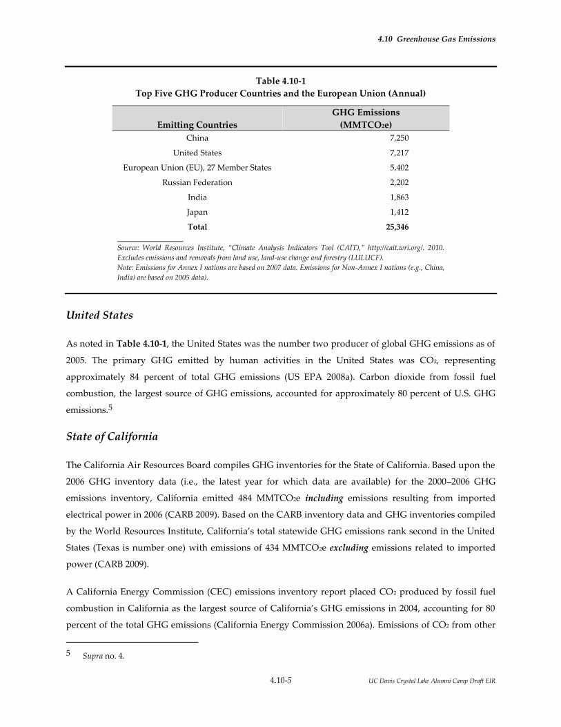
4.10 Greenhouse Gas Emissions
4.10-5 UC Davis Crystal Lake Alumni Camp Draft EIR
Table 4.10-1
Top Five GHG Producer Countries and the European Union (Annual)
Emitting Countries
GHG Emissions
(MMTCO2e)
China 7,250
United States 7,217
European Union (EU), 27 Member States 5,402
Russian Federation 2,202
India 1,863
Japan 1,412
Total 25,346
Source: World Resources Institute, “Climate Analysis Indicators Tool (CAIT),” http://cait.wri.org/. 2010.
Excludes emissions and removals from land use, land-use change and forestry (LULUCF).
Note: Emissions for Annex I nations are based on 2007 data. Emissions for Non-Annex I nations (e.g., China,
India) are based on 2005 data).
United States
As noted in Table 4.10-1, the United States was the number two producer of global GHG emissions as of
2005. The primary GHG emitted by human activities in the United States was CO2, representing
approximately 84 percent of total GHG emissions (US EPA 2008a). Carbon dioxide from fossil fuel
combustion, the largest source of GHG emissions, accounted for approximately 80 percent of U.S. GHG
emissions.5
State of California
The California Air Resources Board compiles GHG inventories for the State of California. Based upon the
2006 GHG inventory data (i.e., the latest year for which data are available) for the 2000–2006 GHG
emissions inventory, California emitted 484 MMTCO2e including emissions resulting from imported
electrical power in 2006 (CARB 2009). Based on the CARB inventory data and GHG inventories compiled
by the World Resources Institute, California’s total statewide GHG emissions rank second in the United
States (Texas is number one) with emissions of 434 MMTCO2e excluding emissions related to imported
power (CARB 2009).
A California Energy Commission (CEC) emissions inventory report placed CO2 produced by fossil fuel
combustion in California as the largest source of California’s GHG emissions in 2004, accounting for 80
percent of the total GHG emissions (California Energy Commission 2006a). Emissions of CO2 from other
5 Supra no. 4.

4.10 Greenhouse Gas Emissions
4.10-6 UC Davis Crystal Lake Alumni Camp Draft EIR
sources contributed 3.1 percent of the total GHG emissions; methane emissions 6.4 percent; nitrous oxide
emissions 7.6 percent; and the remaining 3.2 percent was composed of emissions of high-GWP gases
(California Energy Commission 2006a). These high GWP gases are largely composed of refrigerants, with
small contributions of SF6 used in connection with insulating materials for electricity transmission and
distribution.
4.10.3 REGULATORY CONSIDERATIONS
4.10.3.1 Intergovernmental Panel on Climate Change
The World Meteorological Organization (WMO) and United Nations Environmental Program (UNEP)
established the IPCC in 1988. The goal of the IPCC is to evaluate the risk of climate change caused by
human activities. Rather than performing research or monitoring climate, the IPCC relies on peer-
reviewed and published scientific literature to make its assessment. While not a regulatory body, the
IPCC assesses information (i.e., scientific literature) regarding human-induced climate change and the
impacts of human-induced climate change, and recommends options to policy makers for the adaptation
and mitigation of climate change. The IPCC reports its evaluations in special reports called “assessment
reports.” The Fifth Assessment Report was published in 2014. The Fifth Assessment Report upgrades the
likelihood of climate change being attributable to human activities to “extremely likely.”
4.10.3.2 Federal Laws and Regulations
In Massachusetts vs. EPA, the Supreme Court held that United States Environmental Protection Agency
(US EPA) has the statutory authority under Section 202 of the Clean Air Act (CAA) to regulate GHGs
from new motor vehicles. The court did not hold that the US EPA was required to regulate GHG
emissions; however, it indicated that the agency must decide whether GHGs from motor vehicles cause
or contribute to air pollution that is reasonably anticipated to endanger public health or welfare. Upon
the final decision, the President signed Executive Order 13432 on May 14, 2007, directing the US EPA,
along with the Departments of Transportation, Energy, and Agriculture, to initiate a regulatory process
that responds to the Supreme Court’s decision.
In December 2007, the President signed the Energy Independence and Security Act of 2007, which sets a
mandatory Renewable Fuel Standard (RFS) requiring fuel producers to use at least 36 billion gallons of
biofuel in 2022 and sets a national fuel economy standard of 35 miles per gallon by 2020. The act also
contains provisions for energy efficiency in lighting and appliances and for the implementation of green
building technologies in federal buildings. On July 11, 2008, the US EPA issued an Advanced Notice of
4.10 Greenhouse Gas Emissions
4.10-7 UC Davis Crystal Lake Alumni Camp Draft EIR
Proposed Rulemaking (ANPRM) on regulating GHGs under the CAA. The ANPRM reviews the various
CAA provisions that may be applicable to the regulation of GHGs and presents potential regulatory
approaches and technologies for reducing GHG emissions. On April 10, 2009, the US EPA published the
Proposed Mandatory Greenhouse Gas Reporting Rule in the Federal Register (US EPA 2009). The rule was
adopted on September 22, 2009 and covers approximately 10,000 facilities nationwide, accounting for
85 percent of US GHG emissions.
On September 15, 2009, the US EPA and the Department of Transportation’s (DOT) National Highway
Traffic Safety Administration (NHTSA) issued a joint proposal to establish a national program consisting
of new standards for model year 2012 through 2016 light-duty vehicles that will reduce GHG emissions
and improve fuel economy. The proposed standards would be phased in and would require passenger
cars and light-duty trucks to comply with a declining emissions standard. In 2012, passenger cars and
light-duty trucks would have to meet an average standard of 295 grams of CO2 per mile and 30.1 miles
per gallon. By 2016, the vehicles would have to meet an average standard of 250 grams of CO2 per
mile and 35.5 miles per gallon.6 These standards were formally adopted by the US EPA and DOT on
April 1, 2010.
On December 7, 2009, the US EPA Administrator signed two distinct findings regarding GHGs under
section 202(a) of the CAA:
Endangerment Finding: The Administrator finds that the current and projected
concentrations of the six key well-mixed GHGs (carbon dioxide, methane, nitrous
oxide, hydrofluorocarbons, perfluorocarbons, and sulfur hexafluoride) in the
atmosphere threaten the public health and welfare of current and future generations.
Cause or Contribute Finding: The Administrator finds that the combined emissions
of these well-mixed greenhouse gases from new motor vehicles and new motor
vehicle engines contribute to the greenhouse gas pollution which threatens public
health and welfare.
While these findings do not impose additional requirements on industry or other entities, this action was
a prerequisite to finalizing the US EPA’s proposed GHG emissions standards for light-duty vehicles,
which were jointly proposed by the US EPA and DOT. On April 1, 2010, the US EPA and NHTSA issued
final rules requiring that by the 2016 model-year, manufacturers must achieve a combined average
vehicle emission level of 250 grams of CO2 per mile, which is equivalent to 35.5 miles per gallon as
measured by US EPA standards. These agencies are currently in the process of developing similar
regulations for the 2017 through 2025 model years.
6 The CO2 emission standards and fuel economy standards stated are based on US EPA formulas.

4.10 Greenhouse Gas Emissions
4.10-8 UC Davis Crystal Lake Alumni Camp Draft EIR
4.10.3.3 State Laws and Regulations
Title 24 Building Standards Code
The California Energy Commission first adopted Energy Efficiency Standards for Residential and
Nonresidential Buildings (California Code of Regulations, Title 24, Part 6) in 1978 in response to a
legislative mandate to reduce energy consumption in the state. Although not originally intended to
reduce GHG emissions, increased energy efficiency, and reduced consumption of electricity, natural gas,
and other fuels would result in fewer GHG emissions from residential and nonresidential buildings
subject to the standard. The standards are updated periodically to allow for the consideration and
inclusion of new energy efficiency technologies and methods. The latest revisions were adopted in 2013
and became effective on July 1, 2014.
Part 11 of the Title 24 Building Standards Code is referred to as the California Green Building Standards
Code (CALGreen Code). The purpose of the CALGreen Code is to “improve public health, safety and
general welfare by enhancing the design and construction of buildings through the use of building
concepts having a positive environmental impact and encouraging sustainable construction practices in
the following categories: (1) Planning and design; (2) Energy efficiency; (3) Water efficiency and
conservation; (4) Material conservation and resource efficiency; and (5) Environmental air quality
(California Building Standards Commission 2009). The CALGreen Code is not intended to substitute or
be identified as meeting the certification requirements of any green building program that is not
established and adopted by the California Building Standards Commission (CBSC). The CBSC has
released a 2013 California Green Building Standards Code on its website (California Building Standards
Commission 2013). The update to Part 11 of the Title 24 Building Standards Code became effective on
January 1, 2014. Unless otherwise noted in the regulation, all newly constructed buildings in California
are subject of the requirements of the CALGreen Code.
Executive Order S-3-05 and the Climate Action Team
In June 2005, Governor Schwarzenegger established California’s GHG emissions reduction targets in
Executive Order S-3-05. The Executive Order established the following goals: GHG emissions should be
reduced to 2000 levels by 2010, 1990 levels by 2020, and 80 percent below 1990 levels by 2050.
The Secretary of Cal EPA is required to coordinate efforts of various agencies in order to collectively and
efficiently reduce GHGs. Some of the agency representatives involved in the GHG reduction plan include
the Secretary of the Business, Transportation and Housing Agency, the Secretary of the Department of
Food and Agriculture, the Secretary of the Resources Agency, the Chairperson of CARB, the Chairperson
of the CEC, and the President of the Public Utilities Commission.

4.10 Greenhouse Gas Emissions
4.10-9 UC Davis Crystal Lake Alumni Camp Draft EIR
Representatives from each of the aforementioned agencies comprise the Climate Action Team. The Cal
EPA secretary is required to submit a biannual progress report from the Climate Action Team to the
governor and state legislature disclosing the progress made toward GHG emission reduction targets. In
addition, another biannual report must be submitted illustrating the impacts of global warming on
California’s water supply, public health, agriculture, coastline, and forests, and reporting possible
mitigation and adaptation plans to combat these impacts. Some strategies currently being implemented
by state agencies include CARB introducing vehicle climate change standards and diesel anti-idling
measures, the Energy Commission implementing building and appliance efficiency standards, and the
Cal EPA implementing their green building initiative. The Climate Action Team also recommends future
emission reduction strategies, such as using only low-GWP refrigerants in new vehicles, developing
ethanol as an alternative fuel, reforestation, solar power initiatives for homes and businesses, and
investor-owned utility energy efficiency programs. According to the report, implementation of current
and future emission reduction strategies have the potential to achieve the goals set forth in Executive
Order S-3-05.
Assembly Bill 32
In furtherance of the goals established in Executive Order S-3-05, the legislature enacted Assembly Bill 32
(AB 32, Nuñez and Pavley), the California Global Warming Solutions Act of 2006, which Governor
Schwarzenegger signed on September 27, 2006. AB 32 represents the first enforceable statewide program
to limit GHG emissions from all major industries with penalties for noncompliance. AB 32 requires the
state to undertake several actions. The major requirements are discussed below.
CARB Early Action Measures
CARB is responsible for carrying out and developing the programs and requirements necessary to
achieve the goal of AB 32—the reduction of California's GHG emissions to 1990 levels by 2020. The first
action under AB 32 resulted in CARB’s adoption of a report listing three specific early-action greenhouse
gas emission reduction measures on June 21, 2007. On October 25, 2007, CARB approved six additional
early-action GHG reduction measures under AB 32. CARB has adopted regulations for all early action
measures. The early-action measures are divided into three categories:
Group 1 – GHG rules for immediate adoption and implementation
Group 2 – Several additional GHG measures under development
Group 3 – Air pollution controls with potential climate co-benefits

4.10 Greenhouse Gas Emissions
4.10-10 UC Davis Crystal Lake Alumni Camp Draft EIR
The original three adopted early-action regulations meeting the narrow legal definition of “discrete early-
action GHG reduction measures” include:
a low-carbon fuel standard to reduce the “carbon intensity” of California fuels;
reduction of refrigerant losses from motor vehicle air conditioning system
maintenance to restrict the sale of ”do-it-yourself” automotive refrigerants; and
increased methane capture from landfills to require broader use of state-of-the-art
methane capture technologies.
The six additional early-action regulations adopted on October 25, 2007, also meeting the narrow legal
definition of “discrete early-action GHG reduction measures,” include:
reduction of aerodynamic drag, and thereby fuel consumption, from existing trucks
and trailers through retrofit technology;
reduction of auxiliary engine emissions of docked ships by requiring port
electrification;
reduction of perfluorocarbons from the semiconductor industry;
reduction of propellants in consumer products (e.g., aerosols, tire inflators, and dust
removal products);
the requirement that all tune-up, smog check and oil change mechanics ensure
proper tire inflation as part of overall service in order to maintain fuel efficiency; and
restriction on the use of sulfur hexafluoride (SF6) from non-electricity sectors if viable
alternatives are available.
State of California Greenhouse Gas Inventory and 2020 Limit
As required under AB 32, on December 6, 2007, CARB approved the 1990 GHG inventory, thereby
establishing the emissions limit for 2020. The 2020 emissions limit was set at 427 MMTCO2e. CARB also
projected the state’s 2020 GHG emissions under “business as usual” (BAU) conditions—that is, emissions
that would occur without any plans, policies, or regulations to reduce GHG emissions. CARB used an
average of the state’s GHG emissions from 2002 through 2004 and projected the 2020 levels based on
population and economic forecasts. The projected net emissions totaled approximately 596 MMTCO2e,
though this was updated in 2010 to 507 MMTCO2e. Therefore, the state must reduce its 2020 BAU
emissions by approximately 16 percent in order to meet the 1990 target.
The inventory revealed that in 1990, transportation, with 35 percent of the state's total emissions, was the
largest single sector, followed by industrial emissions, 24 percent; imported electricity, 14 percent; in-state

4.10 Greenhouse Gas Emissions
4.10-11 UC Davis Crystal Lake Alumni Camp Draft EIR
electricity generation, 11 percent; residential use, 7 percent; agriculture, 5 percent; and commercial uses,
3 percent. AB 32 does not require individual sectors to meet their individual 1990 GHG emissions
inventory; the total statewide emissions are required to meet the 1990 threshold by 2020.
CARB Mandatory Reporting Requirements
In addition to the 1990 emissions inventory, CARB also adopted regulations requiring the mandatory
reporting of GHG emissions for large facilities on December 6, 2007. The mandatory reporting regulations
require annual reporting from the largest facilities in the state, which account for approximately
94 percent of point source greenhouse gas emissions from industrial and commercial stationary sources
in California. About 800 separate sources fall under the new reporting rules and include electricity-
generating facilities, electricity retail providers and power marketers, oil refineries, hydrogen plants,
cement plants, cogeneration facilities, and industrial sources that emit over 25,000 tons of carbon dioxide
each year from on-site stationary combustion sources. Transportation sources, which account for
38 percent of California’s total GHG emissions, are not covered by these regulations but will continue to
be tracked through existing means.
AB 32 Climate Change Scoping Plan
As indicated above, AB 32 requires CARB to adopt a scoping plan indicating how reductions in
significant GHG sources will be achieved through regulations, market mechanisms, and other actions.
After receiving public input on their discussion draft of the scoping plan, the CARB Governing Board
approved the Climate Change Scoping Plan on December 11, 2008. Key elements of the Scoping Plan
include the following recommendations:
Expanding and strengthening existing energy efficiency programs as well as building
and appliance standards;
Achieving a statewide renewable energy mix of 33 percent;
Developing a California cap-and-trade program that links with other Western
Climate Initiative partner programs to create a regional market system;
Establishing targets for transportation-related greenhouse gas emissions for regions
throughout California and pursuing policies and incentives to achieve those targets;
Adopting and implementing measures pursuant to existing state laws and policies,
including California’s clean car standards, goods movement measures, and the Low
Carbon Fuel Standard; and

4.10 Greenhouse Gas Emissions
4.10-12 UC Davis Crystal Lake Alumni Camp Draft EIR
Creating targeted fees, including a public goods charge on water use, fees on high
global warming potential gases, and a fee to fund the administrative costs of the
state’s long-term commitment to AB 32 implementation.
Under the Scoping Plan, approximately 85 percent of the state’s emissions are subject to a cap-and-trade
program where covered sectors are placed under a declining emissions cap. The emissions cap
incorporates a margin of safety whereas the 2020 emissions limit will still be achieved even in the event
that uncapped sectors do not fully meet their anticipated emission reductions. Emissions reductions will
be achieved through regulatory requirements and the option to reduce emissions further or purchase
allowances to cover compliance obligations. It is expected that emission reduction from this
cap-and-trade program will account for a large portion of the reductions required by AB 32.
Table 4.10-2, AB 32 Scoping Plan Measures (SPMs), lists CARB’s preliminary recommendations for
achieving GHG emissions reductions under AB 32 along with a brief description of the requirements and
applicability.
Table 4.10-2
AB 32 Scoping Plan Measures (SPMs)
Scoping Plan Measure Description
SPM-1: California Cap-and-Trade Program linked to Western Climate Initiative
Implement a broad-based cap-and-trade program that links with other Western Climate Initiative Partner programs to create a regional market system. Ensure California’s program meets all applicable AB 32 requirements for market-based mechanisms. Capped sectors include transportation, electricity, natural gas, and industry. Projected 2020 business-as-usual emissions are estimated at 512 metric tons of CO2 equivalents (MTCO2e); preliminary 2020 emissions limit under cap-and-trade program are estimated at 365 MTCO2e (29 percent reduction).
SPM-2: California Light-Duty Vehicle GHG Standards
Implement adopted Pavley standards and planned second phase of the program. AB 32 states that if the Pavley standards (AB 1493) do not remain in effect, CARB shall implement equivalent or greater alternative regulations to control mobile sources.
SPM-3: Energy Efficiency Maximize energy efficiency building and appliance standards, and pursue additional efficiency efforts. The Scoping Plan considers green building standards as a framework to achieve reductions in other sectors, such as electricity.
SPM-4: Renewables Portfolio Standard Achieve 33 percent Renewables Portfolio Standard by both investor-owned and publicly owned utilities.
SPM-5: Low Carbon Fuel Standard CARB identified the Low Carbon Fuel Standard as a Discrete Early Action item and the final regulation was adopted on April 23, 2009. In January 2007, Governor Schwarzenegger issued Executive Order S-1-07, which called for the reduction of the carbon intensity of California's transportation fuels by at least 10 percent by 2020.
SPM-6: Regional Transportation-Related Greenhouse Gas Targets
Develop regional greenhouse gas emissions reduction targets for passenger vehicles. SB 375 requires CARB to develop, in consultation with metropolitan planning organizations (MPOs), passenger vehicle greenhouse gas emissions reduction targets for 2020 and 2035 by September 30, 2010. SB 375 requires MPOs to prepare a sustainable communities strategy to reach the regional target provided by CARB.
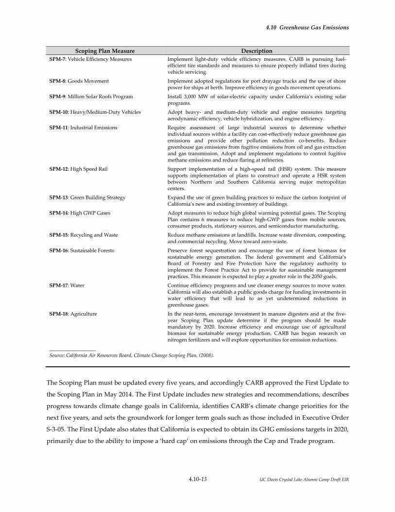
4.10 Greenhouse Gas Emissions
4.10-13 UC Davis Crystal Lake Alumni Camp Draft EIR
Scoping Plan Measure Description
SPM-7: Vehicle Efficiency Measures Implement light-duty vehicle efficiency measures. CARB is pursuing fuel-efficient tire standards and measures to ensure properly inflated tires during vehicle servicing.
SPM-8: Goods Movement Implement adopted regulations for port drayage trucks and the use of shore power for ships at berth. Improve efficiency in goods movement operations.
SPM-9: Million Solar Roofs Program Install 3,000 MW of solar-electric capacity under California’s existing solar programs.
SPM-10: Heavy/Medium-Duty Vehicles Adopt heavy- and medium-duty vehicle and engine measures targeting aerodynamic efficiency, vehicle hybridization, and engine efficiency.
SPM-11: Industrial Emissions Require assessment of large industrial sources to determine whether individual sources within a facility can cost-effectively reduce greenhouse gas emissions and provide other pollution reduction co-benefits. Reduce greenhouse gas emissions from fugitive emissions from oil and gas extraction and gas transmission. Adopt and implement regulations to control fugitive methane emissions and reduce flaring at refineries.
SPM-12: High Speed Rail Support implementation of a high-speed rail (HSR) system. This measure supports implementation of plans to construct and operate a HSR system between Northern and Southern California serving major metropolitan centers.
SPM-13: Green Building Strategy Expand the use of green building practices to reduce the carbon footprint of California’s new and existing inventory of buildings.
SPM-14: High GWP Gases Adopt measures to reduce high global warming potential gases. The Scoping Plan contains 6 measures to reduce high-GWP gases from mobile sources, consumer products, stationary sources, and semiconductor manufacturing.
SPM-15: Recycling and Waste Reduce methane emissions at landfills. Increase waste diversion, composting, and commercial recycling. Move toward zero-waste.
SPM-16: Sustainable Forests Preserve forest sequestration and encourage the use of forest biomass for sustainable energy generation. The federal government and California’s Board of Forestry and Fire Protection have the regulatory authority to implement the Forest Practice Act to provide for sustainable management practices. This measure is expected to play a greater role in the 2050 goals.
SPM-17: Water Continue efficiency programs and use cleaner energy sources to move water. California will also establish a public goods charge for funding investments in water efficiency that will lead to as yet undetermined reductions in greenhouse gases.
SPM-18: Agriculture In the near-term, encourage investment in manure digesters and at the five-year Scoping Plan update determine if the program should be made mandatory by 2020. Increase efficiency and encourage use of agricultural biomass for sustainable energy production. CARB has begun research on nitrogen fertilizers and will explore opportunities for emission reductions.
Source: California Air Resources Board, Climate Change Scoping Plan, (2008).
The Scoping Plan must be updated every five years, and accordingly CARB approved the First Update to
the Scoping Plan in May 2014. The First Update includes new strategies and recommendations, describes
progress towards climate change goals in California, identifies CARB’s climate change priorities for the
next five years, and sets the groundwork for longer term goals such as those included in Executive Order
S-3-05. The First Update also states that California is expected to obtain its GHG emissions targets in 2020,
primarily due to the ability to impose a ‘hard cap’ on emissions through the Cap and Trade program.

4.10 Greenhouse Gas Emissions
4.10-14 UC Davis Crystal Lake Alumni Camp Draft EIR
Senate Bill 97 (CEQA Guidelines)
In August 2007, the legislature enacted SB 97 (Dutton), which directed the Governor’s Office of Planning
and Research (OPR) to develop guidelines under the California Environmental Quality Act (CEQA) for
the mitigation of GHG emissions. A number of actions have taken place under SB 97, which are discussed
below. In its work to formulate CEQA Guideline Amendments for GHG emissions, OPR submitted the
Proposed Draft CEQA Guideline Amendments for Greenhouse Gas Emissions to the Secretary for Natural
Resources on April 13, 2009. The Natural Resources Agency conducted formal rulemaking procedures in
2009 and adopted the CEQA Guideline Amendments on December 30, 2009. They became effective in
March 2010.
Senate Bill 375
The California legislature passed SB 375 (Steinberg) on September 1, 2008. SB 375 requires CARB to set
regional GHG reduction targets after consultation with local governments. The target must then be
incorporated within that region’s regional transportation plan (RTP), which is used for long-term
transportation planning, in a Sustainable Communities Strategy. SB 375 also requires each region’s
regional housing needs assessment (RHNA) to be adjusted based on the Sustainable Communities
Strategy in its RTP. Additionally, SB 375 reforms the environmental review process to create incentives to
implement the strategy, especially transit priority projects. The governor signed SB 375 into law on
September 30, 2008.
On January 23, 2009, CARB appointed a Regional Targets Advisory Committee (RTAC) to provide
recommendations and methodologies to be used in the target setting process. The RTAC provided its
recommendations in a report to CARB on September 29, 2009. On August 9, 2010, CARB staff issued the
Proposed Regional Greenhouse Gas Emission Reduction Targets for Automobiles and Light Trucks Pursuant to
Senate Bill 375. CARB staff proposed draft reduction targets for the four largest MPOs (Bay Area,
Sacramento, Southern California, and San Diego) of 7 to 8 percent for 2020 and reduction targets between
13 to 16 percent for 2035. For the Bay Area, CARB established a draft target of 7 percent for 2020 and
15 percent for 2035. These targets were recommended to CARB by the Metropolitan Transportation
Commission, which adopted the thresholds for its planning purposes on July 28, 2010. Of note, the
proposed reduction targets explicitly exclude emission reductions expected from the AB 1493 and low
carbon fuel standard regulations. CARB adopted the final targets on September 23, 2010.

4.10 Greenhouse Gas Emissions
4.10-15 UC Davis Crystal Lake Alumni Camp Draft EIR
4.10.3.4 Applicable Local Plans and Policies
University of California Policy on Sustainable Practices
The University of California Policy on Sustainable Practices was adopted by The Regents in 2006 and
revised periodically through June 2015. The policy was developed to standardize campus practices and is
a system-wide commitment to minimize the University of California’s impact on the environment and
reduce the University’s dependence on non-renewable energy sources. The University of California
Policy on Sustainable Practices promotes the principles of energy efficiency and sustainability in the
following areas:
Green Building Design
Clean Energy Standard
Climate Protection Practices
Sustainable Transportation Practices
Sustainable Operations
Recycling and Waste Management
Environmentally Preferable Purchasing Practices
Food
The policy guidelines that address these topics recommend that University operations:
Incorporate the principles of energy efficiency and sustainability in all capital projects, operations and
maintenance within budgetary constraints and programmatic requirements.
Minimize the use of non-renewable energy sources on behalf of UC’s built environment by creating a
portfolio approach to energy use, including use of local renewable energy and purchase of green
power from the grid as well as conservation measures that reduce energy consumption.
Incorporate alternative means of transportation to/from and within the campus to improve the
quality of life on campus and in the surrounding community. The campuses will continue their
strong commitment to provide affordable on-campus housing, in order to reduce the volume of
commutes to and from campus. These housing goals are detailed in the campuses’ LRDPs.
Track, report and minimize GHG emissions on behalf of UC operations.
Minimize the amount of University-generated waste sent to landfill.
Utilize the University’s purchasing power to meet its sustainability objectives.

4.10 Greenhouse Gas Emissions
4.10-16 UC Davis Crystal Lake Alumni Camp Draft EIR
The University of California has signed the American College and University Presidents Climate
Commitment. Each signatory commits to completing an inventory of GHG emissions within one year,
and to developing, within two years, an institutional plan to achieve climate neutrality as soon as
possible. The commitment also includes specific interim actions, including requiring that new campus
construction will be built to at least the US Green Building Council’s LEED Silver standard or equivalent;
purchasing Energy Star appliances; offsetting greenhouse gas emissions generated by institutional air
travel; encouraging and providing access to public transportation; purchasing or producing at least 15
percent of the institution’s electricity consumption from renewable sources; supporting climate and
sustainability shareholder proposals at companies where the institution’s endowment is invested; and
adopting measures to reduce waste.
4.10.4 IMPACTS AND MITIGATION MEASURES
4.10.4.1 Significance Criteria
The impacts related to GHG emissions resulting from the implementation of the proposed project would
be considered significant if they would exceed either of the following significance criteria, in accordance
with Appendix G of the State CEQA Guidelines:
Generate greenhouse gas emissions, either directly or indirectly, that may have a significant impact
on the environment;
Construction: On an annualized basis, the project would have a significant impact if the
construction GHG emissions equaled or exceeded 1,100 metric tons/year (expressed as CO2e).
Operation: On an annualized basis, the project would have a significant impact if the operational
phase GHG emissions equaled or exceeded 1,100 metric tons/year (expressed as CO2e).
Conflict with an applicable plan, policy, or regulation adopted for the purpose of reducing the
emissions of greenhouse gases.
The University of California does not have an adopted CEQA threshold of significance for GHG emission
and typically relies on the local air district with jurisdiction in the project area for guidance in setting an
appropriate threshold for GHG emission. However, the Northern Sierra Air Quality Management
District has not adopted a GHG emissions threshold. The nearby Sacramento Metropolitan Air Quality
Management District (SMAQMD) has adopted thresholds after review of overall GHG control efforts and
consideration of public input. The University will utilize the SMAQMD thresholds for the proposed
project. Details of the SMAQMD thresholds are available at the SMAQMD CEQA guide website

4.10 Greenhouse Gas Emissions
4.10-17 UC Davis Crystal Lake Alumni Camp Draft EIR
4.10.4.2 Methodology
The NSAQMD does not provide GHG emission methodology guidance in the adopted district guidelines
for assessing air quality impacts. This section follows the SMAQMD CEQA guide using the CalEEMod
emissions estimating model to estimate project-related GHG emissions. Site-specific or project-specific
data were used in the CalEEMod model where available. Where information was not available for the
proposed project, model default values were used. Emission calculations conducted for the proposed
project are contained in Appendix 4.2.
4.10.4.4 Project Impacts and Mitigation Measures
Impact GHG-1: The proposed project would not generate greenhouse gas emissions, either
directly or indirectly, that may have a significant impact on the environment.
(Less than Significant)
The project GHG emissions were calculated using the CalEEMod emissions model. CalEEMod provides
output for construction related emissions and for operational emissions. The following impact analysis
first addresses construction GHG emissions and then operational GHG emissions.
Construction Emissions
For construction emissions, project-specific data regarding construction timing, expected construction
equipment, vegetation management, and trip information for construction workers, hauling, and
deliveries were used as inputs for the CalEEMod modelling. Where project-specific information was not
available, the CalEEMod default values were utilized.
The proposed project consists of four main construction phases: vegetation management, rough grading,
utility installation, building, construction, and paving with nearly all construction expected to occur in a
single year. The model outputs for construction activities are provided in Appendix 4.2. The total
emissions the first year of construction were estimated to be 525 MTCO2e and 7.3 MTCO2e during the
second year. GHG emissions during none of the construction years would exceed the threshold of 1,100
MTCO2e per year. The potential GHG emission impact from construction activities would be less than
significant.

4.10 Greenhouse Gas Emissions
4.10-18 UC Davis Crystal Lake Alumni Camp Draft EIR
Operational Emissions
The CalEEMod emission estimator does not include a land use input for educational camps,
campgrounds, or event center. To evaluate the proposed project’s operational impacts, GHG emissions
were estimated using basic CalEEMod default land uses (city park, mobile home park, swimming pool,
single-family residences, and motel units) as approximations of the actual land uses proposed for the
project.
Table 4.3-5, Annual GHG Emissions for Operational Activities, summarizes the output of operational
GHG emissions that would result from the proposed project. The proposed project is projected to result
in new operational GHG emissions of 336 MTCO2e per year. The projected increased is less than the
threshold of 1,100 MTCO2e per year. The potential impact would be less than significant.
Table 4.3-5
Annual GHG Emissions for Operational Activities
Scope Source
GHG Emissions
(Metric Tons CO2e/year)*
Area
Campfires, consumer
product, equipment usage 1.3
Energy
Purchased Electricity and
Gas Combustion 167.1
Other Waste 25.0
Other Water 34.6
Mobile
Vehicle trips (on and off-
road)
108.6
Total Annual GHG Emissions 336
Source: CalEEMod Model Results. Emission details are provided in Appendix 4.2.
Note: Totals in table may not appear to add exactly due to rounding.
Mitigation Measures: No project-level mitigation measures are required.
Impact GHG-2: The proposed project would not conflict with an applicable plan, policy, or
regulation adopted for the purpose of reducing GHG emissions. (Less than
Significant)
The Northern Sierra AQMD has not adopted a plan, policy, or regulation for reducing GHG emissions.
Applicable policies from the University of California regarding goals for reduced GHG emissions relate
to the proposed project and the overall efforts of the University to minimize GHG emissions will extend

4.10 Greenhouse Gas Emissions
4.10-19 UC Davis Crystal Lake Alumni Camp Draft EIR
to the design and operational details of the proposed project. While the proposed project represents a net
increase in GHG emission at the project site, the proposed vacation activity at the project site by alumni
and other affiliates of the University are already producing GHG emissions in terms of travel,
combustion, and resource use resulting in GHG emissions. These factors make the overall contribution of
the proposed project difficult to assess and precisely quantify. With the identified minor contribution of
total emission quantified above in impact GHG-1, the proposed project contains no elements that would
conflict with UC Davis’s GHG reduction efforts, including the Campus’s Climate Action Plan and the
overall efforts of the University of California. The potential impact would be less than significant.
Mitigation Measures: No project-level mitigation measures are required.
4.10.4.3 Cumulative Impacts and Mitigation Measures
As the impact from a project’s GHG emissions is essentially a cumulative impact and program-level
emission reductions are necessary to consider the overall efforts to reduce GHG emissions. For this
reason, project-level impacts are considered one and the same as cumulative impacts. This approach is
consistent with the guidance provided by the SMAQMD and the analysis presented in this section
provides an adequate analysis of the proposed project’s cumulative impact related to GHG emissions.
The potential impact would be less than significant.
4.10.5 REFERENCES
California Air Pollution Control Officers Association (CAPCOA). 2008. CEQA & Climate Change:
Evaluating and Addressing Greenhouse Gas Emissions from Projects Subject to the California
Environmental Quality Act.
California Air Resources Board (CARB). 2009. California Greenhouse Gas 2000-2006 Inventory by Scoping
Plan Category – Summary. http://www.arb.ca.gov/cc/inventory/data/data.htm.
California Building Standards Commission. 2009. 2008 California Green Building Standards Code.
California Building Standards Commission. 2010. “CALGreen,” http://www.bsc.ca.gov/CALGreen
/default.htm.
California Climate Action Registry. 2009. General Reporting Protocol: Reporting Entity-Wide Greenhouse as
Emissions Version 3.1.
California Department of Finance. 2008. “E-5 City/County Population and Housing Estimates, 2008,
Revised 2001-2007, with 2000 Benchmark,” http://www.dof.ca.gov/research/demographic/reports
/estimates/e-5_2001-06/.
California Department of Finance. 2009. Financial & Economic Data: Gross Domestic Product, California.
http://www.dof.ca.gov/HTML/FS_DATA/LatestEconData/FS_Misc.htm. June 2.

4.10 Greenhouse Gas Emissions
4.10-20 UC Davis Crystal Lake Alumni Camp Draft EIR
California Energy Commission. 2002. Diesel Use in California, Remarks by Commissioner James D. Boyd.
California Energy Commission. 2006a. Inventory of California Greenhouse Gas Emissions and Sinks 1990 to
2004.
California Energy Commission. 2006b. Refining Estimates of Water-Related Energy Use in California, PIER
Final Project Report (CEC-500-2006-118). Prepared by Navigant Consulting, Inc.
California Energy Commission. 2007. Revisions to the 1990–2004 Greenhouse Gas Emissions Inventory Report,
Published in December 2006. http://www.energy.ca.gov/2006publications/CEC-600-2006-013/2007-
01-23_GHG_INVENTORY_REVISIONS.PDF.
California Environmental Protection Agency (Cal EPA), Climate Action Team. 2006. Climate Action Team
Report to Governor Schwarzenegger and the Legislature.
California Natural Resources Agency. 2009. Final Statement of Reasons for Regulatory Action: Amendments to
the State CEQA Guidelines Addressing Analysis and Mitigation of Greenhouse Gas Emissions Pursuant
to SB97.
The Climate Registry. 2010. Local Government Operations Protocol: For the quantification and reporting of
greenhouse gas emission inventories, Version 1.1.
Energy Information Administration. 2007. “Other Gases: Hydrofluorocarbons, Perfluorocarbons, and
Sulfur Hexafluoride,” http://www.eia.doe.gov/oiaf/1605/ggrpt/summary/other_gases.html.
Intergovernmental Panel on Climate Change (IPCC). 1996. Climate Change 1995: The Science of Climate
Change – Contribution of Working Group I to the Second Assessment Report of the Intergovernmental
Panel on Climate Change.
Intergovernmental Panel on Climate Change (IPCC). 2014. Climate Change 2014: The Physical Science Basis,
Summary for Policymakers. http://ipcc-wg1.ucar.edu/wg1/docs/WG1AR4_SPM
_PlenaryApproved.pdf.
Sacramento Metropolitan Air Quality Management District (SMAQMD). 2009. Guide to Air Quality
Assessment in Sacramento County. Updated through June 2015.
State of California, Governor’s Office of Planning and Research (OPR). 2008. CEQA and Climate Change:
Addressing Climate Change Through California Environmental Quality Act (CEQA) Review.
State of California, Governor’s Office of Planning and Research (OPR). 2009. Draft CEQA Guideline
Amendments for Greenhouse Gas Emissions.
US Census Bureau. 2009. “Data Finders.” http://www.census.gov/.
US Environmental Protection Agency (US EPA). 1996. AP-42 Compilation of Air Pollutant Emission
Factors, Fifth Edition, Volume I, Chapter 3.4. October.
US Environmental Protection Agency (US EPA). 1998. AP-42 Compilation of Air Pollutant Emission
Factors, Fifth Edition, Volume I, Chapter 1.4. July.

4.10 Greenhouse Gas Emissions
4.10-21 UC Davis Crystal Lake Alumni Camp Draft EIR
US Environmental Protection Agency (US EPA). 2000. AP-42 Compilation of Air Pollutant Emission
Factors, Fifth Edition, Volume I, Chapter 3.1. April.
US Environmental Protection Agency (US EPA). 2005. Greenhouse Gas Emissions from a Typical Passenger
Vehicle (EPA420-F-05-004).
US Environmental Protection Agency (US EPA). 2008a. Glossary of Climate Change Terms.
http://www.epa.gov/climatechange/glossary.html.
US Environmental Protection Agency (US EPA). 2008b. Inventory of US Greenhouse Gas Emissions and Sinks
1990–2006. http://www.epa.gov/climatechange/emissions/usinventoryreport.html.
US Environmental Protection Agency (US EPA). 2009. “Climate Change.” http://www.epa.gov
/climatechange.
US Environmental Protection Agency (US EPA). n.d.(a) “High GWP Gases and Climate Change,”
http://www.epa.gov/highgwp/scientific.html#sf6.
US Environmental Protection Agency (US EPA). n.d.(b) “Methane: Sources and Emissions,”
http://www.epa.gov/methane/sources.html.

4.11-1 UC Davis Crystal Lake Alumni Camp Draft EIR
SECTION 4.11
HAZARDS AND HAZARDOUS MATERIALS
4.11.1 INTRODUCTION
This section discusses existing conditions with respect to the routine transport, use, or disposal of
hazardous materials for the proposed project and analyzes the potential for the proposed project to
increase the exposure to hazards or increase the risk associated with the use and disposal of hazardous
materials. This section also addresses hazards related to emergency response planning and hazards
related to wildland fires.
Public and agency comments related to Hazards and Hazardous Materials received in response to the
Notice of Preparation are summarized below.
Emergency evacuation use and adequacy of Crystal Lake Road.
Environmental concerns related to site contamination such as contamination of existing structures,
school site related sensitivity, and potential for naturally occurring asbestos.
Potential impacts to campers from transport of hazardous materials on adjacent railroad.
4.11.2 ENVIRONMENTAL SETTING
4.11.2.1 Study Area
The study area includes the project site and the property along the Crystal Lake road that is proposed as
road access for the Crystal Lake property.
4.11.2.2 Hazardous Materials
The term “hazardous material” is defined in Section 25501 of the California Health and Safety Code as
any material that, because of quantity, concentration, or physical or chemical characteristics poses a
significant present or potential hazard to human health and safety or to the environment. Hazardous
materials are grouped into the following four categories, based on their properties: toxic (causes human
health effects), ignitable (has the ability to burn), corrosive (causes severe burns or damage to materials),
and reactive (causes explosions or generates toxic gases).
Hazardous materials are used in facility operations and building, grounds and vehicle maintenance.
Hazardous material use in turn generates hazardous wastes. The University has numerous policies and

4.11 Hazards and Hazardous Materials
4.11-2 UC Davis Crystal Lake Alumni Camp Draft EIR
procedures in place that govern how chemicals are used, stored, and disposed. This ensures compliance
with applicable federal, state, and local laws and regulations pertaining to hazardous materials.
4.11.2.3 Soil and Groundwater Contamination
A government records report was obtained for the project site and the area within 0.5 mile of the site.
This report searches federal and state databases, including the California Government Code 65962.5
(Cortese) list, for potential sources of hazardous substances or petroleum that might affect soil and/or
groundwater quality at the project site and its vicinity. No sites with potential contamination are on the
project site and the site history evaluation found no signs of site contamination (University of California
2014).
4.11.3 REGULATORY CONSIDERATIONS
University facilities are subject to environmental, health, and safety regulations applicable to the
transportation, use, management, and disposal of hazardous materials and wastes. This section provides
an overview of the regulatory setting and describes current health and safety policies and procedures.
The primary federal agencies with responsibility for hazardous materials management include the United
States Environmental Protection Agency (US EPA), and the US Department of Transportation (DOT). The
applicable federal laws, regulations, and responsible agencies are discussed in detail in this section. In
many cases, California state law mirrors or is more restrictive than federal law, and enforcement of these
laws has been delegated to the state or a local agency. In January 1996, the California Environmental
Protection Agency adopted regulations implementing a Unified Hazardous Waste and Hazardous
Materials Management Regulatory Program (Unified Program). The program has six elements:
(1) hazardous waste generators and hazardous waste on-site treatment, (2) underground storage tanks,
(3) aboveground storage tanks, (4) hazardous materials release response plans and inventories, (5) risk
management and prevention programs, and (6) Unified Fire Code hazardous materials management
plans and inventories. The local agency responsible for implementation of the Unified Program is called
the Certified Unified Program Agency (CUPA). As the project site is located within Nevada County, the
Environmental Health Department of Nevada County is the designated CUPA for the property.
4.11.3.1 Hazardous Materials Management
Federal and state laws require detailed planning to ensure that hazardous materials are properly
handled, used, stored, and disposed of, and in the event that such materials are accidentally released, to
prevent or to mitigate injury to health or the environment. These laws require hazardous materials users

4.11 Hazards and Hazardous Materials
4.11-3 UC Davis Crystal Lake Alumni Camp Draft EIR
to prepare written plans, such as Hazardous Materials Business Plans. Nevada County, through its CUPA
program, requires any business that handles hazardous materials above certain thresholds to prepare a
Hazardous Materials Business Plan, which must include the following:
Details of the facility and business conducted at the site
An inventory of hazardous materials that are handled or stored on site
An emergency response plan and contact information
A site map
4.11.3.2 Hazardous Waste Handling
The federal Resource Conservation and Recovery Act of 1976 (RCRA) created a federal hazardous waste
“cradle-to-grave” regulatory program administered by US EPA. Under RCRA, US EPA regulates the
management, treatment, and disposal of hazardous waste, and the investigation and remediation of
hazardous waste sites. Individual states may apply to US EPA to authorize them to implement their own
hazardous waste programs in lieu of RCRA, as long as the state program is at least as stringent as federal
RCRA requirements. California has been authorized by US EPA to implement its own hazardous waste
program, with certain exceptions. In California, the DTSC regulates the generation, transportation,
treatment, storage, and disposal of hazardous waste, and the investigation and remediation of hazardous
waste sites. The California DTSC program incorporates provisions of both federal and state hazardous
waste laws. As noted above, DTSC has delegated several components of the hazardous waste program to
the local CUPA.
4.11.3.3 Hazardous Materials Transportation
The DOT regulates the transportation of hazardous materials between states and foreign countries. DOT
regulations govern all means of transportation, except for packages sent by mail, which are governed by
US Postal Service regulations. The State of California has adopted DOT regulations for the intrastate
movement of hazardous materials. In addition, the State of California regulates the transportation of
hazardous waste originating in the state and passing out of the state.
The two state agencies that have primary responsibility for enforcing federal and state regulations and
responding to hazardous materials transportation emergencies are the California Highway Patrol (CHP)
and the California Department of Transportation (Caltrans). The CHP enforces hazardous material and
hazardous waste labeling and packing regulations to prevent leakage and spills of material in transit and
to provide detailed information to cleanup crews in the event of an accident. The CHP conducts regular
inspections of licensed transporters to assure regulatory compliance.

4.11 Hazards and Hazardous Materials
4.11-4 UC Davis Crystal Lake Alumni Camp Draft EIR
Every hazardous materials package type used by a hazardous materials shipper must undergo tests that
imitate some of the possible rigors of travel. While not every package must be put through every test,
representative packages for any package design must be able to be dropped, fully loaded, onto a concrete
floor with no significant leakage; survive a compression test in a stacked configuration with no significant
damage or distortion; demonstrate that they are leak proof when subjected to internal air and/or liquid
pressure; and not have package closure mechanisms adversely affected by vibration.
4.11.3.4 Occupational Safety
Occupational safety standards exist in federal and state laws to minimize worker safety risks from both
physical and chemical hazards in the workplace. The State of California Division of Occupational Safety
and Health Administration (Cal/OSHA) is responsible for developing and enforcing worker safety in the
workplace in California.
Cal/OSHA regulations contain requirements concerning the use of hazardous materials in the workplace
and during construction that mandate employee safety training, safety equipment, accident and illness
prevention programs, hazardous substance exposure warnings, emergency action and fire prevention
plan preparation, and a hazard communication program. The hazard communication program
regulations contain training and information requirements, including procedures for identifying and
labeling hazardous substances, and communicating hazard information relating to hazardous substances
and their handling. The hazard communication program also requires that Material Safety Data Sheets or
equivalent safety information be available to employees, and that employee information and training
programs be documented. These regulations require preparation of emergency action plans (escape and
evacuation procedures, rescue and medical duties, alarm systems, and training in emergency evacuation).
Cal/OSHA regulations include special provisions for hazard communication to employees in research
laboratories, including training in chemical work practices. Specific, more detailed training and
monitoring is required for the use of carcinogens, ethylene oxide, lead, asbestos, and certain other
chemicals. Emergency equipment and supplies, such as fire extinguishers, safety showers, and eye
washes, must also be provided and maintained in accessible places as the need dictates. The University
compliance process with these state requirements minimizes risks to employees.
4.11.3.5 Emergency Response and Building Code
Fire science research indicates the area around a home or other buildings requires at least 100 to 200 feet
of reduced and modified vegetation to minimize structure ignition from radiation and convection heat,
and/or firebrands landing and accumulating directly on the home. Fire science also indicates that
structure fires can produce sufficient amounts of heat and firebrand to ignite wildland vegetation.

4.11 Hazards and Hazardous Materials
4.11-5 UC Davis Crystal Lake Alumni Camp Draft EIR
Nevada County Land Use and Development Code Chapter XVI requires new projects and construction
meet fire safety standards described in PRC 4290, and establishes requirements for fuel modification and
emergency water supply, as well as minimum fire safe driveway and road standards. New structures
built in Nevada County must also comply with fire safety building regulations. These building codes
require the use of ignition-resistant building materials and establish design standards to improve the
ability of a building to survive a wildfire.
State-mandated PRC 4291 requires the management of flammable vegetation around buildings or
structures as a firebreak within 30 feet or to the property line from a structure, and as a fuelbreak, within
30 to 100 feet or to the property line from the structure. This regulation applies to all buildings or
structures in a mountainous area; forest-covered, brush-covered, or grass-covered lands; or any land that
is covered with flammable material in the SRA (Nevada County 1996).
4.11.4 IMPACTS AND MITIGATION MEASURES
4.11.4.1 Significance Criteria
The impacts related to hazards and hazardous materials from the implementation of the proposed project
would be considered significant if they would exceed the following Standards of Significance, in
accordance with Appendix G of the State CEQA Guidelines and the UC CEQA Handbook:
Create a significant hazard to the public or the environment through the routine transport, use, or
disposal of hazardous materials;
Create a significant hazard to the public or the environment through reasonably foreseeable upset
and accident conditions involving the release of hazardous materials into the environment;
Emit hazardous emissions or handle hazardous or acutely hazardous materials, substances, or waste
within 0.25 mile of an existing or proposed school;
Be located on a site that is included on a list of hazardous materials sites compiled pursuant to
Government Code Section 65962.5 and, as a result, create a significant hazard to the public or the
environment;
For a project located within an airport land use plan or, where such plan has not been adopted,
within 2 miles of a public airport or public use airport, result in a safety hazard for people residing or
working in the project area;
For a project within the vicinity of a private airstrip, result in a safety hazard for people residing or
working in the project area;

4.11 Hazards and Hazardous Materials
4.11-6 UC Davis Crystal Lake Alumni Camp Draft EIR
Impair implementation of or physically interfere with an adopted emergency response plan or
emergency evacuation plan; or
Expose people or structures to a significant risk of loss, injury, or death involving wildland fires,
including where wildlands are adjacent to urbanized areas or where residences are intermixed with
wildlands.
4.11.4.2 Methodology
The potential for the release of hazardous materials during implementation of the proposed project was
evaluated by identifying the types of hazardous materials and wastes expected to be present on the
project property as well as ways in which the handling and disposal of such materials could result in
accidental releases to the environment.
Hazardous materials could be released to the environment during their delivery to or removal from the
project site. Once hazardous materials are delivered to the project site, accidents or spills in outdoor
areas, and air emissions from evaporation, and engine exhausts would be the only potential release
sources for hazardous materials to the immediate outside environment.
4.11.4.3 Project Impacts and Mitigation Measures
Impact HAZ-1: Create a significant hazard to the public or the environment through the
routine transport, use, or disposal of hazardous materials (Less than
Significant)
During construction and operation, the project would use typical fuels, solvents, paints, and cleaning
supplies in accordance with the policies of the University of California, Nevada County, and federal and
state laws. The materials would be used in relatively low amounts with the highest expected amounts
expected to consist of diesel fuel during construction and propane during project operations.
Construction contracts will specify the use and disposal requirements of diesel fuel and fuel for the
construction operation would be delivered by a licensed company using fuel delivery trucks in
accordance with federal Department of Transportation regulations. Propane for the camp operation will
also be delivered by commercial vehicles from approved propane commercial delivery companies. The
propane will be delivered to storage tanks constructed on the project site and approved by Nevada
County in accordance with Nevada County and state requirements. The types of hazardous materials
associated with the project are commonly used throughout Nevada County and the substantive

4.11 Hazards and Hazardous Materials
4.11-7 UC Davis Crystal Lake Alumni Camp Draft EIR
regulatory requirements for the transport, use, or disposal of these materials match or are exceed by the
policies of the University of California. The potential impact would be less than significant.
Mitigation Measure(s): No mitigation measures are required.
Impact HAZ-2: Create a significant hazard to the public or the environment through
reasonably foreseeable upset and accident conditions involving the release of
hazardous materials into the environment (Less than Significant)
As described above in Impact HAZ-2, the proposed project is expected to utilize common hazardous
materials during project construction and operation. The delivery and storage of these materials would
take place on roads and storage facilities constructed to adequate design and safety standards for
commercial vehicles on public roads. The project site and surrounding area contain no unusual
conditions that would present unusual safety risks leading to the release of hazardous materials into the
environment. Roadway accidents involving fuel delivery could occur in the project area and such events
could occur in association with the deliveries for the proposed project. However, the fuel types and
regulatory requirements currently in place are expected to minimize this risk.
Railroad uses adjacent to the property could include upset or accident conditions involving hazardous
materials. Solid or liquid materials would be downhill of the project site and their release would have no
impact on safety at the project site. Releases of gas or smoke from railroad accidents could impact the
project site. The federal railroad transport regulatory environment controls the equipment, safety
procedures, labelling, and response requirements for rail use involving hazardous materials. The
regulations are designed to allow rail transport adjacent to sensitive uses such as schools, parks,
hospitals, and residential areas. The proposed project risk from railroad accidents would be the same as
the risk to uses along the entire rail corridor. The developed portion of the camp would be buffered by a
separation area of 800 feet from the railroad tracks and would be elevated approximately 100 feet above
the railroad tracks. The existing regulatory environment, lack of unique project-specific hazard
conditions, and the buffer separation area would minimize potential risk from railroad accident
conditions. The impact would be less than significant.
Mitigation Measure(s): No mitigation measures are required.
Impact HAZ-3: Emit hazardous emissions or handle hazardous or acutely hazardous materials,
substances, or waste within 0.25 mile of an existing or proposed school (No
Impact)
The project is not located within 0.25 miles of an existing or proposed school. No impact would occur.

4.11 Hazards and Hazardous Materials
4.11-8 UC Davis Crystal Lake Alumni Camp Draft EIR
Mitigation Measure(s): No mitigation measures are required.
Impact HAZ-4: Be located on a site that is included on a list of hazardous materials sites
compiled pursuant to Government Code Section 65962.5 and, as a result, create
a significant hazard to the public or the environment (No Impact)
The proposed project includes no contaminated areas and is not located on a list of hazardous materials
sites. Database lists maintained by the State of California were reviewed in 2014 and in August 2015 to
confirm that the Crystal Lake property and the Crystal Lake road are not on a list compiled pursuant to
Government Code Section 65962.5. No impact would occur.
Mitigation Measure(s): No mitigation measures are required.
Impact HAZ-5: For a project located within an airport land use plan or, where such plan has
not been adopted, within 2 miles of a public airport or public use airport,
result in a safety hazard for people residing or working in the project area (No
Impact)
The nearest public use airport to the project site is the airport and Blue Canyon, which lies approximately
seven miles from the site. There are no other public or public use airport facilities in the vicinity of the
project site. Development of the project would not result in an airport-related safety hazard for people
residing or working at the site. No impact would occur.
Mitigation Measure(s): No mitigation measures are required.
Impact HAZ-6: For a project within the vicinity of a private airstrip, result in a safety hazard
for people residing or working in the project area (No Impact)
There is no private airport facility in the vicinity of the project. No impact would occur.
Mitigation Measure(s): No mitigation measures are required.
Impact HAZ-7: Impair implementation of or physically interfere with an adopted emergency
response plan or emergency evacuation plan (Significant; Less than Significant
with Mitigation)
The existing camp areas along Crystal Lake Road including the existing uses on the project property
utilize Crystal Lake Road for emergency evacuation and emergency access from first responders. The
primary route for emergency purposes is from Interstate 80 to Lake Valley Road and then Crystal Lake

4.11 Hazards and Hazardous Materials
4.11-9 UC Davis Crystal Lake Alumni Camp Draft EIR
Road. If a rapid evacuation is needed or if the westward segment of Crystal Lake Road is unavailable,
the eastward segment of Crystal Lake Road is available as a secondary emergency only route. The
eastward emergency route utilizes Crystal Lake Road, through the project property, across the railroad
tracks and then to the Eagle Lakes freeway exit on Interstate 80. During summer months, the Union
Pacific Railroad installs concrete ramps across the railroad tracks to make the emergency route accessible
for typical on-road vehicles and for emergency response vehicles.
The current westward and eastward segments of Crystal Lake Road would be physically unchanged by
the proposed project in terms of allowed usage and on-going access for use of the eastward segment is
expected to continue. The westward segment of the unpaved section of Crystal Lake Road would be
improved with widening and road bed/surface improvements to meet Nevada County and CalFire
standards.
The proposed project would introduce a new population to the project site who could need to use the
westward or eastward during an emergency evacuation. To analyze the capacity of the existing routes,
the following projection assumes a need to evacuate up to 300 vehicles for the existing 250 campsites
served by Crystal Lake Road. Using this projection and assuming that six vehicles per minute could cross
the railroad tracks (one every 10 seconds), the current population would need approximately 40 minutes
to cross the railroad tracks toward Eagle Lake Road. Adding the guest and employee population of the
proposed project would increase the total vehicles to roughly 400 vehicles requiring approximately 67
minutes to evacuate the total population. The resulting increase from approximately 40 minutes to
approximately 67 minutes would increase the total evacuation time by approximately 30 minutes.
The projection assumes that all groups would receive an evacuation notice at the same time and that all
drivers would need an equivalent amount of time to account for family members, collect basic belonging,
access their vehicle, and follow guidance on the appropriate evacuation direction. The increased time to
evacuate the project area would physically impair the existing emergency evacuation plan. While the
project would impair the existing emergency evacuation plan, the upcoming review process by CalFire as
the responding fire agency will determine whether the existing evacuation time of 67 minutes is
acceptable or whether projected evacuation time is acceptable. The site specific conditions related to fuel
load, topography, existing site fire break and regional fire breaks, safety zones within the project site, and
additional measures to improve emergency conditions would be considered as part of the CalFire review
and approval process. The potential impact would be significant.
Mitigation Measure HAZ-7: The emergency evacuation plan for the proposed project will be
reviewed and approved through consultation with CalFire and will, at a minimum,

4.11 Hazards and Hazardous Materials
4.11-10 UC Davis Crystal Lake Alumni Camp Draft EIR
include a rapid emergency notification process, safety zones within the project site, and
fuel reduction efforts to ensure that the resulting emergency plan is adequate.
Significance after Mitigation: The impact from HAZ-7 would be reduced to a less-than-significant level.
Impact HAZ-8: Expose people or structures to a significant risk of loss, injury, or death
involving wildland fires, including where wildlands are adjacent to urbanized
areas or where residences are intermixed with wildlands (Significant; Less
than Significant with Mitigation)
Wildand fires are a common occurrence in the conditions surrounding the project site. Recent fire
activity has been within two miles of the project site and recent fires at similar elevations in the Sierra
have shown that wildland fires can spread quickly in out of control conditions. As described above for
Impact HAZ-7, the proposed project would include an adequate emergency evacuation plan to assist
with minimizing risks to people during wildland fires. In addition, the project would comply with the
applicable building codes (CA Code Section 4290) matching the fire hazard rating of the project property
(high or very high) to minimize wildland fire hazards to structures. The camp would be operated with
strict rules regarding prohibitions on open flames except for attended fires within designated campfire
rings (State of California 2010; Calfire 2006). Cleared area requirements near the campfire rings and
available water supply near the campfire rings would also be included. The project property is currently
densely overgrown with vegetation and the proposed project would include fuel reduction efforts to
decrease fuel density near roads and the developed area, reduce light fuels at ground level, and reduce
ladder fuels between the ground and higher portions of the remaining trees. With these proposed items,
the impact to people or structures involving wildland fires would be minimized. The impact would be
less than significant.
Mitigation Measure(s): No mitigation measures are required.
4.11.4.4 Cumulative Impacts and Mitigation Measures
Cumulative Impact HAZ-1: Cumulative effect of proposed project in relation to hazards and
wildland fires (Less than Significant)
The proposed project would be developed within Nevada County and would meet the applicable
building code and CalFire safety standards. Hazardous materials would be regulated in accordance with
applicable local, state and federal requirements. The project would incrementally add to the hazards and

4.11 Hazards and Hazardous Materials
4.11-11 UC Davis Crystal Lake Alumni Camp Draft EIR
wildland interface conditions in Nevada County. These conditions are part of the anticipated growth in
Nevada County and within the service levels expected for Nevada County. The impact would be less
than significant.
4.11.5 REFERENCES
University of California. 2014. University of California Phase 1 Site Investigation completed by Robert
Charbonneau for the Crystal Lake Property. January 6, 2014.
Nevada County. 1996. Nevada County General Plan, Safety Element.
Calfire. 2006. General Guidelines for Creating Defensible Space. State of California Board of Foretry and
Fire Protection. Adopted February 8, 2006
State of California 2010. Title 14, Division 1.5, Chapter 7, Subchapter 2,Fire Safe Regulations, Articles 1
through 5. SRA Fire Safe Regulations.

4.12-1 UC Davis Crystal Lake Alumni Camp
SECTION 4.12
HYDROLOGY AND WATER QUALITY
4.12.1 INTRODUCTION
This section identifies existing conditions; describes the regulatory setting for hydrology, water quality,
and groundwater resources in the study area; and analyzes the potential for the proposed project to affect
these resources. Information presented in the discussion and used for the subsequent analysis was drawn
primarily from the following sources.
UC Davis Crystal Lake Property, Botanical Surveys (ICF 2015).
UC Davis Crystal Lake Property, Aquatic Habitat Inventory Surveys (ICF 2014).
Nevada County General Plan (Nevada County 2015a).
Cooperative Climatological Data Summaries, NOAA Cooperative Stations—Temperature and
Precipitation (WRCC 2015).
Water Quality Control Plan (Basin Plan) for the California Regional Water Quality Control Board Central
Valley Region (Fourth Edition) (Central Valley Water Board 2011).
Comments submitted in response to the Notice of Preparation (NOP) are included in Appendix 1. Public
and agency comments related to hydrology and water quality received in response to the NOP are
summarized below.
Potential federal and state stormwater and Clean Water Act permit requirements.
Regulatory requirements for commercially irrigated agriculture,
Potential increases in peak flow runoff.
Capacity of stormwater facilities.
Alteration of 100-year floodplain boundaries.
Septic system impacts on water quality.
Water quality and changes to peak flows from runoff resulting from new parking, roads, and other
facilities.
Aquifer capacity and impacts on groundwater levels.
4.12 Hydrology and Water Quality
4.12-2 UC Davis Crystal Lake Alumni Camp Draft EIR
4.12.2 ENVIRONMENTAL SETTING
4.12.2.1 Study Area
The approximate 210-acre study area is located on the west slope of the Sierra Nevada, near the Sierra
Nevada crest, within the South Yuba River watershed in the southeastern portion of Nevada County. It is
located south of Interstate 80 and is accessed from the Yuba Gap exit (Figures 3-1 and 3-2). The study area
is within projected Section 24, Township 17 North and Range 12 East, MDB&M, and is on the Cisco
Grove 7.5-minute USGS topographic quadrangle. Crystal Lake is located at an elevation of 5,877 feet
above mean sea level (msl).
4.12.2.2 Climate and Topography
The study area has a typical Mediterranean climate with warm, dry summers and cool, wet winters.
Average high temperatures during the summer range from 66 to 77 degrees Fahrenheit. During winter,
average low temperatures range from 16 to 20 degrees Fahrenheit (WRCC 20151). Crystal Lake is located
in an area where abundant snowfall can occur, depending on the temperatures at the time of a storm
event. Precipitation usually takes place from October through May, although thunderstorms frequently
occur in the summer. The average annual precipitation in the vicinity of the study area is 65 inches;
average annual snowfall is approximately 471 inches (WRCC 2015).
Within the 210-acre study area, the topography is highly variable with gently sloping areas near the north
side of Crystal Lake and steeper slopes near the granite outcroppings on the southeast side of the study
area. The study area is generally bowl shaped with the approximate 13-acre Crystal Lake near the middle,
receiving runoff from large portions of the study area that drain toward the lake. The peripheral portions
of the property generally slope away from the central part of the study area, with surface drainage
flowing onto adjacent properties. The outfall of Crystal Lake is located at the northeast corner of the lake,
with the natural streambed blocked by a concrete dam constructed in the 1920s.
1 Climate data was obtained from Station SODA SPRINGS 1 E, CALIFORNIA (#048320), a few miles from the study
area.
4.12 Hydrology and Water Quality
4.12-3 UC Davis Crystal Lake Alumni Camp Draft EIR
4.12.2.3 Surface Water
Hydrology
Regional
The proposed project is within the Sacramento River Hydrologic Region. The Sacramento River
Hydrologic Region encompasses an area of approximately 17.4 million acres (27,200 square miles) and
contains all or large portions of Modoc, Siskiyou, Lassen, Shasta, Tehama, Glenn, Plumas, Butte, Colusa,
Sutter, Yuba, Sierra, Nevada, Placer, Sacramento, El Dorado, Yolo, Solano, Lake, and Napa Counties
(DWR 2003). Most of northern California is located in the Sacramento River Hydrologic Region, which
encompasses several watersheds of various sizes.
According to the U.S. Geological Survey, the study area is located on the top of mountain pass with the
one side draining to the Upper Yuba watershed (USGS Hydrologic Unit Code [HUC] #18020125) and the
other draining to the North Fork American (HUC #18020128) watershed (USGS 1978). Runoff from the
site and surrounding areas is predominantly within the Upper Yuba watershed, with a small portion
along the southwest side of the property draining to the North Fork American watershed.
Local
All channels were classified according to the California Forest Practice Rules (CalFire 2015) classification
system2. Stream habitat inventory surveys based on the methods described in the California Salmonid
Stream Habitat Restoration Manual (Flosi et al. 2010) were completed for the entirety of the Outlet Channel
and for select areas of Inlet Channel 1 and Inlet Channel 2 (see channel descriptions below) (ICF 2014).
Numerous small drainage features are located within the study area, including Crystal Lake, its inlet
channels, and its outlet channel network (Figure 4.12-1). For purposes of classification, the inlet channels
are referred to on Figure 4.12-1 and in this section as Inlet Channel 1 and Inlet Channel 2. There is a side
tributary on the northeast (right bank, facing downstream) side of Inlet Channel 1—it is labeled as Small
Tributary to Inlet Channel 1. Inlet Channel 2 has a side tributary, referred to as Side Gully to Inlet Channel 2,
which has its confluence with Inlet Channel 2 along the gravel access road that leads directly to the main
house on the UC Davis property. Both Inlet Channel 2 and the Side Gully to Inlet Channel 2 have split
channel systems (i.e., braided morphology) and various smaller tributaries that generally terminate
2 A Class I stream is where fish are always or seasonally present, either currently or historically; or habitat to sustain
fish exists. A Class II stream is where seasonal or year-round habitat exists for aquatic non-fish vertebrates
and/or aquatic benthic macro-invertebrates (BMIs). A Class III stream is an intermittent or ephemeral
watercourse that has a defined channel with a defined bank (slope break) that shows evidence of periodic scour
and sediment transport.

Figure 4.12-1Hydrologic Features
Crystal Lake Property, University of California Davis
Path:
K:\P
rojec
ts_1\U
C_Da
vis\00
286_
14_C
rystal
_Lak
e\map
doc\B
io\Hy
dro\Fi
gure_
1_Cr
ystal
_Lak
e_Pr
opert
yA.m
xd; U
ser: 1
9524
; Date
: 8/13
/2015
Inlet FeaturesInlet Channel 1Small Tributary to Inlet Channel 1Inlet Channel 2Side Gully to Inlet Channel 2Tributary to Side Gully to Inlet 2
Outlet FeaturesOutlet ChannelSide Channel ComplexOverflow ChannelEmigrant Trail Tributary
!( Culvert
western channel
eastern channel
´0 300 600
FeetService Layer Credits: Image courtesy of USGS Earthstar Geographics SIO © 2015

4.12 Hydrology and Water Quality
4.12-5 UC Davis Crystal Lake Alumni Camp Draft EIR
quickly in the upstream direction, the largest one of them referred to as “Tributary to Side Gully to Inlet
Channel 2.”
The outlet channel associated with Crystal Lake is labeled as the Outlet Channel. Between the lake and the
access road to its north (Crystal Lake Road, Figure 4.12-1), the Outlet Channel is a complex drainage with
a side tributary on its left bank (referred to as the Emigrant Trail Tributary), a high flow channel on the
right bank floodplain (referred to as the Overflow Channel), and an overflow channel (upstream of the
Outlet Channel’s confluence with both the Emigrant Trail Tributary and the Overflow Channel) that has
its inception at the outlet of the lake (referred to as the Side Channel Complex).
In brief, nearly all channels within the study area are Class II intermittent channels. Exceptions to the
Class II designations include the eastern and western channels (both Class III channels), as well as upper
portions of Inlet Channel 2 (a borderline Class III channel that eventually becomes ephemeral) and the
Tributary to Side Gully to Inlet Channel 2 (a borderline Class III channel). From a biogeomorphic
perspective, all channels are relatively stable and are efficient at storing sediment in the lower gradient
reaches and transporting sediment in the steeper gradient reaches. Habitat units are typical of mountain
environments, with Inlet Channel 1 dominated by step runs, mid-channel pools, and runs; Inlet Channel
2 dominated by step runs and runs; and the Outlet Channel dominated by step pools, step runs, and
cascades.
Streamflow in all channels except the Outlet Channel is controlled primarily by snowmelt and runoff
during heavy precipitation events. Most channels are dry during the summer months. Streamflow in the
Outlet Channel is a function of the water level in Crystal Lake. When the lake is overtopping the
spillway, flows are released, and the channel becomes actively flowing. Flows in the Outlet Channel
move in a northeasterly direction into the South Fork of the Yuba River, which flows westerly into Lake
Spaulding, a reservoir approximately three miles downstream of the study area. As the lake level drops,
streamflow becomes a trickle and is only sustained by a few seeps and springs, which eventually become
dry towards the end of the summer months. During stream surveys in the late spring of 2015,
streamflows in the Outlet Channel were on the order of a few cubic feet per second or less. Streamflows
presumably increase to approximately 1 cfs or slightly greater during periods of high runoff or snowmelt,
based on the observed channel dimensions and characteristics.

4.12 Hydrology and Water Quality
4.12-6 UC Davis Crystal Lake Alumni Camp Draft EIR
Wetlands and Waters of the United States
Crystal Lake is a small (13.3-acre), oligotrophic3 lake located at an elevation of approximately 5,900 feet
above msl. The shoreline of Crystal Lake is composed of granite outcrops, conifer forest, decomposed
granite, and grassy banks. The lake is fed by precipitation, groundwater inflow, and snowmelt. The mean
and maximum depths of Crystal Lake are unknown; however, maximum depth exceeds 25 feet. The
shoreline length surrounding the lake is approximately 3,800 feet.
Wetland reconnaissance surveys prepared by ICF International (ICF 2015) identified a total of 3.51 acres
of additional other waters of the United States in the study area that appear to meet the criteria for federal
or state jurisdiction (Figure 4.6-1).
Refer to Section 4.6, Aquatic Resources, for a full description of each water body in the study area.
Drainage and Stormwater Runoff
There are currently no existing developed runoff facilities for stormwater drainage within the study area
(UC Davis 2015). The majority of surface runoff from the study area drains into Crystal Lake within the
Yuba River watershed from gentle sloping areas near the north side of the lake and steeper slopes near
the granite outcroppings on the southeast side of the study area. The peripheral portions of the study area
generally slope away from the lake with surface drainage flowing onto adjacent properties (UC Davis
2015). Runoff from a small portion along the southwest side of the project vicinity drain to the American
River watershed.
The majority of the study area is pervious. Existing impervious area within the study area is associated
with 2 homes, a pump house, roads, and tennis courts. The surrounding areas are federally owned
national forest land with private ownership consisting of small lots for scattered residential uses, larger
parcels for recreation (camping), water impoundment on ponds and lakes for water storage and
electricity production, and some privately owned areas for timber production.
Water Quality
Existing Water Quality
Limited spatial and temporal water quality information specific to surface flows in the study area is
available. Instantaneous water quality sampling occurred in three locations within the Outlet Channel in
3 Oligotrophic refers to a lake that is relatively low in plant nutrients and containing abundant oxygen in the deeper
parts.

4.12 Hydrology and Water Quality
4.12-7 UC Davis Crystal Lake Alumni Camp Draft EIR
the spring of 2015 as part of the baseline bioassessment surveys by ICF International. Measured water
quality parameters are summarized below in Table 4.12-1. The overall water quality conditions in the
Outlet Channel are considered good for small channels at similar elevations. Water temperatures are
considered normal, water clarity values were relatively high, and dissolved oxygen readings indicate
healthy water quality conditions for aquatic organisms at each location.
Table 4.12-1.
Measured Water Quality Parameters for UC Davis, Crystal Lake Property Bioassessment (Spring 2015)
Sampling Reach 1 Sampling Reach 2 Sampling Reach 3
Date 5/26/15 5/27/15 5/28/15
Time 10:23 10:00 10:00
Temperature (o C) 7.47 7.24 10.15
pH 8.3 7.1 6.8
Dissolved Oxygen (mg/L) 11.22 9.81 6.67
Specific Conductivity (µS/cm) 41 34 29
Salinity (ppt) 0.02 0.02 0.01
Turbidity (NTU) -0.8 -0.8 -1.2
% Dissolved Oxygen 93.6 81.2 60.4
Flow (cfs) 0.05 0.05 0.05
o C = degrees Celsius
mg/L = milligrams per liter
µS/cm =microsiemens per centimeter
ppt = parts per thousand
NTU = nephelometric turbidity unit
cfs = cubic feet per second
Elsewhere (i.e., in other channels throughout the study area where no sampling was conducted), the
water draining to and from the study area is likely to be of fairly high quality due to the remote and
undisturbed condition of the landscape.
In addition, select water quality parameters were measured at Crystal Lake in the fall of 2014 and are
presented in Table 4.12-2. The overall water quality conditions at Crystal Lake are considered very good
for alpine ponds and lakes at similar elevations. Water temperature at the surface (and below) is
considered normal, with slight decreases with corresponding depth below the surface. In addition, water
clarity values were moderately high during each sampling period4, and dissolved oxygen readings
4 In addition, on October 6, 2014, water clarity was measured to be 12.7 feet, based on Secchi disk reading of 12.3 and
13.1 feet.
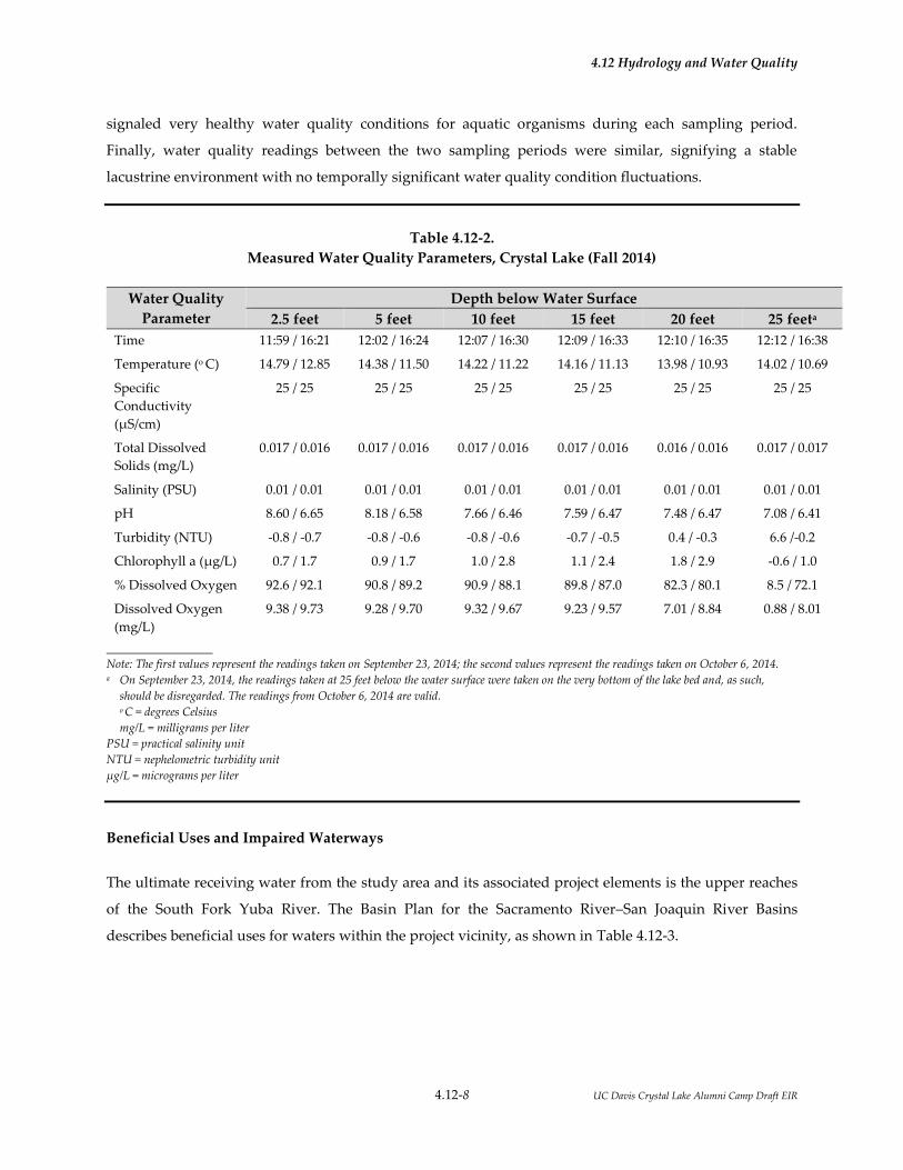
4.12 Hydrology and Water Quality
4.12-8 UC Davis Crystal Lake Alumni Camp Draft EIR
signaled very healthy water quality conditions for aquatic organisms during each sampling period.
Finally, water quality readings between the two sampling periods were similar, signifying a stable
lacustrine environment with no temporally significant water quality condition fluctuations.
Table 4.12-2.
Measured Water Quality Parameters, Crystal Lake (Fall 2014)
Water Quality
Parameter
Depth below Water Surface
2.5 feet 5 feet 10 feet 15 feet 20 feet 25 feeta
Time 11:59 / 16:21 12:02 / 16:24 12:07 / 16:30 12:09 / 16:33 12:10 / 16:35 12:12 / 16:38
Temperature (o C) 14.79 / 12.85 14.38 / 11.50 14.22 / 11.22 14.16 / 11.13 13.98 / 10.93 14.02 / 10.69
Specific
Conductivity
(µS/cm)
25 / 25 25 / 25 25 / 25 25 / 25 25 / 25 25 / 25
Total Dissolved
Solids (mg/L)
0.017 / 0.016 0.017 / 0.016 0.017 / 0.016 0.017 / 0.016 0.016 / 0.016 0.017 / 0.017
Salinity (PSU) 0.01 / 0.01 0.01 / 0.01 0.01 / 0.01 0.01 / 0.01 0.01 / 0.01 0.01 / 0.01
pH 8.60 / 6.65 8.18 / 6.58 7.66 / 6.46 7.59 / 6.47 7.48 / 6.47 7.08 / 6.41
Turbidity (NTU) -0.8 / -0.7 -0.8 / -0.6 -0.8 / -0.6 -0.7 / -0.5 0.4 / -0.3 6.6 /-0.2
Chlorophyll a (µg/L) 0.7 / 1.7 0.9 / 1.7 1.0 / 2.8 1.1 / 2.4 1.8 / 2.9 -0.6 / 1.0
% Dissolved Oxygen 92.6 / 92.1 90.8 / 89.2 90.9 / 88.1 89.8 / 87.0 82.3 / 80.1 8.5 / 72.1
Dissolved Oxygen
(mg/L)
9.38 / 9.73 9.28 / 9.70 9.32 / 9.67 9.23 / 9.57 7.01 / 8.84 0.88 / 8.01
Note: The first values represent the readings taken on September 23, 2014; the second values represent the readings taken on October 6, 2014. a On September 23, 2014, the readings taken at 25 feet below the water surface were taken on the very bottom of the lake bed and, as such,
should be disregarded. The readings from October 6, 2014 are valid. o C = degrees Celsius
mg/L = milligrams per liter
PSU = practical salinity unit
NTU = nephelometric turbidity unit
µg/L = micrograms per liter
Beneficial Uses and Impaired Waterways
The ultimate receiving water from the study area and its associated project elements is the upper reaches
of the South Fork Yuba River. The Basin Plan for the Sacramento River–San Joaquin River Basins
describes beneficial uses for waters within the project vicinity, as shown in Table 4.12-3.

4.12 Hydrology and Water Quality
4.12-9 UC Davis Crystal Lake Alumni Camp Draft EIR
Table 4.12-3.
Designated Beneficial Uses for Surface Water Bodies within the Project Vicinity
Water Body Designated Beneficial Uses
Yuba River (source to
Englebright Reservoir)
Municipal and Domestic Supply; irrigation; stock water; hydropower; water contact
recreation; noncontact water recreation; cold freshwater habitat; cold fish migration;
cold fish spawning; wildlife habitat.
American River, North Fork
(source to Folsom Lake)
Municipal and Domestic Supply; irrigation; water contact recreation; noncontact
water recreation; warma and cold freshwater habitat; cold fish spawning; wildlife
habitat.
Source: Central Valley Water Board 2011. a Potential beneficial use.
No impairments for the South Fork Yuba River upstream of Spaulding Reservoir or the North Fork
American River (upstream of the North Fork Dam on Lake Clementine) were listed on the State Water
Resources Control Board’s Clean Water Act Section 303(d) List / 305(b) Report (State Water Board 2011).
4.12.2.4 Groundwater
Regional Hydrogeology and Water Quality
The study area is located within the Sacramento River Hydrologic Region (Basin 5-1). No subbasins are
mapped or described within the vicinity of the study area. Groundwater provides about 31percent of the
water supply for urban and agricultural uses in the region, and has been developed in both the alluvial
basins and the hard rock uplands and mountains. There are 88 basins/subbasins delineated in the region.
These basins underlie 5.053 million acres (7,900 square miles), about 29 percent of the entire region. (DWR
2003.)
The Sacramento Valley is recognized as one of the foremost groundwater basins in the State, and wells
developed in the sediments of the valley provide excellent supply to irrigation, municipal, and domestic
uses. Many of the mountain valleys of the region also provide significant groundwater supplies to
multiple uses. (DWR 2003.)
The reliability of the groundwater supply varies greatly. In the rural mountain areas of the region,
domestic supplies come almost entirely from groundwater. Although a few mountain communities are
supplied in part by surface water, most rely on groundwater. These groundwater supplies are generally
quite reliable in areas that have sufficient aquifer storage or where surface water replenishes supply

4.12 Hydrology and Water Quality
4.12-10 UC Davis Crystal Lake Alumni Camp Draft EIR
throughout the year. In areas that depend on sustained runoff, water levels can be significantly depleted
in drought years and many old, shallow wells can be dewatered. (DWR 2003.)
Groundwater quality in the Sacramento River Hydrologic Region is generally excellent, although no
regional studies are available for the Sierra Nevada crest area. The closest study that addresses
groundwater quality in the project vicinity is in the Martis Valley to the east of the study area (Fram and
Belitz 2012). This study is not entirely relevant to the study area as the hydrogeology characteristics of the
Martis Valley (which is composed of relatively deep basin [alluvial] deposits) differ from those in the
study area (bedrock with a relatively thin soil mantle).
Study Area Hydrogeology and Water Quality
Conditions of the existing well on the property were not documented by the prior owners. According to
UC Davis, the well has historically produced 8 to 12 gallons per minute (gpm) since it was installed with
no sediment, odor, discoloration, or other issues (Dulcich pers. comm.). Recent laboratory testing
performed in the spring of 2015 indicates that the water is safe for human consumption—no coliform
bacteria were detected in the sample, and the existing water quality meets the generally accepted
definition of bacteriological potability ("bacteriological potability" is the absence of coliform bacteria in
drinking water and this is what is generally referred to when calling water "potable") (Cranmer
Engineering 2015).
The preliminary investigation for the proposed new well location indicated that good water quality exists
at depths of 400 to 1,000 below ground surface (bgs) in the immediate areas outside the study area. These
wells typically produce 5 to 12 gpm, with some artesian wells producing upward of 80 gpm. Based on
this review, the well company identified areas within the northeast quadrant of the study area as the
most likely candidates for a new well (because of closer proximity to the Yuba River). (Dulcich pers.
comm.)
Groundwater Recharge
Groundwater basin recharge primarily occurs due to infiltration of precipitation, applied water,
snowmelt, and streamflow connectivity. This process typically takes place along stream channels, where
sand and gravel deposits occur to sufficient depth that adequate quantities of surface water can infiltrate
into the underlying aquifer. Groundwater tends to occur as seeps through natural discharge. The amount
of groundwater recharge per year is unknown due to the lack of data concerning the subsurface
conditions, although preliminary observations and published soil survey data suggest that the study area
is primarily underlain by bedrock. Groundwater recharge potential is most likely moderate in the vicinity

4.12 Hydrology and Water Quality
4.12-11 UC Davis Crystal Lake Alumni Camp Draft EIR
of the small drainages and Crystal Lake, but lower elsewhere in the study area where solid bedrock
exists.
4.12.2.5 Flooding
Flood Insurance Rate Maps (FIRMs) prepared by the Federal Emergency Management Agency (FEMA)
were reviewed to identify the locations of 100-year floodplains in the project vicinity. (A FIRM is the
official map of a community prepared by FEMA to delineate both the special flood hazard areas and the
flood risk premium zones applicable to the community.) None of the study area is located on FEMA-
designated 100-year floodplains (i.e., areas with a 1 percent chance of flooding in any given year). None
of the areas immediately downstream of the study area on the Outlet Channel is within a FEMA-
designated flood zone.
Upstream dam failure and/or levee failure and ensuing inundation does not pose a risk to the study area
because there are no major water bodies upstream of the study area. All larger impoundments in Nevada
County are west of the study area, associated with the South Fork Yuba River, the North Fork American
River, and their tributaries.
4.12.3 REGULATORY CONSIDERATIONS
4.12.3.1 Federal
Clean Water Act
The federal Clean Water Act (CWA) of 1972 provides for the restoration and maintenance of the chemical,
physical, and biological integrity of the nation’s waters. The CWA emphasizes technology-based (end-of-
pipe) control strategies and requires discharge permits to allow use of public resources for waste
discharge. The CWA also limits the amount of pollutants that may be discharged and requires
wastewater to be treated with the best treatment technology economically achievable regardless of
receiving water conditions. The control of pollutant discharges is established through National Pollutant
Discharge Elimination System (NPDES) permits that contain effluent limitations and standards. The U.S.
Environmental Protection Agency (EPA) has delegated responsibility for implementation of portions of
the CWA, such as Sections 303, 401, and 402 (discussed below), to the State Water Resources Control
Board (State Water Board) and the associated nine Regional Water Quality Control Boards (Regional
Water Boards). The proposed study area is located within the jurisdiction of the Central Valley Regional
Water Quality Control Board (Central Valley Water Board).
4.12 Hydrology and Water Quality
4.12-12 UC Davis Crystal Lake Alumni Camp Draft EIR
Section 303(d) and Total Maximum Daily Loads
The State of California adopts water quality standards to protect beneficial uses of waters of the state as
required by Section 303(d) of the CWA and the Porter-Cologne Water Quality Control Act of 1969 (Porter-
Cologne Act [see Section 4.12.4.2 below]). Section 303(d) of the CWA established the total maximum daily
load (TMDL) process to guide the application of state water quality standards (see the discussion of state
water quality standards below). To identify candidate water bodies for TMDL analysis, a list of water
quality–impaired segments is generated by the State Water Board. These stream or river segments are
impaired by the presence of pollutants, such as sediment, and are more sensitive to disturbance because
of this impairment.
In addition to the impaired water body list required by CWA Section 303(d), CWA section 305(b) requires
states to develop a report assessing statewide surface water quality. Both CWA requirements are being
addressed through the development of a 303(d)/305(b) integrated report, which will address both an
update to the 303(d) list and a 305(b) assessment of statewide water quality. The State Water Board
developed California’s statewide 2010 Integrated Report based on the integrated reports from each of the
nine Regional Water Boards. The 2010 Integrated Report was approved by the State Water Board on
August 4, 2010, and approved by EPA on November 12, 2010, and the 2012 Integrated Report with 303(d)
listings is currently under development.
No impaired water bodies are within or near the study area or would be affected by the proposed project.
Section 401—Water Quality Certification
Section 401 of the CWA requires that an applicant pursuing a federal permit to conduct an activity that
may result in a discharge of a pollutant obtain a Water Quality Certification (or waiver). A Water Quality
Certification requires the evaluation of water quality considerations associated with dredging or
placement of fill materials into waters of the United States. Water Quality Certifications are issued by one
of the nine Regional Water Boards. Under the CWA, the Regional Water Board must issue or waive a
Section 401 Water Quality Certification for a project to be permitted under Section 404.
As described in Section 1.5, the project applicant would be required to obtain a Water Quality
Certification for proposed project construction activities that would affect waterways.
Section 402—National Pollutant Discharge Elimination System
The 1972 amendments to the Federal Water Pollution Control Act established the NPDES permit program
to control discharges of pollutants from point sources (CWA Section 402). The 1987 amendments to the
4.12 Hydrology and Water Quality
4.12-13 UC Davis Crystal Lake Alumni Camp Draft EIR
CWA created a new section devoted to stormwater permitting (Section 402[p]). EPA has granted the State
of California (the State Water Board and Regional Water Boards) primacy in administering and enforcing
the provisions of CWA and NPDES in California. NPDES is the primary federal program that regulates
point-source and nonpoint-source discharges to waters of the United States.
NPDES General Permit for Construction Activities
The General NPDES Permit for Stormwater Discharges Associated with Construction and Land Disturbance
Activities (Order No. 2009-0009-DWQ, as amended by Order No. 2010-0014-DWQ and Order No. 2012-0006-
DWQ) (Construction General Permit) regulates stormwater discharges for construction activities (CWA
Section 402). Dischargers whose projects disturb 1 or more acres of soil, or whose projects disturb less
than 1 acre but are part of a larger common plan of development that in total disturbs 1 or more acres, are
required to obtain coverage under the Construction General Permit. The Construction General Permit
requires the development and implementation of a stormwater pollution prevention plan (SWPPP).
The permit program is risk-based, wherein a project’s risk is based on the project’s potential to cause
sedimentation and the risk of such sedimentation on the receiving waters. A project’s risk determines its
water quality control requirements, ranging from Risk Level 1, which consists of only narrative effluent
standards, implementation of best management practices (BMPs), and visual monitoring, to Risk Level 3,
which consists of numeric effluent limitations, additional sediment control measures, and receiving water
monitoring. Additional requirements include compliance with postconstruction standards focusing on
low impact development (LID), preparation of rain event action plans, increased reporting requirements,
and specific certification requirements for certain project personnel.
As described in Section 1.5, the project applicant would be required to obtain a Construction General
Permit for the proposed project because total land disturbance would be greater than 1 acre.
BMPs included in the SWPPP may include measures such as the following.
a. Providing permeable surfaces where feasible.
b. Retaining and treating stormwater onsite using catch basins and filtering wet basins.
c. Minimizing the contact of construction materials, equipment, and maintenance supplies
with stormwater.
d. Reducing erosion through soil stabilization, watering for dust control, installing
perimeter silt fences, placing rice straw bales, and installing sediment basins. In order to

4.12 Hydrology and Water Quality
4.12-14 UC Davis Crystal Lake Alumni Camp Draft EIR
minimize potential impacts on wildlife, no monofilament plastic mesh or line will be
used for erosion control.
e. Maintaining water quality by using infiltration systems, detention systems, retention
systems, constructed wetland systems, filtration systems, biofiltration/bioretention
systems, grass buffer strips, ponding areas, organic mulch layers, planting soil beds, sand
beds, and vegetated systems such as swales and grass filter strips that are designed to
convey and treat either fallow flow (swales) or sheetflow (filter strips) runoff.
In addition, a procedure for spill prevention and control is typically developed to minimize the potential
for, and effects from, spills of hazardous, toxic, or petroleum substances during all construction activities.
If a spill should occur during construction that causes a release of a hazardous material, including oil and
radioactive materials, the proper agencies are typically notified and an Emergency Release Follow-Up
Notice Reporting Form is submitted no more than 30 days following the release.
Waste Discharge Requirements for Dewatering and Other Low Threat Discharges to Surface Waters
CWA Section 402 also includes WDRs for dewatering activities. While small amounts of construction-
related dewatering are covered under the Construction General Permit, the Central Valley Water Board
has regulations specific to dewatering activities that typically involve reporting and monitoring
requirements.
If dewatering is required as part of the proposed project5, then the project applicant will need to comply
with the Central Valley Water Board dewatering requirements. Coverage under the Construction General
Permit typically covers uncontaminated dewatering activities, which are considered in the permit to be
authorized non–stormwater discharges. As part of the Construction General Permit, all dewatering
discharges are required to be filtered or treated, using appropriate technology, from sedimentation
basins. Authorized non–stormwater dewatering discharges may require a permit because some Regional
Water Boards have adopted General Permits for dewatering discharges. The Central Valley Water Board
has adopted a NPDES Low Threat Discharge and Dewatering General Permit. Therefore, the project
applicant or the project applicant’s contractor would also need to obtain coverage under the NPDES Low
Threat Discharge and Dewatering General Permit, which will require the dewatering discharge to be
treated prior to discharge to any local waterway.
5 As described in Section 4.12.2, Environmental Setting, the drainages on the property are typically dry during the
summer, which is presumably when most construction activities would occur. The Waste Discharge
Requirements described herein are more likely to be necessary for beach or shoreline improvements, not work
conducted in the main impact area on the property, where there are no perennial creeks.

4.12 Hydrology and Water Quality
4.12-15 UC Davis Crystal Lake Alumni Camp Draft EIR
If dewatering activities lead to discharges to the storm drain system or other water bodies, water
treatment measures may be designed and implemented as necessary so that water quality objectives are
met prior to discharge to waters of the state. As a performance standard, these measures will be selected
to achieve the maximum removal contaminant found in the groundwater and will represent the best
available technology (BAT) that is economically feasible. Implemented measures may include using
infiltration areas and retaining dewatering effluent until particulate matter has settled before the water is
discharged. The contractor should perform routine inspections of the construction area to verify that the
water quality control measures are properly implemented and maintained; the contractor will also
conduct observations of the water (e.g., check for odors, discoloration, or an oily sheen on groundwater).
Other pre-discharge sampling and reporting activities required by the Central Valley Water Board is
typically conducted, if necessary. The final selection of water quality control measures would be subject
to review by the Central Valley Water Board, if necessary. If the groundwater is found to not meet water
quality standards, and treatment measures are not effective, the water may need to be hauled offsite for
treatment and disposal at an appropriate waste treatment facility.
Section 404—Dredge/Fill Permitting
The discharge of dredged or fill material into waters of the United States is subject to permitting specified
under Title IV (Permits and Licenses) of the CWA and specifically under Section 404 (Discharges of
Dredge or Fill Material) of the CWA. Section 404 of the CWA regulates placement of fill materials into the
waters of the United States. Section 404 permits are administered by U.S. Army Corps of Engineers
(USACE).
As described in Section 1.5, the project applicant would be required to obtain a Section 404 permit for
proposed project construction activities that would affect waterways.
National Flood Insurance Program
In response to increasing costs of disaster relief, Congress passed the National Flood Insurance Act
(NFIP) of 1968 and the Flood Disaster Protection Act of 1973. The purpose of these acts was to reduce the
need for large, publicly funded flood control structures and disaster relief by restricting development on
floodplains. FEMA administers the NFIP to provide subsidized flood insurance to communities that
comply with FEMA regulations limiting development in floodplains. FEMA issues FIRMs for
communities participating in the NFIP.

4.12 Hydrology and Water Quality
4.12-16 UC Davis Crystal Lake Alumni Camp Draft EIR
4.12.3.2 State
Porter-Cologne Water Quality Control Act
The Porter-Cologne Act authorizes the state to implement the provisions of the CWA and establishes a
regulatory program to protect the water quality of the state and the beneficial uses of state waters.
The act requires projects that are discharging, or proposing to discharge, wastes that could affect the
quality of the state’s waters to file a report of waste discharge (RWD) with the appropriate Regional
Water Board. The Porter-Cologne Act also requires that State Water Board or a Regional Water Board
adopt basin plans for the protection of water quality. Basin plans are updated and reviewed every 3 years
and provide the technical basis for determining WDRs, taking enforcement actions, and evaluating clean
water grant proposals. A basin plan must include the following sections (Central Valley Water Board
2011).
A statement of beneficial water uses that the Regional Water Board will protect.
Water quality objectives needed to protect the designated beneficial water uses.
Strategies and time schedules for achieving the water quality objectives.
As noted above, the proposed project lies within the jurisdiction of the Central Valley Water Board. The
Central Valley Water Board is responsible for the protection of beneficial uses of water resources in the
Central Valley Region. The Basin Plan was last updated in 2011 (Central Valley Water Board 2011).
Regional Water Boards designate beneficial uses for all water body segments in their jurisdictions and
then set criteria necessary to protect these uses. Consequently, the specific water quality objectives
developed for particular water segments are based on the designated use. The Basin Plan specifies region-
wide and water body–specific beneficial uses and has set numeric and narrative water quality objectives
for several substances and parameters for numerous surface waters in its region. Specific objectives for
concentrations of chemical constituents are applied to bodies of water based on their designated
beneficial uses (Central Valley Water Board 2011). In addition, the State Water Board identifies waters
failing to meet standards for specific pollutants, which are then state-listed in accordance with CWA
Section 303(d). If it is determined that waters of the state are impaired for one or more constituents and
the standards cannot be met through point source or nonpoint source controls (NPDES permits or
WDRs), the CWA requires the establishment of TMDLs.

4.12 Hydrology and Water Quality
4.12-17 UC Davis Crystal Lake Alumni Camp Draft EIR
California Fish and Game Code Section 1602—Streambed Alteration Agreement
Under Chapter 6 of the California Fish and Game Code, California Department of Fish and Wildlife
(CDFW) is responsible for the protection and conservation of the state’s fish and wildlife resources.
Section 1602 et seq. of the code defines the responsibilities of CDFW and requires that public and private
applicants obtain an agreement to “divert, obstruct, or change the natural flow or bed, channel, or bank of
any river, stream, or lake designated by the CDFW in which there is at any time an existing fish or
wildlife resource or from which those resources derive benefit, or will use material from the streambeds
designated by the department.” A streambed alteration agreement is required under Section 1602 of the
California Fish and Game Code for all activities that involve temporary or permanent activities within
state jurisdictional waters.
As described in Section 1.5, the project applicant would be required to obtain a Streambed Alteration
Agreement for proposed project construction activities that would affect waterways.
Sustainable Groundwater Management Act
On September 16, 2014, Governor Edmund G. Brown, Jr. signed historic legislation to strengthen local
management and monitoring of groundwater basins most critical to the state’s water needs. The three
bills—SB 1168 (Pavley), SB 1319 (Pavley), and AB 1739 (Dickinson)—together make up the Sustainable
Groundwater Management Act. The bills establish phased requirements for high- and medium-priority
basins to adopt groundwater sustainability plans, depending on whether a basin is in critical overdraft.
The act requires adoption of groundwater sustainability plans by January 31, 2020, for all high or
medium-priority basins in overdraft condition and by January 31, 2022, for all other high- and medium-
priority basins unless legally adjudicated or otherwise managed sustainably. These bills do not apply to
the proposed project because western Nevada County has no groundwater basins.
California Forest Practice Rules
The University will comply will all applicable State of California forestry regulations. Certain vegetation
management activities may require review, permitting, and approval by the State of California. Specific
items such as a timber harvest plan or a timber conversion plan may be filed by a registered professional
forester in accordance with the requirements of CalFire.
Article 6, “Watercourse and Lake Protection, “ of the 2015 California Forest Practice Rules (CalFire 2015)
describes the standard practices and measures to ensure that timber operations do not potentially cause
significant adverse site-specific and cumulative impacts on the beneficial uses of water, native aquatic
and riparian-associated species, and the beneficial functions of riparian zones; result in an unauthorized

4.12 Hydrology and Water Quality
4.12-18 UC Davis Crystal Lake Alumni Camp Draft EIR
take of listed aquatic species; or threaten to cause violation of any applicable legal requirements. This
article also provides protection measures for application in watersheds with listed anadromous
salmonids and watersheds listed as water quality limited under Section 303(d) of the federal Clean Water
Act.
4.12.3.3 Local
Nevada County does not currently have a design and improvement standards manual, a drainage
manual, a stormwater management plan, or a stormwater quality ordinance. All relevant local
regulations and procedures described below are derived from the Nevada County Code, the Nevada
County Department of Environmental Health, or the Nevada County General Plan.
Grading, Erosion, and Sediment Control Ordinances
Although not applicable to the proposed project, the following Nevada County development regulations
relating to hydrology and water quality provide context for comparing the development standards that
would be required on nearby properties and for understanding the water quality protection goals of
Nevada County. Article 19, “Grading,” Chapter V, “Buildings,” of Title 3, “Land Use and Development
Code” of the Nevada County Code (Nevada County 2015) describes the required permits, required
setbacks, drainage considerations, and erosion control procedures for buildings. Storm drainage and
design standards not otherwise specified in Article 19 shall comply with Article 5, “Storm Drainage,”
Chapter XVII, “Road Standards,” of Title 3, “Land Use and Development Code” of the Nevada County
Code.
As described above, under the requirements of the Central Valley Water Board, the project would be
required to comply with design, construction, and maintenance requirements of the Central Valley Water
Board (i.e., Construction General Permit, WDRs for dewatering) for surface water quality and stormwater
pollution prevention.
Nevada County Design Standards
Nevada County’s Comprehensive Site Development Standards identify the basic requirements for site
development in the county, including standards to mitigate the impact of development on the following
environmentally sensitive resources related to hydrology and water quality.
Wetlands.
Riparian corridors within 100 feet of intermittent or perennial water courses.

4.12 Hydrology and Water Quality
4.12-19 UC Davis Crystal Lake Alumni Camp Draft EIR
Floodplains precluding development and land disturbance within floodways and restricting
development within the floodway fringe, through the establishment of floodplain setbacks and
associated development regulations.
Steep slopes (30+ percent).
Areas with high erosion potential.
Nevada County’s Comprehensive Site Development Standards are described under Division 4.3,
“Resource Standards,” Article 4, “Comprehensive Site Development Standards,” Chapter II “Zoning
Regulations,” of Title 3, “Land Use and Development Code” of the Nevada County Code (Nevada
County 2015b).
Nevada County Department of Environmental Health
All septic system design and well development would be subject to the Land Use and Development
Division of the Nevada County Department of Environmental Health permit and inspections process.
Septic system permitting and installation policies, and well installation procedures, are available at the
Nevada County website: (http://www.mynevadacounty.com/nc/cda/eh/Pages/Land-Use-and-
Development-Division.aspx).
Septic Systems
For septic systems, the Nevada County requirements include provisions to protect groundwater quality
and public health, ensure acceptable long-term operation, evaluate site specific conditions, and utilize
proven septic system design standards.
According to Section L-VI 3.7, “Centralized Wastewater Disposal Permit Application Process,” Article 3,
“Centralized Wastewater Collection, Treatment And Disposal System,” Chapter VI “Sewage Disposal,” of
Title 3, “Land Use and Development Code” of the Nevada County Code (Nevada County 2015b), the
property owner or its designated representative must apply for a centralized wastewater disposal permit
on a form provided by the Nevada Country Department of Environmental Health. A design package is to
be submitted to the Nevada Country Department of Environmental Health at the time of application and
contain the following information and/or documents.
A. Past and present conditions including, but not limited to, all prior soil mantles, soils work,
percolation tests, previous proposals, existing wastewater treatment, collection and disposal
systems, etc.

4.12 Hydrology and Water Quality
4.12-20 UC Davis Crystal Lake Alumni Camp Draft EIR
B. Preliminary basis of design including, but not limited to, proposed dwelling structures, flow
projections, topography, hydraulic design factors, materials, manholes, inspection chambers and
well pumps and pressure pipes, objectives and standards, the design basis for the sewage
treatment and final disposal, and the predicted quality and quantity of the final effluent.
C. Proposed location of the treatment system and final disposal area plus locations of any repair or
expansion areas (100 percent repair area for any subsequent subsurface soil absorption system).
D. Location of all wells, water service connections, water distribution systems, or other water
source.
E. All required setback distances.
F. Distances from wells on all parcels included in the proposed system.
G. Location of ponds, creeks, springs, cut banks, rock out-croppings, etc.
H. Direction and percent of slope in the wastewater disposal areas.
I. Location and description of all proposed or existing structures, driveways, roads, etc.
J. Two (2) copies of scaled maps showing all structures, electrical cables, telephone lines, and the
collection system.
K. Two (2) copies of detailed, scaled treatment and disposal site plans showing the locations of any
structures, the sewage treatment and disposal system and repair area.
L. Two (2) copies of scaled two (2) view drawing of all components of the system conforming to
American Standard drawings and drafting room practice. Three (3) view drawings may be
required if necessary to clarify component design.
M. Two (2) copies of the calculations made to determine the quantity and quality of the final
effluent.
N. A statement of justification, alternative analysis and certification of the proposed system by the
designer.
O. A contingency plan, which outlines the immediate actions to be taken should a failure occur and
an action plan for repairs, expansion or replacement of the system as is appropriate.

4.12 Hydrology and Water Quality
4.12-21 UC Davis Crystal Lake Alumni Camp Draft EIR
P. Operation, maintenance, and monitoring instructions, which provide brief and simple guidance
regarding the operation, maintenance, and monitoring of the system.
Q. Grant easement for access by Health Department and Regional Board personnel and agents for
periodic inspection as necessary.
A minimum of six percolation test holds and two soil mantles are required in any proposed absorption
field and the same in the proposed repair expansion area for the initial design review. Additional soils
testing may be required to demonstrate soil consistency throughout the disposal area. Percolation tests
shall be performed in a manner as prescribed by the Health Officer. Any alternative percolation test
procedure may be utilized only with the written approval of the Health Officer. All mantle excavations
must be adequately protected under applicable regulations and backfilled following logging of the soil
profile by a registered civil engineer, registered engineering geologist, or registered sanitarian.
Inspections and Performance Monitoring
According to Section L-VI 315, “Inspections and Performance Monitoring,” Article 3, “Centralized
Wastewater Collection, Treatment And Disposal System,” Chapter VI, “Sewage Disposal,” of Title 3,
“Land Use and Development Code” of the Nevada County Code (Nevada County 2015b), the following
inspections and performance monitoring criteria are applicable to septic systems.
A. Pre-issue inspections shall be made prior to the issuance of a centralized sewage disposal permit
to ascertain the suitability of the site. A permit application will be denied when the Health Officer
determines the centralized disposal system could not be expected to function in a manner that
will protect the public health and safety.
B. Trenches or beds shall be inspected prior to placement of any filter media.
C. Final inspection of each installation shall be made by the Sanitarian before any subsurface system
is backfilled or covered.
D. A monitoring program will be established individually for each centralized system at the time of
permit issuance. Said monitoring shall be performed to ensure that the centralized wastewater
collection, treatment, and disposal system is functioning satisfactorily to protect the public health
and safety. The specific requirements will be based primarily upon recommendations of the
design engineer and the Health Department. Monitoring requirements will normally be expected
to include:
1. Water usage or waste flow metering shall be recorded in a log book.

4.12 Hydrology and Water Quality
4.12-22 UC Davis Crystal Lake Alumni Camp Draft EIR
2. Effluent level measurements in the disposal system.
3. Water quality sampling (bacterial) at least quarterly in monitoring wells or drainages.
E. The owner(s) or administrative authority or their agent will be responsible for (1) and (2) of D
above.
F. Nevada County Health Department and/or its designated representatives will be responsible for
(3) of D above. Additionally, periodic inspections will be made of the condition of the disposal
field, water levels in monitoring wells and equipment operation.
G. All centralized sewage disposal systems shall possess a valid annual certificate of operation
issued by the Health Department. Said certificate permit may be revoked for due cause. The
permit fee will cover monitoring and routine inspections costs.
Wells
According to Section L-X 2.2, “Permit Application,” Article 2, “Water Wells,” Chapter X, “Water Supply
and Resources,” of Title 3, “Land Use and Development Code” of the Nevada County Code (Nevada
County 2015b), no person shall dig, bore, drill, deepen, modify, reconstruct, repair, or destroy a water
well, cathodic protection well, observation well or monitoring well without first obtaining a permit as
provided in Chapter X, “Water Supply and Resources,” of Title 3, “Land Use and Development Code,” of
the Nevada County Code (Nevada County 2015b). An application is complete only when the form (on its
face) is completed in full, is signed by the licensed well driller, and is accompanied by all required
exhibits and fees. The exhibits shall include all of the following:
1. A vicinity map and clear directions to the property and well site.
2. Plans and specifications for the proposed work, including method of sealing the annular
space.
3. Two (2) copies of an accurate site plan drawn to scale showing the proposed well location
and all features of potential contamination (e.g., on-site sewage systems, sewer lines,
animal feed lots, etc.) and property lines within 150 feet of the proposed well site. A
scaled assessor’s plot map may be used for this purpose.
4. Copy of assessor’s plot.
5. Location of any restrictions such as easements on the property.

4.12 Hydrology and Water Quality
4.12-23 UC Davis Crystal Lake Alumni Camp Draft EIR
6. Any other information the enforcement agency finds is necessary to complete the permit
application.
7. Submission of appropriate permit filing fee.
All construction, reconstruction, or destruction work on wells shall be performed by a person who
possesses a valid C-57 contractor’s license in accordance with the provisions of the California Business
and Professions Code, or his or her designated employees. Renewal of a permit may be granted to the
original permittee if an application for permit renewal is filed prior to the original permit expiration date.
Application for permit renewal shall conform to the requirements of Section L-X 2.3, “Permit Application
Procedure,” Article 2, “Water Wells,” Chapter X, “Water Supply and Resources,” of Title 3, “Land Use
and Development Code” of the Nevada County Code (Nevada County 2015b). The permit shall be
renewed or denied consistent with Chapter X “Water Supply and Resources,” of Title 3, “Land Use and
Development Code” of the Nevada County Code (Nevada County 2015b).
Well Locations
All wells shall be located as prescribed in Table 1 of Section L-X 2.10, “Well Location,” Article 2 “Water
Wells,” Chapter X “Water Supply and Resources,” of Title 3 “Land Use and Development Code” of the
Nevada County Code (Nevada County 2015b). These include locating the well at a minimum of 50 feet
from the property line, 5 feet from easements, and 100 feet from septic tanks.
Well Protection
As described in of Section L-X 2.11 “Protection,” Article 2, “Water Wells,” Chapter X, “Water Supply and
Resources,” of Title 3 “Land Use and Development Code” of the Nevada County Code (Nevada County
2015b), at all times during construction, the well shall be protected in such a manner as to prevent
tampering with the well, accidents to persons, the entrance of foreign matter into the well or the entrance
of drilling mud into streams, etc. Water and drilling mud used in drilling shall be free from
contamination.
Well Inspections
As described in of Section L-X 2.18 “Inspections,” Article 2 “Water Wells,” Chapter X, “Water Supply and
Resources,” of Title 3 “Land Use and Development Code” of the Nevada County Code (Nevada County
2015b), the enforcement agency shall make an inspection of the annular seal construction work. It may
make an initial inspection of each proposed drilling site prior to the issuance of a well permit, an
inspection at the completion of the work, and inspections at such other times as it deems appropriate.

4.12 Hydrology and Water Quality
4.12-24 UC Davis Crystal Lake Alumni Camp Draft EIR
Well Completion
As described in of Section L-X 2.20 “Completion,” Article 2, “Water Wells,” Chapter X, “Water Supply
and Resources,” of Title 3 “Land Use and Development Code” of the Nevada County Code (Nevada
County 2015b), upon completion of a well, the driller shall be responsible for the sanitary well seal or a
well cover. The driller shall also submit a completed water well driller’s report or photocopy of same,
completed in detail on the State Department of Water Resources reporting form, to the Health
Department. Said photocopy shall contain the assessor’s parcel number of the subject property and
permit number.
Nevada County General Plan
The proposed project is located on a University of California property that is owned or controlled by The
Regents of the University of California. As a State entity, the University is exempted by the state
constitution from compliance with local land use regulations, including general plans and zoning.
However, the University seeks to develop its property in a manner that minimizes potential land use
conflicts with the policies and plans of local jurisdictions to the extent feasible. Furthermore, the
(potential) receiving water body for hydrology and water quality impacts is the South Fork Yuba River,
which is outside the limits of the study area, but could be affected by project activities. Although not
applicable to the proposed project, the following Nevada County General Plan (Nevada County 2015a)
policies related to hydrology and water quality provide context for comparing the development
standards that would be required on nearby properties and for understanding the land development
goals of Nevada County.
Open Space Element
Goal 6.1
Encourage that land use patterns and site development reflect open space values.
Objective 6.2
Implement development standards that incorporate open space values.
Policy 6.9
Development standards for project design, grading, construction and use, established
through the Comprehensive Site Development Standards, shall be used in project review

4.12 Hydrology and Water Quality
4.12-25 UC Davis Crystal Lake Alumni Camp Draft EIR
of all discretionary project permits to determine open space requirements for each
project.
These standards shall provide for consideration of non-disturbance of, and open space
setbacks from identified sensitive environmental, biological, or cultural resources, e.g.
100-year floodplains, wetlands, slopes in excess of 30 percent (excepting access across
slopes up to 30 percent), lakes, ponds, significant historic or archaeological
sites/resources, critical wildlife areas, minimization of land disturbance, consistency with
the landforms and aesthetic context of the site, temporary and permanent erosion and
sedimentation controls, and vegetation retention, replacement and enhancement.
Safety Element
GOAL FH-10.3
Reduce the potential for injury, property damage, and environmental damage from flooding.
Policy FH-10.3.1
Implement development standards to ensure new construction does not result in increased peak
run-off or flood potential.
Policy FH-10.3.2
Avoid potential increases in downstream flooding potential by protecting natural drainage and
vegetative patterns through project site plan review, application of Comprehensive Site
Development Standards, use of clustered development and project subdivision design. The
Comprehensive Site Development Standards shall include measures applicable to all
discretionary and ministerial projects to avoid downstream flooding resulting from new
development. Such measures, shall include, but not be limited to:
a. Avoidance of stream channel modifications;
b. Avoidance of excessive areas of impervious surfaces; and
c. Use of on-site retention or detention of storm water.

4.12 Hydrology and Water Quality
4.12-26 UC Davis Crystal Lake Alumni Camp Draft EIR
Water Element
Goal 11.1
Identify, protect and manage for sustainable water resources and riparian habitats.
Objective 11.1
Promote and provide for conservation of domestic and agricultural water.
Policy 11.1
Adopt water conservation standards, consistent with State guidelines, for multi-family,
commercial and industrial development encouraging installation and use of low-flow
plumbing fixtures, drip irrigation systems, and drought-tolerant landscape plantings.
Policy 11.2
Encourage the protection of resources which produce water for domestic and agricultural
consumption.
Objective 11.2
Preserve surface and sub-surface water quality and, where feasible, improve such quality.
Policy 11.4
Cooperate with State and local agencies in efforts to identify and reduce to acceptable
levels all sources of existing and potential point- and non-point-source pollution to
ground and surface waters, including leaking fuel tanks, discharges from storm drains,
auto dismantling and dump sites, sanitary waste systems, parking lots, roadways,
logging and mining operations.
Policy 11.6
The County shall continue to enforce its regulations concerning the installation and
operation of private sanitary waste disposal systems in order to protect the quality of
surface and ground water.
The location of septic tanks and leachfields and their appropriate setbacks from water
courses shall be in accordance with the guidelines of the Lahontan Regional Water

4.12 Hydrology and Water Quality
4.12-27 UC Davis Crystal Lake Alumni Camp Draft EIR
Quality Control Board (eastern County) and the Central Valley Regional Water Quality
Control Board (western County).
Policy 11.6A
New development shall minimize the discharge of pollutants into surface water
drainages by providing the following improvements or similar methods which provide
equal or greater runoff control: (a) include curbs and gutters on arterials, collectors, and
local roads consistent with adopted urban street designs; and (b) oil, grease, and silt traps
for subdivisions creating 5 or more parcels and commercial and industrial development
of 1 acre or greater size. Maintenance of such facilities shall be assured through a legally-
enforceable mechanism.
Objective 11.3
Preserve and, where economically feasible, restore the density and diversity of water-dependent
species and continuous riparian habitats based on sound ecological principles.
Policy 11.7
Through the development and application of Comprehensive Site Development Standards,
and project environmental review, establish and enforce minimum building setback lines
from perennial streams and significant wetlands that are adequate to protect stream and
wetland resource values.
Policy 11.8
Utilize voluntary clustering of development to preserve stream corridors, riparian habitat,
wetlands, and floodplains.
Soils Element
Goal 12.1
Minimize adverse impacts of grading activities, loss of soils and soil productivity.
Objective 12.1
Minimize earth movement and disturbance.

4.12 Hydrology and Water Quality
4.12-28 UC Davis Crystal Lake Alumni Camp Draft EIR
Policy 12.1
Enforce Grading Ordinance provisions for erosion control on all new development
projects by adopting provisions for ongoing monitoring of project grading. Project site
inspection shall be required prior to initial site disturbance and grading to ensure all
necessary control measures, including proper staking and tree protection measures, are
in place. The installation, maintenance, and performance of erosion and sedimentation
control measures shall be monitored by County or District staff (or their designee) and
completely funded by a project applicant. All County projects shall comply with this
policy.
Objective 12.2
Minimize erosion due to road construction and maintenance.
Policy 12.4
Require erosion control measures as an element of all County contracts, discretionary
projects, and ministerial projects.
4.12.4 IMPACTS AND MITIGATION MEASURES
4.12.4.1 Significance Criteria
The significance criteria listed below are derived from Appendix G of the State CEQA Guidelines. For the
purpose of this EIR, hydrology and water quality impacts would be significant if implementation of the
proposed project would:
Violate any water quality standards or WDRs.
Substantially deplete groundwater supplies or interfere substantially with groundwater recharge,
resulting in a net deficit in aquifer volume or a lowering of the local groundwater table level (e.g.,
the production rate of pre-existing nearby wells would drop to a level that would not support
existing land uses or planned uses for which permits have been granted).
Substantially alter the existing drainage pattern of the site or area, including through the
alteration of the course of a stream or river, in a manner that would result in substantial erosion
or siltation onsite or offsite.

4.12 Hydrology and Water Quality
4.12-29 UC Davis Crystal Lake Alumni Camp Draft EIR
Substantially alter the existing drainage pattern of the site or area, including through the
alteration of the course of a stream or river, or substantially increase the rate or amount of surface
runoff in a manner that would result in flooding onsite or offsite.
Create or contribute runoff water that would exceed the capacity of existing or planned
stormwater drainage systems or provide substantial additional sources of polluted runoff.
Otherwise substantially degrade water quality.
Place housing within a 100-year flood hazard area, as mapped on a federal flood hazard
boundary map, FIRM, or other flood hazard delineation map.
Place within a 100-year flood hazard area structures that would impede or redirect floodflows.
Expose people or structures to a significant risk of loss, injury, or death involving flooding,
including flooding as a result of the failure of a levee or dam.
Contribute to inundation by seiche, tsunami, or mudflow.
4.12.4.3 Methodology
Impacts related to hydrology, water quality, and water resources were assessed based on technical
reports prepared for the proposed project, other available data (e.g., maps, soil surveys), and professional
judgment. Potential impacts resulting from implementing the proposed project were analyzed by
comparing existing conditions, as described in Section 4.12.2, Environmental Setting, to conditions during
construction and/or operation of the project. The analysis assesses the direct, indirect, short-term, and
long-term impacts related to surface hydrology, flood hazards, groundwater recharge, and surface and
groundwater quality as described below.
Surface Water Hydrology: The surface water hydrology impact analysis considered potential
changes in the physical characteristics of water bodies, impervious surfaces, and drainage
patterns throughout the study area as a result of project implementation. Conclusions and
recommendations from a site-specific drainage analysis have not been incorporated into the
analysis of changes in peak flow runoff as this analysis has not yet been completed. The purpose
of this study will be to estimate 100-year peak flows for existing and developed conditions;
determine the limits of 100-year flooding along the channels associated with the project; provide
a floodway analysis along portions of the channels where development would encroach onto the
flood-prone areas; determine storage requirements for the study area to attenuate 100-year flows

4.12 Hydrology and Water Quality
4.12-30 UC Davis Crystal Lake Alumni Camp Draft EIR
to approximate existing-conditions flows; and present water quality treatment options for the
development.
Flood Hazards: The impact analysis for flood risk considered FEMA NFIP maps to determine
whether the study area overlaps with existing designated 100-year floodplains.
Groundwater Recharge: Impacts on groundwater recharge were assessed qualitatively by
comparing existing sources of recharge versus recharge capabilities following project
implementation. Conclusions and recommendations from a site-specific aquifer study have not
been incorporated into the impacts associated with the underlying aquifer as this analysis has not
yet been completed. The purpose of this study will be to estimate the water-bearing capacity of
the underlying aquifer; to estimate the groundwater recharge rates in the study area and local
vicinity (immediate Crystal Lake drainage basin and other subbasins where development
activities are proposed); and present well installation recommendations for the proposed project.
Surface and Groundwater Quality: Impacts of the proposed project on surface water and
groundwater quality were qualitatively analyzed using existing information on existing water
quality conditions (i.e., 303[d] listed water bodies). These conditions were then compared to
conditions under the proposed project for potential project-related sources of water contaminants
generated or inadvertently released during project construction (e.g., sediments, fuel, oil,
concrete) and project operation (postconstruction runoff and septic tank operation). The potential
for water quality objectives to be exceeded and beneficial uses to be compromised as a result of
the proposed project was also considered.
4.12.4.4 Project Impacts and Mitigation Measures
Proposed Project
Impact WQ-1: Violate any water quality standards or waste discharge requirements during
construction (Less than Significant)
Construction-related earth-disturbing activities for new roads, compacted dirt areas, construction of new
buildings, water crossings, and other project elements would introduce the potential for increased
erosion, runoff, and sedimentation, with subsequent effects on water quality and storm drain capacity.
During site grading, trenching, and other construction activities, areas of bare soil are exposed to erosive
forces during rainfall events. Bare soils are much more likely to erode than vegetated areas because of the

4.12 Hydrology and Water Quality
4.12-31 UC Davis Crystal Lake Alumni Camp Draft EIR
lack of dispersion, infiltration, and retention properties created by covering vegetation. The extent of the
impacts is dependent on soil erosion potential, type of construction practice, extent of disturbed area,
timing of precipitation events, and topography and proximity to drainage channels. In addition,
construction equipment and activities would have the potential to leak hazardous materials, such as oil
and gasoline, and potentially affect surface water or groundwater quality. Improper use or accidental
spills of fuels, oils, and other construction-related hazardous materials such as pipe sealant, solvents, and
paints could also pose a threat to the water quality of local water bodies. These potential leaks or spills, if
not contained, would be considered a significant impact on groundwater and surface water quality. If
precautions are not taken to contain or capture sediments and/or accidental hazardous spills,
construction activities could produce substantial pollutants in stormwater runoff could adversely affect
existing surface water quality.
Construction of bridge crossings (including culvert upgrades) near and within water bodies may result in
discharges of metals and other contaminants in sediment. In-water construction activities would directly
disturb sediment along the river bed and result in a temporary increase in turbidity in the immediate area
and potentially downstream. Concrete, vehicle, and other fluids may be easily released into the creek
during construction as well. These discharges may have adverse impacts on beneficial uses.
However, because the project would disturb more than 1 acre of land, a SWPPP with an associated pre-
determined risk level would be required as part of compliance with the NPDES Construction General
Permit. The purpose of a SWPPP is to reduce the amount of construction-related pollutants that are
transported by stormwater runoff to surface waters. The SWPPP would identify specific construction
BMPs, which include temporary erosion control measures to reduce sedimentation and turbidity of
surface runoff from disturbed areas within the study area, and leak and spill protection for heavy
equipment and hazardous materials use, among others.
In addition to the SWPPP, the proposed project would also be required to comply with other water
quality requirements (i.e., NPDES Low Threat Discharge and Dewatering permit). County
Comprehensive Site Development Standards would also be reviewed and incorporated, where necessary.
Construction dewatering in areas of shallow groundwater may be required during excavation. In the
event groundwater is encountered during construction, dewatering would be conducted locally, and
according to methods described in Section 4.12.3, Regulatory Considerations. In areas where groundwater is

4.12 Hydrology and Water Quality
4.12-32 UC Davis Crystal Lake Alumni Camp Draft EIR
shallow or perched and there is potential to affect riparian habitat, features would be installed using the
vibration method6, which minimizes subsurface disruption.
UC Davis will comply will all applicable State of California forestry regulations. If a timber harvest plan
or timber conversion plan is produced, UC Davis activities will include compliance with the California
Forest Practice Rules Article 6 standard practices and measures.
Therefore, potential water quality impacts, such as violations of water quality objectives or WDRs from
construction activities, would be less than significant.
Mitigation Measure(s): No mitigation measures are required.
Impact WQ-2: Substantially deplete groundwater supplies, resulting in a net deficit in
aquifer volume or a lowering of the local groundwater table level (Significant;
Less than Significant with Mitigation)
The proposed project involves installation of a new well that will be used for project water supply. The
preliminary investigation for the proposed new well location indicated that nearby wells typically
produce 5 to 12 gpm, with some artesian wells producing upward of 80 gpm. Based on this review, the
well company identified areas within the northeast quadrant of the study area as the most likely
candidates for a new well (because of closer proximity to the Yuba River). The proposed project would
have a temporally moderate demand on local groundwater resources, with peak demand occurring in the
summer when the camp has the greatest number of visitors. In addition, the current demand for
groundwater in this remote area is relatively low as the occupancy rate on the neighboring parcels is
relatively low, and the project’s location within a few miles of Sierra Nevada crest suggests an ample
supply of groundwater would be available for the life of the project.
Preliminary evaluation suggests that 50 gallons per day per person will be required to accommodate the
needs of the proposed project. While the existing demand and preliminary investigation suggest the
availability of water will be adequate to serve the needs of the proposed project, the long-term aquifer
yield is not currently known. This constitutes a potentially significant impact. Incorporation of Mitigation
Measure WQ-2 would reduce this impact to a less-than-significant level.
Mitigation Measure WQ-2: Incorporate findings and recommendations from the site-specific
aquifer study to determine if adequate groundwater supplies are available for the
long-term needs of the project
6 Different than standard pumping techniques and cut-off wall installation, the vibration method uses a stainless
steel vibrating device and a vibrating screen to remove water from the soil through vibration and gravity.

4.12 Hydrology and Water Quality
4.12-33 UC Davis Crystal Lake Alumni Camp Draft EIR
A site-specific aquifer study will be completed by a registered hydrogeologist prior to well installation on
the property. The purpose of this study will be to estimate the water-bearing capacity of the underlying
aquifer; to estimate the groundwater recharge rates in the study area and local vicinity (immediate
Crystal Lake drainage basin and other subbasins where development activities are proposed; and present
groundwater extraction recommendations for the proposed project. To the extent possible, the study will
determine the total volume of storage available within the underlying aquifer and take other local
neighboring drawdowns into account to create a groundwater budget. Conclusions and
recommendations from the site-specific aquifer study will be incorporated into the final project plans for
groundwater extraction.
Significance after Mitigation: The impact from substantially depleting groundwater supplies, resulting
in a net deficit in aquifer volume or a lowering of the local groundwater table level would be reduced to a
less-than-significant level.
Impact WQ-3: Interfere substantially with groundwater recharge, resulting in a net deficit in
aquifer volume or a lowering of the local groundwater table level (Less than
Significant)
The proposed project site is predominantly undeveloped, and partially covering undeveloped areas with
impervious surfaces, as proposed by the project, could reduce infiltration of rainfall and runoff, which in
turn could reduce the ability for aquifer recharge and ultimately result in decreased groundwater
supplies. However, the proposed project would not substantially interfere with groundwater recharge
because the study area is underlain by bedrock and does not overlie a regionally significant groundwater
aquifer. In addition, although the proposed disturbance footprint encompasses an area of approximately
18 acres, and approximately 192 acres would remain as open space or landscaped areas, including the
lawn and play area associated with the Main House, thereby protecting valuable natural resources
(forest, intermittent drainages, wetlands, and steep hillsides) through which infiltration would continue
to occur and that contribute to groundwater recharge
Lastly, the development of the project site would not interfere with groundwater recharge via water
infiltration through creeks because no major modification or realignments of the Outlet Channel or any of
the other existing site drainages are proposed. This potential impact on groundwater recharge would,
therefore, be less than significant.
Mitigation Measure(s): No mitigation measures are required.
Impact WQ-4: Substantially alter the existing drainage pattern of the site or area, including
through the alteration of the course of a stream or river, in a manner that

4.12 Hydrology and Water Quality
4.12-34 UC Davis Crystal Lake Alumni Camp Draft EIR
would result in substantial erosion or siltation onsite or offsite (Significant;
Less than Significant with Mitigation)
The proposed project may directly affect the various drainages within the property, most notably the
Inlet Channel as shown on Figure 4.12-1. This could affect local drainage patterns. Site preparation
activities, such as grading and excavation to construct building pads and improve roadways, would
slightly alter the overall existing overland flow drainage patterns in the study area. Alterations in the
natural landscape and drainages (hydromodification) could increase the potential for changes in water
flow in onsite and offsite drainages, creeks, and streams that could, in turn, affect erosion and/or the
amount of sediment in the watercourse. Construction activities also contribute this potential effect
because they would leave areas of exposed soil that could be subject to wind or water erosion, and
stormwater runoff could potentially transport sediment-laden runoff to local drainages. Increased
sediment loads have the potential to degrade water quality and/or reduce the capacity of drainages to
convey water. This potential is increased when earth-moving activities and development footprints are
close to riparian areas and drainages. Nevada County requires standards for open space setbacks from
identified sensitive environmental, biological, or cultural resources such as riparian areas. Actual setbacks
for the study area would be determined during the Section 404 permitting process in consultation with
USACE.
Project components such as the dining hall, lodge, and sleeping pods would create new impervious
surfaces. This would alter drainage patterns on the site compared to existing conditions, but it would also
reduce the amount of soil that could be exposed to erosion. This constitutes a potentially significant
impact. Incorporation of Mitigation Measure WQ-4 would reduce this impact to a less-than-significant
level.
Mitigation Measure WQ-4: Incorporate findings and recommendations from the site-specific
drainage study to mitigate effects on drainage alteration and/or erosion
A hydrologic and hydraulic analysis will be submitted for all proposed drainage facilities. The analysis
must include an introduction/background, location map/description, catchment description/delineation,
hydrologic analysis, hydraulic and structural analysis, risk assessment/impacts discussion, unusual or
special conditions, conclusions, and technical appendices. The analysis will address the following topics.
A calculation of predevelopment runoff conditions and post-development runoff scenarios using
appropriate engineering methods. This analysis will evaluate potential changes to runoff through
specific design criteria, and account for increased surface runoff.

4.12 Hydrology and Water Quality
4.12-35 UC Davis Crystal Lake Alumni Camp Draft EIR
An assessment of existing drainage facilities within the study area, and an inventory of necessary
upgrades, replacements, redesigns, and/or rehabilitation, including the sizing of onsite
stormwater detention features and pump stations.
A description of the proposed maintenance program for the onsite drainage system.
Standards for drainage systems to be installed on a project/parcel-specific basis.
Proposed design measures to ensure structures are not located within intermittent creek areas.
Water quality treatment, infiltration, and erosion control options for the development.
Drainage systems will be designed on a site-specific basis in accordance with the findings of the analysis.
As a performance standard, measures to be implemented will provide for no net increase in peak
stormwater discharge relative to current conditions to ensure that 100-year flooding and its potential
impacts are maintained at or below current levels and that people and structures are not exposed to
additional flood risk. Water quality treatment options, such as vegetated swales, for the development will
be fully evaluated and clearly described. These measures will be incorporated to ensure the proposed
project’s effect on drainage patterns would not cause or exacerbate the rate of sedimentation or siltation
in a manner that would adversely affect the function of natural onsite or offsite drainages, streams, or
creeks.
County Comprehensive Site Development Standards will also be reviewed and incorporated, where
necessary.
Significance after Mitigation: The impact from substantially altering the existing drainage pattern of the
site or area, including through the alteration of the course of a stream or river, in a manner that would
result in substantial erosion or siltation onsite or offsite would be reduced to a less-than-significant level.
Impact WQ-5: Substantially alter the existing drainage pattern of the site or area, including
through the alteration of the course of a stream or river, or substantially
increase the rate or amount of surface runoff in a manner that would result in
flooding onsite or offsite (Significant; Less than Significant with Mitigation)
Project components such as the dining hall, lodge, and sleeping pods would alter surface drainage
patterns as a result of adding impermeable surfaces and directly altering flow patterns which could yield
increased amounts of stormwater runoff. This constitutes a potentially significant impact. Proposed
project activities that convert permeable surfaces or install permanent structures would require
stormwater drainage management measures as described above under Impact WQ-4 to avoid onsite or

4.12 Hydrology and Water Quality
4.12-36 UC Davis Crystal Lake Alumni Camp Draft EIR
offsite flooding impacts. In addition, the proposed project would include road crossings of minor
seasonal streams. However, the proposed crossings would not alter the course of the stream or river and
would be designed to accommodate for potential flooding impacts. Incorporation of Mitigation Measure
WQ-4 described above would reduce this impact to a less-than-significant level.
Mitigation Measure WQ-4: Incorporate findings and recommendations from the site-specific
drainage study to mitigate effects on drainage alteration and/or erosion
Significance after Mitigation: The impact from substantially altering the existing drainage pattern of the
site or area, including through the alteration of the course of a stream or river, or substantially increase
the rate or amount of surface runoff in a manner that would result in flooding onsite or offsite would be
reduced to a less-than-significant level.
Impact WQ-6: Create or contribute runoff water that would exceed the capacity of existing or
planned stormwater drainage systems (Significant; Less than Significant with
Mitigation)
Project components such as enhanced roadways, buildings, and hardscaping would result in an increase
in stormwater runoff as a result of new impervious surfaces. These surfaces could create or contribute
runoff water that would exceed the capacity of existing or planned stormwater drainage systems or
provide substantial additional sources of polluted runoff. As noted in Impact WQ-4, a hydrologic and
hydraulic analysis will be submitted for all proposed drainage facilities. Recommendations and measures
from this analysis as described in Mitigation Measure WQ-4 would ensure the capacity of existing
stormwater drainage systems would not be exceeded.
Mitigation Measure WQ-4: Incorporate findings and recommendations from the site-specific
drainage study to mitigate effects on drainage alteration and/or erosion
Significance after Mitigation: The impact from creating or contributing runoff water that would exceed
the capacity of existing or planned stormwater drainage systems or provide substantial additional
sources of polluted runoff would be reduced to a less-than-significant level.

4.12 Hydrology and Water Quality
4.12-37 UC Davis Crystal Lake Alumni Camp Draft EIR
Impact WQ-7: Create or contribute runoff water that would provide substantial additional
sources of polluted runoff or create conditions that would pose a hazard to
existing groundwater resources (Less than Significant)
Surface Water
Upon completion of the project, components such as enhanced roadways, buildings, and hardscaping
would create new impervious surfaces. This condition would result in an incremental reduction in the
amount of natural soil surfaces available for infiltration of rainfall and runoff, potentially generating
additional runoff during storm events. In addition, the increase in impervious surfaces and increase in
surface water runoff could increase the nonpoint-source discharge of pollutants. Anticipated runoff
contaminants include sediment, pesticides, oil and grease, nutrients, metals, bacteria, sanding/de-icing
agents on roads or walkways, and trash. Contributions of these contaminants to stormwater and non–
stormwater runoff could degrade the quality of receiving waters. During the dry season, vehicles and
other urban activities release contaminants onto the impervious surfaces, where they can accumulate
until the first storm event. During this initial storm event, or first flush, the concentrated pollutants
would be transported in runoff to stormwater drainage systems. Contaminated runoff waters could flow
into the nearby channels that discharge into the Outlet Channel and South Fork Yuba River, ultimately
degrading the water quality of the channel or the river.
As noted in Impact WQ-4, a hydrologic and hydraulic analysis will be submitted for all proposed
drainage facilities. Recommendations and measures from this analysis, as described in Mitigation
Measure WQ-4, would help to ensure the postconstruction stormwater runoff water quality would not be
degraded. To accomplish this, the proposed project’s drainage system would be designed so the
postdevelopment runoff would not detrimentally exceed predevelopment runoff rates, durations, and
volumes from the study area through proper design and the use of BMPs. Additional requirements of the
NDPES Construction General Permit include compliance with postconstruction standards focusing on
LID.
Source control BMPs could include conserving natural areas, protecting slopes and channels, and
minimizing impervious areas. Treatment control BMPs may include use of vegetated swales and buffers,
detention basins, wet ponds, or constructed wetlands, infiltration basins, and other measures. LID
technology incorporates site design and stormwater management to maintain the site’s predevelopment
runoff rates and volumes. Examples of LID measures include sidewalk storage, vegetated swales, buffers
and strips, tree preservation, permeable pavers, and impervious surface reduction and disconnection.
Selection and implementation of these measures would occur on a project-by-project basis and would be
placed throughout the study area. The specific LID measures would depend on project element size and

4.12 Hydrology and Water Quality
4.12-38 UC Davis Crystal Lake Alumni Camp Draft EIR
stormwater treatment needs. Success criteria and performance standards would be developed and
provided to the Central Valley Water Board as part of the Construction General Permit process. UC Davis
will be responsible for ensuring the proposed source and treatment control BMPs conform to the
requirements.
Implementation of the Construction General Permit post-construction requirements focusing on LID
would ensure compliance with the Basin Plan, which specifies water quality objectives and beneficial use
requirements. Water quality impacts during project occupancy would be less than significant.
Groundwater
The addition of a new septic system could comprise groundwater quality and, ultimately, surface water
quality if the septic system was improperly placed, was to leak, or become otherwise compromised. As
described under Section 4.12.3, Regulatory Considerations, septic system permitting and installation
policies enforced by Nevada County Department of Environmental Health would include permit and
inspections processes that would include provisions to protect groundwater quality and public health,
ensure acceptable long-term operation, evaluate site specific conditions, and utilize proven septic system
design standards. These include a thorough investigation of past and present conditions including, but
not limited to, all prior soil mantles, soils work, percolation tests, previous proposals, existing wastewater
treatment, collection and disposal systems, etc.; all required setback distances; distances from wells on all
parcels included in the proposed system; the location of ponds, creeks, springs, cut banks, rock out-
croppings, etc.; a contingency plan, which outlines the immediate actions to be taken should a failure
occur and an action plan for repairs, expansion or replacement of the system as is appropriate; and
operation, maintenance, and monitoring procedures.
A minimum of six percolation test holds and two soil mantles are required in any proposed absorption
field and the same in the proposed repair expansion area for the initial design review. Additional soils
testing may be required to demonstrate soil consistency throughout the disposal area. Percolation tests
shall be performed in a manner as prescribed by the Nevada County Department of Environmental
Health Officer. Any alternative percolation test procedure may be utilized only with the written approval
of the Nevada County Department of Environmental Health Officer. All mantle excavations must be
adequately protected under applicable regulations and backfilled following logging of the soil profile by
a registered civil engineer, registered engineering geologist, or registered sanitarian.
A monitoring program will be established individually for each centralized system at the time of permit
issuance. The monitoring will be performed to ensure that the centralized wastewater collection,
treatment, and disposal system is functioning satisfactorily to protect the public health and safety. The
4.12 Hydrology and Water Quality
4.12-39 UC Davis Crystal Lake Alumni Camp Draft EIR
specific requirements will be based primarily upon recommendations of the design engineer and the
Nevada County Department of Environmental Health.
Groundwater quality impacts during project occupancy would be less than significant.
Mitigation Measure(s): No mitigation measures are required.
Impact WQ-8: Otherwise substantially degrade water quality (Less than Significant)
In addition to urban runoff, one other potential impact on water quality is the discharge of dredged or fill
material into waters of the United States that may result from construction of the proposed lake
recreation beach and dock area. In addition, the proposed project would include road crossings of minor
seasonal streams. These impacts could affect beneficial uses of the wetlands, such as riparian and wildlife
habitat. As described under Impact BIO-7 in Section 4.7, Terrestrial Biological Resources, the project could
result in a maximum amount of wetland fill or alteration of about 0.2 acre. Wetland loss and/or removal
without avoidance, minimization, or compensation would constitute a significant impact.
Implementation of Mitigation Measures BIO-6 and BIO-7 would require UC Davis to compensate for loss
of wetlands and other waters at a minimum 1:1 ratio, resulting in equal wetlands than currently exist
within the study area and benefiting wildlife in the vicinity of the study area. Implementation of
Mitigation Measures BIO-6 and BIO-7 would reduce potential water quality impacts on wetlands and
other waters to a less-than-significant level.
Mitigation Measure BIO-6: Avoid, minimize, and/or compensate for project impacts on riparian
habitat
Mitigation Measure BIO-6 is described in Section 4.7, Terrestrial Biological Resources.
Mitigation Measure BIO-7: Avoid, minimize, and/or compensate for loss of waters and wetlands
Mitigation Measure BIO-6 is described in Section 4.7, Terrestrial Biological Resources.
Significance after Mitigation: The impact from otherwise substantially degrading water quality would
be reduced to a less-than-significant level.
4.12 Hydrology and Water Quality
4.12-40 UC Davis Crystal Lake Alumni Camp Draft EIR
Impact WQ-9: Place housing within a 100-year flood hazard area, as mapped on a federal
Flood Hazard Boundary or Flood Insurance Rate Map or other flood hazard
delineation map (No Impact)
FIRMs prepared by FEMA were reviewed to identify the locations of 100-year floodplains. The study area
does not include FEMA-designated 100-year floodplains. The required drainage study for the project will
identify flood prone areas within the study area, and no structures would be located within those areas.
Accordingly, there would be no impact.
Mitigation Measure(s): No mitigation measures are required.
Impact WQ-10: Place within a 100-year flood hazard area structures that would impede or
redirect floodflows (No Impact)
FIRMs prepared by FEMA were reviewed to identify the locations of 100-year floodplains. The study area
does not include FEMA-designated 100-year floodplains. The required drainage study for the proposed
project will identify flood prone areas within the study area, and no structures would be located within
those areas. Accordingly, there would be no impact.
Mitigation Measure(s): No mitigation measures are required.
Impact WQ-11: Expose people or structures to a significant risk of loss, injury, or death
involving flooding, including flooding as a result of the failure of a levee or
dam (No Impact)
Upstream dam failure and/or levee failure and ensuing inundation does not pose a risk to the study area,
because there are no major water bodies upstream of the study area. All larger impoundments in Nevada
County are west of the study area, associated with the South Fork Yuba River, the North Fork American
River, and their tributaries. Accordingly, there would be no impact.
Mitigation Measure(s): No mitigation measures are required.
Impact WQ-12: Contribute to inundation by seiche, tsunami, or mudflow (Less than
Significant)
Seiches are seismically induced waves in bodies of water that can be particularly hazardous where lakes
and reservoirs are bordered by campgrounds or other facilities on flat banks. Because of the large number
of recreational lakes in Nevada County, seismically induced seiches could prove very damaging.
However, most recorded seiches have not been of significant magnitude, and considering the overall low

4.12 Hydrology and Water Quality
4.12-41 UC Davis Crystal Lake Alumni Camp Draft EIR
seismic risk in Nevada County, seiche risk should be considered only a moderate hazard. This impact is
considered less than significant.
Mitigation Measure(s): No mitigation measures are required.
4.12.4.5 Cumulative Impacts and Mitigation Measures
Cumulative Impact WQ-1: Contribute to a cumulative effect on surface and groundwater quality and
hydrology as a result of the proposed project (Less than Significant)
The cumulative context for evaluation of hydrology and water quality impacts includes the development
proposed under the proposed project only. There is no anticipated development in the areas adjacent to
the proposed project that has the potential to impact the watershed or the underlying groundwater
aquifers. The proposed project would comply with state and federal water quality regulations; therefore,
the proposed project’s contribution to any cumulative effect on surface and groundwater quality would
not be cumulatively considerable. All long-term project impacts would be reduced to a less-than-
significant level through adherence to permit requirements, LID, and BMP installation. Compliance with
these existing permit requirements has been determined to adequately address cumulative impacts by the
regulating agencies. Cumulative impacts on water quality and hydrology from the proposed project are
considered less than significant.
4.12.5 REFERENCES
California Department of Forestry and Fire Protection (CalFire). 2015. California Forest Practice Rules
2015. Available:
http://calfire.ca.gov/resource_mgt/downloads/2015%20FP%20Rulebook_with%20TRA%20No%20
1_Final.pdf. Accessed: August 24, 2015.
California Department of Water Resources (DWR). 2003. California’s Groundwater, Bulletin 118 – Update
2003. Sacramento, CA. Last Updated: January 15, 2015. Available:
http://www.water.ca.gov/groundwater/bulletin118/update_2003.cfm. Accessed: August 10, 2015.
Central Valley Regional Water Quality Control Board (Central Valley Water Board). 2011. Central Valley
Regional Water Quality Control Board Fourth Edition of The Water Quality Control Plan (Basin
Plan) For The Sacramento River And San Joaquin River Basins. Originally Adopted September
19, 1998. Last updated in 2011. Available:
http://www.waterboards.ca.gov/centralvalley/water_issues/basin_plans/sacsjr.pdf. Accessed:
August 10, 2015.
Cranmer Engineering. 2015. Bacterial Report (Crystal Lake Well). Prepared for Office of Environmental
Stewardship and Sustainability, UC Davis, Davis, CA.
4.12 Hydrology and Water Quality
4.12-42 UC Davis Crystal Lake Alumni Camp Draft EIR
Flosi, G., S. Downie, J. Hopelain, M. Bird, R. Coey, and B. Collins. 2010. California salmonid stream
habitat restoration manual (4th Ed.). California Department of Fish and Game, Sacramento, CA.
Fram, M. S., and Belitz, Kenneth. 2012. Status and Understanding of Groundwater Quality in the Tahoe-
Martis, Central Sierra, and Southern Sierra Study Units, 2006–2007—California GAMA Priority
Basin Project: U.S. Geological Survey Scientific Investigations Report 2011-5216, 222 p.
ICF International (ICF). 2015. UC Davis Crystal Lake Property, Botanical Surveys. August. (ICF 00433.14.)
Sacramento, CA. Prepared for Office of Environmental Stewardship and Sustainability, UC
Davis, Davis, CA.
ICF International (ICF). 2014. UC Davis Crystal Lake Property, Aquatic Habitat Inventory Surveys.
November. (ICF 00477.14.) Sacramento, CA. Prepared for Office of Environmental Stewardship
and Sustainability, UC Davis, Davis, CA.
Nevada County. 2015a. General Plan. Last updated: January 26, 2012. Available:
http://www.mynevadacounty.com/nc/cda/planning/Pages/Nevada-County-General-Plan.aspx.
Accessed: August 11, 2015.
Nevada County. 2015b. Nevada County Codes. Last updated: February 22, 2012. Available:
http://www.mynevadacounty.com/nc/countycounsel/Pages/County-Codes.aspx. Accessed:
August 11, 2015.
State Water Resources Control Board (State Water Board). 2011. 2010 Integrated Report (Clean Water Act
Section 303(d) List / 305(b) Report)—Statewide. USEPA approved: October 11, 2011. Available:
http://www.waterboards.ca.gov/water_issues/programs/tmdl/integrated2010.shtml. Accessed:
August 11, 2015.
UC Davis. 2015. Crystal Lake Family Alumni Camp and Environmental Education Center Initial Study.
Prepared by the Environmental Stewardship and Sustainability. June.
United States Geological Survey (USGS). 1978. Hydrologic Unit Map, State of California. Reston, Virginia.
Western Regional Climate Center (WRCC). 2015. Cooperative Climatological Data Summaries, NOAA
Cooperative Stations – Temperature and Precipitation, SODA SPRINGS 1 E, CALIFORNIA
(048320). Last Updated: 2015. Available: http://www.wrcc.dri.edu/cgi-bin/cliMAIN.pl?ca8320.
Accessed: August 10, 2015.
PERSONAL COMMUNICATIONS
Dulcich, Matt, AICP. Assistant Director of Environmental Planning, Environmental Stewardship and
Sustainability. UC Davis. Davis, CA. August 11, 2014—Email exchange with Sara Martin and Jeff
Peters of ICF International about water quality characteristics of existing well at the Crystal Lake
property and potential area for new proposed well.

4.13-1 UC Davis Crystal Lake Alumni Camp Draft EIR
SECTION 4.13
LAND USE
4.13.1 INTRODUCTION
This section presents an overview of the land use conditions and policies for the project. Within the
impact assessment, the proposed land uses and activities for the project site and along the Crystal Lake
Road are assessed for potential conflicts with existing land uses at the project property and adjacent off-
site areas. UC Davis is not required to be consistent with the land development policies in the Nevada
County General Plan the University of California is constitutionally exempt under Article IX, Section 9 of
the California Constitution from local land use regulation including general plans and zoning. The
University seeks to cooperate with local jurisdictions to reduce any physical consequences of potential
land use conflicts to the extent feasible. Accordingly, relevant Nevada County policies are described
below.
Information sources used to prepare this section included the University of California CEQA Handbook,
the Nevada County General Plan, site visits conducted in 2014 and 2015, and detailed review of scoping
comments submitted by the adjacent Snowflower, Inc. Raccoon camp members.
Public and agency comments related to Land Use received in response to the Notice of Preparation are
summarized below.
Concerns that the proposed project would disrupt the use and quality of the Snowflower, Inc.
Raccoon camp. Of primary concern were stated concerns regarding noise, dust, traffic, and safety
along the Crystal Lake access road.
Comment letters inquired whether the proposed project would be consistent with Nevada County
zoning for the property.
Comment letters indicated that the proposed increased use of Crystal Lake Road would divide the
existing Snowflower, Inc. Raccoon camp active camp activities taking place on the south side of the
road from the hiking and open areas north of the road. The concern indicated that the areas north of
the road are integral land areas for the land use activities that take place on the south side of the road.
Comment letters asked that the Draft EIR address all land uses and activities including support
activities such as parking areas that would be needed for the proposed project.

4.13 Land Use and Planning
4.13-2 UC Davis Crystal Lake Alumni Camp
4.13.2 ENVIRONMENTAL SETTING
4.13.2.1 Existing Land Uses
The approximately 210-acre Crystal Lake property is located in Nevada County in the Sierra Nevada at
an elevation of approximately 6,000 feet above sea level. The property is used for residential uses with
the existing lake house available as a short-term vacation rental. The property is approximately 70 miles
east of Sacramento and 20 miles west of Truckee and is within 500 feet of the Interstate 80 freeway
(Figures 3-1 and 3-2). The mountainous geography of the property and nearby areas consist of steep
mountain peaks, heavily forested vegetation, areas of open granite outcroppings, and streams, rivers, and
lakes serving to drain and impound water from snow and rainfall. The property is on the west slope of
the Sierra Nevada approximately 13 miles from the crest of the mountain range.
Within the 210-acre property, the topography is highly variable with gently sloping areas near the north
side of Crystal Lake and steeper slopes near the granite outcroppings on the southeast side of the
property. The property is generally bowl shaped with the approximate 12-acre Crystal Lake near the
middle of the property receiving runoff from large portions of the property that drain toward the lake.
The peripheral portions of the property generally slope away from the property with surface drainage
flowing onto adjacent properties. The outfall of Crystal Lake is located at the northeast corner of the lake
with the natural streambed blocked by a concrete dam constructed in the 1920’s.
Within the property are two utility corridors for an underground petroleum fuel pipe and a fiber-optic
communications line that cross the Sierra Nevada. The fuel pipeline corridor is approximately 20 feet in
width and extends east to west across the property approximately 100 feet north of Crystal Lake. The
fuel pipeline corridor is carefully managed with extensive signage indicating the presence of an
underground pipeline. In addition, the pipeline operator conducts regular inspections and removes
vegetation from within the 20 foot corridor. The fiber-optic communications line is a 10-foot wide
corridor approximately 50 feet north of the fuel pipeline and is managed similarly to the fuel pipeline.
In addition to the dam and utility corridors, existing development on the project property includes the
following:
Main House. The main house was constructed in approximately 1993 as a family vacation home
along the northwest shore of Crystal Lake. The house includes approximately 5,500 square feet
of interior space, a three car garage, patio area, a small dock extending approximately 35 feet into
Crystal Lake, and a lawn and play area of approximately 7,000 square feet.

4.13 Land Use and Planning
4.13-3 UC Davis Crystal Lake Alumni Camp
Caretaker House. The caretaker house, constructed in approximately 1994, is located north of the
main house and includes approximately 1,200 square feet of interior space, a garage, and small
service yard for equipment repair and storage.
Pump House. The pump house, constructed in approximately 1993, is located between the main
house and the caretaker house. The pump house sits next to the underground well and is
approximately 180 square feet with interior space for the water well equipment and an
emergency generator. The existing well is approximately 950 feet deep and provides
approximately 8-12 gallons per minute. Propane tanks adjacent to the pump house provide
approximately 4,000 gallons of storage for propane to serve the main house and the caretaker
house and the emergency generator.
Roads. The Crystal Lake property has a primary gravel road that extends from the west side of
the property toward the caretaker house and then follows the north shore of Crystal Lake toward
the Crystal Lake dam. The road then extends to the east boundary of the property and ends at
the right-of-way for the Union Pacific Railroad. Along the north shore of the property and
extending further north are additional dirt roads that range in condition from well graded
roadways to minimally constructed logging roads that served prior logging efforts on the
property.
Tennis Court. In approximately 1994, a concrete tennis court was constructed north of Crystal
Lake. This recreational facility is approximately 6,500 square feet with metal fencing
surrounding the court.
Prior logging in the northern portions of the property at Crystal Lake last took place in approximately
1994 with selective removal of higher value timber and very little effort to remove lower value trees or
the waste branches and smaller trees that were felled during the logging operation. Many parts of the
property currently have a high amount of dense vegetation growth that resulted from saplings and
younger trees being able to survive the prior logging effort. Portions of the property are densely
vegetated with no evidence of recent fires that would have reduced understory vegetation density.
4.13.2.2 Surrounding Land Uses
The land uses surrounding the property include United States Forest Service (USFS) land to the west and
north. East of the property is the railroad corridor operated by the Union Pacific Railroad and further
east of the rail corridor is privately owned land with no structures and infrequent use between the
railroad and Interstate 80. The south boundary of the property includes ownership by the USFS and
ownership by a private corporation using the land for recreational camping activities. The surrounding

4.13 Land Use and Planning
4.13-4 UC Davis Crystal Lake Alumni Camp
USFS lands (to west, north, and south) are heavily forested and contain no structures. The USFS land
south of the property includes a dirt road that leads to Kelly Lake. A privately-owned campground to
the south of the property (Snowflower, Inc. Raccoon camp) contains access roads to the camping
facilities, structures for restrooms, and improved camp site amenities (picnic tables, electricity, and water
supply).
Within the general vicinity of the property, the Interstate 80 and the Union Pacific Railroad represent the
most intense nearby human activity with Interstate 80 providing a four-lane (two lanes in each direction),
high-speed crossing of the Sierra Nevada providing both regional transportation between the Lake Tahoe
area and the western portion of California and as an interstate connection between California and
destinations to the east. Similarly, the railroad serves as a primary rail line for east-west rail traffic
between California and destinations to the east for cargo and passenger trains with approximately 22
trains per day. While the freeway and railroad serve as intensively used transportation corridors in close
proximity to the proposed project, these corridors do not include substantial stops, commercial services,
or visitor amenities near the project area. From the railroad and the freeway, the elevated gradient and
existing vegetation mostly obscure views of the project property. The areas proposed for new facilities
within the project property are not visible from the railroad or freeway.
In terms of land uses and activities the land surrounding the project property is predominantly
characterized as rural forested areas with large parcels of forest land interspersed by land used for
camping, institutional lodge and camp areas, and occasional rural residential areas with single residences
on large parcels or small clusters of single dwellings on small parcels. Many residences in these areas are
used as vacation homes. Topography in the surrounding area is very rugged with steep mountain peaks,
deep canyons, and areas of exposed granite outcroppings.
4.13.2.2 Proposed Land Uses
The UC Davis Cal Aggie Alumni Association proposes to construct and operate an alumni family
camp/environmental education center and conference center on the 210-acre Crystal Lake property south
of Interstate 80 southwest of the Eagle Lakes freeway exit (Figures 3-2 and 3-3). The camp and education
center would serve a population of up to 350 campers with 70 staff (Figure 3-4 and 3-5). These figures
and the project description provided in Section 3.0 provide the development plan and anticipated land
use of the proposed project and are the subject of the impact analysis provided below. The conference
center would serve as an event venue for professional social gatherings for up to 50 people for a total
population of approximately 470 people during a peak period. The camp area would consist of
4.13 Land Use and Planning
4.13-5 UC Davis Crystal Lake Alumni Camp
approximately 25 acres along the north shore of Crystal Lake. The event center would consist of
approximately 4 acres near the existing lake house at the northwest shore of Crystal Lake. The
remainder of the property would remain undeveloped with access available for the guests of the alumni
camp or the event center.
4.13.3 REGULATORY CONSIDERATIONS
4.13.3.1 University of California
The University of California owns the property and has land use control over the property. The
University acquired the property in 2014 and has not previously adopted a land management or land
development plan for the property. This CEQA environmental review considers the land development
and operations proposed for the property. If approved, the development described in this CEQA review
would be the allowed use of the property with revisions to the allowed uses subject to future CEQA
review and consideration.
4.13.3.2 Nevada County
The University is not subject to municipal policies such as the Nevada County General Plan or zoning
requirements. Nevertheless, such policies are of interest or concern to the University. The University has
a tradition of working cooperatively with the local community, and it is University practice to seek
consistency with local plans and policies, where feasible and understand the planning context for nearby
properties. Therefore, it is appropriate to present a summary of these policies in this EIR. The following
information was obtained from the Nevada County General Plan which was adopted in 1996 and has
been updated through 2014. In the Nevada County General Plan, the four central themes articulated for
developing Nevada County are:
1. Fostering a rural quality of life;
2. Sustaining a quality environment;
3. Development of a strong diversified, sustainable local economy; and
4. Planned land use patterns will determine the level of public services appropriate to the
character, economy and environment of each region.
The Nevada County General Plan land use designation for the property is Forest 160. The Forest 160
general plan land use designation is intended “to provide for production and management (including
timber harvesting and related operations) of timber resources, and compatible recreational and low
density residential uses. Within the Forest designation, the minimum parcel size should be 40+ acres, in
4.13 Land Use and Planning
4.13-6 UC Davis Crystal Lake Alumni Camp
order to provide for preservation of the timber resource and protection of resource management needs
and opportunities” (Nevada County 1996).
Within the Forest element of the Nevada County General Plan, Objective 15.2 states the general plan
objective for Forest lands is to:
Promote and Provide for the continued diversity and sustainability of the forest resources
including timber, watersheds, wildlife habitat, aesthetics, and recreation (Nevada County General
Plan, page 15-2).
To assist with implementation of Objective 15.2, General Plan Policy 15.6 states that the action policy is to
Recognize the need and importance in the Forest land use designation of managing forest
products, and of managing natural resources to enhance outdoor recreation. Recognize the
importance for providing for an efficient and cost effective means of harvesting and using forest
lands. Recognize that the forested areas have a need for certain commercial support uses which
should be allowed in a manner which is consistent with the forest use and outdoor recreation
areas. Uses which are consistent in the Forest land use designation may include: a. the processing
of forest products and natural resources; b. campgrounds; and c. outdoor recreation activities.
(Nevada County General Plan, page 15-3).
The Nevada County zoning for the property is Forest-160. Allowed uses in the Forest zoning district
include residential, employee housing, home businesses, agricultural uses, crop and tree farming,
wineries, and recreational trails. With submittal, review, and approval of a Nevada County Use Permit,
additional uses that can be permitted by Nevada County in the Forest zoning district include, among
other uses, recreational camp and camping facilities such as the development proposed for the Crystal
Lake project site. The Nevada County Zoning rural district site development standards in addition to the
specific zoning provisions for “Camp, Low Intensity” and “Campgrounds, Low Intensity” that would be
considered as part of a proposed Use Permit review process. Details for the basic requirements of
“Camp, Low Intensity” and “Campgrounds, Low Intensity” are provided below in Table 4.13-1.
Although University property is not subject to Nevada County zoning, the process of a Nevada County
Use permit and CEQA review would be similar to the land development process undertaken by the
University to consider the appropriateness of a camp facility at the Crystal Lake property. For a Nevada
County Use Permit, a landowner would need to submit a site-specific development plan with expected
population and facilities needed to support the development. Upon review of the proposed plan and the
environmental impacts of the proposed plan, Nevada County could consider approving the proposal or
approving the proposal with adopted mitigation measures. Similarly, for the proposed project, the

4.13 Land Use and Planning
4.13-7 UC Davis Crystal Lake Alumni Camp
University process is evaluating a site-specific development plan and completing CEQA review of the
proposed project. Both processes include public and agency review and input and the University can
consider approving the plan with adopted mitigation measures to reduce identified impacts of the
proposed project. As with a Use Permit, the development activities at the property would be subject to
the terms and conditions identified in the approved project.

4.13 Land Use and Planning
4.13-8 UC Davis Crystal Lake Alumni Camp
Table 4.13-1
Nevada County Land Use Details for Campgrounds and Camps, Low-Intensity
A. Purpose. To allow for recreational campgrounds and camps of a less intensive nature within rural and forested areas
of the County. In general, such uses will provide for more open space, have less need for infrastructure, generate less
traffic, and have less on-site development than uses allowed within the REC or CH Districts.
B. Definitions.
1. Campgrounds, Low-Intensity - Facilities to accommodate tent camping parties that do not exceed an overall
density of 4 tent sites per acre, and excluding recreational vehicles, for a period of less than 30 days.
2. Camps, Low-Intensity - Facilities providing for a sustained experience through various social, recreational,
educational, and/or religious opportunities in a group setting that do not exceed an overall density of 4 campers per
acre, for a period of less than 30 consecutive days. They normally include trained leadership, organized programs,
and the resources of the natural surroundings to provide for this experience. Individual facilities may include cabins,
tent sites, sleeping platforms, group eating and meeting facilities, lodges, various indoor and outdoor recreational
facilities, and similar facilities, but shall exclude recreational vehicles.
C. Standards. Such facilities are allowed subject to approval of a Use Permit based on the following standards:
1. Ensure consistency with the purpose of the base and combining districts in which they are located.
2. Ensure compatibility with the existing and future surrounding rural and forest uses.
3. Ensure compatibility between such facilities and surrounding property owners and the neighborhood by
providing for not less than a 100-foot non-disturbance buffer around the entire parcel, excluding access and fuel
modification to ensure wild land fire safety. Said buffer shall remain in its natural state or a low-intensity open
space or recreation use (i.e., pasture, tree farm, hiking trails, etc.). This standard may be revised where the Planning
Agency determines that the same practical effect is met through the use of vegetation, fences, walls, or other
provisions to ensure minimizing impacts to surrounding property owners and the neighborhood.
4. Require the approval of a safe and rapid evacuation plan as a condition of approval of the Use Permit.
5. Ensure that the proposed density will not adversely affect the quality and quantity of the water supply for the
neighboring properties.
6. Parking shall be provided for low-intensity campgrounds at a ratio of one parking space per each 4 people per
camp
7. The project shall provide direct access to a publicly-maintained road. If the property does not have direct
access to a publicly-maintained road, the applicant shall be required to form a new or join an existing road
maintenance district (i.e., permanent road division, county service area, community service district).
If the Planning Agency determines that use of a road maintenance district is not feasible, the applicant shall join, form, or
demonstrate that he/she is part of a road maintenance agreement. If a homeowner’s association maintains the private roads,
participation in a road maintenance association must be included as part of the use permit application and a letter of
acknowledgement from the association must accompany the application.
Source: Nevada County Land Use and Development Code, Section L-II, 3.6

4.13 Land Use and Planning
4.13-9 UC Davis Crystal Lake Alumni Camp
4.13.4 IMPACTS AND MITIGATION MEASURES
4.13.4.1 Significance Criteria
The impacts from the implementation of the proposed project related to land use and planning would be
considered significant if they would exceed the following Standards of Significance, in accordance with
Appendix G of the State CEQA Guidelines and the UC CEQA Handbook:
• Physically divide an established community.
• Conflict with any applicable land use plan, policy, or regulation of an agency with jurisdiction
over the project (including, but not limited to, the general plan, specific plan, local coastal program, or
zoning ordinance) adopted for the purpose of avoiding or mitigating and environmental effect.
• Conflict with existing and future adjacent land uses.
• Conflict with any applicable habitat conservation program or natural community conservation
plan.
4.13.4.3 Methodology
The analysis in this section focuses on the compatibility of the proposed project with existing and
planned land uses within and near the site. The project area consists of the lands comprising the Crystal
Lake project site and the surrounding land uses. In addition, the project area includes the Crystal Lake
road and land adjacent to the road. In addition to site visits conducted in 2014 and 2015 to determine
existing conditions and existing adjacencies, the project description (Section 3.0), scoping comments, and
land use planning documents were reviewed to prepare this section.
4.13.4.4 Project Impacts and Mitigation Measures
Impact LU-1: Physically divide an established community (Significant; Significant and
Unavoidable)
The on-site proposed development of new facilities and camp operations would take place within the
Crystal Lake property and these development activities would not divide an existing community. The
off-site road improvements to Crystal Lake Road and resulting increased traffic along Crystal Lake Road
would change the operational character of the road through the introduction of increased traffic volumes
near the Snowflower, Inc. Raccon camp located south of Crystal Lake Road. The Snowflower, Inc.
Raccoon camp members currently use the land north of Crystal Lake Road for recreational activities such

4.13 Land Use and Planning
4.13-10 UC Davis Crystal Lake Alumni Camp
as walking and for children playing in this unused land area. The maximum increased traffic from the
proposed project is expected on summer Saturday and Sunday afternoons coinciding with on-going peak
occupancy and activities at the Snowflower, Inc. Raccoon camp. The increased road traffic could
discourage Snowflower, Inc. Raccoon members from the crossing the road, effectively dividing the
existing camp area south of the road from the open area north of the road.
The severity of this impact is difficult to quantify and assess in terms of impact significance. In the
scoping comment letters received from Snowflower, Inc. Raccoon camp members, detailed information
was provided indicating that the north areas used by camp members are considered integral to the
activity and enjoyment of the actual campsites located south of the road. The south camp area includes a
high density of camp sites with few open areas available for walking, hiking or other recreation. The
existing condition of the road with very low traffic volumes provides opportunities for families to allow
minimally supervised children to play throughout the south camp areas and on the open areas to the
north of Crystal Lake Road. Accordingly, a reasonable conclusion can be made that the north area is
important for the established community of campers to the integrity of the existing land use, particularly
for children staying at the Snowflower, Inc. Raccoon camp. The increased traffic proposed for the Crystal
Lake access road would, for certain users, divide the north area from the south area. While the proposed
project includes construction of a four-way stop sign and crosswalk at the intersection of Crystal Lake
Road and the Snowflower, Inc. Raccoon driveway, the impact would still occur because the new traffic
volumes would disrupt the nearly integrated use of the south and north areas for camp enjoyment. This
impact can be considered as a land use impact that would divide an established community. The impact
would be significant.
Mitigation Measure LU-1: With approval of the landowner, UC Davis or the Cal Aggie Alumni
Association would purchase the approximately 10-acre Snowflower, Inc. Raccoon Camp.
The Snowflower, Inc. organization could then move from the site to use existing sites at
other camp areas or could develop new camp sites. None of the potential relocation sites
would be within 300 feet of the Crystal Lake Road.
Significance after Mitigation: If implemented, the impact from LU-1 would be reduced to a less-than-
significant level because the north and south areas used by Snowflower, Inc. Raccoon members would no
longer be utilized. If not implemented, the impact from LU-1 would be significant and unavoidable
because the Snowflower, Inc. Raccoon south camp sites would be divided from the open area north of
Crystal Lake Road.
Impact LU-2: Conflict with any applicable land use plan, policy, or regulation of an agency
with jurisdiction over the project (including, but not limited to, the general

4.13 Land Use and Planning
4.13-11 UC Davis Crystal Lake Alumni Camp
plan, specific plan, local coastal program, or zoning ordinance) adopted for the
purpose of avoiding or mitigating and environmental effect. (Significant; Less
than Significant)
The University of California is the applicable land use authority for the property in terms of local land
development approval. The Nevada County planning and zoning requirements are not applicable to the
property. However, these items are discussed above in Section 4.13.3.2 to provide background
information regarding Nevada County planning.
For the proposed project, the University will comply will all applicable State of California forestry
requirements. Certain vegetation management activities may require review, permitting, and approval
by the State of California to comply with the California Forestry Practices Act. The project proposes to
develop land on an area zoned for Forest uses and the proposed development would convert land from
timber production uses. Additional details regarding impacts to forestry and consistency with the
California Forestry Practices Act are provided in Section 4.4 Agricultural and Forestry Resources.
Specific items such as a timber harvest plan, timber conversion plan may be filed by a registered
professional forester in accordance with the requirements of CalFire. The proposed conversion of timber
land would conflict with the state definition of timberland. The impact would be significant.
Mitigation Measure LU-2: Prior to proceeding with the project, implement mitigation AG-1
(Comply with timber harvest and timber conversion requirements of CalFire to eliminate
the conflict with an adopted regulation).
Significance after Mitigation: The impact from LU-2 would be reduced to a less-than-significant level.
Impact LU-3: Conflict with existing and future adjacent land uses (Significant; Significant
and Unavoidable)
The existing and future land uses adjacent to the project include the railroad, US Forest Service land, and
the Snowflower, Inc. Raccoon camp. The proposed project would largely include recreational activities
on the project site and would not conflict with the on-going railroad operations and would not conflict
with on-going management of the US Forest Service land uses.
The proposed development and activities at the Crystal Lake property would be a camp and
campground recreational use. The adjacent Snowflower, Inc. Raccoon camp is also a recreational camp
use. All of the development for the proposed for the project would take place at a distance from the
property line exceeding the 100 foot non-disturbance buffer used as the Nevada County standard for
maintaining land use compatibility (as shown in item 3,C of Table 4.13-1). The University of California
4.13 Land Use and Planning
4.13-12 UC Davis Crystal Lake Alumni Camp
does not have an adopted setback or buffer area between a property line and camp facilities. In the
absence of an adopted standard, the project-specific site plan and topographical conditions at the project
site were reviewed to consider potential impacts to adjacent land. For most areas, the proposed project
would include a 600 to 800 foot non-disturbance buffer between the property line and the development
proposed within the camp area. This distance far exceeds the distance needed to provide a reasonable
separation between the proposed uses and potential adjacent land uses. No impacts are expected to
result from the uses proposed within the Crystal Lake property.
The proposed project would change the utilization of the Crystal Lake road from that of a privately used
road with very little traffic to a more heavily used public road. Details related to impacts of road noise
and road dust are provided in Sections 4.5 (Air Quality) and 4.15 (Noise). With regard to land use
compatibility between the existing Snowflower, Inc. Raccoon camp and the Crystal Lake road, the
proposed project would create a land use conflict. The existing Snowflower, Inc. Raccoon camp does not
include a substantial non-disturbance buffer between the road and the existing camp sites. Land use
planning efforts would typically apply a sufficient setback distance between a sensitive land use such as
camping area and a public road. Within Nevada County, this standard is 100 feet. In addition to the
potential noise and air quality impacts, the use of the road could be considered a new land use that
would conflict with the existing camp use located immediately south (within 25 feet) of the Crystal Lake
road. For these reasons, the proposed use of the road could conflict with the existing Snowflower, Inc.
Raccoon camp use. This impact would be significant.
Mitigation Measure LU-3: Implement mitigation LU-1 (Purchase adjacent property to eliminate
land use impacts on nearby campers.)
Significance after Mitigation: If mitigation LU-1 is implemented, the impact from impact LU-3 would be
reduced to a less-than-significant level. If mitigation LU-1 is not implemented, the impact from impact
LU-3 would be significant and unavoidable.
Impact LU-4: Conflict with any applicable habitat conservation program or natural
community conservation plan (No impact)
No habitation conservation program or natural community conservation plan is applicable to the project
property. No impact would occur.
Mitigation Measure(s): No mitigation measures are required.

4.13 Land Use and Planning
4.13-13 UC Davis Crystal Lake Alumni Camp
4.13.4.5 Cumulative Impacts and Mitigation Measures
Cumulative Impact LAN-1: The proposed project, together with other regional growth and
planning efforts, would not result in development that would conflict with
any applicable land use plan, policy, or regulation of an agency with
jurisdiction over the project. (Less than Significant)
It is anticipated that development of future off-site projects in the vicinity of the project site would be
reviewed for consistency with land use plans and policies in the Nevada County General Plan or the
USFS Tahoe Forest Plan. Therefore, it is reasonable to assume that future development would be
consistent with applicable plans or polices, which would result in a less than significant cumulative land
use impact.
Mitigation Measure(s): No mitigation measures are required.
4.13.5 REFERENCES
Nevada County 1996. Nevada County General Plan as amend through 2014.
University of California 2002. University of California Handbook for the California Environmental
Quality Act.

4.14-1 UC Davis Crystal Lake Alumni Camp
SECTION 4.14
MINERAL RESOURCES
4.14.1 INTRODUCTION
This section presents existing mineral resources at the project site and analyzes the potential for
implementation of the proposed project to affect those resources. Information and analysis presented in
this section is based on site visits and the geology description provided in Section 4.14 of this EIR.
No public and agency comments related to mineral resources were received in response to the Notice of
Preparation.
4.14.2 ENVIRONMENTAL SETTING
4.14.2.1 Study Area
The study area includes the proposed project site. The Crystal Lake property consists of areas of exposed
granite with little vegetation, one major lake, and a large forested area generally north of Crystal Lake.
Through the site investigations for this EIR conducted in 2014 and 2015, the biological surveys (Section
4.7), cultural resources surveys (Section 4.8), and aesthetic conditions property evaluations (Section 4.3),
observed no signs of prior mining or mineral resource recovery were observed. The property includes no
signs of prior mining activities and no indications of aggregate recovering or crushing operations.
4.14.2.2 Mineral Land Classification
The Mineral Land Classification of Nevada County, California prepared by the California Department of
Conservation, Division of Mines and Geology (CDMG) in 1990 to identify potential mineral resources in
Nevada County and presents those findings for metallic and industrial resources, aggregate resources,
and life expectancy/sustainability of aggregate resources (CDOC 1990). Updated information regarding
aggregate resources was presented in 2012 on the summary map Aggregate Sustainability in California
published by the California Geological Survey (CDOC 2012). The 2012 update summarized that Nevada
County has an identified 11-20 year supply of aggregate materials available for construction projects.

4.14 Mineral Resources
4.14-2 UC Davis Crystal Lake Alumni Camp
4.14.3 REGULATORY CONSIDERATIONS
4.14.3.1 State of California
The primary State law concerning conservation and development of mineral resources is the California
Surface Mining and Reclamation Act (SMARA) of 1975, as amended. The SMARA is found in the
California Public Resources Code (PRC), Division 2, Chapter 9, Section 2710, et. seq. The SMARA was
enacted in 1975 to limit new development in areas with significant mineral deposits and to prevent or
minimize the negative impacts of surface mining to public health, property, and the environment. In
addition, the SMARA calls for the State Geologist to classify the lands within California based on mineral
resource availability. Headings and corresponding text will vary with environmental topic. Present
federal, state, and local laws and regulations in that order.
4.14.3.1 University of California
The University of California has no regulations related to land management of mineral resources and no
local regulations regarding mineral resources apply to the proposed project. The University considers
local planning efforts in relation to land management and development activities. For purposes of
evaluating the project site and proposed development activities, the Nevada County General Plan was
reviewed to understand the local context for issues related to mineral resources. The Nevada County
General Plan includes a Mineral Resources element and identifies that certain areas of Nevada County
have previously included substantial gold and silver mining with additional areas serving as sand and
gravel mine locations. The Nevada County General Plan does not identify the project site as having
mineral resources or as having a locally important mineral resource recovery site.
4.14.4 IMPACTS AND MITIGATION MEASURES
4.14.4.1 Significance Criteria
The significance criteria listed below are derived from Appendix G of the State CEQA Guidelines. For the
purpose of this EIR, Mineral Resources impacts would be significant if implementation of the proposed
project would:
Result in the loss of availability of a known mineral resource that would be of value to the region
and the residents of the State; or
Result in the loss of availability of a locally-important mineral resource recovery site delineated on a
local general plan, specific plan or other land use plan.
4.14 Mineral Resources
4.14-3 UC Davis Crystal Lake Alumni Camp
4.14.4.3 Methodology
The analysis in this section uses information obtained from the sources listed in the introduction of this
chapter and compares the existing mineral resources and the effects of the proposed project on the
resources. Conclusions are drawn using the significance criteria listed above and, if applicable, mitigation
measures are prescribed.
4.14.4.4 Project Impacts and Mitigation Measures
Impact MIN-1: Result in the loss of availability of a known mineral resource that would be of
value to the region and the residents of the State (Less than Significant)
The proposed project does not include known mineral resources that would be of value to the region or
to the residents of the State. Marginal areas of sand, gravel, or cobble recovery may exist on the project
site but the quantities potentially available but previously undocumented and the amount that could be
potentially lost through the land development actions covering approximately 25 acres of the proposed
project site would not represent a quantity that could be of regional value. The impact would be less than
significant.
Mitigation Measure(s): No mitigation measures are required.
Impact MIN-2: Result in the loss of availability of a locally-important mineral resource
recovery site delineated on a local general plan, specific plan or other land use
plan. (Less than Significant)
The Nevada County General Plan does not identify the project site as having mineral resources or as
having a locally important mineral resource recovery site. The project would not result in the loss of a
locally important mineral resource recovery site. No impact would occur.
Mitigation Measure(s): No mitigation measures are required.

4.14 Mineral Resources
4.14-4 UC Davis Crystal Lake Alumni Camp
4.14.4.5 Cumulative Impacts and Mitigation Measures
Cumulative Impact MIN-1 Result in the loss of availability of a known mineral resource that
would be of value to the region and the residents of the State (Level of
Significance)
The proposed project is not expected to result in a significant loss of availability of a known mineral
resource. No other development projects are proposed in the region that are expected to result in a loss
of known mineral resources. The impact would be less than significant.
Mitigation Measure(s): No mitigation measures are required.
4.14.5 REFERENCES
California Department of Conservation (CDOC), Division of Mines and Geology. 1990. Mineral Land
Classification of 1990, Special Report No. 164. Ralph Lloyd and John Clinkenbeard.
California Department of Conservation (CDOC), California Geological Survey. 2012. Aggregate
Sustainability in California, Fifty Year Aggregate Demand Compared to Permitted Aggregate
Reserves. 2012. John P. Clinkenbeard.
California Department of Conservation (CDOC). 2000. Map of Principal Mineral Producing Localities.
Nevada County General Plan. 1996.

4.15-1 UC Davis Crystal Lake Alumni Camp
SECTION 4.15
NOISE
4.15.1 INTRODUCTION
This section describes the environmental and regulatory setting for noise in the study area. It also
describes the noise impacts, if any, that would result from implementation of the proposed project.
Where significant impacts are identified, mitigation measures are identified if feasible.
Issues identified in response to the Notice of Preparation (NOP) (Appendix 1.0) were considered in
preparing this analysis. The NOP comments pertaining to noise include construction and operational
noise from the proposed project. These comments are summarized below.
Concern over traffic noise from increased visitors, vendors, and construction traffic.
Concern regarding noise from recreational activities, such as amplified music at the proposed
amphitheater.
Construction equipment noise concerns in relation to enjoyment of existing camp areas near the
south side of the project property.
The key sources of data and information used in the preparation of this section are listed below.
Nevada County Code, Land Use and Development Code, Title 17, Section L-II 4.1.7, Noise (2012)
Nevada County General Plan Noise Element (July 2014).
4.15.2 FUNDAMENTALS OF ENVIRONMENTAL NOISE AND VIBRATION
Overview of Noise and Sound
Noise is commonly defined as unwanted sound that annoys or disturbs people and potentially causes an
adverse psychological or physiological effect on human health. Because noise is an environmental
pollutant that can interfere with human activities, an evaluation of noise is necessary when considering
the environmental impacts of a proposed project.
Sound is mechanical energy (vibration) transmitted by pressure waves over a medium such as air or
water. Sound is characterized by various parameters, including the rate of oscillation of sound waves
(frequency), the speed of propagation, and the pressure level or energy content (amplitude). In particular,
the sound pressure level is the most common descriptor for characterizing the loudness of an ambient
(existing) sound level. Although the decibel (dB) scale, a logarithmic scale, is used to quantify sound
4.15 Noise
4.15-2 UC Davis Crystal Lake Alumni Camp
intensity, it does not accurately describe how sound intensity is perceived by human hearing. The human
ear is not equally sensitive to all frequencies in the entire spectrum, so noise measurements are weighted
more heavily for frequencies to which humans are sensitive in a process called A-weighting, written as
dBA and referred to as A-weighted decibels. Table 4.15-1 defines sound measurements and other
terminology used in this chapter, and Table 4.15-2 summarizes typical A-weighted sound levels for
different noise sources.
In general, human sound perception is such that a change in sound level of 1 dB cannot typically be
perceived by the human ear, a change of 3 dB is barely noticeable, a change of 5 dB is clearly noticeable,
and a change of 10 dB is perceived as doubling or halving the sound level as it increases or decreases,
respectively.
Different types of measurements are used to characterize the time-varying nature of sound. These
measurements include the equivalent sound level (Leq), the minimum and maximum sound levels (Lmin
and Lmax), percentile-exceeded sound levels (such as L10, L20), the day-night sound level (Ldn), and the
community noise equivalent level (CNEL). Ldn and CNEL values differ by less than 1 dB. As a matter of
practice, Ldn and CNEL values are considered to be equivalent and are treated as such. These
measurements are defined in Table 4.15-1.
For a point source, such as a stationary compressor or a piece of construction equipment, sound
attenuates (lessens in intensity), based on geometry, at a rate of 6 dB per doubling of distance. For a line
source, such as free flowing traffic on a freeway, sound attenuates at a rate of 3 dB per doubling of
distance (Caltrans 2013a). Atmospheric conditions, including wind, temperature gradients, and humidity,
can change how sound propagates over distance and can affect the level of sound received at a given
location.

4.15 Noise
4.15-3 UC Davis Crystal Lake Alumni Camp
Table 4.15-1
Definition of Sound Measurements
Sound Measurements Definition
Decibel (dB) A unitless measure of sound on a logarithmic scale that indicates the squared
ratio of sound pressure amplitude with respect to a reference sound pressure
amplitude. The reference pressure is 20 micropascals.
A-Weighted Decibel (dBA) An overall frequency-weighted sound level in decibels that approximates the
frequency response of the human ear.
C-Weighted Decibel (dBC) The sound pressure level in decibels as measured using the C-weighting filter
network. The C-weighting is very close to an unweighted or flat response. C-
weighting is used only in special cases (i.e., when low-frequency noise is of
particular importance). A comparison of measured A- and C-weighted level gives
an indication of low- frequency content.
Maximum Sound Level (Lmax) The maximum sound level measured during the measurement period.
Minimum Sound Level (Lmin) The minimum sound level measured during the measurement period.
Equivalent Sound Level (Leq) The equivalent steady-state sound level that in a stated period of time would
contain the same acoustical energy.
Percentile-Exceeded Sound
Level (Lxx)
The sound level exceeded xx % of a specific time period. L10 is the sound level
exceeded 10% of the time, and L90 is the sound level exceeded 90% of the time. L90
is often considered to be representative of the background noise level in a given
area.
Day-Night Level (Ldn) The energy average of the A-weighted sound levels occurring during a 24-hour
period, with 10 dB added to the A-weighted sound levels occurring during the
period from 10 p.m. to 7 a.m.
Community Noise Equivalent
Level (CNEL)
The energy average of the A-weighted sound levels occurring during a 24-hour
period, with 5 dB added to the A-weighted sound levels occurring during the
period from 7 p.m. to 10:p.m. and 10 dB added to the A-weighted sound levels
occurring during the period from 10 p.m. to 7 a.m.
Vibration Velocity Level (or
Vibration Decibel Level, VdB)
The root-mean-square velocity amplitude for measured ground motion expressed
in dB.
Peak Particle Velocity
(Peak Velocity or PPV)
A measurement of ground vibration, defined as the maximum speed (measured
in inches per second) at which a particle in the ground is moving relative to its
inactive state. PPV is usually expressed in inches/second.
Frequency: Hertz (Hz) The number of complete pressure fluctuations per second above and below
atmospheric pressure.

4.15 Noise
4.15-4 UC Davis Crystal Lake Alumni Camp
Table 4.15-2.
Typical A-Weighted Sound Levels
Common Outdoor Activities
Noise Level
(dBA) Common Indoor Activities
—110— Rock band
Jet flyover at 1,000 feet
—100—
Gas lawnmower at 3 feet
—90—
Diesel truck at 50 feet at 50 mph Food blender at 3 feet
—80— Garbage disposal at 3 feet
Noisy urban area, daytime
Gas lawnmower at 100 feet —70— Vacuum cleaner at 10 feet
Commercial area Normal speech at 3 feet
Heavy traffic at 300 feet —60—
Large business office
Quiet urban daytime —50— Dishwasher in next room
Quiet urban nighttime —40— Theater, large conference room (background)
Quiet suburban nighttime
—30— Library
Quiet rural nighttime Bedroom at night, concert hall (background)
—20—
Broadcast/recording studio
—10—
—0—
Source: Caltrans 2013a.
The degree to which the ground surface absorbs acoustical energy also affects sound propagation. Sound
that travels over an acoustically absorptive surface such as grass attenuates at a greater rate than sound
that travels over a hard surface such as pavement. The increased attenuation is typically in the range of 1
to 2 dB per doubling of distance. Barriers such as buildings or topographic features that block the line of
sight between a source and receiver also increase the attenuation of sound over distance.
Community noise environments are generally perceived as quiet when the 24-hour average noise level is
below 45 dBA, moderate when in the 45 to 60 dBA range, and loud when above 60 dBA. Very noisy urban
residential areas are usually around 70 dBA CNEL. Along major thoroughfares, roadside noise levels are

4.15 Noise
4.15-5 UC Davis Crystal Lake Alumni Camp
typically between 65 and 75 dBA CNEL. Incremental changes of 3 to 5 dB in the existing 1-hour Leq, or the
CNEL, are commonly used as thresholds for an adverse community reaction to a noise increase.
However, there is evidence that incremental thresholds in this range may not be sufficiently protective in
areas where noise-sensitive uses are located and CNEL is already high (i.e., above 60 dBA). In these areas,
limiting noise increases to 3 dB or less is recommended (FTA 2006). Noise intrusions that cause short-
term interior noise levels to rise above 45 dBA at night can disrupt sleep. Exposure to noise levels greater
than 85 dBA for 8 hours or longer can cause permanent hearing damage.
Overview of Groundborne Vibration
Operation of heavy construction equipment, particularly pile-driving equipment and other impact
devices (e.g., pavement breakers), create seismic waves that radiate along the surface of and downward
into the ground. These surface waves can be felt as ground vibration. Vibration from the operation of this
type of equipment can result in effects that range from annoyance for people to damage for structures.
Variations in geology and distance result in different vibration levels, including different frequencies and
displacements. In all cases, vibration amplitudes decrease with increased distance.
Perceptible groundborne vibration is generally limited to areas within a few hundred feet of construction
activities. As seismic waves travel outward from a vibration source, they cause rock and soil particles to
oscillate. The actual distance that these particles move is usually only a few ten-thousandths to a few
thousandths of an inch. The rate or velocity (in inches per second) at which these particles move is the
commonly accepted descriptor of vibration amplitude, referred to as peak particle velocity (PPV).
Vibration amplitude attenuates over distance. This is a complex function of how energy is imparted into
the ground and the soil or rock conditions through which the vibration is traveling. The following
equation is used to estimate the vibration level at a given distance for typical soil conditions (FTA 2006).
PPVref is the reference PPV at 25 feet (Table 4.15-3).
PPV = PPVref x (25/Distance)1.5
Table 4.15-3 summarizes typical vibration levels generated by construction equipment (FTA 2006) at the
reference distance of 25 feet and other distances, as determined with use of the attenuation equation
above.
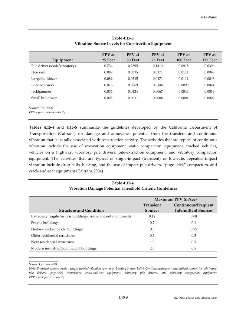
4.15 Noise
4.15-6 UC Davis Crystal Lake Alumni Camp
Table 4.15-3.
Vibration Source Levels for Construction Equipment
Equipment
PPV at
25 Feet
PPV at
50 Feet
PPV at
75 Feet
PPV at
100 Feet
PPV at
175 Feet
Pile driver (sonic/vibratory) 0.734 0.2595 0.1413 0.0918 0.0396
Hoe ram 0.089 0.0315 0.0171 0.0111 0.0048
Large bulldozer 0.089 0.0315 0.0171 0.0111 0.0048
Loaded trucks 0.076 0.0269 0.0146 0.0095 0.0041
Jackhammer 0.035 0.0124 0.0067 0.0044 0.0019
Small bulldozer 0.003 0.0011 0.0006 0.0004 0.0002
Source: FTA 2006.
PPV = peak particle velocity
Tables 4.15-4 and 4.15-5 summarize the guidelines developed by the California Department of
Transportation (Caltrans) for damage and annoyance potential from the transient and continuous
vibration that is usually associated with construction activity. The activities that are typical of continuous
vibration include the use of excavation equipment, static compaction equipment, tracked vehicles,
vehicles on a highway, vibratory pile drivers, pile-extraction equipment, and vibratory compaction
equipment. The activities that are typical of single-impact (transient) or low-rate, repeated impact
vibration include drop balls, blasting, and the use of impact pile drivers, “pogo stick” compactors, and
crack-and-seat equipment (Caltrans 2004).
Table 4.15-4.
Vibration Damage Potential Threshold Criteria Guidelines
Structure and Condition
Maximum PPV (in/sec)
Transient
Sources
Continuous/Frequent
Intermittent Sources
Extremely fragile historic buildings, ruins, ancient monuments 0.12 0.08
Fragile buildings 0.2 0.1
Historic and some old buildings 0.5 0.25
Older residential structures 0.5 0.3
New residential structures 1.0 0.5
Modern industrial/commercial buildings 2.0 0.5
Source: Caltrans 2004.
Note: Transient sources create a single, isolated vibration event (e.g., blasting or drop balls). Continuous/frequent intermittent sources include impact
pile drivers, pogo-stick compactors, crack-and-seat equipment, vibratory pile drivers, and vibratory compaction equipment.
PPV = peak particle velocity

4.15 Noise
4.15-7 UC Davis Crystal Lake Alumni Camp
Table 4.15-5.
Vibration Annoyance Potential Criteria Guidelines
Structure and Condition
Maximum PPV (in/sec)
Transient
Sources
Continuous/Frequent
Intermittent Sources
Barely perceptible 0.04 0.01
Distinctly perceptible 0.25 0.04
Strongly perceptible 0.9 0.10
Severe 2.0 0.4
Source: Caltrans 2013b.Error! Bookmark not defined.
Note: Transient sources create a single, isolated vibration event (e.g., blasting or drop balls). Continuous/frequent intermittent sources include
impact pile drivers, pogo-stick compactors, crack-and-seat equipment, vibratory pile drivers, and vibratory compaction equipment.
PPV = peak particle velocity
Groundborne vibration can also be quantified by the root-mean-square (RMS) velocity amplitudes, which is
useful for assessing human annoyance as a result of noise. The RMS amplitude is expressed in terms of the
velocity level in decibel units (VdB). The background vibration velocity level in residential areas is usually
around 50 VdB or lower. The vibration velocity level threshold of perception for humans is approximately
65 VdB. Most perceptible indoor vibration is caused by sources within buildings, such as the operation of
mechanical equipment, movement of people, or the slamming of doors. Typical outdoor sources of
perceptible ground-borne vibration are heavy construction equipment, steel-wheeled trains, and traffic on
rough roads. If a roadway is smooth, the ground-borne vibration from traffic is rarely perceptible.
Table 4.15-6 summarizes the typical groundborne vibration velocity levels and average human response
to vibration that may be anticipated when a person is at rest in quiet surroundings. If the person is
engaged in any type of physical activity, vibration tolerance increases considerably. The duration of the
event has an effect on human response, as does its daily frequency of occurrence. Generally, as the
duration and frequency of occurrences increase, the potential for adverse human response increases.

4.15 Noise
4.15-8 UC Davis Crystal Lake Alumni Camp
Table 4.15-6.
Typical Levels of Groundborne Vibration
Human or Structural Response
Vibration Velocity
Level (VdB)
Typical Sources
(50 feet from source)
Threshold for minor cosmetic damage to fragile
buildings
100 Blasting from construction project
Bulldozer or heavy-tracked
construction equipment
Difficulty in reading computer screen 90
Upper range of commuter rail
Threshold for residential annoyance for
occasional events (e.g., commuter rail)
80 Upper range of rapid transit
Threshold for residential annoyance for
frequent events (e.g., rapid transit)
Typical commuter rail
Bus or truck over bump
70 Typical rapid transit
Approximate threshold for human perception
of vibration; limit for vibration-sensitive
equipment
Typical bus or truck on public road
60
Typical background vibration
50
Source: FTA 2006.
4.15.3 ENVIRONMENTAL SETTING
4.15.3.1 Study Area
Project Site
The approximate 210-acre study area is located on the west slope of the Sierra Nevada, within the South
Yuba River watershed in the southeastern portion of Nevada County. It is located to the south of
Interstate 80 (I-80) and is accessed from the Yuba Gap exit. The Project area is within projected Section 24,
Township 17 North and Range 12 East, MDB&M, and is on the Cisco Grove 7.5-minute U.S. Geological
Survey (USGS) topographic quadrangle. Crystal Lake is located at an elevation of 5,877 feet above mean
sea level (msl).
Surrounding Land Uses
The development areas for the Project are located approximately 1,500 feet or more from I-80 and 1,200
feet or more from the nearby freight railroad, both located to the north of the study area. Snowflower Inc.
Campground has many loops and campsites located to the south and west of the study area. The closest
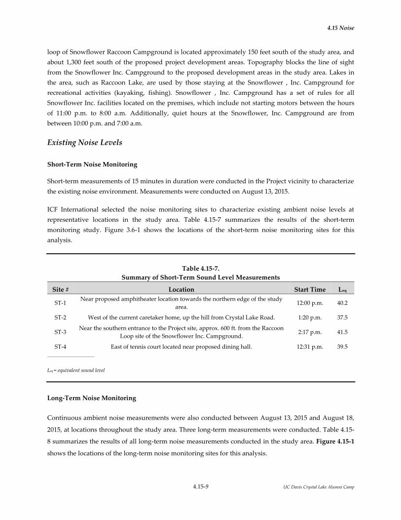
4.15 Noise
4.15-9 UC Davis Crystal Lake Alumni Camp
loop of Snowflower Raccoon Campground is located approximately 150 feet south of the study area, and
about 1,300 feet south of the proposed project development areas. Topography blocks the line of sight
from the Snowflower Inc. Campground to the proposed development areas in the study area. Lakes in
the area, such as Raccoon Lake, are used by those staying at the Snowflower , Inc. Campground for
recreational activities (kayaking, fishing). Snowflower , Inc. Campground has a set of rules for all
Snowflower Inc. facilities located on the premises, which include not starting motors between the hours
of 11:00 p.m. to 8:00 a.m. Additionally, quiet hours at the Snowflower, Inc. Campground are from
between 10:00 p.m. and 7:00 a.m.
Existing Noise Levels
Short-Term Noise Monitoring
Short-term measurements of 15 minutes in duration were conducted in the Project vicinity to characterize
the existing noise environment. Measurements were conducted on August 13, 2015.
ICF International selected the noise monitoring sites to characterize existing ambient noise levels at
representative locations in the study area. Table 4.15-7 summarizes the results of the short-term
monitoring study. Figure 3.6-1 shows the locations of the short-term noise monitoring sites for this
analysis.
Table 4.15-7.
Summary of Short-Term Sound Level Measurements
Site # Location Start Time Leq
ST-1 Near proposed amphitheater location towards the northern edge of the study
area. 12:00 p.m. 40.2
ST-2 West of the current caretaker home, up the hill from Crystal Lake Road. 1:20 p.m. 37.5
ST-3 Near the southern entrance to the Project site, approx. 600 ft. from the Raccoon
Loop site of the Snowflower Inc. Campground. 2:17 p.m. 41.5
ST-4 East of tennis court located near proposed dining hall. 12:31 p.m. 39.5
Leq = equivalent sound level
Long-Term Noise Monitoring
Continuous ambient noise measurements were also conducted between August 13, 2015 and August 18,
2015, at locations throughout the study area. Three long-term measurements were conducted. Table 4.15-
8 summarizes the results of all long-term noise measurements conducted in the study area. Figure 4.15-1
shows the locations of the long-term noise monitoring sites for this analysis.

DAS06
DAS05
CrystalLake
Raccoon Pond
Seasonal Wetland
Honey Lake
Unnamed Lake
Seasonal Wetland
Source:
80
NEVADA COUNTY
PLACER COUNTY
0043
3.14
UCD
Cry
stal
Lak
e (0
8-19
-201
5) S
S
Figure 4.15-1Noise Measurement Locations
Legend Study Area Noise Measurement Locations Short-term Measurement Locations Long-term Measurement Locations
LT-3
LT-#
ST-4
ST-1
ST-3
ST-#
LT-2
LT-1
ST-2

4.15 Noise
4.15-11 UC Davis Crystal Lake Alumni Camp
Table 4.15-8.
Summary of Long-Term Sound Level Measurements
Site # Date Location Ldn Lowest
1-hr Leq
Highest
1-hr Leq
LT-1
Friday 8/14/2015
Near proposed Amphitheater location towards
the northern edge of the Project site.
48 37 54
Saturday 8/15/2015 50 37 59
Sunday 8/16/2015 47 36 48
Monday 8/17/2015 46 36 45
LT-2
Friday 8/14/2015
Located west of the current caretaker home, up
the hill from Crystal Lake Road.
52 39 48
Saturday 8/15/2015 52 38 50
Sunday 8/16/2015 51 36 51
Monday 8/17/2015 52 37 51
LT-3
Friday 8/14/2015 Near the southern entrance to the Project site,
approx. 600 ft. from the Raccoon Loop site of
the Snowflower Inc. Campground.
54 39 53
Saturday 8/15/2015 54 38 51
Sunday 8/16/2015 53 37 50
Monday 8/17/2015 53 38 50
Ldn = day-night sound level
Leq = equivalent sound level
Note that the Ldn (weighted 24-hour average with 10 dB added to noise levels during the hours of 10:00
p.m. to 7:00 a.m.) in the vicinity of the study area is generally very quiet, ranging from 46 to 54 Ldn. The
lowest 1-hour Leq noise level recorded was 36 dBA Leq, and the highest was 59 dBA Leq. To provide a
conservative assessment, the lowest 1-hour Leq noise level of 36 dBA was utilized as the ambient noise
level in the entire Project vicinity and at the adjacent Snowflower Inc. Campground.
4.15.3 REGULATORY CONSIDERATIONS
Federal, state, and local agencies regulate different aspects of environmental noise. Generally, the federal
government sets noise standards for transportation-related noise sources that are closely linked to
interstate commerce. These sources include aircraft, locomotives, and trucks. No federal noise standards
are directly applicable to the Project. The state government sets noise standards for transportation noise
sources such as automobiles, light trucks, and motorcycles. Noise sources associated with industrial,
commercial, and construction activities are generally subject to local control through noise ordinances
and general plan policies. Local general plans identify general principles that are intended to guide and
influence development plans. UC Davis, as a state entity, is not subject to Nevada County noise
standards. However, to match local policies, UC Davis, has applied Nevada County noise standards in
this assessment.
The state and local noise policies and regulations that are applicable to the Project are described below.

4.15 Noise
4.15-12 UC Davis Crystal Lake Alumni Camp
4.15.3.1 State
California Code
Title 24 of the California Code of Regulations, Part 2, California Noise Insulation Standards, establishes
minimum noise insulation standards to protect persons within new hotels, motels, dormitories, long-term
care facilities, apartment houses, and dwellings other than single-family residences. Under this
regulation, interior noise levels that are attributable to exterior noise sources cannot exceed the 45 day-
night level (Ldn) in any habitable room. Where such residences are located in an environment in which
exterior noise is 60 Ldn or greater, an acoustical analysis is required to ensure that interior levels do not
exceed the 45 Ldn interior standard.
4.15.3.2 Local
Nevada County General Plan
The Noise Element of the Nevada County General Plan (Nevada County 2014) establishes maximum
allowable exterior noise levels for various land use categories in terms of the average-hourly (Leq) and
maximum intermittent (Lmax) noise descriptors. Maximum allowable noise standards are identified for
daytime (7:00 a.m. to 7:00 p.m.), evening (7:00 p.m. to 10:00 p.m.), and nighttime (10:00 p.m. to 7:00 a.m.)
periods. The County’s noise standards, which are described as performance standards and land use
compatibility standards in the General Plan, are summarized in Table 4.15-9.
In addition to the identification of noise standards, the County’s general plan also identifies goals,
objectives, and policies to reduce noise-related impacts and land use compatibility conflicts; these goals
and policies are intended to guide future development, and future assessment of noise impacts, and to
ensure adequate protection of the public from noise effects, and can be found on Page 9-2 of the Nevada
County Noise Element. The general plan also identifies land use compatibility standards for new
development adjacent to the Nevada County Airport. Although not directly applicable to the proposed
project, the standards provide guidance as to noise levels that the County considers to be appropriate for
residential uses. The “normally acceptable” noise compatibility standard for new residential development
is 60 Ldn.
Nevada County Land Use Development Code
The allowable exterior noise standards described above are also identified in the Nevada County Land Use
Development Code, Chapter II, Zoning Regulations (Section L-II, 4.1.7, Noise). Construction activities are
exempt from the County’s noise standards.

4.15 Noise
4.15-13 UC Davis Crystal Lake Alumni Camp
Table 4.15-9
County of Nevada Exterior Noise Limits
Use Category Zoning District Time Period Noise Level
Leq Lmax
Rural AG, TPZ, AE, OS, FR, IDR 7 a.m.–7 p.m.
7 p.m.–10 p.m.
10 p.m.–7 a.m.
55
50
40
75
65
55
Residential and Public RA, R1, R2, R3, P 7 a.m.–7 p.m.
7 p.m.–10 p.m.
10 p.m.–7 a.m.
55
50
45
75
65
60
Commercial and Recreation C1, C2, C3, CH, CS, OP, REC 7 a.m.–7 p.m.
7 p.m.– 7 a.m.
70
65
90
75
Business Park BP 7 a.m.–7 p.m.
7 p.m.–7 a.m.
65
60
85
70
Industrial M1, M2 Any time 80 90
Source: Nevada County 2010.
Notes:
• Compliance with the above standards shall be determined by measuring the noise level based on the mean average of not less than three (3) 20-
minute measurements for any given time period. Additional noise measurements may be necessary to ensure that the ambient noise level is
adequately determined.
• Where two different zoning districts abut, the standard applicable to the lower or more restrictive district plus 5 dBA shall apply.
• The above standards shall be measured only on property containing a noise-sensitive land use as defined in General Plan Policy 9.8 and may
be measured anywhere on the property containing said land use.
• If the measured ambient level exceeds that permitted, the allowable noise exposure standard shall be set at 5 dBA above the ambient.
• Because of the unique nature of sound, the County reserves the right to provide for a more restrictive standard than shown in the Exterior
Noise Limits table contained in this policy. The maximum adjustment shall be limited to be not less than the current ambient noise levels and
shall not exceed the standards of this policy or as they may be further adjusted by General Plan Policy 9.1b. Imposition of a noise level
adjustment shall only be considered if one or more of the following conditions are found to exist:
a. Unique characteristics of the noise source:
• The noise contains a very high or low frequency, is of a pure tone (a steady, audible tone such as a whine, screech, or hum), or contains a
wide divergence in frequency spectra between the noise source and ambient level.
• The noise is impulsive in nature (such as hammering, riveting, or explosions), or contains music or speech.
• The noise source is of a long duration.
b. Unique characteristics of the noise receptor when the ambient noise level is determined to be 5 dBA or more below the Policy 9.1 standard for
those projects requiring a General Plan amendment, rezoning, and/or conditional use permit. In such instances, the new standard shall not
exceed 10 dBA above the ambient or General Plan Policy 9.1 standard, whichever is more restrictive.
• The above standards shall not apply to those activities associated with the actual construction of a project or to those projects associated
with the provision of emergency services or functions.
Leq = equivalent sound level
Lmax = maximum sound level
4.15.4 IMPACTS AND MITIGATION MEASURES
4.15.4.1 Significance Criteria
The significance criteria listed below are derived from Appendix G of the State CEQA Guidelines. For the
purpose of this EIR, noise impacts would be significant if implementation of the proposed project would:

4.15 Noise
4.15-14 UC Davis Crystal Lake Alumni Camp
Expose persons to or generate noise levels in excess of standards established in a local general plan or
noise ordinance or applicable standards of other agencies.
Expose persons to or generate excessive ground-borne vibration or ground-borne noise levels.
Result in a substantial permanent increase in ambient noise levels in the Project vicinity above levels
existing without the Project.
Result in a substantial temporary or periodic increase in ambient noise levels in the Project vicinity
above levels existing without the Project.
Be located within an airport land use plan area or, where such a plan has not been adopted, within 2
miles of a public airport or public use airport and expose people residing or working in the Project
area to excessive noise levels.
Be located in the vicinity of a private airstrip and expose people residing or working in the Project
area to excessive noise levels.
4.15.4.3 Methodology
Operational Noise Assessment Methodology
Stationary Source Noise
Primary stationary noise sources associated with the Project, including activities at the beach area,
amphitheater, swimming pool, and the dining hall fan equipment, were analyzed. Reference noise levels
for each noise source at a distance of 50 feet were determined, as was the distance between each source
and the receiver (Snowflower Inc. Campground). Standard geometric attenuation factors, ground
absorption factors, and shielding factors based on distances between receivers and area topography were
used to estimate the noise generated by each analyzed source at the receiver location. Noise levels from
sources that would be generating noise simultaneously were added logarithmically to determine worst-
case loudest noise levels at the nearby noise sensitive land uses for with-project conditions.
Transportation Noise
Transportation noise was evaluated based on information from the Project description stating that the
busiest period of camp (on Saturday/Sunday) could have approximately 125 vehicles departing after a
week of camp (generally on Saturday) or arriving for the start of camp (generally on Sunday) between
10:00 a.m. and 4:00 p.m. Additionally, the conference center could add up to 40 inbound and 40 outbound
vehicle trips over a period of 10:00 a.m. to 8:00 p.m. To provide a conservative analysis, this assessment
assumes that all of the 125 vehicles arriving for or departing from camp would arrive or depart during a
single peak-hour. These trips would not overlap with the 40 inbound or outbound trips for the event
center. Modeling traffic noise levels for 125 vehicle trips would be representative of the loudest traffic
condition in the project vicinity. Traffic noise was modeling using the Federal Highway Administration
Traffic Noise Model (TNM; Version 2.5)

4.15 Noise
4.15-15 UC Davis Crystal Lake Alumni Camp
Construction Noise Assessment Methodology
Noise levels associated with Project-related construction activities were evaluated by summing the noise
levels of the three loudest pieces of equipment that would likely operate on the project site for a given
construction activity or phase. FHWA reference noise levels from the Road Construction Noise Model
(RCNM) User’s Guide were used.
The three loudest pieces of equipment for the grading, roadway and underground infrastructure
development would be a grader, tractor, and excavator. For the foundation and building construction
phase, the three loudest pieces of equipment would be the concrete mixer truck, concrete pump truck,
and tractor. Additionally, tree removal work would take place during a 4-week period; the three loudest
pieces of equipment utilized for tree removal work would be a chainsaw, a loader, and a chipper or
masticator (tree chewing hydraulic head mounted on a backhoe). Note that for all construction activities,
trucks hauling materials to the site or debris (e.g., during tree removal) could be driving to and from the
construction site. A worst-case assumption of 4 truck trips taking place during a given hour was
assumed, and the noise generated from these trucks was added to the construction noise from each
activity. The sum of the equipment noise for the worst-case loudest construction phase is then compared
to the applicable noise standards to determine if there would be a potential noise impact.
4.15.4.4 Project Impacts and Mitigation Measures
Impact NOI-1: Expose persons to or generate noise levels in excess of standards established in
a local general plan or noise ordinance or applicable standards of other
agencies (Significant; Less than Significant with Mitigation or Significant and
Unavoidable)
While the proposed project will involve the development of a campground, the users of which could be
sensitive to noise, the proposed project would not be exposed to noise levels in excess of the County’s
noise compatibility standard. Noise measurements conducted onsite demonstrated that the proposed
project area is very quiet, with Ldn values in the range of 46 to 54 dBA, despite its relatively close
proximity to I-80 and an active train track. This is below the County’s compatibility standard for
residential uses of 60 Ldn, so there would be no noise compatibility issues associated with the
development of a campground in this area.
However, the proposed project may generate noise that could affect nearby noise sensitive land uses. The
potential for the proposed Project to affect nearby noise sensitive land uses (via stationary noise sources,
transportation noise, and construction noise) is discussed below.

4.15 Noise
4.15-16 UC Davis Crystal Lake Alumni Camp
Operational Noise
Stationary Source Operational Noise
Various operational activities associated with the proposed project would generate noise. As described in
Section 4.15.3, Environmental Setting, the nearest noise-sensitive land use is the Snowflower Inc.
Campground, which is located over 1,300 feet from the proposed project development areas.
Areas that would likely generate the most noise at the proposed alumni camp are the swimming pool,
tennis court, beach area, event center, amphitheater, and dining hall. The swimming pool, tennis court,
and beach area would all generate noise during the daytime, and the amphitheater would mostly
generate noise during the evening hours. The dining hall would likely generate noise (from exhaust fans
and HVAC) throughout the day and evening.
The use of the amphitheater would likely generate the most noise of any of the proposed project
activities, as it would be a place where campers and counselors may join together in the evening for skits,
singing, campfires, or other similar group activities. To provide a worst-case analysis for this proposed
use, it is assumed that 420 persons (350 campers and 70 staff) would be present at the amphitheater at the
same time. It is also assumed that all 420 persons would be shouting (for example, cheering loudly at the
end of a skit). Note that amplification would not used for musical performances, only unamplified
acoustic instruments would be used, and a single amplified voice (for a skit, etc.) would be much quieter
than 420 persons shouting at the facility. Assuming 420 persons shouting provides a very conservative
analysis, as it is unlikely that this many people would be at the amphitheater at a given time, and it is
even more unlikely that all 420 persons would be shouting. If 420 persons were shouting at the
amphitheater at a given time, this would generate a noise level of 85 dBA at a reference distance of 50 feet
from the amphitheater (Harris 1979). Including standard attenuation factors for geometric attenuation,
shielding, and ground absorption that would occur between the source (the amphitheater) and the
receiver (the Snowflower Inc. Campground), the amphitheater is predicted to a generate noise level of 36
dBA at the edge of the Snowflower Inc. Campground.
According to noise measurements conducted at the Project site, ambient noise levels in the vicinity of the
Snowflower Inc. Campground are as low as approximately 36 dBA Leq. The noise levels may increase
during times of heavy traffic (when people are arriving or departing from Snowflower Inc.
Campground), but the lowest measured noise level of 36 dBA Leq was utilized as the ambient baseline in
order to ensure that the existing conditions are correctly characterized as very quiet. The 36 dBA noise
level from the amphitheater would combine with the existing ambient levels (added logarithmically) to
equal a sound level of just under 39 dBA at the edge of the Snowflower Inc. Campground. Therefore,

4.15 Noise
4.15-17 UC Davis Crystal Lake Alumni Camp
activities at the amphitheater could increase noise levels from existing conditions (36 dBA) by
approximately 3 dB.
The event center, which would include gatherings of up to 50 people for events such as weddings would
also generate noise. No amplification equipment would be used at the event center. If all 50 people
attending an event at the event center were shouting, this land use would generate a noise level of about
25 dBA Leq at the edge of the Snowflower Inc. Campground. Additionally, the fans and HVAC equipment
associated with the dining hall may be operating simultaneously. This equipment would generate noise
levels of approximately 67 dBA at a reference distance of 50 feet, but would be reduced to about 8 dBA at
the edge of the nearby Snowflower Inc. Campground. Combining the potential worst-case noise from the
amphitheater, event center and dining hall with the ambient noise levels (~36 dBA Leq) in the vicinity
would result in a total evening noise level of 39 dBA Leq at the edge of the Snowflower Inc. Campground;
this is similar to the noise increase of the amphitheater alone, as that would contribute the most noise of
the three aforementioned noise sources. The noise thresholds for Nevada County state that noise levels
may be up to 55 dBA Leq during the daytime hours of 7:00 a.m. to 7:00 p.m., 50 dBA Leq during the
evening hours of 7:00 p.m. to 10:00 p.m., and 40 dBA Leq for rural land uses during the nighttime hours of
10:00 p.m. to 7:00 a.m. A 3 dB increase in noise may be perceptible at the Snowflower Inc. Campground;
however, the modeled noise level of 39 dBA Leq would not exceed even the most stringent nighttime
threshold for Nevada County. Therefore, evening and nighttime noise levels at the edge of the
Snowflower Camp are not expected to exceed County noise standards.
Daytime noise levels in the area would be most greatly influenced by the swimming pool, beach area,
tennis court, dining hall, and the event center. As previously mentioned, the dining hall would generate
minor noise, and is not expected to be perceptible at the edge of the Snowflower Inc. Campground. The
tennis court would generate even less noise. Noise levels at a reference distance of 50 feet from the tennis
court would be in the range of 50 to 60 dBA (Placer County 2011); at the edge of the Snowflower Inc.
Campground, this noise level is predicted to drop to about 8 dBA. Assuming up to 100 people were using
the swimming pool at a given time and all were shouting, the swimming pool would generate a noise
level of 78 dBA at a reference distance of 50 feet. Although other noise may be generated at the pool (such
as the noise associated with a diving board), assuming 100 people are shouting while at the facility is a
conservative analysis. The noise generated by the pool is predicted to drop to about 25 dBA at the edge of
the Snowflower Inc. Campground. Similarly, if 100 people were utilizing the beach area at a given time
and all were also shouting, noise levels would be 75 dBA Leq at a 50-foot reference distance, and 25 dBA at
the edge of the adjacent Snowflower Inc. Campground. Finally, and as mentioned above, the event center
could generate noise levels of about 25 dBA at the edge of the campground.
4.15 Noise
4.15-18 UC Davis Crystal Lake Alumni Camp
All of these noise levels would add to total a 29.0 dBA noise level at the edge of the Snowflower Inc.
Campground, which would combine with the ambient noise level of 36 dBA Leq to total a with-project
day-time noise level of approximately 37 dBA Leq; the increase in noise would be less than 1 dB. This
modeling provides a conservative analysis, because it is unlikely that all of the individuals utilizing the
pool and the beach would be shouting at the same time. The small predicted increase of less than 1 dB
above ambient noise levels may be perceptible to people located nearby based on the tonal characteristics
of the sound, but the overall noise level is not predicted to exceed the daytime (7:00 a.m. to 7:00 p.m.)
threshold of 55 dBA Leq or evening (7:00 p.m. to 10:00 p.m.) threshold of 50 dBA Leq for rural land uses at
the nearby Snowflower Inc. Campground.
Operational noise levels are not predicted to exceed County noise standards. Therefore, this impact is less
than significant.
Transportation Operational Noise
According to the Project description, it is possible that up to 125 vehicles could be arriving or departing
between the hours of 10:00 a.m. and 4:00 p.m. on a Saturday or Sunday. In order to model a reasonable
worst-case peak hour traffic noise condition, it was conservatively assumed that all of these vehicles
would be arriving or departing during a single peak-hour.
Traffic noise modeling was conducted using the Federal Highway Administration’s Traffic Noise Model
(TNM). Posted speed limits along Crystal Lake Road indicate a maximum speed of 5 miles per hour
(mph); the speed limit would remain 5 mph with project implementation. The roadway improvements
proposed with the project would include roadway paving and widening along this street. Because of this,
traffic noise modeling for future with-project conditions conservatively assumed that cars would be
traveling at speeds of 15 (even though posted speeds would be 5 mph). Note that TNM does not
accurately assess traffic noise levels at very low speeds, such as 5 mph, so no attempt was made to model
traffic noise using the 5 mph speed.
Modeling results indicated that Project traffic could generate noise of approximately 50 dBA Leq at a
distance of 20 feet from the roadway centerline, which is the approximate distance to the nearby
campsites at the Snowflower Inc. Campground. This would combine with ambient noise levels of 36 dBA
Leq to equal a total noise level of just over 50 dBA Leq at the nearest campsite. This noise level would be a
14 dB increase from ambient levels. At the portion of the Snowflower Inc. Campground furthest from the
roadway (approximately 450 feet to the southeast), project traffic could generate noise levels of up to 27
dBA. This would add with the ambient noise level of 36 dBA Leq to equal a total noise level of
approximately 37 dBA Leq, which is an approximately 1 dB increase from ambient levels. Note that traffic
4.15 Noise
4.15-19 UC Davis Crystal Lake Alumni Camp
noise modeling was also conducted to determine if buses used in lieu of individual vehicle trips to
transport campers to the site would reduce traffic noise. Results indicate that 6 buses traveling at speeds
of 15 mph would generate noise levels of approximately 53 dBA at a distance of 20 feet from the roadway
centerline. These 6 buses would generate noise 3 dB more of noise in 1 hour than 125 cars traveling down
the same road. Therefore, buses were not further assessed as an option to reduce traffic noise for the
proposed project.
Because ambient noise levels in the project vicinity are so low, increases in traffic noise from cars would
result in increases in noise levels by up to 14 dB. Although the predicted traffic noise level of 53 dBA does
not exceed the daytime threshold of 55 dBA, the analysis indicates potential for project traffic noise to
exceed the evening and nighttime standards (50 dBA and 40 dBA respectively). Therefore, this impact
would be significant. Implementation of Mitigation Measures NOI-1 and LU-1 would reduce this impact
to a less-than-significant level. However, if Mitigation Measure LU-1 cannot be implemented, this impact
would be significant and unavoidable.
Construction Noise
Construction noise is exempt from the Nevada County noise regulations per Section II 4.1.6, Noise, of the
Nevada County Code. The analysis of construction noise associated with the proposed project is included in
the discussion of temporary noise increases assessed under Impact NOI-3.
Mitigation Measure NOI-1: Restrict vehicle speeds along Crystal Lake Road to 5 mph by posting of
speed limit signs and implementing other traffic control features such as speed bumps
and limits on when facility users can access the alumni camp
UC Davis will post signs limiting speeds to 5 mph, install speed bumps, and prohibit users of the facility
from accessing the project site between the hours of 10:00 p.m. and 7:30 a.m.
Mitigation Measure LU-1: Purchase Snowflower Raccoon Camp
This mitigation measure is described in Section 4.13, Land Use and Planning.
Significance after Mitigation: Implementation of Mitigation Measure NOI-1 would reduce operational
noise from vehicle traffic entering the project site and would prohibit nighttime access to the project site
by facility users. Implementation of Mitigation Measure LU-1, as described in Section 4.13, Land Use and
Planning, would reduce operational noise from vehicle traffic by moving the noise sensitive land use
(Snowflower Inc. Campground) about 300 feet further away from the roadway.
Implementation of both Mitigation Measures NOI-1 and LU-1 would reduce this impact to a less-than-
significant level. If Mitigation Measure LU-1 cannot be implemented, and only Mitigation Measure NOI-1

4.15 Noise
4.15-20 UC Davis Crystal Lake Alumni Camp
can be implemented, this impact would be significant and unavoidable because operational project traffic
would remain in close proximity to the campground and could potentially exceed the 50 dBA evening
noise standard.
Impact NOI-2: Expose persons to or generate excessive groundborne vibration or
groundborne noise levels (Less than Significant)
Operational Vibration Impacts
None of the operational activities associated with the proposed project would generate perceptible
vibration; therefore, there would be no operational vibration impacts.
Construction Vibration Impacts
The operation of heavy construction equipment may generate localized groundborne vibration in areas
adjacent to the construction site, especially during the operation of high-impact equipment, such as pile
drivers. Vibration from non-impact construction activity and truck traffic is typically below the threshold
of perception when the activity is more than approximately 50 feet from the noise-sensitive land uses
(Federal Transit Administration 2006). Consequently, for construction activities that do not involve the
use of high-impact equipment and construction sites that are more than 50 feet from noise-sensitive land
uses, groundborne vibration impacts are expected to be less than significant. For the proposed project,
there may be campsites at the Snowflower Inc. Campground located less than 50 feet away from where
some of the roadway construction is proposed for the project; vibration could be perceptible at these
locations, depending on the amount of and specific types of equipment being utilized. However, the
duration of time that equipment would be within 50 feet of a specific campsite would be short;
additionally, none of the covered activities necessary for Project implementation would involve high-
impact equipment, such as pile drivers. Therefore, potential impacts related to the exposure of persons to
excessive groundborne vibration would be less than significant.
Mitigation Measures: No mitigation measures are required.
Impact NOI-3: Result in a substantial permanent increase in ambient noise levels in the
project vicinity above levels existing without the proposed project (Significant
and Unavoidable)
Stationary Source Operation Noise
As described for Impact NOI-1, noise levels in the project vicinity would increase with implementation of
the proposed project. Operational noise from stationary sources associated with the campsite are

4.15 Noise
4.15-21 UC Davis Crystal Lake Alumni Camp
predicted to increase levels from the ambient conditions by less than 1 dB Leq during daytime hours, but
by up to 3 dB during evening and nighttime hours. Although the predicted nighttime noise level of 39
dBA Leq is below the nighttime threshold of 40 dBA Leq, an evening/nighttime increase from
approximately 36 dBA Leq to 39 dBA Leq would likely be perceptible at the edge of the nearby
campground since current ambient conditions in the Project vicinity are very quiet; additionally, note that
even minor increases in noise can be perceptible depending upon the tonal characteristics of the noise
source. A 3 dB or more increase in noise is the threshold level for most people to notice a change in the
noise environment. As the increase in noise due to the propose project could be 3 dB, a substantial
permanent increase in ambient noise levels above levels existing without the proposed project would be
expected. This impact would be significant, and mitigation to reduce this effect would be required, but
even with implementation of Mitigation Measure NOI-3, the impact would remain significant and
unavoidable.
Transportation Operation Noise
As described for Impact NOI-1, traffic noise levels in the project vicinity would increase with
implementation of the proposed project, as additional vehicles would be entering and exiting the Project
site along Crystal Lake Road. Increases in traffic noise from vehicles would result in increases in noise
levels by up to 14 dB. An increase of 3 dB or more is generally accepted as a threshold of perceptibility for
the average healthy human ear. As the current conditions in the area are extremely quiet, and as the
increases associated with project traffic could be as great as 14 dB, a substantial permanent increase in
ambient noise levels would result from increased vehicle traffic. This impact would be significant, and
mitigation to reduce this effect would be required, but even with implementation of Mitigation Measures
NOI-1 and LU-1, the impact would remain significant and unavoidable.
Mitigation Measure NOI-1: Restrict vehicle speeds along Crystal Lake Road to 5 mph by posting of
speed limit signs and implementing other traffic control features such as speed bumps
and limits on when facility users can access the alumni camp
This mitigation measure is described under Impact NOI-1.
Mitigation Measure NOI-3: Prohibit usage of the project amphitheater and event center between the
hours of 10:00 p.m. and 7:00 a.m.
UC Davis will prohibit use of the amphitheater and event center between the hours of 10:00 p.m. and 7:00
a.m.
Mitigation Measure LU-1: Purchase Snowflower Raccoon Camp

4.15 Noise
4.15-22 UC Davis Crystal Lake Alumni Camp
This mitigation measure is described in Section 4.13, Land Use and Planning.
Significance after Mitigation: As described previously for Impact NOI-1, implementation of Mitigation
Measures NOI-1 and LU-1 would reduce operational noise from vehicle traffic entering the Project site,
and reduce the level of effect for Impact NOI-3; however, noise levels would still increase from the
current ambient conditions by more than 3 dB, resulting in a substantial permanent increase in noise.
Impacts from traffic noise would remain significant.
Implementation of Mitigation Measure NOI-3 would ensure that noise levels after 10:00 p.m. would be
reduced to the extent practicable; by prohibiting the use of the event center and the amphitheater (two of
the loudest noise sources associated with project development) during these times, noise levels in the
project vicinity would be in agreement with the quiet hours of the nearby Snowflower Inc. Campground.
This measure would also likely reduce project noise to less-than-perceptible levels during these hours.
However, even with this restriction, noise levels during the hours of 7:00 a.m. to 10:00 p.m. would
increase from current ambient conditions, resulting in a substantial permanent increase in noise.
Operational noise impacts from project stationary noise sources would remain significant.
As Mitigation Measures NOI-1, NOI-3, and LU-1 would not reduce operational noise impacts to less-
than-significant levels, and a substantial permanent increase in noise would still result, noise impacts
from operation of the proposed project would be significant and unavoidable.
Impact NOI-4: Result in a substantial temporary or periodic increase in ambient noise levels
in the project vicinity above levels existing without the project (Significant
and Unavoidable)
As described in the Methodology section above, the noise levels of the three loudest pieces of equipment
for the grading, roadway and underground infrastructure development were summed to assess
construction noise impacts. Additionally, the noise levels for the equipment used for foundation and
building construction and for the tree removal activities were separately summed. The construction
equipment associated with the tree removal activities, which were determined to result in more noise
than the equipment associated with the other two analyzed construction activities, is predicted to
generate a noise level of 87 dBA Leq at a reference distance of 50 feet. The Lmax for this activity is predicted
to be 94 dBA. Although tree removal activities are only anticipated to take place over a 4-week period,
noise associated with the other construction activities would be similarly loud. Table 4.15-10 shows the
predicted construction noise levels for the three analyzed construction activities, where the loudest three
pieces of equipment are operating simultaneously for each activity, at a standard reference distance of 50
feet. Note that these noise levels are conservative because modeling assumes that the three loudest
equipment pieces would be operating in the same location simultaneously, which would be an unlikely
event.

4.15 Noise
4.15-23 UC Davis Crystal Lake Alumni Camp
Table 4.15-10.
Calculated Construction Noise Emission Levels
Source Data
Maximum
Sound
Level (dBA)
Utilization or
Acoustical
Use Factor
Leq Sound
Level (dBA)
Construction Activity 1: Grading, Road and Underground Infrastructure
Source 1: Excavator - Sound level (dBA) at 50 feet = 81 0.4 77
Source 2: Tractor - Sound level (dBA) at 50 feet = 84 0.4 80
Source 3: Grader - Sound level (dBA) at 50 feet = 85 0.4 81
Calculated Data:
All Sources Combined - Lmax (dBA) at 50 feet =
88
All Sources Combined - Leq (dBA) at 50 feet =
84
Construction Activity 2: Foundation and Building Construction
Source 1: Concrete Mixer Truck - Sound level (dBA) at 50
feet = 79 0.2 72
Source 2: Concrete Pump Truck - Sound level (dBA) at 50
feet = 81 0.4 77
Source 3: Tractor - Sound level (dBA) at 50 feet = 84 0.4 80
Calculated Data:
All Sources Combined - Lmax (dBA) at 50 feet =
87
All Sources Combined - Leq (dBA) at 50 feet = 82
Construction Activity 3: Tree Removal Activities
Source 1: Chainsaw - Sound level (dBA) at 50 feet = 84 0.2 77
Source 2: Loader - Sound level (dBA) at 50 feet = 78 0.4 74
Source 3: Chipper - Sound level (dBA) at 50 feet = 93 0.2 86
Calculated Data:
All Sources Combined - Lmax (dBA) at 50 feet =
94
All Sources Combined - Leq (dBA) at 50 feet = 87
dBA = A-weighted decibel Lmax = maximum sound level Leq = equivalent sound level
Construction Activities 1 and 3 from Table 4.15-10 could take place along the access road and could
therefore take place in close proximity to the Snowflower Inc. Campground (i.e., as close as about 20 feet
from the campground). Additional noise would be generated from haul trucks importing building
materials or exporting tree debris. As described in Section 4.15.4.3, Methodology, it was assumed that up to
four truck trips would take place during a given hour. According to the TNM results, four truck trips in a
single hour would result in a noise level of 53 dBA Leq at a distance of 50 feet. Peak passerby noise levels,

4.15 Noise
4.15-24 UC Davis Crystal Lake Alumni Camp
however, could exceed 76 dBA at 50 feet or about 84 dBA at 20 feet (FHA 2006). Construction Activity 2
from Table 4.15-10 would take place on the project site and noise from this activity is expected to drop to
less than 40 dBA at the Snowflower Inc. Campground as a result of distance and shielding attenuation.
Although Construction noise would not be constant, noise levels could reach levels of up to 87 dBA Leq at
a reference distance of 50 feet away from the construction activity, which is the approximate distance to
the Snowflower Inc. Campground campsites from locations where Activity 1 and Activity 3 construction
could take place. Construction noise levels of approximately 87 dBA Leq would result in an exceedance of
the current ambient noise level (36 dBA Leq) by approximately 50 dB. Therefore, a substantial temporary
increase in ambient noise levels above levels existing without the proposed project would result due to
project construction. This impact would be significant, and mitigation (Mitigation Measures NOI-4 and
NOI-4b) to reduce this effect would be required, but the impact would remain significant and
unavoidable.
Mitigation Measure NOI-4a: The construction contractor will employ noise-reducing construction
practices to reduce construction noise
UC Davis will require the construction contractor to employ noise-reducing construction practices.
Measures that can be used to limit noise include, but are not limited to, those listed below.
Locating equipment as far as feasible from noise sensitive uses.
Requiring that all construction equipment powered by gasoline or diesel engines have sound-control
devices that are at least as effective as those originally provided by the manufacturer and that all
equipment be operated and maintained to minimize noise generation.
Not idling inactive construction equipment for prolonged periods (i.e., more than 2 minutes).
Prohibiting gasoline or diesel engines from having unmuffled exhaust.
Scheduling construction activities and material hauling that may affect traffic flow to off-peak hours
and using routes that would affect the fewest number of people.
Using noise-reducing enclosures around noise-generating equipment.
Constructing temporary barriers between noise sources and noise-sensitive land uses or taking
advantage of existing barrier features (terrain, structures) to block sound transmission.
Mitigation Measure NOI-4b: Restrict noise-generating construction work to only take place between
the hours of 8:00 p.m. and 5:00 p.m. on weekdays and non-holidays

4.15 Noise
4.15-25 UC Davis Crystal Lake Alumni Camp
UC Davis will require the construction contractor to limit noise-generating construction to the hours
between 8:00 p.m. and 5:00 p.m. on weekdays and non-holidays. No noise-generating construction
activity will be allowed on weekends and holidays between Memorial Day and Labor Day.
Significance after Mitigation:
Implementation of Mitigation Measure NOI-4a would reduce construction noise by ensuring that all
feasible measures to reduce excessive construction noise are implemented; even with implementation of
many noise-reducing construction practices, construction noise will result in a substantial temporary
increase in noise near noise-sensitive land uses. This impact would remain significant and unavoidable.
Implementation of Mitigation Measure NOI-4b would reduce the period of time on a given day that
excessive construction noise levels would be generated. This mitigation measure would apply to any
noise-generating construction work, such as work utilizing heavy equipment or power tools. Although
noise generated during the construction of a project is technically exempt in Nevada County, this
measure would help reduce the negative effects of construction noise to those located in close proximity
the project site. By restricting construction noise to the hours of 8:00 a.m. to 5:00 p.m., there would be
more hours in a given day when those staying at the nearby Snowflower Inc. Campground would not be
exposed to excessive noise levels. Additionally, by prohibiting noise-generating construction work on the
weekends and on holidays, this measure would ensure that the noise levels at the nearby Snowflower Inc.
Campground would be similar to existing conditions on those days.
Although Mitigation Measures NOI-4a and NOI-4b would reduce the negative effects of construction
noise to nearby noise sensitive land uses, a substantial temporary increase in ambient noise levels would
still result. Therefore, this impact would be significant and unavoidable.
Impact NOI-5: Be located within an airport land use plan area or, where such a plan has not
been adopted, within 2 miles of a public airport or public use airport and
expose people residing or working in the project area to excessive noise levels
(Less than Significant)
AND
Impact NOI-6: Be located in the vicinity of a private airstrip and expose people residing or
working in the project area to excessive noise levels (Less than Significant)
The nearest airport or private airstrip is the Blue Canyon-Nyack Airport, which is located approximately
7.4 miles to the southwest of the proposed project.; other airports, such as the Milhous Ranch Airport, the

4.15 Noise
4.15-26 UC Davis Crystal Lake Alumni Camp
Sierraville Dearwater Airport, and the Alta Sierra Airport, are all located substantially further away (20 to
30 miles away).
Since the proposed project is not located in an area for which an Airport Land Use Plan has been
prepared, and no public or private airfields are located within 2 miles of the project, individuals utilizing
the proposed alumni camp would not be exposed to adverse levels of noise due to aircraft overflight; no
impact would result, and no mitigation would be necessary.
Mitigation Measures: No mitigation measures are required.
4.15.4.5 Cumulative Impacts and Mitigation Measures
In general, the implementation of cumulative development projects has the potential to increase ambient
noise by increasing traffic and human activity throughout a given area. The geographic context for the
analysis of cumulative construction noise impacts and stationary-source operational noise impacts is
generally very small (a few hundred feet) because noise diminishes rapidly with distance (6 dBA per
doubling of distance for point and stationary sources). Because of this, and because the proposed project
is isolated from other development, the proposed project would not contribute to any significant
cumulative noise impacts.
4.15 Noise
4.15-27 UC Davis Crystal Lake Alumni Camp
4.15.5 References
California Department of Transportation. 2004. Transportation and Construction-Induced Vibration
Guidance Manual. June. Available:
http://www.dot.ca.gov/hq/env/noise/pub/vibrationmanFINAL.pdf. Accessed: February 28, 2014.
California Department of Transportation (Caltrans). 2013a. Technical Noise Supplement to the Traffic
Noise Analysis Protocol. September. Available:
http://www.dot.ca.gov/hq/env/noise/pub/TeNS_Sept_2013A.pdf. Accessed: February 9, 2015.
California Department of Transportation. 2013b. Transportation and Construction Vibration Guidance
Manual. September. Available:
<http://www.dot.ca.gov/hq/env/noise/pub/TCVGM_Sep13_FINAL.pdf>.
Federal Highway Administration. 2006. Roadway Construction Noise Model User’s Guide. January.
Available at: http://www.fhwa.dot.gov/environment/noise/construction_noise/rcnm/rcnm.pdf
Federal Transit Administration (FTA). 2006. Transit Noise and Vibration Impact Assessment. FTA-VA-90-
1003-06. Office of Planning and Environment.
Harris, Cyril M. 1979. Handbook of Noise Control. McGraw-Hill. New York.
Nevada County. 2010. Nevada County Land Use Development Code, Chapter II, Zoning Regulations,
2010.
Nevada County. 2014. Nevada County General Plan Noise and Safety Element Update, July 2014.
Available at: http://www.mynevadacounty.com/nc/cda/planning/Pages/Noise-and-Safety-
Element-Update.aspx
Placer County. 2011. Timberline at Auburn EIR; November 2010 (Draft), March 2011 (Final). Available at:
http://www.placer.ca.gov/~/media/cdr/ECS/EIR/Timberline/9_Noise.pdf

4.16-1 UC Davis Crystal Lake Alumni Camp Draft EIR
SECTION 4.16
POPULATION AND HOUSING
4.16.1 INTRODUCTION
This section reviews the existing population and housing conditions for the proposed project. This
section describes the increase in site population directly related to implementation of the project and the
anticipated changes in regional population and housing that could result from the implementation of the
project.
Changes in population, employment, and housing demand are social and economic effects, not
environmental effects. According to the California Environmental Quality Act (CEQA), these effects
should be considered in an EIR only to the extent that they create adverse impacts on the physical
environment. According to Section 15382 of the State CEQA Guidelines, “An economic or social change by
itself shall not be considered a significant effect on the environment.”
No public and agency comments related to population and housing were received in response to the
Notice of Preparation (NOP). However, one comment letter included a heading titled “Population and
Housing” but provided road comments instead of population or housing comments.
4.16.2 ENVIRONMENTAL SETTING
4.16.2.1 Study Area
The project site currently includes a single resident providing caretaker services for the property. The
property currently has two housing units as described in the project description (Section 3.0).
4.16.2.2 Surrounding Area
The surrounding area for this section is generally the area of land south of Interstate 80 from the Yuba
Gap exit. This definition captures the entire population and housing for the approximately five-square
mile area that is served by the Yuba Gap freeway exit and represents a geographic area common to
project site in terms of services received and overall impacts. This surrounding area contains a few year-
round residents with most dwellings utilized as vacation homes. In addition, two commercial
campground facilities, a church camp, and a campground operated by Pacific, Gas and Electric contribute
to the summer population within this area.

4.16 Population and Housing
4.16-2 UC Davis Crystal Lake Alumni Camp Draft EIR
4.16.4 IMPACTS AND MITIGATION MEASURES
4.16.4.1 Significance Criteria
The impacts related to population and housing from the implementation of the proposed project would
be considered significant if they would exceed the following Standards of Significance, in accordance
with Appendix G of the State CEQA Guidelines and the UC CEQA Handbook:
Induce substantial population growth in the area, either directly (for example, by proposing new
homes and businesses) or indirectly (for example, through extension of roads or other infrastructure).
Displace substantial numbers of existing housing, necessitating the construction of replacement
housing elsewhere.
Displace substantial numbers of people, necessitating the construction of replacement housing
elsewhere.
4.16.4.2 Methodology
The effects of population growth are evaluated below by comparing the context of the expected regional
population growth to the population growth that would be induced through implementation of the
proposed project.
4.16.4.3 Project Impacts and Mitigation Measures
Impact POP-1: Induce substantial population growth in the area, either directly (for example,
by proposing new homes and businesses) or indirectly (for example, through
extension of roads or other infrastructure) (Less than Significant)
The proposed project would not induce substantial population growth directly or indirectly.
Development and operation of the proposed project would include development on the project site with
new buildings and access roads. The project would include on-site housing for the employees expected
to run the camp facilities. Most of these employees would be seasonal employees to operate the camp
during the peak summer periods. These facilities are not anticipated to produce secondary effects
whereby other properties would be developed with new homes or businesses. The potential impact
would be less than significant.
Mitigation Measure(s): No mitigation measures are required.

4.16 Population and Housing
4.16-3 UC Davis Crystal Lake Alumni Camp Draft EIR
Impact POP-1: Displace substantial numbers of existing housing, necessitating the
construction of replacement housing elsewhere (No impact)
The proposed project would displace no existing housing and no construction of housing elsewhere
would be required. No impact would occur.
Mitigation Measure(s): No mitigation measures are required.
Impact POP-1: Displace substantial numbers of people, necessitating the construction of
replacement housing elsewhere (No impact)
The proposed project would displace no existing people and no construction of housing elsewhere would
be required. No impact would occur.
Mitigation Measure(s): No mitigation measures are required.
4.16.4.4 Cumulative Impacts and Mitigation Measures
Cumulative Impact POP-1: Induce substantial population growth in the area, either directly (for
example, by proposing new homes and businesses) or indirectly (for example,
through extension of roads or other infrastructure) (Less than Significant)
The proposed project is not anticipated to induce population growth and no other factors are present in
the surrounding area or nearby areas that would induce substantial population growth. All proposed
development projects in the area would follow either Nevada County or Placer County zoning and
general plan requirements. These planning efforts have produced requirements for large lots that mostly
serve to minimize the rate of land development in the area surrounding and near the proposed project.
The potential impact would be less than significant.
4.16.5 REFERENCES
University of California. 2002. University of California Handbook to the California Environmental
Quality Act.
Nevada County. 1996. Nevada County General Plan.

4.17-1 UC Davis Crystal Lake Alumni Camp
SECTION 4.17
PUBLIC SERVICES AND RECREATION
4.17.1 INTRODUCTION
This section describes the police, fire, schools, and parks that are provided in the project area and
analyzes the potential impacts of the proposed project on public services as well as the potential
cumulative effects of the proposed project in combination with other regional growth. The objective of
this environmental analysis is to determine whether the implementation of the project would result in the
need for new or improved public service and recreational facilities, the construction of which could
produce significant environmental effects.
Public and agency comments related to Public Services and Recreation received in response to the Notice
of Preparation are summarized below.
Comments indicated a concern related to increased crime from new UC Davis camp participants.
Comments indicated that the on-going use of existing recreation (camping) on nearby properties
could be impacted. This issue is a land use issue and is addressed in Section 4.13, Land Use and
Planning.
4.17.2 ENVIRONMENTAL SETTING
The environmental setting for the project site consists of the project property and nearby areas that
receive similar services such as the non-federal lands (private land and utility owned lands) accessed
from the Yuba Gap freeway exit at Interstate 80. As a proposed recreational use for families and groups
seeking an all-inclusive vacation experience, the character of the proposed project is not a typical land use
and is a land use that does not typically create demand for public services or recreational facilities. This
environmental setting section focuses on fire service as the primary public service that will be necessary
to serve the project site. Guests at the proposed camp will have be experiencing a focused recreational
live-in vacation experience and would not utilize typical public services or recreational amenities off of
the project site.
CalFire provides service currently to the project site and provides rural fire service to many parts of
Nevada County, particularly at higher elevations on non-federal land. CalFire would continue to provide
fire service for the project and UC Davis, in consultation with CalFire, will coordinate for the review,
inspections, permitting, and fire response details needed for the proposed project. CalFire has been

4.17 Public Services and Recreation
4.17-2 UC Davis Crystal Lake Alumni Camp Draft EIR
initially contacted with details of the proposed project and has indicated that service to the project site
can be provided without creating a need for new facilities.
4.17.3 REGULATORY CONSIDERATIONS
Regulatory considerations for public services and recreation relate mainly to the services provided by
Nevada County with detailed information regarding preferred policies provided in the Nevada County
General Plan. Additional recreational facilities provided on federal US Forest Service land in the area are
governed by the planning and recreation use policies of the US Forest Service. These policies range from
minimally managed public land that is open for recreational pursuits to highly managed ski resorts
operating on US Forest Service land.
4.17.4 IMPACTS AND MITIGATION MEASURES
4.17.4.1 Significance Criteria
The impact on public services and recreation of the proposed project would be considered significant if it
would exceed the following Standards of Significance, in accordance with Appendix G of the State CEQA
Guidelines and the UC CEQA Handbook:
Result in substantial adverse physical impacts associated with the provision of new or physically
altered governmental facilities, need for new or physically altered governmental facilities, the
construction of which could cause significant environmental impacts, in order to maintain acceptable
service ratios, response times or other performance objectives for any of the public services: fire,
police, schools, parks, or other public facilities.
Increase the use of existing neighborhood and regional parks or other recreational facilities such that
substantial physical deterioration of the facility would occur or be accelerated.
Include recreational facilities or require the construction or expansion of recreational facilities, which
might have an adverse physical effect on the environment.
4.17.4.3 Methodology
This analysis evaluates the potential for adverse physical impacts to occur as a result of the provision of
new or altered public service and recreation facilities related to the proposed project, including facilities
or facility expansions needed to accommodate increases in demand for services and service personnel, or
to enable service providers to maintain level of service standards. Increased demand for public services
that would result from implementation of the project is determined by comparing projected population
with the potential need for services to serve that population. An unmet need for services could indicate
4.17 Public Services and Recreation
4.17-3 UC Davis Crystal Lake Alumni Camp Draft EIR
that new facilities would be needed or that additional staff would be needed, which could result in a need
for new or expanded facilities.
4.17.4.4 Project Impacts and Mitigation Measures
Impact PS-1: Adverse physical impacts associated with the provision of new or physically
altered governmental facilities for any governmental facilities, the
construction of which could cause significant environmental impacts (Less
than Significant)
The proposed project is not expected to increase demand for or utilization of fire, police, schools, parks,
or other public facilities. Fire service for the project site would be provided CalFire with response times
that are typical of a rural area and mountainous geography. CalFire has indicated that it can serve the
proposed project from existing fire stations and would not need to construct a new fire station for the
proposed project. Police services are not expected to increase as a result of the proposed project. The
proposed camp activity would primarily include family and groups associated with UC Davis and
accessing the site for vacation or educational purposes. The additional population and the property are
not expected to create a demand for police services that would require construction of nearby police
building to serve the project. Schools are not expected to experience an increase in demand for school
services or a need for physical space as a result of the proposed project. The project would have minimal
full-time, year-round employees (1 to 3 are expected) with most employees hired for the summer camp
period. Parks and other public facilities such as libraries or municipal buildings are not expected to
experience increased demand because the temporary population of guests at the proposed facility will be
on vacation and conducting recreation activities within the proposed project site.
Based on these factors, the proposed project is not expected to result in adverse physical impacts
associated with the provision of new or physically altered governmental facilities, the need for new or
physically altered governmental facilities, the construction of which could cause significant
environmental impacts, in order to maintain acceptable service ratios, response times or other
performance objectives. No impact would occur.
Mitigation Measure(s): No mitigation measures are required.

4.17 Public Services and Recreation
4.17-4 UC Davis Crystal Lake Alumni Camp Draft EIR
Impact PS-2: Increase the use of existing neighborhood and regional parks or other
recreational facilities such that substantial physical deterioration of the facility
would occur or be accelerated (No Impact)
As described above for Impact PS-1, the proposed project is not expected to result in any increased use of
any neighborhood or regional parks or other recreational facilities. No impact would occur.
Mitigation Measure(s): No mitigation measures are required.
Impact PS-3: Include recreational facilities or require the construction or expansion of
recreational facilities, which might have an adverse physical effect on the
environment (No Impact)
The proposed project is a recreational facility and the potential environmental impacts of the proposed
project are the subject of this EIR. Section 3.0 explains the details of the proposed project and Section 2.0
contains a summary of the potential environmental impacts of the proposed project with Section 4.0
providing the detailed project impact analysis related to the construction and operation of the proposed
alumni camp, environmental education center, and event center. The project would not have a secondary
effect such that additional construction or expansion of recreational facilities would be required. No
impact would occur.
Mitigation Measure(s): No mitigation measures are required.
4.17.4.5 Cumulative Impacts and Mitigation Measures
As described above, the project would have no contribution to impacts related to Public Services or
Recreation. Accordingly, the project would have no contribution to regional cumulative impacts related
to Public Services or Recreation. No impact would occur and no mitigation is necessary.
4.17.5 REFERENCES
Nevada County 1996. Nevada County General Plan. Adopted in 1996; updated through 2014.
US Forest Service. 1990. Tahoe National Forest Land and Resource Management Plan.
4.18-1 UC Davis Crystal Lake Alumni Camp
SECTION 4.18
TRANSPORTATION/TRAFFIC
4.18.1 INTRODUCTION
This section describes impacts to the transportation system that would result from the implementation of
the proposed project. The section includes a brief description of the physical transportation setting for
the project area, analysis methodology, and the regulatory context for the evaluation of traffic operating
conditions. In addition, the section describes transportation conditions under existing and cumulative
scenarios. The impact analysis examines the roadway components of the overall transportation system.
Public and agency comments related to transportation and traffic received in response to the Notice of
Preparation are summarized below.
Traffic impacts on Snowflower, Inc. Racoon camp.
The safety impact to people, children, elderly, pets, and wildlife from increased traffic on Crystal
Lake Road.
Traffic speed on Crystal Lake Road.
Traffic impacts to State Route 89 and State Route 28.
Interstate 80 emergency response times during congested periods.
Traffic congestion from special events in the region.
Traffic effects within the context of development within North Tahoe, Truckee, and Squaw
Valley.
Parking capacity at proposed camp.
Use of railroad crossing for primary access to project property. This issue is evaluated in Section
5.4, Alternatives Considered but Rejected as Infeasible.
Width of Crystal Lake Road.
Use of mitigation fees for traffic, road maintenance, speed control, safety, security, traffic
enforcement, property damage, winter usage.
Timing of road improvements and whether improvements would occur before or after
construction.
Ramp capacity on I-80 freeway exits.
Traffic from service and delivery trips to serve the proposed project.
Safety of walking on Crystal Lake Road with proposed improvements and anticipated traffic
volumes.
Width of Crystal Lake Road and adequacy for a car to legally pass a bicyclist.
4.18 Transportation/Traffic
4.18-2 UC Davis Crystal Lake Alumni Camp Draft EIR
Greater usage of Kelly Lake Road to access Kelly Lake from more people in the area.
Emergency services responding to Snowflower, Inc. Racoon camp.
Emergency evacuation should consider the total number of people/cars who might need to
evacuate. This issue is evaluated in Section 4.11, Hazards.
4.18.2 ENVIRONMENTAL SETTING
4.18.2.1 Study Area
The study area includes the project site, Crystal Lake Road from the project site to Lake Valley Road,
Lake Valley Road from Crystal Lake Road to the I-80/Yuba Gap overpass, and Interstate 80 in Nevada
County. The proposed project is a unique land use with travel attributes that are very dissimilar from
other land uses. The proposed alumni camp and environmental education center and event center would
operate at peak capacity only during the summer months with an approximate season of 10 weeks from
approximately early June to late August. In fall, winter, and spring, the center would operate with
reduced guests and possibly with school groups arriving by bus.
During the peak summer season, guests would be allowed to arrive during a specified afternoon period
on Sunday afternoons and expected to leave by midday on Saturday’s. From Sunday to Saturday, most
guests would remain on the property to participate in formal and informal recreation activities and enjoy
site amenities. Guests would typically arrive as a family or group and the remote location of the camp is
expected to result in high vehicle occupancy (3 to 4 people per vehicle). The anticipated traffic volumes
during a peak afternoon arrival or departure period are expected to consist of approximately 125 vehicles
arriving (on a Sunday) or departing (on a Saturday) between 10am and 4pm. Although exact travel times
will not be prescribed, the guests are anticipated to arrive evenly distributed throughout the arrival
window period of 10am to 4pm. Based on these characteristics and applying a peak hour factor to ensure
that impacts are not underestimated, the peak arrival period from 1pm to 2pm on a Sunday afternoon is
expected to result in approximately 50 vehicles in the peak hour period for the proposed camp.
For a Saturday or Sunday conference center event, traffic for an afternoon wedding would arrive between
10am and 2pm and would be expected to depart from 4pm to 8pm. This total is expected to include 40
vehicles. The 10am to 2pm arrival period would overlap with arriving campers. Assuming that 20 of the
wedding vehicles could arrive between 1pm and 2pm would result a total of 145 vehicles for the
proposed project (alumni camp and event center) in this one-hour time period. A peak-hour with 145
vehicles would equate to approximately 2.5 vehicles per minute.

4.18 Transportation/Traffic
4.18-3 UC Davis Crystal Lake Alumni Camp Draft EIR
Figure 3-2 in Section 3.0 shows the project area. Crystal Lake Road is shown as the black line extending
from the project property. During the scoping period, one commenter noted that Crystal Lake Road and
Figure 3-2 in Section 3.0 shows the project area. Crystal Lake Road is shown as the black line extending
from the project property. During the scoping period, one commenter noted that Crystal Lake Road and
Kelly Lake Road are sometimes labeled differently on different maps. A review was conducted of
printed maps and on-line electronic maps. The review indicates an inconsistency in certain mapping
efforts. Most maps identify the road that extends from Crystal Lake as Crystal Lake Road and those
maps match the route shown on Figure 3-2. Some maps differ and show a portion of the same road as
Kelly Lake Road, effectively interchanged with the Crystal Lake Road shown on Figure 3-2. Throughout
this EIR, Crystal Lake Road is considered to be the road alignment shown in a black line and labeled as
Crystal Lake Road. This EIR makes no further effort to reconcile the conflicting map labeling of Crystal
Lake Road.
4.18.2.2 Roadway System
The roads that would be affected by the proposed project include Crystal Lake Road from the project
boundary westward to the connection with Lake Valley Road, Lake Valley Road westward to the
connection with the Yuba Gap/Interstate 80 overcrossing, and Interstate 80. These roads are subject to the
Nevada County standards except for the Interstate 80 facilities which are subject to Caltrans standards.
The relevant components of the circulation system in the project area include intersections, streets, and
freeways. No pedestrian or bicyclist paths are located in the study area.
From 2014 Caltrans traffic data, eastbound volumes of Interstate 80 at Yuba Gap are slightly higher than
westbound volumes with peak hour traffic measure at 3,300 vehicles per hour and Annual Average Daily
Traffic of 24,900 vehicles per day. The highest monthly ADT in 2014 was 33,000. At the Yuba Gap
freeway ramps, traffic volumes from 2007 indicated that for the eastbound off-ramp to Yuba Gap Road,
traffic levels were 150 vehicles per day and the eastbound on ramp traffic was 120 vehicles per day.
Westbound off ramp volumes were 110 vehicles per day and the westbound on ramp was 110 vehicles
per day. These data are consistent with field observations in 2014 and 2015 indicating low to moderate
volumes of traffic on the Interstate 80 freeway at Yuba Gap and very low, negligible traffic exiting or
using the Yuba Gap on ramps. Using the peak hour data of 3,300 vehicles on the I-80 mainline as
representing approximately 15% of the daily volumes, an similar peak hour factor approximation of ramp
volumes indicates that the eastbound peak volumes for traffic exiting from Interstate 80 to the Yuba Gap
exit would be approximately 23 vehicles per hour (approximately 1 vehicle every three minutes during
the peak hour). The ramp length of the eastbound Yuba Gap off-ramp is approximately 1,000 feet.
4.18 Transportation/Traffic
4.18-4 UC Davis Crystal Lake Alumni Camp Draft EIR
4.18.3 REGULATORY CONSIDERATIONS
4.18.3.1 University of California
Headings and corresponding text will vary with environmental topic. Present federal, state, and local
laws and regulations in that order.
4.18.3.1 California Department of Transportation
The California Department of Transportation (Caltrans) provides for the mobility of people, goods,
services, and information. Its mission is to work in partnership with others to provide the people of
California with a safe, efficient, and effective intermodal transportation system by planning, developing,
maintaining, and managing the interregional transportation system and assisting and guiding delivery of
local and regional transportation services. Caltrans provides administrative support for transportation
programming decisions made by the California Transportation Commission and Caltrans for state
funding programs. The State Transportation Improvement Program (STIP) is a multi-year capital
improvement program that sets priorities and funds transportation projects envisioned in long-range
transportation plans. Caltrans oversees the state highway system, including Interstate 80 near the project
site.
4.18.3.1 Nevada County
The Nevada County General Plan contains the following policy related to emergency access for a project
site:
Policy MV 4.2-10: Discretionary development served by a dead end road and located beyond the
dead end road limit shall be required, at a minimum, to construct secondary access roads in
accordance with Chapters XVI and XVII of the Nevada County Land Use Code. Secondary access
roads shall meet Nevada County Fire Standard Access Road standards unless a Petition for
Exception is approved granting lesser standards.
In Nevada County, the classification of roads not classified as Minor Collector and above by the General
Plan Circulation Map is Local Road. These roads function primarily to provide access to individual
properties. The standard to which these roads are to be constructed is determined by the type and
intensity of the adjacent land uses. The class of local road will be determined by the estimated future
Average Daily Traffic (ADT). The future ADT shall be computed using the sum of existing traffic, plus
any additional traffic generated from land uses allowed under the County's current General Plan and

4.18 Transportation/Traffic
4.18-5 UC Davis Crystal Lake Alumni Camp Draft EIR
Chapter II of this Code. For the purpose of implementing the General Plan, local roads can be broken into
the following subcategories:
Minor Collector Equivalent (Local Class 3) Road: Serves a buildout volume in excess of 2,000 Daily
Trips (A.D.T.) and is constructed to the same standard as those roads classified as Minor
Collector on the General Plan Circulation Plan.
Local Class 2: Serves a buildout volume of 401 to 2,000 Average Daily Trips (A.D.T.); Design
criteria specify a 50 foot right-of-way width; travel lane widths of 10 feet, shoulder width of 4
feet, fuel zone modification of 10 feet; and design speed of 25 miles per hour.
Local Class 1: Serves a buildout volume of 101 to 400 A.D.T.; Design criteria specify a 40 foot right-
of-way width; travel lane widths of 9 feet, shoulder width of 2 feet, fuel zone modification of 10
feet; and design speed of 20 miles per hour.
Fire Standard Access Road: Is the minimum standard for access to a driveway for new construction
and serves a maximum of 100 A.D.T.
4.18.4 IMPACTS AND MITIGATION MEASURES
4.18.4.1 Significance Criteria
The impacts from the implementation of the proposed project related to transportation and traffic would
be considered significant if they would exceed the following Standards of Significance, in accordance
with Appendix G of the State CEQA Guidelines and the UC CEQA Handbook:
Conflict with an applicable plan, ordinance or policy establishing the measures of effectiveness for
the performance of the circulation system, taking into account all modes of transportation including
mass transit and non-motorized travel and relevant components of the circulation system, including
but not limited to intersections, streets, highways and freeways, pedestrian and bicycle paths, and
mass transit.
Conflict with an applicable congestion management program, including, but not limited to level of
service standards and travel demand measures, or other standards established by the county
congestion management agency for designated roads or highways.
Result in a change in air traffic patterns, including either an increase in traffic levels or a change in
location that results in substantial safety risks.
Substantially increase hazards due to a design feature (e.g., sharp curves or dangerous intersections)
or incompatible uses (e.g., farm equipment)

4.18 Transportation/Traffic
4.18-6 UC Davis Crystal Lake Alumni Camp Draft EIR
Result in inadequate emergency access
Conflict with adopted policies, plans, or programs supporting alternative transportation (e.g., bus
turnouts, bicycle racks)
4.18.4.3 Methodology
Explain methodology is largely qualitative based on the characteristics of the study area, the character of
the proposed project, and the low volumes of existing and proposed traffic on the largely rural roads that
would be affected by the proposed project.
4.18.4.4 Project Impacts and Mitigation Measures
Impact TRA-1: Conflict with an applicable plan, ordinance or policy establishing the
measures of effectiveness for the performance of the circulation system, taking
into account all modes of transportation including mass transit and non-
motorized travel and relevant components of the circulation system, including
but not limited to intersections, streets, highways and freeways, pedestrian
and bicycle paths, and mass transit (Less than Significant)
The University does not have an applicable plan, policy or ordinance related to roads in the project
vicinity. The roads that would be affected by the proposed project include Crystal Lake Road from the
project boundary westward to the connection with Lake Valley Road, Lake Valley Road westward to the
connection with the Yuba Gap/Interstate 80 overcrossing, and Interstate 80. These roads are subject to the
Nevada County standards except for the Interstate 80 facilities which are subject to Caltrans standards.
The relevant components of the circulation system in the project area include intersections, streets, and
freeways. No pedestrian or bicyclist paths are located in the study area.
For Crystal Lake Road and Lake Valley Road, the proposed project would include road upgrades where
necessary to meet the Nevada County Local Class 1 standard which would include lane widths of 9 feet,
shoulders of 2 feet, and a design speed of 20 miles per hour. This standard would accommodate traffic
up to 400 average vehicles per day. The expected future volumes include the existing volumes estimated
at 150 weekend average daily traffic plus the project volumes of up to 125 vehicles on a peak arrival or
departure day which would be below the 400 average daily traffic capacity for a Local Class 1 road. The
Nevada County road standard functions as a measure of effectiveness for local roads and would provide
adequate performance for the proposed and future volumes of these roads. The intersection at Crystal
Lake Road and the Snowflower, Inc. driveway is proposed to include a four-way stop sign to reduce
vehicle speeds near the adjacent camp area.
4.18 Transportation/Traffic
4.18-7 UC Davis Crystal Lake Alumni Camp Draft EIR
For Interstate 80, the existing low usage and extended length of the Yuba Gap on- and off-ramps would
provide adequate performance for the proposed project. The existing ramps during a peak period
experience approximately one car every three minutes and the proposed project is projected to result in a
peak-hour arrival rate of 2.5 cars per minute. Based on these approximations, the peak ramp usage
period would result in approximately three cars per minute during a peak arrival period. The rate of
traffic flow from the eastbound off-ramp is governed by the existing northbound stop sign at the ramp
terminal. Based on field observation and conservative analysis, one car can progress through the stop
sign every 10 seconds which equates to a capacity of 6 cars per minute which is below the anticipated
peak of 3 cars per minute. Accordingly, the expected arrivals would not result in problematic queuing on
the freeway off-ramps because the arriving traffic could proceed through the ramp terminal stop sign at a
faster rate than the rate of arrival traffic that would be using the freeway off-ramp. For traffic flow on the
Interstate 80 segments east and west of Yuba Gap, the proposed traffic would occur during non-peak
periods. On Saturday’s, traffic from the camp would be departing and generally headed westbound out
of the mountains. Peak weekend traffic in the westbound direction occurs on Sunday’s when more
vacationers are departing the mountains and headed toward the Sacramento and San Francisco
metropolitan areas. On Sunday’s, traffic would be arriving to the camp in the midday during a period
when eastbound traffic is relatively light. The proposed project would primarily involve automobile
traffic and the rural, secluded location of the proposed project tends to have very few non-motorized or
mass transit modes. The project would accommodate non-motorized or mass transit modes in terms of
proposed capacity and design adequacy, if needed.
Based on these characterizations, the proposed project would not conflict with performance measures of
the affected circulation system. The potential impact would be less than significant.
Mitigation Measure(s): No mitigation measures are required.
Impact TRA-2: Conflict with an applicable congestion management program, including, but
not limited to level of service standards and travel demand measures, or other
standards established by the county congestion management agency for
designated roads or highways (No Impact)
There is no applicable congestion management program for the project area. Therefore, the project would
not conflict with an applicable congestion management program. No impact would occur.
Mitigation Measure(s): No mitigation measures are required.

4.18 Transportation/Traffic
4.18-8 UC Davis Crystal Lake Alumni Camp Draft EIR
Impact TRA-3: Result in a change in air traffic patterns, including either an increase in traffic
levels or a change in location that results in substantial safety risks (Level of
Significance)
The project would result in no changes to air traffic patterns. The nearest airport is approximately 7 miles
from the project site and the proposed project would have no relation to air traffic levels or location. No
impact would occur.
Mitigation Measure(s): No mitigation measures are required.
Impact TRA-4: Substantially increase hazards due to a design feature (e.g., sharp curves or
dangerous intersections) or incompatible uses (e.g., farm equipment) (Less
than Significant)
As described in Impact TRA-1, the proposed design features for road improvements would meet the
Nevada County design standards that are appropriate for the expected traffic volumes. These standards
would be wide enough for a car to pass a bicyclist on Crystal Lake Road. For each road segment, specific
items such as visibility, sharp curves, intersection design details, and other items will be included in the
final design effort. The intersection at Crystal Lake Road and the Snowflower, Inc. driveway is proposed
to include a four-way stop sign to reduce vehicle speeds near the adjacent camp area. This design feature
is expected to reduce potential hazards associated with vehicle speed. The project includes no
incompatible road uses or road users. During most of the year (the period outside of the summer camp
peak periods) the road would experience very low levels of traffic. Section 4.13, Impact LU-1 and LU-3
address the issue of compatibility between the proposed road use and the existing Snowflower, Inc.
Raccoon camp area.
Mitigation Measure(s): No mitigation measures are required.
Impact TRA-5: Result in inadequate emergency access (Less than Significant)
The existing route for emergency access to the project property is Crystal Lake Road and the proposed
project would be served by the same route. Emergency responders can also utilize the emergency
crossing of the railroad tracks near the east boundary of the project property if needed. The proposed
project does not include alterations to the existing emergency access routes for the project site except for
road surface and width improvements as described in Impact TRA-1 (above). Calfire has indicated that
Crystal Lake Road can provide adequate emergency access to serve the proposed facility during
operation. The potential impact would be less than significant.

4.18 Transportation/Traffic
4.18-9 UC Davis Crystal Lake Alumni Camp Draft EIR
Mitigation Measure(s): No mitigation measures are required.
Impact TRA-6: Conflict with adopted policies, plans, or programs supporting alternative
transportation (e.g., bus turnouts, bicycle racks) (Less than Significant)
The proposed project is a unique land use with minimal opportunities to support alternative
transportation because of the remote site and steep terrain. Where possible, shared rides for off-site
excursions will be provided for camp guests. The proposed project is not expected to conflict with
Nevada County or Caltrans efforts to support alternative transportation. The potential impact would be
less than significant.
Mitigation Measure(s): No mitigation measures are required.
4.18.4.5 Cumulative Impacts and Mitigation Measures
Cumulative Impact TRA-1: Contribute to cumulatively considerable transportation/traffic effects
(Less than Significant)
The proposed land use at the Crystal Lake alumni camp is a unique land use in terms of traffic impacts.
The proposed project would serve vacationing and education groups with anticipated stays of one week
extending from a Sunday arrival to a Saturday departure. As such, the project is expected to have very
little impact on daily traffic volumes or roadway capacity. While event-related traffic conditions are a
concern in the Interstate 80 corridor around Donner summit and Truckee, the proposed project is
expected to produce peak period traffic during times that are opposite the traditional peak event and
weekend traffic. Accordingly, the proposed project is not expected to contribute to a cumulatively
considerable traffic impact. The potential impact would be less than significant.
4.18.5 REFERENCES
Nevada County. 2010. Chapter XVII Road Standards of Nevada County.
Caltrans 2014a. Traffic Volumes for All Vehicles on State Highways, Average Annual Daily Traffic. 2014.
Caltrans 2014b. Ramp Volumes on California State Freeways. 2014.
Federal Highway Administration (FHWA). 2013. Highway Functional Classification Concepts, Criteria,
Procedure. 2013 Edition. US Department of Transportation. Accessed on August 29, 2015:
http://www.fhwa.dot.gov/planning/processes/statewide/related/highway_functional_classificatio
ns/fcauab.pdf

4.19-1 UC Davis Crystal Lake Alumni Camp
SECTION 4.19
UTILITIES AND SERVICE SYSTEMS
4.19.1 INTRODUCTION
This section describes the existing utilities and service systems that serve the project site and describes the
utilities needed to serve the proposed project. As a rural property, the site is not served by public water,
wastewater or stormwater services.
Public and agency comments related to Utilities and Service Systems received in response to the Notice of
Preparation are summarized below.
Solid waste disposal adequacy for waste generated by the proposed project.
Septic system adequacy to serve the proposed project and address environmental impacts.
Water supply adequacy to serve the project and address potential impacts to the aquifer.
4.19.2 ENVIRONMENTAL SETTING
4.19.2.1 Study Area
The study area includes the project site and the immediate surrounding area. Existing utilities at the
project site include the existing water well, septic system, fire supply water, emergency generator, and
propane tank. The pump house, constructed in approximately 1993, is located between the main house
and the caretaker house. The pump house sits next to the underground well and is approximately 180
square feet with interior space for the water well equipment and an emergency generator. The existing
well is approximately 950 feet deep and provides approximately 8-12 gallons per minute. Propane tanks
adjacent to the pump house provide approximately 4,000 gallons of storage for propane to serve the main
house and the caretaker house and the emergency generator. The septic system and leach field are
located northwest of the existing lake and provide leach sewer service to the existing lake house and the
caretaker house.
Utilities needed to serve the project include the following:
Domestic Water: Domestic water for the property is currently provided by a single well that is
approximately 1,000 feet deep and provides approximately 8-10 gallons per minute. To serve the
proposed camp, an additional well is expected to be needed. A preliminary investigation has identified
the eastern portion of the north side of the property as a likely location to drill a second well. To serve the

4.19 Utilities and Service Systems
4.19-2 UC Davis Crystal Lake Alumni Camp Draft EIR
camp and conference center uses, a total demand of approximately 15,000 to 20,000 gallons per day is
expected. Water storage on the site is would take place in underground tanks. Domestic water supply
lines would be routed underground.
Septic System Capacity: Sanitary sewer service for the existing property is provided by a single septic
tank and leach field uphill of the existing main house. The property is not served by a wastewater
treatment plant. To serve the proposed camp and the conference center, additional septic system capacity
would be needed. In portions of the area proposed for development, a preliminary soil investigation
found adequate soil and slope conditions to allow new leach fields that would support a septic system.
Through the process of engineering new systems and health and safety permitting by Nevada County,
the design for expanded septic service would identify the necessary capacities, treatment details,
inspection needs, and backup land area to provide a new system that would operate correctly. Septic
system lines would be routed underground.
Storm Drainage and Runoff: The project would include detailed engineering and construction measures
to reduce erosion and adequately control runoff.
Electricity: Electricity for the project site is provided by an overhead electrical line that supplies power
from a Pacific Gas and Electric point of connection at the east side of the property along the Union Pacific
Railroad tracks. Electricity of the expanded operations would be provided by the existing supply line or
from an expanded service line that would be routed on the existing power poles. Electrical lines within
the camp area would be placed underground. The existing backup generator would continue in use to
provide limited emergency power during storms or other outages.
Propane: Propane for heating of large buildings and for cooking would be provided to the project by
delivery trucks. Propane storage tanks would be designed into the layout and placed near buildings.
Telecommunications: Most telecommunications would take place wirelessly through the use of nearby
cellular towers operated by commercial carriers. Some additional telecommunications capacity would be
provided by a new telephone service line that would be extended from the east side of the property and
then routed underground to facilities within the camp.

4.19 Utilities and Service Systems
4.19-3 UC Davis Crystal Lake Alumni Camp Draft EIR
4.19.3 REGULATORY CONSIDERATIONS
Public health regulations for septic systems, well water, swimming pool safety, and food service are
overseen by the Nevada County Department of Environmental Health. The Department of
Environmental Health uses State of California Health and Safety Codes as guidance, as well as Nevada
County codes when conducting plan review, inspections, and educational programs. The requirements
of Nevada County for these items would be followed during design, permitting, and operation of the
proposed project.
4.19.4 IMPACTS AND MITIGATION MEASURES
4.19.4.1 Significance Criteria
The significance criteria listed below are derived from Appendix G and Appendix F of the State CEQA
Guidelines and the UC CEQA Handbook. For the purpose of this EIR, utilities, service systems, and
energy impacts would be significant if implementation of the proposed project would:
Exceed the Regional Water Quality Control Board’s wastewater treatment requirements;
Require or result in the construction or expansion of water or wastewater treatment facilities, which
would cause significant environmental effects;
Require or result in the construction or expansion of storm water drainage facilities, which could
cause significant environmental effects;
Have sufficient water supplies available to serve the project from existing entitlements and resources,
or are new or expanded entitlements needed;
Exceed available wastewater treatment capacity;
Be served by a landfill with insufficient permitted capacity to accommodate the project’s solid waste
disposal needs;
Comply with applicable federal, state, and local statutes and regulations related to solid waste.
Require or result in the construction or expansion of electrical or natural gas facilities which would
cause significant environmental impacts;
Result in wasteful, inefficient, and unnecessary use of energy; or
Place a significant demand on regional energy supply or require provision of substantial additional
capacity.

4.19 Utilities and Service Systems
4.19-4 UC Davis Crystal Lake Alumni Camp Draft EIR
4.19.4.3 Methodology
Project impacts to utilities, service systems and energy are based on a qualitative comparison of the
existing and projected demand for utilities, the proposed construction of new utilities to serve the
proposed project, and the resulting need, if any, for new, expanded, or modified facilities to meet the
increased demand. Many issues related to construction of new utilities are relevant to other resource
discussions and environmental impact discussions contained throughout Section 4 of this EIR.
4.19.4.4 Project Impacts and Mitigation Measures
Impact UTIL-1: Exceed the Regional Water Quality Control Board’s wastewater treatment
requirements (No Impact)
The proposed project would not utilize a wastewater treatment plant for wastewater. Accordingly, the
project would not exceed wastewater treatment requirements of the Central Valley Regional Water
Quality Control Board. No impact would occur.
Mitigation Measures: No project-level mitigation measures are required.
Impact UTIL-2: Require or result in the construction or expansion of water or wastewater
treatment facilities, which would cause significant environmental effects (Less
than Significant)
The project would include construction of septic systems and leach fields for wastewater disposal. This
EIR evaluates the construction impacts of the proposed facilities and the Nevada County Environmental
Health Department would provide the design standards and oversee the permitting and inspections of
the new facilities. The impact would be less than significant.
Mitigation Measures: No project-level mitigation measures are required.
Impact UTIL-3: Require or result in the construction or expansion of storm water drainage
facilities, which could cause significant environmental effects (Less than
Significant)
The proposed project would construct new roads and buildings resulting in increased impervious surface
on the project property and could increase storm water flow on the project site. As discussed in Section
4.12 (Hydrology and Water Quality), the project design include a site specific drainage study to minimize

4.19 Utilities and Service Systems
4.19-5 UC Davis Crystal Lake Alumni Camp Draft EIR
effects on drainage alteration study (Mitigation Measure WQ-4) will minimize impacts to storm water
with the site design incorporating necessary treatment measures within the project site. The
environmental impacts of project construction, including the construction of storm water control items
are considered throughout Section 4.0 of this EIR. The impact would be less than significant.
Mitigation Measures: No project-level mitigation measures are required.
Impact UTIL-4: Have sufficient water supplies available to serve the project from existing
entitlements and resources, or are new or expanded entitlements needed (Less
than Significant)
The proposed project would design and construct a new water supply well to meet the expected demand
for the proposed project. As discussed in Sections 4.9 (Geology and Soils) and 4.12 (Hydrology and
Water Quality), the well design would include an aquifer study to confirm available capacity of the local
aquifer to serve the project. The new well would be reviewed, permitted, and inspected by Nevada
County to ensure that the water quality and safety is adequate for the proposed use at the project site.
The impact would be less than significant.
Mitigation Measures: No project-level mitigation measures are required.
Impact UTIL-5: Exceed available wastewater treatment capacity (Less than Significant)
The proposed project would construct septic tanks and leach fields to accommodate the projected
demand for wastewater disposal. The system would be designed to match the needed capacity and to
provide redundancy in the amount of land surface area for potential future relocation/replacement of the
leach field area. The impact would be less than significant.
Mitigation Measures: No project-level mitigation measures are required.
Impact UTIL-6: Be served by a landfill with sufficient permitted capacity to accommodate the
project’s solid waste disposal needs (Less than Significant)
Recology Ostrom Road landfill in Yuba County provides solid waste disposal for areas within Nevada
County. The landfill is open to commercial waste haulers and can accept up to 3,000 tons of municipal
solid waste per day. The site has an expected closure date of 2084 with a total design capacity of over 41
million cubic yards. The proposed project has a limited peak season and would generate a limited
amount of solid waste. The proposed project would not exceed the permitted capacity of the Ostrom
Road landfill. The impact would be less than significant.

4.19 Utilities and Service Systems
4.19-6 UC Davis Crystal Lake Alumni Camp Draft EIR
Mitigation Measures: No project-level mitigation measures are required.
Impact UTIL-7: Comply with applicable federal, state, and local statutes and regulations
related to solid waste (Less than Significant)
The proposed project would be consistent with the University of California requirements for solid waste
disposal. The University of California requirements are designed to comply with all federal and state
requirements. The impact would be less than significant.
Mitigation Measures: No project-level mitigation measures are required.
Impact UTIL-8: Require or result in the construction or expansion of electrical or natural gas
facilities which would cause significant environmental impacts (Less than
Significant)
The proposed project would be served by existing electrical service at the property boundary and would
not require expansion of electrical facilities. The project would be served by propane gas for heating and
cooking purposes with the propane delivered by commercial truck services. With several propane
delivery services available in the region, no expansion of propane services is expected to adequately serve
the proposed project. The impact would be less than significant.
Mitigation Measures: No project-level mitigation measures are required.
Impact UTIL-9: Result in wasteful, inefficient, and unnecessary use of energy (Less than
Significant)
The proposed buildings would be constructed to minimize energy use with lighting, lighting controls,
heating, building insulation, and appliances selected to minimize energy use. The proposed project
would not result in wasteful, inefficient, or unnecessary use of energy. The impact would be less than
significant.
Mitigation Measures: No project-level mitigation measures are required.
Impact UTIL-10: Place a significant demand on regional energy supply or require provision of
substantial additional capacity (Less than Significant)
The proposed project is a relatively small land use with typical energy demands. The proposed project
does not include major industrial processes or other similar uses that would not require substantial
capacity. The impact would be less than significant.

4.19 Utilities and Service Systems
4.19-7 UC Davis Crystal Lake Alumni Camp Draft EIR
Mitigation Measures: No project-level mitigation measures are required.
4.8.4.5 Cumulative Impacts and Mitigation Measures
Cumulative Impact UTIL-11: Cumulative contribution to water, wastewater, stormwater, or solid
waste disposal capacity (Less than Significant)
The proposed project is a relatively small land use on approximately 25 acres and would be served by
primarily by on-site utilities. The project would not contribute to cumulative impacts related to
stormwater capacity, wastewater treatment, water supply, or solid waste disposal capacity. The impact
would be less than significant.
Mitigation Measures: No project-level mitigation measures are required.
4.8.5 REFERENCES
California Integrated Waste Management Board (CalRecycle). http://www.calrecycle.ca.gov/
US Green Building Council. http://www.usgbc.org/home


![[XLS]f01.justanswer.com · Web view2012/01/29 · 8916 6060 4.8 42 26 31 8916 6060 4.8 42 26 31 8916 6110 4.8 42 26 31 8916 4306 4.8 42 26 31 8916 2024 4.8 42 26 31 8916 2162 4.8](https://img.pdfslide.us/doc/110x75/5b1d0bfa7f8b9aad5d8be633/xlsf01-web-view20120129-8916-6060-48-42-26-31-8916-6060-48-42-26.jpg)


![Robert Mondavi Institute - UC Davis: Homesustainability.ucdavis.edu/local_resources/docs/recycling/compost... · 3 Academic Template [Template for food processing facilities] This](https://img.pdfslide.us/doc/110x75/5b5b7bc47f8b9a24038eba02/robert-mondavi-institute-uc-davis-3-academic-template-template-for-food.jpg)