Embed Size (px)
Citation preview
State of Ohio Enhanced Hazard Mitigation Plan Rev. January 2011
Section 4: Local Mitigation Program Coordination 314
SECTION 4: LOCAL MITIGATION PROGRAM
COORDINATION
State of Ohio Enhanced Hazard Mitigation Plan Rev. January 2011
Section 4: Local Mitigation Program Coordination 315
4.1 LOCAL CAPABILITY ASSESSMENT
OVERVIEW
The preparation of Local Hazard Mitigation Plans (LHMPs) is a precondition for receipt of Hazard Mitigation Assistance grant project funds under the Disaster Mitigation Act of 2000 (DMA 2000) which also requires that states examine LHMPs as part of their SHMP process. FEMA has established mitigation planning requirements for local jurisdictions to meet, among other things, to demonstrate that proposed mitigation actions are based on a sound planning process that accounts for the inherent risk and capabilities of the individual communities.
The Ohio EMA Mitigation Branch administers the LHMP Program for the state. The Mitigation Branch supports and assists local governments in the development and update of LHMPs. In 2002 and 2003, significant amounts of federal and state PDM funds were provided to develop LHMPs. For the time period spanning from the 2005 plan to the 2008 update, the main planning emphasis of the Mitigation Branch has been to get LHMPs reviewed, adopted, and FEMA approved. From 2008 to 2011, the emphasis shifted to tracking LHMP progress and effectiveness in a quantitative way, and integrating plan information more significantly into the state plan. The focus during 2011-2013 will be populating the State Hazard Analysis, Resource and Planning Portal (SHARPP, see Appendix J) with local plan information that will enhance mitigation planning efforts statewide.
Currently, Ohio has a very good LHMP participation rate. A county-by-county plan status report is included in Appendix D. As of December 2010, every county in the state of Ohio had developed a baseline mitigation plan that had been approved by FEMA. Based on an October 2010 report from FEMA Region V:
87.4% of the population of Ohio was situated in a community with a locally adopted, FEMA approved plan.
There are 885 jurisdictions in Ohio that participated in the development of a LHMP.
669 of the 885 jurisdictions have provided plan adoption documentation to FEMA, through Ohio EMA.
However, over 70% of the county plans in Ohio will expire between 2011 and 2012.
The Mitigation Branch has engaged in multiple outreach efforts to counties with expiring LHMPs to emphasize the importance of updating the plan, offer technical assistance, and identify possible funding sources for local mitigation plan updates. Twenty-eight LHMP updates were funded in 2010 with HMGP funds as a result of DR-1805. The Mitigation Branch will continue local mitigation plan outreach and technical assistance efforts during the next SHMP update cycle.

State of Ohio Enhanced Hazard Mitigation Plan Rev. January 2011
Section 4: Local Mitigation Program Coordination 316
SHARPP will help to highlight local mitigation planning and project efforts (see Appendix J). Providing greater public access to local mitigation plans will help publicize local strategies for reducing risk, and support requests for investment in mitigation projects.
In addition to the benefits provided by SHARPP, local mitigation planning capability has been enhanced by the Mitigation Branch’s efforts to conduct statewide HAZUS runs for the 25- and 100-year recurrence intervals (see Section 2.2). These HAZUS runs were made available to local officials for inclusion in LHMP updates. The Ohio EMA Mitigation Branch will continue to utilize HAZUS and promote the use of the tool throughout the state.
Local authority to implement a comprehensive hazard mitigation program is ample. Ultimately, it is up to each local jurisdiction to determine which mix of authorities, programs, policies, and capabilities it wants to develop. All Ohio communities (cities, villages, and counties) have the power to develop and adopt many different kinds of plans including comprehensive plans, capital improvement plans, economic development plans, emergency operations/response plans, continuity of operations plans, and hazard mitigation plans. Communities have regulatory powers to adopt zoning, subdivision, building and development, floodplain management and health codes. Ohio communities have the power to levy taxes / assessments for special purposes (including petition ditch projects, stormwater utilities) and have the authority to borrow funds (bonding). Finally, communities have the authority to create planning, emergency management, health, public works, economic development and other needed agencies. All of these authorities have, or potentially could have, a bearing on local hazard mitigation.
QUALITATIVE ANALYSIS OF LHMPS
Because the Mitigation Branch has reviewed each LHMP, some trends were evident. Again, these trends are based on a qualitative, not quantitative review of the LHMPs.
Overall Plan Quality
Overall, LHMPs involved many local agencies/entities and are of a good quality. It was noted that the quality of the plan is not dependent on its size; rather, it is the format and quality of information in the plan that is more important. Some of the best LHMPs are small to moderate sized.
Many LHMPs utilized FEMA’s planning how-to publications; however, even more utilized the Ohio Natural Hazard Planning Guidebook. The handbook was written to be one volume with the intent to create

State of Ohio Enhanced Hazard Mitigation Plan Rev. January 2011
Section 4: Local Mitigation Program Coordination 317
a basic LHMP. In reality, Mitigation Branch staff advised LHMP plan keepers to use both resources.
Definitions used in the LHMPs were not consistent. The areas where inconsistencies were most evident was in defining critical facilities, identifying what constitutes a mitigation action, and defining hazards to which a community was susceptible.
The way LHMPs conducted risk assessments and ranked hazards to which communities are susceptible was extremely variable. Variability in the risk assessment process and data sources used is not surprising given that communities have significantly different amounts and quality of data. In terms of ranking hazards, some LHMPs ranked the hazards based on a numerical ranking (using a matrix or scoring system), some developed a relative ranking system (one hazard ranked higher than another but no number identified), and some developed a qualitative ranking system (ranking hazards as high, medium or low threat). However, flooding, severe summer storms, high winds/tornadoes, and severe winter storms were consistently ranked high or severe.
Single community LHMPs tended to be much more focused than did multi-jurisdictional mitigation plans. Although the overwhelming majority of mitigation plans in Ohio are multi-jurisdictional (90%+), some jurisdictions felt that a stand-alone plan would be more meaningful. While we do not have data to determine whether this is true, the stand-alone plans were much more focused on specific issues.
Mitigation Policies, Programs & Capabilities
Local mitigation policies and programs can be best understood by reviewing the local mitigation strategies. Those strategies should indicate whether policies or programs exist and need to be modified, or whether they exist at all. A few trends were noted.
It was evident that larger communities and counties have more extensive policies and programs in place vs. smaller communities. Many of the local strategies pertaining to larger local governments tended to be geared towards refining or enhancing existing policies and programs vs. creating them. The reverse was seen with smaller units of government.
A similar trend was seen with local mitigation capability. Participants in the planning process for larger communities tended to be professional staff positions and/or multiple persons, while participants for smaller communities ranged from the mayor to council members, to an appointed citizen.
Mitigation policies/programs/capabilities varied significantly from community to community and county to county. Some communities and counties had very sophisticated mitigation programs either demonstrated by the sophistication of their mitigation plans/goals/actions or the integration of mitigation programs. In addition, some communities developed their own, stand-alone plans. On the other end of the spectrum were communities that have virtually no involvement in hazard mitigation.

State of Ohio Enhanced Hazard Mitigation Plan Rev. January 2011
Section 4: Local Mitigation Program Coordination 318
Mitigation Actions
Mitigation actions identified in LHMPs were heavily influenced by whoever was leading the planning effort. For example, a LHMP developed in-house by a county emergency management agency had a tendency to focus on mitigation actions that were emergency management related. Similarly, LHMPs developed by a county planning agency tended to have a focus on land use management measures.
It was evident that there was some confusion as to what constituted a mitigation goal/objective/action. Many actions in LHMPs were either preparedness or response actions. There is one LHMP where nearly no action is related to hazard mitigation.
Education and outreach actions were the most numerous identified in LHMPs. Other actions that were frequently mentioned included flood mitigation projects (acquisitions, stream clearing/dredging), development of emergency action plans downstream of high hazard dams, shelter creation/development, upgrade regulations (building code, floodplain management regulations, zoning), and warning systems (flood/wind).

State of Ohio Enhanced Hazard Mitigation Plan Rev. January 2011
Section 4: Local Mitigation Program Coordination 319
4.2 LOCAL MITIGATION PLANNING ASSISTANCE
44 CFR 201.4(c)(4)(i) requires the state to include a description of the process to support, through funding and technical assistance, the development of LHMPs.
Hazard mitigation planning is a way, in a non-disaster environment, to understand hazards and prepare strategies and actions to reduce the impact of these hazards. The ever-rising recovery costs of disasters plaguing Ohio made it apparent that a pre-disaster planning and project focus with ongoing risk analysis could reduce these costs. The State of Ohio utilizes any available Federal program funds for mitigation projects, and has documented success stories proving the necessity and effectiveness of the programs. The DMA 2000 stipulates that state and local jurisdictions need to have an approved LHMP to remain eligible for most Federal funding for mitigation projects. Ohio has taken a very proactive role in the involvement with local jurisdictions to secure the availability of the funding programs and assist local communities in developing LHMPs in the past nine years (2002-2011). This effort has resulted in a very large number of communities having developed and adopted LHMPs.
INITIAL STATE EFFORTS
LHMP creation has been a primary goal of the Mitigation Branch for several years. From 2002-2006, Ohio EMA distributed PDM and HMGP funds to any jurisdiction with the ability and willingness to complete a LHMP. The Ohio EMA Mitigation Branch staff is responsible for interaction with counties, cities and villages working on LHMPs. The Mitigation Branch explained the initial planning requirements and recommendations on the usage of planning funds during planning coordination meetings. As the planning process evolved, so did the involvement of the state. The availability of the Mitigation Branch to provide technical assistance throughout the process and a final review of the draft plan provide communities with increased opportunities to produce an approvable plan.
When the plan requirements were initially distributed, local jurisdictions were unsure about the creation and significance of the plan. Communities applied for state funds to assist with the planning process. The State of Ohio committed to the effort of LHMP creation by matching 2002 and 2003 PDM planning funds dollar for dollar. Ohio EMA Mitigation staff met individually with all recipients of PDM 2002 funds for planning. All recipients of PDM 2003 funds were invited to one of four regional meetings for assistance with their plans. Any jurisdictions requesting funds for planning, after all of the PDM funds were allocated, were funded through HMGP. The state offered guidance for those recipients at a meeting in the state office.
The meetings provided an opportunity for Ohio EMA staff to verbalize their expectations for the communities to create an approvable plan. Ohio, as a Managing State, was able to pre-approve the plans before they were sent to FEMA. All the plans had to meet the standard planning requirements, but the pre-approval allowed Ohio flexibility. Ohio EMA was aware of the resources available to communities and expected more from urban areas versus limited

State of Ohio Enhanced Hazard Mitigation Plan Rev. January 2011
Section 4: Local Mitigation Program Coordination 320
less developed jurisdictions. Each jurisdiction received several technical assistance tools at the planning briefing to assist with the process. The Mitigation Branch staff who conducted the meeting distributed and explained the relevance of each document.
The informational packet included:
A copy of the Law listing the requirements for the LHMP
An outline of Ohio EMA expectations and additional planning resources
FEMA publications 386-1 thru 386-4, part of the Getting Started Series
FEMA’s DMA 2000 Mitigation Plan Guidance
Ohio’s Mitigation Planning Guidance
An extensive list of contractors who have assisted other communities with Plans
A copy of the crosswalk that outlines the requirements and method for assessment of the plan
Ohio utilized and distributed FEMA documents to assist communities with their LHMPs. In addition, communities were provided with a copy of the Ohio Natural Hazard Mitigation Planning Guidebook. The Guidebook outlined requirements relevant to Ohio communities and explained a simple, easy to use, planning process.
From 2002-2006 the Appalachian Flood Risk Reduction Initiative (AFRRI) resulted in the completion of many plans. Of note, the AFRRI was not funded by FEMA; rather, it was jointly funded by the United States Economic Development Administration and the Ohio Department of Natural Resources.
Whether through the initial 2002-03 PDM planning effort, HMGP funding for LHMP planning, or AFRRI, the state staff also provided technical assistance with LHMP development. Staff at the ODNR, Floodplain Management Program and Ohio EMA Mitigation Branch has provided hands-on technical assistance with plan development. State staff provides reviews for LHMPs, facilitate planning meetings, assist with technical data acquisition/development, provide information on mitigation options, and assist in locating funding sources.

State of Ohio Enhanced Hazard Mitigation Plan Rev. January 2011
Section 4: Local Mitigation Program Coordination 321
CURRENT STATE EFFORTS
LHMPs are now prerequisites to obtaining funds from most FEMA mitigation programs (except RFC). In addition, new requirements published by FEMA on October 31, 2007 require all updated plans to meet FMA planning requirements (additional flood hazard mitigation strategy and strategy for repetitive loss programs). To keep abreast of and implement these changes, the Mitigation Branch will continue to prioritize the planning element of the state mitigation program.
Technical Assistance
Technical assistance that the state can provide communities includes:
Mitigation planning process assistance including facilitating planning meetings, providing guidance documents for plan creation/update, etc.
HIRA data development. The Ohio EMA Mitigation Branch and the ODNR, Floodplain Management Program both have competencies in running FEMA’s HAZUS-MH program. Staff can provide assistance and training in HAZUS-MH and conduct HAZUS analyses that are available for communities to incorporate into LHMPs. In addition, state staff can provide other data that communities may not have (other flood studies, underground mine maps, etc). State staff, with the assistance of Federal agency partners, often develops data after disasters.
Information on mitigation actions including manuals, reference documents and other resources on different mitigation actions for all hazards.
Mitigation action budget information. Since state staff is often involved in implementing mitigation projects statewide, they have a good understanding of the current costs of mitigation actions.
Reviewing draft LHMPs for compliance with FEMA criteria. A jurisdiction sends their final drafts to Ohio EMA for approval. A reviewer in the Mitigation Branch uses the crosswalk provided by FEMA to evaluate the plan according to the requirements. If the plan meets all the requirements, the crosswalk and draft plan are forwarded to FEMA for approval. If a plan does not meet the requirements, Mitigation Branch staff provides recommendations to the jurisdiction that will address deficiencies. Mitigation Branch staff review the revised draft prior to submittal to FEMA.
Financial Assistance
44 CFR201.4(c)(3)(iv) requires the state to include identification of current and potential sources of Federal, state, local or private funding to implement LHMP mitigation actions and to undertake mitigation planning.
It is important not only to provide financial assistance whenever possible, but also to identify sources of funding that can fund hazard mitigation planning and action item implementation (projects). LHMPs, if properly created, should not

State of Ohio Enhanced Hazard Mitigation Plan Rev. January 2011
Section 4: Local Mitigation Program Coordination 322
only identify mitigation actions that can be funded by FEMA, but other agencies as well. Table 4.2.a identifies several potential funding sources for hazard mitigation projects.
The primary source for state and local hazard mitigation projects have been the federally funded cost-share programs. The state has historically matched a portion of FEMA hazard mitigation grant programs (primarily HMGP) through the state’s disaster relief fund and has contributed over $21.7 million for hazard mitigation activities since 1990. As a general policy, the state requires local jurisdictions to contribute a portion of the non-Federal matching funds. A summary of federal, state, and local contributions to all HMA programs can be found in Appendix F.
The limited funding from local community budgets requires the use of alternate funding sources for the cost-share match. Different state agencies distribute funds that can be used for mitigation activities. This section examines the Federal, state, local, and private sources available to provide financial assistance to local communities to implement hazard mitigation projects.

State of Ohio Enhanced Hazard Mitigation Plan Rev. January 2011
Section 4: Local Mitigation Program Coordination 323
Table 4.2.a
Potential Hazard Mitigation Funding Sources
Program Administered By?
Federal / State / Local Source?
Purpose / Contact Used Before?
Hazard Mitigation Grant Program (HMGP)
Ohio EMA Mitigation Branch
Federal - FEMA
Provides funds after Federally declared disaster to implement certain hazard mitigation projects (includes mitigation planning grants). Can be used for any hazard, subject to state Administrative Plan and Mitigation Strategy. Commonly used to acquire/demolish, elevate, retrofit, buildings; construction of tornado/high wind safe rooms, stormwater management system improvements., etc.
http://ema.ohio.gov/MitigationBranch.aspx
Yes, extensively. Largest mitigation program used in Ohio – over $100 million Fed/state/local funds since 1990.
Pre-Disaster Mitigation Grant Program (PDM)
Ohio EMA Mitigation Branch
Federal – FEMA
Provides funds annually based on Congressional appropriations to implement certain hazard mitigation projects (includes mitigation planning grants). Can be used for any hazard. Nationally competitive. Commonly used for activities similar to HMGP.
http://ema.ohio.gov/MitigationBranch.aspx
Yes, increasingly used. Over $15.9 million Fed/state/local funds since 2002.
Flood Mitigation Assistance Program (FMA)
Ohio EMA Mitigation Branch
Federal – FEMA
Provides funds annually based on Congressional appropriations to implement certain flood hazard mitigation projects (includes flood mitigation planning grants). Each state receives an allocation of funds. Commonly used for flood mitigation activities similar to HMGP.
Yes – FMA funds available since 1988. Ohio receives allocation of between $200,000 and $300,000 per year. Usually funds 1-2 projects from communities.

State of Ohio Enhanced Hazard Mitigation Plan Rev. January 2011
Section 4: Local Mitigation Program Coordination 324
Program Administered By?
Federal / State / Local Source?
Purpose / Contact Used Before?
http://ema.ohio.gov/MitigationBranch.aspx
Repetitive Flood Claims Program (RFC)
Ohio EMA Mitigation Branch
Federal – FEMA
A nationally competitive grant, provides funds annually based on Congressional appropriation to implement certain flood hazard mitigation projects (no planning grants). Commonly used for flood mitigation activities similar to HMGP.
http://ema.ohio.gov/MitigationBranch.aspx
Yes. Program was new in 2007. There have been five grants awarded in Ohio for over $804,000.
Severe Repetitive Loss Program (SRL)
Ohio EMA Mitigation Branch
Federal – FEMA
A nationally competitive grant with an annual funding cycle subject to Congressional appropriation. Funds flood hazard mitigation projects (no planning grants) that will result to the greatest savings to the National Flood Insurance Flood in the shortest period. Commonly used for flood mitigation activities similar to HMGP.
http://ema.ohio.gov/MitigationBranch.aspx
Yes. Program was new in 2007. There have been two grants awarded in Ohio for over $254,000.
State Match to HMGP and 406 Public Assistance Mitigation
Ohio EMA Mitigation Branch
State – Disaster Relief Fund
Dollars from the State Disaster Relief Fund are used to match federal HMGP project funds and state management cost awards for Hazard Mitigation Assistance grants in Ohio. The State Controlling Board must approve the use of Disaster Relief Funds.
The State of Ohio has contributed over $23.2 million in state funds as match to all of FEMAs HMA grants.

State of Ohio Enhanced Hazard Mitigation Plan Rev. January 2011
Section 4: Local Mitigation Program Coordination 325
Program Administered By?
Federal / State / Local Source?
Purpose / Contact Used Before?
Community Development Block Grant (CDBG)
Ohio Department of Development - Office of Housing Community Partnerships
State The Community Development Program(s) provides funding to Ohio's non-entitlement counties and cities for housing rehabilitation, economic development and public works improvements that meet federal and state objectives to benefit low- and moderate-income persons and/or eliminate blighted areas. Also includes CHIP funds.
http://www.odod.state.oh.us/CDD/OHCP/cdp.htm
Yes, extensively. Has been one of the largest sources of matching funds for FEMA mitigation program projects. Must be used in projects where low to moderate-income households are affected.
HUD Disaster Supplemental Funds
Ohio Department of Development
State or Federal depending on Congress
Yes, used for five previous disasters. When funds are available, can be used to supplement FEMA funds to increase the number and size of mitigation projects.
Home and Business Physical Disaster Loans
Small Business Administration (SBA)
Federal Any business or non-profit organization that is located in a declared disaster area and has incurred damage during the disaster may apply for a loan to help repair or replace damaged property to its pre-disaster condition. The SBA makes physical disaster loans of up to $1.5 million to qualified businesses. Physical Disaster Loans are for permanent rebuilding and replacement of uninsured or underinsured disaster- damaged privately-owned real and/or personal property. Physical disaster loans are also available to individuals and renters for permanent rebuilding and replacement of uninsured or underinsured disaster- damaged privately-owned real and/or personal property.
To help disaster victims fund protective measures, home
Yes – although frequency unknown.

State of Ohio Enhanced Hazard Mitigation Plan Rev. January 2011
Section 4: Local Mitigation Program Coordination 326
Program Administered By?
Federal / State / Local Source?
Purpose / Contact Used Before?
and business owners may request an increase of up to 20 percent of the total approved SBA loan amount to help pay for mitigation measures. Only available after a Federally declared disaster where there is an SBA declaration.
http://www.sba.gov/services/disasterassistance/index.html
Section 406 Public Assistance Mitigation Funds
Ohio EMA Disaster Recovery Branch
Federal The Robert T. Stafford Disaster Relief and Emergency Assistance Act provides FEMA the authority to fund the restoration of eligible facilities(public and certain non-profit) that have sustained damage due to a Presidentially declared disaster. Section 406 of the Stafford Act contains a provision for the consideration of funding additional mitigation measures (further described in 44 CFR §206.226) that will enhance a facility's ability to resist similar damage in future events
Frequently used in Ohio. The need and eligibility for 406 mitigation funds are determined on a project-by-project basis, when projects are evaluated by FEMA and the state for normal Public Assistance funding. 406 mitigation can pay to elevate public buildings, upsize damaged culverts, etc.
Clean Ohio Fund
ODNR State The Clean Ohio Fund, created by House Bill 3 in November 2000, consists of four competitive funding programs. The Clean Ohio Green Space Conservation Program helps to fund preservation of open spaces, sensitive ecological areas, and stream corridors.
The Clean Ohio Agricultural Easement Purchase Program supports the permanent preservation of Ohio’s most valuable farmland through the purchase of development rights.
The Clean Ohio Trails Fund works to improve outdoor recreational opportunities for Ohioans by funding trails for outdoor pursuits of all kinds.
Clean Ohio Funds have been used to match several mitigation projects. The 2008 Clean Ohio ballot initiative passed overwhelmingly and the legislature will decide this January on the level of funding for these programs.

State of Ohio Enhanced Hazard Mitigation Plan Rev. January 2011
Section 4: Local Mitigation Program Coordination 327
Program Administered By?
Federal / State / Local Source?
Purpose / Contact Used Before?
The Clean Ohio Revitalization Fund supports the cleanup of polluted properties so that they can be restored to productive uses.
Coastal Management Assistance Grant
ODNR – Office of Coastal Management
Federal Every year, ODNR awards at least $250,000 in Coastal Management Assistance Grants. Coastal Management Assistance Grants are funds awarded to help preserve, protect and enhance Ohio's Lake Erie coastal resources. Grants are awarded on a competitive basis, with applicants providing a minimum of 50 percent of the project costs.
Since the program began in 1997, 99 projects have been awarded more than $3.2 million. For 2010, nine projects totaling $675,000 were awarded Coastal Management Assistance Grants.
Planning Assistance to States (PAS)
USACE Federal Section 22 of the Water Resources Development Act (WRDA) of 1974, as amended, provides authority for the Corps of Engineers to assist the states, local governments, and other non-Federal entities in the preparation of comprehensive plans for the development, utilization, and conservation of water and related land.
The Planning Assistance to States (PAS) Program is funded annually by Congress. Federal allotments for each State or Tribe from the nation-wide appropriation are limited to $500,000 annually, but typically are much less.
These studies are cost shared on a 50 percent Federal-50 percent non-Federal basis.
The PAS was used to conduct a Level 1 HAZUS-MH analysis for the HIRA section of the 2008 SHMP update. The study covered the 25-year and 100-year flood analysis for 49 of the 88 counties in Ohio.

State of Ohio Enhanced Hazard Mitigation Plan Rev. January 2011
Section 4: Local Mitigation Program Coordination 328
Program Administered By?
Federal / State / Local Source?
Purpose / Contact Used Before?
Flood Control (Structural & Non-Structural)
USACE Federal USACE, without specific authorization, may study, adopt, and construct small flood control projects, stream clearing and snagging projects, and participate in planning and preparedness.
The cost share for Flood Control projects are 65 percent Federal-35 percent non-Federal
Emergency Streambank and Shore Protection
USACE Federal Authorizes USACE to study, adopt, and construct emergency streambank and shoreline protection works to protect highways, bridges, public works, and nonprofit public services.
The annual program limit for federal expenditures is $15 million with not more than $1 million expended per site.
The cost share for Flood Control projects are 65 percent Federal-35 percent non-Federal
“Partners in Watershed Management” Project Assistance Program
Muskingum Watershed Conservancy District
Local The Muskingum Watershed Conservancy District (MWCD), in an effort to support the work of agencies and groups involved in conservation programs, water quality issues, and flood reduction and mitigation projects, has developed the “Partners in Watershed Management” Project Assistance Program (PWM). This competitive grant program provides assistance to local communities, agencies and groups involved in projects and programs that support the conservation and flood control aspects of the MWCD.
Political subdivisions of the state, IRS Section 501 groups, and other organizations in the Muskingum River
This program was created in 2009 and has been used as non-federal match for two HMA projects in the Muskingum Watershed.
State of Ohio Enhanced Hazard Mitigation Plan Rev. January 2011
Section 4: Local Mitigation Program Coordination 329
Program Administered By?
Federal / State / Local Source?
Purpose / Contact Used Before?
watershed are eligible for potential assistance through this program. Applications are accepted on a year-round basis for assistance with non-federal match to FEMA Hazard Mitigation Assistance programs.

State of Ohio Enhanced Hazard Mitigation Plan Rev. January 2011
Section 4: Local Mitigation Program Coordination 330
4.3 LOCAL MITIGATION PLAN INTEGRATION INTO STATE PLAN
44 CFR 201.4(c)(4)(ii) requires a description of the state’s process and timeframe by which the LHMPs will be reviewed, coordinated, and linked to the State Mitigation Plan.
LHMP REVIEW AND COORDINATION PROCESS As mentioned in the previous section, the Ohio EMA Mitigation Branch reviews all LHPs; however, FEMA is the final approval authority. The LHMPs are logged into SHARPP upon arrival at the Ohio EMA. The State will review the draft to ensure compliance with 44 CFR 201.6 local mitigation plan criteria within 45 days of the arrival. If the plan does not meet FEMA requirements, it is returned to the community with recommendations for revision. If the plan meets all FEMA requirements, it is forwarded to FEMA with a completed Crosswalk for approval. The Mitigation Branch communicates the status of the plan review to the community. Once the State has received FEMA plan approval pending local adoption, the State notifies the local jurisdiction in writing and requests copies of the adoption documentation. Upon receipt, the local adoption documentation is forwarded to FEMA for final approval. When the State receives a letter from FEMA indicating final approval, that documentation is forwarded to the jurisdiction with a congratulatory letter that describes the plan update and maintenance requirements.
LHMP TRACKING Historically, LHMP status was tracked using a spreadsheet (see Appendix D). LHMP status is now tracked through SHARPP. When a local official uploads a draft plan into SHARPP for state review the status of the plan is tracked from the time of submittal to FEMA final approval. Once the plan receives final FEMA approval, it is posted to SHARPP for view by the public. A report can be generated in SHARPP that summarizes the status of all LHMPs in the state. SHARPP is a repository for past, present, and future versions of all local natural hazard mitigation plans in Ohio. These documents are stored as *.pdf files and can be searched and retrieved by county and/or community. Providing easier public access to these documents will help inform citizens about local natural hazard risk and the actions that communities have planned to undertake that will reduce risk. As local mitigation plans are updated they will be uploaded into SHARPP by local officials responsible for mitigation plan maintenance in their respective communities.

State of Ohio Enhanced Hazard Mitigation Plan Rev. January 2011
Section 4: Local Mitigation Program Coordination 331
LINKING LHMPS TO THE SHMP Because LHMPs are developed based on guidance and must meet specific Federal criteria, there are some similarities in their content. Nonetheless, LHMPs tend to be very different from one another in terms of: the quantity and quality of data presented in the HIRA; the techniques used to complete risk assessments and vulnerability analyses; and the “structure” of goals, objectives and action items. For that reason, the Mitigation Branch has determined that the two most logical areas where the LHMP should link back to the state plan are in the HIRA and the State Mitigation Strategy. Link to HIRA. The LHMPs were reviewed and used to “ground truth” the data the state used to determine the most serious hazards facing the state. In Section 2, flooding, tornadoes, severed summer storms and winter storms were identified among the most significant risk facing the state. These four were also the highest ranked hazards based on the number of LHMPs reviewed indicating them as serious hazards. Coastal flooding, landslides, and invasive species are ranked high in the state plan; however only some LHMPs identified these hazards as significant. This is likely due to the more limited geographical extent of these hazards. Narrative descriptions and summaries of LHMP data are included throughout the state HIRA. Analyses in the state plan HIRA are utilized by local officials and may be incorporated into LHMP updates. One of the tasks that the Mitigation Branch completed in early 2011 is to notify local county emergency management agency directors that HAZUS runs were conducted by the Mitigation Branch in all counties for 25- and 100-year recurrence intervals. Local officials were encouraged to incorporate this information into LHMP updates. Future SHMP updates will analyze local HIRA data input into SHARPP (see Appendix J). When local officials upload a mitigation plan into SHARRP, they are asked to input data that summarize their local hazard analysis and vulnerability assessment. In order to standardize the local data collected, SHARPP utilizes the factors considered in the HIRA methodology used by the State of Ohio. Local officials use information collected in their mitigation plans to complete the hazard analysis summary screen in SHARPP. Collecting the information in a standardized format will allow the state to analyze risk statewide based on local risk assessments. Many local plans also contain estimates of the potential dollar losses to vulnerable structures. Vulnerability analysis information can be entered into SHARPP as part of the local mitigation plan upload process. Summarizing local HIRA information in a standardized format allows the state to analyze vulnerability and potential loss to structures based on local risk assessments.

State of Ohio Enhanced Hazard Mitigation Plan Rev. January 2011
Section 4: Local Mitigation Program Coordination 332
Since many of the plans currently in SHARPP were entered by the contractor who developed the application, many communities have not populated their initial HIRA summary. As the Mitigation Branch provides training to local officials on how to use SHARPP, and local mitigation plans are updated and uploaded, a HIRA summary will be completed for each plan in SHARPP. Link to State Mitigation Strategy. Because the state mitigation strategy is a global view, objectives and actions may be of a different nature than those found in LHMPs. However, the goals in the state mitigation strategy reflect and are complimentary to LHMP goals. LHMP goals/objectives/actions are useful to identify trends, needs, and do have a bearing in the development of state mitigation strategy goals and action items. For example, Goal 2, Objective 2 in the state mitigation strategy, which is to develop web pages and information on mitigation for the business community, is proposed based on the large number of LHMPs that have identified this as an objective / action. Carrying out this action will not only have a positive impact on those counties with this identified in their LHMPs but statewide as well. To determine whether or not a particular local objective / action is reflected in the state plan, it is evaluated to determine whether it has statewide applicability and whether it is a need expressed in a large number of LHMPs. SHARPP has simplified the task of reviewing mitigation action items in LHMPs. Local officials enter information into SHARPP that summarizes the local mitigation action items identified in their jurisdictions mitigation plan. SHARPP captures basic information about the proposed mitigation action including: project lead, cost, potential funding sources, estimated start and end dates. SHARPP can generate a report that summarizes the locally proposed mitigation action items in each community. Analyzing these data will help the state to identify trends, needs, and assist in project identification and development. Local officials can update the status of proposed mitigation action items as they are implemented to help track progress.
LOCAL RISK ASSESSMENT INTEGRATION INTRODUCTION. In the 2011 update of the State Hazard Mitigation Plan, Ohio EMA focused on the integration of local mitigation plans in the counties with the highest number of repetitive loss structures as identified by the National Flood Insurance Program. Due to the amount of completed and approved local mitigation plans in Ohio, it would have been an overwhelming task to review and incorporate all of the local plans throughout the state. The Ohio EMA will be able to better incorporate and analyze data from local mitigation plans with the assistance of SHARPP, once the system is brought online during the second quarter of 2011.

State of Ohio Enhanced Hazard Mitigation Plan Rev. January 2011
Section 4: Local Mitigation Program Coordination 333
METHODOLOGY. The Ohio EMA Mitigation Branch examined repetitive flood loss data for all 88 counties and their affected communities. First, data were compiled and analyzed for the top ten communities with the greatest number of repetitive flood loss structures. Then, data were compiled and analyzed for the top ten Ohio counties with the most repetitive flood loss property. In comparison, seven of the ten counties were confirmed to have both a significant amount of repetitive flood loss property on a community level as well as on a county level. These counties were identified as Erie, Hancock, Hamilton, Lake, Lucas, Ottawa and Washington. The remaining counties that were unique to either category were identified as Athens, Belmont, Cuyahoga, Defiance and Putnam. The Mitigation Branch discussed the significance of both categories, counties and jurisdictions, and decided that the focus should be on the top 12 counties with the highest number of repetitive loss structures. The counties are summarized in Table 4.3.a. The Total Amount of Loss in the right-hand column is the summed building and contents payments from the repetitive loss structures.
Table 4.3.a
RANK COUNTY REPETITIVE LOSS
STRUCTURES
SEVERE REPETITIVE LOSS STRUCTURES
TOTAL AMOUNT OF
LOSS
1 Washington 194 3 $ 10,777,249.39
2 Hancock 176 7 $ 11,009,504.87
3 Ottawa 117 0 $ 2,737,942.29
4 Hamilton 107 3 $ 7,460,069.47
5 Erie 80 3 $ 2,386,105.22
6 Cuyahoga 77 3 $ 10,111,216.93
7 Lucas 61 3 $ 1,672,725.32
8 Lake 53 3 $ 1,811,101.97
9 Athens 49 0 $ 1,929,730.60
10 Belmont 48 0 $ 1,690,077.38
11 Defiance 36 2 $ 1,270,536.24
12 Putnam 34 2 $ 1,830,807.01
TOTAL 1,032 Structures 29 Structures $ 54,687,066.69
In regards to Table 4.3.a, repetitive loss structures are defined as NFIP-insured structures that have had at least two paid flood losses of more than $1,000 each in any ten-year period of time since 1978. A severe repetitive loss property is defined as a residential property that is covered under an NFIP flood insurance policy and:
a. That has at least four NFIP claim payments (including building and contents) over $5,000 each, and the cumulative amount of such claims payments exceeds $20,000; or
b. For which at least two separate claims payments (building payments only) have been made with the cumulative amount of the building portion of such claims exceeding the market value of the building.
State of Ohio Enhanced Hazard Mitigation Plan Rev. January 2011
Section 4: Local Mitigation Program Coordination 334
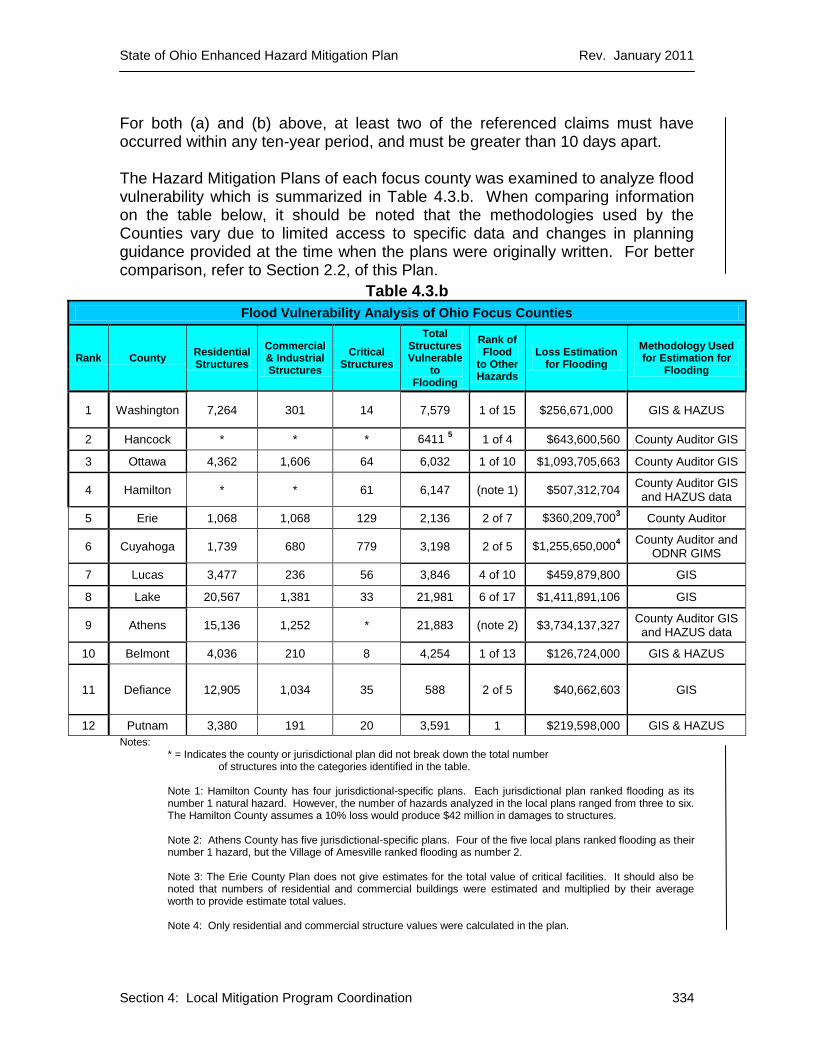
For both (a) and (b) above, at least two of the referenced claims must have occurred within any ten-year period, and must be greater than 10 days apart. The Hazard Mitigation Plans of each focus county was examined to analyze flood vulnerability which is summarized in Table 4.3.b. When comparing information on the table below, it should be noted that the methodologies used by the Counties vary due to limited access to specific data and changes in planning guidance provided at the time when the plans were originally written. For better comparison, refer to Section 2.2, of this Plan.
Table 4.3.b
Flood Vulnerability Analysis of Ohio Focus Counties
Rank County Residential Structures
Commercial & Industrial Structures
Critical Structures
Total Structures Vulnerable
to Flooding
Rank of Flood
to Other Hazards
Loss Estimation for Flooding
Methodology Used for Estimation for
Flooding
1 Washington 7,264 301 14 7,579 1 of 15 $256,671,000 GIS & HAZUS
2 Hancock * * * 6411 5 1 of 4 $643,600,560 County Auditor GIS
3 Ottawa 4,362 1,606 64 6,032 1 of 10 $1,093,705,663 County Auditor GIS
4 Hamilton * * 61 6,147 (note 1) $507,312,704 County Auditor GIS and HAZUS data
5 Erie 1,068 1,068 129 2,136 2 of 7 $360,209,7003 County Auditor
6 Cuyahoga 1,739 680 779 3,198 2 of 5 $1,255,650,0004
County Auditor and ODNR GIMS
7 Lucas 3,477 236 56 3,846 4 of 10 $459,879,800 GIS
8 Lake 20,567 1,381 33 21,981 6 of 17 $1,411,891,106 GIS
9 Athens 15,136 1,252 * 21,883 (note 2) $3,734,137,327 County Auditor GIS and HAZUS data
10 Belmont 4,036 210 8 4,254 1 of 13 $126,724,000 GIS & HAZUS
11 Defiance 12,905 1,034 35 588 2 of 5 $40,662,603 GIS
12 Putnam 3,380 191 20 3,591 1 $219,598,000 GIS & HAZUS
Notes: * = Indicates the county or jurisdictional plan did not break down the total number
of structures into the categories identified in the table.
Note 1: Hamilton County has four jurisdictional-specific plans. Each jurisdictional plan ranked flooding as its number 1 natural hazard. However, the number of hazards analyzed in the local plans ranged from three to six. The Hamilton County assumes a 10% loss would produce $42 million in damages to structures. Note 2: Athens County has five jurisdictional-specific plans. Four of the five local plans ranked flooding as their number 1 hazard, but the Village of Amesville ranked flooding as number 2. Note 3: The Erie County Plan does not give estimates for the total value of critical facilities. It should also be noted that numbers of residential and commercial buildings were estimated and multiplied by their average worth to provide estimate total values. Note 4: Only residential and commercial structure values were calculated in the plan.

State of Ohio Enhanced Hazard Mitigation Plan Rev. January 2011
Section 4: Local Mitigation Program Coordination 335
Note 5: The plan’s loss estimation method studied parcels rather than individual structures. Therefore, it is not possible to determine numbers or categories of structures, however, values were estimated and summed.
The Athens County entry in Table 4.3.b is the summation of data from five separate jurisdictional plans which include the Village of Amesville, City of Athens, Village of Trimble, Athens County Multi-Jurisdictional (incorporated Villages other than listed above) and Athens County unincorporated. The Hamilton County entry in Table 4.3.b includes aggregated data from four, separate jurisdictional plans from Colerain Township, Delhi Township, the Village of Fairfax and Hamilton County’s remaining jurisdictions. A total of nineteen local hazard planes were reviewed as part of this analysis. Even though methodologies may differ in vulnerability assessments throughout the Focus Counties, they all show high numbers of structures at risk, which correspond to high amounts of dollars vulnerable to flooding. This conclusion is in line with the conclusions drawn from the HAZUS data in this state hazard mitigation plan. It should be noted that local hazard mitigation plan developers utilize different approaches and methodologies to examine risk, calculate the number of affected structures and estimate loss. Some counties examined a few structure types while others may have included several. This is due to local variability in the availability of specific data needed for risk and vulnerability assessment and the flexibility provided by the local mitigation plan criteria. This may explain why smaller counties such as Hancock and Ottawa have greater amounts of monetary value for loss estimation rather than Cuyahoga. Some counties, such as Athens County, conducted a thorough assessment of their structures, but have a unique building stock (i.e., Ohio University is located in Athens, Ohio). Below are approaches and methodologies used in the Focus County plans that address these varying loss estimation methodologies: Washington County Multi-Jurisdictional Hazard Mitigation Plan, January 2005. After identifying the areas in which the hazards were most prominent, Washington County profiled and positioned the hazards into a Geographic Information System (GIS)-based map. This map contains several themes with information regarding the individual hazards. Within each of the denoted "hazard risk areas," assets (structures, utilities, etc.) were inventoried and loss estimates were calculated for each of the inventoried assets with respect to that particular hazard. Hancock County Hazard Mitigation Plan, May 1, 2007. Projections made for loss estimation were related to data obtained from the FIRMs (Flood Insurance Rate Maps). County Auditor data, FIRM shapefiles and GIS were utilized to determine parcels and structures in the floodplains. An analysis was provided on the numbers and types of property parcels and their respective values found within the County. These figures were compared with those parcels determined to be within the hazard area.

State of Ohio Enhanced Hazard Mitigation Plan Rev. January 2011
Section 4: Local Mitigation Program Coordination 336
Ottawa County All-Natural Hazard Mitigation Plan, 2004. Community profiles and loss estimates were prepared by placing 100-year floodplain boundaries on USGS maps. 2000 Census information and local records helped establish the structure numbers and types. Structure values were determined using property tax records from the Ottawa County Auditor’s office. These data were used to tabulate the appraised building values for the townships, villages and the City of Port Clinton. Hamilton County. There are three jurisdictional plans as well as a countywide plan in Hamilton County:
Colerain Township All Natural Hazards Mitigation Plan, March 2010. To determine vulnerability, the potential for damage was measured based on historical events. Information from the National Climatic Data Center was used along with historic flood depth data. Other information was obtained from local libraries. Structure numbers, types and values were determined using information from County Auditor files. All sources combined were used to calculate the impact in terms of damage and loss. Delhi Township. All Natural Hazard Mitigation Plan, June 2005. The township plan incorporated at-risk structure data generated by the ODNR Floodplain Structure Inventory project. Structures were broken into use categories by comparing the structure inventory to the township zoning map. There are 32 residential at-risk structures: four located along Muddy Creek; three along Rapid Run; and 25 situated along Wulff Run. The remaining six at-risk structures are industrial and are all located along Rapid Run. The median value of housing of $115,400 was used from the 2000 Census. This figure was multiplied by the 32 structures at-risk structures to determine a potential loss of $3,692,800. Village of Fairfax Multi-Hazard Mitigation Plan, October 2010. A level 1 HAZUS analysis was performed to incorporate national GIS datasets and US Census data in order to estimate damages resulting from specified storm events. This analysis was performed for the 10%-, 2%-, 1%- and 0.2%-annual-chance flood events. The analysis did not specifically identify impacted structures and was less accurate than FEMA delineated floodplains available for the area, but provided a good estimate of risk and vulnerability.

State of Ohio Enhanced Hazard Mitigation Plan Rev. January 2011
Section 4: Local Mitigation Program Coordination 337
Natural Hazard Mitigation Plan, Hamilton County, 2007. Using CAGIS, Hamilton County developed a map interface system to determine areas most susceptible to damage from an event. Combined with 2000 census residential property data by jurisdiction and other information from the County Auditor’s Office, Hamilton County was able to estimate loss in the floodplains.
Erie County Natural Hazards Mitigation Plan, January 2005. The value of the property being damaged was determined based on the average value of a facility within that category. Typical values of the structures were determined using data received from the County’s Auditor’s Office. The contents value was calculated as a percentage of each structure’s value in accordance with FEMA guidance documents. Three levels of physical damage were evaluated for each category of structure. Each level had an associated percentage of damage. According to the local plan, the loss estimates for each level may have been underestimated since the methodology does not consider the cost of downtime associated with closing businesses for extended periods of time. County-wide All-Natural Hazards Mitigation Plan for Cuyahoga County, December 2003. Each of the participating jurisdictions received a map showing their at-risk structure inventory, and they were asked to differentiate between residential and commercial/industrial structures. Based on the information received from the communities, the total number of residential and commercial structures for the communities within Cuyahoga County was tabulated. This information was then taken and compared to the median value of housing units as well as the median value of commercial/industrial at-risk structures to calculate the vulnerability within the 100-year floodplain. The average value of residential structures was obtained from the U.S. Census web site (2000 data), and the average value of commercial/industrial structures was obtained from the Cuyahoga County Auditor’s office.
Lucas County, Ohio Countywide All Natural Hazards Plan, January 2004. County planners utilized GIS to map the 100-year floodplains around major rivers in the county, their tributaries and Lake Erie as a base standard. Flood-prone soils were also included in the data. The Lucas County Auditor’s parcel data was used to plot at-risk structures in the floodplain for each jurisdiction. Additional parcel information was used to categorize each at-risk structure’s type and value on a table per jurisdiction. The results were tallied and displayed on the Countywide Flood Hazard Area Summary by structure usage, number and value in the 100-year floodplain to determine the loss estimate.

State of Ohio Enhanced Hazard Mitigation Plan Rev. January 2011
Section 4: Local Mitigation Program Coordination 338
Lake County Multi-Jurisdictional Hazards Mitigation Plan, Updated 2010. To identify areas in which the hazards were most prominent, the county’s GIS Department and the Engineer’s Office created maps to identify themed “hazard risk areas.” Loss estimation was conducted in accordance with FEMA Publication 386-2. Data were taken from asset inventory information according to the county’s GIS Department, Auditor’s Office, Development Council and Planning Commission. This information was plotted on the floodplain-themed map and used to determine structure types and values on spreadsheets to estimate loss. Results were tabulated to show the numbers, types and values of structures in the hazard areas.
Athens County. There are three jurisdictional plans, one countywide plan for the unincorporated areas of the county, and a multi-jurisdictional plan that includes the City of Nelsonville and several villages in Athens County:
Village of Amesville Natural Hazard Mitigation Draft Plan, Revised May 2005. City and County planners obtained information from Flood Insurance Rate Maps and reports from previous flood events. Planners had historic information from county-wide events that applied to the Village of Amesville. Planners also referenced information from the National Climatic Data Center. The asset inventory was tallied from property tax cards at the Athens County Auditor’s office and applied to areas subject to flooding. The cards provided the address, parcel number, usage, description and value for each structure. Planners identified and determined values of residential structures known to flood since the back-to-back floods of 1997 and 1998. From summary reports, damage was estimated as 23 structures valued at a total of $746,723. Additionally, one local business (a convenience store) suffered $152,000 in loss of inventory, equipment and lost revenue for five months. The local post office lost $100,000 in inventory and equipment. Natural Hazard Mitigation Plan for the City of Athens, June 2004. The 2000 census was used to determine the city’s population and housing unit count. Data from the County Auditor’s Office made it possible to estimate the replacement values of single-family homes. Multi-family homes, Ohio University structures, public and commercial structures were analyzed using GIS to determine square footage and replacement costs. Due to limited planning resources, a statistical sampling was used to determine loss estimates. For the sample, GIS was used to isolate assets in flood zones. A surveyor’s level was used in conjunction with a handheld level to determine the level of the lowest floor. Since this technique could only measure the height of the lowest floor above grade, nine feet was subtracted to determine basement floor elevations. Structures were counted in the city’s 1%-annual-chance floodplain.

State of Ohio Enhanced Hazard Mitigation Plan Rev. January 2011
Section 4: Local Mitigation Program Coordination 339
Utilizing federal planning guidance for percentage loss numbers, downtime, and displacement time, a spreadsheet was developed for this sample. Sample data was then applied to residential areas, commercial property, university buildings and other structures to determine the numbers and values of structures in the floodplains. Natural Hazard Mitigation Plan for the Village of Trimble, December 2005. Asset identification was conducted by analyzing maps of the village, data from the FIRM and using 2000 Census data. Data from the County Auditor were used to determine real estate values and average structure replacement values. Asset loss estimates were obtained by using GIS with digitally mapped flood zones. Structures in the flood zone were analyzed for lowest floor elevations and replacement values. Multijurisdictional Natural Hazard Mitigation Plan for the City of Nelsonville, and the Villages of Albany, Buchtel, Chauncey, Coolville, Glouster, and Jacksonville, October 2005. Asset loss estimates were generated in a GIS with geo-referenced FEMA flood maps. The County also has many “A” zones on its floodplain maps, so 1%-annual-chance flood elevations are not known. The asset loss study that was conducted in the Village of Trimble was used to estimate losses in Nelsonville and the other villages. Nelsonville and these villages were assumed to be similar to Trimble in order to compute these estimates. (Unincorporated Jurisdictions) Natural Hazard Mitigation Plan for the County of Athens, February 2006. Information from the 2000 Census was determined for population and housing count. Data from the County Auditor were used for determining the values of single family homes and replacement costs. Estimates were made for the number of mobile homes using aerial photography to analyze a random sample of 50 parcels that were known to contain mobile homes. The results of the sample analysis were used to determine an estimated number of mobile homes. Replacement values were determined by contacting a local mobile home dealer. The number of mobile homes and their replacement values were added to the number of single family structures and their replacement values to determine the total numbers and replacement values of real estate and mobile homes. County Auditor data were used to determine the number and value of commercial property, apartments and temporary lodging. A random sample of 50 parcels was analyzed using GIS to determine square footage replacement costs. Additionally, 19 parcels were listed as industrial and measured for square footage of building space and determining replacement values. For residential dwellings, it was assumed that 50% had an accessory building with them and an average replacement value was estimated. County Auditor data were used to determine the total number of exempt
State of Ohio Enhanced Hazard Mitigation Plan Rev. January 2011
Section 4: Local Mitigation Program Coordination 340
property parcels with structures such as fire stations, schools and public works. Taking a random sample of 50 parcels and utilizing federal replacement cost values, the average replacement cost for the sample was multiplied by the total number of exempt property parcels. The above information was tabulated by asset type, total number, average replacement value, total replacement value and total contents value. Results were summed to a total of 14,257 structures with contents valued at $605,524,149 and a total replacement value of $980,351,658.
Belmont County Hazard Mitigation Plan, 2005. Belmont County used GIS-based mapping, HAZUS, and interviews with local representatives, as well as Worksheet #4 from the Federal Emergency Management Agency’s (FEMA) State and Local Mitigation Planning How-to Guide: Understanding Your Risks to estimate the potential dollar losses if the county was to experience the profiled hazard events. The information that was gathered in the asset inventory stage of the risk assessment was used to determine the estimated losses. Displacement time was estimated based on historical data of past hazard events. Natural Hazard Mitigation Plan Update Feature: Flood Mitigation Assistance Program, Defiance County, July 2009. The county utilized ODNR Floodplain Structure Inventory data and aerial photography in GIS to identify at-risk structures throughout the county. Defiance County has identified a total of 588 structures with a value of $40,662,603 in the 100-year floodplain. Valuation of potential losses was accomplished by analyzing those parcels at risk and corresponding Defiance County Auditor Office records. Putnam County Natural Hazard Plan, 2005. After identifying the areas in which the hazards were most prominent, local officials utilized GIS to create a multi-themed map identifying these “hazard risk areas.” Within each of the denoted “hazard risk areas,” assets (structures, utilities, etc.) were inventoried and loss estimates were calculated with respect to each hazard. CONNECTION WITH THE STATE PLAN In the local risk assessment integration analysis, potential losses were reviewed. It was difficult to compare each of the counties’ potential losses because there is no requirement for a standardized plan template. Therefore each county had the liberty to use its own methodology and approaches for determining potential loss. As a whole, the local plans list flooding as their number one hazard, which corresponds well with the state’s ranking. There are some dissimilarities, but those may be due to the limited number of significant events those communities had sustained prior to writing or updating their local mitigation plans.

State of Ohio Enhanced Hazard Mitigation Plan Rev. January 2011
Section 4: Local Mitigation Program Coordination 341
It should be noted that the Focus Counties fill the majority of the top quartile of all counties with repetitive loss structures. Within the twelve counties, six are located in Region 1, three are located in Region 2 and three are located in Region 3 of the state. These numbers of counties coincide with the NFIP loss data per region found in the state HIRA. As part of the State mitigation strategy, Goal #4 includes the elimination of repetitive loss flood-prone structures. One of the three objectives under this Goal is to prioritize repetitive loss properties for available funds from FEMA mitigation programs. As opportunities for mitigation funding have developed, Ohio has worked with local jurisdictions, counties and FEMA to address repetitive loss and other issues to reduce loss or disaster impact.
Table 4.3.c
COUNTY
NUMBER OF FLOOD
MITIGATION PROJECTS
NUMBER OF MITIGATED
STRUCTURES
NUMBER
OF RFC
NUMBER OF SRL
NUMBER OF ELEVATED
STRUCTURES
NUMBER OF RETROFITTED STRUCTURES
NUMBER OF ACQUIRED
STRUCTURES
PROJECT FUNDING TOTAL
NUMBER OF REMAINING
PROPERTIES IN OPEN
PROJECTS
Washington 3 10 1 0 0 0 10 403,260.00 0
Hancock 4 43 19 1 0 0 43 4,395,042.00 14
Ottawa 3 12 2 0 12 0 0 693,411.00 0
Hamilton 7 80 2 0 0 16 64 5,396,933.00 2
Erie 0 0 0 0 0 0 0 0.00 0
Cuyahoga 5 15 6 1 9 0 6 4,279,100.00 24
Lucas 2 15 1 0 0 0 15 734,595.00 0
Lake 3 42 0 0 0 0 42 7,214,319.00 38
Athens 4 62 6 0 1 6 55 2,927,073.00 0
Belmont 1 36 0 0 0 0 36 1,239,869.00 0
Defiance 0 0 0 0 0 0 0 0.00 0
Putnam 4 39 1 0 0 0 39 1,672,288.00 0
TOTALS: 36 354 38 2 22 22 310 28,955,890.00 78
Assumptions: Chart reflects structures that have been mitigated as of April 15, 2011. Project Funding Total column for completed projects = Final Project Cost. Project Funding Total column for open projects = Total awarded amount with number of remaining
properties to be mitigated listed in last column.
Records from closed mitigation projects in Ohio indicate that there have been over 900 structures mitigated in the state. As shown in Table 4.3.c, over 39% of these structures are located in the Focus Counties with an average of about $82,000 invested in mitigation actions per structure. Approximately 88% of the structures in the Focus Counties are acquisition projects and about 12% are identified Repetitive Loss or Severe Repetitive Loss structures. This aligns with the state mitigation strategy of prioritizing acquisitions and concentrating efforts on mitigating repetitive loss structures. Ohio’s record of successfully mitigating these structures helps the state reach the goal of minimizing societal disruption and damage to property from hazard events (Goal 2, Objective 3).

State of Ohio Enhanced Hazard Mitigation Plan Rev. January 2011
Section 4: Local Mitigation Program Coordination 342
Ohio continues to be very active in accomplishing the objectives set forth in the mitigation strategy regarding repetitive loss structures. Still, there are counties where there have been few or no mitigated repetitive loss structures. Ultimately, mitigation occurs at the local level. There are many valid reasons why a particular community has not yet addressed identified repetitive loss structures including: lack of property owner interest, the targeted structure cannot meet benefit-cost analysis requirements, lack of grant match dollars, etc. As demonstrated by the number of successful mitigation projects in the Focus Counties, the Ohio EMA Mitigation Branch is committed to working with Ohio communities to overcome these obstacles and support local mitigation efforts. The State of Ohio strives to promote sustainable communities and development (Goal #2, Objective 4). The ODNR Floodplain Management Program’s effort to promote sound floodplain management statewide is one example of the state’s commitment. Ohio EMA’s promotion of mitigation planning through SHARPP also demonstrates the state’s commitment to promoting community sustainability principles. The mitigation priorities identified in the State Hazard Mitigation Plan align well with the identified risk in the state. In partnership with the Federal government and local communities, the State of Ohio will continue to develop, implement and administer mitigation grant programs that reduce risk to repetitive loss properties. These mitigation planning and project activities will continue to decrease the burden of repetitively flood damaged structures on the Disaster Relief Fund and the National Flood Insurance Fund.
4.4 PRIORITIZING LOCAL MITIGATION FUNDING ASSISTANCE
44 CFR 201.4(c)(4)(iii) requires states to include criteria in their mitigation plans for prioritizing communities and local jurisdictions that would receive planning and project grants under available funding programs. The criteria should include consideration for communities with the highest risks, repetitive loss properties, and most intense development pressures. The plan also needs to include a principal criterion for non-planning grants based on the extent to which benefits are maximized according to a benefit-cost review.
Demand for hazard mitigation funds usually exceeds fund availability. In the last three flood-related Presidential Declarations, available Federal mitigation funds have only met 15% of the demand.

State of Ohio Enhanced Hazard Mitigation Plan Rev. January 2011
Section 4: Local Mitigation Program Coordination 343
Table 4.4.a
EVENT HMGP FUNDS REQUESTED
HMGP FUNDS AVAILABLE (FED)
DIFFERENCE
DR-1651 $15,191,356 $1,798,019 -$13,393,337
(-88%)
DR-1656 $18,166,108 $3,411,736 -$14,754,372
(-81%)
DR-1720 $44,888,432 $6,630,799 -$38,257,633
(-85%)
Therefore, it is important that the State of Ohio prioritize local mitigation funding assistance. Section 3.4 explains how Ohio has established both eligibility and prioritization criteria. Appendix G includes the worksheets the SHMT uses to rank project and planning applications for funding. The final project ranking by the SHMT is also the prioritization of eligible projects for funding. The exceptions to this are under HMGP where 5% and 7% projects are funded outside of the SHMT ranking process. Projects submitted under these categories are funded in accordance with the specific priority outlined in the Administrative Plan and Mitigation Strategy for that particular event.
In the event that there is not enough funding for an eligible, high-ranking mitigation project, Mitigation Branch staff will work with the subapplicant to refine and submit the project for consideration under another grant funding cycle or program.
Although Federal planning guidance indicates criteria for local mitigation funding assistance should include consideration for communities with the highest risks, repetitive loss properties, communities with the most intense development pressures, and maximizing benefits based on a benefit-cost analysis; Ohio only considers repetitive loss and benefit-cost. For the nationally competitive grant programs, state criteria match the national ranking and evaluation criteria exactly. Doing otherwise would put Ohio projects at a competitive disadvantage as compared to other projects that used the national criteria. For HMGP and FMA, repetitive loss is considered as is benefit-cost; however, communities with the highest risks and high development pressures are not. The reason for this is that it is assumed that almost all Ohio communities have high risk from the most serious hazards and mitigation projects are used to remedy the “already built” environment, not the developing environment, which is much better handled through appropriate codes and land use measures.
Grant applications to update LHMPs are evaluated based on program criteria. The SHMT considers local plan expiration dates and whether or not the jurisdiction has updated information in SHARPP when prioritizing funding.

State of Ohio Enhanced Hazard Mitigation Plan Rev. January 2011
Section 4: Local Mitigation Program Coordination 344
4.5 ASSESSMENT OF MITIGATION ACTIONS
Mitigation actions identified in both the SHMP and LHMPs are tracked and assessed. For the state plan, tracking and assessment of state goals, objectives, and actions will be done in accordance with the Section 1.5 after each Federal disaster declaration, on an annual basis, and at the next three-year update point.
For mitigation actions in LHMPs, tracking and assessment is done in SHARPP (see Appendix J). Local officials enter information into SHARPP that summarizes the local mitigation action items identified in their jurisdictions mitigation plan. SHARPP captures basic information about the proposed mitigation action including: project lead, cost, potential funding sources, estimated start and end dates. SHARPP can generate a report that summarizes the locally proposed mitigation action items in each community. Action items that can be mapped are displayed in the SHARPP mapping system as an Area of Mitigation Interest.
Local officials can update the status of these action items as they are implemented to help track progress. The status of mitigation action items are recorded in SHARPP as: new, unchanged, deferred, deleted, or completed. These data are analyzed to help establish trends, identify needs, and develop success stories.
SHARPP helps the state demonstrate that mitigation projects are investments that improve community sustainability. The SHARPP home page displays the aggregate losses avoided (benefits) by implementing flood mitigation projects in the state since 2004. SHARPP automatically calculates this figure based on the expected annual benefits (i.e. losses avoided) for each mitigated structure as computed by FEMA benefit-cost analysis software at the time of project application. The expected annual benefits are multiplied by the number of years that the project has been closed (up to the “useful life” of the project) and then totaled for all structures to produce a dollar estimate of the losses avoided to date.
SHARPP will also help to quantify the “actual” costs avoided by implementing flood mitigation projects in the state. In order to calculate the actual costs avoided, a flood must occur in an area where a mitigation project has been implemented. One methodology for quantifying the actual costs avoided is outlined in the FEMA December 2009 publication titled, Loss Avoidance Study, Riverine Methodology Report. Using this methodology, actual losses avoided are estimated by comparing damage that would likely have been caused by the same flood events without the mitigation project, with damage that actually occurred with the project completed. In order to estimate the actual losses avoided as the result of implementing a particular mitigation project, data are needed on the pre- and post-conditions of the subject property, in addition to other data collected throughout the project. All of the project-specific data required as input for a loss avoidance study are collected through SHARPP.
Loss avoidance studies will be conducted for past mitigation project implemented in Ohio dependent on:
State of Ohio Enhanced Hazard Mitigation Plan Rev. January 2011
Section 4: Local Mitigation Program Coordination 345
A large event occurring in a past mitigation project area that justifies the resources required to conduct a loss avoidance study,
The availability of the data required to conduct a loss avoidance study in the project area, and
The availability of 5% HMGP funds, HMA State Management Cost funds, or another funding source to pay for the study.
The Ohio EMA Mitigation Branch contains a page that highlights success stories and best practices (http://www.ema.ohio.gov/Mitigation_BestPractices.aspx). This web page highlights successful mitigation projects in sixteen different communities in the state. The success stories cover a range of mitigation project types that have been implemented across the state to reduce flood risk.
Mitigation Branch staff document losses avoided as the result of previous mitigation measures by implementing the following process:
Utilize information in SHARPP to determine if a mitigation project has occurred in an area impacted by a hazard event.
If yes, contact local officials to request information on the effectiveness of the mitigation project and the impact of the event in the project area.
Meet with local officials to conduct an interview and gather information (photos, high water marks, and historic damage data).
Develop and publish a success story based on the information collected. Promote the success story statewide to encourage mitigation measures that will reduce future disaster losses.