Embed Size (px)
Citation preview
SECTION 3
EXISTING CONDITIONS

Intentional left blank
Section 3 Existing Conditions
TABLE OF CONTENTS
3.1 INTRODUCTION..........................................................................................1 3.2 GENERAL ENVIRONMENTAL SETTING.................................................1
3.2.1 Infrastructure............................................................................................1 3.3 PLANT COMMUNITIES ..............................................................................2 3.4 FIRE...............................................................................................................8 3.5 FISH AND WILDLIFE RESOURCES .........................................................9 3.6 THREATENED AND ENDANGERED SPECIES .....................................11
3.6.1 American Crocodile.................................................................................12 3.6.2 Bald Eagle ...............................................................................................12 3.6.3 Eastern Indigo Snake .............................................................................12 3.6.4 Florida Panther.......................................................................................13 3.6.5 Red-Cockaded Woodpecker.....................................................................14 3.6.6 Estuarine Fishes and Sea Turtles..........................................................14 3.6.7 Snail Kite.................................................................................................15 3.6.8 West Indian Manatee..............................................................................15 3.6.9 Wood Stork ..............................................................................................16 3.6.10 Endangered Plants .................................................................................17 3.6.11 Essential Fish Habitat............................................................................17
3.7 GEOLOGY AND SOILS..............................................................................18 3.7.1 Geology ....................................................................................................18 3.7.2 Soils .........................................................................................................18
3.8 AIR QUALITY .............................................................................................19 3.9 CLIMATE ....................................................................................................19 3.10 HYDROLOGY..............................................................................................19
3.10.1 Water Supply ..........................................................................................20 3.10.2 Water Quality..........................................................................................21 3.10.3 Water Management ................................................................................23
3.11 ESTUARINE RESOURCES........................................................................23 3.12 SOCIO-ECONOMICS .................................................................................26
3.12.1 Land Use And Population.......................................................................26 3.12.2 Water Demand ........................................................................................27
3.13 AESTHETIC RESOURCES........................................................................28 3.14 HAZARDOUS, TOXIC, AND RADIOACTIVE WASTES ..........................28 3.15 CULTURAL RESOURCES .........................................................................32 3.16 RECREATION.............................................................................................33 3.17 NOISE..........................................................................................................34
Final Project Implementation Report & EIS September 2004 Picayune Strand (formerly SGGE) 3-iii
Section 3 Existing Conditions
LIST OF FIGURES
Figure 3 - 1 Current Southern Golden Gate Estates Area Vegetation Map...........................................................................................................5
Figure 3 - 2 Estuaries, Rivers, And Bays Affected By SGGE Canal Drainage Pattern .....................................................................................6
Figure 3 - 3 HTRW Zones And Chemicals Of Concern ...................................30
LIST OF TABLES
Table 3 - 1 Factors Maintaining Major Plant Community Types.....................4 Table 3 - 2 Southern Golden Gate Estates Area Plant Community
Changes From NRCS 1940 & 1995 Maps...............................................7
Final Project Implementation Report & EIS September 2004 Picayune Strand (formerly SGGE) 3-iv

Section 3 Existing Conditions
SECTION 3 EXISTING CONDITIONS
3.1 INTRODUCTION
This section describes the existing environmental resources of the Southern Golden Gate Estates Project Area landscape. It does not describe the entire existing environment. For Comprehensive Everglades Restoration Plan (CERP) projects, “existing conditions” are defined as the landscape present as of December 2000. In conjunction with the description of the future without project (no-action) alternative, “existing conditions” forms the base line conditions for determining the environmental impacts of the proposed action and reasonable alternatives. Future “without project conditions” are described in Section 4 of this document.
3.2 GENERAL ENVIRONMENTAL SETTING
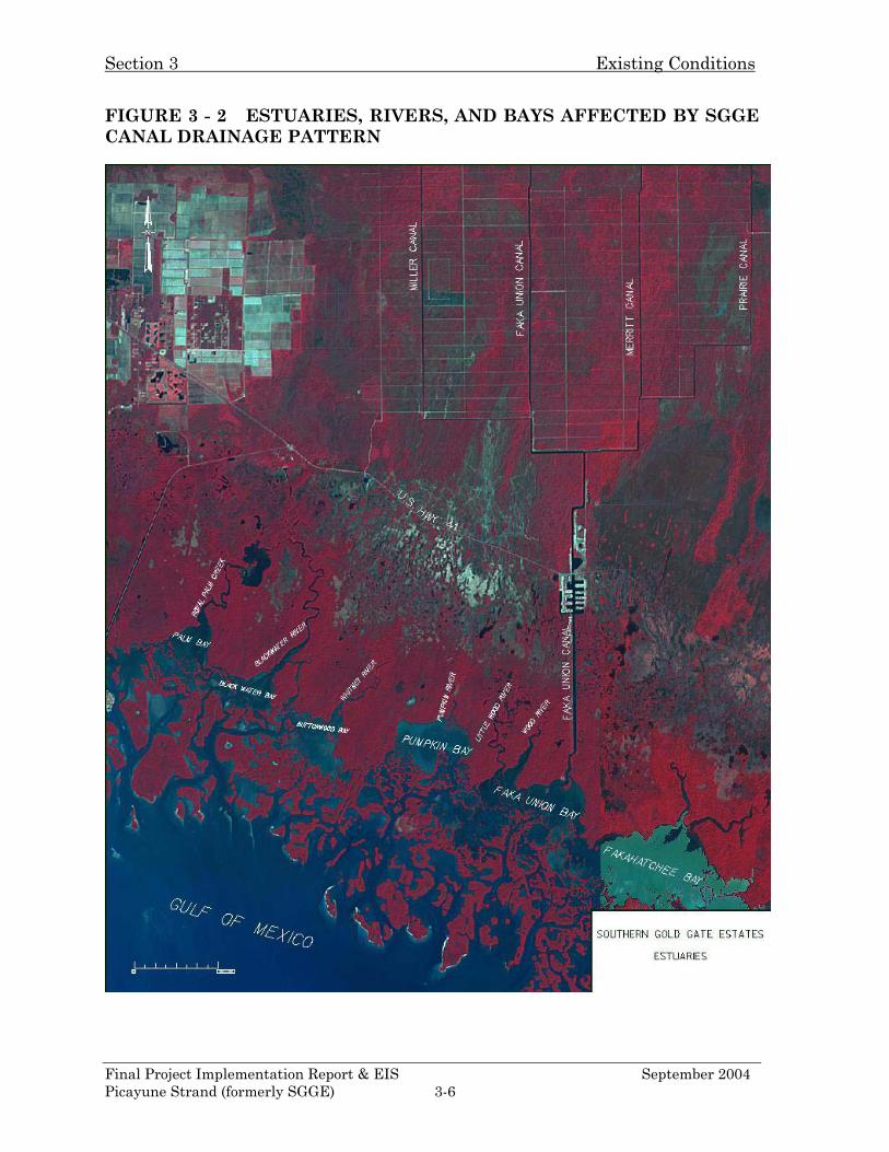
The Southern Golden Gate Estates (SGGE) Project Area is located in Collier County, Florida. It lies east of the city of Naples, between Interstate 75 and U.S. Highway 41. Combined with the Belle Meade State Conservation and Recreation Lands (CARL) area to the west, the SGGE Project Area constitutes the heart of what is now called the Picayune Strand State Forest. This forest is located south of Northern Golden Gate Estates (NGGE) and Interstate 75, southwest of the Florida Panther National Wildlife Refuge, north of the marine preserves and refuges that constitute the Ten Thousand Islands Region, and west of the Fakahatchee Strand State Preserve. It contains some of the most diverse plant and wildlife communities on the North American continent and could provide habitat for several Federally listed endangered species, including the critically endangered Florida panther. Currently the SGGE Project Area canal system has a hydrologic influence over all the surrounding private, state, and federal lands (Figures 1-1 and 1-2). The estuarine area of influence of the SGGE Project Area canal drainage within the coastal communities covers four major embayments, which are, from west to east, Blackwater River, Pumpkin Bay, Faka Union Bay and Fakahatchee Bay (Figure 3-2).
3.2.1 Infrastructure
The SGGE Project Area subdivision as it currently exists has an infrastructure of roads, bridges, canals, weirs, and other infrastructure. By the early 1970’s, all of the roads and canals had been constructed. The current road infrastructure is essentially the same as it was in the 1970’s. There are a total of 279 miles of Final Project Implementation Report & EIS September 2004 Picayune Strand (formerly SGGE) 3-1
Section 3 Existing Conditions
roadway of which, 60 miles are paved with asphalt and 219 miles are surfaced with a crushed limerock surface. 251 culverts and ten bridges, two of which are newer construction, are part of the road system. There are 125 “improved” sites within the SGGE Project Area. These range from hunting camps and trailers to permanent homes. Nearly all of the sites were constructed without county building permits, do not have electric or telephone service, and very few have septic systems. The exceptions are on 52 and 54th Ave SE and at Port of the Islands. All properties, except those at Port of the Islands, are being purchased by the state. Five structures will be retained to assist with the restoration, law enforcement, and management of the area; and the reminder will be demolished. The canal system is 48 miles in length, with three fixed-crest weirs and four adjustable weirs. The newest weir was constructed on Merritt canal south of Interstate 75, to minimize drainage flowing from the Florida Panther National Wildlife Refuge. Interstate 75 (I-75) is located at the northern edge of the SGGE CARL boundary and divides SGGE from NGGE. State Road 29 runs north and south along the eastern edge of Fakahatchee Strand State Preserve. It is approximately 8 miles east of SGGE. U.S. 41 runs generally west northwest to east-southeast. It is located aloang the southern edge of the SGGE CARL boundary and near the southern edge of the SGGE Project Area. See Figures 1-3, 1-4, and 1-5 for locations of these roads.
3.3 PLANT COMMUNITIES
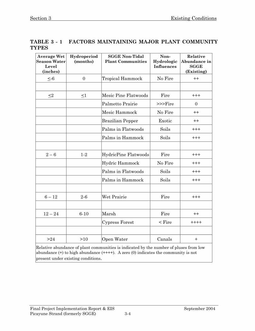
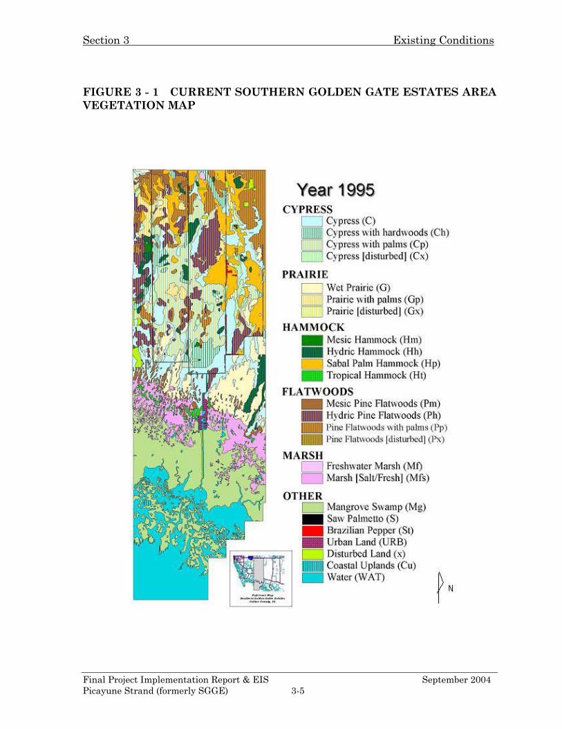
In July 2001 the Natural Resources Conservation Service (NRCS) provided a detailed map, based on recent soil survey field data and aerial photographs, of the 1995 distribution of major plant community types in the SGGE Project Area (Figure 3-1). This NRCS map represents a valuable baseline of real world plant community acreages for current conditions. Using the MIKESHE model, South Florida Water Management District (SFWMD) produced an “existing conditions” model run of hydrologic conditions. Plant community distributions were predicted using the relationship between the hydrologic characteristics of each major community type (Table 3-1) and the average wet season water depths (July 1 through October 1) as predicted by the model. A more in depth assessment of the NRCS maps and the MIKESHE model can be found in the SFWMD “Resource Assessment of the Southern Golden Gate Estates Hydrologic Restoration Plan” (RA) located in Appendix D of this document. Major changes to the hydrology and biology of the SGGE Project Area landscape began between 1968 and 1971, when the four canals that comprise the Faka Union Canal system and the 279-mile road system were completed. This
Final Project Implementation Report & EIS September 2004 Picayune Strand (formerly SGGE) 3-2
Section 3 Existing Conditions
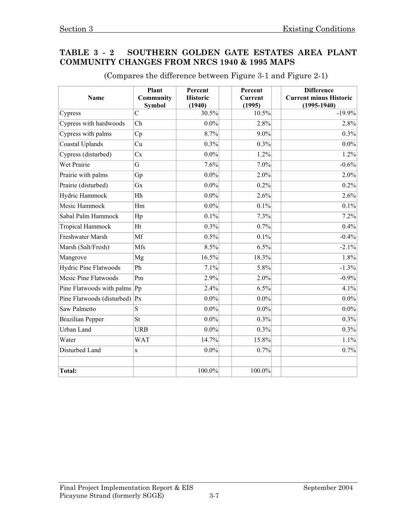
construction led to a significant decline in the landscape’s ecology, which is still occurring to this day. Historic plant community composition changed from that of wetland and transitional vegetation to more upland, invasive, and exotic dominated systems (such as Cx, Hp, Hx, and Pp) as shown in Figure 3-1 and evaluated in Table 3-2. As historic cypress strands within the SGGE Project Area became drier due to the canal-induced draw down, there was a shift in vegetative succession toward a mixed cypress-hardwood-sabal palm system. Additionally, as a result of these abnormally dry conditions, hotter fire now frequently burns farther from prairies and flatwood communities into adjacent cypress strands or other hydric forested systems. Pines, sabal palms and saw palmettos that are adapted to drier conditions and more intensive fire regimes have replaced the cypress forest communities. Often invasive exotic species like Brazilian pepper (Schinus terebinthifolius) and melaleuca (M. quinquenervia) have become dominant or co-dominant in many of these formerly hydric communities. The native sabal palm (Sabal palmetto), also commonly called the cabbage palm, has become dominant throughout much of the SGGE Project Area during the past few decades. These palms form dense populations of similar sized, apparently young trees, beneath widely spaced individuals that appear to be very old. Ages of sabal palms here have been subjectively estimated, as features of their growth do not conform to annual or seasonal events, and ages cannot be accurately determined from their physical characters. Most areas with dense sabal populations do not appear to have had dense sabal palm populations on aerial photographs taken in 1940 and 1953. This suggests a sparse parent population that has given rise to a successful population of offspring, all at about the same time. The younger palms appear to be 2-3 decades old (again, ages determined subjectively), suggesting that the population increase occurred as the hydrology of the area changed. The sabal palm forest has now become almost a pure biotype within many areas of the SGGE Project Area. The Florida Division of Forestry (DoF) now considers this palm an invasive species by that needs to be controlled in order to maintain diversity in the ecosystem. More detailed descriptions of the SGGE Project Area plant communities can be found in the SFWMD documents entitled “Resource Assessment of the Southern Golden Gate Estates Hydrologic Restoration Plan” attached in Appendix D.
Final Project Implementation Report & EIS September 2004 Picayune Strand (formerly SGGE) 3-3
Section 3 Existing Conditions
TABLE 3 - 1 FACTORS MAINTAINING MAJOR PLANT COMMUNITY TYPES
Average Wet Season Water
Level (inches)
Hydroperiod (months)
SGGE Non-Tidal Plant Communities
Non-Hydrologic Influences
Relative Abundance in
SGGE (Existing)
<-6 0 Tropical Hammock No Fire ++
<2 <1 Mesic Pine Flatwoods Fire +++
Palmetto Prairie >>>Fire 0
Mesic Hammock No Fire ++
Brazilian Pepper Exotic ++
Palms in Flatwoods Soils +++
Palms in Hammock Soils +++
2 – 6 1-2 HydricPine Flatwoods Fire +++
Hydric Hammock No Fire +++
Palms in Flatwoods Soils +++
Palms in Hammock Soils +++
6 – 12 2-6 Wet Prairie Fire +++
12 – 24 6-10 Marsh Fire ++
Cypress Forest < Fire ++++
>24 >10 Open Water Canals +
Relative abundance of plant communities is indicated by the number of pluses from low abundance (+) to high abundance (++++). A zero (0) indicates the community is not present under existing conditions.
Final Project Implementation Report & EIS September 2004 Picayune Strand (formerly SGGE) 3-4
Section 3 Existing Conditions
FIGURE 3 - 1 CURRENT SOUTHERN GOLDEN GATE ESTATES AREA VEGETATION MAP
Final Project Implementation Report & EIS September 2004 Picayune Strand (formerly SGGE) 3-5
Section 3 Existing Conditions
FIGURE 3 - 2 ESTUARIES, RIVERS, AND BAYS AFFECTED BY SGGE CANAL DRAINAGE PATTERN
Final Project Implementation Report & EIS September 2004 Picayune Strand (formerly SGGE) 3-6
Section 3 Existing Conditions
TABLE 3 - 2 SOUTHERN GOLDEN GATE ESTATES AREA PLANT COMMUNITY CHANGES FROM NRCS 1940 & 1995 MAPS
(Compares the difference between Figure 3-1 and Figure 2-1)
Name
Plant Community
Symbol
Percent Historic (1940)
Percent Current (1995)
Difference Current minus Historic
(1995-1940) Cypress C 30.5% 10.5% -19.9%Cypress with hardwoods Ch 0.0% 2.8% 2.8%Cypress with palms Cp 8.7% 9.0% 0.3%Coastal Uplands Cu 0.3% 0.3% 0.0%Cypress (disturbed) Cx 0.0% 1.2% 1.2%Wet Prairie G 7.6% 7.0% -0.6%Prairie with palms Gp 0.0% 2.0% 2.0%Prairie (disturbed) Gx 0.0% 0.2% 0.2%Hydric Hammock Hh 0.0% 2.6% 2.6%Mesic Hammock Hm 0.0% 0.1% 0.1%Sabal Palm Hammock Hp 0.1% 7.3% 7.2%Tropical Hammock Ht 0.3% 0.7% 0.4%Freshwater Marsh Mf 0.5% 0.1% -0.4%Marsh (Salt/Fresh) Mfs 8.5% 6.5% -2.1%Mangrove Mg 16.5% 18.3% 1.8%Hydric Pine Flatwoods Ph 7.1% 5.8% -1.3%Mesic Pine Flatwoods Pm 2.9% 2.0% -0.9%Pine Flatwoods with palms Pp 2.4% 6.5% 4.1%Pine Flatwoods (disturbed) Px 0.0% 0.0% 0.0%Saw Palmetto S 0.0% 0.0% 0.0%Brazilian Pepper St 0.0% 0.3% 0.3%Urban Land URB 0.0% 0.3% 0.3%Water WAT 14.7% 15.8% 1.1%Disturbed Land x 0.0% 0.7% 0.7%
Total: 100.0% 100.0%
Final Project Implementation Report & EIS September 2004 Picayune Strand (formerly SGGE) 3-7
Section 3 Existing Conditions
3.4 FIRE
The extensive system of drainage canals and roads in the SGGE Project Area have had a profound impact on surface water hydrology. Thirty years of anthropogenic alterations to the hydrological cycle caused by the SGGE Project Area canals have resulted in more frequent wildfires with greater intensity. Fires that occur today may burn closer to or below the soil surface, as surface water and moisture levels are likely to be lower than levels before drainage. Wildfires in Collier County increased dramatically after completion of the Golden Gate Estates (GGE) drainage system (Gore, 1988). The year following its completion in 1971, four times as many acres burned as the cumulative total of acres burned from 1963-1971. Furthermore, for the following five years, the mean acreage burned per year exceeded this cumulative total. In the years from 1980 through 2002, the Division of Forestry (DoF) has tracked the number and total average acreage of wildfires within the SGGE Study Area. For this time period, the number of fires per year averaged 17.4, with a total average acreage burned per year of 2654 acres. The average size of each fire was 153 acres. It is anticipated by DoF that this trend will continue. Fires today commonly burn farther from prairies and pine flatwoods into adjacent cypress sloughs or other hydric forest communities. This alters species compositions in communities formerly more hydric, as most resident wetland species are not well adapted to withstand fires (Wade et al., 1980). These fires often burn through wetlands that, before the construction of the canals, experienced fires only during periods of extreme drought. The intensity of the fires has burned out the soil organic matter that is associated with many of the hydric plant communities. The increased frequency and intensity of wildfire favors a less diverse plant community dominated by fire tolerant species, primarily sabal palm (Sabal palmetto). Due to rapid drainage by the canals, the window for prescribed burning is often reduced to the time between the end of the rainy season and when the water table drops out of the root zone of the South Florida Slash (Pinus elliotti var. densa). The speed with which the land dries out severely limits the number of days that prescribed burns can be accomplished. There are only a few days during a burn season when the wind speed, wind direction, humidity, rainfall, water levels, manpower, and helicopter availability will all occur at the same time. Due to the excessive drainage, many areas will not be burned before the drought index will force prescribed burning to cease for that season. Fewer prescribed burns lead to fuel build up, more intense wildfires, and a reduced ability to control exotic species.
Final Project Implementation Report & EIS September 2004 Picayune Strand (formerly SGGE) 3-8
Section 3 Existing Conditions
3.5 FISH AND WILDLIFE RESOURCES
By their nature, the hydroperiods of wetland systems are highly susceptible to the impacts of drainage projects. The shortened hydroperiods currently present in the SGGE Project Area clearly demonstrate the profound impacts of drainage projects on the shallow wetlands and the associated fish and wildlife in this part of SW Florida. The drainage of the SGGE Project Area has increased fire frequency, accelerated the invasion of exotic and nuisance species, and degraded resources for vertebrates within and adjacent to the project area. A reduction in those species dependent on wetland systems for all or part of their life cycle, such as amphibians, some reptiles, and forage fish, is confirmed by ongoing surveys (Dave Addison 2001). Plant diversity has been reduced as a result of replacement of historic cypress communities by monocultures of cabbage palm and non-native plant species. Radio telemetry information for the Florida panther indicates significantly less use of the project area than adjacent public lands to the east and west, possibly due to reduced prey availability and the disturbance related to human presence, which is exacerbated by a grid road system (Darrell Land 2001). Increased high intensity wildfire has eliminated pine canopy that could be utilized by migratory birds, the state-listed Southeastern American kestrel (Falco sparverius paulus) and Big Cypress fox squirrel (Sciuris niger avicennia), and the state and federally listed red-cockaded woodpecker (Picoides borealis), which is present on adjacent public lands with greater pine forest density. The shortened hydroperiods and the rapid drainage that now occurs in the SGGE Project Area with the onset of the dry season have also impacted aquatic and terrestrial wildlife. For example, much of the decline in wading bird populations throughout South Florida is directly attributable to the loss of wetland function resulting from drainage. In the SGGE Project Area, the acreage of wetlands that once supported large populations of fish and aquatic invertebrates well into the dry season are now impaired in their ability to function as forage areas. While they can serve as foraging areas, the period of time that they can function in this capacity has been truncated. Areas that once retained water even in time of drought, no longer do so. Further, these wetlands can no longer function effectively as refugia for alligators, turtles, amphibians, and fish during droughts. The extent of this loss of function in the SGGE Project Area was demonstrated during the drought in 2001. No natural wetlands in the SGGE Project Area retained any water whatsoever. In the adjacent Fakahatchee Strand State Preserve, an area that has not been as seriously impacted by drainage, some of the deeper wetlands retained water and were refuges for wildlife (Nelson et al. 2001).
Final Project Implementation Report & EIS September 2004 Picayune Strand (formerly SGGE) 3-9

Section 3 Existing Conditions
The Florida Department of Forestry provided a list of species known to inhabit the study area as of 2001. The list can be found in Appendix D of this report under Species of the Picayune Strand State Forest. The effect of excessive drainage of freshwater through the Faka Union canal system on fish species of part of Ten Thousand Islands Region is under study by the Florida Department of Environmental Protection’s (FDEP) Rookery Bay National Estuarine Research Reserve (NERR). The NERR is defined as that part of Ten Thousand Islands Region between Cape Romano and the border of Everglades National Park. Pat O’Donnell has provided a list of NERR fish species gleaned from his in-progress project, called Rookery Bay/10,000 Islands Fisheries Monitoring Project. This list, titled Fish Species of the Upper 10,000 Islands, can be located in Appendix D of this report.
3.5.1 Wading Birds
As part of this study, monthly aerial surveys of the SGGE Project Area were conducted during the first six months of 2001. The survey documented numbers and locations of wading birds, wading bird activity, and surface water cover within the project area. Recorded wading bird numbers were generally very low throughout the study area during all survey months; however, 2001 drought conditions probably contributed somewhat to the low counts. The only water present on the SGGE Project Area was in canals with steep banks and deep water, which made them inaccessible to wading birds (Nelson et al. 2001). In contrast during this same survey, relatively undisturbed wetlands adjacent to the SGGE Project Area, including Fakahatchee Strand State Preserve, Big Cypress National Preserve, and Ten Thousand Islands National Wildlife Refuge supported significant concentrations of foraging and nesting wading birds during the same time period.
3.5.2 Small Mammals
Preliminary data from an ongoing small mammal trapping survey in the SGGE Project Area seems to indicate that the drainage may have had some impact on the distribution of cotton mice, rice water rats, and cotton rats. Areas that are in the southern (wetter) portion of the SGGE Project Area seem to have higher catch rates for these species. During the dry season, few or none of these rodents were captured in the dryer northern study sites. As the rainy season began, some of the previously dry study sites began to retain some water, and trapping success began to increase on some of these areas, particularly with respect to cotton mice. These data are still being compiled and have not been analyzed, but, at this point, they seem to suggest that these rodents may
Final Project Implementation Report & EIS September 2004 Picayune Strand (formerly SGGE) 3-10
Section 3 Existing Conditions
respond positively to wetter conditions. An increase in the small mammals population, if indeed their numbers have been depressed by the drainage, would provide more food resources for predators such as hawks, snakes, bobcats, etc. (Addison 2001).
3.6 THREATENED AND ENDANGERED SPECIES
In accordance with Section 7 of the Endangered Species Act, the U.S. Fish and Wildlife Service (FWS) was contacted concerning federal threatened and endangered (T&E) species. In an October 27, 1999 Planning Aid Letter (PAL), the FWS responded with the following information (U. S. FWS 1999). Federally listed species that are known to occur in the vicinity of, may occur in, or may be affected by the SGGE project are the threatened eastern indigo snake (Drymarchon corais couperi), endangered Wood stork (Mycteria Americana), endangered red-cockaded woodpecker (Picoides borealis), endangered Florida panther [Felis (=Puma) concolor coryi], endangered snail kite, (Rostrhamus sociabilis plumbeus), endangered American crocodile (Crocodylus acutus), and endangered West Indian manatee (Trichechus manatus). In a PAL dated January 17, 2003, FWS reaffirmed this list of species and added the threatened bald eagle (Haliaeetus leucocephalus). Additional information about these listed species can be found in the South Florida Multi-Species Recovery Plan (U. S. FWS, 1999b). In southwest Florida, all of the above listed upland and marine species are vulnerable to the same significant threats to their survival. Collier County, in which SGGE is located, has one of the fastest growing human populations in the United States. Residential and commercial construction, agriculture, and timbering have caused widespread habitat loss, degradation, and/or fragmentation. The SGGE Project Area is bordered on three sides by large expanses of federal and state owned public lands dedicated to the preservation of natural ecosystems (Figure 1-1). The restoration of the SGGE Project Area is the key to providing the extensive home ranges needed by these and many other species. Marine species are affected when these human activities require site drainage that cuts off and funnels sheet flow into canals and sends the water to the ocean as point sources. The Faka Union canal system degrades marine habitat in Faka Union Bay by sending it too much fresh water too fast. Other bays in the Ten Thousand Islands Region are effected by receiving too little fresh water. More information about the affects of the canal system on estuarine salinity can be found in Section 3.11, 9.11, and Appendix D.
Final Project Implementation Report & EIS September 2004 Picayune Strand (formerly SGGE) 3-11
Section 3 Existing Conditions
3.6.1 American Crocodile
The U.S. Fish and Wildlife Service (FWS) and the Florida Fish and Wildlife Conservation Commission (FWC) list the American crocodile as endangered. This species occurs in extreme South Florida primarily in Biscayne and Florida Bays. Crocodiles have been observed as far north as the coasts of Lee and Collier Counties, but Collier County is not thought to support a significant resident population of crocodiles. Drainage canals associated with the SGGE Project Area have changed the seasonal timing and discharge of sheet flows to bays and estuaries of the Ten Thousand Islands Region, which has altered the salinity of the intertidal creeks, marshes, and mangrove forests used by crocodiles. Pumpkin and Blackwater Bays now receive less freshwater discharge, whereas Faka Union Bay has become less saline due to increased and “flashier” surge discharges. Changes in the distribution, timing, and quantity of water flows have affected the crocodile, although the specifics of these effects are not clear. The SGGE Project Area does not include designated American crocodile critical habitat.
3.6.2 Bald Eagle
The U.S. Fish and Wildlife Service (FWS) and the Florida Fish and Wildlife Conservation Commission (FWC) list the bald eagle as threatened. Currently, Florida has the highest number of breeding bald eagles of any southeastern state, supporting approximately 70 percent of the occupied territories in this region. Eagle sightings within the SGGE Study Area are common in particular along the edges of the Ten Thousand Islands Region. However, intensive conversion of natural plant communities to agricultural, residential, and commercial uses has encroached, and continues to encroach, on bald eagle nesting and foraging habitats. The drainage and development of the SGGE Project Area destroyed most of the wetlands that were bald eagle habitat. Eagle use varies in the SGGE Project Area but is primarily confined to foraging activities. No known bald eagle nests are located in the SGGE Project Area although one nest is located approximately 5 miles west of the project site in the Belle Meade tract of Picayune Strand State Forest.
3.6.3 Eastern Indigo Snake
The threatened eastern indigo snake (Drymarchon corais couperi) is present throughout the state, but its abundance is reduced to a point where it is uncommon.
Final Project Implementation Report & EIS September 2004 Picayune Strand (formerly SGGE) 3-12
Section 3 Existing Conditions
The snake is listed as threatened by the U.S. Fish and Wildlife Service (FWS) and the Florida Fish and Wildlife Conservation Commission (FWC). It was listed as a threatened species as a result of dramatic population declines caused by over-collecting for the domestic and international pet trade, as well as mortalities caused by rattlesnake collectors, who gas gopher tortoise burrows to collect snakes. Because of its relatively large home range, this snake is especially vulnerable to habitat loss, degradation, and fragmentation. Residential and commercial expansions within the SGGE Study Area have become very significant threats to the snake. There is no quantitative data with which to evaluate the trend of eastern indigo snake populations in South Florida. The population, as a whole, is most likely declining because of current rates of habitat destruction and degradation. Even with continued habitat destruction in southwest Florida, this species will probably persist in most localities where large, unfragmented pieces of natural habitat remain. Unfortunately, current and anticipated future habitat fragmentation will probably result in a large number of isolated small groups of indigo snakes that probably cannot support a sufficient number of individuals to ensure viable populations.
3.6.4 Florida Panther
“The Florida panther is one of the most endangered large mammals in the world. A small population in South Florida represents the only known remaining wild population of an animal that once ranged throughout most of the southeastern United States. The most recent verifiable population estimate is 60 panthers, including adults and subadults” (McBride 2000). At this time, panthers are not confirmed as to be occupying the SGGE Project Area. The SGGE project area is utilized primarily by sub-adult male panthers, which disperse through the site to the Belle Meade portion of Picayune Strand State Forest from Fakahatchee Strand. The SGGE Project Area does not include any established home ranges for adult (breeding) female panthers (Land, pers. comm. 2001). Telemetry data for the SGGE project area indicate reduced occurrence, possibly consistent with degraded habitat and human disturbance associated with 279 miles of primary and secondary roadways (Land pers. comm. 2001). The core panther population is in the Florida Panther National Wildlife Refuge and Fakahatchee Strand State Preserve, which border the SGGE Project Area to the northeast and east (Figure 1-2).
Final Project Implementation Report & EIS September 2004 Picayune Strand (formerly SGGE) 3-13
Section 3 Existing Conditions
3.6.5 Red-Cockaded Woodpecker
The red-cockaded woodpecker (RCW) was federally listed as endangered in 1970 and, currently, is classified as threatened by the State of Florida. Statewide protection and restoration efforts focus on acquiring, managing, and restoring habitat surrounding these populations. Lands identified for acquisition should be contiguous with publicly owned conservation lands that contain red-cockaded woodpecker clusters (Beever and Dryden 1992). The acquisition and restoration of the SGGE Project Area would establish a contiguous block of public land (Figure 1-1) adjacent to the existing active red-cockaded woodpecker clusters in the South Belle Meade portion of the Picayune Strand State Forest. Approximately 40 clusters are located 15 miles east of the project in the Big Cypress National Preserve. Pine stands, or pine-dominated pine/hardwood stands, with a low or sparse under story and many large old-growth pines, constitute primary nesting and roosting habitat for the woodpecker. The drainage of the SGGE Project Area has caused an increase in the number and intensity of wildfires. These fires and the lack of hydrology have caused the displacement of most of the pines in the pine flatwoods and allowed the understory to be invaded by sable palms and other invasive and exotic species thus destroying most of the red-cockaded woodpecker habitat.
3.6.6 Estuarine Fishes and Sea Turtles
On May 1, 2003 the smalltooth sawfish (Pristis pectinata) was added under the Section 7 heading when the National Marine Fisheries Service (NMFS) listed it as an endangered species. In their draft Coordination Report (dCAR) dated February 2004 the FWS added the threatened loggerhead sea turtle (Caretta caretta), endangered Kemp’s ridley sea turtle (Lepidochelys kempi), endangered Atlantic green sea turtle (Chelonia mydas mydas), endangered Hawksbill sea turtle (Eretmochelys imbricate) and the following three candidate fish species: the goliath grouper (Epinephelus itajara), mangrove rivulus (Rivulus marmoratus), and sand tiger shark (Odontaspis taurus). The smalltooth sawfish, the three candidate fishes, and the sea turtles use habitats in shallow coastal areas and estuaries of the Ten Thousand Islands Region, with some specimens moving upriver in freshwater. Although these species are excluded from entering the Faka Union Canal system by a weir located just north of Highway 41, they are affected by the concentration of freshwater drainage from the SGGE Study Area into the Faka Union Canal system. This concentration lowers salinity as it discharges into Faka Union Bay. The canal system also affects the area of optimum-salinity habitat in nearby
Final Project Implementation Report & EIS September 2004 Picayune Strand (formerly SGGE) 3-14
Section 3 Existing Conditions
bays of the Ten Thousand Islands Region by diverting to Faka Union Bay this fresh water that otherwise would have entered these other systems as surface or groundwater flows. Browder et al. (1989) noted a reverse salinity gradient into Pumpkin Bay (a neighboring bay to the west) during part of the year, probably due to the large amount of fresh water exiting the Ten Thousand Islands Region through Faka Union Bay. These alterations in the timing and quantity of freshwater flowing into the estuaries has an impact on natural biodiversity by affecting food availability, predation pressure, reproductive success, and most likely has caused chronic and acute stress to these fishes and turtles. Additional information about these species can be found in the FWS draft Coordination Report located in Appendix D.
3.6.7 Snail Kite
The Florida subspecies of snail kite was first listed as endangered pursuant to the Endangered Species Conservation Act in 1967. The common name used in the original listing was “Everglade snail kite.” This remains unchanged in the FWS Code of Federal Regulations, even though the official name for the species is now simply “snail kite” (AOU 1983). Both the U.S. Fish and Wildlife Service (FWS) and the Florida Fish and Wildlife Conservation Commission (FWC) list the snail kite as endangered. Snail kite habitat consists of freshwater marshes and the shallow vegetated edges of lakes (natural and man-made), where apple snails can be found. Drainage of Florida’s interior wetlands has reduced the extent and quality of habitat for both the snail and the kite. The severely altered hydrology of the present day SGGE Project Area has drained most of the freshwater marshes that provided habitat for the snail kite.
3.6.8 West Indian Manatee
Both the U.S. Fish and Wildlife Service (FWS) and the Florida Fish and Wildlife Conservation Commission (FWC) list the West Indian manatee as endangered. The 1960s and early 70s development of the SGGE Project Area disrupted the historic seasonal timing and discharge of sheet flow into Faka Union Bay. What was once a slow discharge across a broad front is now a point source surge at the mouth of the Faka Union Canal system. Aerial surveys conducted in the mid 1970s through the early 1980s documented manatee distribution throughout the region, particularly in the Faka Union Canal below US Highway 41 (Beeler and O’Shea 1985). Radio tracking data for manatees shows animals traveling extensive distances (10's of kilometers) to and from the Faka Union canal area to forage on offshore seagrass beds (Service 2002). These animals show a pattern of multiple days of feeding on seagrass beds followed by rapid, directed
Final Project Implementation Report & EIS September 2004 Picayune Strand (formerly SGGE) 3-15

Section 3 Existing Conditions
movement to a distant source of freshwater, where manatees remain only briefly before moving back to offshore areas. These movements suggest that the availability of freshwater may be an important determinant of manatee distribution and abundance in this region. The Port of the Islands Marina basin, located within the Faka Union Canal system directly south of the last weir structure and including areas underneath and slightly north of U.S. 41, is the second largest warm water refugia in southwest Florida. This marina basin can support up to 300 manatees during periods of cold stress. The marina’s depth is probably the key feature responsible for creating a “passive” warm water refugium for this species.
3.6.9 Wood Stork
The U.S. Fish and Wildlife Service (FWS) listed the wood stork population in Florida as endangered. in 1984. It is also designated as endangered by FWC. The listing occurred because stork populations had declined by more than 75 percent since the 1930s. The original listing recognized the relationship between the declining wood stork population, the loss of suitable foraging habitat, and colony nesting failures, particularly in the breeding colonies in South Florida, where human actions have reduced wetland areas by about 35 percent (Ogden 1979). Corkscrew Swamp Sanctuary, which is located approximately 23 km northeast of the SGGE Project Area, is the largest wood stork rookery in the United States. Fledgling production at the Sanctuary declined from a high of 17,000 fledglings in 1962 to less than 1,000 fledglings in 1998. Wetlands within 30 km of rookery sites have been described as core forage areas for wood storks; however, they may forage as far as 75 km from rookery sites. Storks nesting in the Big Cypress basin, under 1930s pre-drainage conditions formed colonies between November and January regardless of annual rainfall and water level conditions (Ogden 1994). In response to deteriorating habitat conditions in South Florida, wood storks in this region have delayed the initiation of nesting by approximately two months, to February or March in most years, since the 1970s. This shift in the timing of nesting is believed to be responsible for the increased frequencies of nest failures and colony abandonment in this region over the last 20 years. Colonies that start after January in South Florida risk having young in the nests when May-June rains flood marshes and disperse fish. The SGGE subdivision and other human caused changes in the distribution, timing, and quantity of water flows have dramatically reduced the spatial extent of habitat surrounding the Corkscrew Sanctuary. The 1960s development of the SGGE Project Area is a classic example of severe landscape alteration affecting the wood stork foraging during fledgling production. Construction of 279 miles of
Final Project Implementation Report & EIS September 2004 Picayune Strand (formerly SGGE) 3-16
Section 3 Existing Conditions
roads and 4 large drainage canals disrupted the overland sheetflow and destroyed most of the wetland habitat that is required for the unique feeding method of the wood stork.
3.6.10 Endangered Plants
During Florida Natural Area Inventory (FNAI) surveys of October 2000, March 2001, and May 2001, no federally listed plant species were documented on the SGGE project site. The record search did reveal nine plant species of management concern to the US Fish and Wildlife Service (FWS). The FNAI report and discussions with local land managers (Durrwatcher 2001) failed to document the potential for occurrence of any federally listed plant species. However the FNAI record search did document the presence, on the SGGE Study Area, of seventy-five plant species listed by the State of Florida as state threatened or endangered.
3.6.11 Essential Fish Habitat
The existing Faka Union Canal system collects rainfall runoff from both NGGE and the SGGE Project Area. This water, which would have been shallow slow moving sheet flow under natural conditions, is channeled through the system as surge flows into Faka Union Bay. Fish habitat in Faka Union Bay is damaged by the high flows and all bays are damaged by the reduction in slowly infiltrating freshwater that is needed to maintain optimal salinities. The shallows, and feeder creeks that make up the estuaries of the six bays located within the Ten Thousand Islands Region are displayed in Figure 3-2. These estuaries provide Essential Fish Habitat (EFH) for both adult and juvenile brown shrimp (Penaeus aztecus), gray snapper (Lutjanus griseus), gulf stone crab (Menippe adina), pink shrimp (Penaeus duorarum), red drum (Sciaenops ocellatus), Spanish mackerel (Scomberomorus maculates), spiny lobster (panulirus argus), stone crab (Menippe mercenaria), and white shrimp (Penaeus setiferus). The EFH consists of shallow open waters, mangrove-lined tidal fringes, seagrasses, macroalgal assemblages, and oyster reefs. Mangroves are considered EFH because of their role as exporters of large quantities of particulate detritus (leaf litter) and dissolved organic matter into the embayments, and because they provide tremendous shelter and forage within the prop root communities that line the shores and creek banks. Seagrass beds and shallow oyster reefs likewise provide structure and shelter for juvenile life stages and small prey fish. Small "forage" fishes of many species are prey for larger individuals of commercially important species. Some 80-90+ percent of all commercially important fish and shellfish species in southwest
Final Project Implementation Report & EIS September 2004 Picayune Strand (formerly SGGE) 3-17
Section 3 Existing Conditions
Florida depend on these shallow, highly productive habitats for completion of at least one stage of their life cycles.
3.7 GEOLOGY AND SOILS
3.7.1 Geology
The geology of the SGGE Project Area has not changed substantially from the pre-drainage conditions present in the 1940.
3.7.2 Soils
In the 1954 Collier County Soil Survey (Leighty, et. al 1954), the deepest of these flow-ways and basins are identified as a generic map unit labeled as Cypress Swamp (Cf). The survey names several soils that might be found within this map unit. Most of them have black or dark-gray mucky fine sand or peaty muck; in others it is brown peat. According to the current Soil Survey of Collier County Area, Florida (Luidahl, et. al. 1998), areas mapped as Cf in the 1954 survey have soils with sandy or mucky fine sands. A close study of 1940 and 1953 aerial photography also verifies the presence of these plant communities within this map unit. Duever (1984) classified four major soil groups (rock, sand, marl, and organics) in the Big Cypress National Preserve. These major soil groups are found in the SGGE Study Area and historically were subject to intermittent or prolonged flooding and are characterized as poorly or very poorly drained. Soils throughout the SGGE Study Area vary in thickness over limestone. If the thickness of the soil layer above the limestone is greater than four feet, soil-forming processes occur to either form stain layers or cause mineral movement within clay layers above the limestone. South of the four major canals that drain the SGGE Project Area, soils in the wet prairies have marl over sandy deposits on rock. The drainage of the SGGE Project Area landscape and the consequent increase in wildfires has caused the oxidation of much of the organic soil. Lost organic soils in some of the deeper wetlands would require centuries to replace. In the meantime, either deeper wetland communities, such as pop ash or pond apple sloughs, or open water would dominate these sites. The detailed map units from the modern soil survey seem to indirectly qualify that oxidation through drainage or fire activity has thinned the organic surface layers.
Final Project Implementation Report & EIS September 2004 Picayune Strand (formerly SGGE) 3-18
Section 3 Existing Conditions
3.7.2.1 Prime and Unique Farmland
The Natural Resources Conservation Service (NRCS) was contacted by telephone on August 4, 2001. Mr. Tony Polizos, District Conservationist for the NRCS Naples Field Office, stated that he was unaware of any prime or unique farmland within the SGGE project boundaries. A letter dated January 15, 2003 from NRCS State Soil Scientist Mr. Warren Henderson confirms that there is no land within the SGGE Project Area that meets the current criteria for prime or unique farmland. Based on the above information “Prime and Unique Farmland” will be dropped from discussion in the remainder of this document.
3.8 AIR QUALITY
Air quality within the SGGE Project Area is in compliance with the Environmental Protection Agency (EPA) and Florida Department of Environmental Protection (FDEP) air standards. There are no non-attainment basins in the area or its immediate surroundings.
3.9 CLIMATE
The construction of the canal network has resulted in an average estimated 17 inches of annual runoff from the Faka Union watershed (Black, Crow and Eidsness, Inc. 1974). This water is no longer moving into the groundwater nor across the land in slow shallow sheet flow. The lack of standing water on the land has the microclimate affect of eliminating the freeze protection for plants such as orchids, which can be found in the adjacent Fakahatchee Strand State Preserve.
3.10 HYDROLOGY
Land drainage activities began in southwest Florida with the diversion and channelization of the Caloosahatchee River. Significant anthropogenic alterations of the hydrologic regime and vegetative communities have occurred within the SGGE Project Area since the cypress logging operations in the 1940s and 1950s. The greatest changes to the SGGE area began with the 1960s development. The area was subdivided into rectangular plots. A network of 279 miles of roads was laid out on a quarter mile grid. Roads were built above surrounding ground by excavation of borrow ditches on each side. The roads and ditches, oriented north-south and east-west, intercepted historic shallow flow paths, which were generally oriented in a NNE-SSW direction. To maintain a lower groundwater table and provide flood drainage, 48 miles of large artificial
Final Project Implementation Report & EIS September 2004 Picayune Strand (formerly SGGE) 3-19
Section 3 Existing Conditions
channels were built. The Merritt, Faka Union, Miller, and Prairie canals ultimately delivered all drainage to the lower end of the Faka Union (central) canal. These canals additionally provided conveyance for water drained from Northern Golden Gate Estates, located outside the main study area, north of Interstate 75. The operation of these large canals lowered groundwater throughout the SGGE Project Area landscape. Pre-drainage sheet flow was virtually eliminated; aquifer storage was reduced due to the generally lowered water table. Channeling all of the flow caused “shock load” discharges to the estuaries, releases of very large quantities of freshwater over a relatively small cross-sectional area of Faka Union Bay, during a relatively short time. Subdivision and road construction, as well as some land clearing on purchased lots inside the SGGE Project Area further changed the landscape by promoting invasion of upland and exotic vegetation, changes in species dominance in native communities, and increased wildfire. Beginning in 1985, the State of Florida started purchasing the SGGE Project Area lands with the purpose of restoring the hydrology and ecology of the area and combining the surrounding natural preserve units. It is estimated that the Golden Gate and Faka Union Canal systems have increased drainage 16 times faster than historic conditions, lowered water tables by 2 to 4 feet, and reduced hydroperiods by 2 to 4 months, resulting in a dramatic increase in forest fires and annual runoff (Gore 1988). Table 1-2 outlines a chronology of the development of the SGGE Project Area.
3.10.1 Water Supply
The major freshwater aquifers underlying the SGGE Study Area region are the water table, the Lower Tamiami, and the sandstone aquifers. The water table and Lower Tamiami are the primary sources of water supply and occur within the surficial aquifer system. Presently, the NGGE area is not served by any public water or sewerage utility. Potable water is self-supplied primarily from the Lower Tamiami Aquifer. The sandstone aquifer, a part of the intermediate aquifer system, is separated from the surficial system by low permeability sediments and is present only on the northern part of the watershed. Rainfall is the primary source of recharge to the surficial aquifer system. Downward movement of water through the leaky confining beds underlying the water table recharges the Lower Tamiami aquifer. Since most of the SGGE Study Area canals are located in areas where the limestone of the shallow aquifer is within ten feet of the land surface, there is a direct hydraulic connection between the canal system and the upper portions of the surficial aquifer. The City of Naples Eastern Golden Gate Well field is located along the Faka Union Canal between weirs Faka Union No. 4 and Faka Union No. 5, in the
Final Project Implementation Report & EIS September 2004 Picayune Strand (formerly SGGE) 3-20
Section 3 Existing Conditions
Northern Golden Gate Estates area. With a maximum daily allocation of 21.0 million gallons per day, this well field provides the lion’s share of the potable water for Naples and its unincorporated service area. Recharge from the canal influences the yield of the well field. Protection of the long-term sustained yield of this well field is one of the city’s primary issues related to hydrologic restoration of the SGGE Project Area.
3.10.2 Water Quality
The SGGE Project Area comprises of the southern portion of the Faka Union Canal system. The construction of canals, levees and roads within the Faka Union Basin have eliminated the historical freshwater sheet flow and resulted to changes to the timing and quantity of flow within the system that have influenced water quality conditions in the project area and impacted the downstream estuaries of the Ten Thousand Islands Region. The large centralized freshwater inputs through the Faka Union Canal contribute to large fluctuations in the salinity levels in the Faka Union Bay and extended hyper-saline periods within the surrounding estuaries. This results in enormous shocks to the aquatic biota of the Faka Union Bay. There are several monitoring efforts currently being conducted within the sphere of influence of this project area. The Collier County Pollution Control Department (CCPCD) monitors surface waters from at least eight sites that are classified as inflows or outflows to the SGGE Project Area. The Southeast Environmental Research Center of Florida International University (FIU) maintains an extensive monitoring network within the estuarine waters of the southwestern coast of Florida, including a site within the Faka Union Bay, located at the mouth of the canal. The FDEP Rookery Bay National Estuarine Research Reserve (NERR) is also collecting continuous data for the Faka Union Bay and Fakahatchee Bay. The physical and chemical conditions of surface waters in the Class III freshwater bodies (recreation, fish and wildlife propagation) of the SGGE Study Area generally meet the water quality state standards. The quality of groundwater is also within the Florida Department of Environmental Protection’s (FDEP) drinking water standard for potable supply. According to the FDEP Impaired Waters Rule Assessment, the Faka Union Canal and the estuaries receiving flow from the Faka Union Basin meet standards for dissolved oxygen, fecal coliform and turbidity. However, in addition to also meeting the standard for chlorophyll, the receiving estuaries from the Faka Union Basin are listed as impaired water bodies due to the concentrations of bacteria found in shellfish.
Final Project Implementation Report & EIS September 2004 Picayune Strand (formerly SGGE) 3-21
Section 3 Existing Conditions
Data from monitoring sites located at the inflows of the project area along the Faka Union and Merritt Canals indicate mean phosphorus concentrations of 15 parts per billion (ppb). The estuarine sampling site located at the outfall of the Faka Union Canal weir averaged 20 ppb. An outlying concentration of 150 ppb was also obtained at the estuarine site. While there have been no indications that these concentrations have caused algal blooms within the study area (chlorophyll is used as an indicator of nutrient enrichment, and no violations for chlorophyll were found at the Faka Union site going into the estuary or in monthly data collected within the estuaries), the downstream estuarine systems are classified as extremely oligotrophic and impairments from sustained high levels of nutrients would be a concern. Total coliform have been detected in increasing concentrations at upland watershed monitoring sites associated with the Faka-Union Canal. These trends may be due in part to the approximate 20% increase over the past two years in the number of individual homeowner estates being developed in the Northern Golden Gate Estates (CCPCD, 2002). The majority of existing and new housing occurring in this basin uses septic systems and not municipal sewer. Upland land use in this portion of the watershed is also suspected of causing the presence of mean concentrations of chromium, greater than the national status and trend (NS&T) 85th Percentile, to be found within the tissue of oysters collected from a site located within Faka-Union Bay (Cantillo et. al., 1999). The current agricultural activity in the watershed, as well as the numerous fallow agricultural fields within the western portion of the SGGE project area have been identified as areas of concern for future hydrologic restoration activities. The active fields to the west (Belle Mead) and the fallow fields along the western boundary of the project area have been identified as sources for high levels of residual pesticides in the soil samples collected from these areas. The pesticide Chlordane was found to be of particular concern in these areas and its elevated presence in soils collected at the ends of accessible roads within the western portion of the SGGE project area indicate that illegal dumping is also at play. Reflooding of these farmlands for hydrologic restoration could lead to the mobilization of these persistent organochlorines and result in food web contamination in the reflooded marsh area and the downstream estuaries. Many organochlorine pesticides and PCBs have been linked to hormone disruption and reproductive problems in aquatic animals (Colborn, et. al., 1993). In order to prevent the introduction of these biologically damaging contaminants to the 10,000 Islands estuary, the level of decontamination necessary for these soils needs to be clearly addressed before sheetflow is restored. USGS and FDEP have performed, and continue to conduct, significant groundwater and water quality studies within the SGGE project boundaries and downstream estuaries. A water quality monitoring plan has been developed as part of this project and is included in Appendix D. Scientifically based
Final Project Implementation Report & EIS September 2004 Picayune Strand (formerly SGGE) 3-22
Section 3 Existing Conditions
performance measures will also be developed and hydrodynamic models for salinity in the downstream estuaries will be run, if necessary, during the Detailed Design Report (DDR) level in order to predict the benefits to water quality.
3.10.3 Water Management
In the SGGE Study Area, the management of surface and groundwater resources for drainage, flood control, protection of water supply, and water quality is regulated, operated, and maintained by the Big Cypress Basin (BCB) office of the SFWMD under the authority of Chapter 373, Florida Statutes. The operations and maintenance activities primarily consist of maintaining canal conveyance capacity by regular control of aquatic weeds, shoal removal, operation of the water control structures, according to specified schedules, to release floodwaters during the wet season, and storage of water to reduce overdrainage during the dry season. BCB also performs long-term planning and capital improvement construction activities to enhance functional capabilities of the canals and structures. The existing canal system in Northern Golden Gate Estates (NGGE) drains water into the SGGE Project Area via the Miller and Faka Union Canals. Continued maintenance of the existing drainage is of prime concern to the residents of NGGE. Rapid urban growth into historic lowlands has resulted in occasional “flooding” (natural inundation) of some NGGE properties. The “Recommended Level of Service Standard for Stormwater Management” in Collier County’s Growth Management Plan uses the 10-year, 3-day storm for the NGGE area. The Growth Management Plan’s “level of service” relates to how well a stormwater management facility or system addresses water quantity, quality, and groundwater recharge. Based on their consultant’s study, the drainage sub-element of both the Oct. 1997 and the May 2000 Growth Management Plan rated two of the four canal sub-basins in NGGE as “D,” unacceptable, on a scale of A to D, because existing facilities couldn’t handle the 10-year storm adequately. The other two canal sub-basins were rated “C.”
3.11 ESTUARINE RESOURCES
An essay by Carl Hiaasen (2002) on the SGGE and Thousand Islands Region describes the southwest Florida coastline south of the SGGE study area as “fractal.” It is a coast consisting of a great deal of shoreline and large expanses of very shallow water. There are a series of short, meandering tidal rivers, flowing generally NNE-SSW, each of which opens into a more or less funnel-shaped bay (with the narrow neck of the funnel pointing upriver). The lower
Final Project Implementation Report & EIS September 2004 Picayune Strand (formerly SGGE) 3-23
Section 3 Existing Conditions
rivers and bays are mangrove-lined. Located at the southern end of each of the bays are many low-relief islands with highly sinuous shorelines. Passes between the islands eventually empty into the Gulf of Mexico. The estuarine sub-team of the Project Delivery Team identified the following river/bay systems as located in the historic SGGE flowways, from west to east:
• Blackwater River/Blackwater Bay • Whitney River/Buttonwood Bay • Pumpkin River/Pumpkin Bay • Wood River and Little Wood River/Santina Bay • Faka Union Canal/Faka Union Bay
At the extreme east and receiving drainage primarily from the Fakahatchee Strand State Forest is Fakahatchee Bay. This bay is considered relatively unchanged from its historic condition and is used as a basis for comparison. Figure 3-2 illustrates the location and relationship of the above bays. Unlike most of South Florida, Collier County’s estuarine areas remained virtually unaltered until the 1960's when severe pressure for residential and agricultural development occurred. An extensive network of canals was constructed to drain the watershed. The dredge and fill of mangrove areas to create residential development hit a feverish pace (FLDNR 1988). Development of Marco Island and construction of the Gulf America Corporation (GAC) canal network, which included NGGE and SGGE, were particularly devastating to adjacent estuarine areas. When the Faka Union drainage project was completed, the canals in SGGE effectively lowered the groundwater table over large expanses of land, reducing the stored water available for seepage to the estuaries. At the same time, nearly all of the overland flow originating north of US-41 was captured by Faka Union Canal, and released into Faka Union Bay. Blackwater River, Whitney River, Pumpkin River, Wood River and Little Wood River experienced greatly reduced inflows, while virtually all of this freshwater was discharged directly through Faka Union canal. Curtailment of both flow and groundwater seepage from the Golden Gates region has caused a reduction in oyster reef and submerged aquatic vegetation (SAV) in tidal rivers and affected bays, and also to changes (displacement) in location and cover of the mangrove zones and oyster reefs. The drainages deprived of sheetflow and seepage are believed to show inland-trending displacement of the mangrove/tidal zone, as well as some vegetation and oyster reef die-off. In these estuaries, reduction of the slow pulse of the combined sheet flow/seepage during the early dry season is believed to have led to hypersaline conditions in late spring. In contrast, the lines of equal salinity have been displaced down-current
Final Project Implementation Report & EIS September 2004 Picayune Strand (formerly SGGE) 3-24
Section 3 Existing Conditions
in Faka Union Bay. Oysters making up reefs that previously flourished within the inner bays have suffered high rates of mortality and low rates of growth and recruitment, and the loci for reef development has shifted to a more downstream position (Savarese and Volety 2001). Estuarine plankton and nekton have been flushed out, SAV cover is reduced or absent, and sport and commercial fisheries have declined, according to anecdotal accounts. Oysters are considered a good indicator of overall ecosystem health in the estuaries and embayments. While tolerant of a wide range of water salinity concentrations, they are very sensitive to timing and duration of salinity variations outside their normal range of tolerances. As filter feeders, they are also sensitive to turbid water. Therefore, oyster reef occurrence and development are considered indicative of general estuarine ecosystem health and have been used as a surrogate for ecosystem improvements (Savarese and Volety 2001). The present day discharge from the Faka Union Canal experiences extreme seasonal variations, resulting in large fluctuations in the salinity levels of the receiving bays. Canal discharge records measured at the USGS gauging station, located upstream from the outfall weir of the Faka Union Canal, are available starting in 1969. The average discharges for the period of record are 115 cfs during the dry season (November through May) and 460 cfs during the wet season (June through October), with an extreme discharge of 3,200 cfs occurring right after the canals were built. Current point source discharge patterns cause enormous shocks to the aquatic biota of Faka Union Bay and deliver too little freshwater input to the saline areas in surrounding bays. During drainage pulses, estuarine salinity rapidly declines to near freshwater conditions. These conditions have caused prolonged salinity stresses and have eliminated or displaced a high proportion of the benthic, midwater, and fish plankton communities from the Bay. Such suppressed plankton development has resulted in very low relative abundance of midwater fish and also a considerable drop in shellfish harvest levels. The impact on commercial and recreational fisheries has been very significant. Comparisons of oyster physiology and ecology clearly demonstrate that water management practices, specifically the impacts of freshwater inundation from the uncontrolled draining and channeling of the wetlands within SGGE, have adversely affected oysters and the development of reefs. Sea grass meadows are no longer a prevalent habitat type in the Bay. Instead, bare, sandy mud and algal areas predominate.
Final Project Implementation Report & EIS September 2004 Picayune Strand (formerly SGGE) 3-25
Section 3 Existing Conditions
3.12 SOCIO-ECONOMICS
3.12.1 Land Use And Population
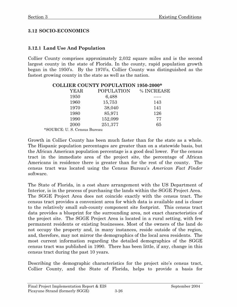
Collier County comprises approximately 2,032 square miles and is the second largest county in the state of Florida. In the county, rapid population growth began in the 1950’s. By the 1970’s, Collier County was distinguished as the fastest growing county in the state as well as the nation.
COLLIER COUNTY POPULATION 1950-2000* YEAR POPULATION % INCREASE 1950 6,488 ----- 1960 15,753 143 1970 38,040 141 1980 85,971 126 1990 152,099 77
2000 251,377 65 *SOURCE: U. S. Census Bureau
Growth in Collier County has been much faster than for the state as a whole. The Hispanic population percentages are greater than on a statewide basis, but the African American population percentage is a good deal lower. For the census tract in the immediate area of the project site, the percentage of African Americans in residence there is greater than for the rest of the county. The census tract was located using the Census Bureau’s American Fact Finder software. The State of Florida, in a cost share arrangement with the US Department of Interior, is in the process of purchasing the lands within the SGGE Project Area. The SGGE Project Area does not coincide exactly with the census tract. The census tract provides a convenient area for which data is available and is closer to the relatively small sub-county component site footprint. This census tract data provides a blueprint for the surrounding area, not exact characteristics of the project site. The SGGE Project Area is located in a rural setting, with few permanent residents or existing businesses. Most of the owners of the land do not occupy the property and, in many instances, reside outside of the region, and, therefore, may not mirror the demographics of the local area residents. The most current information regarding the detailed demographics of the SGGE census tract was published in 1990. There has been little, if any, change in this census tract during the past 10 years. Describing the demographic characteristics for the project site’s census tract, Collier County, and the State of Florida, helps to provide a basis for
Final Project Implementation Report & EIS September 2004 Picayune Strand (formerly SGGE) 3-26
Section 3 Existing Conditions
understanding the existing socio-economic context. Some of these characteristics are outlined below. Based on the comparative profile data delineated below, people at the poverty level make up a smaller share of the population in the SGGE Project Area than in the State of Florida as a whole. The Hispanic population percentage is very close to the state average as a whole (higher at the county level, lower at the census tract level). The non-white population share is similar but lower in the project area.
Florida: Population 2000 15,982,378 Change in population, 1990-2000 23.5% Below poverty level, 1999 estimate 12.5% White, 2000 78.0% Black, 2000 14.6% Other, 2000 7.4% Hispanic origin, 2000 16.8% Collier County: Population 2000 251,377 Change in population, 1990-2000 65.3% Below poverty level, 1997 estimate 11.2% White, 2000 86.1% Black, 2000 4.5% Other, 2000 9.4% Hispanic origin, 2000 19.6% Southern Golden Gate Estates 1990 Census Tract Profile (Census Tract 0111.02) Population 2,945 Percent below poverty level 11.8% White 90.1% Black 8.9% ("Non-white other" share of population negligible) Hispanic origin 8.5%
3.12.2 Water Demand
The total annual average water use for 2000 in Collier County is estimated at 230 million gallons per day (MGD), with 202.5 MGD coming from groundwater and 27.5 MGD coming from surface water. These figures, compiled by the USGS, include domestic, commercial, industrial, recreational, agricultural and power generation demands. These figures do not include the environmental
Final Project Implementation Report & EIS September 2004 Picayune Strand (formerly SGGE) 3-27
Section 3 Existing Conditions
demand for water, which accounts for a majority of the water demanded in the SGGE Study Area. There are currently only a small number of residents residing in the SGGE Study Area, and they are utilizing private wells to fulfill their water demands. The Port of the Isles community is located outside the southern boundary of the Project Area and currently uses a community well field for water supply. The SGGE Study Area is not currently suffering from a shortage of water, except for environmental concerns. Due to the relatively low number of persons and businesses in the existing area, the supply is sufficient for the demand. The Northern Golden Gates Estates currently has a well field that supplies public water. There have been no unmet demands for water being supplied by the well fields. Most of the residents in NGGE have private wells to supply their water. There are shortages of water and saline problems during excessive droughts.
3.13 AESTHETIC RESOURCES
The SGGE Project Area is a subdivision where few lots were actually developed for housing. There exists an infrastructure of 279 miles of roads laid out on a quarter mile grid. This easy access enables the indiscriminate use of all types of vehicles. Illegal dumping of trash, poaching, and the irresponsible use of firearms are existing realities.
3.14 HAZARDOUS, TOXIC, AND RADIOACTIVE WASTES
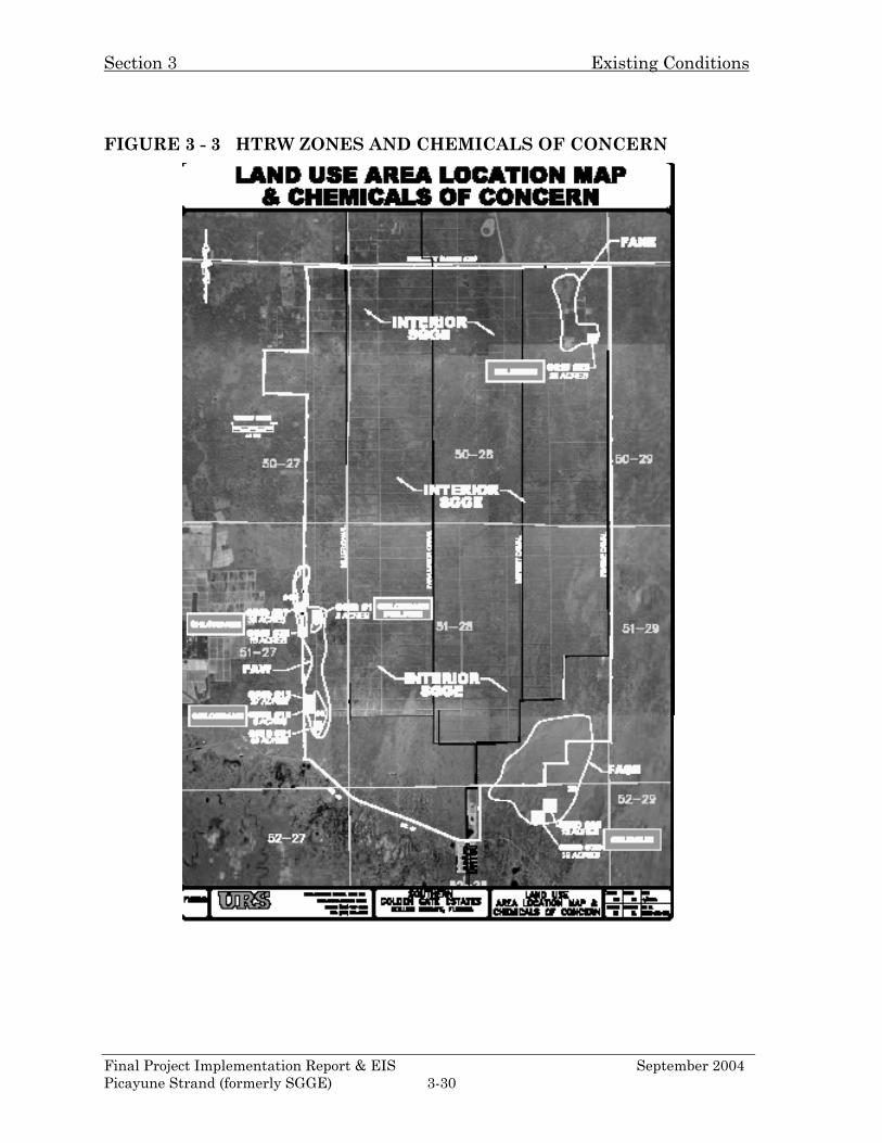
An Environmental Site Assessment (ESA) was conducted to assess and identify areas of concern and confirm the presence, or absence, of soil/groundwater contamination or contaminated media associated with the previous and current activities conducted within the SGGE project area. The Phase I ESA was performed in general accordance with American Society for Testing and Materials Standard Practice for Environmental Site Assessments (ASTM Practice E 1527-00). This method has been used as a guide to ensure appropriate inquiry into the environmental characteristics and conditions of the site consistent with good commercial/customary engineering and environmental practices. The SFWMD contracted with URS Corporation for Hazardous, Toxic, and Radioactive Waste (HTRW) Phase I, II, & III assessments on the SGGE Project Area and immediate surrounding area. The contract was completed on September 30, 2003 by delivery of the report entitled Phase I/II Environmental
Final Project Implementation Report & EIS September 2004 Picayune Strand (formerly SGGE) 3-28
Section 3 Existing Conditions
Site & Ecological Risk Assessment. Additionally the District contracted with Environmental Consulting & Technology, Inc (ECT), to delineate impacts in a portion of the SGGE project and prepare a supplemental assessment a report entitled Additional Scope Sampling Program. Executive summaries for the URS and ECT reports, including instructions for accessing an electronic copy of each document, can be found in Appendix D. The URS report delineates the project area into 4 zones. In addition to the Interior Area of the SGGE Project Area, three former agriculture zones were identified within the project footprint. These former agricultural areas comprise approximately 2,800 acres or 5% of the SGGE Project Area. The following is a brief overview of the potential HTRW risks within each zone. Each of these specific zones can be located on Figure 3-3. (1) Interior Area The Interior Area represents approximately 50,000 acres of the SGGE or 91% of the SGGE. Ninety-three (93) soil samples were collected from six landscape nursery/grove areas and 10 soil samples were collected from smaller farm operations within the interior portion of the SGGE. In addition to the cultivated areas, soil samples were collected from areas of potential point sources (i.e. irrigation pump wells, agrochemical mixing areas, etc). Soil samples were analyzed for organochlorine pesticides and chlorinated herbicides. The results of Phase I/II and Phase III Environmental Risk Assessment (ERA) for the Interior Area indicated that the residual levels of pesticides exhibited in the Interior Area do not appear to pose a significant risk to aquatic animals or terrestrial animals and it is not anticipated that it will affect the trustee species. Therefore, no significant HTRW impacts would inhibit the proposed restoration activities within this zone. However, it is recommended that the homesteads be surveyed for potential asbestos containing materials, the potable wells abandoned, and the septic systems decommissioned prior to the proposed restoration. (2) Former Agricultural Area – Southeast (FASE) The FASE zone is located in the southeast section of the SGGE Project Area. The FASE represents approximately 1,450 acres of cultivated land that was reportedly used for the cultivation of tomatoes in the 1930s. Soil sampling in this zone identified selenium above the FWS interim 1 mg/kg guideline concentration established for screening agriculture property proposed for conversion to restored wetland or storm water treatment areas. The ERA results indicates that selenium as well as the organochlorine pesticides does not appear to pose any significant risk potential to aquatic plants or animals. Groundwater samples from two monitor wells installed in the FASE did not exhibit elevated concentrations of organochlorine pesticides or metals.
Final Project Implementation Report & EIS September 2004 Picayune Strand (formerly SGGE) 3-29
Section 3 Existing Conditions
FIGURE 3 - 3 HTRW ZONES AND CHEMICALS OF CONCERN
Final Project Implementation Report & EIS September 2004 Picayune Strand (formerly SGGE) 3-30
Section 3 Existing Conditions
(3) Former Agricultural Area - Northeast (FANE) The FANE zone is located in the northeast section of the SGGE Project Area. The FANE represents approximately 600 acres of cultivated and uncultivated land, which was used for the cultivation of landscape plants and groves from the 1970s to 2000. Soil sampling within the FANE identified the presence of 4,4-DDT and toxaphene. Confirmation soil samples collected indicated that residual organochlorine pesticides were not consistently applied over the FANE, and are limited to localized areas and at low concentrations. Groundwater samples collected from the FAW did not exhibit detectable concentrations of organochlorine pesticides. Concentrations of metals were detected in groundwater samples below their respective GCTLs. Additionally; levels of selenium above the FWS 1 mg/kg guideline were detected. Based on the ERA, the levels of selenium in soils found in the FANE may pose a minimal risk potential for certain small ground foraging mammals but it is not likely to affect the trustee species. (4) Former Agricultural Area – West (FAW) The FAW zone is located in the western section of the SGGE Project Area. The FAW represents approximately 750 acres of cultivated and uncultivated land, which was cleared in the early 1960s and used for the cultivation of row crops. Soil sampling within the FAW indicated that organochlorine pesticides chlordane and dieldrin were detected above their SQAG. The impacted soils make up approximately 150 acres. Based on the sediment desorption, toxicity, and bioaccumulation tests, the levels of chlordane and dieldrin at the FAW does appear to pose a significant risk potential for sediment dwelling organisms, however, the residual organochlorine pesticides do pose some risk potential to aquatic receptors and piscivorous birds. ECT conducted a supplementary assessment of FAW to confirm the extent of impacted soil that will require corrective action. Since no selenium was detected above the 1.0 mg/kg USFWS guidance concentration, ECT proposed no further action with respect to selenium impacts. Nevertheless, as discussed with the USFWS, ECT will re-sample grids 29 and 30 (25 acres each) with the USFWS to confirm results in these two grids. It is anticipated that the selenium re-sampling will return results less than the guidance concentration. In the event the guidance concentration is exceeded, corrective action may be required. Based on the results of the supplementary assessment, 36 acres of chlordane-impacted soil will require additional assessment or corrective actions. Three levels of impacts were identified, based on the concentration of chlordane:
• 8 acres low-level chlordane (e.g., between 100 ug/kg and 200 ug/kg); • 21 acres medium level, (e.g., between 200 ug/kg and 1,000 ug/kg); and • 7 acres for high level (e.g., greater than 1,000 ug/kg).
Final Project Implementation Report & EIS September 2004 Picayune Strand (formerly SGGE) 3-31
Section 3 Existing Conditions
Section 9.14 HTRW and Appendix D contain remediation recommendations. Groundwater samples collected from the FAW did not exhibit detectable concentrations of organochlorine pesticides.
3.15 CULTURAL RESOURCES
A review of the Florida Master Site Files shows 13 known prehistoric sites within the Southern Golden Gate Estates area. A site visit, review of topographic maps and consultation with local informants indicates the location of approximately 750 acres of high probability areas, which have the potential to contain sites. Due to the existence of known historical properties, and the high probability of unrecorded sites within the project area, an archaeological survey is necessary, which has been concurred to by the Florida State Historical Preservation Officer. This determination has been made in compliance with Section 106 of the National Historic Preservation Act of 1966 (PL89-665), as amended in 2000; its implementing regulations (36 CFR Part 800) and the Archaeological and Historic Preservation Act of 1974 (PL93-291), as amended. Consultation with both the Miccosukee and Seminole tribes addressing potential cultural concerns within the Southern Golden Gate Estates is currently underway. Based on a literature review in the Florida Master Site File (FMSF), a study of satellite photographs, topographic maps, and several site visits, there are 13 known archaeological sites within the Golden Gate Estates study area. An estimated 600 acres of high probability areas were identified in the SGGE Project Area, which have the potential to be historically significant. The U.S. Army Corps of Engineers (USACE) has determined that there is a potential for historic resources, eligible for the National Register of Historic Properties, to be affected by the SGGE Project Area. A cultural resources survey is necessary to determine the impact. No project specific cultural resource surveys have been conducted to date; however, because of the site density and project locations, it is expected that additional sites will be located within the SGGE Project Area. This determination is made according to the guidelines established by the 106 Process (36 CFR 800) of the National Historic Preservation Act of 1966 (NHPA), as amended through 2000 (PL-89-665), the Archaeological and Historic Preservation Act of 1974 as amend (PL 93-291), and Executive Order 11593. Presently, coordination with the State Historic Preservation Officer (SHPO) is ongoing and project construction will not commence until coordination with SHPO is completed. A review of the FMSF was made of the SGGE Project Area to evaluate both the historical significances and the potential impact by the
Final Project Implementation Report & EIS September 2004 Picayune Strand (formerly SGGE) 3-32
Section 3 Existing Conditions
projects to each area. The exact locations of the SGGE projects have not yet been determined and the site review was limited to the topography maps of the general areas. The SGGE Project Area has been heavily impacted by residential planning and both road and canal construction. The 1994 Conservation and Recreation Land (CARL) Survey located 13 known archaeological sites within the SGGE Study Area, of which four were relocated and three were tested during the survey. Testing was limited to soil removal with a posthole digger and recording the presence of faunal, shards, and shell. All sites are classified as prehistoric, although one has a possible Seminole component (Weisman and Newman 1994). The National Environmental Policy Act of 1969 requires that potential impacts to cultural resources and historic properties be identified prior to a Federal undertaking. Despite the fact that most of the SGGE Project Area has been impacted by human activities, the existence of previously recorded historic properties, and the existence of high probability archaeological sites necessitate a detailed survey. Both a Phase I and Phase II archaeological survey are being coordinated with the SHPO and the Advisory Council on Historical Places (ACHP), in accordance with the Archaeological and Historic Preservation Act of 1974 as amend (PL 93-291), the National Historic Preservation Act of 1966 as amended through 2000 (PL-89-665) and in accordance with the Section 106 process. Site file reviews, consultation with the SHPO and other concerned parties, determinations of significance, and surveys will continue until the Section 106 process is completed. If research identifies historic properties that are determined to be eligible or potentially eligible for the National Register of Historic Places, further measures will be taken to avoid, minimize or mitigate adverse impacts to such sites. A Phase I Survey was conducted in September 2003, in the Prairie Canal Corridor of the Southern Golden Gate Estates Project, as part of the Prairie Canal Early Start Project. New South Associates conducted this survey under contract from the South Florida Water Management District. No previously unrecorded archaeological sites or historical properties were located during this survey. Due to extreme flooding of the survey area, two sites in the survey area, 8CR720 and 8CR721, were not tested as originally planned. The two sites will be tested at a future time in the Southern Golden Gate Estates Survey, scheduled to occur during the Detailed Design Report (DDR) phase of this project
3.16 RECREATION
The Picayune Strand State Forest and the Fakahatchee Strand are the two main recreational resources in the study area. SGGE comprises the eastern half of the Picayune Strand State Forest, which is a popular area for hunting, off-road vehicle use, mountain biking, camping, and horseback riding. The Florida
Final Project Implementation Report & EIS September 2004 Picayune Strand (formerly SGGE) 3-33
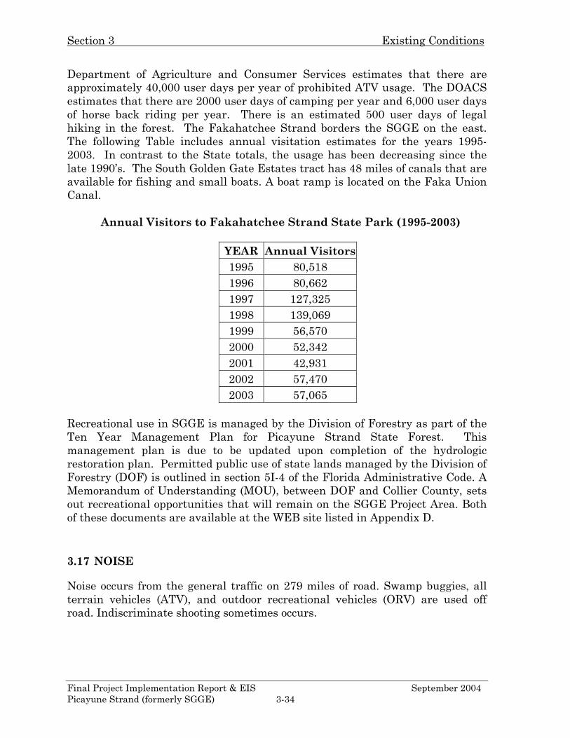
Section 3 Existing Conditions
Final Project Implementation Report & EIS September 2004 Picayune Strand (formerly SGGE) 3-34
Department of Agriculture and Consumer Services estimates that there are approximately 40,000 user days per year of prohibited ATV usage. The DOACS estimates that there are 2000 user days of camping per year and 6,000 user days of horse back riding per year. There is an estimated 500 user days of legal hiking in the forest. The Fakahatchee Strand borders the SGGE on the east. The following Table includes annual visitation estimates for the years 1995-2003. In contrast to the State totals, the usage has been decreasing since the late 1990’s. The South Golden Gate Estates tract has 48 miles of canals that are available for fishing and small boats. A boat ramp is located on the Faka Union Canal.
Annual Visitors to Fakahatchee Strand State Park (1995-2003)
YEAR Annual Visitors 1995 80,518 1996 80,662 1997 127,325 1998 139,069 1999 56,570 2000 52,342 2001 42,931 2002 57,470 2003 57,065
Recreational use in SGGE is managed by the Division of Forestry as part of the Ten Year Management Plan for Picayune Strand State Forest. This management plan is due to be updated upon completion of the hydrologic restoration plan. Permitted public use of state lands managed by the Division of Forestry (DOF) is outlined in section 5I-4 of the Florida Administrative Code. A Memorandum of Understanding (MOU), between DOF and Collier County, sets out recreational opportunities that will remain on the SGGE Project Area. Both of these documents are available at the WEB site listed in Appendix D.
3.17 NOISE
Noise occurs from the general traffic on 279 miles of road. Swamp buggies, all terrain vehicles (ATV), and outdoor recreational vehicles (ORV) are used off road. Indiscriminate shooting sometimes occurs.