Embed Size (px)
Citation preview
SECTION 10
COASTAL ZONE REGION / ESTUARIES AND TIDAL FLATS
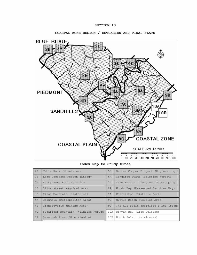
Index Map to Study Sites
2A Table Rock (Mountains) 5B Santee Cooper Project (Engineering &
2B Lake Jocassee Region (Energy
P d ti )
6A Congaree Swamp (Pristine Forest)
3A Forty Acre Rock (Granite
O t i )
7A Lake Marion (Limestone Outcropping)
3B Silverstreet (Agriculture) 8A Woods Bay (Preserved Carolina Bay)
3C Kings Mountain (Historical
B ttl d)
9A Charleston (Historic Port)
4A Columbia (Metropolitan Area) 9B Myrtle Beach (Tourist Area)
4B Graniteville (Mining Area) 9C The ACE Basin (Wildlife & Sea Island
lt )4C Sugarloaf Mountain (Wildlife Refuge) 10A Winyah Bay (Rice Culture)
5A Savannah River Site (Habitat
R t ti )
10B North Inlet (Hurricanes)


10-i
TABLE OF CONTENTS FOR SECTION 10
COASTAL ZONE REGION / ESTUARIES AND TIDAL FLATS - Index Map to Estuarine and Tidal Flat Study Sites - Table of Contents for Section 10 - Power Thinking Activity - "Pirate Pursuit" - Performance Objectives - Background Information
- Description of Landforms, Drainage Patterns, and Geologic Processes p. 10-2 . . . . . - Characteristic Landforms of Estuaries and Tidal Flats p. 10-2 . . . . . - Geographic Features of Special Interest p. 10-3 . . . . . - Types of Estuaries p. 10-3 . . . . . - Processes Shaping South Carolina's Coast p. 10-4 . . . . . - Movement of Sand
- Influence of Topography on Historical Events and Cultural Trends p. 10-5 . . . . . - Rice Plantation Era p. 10-5 . . . . . - Rice Became a Culture as Well as a Crop p. 10-6 . . . . . . . . . - story - "How Rice Came to the Carolinas" p. 10-7 . . . . . . . . . - figure 10-1-"Comparison of State Agricultural Production, 1860" p. 10-8 . . . . . - Decline of Rice Exports After the Civil War p. 10-9 . . . . . . . . . - story - "The Man of the House of Vanderbilt"
- Natural Resources, Land Use, and Environmental Concerns p. 10-10 . . . . - Soils of Beaches and Salt Marshes p. 10-10 . . . . - Ecological Significance of Estuaries and Salt Marshes p. 10-11 . . . . - Non-Point Source Pollution in Coastal Waterways
- Summary - Places to Visit - References and Resources
10-ii
- STUDY AREA 10 : ESTUARIES AND TIDAL FLATS (ICONS) Overv = ! Sci = " Math = # Hist = $ Lang Arts = % - Activity 10-1 : Overview - Materials
- Performance Tasks p. 10-15 . . . . . . . . 1. describe topography of estuarine environment ! p. 10-15 . . . . . . . . 2. determine land use in estuarine environment ! " p. 10-15 . . . . . . . . 3. distinguish among three categories of estuaries ! p. 10-16 . . . . . . . . 4. describe influence of geological events on coastal landforms " p. 10-16 . . . . . . . . 5. recognize "chicken drumstick" shape of barrier islands " p. 10-16 . . . . . . . . 6. write historical fiction about the first rice crop $ % p. 10-16 . . . . . . . . 7. identify counties where rice was planted " $
- Enrichment p. 10-17 . . . . . . . . 1. use tide tables to explain tidal range along coast " p. 10-17 . . . . . . . . 2. find out how people lived and worked on plantations $ % p. 10-17 . . . . . . . . 3. research how estuaries serve as filtering systems " p. 10-17 . . . . . . . . 4. model the effects of longshore drift " p. 10-17 . . . . . . . . 5. diagram a typical food chain for salt marsh " p. 10-17 . . . . . . . . 6. research story of Henry Woodward " $ % - STUDY SITE 10A : WINYAH BAY (RICE CULTURE) (ICONS) Overv = ! Sci = " Math = # Hist = $ Lang Arts = % - Newspaper Article - "Scuba Divers Find Evidence of Ancient Forests . . ." - Rationale
- Brief Site Description p. 10A-2 . . . . - Old Beach Ridges p. 10A-2 . . . . - Bellefield Nature Center p. 10A-3 . . . . - Rice Cultivation p. 10A-4 . . . . - Slavery on Waccamaw River Rice Plantations p. 10A-5 . . . . . . . . - story - "An Antebellum Rice Recipe from a Plantation Cook"
10-iii
p. 10A-5 . . . . . . . . - figure 10A-1- "Rice Trunk Gate" p. 10A-5 . . . . - Trickster Tales p. 10A-6 . . . . . . . . - story - "You Never Know What Trouble is Until it Finds You"
- Activity 10A-1 : Plantations and the Rice Culture - Materials
- Performance Tasks p. 10A-9 . . . . . . . . 1. locate the study site ! " p. 10A-9 . . . . . . . . 2. locate natural and man-made features ! p. 10A-9 . . . . . . . . 3. compare marsh and wooded areas ! p. 10A-10 . . . . . . . 4. analyze changes through time ! p. 10A-10 . . . . . . . 5. locate several plantation sites " $ p. 10A-10 . . . . . . . 6. examine parallel remnants of former beach ridges " p. 10A-10 . . . . . . . 7. analyze the newspaper article " % p. 10A-11 . . . . . . . 8. estimate size of average rice field impoundment # p. 10A-11 . . . . . . . 9. outline steps necessary for planting rice $ p. 10A-11 . . . . . . . 10. graph and analyze rice production # p. 10A-11 . . . . . . . 11. analyze why escape was difficult for slaves $ p. 10A-12 . . . . . . . 12. relate life story of a 200 year-old fanner basket $ % p. 10A-12 . . . . . . . 13. solve Alexander the Ant's problem # p. 10A-12 . . . . . . . 14. explain relationship of physical setting to Pourquoi Tale $ % p. 10A-12 . . . . . . . 15. write your own Pourquoi Tale for this region %
- Enrichment p. 10A-13 . . . . . . . 1. determine effect of end of slavery on rice cultivation $ p. 10A-13 . . . . . . . 2. invite a storyteller to perform for the class % p. 10A-13 . . . . . . . 3. collect samples of Pourquoi Tales % - STUDY SITE 10B : NORTH INLET (HURRICANES) (ICONS) Overv = ! Sci = " Math = # Hist = $ Lang Arts = % - Newspaper Article - "Soft Sand Added Danger Near Beaches" - Rationale
- Brief Site Description p. 10B-2 . . . . - Shoreline Changes Due to Major Storms p. 10B-2 . . . . . . . . - figure 10B-1- "North Inlet Migration" p. 10B-3 . . . . - Famous South Carolina Hurricanes
10-iv
p. 10B-3 . . . . . . . . - figure 10B-2 - 'List of Famous South Carolina Hurricanes" p. 10B-4 . . . . . . . . - figure 10B-3 - "Map of Major South Carolina Hurricanes: 1893-1989" p. 10B-5 . . . . . . . . - story - "The Hurricane of 1893" p. 10B-6 . . . . - Diary of Destruction--Hurricane Hugo p. 10B-7 . . . . . . . . - story - "Hugo Stories" - Activity 10B-1 : Hurricane Hugo - Materials
- Performance Tasks p. 10B-8 . . . . . . . . 1. locate the study site ! " p. 10B-8 . . . . . . . . 2. analyze the newspaper article % p. 10B-8 . . . . . . . . 3. compare pre and post Hurricane Hugo features ! " p. 10B-9 . . . . . . . . 4. assess extent of Hurricane Hugo damage ! p. 10B-9 . . . . . . . . 5. outline changes in North Inlet since 1872 " $ p. 10B-9 . . . . . . . . 6. estimate buildup of sand at inlet " # p. 10B-10 . . . . . . . 7. trace shorline position during storm surge " # p. 10B-10 . . . . . . . 8. evaluate effects of hurricanes on rice impoundments $ p. 10B-10 . . . . . . . 9. tell your favorite hurricane story to your group % p. 10B-10 . . . . . . . 10. plot paths of major hurricanes " $ p. 10B-10 . . . . . . . 11. make up a name for the Hurricane of 1893 $
- Enrichment p. 10B-11 . . . . . . . 1. research recent local natural disasters $ % p. 10B-11 . . . . . . . 2. research impact Hurricane Hugo had on wildlife habitats " p. 10B-11 . . . . . . . 3. determine how hurricanes are classified and named " p. 10B-11 . . . . . . . 4. analyze hurricane-induced changes in Santee Delta " $ p. 10B-11 . . . . . . . 5. relate tales of other natural disasters %


10-1
SECTION 10
COASTAL ZONE REGION / ESTUARIES AND TIDAL FLATS
POWER THINKING ACTIVITY - "Pirate Pursuit" You are the first mate on board the pirate ship Queen Anne's Revenge under the command of the notorious pirate, Blackbeard. You have just attacked and robbed two ships moving trade goods into the rice port of Georgetown. You want to leave Winyah Bay as quickly as possible, before the British Navy can assemble to pursue you, but, as you are leaving Winyah Bay, a big storm comes up. You can't go out into the open ocean because of the storm, but you can't return to Georgetown, where the British Navy is gathering its forces. Where can you go, close by, to wait out the storm and to hide from the navy? Use the NORTH INLET TOPOGRAPHIC MAP and the WINYAH BAY LITHOGRAPH to help you determine a specific place to hide. Consider the size of your ship and the geometry of the landform features in the area. Remember that you have to get your boat out of the naval forces' view at Georgetown to make them think you have left the area. PERFORMANCE OBJECTIVES 1. Describe the ecological significance of estuarine environments
and assess the short and long-term effects of draining these wetlands.
2. Relate requirements for the cultivation of rice to the development of the plantation system and the resulting widespread alteration of the estuarine landscape.
3. Outline and assess contributions made by African Americans in the Coastal Zone throughout South Carolina history.
4. Explain how trickster tales developed and changed through time and were used to convey hidden meanings to specific groups of listeners.
5. Interpret and retell Pourquoi Tales, legends, and stories from Low Country folklore.
6. Determine the economic and social impact hurricanes have had on South Carolina's Coastal Zone Region.
7. Compare and contrast changes in shoreline features, land cover, and land use patterns resulting from Hurricane Hugo.
8. Determine dimensions of rice impoundments, height of tidal range, and average crop yields using appropriate mathematical models.
9. Plot paths of major hurricanes and associated storm surge high-water marks on topographic maps and lithographs.
10-2
BACKGROUND INFORMATION Description of Landforms, Drainage Patterns, and Geologic Processes
Characteristic Landforms of Estuaries and Tidal Flats
Estuaries consist of small islands of high ground and expansive salt marshes, cut with winding tidal creeks. The deeper creeks hold water even at low tide while only the peak of the six-hour tidal cycle floods the marsh surface. Most South Carolina rivers enter the ocean through estuaries, which represent former river channels that have been flooded because sea level has gradually risen. Most pre-existing landforms are hidden below the water line, leaving only shallow marshy areas visible along the boundary of the estuary. They are essential wetland areas, where fresh water from inland sources joins incoming salt water from the oceans. They develop extremely dynamic ecosystems that are constantly changing in response to tidal action and to the varying amounts of fresh water, governed by seasonal and meteorological changes. Rivers, creeks, and smaller tributaries serve as arteries for transporting nutrient-rich material eroded from upstream. This material, along with nutrients brought in by the tides, nourishes many forms of marine life, especially the larval stages of invertebrate species that flourish in this protected environment.
Tidal flats are mostly flat, low-lying areas flooded by seawater part of the time and exposed to the air part of the time. The total amount of land flooded depends on the tidal range and the effects of storms. In many ways tidal flats are similar to river floodplains. Tidal channels drain the higher portions of the mostly featureless plains covered with marsh grass. The channels meander widely across muddier areas forming occasional tidal channel levees and sandy point bar deposits. The channels often interconnect, especially near the tidal inlet, which provides access to the open ocean. Some tidal flat systems are dominated by a very strong incoming tidal current. Sediments are pushed landward by these currents to form flood tidal deltas. If the outgoing tidal current is stronger, sediments will often be carried out into the open ocean, through the tidal inlet, to form ebb tidal deltas. The relative amount of erosion and deposition on any portion of the tidal flat depends on the height of that land above or below average sea level (mean sea level).
10-3
Geographic Features of Special Interest
All major South Carolina rivers, except for the Santee, have been recently flooded by rising sea level to form estuaries surrounded by marshy wetlands. The Santee River System has brought enough sediment to the coast that it has been able to keep pace with rising sea level and maintain its delta. This low lying area also contains extensive salt marshes. Other coastal embayments, such as Bull's Bay, St. Helena Sound, and Port Royal Sound, are likewise surrounded by vast expanses of salt marsh. Several prime areas of salt marsh habitat have been preserved as wildlife refuges, such as the Cape Romain National Wildlife Refuge adjacent to Bull's Bay in Charleston County, and the Pinckney Island National Wildlife Refuge near Hilton Head Island in Beaufort County. Hobcaw Barony, designated for teaching and research, is located just across Winyah Bay from the city of Georgetown. It contains abandoned rice fields, old beach ridges, and a diverse tidal flat environment, along with a lookout tower that provides spectacular views of the coastal landscape. Several state parks with excellent examples of tidal inlets and tidal flats include Hunting Island State Park in Beaufort County and Edisto Beach State Park in Colleton County. Almost all barrier islands along the coast exhibit well formed tidal inlets and tidal flat drainage systems.
Types of Estuaries
Several types of estuaries are found within the Coastal Zone, ranging from predominantly saltwater estuary systems, to a mix of fresh and saltwater (brackish water), to isolated freshwater estuaries. Salt marshes occur along most saltwater estuaries found in the Coastal Zone. These marshes are highly saline and primarily support spartina grass. North Inlet and Pawleys Inlet marshes are excellent examples of ecologically important salt marshes.
A second type of coastal estuary contains the brackish water marshes that are located in the less salty reaches of tidal rivers and marshes. They have a mixture of both salt and fresh water characteristics. It was these estuaries which were used as rice field impoundments during the rice planting era. Examples can be easily recognized on the Winyah Bay lithograph because of the rectangular block patterns of the dikes and ditches dividing the fields.
Excess rainwater drained from upland areas forms a third type of estuary containing only fresh water. These freshwater estuaries are also known as coastal swamps and are mostly found in low-lying depressions or river tributaries. The North Inlet
10-4
Topographic Map contains excellent examples of fresh water estuaries. These areas are mostly vegetated by deciduous water-tolerant tree species such as gums, cypress, and oaks.
Processes Shaping South Carolina's Coast
Viewed in geologic time, South Carolina's coastal region developed slowly by deposition of sediment eroded from the Appalachian Mountains and carried to the sea by rivers. These sediments gradually built out into the ocean and have been reworked and sculpted into the landform structures visible on today's Coastal Plain. The present system of Coastal Zone landforms however, including modern barrier islands and beaches, is geologically much younger than most other South Carolina landforms. During the Pleistocene ice ages, sea level rose and fell several times, causing shoreline features to advance and recede. Sand dune remnants in the Coastal Plain Region and a series of escarpments and terraces are evidence that the shoreline was once farther inland. Still present on the Continental Shelf off our coast are additional remnants of terraces, showing that sea level was once lower than it is today. These processes, over geologic time, have created parallel rows of dune ridges behind the active shoreline. These ridges can easily be seen along many portions of the Coastal Zone, particularly on aerial photographs and satellite images. These dune ridges were once active barrier islands typical of the South Carolina coast and the tide-dominated Coastal Zone in general. Older dune ridges have become vegetated by mature maritime forests, but younger sand ridges closer to the beach front are dominated by sea oats and other salt-tolerant shrubs and grasses.
From 20,000 years until about 10,000 years ago, the world's glaciers were melting rapidly, causing the sea level to rise several feet per century, for a total of more than 350 feet. Beaches migrated inland to near their present position to keep pace with the rising sea. South Carolina's present-day barrier islands and beaches began to grow, and the wetlands and estuaries behind the outer beaches began to develop, when sea level finally stabilized some time after the most recent of the Pleistocene ice ages. River sediments, a mixture of sand, silt, and clay, began to accumulate on the bottoms of drowned river valleys, which were flooded as sea level rose because of the water released by melting continental glaciers. The type of sediment deposited at any particular location depended primarily on the intensity of wave and current energies at that location. High energy levels caused sands to be deposited along beaches, while finer silts and clays were able to settle in marshes and as offshore mud deposits because of the lower energy of these environments.
10-5
In the long run, both subtle changes and sudden dramatic storm events have been important factors in shaping Coastal Zone landscapes. In recent times, however, the most dramatic Coastal Zone changes have occurred as the result of human engineering. Far more than natural processes, the shapes and characteristics of shorelines have been affected by the building of dams which reduced the sediment load transported by rivers, the draining and filling of marshes and other wetlands, increased shoreline development, beach renourishment projects, and the construction of jetties, groins, and sea walls.
Movement of Sand
Beach sand is transported parallel to the coast by longshore movement and from offshore sand bars into the surf zone by wave and tidal action. All of South Carolina's Coastal Zone is influenced by the rise and fall of tides, an effect that extends approximately ten miles inland, affecting all of the major bays, sounds, and inlets. Waves seldom strike the beach from directly offshore; rather they usually come in at an angle. This angled approach helps to develop a current moving parallel to the coast that is familiar to anyone who has played in the surf for a while and noticed that they have been graduallymoved relative to the beach, sometimes for as much as several hundred yards. This same current moves huge amounts of sand along South Carolina's coast each year.
Seasonal differences in wave direction and wave strength can move sand from offshore sand bars into the surf zone. In general, winter storms tend to move sand offshore, while more gentle summer waves tend to return the sand and build up the beach face. Where beaches are built up by deposits of sand from the ocean, wind often carries the loose particles higher up the beach. A variety of debris then breaks the force of the wind and the sand is deposited, forming rows of sand dunes. Sea oats and other beach front grasses take root and provide more wind-breaks for further sand accumulation and greater dune stabilization. The slow movement of sands and sandbars through time is easily seen in a time sequence of aerial photographs and satellite images. Ancient dune ridges built by this same process are also obvious features on both types of cartographic products. Influence of Topography on Historical Events and Cultural Trends
Rice Plantation Era
The Rice Plantation Era originated in South Carolina in the early 1700's when the river basins around Charleston and Georgetown became major tidewater rice cultivation areas.
10-6
Georgetown, at the head of Winyah Bay, was strategically located at the confluence of the Waccamaw, Pee Dee, Sampit, and Black rivers, and it became the major port for exporting rice to England and the West Indies. The extremely labor intensive cultivation of rice created a planter's aristocracy of great wealth and power, made possible by the hard work of thousands of slaves. Evidence indicates that rice seeds were first brought to the state by Africans from Madagascar, a large island off the east coast of Africa.
The first rice crops were grown in open fields, but keeping the weeds from choking the young plants and insects from devouring the crop were major problems. However, early in the eighteenth century it was discovered that tidewater cultivation of rice, on reclaimed swamp lands, solved most of these problems. In the tidewater model, rice plantations were located just above the level of the incursion of salt water and just below the upper limit of the tidal effect. In the brackish-water estuaries or marshes, strategically placed gates, dikes, ditches, and canals, allowed the rice planters to make use of the rising and falling tides, which provided the energy to move water back and forth between the rice field and the canal or river. This tidal flushing action provided the proper agricultural conditions for rice cultivation. Even though the Savannah, Combahee, Ashepoo, Edisto, and Cooper rivers all became important tidal rice cultivation areas, it was the Waccamaw, Santee, Sampit, Black, and Pee Dee rivers that combined to make the Georgetown area the major rice producing region in South Carolina and one of the largest producing areas in the world.
Rice Became a Culture as Well as a Crop
It was slave labor that cleared the cypress swamps and constructed dikes with sluice gates to flood and drain the fields, but slaves also provided much of the knowledge necessary for the cultivation of rice, since none of the Europeans had much experience with rice cultivation at that time. In fact, the rice planters of South Carolina preferred to import slaves from Sierra Leone, along the West African coast, where Africans had years of experience with rice cultivation. During the Plantation Era, in South Carolina, these slaves continued to use the traditional African methods of planting, hoeing, winnowing, and threshing rice.
Many slaves were able to maintain and transmit some of their African heritage through development of the Gullah language, crafts, and folk tales. For example, in the rice-growing regions of South Carolina, basketry flourished and found practical application in the production of baskets for both storage purposes
10-7
and the winnowing of rice. These baskets used distinctive West African construction techniques, although they utilized local materials, traditionally coils of sweetgrass stitched together with dried palmetto fronds (leaves).
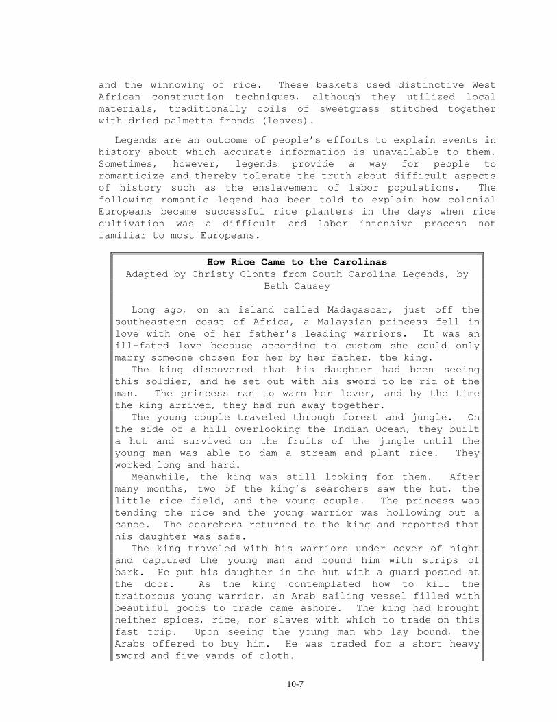
Legends are an outcome of people’s efforts to explain events in history about which accurate information is unavailable to them. Sometimes, however, legends provide a way for people to romanticize and thereby tolerate the truth about difficult aspects of history such as the enslavement of labor populations. The following romantic legend has been told to explain how colonial Europeans became successful rice planters in the days when rice cultivation was a difficult and labor intensive process not familiar to most Europeans.
How Rice Came to the Carolinas Adapted by Christy Clonts from South Carolina Legends, by
Beth Causey Long ago, on an island called Madagascar, just off the southeastern coast of Africa, a Malaysian princess fell in love with one of her father’s leading warriors. It was an ill-fated love because according to custom she could only marry someone chosen for her by her father, the king. The king discovered that his daughter had been seeing this soldier, and he set out with his sword to be rid of the man. The princess ran to warn her lover, and by the time the king arrived, they had run away together. The young couple traveled through forest and jungle. On the side of a hill overlooking the Indian Ocean, they built a hut and survived on the fruits of the jungle until the young man was able to dam a stream and plant rice. They worked long and hard. Meanwhile, the king was still looking for them. After many months, two of the king’s searchers saw the hut, the little rice field, and the young couple. The princess was tending the rice and the young warrior was hollowing out a canoe. The searchers returned to the king and reported that his daughter was safe. The king traveled with his warriors under cover of night and captured the young man and bound him with strips of bark. He put his daughter in the hut with a guard posted at the door. As the king contemplated how to kill the traitorous young warrior, an Arab sailing vessel filled with beautiful goods to trade came ashore. The king had brought neither spices, rice, nor slaves with which to trade on this fast trip. Upon seeing the young man who lay bound, the Arabs offered to buy him. He was traded for a short heavy sword and five yards of cloth.
10-8
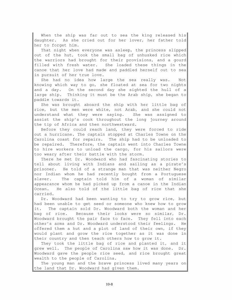
When the ship was far out to sea the king released his daughter. As she cried out for her lover, her father told her to forget him. That night when everyone was asleep, the princess slipped out of the hut, took the small bag of unhusked rice which the warriors had brought for their provisions, and a gourd filled with fresh water. She loaded these things in the canoe that her love had made and paddled herself out to sea in pursuit of her true love. She had no idea how large the sea really was. Not knowing which way to go, she floated at sea for two nights and a day. On the second day she sighted the hull of a large ship. Thinking it must be the Arab ship, she began to paddle towards it. She was brought aboard the ship with her little bag of rice, but the men were white, not Arab, and she could not understand what they were saying. She was assigned to assist the ship’s cook throughout the long journey around the tip of Africa and then northwestward. Before they could reach land, they were forced to ride out a hurricane. The captain stopped at Charles Towne on the Carolina coast for repairs. The ship had to be unloaded to be repaired. Therefore, the captain went into Charles Towne to hire workers to unload the cargo, for his sailors were too weary after their battle with the storm. There he met Dr. Woodward who had fascinating stories to tell about living with Indians and sailing as a pirate’s prisoner. He told of a strange man that was neither Negro nor Indian whom he had recently bought from a Portuguese slaver. The captain told him of a woman of similar appearance whom he had picked up from a canoe in the Indian Ocean. He also told of the little bag of rice that she carried. Dr. Woodward had been wanting to try to grow rice, but had been unable to get seed or someone who knew how to grow it. The captain sold Dr. Woodward both the woman and her bag of rice. Because their looks were so similar, Dr. Woodward brought the pair face to face. They fell into each other’s arms and Dr. Woodward understood their feelings. He offered them a hut and a plot of land of their own, if they would plant and grow the rice together as it was done in their country and then teach others how to grow it. They took the little bag of rice and planted it, and it grew well. The people of Carolina saw how it was done. Dr. Woodward gave the people rice seed, and rice brought great wealth to the people of Carolina. The young man and the brave princess lived many years on the land that Dr. Woodward had given them.
10-9
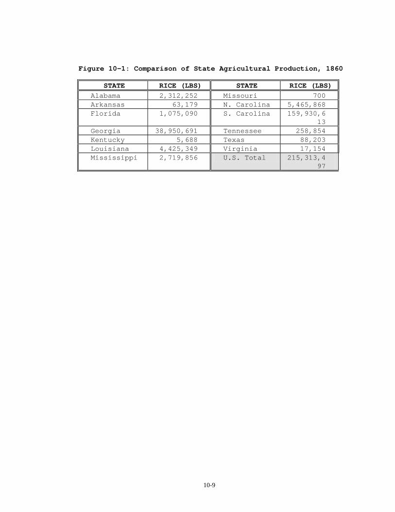
Figure 10-1: Comparison of State Agricultural Production, 1860
STATE RICE (LBS) STATE RICE (LBS)
Alabama 2,312,252 Missouri 700 Arkansas 63,179 N. Carolina 5,465,868 Florida 1,075,090 S. Carolina 159,930,6
13 Georgia 38,950,691 Tennessee 258,854 Kentucky 5,688 Texas 88,203 Louisiana 4,425,349 Virginia 17,154 Mississippi 2,719,856 U.S. Total 215,313,4
97
10-10
Decline of Rice Exports After the Civil War
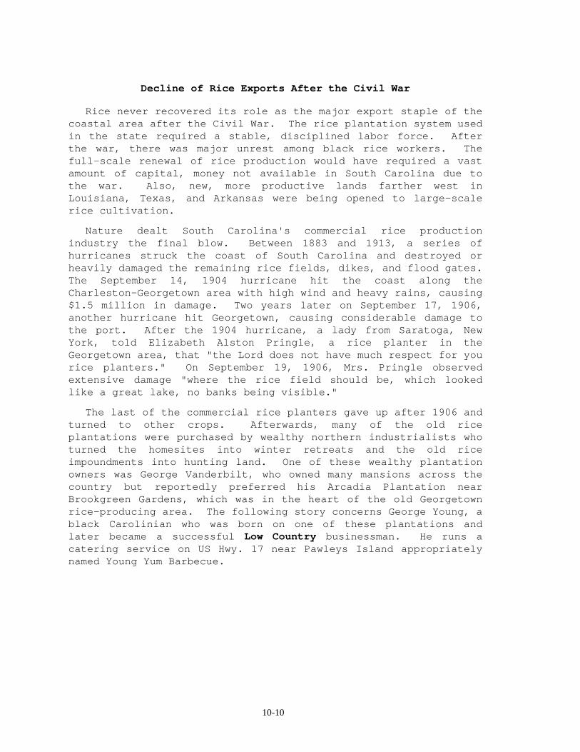
Rice never recovered its role as the major export staple of the coastal area after the Civil War. The rice plantation system used in the state required a stable, disciplined labor force. After the war, there was major unrest among black rice workers. The full-scale renewal of rice production would have required a vast amount of capital, money not available in South Carolina due to the war. Also, new, more productive lands farther west in Louisiana, Texas, and Arkansas were being opened to large-scale rice cultivation.
Nature dealt South Carolina's commercial rice production industry the final blow. Between 1883 and 1913, a series of hurricanes struck the coast of South Carolina and destroyed or heavily damaged the remaining rice fields, dikes, and flood gates. The September 14, 1904 hurricane hit the coast along the Charleston-Georgetown area with high wind and heavy rains, causing $1.5 million in damage. Two years later on September 17, 1906, another hurricane hit Georgetown, causing considerable damage to the port. After the 1904 hurricane, a lady from Saratoga, New York, told Elizabeth Alston Pringle, a rice planter in the Georgetown area, that "the Lord does not have much respect for you rice planters." On September 19, 1906, Mrs. Pringle observed extensive damage "where the rice field should be, which looked like a great lake, no banks being visible."
The last of the commercial rice planters gave up after 1906 and turned to other crops. Afterwards, many of the old rice plantations were purchased by wealthy northern industrialists who turned the homesites into winter retreats and the old rice impoundments into hunting land. One of these wealthy plantation owners was George Vanderbilt, who owned many mansions across the country but reportedly preferred his Arcadia Plantation near Brookgreen Gardens, which was in the heart of the old Georgetown rice-producing area. The following story concerns George Young, a black Carolinian who was born on one of these plantations and later became a successful Low Country businessman. He runs a catering service on US Hwy. 17 near Pawleys Island appropriately named Young Yum Barbecue.
10-11
The Man of the House of Vanderbilt Adapted from Plantation Tales, by Nancy Rhyne
George Young remembers how, and even precisely when, he first began to learn the mannerisms, traits, and disposition that would take him to the top in George Vanderbilt's Arcadia Mansion. Annie Young, George's mother, was a cook at Arcadia. Annie's dark hands moved swift and sure, as she prepared the foods so desired by Vanderbilt and his wealthy visitors. George recalls how his mother's rare learning and her low musical language made their
way into his heart as he watched her work in the large kitchen. Annie's husband took care of the Vanderbilt horses and dogs, a strenuous task. But George portrays the quiet ease of his mother as he speaks of her poise and the lightness of her footfalls as she came and went from the Vanderbilt kitchen. As a child, George began to perceive that he could be like his mother and could even
learn to cook like her. She would be his model and perhaps someday he, too, could cook in that kitchen. One day Mr. Vanderbilt asked George if he would set up the tables for a dinner after a deer hunt at Debordieu, Vanderbilt's seashore portion of his estate. George considered the request a great honor. But all the while that George was getting the tables ready for the dinner, he was watching the man who was barbecuing meat. "He didn't know I was watching him, but I wanted to learn how to cook meat by
barbecuing it just like I'd learned to cook by watching my mother. Every now and then, when they'd killed a deer, they would bring a quarter of the meat to the barbecue pit. The cook would baste the meat with sauce and cook it on the grill. George Young was adept and learned almost every facet of running the plantation.
"When I first started working in the house, I was bringing in wood, scrubbing the floor and washing dishes," he said. "Finally I learned to do about everything the other household help did." Mr. Vanderbilt employed people from all over the world and sometimes they didn't agree on how things should be handled. One day Mr. Vanderbilt called George Young upstairs and said, "George, I can't stand this arguing all the time. You must learn how to run this house because I'm going to get rid of them and give the whole job to you!" George pointed out that he had had no schooling for being a butler or running such a
magnificent, huge house. After all, a good butler was a status symbol, like a Rolls Royce. Mr. Vanderbilt insisted that he thought George could do it and told him to take over the mansion. Twenty-five people would report to him. Everything progressed wonderfully and Mr. Vanderbilt was pleased with the work of George Young, the man who had been born on the plantation and attended the little plantation schoolhouse. Later, George Vanderbilt took George Young with him to act as a supervisor for
several of his other houses around the country. He told him "George, you have all those people working for you and I've never known you to have the slightest argument with a single one of them. You are the best I've ever had at running a big house." Vanderbilt later gave George Young the deed to five acres of land adjoining Arcadia Plantation and helped him build a house there. Today George runs a barbecue business on his property. He has a bad hip and the
arthritis in his knees is a nuisance, but he cooks in the same way as he did at the house of Vanderbilt. In an interview, George summed up his feelings about the late George Vanderbilt. "I tell you, Missy, I miss him like I miss my mother."
Natural Resources, Land Use, and Environmental Concerns
10-12
Soils of Beaches and Salt Marshes
Beach sands, old sand dunes, and salt marshes represent the youngest soils in the state. All are formed from parent material deposited by the ocean, yet they are very different in character for two principal reasons. First, the beach and dune soils are composed of coarse, sandy, material, while salt marsh soils consist of clay, silt, and fine sand sized particles. Secondly, their position in the landscape, and therefore their elevation, is different enough to affect soil moisture content and water holding capacity. The elevation of marsh soils is essentially sea level, although during very high tides, they can be completely covered with seawater. The chemical effect of salt in the soil plays a significant role in the types of plants that a soil can support.
Ecological Significance of Estuaries and Salt Marshes
Coastal vegetation can be grouped into four zones - fresh marshes, maritime forests, salt marshes, and sand dunes. Fresh marshes are inundated by fresh water and are protected from saltwater intrusion by old beach ridges. They support a marsh-type vegetation dominated by rushes, and in contrast to swamps, contain no trees or shrubs. The vegetation is composed primarily of bulrush, cattail, and black needlerush. Beach ridges were once active sand dunes that are now separated from the shore and have a distinct maritime forest vegetation. Maritime forests are dominated by trees and shrubs that are tolerant of sea winds and salt spray. The live oak and the palmetto palm are particularly tolerant of these conditions. Other trees and shrubs of the maritime forest include the slash pine, magnolia, holly, waxmyrtle, and wild olive. On the shoreline itself are the sand dunes, created by the interaction of land, waves, and wind. Nearest the ocean, the fore dune is dominated and anchored by sea oats. Also common on the fore dune is the marsh elder and on the dune's protected backslope the pennyworth and sandspurs are found. In the depressions behind the fore dune is an area protected from salt spray. It is here that yaupon, waxmyrtle, dwarfed live oak, Spanish bayonet, and other similar plants thrive. Secondary dunes, though somewhat protected by the fore dune, have a similar arrangement of vegetation.
Closer to the ocean and inundated at high tide are the salt marshes. With ample sunlight, plentiful nutrients provided by inland rivers, and periodic tidal flushing, the salt marsh provides an ideal environment for plant production. However, the high salinity of the water limits plant life to one dominant species called cord grass, or spartina. This single species
10-13
dominates the entire salt marsh, growing tall along creek banks, and somewhat shorter on the expansive flats. As spartina growth slows during the winter months, wave action and bacteria break down the stalks to form a rich soup called detritus which provides a source of energy for zooplankton (microscopic aquatic animals) and phytoplankton (microscopic aquatic plants) and represents the base of the estuarine food chain.
Few animals can survive the sudden and drastic environmental changes of the twice daily tides which alternately flood and drain much of the salt marsh. Marine animals, such as fiddler crabs, periwinkle snails, ribbed muscles, oysters, and clams, are especially adapted to deal with such rapid change by burrowing into the soft mud, called pluff mud, or closing their shells to provide protection from predators and desiccation when tides are low. The only vertebrates that live year round in the salt marsh are diamond back terrapins, clapper rails, and a few small fishes. Many species of vertebrates and invertebrates, however, visit the salt marsh with the rising tide to prey on resident animals and on each other. Life in the salt marsh is therefore intimately connected to life inland and even the open ocean.
The food web includes grazers such as the salt marsh grasshopper and marsh periwinkle, while animals like shrimp, fiddler crabs, and mullet feed directly on detritus. Less mobile organisms such as oysters, clams, and mussels filter nutrients directly from the murky water, and scavenging crabs clean up dead organic matter. Predators at the top of the food chain include such birds as clapper rails, oystercatchers, pelicans, herons, and egrets, as well as many species of fish, notably red drum, spotted seatrout, and flounder.
Three-quarters of all recreational and commercially important fish and shellfish spend all or part of their lives in estuarine waters in and around salt marshes. Many species of shrimp, crabs, and fish utilize the marsh's narrow, shallow creeks as nurseries for their early larval stages. In addition to providing food and shelter for so many marine organisms, the salt marsh also filters pollutants and silt from coastal waters, and buffers adjacent highlands from wind and waves. Recent development activities, however, pose an ever-increasing threat to the well-being of these unique South Carolina features. Destruction of wetlands by housing and recreational developments, water quality changes due to pollution from industries, and overuse of natural resources are three major threats to this ecosystem.
Non-Point Source Pollution in Coastal Waterways

10-14
Wetland ecosystems have a unique ability to remove certain non-point source pollutants. Poisonous to fish and baby mammals, including human babies, nitrates from over-fertilization drain into a wetland soil. Due to the wetness of the soils, the soil microorganisms need a substitute for oxygen. So the microorganisms take the nitrates and break them down to release harmless nitrogen gas or nitrous oxides into the atmosphere. In addition, the active chemical nature of the organic matter that is abundant in wetland soils chemically traps many organic contaminants such as gasoline, oils, benzene, and PCB's.
10-15
Summary
The South Carolina Coastal Zone offers a diversity of landforms from white-sand beaches to estuaries floored with black mud. Every morning the sun rises over the Atlantic ocean to the east, and every evening it sets over the land to the west. In between it shines down on a rich, varied, and sometimes mysterious coast. Although it is a cliché to say it, change is a constant along the coast of South Carolina. Changing sea levels, currents, winds, and seasons all have their effect on the beaches of the Coastal Zone. Former beach locations are shown by parallel ridges of sand inland from the current beach. Movement of sand onto the beach and off, as well as along it, reshape the beaches themselves and the coast in general, making South Carolina’s beaches a dynamic as well as intriguing environment. Coastal areas are hit from time to time by massive storms called hurricanes. The combination of high winds, vast amounts of rainfall, and high water storm surges alter coastal landforms to a degree exceeded only by human engineering.
Between the beaches, the numerous bays, inlets, and estuaries are a different, but perhaps even more vibrant part of the Coastal Zone. They are breeding and feeding grounds for many sea creatures and much bird life, and, historically, these mixing grounds of fresh and salt water have also provided the means of support for numerous people. One may think naturally of fish and shellfish as the foodstuffs for early settlers living along the coast. From 1700 until the Civil War, rice was the basis of the economy of much of the Coastal Zone, and the foundation of a culture. Many who labored to grow the rice and to support the culture were slaves, brought to the South Carolina coast primarily from West Africa. Slaves provided not only a labor force but also the experience needed to grow and process rice, a labor-intensive crop common in some coastal areas of Africa. Without their skills and efforts the Carolina rice culture could not have existed, and without their traditions of crafts, such as basket making, and oral tales the culture would have been poorer.
Although rice has not been an important crop in the Coastal Zone of South Carolina this century, the richness of the area still affects its culture. Anglers, hunters, pleasure sailors, artists, vacationers, and others who appreciate this region where land and sea mingle, where fresh and salt water mix, are drawn to the Coastal Zone in huge numbers. Allowing access while protecting this region for the future is a serious challenge. Development and increased tourism are mixed blessings. Pollution, including non-point source pollution, is no blessing at all, but it is a problem that must be overcome. Education about the

10-16
importance of these areas and their delicate balance is the best defense.
10-17
PLACES TO VISIT &&&&
Bellefield Nature Center. Located on US Highway 17 just north of Georgetown. For information call 803-546-4623. Brookgreen Gardens. Located on Highway 17 three miles south of Murrells Inlet. For information call 803-237-4218. Huntington Beach State Park. On Highway 17 across from Brookgreen Gardens. For information call 803-237-4440. Rice Museum. In Georgetown on the river front area. For information call 803-546-7423. Hampton Plantation State Park. Located 15 miles southwest of Georgetown off US 17, at 1950 Rutledge Road in McClellanville,SC. For information call 803-546-9361. Savannah National Wildlife Refuge. Located 8 miles south of Hardeeville off US 17 in Jasper County. For information call 912-944-4415. REFERENCES AND RESOURCES ''''
DuBois, Dean and Kent Krell. (1993). Carolina Decameron: Tales
of Hugo and Other Stories. Columbia SC: State Printing Company.
Fairey, Daniel A. (1988). South Carolina's Land Resources: A
Regional Overview. Columbia, SC: South Carolina Land Resources Commission.
The Garden of Gold. Videotape: Available for purchase from the
Georgetown Rice Museum. Jones, Lewis P. (1985). South Carolina: One of the Fifty
States. Orangeburg, SC: Sandlapper Publishing Co., Inc. Joyner, Charles. (1989). Remember Me: Slave Life in Coastal
Georgia. Atlanta, GA: Georgia Humanities Council. Joyner, Charles. (1984). Down by the Riverside: A South
Carolina Slave Community. Chicago: University of Illinois Press.
10-18
Kovacik, Charles F. and Winberry, John J. (1989). South Carolina: The Making of a Landscape. Columbia, SC: University of South Carolina Press.
Mancke, Rudy. ETV (Producer). (1980). Nature Scene. (Videotape
Series). Lesson 46, "Memories of the Sea." Columbia, SC: SC ETV.
Mancke, Rudy. ETV (Producer). (1986). Nature Scene. (Videotape
Series). Lesson 42, "Shrimp Boat." Columbia, SC: SC ETV. Mancke, Rudy. ETV (Producer). (1986). Nature Scene. (Videotape
Series). Lesson 29, "Southern Plantations." Columbia, SC: SC ETV.
Mancke, Rudy. ETV (Producer). (1985). Nature Scene. (Videotape
Series). Lesson 12, "South Atlantic Beach." Columbia, SC: SC ETV.
Murphy, Carolyn Hanna. (1995). Carolina Rocks. Orangeburg, SC:
Sandlapper Publishing Co., Inc. Long, Mary. ETV (Producer). (1987). Yesteryear - Pirates. Rock
Hill, SC: SC ETV. Petit, James Percival. (1976). South Carolina and the Sea.
(Vol.I). Charleston, SC: Walker, Evans & Cogswell Company, Inc.
Porcher, Richard. (1985). A Field Guide to the Bluff Plantation.
Charleston, SC: The Kathleen O'Brien Foundation. Possen, Robert N. (1982). A Short History of Charleston.
Charleston, SC: Peninsula Press. Pringle, Elizabeth Allston and Joyner, Charles (Introduction).
(1994). A Woman Rice Planter. Columbia, SC: University of South Carolina Press.
Pringle, Elizabeth Allston. (1940). Chronicles of Chicora Wood.
Boston, MA: Christopher Publishing House. Rogers, George C., Jr. (1971). The History of Georgetown County,
South Carolina. Columbia, SC: University of South Carolina Press.
Rogers, George C., Jr. and Taylor, James. (1994). A South
Carolina Chronology: 1497-1992. Second edition. Columbia, SC: University of South Carolina Press.

10-19
Rhyne, Nancy. (1989). Plantation Tales. Orangburg, SC:
Sandlapper Publication Co., Inc. Rhyne, Nancy. (1982). Tales of the South Carolina Lowcountry.
Winston-Salem, NC: John F. Blair, Publishers. South Carolina Coastal Council (1982). Understanding Our Coastal
Environment. South Carolina Coastal Council.
10-20
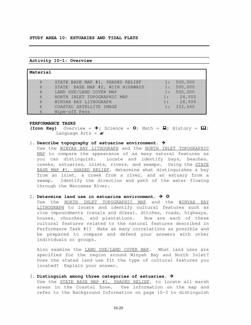
STUDY AREA 10: ESTUARIES AND TIDAL FLATS
Activity 10-1: Overview Material
6 STATE BASE MAP #1, SHADED RELIEF 1: 500,000 6 STATE BASE MAP #2, WITH HIGHWAYS 1: 500,000 6 LAND USE/LAND COVER MAP 1: 500,000 6 NORTH INLET TOPOGRAPHIC MAP 1: 24,000 6 WINYAH BAY LITHOGRAPH 1: 18,000 6 COASTAL SATELLITE IMAGE 1: 332,640 6 Wipe-off Pens
PERFORMANCE TASKS (Icon Key) Overview = !!!!; Science = """"; Math = ####; History = $$$$;
Language Arts = %%%%
1. Describe topography of estuarine environment. !!!! Use the WINYAH BAY LITHOGRAPH and the NORTH INLET TOPOGRAPHIC
MAP to compare the appearance of as many natural features as you can distinguish. Locate and identify bays, beaches, creeks, estuaries, inlets, rivers, and swamps. Using the STATE BASE MAP #1, SHADED RELIEF, determine what distinguishes a bay from an inlet, a creek from a river, and an estuary from a swamp. Identify the direction and path of the water flowing through the Waccamaw River.
2. Determine land use in estuarine environment. !!!! """" Use the NORTH INLET TOPOGRAPHIC MAP and the WINYAH BAY
LITHOGRAPH to locate and identify cultural features such as rice impoundments (canals and dikes), ditches, roads, highways, houses, churches, and plantations. How are each of these cultural features related to the natural features described in Performance Task #1? Make as many correlations as possible and be prepared to compare and defend your answers with other individuals or groups.
Also examine the LAND USE/LAND COVER MAP. What land uses are specified for the region around Winyah Bay and North Inlet? Does the stated land use fit the type of cultural features you located? Explain your answer.
3. Distinguish among three categories of estuaries. !!!! Use the STATE BASE MAP #1, SHADED RELIEF, to locate all marsh
areas in the Coastal Zone. Use information on the map and refer to the Background Information on page 10-3 to distinguish

10-21
salt marshes from brackish marshes from freshwater. Mark the locations of these features on the map using a different color wipe-off pen for each category. What map evidence did you use to make your determination? What general conclusions can you present to be able to distinguish these types easily?
10-22
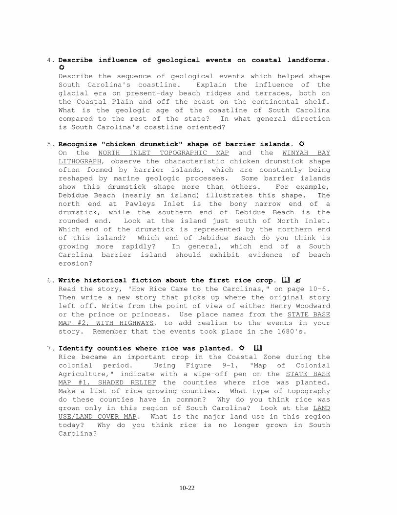
4. Describe influence of geological events on coastal landforms. """"
Describe the sequence of geological events which helped shape South Carolina's coastline. Explain the influence of the glacial era on present-day beach ridges and terraces, both on the Coastal Plain and off the coast on the continental shelf. What is the geologic age of the coastline of South Carolina compared to the rest of the state? In what general direction is South Carolina's coastline oriented?
5. Recognize "chicken drumstick" shape of barrier islands. """" On the NORTH INLET TOPOGRAPHIC MAP and the WINYAH BAY
LITHOGRAPH, observe the characteristic chicken drumstick shape often formed by barrier islands, which are constantly being reshaped by marine geologic processes. Some barrier islands show this drumstick shape more than others. For example, Debidue Beach (nearly an island) illustrates this shape. The north end at Pawleys Inlet is the bony narrow end of a drumstick, while the southern end of Debidue Beach is the rounded end. Look at the island just south of North Inlet. Which end of the drumstick is represented by the northern end of this island? Which end of Debidue Beach do you think is growing more rapidly? In general, which end of a South Carolina barrier island should exhibit evidence of beach erosion?
6. Write historical fiction about the first rice crop. $$$$ %%%% Read the story, "How Rice Came to the Carolinas," on page 10-6.
Then write a new story that picks up where the original story left off. Write from the point of view of either Henry Woodward or the prince or princess. Use place names from the STATE BASE MAP #2, WITH HIGHWAYS, to add realism to the events in your story. Remember that the events took place in the 1680's.
7. Identify counties where rice was planted. """" $$$$ Rice became an important crop in the Coastal Zone during the
colonial period. Using Figure 9-1, "Map of Colonial Agriculture," indicate with a wipe-off pen on the STATE BASE MAP #1, SHADED RELIEF the counties where rice was planted. Make a list of rice growing counties. What type of topography do these counties have in common? Why do you think rice was grown only in this region of South Carolina? Look at the LAND USE/LAND COVER MAP. What is the major land use in this region today? Why do you think rice is no longer grown in South Carolina?

10-23
ENRICHMENT 1. Use tide tables to explain tidal range along coast. """" The intertidal zone has played an important role in the shaping
of South Carolina's coast. Illustrate with a diagram the effect of the Moon and the Sun on the tides. Show the position of the Sun, Moon, and Earth during each phase of the moon. Explain how these positions affect daily tidal changes along South Carolina's coast. What position of the Moon and Sun causes the most damage to occur during a hurricane? At most South Carolina beaches, tide charts are available. Why are people interested in knowing when high and low tides will occur?
2. Find out how people lived and worked on plantations. $$$$ %%%% In the early 1900's, many years after the Civil War had
virtually ended the Rice Plantation Era, Elizabeth Allston Pringle struggled to keep her plantation together by cultivating rice. Named Chicora Wood, her plantation was located up the Pee Dee River from Georgetown. Through two books, A Woman Rice Planter and Chronicles of Chicora Wood, Mrs. Pringle gives a vivid account of the rice plantation era. Find out how the people lived, worked, and played on a plantation in that period of time.
3. Research how estuaries serve as filtering systems. """" How do estuaries serve as filtering systems for pollution and
storm water? Is there a limit to the ability of estuaries to serve as filtering systems? Explain.
4. Model the effects of longshore drift. """" This activity must be performed outdoors or in a large room
with no obstructions. Divide the class into two groups. Students in the first group will represent individual sand grains on a beach. Students in the second group will represent ocean waves. The groups should line up in two parallel rows about two feet apart, facing each other. At a teacher's signal, each student in the "wave" group should step forward and gently push a student "sand grain" backwards. The "wave" students should retreat and the "sand grain" students should return to their original position. Longshore drift can be modeled by having "wave" students approach and push "sand grains" at an angle. Regardless of the push angle, "sand grains" must always return in a path perpendicular to the "shoreline".
5. Diagram a typical food chain for salt marsh. """" Construct a food chain diagram for a saltwater marsh on Winyah
Bay. Next construct a similar food chain diagram for the
10-24
freshwater marshes along the Santee River. Compare the results, noting the similarities and differences in the following areas: animal and plant life, microscopic organisms, soil composition, and environmental benefits. Why must we protect our South Carolina estuaries?
6. Research story of Henry Woodward. """" $$$$ %%%% The legend of "How Rice Came to the Carolinas" (found on page
10-6) has little basis in fact except for the role that the Englishman Henry Woodward played. Yet the true life story of this rice planter who used the expertise of enslaved African laborers to begin the first successful rice plantation in South Carolina is almost equally as fantastic as this romantically Eurocentric tale of a princess from Madagascar and her beloved warrior. Research the factuality of each of the following statements, as they relate to Henry Woodward’s life.
a. In 1666 Woodward booked passage on an English ship sent to explore the coast of South Carolina for the purpose of establishing an English colony. b. After months at sea, the ship landed near modern-day Beaufort, SC. c. When the ship was ready to return to England, Woodward volunteered to stay behind as a good-will ambassador to the Native Americans. d. Soon after the ship left, he was captured and imprisoned by the Spanish. e. He escaped and joined the crew of an English privateer engaged in acts of piracy against the Spanish merchant ships in the Caribbean. f. Woodward was then shipwrecked on a Caribbean island during a hurricane. g. He was rescued by a passing English ship which happened to be carrying the colonists he was supposed to be waiting for back in the Carolinas. h. In 1670 the colony was established near modern-day Charleston. i. In the 1680’s, a sea captain gave Woodward a bag of rice seed. j. Experimenting with the rice, Woodward found it would grow abundantly in the Carolina marshlands. k. By the time of the American revolution, South Carolina was one of the largest producers of rice in the world. l. The heart of the rice empire was Waccamaw Neck, the narrow peninsula created by the Atlantic on the east and the Waccamaw River on the west.
10A-1
STUDY SITE 10A: WINYAH BAY (RICE CULTURE)
TThhee SSttaattee October 28, 1994
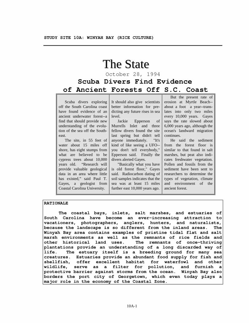
Scuba Divers Find Evidence of Ancient Forests Off S.C. Coast
Scuba divers exploring off the South Carolina coast have found evidence of an ancient underwater forest--a find that should provide new understanding of the evolu-tion of the sea off the South-east. The site, in 55 feet of water about 15 miles off shore, has eight stumps from what are believed to be cypress trees about 10,000 years old. “Research will provide valuable geological data in an area where little has existed,” said Paul T. Gayes, a geologist from Coastal Carolina University.
It should also give scientists better information for pre-dicting any future rises in sea level. Jackie Epperson of Murrells Inlet and three fellow divers found the site last spring but didn't tell anyone immediately. "It's kind of like seeing a UFO--you don't tell everybody," Epperson said. Finally the divers alerted Gayes. "Basically what you have is old forest floor," Gayes said. Radiocarbon dating of soil samples indicates that the sea was at least 15 miles further east 10,000 years ago.
But the present rate of erosion at Myrtle Beach--about a foot a year--trans-lates into only two miles every 10,000 years. Gayes says the rate slowed about 6,000 years ago, although the ocean's landward migration continues. He said the sediment from the forest floor is similar to that found in salt marshes, but peat also indi-cates freshwater vegetation. Pollen and fossils from the sediment have been sent to researchers to determine the types of vegetation, climate and environment of the ancient forest.
RATIONALE The coastal bays, inlets, salt marshes, and estuaries of South Carolina have become an ever-increasing attraction to vacationers, photographers, anglers, hunters, and naturalists, because the landscape is so different from the inland areas. The Winyah Bay area contains examples of pristine tidal flat and salt marsh environments as well as the remnants of rice fields and other historical land uses. The remnants of once-thriving plantations provide an understanding of a long discarded way of life. The estuary itself is a breeding ground for many sea creatures. Estuaries provide an abundant food supply for fish and shellfish, offer excellent habitat for waterfowl and other wildlife, serve as a filter for pollution, and furnish a protective barrier against storms from the ocean. Winyah Bay also borders the port city of Georgetown, which even today plays a major role in the economy of the Coastal Zone.
10A-2
Brief Site Description
Old Beach Ridges
Throughout the Coastal Zone, the distribution of wetlands, tidal flats, and even estuaries, to some extent, is influenced by the position of elongated, linear or arcuate (curved) beach ridges. These landforms are higher in elevation than the surrounding land and provide a very different habitat from tidal flat and marshland environments. As remnants of former shoreline positions, the ridges are mostly composed of coarse, well-sorted sand, characteristic of sand dunes or barrier island beachfront deposits.
As sea level changed, these beach ridges were alternately flooded and drained dry. Some ridges can be traced from land out into the ocean, indicating that shoreline positions of the past were not always exactly parallel to present positions. Where several beach ridges occur close together, they tend to form a wide band of raised topography, where most Coastal Zone development is concentrated. Because of their high sand content, beach ridges do not hold moisture well and can become very dry. Some of the plant communities characteristic of beach ridges are closely related to those of desert ecosystems, and are significantly different from the wet, muddy environments of estuaries, marshlands, and tidal flats.
Bellefield Nature Center
One of the foremost private nature preserves in South Carolina is Hobcaw Barony, 17,500 acres of land formerly acquired by the statesman Bernard Baruch. The land is now entrusted to the Belle W. Baruch Foundation to carry out studies in forestry, wildlife management, and marine science by South Carolina colleges and universities. The Baruch family initially purchased the property, including the rice fields and surrounding acreage around Winyah Bay, as a hunting retreat and vacation home. The original wood mansion burned nearly to the ground and was replaced by the present almost all-brick construction that faces Winyah Bay. For many years, the boat dock provided the only access to this plantation, even for visitors from nearby Georgetown. Famous visitors included President Franklin D. Roosevelt and British Prime Minister Sir Winston Churchill.
Today, the Hobcaw Barony mansion is preserved as a museum, and most of the grounds are devoted to nature study and to research in forestry and marine science. The Bellfield Nature Center, named for Baruch's daughter, provides a variety of marine environmental

10A-3
programs for school groups as well as tours through the mansion and the nearby remains of the village of Friendfield, quarters for slaves who worked the plantation. The relatively pristine complex of estuary, tidal flat, beach ridge, and salt marsh habitats provides an important comparison to the more highly developed and altered environments of Debidue Beach immediately to the north. Unfortunately, Hurricane Hugo destroyed the Marine Laboratory on the site and killed many trees by saltwater poisoning during the storm surge.
10A-4
Rice Cultivation
Most plantations in the Winyah Bay area specialized in rice cultivation. Along the rivers, plantation boundary lines were usually marked with ditches. Many of these ditches are still clearly visible on infrared aerial lithographs and topographic maps. In Waccamaw Neck, plantations were usually laid out as narrow strips of land running west to east between Winyah Bay and the Atlantic Ocean. The banks of the local rivers provided an excellent environment for tidewater rice culture because of the predictable ebb and flow of the tides. High tides naturally raised the level of the fresh water in streams, flooding the rice fields, while the low tides that followed dropped the level of the streams, draining the fields. The more dense salt water moving in with the tide caused the less dense fresh water to remain on top of the river. Dikes, levees, and other impoundments were constructed in such a way as to allow the upper, less dense fresh water layer to enter the fields while preventing the more dense salt water from contaminating the crops.
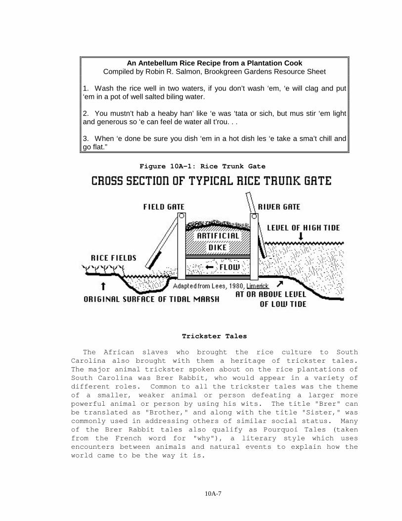
Once the dikes, ditches, canals, and banks were constructed and the fields cleared, rice trunks were built to allow water to pass over the rice fields. A rice trunk is simply a confined passageway in which the flow of water can be controlled connecting the rice fields with the river. Each rice trunk had a hanging gate at each end of the passageway. These gates could be opened manually by lifting or could swing open when pushed by floating water. To flood a field, the gate on the river side was raised during high tide, and river water rushed through the rice trunk, pushed open the swinging field gate, and washed over the rice fields. As the tide began to ebb and the river level began to fall, the field gate slammed shut to prevent any backflow of water into the river. When planters wished to drain the fields, the process was reversed. The field gate was raised during low tide, allowing the field water to wash through the rice trunk, push open the swinging river-gate, and discharge into the river.
The tools used to cultivate rice were crude by today's standards. Most of the work of rice culture was drudgery and took an immense amount of time and hard labor. The principle tool was the hoe. Other tools included the open-ended gourd for sowing the seed, sickles for harvesting the grain, wooden flails for threshing, and mortars and pestles for separating rice grains from the chaff.
Rice cultivation required a large number of slaves with year-round duties. Each month brought on different chores. In December and January, the stubble was burned from the previous year. Next, the fields had to be prepared by hoeing. Trunks, canals, and ditches had to be cleaned and repaired. Planting the
10A-5
crop, by dropping seed rice into shallow trenches, began in March and continued through April. Often a ball of clay was placed around each seed so that it would not float. Phases of the Moon were closely monitored so that the flooding of the fields at full Moon spring tide, the period of highest tides, would coincide with the sprouting of the rice. Water covered the rice fields for five days during this so-called "sprout flow." The fields were slowly drained during the next couple of weeks as the Moon changed to its first quarter phase, which brought a period of lower or neap tides. After fields were given two more hoeings, they were again flooded during the period called harvest flow and kept under water for six to eight weeks. During this time, the water was allowed to rise higher on the plants, keeping the water level just below the heads of the growing rice stalks.
Following the harvest flow, which usually came in late August or early September, the fields were drained and the stalks cut with sickles called rice hooks. The rice sheaves were bound, dried, and laid in parallel rows on a large sheet. Laborers began the task of separating the grain from the husk. Wooden flailing sticks were used to thresh the rice. Mortars were hollowed out of cypress logs, and pestles were used for removing the husks and polishing the grain. Harvesting was finished in November, just in time to begin the cycle of rice culture over again in December. During the peak period of rice cultivation, mills for pounding, the separation of the hulls from the kernels, were built along many of the local rivers. Some are still standing today as a reminder of the importance of rice cultivation to the economy of the Low Country of South Carolina.
Slavery on Waccamaw River Rice Plantations
From 1810 to 1860, slaves made up 85-89 percent of the total population of the Georgetown District. Figures from the records of Brookgreen Gardens indicate that, in 1860, ‘‘. . . the estate of Joshua John Ward owned 1,121 slaves. In that same year the estate listed 10,100 unimproved acres; 3,500 improved acres; an annual rice crop of 4,410,000 pounds; 1,260 pounds of rice produced per acre; and 3,933 pounds of rice produced per slave. The average price of a prime field hand was $700 to $1,200. Rice brought from 2.9 cents to 4.3 cents per pound.’’ In 1840, nearly half of the national production of rice came from the Georgetown District of South Carolina.
Slaves on rice plantations worked in what was called the ‘‘Task System.’’ Each slave had a specified task which was based on the worker’s age, ability, and physical condition. Categories of tasks were ‘‘full,’’ ‘‘three-quarter,” “ half,” and “ quarter.”
10A-6
The owner of Laurel Hill Plantation, Plowden Weston, defined a task as ‘‘as much work as the meanest hand can do in nine hours working industriously.’’ Slaves were given their task assignments in early morning. Once the work was complete, the slave could pursue personal interests. Slaves often worked together to help each other complete tasks, a tradition carried over from their original African culture. The singing of songs while working was another African custom which made the work seem to go faster and easier.
Both women and men worked in the rice fields, but the harder work of ditching, building embankments, and preparing the fields for planting was usually done by the men. Pregnant women were given maternity leaves of up to six weeks. The basic slave diet consisted of corn, peas, potatoes, and of course rice, along with a ration of molasses, salted fish, pork, and bacon. Each worker received two quarts of soup each day. The soup was usually made from fresh beef stock thickened with rice and garden vegetables.
10A-7
An Antebellum Rice Recipe from a Plantation Cook Compiled by Robin R. Salmon, Brookgreen Gardens Resource Sheet
1. Wash the rice well in two waters, if you don’t wash ‘em, ‘e will clag and put ‘em in a pot of well salted biling water. 2. You mustn’t hab a heaby han’ like ‘e was ‘tata or sich, but mus stir ‘em light and generous so ‘e can feel de water all t’rou. . . 3. When ‘e done be sure you dish ‘em in a hot dish les ‘e take a sma’t chill and go flat.”
Figure 10A-1: Rice Trunk Gate
Trickster Tales
The African slaves who brought the rice culture to South Carolina also brought with them a heritage of trickster tales. The major animal trickster spoken about on the rice plantations of South Carolina was Brer Rabbit, who would appear in a variety of different roles. Common to all the trickster tales was the theme of a smaller, weaker animal or person defeating a larger more powerful animal or person by using his wits. The title "Brer" can be translated as "Brother," and along with the title "Sister," was commonly used in addressing others of similar social status. Many of the Brer Rabbit tales also qualify as Pourquoi Tales (taken from the French word for "why"), a literary style which uses encounters between animals and natural events to explain how the world came to be the way it is.
10A-8
You Never Know What Trouble Is Until It Finds You abridged and adapted from a collection called Afro-American
Folktales, edited and selected by Roger D. Abrahams
One time, Brer Alligator’s back used to be smooth and white as a catfish skin. When he came out of the water and lay down to sleep in the hot sun, he shined like a piece of silver. He was mighty proud of that hide, and all ‘round stuck up and pleased with himself in every way. He and his wife and his family lived down in the river at the edge of a rice field down near Georgetown. They had plenty of fish to eat and never had to bother any of the animals on land. And they were so satisfied with themselves that they thought that there wasn’t anybody quite like them in the entire county. And they had no notion how true that was! Well, one hot day in the fall, Brer Gator was resting himself upon a rice field bank, letting the sun soak into that bright back of his, when along came Brer Rabbit. Now Brer Rabbit had no love for Brer Gator, but he stopped all the same to pass the time, to have a little conversation. Brer Rabbit loved to talk with anyone. So rather than keep his mouth shut he goes out of his way to talk. ‘‘Howdy, Brer Alligator. How is Sister Alligator, and all the young alligators making out?’’ Brer Gator didn’t even bother to reply at first. ‘‘Please God, they’re getting on just fine. But it’s no wonder that those children are smart and pretty and raised right, because they live right here in the river. I swear to God, I can’t see how you others get by living up on top of that dry, drafty land.’’ Brer Rabbit got really angry with Brer Gator for being so set in his notion and so superior in his manners. But you know how, even when he’s angry, he can hide it, so Brer Rabbit just stayed calm and pretended that Brer Gator is a wise man and sighs and says, ‘‘Maybe so. We sure have been seeing a lot of trouble up here lately.’’ ‘‘What’s that you’re talking about, Brer Rabbit--Trouble?’’ Brer Rabbit thought that Brer Gator must be joking with him. ‘‘What’s that, Brer Alligator! You never heard of--Trouble, Brer Rabbit shaking his head asks." ‘‘No. I never heard about him, nor have I seen him. What does he look like?’’ "Oh, for crying out loud, Brer Alligator! Old as you is, and you haven’t seen Trouble yet?’’ ‘‘I tell you, Brer Rabbit, I ain’t never known nothing about this here Trouble. What does Trouble look like?’’
10A-9
Brer Rabbit is mischievous and scheming and he takes his chance to teach Brer Alligator a lesson. ‘‘I don’t know that I can tell you exactly what Trouble looks like. But maybe you’d like to see him?’’ ‘‘Of course I can show him to you, Brer Alligator, but maybe you won’t really like him so well when you actually meet him.’’ Still full of himself, Brer Alligator says, ‘‘What are you talking about? I’m not worried about that. I just want to see him. If I don’t like him, that won’t matter to me at all.’’ ‘‘Well I’m pretty busy right now,’’ Brer Rabbit pretended. ‘‘Come now, Brer Rabbit! After all, it is me, Brer Alligator, that is requesting this from you, don’t forget that!’’ ‘‘Of course, how can I forget that!’’ Brer Rabbit mocked him, only Brer Gator didn’t never recognize that Brer Rabbit meant to trick him. Brer Rabbit protested that he had to fix up his house and said that Sister Rabbit wasn’t feeling well, the children had to be watched and what all. Brer Alligator just kept on coaxing and begging ‘til at last Brer Rabbit agreed to show him Trouble. ‘‘Meet me here as soon as the dew is dry on the grass next Saturday. Trouble may have some time off on Saturday.’’ And Brer Rabbit bid him good morning and went along down the road. On came Saturday, and Brer Gator got up before dawn and started to make himself presentable. Sister Alligator woke up and asked, ‘‘Where are you going?’’ Brer Gator didn’t bother to answer, but Sister Alligator kept on asking until finally he said, ‘‘I am going out with Brer Rabbit.’’ Sister Alligator kept right on askin’ so Brer Alligator made a long mouth and tried to pay her no more attention, but Sister Alligator knew how to handle him. So after a while he told her that he was going to meet Trouble. Sister Alligator says, ‘‘What is Trouble?’’ Brer Alligator answers, ‘‘How do I know? That’s what I’m going to see.’’ ‘‘Can I go along,’’ asked Sister Alligator. ‘‘No,’’ says he. But after he saw that the woman would not shut up he said, "All right, you can come along.’’ His patience was worn thin. After a while all the little alligators noticed their pappy and their mammy fixing themselves up and then nothing would have it but they had to go too. Then they fixed themselves all up too with mud on their heads, marsh on their backs, and moonshine on their tails and didn’t they think they looked fine! About this time Brer Alligator looked out the door and saw that the dew was almost gone, so he called them all to come on. They all came out crowding each other, going down the rice-field bank to wait for Brer Rabbit. They hadn’t been there long before Brer Rabbit came along and when he got to where they were, he was surprised to see the whole family there. He laughed to himself, but
10A-10
he didn’t say anything but ‘‘Howdy’’ to Brer Gator and his wife. He told them, ‘‘How nice your children look today!’’ But all the time he was saying to himself, ‘‘Oh Lord! This is an ugly gang of people, aren’t they? And just look at those clothes!’’ All the little alligators were so excited because they feared Brer Rabbit was going to send them home that they danced about for joy. Brer Rabbit wanted to laugh but instead he just looked at his watch and knitted his brows and said, ‘‘Time to get going, I guess.’’ So they all started down the rice field bank, Brer Rabbit and Brer Gator leading off, with Sister Alligator walking behind to make the little alligators behave themselves. But they wouldn’t hardly mind her, they played along, dawdled, or fought ‘til they almost drove her crazy. Brer Rabbit led them up through a patch of woods until he got to a field grown over with broomgrass and briar! The grass stood like pure gold. The path they took went straight through this big field. When they got to the middle of the field he stopped and cupped his ear and pretended to be listening for something. ‘‘Sh! Sh! he told the children. Sister Alligator said, ‘‘Sh! Sh! Or I’ll lick the tar out of you! Shh! Shh!’’ Brer Rabbit listened some more and then he shouted out, ‘‘Who is that calling Brer Rabbit?’’ Then he pretended that he heard something more, and he yelled back, ‘‘Yes, It’s me. What do you want with me?’’ He cupped his hand to his ear again, and then he said, ‘‘I am coming right now.’’ And he turned to Brer Gator and told him, ‘‘I beg your pardon, but somebody is calling me away for a minute on business. Please excuse me. Wait right here, and I’ll be right back.’’ ‘‘We aren’t going anyplace,’’ Brer Gator promised. Brer Rabbit made a low bow and ran along the path out of sight. That deceitful devil ran until he got to the edge of the wood, and he sat down and chuckled to himself like he was tasting the fun before it started. Then he got down to business. He smelled the wind and looked which way it was blowing. Then he pulled a handful of that long, dry broomgrass down, pulled a match from his pocket, struck it and lit the broomstraw blowing on it till the grass caught fire good. Then he ran along the edge of the field and set the field ablaze all around. When he was finished, he got up on a safe high stump where he could see good and he sat down. All the while Brer Alligator was back in the center of the field trying to rest with Sister Alligator and all the little alligator brats just pestering him to death saying, ‘‘Which way are we going to find Trouble? How long do we have to wait?’’ They sat and they sat until finally the
10A-11
wind caught the fire and the fire flared high and the sparks and flames flew way up in the sky. One of the little alligators saw that and he hollered, ‘‘Oh look! That must be Trouble! Trouble is pretty! Trouble is pretty!’’ Then all the little alligator brats sang out, ‘‘Trouble is pretty!’’ But at last one of the hot sparks landed right on one of the little alligators’ back. He screamed and cried, ‘‘Trouble hurts!’’ His mother smacked him in the jaw and told him to mind his manners and to shut up, and to look at how pretty Trouble is. But just as she did that, a big spark lit on her and burned her bad. She started jumping around and hollering, ‘‘It’s true; Trouble hurts!’’ And they remembered then who they had forgotten. They called, ‘‘Brer Rabbit! We don’t want to see no more Trouble, Brer Rabbit!’’ By this time the sparks began to burn the whole bunch and they were so mixed up they didn’t know what to do. They ran around and ran around this way and that, to get away, but everywhere they turned was fire. They hollered and hollered, ‘‘Brer Rabbit, where are you? Call to Trouble, Brer Rabbit! Come for us!’’ But Brer Rabbit didn’t come and he didn’t say anything. And very soon the fire got so close to those gators that they couldn’t hold their ground any longer. They stopped calling Brer Rabbit, and got ready to get through the fire the best they could. They didn’t have any notion left in their head but, Get Home! They went right through the scorching flames right past Brer Rabbit on the stump but they were going too fast to see him. ‘‘Wait, Brer Alligator!’’ he shouted, ‘‘I guess you have seen Trouble now! Get back in the water where you belong. And don’t ever hunt Trouble again.’’ And they didn’t stop either ‘til they got to the rice field bank and jumped in the river with a ‘‘Swiish-ss-sh.” When they finally got a chance to look at each other they found that their white skin was just as black and crinkly as a burned log of wood, and as rough as live oak bark. From that day to this, alligators have had a horny hide.
10A-12
Activity 10A-1: Plantations and the Rice Culture Materials
6 STATE BASE MAP #1, SHADED RELIEF 1 : 500,000 6 STATE BASE MAP #2, WITH HIGHWAYS 1 : 500,000 6 LAND USE/LAND COVER MAP 1: 500,000 6 GENERAL SOIL MAP 1: 594,000 6 GEOLOGIC AND MINERAL RESOURCE MAP 1: 1,000,000 6 NORTH INLET TOPOGRAPHIC MAP 1: 24,000 6 NORTH INLET LITHOGRAPH 1: 12,000 6 WINYAH BAY LITHOGRAPH 1: 18,000 1 State Map of Major Drainage Basins Figure 1-2 6 Wipe-off Pens
PERFORMANCE TASKS (Icon Key) Overview = !!!!; Science = """"; Math = ####; History = $$$$;
Language Arts = %%%%
1. Locate the study site. !!!! """" Locate the Winyah Bay Study Site on the STATE BASE MAP #2, WITH
HIGHWAYS, on the LAND USE/LAND COVER MAP, on the GEOLOGIC AND MINERAL RESOURCE MAP, and on the GENERAL SOIL MAP by drawing a small box around the correct site on each map using a wipe-off pen. Briefly summarize the one or two most important land uses at this site, the age (Geologic Period), the type of rock at the site, and the predominant soil type at the site. Use the scale bar on the base map to estimate the straight-line distance between this study site and your school. Through which of the major river systems, Savannah, Santee, Pee Dee, or Coastal Plain, does this site drain? Refer to Figure 1-2, "State Map of Major Drainage Basins."
2. Locate natural and man-made features. !!!! Compare the NORTH INLET TOPOGRAPHIC MAP with the WINYAH BAY
LITHOGRAPH. Locate North Inlet, Waccamaw Neck, Debidue Beach, Debidue Creek, Bellefield Plantation, Arcadia Plantation, Bellefield Nature Center, US Hwy. 17, and old rice field impoundments along the Waccamaw River and Waccamaw Neck. How is the Waccamaw Neck area drained? Use a wipe-off pen to indicate drainage patterns. Locate the major drainage ditch extending from US Hwy. 17 to Debidue Beach. Determine the direction the ditch water is flowing by using the contour lines on the topographic map. Just barely visible on the lithograph are the original drainage ditches running in almost parallel bands in an east-west direction. These ditches marked the boundary lines between original land grant plantations and provided the owners access to both the Waccamaw River and the Atlantic Ocean. Locate a spoils pile of dredged material on the bank of the Waccamaw River.
10A-13
3. Compare marsh and wooded areas. !!!! Refer to the NORTH INLET TOPOGRAPHIC MAP and the WINYAH BAY
LITHOGRAPH. Notice, especially on the lithograph, several arc-shaped patterns of land covered by trees and other vegetation that have formed on ancient dune ridges over a long period of time. Analyze the topographic map symbols representing marsh and wooded areas to distinguish between areas of maritime (coastal) forest and tidal zone marshes on the topographic map. Compare these same areas on the lithograph and determine the type of vegetation present by using your understanding of false-color infrared photographs, by referring to Figure 3, "Interpreting Infrared Images," in the Introductory Section, and by using the specific color codes below. Focus on the different hues of reds and grays to identify the different types of foliage found in maritime (coastal) forests, old rice fields, and oceanfront beach areas.
gums, cypress, oaks (leaf-off condition - winter) = gray-green to very dark red
pines and other evergreens (with leaves) = red to grayish-red
estuaries or saltwater marshes = various shades of purplish-gray.
brackish-water marshes or rice field impoundments = blue-gray or steel-gray
rice field impoundments planted with a winter cover crop = bright pinkish-red.
4. Analyze changes through time. !!!! On the NORTH INLET TOPOGRAPHIC MAP, notice the features shown
in purple. These represent developments or changes which have occurred between 1942 when the topographic map was first printed and 1973 when the photorevised version was printed. Identify major new features not present on the original map. What section of the map area has experienced the most change? How many of these changes are man-made? How many have occurred naturally? Why do you think these changes have occurred? How many of these changes can you recognize on the WINYAH BAY LITHOGRAPH? In what year was the aerial photograph taken? Circle and explain any additional changes which occurred between the time the map was revised and the time the photograph was taken. Does the difference in scale make it easier to recognize changes on the lithograph or the map? Explain your answer.
5. Locate several plantation sites. """"$$$$ The NORTH INLET TOPOGRAPHIC MAP names two plantation sites
still in existence. Locate these plantations. Discuss the
10A-14
strategic location of each in relation to rice fields, water transportation, and inland roads. Based on map data, explain why you think planters chose these particular locations for their plantations.
6. Examine parallel remnants of former beach ridges. """" With the NORTH INLET LITHOGRAPH, locate several parallel beach
ridges left by a previous shoreline. Describe the terrain and vegetation of the beach ridges and compare to the terrain and vegetation of marsh or tidal areas. Are the older beach ridges exactly parallel to the modern shoreline? How many different beach ridges can you identify? Assume differences in vegetation (color) are caused by differences in elevation. Is the elevation of each ridge is constant? Explain your answer.
7. Analyze the newspaper article. """" %%%% Read the newspaper article on page 10A-1, "Scuba Divers Find
Evidence of Ancient Forests Off S.C. Coast." Explain how the story relates to the Coastal Zone Landform Region. Identify on the STATE BASE MAP #2, WITH HIGHWAYS, (refer to the COASTAL SATELLITE IMAGE if needed), where the places and events named in the story might be located. Explain why the publisher thought this story might be of interest to newspaper readers. Using the same references and setting, write another newspaper article related to the same situation, but date it far enough in either the future or the past so that you will have some changes to report. Choose a title (headline) and draw an appropriate picture to illustrate your main point.
8. Estimate size of average rice field impoundment. #### Using the NORTH INLET TOPOGRAPHIC MAP, estimate the size (in
acres) of the average rice field impoundment along the Waccamaw and Pee Dee rivers. Use a ruler to measure the dimensions of 5-10 fields before calculating the average field area in square inches. Assume fields are separated by drainage ditches. Use the scale bar on the map to convert your answer to square feet, and then convert your answer to acres (1 acre = 43,560 square feet). Also determine the median and the mode of your statistical data. Notice the map patterns made by the rice field impoundment ditches which regulated the water entering and leaving the fields. Why do you think the ditches were dug perpendicular to the rivers? Would you have placed the ditches differently? Explain your answer.
9. Outline steps necessary for planting rice. $$$$ Cultivating rice was a year-long, labor-intensive process.
Using the paragraphs entitled ‘‘Rice Cultivation" on pages 10A-3 and 10A-4, make a year-long histograph (timeline) outlining the steps for cultivating rice. Next, answer the following questions. In what months was rice planted? Why was it
10A-15
necessary to flood the rice fields? List any other advantages you can think of to flooding the rice fields periodically. How long did it take rice seeds to mature? When was rice harvested? After removing the rice from the fields, what was the next step in preparing it for the market? Why was rice cultivation such a labor-intensive crop? Refer to the WINYAH BAY LITHOGRAPH and the NORTH INLET TOPOGRAPHIC MAP to identify possible locations where each of the above steps would have been carried out. Also locate Bellefield Plantation, where the owners lived, and the slave community of Friendfield. Lastly, identify possible routes by which the final product was taken to market.
10. Graph and analyze rice production. #### Use Figure 10-1, “ Comparison of State Agricultural Production,
1860,’’ to calculate each state's percentage of rice grown in relation to the total United States rice production. Rank these states in descending order according to rice production. What place did South Carolina hold in this ranking? Make a pie graph showing the percentages for the top four states. Have one slice show all other states combined. How did our neighboring states, Georgia and North Carolina rank? Using only your percent rankings and your knowledge of the topography necessary for rice production, compare South Carolina's coastal region with that of Georgia and North Carolina.
11. Analyze why escape was difficult for slaves. $$$$ Study the NORTH INLET TOPOGRAPHIC MAP and the STATE BASE MAP
#1, SHADED RELIEF. Why do you think escape was extremely difficult for the African slaves during the period from the early 1700's to the mid 1800's? What were the problems they encountered in escaping from plantations? Before the advent of highways, where could they go?
10A-16
12. Relate life story of a 200 year-old fanner basket. $$$$ %%%% The fanner basket, still available for purchase in sweet grass
basket stands along the coast, was used during harvest to separate the grains of rice from their husks. People in Sierra Leone, Africa, still make a basket very similar to those made in South Carolina. Enslaved Africans brought this rice-related craft to South Carolina along with their methods of cultivating rice. Pretend to be a two hundred year-old fanner basket handed down through eight generations in a South Carolina family. Give yourself a voice. Write an eight stanza poem with four lines per stanza. Include references to rice cultivation, local landscape and local history in each stanza. Refer to several landform characteristics in the Winyah Bay area as you tell your story.
13. Solve Alexander the Ant's problem. #### Alexander the Ant lives in a rice field on the Waccamaw River.
He moved in when the rice was beginning to grow and did not need additional irrigation. He worked hard to store up 3,000 rice grains for his future food supply. Now Alexander has overheard some field workers say that the land is going to be flooded soon for harvest, so he has to move back to his old home 1,000 feet away. Alexander decides he wants to take the rice he has collected with him. As he begins his journey, he finds he can only carry 1,000 rice grains at a time. He has to eat one rice grain for every foot that he travels in order to keep up his strength.
Alexander's problem: What is the greatest number of grains that he can amass at his new home?
14. Explain relationship of physical setting to Pourquoi Tale.
$$$$ %%%% The Brer Rabbit story (found on page 10A-6) is set in a rice
field. Using the NORTH INLET TOPOGRAPHIC MAP, find the ditches along the rivers that marked the boundaries of the old rice plantations. Considering elements visible on the topographic map, decide what kinds of settings will be favored by the future tellers of Pourquoi Tales in this area. What do you think is the most popular medium for storytelling today? How does this medium tie together stories with their physical setting?
15. Write your own Pourquoi Tale for this region. %%%% The Brer Rabbit story (found on page 10A-6) explains why
alligators have a horny hide. Use the following list of suggestions, or your own mental list of observations of Low Country land and sea scapes, flora and fauna, etc., to develop a Pourquoi Tale of your own (remember pourquoi means "why" in
10A-17
French). You may choose to use a known folk hero like Brer Rabbit or you may choose to develop a wily trickster character of your own, or you may make yours a romantic tale. To borrow the phrase of famed African- American folklorist Zora Neale Hurston, what should follow will be ‘‘lies above suspicion.’’ The only requirement is that in the Pourquoi Tale tradition you explain some fact of nature in a memorable way that totally ignores science. Above all, relax and have fun with your story! Remember to give your tale an intriguing title.
* Why so many cockroaches live in the South Carolina Low Country
* Why seagulls are such greedy birds
* How the sea islands came to protect the mainland * How the oyster got such a homely shell but the sweetest
juice
* How sea grass learned to dance so gracefully
* Why the mosquito has such a nasty disposition
* Why shrimp caught in South Carolina taste better than those caught in Florida
* Why fiddler crabs fight all the time and only walk sideways
* Why hermit crabs can never have a home of their own
* Why azaleas have so many flowers and so many gaudy colors of flowers
* Why Carolina jasmine smells so sweet * How the palmetto tree came to effectively guard the
Carolina coast against hurricanes and other eroding and destructive agents
ENRICHMENT 1. Determine effect of end of slavery on rice cultivation. $$$$ Some sources say that the Civil War and the abolition of
slavery greatly impacted the rice industry in South Carolina. Others credit the series of terrible hurricanes that struck the Carolina coast with ultimately making the growing of rice unprofitable. Do some research and try to settle this question for yourself. After researching the impact of hurricanes on rice cultivation in the state, use the voice of either a rice planter, an overseer or the descendant of an enslaved African-American field-hand living in the early part of the twentieth century to explain the effect of hurricanes on the cultivation of rice.
2. Invite a storyteller to perform for the class. %%%% Invite a storyteller who includes Brer Rabbit or Gullah tales
in his or her repertoire to perform for the class.
10A-18
3. Collect samples of Pourquoi Tales. %%%% Make a list of stories you are familiar with which explain some
aspect of nature. Try to include one from as many different cultures as possible. You may be familiar with tales such as ‘‘Why Mosquitoes Buzz in People’s Ears’’ and ‘‘How the Elephant Got Its Trunk.’’ Discuss the ways these tales are alike and the ways they are different. Decide which ones are most familiar and why. What physical environments are described in each of these stories?


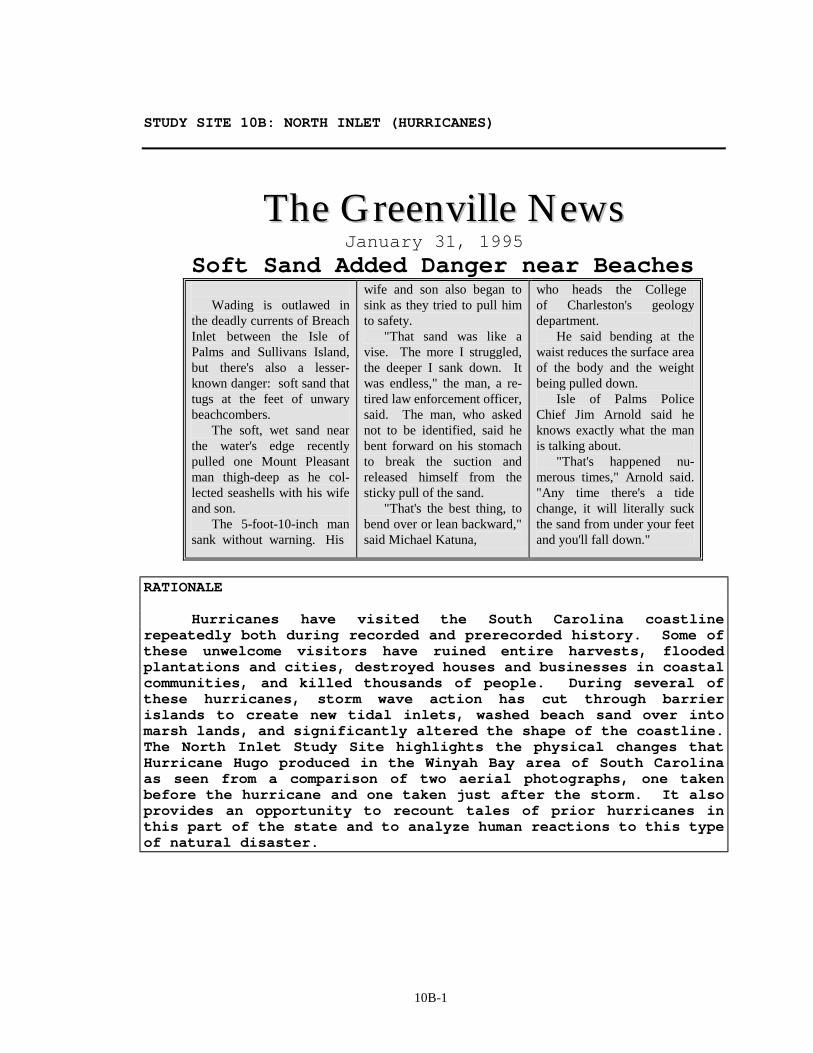
10B-1
STUDY SITE 10B: NORTH INLET (HURRICANES)
TThhee GGrreeeennvviillllee NNeewwss
January 31, 1995
Soft Sand Added Danger near Beaches Wading is outlawed in the deadly currents of Breach Inlet between the Isle of Palms and Sullivans Island, but there's also a lesser-known danger: soft sand that tugs at the feet of unwary beachcombers. The soft, wet sand near the water's edge recently pulled one Mount Pleasant man thigh-deep as he col-lected seashells with his wife and son. The 5-foot-10-inch man sank without warning. His
wife and son also began to sink as they tried to pull him to safety. "That sand was like a vise. The more I struggled, the deeper I sank down. It was endless," the man, a re-tired law enforcement officer, said. The man, who asked not to be identified, said he bent forward on his stomach to break the suction and released himself from the sticky pull of the sand. "That's the best thing, to bend over or lean backward," said Michael Katuna,
who heads the College of Charleston's geology department. He said bending at the waist reduces the surface area of the body and the weight being pulled down. Isle of Palms Police Chief Jim Arnold said he knows exactly what the man is talking about. "That's happened nu-merous times," Arnold said. "Any time there's a tide change, it will literally suck the sand from under your feet and you'll fall down."
RATIONALE Hurricanes have visited the South Carolina coastline repeatedly both during recorded and prerecorded history. Some of these unwelcome visitors have ruined entire harvests, flooded plantations and cities, destroyed houses and businesses in coastal communities, and killed thousands of people. During several of these hurricanes, storm wave action has cut through barrier islands to create new tidal inlets, washed beach sand over into marsh lands, and significantly altered the shape of the coastline. The North Inlet Study Site highlights the physical changes that Hurricane Hugo produced in the Winyah Bay area of South Carolina as seen from a comparison of two aerial photographs, one taken before the hurricane and one taken just after the storm. It also provides an opportunity to recount tales of prior hurricanes in this part of the state and to analyze human reactions to this type of natural disaster.
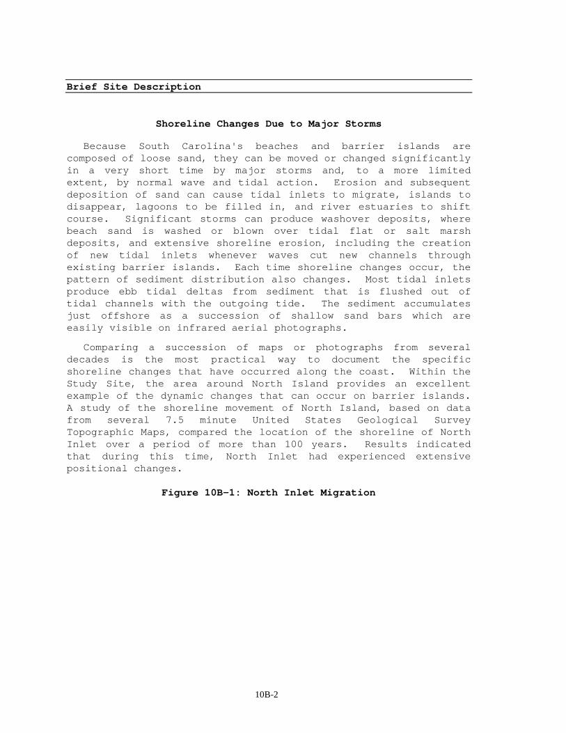
10B-2
Brief Site Description
Shoreline Changes Due to Major Storms
Because South Carolina's beaches and barrier islands are composed of loose sand, they can be moved or changed significantly in a very short time by major storms and, to a more limited extent, by normal wave and tidal action. Erosion and subsequent deposition of sand can cause tidal inlets to migrate, islands to disappear, lagoons to be filled in, and river estuaries to shift course. Significant storms can produce washover deposits, where beach sand is washed or blown over tidal flat or salt marsh deposits, and extensive shoreline erosion, including the creation of new tidal inlets whenever waves cut new channels through existing barrier islands. Each time shoreline changes occur, the pattern of sediment distribution also changes. Most tidal inlets produce ebb tidal deltas from sediment that is flushed out of tidal channels with the outgoing tide. The sediment accumulates just offshore as a succession of shallow sand bars which are easily visible on infrared aerial photographs.
Comparing a succession of maps or photographs from several decades is the most practical way to document the specific shoreline changes that have occurred along the coast. Within the Study Site, the area around North Island provides an excellent example of the dynamic changes that can occur on barrier islands. A study of the shoreline movement of North Island, based on data from several 7.5 minute United States Geological Survey Topographic Maps, compared the location of the shoreline of North Inlet over a period of more than 100 years. Results indicated that during this time, North Inlet had experienced extensive positional changes.
Figure 10B-1: North Inlet Migration
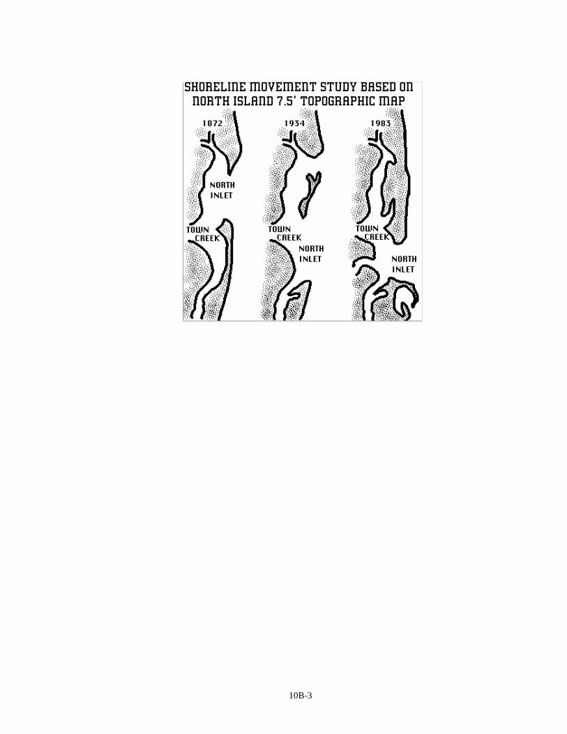
10B-3
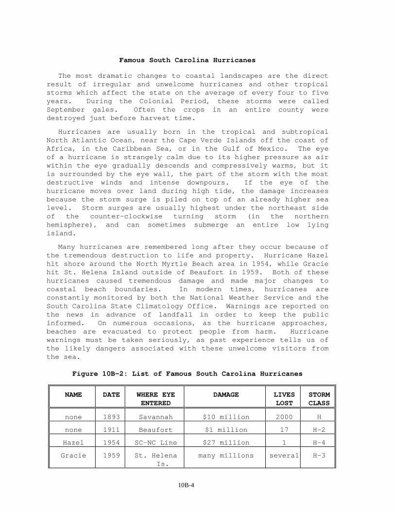
10B-4
Famous South Carolina Hurricanes
The most dramatic changes to coastal landscapes are the direct result of irregular and unwelcome hurricanes and other tropical storms which affect the state on the average of every four to five years. During the Colonial Period, these storms were called September gales. Often the crops in an entire county were destroyed just before harvest time.
Hurricanes are usually born in the tropical and subtropical North Atlantic Ocean, near the Cape Verde Islands off the coast of Africa, in the Caribbean Sea, or in the Gulf of Mexico. The eye of a hurricane is strangely calm due to its higher pressure as air within the eye gradually descends and compressively warms, but it is surrounded by the eye wall, the part of the storm with the most destructive winds and intense downpours. If the eye of the hurricane moves over land during high tide, the damage increases because the storm surge is piled on top of an already higher sea level. Storm surges are usually highest under the northeast side of the counter-clockwise turning storm (in the northern hemisphere), and can sometimes submerge an entire low lying island.
Many hurricanes are remembered long after they occur because of the tremendous destruction to life and property. Hurricane Hazel hit shore around the North Myrtle Beach area in 1954, while Gracie hit St. Helena Island outside of Beaufort in 1959. Both of these hurricanes caused tremendous damage and made major changes to coastal beach boundaries. In modern times, hurricanes are constantly monitored by both the National Weather Service and the South Carolina State Climatology Office. Warnings are reported on the news in advance of landfall in order to keep the public informed. On numerous occasions, as the hurricane approaches, beaches are evacuated to protect people from harm. Hurricane warnings must be taken seriously, as past experience tells us of the likely dangers associated with these unwelcome visitors from the sea.
Figure 10B-2: List of Famous South Carolina Hurricanes
NAME DATE WHERE EYE ENTERED
DAMAGE LIVES LOST
STORM CLASS
none 1893 Savannah $10 million 2000 H
none 1911 Beaufort $1 million 17 H-2
Hazel 1954 SC-NC Line $27 million 1 H-4
Gracie 1959 St. Helena Is.
many millions several H-3

10B-5
David 1979 Savannah $10 million N/A H-2
Hugo 1989 Charleston $6 billion 35 H-4
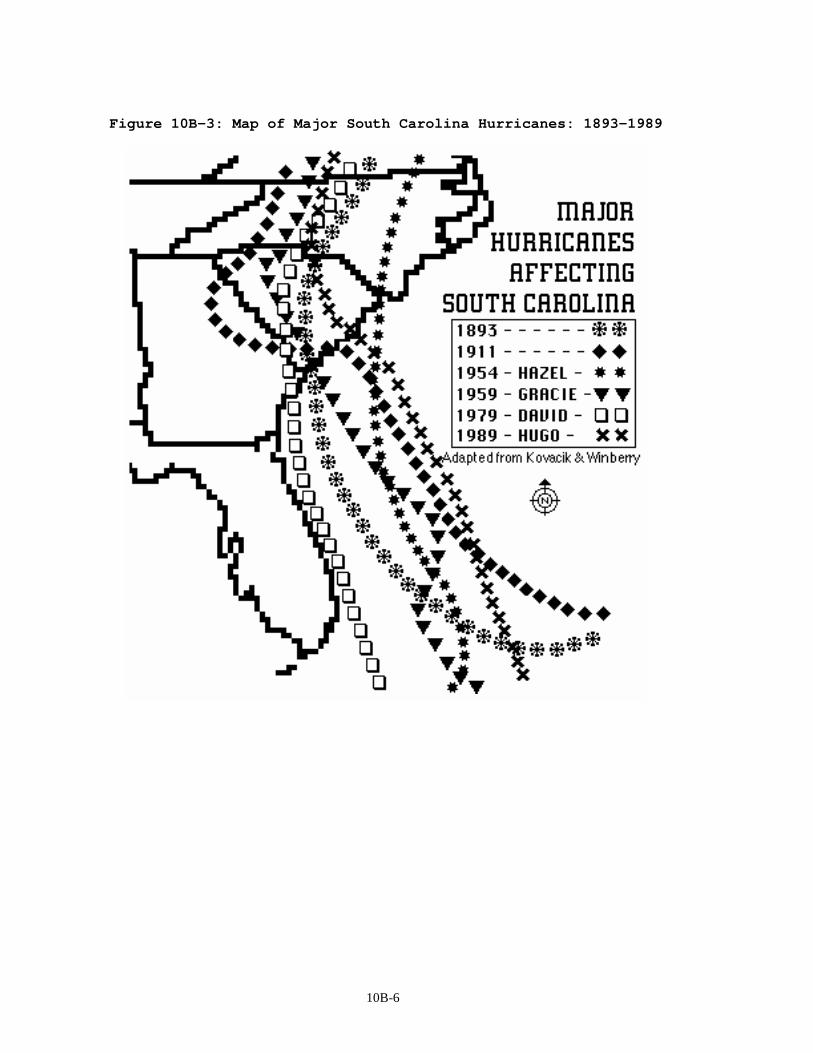
10B-6
Figure 10B-3: Map of Major South Carolina Hurricanes: 1893-1989
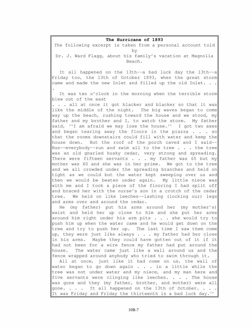
10B-7
The Hurricane of 1893 The following excerpt is taken from a personal account told
by Dr. J. Ward Flagg, about his family’s vacation at Magnolia
Beach. It all happened on the 13th--a bad luck day the 13th--a Friday too, the 13th of October 1893, when the great storm came and made the new Inlet and filled up the old Inlet. . . . It was ten o’clock in the morning when the terrible storm blew out of the east . . . all at once it got blacker and blacker so that it was like the middle of the night. The big waves began to come way up the beach, rushing toward the house and we stood, my father and my brother and I, to watch the storm. My father said, ‘‘I am afraid we may lose the house.’’ I got two axes and began tearing away the floors in the piazza . . . so that the rooms downstairs could fill with water and keep the house down. But the roof of the porch caved and I said--Run--everybody--run and swim all to the tree . . . the tree was an old gnarled husky cedar, very strong and spreading. There were fifteen servants . . . my father was 65 but my mother was 60 and she was in her prime. We got to the tree and we all crowded under the spreading branches and held on tight as we could but the water kept sweeping over us and then we would be beaten under again. My little niece was with me and I took a piece of the flooring I had split off and braced her with the nurse’s son in a crotch of the cedar tree. We held on like leeches--lashing (locking our) legs and arms over and around the cedar. He (my father) put his arms around her (my mother’s) waist and held her up close to him and she put her arms around him right under his arm pits . . . she would try to push him up when the water came and he would get down on the tree and try to push her up. The last time I saw them come up, they were just like always . . . my father had her close in his arms. Maybe they could have gotten out of it if it had not been for a wire fence my father had put around the house. The water came just like a wall around us and the fence wrapped around anybody who tried to swim through it. All at once, just like it had come on us, the wall of water began to go down again . . . in a little while the tree was not under water and my niece, and my man here and five servants were clinging like leeches. . . . The house was gone and they (my father, brother, and mother) were all gone. . . . It all happened on the 13th of October. . . . It was Friday and Friday the thirteenth is a bad luck day.’’

10B-8
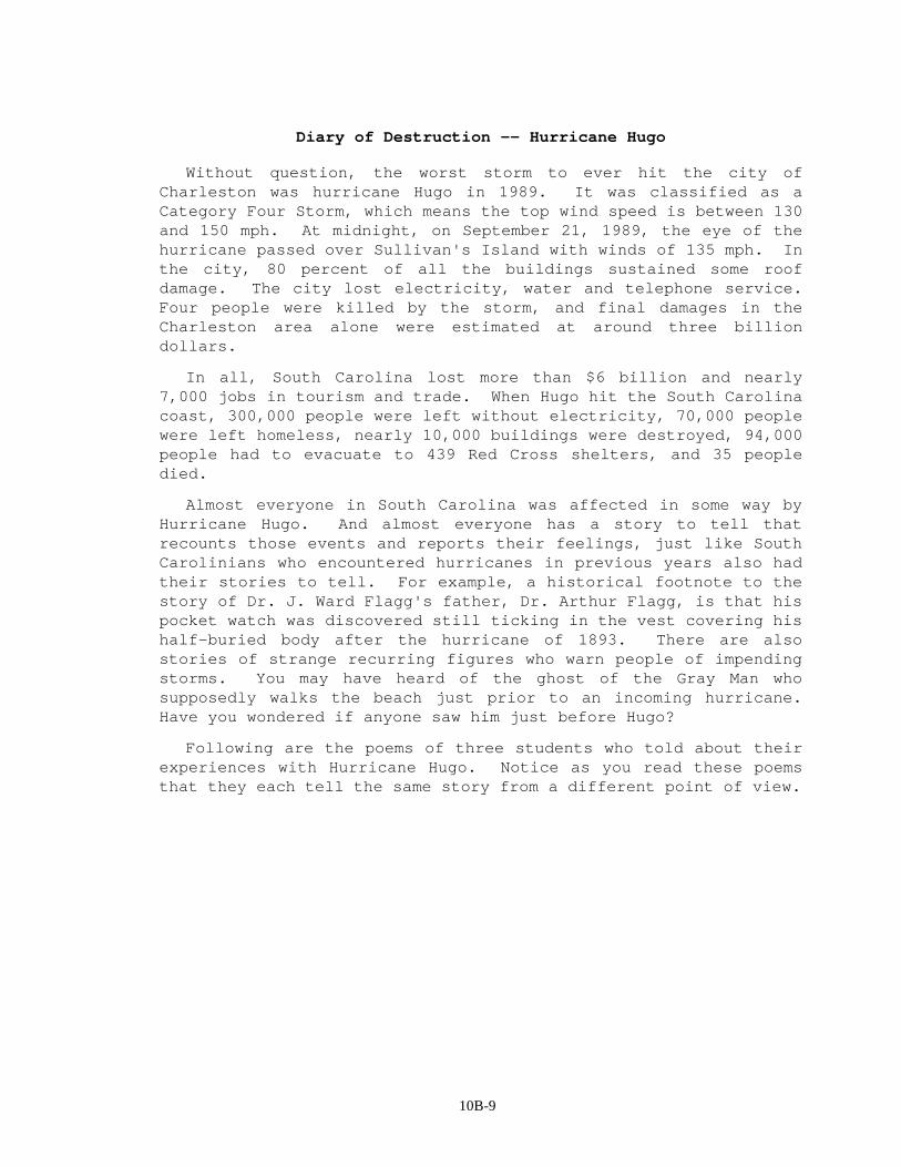
10B-9
Diary of Destruction -- Hurricane Hugo
Without question, the worst storm to ever hit the city of Charleston was hurricane Hugo in 1989. It was classified as a Category Four Storm, which means the top wind speed is between 130 and 150 mph. At midnight, on September 21, 1989, the eye of the hurricane passed over Sullivan's Island with winds of 135 mph. In the city, 80 percent of all the buildings sustained some roof damage. The city lost electricity, water and telephone service. Four people were killed by the storm, and final damages in the Charleston area alone were estimated at around three billion dollars.
In all, South Carolina lost more than $6 billion and nearly 7,000 jobs in tourism and trade. When Hugo hit the South Carolina coast, 300,000 people were left without electricity, 70,000 people were left homeless, nearly 10,000 buildings were destroyed, 94,000 people had to evacuate to 439 Red Cross shelters, and 35 people died.
Almost everyone in South Carolina was affected in some way by Hurricane Hugo. And almost everyone has a story to tell that recounts those events and reports their feelings, just like South Carolinians who encountered hurricanes in previous years also had their stories to tell. For example, a historical footnote to the story of Dr. J. Ward Flagg's father, Dr. Arthur Flagg, is that his pocket watch was discovered still ticking in the vest covering his half-buried body after the hurricane of 1893. There are also stories of strange recurring figures who warn people of impending storms. You may have heard of the ghost of the Gray Man who supposedly walks the beach just prior to an incoming hurricane. Have you wondered if anyone saw him just before Hugo?
Following are the poems of three students who told about their experiences with Hurricane Hugo. Notice as you read these poems that they each tell the same story from a different point of view.
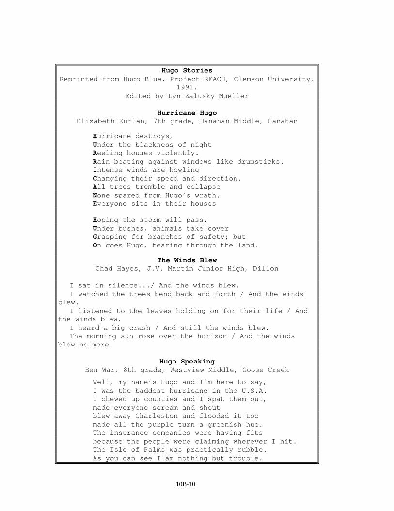
10B-10
Hugo Stories Reprinted from Hugo Blue. Project REACH, Clemson University,
1991. Edited by Lyn Zalusky Mueller
Hurricane Hugo
Elizabeth Kurlan, 7th grade, Hanahan Middle, Hanahan
Hurricane destroys, Under the blackness of night Reeling houses violently. Rain beating against windows like drumsticks. Intense winds are howling Changing their speed and direction. All trees tremble and collapse None spared from Hugo’s wrath. Everyone sits in their houses
Hoping the storm will pass. Under bushes, animals take cover Grasping for branches of safety; but On goes Hugo, tearing through the land.
The Winds Blew Chad Hayes, J.V. Martin Junior High, Dillon
I sat in silence.../ And the winds blew. I watched the trees bend back and forth / And the winds blew. I listened to the leaves holding on for their life / And the winds blew. I heard a big crash / And still the winds blew. The morning sun rose over the horizon / And the winds blew no more.
Hugo Speaking
Ben War, 8th grade, Westview Middle, Goose Creek
Well, my name’s Hugo and I’m here to say, I was the baddest hurricane in the U.S.A. I chewed up counties and I spat them out, made everyone scream and shout blew away Charleston and flooded it too made all the purple turn a greenish hue. The insurance companies were having fits because the people were claiming wherever I hit. The Isle of Palms was practically rubble. As you can see I am nothing but trouble.
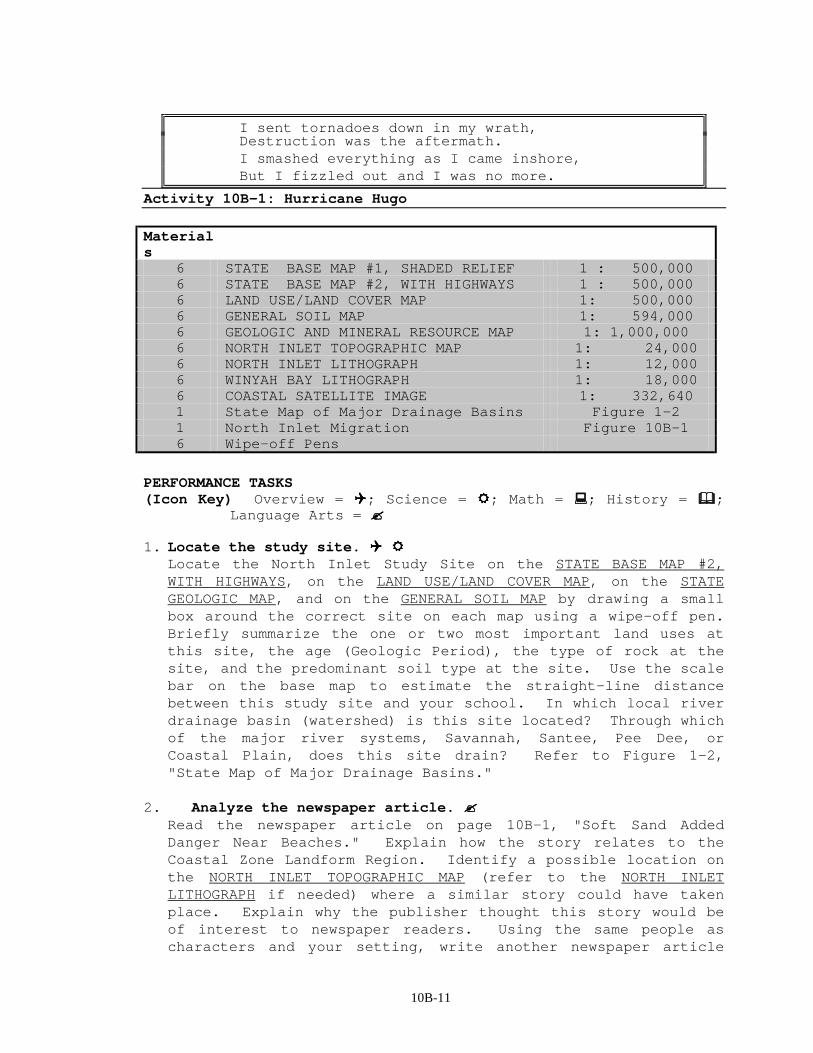
10B-11
I sent tornadoes down in my wrath, Destruction was the aftermath. I smashed everything as I came inshore, But I fizzled out and I was no more.
Activity 10B-1: Hurricane Hugo Materials
6 STATE BASE MAP #1, SHADED RELIEF 1 : 500,000 6 STATE BASE MAP #2, WITH HIGHWAYS 1 : 500,000 6 LAND USE/LAND COVER MAP 1: 500,000 6 GENERAL SOIL MAP 1: 594,000 6 GEOLOGIC AND MINERAL RESOURCE MAP 1: 1,000,000 6 NORTH INLET TOPOGRAPHIC MAP 1: 24,000 6 NORTH INLET LITHOGRAPH 1: 12,000 6 WINYAH BAY LITHOGRAPH 1: 18,000 6 COASTAL SATELLITE IMAGE 1: 332,640 1 State Map of Major Drainage Basins Figure 1-2 1 North Inlet Migration Figure 10B-1 6 Wipe-off Pens
PERFORMANCE TASKS (Icon Key) Overview = !!!!; Science = """"; Math = ####; History = $$$$;
Language Arts = %%%%
1. Locate the study site. !!!! """" Locate the North Inlet Study Site on the STATE BASE MAP #2,
WITH HIGHWAYS, on the LAND USE/LAND COVER MAP, on the STATE GEOLOGIC MAP, and on the GENERAL SOIL MAP by drawing a small box around the correct site on each map using a wipe-off pen. Briefly summarize the one or two most important land uses at this site, the age (Geologic Period), the type of rock at the site, and the predominant soil type at the site. Use the scale bar on the base map to estimate the straight-line distance between this study site and your school. In which local river drainage basin (watershed) is this site located? Through which of the major river systems, Savannah, Santee, Pee Dee, or Coastal Plain, does this site drain? Refer to Figure 1-2, "State Map of Major Drainage Basins."
2. Analyze the newspaper article. %%%% Read the newspaper article on page 10B-1, "Soft Sand Added
Danger Near Beaches." Explain how the story relates to the Coastal Zone Landform Region. Identify a possible location on the NORTH INLET TOPOGRAPHIC MAP (refer to the NORTH INLET LITHOGRAPH if needed) where a similar story could have taken place. Explain why the publisher thought this story would be of interest to newspaper readers. Using the same people as characters and your setting, write another newspaper article
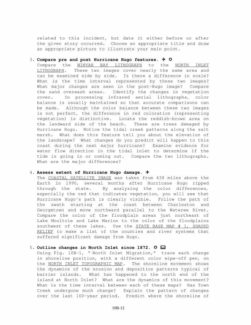
10B-12
related to this incident, but date it either before or after the given story occurred. Choose an appropriate title and draw an appropriate picture to illustrate your main point.
3. Compare pre and post Hurricane Hugo features. !!!! """" Compare the WINYAH BAY LITHOGRAPH to the NORTH INLET
LITHOGRAPH. These two images cover nearly the same area and can be examined side by side. Is there a difference in scale? What is the time interval represented by these two images? What major changes are seen in the post-Hugo image? Compare the sand overwash areas. Identify the changes in vegetation cover. In processing infrared aerial lithographs, color balance is usually maintained so that accurate comparisons can be made. Although the color balance between these two images is not perfect, the difference in red coloration (representing vegetation) is distinctive. Locate the reddish-brown area on the landward side of the beach. These are trees damaged by Hurricane Hugo. Notice the tidal creek patterns along the salt marsh. What does this feature tell you about the elevation of the landscape? What changes do you predict will happen to this coast during the next major hurricane? Examine evidence for water flow direction in the tidal inlet to determine if the tide is going in or coming out. Compare the two lithographs. What are the major differences?
4. Assess extent of Hurricane Hugo damage. !!!! The COASTAL SATELLITE IMAGE was taken from 438 miles above the
Earth in 1990, several months after Hurricane Hugo ripped through the state. By analyzing the color differences, especially the red that indicates vegetation, you will see that Hurricane Hugo's path is clearly visible. Follow the path of the swath starting at the coast between Charleston and Georgetown and move northward parallel to the Wateree River. Compare the color of the floodplain areas just northeast of Lake Moultrie and Lake Marion to the color of the floodplains southwest of these lakes. Use the STATE BASE MAP # 1, SHADED RELIEF to make a list of the counties and river systems that suffered significant damage from Hugo.
5. Outline changes in North Inlet since 1872. """" $$$$ Using Fig. 10B-1, “ North Inlet Migration,” trace each change
in shoreline position, with a different color wipe-off pen, on the NORTH INLET TOPOGRAPHIC MAP. The shoreline movement shows the dynamics of the erosion and deposition patterns typical of barrier islands. What has happened to the north end of the island at North Inlet? What are the dynamics of this movement? What is the time interval between each of these maps? Has Town Creek undergone much change? Explain the pattern of changes over the last 100-year period. Predict where the shoreline of
10B-13
the North Inlet will be in the year 2000, 2025, and 2050. Make appropriate drawings on the topographic map with a wipe-off pen.
6. Estimate buildup of sand at inlet. """" #### Locate Debidue Beach and Pawleys Island on the NORTH INLET
TOPOGRAPHIC MAP. One significant difference between Debidue Beach and Pawleys Island is the fact that Pawleys Island has been extensively developed. Note the purple area on the south end of Pawleys Island indicating the deposition of sand during the period between 1942 and 1973, when the map was revised. Do you think this purple area is a good location on which to build a beach house or condominium? Why or why not? Measure the length of the sand bar (sand spit) in the purple area. Use the scale bar to determine this distance in feet. Based on the publication and revision dates listed on the map, calculate the average linear rate of deposition of sand in feet per year. Do you think this rate will continue indefinitely? Explain. Measure the width of the sand spit in several places and calculate the average width in feet. Assume that the sand depth is five feet, and estimate the total volume of sand, in cubic feet, added to the area between 1942 and 1973.
10B-14
7. Trace shoreline position during storm surge. """" #### Looking at the NORTH INLET TOPOGRAPHIC MAP, identify several
elevation points marked in black by an "X" with the number nearby. Some of these numbers are accompanied by the letters BM (abbreviation for Benchmark) and a black triangle. What is the highest elevation marked on this topographic map? Locate several benchmarks along US Hwy. 17. Determine the average elevation of this highway. Also determine the elevation of at least two plantations listed on the map. What would happen to this area if sea level rose 20 feet? What would happen to the plantations? Using a wipe-off pen, draw a line on top of the 20 foot contour line on the topographic map. This was the approximate height of the Hugo storm surge, which was actually 18 feet. Another factor involved in the total height of the storm surge is the tidal phase. Hurricanes hitting at times of high tide can receive an additional 5-10 feet of storm surge. How much of the land on the map would be covered by salt water if the storm surge rose to the 30 foot contour mark?
8. Evaluate effects of hurricanes on rice impoundments. $$$$ What happens to the dikes, ditches and canals associated with
rice fields after a major hurricane hits these coastal areas? Describe what you think rice impoundments looked like shortly after Hurricane Hugo. Now describe what you think might have happened to rice impoundments after the two hurricanes hit the coast in 1904 and 1906. Why do you think planters abandoned rice cultivation after these major hurricane disasters?
9. Tell your favorite hurricane story to your group. %%%% Read the "Hugo Stories" on page 10B-7. Try to remember where
you were the last time a hurricane hit South Carolina. If a hurricane has not come to your area recently, ask your family members or neighbors for stories they may recall about a hurricane. Tell your group your favorite Hurricane Hugo tale (or other hurricane tale). It does not have to be original. Make certain that your tale has all the basic components necessary for effective storytelling.
10. Plot paths of major hurricanes. """" $$$$ Plot the pathways of major South Carolina hurricanes from 1893
to 1989 on the STATE BASE MAP # 2, WITH HIGHWAYS. Use Figure 10B-3, "Map of Major SC Hurricanes: 1893-1989" as a guide. Use different colors of wipe-off pens to illustrate the track taken by each hurricane. Mark the location of your school on the map and use the scale bar to measure how close each of these storms came to your school.
11. Make up a name for the Hurricane of 1893. $$$$

10B-15
Hurricanes were not given names until the '50's. And until recently they were always given female names. Pick an appropriate name for the Hurricane of 1893 that damaged the rice fields on the Carolina coast. Tell a story, complete with the details of the destruction, to justify your choice of name for this storm. Read ‘‘The Hurricane of 1893’’ on page 10B-5.
10B-16
ENRICHMENT 1. Research recent local natural disasters. $$$$ %%%% Find out when the last natural disaster occurred in your
community. Interview community members about their recollection of events and their feelings about what happened, or about event stories that they’ve heard.
2. Research impact Hurricane Hugo had on wildlife habitats. """" On September 21-22, 1989, Hurricane Hugo had a tremendous
impact on a significant part of South Carolina. Research the impact that Hugo had on trees, birds, insects, reptiles, and fur bearing animals. What are the long-lasting effects on the timber industry in South Carolina? What happened to timber prices after Hugo? What attempts have been made to reforest the land?
3. Determine how hurricanes are classified and named. """" When does the official Atlantic hurricane season begin? When
does it end? How are hurricanes classified by categories? How are records kept on hurricanes? Where are the official records kept? What is a storm surge? How high was the Hugo storm surge? How are hurricanes assigned names? Why do you think female names were usually used prior to 1985? Why did Hurricane Centers start using male as well as female names? What are Cape Verde storms? Where is Cape Verde? What is the difference between a hurricane and a tornado? In a tornado, which does the most damage, the high winds, excessive rain or the high tides? Which does the most damage in a hurricane?
4. Analyze hurricane-induced changes in Santee Delta. """" $$$$ Locate old maps of the Santee Delta. How is the land
different today? Discuss how the delta shape changed with time. How might hurricanes have affected the delta? What human activity has caused changes to the delta? Are the changes positive or negative? Explain.
5. Relate tales of other natural disasters. %%%% If students in your class have been through other types of
natural disasters and wish to talk about them, ask them to relate what happened to them. Class members may ask specific questions to help storytellers recall the details of their experiences. For instance: What time of day was it? Do you remember any unusual sounds? How old were you? Did you have any warning? Were you scared? What did you do?