Embed Size (px)
Citation preview

Second Indus Basin Knowledge Forum
RESEARCH PROGRAM ON
Water, Land and Ecosystems
‘New knowledge frontiers for development and resilience’
July 4-6, 2017
The Hilton Colombo Hotel, Sri Lanka

Front cover photograph: Alan Nicol/IWMI.

Contents
Summary ................................................................................................................................ 3
Background ............................................................................................................................ 4
The Indus Basin Knowledge Forum: New Knowledge Frontiers for Development and Resilience .................................................................................................. 5
The Indus Basin Knowledge Forum ........................................................................................ 6
Country Perspectives .............................................................................................................. 7
Knowledge Initiatives from around the Basin: Current Approaches, Practical Steps .............. 10
Frontiers to the Existing Knowledge Landscape..................................................................... 12
Pushing Out Knowledge Frontiers ........................................................................................ 13
Building Knowledge for Development Actions – What Do Key Decision Makers Think in Different Institutions? .............................................................................................. 14
Innovations at the Science-policy Interface ........................................................................... 15
What Does a New Knowledge Landscape Look Like? .......................................................... 17
Knowledge Actions – Taking Forward Key Steps and Initiatives ............................................ 20
Taking Forward the Ten Action Points .................................................................................. 20
Annex 1. Agenda. ................................................................................................................. 26
Annex 2. List of Participants. ................................................................................................ 32
Annex 3. Results of the Group Exercise: Frontiers to the Existing Knowledge Landscape. ..... 37


3
1. Summary
The ‘Indus Basin Knowledge Forum’ (IBKF), co-convened by the International Water Management Institute (IWMI), the International Centre for Integrated Mountain Development (ICIMOD) and the World Bank, was held in July 2017. The purpose of the IBKF was to assess the nature of existing knowledge related to development of the Indus Basin and the challenges faced, to explore new knowledge frontiers, and to build greater coordination through further co-development and sharing of knowledge.
The meeting brought together over 100 key stakeholders, including representatives from the four basin countries (Afghanistan, China, India and Pakistan), and from governments, civil society, academia, donor agencies and the private sector. A key objective of the meeting was to build stronger collaboration between science communities – the ‘producers’ of knowledge – and those who can use greater knowledge and understanding to make informed decisions, and construct and implement more effective policies. Through this process of convening and collectively assessing the current state of knowledge, the meeting sought for methods to build new initiatives while strengthening existing initiatives that could connect scientific and policy-making communities, and to expand and deepen opportunities for co-production of knowledge across the basin.
The Forum took place over a period of 2 days. Day 1 involved mapping out and understanding the knowledge landscape in the Indus Basin. The gaps surrounding knowledge generation and sharing in the basin, and the possible methods of bridging these gaps to meet major challenges around climate change were also discussed. The risks and insecurities inherent in a fragmented knowledge environment that makes planning and policy making harder to achieve were considered. Discussions emphasized the need to engage policy makers and link them more effectively with the scientific community, as well as sharing knowledge with international institutions outside the basin. The importance of consolidating existing knowledge, and co-generating and co-developing knowledge within the countries at transboundary level was also highlighted. Participants suggested regularizing the knowledge forum process and establishing it as part of the landscape of Indus basin dialogues.
Day 2 of IBKF considered knowledge sharing from the perspective of policy makers and decision makers, with a specific mandate to explore links between knowledge and policy. The views of the donor community and media representatives were also elicited. At the end of Day 2, working groups identified 10 practical actions that would help facilitate interaction between science knowledge and policy environments.
Outputs from the event are available at http://www.iwmi.cgiar.org/events/indus-basin-knowledge-forum/.
4
2. Background
The Indus River Basin is shared by Afghanistan, China, India and Pakistan. Rising in the Tibetan Plateau and fed by tributaries from the Hindu Kush, Karakorum and Himalayan ranges, some 300 million people live in the basin and rely on its resource base for their livelihoods and health. Millions more benefit from effective harnessing of the basin’s resources, including significant energy and food production, and trade.
However, driven by rapid population increase and economic development, the basin’s resources are under growing stress. This includes the impact of groundwater use for agriculture and the demand for water from the basin’s burgeoning cities. In addition, the effects of climate change are causing high levels of uncertainty to inter- and intra-annual surface flows, challenging the resilience of this complex system and its capacity to provide future benefits to people, economies and environments.
Upstream glaciers and snowfields contribute to more than 40% of the river’s annual flow. However, a lack of understanding of this key feature increases the risk of poor decision making, reducing options for adaptation and exacerbating the vulnerability of populations. In other parts of the system, increases in salinity and pollutant loads as well as reductions in sediment flows are causing significant environmental impacts and reducing the quality of resources available for domestic consumption.
Building a stronger knowledge base on these issues, and establishing effective mechanisms for sharing, can significantly strengthen the capacity to identify and implement policy responses in the basin. These can include low and no-regret solutions that enable basin managers and other resource users to plan for a more resilient future.
In this respect, stronger, more consolidated knowledge represents a key public good that can and should underpin sustainable development throughout the basin, including providing a substantial building block towards the achievement of the United Nations Sustainable Development Goals (SDGs).

5
3. The Indus Basin Knowledge Forum: New Knowledge Frontiers for Development and Resilience
The ‘Indus Basin Knowledge Forum’ (IBKF), co-convened by the International Water Management Institute (IWMI), the International Centre for Integrated Mountain Development (ICIMOD) and the World Bank, was held at The Hilton Colombo Hotel, Sri Lanka, on July 4-6, 2017.
The objective of the IBKF was to assess the nature of existing knowledge related to development of the Indus Basin and the challenges faced, to explore new knowledge frontiers, and to build greater coordination through further co-development and sharing of knowledge.
The IBKF took place over a period of 2 days. The meeting brought together over 100 key stakeholders, including representatives from the four basin countries, and from governments, civil society, academia, donor agencies and the private sector. Among the participants were members of the Indus Forum. Annex 1 provides details of the conference agenda and the complete list of participants is included in Annex 2.
Throughout the two-day event, Emojot (https://emojot.com/) – a software-based, emotion sensor platform – helped facilitate participation of conference attendees through online, real-time voting applications. The sessions were also streamed live online to a potential global audience. Outputs from the event are available at http://www.iwmi.cgiar.org/events/indus-basin-knowledge-forum/.
The Indus Forum and the Indus Basin Knowledge Forum: The Indus Basin Knowledge Forum evolved from the Indus Forum, which is a multi-stakeholder dialogue platform that identifies strategic collaborative opportunities regarding the river’s water resources to enable development and climate resilience. The Indus Forum includes members from the four riparian countries (Afghanistan, China, India and Pakistan) and is co-facilitated by the World Bank’s South Asia Water Initiative (SAWI), ICIMOD and IWMI. It originated from the South Asia regional Abu Dhabi Dialogue (ADD) process in 2006, which gathered government officials and opinion leaders from the seven countries that share the rivers of the Greater Himalayas.
The Upper Indus Basin (UIB) Network: The UIB Network is an informal network that has been set up to foster coordination between national and international researchers working in the Indus Basin on a variety of topics. These researchers belong to national depart-ments, organizations and universities from Afghanistan, China, India and Pakistan, as well as other international organizations, including ICIMOD.

6
4. The Indus Basin Knowledge Forum
The purpose and context of the IBKF was highlighted at the start of the forum. This was followed by speeches from representatives of the three co-convening organizations: Jeremy Bird (IWMI), Arun Shrestha (ICIMOD) and Bill Young (World Bank) (Figure 1).
Bird described IWMI’s long history of engagement with the Indus Basin across a range of topics, including irrigation management and groundwater systems. The Indus Basin was an important benchmark for IWMI’s work conducted under the CGIAR Challenge Program on Water and Food (CPWF). Currently, IWMI is leading the ‘Informing change in the Indus Basin’ project, funded by the UK Department for International Development (DFID), with assistance from the CGIAR Research Program on Water, Land and Ecosystems (WLE).
Shrestha described ICIMOD’s hosting of the International Conference on Climate and Environmental Change Impacts on the Indus Basin Waters in February 2016, the precursor to the IBKF. ICIMOD also organized a joint meeting between the Indus Forum and the Upper Indus Basin Network in May 2017.
Young described the World Bank’s association with the Indus Basin under the South Asia Water Initiative (SAWI), which is a multi-donor trust that works across areas of knowledge generation and dissemination, and capacity building to identify new projects for development finance.
Figure 1. Left to right: Arun Shrestha (ICIMOD), Diana Suhardiman (IWMI), Bill Young (World Bank) and Jeremy Bird (IWMI) addressing the audience. Photo: Lahiru Kodippili.
7
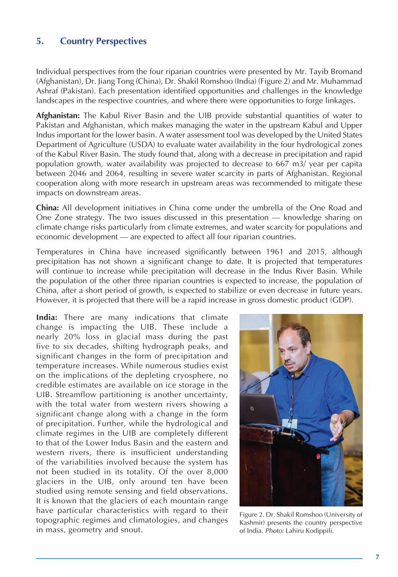
5. Country Perspectives
Individual perspectives from the four riparian countries were presented by Mr. Tayib Bromand (Afghanistan), Dr. Jiang Tong (China), Dr. Shakil Romshoo (India) (Figure 2) and Mr. Muhammad Ashraf (Pakistan). Each presentation identified opportunities and challenges in the knowledge landscapes in the respective countries, and where there were opportunities to forge linkages.
Afghanistan: The Kabul River Basin and the UIB provide substantial quantities of water to Pakistan and Afghanistan, which makes managing the water in the upstream Kabul and Upper Indus important for the lower basin. A water assessment tool was developed by the United States Department of Agriculture (USDA) to evaluate water availability in the four hydrological zones of the Kabul River Basin. The study found that, along with a decrease in precipitation and rapid population growth, water availability was projected to decrease to 667 m3/ year per capita between 2046 and 2064, resulting in severe water scarcity in parts of Afghanistan. Regional cooperation along with more research in upstream areas was recommended to mitigate these impacts on downstream areas.
China: All development initiatives in China come under the umbrella of the One Road and One Zone strategy. The two issues discussed in this presentation — knowledge sharing on climate change risks particularly from climate extremes, and water scarcity for populations and economic development — are expected to affect all four riparian countries.
Temperatures in China have increased significantly between 1961 and 2015, although precipitation has not shown a significant change to date. It is projected that temperatures will continue to increase while precipitation will decrease in the Indus River Basin. While the population of the other three riparian countries is expected to increase, the population of China, after a short period of growth, is expected to stabilize or even decrease in future years. However, it is projected that there will be a rapid increase in gross domestic product (GDP).
Figure 2. Dr. Shakil Romshoo (University of Kashmir) presents the country perspective of India. Photo: Lahiru Kodippili.
India: There are many indications that climate change is impacting the UIB. These include a nearly 20% loss in glacial mass during the past five to six decades, shifting hydrograph peaks, and significant changes in the form of precipitation and temperature increases. While numerous studies exist on the implications of the depleting cryosphere, no credible estimates are available on ice storage in the UIB. Streamflow partitioning is another uncertainty, with the total water from western rivers showing a significant change along with a change in the form of precipitation. Further, while the hydrological and climate regimes in the UIB are completely different to that of the Lower Indus Basin and the eastern and western rivers, there is insufficient understanding of the variabilities involved because the system has not been studied in its totality. Of the over 8,000 glaciers in the UIB, only around ten have been studied using remote sensing and field observations. It is known that the glaciers of each mountain range have particular characteristics with regard to their topographic regimes and climatologies, and changes in mass, geometry and snout.
8
For example, over the past 8 years, the Karakoram glaciers have been relatively stable while those in the Kashmir Valley are receding at a high rate. Further, Kashmir Valley has the highest concentration of carbon in the Himalayas, and the possible impact of this on the rapid loss in glacial mass is being investigated.
Adding to the complication is the presence of many databases, including the Randolph Glacier Inventory (RGI) and that of ICIMOD, with the results varying significantly among these databases. Two national missions in India - the National Action Plan on Climate Change and the National Mission on Sustaining the Himalayan Ecosystem - focus on the Himalayas, and study glaciers and other aspects of climate change in the UIB. However, a lack of data sharing within and between countries, particularly in relation to the UIB, continues to remain a challenge in developing a more comprehensive understanding of the entire system.
Pakistan: While Pakistan has one of the largest irrigation systems in the world, and the fourth largest groundwater system, it is estimated that the county will face absolute water scarcity by 2025. At the other extreme, recurring flooding is also a concern, with inadequate water harvesting and storage facilities, and a lack of good watershed management practices being contributing factors.
Studies carried out thus far on water resources include the delineation of groundwater quality zones in the Upper and Lower Indus basins using geophysical methods, satellite-based groundwater monitoring using Gravity Recovery and Climate Experiment (GRACE) satellite applications, flood forecasting models and measuring real-time flow using Indus Telemetry, the latter led by the Pakistan Council for Research in Water Resources (PCRWR) in collaboration with IWMI. Also, PCRWR has recently initiated irrigation advisory services through the provision of real-time data for farmers, and established a water resources information system.
There is considerable knowledge on many aspects of the Indus Basin. However, despite its availability, key knowledge gaps exist, for example, regarding the impacts and management of climate change. A forecast mechanism at a regional scale is also lacking. Current knowledge is isolated and piecemeal, and a single platform for knowledge sharing among riparian countries is absent. There is a lack of partnerships and coordination among institutions, and an absence of a data portal for information sharing, despite IWMI and PCRWR having started knowledge portals recently. It is also important that the considerable amount of knowledge that is available is taken stock of, assessed and disseminated to users.
In the question and answer session following the presentations, the observed changes to river flow as a result of climate change were discussed. While some studies reveal that flows in the western rivers peaked around 1995 as a result of increased glacial melt and have been declining since then, others project that an increase in river flow can be expected until 2050 due to glacial melt, posing a challenging contradiction to some of the available studies.
The role of the knowledge providers and the knowledge community in helping to establish a regional forecasting system on drought and flood risk, a key issue that affects upstream and downstream populations, was also raised. The Government of Afghanistan is planning to implement a hydrometeorological data dissemination policy in the coming months. China has been building an early warning system at the country level, and India and Pakistan too have initiatives in this regard. However, data sharing between the riparian countries poses an important challenge (including the need for access to more real-time data that could support early warning systems).
Potential points of connection between research initiatives in Central Asia and the countries in the Indus Basin, particularly Afghanistan and Pakistan, were also discussed.
9
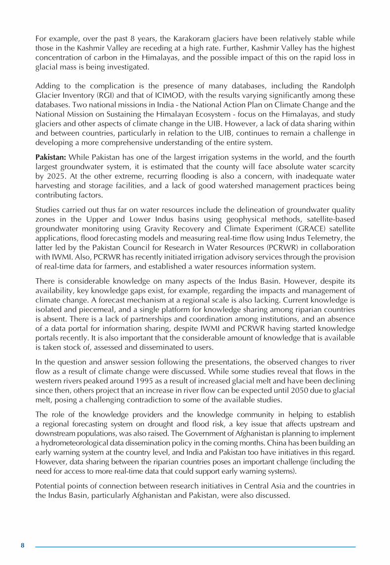
Figure 5. Have the participants learned something that will be useful in their work? (left); What are the ma-jor challenges to the existing knowl-edge landscape in the Indus Basin? (right). Source: Emovyz.
Figure 3. How important is a strong knowledge environment for sustainable development in the basin? (left); How do the participants feel about the potential outcomes of the forum? (right). Source: Emovyz.
Figure 4. What are the major challenges to the existing knowl-edge landscape in the Indus Basin? Source: Emovyz.

10
Key messages:
• Demand for, and supply of, water resources will be a major challenge for the countries going forward, which will be further complicated by the uncertainties regarding the impacts of climate change.
• While there is considerable knowledge on the various aspects of these challenges, key knowledge gaps exist. There is also potential for further coordination between the countries and institutions in the basin to help shrink some of these gaps.
The results of the online survey conducted during Day 1 are presented in Figures 3 to 5.
6. Knowledge Initiatives from around the Basin: Current Approaches, Practical Steps
The previously outlined institutional landscape was explored further, with practical examples of knowledge initiatives by some of the networks and organizations present in the Indus Basin. The UIB network (Dr. Arun Shrestha), IWMI’s Indus Basin Knowledge Platform (Mr. Sanjiv de Silva), the Partnerships for Enhanced Engagement in Research (PEER) network (Dr. Jason Porter) and the World Bank’s initiatives (Dr. Josh Newton) were presented and discussed.
Activities of the UIB Network: A field visit organized in 2014 led to the formation of six expert technical working groups on data collection and sharing on various aspects of climate change, risks, water resources availability and demand, and adaptation strategies at the local level. An international conference, Climate and environmental change impacts on the Indus Basin waters, was organized in February 2016 in Kathmandu to bring the networks together and determine the roles of the UIB Network and the Indus Forum. A joint Indus Forum /Upper Indus Basin Network meeting was held in May 2017 to explore how the Indus Forum and UIB Network could work together in view of their commonalities and potentials. It was decided that ICIMOD should take on the role of coordinating the scientific aspects of the project. In the future, more country representation is needed to keep the UIB Network moving forward and to ensure uptake of the large amounts of research material generated. Gender balance remains a challenge, especially in the UIB network.
The Indus Basin Knowledge Platform (IBKP): Developed by IWMI, the IBKP (http://www.indusbasin.org/) attempts to consolidate knowledge available on the Indus Basin and improve its access to all stakeholders. The platform is funded under DFID’s South Asia Water Governance Programme (SAWGP), and provides a virtual repository for links to scientific publications, laws and policies, hydrological models, gender mapping, multimedia outputs, hydrological models, and various spatial and non-spatial datasets. Currently, access is provided to over 1,400 publications from both the social and physical sciences, and national and subnational boundaries. Participants were invited to contribute data and knowledge products and/or become ‘Knowledge Partners’ to help IBKP grow and expand.
Activities under the PEER program: The PEER program is a partnership between the United States Agency for International Development (USAID) and the US National Academy of Sciences (NAS). The latter organization implements the PEER program. The mission and goals of PEER are to provide small grants to scientists who work towards solving critical development issues. PEER has nine projects in the Indus Basin, three in Pakistan and six in Afghanistan on the Kabul River. A substantial portion of this program aims to strengthen capacities to analyze, synthesize, share and

11
use data. Researchers from both sides of the border are brought together regularly to communicate with each other. The Contribution to High Asia Runoff from Ice and Snow (CHARIS) project is another USAID local research initiative that works with partners in 11 countries in Central and South Asia, and looks at glacier dynamics and the impacts of climate change.
Understanding climate change adaptation in the Indus Basin (World Bank): The World Bank has been working with a Working Group of the Indus Forum to develop a joint research proposal for the Indus Basin. The main purpose of this proposal is to develop a framework for integrated basin-wide water research on climate change processes and impacts in the basin. It has members from all four riparian countries. Outcomes include establishing long-term monitoring sites and assessing potential impacts on water resources amid possible future climate change scenarios. Four work packages have been designed: (1) Baseline observations, (2) climate change scenarios, (3) climate change adaptation, and (4) capacity building. The work packages will be governed by a secretariat managed by IWMI and ICIMOD.
The discussion that followed touched on several points including the importance of groundwater in the context of transboundary waters. While groundwater plays an important role in the region, water policies are largely focused on surface water challenges. With climate change, natural storage in glaciers is depleting rapidly and storage is being built to harness surface runoff. Groundwater has been inadequately studied, though it is more resilient to climate change, providing natural ‘buffer’ storage against future evaporation losses. Joint efforts are necessary to study this resource and optimize its future protection and use. Higher resolution datasets for surface water and groundwater modeling are necessary to better understand the current and future behavior of critical groundwater systems.
Comments regarding knowledge gaps on specific aspects of basin management were raised. Earthquakes and their impacts on glaciers (and the impacts of changes in glaciation on the movement of the Earth’s crust) are likely to be significant, but little work has been undertaken to explore this. Further, the impact of floods and droughts, and the role of flood forecasting, in the Himalayas and Indus Basin must also be looked at as a priority. In addition, many areas of the basin (reservoirs, specifically) and cities suffer due to the problem of sedimentation. It is important to ascertain sources of sediment and the types of management measures, including in upstream watersheds that can minimize sediment flow and future impacts.
Ways to link the different knowledge databases that are available were also explored. Primary datasets are often owned by the countries that generate them, and it is important that such data are shared. For example, as part of its climate change adaptation strategy, the Indian government has initiated hydrological modelling and the production of data at the lowest unit of the planning process. Such databases are available on the government website and could be shared.
It was agreed that a holistic approach was important, encompassing both the physical and social aspects. However, as the comparative strengths of organizations are being harnessed, in some cases it is also important to work on upstream areas and focus more on the physical aspects of the basin, while also keeping in mind socioeconomic challenges and changes in the basin.
Key messages:
• Several initiatives exist to facilitate further research and knowledge generation in the Indus Basin, in order to consolidate existing knowledge and foster a community of experts in the basin. This includes activities by the UIB Network, the IBKP, projects under the PEER program and the development of a joint research proposal, supported by the World Bank.
• Further emphasis needs to be placed on the study of groundwater in the context of transboundary water management.

12
7. Frontiers to the Existing Knowledge Landscape
During Day 1, participants broke into groups to discuss two core questions: (1) Knowledge sharing: What key gaps are there in existing knowledge sharing?
2) Knowledge generation: What opportunities exist to address these gaps, and how are they addressed? What are the risks and opportunities, and any unexplored development problems?
Annex 3 provides the results of this exercise. Following this exercise, a virtual knowledge landscape was explored, looking at where knowledge development and sharing, and co-development of knowledge were strongest and weakest, and what the nature of a ‘middle ground’ was (Figure 6).
The key findings from the exercise are presented in Table 1.
Figure 6. Participants deliberating on frontiers to the existing knowledge landscape in the Indus Basin. Photo: Lahiru Kodippili.
Table 1. Findings from the exercise on frontiers to the existing knowledge landscape.
How do we do it – what are the opportunities? • Present outcomes and recommendations to governments• Third-party engagement• Categorization of data from sensitive to non-sensitive• Using data for consensus building • Joint research and studies • Use of media for awareness raising
Where do we need to be stronger?• Economics• Benefit sharing• Institutions• Minimizing redundancies• Country-level collaborations • Political will to collaborate
What are the big gaps?• Legality of data sharing• Access to high-altitude regions • Lack of demand-driven research• Insufficient data on groundwater
Where is knowledge sharing the strongest?• Climate and hydrological data • Sharing among researchers• Remote sensing data• Treaty that requires knowledge • Population growth
Where is knowledge sharing the weakest? • Flow data • Transboundary data• Data on dam filling and emptying • Science to policy • Planned measures• Glaciers
13
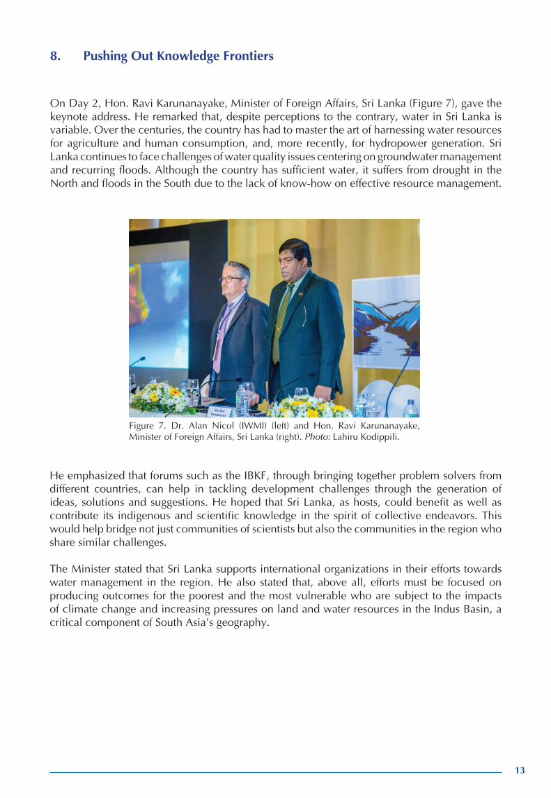
8. Pushing Out Knowledge Frontiers
On Day 2, Hon. Ravi Karunanayake, Minister of Foreign Affairs, Sri Lanka (Figure 7), gave the keynote address. He remarked that, despite perceptions to the contrary, water in Sri Lanka is variable. Over the centuries, the country has had to master the art of harnessing water resources for agriculture and human consumption, and, more recently, for hydropower generation. Sri Lanka continues to face challenges of water quality issues centering on groundwater management and recurring floods. Although the country has sufficient water, it suffers from drought in the North and floods in the South due to the lack of know-how on effective resource management.
He emphasized that forums such as the IBKF, through bringing together problem solvers from different countries, can help in tackling development challenges through the generation of ideas, solutions and suggestions. He hoped that Sri Lanka, as hosts, could benefit as well as contribute its indigenous and scientific knowledge in the spirit of collective endeavors. This would help bridge not just communities of scientists but also the communities in the region who share similar challenges.
The Minister stated that Sri Lanka supports international organizations in their efforts towards water management in the region. He also stated that, above all, efforts must be focused on producing outcomes for the poorest and the most vulnerable who are subject to the impacts of climate change and increasing pressures on land and water resources in the Indus Basin, a critical component of South Asia’s geography.
Figure 7. Dr. Alan Nicol (IWMI) (left) and Hon. Ravi Karunanayake, Minister of Foreign Affairs, Sri Lanka (right). Photo: Lahiru Kodippili.

14
9. Building Knowledge for Development Actions – What Do Key Decision Makers Think in Different Institutions?
Decision makers from Afghanistan, China, India and Pakistan that participated in the forum discussed the types of information they need to translate knowledge into policy. The discussion revolved around the questions of what knowledge, how and when delivered is critical to achieving more informed decision making in the Indus Basin. What does this imply for improving systems of knowledge development and sharing across the basin, and in achieving greater co-production of knowledge? Their perspectives on the role of knowledge in key decision-making environments (climate adaptation, water management, groundwater development, environmental management) were also elicited. The media perspective was considered in view of the importance of its role as a key knowledge broker.
In response to the questions, the importance of addressing policy makers in a language they could easily understand was raised. This includes providing cost-benefit analyses of projects and programs, and the potential impact and benefits to the country, answering the questions - ‘What is in it? How will it be implemented? What are the benefits? This also includes taking into consideration the ‘non-technical’ background of most policy makers, and thereby presenting them with information in formats such as pilot research findings and case studies.
Further, as most policy makers are usually risk-averse and cost-conscious, they may look at investments that may not necessarily be heavy on research but rather on innovation and testing new technologies that are focused on transformational change. The role of think tanks is expanding in the Indus Basin. It was argued that one of the roles of these organizations could be to reach out to policy makers from the moment an idea is generated, and then follow through with a ‘value chain’ that interfaces with the policy makers.
Those from the policy realm have shown interest in some areas, e.g., the gaps between water availability and demand, and ways of bridging these gaps given future projections. However, this remains a challenge for certain topics such as climate change, where future scenarios are complex to construct, interpret and explain. On the importance of data at different scales, a comment was made on the necessity for making more local-level data available for community-level planning. More attention must be given to the water-livelihood-gender nexus, which is an immediate problem that requires affordable and replicable solutions.
On the role of the media as a knowledge broker - while the media have an important role to play in communicating such issues as a transparent knowledge broker, limitations do exist. For example, while it is generally agreed that transboundary data are important for more effective management of the Indus Basin, three of the four countries in the basin have laws that make it illegal to provide live water flow data to the public. However, there are ways around such restrictions, and partnerships with the media have the potential to contribute to more cooperative and sustainable development in the Indus Basin. Further, it is also necessary for researchers to understand that the media deal in up-to-the-minute news. Therefore, most media personnel will not be interested in information arising from academic publications such as research papers, the data for which are usually months or even years old by the time they are made available for public use.
Key messages:
• It is important to understand that the priorities of policy makers are different, with a heavier focus on the development needs of the country. This should be given consideration when support is enlisted for research initiatives and in the dissemination of research findings.
•
15
• The media have an important role to play in improving the understanding of issues in the basin. However, knowledge distribution processes from the scientific community (e.g., the lengthy process of publications) may not always be synchronized to meet the needs of the media, which require more current information.
10. Innovations at the Science-policy Interface
Building on the central question posed in the previous session, this session looked at examples of initiatives at the interface of scientific knowledge and policy/decision making.
Remote sensing applications – (Bill Young, World Bank): The World Bank has extensive online resources which are accessible through web links that are publicly available. One aspect of these resources is top-down data acquisition, which complements the bottom-up data of on-the-ground ground monitoring. Water resource observations, hydrometeorological networks, previous paper documentation and systems, etc., are integrated into centralized databases and delivered through a variety of platforms, web portals and mobile applications.
Speedy access to high-resolution datasets, which are available through Google Earth, can now be accessed by the Google Chrome engine and integrated using the World Bank’s online cloud computing platform. Other tools available include a ‘spatial agent’ application that can deliver information to electronic devices, a global surface water explorer that provides public access to water information, and free geographic information system (GIS) tools for flood mapping that enable the creation and uploading of maps, which can be used by those with little professional training. The complete list of web links to the information provided by the World Bank can be accessed from the presentation (available at https://drive.google.com/drive/folders/0By6AIjE59eHSSlh0U21NZ1hwdmM).
Working with new data environments: Indus Telemetry – (Arif Anwar, IWMI): This is an on-the-ground monitoring device that uses cost-effective mobile data communications and easily available cloud computing technology, operationalized under the Informing Change in the Indus Basin (ICIB) project by IWMI. It can be communicated through the internet or by mobile phones to any number of displays, anywhere, and runs continuously. Its hardware comprises of off-the-shelf material including cameras and sensors, and it uses a basic Raspberry Pi Microcomputer, with all the data processing carried out through a cloud server. Overall, there is little loss of data integrity. This technology is accessible. Although hardware costs and the skill levels required for its operation are relatively high, the operational costs are low. Plans for the future include expanding the prototype to the provinces of Balochistan, Khyber Pakhtunkhwa, Punjab and Sindh, and increasing engagement with institutions in the country, as well as provincial irrigation departments to promote its use. Looking beyond the Indus Telemetry project, a point that should be deliberated is whether government agencies should procure data or hardware to facilitate information generation.
Integrated modelling framework to explore operational and policy scenarios – (Mobin-ud-Din Ahmad, Department of Foreign Affairs and Trade [DFAT] - Commonwealth Scientific and Industrial Research Organisation [CSIRO]): Sustainable Development Investment Portfolio (SDIP) is an initiative by the Australian government that aims to increase water, food and energy security in South Asia through accessing the poorest and most vulnerable populations. In consultation with the Ministry of Water and Power, and the provincial irrigation departments and other relevant departments in Pakistan, SDIP has identified the need to set up an integrated modelling framework that looks at operational and management scenarios in the UIB Network
16
to understand glacier melt and inflow processes. SDIP is also supporting a water apportionment accord to look at how water is shared among different provinces and delivered to different canal commands. The framework aims to understand the impact of climate change on water availability as well as some of the water sharing scenarios in agriculture, hydropower and the environment under future climatic conditions. The framework replicates the Indus River System Authority’s implementation of the 1991 Water Apportionment Accord and simulates water demand that can be used for water balance analyses.
Integrated Solutions for Water, Energy and Land (ISWEL) – (Simon Langan, International Institute for Applied Systems Analysis [IIASA]): IIASA is a systems analysis institute that has been developing integrated assessment models that look at energy supply-demand and environmental services. The institution has developed a community model and a hydro-economic model which can be combined with models on energy and land use to explore where water resources are used, what they are used for, and the synergies and trade-offs that arise. These models work at global and regional scales, for the ISWEL project (funded through the Global Environment Facility), the Indus Basin along with the Zambezi Basin provide pilot case studies for the development of tools to support operationalization of many of the issues surrounding the so-called water-energy-food nexus. The intention is to use the models with scenarios developed with basin stakeholders to enhance technical capacity and explore the possible policy options/solutions for management interventions to maximize synergies and reduce trade-offs relating to water, energy and land.
Experiences in acquiring, using and sharing Indus knowledge – (Hamish Pritchard, British Antarctic Survey): Glaciers in the Indus Basin play a vital role because they act as buffers against droughts and keep the rivers flowing in the summer, which is particularly important for a region suffering from high water stress. The study undertaken in the basin found that glacier melt dominates water supply in the Indus at a crucial time — during the period of peak water stress. It supplies melt water sufficient to sustain about 70 million people in the basin and is responsible for several million dollars worth of hydropower generation. The information for the study was procured from freely available datasets, and remote sensing and modelling tools. However, it must be noted that there are large uncertainties in datasets and their ability to predict future water use is limited. New high-altitude weather observations are necessary if these uncertain mountain climate models are to be improved and tested. In particular, improved high-resolution/high-altitude climate models and new field data on glacier-wise volume measurements are needed to predict future changes.
The discussion that followed highlighted the importance of multidisciplinarity, and the need to include expertise from disciplines such as international relations, politics and political economy studies in order to better target areas for action that would enable more effective data and knowledge sharing.
The issue of how water and related departments could take ownership of studies such as the Integrated Modelling Framework and the Indus Telemetry system, and how these could be made more robust so that government institutions such as irrigation departments could use them, was raised. It was highlighted that it remains a challenge to transfer technology or hardware to governments, and ensure it remains updated and used appropriately. This leads to the debate of whether it is hardware or data that government should be acquiring. On the topic of the Indus Telemetry, it was mentioned that similar technologies are being put into practice in other areas such as Kazakhstan, and that this application should be further explored.
On the interface between science and policy, there are four international frameworks centered on climate change adaptation — the Paris Climate Agreement, the 2030 Agenda for Sustainable Development, the Addis Ababa Action Agenda of the Third International Conference on Financing for Development, and the Sendai Framework for Disaster Risk Reduction. The

17
importance of looking at the interface between these frameworks, the SDGs, and vulnerability and adaptation was raised.
Key messages:
• Initiatives at the science-policy interface in the Indus Basin include remote sensing applications by the World Bank, IWMI’s work with telemetry, modelling frameworks to explore operational and policy scenarios by CSIRO, and IIASA’s work on providing integrated assessment models for water, energy and land.
• Such multidisciplinary work also needs to consider including inputs from disciplines that may not have been traditionally considered, such as international relations, politics and political economy studies, but can assist in improved effective data and knowledge sharing.
11. What Does a New Knowledge Landscape Look Like?
The views of the donor representatives participating in the forum regarding the funding landscape for such initiatives and others were elicited.
A commonly held view was that donors are interested in supporting initiatives that seek to bring about change. Therefore, a funding proposal should go beyond the ‘what’ and ‘who’, and also specify the ‘why’, i.e., what difference the proposed project will make in 2-5 years. Demonstrating knowledge of the context in which the proposal is submitted, and focusing not only on the science but the bigger implications, could also be important in submitting a successful proposal. The importance of demonstrating knowledge of the scenarios in which the donor operates, understanding their key policy drivers, and communicating why the particular funder should support that work and how it supports their interests were also mentioned.
The Indus community has grown to a large extent and it is fast becoming a network of connected people who are building a community of knowledge. However, it was argued that, as the community matures, it needs to think about ways of engagement with policy makers. The combined power and intellect of this forum would help immensely in achieving this. A structured approach needs to evolve to understand the needs and wants of policy makers, and how best they can be connected and engaged with. It is also possible that the group could look into providing a critical review and synthesis function across an emerging knowledge base. It could, for example, focus on particular contentious issues in the science world and work together to come up with a scientific consensus, enabling a more effective public discourse on policy options.
Key messages:
• The community of donors would seek to support initiatives that aim to bring about developmental change. Demonstrating how a proposal could achieve this, as well as knowledge of the context in which a donor operates, is important to consider when seeking funding.
• As the Indus community grows further and matures, it could also begin to consider how it can further engage with policy makers and contribute to public discourses and policy options.
The results of the online survey conducted during Day 2 are presented in Figures 8 to 13.

18
Figure 8. How would you describe the science/knowledge-policy/decision-making relationship in the basin? Source: Emovyz.
Figure 10. How optimistic are you that they will listen? Source: Emovyz.
Figure 9. Scientists and researchers: Has this provided you with new ideas on engaging with policy makers? Source: Emovyz.

19
Figure 11. Policy and decision makers: Have you identified new ways of working with scientists and researchers? Source: Emovyz.
Figure 12. Policy makers and decision makers: How would you describe the science/knowledge-policy/decision-making relationship in the Indus Basin? Source: Emovyz.
Figure 13. Policy makers and decision makers: How optimistic are you this will improve? Source: Emovyz.

20
12. Knowledge Actions – Taking Forward Key Steps and Initiatives
A group exercise was conducted to help shape a more cohesive knowledge community in the basin; one that was more inclusive of practitioners and policy makers, more able to respond to knowledge needs, and increasingly able to deliver state-of-the-art knowledge products through stronger collaboration.
Participants were asked to separate into action groups, and each group was invited to work on three ideas based on the opportunities identified, on how the participants felt the Indus Knowledge landscape should look like in the next 5 to 10 years, and how this knowledge could be fed into policy. It was expected that the ideas would facilitate joint research and influence joint policy, while being capable of being actioned within the next 3 to 5 years. These ideas were provided to the facilitators who clustered and consolidated them according to 11 big themes (subsequently reduced to 10) (Figure 14).
13. Taking Forward the Ten Action Points
Following from the previous exercise, participants were invited to join the group of their choice to work on proposals for new knowledge products, processes and activities. Ten action groups met and worked on 10 ‘big bucket items’ or Action Points. The ideas were developed through open-space working groups. This flexible working group format enabled members at a table to move to other tables and contribute to other discussions. The results of the deliberations were then presented back to the plenary by a self-nominated ‘champion’ who was expected to make a commitment to take the lead on putting into action that particular idea. Participants were invited to vote on the action points they considered most important or those that were of most interest to them (Figure 15). The results of the voting on the ten Action Points are shown in Figure 16.
Figure 14. Clustering the Action Points. Photo: Lahiru Kodippili.
Figure 15. Participants vote on the Action Points. Photo: Lahiru Kodippili.

21
Figure 16. Results of the voting on the Action Points. Source: Emovyz.
The ten Action Points are as follows:
1. Centre of Excellence: Shakil Romshoo, University of Kashmir: There is a need for an interdisciplinary/multidisciplinary cross-sectoral and cross-regional platform with an up-stream/downstream focus, and with a physical organizational structure. The Indus Center of Excellence can be expected to provide an overarching framework under which other proposed actions can be accomplished and linkages made to researchers both within and outside the basin. It would have a Board of Governors with membership from the basin countries (as well as outside) and a Research Advisory Council with a science/pol-icy focus. Thematic areas covered would include hydrology, glaciology, climate change, water policy making, disasters, water/food/energy security, capacity building, etc. The secretariat hosting the organization could be based at an institute such as IWMI with sub-centers in the basin countries or outside. The center should focus on the priorities in the basin, in order to successfully facilitate involvement from the government.
2. Indus Basin Knowledge Forum/Platform: Muhammed Nawaz, USAID: The Indus Basin Knowledge Forum is to be a virtual network without the need for a physical structure or secretariat, at least in the short term. The network would convene once a year, ideally with funding arranged for 5 years, so that sustainability is ensured. Complementing this would also be fora at the national level, which would act as a bridge between the IBKF and national institutions. The national forum would meet bi-annually following the yearly IBKF to synthesise outcomes, and prior to the next IBKF to set priorities. The network should be broadened to include more representation from other disciplines such as the social sciences and ecology, and other categories of stakeholders such as nongovernmental organizations (NGOs), the private sector and subnational governments.
3. Connecting science with policy/practice: Muthukumara Mani, World Bank/Kallur Subrammanyam Murali, International Development Research Centre (IDRC): This action point considered two approaches to better link science with policy and practice. The first approach was to sensitize policy makers with scientific information. Taking into consideration what drives policy making (including economic drivers, livelihoods

22
and politics, electoral cycles), conducting policy dialogues that translate the findings from scientific studies was proposed for those in the policy making realm, while linking such findings with the concerns of the policy makers, including economics, livelihood security and sustainable development. A public policy institute that would help scientists become familiar with the process of policy making in a given context, and the importance of engaging think tanks were also proposed. A regional policy dialogue could be held involving young parliamentarians who are perceived as being more receptive to scientific findings. Further, such findings could be strategically placed through engaging with local media, so that the information reaches parliamentarians from the relevant constituencies. A joint effort should be undertaken to understand what drives policy making at the local and regional levels.
4. Extreme event/floods/disaster risk management: Tian Lide, Chinese Academy of Sciences: The Indus Basin is vulnerable to several types of climate-related disasters, including droughts, floods, glacial lake outburst floods (GLOFs), landslides, glacier collapse, typhoons (cyclones), cloud bursts and avalanches. To address this, measures and solutions proposed by this Action Point include forecasting disasters (in the case of droughts), early warning systems (for floods, landslides, glacier collapse, GLOFs), risk evaluation and hazard mapping (vulnerability mapping), floodplain zoning, basin planning, action to relieve disaster damage, disaster relief (government and society) and commercial insurance. Specifically, this would involve real-time flood and drought mapping with advanced warning, mid-term and long-term climate prediction and projections, the involvement of institutions and universities for vulnerability mapping, glacier-related disaster early warning, flood inundation mapping, and coordination with flood-related agencies to assist in planning and implementation. This would require government cooperation from the riparian countries, and involve scientists, local communities, a coordinator and channels for communication between scientists, governments and local communities (for example, through mobile networks).
5. Kabul River Integrated Water Resources Management (IWRM) dialogue process: Jamal Naser Shokory, Researches Organization for Development: The mission of this Action Point is Integrated Water Resources Management (IWRM) in the Kabul River Basin. The vision is to build collaborative and cooperative water management based on an ‘equitable and reasonable’ approach. In order to accomplish this, scientific collaboration and capacity building should be conducted with joint representation from Pakistan and Afghanistan. In addition, knowledge and information could be consolidated through the development of joint research proposals on a topic such as water and climate change, so that information could be shared between the research communities as a way of circumventing government reluctance to share raw data. A specific area to be addressed is IWRM and integrated flood management using an upstream approach, as the risk of flooding is a primary concern for both Pakistan and Afghanistan.
6. Capacity building (youth and policy focus): Hamza Khalid, DFAT: This will be a voluntary group that aims to influence and (wherever required) challenge existing discourses surrounding the management of the Indus Basin. It will comprise young professionals between the ages of 28 and 35 and will be a multidisciplinary group from all four riparian countries, with equal representation from men and women. The group will act as a basin-wide fraternity/sorority that is decoupled from countries and organizations. Developing the employability or capacity building of its members will not be the main focus of the group. The group will not rely on donor funding, but will be taken forward by the entrepreneurial spirit of its members. The group will aim to present its vision and roadmap on how it can be achieved. This will take place after the next two Indus Basin Knowledge Forums. Those interested in joining this group can contact Panchali Saikia (IWMI), Azeem Shah (IWMI) or Hamza Khalid (DFAT).
23
7. Data sharing, including hydrometeorological data, data portals and knowledge networks: Muhammad Riaz, Pakistan Meteorological Department; Ali Tauqeer Sheikh, Leadership for Environment and Development (LEAD), Pakistan: While data sharing is a difficult topic to approach, it is nevertheless important that it is attempted (Figure 17). Examples of hydrometeorological data that could be shared for better management of the Indus Basin include flow data (historical and real-time data with increased frequency of extreme weather events) and meteorological data (historical and real-time data for rainfall, temperature, relative humidity, thunderstorms, etc.). Existing protocols could be tapped into. As the next steps, developing partnerships and trust building measures while remaining within existing treaties and, in addition, where possible, using remote sensing data were suggested. With regard to data portals, open data portals could be used to share data. The need for data harvesting and consolidation through existing data portals was reiterated.
8. Joint research program (requesting external support agency/donor engagement): Idrees Malyar, Individual Consultant: The role of this Action Point will be in supporting the other subgroups in taking forward their research initiatives (Figure 18). However, significant challenges will have to be overcome, including maneuvering through political sensitivities, complications in data sharing and establishing effective coordination. Categories of stakeholders who should be involved include researchers, the global community (government agencies), potential beneficiaries and the donor community. In terms of structuring, it could function as a virtual group at the beginning, working on prioritization of research initiatives by engaging with the proposed Centre of Excellence, supporting the drafting of proposals and obtaining funding, and the transferring of knowledge through workshops, the media, publications, etc. Organizations such as IWMI or USAID could act as coordinating bodies.
Figure 17. Presenting Action Point 7: Data sharing, data portals and knowledge networks. Photo: Lahiru Kodippili.

24
9. Scenarios/trends/futures (systems): Simon Langan, IIASA: This Action Point can act as an interface between science and policy, and assist informed decision making through answering ‘what if’ questions and scenario building. It can, therefore, assist policy makers to better understand the complexities involved in basin management, e.g., the trade-offs or synergies arising from a certain project. It can help investors to understand risks and also help researchers ascertain where gaps and uncertainties exist. It can, therefore, provide a means for dialogue about the entire system. To do so, it could provide a common framework based on a set of assumptions and data, thereby ensuring transparency. The next step in taking forward this Action Point would be to develop the necessary engagement in a scenario development exercise for the Indus Basin.
10. Central Asian Water (CAWa), South Asian water networks (SAWI, South Asia Consortium for Interdisciplinary Water Resources Studies [SaciWATERs])/Indus Basin interaction: Jay Sagintayev, University of Maryland: This Action Point has arisen as a result of an idea to connect the substantial amount of work being developed in the regions of South Asia and Central Asia, through programs that foster knowledge transfer between Central Asian Water (CAWa), the Indus Basin Knowledge Forum and other South Asian water networks. Technologies and studies that might be suitable for such programs include the floating solar cover initiatives in China and India, and the Hazus models by the Federal Emergency Management Agency (FEMA) of the USA that estimates potential losses from natural disasters. Another example is the use of automated sensors for storm water management, which shares similarities with the Indus Telemetry system. Potential partners for such initiatives are the Red River Basin Commission, IWMI, ICIMOD, the CGIAR network, USAID, World Bank and Asian Development Bank.
Figure 18. Presenting Action Point 8: Joint research program. Photo: Lahiru Kodippili.

25
Key messages:
• The way forward was discussed on how a more cohesive knowledge community can be shaped in the basin, one that is more inclusive of practitioners and policy makers, and more able to respond to knowledge needs and deliver knowledge products through stronger collaboration.
• Ten ‘Action Points’ were identified to operationalize this, each led by a self-appointed champion who would make the commitment to further develop and implement the ideas.

26
Annex 1. Agenda.
Conference on New knowledge frontiers for development and resilience
July 4-6, 2017
July 3, 2017 – Arrival of participants (The Hilton Colombo Hotel)/pre-meetings
Agenda
Day 1: July 4, 2017 - The current knowledge landscape
Opening Chair: Diana Suhardiman, IWMI09.00-10.00 Opening speeches
• Jeremy Bird, Director General, IWMI • Arun Shrestha, Regional Program Manager, River Basin Management, ICIMOD • Bill Young, Lead Water Specialist, World Bank
Brief introductions from different initiatives represented in the room
Session 1 Chair: Philippus Wester, ICIMOD10.00-11.15 The Indus Basin knowledge landscape – Country perspectives
• Afghanistan – Tayeb Bromand, Ministry of Energy and Water • China – Jiang Tong, Chinese Academy of Sciences • India – Shakil Romshoo, University of Kashmir • Pakistan – Muhammad Ashraf, Pakistan Council of Research in Water Resources
Facilitated discussion in plenary: What are the key features of this landscape? What are the specific challenges?
Facilitator: Alan Nicol, IWMI
Break 11.15-11.45 Tea/coffee served
27
Session 2 Chair: Nisar Memon, Water Environment Forum, Pakistan11.45-13.00 Knowledge initiatives from around the basin – current approaches, practical steps
• Arun Shrestha, ICIMOD – Upper Indus Basin Network • Nitasha Nair/Sanjiv de Silva, IWMI – Indus Basin Knowledge Platform • Dalal Najib, NAS – Partnerships for Enhanced Engagement in Research (PEER) • Josh Newton, World Bank – World Bank, Indus Forum: Understanding climate change adaptation in the Indus Basin
Facilitated plenary discussion/preparation for post-lunch working groups
Facilitator: Undala Alam, DFID
Lunch Buffet lunch served13.00-14.00
Session 3 Chair: Muthukumara Mani, World Bank14.00-16.00 Assessing the gaps: Facilitated plenary discussion then break-out groups
Eight breakout groups with 45 minutes each reporting back to plenary: Groups clustered around two core question areas: (1) Knowledge sharing: What are the key gaps in existing knowledge sharing? and (2) Knowledge generation: What opportunities exist to address these gaps and how? What are the risks and opportunities, and any unexplored development problems?
Facilitated plenary discussion and synthesis
Facilitator: Arif Anwar, IWMI
Break Tea/coffee served16.00-16.30
Session 4 Chair: Mohamed Hassan Faizee, Ministry of Foreign Affairs, 16.30-17.30 Afghanistan
Recapping and concluding Day 1: What are the frontiers to the existing knowledge landscape?
Participants conclude with an overview ‘landscape map’ for the basin
Facilitator: Christina Leb, World Bank

28
18.30 Cocktail reception and dinner for all participants
Day 2: July 5, 2017 – Pushing out knowledge frontiers
Opening Chair: Jiang Tong, Chinese Academy of Sciences09.00-09.30 Keynote address: Hon. Ravi Karunanayake, Minister of Foreign Affairs, Sri Lanka
Session 1 Chair: Jiang Tong, Chinese Academy of Sciences09.30-10.30 Building knowledge for development actions – What do key decision makers think in different institutions?
• Perspectives of decision makers from Afghanistan, China, India and Pakistan • The role of the media as ‘knowledge broker’ – Joydeep Gupta, Third Pole Project
Synthesis discussion – What knowledge, how and when delivered is critical to achieving more informed decision making in the Indus Basin? What does this imply for improving systems of knowledge development and sharing across the basin, and in achieving greater co-production of knowledge?
Facilitator: Alan Nicol, IWMI
Session 2 Chair: Sharad Jain, National Institute of Hydrology, India10.30-11.30 Innovations at the science-policy interface
• Remote sensing applications – Bill Young, World Bank • Working with new data environments: Indus Telemetry – Arif Anwar, IWMI • Indus SDIP project – Mobin-ud-Din Ahmad, CSIRO • Integrated Solutions for Water, Energy and Land (ISWEL) – Simon Langan, IIASA • Indus glaciers as a regionally-important buffer against drought – Hamish Pritchard, British Antarctic Survey
Buzz groups further explore innovations, potential uptake challenges and pathways
Report back and facilitated discussion
Facilitator: Priyanka Chaturvedi, World Bank

29
Break Tea/coffee served11.30-12.00
Session 3 Chair: Alok Sikka, IWMI12.00 -13.00 Plenary discussion: What does a new knowledge landscape look like?
Facilitator leads group through an exercise to help shape a more cohesive knowledge community in the basin; more inclusive of practitioners and policy makers, more able to respond to knowledge needs, and increasingly able to deliver state-of-the-art knowledge products through stronger collaboration
Identification of action groups that will meet after lunch to deliberate and plan
Facilitator: Philippus Wester, ICIMOD
Lunch Buffet lunch served13.00-14.00
Session 4 Chair: Alok Sikka, IWMI14.00-16.00 Action groups: Meet and work on specific proposals for new knowledge products/processes and activities that are to be presented back in the plenary session
Separate rooms provided
Facilitator: Philippus Wester, ICIMOD
Break Tea/coffee served 16.00-16.30
Session 5 Chair: Arun Shrestha, ICIMOD16.30-18.00 Final plenary: Knowledge actions – Taking forward key steps and initiatives from group discussions
Facilitated discussion: 10 steps to strengthen the Indus Basin knowledge landscape
Summary and close
Facilitator: Alan Nicol, IWMI
30
Day 3: July 6, 2017 – Field visit to Kalpitiya Peninsula
06.30-16.30 (approx.) Field visit to farmer irrigation systems on the coast north west of Colombo. Meetings with farmers and farmer groups plus local officials. Buses leave from the hotel at 6.30 and return by 16.30. First stop on the return journey will be the international airport for those departing earlier.

31
Annex 2. List of Participants.
Name Position/Organization Email address
Afghanistan
Mohammad Tayib Climate Change Adaptation [email protected] Bromand Specialist, Ministry of Energy and Water, Afghanistan Idrees Malyar Independent consultant malyarkhan_786@yahoo. comProfessor Mohammad Kabul University, Afghanistan [email protected] Naim Eqrar Abaceen Nasimi Director, Duran Research & Analysis abaceen.nasimi@gmail. comJamal Naser Shokory Ministry of Energy and Water jamalnaser.shokory@gmail. comSediqa Hassani Adviser to DM Water, Ministry [email protected] of Energy and Water Khadija Jawadi Environmental Conservation javadi.environment.phd@ Specialist Organization of gmail.com Afghanistan (ECSOA) Mohammad Hassan Ministry of Foreign affairs [email protected] Faizee Fahima Sadeqi Nazhad Azma Technical and Vocational fahima.sadeqinazhad@ Institute, Herat gmail.comHasina Ibrahimkhil USAID/Afghanistan; Project Management Specialist (WASH) [email protected] Meelad Advisor to Minister at Ministry of Energy and Water [email protected]
China
Zeng Gang East China Normal University [email protected] Zengxin Nanjing University of Forest [email protected] Wang Nanjing University of Information [email protected] Sciences and Technology Guojie Wang, Nanjing University of Information [email protected] Sciences and Technology Gao Chao Anhui Normal University [email protected] Zhao Jing Nanjing University zhaojing_199303@163. comMs Chen Xue Nanjing University [email protected] Kui Sanjiangyuan Project Manager, [email protected] Global Environmental Institute Tian Lide Institute of Tibetan Plateau Research, [email protected] Chinese Academy of Sciences Wang Rong Beijing Climate Center [email protected]. Dr. Su Buda National Climate Centre of China [email protected] Meteorological Administration and Chinese Academy of Sciences

32
Dr. Jiang Tong Special Advisor National Climate [email protected] Centre , China Meteorological Administration Yunnan, China Yin Yizhou National Climatic Center [email protected] Shaoliang ICIMOD [email protected]
India
Dr. Anamika Barua Department of Humanities and [email protected] Social Sciences, Indian Institute of Technology, Guwahati Dr. Shakil Ahmad Head of Department, Earth Sciences, [email protected] Romshoo University of Kashmir Anil V Kulkarni Distinguished Visiting Scientist [email protected]. Centre for Atmospheric & Oceanic ernet.in; anil_vishnu@ Sciences Indian Institute of Science yahoo.comJoydeep Gupta Director, Thirdpole.net joydeep.gupta@thethird pole.netDr. Kallur Senior Programme Officer | Position [email protected] Subrammanyam Murali des employés, IDRC Uttam Sinha Senior Fellow, Institute of Defense [email protected] studies and Analysis (IDSA) Anil Vaidya Nodal Officer cum Conservator of [email protected] Forest (CAT Plans), Government of Himachal Pradesh Dr. Shresth Tayal Adjunct Faculty, Department of [email protected] Natural Resources, The Energy and Resources Institute (TERI) Dr. Renoj Thayyen National Institute of Hydrology [email protected] Powell Head, Centre for Resources [email protected] Management, Observer Research Foundation, New Delhi, India Dr. Archana Sharma Director, Department of Environment, [email protected] Science & Technology, Government of Himachal Pradesh Suresh C. Attri Principal Scientific Officer [email protected] (Environment) Department of Environment, Science & Technology
Pakistan
Dr. Muhammad Ashraf Chairperson, Pakistan Council for muhammad_ashraf63@ Research in Water Resources yahoo.com (PCRWR) Dr. Fateh Marri Program Director, Planning and [email protected] Development Department, Government of Sindh, Pakistan Habib Ullah Bodla Chief Monitoring, Irrigation [email protected] Department, Punjab Iftikhar Ali Khan Ex. Vice President, Nespak, Pakistan [email protected] Lotia LEAD, Pakistan [email protected]
33
Dr. Mansoor Ahmad Advisor, FAST University, Lahore mansoorhashmi55@gmail. Hashmi comAli Tauqeer Sheikh Country Head/Lead Pakistan [email protected]; hlo [email protected] Arshad LEAD, Pakistan [email protected] Nasab Chief Executive Officer, Focus nusrat.nasab@focushuman Humanitarian Assistance itarian.orgDr. Zia Hashmi World Wide Fund for Nature (WWF) [email protected] - Pakistan Muhammed Nawaz USAID/Pakistan [email protected]. Dr. Nisar Memon Quaid-e-Awam University of [email protected] Engineering, Science and Technology, Chairman, Water Environment Forum Barbar Khan Sr. Conservation Manager/Head, [email protected] WWF-Pakistan (Gilgit-Baltistan) Muhammad Abid LEAD, Pakistan [email protected]. Muhammad Riaz Chief Meteorologist, Flood pakmet_islamabad@yahoo. Forecasting Division (FFD), Pakistan com; riaz1962@hotmail. Meteorological Department comMr. Saad Bin Rafiq Section Officer, Aviation Division, pakmet_islamabad@yahoo. Government of Pakistan comMobin Ahmed CSIRO, Irrigation Hydrologist, CSIRO [email protected] Jain Scientist, National Institute of [email protected] Hydrology and DG, National Water Development Agency (NWDA)
Other
Dr. Arun B Shrestha Regional Programme Manager, River [email protected] Basin Management, ICIMOD Dalal Najib Senior Program Officer, The [email protected] National Academies, Policy and Global Affairs Dr. Christina Leb SAWI team, Senior Water Resources [email protected] Specialist, World Bank Dr. Muthukumara Mani Senior Environmental Economist, [email protected] Sustainable Development Department, World Bank Ms. Laurie Vasily ICIMOD [email protected] Barannik Regional Environmental Adviser [email protected] Stuart John Astill IOD PARC [email protected] Henderson IOD PARC [email protected]. Simon Langan Head of Water Securities Group, [email protected] IIASA (doing study on Indus water security as part of global nexus modelling) Enrique Wedgwood IOD PARC [email protected]

34
Dr Ian Reid Education Services Manager at [email protected] International Centre of Excellence in Water Resource Management (ICE WaRM) Darryl Day Managing Director, International [email protected] Centre of Excellence in Water Resources Management (ICE WaRM) Jay Sagin Nazarbayev University [email protected]. kzDr Undala Alam Regional Water Resources and [email protected] Climate Adviser & Manager, South Asia Water Governance Programme, Asia Regional Team, DFID Priyanka Chaturvedi World Bank pchaturvedi@worldbank. orgJoshua Newton Consultant [email protected] Khalid DFAT [email protected] Doan US Liaison Engineer [email protected]. army.milWilliam Young World Bank [email protected] Afshan Economic Specialist, Embassy of US, [email protected] Islamabad Jason Porter USAID Contractor, Research [email protected] Advisor - Sub-Saharan Africa and Central Asia, U.S. Global Development Lab, USAID Madhav Dhakal ICIMOD Madhav.Dhakal@icimod. orgPhilippus Wester ICIMOD Philippus.Wester@icimod. orgRafik Fatehali Hirji World Bank [email protected]. Nathan Forsythe Newcastle University Cassie nathan.forsythe@newcastle. Building, Newcastle University, UK ac.ukHamish D. Pritchard Glaciologist, British Antarctic Survey [email protected] mailto:an [email protected])Ms. Kate Hayes Advisor, Sustainable Development [email protected] Investment Portfolio (SDIP) Department of Foreign Affairs and Trade (DFAT), Government of Australia Haukland, Semund Senior Adviser, Water Resources Semund.Haukland@norad. Department for Climate, Energy no and Environment, Mobin Ahmed CSIRO, Irrigation Hydrologist, CSIRO [email protected]. Saravanabawan Director, Programme Management [email protected] Department of Irrigation, Sri Lanka Jeremy Bird Director General, IWMI [email protected] Kalanithy Deputy Director General (Research [email protected] Vairavamoorthy for Development), IWMI Dr. Alan Nicol Strategic Program Leader – [email protected] Promoting Sustainable Growth, IWMI Ian Makin Director, Asia, IWMI [email protected]
35
Dr. Diana Suhardiman Research Group Leader - [email protected] Governance and Gender, IWMI Sanjiv De Silva Researcher, Natural Resource [email protected] Governance, IWMI Dr. Arif Anwar Research Group Leader, Agriculture [email protected] Water Management, IWMI Dr. Azeem Shah Researcher, Governance of Water [email protected] Institutions, IWMI Dr Tushaar Shah Senior Fellow, IWMI [email protected]. Alok Sikka IWMI Representative, India [email protected]. Salman Siddiqui Senior Manager, GIS/RS/Data [email protected] Management, IWMI Dr. David Wiberg Hydroinformatics Leader, IWMI [email protected]. Upali Amarasinghe Senior Researcher, IWMI [email protected] Russell Senior Manager, Communications [email protected] and Knowledge Management Asgher Hussain Senior Research Officer, IWMI [email protected] Nair Senior Communications Officer, [email protected] IWMI Panchali Saikia Consultant, IWMI [email protected] Verma Consultant, IWMI [email protected] Arulingam Consultant, IWMI [email protected] Ahmad Coordinator for Research into [email protected] Impact, IWMI Samurdhi Ranasinghe Communications Officer, IWMI [email protected] Piyathara Intern, IWMI rananjaliharshini@gmail. comJustin Dupre-Harbord Intern, IWMI [email protected] Elangasinghe Senior Administrative Officer, IWMI [email protected]

36
Annex 3. Results of the Group Exercise: Frontiers to the Existing Knowledge Landscape.
Group 1:
Gaps:
• Data that have not been fully processed cannot be shared. However, this can also be an excuse for not sharing the data
• Lack of formal institutions/platforms to share data
• Benefits of shared data to the specific country/institution
• Lack of policy level researchers
• Lack of trust makes data sharing difficult
• Gaps between researchers and policy makers
Opportunities:
• Training of trainers needed to communicate knowledge at various levels
• Media dialogues
• Introduce simple communication methods
• Benefit sharing
• Simplify scientific jargon through policy briefs, etc.
• Involve more policy makers in the Indus Basin Knowledge Forums
Group 2:
Gaps:
• Data sharing issues at both national and international levels
• Fragmentation of data
• Lack of proper mechanisms for data sharing – need for memorandums of understanding (MOUs)
• Lack of political will
• Lack of trust
• Lack of proper infrastructure and human resources to deliver good data
• Lack of reliability and quality of data
• Less public support for sharing and use of data
Opportunities:
• Need to categorize data into critical/non-critical areas
• Need to avoid duplication of data
• Need MOUs and agreements between governments to support regional platforms
• Mechanisms for verification of data

37
• Use of remote sensing technology
• Carry out public awareness campaigns, media dialogues
• Necessity for country support
• Introduce joint projects/benefit sharing
Risks:
• Countries are afraid to release data due to national security concerns
• Fear of misuse of data
Group 3:
Gaps:
• Duplication of data, absence of standardized methods
• Lack of government involvement at all stages, which can lead to issues such as mistrust of data
Opportunities:
• Standardizing the scale of collecting data
• Identifying and connecting institutions that collect data
• Identifying data that is sensitive when integrated with other datasets and taking appropriate actions to safeguard data in such situations
• Formation of advisory panel, science translators
• Creating technical knowledge platforms for stakeholders
• Creating opportunities for the meeting of stakeholders on mutually agreed priorities for data sharing
• Communicating data to non-technical users, e.g., through stories, anecdotes
• Sharing of conclusions can be more acceptable than sharing data per se
• Sharing of conclusion of analyses can be more palatable than sharing of data per se
Group 4:
Gaps:
• Lack of communication between scientists and policy makers
• Lack of trust between stakeholders - upstream/ downstream and at the transboundary level
• Low quality of data makes providers unwilling to share the data
• Synthesized reports are necessary for policy makers
• Weak linkages – a network of networks is necessary
• Conflict of interests in data and knowledge sharing can at times lead to delays in sharing

38
Opportunities:
• Improve communication for face-to-face dialogue, regional conferences, scientific unions, joint institutions and committees
• Possibility of multilateral funding to incentivize transboundary cooperation
• Joint disaster response, the emotional experiences of sharing disaster experiences
• Internal pressure to generate accurate knowledge, grassroots level demand for scientific information and knowledge
• Utilize science information for solving problems
• Involve open-minded youth through social media and other platforms
• Create a win-win situation for both parties to benefit from sharing
Risks:
• Data/knowledge can be used and also abused
Group 5:
Gaps:
• Water specialists can tend to dominate and other disciplines are sometimes ignored
• Lack of data sharing mechanisms at the national and international levels
• Language used in communicating information can sometimes be difficult to understand
• Poor data management
Opportunities:
• Smart data processing and communication
• Establish a center of excellence between countries to generate and communicate knowledge and build capacities
• Utilize UN/SDG forums to create an Indus Basin citizen group
• Crowdsourcing to expand data sharing
• Putting a human face to the story
Risks:
• Lack of trust as to whether the data will be used for the purpose it was requested for
• Misrepresentation or misinterpretation
• Limited focus on modelling of water
Group 6:
Opportunities:
• Funding for transboundary collaboration to build validated datasets to develop scientific trust and confidence

39
Risks:
• Common shared risk vulnerability through transdisciplinary projects that work with stakeholders from local to national level to develop knowledge products to address various issues in communities
Group 7:
Gaps:
• Lack of a centralized agency to consolidate the data
• Lack of ownership due to data updating
• Population pressure is more of a threat for India and Pakistan when compared with climate change, the need to focus on how populations are utilizing water in the future
Opportunities:
• Technology helps collect a wider variety of data types and so there could be additional data that are freely available
• Developing the capacities of various regional stakeholders to address the inability to understand data and translate it into practice
• Donor funding should ensure that data are openly shared
• Explore how the Indus Basin ecosystem has changed as a result of interventions
Group 8:
Gaps:
• Missing link between policy makers and the entities generating knowledge
• Limited communication at interstate levels
• Geopolitics play a strong role
Opportunities:
• Rethinking the designing of research with greater buy-in from a larger community of stakeholders, including think tanks, governments and the media
• Introduce/expand data sharing protocols between India and Pakistan to disseminate and share data more widely to create demand
• A better and deeper understanding of the political economy of institutions


International Water Management Institute (IWMI)127 Sunil Mawatha, Pelawatta, Battaramulla, Sri LankaMailing Address:PO Box 2075, Colombo, Sri LankaTel: +94-11 2880000 Fax: +94-11 2786854 E-mail: [email protected]: www.iwmi.org
IWMI is a CGIAR ResearchCenter and leads the:
RESEARCH PROGRAM ON
Water, Land and Ecosystems
The International Water Management Institute (IWMI) is a non-profit, scientific research organization focusing on the sustainable use of water and land resources in developing countries. IWMI works in partnership with governments, civil society and the private sector to develop scalable agricultural water management solutions that have a real impact on poverty reduction, food security and ecosystem health. Headquartered in Colombo, Sri Lanka, with regional offices across Asia and Africa, IWMI is a CGIAR Research Center and leads the CGIAR Research Program on Water, Land and Ecosystems (WLE).
Printed: May 2018
Photo: Lahiru Kodippili.