Embed Size (px)
Citation preview

mil SOMS DocID 2136661
SECOND EXPLANATION OF SIGNIFICANT DIFFERENCES for the
AVTEX FIBERS SUPERFUND SITE FRONT ROYAL, VIRGINIA
Operable Unit 7 - Viscose Basins 9-11 and Institutional Controls Components Operable Unit 8 - Institutional Controls for Areas A «& B
Operable Unit 10 -Institutional Controls Components
I. INTRODUCTION
Site Name: Avtex Fibers Superfund Site
Site Location: Front Royal, Warren County, Virginia
Lead Agency: United States Environmental Protection Agency Region III
Support Agency: The Virginia Department of Environmental Quality ("VADEQ")
This Second Explanation of Significant Differences ("ESD") is being issued in accordance with Section 117(c) of the Comprehensive Environmental Response, Compensation and Liability Act, as amended ("CERCLA"), 42 U.S.C. § 9617(c), and 40 C.F.R. § 300.435(c)(2)(i) of the National Oil and Hazardous Substances Pollution Contingency Plan ("NCP") for the Avtex Fibers Superfund Site ("Site"). The NCP requires the publication of an ESD when modifications to the remedial action selected in a Record of Decision ("ROD") are necessary, and such modifications significantly change, but do not fundamentally alter, the remedial action with respect to scope, performance, or cost.
EPA is issuing this Explanation of Significant Differences for the Site to:
•
•
Regarding the Operable Unit ("OU") 7 Record of Decision ("ROD"), modify the Ecologically Protective Backfill Values and include a performance standard for the pH of the upper six inches of soil to be no less than 5.5 prior to seeding; and
Select and modify the institutional control selected in the 0U7 and 0U8 RODs and acknowledged in the 0U7, 0U8 and OUIO RODs. The remedy selected in the September 2000 0U8 ROD, which referenced the December 1999 Conservation and Environmental Protection Easement and Declaration of Restrictive Covenants ("Conservation Easement"), selected institutional controls to protect the former plant portion of the Site. The January 2010 0U7 ROD, which also acknowledged the Conservation Easement, added institutional controls to protect other portions of the Site.
AR300103

With respect to institutional controls, this ESD: (1) applies the substantive land use restrictions contained in the Conservation Easement to the entire Site; (2) selects the Conservation Easement as an institutional control for the Site; and (3) acknowledges the replacement of the 1999 Conservation Easement with four very similar Conservation Easements: two Conservation Easements to protect the conservancy/soccerplex areas (Areas 1, 3 and 5 on the map attached as Figure 1) a third to protect the former plant area (Area 2 and Parcels 2A and 2B on Figure 1) and a fourth to protect property owned by Honeywell, Inc. (Area 4 on Figure 1).
II. STATEMENT OF PURPOSE
This ESD summarizes the information that supports the modifications and confirms that the remedial actions for 0U7, 0U8 and OUIO, as revised by these modifications, will continue to comply with the statutory requirements of Section 121 of CERCLA, 42 U.S.C. § 9621.
The modifications in this ESD will not fundamentally alter the remedies selected in the 0U7, 0U8 and OUIO RODs with respect to scope, performance, or cost. In addition, EPA does not anticipate any significant changes to the overall scope or costs from estimates in the original 0U7 ROD. However, the performance will be significantly changed by meeting a site-specific ecologically protective backfill value.
The Administrative Record, containing the information EPA has relied upon or considered in issuing this ESD, is available for public review at the locations Usted below:
U.S EPA, Region III - 6̂ '' floor Docket Room Hours: Monday - Friday 8:30am - 4:30pm 1650 Arch Street (215)814-3024 Philadelphia, PA 19103
Samuels Public Library 538 Villa Avenue Front Royal, VA 22630 (540)635-3153
The Administrative Record is also available online at:
http://loggerhead.epa.gov/arweb/public
The 0U7 ROD, signed on January 13, 2010 included a Table 11 (Attachment 1 to this ESD) of Ecologically Protective backfill values ("Backfill Values") in which the clean-up performance standard for soils in the vicinity of Viscose Basins 9, 10 and 11 was listed. EPA obtained information following the issuance of the 0U7 ROD demonstrating that the Backfill Values for five of the metals would be difficult to achieve because of naturally occurring regional
AR300104

background levels. This ESD modifies these Backfill Values. In addition, this ESD establishes a performance standard for the pH of the top six inches of remediated soil.
As set forth above, the 0U7, 0U8 and OUIO RODs acknowledged the existing Conservation Easement for portions of the Site. The purpose of the Conservation Easement was to restrict land use at the entire Avtex Site. The Easement restricts the following land use: Parcel 1/Area 1 (identified on Figure 1) to active recreational use; the former plant area/Area 2, 2A/2B, east of the railroad tracks, to commercial/light industrial use; the basin area/Area 3, west of the railroad tracks, to conservancy and open space.
One purpose of this ESD is to select a remedy which would impose land use restrictions on the entire Site. A second purpose of this ESD is to select the Conservation Easement as an institutional control for the Site. A third purpose of this ESD is to acknowledge the modification of the existing Conservation Easement. This existing Conservation Easement essentially carved the Site into two uses: (1) industrial or commercial use for the former plant area; and (2) conservancy for the area west of the railroad tracks. EPA is replacing the existing Conservation Easement with two Conservation Easements to address property owned by the Economic Development Authority at the Site, a third Conservation Easement to address property owned by Warren County, and a fourth Conservation Easement' to address property owned by Honeywell International Inc. Overall, the new Conservation Easements provide similar restrictions, except that they allow college or university educational classrooms at a portion of the Site, and are carved into four separate easements to address specific property development and stewardship requirements.
III. SUMMARY OF THE SITE HISTORY, SITE CONDITIONS, AND SELECTED REMEDY
A. Background and Site History
The Site is located at 404 Kendrick Lane in Front Royal, Warren County, Virginia. Figure 2 shows a map of the Site; the Site occupies approximately 440 acres. The Randolph Macon Academy is located along the eastern Site boundary. The former General Chemical plant is located along the northwest border of the Site. Residential areas are located to the east, south, and north of the Site. The South Fork Shenandoah River is located along the western portion of the Site.
Operations at the Site began in 1940, when American Viscose opened a rayon production plant. In 1963, American Viscose sold the plant and property to FMC Corporation ("FMC"), and, in 1976, the plant and property were sold by FMC to Avtex Fibers-Front Royal, Inc. ("Avtex").
' EPA's draft ESD called for three Conservation Easements. During the public comment period, EPA learned that the EDA had conveyed the Soccer Plex area to Warren County. Accordingly, this ESD calls for four, rather than three Conservation Easements in order to account for the change in ownership of the Soccer Plex area. This minor change does not warrant ftirther public comment.
AR300105

Rayon fibers were continually produced until the plant closed in 1989. Polyester and polypropylene were also produced over short periods of time.
In 1982, the Commonwealth of Virginia detected carbon disulfide in residential wells located across the South Fork Shenandoah River. On October 14, 1984, EPA proposed the Site for inclusion on the National Priorities List ("NPL") and added the Site to the NPL on June 10, 1986. Between 1986 and 1988, Avtex conducted an investigation of the source and extent of the carbon disulfide in groundwater. The investigafion determined that waste viscose containing carbon disulfide was leaching from three of the eleven viscose basins (Viscose Basins 9, 10, and 11). In 1988, EPA issued a ROD that called for pumping and treating the groundwater beneath and downgradient of Viscose Basins 9, 10, and 11. This remedy was subsequently suspended as described below. EPA issued a final ROD on January 13, 2010 in which it selected a remedy for the Viscose Basins 9, 10, and 11; the groundwater, and the surface water.
Shortly after the 1988 ROD was issued, Avtex shut down the facility. After the plant shut down in 1989, EPA initiated response actions at the Site to ensure there would be no uncontrolled releases of hazardous substances or other threats to human health and the environment. Reactive and dangerous materials were left in tanks, piping, and buildings when Avtex shut down the facility. Preventing a release became the highest priority. Since no one was being exposed to contaminated groundwater, EPA suspended and deferred the implementation of the 1988 ROD while it focused on removal efforts to control potential releases. In the several years following the plant's shutdown,' EPA responded to various emergency and time-critical conditions present at the Site. In 1993 and 1994, EPA and FMC conducted a Site-wide Remedial Investigafion of buildings, sewers, waste disposal areas, on-site soils and groundwater to assess the environmental condition of the Site.
The remedial work performed at the Site, as at many other Superfund sites, was divided into smaller manageable phases called operable units ("OUs"). Over the last twenty years numerous removal and remedial activities at the Site have been conducted to address threats to human health and the environment as outlined below in Table 1.
OU/Removal Action 1
2
3
4
5
6
Table 1
Description
Groundwater - ROD #1 issued on 9/30/88
PCB Contaminated Soil - ROD #2 issued on 9/28/90 Acid Reclaim Building - ROD #2 issued on 9/28/90 Site Security - ROD #2 issued on 9/28/90
Drum material - ROD #2 issued on 9/28/90
Investigation of Buildings
Status
Suspended and deferred toOU7 Completed January 1992
Completed September 1993 Completed September 2002 Cornpleted September 1994 Suspended and deferred
AR300106

OU/Removal Action
7
8
9
10 •
TCRA NTCRA #1
NTCRA#2
Table 1
Description
Groundwater, Surface Water and Viscose Basins 9, 10, and 11- ROD #4 issued on 1/13/10 Areas B (open lot) and C (former parking lot) - ROD #3 issued on 9/29/00
Ecological Investigation and Risk Assessment. Risks are being addressed under ongoing Non^Time-Critical Removal Acfion (NTCRA) #1; the ongoing activities under ROD #4 (OUIO ROD) for Plant Area Soils, Viscose Basins 1 through 8, New Landfill, and Waste Water Treatment Plant (WWTP); and 0U7 Groundwater, Surface Water and Viscose Basins 9, 10, and 11 (the 0U7 ROD issued on January 13, 2010) Plant Area Soils, Viscose Basins 1 through 8, New Landfill, and WWTP -ROD #4 (OUIO ROD) issued on March 10, 2004 and modified with an ESD on January 6,2006 Investigation of buildings Basins - includes Sulfate Basins I through 5, Fly Ash Basins, Fly Ash Stock Pile, and WWTP Remaining Buildings and Sewers
Status
to Time Critical Removal Action (TCRA) On-going
Being addressed through a Conservation Easement Being addressed under several actions
Remedial Action is ongoing.
Complete On-going
In the final stages of being removed.
In 1999, EPA and FMC entered into a comprehensive Consent Decree under Sections 106 and 107 of CERCLA, which incorporated work for the Time Critical Removal Action: Buildings, OUIO ROD, both of the Non-Time Critical Removal Actions, 0U7 ROD, and Site Security and Maintenance. The following is a summary of the RODs for 0U7, OUS, OUIO and OUIO ESD, components of which are being modified by this ESD.
AR300107

B. January 13, 2010 ROD - OU7 - Viscose Basins 9,10 and 11, Ground Water and Surface Water
The major components of the 0U7 Selected Remedy included:
• Installation of a low permeability cap over Viscose Basins 9, 10, and 11. • Construction and operation of a groundwater extraction and treatment system to meet
both the risk-based and ARAR-based in-situ groundwater cleanup standards.. • Construction and operation of a wastewater treatment plant. • Evaluation of the basins and extraction and treatment of the leachate to meet performance
standards. • Characterization, removal, and disposal of impacted sediments associated with seeps
adjacent to Viscose Basins 9, 10, and 11 and 0U7 soils located outside of Viscose Basins 9, 10, and 11.
• Implementationof Institutional Controls. • Provision of water to impacted property owners on west side of the South Fork
Shenandoah River. • Post-closure monitoring and maintenance. • Annual sampling of surface water, sediments aiid biota in the South Fork Shenandoah
River to determine if there are decreasing trends in the concentration of contaminants. • Surface water sampling of the drainage way north of Viscose Basins 9 and 10 after
construction of the cap.
To address soils that could be contaminated in the vicinity of Viscose Basins 9, 10 and 11, the 0U7 ROD included Table 11 (Attachment 1 to this ESD), which set forth the Backfill Values, and which is one of several performance standards for remediation of soils in the vicinity of the viscose basins.
The 0U7 ROD selected enforceable limitations on future use of Viscous Basins 9, 10 and 11 and Site groundwater. In doing so, the ROD acknowledged the Conservation Easement which was filed on December 7, 1999.
C. September 29, 2000 ROD - OUS - Institutional Controls for Areas B and C
0U8 for the Avtex Site consists of Area B; a 24-acre open field (depicted as Parcel 2B on Figure 1 herein) and Area C, a ten-acre paved parking lot (depicted as Parcel 2A on Figure 1 herein).
The soil sampling results for Areas B and C were compared to EPA's Region III Risk-Based Concentration Table (April 1999 Table) for an industrial exposure scenario. The results showed that the concentrations were below the criteria for industrial exposure or within the range of concentrations detected in background surface soil samples. EPA's September 29, 2000 ROD selected institutional controls to restrict land use of Areas B and C to commercial/industrial use.
AR300108

The 0U8 ROD acknowledged the Conservation Easement for Areas B and C, which permanently restricted Areas B and C to commercial/industrial land use.
D. March 10,2004 ROD - OUIO - Viscose Basins 1-8, New Landfill, and the Plant Area Soils
On March 10, 2004, EPA issued the OUIO ROD for the Avtex Site. The selected remedy, among other things, included:
• Viscose Basins 1 through 8: Enhance Existing Covers and Collect and Treat Leachate.
• New Landfill: Soil Cover and Leachate Treatment. • Waste Water Treatment Plant (WWTP): Decontamination and demolition of the
on-site WWTP, and excavation of soils beneath or adjacent to the concrete structures.
• Plant Area Soils: Excavation of Contaminated Soils.
The remedial actions for the Viscose Basins 1 through 8, and the Plant Area Soils are scheduled for completion in June 2012. The WWTP will be decontaminated and demolished when it is no longer required to treat storm water and leachate. The last phase of the OUIO remedial action will be the closure of the New Landfill.
E. January 10,2006 Explanation of Significant Differences for OUIO ROD
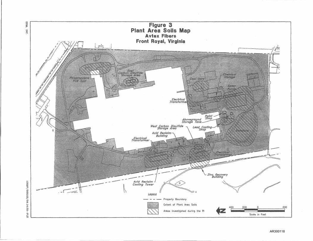
An ESD was issued for OUIO on January 10, 2006 ("OUIO ESD") to extend the area to be remediated. The OUIO ROD described Plant Area Soils as potentially impacted soils located on the eastern portion of the Site (east of the railroad tracks) surrounding the footprint of the former manufacturing plant. The aerial extent of potentially impacted soils was included in the OUIO ROD and is attached as Figure 3 to this ESD.
Following the issuance of the OUIO ROD, several areas with known contaminated waste and soil and potentially contaminated waste and soil were discovered outside the area defined as Plant Area Soils. The aerial extent of the expanded area was included in the OUIO ESD and is attached as Figure 3A to this ESD.
^ The ROD acknowledged the Conservation Easement as an institutional control in place for the entire Avtex Site as a permanent, enforceable legal instrument to restrict the future use of the Site and prohibits the use of ground water.
AR300109

F. Common Elements - Institutional Controls for OU7, OUS and OUIO RODs
As discussed above, the 0U7 and OUS RODs selected institutional controls as part of the remedial action. Those RODs also required the imposition of land use restrictions to portions of the Site. In addition, the 0U7, OUS and OUIO RODs acknowledged an "existing Conservation Easement." The purpose of the Conservation Easement was to restrict land use at the Avtex Site. The Conservation Easement essentially carved the Site into three uses; industrial or commercial use for Parcels 2, 2a and 2b; recreational use for Parcel 1; and conservancy Parcels 3 and 5. See Figure 1 attached to this ESD for the locations of these parcels.
IV. DESCRIPTION OF SIGNIFICANT DIFFERENCES AND THE BASIS FOR SUCH DIFFERENCES
A. OU 7
The 0U7 ROD required the characterization of soils outside of Viscose Basin 9, 10, and 11 that are not to be covered by the capping system. The 0U7 ROD also required that all soils that do not exceed the ground water protection standards, and that are not hazardous within the meaning of 9 VAC 20-60-261, but have concentrations that exceed EPA's Region 3 Ecologically Protective Backfill Values listed on Table 11 of the 0U7 ROD (Attachment 1 to this ESD) be excavated and placed in the basins under the cap.
After the ROD was issued, EPA received information that demonstrated that the values listed on Table 11 of the 0U7 ROD for five metals, namely aluminum, iron, manganese, mercury, and zinc are lower than naturally occurring regional background levels. Therefore, remediation of soils to meet the standards on Table 11 could be not only extremely costly to implement, but also extremely difficult to achieve.
To develop appropriate cleanup numbers, EPA evaluated data from various background areas and reviewed prior ecological standards used at the Site. This analysis is provided in Attachment 2 to this ESD. Based on this analysis, EPA has determined that the cleanup criteria for the five metals listed in Attachment 1 are not site-specific and should be modified as listed below in Table 2. The revised cleanup criteria for soils remain protective of ecological receptors at the Site.
Metal
Aluminum Iron Manganese
Table 2 OU 7 ROD Table 11 Ecologically Protective Backfill Cleanup Values (mg/kg) 50 200 220
EPA's OU7 ROD Modification for Ecologically Protective Cleanup Values (mg/kg) 20,200 31,700 441
AR300110

Metal
Mercury Zinc
Table 2 OU 7 ROD Table 11 Ecologically Protective Backfill Cleanup Values (mg/kg) 0.00051 120
EPA's OU7 ROD Modification for Ecologically Protective Cleanup Values (mg/kg) 0.14 233
Site soils are predominantly acidic. The low pH of soils inhibits establishing a vegetative growth. Therefore, EPA is adding the following performance standard to Section 11.2.9 of the 0U7 ROD: "The upper six inches of cover soil in remediated areas will be amended as necessary to achieve pH of no less than 5.5 prior to seeding/planting." A more neutral pH should allow for the establishment of a vegetative cover that minimizes erosion.
The 0U7 ROD stated that 0U7 soils located outside the basins that are not to be covered by the Viscose Basins 9, 10, and 11 cover systems will be characterized. All soils and sediments classified as a hazardous waste within the meaning of 9 VAC 20-60-261 will be disposed of appropriately at an off-site RCRA Subtitle C landfill. All soils and sediments that are not classified as hazardous waste within the meaning of 9 VAC 20-60-261, and do not exceed the groundwater protection standards, but have concentrations that exceed the Regional Screening Levels for industrial soils at a total excess cancer risk of 1 x 10'^ a total non-cancer risk for target organ-specific HQ of 1, and/or EPA's Region 3 Ecologically Protective Backfill Values, listed on Table 11 in the 0U7 ROD (see Attachment 1), will be excavated and placed into the basins under the cap. Soils exceeding groundwater protection standards, but not classified as hazardous waste within the meaning of 9 VAC 20-60-261, will be disposed off-site in an off-site RCRA Subtitie D landfill. This ESD's modification to cleanup criteria is limited to the Ecologically Protective Backfill values as described above.
Changes to the institutional controls for 0U7 will be discussed in Section D, below.
B. OU S ROD
OUS for the Avtex Site consists of Area B; a 24-acre open field (depicted as Parcel 2B on Figure 1) and Area G; a ten-acre paved parking lot (depicted as Parcel 2A on Figure 1).
EPA's September 29, 2000 ROD selected institutional controls to restrict land use of Areas B and C to commercial/industrial use. The ROD acknowledged the Conservation Easement as an institutional control in place for the entire Avtex Site that permanently restricts Areas B and C to commercial/industrial land use.
EPA is working with the signatories of the Conservation Easement and Warren County to replace the existing Conservation Easement with four separate Conservation Easements to address the various owners, stewards, and uses of the Site. The land use restrictions for Areas B
AR300111

and C will essentially remain the same with the exception of allowing for college or university education classrooms; accordingly, the Conservation Easement will change.
Changes to the institutional controls for OUS will be discussed in further detail in Section D, below.
C. OUIO ROD
The OUIO ROD acknowledged the Conservation Easement as an institutional control to prevent exposure and protect the selected remedy. Changes to the institutional controls for OUIO will be discussed in Section D, immediately below.
D. Institutional Controls for OU7, OUS, and OUIO
The institutional controls selected in the 0U7 and OUS RODs and acknowledged in the OUIO ROD covered, only portions of the entire Site. In addition, although they referenced the Conservation Easement, they did not specifically select the Conservation Easement as an institutional control for the Site. For these reasons, this ESD expands the institutional controls to cover the entire Site and selects the Conservation Easement (as modified below) as an institutional control for the Site.
However, the existing Conservation Easement does not account for changing uses and stewardship of the properties comprising the Site. For that reason, EPA is replacing the existing Conservation Easement with two Conservation Easements to address property owned by the Economic Development Authority, a third Conservation Easement to address property owned by Warren County, and a fourth Conservation Easement to address property owned by Honeywell International Inc. Overall, with one exception, the new Conservation Easements will provide the same restrictions as the original Conservation Easement, but are carved into four separate easements to address the specificity of fiiture development.
The original Conservation Easement prohibited any educational institutions. Recentiy, a university has expressed an interest in leasing space for evening classes. The Town of Front Royal and the Economic Development Authority are interested in potentially leasing a portion of the site for evening college classes. EPA and the signatories to the Easement therefore agree that adult education is an appropriate future use of the Site. As a result, the revised Conservation Easement will allow for college-level evening classes.
The original Conservation Easement cited the Front Royal Town Code for allowable uses on the portion of the Site formerly occupied by the plant (Area 2, 2 A and 2B on Figure 1). The Conservation Easement is meant to be a permanent restriction that runs with the land. However the Town Code is subject to change. Therefore, to avoid confusion, the revised Conservation Easement for the Parcels 2, 2A and 2B specifically will list allowable fiiture uses as well as prohibited future uses.
-L0_
AR300112

Area 3 on Figure 1 is slightly modified from the original Conservation Easement to allow for a very small portion, approximately 225 square feet, of the extreme southeastern tip to be dedicated to the public use for the improvement of Luray Avenue. In addition, an area, approximately one acre in size, located adjacent to the boat ramp at the base of Luray Avenue will be designated for expansion of the boat ramp.
E. CONSISTENCY WITH APPLICABLE, RELEVANT AND APPROPRIATE REGULATIONS ("ARARs")
This ESD does not fundamentally change the remedies selected in the 0U7, OUS and OUIO RODs. No new ARARs have been identified. The modifications described in this ESD do not affect any of the remedy-specific ARARs described in the 0U7 and OUIO RODs. The ROD for OUS did not identify any ARARs.
F. CONSISTENCY WITH REMEDIAL ACTION OBJECTIVES
The modifications selecteded in this ESD will not fundamentally alter the remedies selected in the 0U7, OUS and OUIO RODs with respect to scope, performance, or cost. In addition, EPA does not anticipate any significant changes to the overall scope or costs from estimates in the January 13, 2010 0U7 ROD. However, the performance will be significantly changed by meeting a sitcrspecific ecologically protective backfill value.
1. OU7ROD
This ESD is consistent with the remedial action objectives in the 0U7 ROD. The remedial action objectives ("RAOs") in the original 0U7 ROD did not address the ecological backfill protection levels for remediated soil. The RAOs in the ROD did address preventing human and ecological exposure to both ground water contamination and waste contamination. The new Conservation Easements will provide the same level of protection as the Conservation Easement described in the 0U7 ROD.
2. OUS ROD
This ESD is consistent with the remedial action objectives for Areas B and C in the OU S ROD. The new Conservation Easements provide the same level of protection as the Conservation Easement described in the OUS ROD.
3. OUIO ROD
This ESD is consistent with the remedial action objectives for the remedial activities in the OUIO ROD. The new Conservation Easements provide the same level of protection as the Conservation Easement described in the OUIO ROD.
11
AR300113

V. SUPPORT AGENCY REVIEW
EPA has notified the Commonwealth of Virginia of the changes selected in this ESD in accordance with 40 C.F.R. § 300.435(c)(2). The Commonwealth of Virginia has concurred with this ESD in a letter dated November 28, 2011.
VI. AFFIRMATION OF THE STATUTORY DETERMINATIONS
EPA has determined that the revised remedies for 0U7, OUS, and OUIO comply with the statutory requirements of Section 121 of CERCLA, 42 U.S.C. § 9621. The remedies remain protective of human health and the environment, are cost effective, and are equivalent to Federal and State requirements that are applicable or relevant and appropriate to the remedial actions described in the 0U7, OUS and OUIO RODs.
VH. PUBLIC PARTICIPATION COMPLIANCE
EPA placed a fiill-page notice in the mid-September 2011 edition of the "Warren County Report," which is a free local newspaper. The 30-day public comment period ran fi-om September 14, 2011 through October 14, 2011. EPA did not receive any comments.
The Administrative Record for this decision contains all information that EPA considers or relies upon in making its remedy decision, including the ESD.
The Administrative Record is available for public review at the locations listed in Section II of this ESD. EPA's point of contact for this Site:
Kate Lose, Remedial Project Manager EPA Region III 1650 Arch Street (3HS23) Philadelphia, PA 19103-2029 215-814-3240 [email protected]
me Ronald<l. Borsellino, Director H^^zardous Site Cleanup Division EPA Region III
J.2_
AR300114

List of Figures and Attachments
Figure 1
Figure 2
Figure 3
Figure 3A
Map of Future Land Use
Avtex Location Map
Plant Area Soils Map for OUIO ROD
Revised Plant Area Soils Boundary for OUIO ESD
Attachment 1
Attachment 2
Table 1 lof 0U7 ROD - EPA Region 3 Ecologically Protective Backfill Values
Analysis of various background areas and review of prior ecological standards used at the Avtex Site
Attachment 3 Commonwealth of Virginia Concurrence Letter
AR300115

Figure 1 MAP OF FUTURE LAKD USE
AVTEX FIBERS SUPERFUND SITE FRONT ROYAL, VIRGINIA
Parcel 2A (Re medio I Investigation
Area C)
Industrial/ Commercial
3 \ / ' (Remedial V f
/^^^ Investigation \ Area B) \ ^
Alternative Route_^-to A vtex Fibers t -Superfund Site
\
A T i . A %,¥^K2 W - \ x ^ I , / M / / \ ^ T •" Nyatrial/ \ «^s#f' / \ y 0 ^ ( i > ^ . % '•• 3 'tiommercial \ '&^: :^% / ' \ , A ^ 0 C<^;^-\-;l';-••',,, (former PlariJ 'SX ' / } ^ W^ .r^T^^\.,.:.-x\ Area) ''~'':'.CJ&.L,y .
AREA 1 Parcel 1
Soccer Plex /
/ AREA 4 (Former General
Cfiemicat Property)
':v.
r ,/•"' ( Recreational/^'-"""''"1\ \ i / ' %.V. Conservancv/'SMce) '^••^•—•i^ i "^•^•, X \ y ••
,̂ \(lmp.puodff>e{its. Opd^ \ Fill Ar
V, :->'-'-'-r'
i . . . ! . • . : . . , ^ ' :••• ' 4 •-
J ••' i : \ ;
% . . . . . h •••;
1: -- T I
. ' < ^ r
- Consent Decree Property Boundary
South Fork ^
AREAS Recreational/
Conservancy Space (Rivermont Acres)
U\ L\\. > '
MB « P I
AR300116

Figure 2 Avtex Location IViap
V\192.168 3,1 l\proj(!cl5\C0'(5_Avti!x\Woildna\Feasibilily Sludy\EPAConmeiitsVFS_CRD_ll-05\FiBU'K\tlB'ir« l - lJoc
AR300117
s
<o .J 01 o
1
Figure 3 Plant Area Soils lyflap
Avtex Fibers Front Royal, Virginia
Legend
' ' — — —— Property BouncJory
Extent of Plont Area Soils
Areos investigated during the Rl ^
400 200 400
Scole in Feet
AR300118

4s:
FIGURE 3A REVISED PLANT AREA SOILS BOUNDARY
AVTEX SUPERFUND SITE FRONT ROYAL, VIRGINIA
4S'
LEGEND
. — . . . - PROPERIYUNE
1 1- RMUVMD
^ — — 2004 ROO PLANT AREA SOILS BOUNDARY
SOCCERPLEX BOUNDARY
SOCCERPLEX PHASE BOUNDARIES
EXTENT OF PLANT AREA SOILS
AREAS MVESTIGATEO DURING THE Rl
EXPANDED PLANT AREA SOILS LIMITS
r ̂ A 300
mm SCALE M FEET
MLB/12-09-05 ERM. INC.
AR300119

ATTACHMENT 1
AR300120

Table 11
EPA Region 3 Ecologically Protective Backfill Values
Analyte* (mg/kg)
Al An As Ba Be 8 Cd Cr (3/6) Co Cu Fe Pb M n HgOnora) Ni Se Ag Ti Sn V Zn ON
EPA Region 3 backfill
50.0 2.7
18.0 330.0 40.0
0.5 3.6
260/1300 13.0 70.0
200.0 110.0 220.0
0.00051 38.0 0.52 42.0
1.0 51.5 78.0
120.0 5.0
Compound* (mg/kg
ACENAPHTHENE ANTHRACENE BENZO[A]PYRENE BIPHENYL. 1.1-CHLOROANILINE. P- . CHLOROBENZENE CHLOROPHENOL. 2-DDT and metabolites DICHLOROBENZENE. P-DICHLOROPHENOL. 2.4-DICHOLOR-2-BUTENE. 1.4-DIELORIN DIETHYL PHTHALATE DIMETHYLPHTHALATE DI-N-BUTYLPHTHALATE DINITROPHENOL. 2.4-ETHYL BENZENE ETHYLENE GLYCOL FLUORANTHENE FLUORENE HEXACHLOROCYCLOPENTADIENE NAPHTHALENE NITROBENZENE NITROPHENOL. 2-NITROPHENOL. 4-NITROSODIPHENYLAMINE. N-PAHs, TOTAL PAHs,LMW PAHs. HMW PCBs, TOTAL PENTACHLOROBENZENE PENTACHLOROPHENOL PHENANTHRENE PHENOL PYRENE PYRIDINE STYRENE TETRACHLORODIBENZOFURAN. 2.3.7,8- (TCDF) TETRACHLORODIBENZO-P-DIOXIN. 2,3,7,8- (TCDD) TETRACHLOROPHENOL. 2,3,4,6-TOLUENE TRICHLOROBENZENE. 1.2,4-TRICHLOROPHENOL. 2.4.5-TRICHLCROPHENOL. 2.4,6-XYLENES (TOTAL)
EPA Region 3 backfill
20 0.1 0.1 60 20
0.05 7
0.21 20 20
1000 0.049
100 200 200
20 • 0.05
97 0.1 30 10
0.1 40
7 7
20 1
29 11
0.371 20
5 0.1 30
0.1 0:1 0.1
0.00084 0.00000315
20 0.05
20 4 9
0.05
*For analytes and compounds not listed, use PADEP Safe Fill Standards for Residential Direct Contact
Slight exceedances of these values may be acceptable if the backfill area is spatially limited, the soils are amended with organics to reduce bioavailability, or if toxicity testing of the backfill material demonstrates that it does not pose risk.
AR300121

ATTACHMENT 2
AR300122

March 1,2010
To: Kate Lose (EPA)
From: Sid Curran (Gannett Fleming, Inc.
RE: FMC's February 18, 2010 "Request for Concurrence of Approach to Use Regional Background Soil Concentrations for the OU-7 Remedy", Operable Unit 7, Avtex Fibers Superfund Site, Front Royal, Virginia
Gannett Fleming, Inc. offers the following comments and discussion pertaining to the referenced document.
FMC's February 18, 2010 "Request for Concurrence of Approach to Use Regional Background Soil Concentrations for the OU-7 Remedy", Operable Unit 7, Avtex Fibers Superfund Site, Front Royal, Virginia was submitted due to FMC's concerns that background concentrations of some metals appeared to exceed the Ecologically Protective Backfill Values presented in the OU-7 Record of Decision (ROD). FMC has proposed alternative cleanup levels based on "Regional Virginia Background Soil Concentrations" for the following metals of particular concern to FMC: aluminum, barium, iron, manganese, mercury, and zinc.
Part A below provides information concerning on-site data from areas not believed to have been impacted by historical Avtex Site activities, including the 2003 data for the SoccerPlex referred to in FMC's submission. In summary, the OU-7 ROD values for aluminum, iron, and mercury are clearly lower than the likely background concentrations at the site by 2 to 3 orders of magnitude. For barium, it is not clear why FMC is proposing an increased cleanup level because it appears the background concentration of barium at the site would be less than the OU-7 ROD value of 330 mg/kg. Manganese and zinc appear to be borderline, but a moderate increase in the cleanup level appears to be warranted.
Part B below describes the approach used to set PRGs for the Fly Ash Stockpile (FAS) clean closure and the Sulfate Basin 2 clean closure. This information is provided because, if the OU-7 ROD cleanup levels are to be modified, it is important to know the available ecological data and what has been done historically at the site. FMC's proposed levels for mercury and zinc are similar to, but not the same, as those established historically using the Ecological Risk Assessment (ERA) data and "Regional Virginia Background Concentrations" data.
Summary/Recommendations
Aluminum: The site background concentration appears to be in the range of 13,000 to perhaps 20,000 mg/kg. FMC's proposed 51,000 mg/kg appears to be high, but was based on "Regional Virginia Background Concentrations" values.
Barium: The OU-7 ROD value of 330 mg/kg seems fine. None of the data presented in Table 1 exceeded 330 mg/kg.
Iron: Based on the limited available data, the background concentration appears to be between 14,000 mg/kg and approximately 55,800 mg/kg. FMC has proposed using the "Regional Virginia Background Concentrations" value of 31,700 mg/kg, which appears reasonable.
AR300123

Manganese: The OU-7 ROD value of 220 mg/kg appears to be somewhat low. The "Regional Virginia Background Concentrations" value of 441 mg/kg appears to be reasonable.
Mercury: The OU-7 ROD value of 0.00051 mg/kg is clearly lower than background at the site. The PRG based on the No Observed Adverse Effects Level (NOAEL) of 0.14 mg/kg calculated for the Fly Ash Stockpile clean closure would appear reasonable. FMC had proposed using the "Regional Virginia Background Concentrations" level of 0.1, which, unrounded would have been approximately 0.135 mg/kg.
Zinc: The OU-7 ROD value of 120 mg/kg appears to be somewhat low. The "Regional Virginia Background Concentrations" value of 233 mg/kg calculated for use in the closure of the FAS would appear to be reasonable. FMC had proposed a value of 276 mg/kg as the "Regional Virginia Background Concentrations" level, however, EPA and FMC had previously agreed upon and used the 233 mg/kg concentration during the Fly Ash Stockpile clean closure and the Sulfate Basin 2 closure.
Part A
The purpose of this section is to provide site data from areas either not believed to have been impacted by historical on-site activities, or seem to provide insight into what site background levels may be. Data for soils that were imported from a local off-site quarry for placement as the growth and infiltration layer in cover systems for several disposal areas are also included.
The following are brief descriptions of the areas the Table 1 data came from.
Imported Soil from Off-Site Quarry: Data are provided for an April 16, 2008 sample for imported soil for use on Viscose Basins 4-6 and data for a January 25, 2002 sample for imported soil used in the NTCRA - Basins. These data demonstrate that obtaining off-site soil that meets OU-7 ROD levels for aluminum, iron, and mercury may not be possible.
Sulfate Basin 5 Soil from Berms Above Water Line: These soils were from the berms around Sulfate Basin 5 at elevations above the water level. It was believed these soils would have been minimally impacted by site activities. The barium and zinc data were less than the OU-7 ROD values, and the mercury concentrations were relatively low.
SoccerPlex Investigations: The "SoccerPlex" area is an area of the site that historically was used as a trailer park for workers' housing and a recreational area (Stump Park). It was believed that this area had not been impacted by historical site industrial activities, and the development plan was to Install a number of soccer fields for use in youth soccer leagues. Several investigations were performed in this area, including work performed by EPA in 1995 and an investigation by FMC in 2003. These data demonstrate that cleaning up soils to the OU-7 ROD aluminum, iron, and mercury levels may not be possible. Barium appears to be achieved. Although FMC's zinc samples were less than the OU-7 ROD levels, some of EPA's samples were considerably higher. One of three manganese samples exceeded the OU-7 levels.
S(te_Bkgc(_Ecol_022610.doc P a g e 2 Of 5
AR300124

Clean Closure Fly Ash Stockpile (FAS): This area was formerly covered by a 90-foot high "mountain" of fly ash. After removing the fly ash until the soils appeared visually clean, samples were collected from throughout the former FAS footprint. The soils underlying the pile are believed to have been largely the original undisturbed soils. Although some fly ash impact could be present, the data for mercury and zinc are informative.
Areas B and C: Area B is a parcel on the northern end of the site that never had industrial activities on it and is not believed to have been impacted; Area C was a parking lot across Kendrick Lane from the site. Surface soils in Areas B and C were sampled during a Focused Feasibility Study conducted in 1995. Also, during the NTCRA - Basins, soils from Area B were excavated ahd tested in 2002 for use as cover system soils for closing several disposal basins. These data demonstrate that cleaning up soils to the OU-7 ROD mercury level may not be possible. Barium appears to be achieved. The data suggest a moderate increase in the cleanup level may be warranted for manganese and zinc.
Boreholes 101 and 102: Boreholes 101 and 102 are the locations at which upgradient monitoring wells were installed near the Avtex property line. Samples were collected from the surface to a depth of approximately 22 feet. The results were similar to other locations.
Site_Bkgd_Ecol_022610.doc P a g e 3 Of 5
AR300125

Parte:
Prior Ecological Standards at Avtex
The first ecological cleanup standards for FMC activities were established for the clean closure of Sulfate Basin 5. PRGs based on the NOAEL and LOAEL were calculated using site-specific toxicity data for zinc.
The second ecological cleanup standards for FMC activities were established for the clean closure of the Fly Ash Stockpile in the document "Field Sampling and Analysis Plan Supplement - Former Fly Ash Stockpile" under the NTCRA - Basins, dated August 15, 2006. EPA BTAG utilized the data for the Fly Ash Stockpile area presented in the "Final Ecological Risk Assessment", dated February 1999 to calculate preliminary remediation goals (PRGs) based on the No Observed Adverse Effects Level (NOAEL) and Lowest Observed Adverse Effects Level (LOAEL) (EPA e-mail dated November 12, 2003 from Bruce Pluta [BTAG] to Bonnie Gross [EPA RPM]. Recognizing that the background concentrations of some metals might be higher than the calculated PRGs, "Regional Viriginia Background Concentrations" were calculated. The cleanup standard was set at the PRG based on the NOAEL unless the NOAEL was less than the "Regional Virginia Background Concentration". When the PRG based on the NOAEL was less than these background concentrations: 1) The "Regional Virginia Background Concentration" was used If it was less than the PRG based on the LOAEL, and 2) The PRG based on the LOAEL was used if it was less than or equal to the "Regional Virginia Background Concentration". Using this approach, the following Ecological Cleanup Standards were established for the Clean Closure of the Fly Ash Stockpile area:
Metal Arsenic Chromium Copper Lead Mercury Zinc
Ecological Cleanup Level (mg/kg)
17.6 496 32.4 37.2 0.14 233
Basis for Cleanup Level Maximum Site Background PRG based on NOAEL PRG based on LOAEL Average VA Background PRG based on NOAEL Average VA Background
This approach was also used for the closure of Sulfate Basin 2 (E-mail from John McClosky [BTAG - Fish and Wildlife Service] to Bonnie Gross [EPA], dated January 31, 2008. The resulting cleanup levels for mercury and zinc were the same as in the table above for the FAS area.
AR300126

Table 1: Example Analytical Data for Soil from Off-Site and On-Site Locations
All values are in mg/kg.
Compounds and Ecological Cleanup Levels
Cmpd
Al
Ba
Iron
Mn
Hg
Zinc
OU7 ROD
50
330
200
220
0.00051
120
FMC Prop.
51,000
436
31,700
441
0.1
276
FAS PRGs
0.14
233
Imported Soil from
Off-Site Quarry
VB4-6 Cover
04/16/08
13,600
35.6
21,700
28.3
0.053 J
14.9
Riverton 01/25/02
<61.1
<0.12
97.1
•
Sulfate Basin 5 Soil From Berms Above Water Line
North 02/22/02
82.9
—
<0.11
47.7
South 02/22/02
50.0
• —
<0.11
32.6
Socc invest!
EPA 1995 (9 Samples)
—
14,000 to 26,000
92 to 690 Avg = 302
Median= 210
erPlex gallons
FMC May 2003
TAL Metals (3 Samples)
16,900 15,800 20,200
111 93.7 ,92.4
46,300 42,700 32,500
95.6 128 539
0.181 0.196
0.0613 J
94.5 94.1 59.3
(Also, 14 samples
reduced list) 19.8 to 81.7
Clean Closure Fly
Ash Stockpile
2006 Post-Excavation Sampling
—
—
(89 samples) 0.0139 to 0.249 10 were > 0.1 6 were > 0.14
(76 samples) 10.1 to 434
15 were > 50 2 were > 233
Areas B and C Borrow Area X
2002 Excavated Soil
(52 Samples)
Min = 51.5 Max = 222 Avg = 91.3
Median = 85.1
—
Min = 86.7 Max = 895
Avg = 260.2 Median = 217 25 were > 220 4 were > 441
37 Not Detected at 0.11 mg/kg. 15 detections
ranged from 0.12 to 0.87 mg/kg. 9 were > 0.14
Min = 22.9 Max = 606
Avg = 114.4 Median = 71.0 15 were > 120 7 were > 233
Focused FS -Surface-1995
(5 samples)
4,940 to 11,000
40.1 to 54.0
14,500 to 22,900
68.4 to 293
2 samples <0.04
(17 samples) 9.9 to 100.0
1
Boreholes 101 and 102
(Upgradient]^
1993 Rl Surface to 21
(11 samples 3,390 to 15,5
Avg = 8,64: Median = 7,8
23.4 to 156 Avg = 76.9
Median = 77
5,530 to 55,8 (2 were > 31,7
Avg = 24,85 Median = 24,£
24 to 741 (8 were > 22 5 were > 44'
Avg = 355 Median = 31
8.3 to 119 Avg = 49.8
Median = 51.
ft
0
0
5
0~
:
1
:
AR300127

ATTACHMENT 3
AR300128

Douglas W. Domenech Secretary of Natural Resources
..mmh.
COMMONWEALTH of VIRGINIA DEPARTMENT OF ENVIRONMENTAL QUALITY
Street address: 629 East Main Street, Richmond, Virginia 23219 ^/(ailing address: P.O. Box 1105, Richmond, Virginia 23218
TDD (804) 698-4021 www.deq.virginia.gov
November 28, 2011
David K. Paylor Director
(804) 698-4020 1-800-592-5482
Mr. Ronald J. Borsellino, Director Hazardous Site Cleanup Division (3HS00) U. S. Environmental Protection Agency, Region HI 1650 Arch Street Philadelphia, Pennsylvania 19103-2029
Re: Second Explanation of Significant Differences for OU-8, OU-9, OU-10 Avtex Fibers
Dear Mr. Borsellino:
The Virginia Department of Environmental Quality staff has reviewed the Second Explanation of Significant Differences (ESD) for Operable Units 7, 8 and 10 at the Avtex Fibers site. We concur with the changes in the remedy as described in the ESD that was received on November?, 2011.
If you have any questions about this rnatter, please contact Tom Modena at (804) 698-4183.
Sincerely, ,
Durwood Willis, Director Office of Remedial Programs
cc: Kate Lose, EPA Region HI (3HS23) Kevin L. Greene Thomas D. Modena
AR300129