Embed Size (px)
Citation preview
16 OCTOBER 2020
Level 1, 34 Colin Street, West Perth, Western Australia, 6005 | T: +61 8 9481 2555 | F: +61 8 9485 1290 www.azureminerals.com.au | ABN: 46 106 346 918 | ASX: AZS
SECOND ANDOVER DRILL HOLE HITS MORE NICKEL-COPPER SULPHIDE MINERALISATION
Assays from ANDD0001 pending • Drill hole ANDD0002 intersected 14.50m of semi-massive, matrix and disseminated
nickel and copper sulphide mineralisation from a depth of 104.50m
• Internal interval of 4.05m of semi-massive and matrix sulphide mineralisation correlates with the down-dip extension of the similar strongly mineralised interval intersected in ANDD0001 (refer ASX release: 12 October 2020)
• Width and tenor of the mineralised intercept in ANDD0002 is consistent with the electromagnetic (EM) conductor plate, validating the geophysical modelling
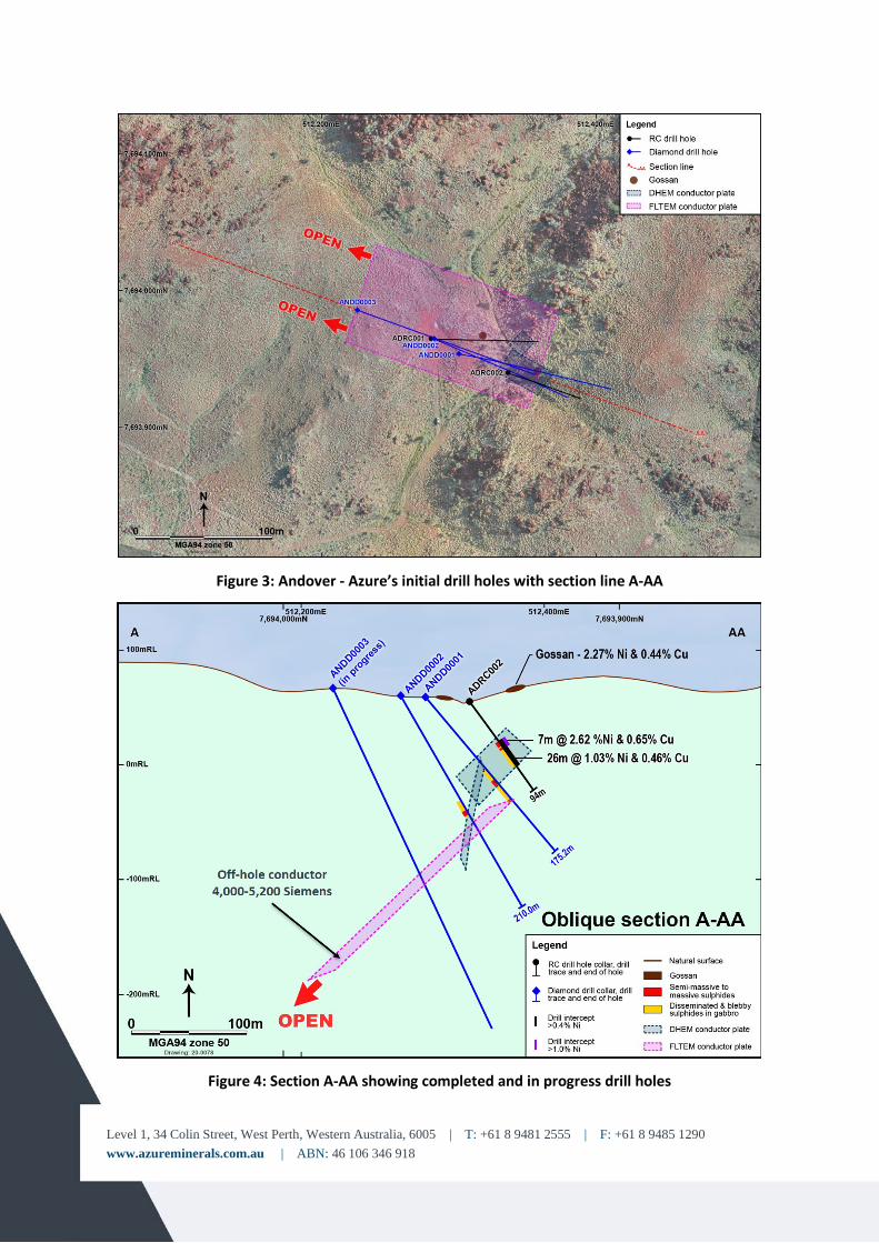
• EM conductor plate as modelled is expected to increase in strength (up to 5,200S) and scale as it deepens and is interpreted as a significant down-dip mineralised extension that is currently being tested by ANDD0003
• Downhole electromagnetic (DHTEM) survey crew is on site and has started surveying hole ANDD0002
Azure Minerals Limited (ASX: AZS) (“Azure” or “the Company”) is pleased to report that, following on from the excellent sulphide mineralised intersection observed in Azure’s first drill hole ANDD0001 (ASX: 12 October 2020), more significant nickel and copper sulphide mineralisation has been observed in core from the Company’s second drill hole ANDD0002 on the Andover Project (60% Azure / 40% Creasy Group), located in the West Pilbara region of Western Australia.
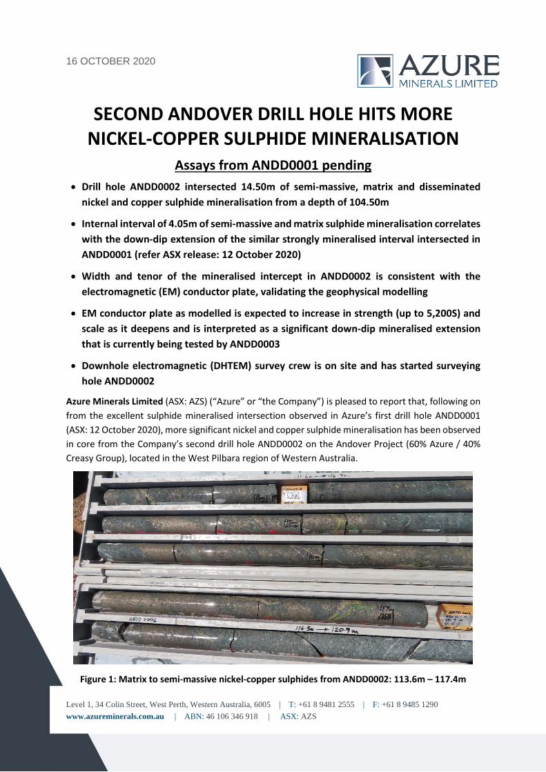
Figure 1: Matrix to semi-massive nickel-copper sulphides from ANDD0002: 113.6m – 117.4m
Level 1, 34 Colin Street, West Perth, Western Australia, 6005 | T: +61 8 9481 2555 | F: +61 8 9485 1290 www.azureminerals.com.au | ABN: 46 106 346 918
Commenting on this latest mineralised intersection, Managing Director, Mr. Tony Rovira said:
“Andover continues to impress with our second drill hole intersecting strong nickel and copper sulphide mineralisation, extending the mineralised zone for at least an additional 40m down-dip to the northwest from the first hole ANDD0001.
“The strongly mineralised intersections from our first two drill holes coincide with the interpreted locations of the conductor plates identified by earlier EM surveys, validating the geophysical modelling. This modelling indicates that the main conductor strengthens at depth and this target is currently being tested by hole ANDD0003. To provide additional definition of along-strike and down-dip extensions to these conductor plates and refine future drill targeting, the EM survey crew has arrived back on site and down hole surveying has started in hole ANDD0002, with additional holes to be surveyed as they are completed.
“The strong correlation of EM conductors with massive to semi-massive nickel and copper mineralisation augurs well for further exploration success as numerous EM conductors identified from surface surveying remain to be tested.”
OVERVIEW
In Azure’s first two diamond drill holes at Andover, the Company’s geologists have observed significant quantities of nickel and copper sulphide mineralisation in the drill core, which has been verified by pXRF readings.
Mineralised intersections consist of a mix of massive, semi-massive, matrix, stringer, blebby and disseminated sulphides present as pentlandite (nickel sulphide), chalcopyrite (copper sulphide) and pyrrhotite (iron sulphide) hosted in gabbro and similar mafic rocks of the Andover mafic-ultramafic intrusive complex.
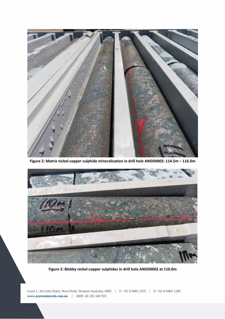
The recently completed second drill hole, ANDD0002, contains an overall mineralised interval of 14.50m commencing at 104.50m downhole. This includes a strongly mineralised 4.05m-wide zone of semi-massive to matrix nickel-copper sulphide mineralisation starting from 113.35m. This intersection correlates as the down-dip extension of the massive to semi-massive sulphide interval intersected in the first hole ANDD0001, extending the mineralised zone by an additional 40m.
Cutting and sampling of the mineralised interval in hole ANDD0002 has been completed and the samples are in transit to the laboratory in Perth for analysis.
Samples from hole ANDD0001 have been received at the laboratory and analysis is in progress. Results will be released as they become available.
Level 1, 34 Colin Street, West Perth, Western Australia, 6005 | T: +61 8 9481 2555 | F: +61 8 9485 1290 www.azureminerals.com.au | ABN: 46 106 346 918
Figure 2: Matrix nickel-copper sulphide mineralisation in drill hole ANDD0002: 114.5m – 116.0m
Figure 2: Blebby nickel-copper sulphides in drill hole ANDD0002 at 110.0m
Level 1, 34 Colin Street, West Perth, Western Australia, 6005 | T: +61 8 9481 2555 | F: +61 8 9485 1290 www.azureminerals.com.au | ABN: 46 106 346 918
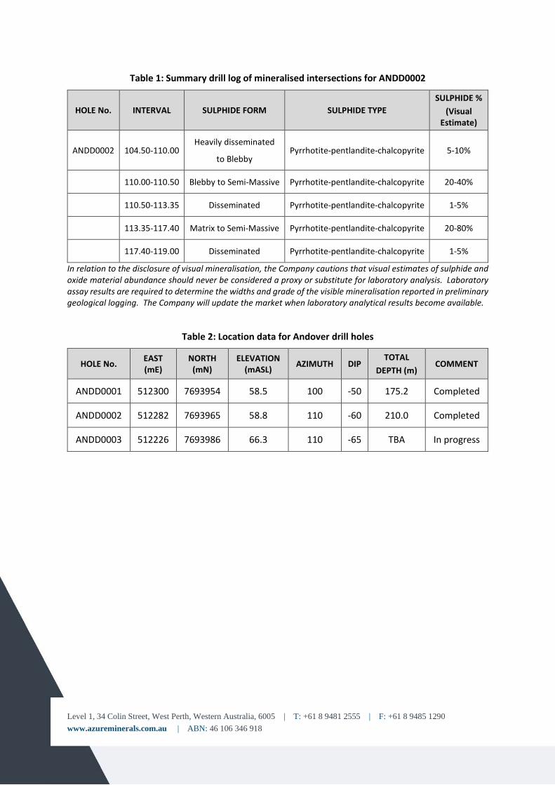
Table 1: Summary drill log of mineralised intersections for ANDD0002
HOLE No. INTERVAL SULPHIDE FORM SULPHIDE TYPE SULPHIDE %
(Visual Estimate)
ANDD0002 104.50-110.00 Heavily disseminated
to Blebby Pyrrhotite-pentlandite-chalcopyrite 5-10%
110.00-110.50 Blebby to Semi-Massive Pyrrhotite-pentlandite-chalcopyrite 20-40%
110.50-113.35 Disseminated Pyrrhotite-pentlandite-chalcopyrite 1-5%
113.35-117.40 Matrix to Semi-Massive Pyrrhotite-pentlandite-chalcopyrite 20-80%
117.40-119.00 Disseminated Pyrrhotite-pentlandite-chalcopyrite 1-5%
In relation to the disclosure of visual mineralisation, the Company cautions that visual estimates of sulphide and oxide material abundance should never be considered a proxy or substitute for laboratory analysis. Laboratory assay results are required to determine the widths and grade of the visible mineralisation reported in preliminary geological logging. The Company will update the market when laboratory analytical results become available.
Table 2: Location data for Andover drill holes
HOLE No. EAST (mE)
NORTH (mN)
ELEVATION (mASL) AZIMUTH DIP
TOTAL DEPTH (m)
COMMENT
ANDD0001 512300 7693954 58.5 100 -50 175.2 Completed
ANDD0002 512282 7693965 58.8 110 -60 210.0 Completed
ANDD0003 512226 7693986 66.3 110 -65 TBA In progress
Level 1, 34 Colin Street, West Perth, Western Australia, 6005 | T: +61 8 9481 2555 | F: +61 8 9485 1290 www.azureminerals.com.au | ABN: 46 106 346 918
Figure 3: Andover - Azure’s initial drill holes with section line A-AA
Figure 4: Section A-AA showing completed and in progress drill holes
Level 1, 34 Colin Street, West Perth, Western Australia, 6005 | T: +61 8 9481 2555 | F: +61 8 9485 1290 www.azureminerals.com.au | ABN: 46 106 346 918
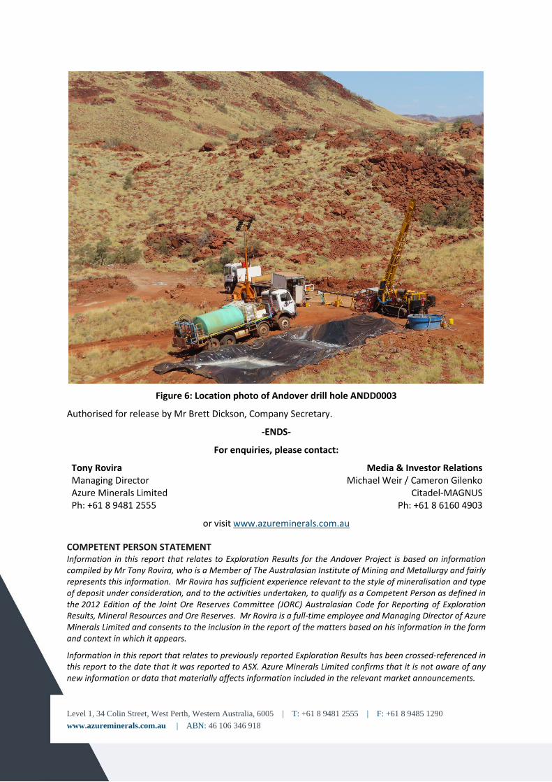
Figure 6: Location photo of Andover drill hole ANDD0003
Authorised for release by Mr Brett Dickson, Company Secretary.
-ENDS-
For enquiries, please contact:
Tony Rovira Managing Director Azure Minerals Limited Ph: +61 8 9481 2555
Media & Investor Relations Michael Weir / Cameron Gilenko
Citadel-MAGNUS Ph: +61 8 6160 4903
or visit www.azureminerals.com.au
COMPETENT PERSON STATEMENT Information in this report that relates to Exploration Results for the Andover Project is based on information compiled by Mr Tony Rovira, who is a Member of The Australasian Institute of Mining and Metallurgy and fairly represents this information. Mr Rovira has sufficient experience relevant to the style of mineralisation and type of deposit under consideration, and to the activities undertaken, to qualify as a Competent Person as defined in the 2012 Edition of the Joint Ore Reserves Committee (JORC) Australasian Code for Reporting of Exploration Results, Mineral Resources and Ore Reserves. Mr Rovira is a full-time employee and Managing Director of Azure Minerals Limited and consents to the inclusion in the report of the matters based on his information in the form and context in which it appears.
Information in this report that relates to previously reported Exploration Results has been crossed-referenced in this report to the date that it was reported to ASX. Azure Minerals Limited confirms that it is not aware of any new information or data that materially affects information included in the relevant market announcements.
16 OCTOBER 2020
Level 1, 34 Colin Street, West Perth, Western Australia, 6005 | T: +61 8 9481 2555 | F: +61 8 9485 1290 www.azureminerals.com.au | ABN: 46 106 346 918 | ASX: AZS
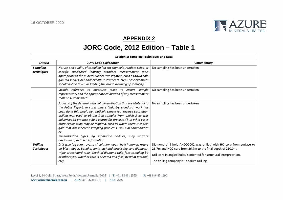
APPENDIX 2 JORC Code, 2012 Edition – Table 1
Section 1: Sampling Techniques and Data Criteria JORC Code Explanation Commentary
Sampling techniques
Nature and quality of sampling (eg cut channels, random chips, or specific specialised industry standard measurement tools appropriate to the minerals under investigation, such as down hole gamma sondes, or handheld XRF instruments, etc). These examples should not be taken as limiting the broad meaning of sampling
No sampling has been undertaken
Include reference to measures taken to ensure sample representivity and the appropriate calibration of any measurement tools or systems used.
No sampling has been undertaken
Aspects of the determination of mineralisation that are Material to the Public Report. In cases where ‘industry standard’ work has been done this would be relatively simple (eg ‘reverse circulation drilling was used to obtain 1 m samples from which 3 kg was pulverised to produce a 30 g charge for fire assay’). In other cases more explanation may be required, such as where there is coarse gold that has inherent sampling problems. Unusual commodities or mineralisation types (eg submarine nodules) may warrant disclosure of detailed information.
No sampling has been undertaken
Drilling Techniques
Drill type (eg core, reverse circulation, open- hole hammer, rotary air blast, auger, Bangka, sonic, etc) and details (eg core diameter, triple or standard tube, depth of diamond tails, face-sampling bit or other type, whether core is oriented and if so, by what method, etc).
Diamond drill hole ANDD0002 was drilled with HQ core from surface to 26.7m and HQ2 core from 26.7m to the final depth of 210.0m.
Drill core in angled holes is oriented for structural interpretation. The drilling company is Topdrive Drilling.
Level 1, 34 Colin Street, West Perth, Western Australia, 6005 | T: +61 8 9481 2555 | F: +61 8 9485 1290 www.azureminerals.com.au | ABN: 46 106 346 918
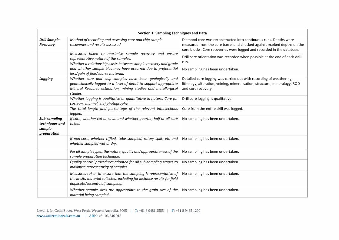
Section 1: Sampling Techniques and Data Drill Sample Recovery
Method of recording and assessing core and chip sample recoveries and results assessed.
Diamond core was reconstructed into continuous runs. Depths were measured from the core barrel and checked against marked depths on the core blocks. Core recoveries were logged and recorded in the database.
Drill core orientation was recorded when possible at the end of each drill run.
No sampling has been undertaken.
Measures taken to maximise sample recovery and ensure representative nature of the samples.
Whether a relationship exists between sample recovery and grade and whether sample bias may have occurred due to preferential loss/gain of fine/coarse material.
Logging Whether core and chip samples have been geologically and geotechnically logged to a level of detail to support appropriate Mineral Resource estimation, mining studies and metallurgical studies.
Detailed core logging was carried out with recording of weathering, lithology, alteration, veining, mineralisation, structure, mineralogy, RQD and core recovery.
Whether logging is qualitative or quantitative in nature. Core (or costean, channel, etc) photography.
Drill core logging is qualitative.
The total length and percentage of the relevant intersections logged.
Core from the entire drill was logged.
Sub-sampling techniques and sample preparation
If core, whether cut or sawn and whether quarter, half or all core taken.
No sampling has been undertaken.
If non-core, whether riffled, tube sampled, rotary split, etc and whether sampled wet or dry.
No sampling has been undertaken.
For all sample types, the nature, quality and appropriateness of the sample preparation technique.
No sampling has been undertaken.
Quality control procedures adopted for all sub-sampling stages to maximise representivity of samples.
No sampling has been undertaken.
Measures taken to ensure that the sampling is representative of the in-situ material collected, including for instance results for field duplicate/second-half sampling.
No sampling has been undertaken.
Whether sample sizes are appropriate to the grain size of the material being sampled.
No sampling has been undertaken.
Level 1, 34 Colin Street, West Perth, Western Australia, 6005 | T: +61 8 9481 2555 | F: +61 8 9485 1290 www.azureminerals.com.au | ABN: 46 106 346 918
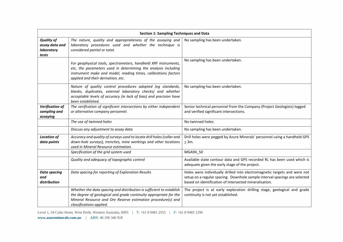
Section 1: Sampling Techniques and Data Quality of assay data and laboratory tests
The nature, quality and appropriateness of the assaying and laboratory procedures used and whether the technique is considered partial or total.
No sampling has been undertaken.
For geophysical tools, spectrometers, handheld XRF instruments, etc, the parameters used in determining the analysis including instrument make and model, reading times, calibrations factors applied and their derivation, etc.
No sampling has been undertaken.
Nature of quality control procedures adopted (eg standards, blanks, duplicates, external laboratory checks) and whether acceptable levels of accuracy (ie lack of bias) and precision have been established.
No sampling has been undertaken.
Verification of sampling and assaying
The verification of significant intersections by either independent or alternative company personnel.
Senior technical personnel from the Company (Project Geologists) logged and verified significant intersections.
The use of twinned holes No twinned holes.
Discuss any adjustment to assay data No sampling has been undertaken.
Location of data points
Accuracy and quality of surveys used to locate drill holes (collar and down-hole surveys), trenches, mine workings and other locations used in Mineral Resource estimation.
Drill holes were pegged by Azure Minerals’ personnel using a handheld GPS + 3m.
Specification of the grid system used MGA94_50
Quality and adequacy of topographic control Available state contour data and GPS recorded RL has been used which is adequate given the early stage of the project.
Data spacing and distribution
Data spacing for reporting of Exploration Results Holes were individually drilled into electromagnetic targets and were not setup on a regular spacing. Downhole sample interval spacings are selected based on identification of intersected mineralisation.
Whether the data spacing and distribution is sufficient to establish the degree of geological and grade continuity appropriate for the Mineral Resource and Ore Reserve estimation procedure(s) and classifications applied.
The project is at early exploration drilling stage, geological and grade continuity is not yet established.
Level 1, 34 Colin Street, West Perth, Western Australia, 6005 | T: +61 8 9481 2555 | F: +61 8 9485 1290 www.azureminerals.com.au | ABN: 46 106 346 918
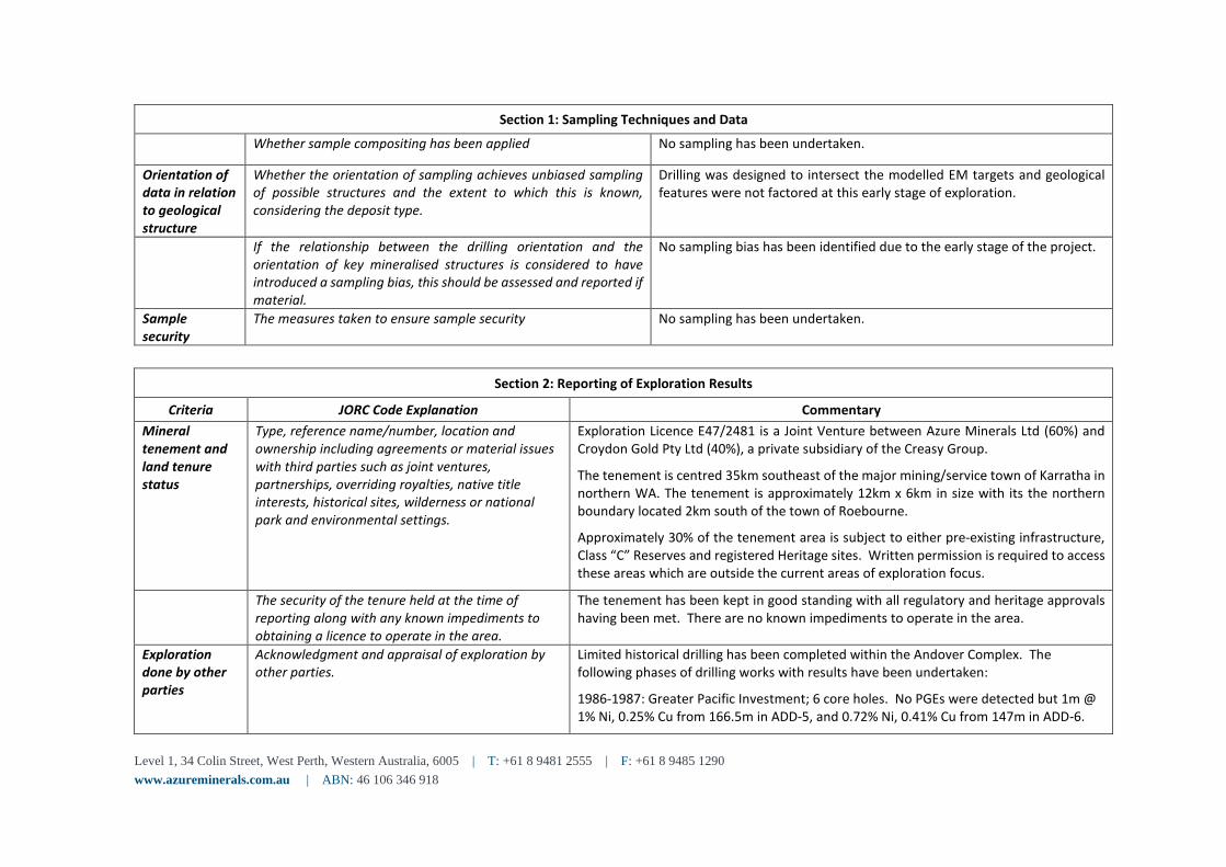
Section 1: Sampling Techniques and Data Whether sample compositing has been applied No sampling has been undertaken.
Orientation of data in relation to geological structure
Whether the orientation of sampling achieves unbiased sampling of possible structures and the extent to which this is known, considering the deposit type.
Drilling was designed to intersect the modelled EM targets and geological features were not factored at this early stage of exploration.
If the relationship between the drilling orientation and the orientation of key mineralised structures is considered to have introduced a sampling bias, this should be assessed and reported if material.
No sampling bias has been identified due to the early stage of the project.
Sample security
The measures taken to ensure sample security No sampling has been undertaken.
Section 2: Reporting of Exploration Results Criteria JORC Code Explanation Commentary
Mineral tenement and land tenure status
Type, reference name/number, location and ownership including agreements or material issues with third parties such as joint ventures, partnerships, overriding royalties, native title interests, historical sites, wilderness or national park and environmental settings.
Exploration Licence E47/2481 is a Joint Venture between Azure Minerals Ltd (60%) and Croydon Gold Pty Ltd (40%), a private subsidiary of the Creasy Group.
The tenement is centred 35km southeast of the major mining/service town of Karratha in northern WA. The tenement is approximately 12km x 6km in size with its the northern boundary located 2km south of the town of Roebourne.
Approximately 30% of the tenement area is subject to either pre-existing infrastructure, Class “C” Reserves and registered Heritage sites. Written permission is required to access these areas which are outside the current areas of exploration focus.
The security of the tenure held at the time of reporting along with any known impediments to obtaining a licence to operate in the area.
The tenement has been kept in good standing with all regulatory and heritage approvals having been met. There are no known impediments to operate in the area.
Exploration done by other parties
Acknowledgment and appraisal of exploration by other parties.
Limited historical drilling has been completed within the Andover Complex. The following phases of drilling works with results have been undertaken:
1986-1987: Greater Pacific Investment; 6 core holes. No PGEs were detected but 1m @ 1% Ni, 0.25% Cu from 166.5m in ADD-5, and 0.72% Ni, 0.41% Cu from 147m in ADD-6.
Level 1, 34 Colin Street, West Perth, Western Australia, 6005 | T: +61 8 9481 2555 | F: +61 8 9485 1290 www.azureminerals.com.au | ABN: 46 106 346 918
Section 2: Reporting of Exploration Results 1996-1997: Dragon Mining; Stream sediment sampling, 5 RC holes in the NE at Mt Hall Ni-Cu target. Zones of noted sulphides (in sediments & gabbro) were selectively sampled with no anomalous results. Rare intervals of ultramafics were sampled so results are inconclusive.
1997-1998: BHP Minerals; 2 RC/DD holes were drilled within the Andover project areas. Both holes intersected strongly magnetic serpentinite containing elevated values of nickel (up to 0.29% Ni), copper (up to 0.26% Cu) and cobalt (up to 332ppm Co) but no anomalous PGE’s.
2012-2018: Croydon Gold; VTEM Survey, soil and rock chip sampling, 7 RC holes over 4 Ni-Cu-Co targets.
Geology Deposit type, geological setting and style of mineralisation.
The Andover Complex is an Archean-age layered mafic-ultramafic intrusion covering an area of about 200km2. The complex is part of a series of mafic-ultramafic bodies that intruded the West Pilbara Craton.
The Andover Complex comprises a lower layered ultramafic zone 1.3km thick and an overlying 0.8km gabbroic layer intruded by dolerites.
Ni-Cu-Co sulphide mineralisation occurs at lithological boundaries, either between different types of gabbro’s, or between pyroxenites and ultramafics. The current interpretation of the mineralized sulphides suggests a magmatic origin, heavily overprinted by one or several hydrothermal events.
Drill hole information
A summary of all information material to the understanding of the exploration results including a tabulation of the following information for all Material drill holes:
Table included in the body of this report.
easting and northing of the drill hole collar See above
elevation or RL (Reduced Level – elevation above sea level in metres) of the drill hole collar See above
dip and azimuth of the hole See above down hole length and interception depth See above hole length. See above
Level 1, 34 Colin Street, West Perth, Western Australia, 6005 | T: +61 8 9481 2555 | F: +61 8 9485 1290 www.azureminerals.com.au | ABN: 46 106 346 918
Section 2: Reporting of Exploration Results If the exclusion of this information is justified on the
basis that the information is not Material and this exclusion does not detract from the understanding of the report, the Competent Person should clearly explain why this is the case.
No material information has been excluded.
Data aggregation methods
In reporting Exploration Results, weighting averaging techniques, maximum and/or minimum grade truncations (eg cutting of high grades) and cut-off grades are usually Material and should be stated.
No sampling has been undertaken.
Where aggregate intercepts incorporate short lengths of high-grade results and longer lengths of low-grade results, the procedure used for such aggregation should be stated and some typical examples of such aggregations should be shown in detail.
No sampling has been undertaken.
The assumptions used for any reporting of metal equivalent values should be clearly stated.
No sampling has been undertaken.
Relationship between mineralisation widths and intercept lengths
These relationships are particularly important in the reporting of Exploration Results
No drilling results have been reported in this release.
If the geometry of the mineralisation with respect to the drill hole angle is known, its nature should be reported.
Results are reported as downhole widths. Drilling was designed to intersect the modelled EM targets and geological features have not been factored at this early stage of exploration. The true direction of mineralisation is not determined at this stage.
If it is not known and only the down hole lengths are reported, there should be a clear statement to this effect (eg ‘down hole length, true width not known’).
Downhole lengths have been reported and true widths are not known at this stage.
Level 1, 34 Colin Street, West Perth, Western Australia, 6005 | T: +61 8 9481 2555 | F: +61 8 9485 1290 www.azureminerals.com.au | ABN: 46 106 346 918
Section 2: Reporting of Exploration Results Diagrams Appropriate maps and sections (with scales) and
tabulations of intercepts should be included for any significant discovery being reported These should include, but not be limited to a plan view of drill hole collar locations and appropriate sectional views.
Refer to figures in the report.
Balanced reporting
Where comprehensive reporting of all Exploration Results is not practicable, representative reporting of both low and high grades and/or widths should be practiced to avoid misleading reporting of Exploration Results.
No sampling has been undertaken but photographs of sulphide intervals are included in this report.
Other substantive exploration data
Other exploration data, if meaningful and material, should be reported including (but not limited to): geological observations; geophysical survey results; geochemical survey results; bulk samples – size and method of treatment; metallurgical test results; bulk density, groundwater, geotechnical and rock characteristics; potential deleterious or contaminating substances.
Everything meaningful and material is disclosed in the body of the report. Geological observations have been factored into the report.
Further work The nature and scale of planned further work (eg tests for lateral extensions or large-scale step out drilling).
Submit selected drill core from ANDD0002 for analysis.
Additional diamond drilling to follow-up the sulphide intersections.
Downhole EM surveying. Diagrams clearly highlighting the areas of possible extensions, including the main geological interpretations and future drilling areas, provided this information is not commercially sensitive.