Embed Size (px)
Citation preview
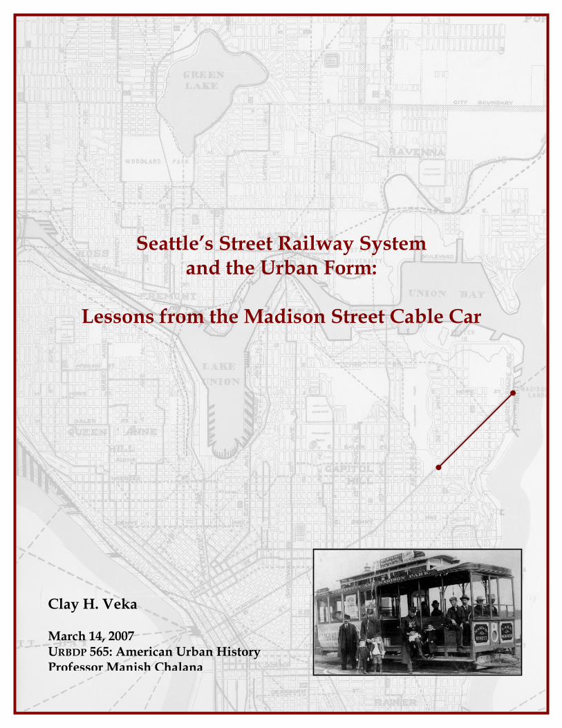
Clay H. Veka March 14, 2007 URBDP 565: American Urban History Professor Manish Chalana
Seattle’s Street Railway System and the Urban Form:
Lessons from the Madison Street Cable Car

2
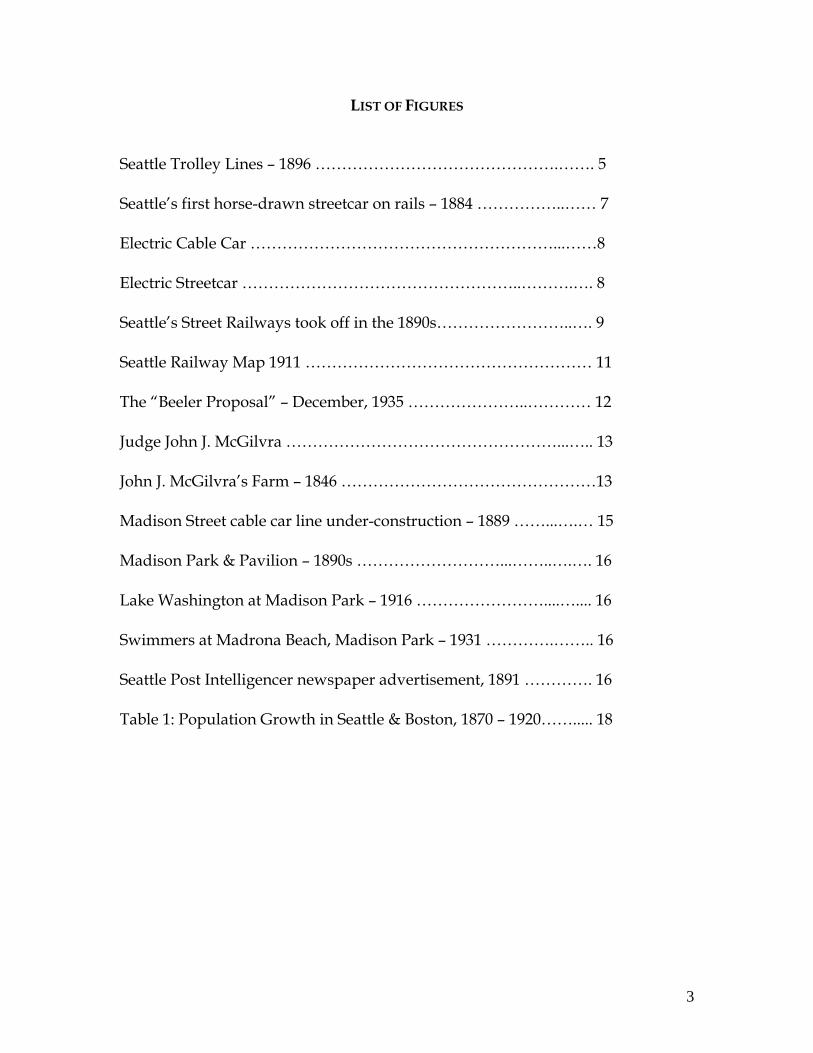
TABLE OF CONTENTS
Table of Contents………………………………………………………… 2 List of Figures…………………………………………………………….. 3 List of Maps……………………………………………………………….. 4 Introduction.………...……………………….…………………………… 5 Purpose……………………………………………………….…… 5
Existing Scholarship………………….………………….………. 6
Street Railway Background: ………………………………………….… 7
United States……………………………………………………… 7 Seattle……………………………………………………………… 9
Madison Street…………………………………………………… 13
The Impact of the Madison Street Cable Car on the Urban Form….. 17 Population…………………………………………………………17 Maps………………………………………………………………..19 Written Records………………………………………………….. 27 Conclusion………………………………………………………………... 27 Works Cited………………………………………………………………. 29
3
LIST OF FIGURES Seattle Trolley Lines – 1896 ……………………………………….……. 5 Seattle’s first horse-drawn streetcar on rails – 1884 ……………..…… 7 Electric Cable Car …………………………………………………...……8 Electric Streetcar ……………………………………………..……….…. 8 Seattle’s Street Railways took off in the 1890s……………………..…. 9 Seattle Railway Map 1911 ……………………………………………… 11 The “Beeler Proposal” – December, 1935 …………………..………… 12 Judge John J. McGilvra ……………………………………………...….. 13 John J. McGilvra’s Farm – 1846 …………………………………………13 Madison Street cable car line under-construction – 1889 ……...….… 15 Madison Park & Pavilion – 1890s ………………………...……..….…. 16 Lake Washington at Madison Park – 1916 ……………………....….... 16 Swimmers at Madrona Beach, Madison Park – 1931 ………….…….. 16 Seattle Post Intelligencer newspaper advertisement, 1891 …………. 16 Table 1: Population Growth in Seattle & Boston, 1870 – 1920……..... 18

4
List of Maps
Panoramic Maps Map P1: 1878 ……………………………………………………. 20
Map P2: 1884 ……………………………………………………. 20 Map P3: 1891 ……………………………………………………. 21
Cartographic Maps Map C1: 1856 …………………………………………………… 22
Map C2: 1888 ……………………………………….…………... 23 Map C3: 1892 …………………………………………………… 24 Map C4: 1897 …………………………………………………… 25 Map C5: 1911 …………………………………………………… 26
5
Imag
e cou
rtes
y of
Mus
eum
of H
istor
y an
d In
dust
ry
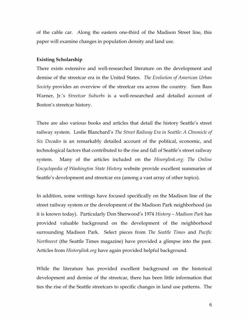
Seattle Trolley Lines - 1896
Madison St.
INTRODUCTION Purpose There is a strong nexus between
transportation and land use. Where
transportation systems are placed,
land is prone to development. This
relationship between transportation
and land use has been evident
throughout human history. The
advent of motorized transportation
has allowed humans to travel
further, faster than ever before and
has led to increased speed and
intensity of land development and
use over the last two centuries.
Chudacoff and Smith highlight this nexus in The Evolution of American Urban
Society.
Mass transportation…catalyzed physical expansion…by opening vast areas of unoccupied land for residential expansion…[and] pulled settled regions outward much more distant from city centers than they were in the premodern era…. The new accessibility of peripheral land sparked real estate development and urban sprawl” (Chudacoff, p. 92).
In this paper, I attempt to understand the impact that the street railway system in
Seattle had on land development and the urban form. The street railways have
been credited and blamed for allowing for the first suburban development and
widespread, low-density growth. Did Seattle’s street railway system lead to the
same outcome? Specifically, I will examine how land surrounding one line of the
Seattle system, the Madison Street cable car line, was affected by the introduction
6
of the cable car. Along the eastern one-third of the Madison Street line, this
paper will examine changes in population density and land use.
Existing Scholarship
There exists extensive and well-researched literature on the development and
demise of the streetcar era in the United States. The Evolution of American Urban
Society provides an overview of the streetcar era across the country. Sam Bass
Warner, Jr.’s Streetcar Suburbs is a well-researched and detailed account of
Boston’s streetcar history.
There are also various books and articles that detail the history Seattle’s street
railway system. Leslie Blanchard’s The Street Railway Era in Seattle: A Chronicle of
Six Decades is an remarkably detailed account of the political, economic, and
technological factors that contributed to the rise and fall of Seattle’s street railway
system. Many of the articles included on the Hisorylink.org: The Online
Encyclopedia of Washington State History website provide excellent summaries of
Seattle’s development and streetcar era (among a vast array of other topics).
In addition, some writings have focused specifically on the Madison line of the
street railway system or the development of the Madison Park neighborhood (as
it is known today). Particularly Don Sherwood’s 1974 History – Madison Park has
provided valuable background on the development of the neighborhood
surrounding Madison Park. Select pieces from The Seattle Times and Pacific
Northwest (the Seattle Times magazine) have provided a glimpse into the past.
Articles from Historylink.org have again provided helpful background.
While the literature has provided excellent background on the historical
development and demise of the streetcar, there has been little information that
ties the rise of the Seattle streetcars to specific changes in land use patterns. The
7
Phot
o co
urte
sy o
f Mus
eum
of
Hist
ory
and
Indu
stry
Seattle’s first horse-drawn streetcar on rails - 1884
link between transportation infrastructure and real estate development is widely
acknowledged, but the impact that mass transit has had on the urban form has
not been closely examined. This paper will endeavor to fill a very small sliver of
this missing piece in scholarship by demonstrating the degree to which the
Madison cable car line encouraged suburban growth. In order to dissect this
relationship, this paper will pull upon census data, historical maps, and written
records.
STREET RAILWAY BACKGROUND
United States
Appearing as early as 1832 in
New York City, (Chudacoff, p.
86) the horse-drawn streetcar
on rails gained popularity over
the next 60 years. While the
horse-drawn streetcar proved
an efficient means of mass
transportation, there were
many challenges associated with using horses for urban transportation. Some
challenges included the fact that any given animal could only work so many
hours on a given day, had to be housed, groomed, fed and cared for. They also
produced extraordinary amounts of manure, which polluted the city streets and
was expensive to dispose of.
Due to these limitations, when innovators applied mechanical power to vehicles
in the last quarter of the century, the technology took off (Chudacoff, p. 86). The
cable car kicked off the revolution when Andrew Hallidie introduced it in San
Francisco in 1873. In 1888 Frank J. Sprague introduced the first electric streetcar
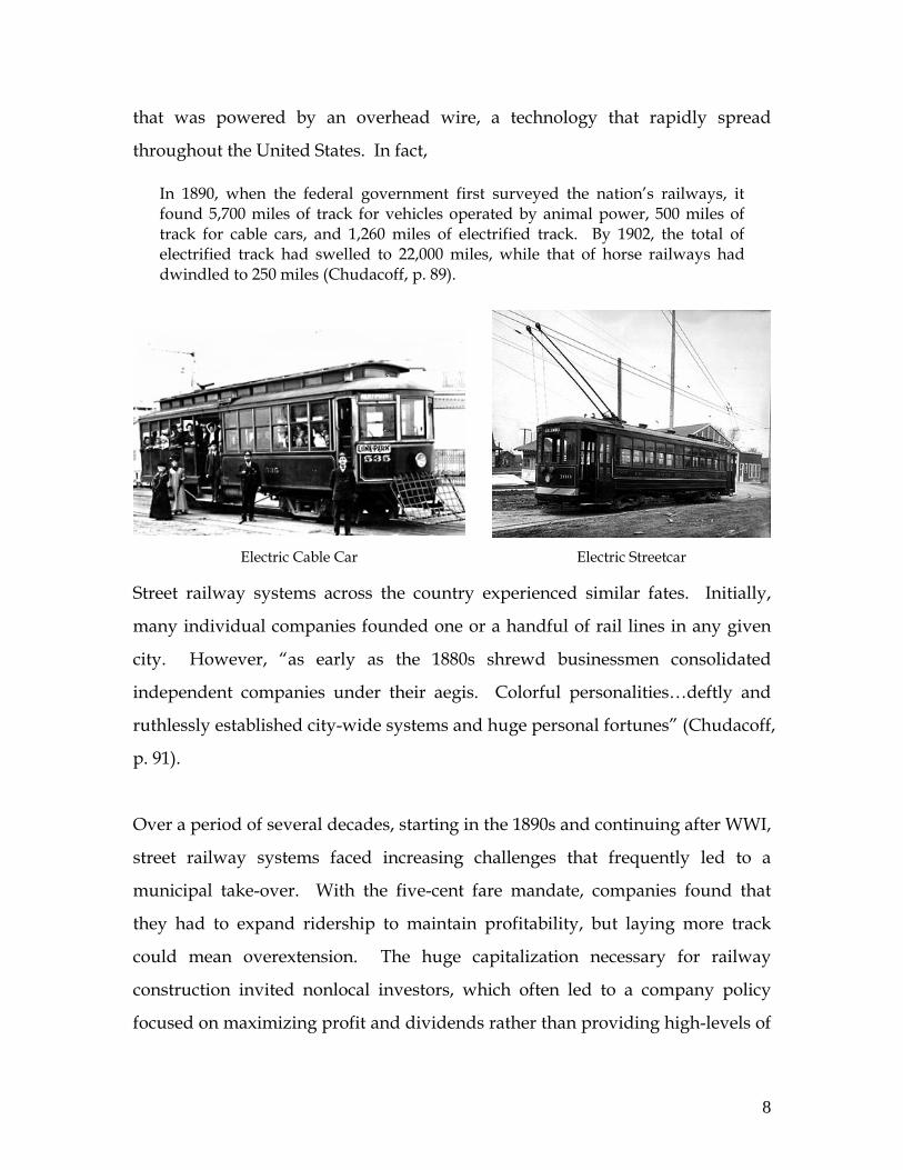
8
Electric Cable Car Electric Streetcar
that was powered by an overhead wire, a technology that rapidly spread
throughout the United States. In fact,
In 1890, when the federal government first surveyed the nation’s railways, it found 5,700 miles of track for vehicles operated by animal power, 500 miles of track for cable cars, and 1,260 miles of electrified track. By 1902, the total of electrified track had swelled to 22,000 miles, while that of horse railways had dwindled to 250 miles (Chudacoff, p. 89).
Street railway systems across the country experienced similar fates. Initially,
many individual companies founded one or a handful of rail lines in any given
city. However, “as early as the 1880s shrewd businessmen consolidated
independent companies under their aegis. Colorful personalities…deftly and
ruthlessly established city-wide systems and huge personal fortunes” (Chudacoff,
p. 91).
Over a period of several decades, starting in the 1890s and continuing after WWI,
street railway systems faced increasing challenges that frequently led to a
municipal take-over. With the five-cent fare mandate, companies found that
they had to expand ridership to maintain profitability, but laying more track
could mean overextension. The huge capitalization necessary for railway
construction invited nonlocal investors, which often led to a company policy
focused on maximizing profit and dividends rather than providing high-levels of
9
service. With poor service, aging infrastructure, and some companies engaged in
graft and fraud, reformers were prompted to seek municipal ownership of mass
transit early on (in New York in the early 1890s and in Chicago in 1907). During
and after WWI, public ownership became the only way that many cities could
sustain mass transit. But public assumption of transportation responsibilities
occurred just when private automobiles and rubber wheeled buses began to
replace streetcars as the major mode of conveyance (Chudacoff, pp. 91-92).
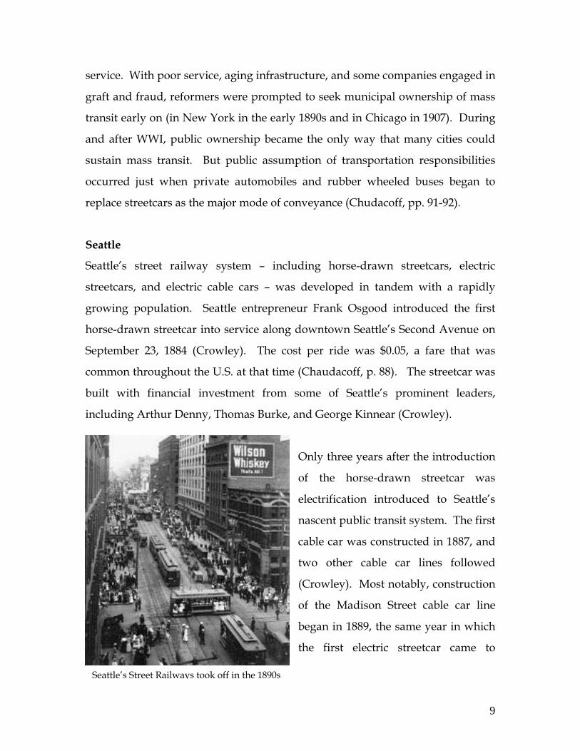
Seattle
Seattle’s street railway system – including horse-drawn streetcars, electric
streetcars, and electric cable cars – was developed in tandem with a rapidly
growing population. Seattle entrepreneur Frank Osgood introduced the first
horse-drawn streetcar into service along downtown Seattle’s Second Avenue on
September 23, 1884 (Crowley). The cost per ride was $0.05, a fare that was
common throughout the U.S. at that time (Chaudacoff, p. 88). The streetcar was
built with financial investment from some of Seattle’s prominent leaders,
including Arthur Denny, Thomas Burke, and George Kinnear (Crowley).
Only three years after the introduction
of the horse-drawn streetcar was
electrification introduced to Seattle’s
nascent public transit system. The first
cable car was constructed in 1887, and
two other cable car lines followed
(Crowley). Most notably, construction
of the Madison Street cable car line
began in 1889, the same year in which
the first electric streetcar came to
Seattle’s Street Railways took off in the 1890s

10
Seattle.
The private street railways quickly multiplied. By 1892, Seattle claimed 48 miles
of streetcar track and 22 miles of cable railway. While the economic panic of 1893
bankrupted many companies, street railway tracks doubled in the 1890s
(Crowley).
In 1898 Seattle banker, Jacob Furth, on behalf of the investment firm Stone &
Webster, began buying up the city's 22 independent streetcar lines. Its local
Seattle Electric Railway Company won a 40-year city franchise in 1900, over the
objections of reformers who feared the creation of a transit monopoly (Blanchard,
p. 58).
The promise of improved service was not fulfilled. In fact,
By 1918 the transportation situation in Seattle had become quite intolerable. Service was hardly better than it had been in 1899 when Stone and Webster began taking over the independent lines – service was erratic, cars were ill maintained and often dilapidated, and roadbed maintenance on many lines had been neglected to the point where it was literally unsafe to run cars over them" (Blanchard, p. 90).
While Stone & Webster were partly to blame for the poor service, it is also
important to recognize that the mandated nickel fares, numerous strikes, and
growing competition from automobiles and electric buses made turning a profit
very challenging.
In a controversial deal, Seattle Mayor Ole Hanson agreed to buy the streetcar
system for $15 million, a price that is estimated at three times the actual value of
the system (Blanchard, p. 94). This high price crippled the new Municipal Street
Railway with debt from the outset .

11
Seattle Railway Map - 1911
Map
cour
tesy
of U
nive
rsity
of W
ashi
ngto
n, S
peci
al C
ollec
tions
By 1936, the Municipal Street Railway operated 410 streetcars on 26 electric
routes, and three cable railways (Yesler-Jackson, James Street, and Madison
Street) totaling 231 miles of track, plus 60 buses on 18 other routes (Blanchard, p.
126). Despite average daily fares of $11,000, the system had run up a $4 million
deficit and still owed half of the principal on its 1918 bonds (Crowley).
By the mid-1930s, Seattle was
desperate for an escape route. In
1935 the John C. Beeler
Organization proposed a solution
to the City that was a combination
of streetcars and buses (Beeler,
1935, p. 1), but the proposal was
rejected by Seattle voters in 1937.
Although the city was able to
secure a $10 million loan from the
federal government in 1939 to pay
off the streetcar debt and
implement a revised version of the
Beeler Plan, the loan was not
enough to save the system. The
last of Seattle’s streetcars closed in
the spring of 1941 (Thompson).
12
The “Beeler Proposal” as presented to the City of Seattle – December, 1935
Repr
int c
ourt
esy
of th
e U
nive
rsity
of W
ashi
ngto
n
13
Judge John J. McGilvra
Phot
o co
urte
sy B
agley
, Hist
ory
of K
ing
Coun
ty
Phot
o co
urte
sy o
f Mus
eum
of H
istor
y an
d In
dust
ry
John J. McGilvra’s Farm – 1846
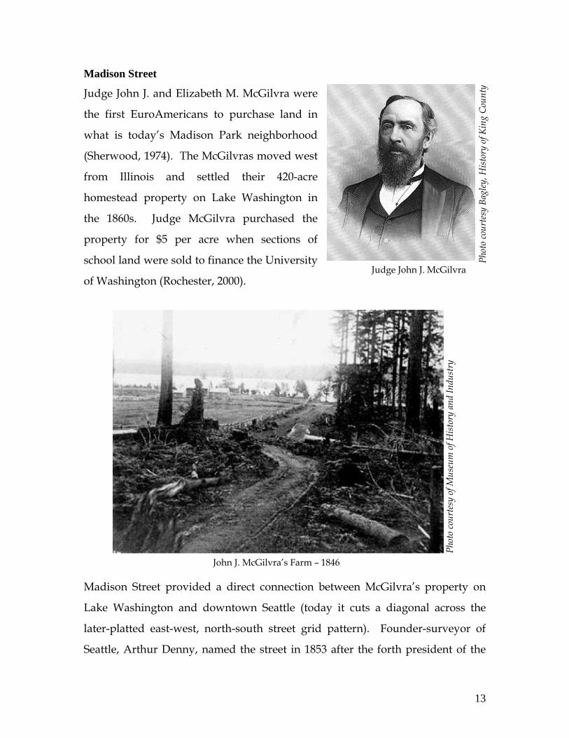
Madison Street
Judge John J. and Elizabeth M. McGilvra were
the first EuroAmericans to purchase land in
what is today’s Madison Park neighborhood
(Sherwood, 1974). The McGilvras moved west
from Illinois and settled their 420-acre
homestead property on Lake Washington in
the 1860s. Judge McGilvra purchased the
property for $5 per acre when sections of
school land were sold to finance the University
of Washington (Rochester, 2000).
Madison Street provided a direct connection between McGilvra’s property on
Lake Washington and downtown Seattle (today it cuts a diagonal across the
later-platted east-west, north-south street grid pattern). Founder-surveyor of
Seattle, Arthur Denny, named the street in 1853 after the forth president of the
14
United States, James Madison (Dorpat). In order to more easily travel between
his property and downtown, McGilvra improved the road in 1864-5, which had
earlier passed through dense forest and over a rushing salmon stream
(Rochester). The rough road continued to be a popular public by-way. Wagons,
horses, and hikers all tramped along it to the pristine edge of Lake Washington.
Until 1880, the McGilvras were the only residents of Madison Park, living at their
Laurel Shade estate. Junius Rochester states, “Either loneliness or commercial
prospects – perhaps both – impelled McGilvra to plat most of his property for
sale…” (Rochester). Don Sherwood details the history of the real estate
development in Seattle and associated commercial interests.
All the realtors who had property so far from town had the common problem of getting prospective buyers out to the real estate and to induce them to live so far from town. Lakeshore picnic sites had become possible and popular with the glorified stage coaches rattling over the long, rutted roads. Then came a new "toy": the electric trolley car and cable car. As soon as the fears of electrocution had abated, the realtors knew they had a sales trick: build cable or trolley cars out to their subdivisions with a park at the end of the line offering inducements ranging from picnics, boating and swimming to gambling, vaudeville and zoos (Sherwood, p. 1).1
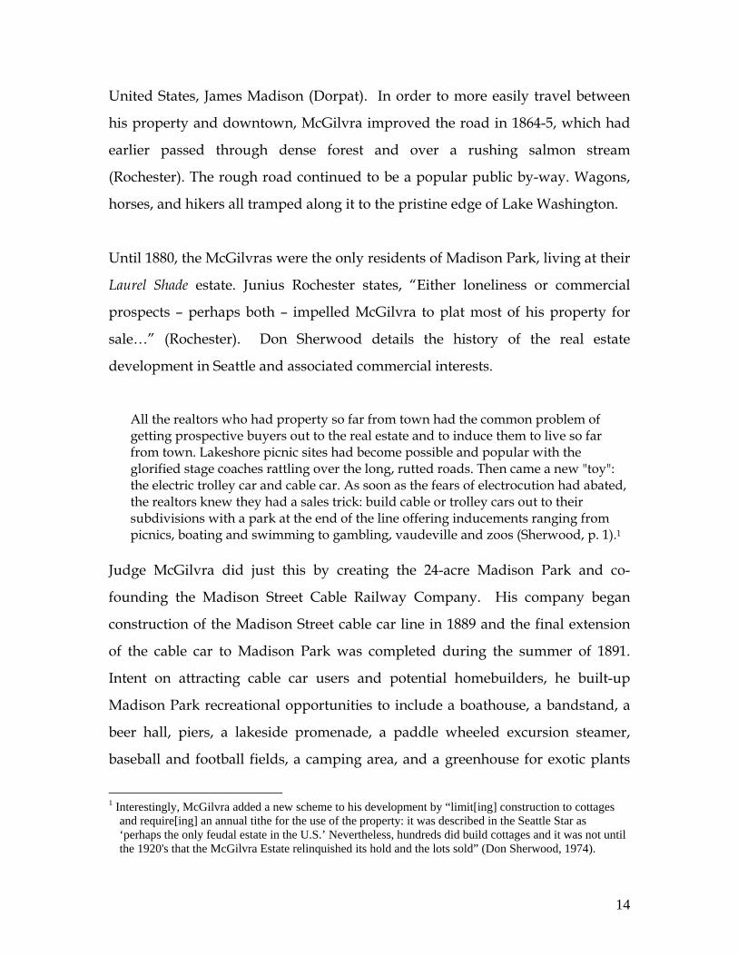
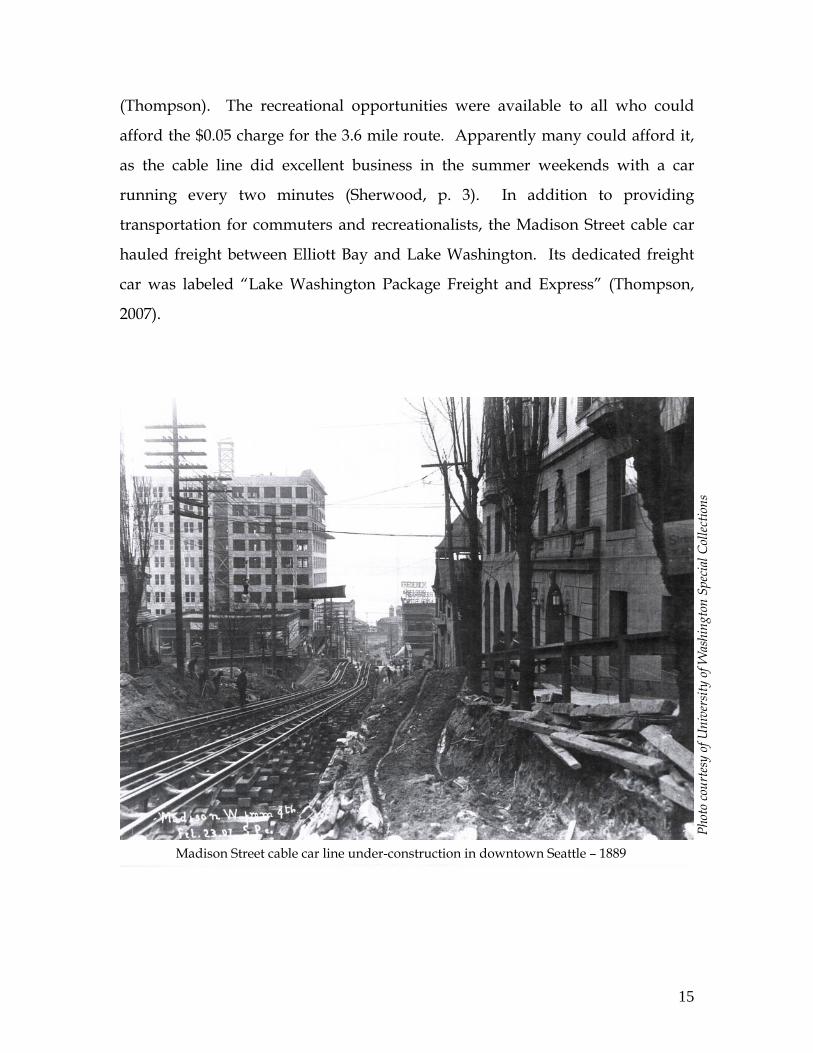
Judge McGilvra did just this by creating the 24-acre Madison Park and co-
founding the Madison Street Cable Railway Company. His company began
construction of the Madison Street cable car line in 1889 and the final extension
of the cable car to Madison Park was completed during the summer of 1891.
Intent on attracting cable car users and potential homebuilders, he built-up
Madison Park recreational opportunities to include a boathouse, a bandstand, a
beer hall, piers, a lakeside promenade, a paddle wheeled excursion steamer,
baseball and football fields, a camping area, and a greenhouse for exotic plants
1 Interestingly, McGilvra added a new scheme to his development by “limit[ing] construction to cottages
and require[ing] an annual tithe for the use of the property: it was described in the Seattle Star as ‘perhaps the only feudal estate in the U.S.’ Nevertheless, hundreds did build cottages and it was not until the 1920's that the McGilvra Estate relinquished its hold and the lots sold” (Don Sherwood, 1974).
15
Phot
o co
urte
sy o
f Uni
vers
ity o
f Was
hing
ton
Spec
ial C
ollec
tions
Madison Street cable car line under-construction in downtown Seattle – 1889
(Thompson). The recreational opportunities were available to all who could
afford the $0.05 charge for the 3.6 mile route. Apparently many could afford it,
as the cable line did excellent business in the summer weekends with a car
running every two minutes (Sherwood, p. 3). In addition to providing
transportation for commuters and recreationalists, the Madison Street cable car
hauled freight between Elliott Bay and Lake Washington. Its dedicated freight
car was labeled “Lake Washington Package Freight and Express” (Thompson,
2007).
16
Phot
o co
urte
sy o
f Mus
eum
of
Hist
ory
& In
dust
ry
Madison Park & Pavilion – 1890s
Phot
o co
urte
sy o
f Uni
vers
ity o
f Was
hing
ton
Phot
o co
urte
sy o
f Law
ton
Gow
ey
Lake Washington at Madison Park – 1916
Swimmers at Madrona Beach, Madison Park – 1931
Phot
o co
urte
sy o
f M
useu
m o
f Hist
ory
& In
dust
ry
Seattle Post Intelligencer newspaper advertisement, June 1891
17
As a part of its consolidation efforts, the Seattle Electric Company acquired the
Madison Street cable car line in 1900. Due to financial difficulties and aging
infrastructure, the company began cutting service within the decade. By 1910 the
Madison cable car only provided service from downtown as far at 21st Avenue.
In 1914 service was further limited and the decline of the Madison Street cable
car was well underway (Thompson).
One of the factors that precipitated this decline was the cheap and poorly laid
rails selected from the outset. As real estate men, there was more incentive to
provide immediate, low-cost transportation to outlying properties than there was
to invest in long-term, high-quality rails and infrastructure.
The Impact of the Madison Street Cable Car on the Urban Form
The street railway system dramatically changed the face of many urban centers,
but particularly the older, more crowded cities. Prior to the advent of the electric
street railway, most urban dwellers were confined to the limits of the “walking
city”. When the electric streetcar was introduced, those working in the city
center were no longer limited to living within walking distance of the work place.
For those with sufficient means, they could move out to, what has become
known today as, the streetcar suburbs.
Population
An example of an overcrowded and dense older city was Boston in the 1870s and
1880s. With the exception of the wealthiest 1-2% of society, urban residents were
confined to living in the “walking city”, a city whose boundary was no more
than 2.5 miles from city hall (Warner). In 1880 there were 362,839 residents
living in Boston (Gibson). With this large number of people living in such a
confined area, the advent of the electric streetcar was the technological
18
breakthrough necessary to allow the boundaries of the city to explode and for
residents with sufficient means to escape the crowded city center and settle in the
rural land 2-4 miles beyond the walking city boundary.
Understanding whether or not Seattle was experiencing similar population
pressures prior to the introduction of the street railway system provides insight
into the degree to which the Madison Street cable car promoted residential
expansion into the Madison Park neighborhood.
In 1870 and 1880, Seattle was a very different place from Boston. The first Euro-
American settlers had arrived as recently at 1851. Seattle was very much a
frontier town whose industries were developing around the natural resources of
the surrounding landscape. While growing, the population was small with only
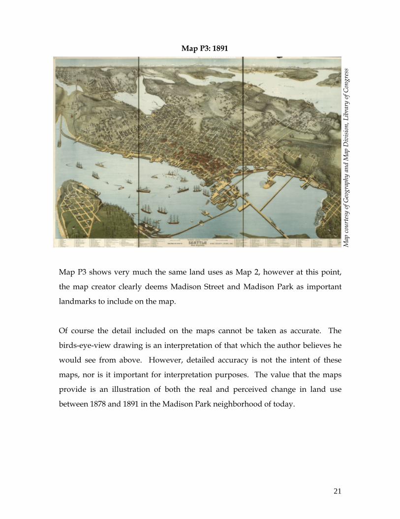
1,107 residents in 1870 and 3,533 in 1880. Strikingly, Seattle’s population
exploded between 1880 and 1890, growing 1112% to 42,837 (see Figure 1).
Table 1: Population Growth in Seattle & Boston, 1870 – 1920
Year 1870 1880 1890 1900 1910 1920 Seattle Size 1,107 3,533 42,837 80,671 237,194 315,312 % Growth 219% 1112% 88% 194% 33%
Boston Size 250,526 362,839 448,477 560,892 670,585 748,060
Immediately prior to the introduction of the electric street railway, Seattle and
Boston had really different population dynamics that were confined to relatively
similar geographic areas. This disparity suggests that Seattle and Boston likely
were molded by the electric street railway in very different ways. While the
street railways acted as a pressure relief valve to an overcrowded Boston, the
Seattle system was introduced at the same time that the city’s population was
quickly growing. Rather than relieving overcrowding in Seattle, the streetcars
Table 1: US Historic Census Data
19
helped to prevent overcrowding from occurring by opening up developable land
beyond Seattle’s walking city boundaries.
Lacking the same level of pressure on the city boundaries as experienced by the
larger urban areas, it is likely that Seattle’s expansion into the streetcar suburbs
was slower and had less immediate impact on the urban form. Nevertheless, the
street railways still altered the urban form by allowing for residents to settle
outside of the traditional walking-city boundaries. The following section will
explore the degree to which this occurred along the eastern extent of the
Madison Street cable car line.
Maps
Comparing historical maps is a helpful way to understand the development of a
particular area. Even more useful is to draw comparisons between maps while
being clear about the historical context of the time. In analyzing the maps, it is
helpful to consider the following dates and associated events.
Street Railway Dates:
o 1850s – Madison Street is a rough trail leading to Lake Washington o 1865 – McGilvra completes Madison Street improvements o 1880s – McGilvra plats most of his 420 acres for sale o 1884 – First horse-drawn streetcar in Seattle o 1887 – First cable car in Seattle o 1889 – Construction begins on Madison Street cable car line o 1891 – Madison Street cable car line is completed
City Population:
o 1880 – Seattle population = 3,533 o 1890 – Seattle population = 42,837
PANORAMIC MAPS: From a series of panoramic maps provided by the Library of
Congress Geography and Map Division, one is provided a visual sense of how
the Seattle landscape changed between the late 1870s and the early 1890s.
20
Map
cour
tesy
of G
eogr
aphy
and
Map
Div
ision
, Li
brar
y of
Con
gres
s
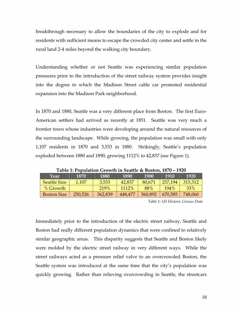
Map P1 shows a city center that has developed along Elliott Bay, while the
eastern hillsides leading down toward Lake Washington are forested and
uninhabited by white settlers.
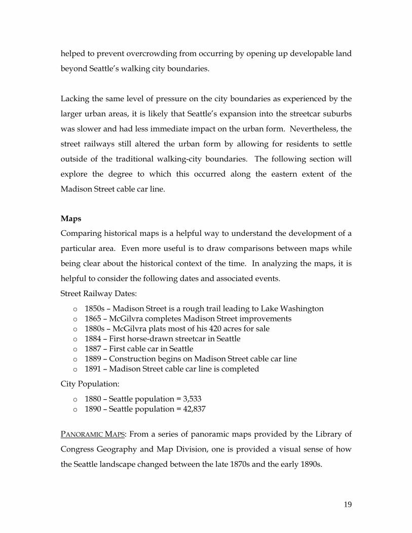
Map P2 shows the same perspective, though the forest has been cleared and the
land on the eastern hillsides approaching the Lake Washington shores appears
under cultivation or simply left as open space.
Map P2: 1884
Map P1: 1878
Map
cour
tesy
of G
eogr
aphy
and
Map
Div
ision
, Lib
rary
of C
ongr
ess
21
Map
cour
tesy
of G
eogr
aphy
and
Map
Div
ision
, Lib
rary
of C
ongr
ess
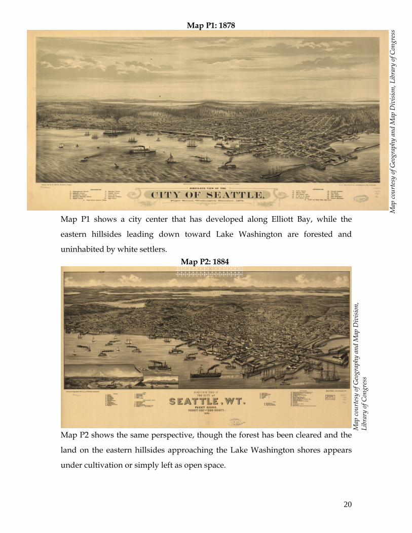
Map P3 shows very much the same land uses as Map 2, however at this point,
the map creator clearly deems Madison Street and Madison Park as important
landmarks to include on the map.
Of course the detail included on the maps cannot be taken as accurate. The
birds-eye-view drawing is an interpretation of that which the author believes he
would see from above. However, detailed accuracy is not the intent of these
maps, nor is it important for interpretation purposes. The value that the maps
provide is an illustration of both the real and perceived change in land use
between 1878 and 1891 in the Madison Park neighborhood of today.
Map P3: 1891
22
Map
cour
tesy
of W
ashi
ngto
n Ca
dast
ral S
urve
y
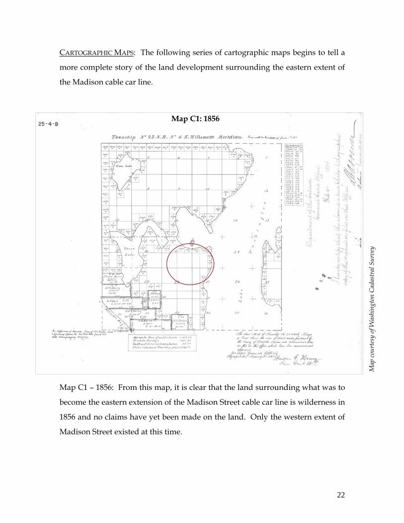
CARTOGRAPHIC MAPS: The following series of cartographic maps begins to tell a
more complete story of the land development surrounding the eastern extent of
the Madison cable car line.
Map C1 – 1856: From this map, it is clear that the land surrounding what was to
become the eastern extension of the Madison Street cable car line is wilderness in
1856 and no claims have yet been made on the land. Only the western extent of
Madison Street existed at this time.
Map C1: 1856
23
Map
cour
tesy
of U
nive
rsity
of W
ashi
ngto
n, S
peci
al C
ollec
tions
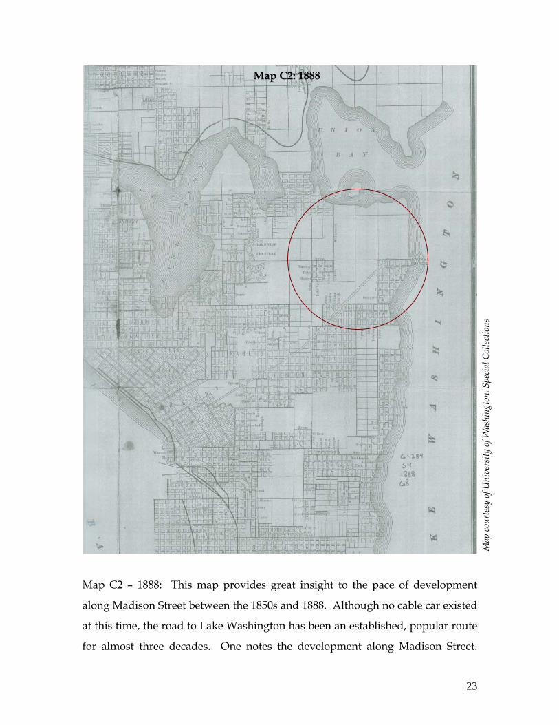
Map C2 – 1888: This map provides great insight to the pace of development
along Madison Street between the 1850s and 1888. Although no cable car existed
at this time, the road to Lake Washington has been an established, popular route
for almost three decades. One notes the development along Madison Street.
Map C2: 1888
24
Map
cour
tesy
of U
nive
rsity
of W
ashi
ngto
n, S
peci
al C
ollec
tions
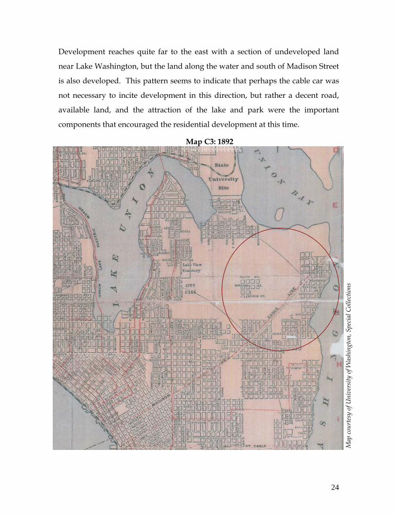
Development reaches quite far to the east with a section of undeveloped land
near Lake Washington, but the land along the water and south of Madison Street
is also developed. This pattern seems to indicate that perhaps the cable car was
not necessary to incite development in this direction, but rather a decent road,
available land, and the attraction of the lake and park were the important
components that encouraged the residential development at this time.
Map C3: 1892
25
Map
cour
tesy
of U
nive
rsity
of W
ashi
ngto
n, S
peci
al C
ollec
tions
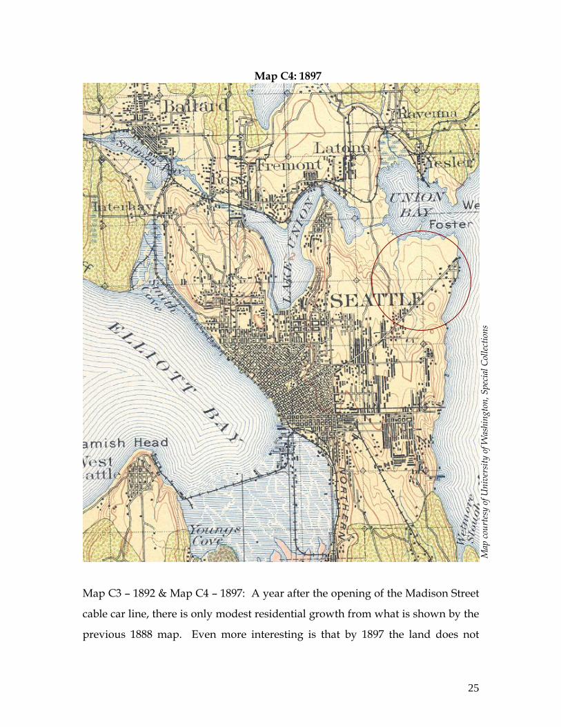
Map C3 – 1892 & Map C4 – 1897: A year after the opening of the Madison Street
cable car line, there is only modest residential growth from what is shown by the
previous 1888 map. Even more interesting is that by 1897 the land does not
Map C4: 1897

26
Map
cour
tesy
of U
nive
rsity
of W
ashi
ngto
n, S
peci
al C
ollec
tions
appear to be any more developed than it is five years earlier. Also of note is the
legend to this map that indicates that the land surrounding the Madison cable car
is “timberless area – not restocking”.
Map C5 – 1911: Finally by 1911 much of the land around the eastern extension of
the Madison Street cable car had begun to fill in. However, it is remarkable that
the land north of its terminus still remained undeveloped. Whether the owner
chose not to plat and sell the land or the demand simply did not exist to develop
it, has been difficult to determine. However, the preservation of this land as
Map C5: 1911
27
open space twenty years after the opening of the cable car indicates that there
was not strong pressure to develop the area.
Written Records
Written records also contribute to our understanding of the ways in which the
cable car changed the land form in the Madison Park area. For instance, Leslie
Blanchard indicates that the construction of the cable railway resulted in more
right-of-way clearing and the building of a large trestle through the core of
Madison Valley. The valley was then a pass-through area, despite its wild
salmon stream and lush growth. “Passengers enjoyed the view, but were
looking forward to reaching the waters of Lake Washington” (Rochester). This
account corroborates the patterns that appear in the maps above.
Also, as reported by Rochester,
Around 1905, the Madison Street trestle over the rushing salmon stream was replaced by an earthen dam and became a permanent road. The rushing salmon stream dried up, the remaining trickle was routed through a pipe.
With the visual description provided by the maps and the written descriptions of
these accounts, the process of development becomes clearer. The availability of
land and the existing road drew people to the area before the cable car existed.
The cable car allowed for additional development to occur, but at a slow rate.
While the Seattle population was increasing at very quickly, there was enough
land with sufficient access that the population explosion did not put enormous
pressure on the Madison Park area. Additionally, the population of Seattle was
initially so small that it is likely that much of the “walking city” was able to
absorb some of the population boom of the 1880s.
28
CONCLUSION
Many have observed that “mass transportation…catalyzed physical…expansion
by opening vast areas of unoccupied land for residential expansion” (Chudacoff,
p. 92). This paper has endeavored to understand the degree to which Seattle’s
Madison Street cable car line encouraged residential expansion on the land
surrounding its eastern terminus. Historic census data, panoramic maps,
cartographic maps, and written records have been critical to this quest. In
examining these historic records, it has become clear that the cable car led to only
limited residential development on land in today’s Madison Park neighborhood.
With a small but growing population in the 1880s, Seattle’s population expanded
together with the development of the street railway system. While the system
certainly permitted some residents to settle outside of the traditional walking city,
we have seen that other factors also led to this dispersal of residential
development. Roads, available lots, the shores of Lake Washington, and the
Madison Park recreational facilities seem to have played a role in attracting
residents, even before the cable car line existed.
Some lessons have been learned from the rise and fall of Seattle’s earlier street
railway era that are being diligently applied and adhered to today. The street
railway system built in Seattle at the turn of the century was developed in part to
support low-density real estate endeavors outside of the Seattle walking city. As
a new streetcar and light rail boom are underway today in Seattle and the
surrounding region, there is a strong push to increase densities along the rail
routes. As was learned in Seattle a century ago, insufficient population densities
(among other deficiencies) can lead to overextension of the rail system and
insufficient ridership. Perhaps the street railway system of today will help
promote infill development and increased densities along its corridors.
29
WORKS CITED
Crowley, Walt. “Street Railways in Seattle – A Snapshot History.” Historylink.org: The Online Encyclopedia of Washington State History, October 02, 2000. Take from website February 4, 2007: http://www.historylink.org/essays/output.cfm?file_id=2707
Crowley, Walt. “Streetcars First Enter Service in Seattle on September 23, 1884.”
Historylink.org: The Online Encyclopedia of Washington State History, October 02, 2000. Take from website February 4, 2007: http://www.historylink.org/essays/output.cfm?file_id=2688.
Beeler, John A. “Report to the City of Seattle on its Municipal Street Railway
System.” The Beeler Organization, New York, 1935, 1-102. Blanchard, Leslie. “The Street Railway Era in Seattle: A Chronicle of Six
Decades.” Harold E. Cox, Forty Fort, PN, 1969. Bouillon, Arthur M. “Polk’s New Guide Map of the City of Seattle, Washington.”
Seattle, Wash.: Polk’s Seattle Directory Co., 1899. Chudacoff, Howard P., Judy E. Smith. “The Evolution of American Urban
Society.” Pearson Education, Inc., Upper Saddle River, New Jersey, 2005. Dorpat, Paul. “The Making of Madison.” Pacific Northwest, The Seattle Times
Magazine, December 12, 2004. http://seattletimes.nwsource.com/pacificnw/2004/1212/nowthen.html.
Engeman, Richard. “Electric Streetcars in Seattle.” Pacific Northwest Quarterly
3(58), April 1986, pages 59-65. Gibson, Campbell. "Population of the 100 Largest Cities and Other Urban Places
in the United States: 1790 to 1990." Population Division, U.S. Census Bureau, Washington, D.C., Population Division Working Paper No. 27, June 1998.
Glover, E.S. “Bird’s eye view of the city of Seattle, Puget Sound, Washington
Territory, 1878.” A.L. Bancroft & Co., Portland, OR, 1878. From Library of Congress panoramic maps electronic collections at http://memory.loc.gov/ammem/pmhtml/panhome.html
IEE. “ Frank J. Sprague, 1857 – 1934.” IEE History Center Biographies, 2007.
Taken March 9, 2007 from
30
http://www.ieee.org/web/aboutus/history_center/biography/sprague.html.
Kim, Gina. “Madison Memoirs: The Only Street Running Directly from Lake
Washington to Elliott Bay.” The Seattle Times, November 12, 2001. http://seattletimes.nwsource.com/news/local/seattle_history/articles/madison.html.
Koch, Augustus. “Birds-eye-view of Seattle and environs King County, Wash.,
1891.” Hughes Litho Co, Chicago, IL, 1891. From Library of Congress panoramic maps electronic collections at http://memory.loc.gov/ammem/pmhtml/panhome.html
O.P. Anderson and Co. “Anderson’s New Guide Map of the City of Seattle and
Environs, Washington.” Wash.?: O.P. Anderson, c1892. Rochester, Junius. “Seattle Neighborhoods: Madison Park – Thumbnail History.”
Historylink.org: The Online Encyclopedia of Washington State History, November 16, 2000. Take from website February 4, 2007: http://www.historylink.org/essays/output.cfm?file_id=3471
Rochester, Junius. “Seattle Neighborhoods: Madison Valley – Thumbnail
History.” Historylink.org: The Online Encyclopedia of Washington State History, June 21, 2001. Take from website February 4, 2007: http://www.historylink.org/essays/output.cfm?file_id=3471
Sherwood, Don. “History – Madison Park.” Seattle Parks and Recreation, Park
History, Sherwood Recreation File, November, 1974. Taken from website March 9, 2007: http://www.cityofseattle.net/parks/history/sherwood.htm#m
Thompson, Joe. “The Cable Car Home Page.” http://www.cable-car-guy.com/
Updated February 2007. Taken from website February 4, 2007. Warner, Sam Bass. “Streetcar Suburbs: the Process of Growth in Boston, 1870-
1900.” Cambridge: Harvard University Press, 1978. Well, Henry. “Birds eye view of the city of Seattle, W.T., Puget Sound, county
seat of King County 1884.” Madison, WI, J.J. Stoner, 1884. From Library of Congress panoramic maps electronic collections at http://memory.loc.gov/ammem/pmhtml/panhome.html