Embed Size (px)
Citation preview

Seattle Department of Transportation
SOUTH LANDER STREET GRADE SEPARATION PROJECT
SOCIAL EFFECTS AND ENVIRONMENTAL JUSTICE DISCIPLINE REPORT
January 2017

CITATION
Parametrix. 2017. South Lander Street Grade Separation Project, Social Effects and Environmental Justice Discipline
Report. Prepared for the Seattle Department of Transportation. Seattle, WA. January 2017.

S Lander St Grade Separation Project Social Effects and Environmental Justice Discipline Report
January 2017 i
TABLE OF CONTENTS EXECUTIVE SUMMARY ..................................................................................................................... ES-1
Social Effects ....................................................................................................................................... ES-1
Environmental Justice ......................................................................................................................... ES-2
1. INTRODUCTION AND PROJECT DESCRIPTION .............................................................................. 1-1
1.1 Project Background ....................................................................................................................... 1-1
1.2 Project Location ............................................................................................................................ 1-1
1.3 Purpose and Need for the Project ................................................................................................ 1-3
1.4 Project Description ....................................................................................................................... 1-3
1.4.1 Bridge Alignment and Cross Section ............................................................................. 1-3
1.4.2 Nonmotorized Facilities ................................................................................................ 1-5
1.4.3 Local Access West of Railroad Tracks ........................................................................... 1-6
1.4.4 Local Access East of Railroad Tracks ............................................................................. 1-6
1.4.5 Intersections at 1st Ave S and 4th Ave S ...................................................................... 1-6
2. METHODOLOGY .......................................................................................................................... 2-1
2.1 Applicable Regulations .................................................................................................................. 2-1
2.2 Analysis Methods .......................................................................................................................... 2-1
3. AFFECTED ENVIRONMENT........................................................................................................... 3-1
3.1 Study Area Neighborhoods ........................................................................................................... 3-1
3.2 Local and Regional Economy ........................................................................................................ 3-1
3.3 Local Businesses ............................................................................................................................ 3-1
3.4 Public Facilities and Services ......................................................................................................... 3-2
3.5 Pedestrian, Bicyclist, and Transit Facilities ................................................................................... 3-2
3.6 Utilities .......................................................................................................................................... 3-3
4. CONSTRUCTION IMPACTS AND MITIGATION MEASURES ............................................................ 4-1
4.1 Local and Regional Economy ........................................................................................................ 4-1
4.2 Local Businesses ............................................................................................................................ 4-1
4.2.1 Temporary Construction Easements ............................................................................ 4-1
4.2.2 Other Project Impacts ................................................................................................... 4-2
4.3 Public Facilities and Services ......................................................................................................... 4-2
4.4 Pedestrian, Bicyclist, and Transit Facilities ................................................................................... 4-3
4.5 Utilities .......................................................................................................................................... 4-3
4.6 Potential Mitigation Measures ..................................................................................................... 4-3

S Lander St Grade Separation Project Social Effects and Environmental Justice Discipline Report
TABLE OF CONTENTS (CONTINUED)
ii January 2017
5. OPERATIONAL IMPACTS AND MITIGATION MEASURES ............................................................... 5-1
5.1 Local and Regional Economy ........................................................................................................ 5-1
5.2 Local Businesses ............................................................................................................................ 5-2
5.2.1 Right-of-Way Acquisition .............................................................................................. 5-2
5.2.2 Changes to Existing Access and Parking ....................................................................... 5-2
5.2.3 Changes to Visibility ...................................................................................................... 5-3
5.2.4 Changes in Noise Levels ................................................................................................ 5-3
5.3 Public Facilities and Services ......................................................................................................... 5-3
5.4 Pedestrian, Bicyclist, and Transit Facilities ................................................................................... 5-4
5.5 Utilities .......................................................................................................................................... 5-4
5.6 Potential Mitigation Measures ..................................................................................................... 5-5
6. ENVIRONMENTAL JUSTICE EVALUATION ..................................................................................... 6-1
6.1 Study Area ..................................................................................................................................... 6-2
6.2 Demographic Data ........................................................................................................................ 6-2
6.2.1 Minority ........................................................................................................................ 6-5
6.2.2 Low Income .................................................................................................................. 6-5
6.2.3 Limited English Proficiency ........................................................................................... 6-5
6.3 Potential Project Impacts and Proposed Mitigation ..................................................................... 6-5
6.3.1 Compliance with Race and Social Justice Initiative ...................................................... 6-6
6.4 Project Benefits ............................................................................................................................. 6-6
6.5 Conclusion ..................................................................................................................................... 6-7
7. REFERENCES ............................................................................................................................... 7-1
LIST OF FIGURES
1-1 Project Area ........................................................................................................................................ 1-2
1-2 Proposed Alignment ........................................................................................................................... 1-4
1-3 Proposed Bridge Cross Section ........................................................................................................... 1-5
2-1 Existing Land Uses and Community Resources .................................................................................. 2-2
6-1 Census Block Groups .......................................................................................................................... 6-4
LIST OF TABLES
1-1 Summary of Project Design Features ................................................................................................. 1-3
6-1 Population by Race in Study Area ...................................................................................................... 6-3
6-2 Beacon Hill International Elementary School Demographic Data ...................................................... 6-3
ATTACHMENTS
A Demographic Data

S Lander St Grade Separation Project Social Effects and Environmental Justice Discipline Report
January 2017 iii
ACRONYMS AND ABBREVIATIONS
ACS American Community Survey
B&O business and occupation
City City of Seattle
FAST Freight Action Strategy
I‐5 Interstate 5
MIC Manufacturing/Industrial Center
NEPA National Environmental Policy Act
OSPI Office of Superintendent of Public Instruction
RCW Revised Code of Washington
SDOT Seattle Department of Transportation
SEPA State Environmental Policy Act
SMC Seattle Municipal Code
SODO South Downtown (Seattle)
Sound Transit Central Puget Sound Regional Transit Authority
SR State Route
TS&L type, size, and location
USDOT U.S. Department of Transportation
WSDOT Washington State Department of Transportation


S Lander St Grade Separation Project Social Effects and Environmental Justice Discipline Report
January 2017 ES-1
EXECUTIVE SUMMARY The social effects and environmental justice study was conducted for the City of Seattle’s proposed S Lander St Grade Separation Project to document the existing conditions, the potential social and environmental justice impacts of the project, and potential mitigation measures in accordance with the National Environmental Policy Act (NEPA) and the Washington State Environmental Policy Act (SEPA).
Social Effects The analysis of social effects considered the local and regional economy; businesses; public facilities and services; pedestrian, bicycle, and transit facilities; and utilities.
During construction, temporary construction easements would be required from seven parcels. Five permanent partial acquisitions would be needed for right-of-way.
During the approximately 24-month construction period, local businesses would experience disruptions caused by construction traffic, noise and dust, construction staging, and materials delivery and stockpiling. Access to all businesses would remain available during construction outside of intermittent temporary closures; in addition, most businesses in the study area are destination businesses and do not rely on drive-by traffic, which is expected to lessen the impact of reduced or detoured traffic. Therefore, it is not expected that local businesses, or their patrons, would experience significant adverse impacts as a result of project construction. The City would implement measures to minimize temporary construction impacts on local businesses. The City will communicate and coordinate with affected businesses and other stakeholders before and during project construction about expected construction impacts, such as access modifications, utility disruptions, and traffic detours in an effort to minimize impacts on the surrounding community. Specific measures would be established as part of the Seattle Department of Transportation construction management plan, and would meet the City’s regulatory and permit requirements.
Emergency response times could be affected by the detour and/or traffic congestion during construction because the two nearest east-west streets that cross the railroad tracks (S Holgate St to the north and S Horton St to the south) are both several blocks away. However, the nearest emergency responder, Seattle Fire Department Station 14, is located on S Horton St, so responders from that station needing to head west across the railroad tracks can easily do so; response times from the fire station are expected to be similar to current conditions.
During construction, detours around the construction area for pedestrians, bicyclists, and transit facility users could take people several blocks out of their way, depending on their destination. Once construction is completed, the new bridge structure would include a 14-foot-wide two-way shared use path for bicycles and pedestrians, enhancing nonmotorized facilities in the area and increased safety by separating pedestrians and bicyclists from the railroad tracks. The King County Metro Route 21 bus stop on S Lander St and 3rd Ave S would be displaced by the new bridge and would need to be relocated, likely one block east to 4th Ave S.
Many of the utilities located within this corridor would require relocation during construction of the project. During operation, utility providers with underground utilities would access and perform maintenance work in the new locations, working around or under the new bridge.

S Lander St Grade Separation Project Social Effects and Environmental Justice Discipline Report
ES-2 January 2017
Environmental Justice To determine the presence of minority, low-income, and limited-English proficiency residents within the study area, the project analyst reviewed 2010 Census, 2010–2014 American Community Survey (ACS) Summary Report (U.S. Census Bureau 2015), and Office of Superintendent of Public Instruction (OSPI) data. The S Lander St Grade Separation Project would not result in disproportionately high and adverse effects on low-income, minority, and limited-English proficiency populations. The study area is located in the Duwamish Manufacturing/Industrial Center (MIC). Although the demographic data indicates that there are minority, low-income, and limited-English proficiency people living within the study area, the Census also showed there are very few people who live there (97 people total). The actual number of people who live in the study area today could be even less because a visit to the study area did not identify visible residential housing.
The project’s construction impacts and operational benefits would have similar effects on everyone in the study area. Construction-related impacts, such as temporary traffic delays and detours, would be experienced by everyone working, shopping, and traveling near the study area. Once the new bridge is in operation, everyone in the study area would benefit from increased safety, mobility, and reliability due to the elimination of the at-grade railroad crossing, and the nonmotorized facilities on the new bridge.
No minority or low-income populations have been identified that would be adversely affected by this project as determined above. Therefore, this project has met the provisions of Executive Order 12898, as it is supported by Title VI of the Civil Rights Act.

S Lander St Grade Separation Project Social Effects and Environmental Justice Discipline Report
January 2017 1-1
1. INTRODUCTION AND PROJECT DESCRIPTION This report documents the study of the social environment and environmental justice that was conducted for the City of Seattle’s proposed S Lander St Grade Separation Project. The study was conducted to satisfy the National Environmental Policy Act (NEPA) and will address requirements for the Washington State Environmental Policy Act (SEPA). This report describes the methods used to perform the analysis, the existing conditions in the study area, potential impacts of the project during construction and operation, and potential mitigation measures.
1.1 Project Background The City of Seattle (City) proposes to build a bridge on S Lander St between 1st Ave S and 4th Ave S to provide a grade-separated crossing over the BNSF Railway’s railroad tracks that will improve local traffic circulation and safety in the City’s SODO neighborhood. S Lander St is an essential east-west corridor that is heavily used by freight and commuter traffic as well as pedestrians, bicycles, and transit. It serves one of the largest manufacturing and industrial centers in the state, including the Port of Seattle’s seaport terminals. The street currently intersects with four BNSF tracks at an at-grade crossing located between Occidental Ave S and 3rd Ave S. Available data indicate that more than half of the BNSF rail cars that move through Washington go through the S Lander St crossing, contributing to vehicular delays averaging over 4 ½ hours each day. These delays affect freight, commuters, local businesses, and the public. An overcrossing at this location would eliminate delays caused by train crossings, benefiting mobility and safety in the area.
The City envisioned the S Lander St Grade Separation Project nearly 20 years ago. It was one of the original Freight Action Strategy (FAST) Corridor projects (Texas Transportation Institute 1997), intended to improve railroad crossings along the BNSF Everett-Seattle-Tacoma rail corridor. There are currently two existing grade-separated crossings in the north end of SODO at S Royal Brougham Way and Edgar Martinez Dr S (SR 519); to the south, the Spokane St Viaduct provides a route that passes above this set of railroad tracks. Between those two locations, S Lander St is the most viable of the remaining grade separation options because of its wide right-of-way, the distance between railroad tracks and adjacent streets, and the relatively small railroad crossing width. These factors allow for a shorter crossing that has sufficient space to reach the necessary clearance requirements over the tracks. The grade separation would be designed to provide the necessary vertical clearance over the railroad tracks while maintaining access to local businesses.
The S Lander St Grade Separation Project is a high-priority project in the Seattle Freight Master Plan and in the 2015 Plan to Move Seattle, the 10-year City strategic plan for increasing safety, reducing congestion, and balancing modal needs. It also supports the Industrial Areas component of the Seattle Comprehensive Plan and was identified as a Tier 1 project by the Seattle Industrial Areas Freight Access Project. These plans have elevated the project as a City priority not only because of its safety, congestion, and multimodal access benefits, but also because of its important role in the regional freight network.
1.2 Project Location The project area is shown in Figure 1-1. The project area extends along S Lander St from 1st Ave S on the west to 4th Ave S on the east. Improvements would generally be made within the existing 100-foot wide City right-of-way.

S Lander St Grade Separation Project Social Effects and Environmental Justice Discipline Report
1-2 January 2017
Figure 1-1. Project Area

S Lander St Grade Separation Project Social Effects and Environmental Justice Discipline Report
January 2017 1‐3
1.3 Purpose and Need for the Project The primary purpose of the project is to provide a grade separation between the roadway and the BNSF tracks to reduce delays and improve safety for all users. The City’s goals and objectives for the S Lander St corridor have been documented in the Access Duwamish Report in 2000 (City of Seattle and Port of Seattle 2000) as well as the bridge type, size, and location (TS&L) study in 2016 (COWI 2016).
1.4 Project Description The project would extend from 1st Ave S on the west to 4th Ave S on the east. Both of these roadways serve as major north‐south arterials in the existing surface street network. The grade‐separated structure would have a four‐lane cross section, which would accommodate forecast traffic volumes through the year 2040.
Table 1‐1 summarizes the main project design features related to the bridge alignment, local access, and nonmotorized facilities. Each of these elements is described in more detail in the following subsections.
Table 1‐1. Summary of Project Design Features
Project Element Description
Bridge alignment Bridge centerline offset 6 feet north of existing S Lander St centerline.
Bridge profile To meet the railroad track-clearance requirement of 23.5 feet and a desired maximum grade of 7%, the bridge would be 7 to 8 feet above Occidental Ave S, eliminating its existing intersection with S Lander St.
Cross section 67.5 feet in total width including exterior barriers. Includes two 12-foot lanes two 11-foot lanes, a 14-foot-wide multi-use path, and a barrier between motorized and nonmotorized vehicles.
Nonmotorized facilities 14-foot-wide two-way shared use path on north side of the bridge.
Local access west of railroad tracks
Dead-end Occidental Ave S on each side of bridge.
Local access east of railroad tracks
Two-Way Connection—two-way surface street along south side of bridge, crossing under bridge to Seattle Public Schools John Stanford Center for Educational Excellence site.
S Lander St intersections at 1st Ave S and 4th Ave S
Westbound S Lander St approaching 1st Ave S—one left-turn lane, one through lane, and one right-turn lane.
Eastbound S Lander St approaching 4th Ave S—one left-turn lane, one through lane, and one through right-turn lane.
1.4.1 Bridge Alignment and Cross Section The proposed bridge alignment is offset 6 feet northward of the existing centerline of S Lander St as shown in Figure 1‐2.

S Lander St Grade Separation Project Social Effects and Environmental Justice Discipline Report
1-4 January 2017
Figure 1-2. Proposed Alignment

S Lander St Grade Separation Project Social Effects and Environmental Justice Discipline Report
January 2017 1‐5
A four‐lane bridge is proposed for this project. The total width of the bridge would be 67.5 feet, with a cross section that would include a 14‐foot‐wide multi‐use path for nonmotorized traffic (described below), one 12‐foot lane (curbside) and one 11‐foot lane in each direction, plus a 2‐foot shoulder adjacent to the eastbound barrier and a 1.5‐foot lane separator between the nonmotorized facilities and vehicle lanes. Figure 1‐3 depicts the proposed bridge cross section.
Figure 1‐3. Proposed Bridge Cross Section
The bridge would be a 4‐span structure, with drilled shaft foundations up to 200 feet in depth. Geofoam approaches, up to 20 feet in height, would be used to reduce the loading on the underlying utilities between exterior bridge barriers (not shown).
The proposed bridge must clear all BNSF railroad tracks by 23.5 feet and a future Amtrak rail line by 22.5 feet; the desired maximum grade for the roadway is 7 percent. Given those design parameters, the bridge approaches would meet Occidental Ave S about 7 to 8 feet above the existing street grade, which would eliminate the existing intersection. There would be more horizontal distance between the railroad tracks and 3rd Ave S to the east, and the intersection at S Lander St/3rd Ave S would be retained by raising 3rd Ave S by 2 to 3 feet.
1.4.2 Nonmotorized Facilities The project would create a 14‐foot‐wide, two‐way multi‐use path on the north side of the bridge, separated from the vehicle lanes by a 1.5‐foot lane separator (Figure 1‐3). This configuration would accommodate the large majority of pedestrians in the corridor who walk along the north side, which is along the direct walking route between the Starbucks Center, the Seattle Public Schools John Stanford Center for Educational Excellence (district headquarters building), and the SODO Link light rail station. The 14‐foot width is comparable to other multi‐use trails such as the Elliott Bay Trail, the West Seattle Trail across the Spokane St swing bridge, and the SR 520 regional shared‐use path across the new floating bridge. The multi‐use path on S Lander St would provide capacity for shared use by both pedestrians and bicyclists, space for passing, and separation between vehicular and nonmotorized traffic. On the west, the path would continue to 1st Ave S. On the east, the dedicated path would end at 3rd Ave S; however, a wider sidewalk would be included between 3rd and 4th Aves S to accommodate the potential increase in bicycle activity.
In addition to the multi‐use path on the bridge, sidewalks with a minimum width of 6 feet would be provided at street level adjacent to the Seattle Public School District headquarters, the access road to 3rd Ave S, and on each side of the roadway between 1st Ave S and Occidental Ave S (see Figure 1‐2).

S Lander St Grade Separation Project Social Effects and Environmental Justice Discipline Report
1-6 January 2017
1.4.3 Local Access West of Railroad Tracks
The bridge approaches would be elevated above Occidental Ave S west of the railroad tracks, which would eliminate the ability to connect the street north and south of S Lander St. As a result, Occidental Ave S would be dead-ended north and south of the bridge. Figure 1-2 shows the proposed configuration.
Between 1st Ave S and the railroad tracks, the new structure would eliminate access to businesses from S Lander St because the roadway would be elevated above these sites. The driveways for the South Lander Business Park and Frye Lander Station would need to be moved to Occidental Ave S, with access to the arterial network provided via the S Forest St/1st Ave S intersection to the south and the S Stacy St/1st Ave S intersection to the north. Both of those intersections are signalized and provide access from all directions.
1.4.4 Local Access East of Railroad Tracks
Local access to the Seattle Public Schools John Stanford Center for Educational Excellence, Pacific Galleries, and Republic Services properties located east of the railroad tracks would be provided via a two-way local roadway along the south side of S Lander St at the 3rd Ave S intersection, as shown in Figure 1-2.
1.4.5 Intersections at 1st Ave S and 4th Ave S
The intersection at S Lander St and 1st Ave S would be designed to accommodate three westbound lanes: a left-turn lane, a through lane, and a right-turn lane. The left-turn lane would allow the intersection to operate with protected or protected-permissive left-turn phasing, consistent with current operations. Only one through lane in each direction is necessary for the expected demand. A right-turn-only lane would allow the pedestrian crossing of the intersection’s north leg to be separated from right-turn traffic, if necessary. One eastbound departure lane (leaving 1st Ave S) would be wide enough (or would have buffer space) to allow for large truck-turning movements.
The intersection at S Lander St and 4th Ave S would also be designed to accommodate three westbound lanes: a left-turn lane, a through lane, and a through/right-turn lane. The inside eastbound lane on the bridge would transition to the left-turn lane at this intersection, and signage would be provided to alert motorists that they are approaching a turn lane.

S Lander St Grade Separation Project Social Effects and Environmental Justice Discipline Report
January 2017 2‐1
2. METHODOLOGY
2.1 Applicable Regulations There are federal and state regulations that require the consideration of impacts on the social environment and environmental justice populations. Both NEPA and SEPA provide guidance for considering impacts on the social environment. This means evaluating how a project would affect the people who live, work, and recreate in the vicinity of the project, which includes evaluating the local economy, public facilities and services, nonmotorized and transit facilities, and utilities near the proposed project.
Title VI of the Civil Rights Act requires recipients of federal financial assistance to ensure non‐discrimination on the basis of race, color, or national origin in all of their programs and activities. Similarly, federal Executive Order 12898 requires federal agencies to consider the impacts of their actions on minority and low‐income populations. The Americans with Disabilities Act, the Age Discrimination Act of 1975, and Presidential Executive Order 13166, Limited English Proficiency, also require projects to be nondiscriminatory to specific populations. The evaluation of environmental justice impacts from federal transportation projects is mandated by U.S. Department of Transportation (USDOT) Order 5610.2, Actions to Address Environmental Justice in Minority Populations and Low‐Income Populations (April 15, 1997), and USDOT Order 5610.2(a) (May 2, 2012), updating the USDOT policy to consider environmental justice principles in all programs, policies, and activities.
2.2 Analysis Methods To determine potential project impacts on social resources and environmental justice populations, the project social resources analyst followed the analysis requirements in the Washington State Department of Transportation (WSDOT) Environmental Procedures Manual (WSDOT 2016) and NEPA Categorical Exclusions: A Guide for Local Agencies. Because the City of Seattle is the local agency project sponsor, the analysis also reviewed the project’s compliance with the City’s Race and Social Justice Initiative Three‐Year Plan 2012‐2014, which is a citywide effort to eliminate racial disparities and achieve racial equity in Seattle (City of Seattle 2011).
The social resources study area was defined as the area within ½ mile of the proposed project footprint as shown in Figure 2‐1. This distance captures most of the project’s direct impacts, and is roughly the distance a person can walk in 10 minutes. The analyst identified public facilities and services; pedestrian, bicycle, and transit facilities; and environmental justice populations located within the study area through online research, U.S. Census Bureau data, Office of Superintendent of Public Instruction (OSPI) data, and a site visit on August 12, 2016. The utilities that would be affected by the project were identified through COWI’s Bridge and Structures Type, Size, and Location Report (COWI 2016). Information on the local and regional economy was found in the City of Seattle’s Duwamish M/IC Policy and Land Use Study Draft Recommendations document (City of Seattle 2013). The analyst reviewed the details of the project to determine potential impacts on these resources. Where appropriate and possible, the analyst proposed mitigation measures to avoid, reduce, or eliminate potential project impacts on local businesses and their patrons, public facilities and services; pedestrian, bicycle, and transit facilities; utilities; and environmental justice populations.

!(
DUWAM
ISH WATERW
AY
§̈¦90
§̈¦5
")99
ELLIOTT BAY
WEST SEATTLE BRIDGE
S EVA TS1
S EVA
HT6
EDGAR MARTINEZ DR S
ALAS
KAN
WAY
SS E
VA O
DAR
OLOC
S EVA
DN2
S STACY ST
S COURT ST
S HOLGATE ST
S JACKSON ST
S SPOKANE ST
S EVA L
ATNE
DICC
O
S DEARBORN ST
S LANDER ST
S MASSACHUSETTS ST
S MCCLELLAN ST
S SNOQUALMIE ST
S HORTON ST
S NEVADA ST
S EVA
HT71
S EVA
DR3
S OREGON ST
BEACO
N A
VE S
S
COLUMBIAN
WAY
RAINIER AVE S
13TH
AV
E SW
SRAILRO
ADW
AY
INDUSTRIAL WAY
S WALKER ST
S LP HT6
16TH
AV
E SW
S EVA HAT
U
POW
ELL
PL S
S LP HT7
GO
LFD
RS
AIRP
ORT
WAY
S
EM
ARG
INA
LW
AYS
S EVA
HT5
S EVA
HT4
S EVA
HT21
S EVA
HT51
KLICKITATAVE
SW
WM
ARGIN
AL
WAY
SW
10TH
AVE
S
ALLE
Y
V
A HOSPITAL
[
Docu
men
t Pa
th: U
:\PS
O\P
roje
cts\
Clie
nts\
7553
-CO
WI\5
53-7
553-
001
SLan
derS
tGra
dSep
Dsgn
\99S
vcs\
GIS
\Map
docs
\Fig
_1_V
icin
ityEx
tend
ed_E
xisti
ngLa
ndU
se_a
ndCo
mm
unity
Reso
urce
s.m
xd
0 0.25 0.5Miles
Service Layer Credits: Pictometry International Corp. 2015Land Use Source: King County Parcels (GEN_USE - 2016)
Seattle
Mercer Island
BainbridgeIsland
Kirkland
Bellevue
SeattleFire Station 14
SODOTrail
Elliott BayTrail
I-90Trail
WestSeattleBridge
Trail
DuwamishTrail
1/2-mile Study Area
Railway
Community Resources
!( Fire Station
Multi-use Trail
Residential - Single Family
Residential - Multi-Family
Residential - Other
Commercial - Retail
Commercial - Service
Office
Industrial
Institutional
School
Recreation
Open Space
Parking
Right-of-way
Utilities
Vacant
Unknown
Existing Land Uses
John StanfordCenter
Universal Life Church Monastery
O�ce
BNSF/Sounder/Amtrak
FSNB
Project Footprint(Approximate)
Figure 2-1Existing Land Uses andCommunity Resources
S Lander Street Grade Separation

S Lander St Grade Separation Project Social Effects and Environmental Justice Discipline Report
January 2017 3-1
3. AFFECTED ENVIRONMENT
3.1 Study Area Neighborhoods The project is located in the SODO neighborhood, which is part of an area designated by the City of Seattle as the Duwamish Manufacturing/Industrial Center (MIC). The portion of the SODO neighborhood in which the project would be located primarily contains commercial and industrial businesses. No residential housing is known to exist in the study area; residential uses, other than live-work loft space, are not permitted under the existing industrial zoning, and no live-work loft spaces were identified during reconnaissance of the study area or by searching property records. As a result of its non-residential character, this part of the neighborhood lacks the types of amenities, such as libraries, parks, grocery stores, and other services, that support residential communities.
On August 12, 2016, the analyst canvassed the study area and did not identify any obvious residential housing units. The study area consists of commercial and industrial buildings that house businesses, along with roads, railroads, and parking lots. The 2010 Census data indicated that 97 people lived within the study area when the Census was taken; however, today there appear to be few or no residents. There are several possible reasons for this finding. It may be that the 2010 Census data for these blocks included residential units that have since been removed or converted to non-residential uses.
3.2 Local and Regional Economy The Duwamish MIC, of which SODO is a part, has been in industrial use for over 100 years and is a vital industrial and economic center of the Seattle metropolitan region and the State of Washington. It is home to Port of Seattle maritime facilities, including a wide variety of manufacturing, industrial, commercial, professional sports, and entertainment activities, and represents the largest concentration of these activities in the region. The Duwamish MIC covers approximately 5,000 acres, which represents 84 percent of industrial zoned land in Seattle and is the largest industrial area in the city. In 2010, the Duwamish MIC included approximately 57,000 jobs within its boundaries; these jobs were in the manufacturing, warehousing, utilities, and services sectors (City of Seattle 2013). According to the 2013 Duwamish M/IC Policy and Land Use Study conducted by the City of Seattle, the City’s industrial lands generate approximately $6 billion per year in taxable retail sales and $37 million per year in business and occupation (B&O) taxes (City of Seattle 2013). With over 80 percent of the industrially zoned land in Seattle located within the north Duwamish industrial area, it is clear that industrial businesses in the study area generate a large proportion of this tax base.
3.3 Local Businesses The parcels immediately adjacent to the project along S Lander St between 1st Ave S and 4th Ave S are occupied by commercial buildings housing a variety of businesses including an auto parts and service store; an antique mall; a large recycling processing facility; building supply stores (countertops, cabinets, bathroom and kitchen); business parks with several types of companies such as document production, automated financial services, property management, audio/visual event production, mailing service, engineering and architecture, and healthcare supply; a U.S. Postal Service business mail operation; a 24-hour service station, car wash and mini-mart; and various small restaurants that cater to local and drive-by customers. One building, located in the southeast corner of the intersection of S Lander St and 1st Ave S, houses leased artist studios.

S Lander St Grade Separation Project Social Effects and Environmental Justice Discipline Report
3-2 January 2017
The headquarters of Starbucks Coffee and a Home Depot store are located opposite each other at the intersection of S Lander St and Utah Ave S, just west of the project footprint; the Starbucks headquarters employs over 3,000 people. In general, the land use composition within the study area as a whole consists of similar commercial and industrial type businesses as seen along S Lander St, with eateries and fast food restaurants catering to the local workforce. Businesses in the area, as well as those along S Lander St, have off-street parking (parking lots) available for business employees and patrons. On street parking is also currently allowed in curb zones between driveways and intersections on both sides of S Lander St in the project footprint.
3.4 Public Facilities and Services There are very few public facilities or services within the study area. The analyst identified four resources, shown on Figure 2-1:
Office for the Universal Life Church Monastery
Seattle Public Schools John Stanford Center for Educational Excellence (office building)
Seattle Fire Department Station 14
SODO multi-use trail adjacent to SODO busway
The Universal Life Church Monastery is located in a commercial building one block south of S Lander St on 1st Ave S. This church is an online organization, and services are not performed at this office location.
The John Stanford Center for Educational Excellence occupies one of the largest parcels on the north side of S Lander St, between the railroad tracks to the west and 3rd Ave S to the east. The building includes offices and training facilities for the school district administration and staff, meeting facilities for the school board, and an auditorium. The building also includes facilities for food storage and preparation and for materials distribution for schools within the district. A number of trucks arrive and depart the facility each day. There are two driveways on S Lander St, one of which is used as an exit point for truck traffic. Approximately 700 school district employees work at this facility.
The Seattle Fire Department provides fire protection and emergency medical services to the project area. The nearest fire station is Station 14, located within the study area at 3224 4th Ave S. This station is equipped with a ladder truck and an aid unit.
The SODO multi-use trail is a two-way, off-street trail for bicycles and pedestrians, located on the east side of the SODO busway between S Forest St to the south and S Royal Brougham Way to the north. The trail is located within the study area, but would not be affected by the project.
The Seattle Police Department South Precinct provides law enforcement services for the study area, but the precinct is located at 3001 S Myrtle St, not within the study area.
3.5 Pedestrian, Bicyclist, and Transit Facilities The sidewalks in the study area are generally 5 feet wide on both sides of the main arterials (1st Ave S, 4th Ave S, and S Lander St). Between 1st Ave S and Occidental Ave S, the sidewalks on S Lander St are approximately 4 feet wide where they are adjacent to buildings. West of Occidental Ave S, the sidewalks along S Lander St are separated from the roadway by a landscaped buffer. Signalized crossings of S Lander St are currently provided at the 1st Ave S and 4th Ave S intersections; there are no marked crossings in between these two intersections. However, pedestrians are allowed to cross S Lander St at Occidental Ave S and 3rd Ave S even though the crossings are not marked. Sharrows (shared lane

S Lander St Grade Separation Project Social Effects and Environmental Justice Discipline Report
January 2017 3-3
pavement markings) are provided for bicyclists on 1st Ave S and S Lander St. Pedestrians and bicyclists can also use a multi-use trail along the SODO busway, located one block east of the project footprint, to access downtown Seattle and local businesses.
As part of the analysis for the project’s Transportation Discipline Report (Heffron 2016), pedestrian and bicycle counts were conducted along S Lander St during peak periods. The counts indicated that fewer than 20 bicycles per hour were observed on S Lander St in May 2016, which was Bike to Work Month. About 190 pedestrians per hour were observed on the sidewalks along S Lander St; 90 percent of the pedestrians walked on the north side of the street.
Most of the existing transit service in the study area uses the north-south arterials and the transit-only SODO busway. Transit stops are located on both sides of 1st Ave S, 4th Ave S, and the SODO busway. Bus transit routes that serve 1st Ave S at S Lander St are King County Metro routes 21, 50, 116, 118, and 119. Bus transit routes that serve 4th Ave S at S Lander St include King County Metro routes 21, 131, and 132. King County Metro route 21, which connects West Seattle to Downtown Seattle, has a stop on S Lander St at 3rd Ave S in front of the John Stanford Center (route heads westbound on S Lander St to 1st Ave S to travel south to West Seattle), and a stop located on 1st Ave S at S Lander St (route turns east onto S Lander St to 4th Ave S to travel north to downtown Seattle). The bus transit routes that serve the SODO busway and stop at S Lander St are King County Metro routes 101, 102, 106, 150, 177, 178, and 190.
Sound Transit has a street-level light rail station (SODO Station) on the east side of the SODO busway just north of S Lander St, which is one block east of and outside the project area. Vehicle parking is not provided at this station; riders access the station from the multi-use trail that travels along the east side of 5th Ave S and from sidewalks.
3.6 Utilities S Lander St is a major east-west utility corridor containing a 90-inch storm drain and a 16-inch water main owned by Seattle Public Utilities, as well as a 96-inch sanitary sewer owned by King County. Seattle City Light maintains multiple voltages of aerial and underground power lines, ranging from 26 kilovolts to 120 volts, both along S Lander St and crossing S Lander St at Occidental Ave S. Puget Sound Energy maintains a small gas main and services along S Lander St. Comcast, Verizon, CenturyLink and Seattle IT maintain aerial and underground telecommunications facilities along and crossing the project site (COWI 2016).


S Lander St Grade Separation Project Social Effects and Environmental Justice Discipline Report
January 2017 4-1
4. CONSTRUCTION IMPACTS AND MITIGATION MEASURES
4.1 Local and Regional Economy Expenditures related to project construction would benefit the local (Duwamish MIC) and regional (larger Seattle area) economy. Early planning estimates place the project cost at approximately $140 million. Project construction expenditures would generate economic activity in the form of construction jobs, wages, sales of construction materials, sales tax revenue, and revenue from B&O taxes; these would be direct impacts to the local economy. An estimated 100,000 working hours would be needed to build the project. These working hours would be for many different types of construction jobs; some jobs may last the duration of the construction period, while others may last a shorter timeframe. Approximately 50 construction workers would be working during the peak of construction (Ott-Sakai 2016). Wages paid to workers employed by companies that provide materials, products, and services that support construction of the project would be an indirect impact of the project. Wages paid to construction workers or those in supporting industries would be spent on other goods and services in the area; these would be induced impacts of the project. The direct, indirect, and induced economic impacts would be beneficial to the economy during construction because the project would create jobs, which would result in salaries and money being spent locally. Because only a small amount of property and no buildings would be permanently acquired, minimal impacts on property taxes are anticipated.
Project construction could result in longer travel times around the project area due to road closure or detour, but the potential delays would be isolated and would not impact Duwamish MIC or Port of Seattle operations.
4.2 Local Businesses
4.2.1 Temporary Construction Easements
The project would require temporary construction easements from seven parcels, as listed below (easement sizes are estimates based on 30 percent design):
2454 Occidental Ave S (South Lander Business Park): 6,795 square feet along the south side of
the property, north of S Lander St
151 S Lander St (Frye Lander Station): 1,735 square feet along the north side of the property,
south of S Lander St
230 S Lander St (Seattle Public Schools John Stanford Center for Educational Excellence):
16,941 square feet along the south side of the property, north of S Lander St
241 S Lander St (Pacific Galleries): 3,167 square feet along the north side of the property, south
of S Lander St
2733 3rd Ave S (Republic Services): 1,377 square feet along the north side of the property, south
of S Lander St
2461 4th Ave S (Shell Station): 1,631 square feet along the south side of the property, north of
S Lander St
2701 4th Ave S (Pep Boys Auto Service & Tire): 2,522 square feet along the north side of the
property, south of S Lander St
The estimated total area of temporary construction easements is 34,168 square feet.

S Lander St Grade Separation Project Social Effects and Environmental Justice Discipline Report
4-2 January 2017
4.2.2 Other Project Impacts
During the approximately 24-month construction period, local businesses would experience disruptions caused by construction traffic, noise and dust, construction staging, and materials delivery and stockpiling. An assortment of construction equipment would be operating in the area including drilling equipment, cranes, dump trucks, concrete trucks, and asphalt and concrete paving equipment. Paving operations would create odors detectable to some people near the project site, although these odors would be of short duration. Businesses may experience temporary utility disruptions during construction as utilities are relocated to accommodate the new bridge. Occupants of buildings located within 50 feet or less of construction activities would experience a noticeable temporary increase in noise when construction activities are underway.
The construction activities described above could temporarily discourage some customers from patronizing businesses in the study area. Although the City would maintain business access to the greatest extent feasible during construction, some customers might choose to avoid the area because of noise, disruption, and detours. The greatest potential effect would be on those businesses immediately north and south of the proposed structure between approximately Occidental Ave S and 3rd Ave S, where construction activity would be the most intense and long-lasting and where their access is limited to S Lander St. Some of these businesses (such as the Pacific Galleries Antique Mall) attract a regional clientele, and customers are not expected to be deterred by nearby construction if access is available. Most of the businesses that require access to conduct daily business, such as Pep Boys, Republic Services, local restaurants, and building supply stores, are accessible from 1st Ave S and 4th Ave S. Overall, because access to all businesses would remain available during construction outside of intermittent temporary closures, it is not expected that local businesses would experience significant adverse impacts as a result of project construction.
4.3 Public Facilities and Services Of the four public facilities and services in the study area, the project would only impact one, due to its proximity to the project site. This is the John Stanford Center for Educational Excellence, which borders S Lander St just west of 3rd Ave S. The John Stanford Center would experience the same construction-related impacts described above for other local businesses located on S Lander St. Employees would experience noise, dust, and disruption from construction equipment. Traffic on S Lander St could be disrupted by detours and utility service could be interrupted during utility relocations. There would also be a temporary construction easement that would cause a short-term loss of some parking spaces in the south lot while the new bridge is constructed. The loss of parking spaces in the south lot could require some employees to seek nearby on-street parking during construction of the project. Access would be available to the site during operating hours.
S Lander St would be closed to traffic during most of the 24-month construction duration. Emergency vehicles would still have access to the area via other streets but would not be able to travel east-west on S Lander St between 1st Ave S and 4th Ave S. Emergency response times could be affected by the detour and/or traffic congestion during construction because the two nearest east-west streets that cross the railroad tracks (S Holgate St to the north and S Horton St to the south) are both several blocks away (less than 0.5 mile to each street). The nearest emergency responder, Seattle Fire Department Station 14, is located on S Horton St, so responders from that station needing to head west across the railroad tracks can easily do so. Since the first station is about 0.5 mile away from the project and east-west access across the railroad tracks would be maintained at S Horton St, response times from the fire station are expected to be similar to current conditions.
S Lander St Grade Separation Project Social Effects and Environmental Justice Discipline Report
January 2017 4-3
4.4 Pedestrian, Bicyclist, and Transit Facilities Pedestrian, bicyclist, and transit facilities along S Lander St would be affected during construction of the project. Depending on their destination, detours could route people several blocks out of their way around the construction area. The City plans to maintain a sidewalk on S Lander St during construction.
4.5 Utilities S Lander St is a major east-west utility corridor; many of the utilities located within this corridor would require relocation during construction of the project. The following utilities are expected to be relocated:
The 16-inch Seattle Public Utilities water main would be relocated for better placement adjacent to the new structure.
Side sewers and storm laterals along S Lander St may be relocated a short distance for better placement adjacent to the new structure.
Electrical lines above and below ground may be relocated where they are in direct conflict with proposed improvements, to maintain minimum clearances from the new transportation facilities, or for construction of the project.
Aerial and underground telecommunication lines and facilities would be relocated, as necessary, by the utility owners.
Puget Sound Energy’s gas main and services would be relocated, as necessary, to avoid the new structure and facilities (COWI 2016).
As the project design progresses, the list of specific utilities that would be relocated will be refined, and may include more (or fewer) utility relocations than presented here.
4.6 Potential Mitigation Measures The City would implement mitigation measures to minimize temporary construction impacts on local businesses. The City will communicate and coordinate with affected businesses and other stakeholders before and during project construction about expected construction impacts, such as access modifications, utility disruptions, and traffic detours. Project construction will be in accordance with the City of Seattle Standard Specifications for Road, Bridge, and Municipal Construction 2014 Edition. Traffic control will be in accordance with the City of Seattle Traffic Control Manual for In-Street Work, updated in 2012. Temporary road closures will be minimized. Specific mitigation measures would be established as part of the Seattle Department of Transportation construction management plan, and would meet the City’s regulatory and permit requirements. Potential mitigation measures include:
Access to all adjacent properties will be maintained during the approximately 24-month construction period.
During project construction, provide an alternative pedestrian and bicycle route between 3rd Ave S and 1st Ave S that is clearly marked and ADA-compliant.
During construction, signage will be provided to affected businesses to indicate that businesses are open during construction.
Noise from construction activities will be subject to the Seattle Noise Ordinance (Seattle Municipal Code [SMC] Chapter 25.08). See the Noise Discipline Report prepared for this project for a complete description of potential noise mitigation measures.

S Lander St Grade Separation Project Social Effects and Environmental Justice Discipline Report
4-4 January 2017
The construction contractor will be required to comply with all relevant federal, state,and local air quality laws and to implement best management practices necessary tocomply with air quality regulations involved in the construction process. Bestmanagement practices could include:
o Spraying exposed soil with water or other suppressant to reduce emissionsand deposition of particulate matter
o Covering dirt, gravel, and debris piles, as needed, to reduce dust andwind-blown particles
o Promptly cleaning up spills of transported material on public roads
For impacts to utilities, the City would seek to avoid impacts to utilities whereverpossible (and economically feasible) instead of relocating them. For instance, drilledshafts would be used to support the bridge structure rather than piles to avoidpotential vibration damage to these utilities that could occur with pile driving. Also,the two bridge approach structures would utilize geofoam fill for a zero net loadabove the underlying utilities.
The City would ensure that any outages are minimized. It is possible that some utilitywork could be performed at night.
In accordance with SMC 20.84 and Revised Code of Washington [RCW] 8.26, the City would provide fair compensation, as determined by a qualified appraiser, to the owners of properties for which the City requires temporary construction easements. The City would generally restore temporary construction easement areas to their pre-construction condition.
S Lander St Grade Separation Project Social Effects and Environmental Justice Discipline Report
January 2017 5-1
5. OPERATIONAL IMPACTS AND MITIGATION MEASURES
5.1 Local and Regional Economy The S Lander St Grade Separation Project would result in substantial benefits for both the local and regional economy. By eliminating one of the most critical points of conflict between surface street traffic and rail traffic in Seattle, the project would significantly improve freight mobility due to the reduction in vehicle delay. Because the Duwamish MIC is one of the largest manufacturing and industrial centers in the state, this improvement would save freight interests time and money, reduce delivery times (and thus expenses) for manufacturers, reduce disruptions in operations for local businesses, and, overall, enhance the economic viability of the area’s industrial and manufacturing firms. With reduced congestion and improved traffic circulation, S Lander St would become even more of a vital east-west transportation corridor for moving freight and commuter traffic in the SODO neighborhood.
Providing infrastructure that supports the long-term viability of the Port of Seattle’s seaport terminal in the Duwamish MIC is of critical economic importance. A joint Port of Seattle and Port of Tacoma 2014 study of the local and regional economic impacts generated by marine activity at each Port’s respective marine terminals found that Port of Seattle marine cargo activity accounts for a total of 23,409 jobs (direct, indirect, and induced), resulting in a total of almost $2 billion in total income and re-spending. In addition, Port of Seattle marine cargo activity resulted in approximately $184 million in state and local taxes, and approximately $581 million in local purchases (Martin Associates 2014). The study also reports that, in 2013, $138.1 billion of total economic activity in Washington was associated with marine cargo activity at the Ports of Tacoma and Seattle. The study states, “Of the $138.1 billion, $4.3 billion is the direct business revenue received by the firms directly dependent upon the Ports and providing maritime services and inland transportation services to the cargo handled at the marine terminals and the vessels calling the port. The remaining $133.8 billion represents the value of the output to the state of Washington that is created due to the cargo moving via the Ports of Tacoma and Seattle marine terminals” (Martin Associates 2014).
Ensuring that freight moves efficiently in the Duwamish MIC is of vital economic importance, and this project would improve traffic operations along S Lander St to achieve that end. Truck volumes in the Duwamish MIC are projected to increase by 1.3 percent per year through 2040, and train traffic is expected to increase 2-3 percent during that period, as discussed in the Transportation Discipline Report for this project. These increases in truck and train traffic, along with the increase in general vehicle volumes, would result in greater delays and congestion within the Duwamish MIC. The S Lander St project would eliminate the delays caused by train crossings, which would benefit mobility in the area. The Port of Seattle estimates that for every eliminated hour of truck delay, the state receives a $114 benefit per truck to the tax base. Based on 2016 observations by SDOT, the South Lander Street Grade Separation Project would eliminate 330 hours of truck delay and 670 hours of personal vehicle delay every day. Correlating that data with analysis from the Washington State Freight Mobility Plan, the project would result in a $9.5 million benefit to the state's tax base (SDOT 2016). The project is located in an industrial zoned area, and would be consistent with City goals and policies for development in industrial areas. According to the City’s Seattle 2035 Comprehensive Plan, Land Use Goal 10 for industrial zones is to “provide sufficient land with the necessary characteristics to allow industrial activity to thrive in Seattle and protect the preferred industrial function of these areas from activities that could disrupt or displace them.” This project would support the Duwamish MIC and Port of Seattle industrial activities. The project would also “accommodate the expansion of current industrial businesses and promote opportunities for new industrial businesses within Seattle” because it would

S Lander St Grade Separation Project Social Effects and Environmental Justice Discipline Report
5-2 January 2017
facilitate the movement of freight in the area; this would be consistent with Comprehensive Plan Policy LU 10.3 (City of Seattle 2016).
5.2 Local Businesses During project operation, businesses located along S Lander St would be affected by changes to existing access and parking, reduced visibility, and reduced drive-by traffic. Each of these effects is described in greater detail below.
5.2.1 Right-of-Way Acquisition
The project primarily would be built within existing right-of-way, but there would be five permanent partial acquisitions, as listed below (size of partial acquisitions are estimates based on 30 percent design):
230 S Lander St (Seattle Public Schools John Stanford Center for Educational Excellence):
316 square feet strip along the south side of the property, north of S Lander St, and around the
corner on the east side of property west of 3rd Ave S, north of S Lander St
241 S Lander St (Pacific Galleries): 671 square feet strip along the north side of the property, south of S Lander St
2733 3rd Ave S (Republic Services): 885 square feet along the northeast corner of the property,
south of S Lander St
2461 4th Ave S (Shell Station): 108 square feet along the southwest corner of the property,
north of S Lander St
2701 4th Ave S (Pep Boys Auto Service & Tire): 118 square feet along the northwest corner of
the property, south of S Lander St
The estimated total area of permanent partial acquisitions is 2,098 square feet.
5.2.2 Changes to Existing Access and Parking
The bridge approach would be elevated above Occidental Ave S west of the railroad tracks, which would eliminate the ability to connect the street north and south of S Lander St. As a result, Occidental Ave S would be dead-ended north and south of the bridge. Figure 1-2 shows the proposed configuration. This would alter access to businesses between Occidental Ave S and the railroad tracks. The access to the parking lots for the South Lander Business Park and Frye Lander Station would be moved to Occidental Ave S, with access to the arterial network provided via the S Forest St/1st Ave S intersection to the south and the S Stacy St/1st Ave S intersection to the north. Both of those intersections are signalized and provide access from all directions.
Local access to properties located east of the railroad tracks, such as Pacific Galleries, and Republic Services, would be provided via a two-way local roadway along the south side of S Lander St at the 3rd Ave S intersection, as shown in Figure 1-2.
The change in access along S Lander St is not expected to negatively affect the local businesses’ ability to conduct business because they are predominantly office spaces or are destination locations for their clientele and do not rely on drive-by traffic to generate patronage. The change in access may be a temporary inconvenience for some people as they learn a new way to access their workplace or to shop. First Ave S and 4th Ave S would continue to provide access to the restaurants and service businesses that

S Lander St Grade Separation Project Social Effects and Environmental Justice Discipline Report
January 2017 5-3
rely on foot traffic or drive by patronage; these businesses, with the exception of Pacific Galleries, are located at the west or east end of the project footprint and do not rely solely on S Lander St for access.
This grade separation project would eliminate approximately 50 on-street parking spaces on S Lander St between 1st Ave S and 4th Ave S. The loss of this free on-street parking may discourage some customers from visiting the area and doing business with local merchants; however, the businesses along S Lander St have parking lots for their patrons. Also, some on-street parking along Occidental Ave S may be signed for short-term use to serve customers of adjacent businesses. The parking loss is not anticipated to have a substantial impact on the businesses in the study area. It is possible that the project would add an estimated 34 parking spaces underneath the new bridge structure; however, a final decision on the inclusion of parking as part of the project has not been made.
5.2.3 Changes to Visibility
Pacific Galleries and the retail businesses in Frye Lander Station and the South Lander Business Park would experience a reduction in drive-by traffic as a result of the project, because through traffic on S Lander St would use the new bridge rather than the at-grade access road. These businesses would also lose visibility from S Lander St due to the new bridge structure. However, as described above, the businesses in these office park buildings are either office spaces or have an existing clientele and do not rely on drive-by traffic; for many, the business signs are not visible to drive-by traffic. Because the study area is primarily industrial and commercial, it is not likely to be frequented by retail shoppers without a specific destination in mind. Therefore, any adverse impacts on local businesses due to changes in visibility are expected to be minor.
5.2.4 Changes in Noise Levels
Noise from traffic on elevated structures is typically 2 to 3 decibels louder than noise from at-grade alignments, and, because traffic would be elevated, noise from traffic on S Lander St may carry slightly farther when compared to the existing at-grade alignment. However, given the existing traffic noise levels and rail traffic, any such slight changes in noise levels (increases or decreases) are not likely to be noticeable to people. The structural shielding from existing buildings would prevent most noise from propagating far from the corridor.
Train-related noise would continue to be part of the noise environment in the project area. However, there would be a reduction in train-related noise sources. The new bridge would eliminate the current requirement for trains to sound horns for the at-grade crossing at S Lander St, and the crossing bells and gates would be removed.
5.3 Public Facilities and Services The project would affect the John Stanford Center for Educational Excellence, which is located on the north side of S Lander St between the railroad tracks and 3rd Ave S. The new bridge would eliminate the existing driveway access to and from S Lander St. Access would be retained on the west side of the property via a new access road connecting to 3rd Ave S on the south side of S Lander St (see Figure 1-2). The existing driveway from the John Stanford Center to 3rd Ave S would remain, but would be modified to become an entrance as well as an exit. The proposed access modification would provide adequate replacement access to the property. Since the John Stanford Center has its own parking lot for employees and visitors, it is anticipated that the loss of on-street parking along S Lander St would not affect its ability to conduct business.

S Lander St Grade Separation Project Social Effects and Environmental Justice Discipline Report
5-4 January 2017
Public services and facilities would benefit from the project. Such benefits would include less congestion along S Lander St and in the study area, which could shorten response times for police or fire department vehicles, for instance. Another benefit would be new pedestrian and bicycle facilities, which would lead to increased safety for those walking or biking to public facilities or services in the area.
5.4 Pedestrian, Bicyclist, and Transit Facilities The project would enhance the pedestrian, bicycle, and transit environment within the study area. The new bridge structure would include a 14-foot-wide two-way shared use path for bicycles and pedestrians on its north side, providing new nonmotorized facilities and increased safety by separating pedestrians and bicyclists from the railroad tracks. The project would replace the sidewalks that currently exist on both sides of S Lander St, and would include a new pedestrian crossing of S Lander St with curb ramps on the east side of 3rd Ave S. Future improvements to Link light rail service at the SODO Station are expected to result in increased pedestrian volumes in the area; the new shared use path and pedestrian facilities would accommodate the increase. The placement of the shared path on the north side of the bridge was determined by the fact that 90 percent of the pedestrians observed during the pedestrian counts for the Transportation Discipline Report were using the north side of S Lander St.
The new bridge structure would require King County Metro to relocate the Route 21 bus stop that is currently located at S Lander St and 3rd Ave S (in front of the John Stanford Center). Two possible locations for the bus stop are on S Lander St just west of 4th Ave S or on 4th Ave S just north of S Lander St. Both of these locations are approximately one block (0.05 mile) away from the current stop at S Lander St and 3rd Ave S. Either location may require the closure of one driveway to the Shell gas station, which currently has five access driveways. The closure would not affect access for fuel trucks or the exit from the carwash. The relocated bus stop would continue to provide access to the John Stanford Center.
East-west transit service between 1st Ave S and 4th Ave S would become more reliable as a result of this project because buses would no longer be delayed due to railroad-related traffic. The project would result in faster and more reliable transit service because it would eliminate delays caused by train crossings, benefitting mobility in the area. See the Transportation Discipline Report for more information regarding impacts to these resources.
The Seattle Pedestrian Master Plan’s Priority Investment Network, which identifies streets that connect pedestrians to key destinations to be prioritized for pedestrian improvements, includes S Lander St as an arterial street that needs pedestrian improvement. The project’s inclusion of pedestrian facilities along S Lander St is consistent with the Pedestrian Master Plan’s goal to improve the pedestrian environment along this corridor. The proposed nonmotorized facilities are also consistent with the safety and connectivity goals outlined in the City of Seattle Bicycle Master Plan (SDOT 2015).
5.5 Utilities When the bridge structure is in place, access (trenching) under the bridge approaches for maintenance of utilities would be restricted. Utility providers with underground utilities would have to work around the new bridge approaches to access them.

S Lander St Grade Separation Project Social Effects and Environmental Justice Discipline Report
January 2017 5-5
5.6 Potential Mitigation Measures The City would implement mitigation measures to minimize operational impacts of the project. The City would compensate the owners of properties acquired for right-of-way in accordance with Washington’s relocation and property acquisition law and regulations (RCW 8.26).
Other potential mitigation measures include:
Use landscaping, such as trees and bushes, to soften visual impact of new bridge structure.
Use design features, such as wall patterns and styled columns, to soften visual impact of new bridge structure.
Use consistent treatment of sidewalk, curb, median, and crosswalks to provide visual unity and to reinforce the sense of direction.


S Lander St Grade Separation Project Social Effects and Environmental Justice Discipline Report
January 2017 6‐1
6. ENVIRONMENTAL JUSTICE EVALUATION The purpose of an environmental justice evaluation is to determine if potential project impacts would be “disproportionately high and adverse” on minority, low‐income, and limited‐English proficiency populations and households. In this context, “disproportionately high and adverse” means that an adverse effect: (1) is predominantly borne by an environmental justice population, or (2) will be suffered by the environmental justice population, and is appreciably more severe or greater in magnitude than the adverse effect that will be suffered by the non‐environmental justice population.1
Title VI of the Civil Rights Act requires recipients of federal financial assistance to ensure non‐discrimination on the basis of race, color, or national origin in all of their programs and activities. Similarly, federal Executive Order 12898 requires federal agencies to consider the impacts of their actions on minority and low‐income populations. The Americans with Disabilities Act, the Age Discrimination Act of 1975, and Presidential Executive Order 13166, Limited English Proficiency also require projects to be nondiscriminatory to specific populations. The evaluation of environmental justice impacts from federal transportation projects is mandated by Presidential Executive Order 12898, Federal Actions to Address Environmental Justice to Minority Populations and Low‐Income Populations (February 11, 1994); U.S. Department of Transportation (USDOT) Order 5610.2, Actions to Address Environmental Justice in Minority Populations and Low‐Income Populations (April 15, 1997), and USDOT Order 5610.2(a) (May 2, 2012), updating the USDOT policy to consider environmental justice principles in all programs, policies, and activities.
For this evaluation, the City of Seattle used 2010 U.S. Census Bureau demographic data and 2010‐2014 American Community Survey (ACS) Summary Report data within the social resources ½ mile study area. The demographic data for the study area was obtained using the Environmental Protection Agency’s EJScreen uses data from U.S. Census Bureau and ACS. In addition, the Census data for minority, low‐income, and limited‐English proficiency populations were reviewed for the Census Block Groups that intersect with the study area boundaries; see Figure 6‐1. The Census Block Groups encompass an area larger than the environmental justice study area for this project. This means that demographic data for the study area is a subset of the data for the Census Block Groups. The Census Block Groups that intersect with the study area and their demographic data are included to provide contextual information about the neighborhood in which the project is located. The environmental justice evaluation focuses on the populations within the ½ mile study area.
The project analyst also reviewed school demographic data for the nearest elementary school, Beacon Hill International Elementary, to verify the Census demographic data because such data are only collected every 10 years. The analyst visited the study area during summer 2016 and did not see anything to suggest that the 2010 Census Block Group and school data reviewed for this evaluation were a poor representation of the demographics.
1 USDOT Order 5610.2(a). Actions to Address Environmental Justice in Minority Populations and Low‐income Populations.
S Lander St Grade Separation Project Social Effects and Environmental Justice Discipline Report
6-2 January 2017
The following definitions, taken from USDOT Order 56120.1(a), were used for this evaluation:
Minority—Persons who are American Indian and Alaska Native, Asian, Black or African American, Hispanic or Latino, and Native Hawaiian and other Pacific Islander.
Minority population—Any readily identifiable group or groups of minority persons who live in geographic proximity, and if circumstances warrant, geographically dispersed or transient persons such as migrant workers or Native Americans that would be similarly affected by a proposed DOT program, policy, or activity.
Low-income—A person whose median household income is at or below the Department of Health and Human Services poverty guidelines.2
Low-income population—Any readily identifiable group of low-income persons who live in geographic proximity, and, if circumstances warrant, geographically dispersed/transient persons (such as migrant workers or Native Americans) that would be similarly affected by a proposed DOT program, policy or activity.
Limited-English proficient—Any person ages five and older who reported speaking English less than “very well” as classified by the U.S. Census Bureau.3
6.1 Study Area The project is located in the SODO neighborhood, which is part of an area designated by the City of Seattle as the Duwamish Manufacturing/Industrial Center. The portion of the SODO neighborhood in which the project would be located primarily contains commercial and industrial businesses. The 2010 Census data indicated that 97 people lived within the study area; however, a site visit did not identify any visible residential housing, and it appears that the study area contains few, if any, residents.
6.2 Demographic Data To determine the presence of minority, low-income, and limited-English proficiency residents within the study area, the project analyst reviewed 2010 Census, 2010–2014 ACS Summary Report (U.S. Census Bureau 2015), and Office of Superintendent of Public Instruction (OSPI) data for school year 2014-2015. The data used in this evaluation are provided in Attachment A. Census and OSPI race data describe the same racial populations but use different terminology for the race groupings, as presented in Tables 6-1 and 6-2. Figure 6-1 shows the minority, low-income, and limited-English proficiency data for each Census Block Group in the study area.
Table 6-1 summarizes the 2010 Census data for the area within ½ mile of the project centerline.
2 The poverty guidelines are issued in the Federal Register each year by the Department of Health and Human Services, and are used to determine financial eligibility for certain federal programs. The 2016 poverty guidelines can be found at: https://www.federalregister.gov/documents/2016/01/25/2016-01450/annual-update-of-the-hhs-poverty-guidelines.
3 “Very well” is one of four response categories to the ACS survey question, “How well does this person speak English?” The other response categories are: “well,” “not well”, and “not at all”. The survey respondent reports which category describes them.

S Lander St Grade Separation Project Social Effects and Environmental Justice Discipline Report
January 2017 6-3
Table 6-1. Population by Race in Study Area
Race Number of Persons Percentage
Total Hispanic Population 14 14
Total Non-Hispanic Population 83 86
White Alone 39 40
Black Alone 9 10
American Indian Alone 3 4
Non-Hispanic Asian Alone 27 27
Pacific Islander Alone 0 0
Other Race Alone 1 1
Two or More Races Alone 4 4
TOTAL POPULATION 97 100
Source: EJSCREEN website Census 2010 Summary Report provided in Attachment A.
The nearest elementary school to the study area is Beacon Hill International Elementary School, located at 2025 14th Ave S in Seattle. The school is shown in Figure 6-1 and its demographic data are summarized in Table 6-2. School data are used to verify the Census data because the Census is only conducted every 10 years. For this project, the nearest elementary school is at a distance from the project site (approximately ¾ mile away) and is located in a different neighborhood on the east side of Interstate 5 (I-5). The data are presented below, but are not a good representation of the demographics within the study area.
Table 6-2. Beacon Hill International Elementary School Demographic Data
Enrollment Percentage
Total Students 481 100
Hispanic or Latino 186 38.7
White 73 15.2
Black or African American 36 7.5
American Indian/Alaskan Native 3 0.6
Asian 138 28.7
Native Hawaiian/Other Pacific Islander 1 0.2
Two or More Races 44 9.1
Free or Reduced-Price Meal Participation 283 58.8
Transitional Bilingual Education 222 46.2
Source: Office of Superintendent of Public Instruction, Washington State Report Card (OSPI 2016). Report Card provided in Attachment A.
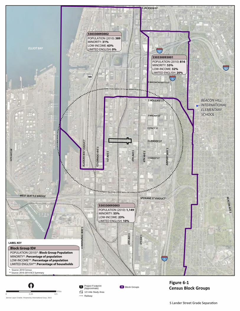
3016
Docu
men
t Pa
th: U
:\PS
O\P
roje
cts\
Clie
nts\
7553
-CO
WI\5
53-7
553-
001
SLan
derS
tGra
dSep
Dsgn
\99S
vcs\
GIS
\Map
docs
\Fig
_2_V
icin
ityEx
tend
ed_C
ensu
s_Bl
ocks
.mxd
Project Footprint
1/2-mile Study Area
Railway
Block Groups
S HOLGATE ST
S FOREST ST
S STACY ST
S WALKER ST
SPOKANE ST VIADUCT
DUWAM
ISH WATERW
AY
90
90
599
5
BEACON
AVE SS JACKSON ST
WEST SEATTLE BRIDGE
S EVA TS1
S EVA
HT4
S EVA
HT6
AIRP
ORT
WAY
S
COLO
RAD
O A
VE
S
16TH
AV
E SW
S MASSACHUSETTS ST
S EVA
HT6
S EVA
HT4
S YAW L
ANI
GRA
M E
ELLIOT BAY
S LANDER ST
ALAS
KAN
WAY
VIA
DU
CT
530330093002
MINORITY: 31%LOW-INCOME: 63%LIMITED ENGLISH: 0%
LABEL KEY
Block Group ID#
MINORITY*: Percentage of populationLOW-INCOME**: Percentage of populationLIMITED ENGLISH**: Percentage of households
POPULATION (2010): 389
530330093001
MINORITY: 53%LOW-INCOME: 32%LIMITED ENGLISH: 20%
POPULATION (2010): 816
530330093003
MINORITY: 55%LOW-INCOME: 23%LIMITED ENGLISH: 10%
POPULATION (2010): 1,149
POPULATION (2010)*: Block Group Population
* Source: 2010 Census** Source: 2010-2014 ACS Summary
BEACON HILLINTERNATIONALELEMENTARYSCHOOL
BEACON HILLINTERNATIONALELEMENTARYSCHOOL
(Approximate)
Figure 6-1Census Block Groups
S Lander Street Grade Separation
[0 0.25 0.5
Miles
Service Layer Credits: Pictometry International Corp. 2015
S Lander St Grade Separation Project Social Effects and Environmental Justice Discipline Report
January 2017 6-5
6.2.1 Minority
The 2010 Census data shown in Table 6-1 and the OSPI elementary school data shown in Table 6-2 both indicate a mixture of races present in and near the study area. According to the 2010 Census data, the small population that lives in the study area is a mixture of races with White Alone (40 percent), Non-Hispanic Asian Alone (27 percent), Black Alone (10 percent), and Hispanic (14 percent) having the largest percentages. As shown in Tables 6-1 and 6-2, the 2010 Census data for the ½ mile study area and the OSPI elementary school data (2014-2015 school year) do not depict the same communities. The Beacon Hill International Elementary School is located in the Beacon Hill neighborhood, which is approximately ¾ mile east of the project and on the other side of I-5. Beacon Hill is an established residential neighborhood, unlike the SODO neighborhood where the project would be located, which is largely commercial and industrial businesses. The Beacon Hill neighborhood is very diverse and that diversity is indicated in the demographics of the elementary school, which is about 85 percent minority; more than half the student body populations is either Hispanic (38.7 percent) or Asian (28.7 percent).
6.2.2 Low Income
The 2010–2014 ACS Summary Report indicated that there are 3 households or 7 percent of the population surveyed within the study area, that earn less than $25,000. The OSPI “Free or Reduced Price Meal Participation” data (Table 6-2) show that approximately 59 percent of the student body qualifies for the program. There is a considerable difference between the ACS and OSPI data. A difference in the thresholds for low-income and eligibility for free or reduced price meals could explain this discrepancy. This discrepancy also can be attributed to the different characteristics between the SODO and Beacon Hill neighborhoods. As previously mentioned, the SODO neighborhood where the project is located has very few residents, whereas the Beacon Hill neighborhood is residential. The data indicate that there are few low-income residents near the proposed project, possibly because very few people live in the study area.
6.2.3 Limited English Proficiency
The 2010–2014 ACS Summary Report “Speak English ‘less than well’” data category indicated that 11 percent of the study area population speak English less than well; see Attachment A. The OSPI school data for Beacon Hill International Elementary School showed about 46.2 percent of the students have limited English fluency (Table 6-2). The 11 percent reported in the ACS Summary Report exceeds the WSDOT limited-English proficiency presence threshold; therefore, this indicates that there may be a population of non-English speakers in the study area for whom translated project materials should be made available. The project analyst consulted the Beacon Hill International Elementary School website to determine which foreign languages are present within the student body. The diversity in the school is such that Parent Teacher Association meetings are conducted in English, Chinese, and Spanish. Families that do not speak these three main languages generally come from Vietnam, Laos, and Somalia.
6.3 Potential Project Impacts and Proposed Mitigation Project impacts during construction, such as noise, dust, access changes and detours, and other temporary construction-related impacts would occur and affect businesses, their patrons, and others who visit or travel through the study area. These impacts would last during the approximately 24-month construction period. The City would implement mitigation measures to reduce impacts on air quality, noise, and access changes associated with project construction, as discussed in Section 4.6. The project would require seven temporary construction easements (TCEs), a total of 34,168 square feet of property. Once construction is complete, the TCEs would be restored to their original condition. The City

S Lander St Grade Separation Project Social Effects and Environmental Justice Discipline Report
6-6 January 2017
would compensate the owners of property for temporary construction easements in accordance with the City’s and Washington’s relocation and property acquisition law and regulations (SMC 20.84 and RCW 8.26).
The City will communicate and coordinate with affected businesses and residents in the study area before and during project construction about expected construction impacts, such as access modifications, utility disruptions, and traffic detours. The City translates project materials into non-English languages if five (or more) percent of the population in the project area speak a given language. The 2010-2014 ACS data indicate there are Chinese and Spanish speakers in the study area, and there are possibly Korean speakers, based on observations of some of the businesses in the vicinity of the project. The City has provided, and will continue to provide, project materials translated into these three languages. To date, the City has provided translated project fact sheets, meeting notifications, and a translated text box on the project website explaining that translated materials in other languages can be provided upon request.
The project would have minor long-term impact on private property because it is designed to be built mostly within the existing right-of-way. However, there would be five permanent partial acquisitions, which would total 2,098 square feet of property. These partial acquisitions are strips of property needed for road right-of-way. The City would compensate the owners of properties acquired for right-of-way in accordance with Washington’s relocation and property acquisition law and regulations (RCW 8.26).
The project would result in the removal of approximately 50 on-street parking spaces on S Lander St between 1st Ave S and 4th Ave S. It is possible that the City would provide parking underneath the new bridge structure, but the final decision has not been made. To address the visual impact of a new bridge, the City could use landscaping and design elements to soften the visual impact of the bridge on viewers; see potential operation mitigation measures in Section 5.6. Once built, the proposed project would not affect environmental justice populations within the study area because few people live near the project The project would provide benefits for the surrounding community, as discussed in the Project Benefits section below.
6.3.1 Compliance with Race and Social Justice Initiative
The Race and Social Justice Initiative is the City’s commitment to eliminate racial disparities and achieve racial equity in Seattle. The Race and Social Justice Initiative Three-Year Plan 2012-2014 presents a three-year plan to focus the City’s efforts on achieving racial equity in Seattle. In the Plan, inclusive outreach and public engagement is a key component of achieving racial equity. Inclusive public outreach is a component of this project, including the availability of translated materials for non-English speakers in the project vicinity so that they are informed about project activities that may impact the community. The use of inclusive public outreach and engagement strategies is consistent with Equity Strategy #1: Apply racial equity tools to our programs and projects. In addition, the Seattle Department of Transportation is using the Racial Equity Toolkit to conduct comprehensive reviews of its programs, policies, and budgets in an effort to identify areas of opportunity for changes to increase racial equity.
6.4 Project Benefits The project would result in benefits for everyone, including environmental justice populations. Such benefits involve less congestion along S Lander St and in the study area, which would lead to more reliable travel times and bus transit service, as well as new pedestrian and bicycle facilities, which also would lead to increased safety for these users. The project would benefit local businesses, such as Home Depot, John Stanford Center for Educational Excellence, Starbucks headquarters, and businesses

S Lander St Grade Separation Project Social Effects and Environmental Justice Discipline Report
January 2017 6-7
located along S Lander St, by providing improved mobility, which would make employee commutes easier and patron visits more convenient. These improvements would benefit all who work or shop in this area of Seattle.
6.5 Conclusion The S Lander St Grade Separation Project would not result in disproportionately high and adverse effects on low-income, minority, and limited-English proficiency populations. The study area is located in the Duwamish MIC. Although the 2010 U.S. Census Bureau and 2010-2014 ACS demographic data indicate that there are minority, low-income, and limited-English proficiency people living within the study area, the Census also showed there are very few people who live there (97 people total). The actual number of people who live in the study area today could be even less because a visit to the study area did not identify visible residential housing.
The project’s construction impacts and operational benefits would have similar effects on everyone in the study area. Construction-related impacts, such as temporary traffic delays and detours, would be experienced by everyone working and traveling near the study area. Once the new bridge is in operation, everyone in the study area would benefit from increased safety, mobility, and reliability due to the elimination of the at-grade railroad crossing.
No minority or low-income populations have been identified that would be adversely affected by this project as determined above. Therefore, this project has met the provisions of Executive Order 12898, as it is supported by Title VI of the Civil Rights Act.

S Lander St Grade Separation Project Social Effects and Environmental Justice Discipline Report
January 2017 7-1
7. REFERENCES City of Seattle and Port of Seattle. 2000. Access Duwamish: A Freight Mobility and Economic Strategy for
the Duwamish Area. Project Summary Report. June 2000.
City of Seattle. 2016. Seattle 2035 Comprehensive Plan: Managing Growth to Become an Equitable and Sustainable City 2015-2035. Available at: http://www.seattle.gov/dpd/ cityplanning/completeprojectslist/comprehensiveplan/documents/default.htm. Seattle, Washington. November 2016.
City of Seattle. 2013. Duwamish M/IC Policy and Land Use Study—Draft Recommendations. Prepared by the City of Seattle Department of Planning and Development. Seattle, Washington. November 2013.
City of Seattle. 2011. Racial Equity in Seattle: Race and Social Justice Initiative Three-Year Plan 2012-2014. Available at: https://www.seattle.gov/Documents/Departments/RSJI/ RacialEquityinSeattleReport2012-14.pdf. Seattle, Washington.
COWI (COWI North America, Inc.). 2016. South Lander Street Grade Separation: Bridge and Structures Type, Size, and Location Report. Prepared for Seattle Department of Transportation. Seattle, Washington. July 29, 2016.
Heffron (Heffron Transportation, Inc.). 2016. Lander Street Grade Separation Transportation Discipline Report. Prepared for Seattle Department of Transportation. Seattle, Washington. August 29, 2016.
Martin Associates. 2014. The Economic Impact of Marine Cargo at the Ports of Tacoma and Seattle. Prepared by Martin Associates. Lancaster, Pennsylvania. September 2014.
OSPI (Office of Superintendent of Public Instruction). 2016. Washington State Report Card. Seattle, Washington.
Ott-Sakai Associates. 2016. South Lander Street Grade Separation—30% Green Sheet Craft Hours Estimate (Excel table). Seattle, Washington.
SDOT (Seattle Department of Transportation). 2016. Fastlane Application. Available at: http://www.seattle.gov/transportation/southlander_Fastlane.htm. April 2016.
SDOT (Seattle Department of Transportation). 2015. Seattle Bicycle Master Plan: Implementation Plan 2015–2019. March 27, 2015.
Texas Transportation Institute. 1997. FAST Project Report. March 1997.
U.S. Census Bureau. 2015. EJSCREEN ACS Summary Report. In: American Community Survey (ACS) 2010-2014. Accessed August 9, 2016.
WSDOT (Washington State Department of Transportation). 2016. Environmental Procedures Manual. Publication M 31-11, Version M 31-11.16. Available at: http://www.wsdot.wa.gov/Publications/ Manuals/M31-11.htm. October 2016.