Embed Size (px)
Citation preview
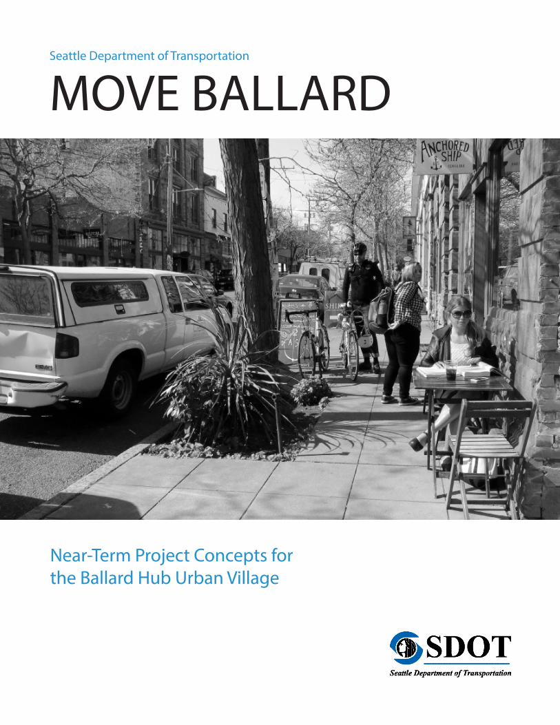
Seattle Department of Transportation
MOVE BALLARD
Near-Term Project Concepts for the Ballard Hub Urban Village

CONTENTS
1 BACKGROUND ......................................................................................................................................................4
1.1 Purpose .........................................................................................................................................................4
1.2 Objectives ....................................................................................................................................................5
2 EXISTING TRANSPORTATION CONDITIONS ..............................................................................................6
2.1 Street Network ...........................................................................................................................................6
2.2 Pedestrian Network ................................................................................................................................11
2.3 Bicycle Network .......................................................................................................................................12
2.4 Transit Network ........................................................................................................................................14
2.5 Freight Network .......................................................................................................................................15
3 EXISTING PLANS ................................................................................................................................................17
3.1 Pedestrian Master Plan (2009 – Currently Being Updated) ......................................................17
3.2 Transit Master Plan (2012 – Updated 2016) ...................................................................................18
3.3 Bicycle Master Plan (2014) ...................................................................................................................20
3.4 Freight Master Plan (Ongoing) ...........................................................................................................21
3.5 Move SEattle .............................................................................................................................................21
4 COMMUNITY OUTREACH ..............................................................................................................................22
4.1 Outreach Overview.................................................................................................................................22
4.2 Phase I Outreach ......................................................................................................................................22
4.3 Phase II Outreach.....................................................................................................................................25
5 MULTIMODAL PROJECT EVALUATION CRITERIA AND PRIORITIZATION .....................................27
5.1 Developing the Project List .................................................................................................................27
5.2 Prioritization Criteria ..............................................................................................................................28
6 PRIORITIZED PROJECT LIST ..........................................................................................................................30
7 STATION AREA ASSESSMENT .......................................................................................................................43
7.1 Purpose of the Station Area Assessment ........................................................................................43
7.2 Evaluating Transit Orientation ............................................................................................................43
7.3 Station Area Comparison .....................................................................................................................44
7.4 Results .........................................................................................................................................................45
4 | MOVE BALLARD
1 BACKGROUND
project list and vote in the fall of 2016, this study evaluates and prioritizes potential future light rail stations identified in the Ballard to Downtown Seattle Transit Expansion Study (2014). Understanding the neighborhood’s preference for high capacity transit (HCT) station locations along with the connectivity and mobility challenges to reach those stations will allow the Seattle Department of Transportation (SDOT) to more effectively partner with Sound Transit to implement HCT in Ballard.
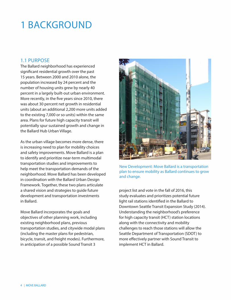
1.1 PURPOSE The Ballard neighborhood has experienced significant residential growth over the past 15 years. Between 2000 and 2010 alone, the population increased by 24 percent and the number of housing units grew by nearly 40 percent in a largely built-out urban environment. More recently, in the five years since 2010, there was about 30 percent net growth in residential units (about an additional 2,200 more units added to the existing 7,000 or so units) within the same area. Plans for future high capacity transit will potentially spur sustained growth and change in the Ballard Hub Urban Village.
As the urban village becomes more dense, there is increasing need to plan for mobility choices and safety improvements. Move Ballard is a plan to identify and prioritize near-term multimodal transportation studies and improvements to help meet the transportation demands of the neighborhood. Move Ballard has been developed in coordination with the Ballard Urban Design Framework. Together, these two plans articulate a shared vision and strategies to guide future development and transportation investments in Ballard.
Move Ballard incorporates the goals and objectives of other planning work, including existing neighborhood plans, previous transportation studies, and citywide modal plans (including the master plans for pedestrian, bicycle, transit, and freight modes). Furthermore, in anticipation of a possible Sound Transit 3
New Development: Move Ballard is a transportation plan to ensure mobility as Ballard continues to grow and change.
MOVE BALLARD | 5
1.2 OBJECTIVES The primary objectives of Move Ballard are summarized below:
• Identify existing accessibility and mobility challenges for all modes of transportation through extensive community outreach
• Review prior studies, existing modal plans, and work with local organizations to identify project concepts that best meets Ballard’s needs and goals
• Develop an integrated land use and transportation strategy by coordinating with the Ballard Urban Design Framework
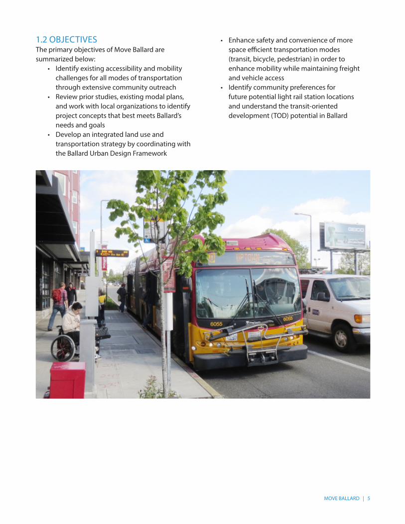
• Enhance safety and convenience of more space efficient transportation modes (transit, bicycle, pedestrian) in order to enhance mobility while maintaining freight and vehicle access
• Identify community preferences for future potential light rail station locations and understand the transit-oriented development (TOD) potential in Ballard
6 | MOVE BALLARD
2 EXISTING TRANSPORTATION CONDITIONS
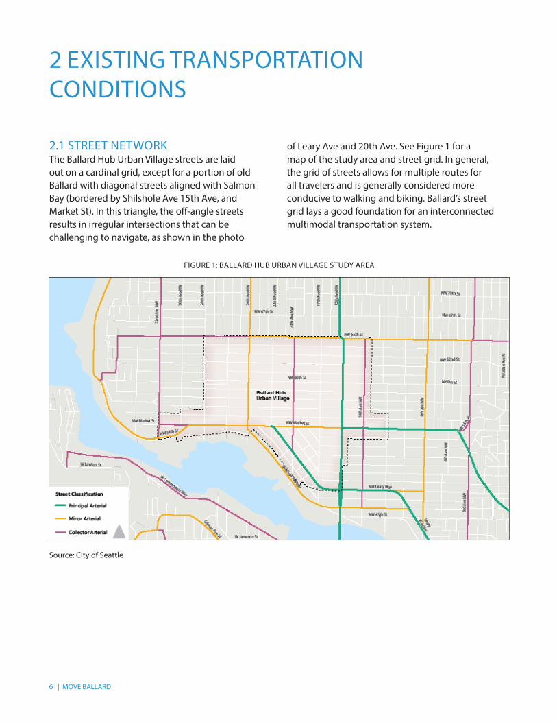
of Leary Ave and 20th Ave. See Figure 1 for a map of the study area and street grid. In general, the grid of streets allows for multiple routes for all travelers and is generally considered more conducive to walking and biking. Ballard’s street grid lays a good foundation for an interconnected multimodal transportation system.
2.1 STREET NETWORKThe Ballard Hub Urban Village streets are laid out on a cardinal grid, except for a portion of old Ballard with diagonal streets aligned with Salmon Bay (bordered by Shilshole Ave 15th Ave, and Market St). In this triangle, the off-angle streets results in irregular intersections that can be challenging to navigate, as shown in the photo
FIGURE 1: BALLARD HUB URBAN VILLAGE STUDY AREA
Source: City of Seattle
MOVE BALLARD | 7
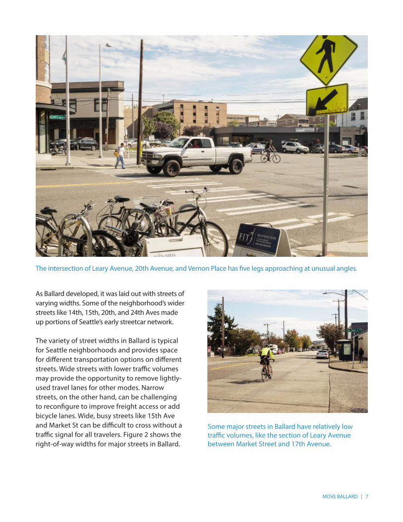
As Ballard developed, it was laid out with streets of varying widths. Some of the neighborhood’s wider streets like 14th, 15th, 20th, and 24th Aves made up portions of Seattle’s early streetcar network.
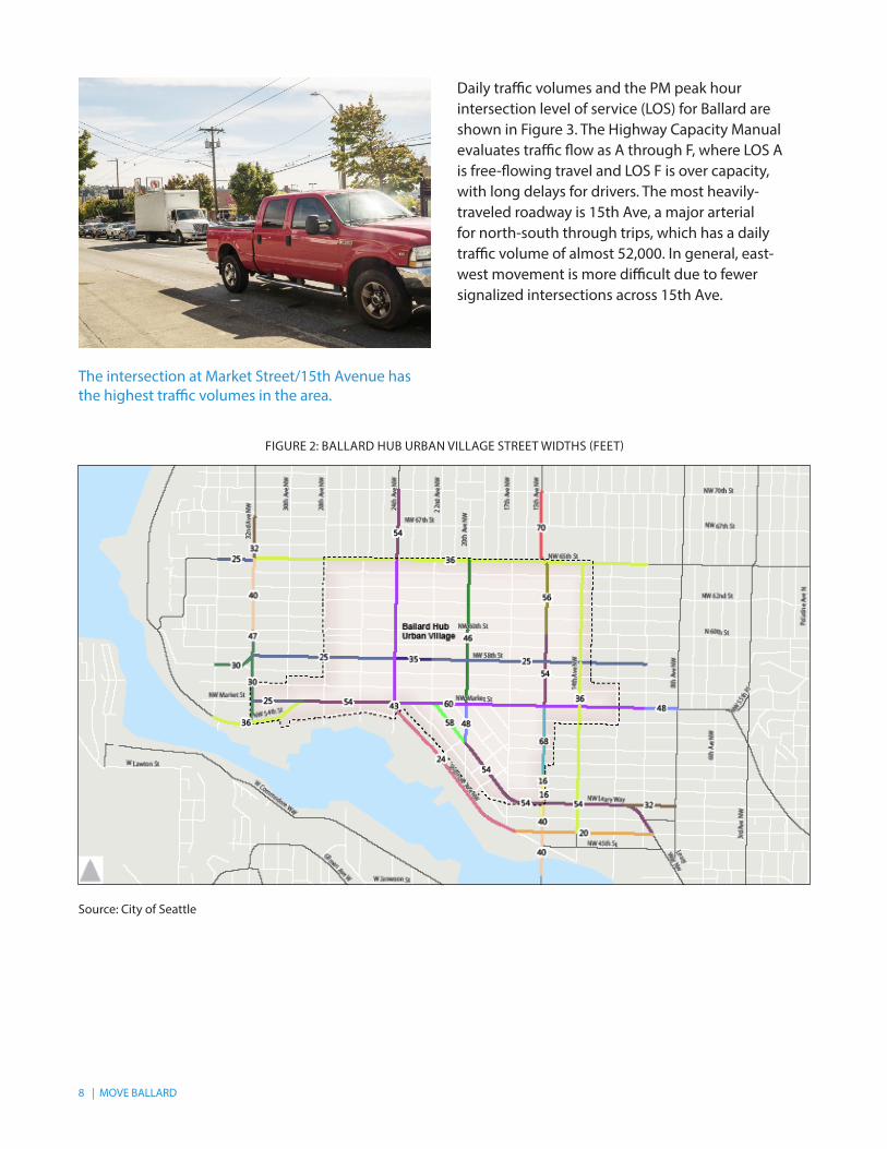
The variety of street widths in Ballard is typical for Seattle neighborhoods and provides space for different transportation options on different streets. Wide streets with lower traffic volumes may provide the opportunity to remove lightly-used travel lanes for other modes. Narrow streets, on the other hand, can be challenging to reconfigure to improve freight access or add bicycle lanes. Wide, busy streets like 15th Ave and Market St can be difficult to cross without a traffic signal for all travelers. Figure 2 shows the right-of-way widths for major streets in Ballard.
The intersection of Leary Avenue, 20th Avenue, and Vernon Place has five legs approaching at unusual angles.
Some major streets in Ballard have relatively low traffic volumes, like the section of Leary Avenue between Market Street and 17th Avenue.
8 | MOVE BALLARD
FIGURE 2: BALLARD HUB URBAN VILLAGE STREET WIDTHS (FEET)
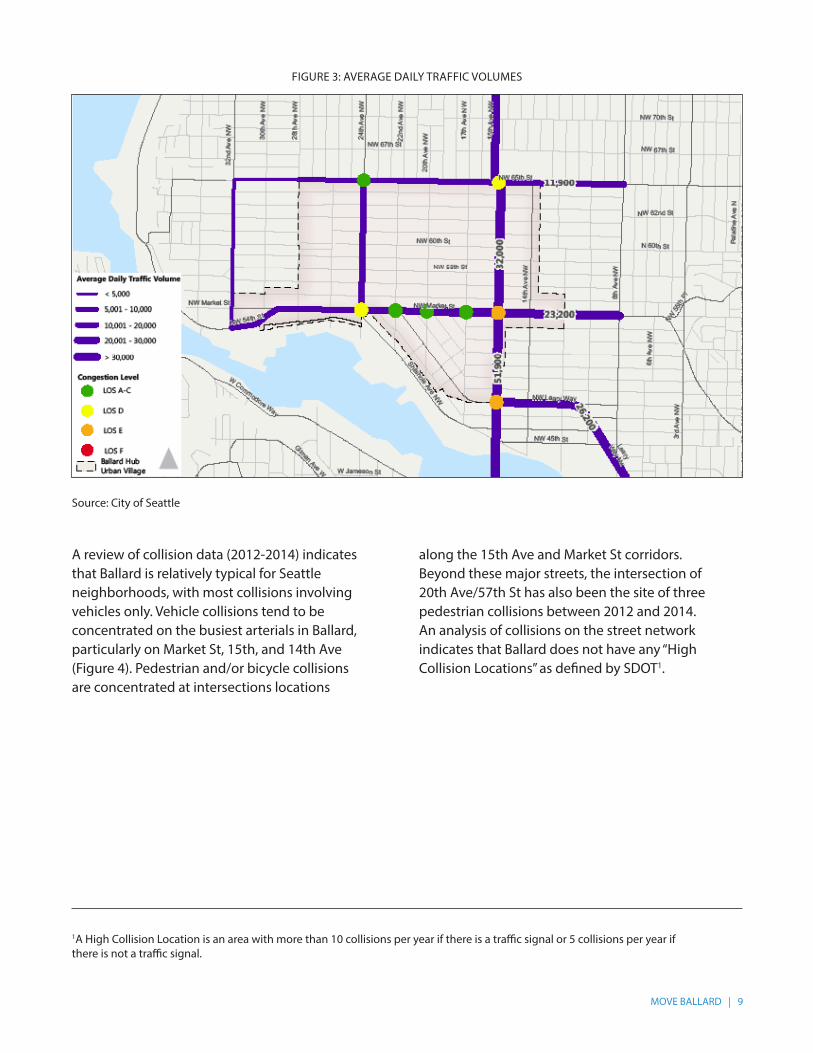
Daily traffic volumes and the PM peak hour intersection level of service (LOS) for Ballard are shown in Figure 3. The Highway Capacity Manual evaluates traffic flow as A through F, where LOS A is free-flowing travel and LOS F is over capacity, with long delays for drivers. The most heavily-traveled roadway is 15th Ave, a major arterial for north-south through trips, which has a daily traffic volume of almost 52,000. In general, east-west movement is more difficult due to fewer signalized intersections across 15th Ave.
The intersection at Market Street/15th Avenue has the highest traffic volumes in the area.
Source: City of Seattle
MOVE BALLARD | 9
FIGURE 3: AVERAGE DAILY TRAFFIC VOLUMES
Source: City of Seattle
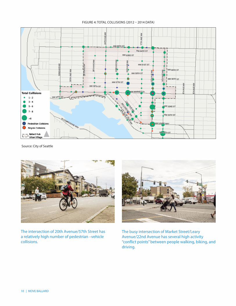
A review of collision data (2012-2014) indicates that Ballard is relatively typical for Seattle neighborhoods, with most collisions involving vehicles only. Vehicle collisions tend to be concentrated on the busiest arterials in Ballard, particularly on Market St, 15th, and 14th Ave (Figure 4). Pedestrian and/or bicycle collisions are concentrated at intersections locations
along the 15th Ave and Market St corridors. Beyond these major streets, the intersection of 20th Ave/57th St has also been the site of three pedestrian collisions between 2012 and 2014.An analysis of collisions on the street network indicates that Ballard does not have any “High Collision Locations” as defined by SDOT1.
1A High Collision Location is an area with more than 10 collisions per year if there is a traffic signal or 5 collisions per year if there is not a traffic signal.
10 | MOVE BALLARD
FIGURE 4: TOTAL COLLISIONS (2012 – 2014 DATA)
Source: City of Seattle
The busy intersection of Market Street/Leary Avenue/22nd Avenue has several high activity “conflict points” between people walking, biking, and driving.
The intersection of 20th Avenue/57th Street has a relatively high number of pedestrian –vehicle collisions.
MOVE BALLARD | 11
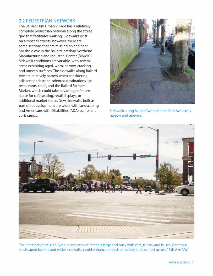
2.2 PEDESTRIAN NETWORKThe Ballard Hub Urban Village has a relatively complete pedestrian network along the street grid that facilitates walking. Sidewalks exist on almost all streets; however, there are some sections that are missing on and near Shilshole Ave in the Ballard Interbay Northend Manufacturing and Industrial Center (BINMIC). Sidewalk conditions are variable, with several areas exhibiting aged, worn, narrow, cracking, and uneven surfaces. The sidewalks along Ballard Ave are relatively narrow when considering adjacent pedestrian-oriented destinations like restaurants, retail, and the Ballard Farmers Market, which could take advantage of more space for café seating, retail displays, or additional market space. New sidewalks built as part of redevelopment are wider with landscaping and Americans with Disabilities (ADA) compliant curb ramps.
Sidewalk along Ballard Avenue near 20th Avenue is narrow and uneven.
The intersection at 15th Avenue and Market Street is large and busy with cars, trucks, and buses. Generous landscaped buffers and wider sidewalks could enhance pedestrian safety and comfort across 15th Ave NW.
12 | MOVE BALLARD
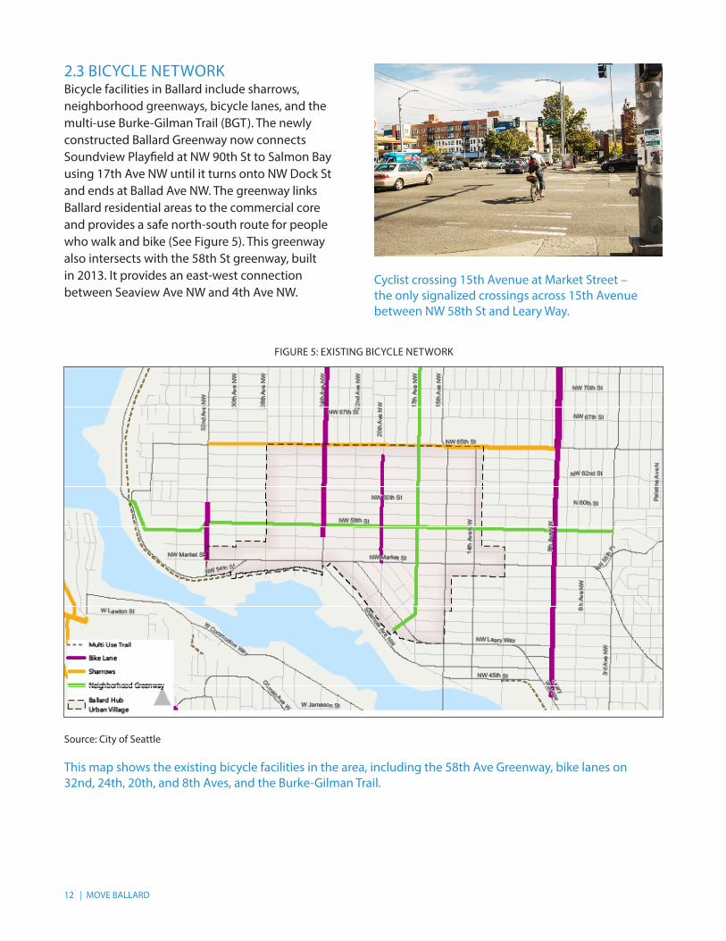
2.3 BICYCLE NETWORK Bicycle facilities in Ballard include sharrows, neighborhood greenways, bicycle lanes, and the multi-use Burke-Gilman Trail (BGT). The newly constructed Ballard Greenway now connects Soundview Playfield at NW 90th St to Salmon Bay using 17th Ave NW until it turns onto NW Dock St and ends at Ballad Ave NW. The greenway links Ballard residential areas to the commercial core and provides a safe north-south route for people who walk and bike (See Figure 5). This greenway also intersects with the 58th St greenway, built in 2013. It provides an east-west connection between Seaview Ave NW and 4th Ave NW.
Cyclist crossing 15th Avenue at Market Street – the only signalized crossings across 15th Avenue between NW 58th St and Leary Way.
This map shows the existing bicycle facilities in the area, including the 58th Ave Greenway, bike lanes on 32nd, 24th, 20th, and 8th Aves, and the Burke-Gilman Trail.
FIGURE 5: EXISTING BICYCLE NETWORK
Source: City of Seattle
MOVE BALLARD | 13
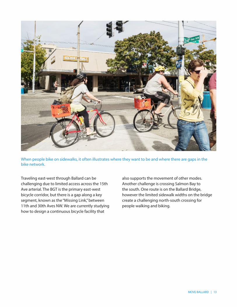
Traveling east-west through Ballard can be challenging due to limited access across the 15th Ave arterial. The BGT is the primary east-west bicycle corridor, but there is a gap along a key segment, known as the “Missing Link,” between 11th and 30th Aves NW. We are currently studying how to design a continuous bicycle facility that
also supports the movement of other modes. Another challenge is crossing Salmon Bay to the south. One route is on the Ballard Bridge, however the limited sidewalk widths on the bridge create a challenging north-south crossing for people walking and biking.
When people bike on sidewalks, it often illustrates where they want to be and where there are gaps in the bike network.
14 | MOVE BALLARD
2.4 TRANSIT NETWORKBus service exists between Ballard and major destinations in Seattle. The following routes serve Ballard:
• RapidRide D (Downtown Seattle, Uptown, Queen Anne, Interbay, Crown Hill)
• Route 15 (Downtown Seattle, Uptown, Queen Anne, Interbay, Crown Hill, Blue Ridge)
• Route 17 (Downtown Seattle, Queen Anne, Ballard, Sunset Hill, Loyal Heights)
• Route 18 (Downtown Seattle, Uptown, Queen Anne, Interbay, Loyal Heights, North Beach)
• Route 28 (SoDo, Downtown Seattle, Queen Anne, Fremont, Greenwood, Broadview)
• Route 29 (Queen Anne, Downtown Seattle)• Route 40 (Downtown Seattle, South Lake
Union, Fremont, Crown Hill, North Beach, North Seattle College, Northgate)
• Route 44 (Government Locks, Wallingford, University District, Montlake)
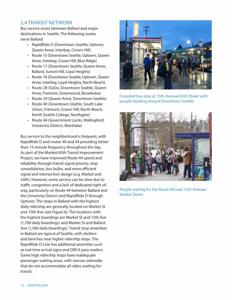
Bus service to the neighborhood is frequent, with RapidRide D and routes 40 and 44 providing better than 15 minute frequency throughout the day. As part of the Market/45th Transit Improvement Project, we have improved Route 44 speed and reliability through transit signal priority, stop consolidation, bus bulbs, and more efficient signal and intersection design (e.g. Market and 24th). However, some service can be slow due to traffic congestion and a lack of dedicated right-of-way, particularly on Route 44 between Ballard and the University District and RapidRide D through Uptown. The stops in Ballard with the highest daily ridership are generally located on Market St and 15th Ave (see Figure 6). The locations with the highest boardings are Market St and 15th Ave (1,700 daily boardings) and Market St and Ballard Ave (1,300 daily boardings). Transit stop amenities in Ballard are typical of Seattle, with shelters and benches near higher ridership stops. The RapidRide D Line has additional amenities such as real time arrival signs and ORCA pass readers. Some high ridership stops have inadequate passenger waiting areas, with narrow sidewalks that do not accommodate all riders waiting for transit.
Crowded bus stop at 15th Avenue/65th Street with people heading toward Downtown Seattle.
People waiting for the Route 44 near 15th Avenue/Market Street.

MOVE BALLARD | 15
FIGURE 6: TRANSIT ROUTES AND RIDERSHIP
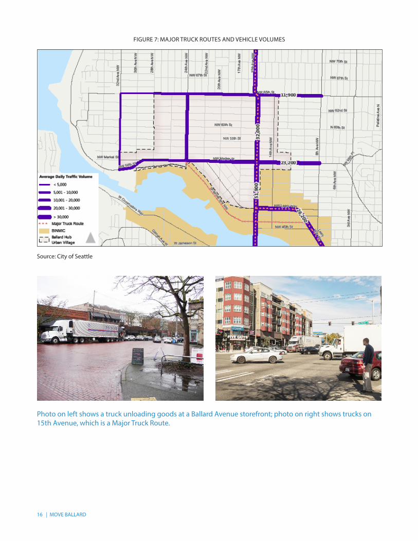
2.5 FREIGHT NETWORKThe Ballard Interbay Northend Manufacturing & Industrial Center (BINMIC) adjacent to the study area is a designated industrially zoned area that relies on regional freight access to distribute products and receive supplies. The increasing density of Ballard also means that there are more trucks serving construction sites and delivering products. Therefore, supporting freight and local access are high priorities in Move Ballard.
A major truck street is an arterial street that accommodates significant freight movement through the city, and to and from major freight
Source: City of Seattle
traffic generators. Typically designated as principal arterials, major truck streets generally carry heavier loads and higher truck volumes than other streets in the city. SDOT uses the designation of major truck street on an on-going basis as an important criterion for street design, traffic management decisions and pavement design and repair. The current designated major truck streets in Ballard include Shilshole Ave, 15th Ave, and Leary Way east of 15th Ave (see Figure 7). In addition to the major truck street network, the City’s Freight Master Plan is under development and will provide guidance on improving freight mobility throughout Seattle.
16 | MOVE BALLARD
FIGURE 7: MAJOR TRUCK ROUTES AND VEHICLE VOLUMES
Source: City of Seattle
Photo on left shows a truck unloading goods at a Ballard Avenue storefront; photo on right shows trucks on 15th Avenue, which is a Major Truck Route.
MOVE BALLARD | 17
3 EXISTING PLANS
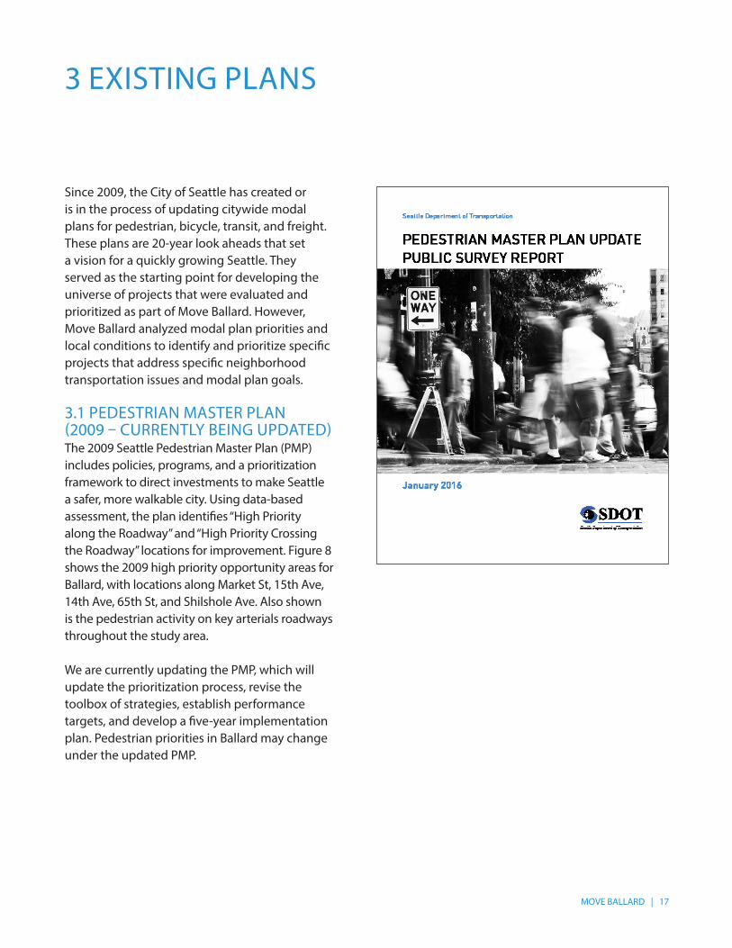
Since 2009, the City of Seattle has created or is in the process of updating citywide modal plans for pedestrian, bicycle, transit, and freight. These plans are 20-year look aheads that set a vision for a quickly growing Seattle. They served as the starting point for developing the universe of projects that were evaluated and prioritized as part of Move Ballard. However, Move Ballard analyzed modal plan priorities and local conditions to identify and prioritize specific projects that address specific neighborhood transportation issues and modal plan goals. 3.1 PEDESTRIAN MASTER PLAN (2009 – CURRENTLY BEING UPDATED)The 2009 Seattle Pedestrian Master Plan (PMP) includes policies, programs, and a prioritization framework to direct investments to make Seattle a safer, more walkable city. Using data-based assessment, the plan identifies “High Priority along the Roadway” and “High Priority Crossing the Roadway” locations for improvement. Figure 8 shows the 2009 high priority opportunity areas for Ballard, with locations along Market St, 15th Ave, 14th Ave, 65th St, and Shilshole Ave. Also shown is the pedestrian activity on key arterials roadways throughout the study area.
We are currently updating the PMP, which will update the prioritization process, revise the toolbox of strategies, establish performance targets, and develop a five-year implementation plan. Pedestrian priorities in Ballard may change under the updated PMP.

18 | MOVE BALLARD
FIGURE 8: PEDESTRIAN MASTER PLAN
Source: City of Seattle
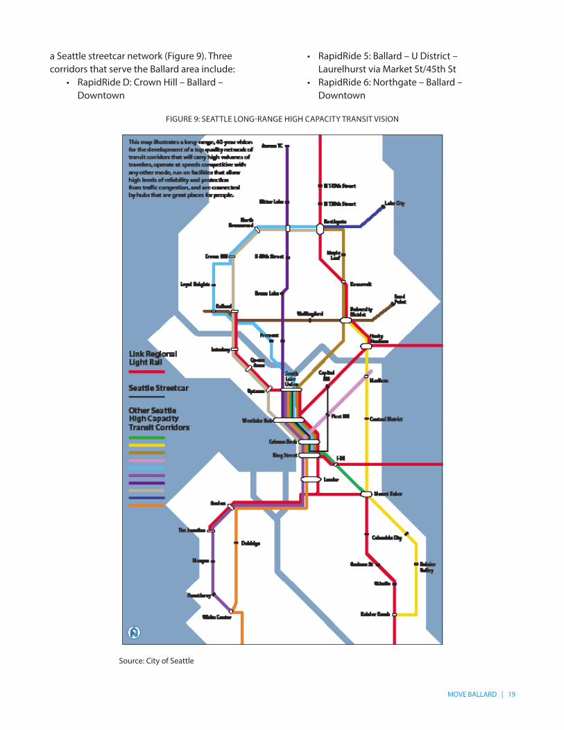
3.2 TRANSIT MASTER PLAN (2012 – UPDATED 2016)In 2012, the City of Seattle completed a new Transit Master Plan (TMP), which was an extensive update of the prior 2005 Transit Plan. The 2012 TMP update included a revised evaluation framework for identifying high-priority transit corridors and evaluation of modes for each corridor including rail modes and rapid bus. In 2016, the TMP was updated to reflect newly identified RapidRide corridors from the Move Seattle plan, and funded in the recent Levy to Move Seattle. These new routes are an addition to the three existing RapidRide routes in Seattle, including RapidRide D, a frequent key route that provides service from Ballard to Downtown Seattle via Queen Anne.
The TMP articulates a long-range transportation vision for Seattle built on the backbone of Link Regional Light Rail, 10 RapidRide Corridors, and
MOVE BALLARD | 19
a Seattle streetcar network (Figure 9). Three corridors that serve the Ballard area include:
• RapidRide D: Crown Hill – Ballard – Downtown
• RapidRide 5: Ballard – U District – Laurelhurst via Market St/45th St
• RapidRide 6: Northgate – Ballard – Downtown
FIGURE 9: SEATTLE LONG-RANGE HIGH CAPACITY TRANSIT VISION
Source: City of Seattle
20 | MOVE BALLARD
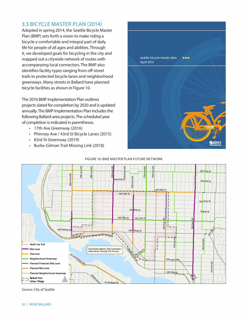
3.3 BICYCLE MASTER PLAN (2014)Adopted in spring 2014, the Seattle Bicycle Master Plan (BMP) sets forth a vision to make riding a bicycle a comfortable and integral part of daily life for people of all ages and abilities. Through it, we developed goals for bicycling in the city and mapped out a citywide network of routes with accompanying local connectors. The BMP also identifies facility types ranging from off-street trails to protected bicycle lanes and neighborhood greenways. Many streets in Ballard have planned bicycle facilities as shown in Figure 10.
The 2016 BMP Implementation Plan outlines projects slated for completion by 2020 and is updated annually. The BMP Implementation Plan includes the following Ballard-area projects. The scheduled year of completion is indicated in parentheses.
• 17th Ave Greenway (2016)• Phinney Ave / 43rd St Bicycle Lanes (2015)• 83rd St Greenway (2019)• Burke-Gilman Trail Missing Link (2018)
FIGURE 10: BIKE MASTER PLAN FUTURE NETWORK
Source: City of Seattle
MOVE BALLARD | 21
3.4 FREIGHT MASTER PLAN (ONGOING)We are currently in the process of developing a Freight Master Plan (FMP). The plan will outline why freight is important to the city and will focus primarily on urban goods mobility and delivery. Elements of the plan will include an existing conditions report, policy framework, future conditions assessment, identification of near- and long-term improvements, design guidelines, and the creation of an implementation strategy that includes a prioritization framework.
Ballard is adjacent to the Ballard-Interbay Northend Manufacturing Industrial Center (BINMIC), an industrial area that extends south to the northeast end of Downtown. The study area is serviced by the following major truck streets: 15th Ave, Leary Ave, and Shilshole Ave. With an active commercial core and its adjacency to the BINMIC), freight movement is an important piece of the neighborhood’s transportation network.
SDOT is coordinating Move Ballard with the Freight Master Plan to ensure compatibility with future Freight Master Plan projects.
3.5 MOVE SEATTLEIn addition to these modal plans, the City identified strategic multimodal transportation projects to be implemented in the next 10 years in the Move Seattle plan. The Levy to Move Seattle passed in 2015, and this will be a funding source for the identified projects, most of which are mentioned in the modal plans.
22 | MOVE BALLARD
4 COMMUNITY OUTREACH
supplemental transportation component), resulted in engagement with a broad audience. The cornerstone to this outreach was the advisory role of the Urban Design and Transportation (UDaT) working group of the Ballard Partnership for Smart Growth representing more than 50 Ballard business, neighborhood, and community leaders. UDaT’s monthly meetings provided a venue for city staff to receive input and gauge community sentiment during the identification, development, and prioritization of transportation improvement projects.
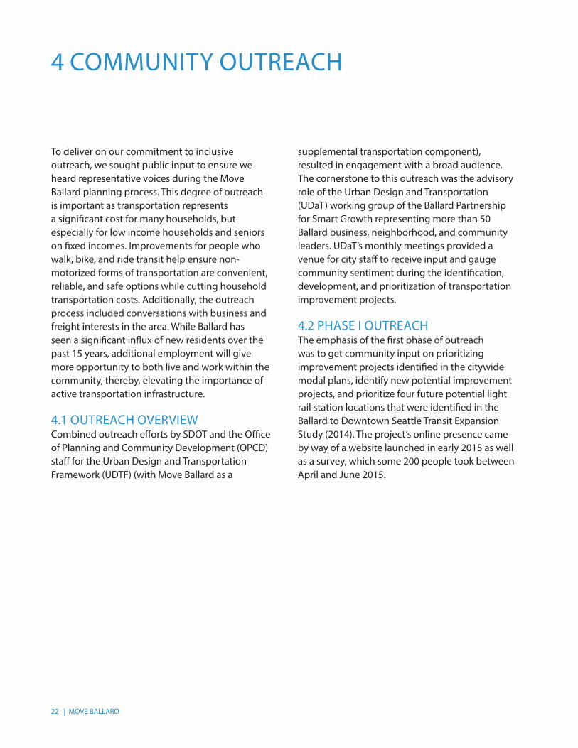
4.2 PHASE I OUTREACHThe emphasis of the first phase of outreach was to get community input on prioritizing improvement projects identified in the citywide modal plans, identify new potential improvement projects, and prioritize four future potential light rail station locations that were identified in the Ballard to Downtown Seattle Transit Expansion Study (2014). The project’s online presence came by way of a website launched in early 2015 as well as a survey, which some 200 people took between April and June 2015.
To deliver on our commitment to inclusive outreach, we sought public input to ensure we heard representative voices during the Move Ballard planning process. This degree of outreach is important as transportation represents a significant cost for many households, but especially for low income households and seniors on fixed incomes. Improvements for people who walk, bike, and ride transit help ensure non-motorized forms of transportation are convenient, reliable, and safe options while cutting household transportation costs. Additionally, the outreach process included conversations with business and freight interests in the area. While Ballard has seen a significant influx of new residents over the past 15 years, additional employment will give more opportunity to both live and work within the community, thereby, elevating the importance of active transportation infrastructure.
4.1 OUTREACH OVERVIEWCombined outreach efforts by SDOT and the Office of Planning and Community Development (OPCD) staff for the Urban Design and Transportation Framework (UDTF) (with Move Ballard as a
MOVE BALLARD | 23
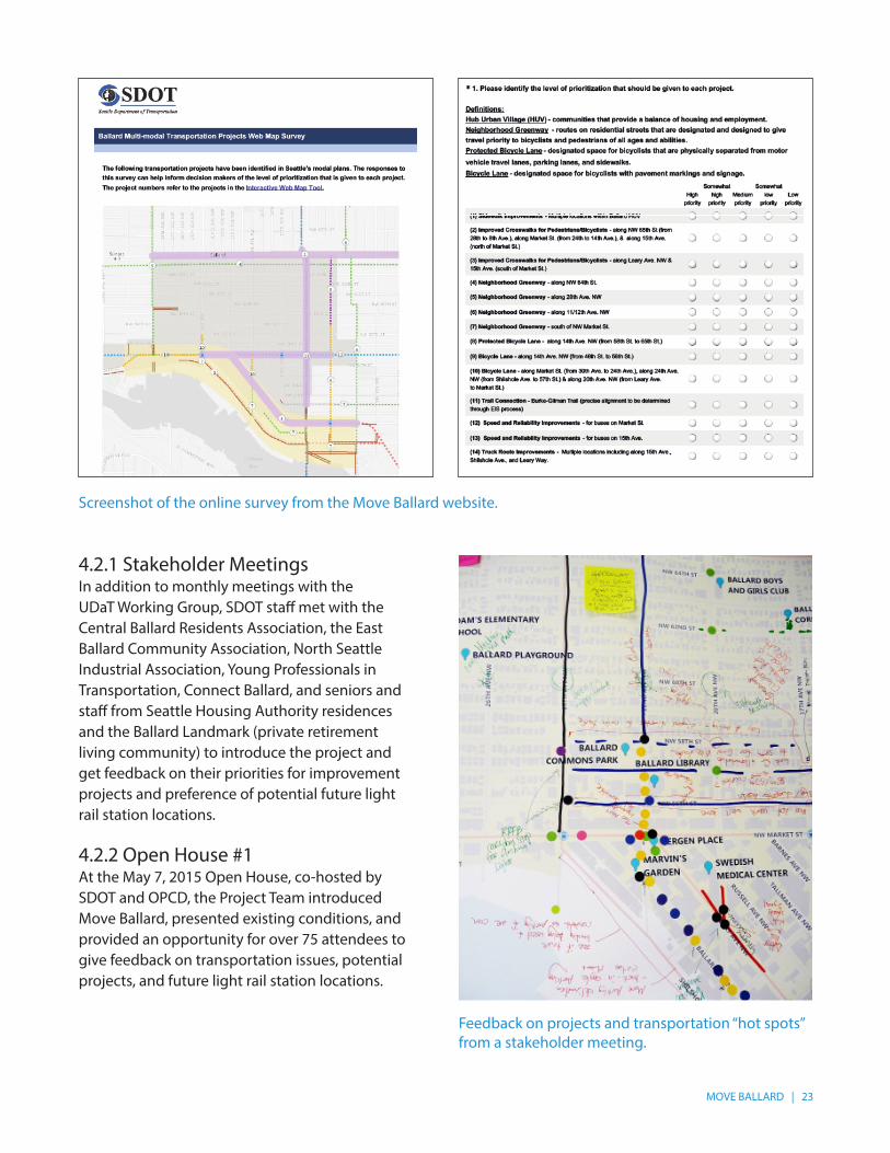
4.2.1 Stakeholder MeetingsIn addition to monthly meetings with the UDaT Working Group, SDOT staff met with the Central Ballard Residents Association, the East Ballard Community Association, North Seattle Industrial Association, Young Professionals in Transportation, Connect Ballard, and seniors and staff from Seattle Housing Authority residences and the Ballard Landmark (private retirement living community) to introduce the project and get feedback on their priorities for improvement projects and preference of potential future light rail station locations.
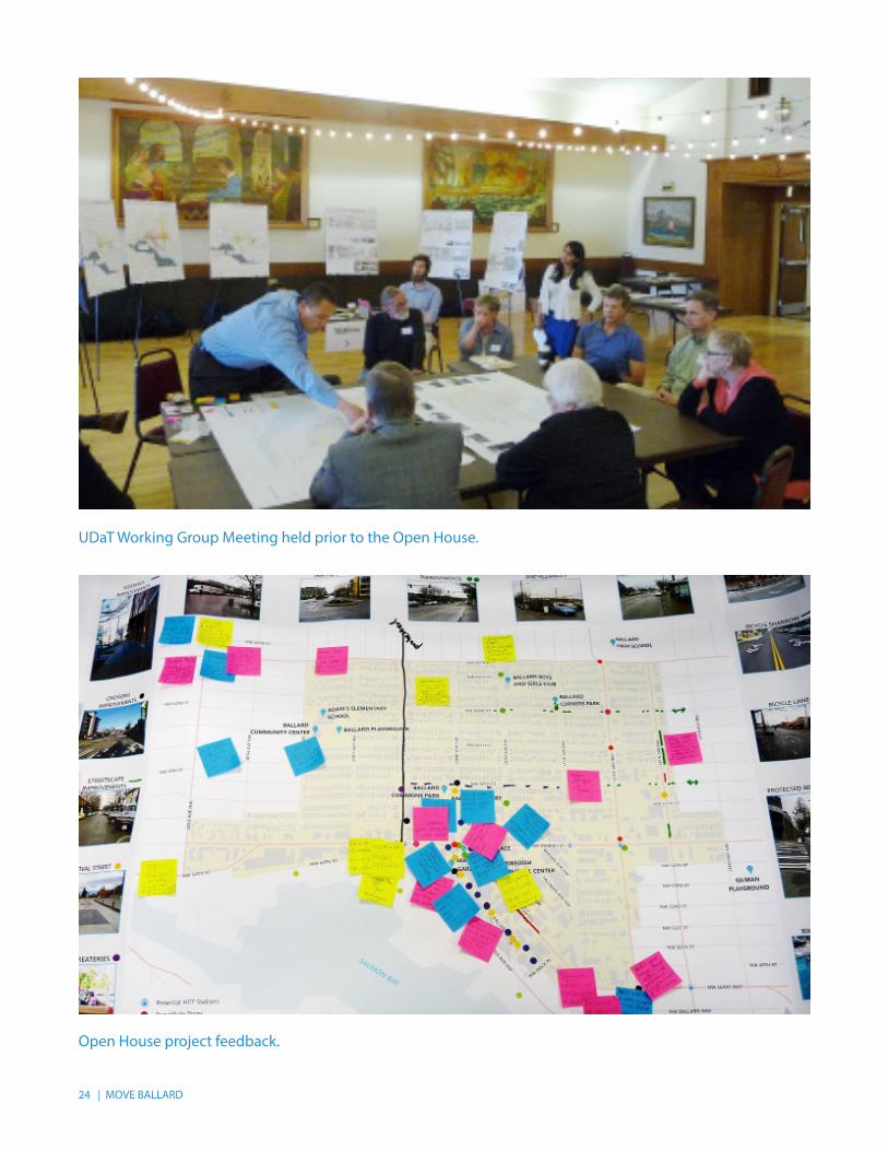
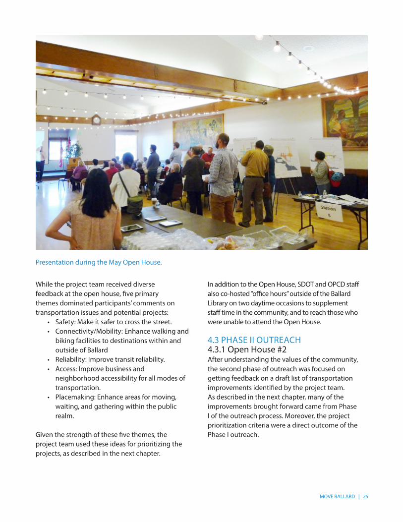
4.2.2 Open House #1At the May 7, 2015 Open House, co-hosted by SDOT and OPCD, the Project Team introduced Move Ballard, presented existing conditions, and provided an opportunity for over 75 attendees to give feedback on transportation issues, potential projects, and future light rail station locations.
Screenshot of the online survey from the Move Ballard website.
Feedback on projects and transportation “hot spots” from a stakeholder meeting.
24 | MOVE BALLARD
UDaT Working Group Meeting held prior to the Open House.
Open House project feedback.
MOVE BALLARD | 25
While the project team received diverse feedback at the open house, five primary themes dominated participants’ comments on transportation issues and potential projects:
• Safety: Make it safer to cross the street.• Connectivity/Mobility: Enhance walking and
biking facilities to destinations within and outside of Ballard
• Reliability: Improve transit reliability.• Access: Improve business and
neighborhood accessibility for all modes of transportation.
• Placemaking: Enhance areas for moving, waiting, and gathering within the public realm.
Given the strength of these five themes, the project team used these ideas for prioritizing the projects, as described in the next chapter.
In addition to the Open House, SDOT and OPCD staff also co-hosted “office hours” outside of the Ballard Library on two daytime occasions to supplement staff time in the community, and to reach those who were unable to attend the Open House.
4.3 PHASE II OUTREACH4.3.1 Open House #2 After understanding the values of the community, the second phase of outreach was focused on getting feedback on a draft list of transportation improvements identified by the project team. As described in the next chapter, many of the improvements brought forward came from Phase I of the outreach process. Moreover, the project prioritization criteria were a direct outcome of the Phase I outreach.
Presentation during the May Open House.

26 | MOVE BALLARD
At the November 18, 2015 Open House, we asked attendees to comment on thirteen transportation improvements that scored high in the project prioritization process. Approximately 70 people attended the Open House and were generally supportive of the high-priority projects. Community feedback was used to refine project elements. Comments on the project boards presented at both Open Houses along with detailed survey responses can be found in the Technical Appendix.
Visitors reviewing the high-priority projects at the second Open House in November.
4.3.2 Stakeholder MeetingsFollowing the second Open House, the project team continued to meet with the UDaT Working Group and other stakeholders to refine the project list and conceptual designs of the high priority projects to ensure that the concepts are both feasible and address community concerns. This outreach coincided with additional internal project review with SDOT staff. The results of the final outreach and internal project vetting are reflected in the project list and project descriptions in Chapter 6.
MOVE BALLARD | 27
5 MULTIMODAL PROJECT EVALUATION CRITERIA AND PRIORITIZATION
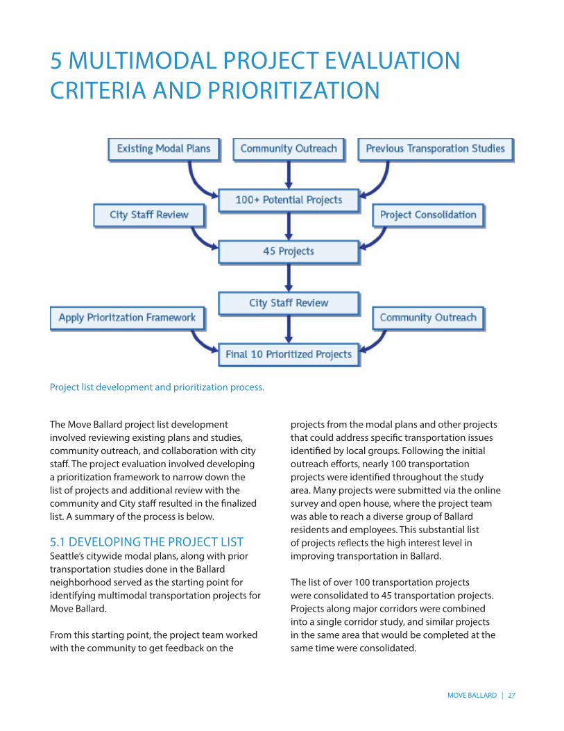
The Move Ballard project list development involved reviewing existing plans and studies, community outreach, and collaboration with city staff. The project evaluation involved developing a prioritization framework to narrow down the list of projects and additional review with the community and City staff resulted in the finalized list. A summary of the process is below. 5.1 DEVELOPING THE PROJECT LIST Seattle’s citywide modal plans, along with prior transportation studies done in the Ballard neighborhood served as the starting point for identifying multimodal transportation projects for Move Ballard.
From this starting point, the project team worked with the community to get feedback on the
Project list development and prioritization process.
projects from the modal plans and other projects that could address specific transportation issues identified by local groups. Following the initial outreach efforts, nearly 100 transportation projects were identified throughout the study area. Many projects were submitted via the online survey and open house, where the project team was able to reach a diverse group of Ballard residents and employees. This substantial list of projects reflects the high interest level in improving transportation in Ballard.
The list of over 100 transportation projects were consolidated to 45 transportation projects. Projects along major corridors were combined into a single corridor study, and similar projects in the same area that would be completed at the same time were consolidated.
28 | MOVE BALLARD
5.2 PRIORITIZATION CRITERIA To prioritize these projects, the project team identified evaluation criteria informed by Move Seattle and other City prioritization frameworks. The prioritization criteria include:
• Safety – improves the safety of the community by improving high collision locations.
• Equity – serves a range of socioeconomic demographics and vulnerable sectors of the community.
• Accessibility – improves access to destinations and connects transportation facilities.
• Neighborhood Vitality and Placemaking – improves neighborhood economic vitality by ensuring freight and local delivery truck access, maintain loading zones, or adding parking. The placemaking component also evaluated how the project improves the pedestrian and biking environment within the community.
• Modal Plan Implementation – evaluates a project’s consistency with the planned projects in one of the City’s adopted modal plans.
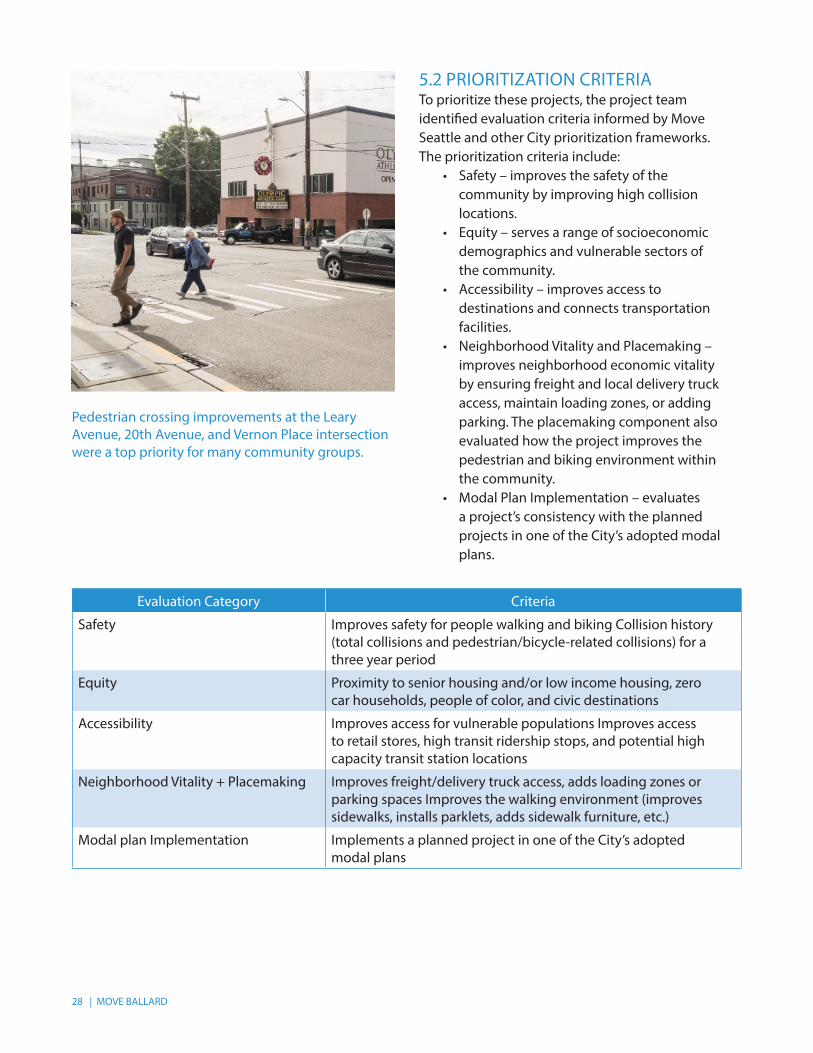
Pedestrian crossing improvements at the Leary Avenue, 20th Avenue, and Vernon Place intersection were a top priority for many community groups.
Evaluation Category Criteria
Safety Improves safety for people walking and biking Collision history (total collisions and pedestrian/bicycle-related collisions) for a three year period
Equity Proximity to senior housing and/or low income housing, zero car households, people of color, and civic destinations
Accessibility Improves access for vulnerable populations Improves access to retail stores, high transit ridership stops, and potential high capacity transit station locations
Neighborhood Vitality + Placemaking Improves freight/delivery truck access, adds loading zones or parking spaces Improves the walking environment (improves sidewalks, installs parklets, adds sidewalk furniture, etc.)
Modal plan Implementation Implements a planned project in one of the City’s adopted modal plans

MOVE BALLARD | 29
In addition to these evaluation categories, consideration was also given to the ability to be implemented in the near term, such as the Shilshole Ave and 17th Ave Truck Access Improvement project.
Feedback on potential projects following a community meeting with SDOT staff.
30 | MOVE BALLARD
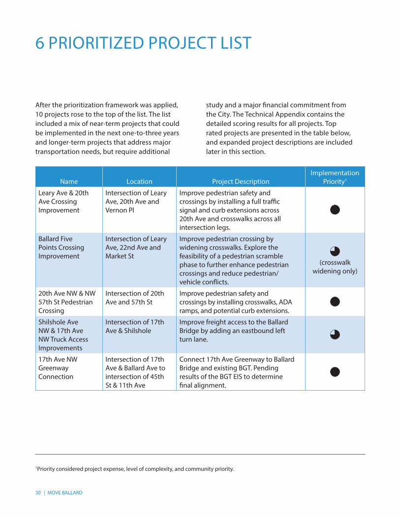
6 PRIORITIZED PROJECT LIST
After the prioritization framework was applied, 10 projects rose to the top of the list. The list included a mix of near-term projects that could be implemented in the next one-to-three years and longer-term projects that address major transportation needs, but require additional
study and a major financial commitment from the City. The Technical Appendix contains the detailed scoring results for all projects. Top rated projects are presented in the table below, and expanded project descriptions are included later in this section.
1Priority considered project expense, level of complexity, and community priority.
Name Location Project DescriptionImplementation
Priority1
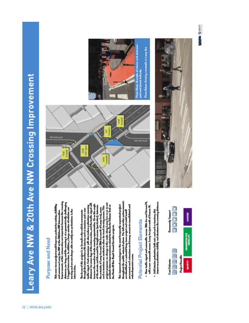
Leary Ave & 20th Ave Crossing Improvement
Intersection of Leary Ave, 20th Ave and Vernon Pl
Improve pedestrian safety and crossings by installing a full traffic signal and curb extensions across 20th Ave and crosswalks across all intersection legs.
Ballard Five Points Crossing Improvement
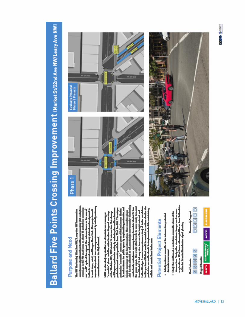
Intersection of Leary Ave, 22nd Ave and Market St
Improve pedestrian crossing by widening crosswalks. Explore the feasibility of a pedestrian scramble phase to further enhance pedestrian crossings and reduce pedestrian/vehicle conflicts.
(crosswalk
widening only)
20th Ave NW & NW 57th St Pedestrian Crossing
Intersection of 20th Ave and 57th St
Improve pedestrian safety and crossings by installing crosswalks, ADA ramps, and potential curb extensions.
Shilshole Ave NW & 17th Ave NW Truck Access Improvements
Intersection of 17th Ave & Shilshole
Improve freight access to the Ballard Bridge by adding an eastbound left turn lane.
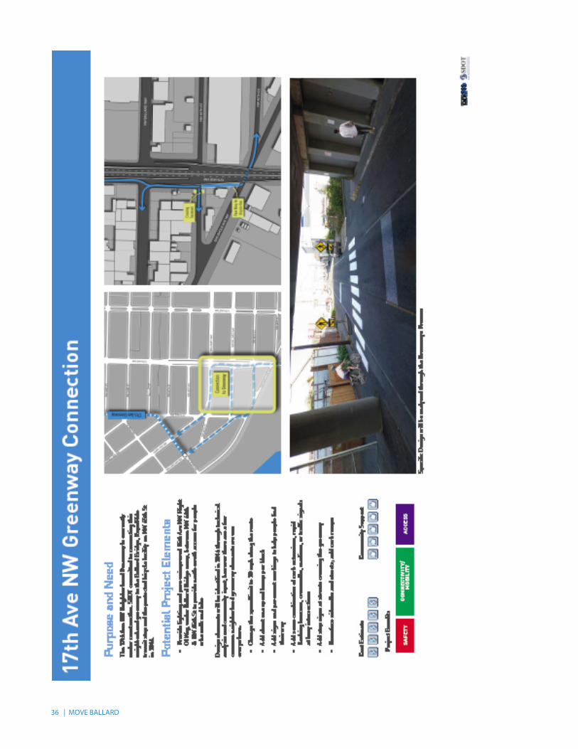
17th Ave NW Greenway Connection
Intersection of 17th Ave & Ballard Ave to intersection of 45th St & 11th Ave
Connect 17th Ave Greenway to Ballard Bridge and existing BGT. Pending results of the BGT EIS to determine final alignment.
MOVE BALLARD | 31
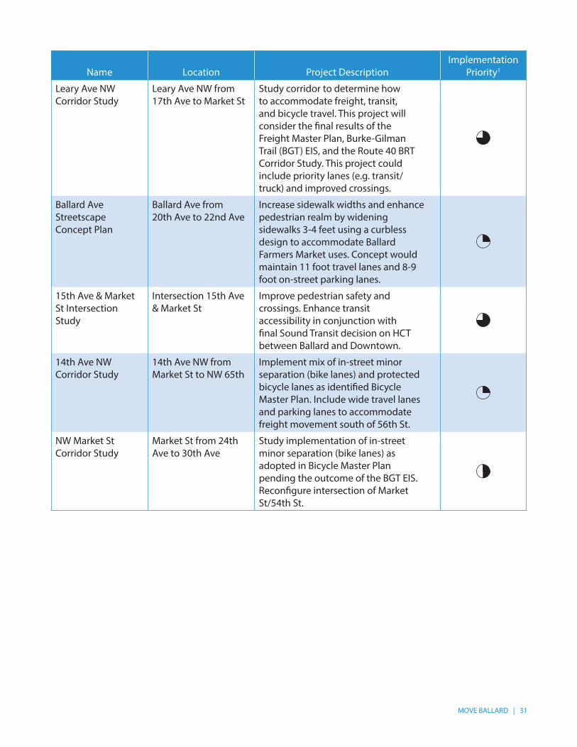
Name Location Project DescriptionImplementation
Priority1
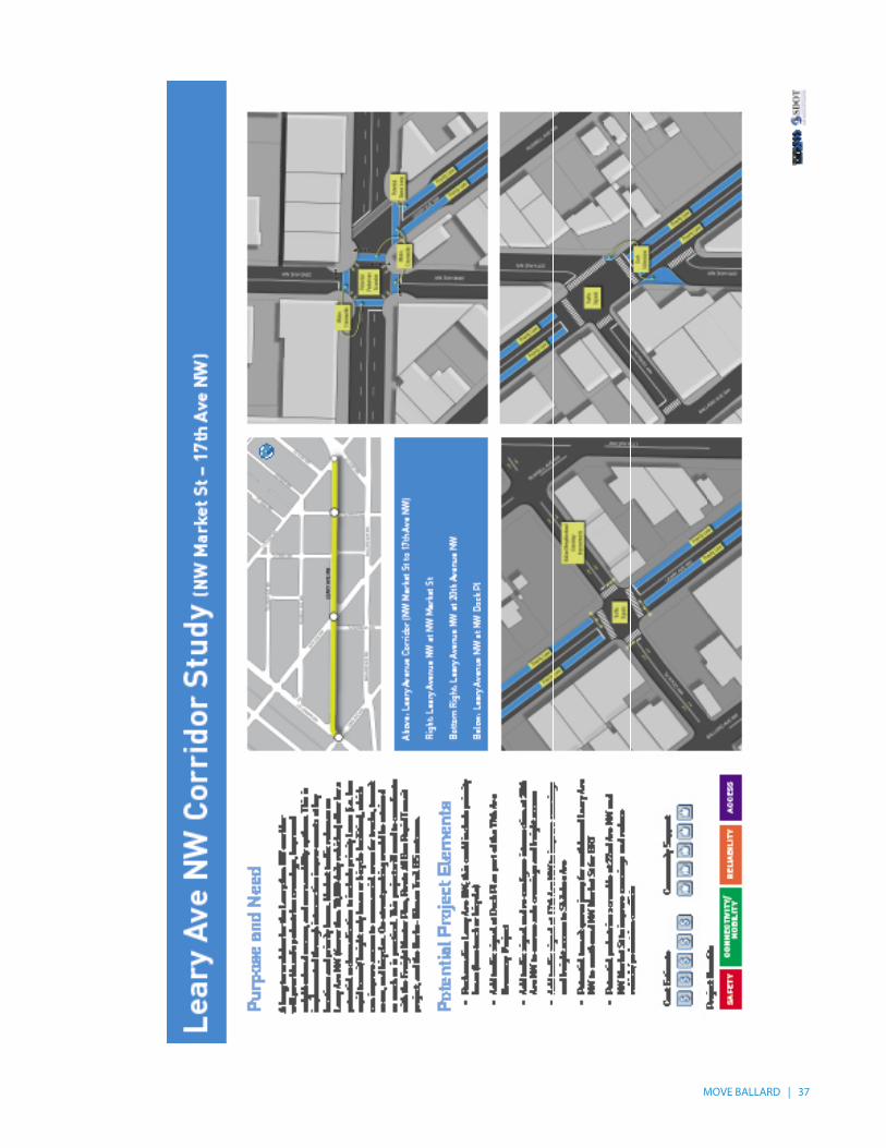
Leary Ave NW Corridor Study
Leary Ave NW from 17th Ave to Market St
Study corridor to determine how to accommodate freight, transit, and bicycle travel. This project will consider the final results of the Freight Master Plan, Burke-Gilman Trail (BGT) EIS, and the Route 40 BRT Corridor Study. This project could include priority lanes (e.g. transit/truck) and improved crossings.
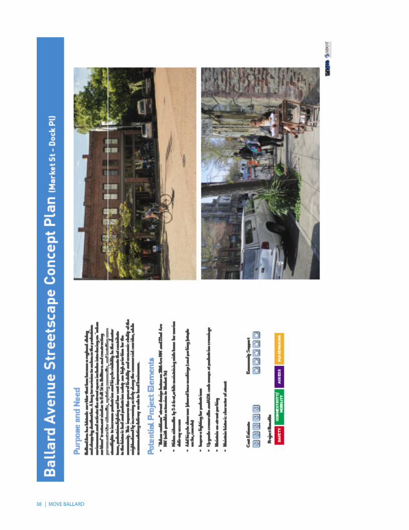
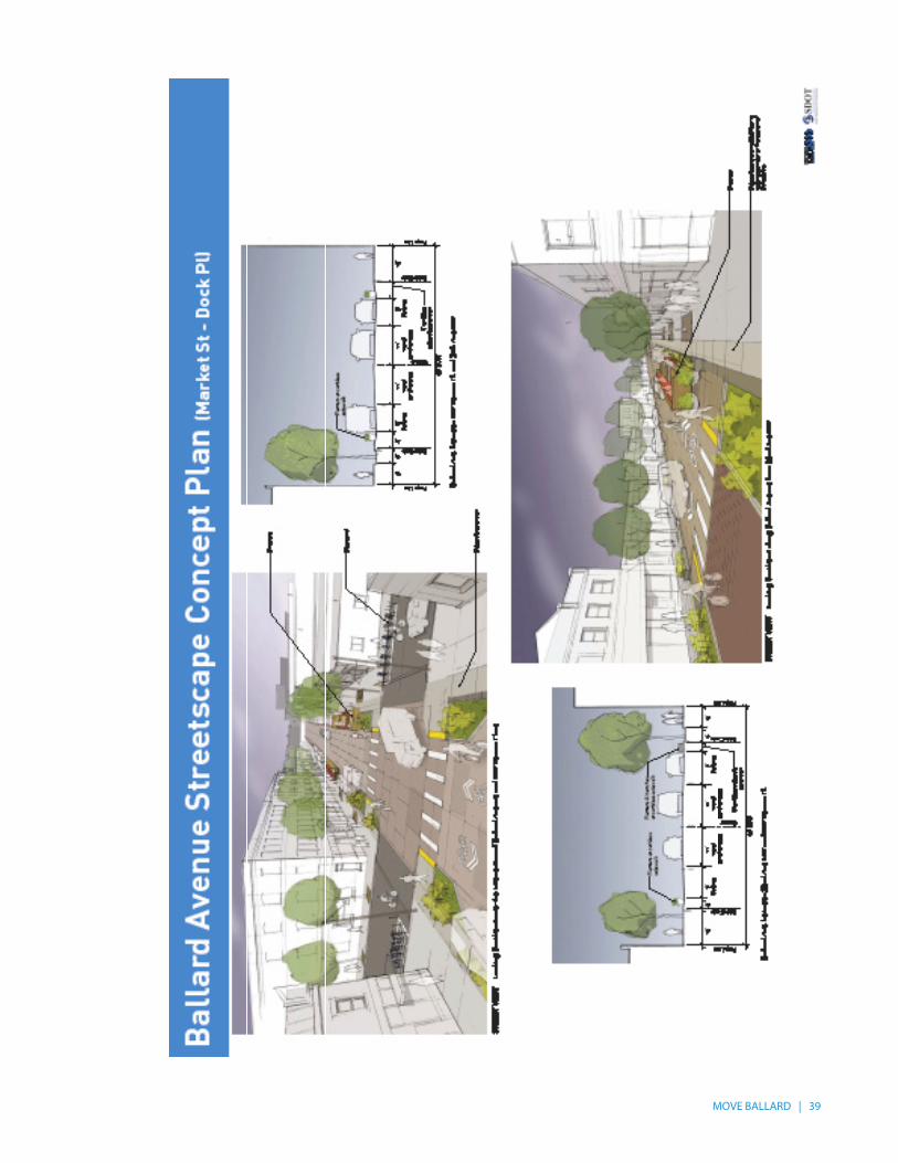
Ballard Ave Streetscape Concept Plan
Ballard Ave from 20th Ave to 22nd Ave
Increase sidewalk widths and enhance pedestrian realm by widening sidewalks 3-4 feet using a curbless design to accommodate Ballard Farmers Market uses. Concept would maintain 11 foot travel lanes and 8-9 foot on-street parking lanes.
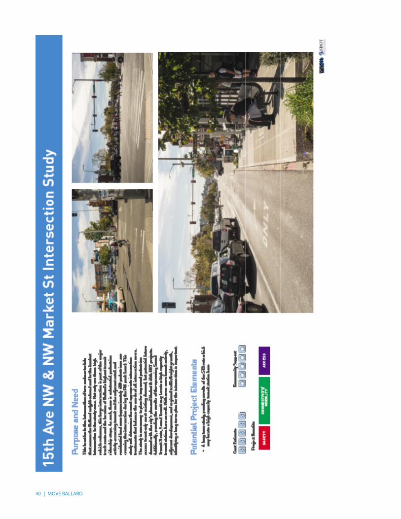
15th Ave & Market St Intersection Study
Intersection 15th Ave & Market St
Improve pedestrian safety and crossings. Enhance transit accessibility in conjunction with final Sound Transit decision on HCT between Ballard and Downtown.
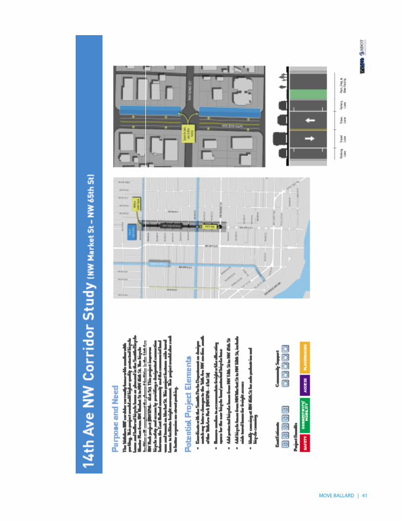
14th Ave NW Corridor Study
14th Ave NW from Market St to NW 65th
Implement mix of in-street minor separation (bike lanes) and protected bicycle lanes as identified Bicycle Master Plan. Include wide travel lanes and parking lanes to accommodate freight movement south of 56th St.
NW Market St Corridor Study
Market St from 24th Ave to 30th Ave
Study implementation of in-street minor separation (bike lanes) as adopted in Bicycle Master Plan pending the outcome of the BGT EIS. Reconfigure intersection of Market St/54th St.
32 | MOVE BALLARD
MOVE BALLARD | 33

34 | MOVE BALLARD

MOVE BALLARD | 35
36 | MOVE BALLARD
MOVE BALLARD | 37
38 | MOVE BALLARD
MOVE BALLARD | 39
40 | MOVE BALLARD
MOVE BALLARD | 41

42 | MOVE BALLARD
MOVE BALLARD | 43
7 STATION AREA ASSESSMENT
7.1 PURPOSE OF THE STATION AREA ASSESSMENTThe Ballard to Downtown Seattle Transit Expansion Study (2014), jointly led by SDOT and Sound Transit, identified five conceptual alignments for HCT connecting Ballard to Downtown Seattle. Along those alignments were four discrete potential station locations within the Ballard Hub Urban Village:
• 15th Ave & Market St• 17th Ave & Market St• 24th Ave & Market St• 14th Ave & Leary Way
The purpose of this assessment is to evaluate and compare the transit orientation of the areas surrounding these potential stations. Transit orientation is the degree to which an area supports rail and bus ridership while reducing overall reliance on personal automobiles. For the purposes of this study, we defined station areas as the primary market area for transit patronage: ½-mile buffers or the approximate equivalent of a 10-minute walk for the average person. Evaluation criteria include factors related to high transit ridership, increased walking and biking, redevelopment opportunities, and community input. The results of this assessment will be used to inform discussions with Sound Transit as it further develops its ST3 package of transit projects.
7.2 EVALUATING TRANSIT ORIENTATIONWhen evaluating the transit orientation of a potential station area (most commonly defined as the ½-mile buffer surrounding the station), it is customary to assess the “3 D’s of Transit Oriented Development (TOD)” – density, diversity and design.
Density is the number of residents, households, employees, businesses, or a combination thereof, usually averaged by acre. Diversity reflects the mix of transit supportive land uses such as retail, services and community facilities. Design is some measure of the general walkability, accessibility and connectivity of the area. Although the 3 D’s of TOD provide the basis for this assessment of transit orientation, the measures have been further refined and expanded. The “6 P’s of TOD” listed below capture a more holistic view of future station potential by incorporating existing transit performance, development opportunities, and community preferences.
• People (Density) – Combined number of residents and employees. Whereas the former generate transit trip that originate in Ballard, the latter help optimize the transit investment by attracting trips to Ballard.
• Places (Diversity) – Number of retail and service establishments that allow residents and employees to meet their needs without the daily use of a car.
• Pedestrian/Bicycle (Design) – Composite measure of the accessibility of the area for pedestrians and cyclists. Average block size is used as a proxy for connectivity given that a finer grain grid affords pedestrians more direct options for reaching their destinations. Smaller blocks also support more compact and space efficient urban development. Miles of biking facilities include neighborhood greenways, trails, and protected and traditional bicycle lanes.
• Performance – Existing transit ridership within the study area. This serves as a gauge for the intermodal connectivity of the area with local and regional bus routes.
44 | MOVE BALLARD
• Potential – Acres of underutilized land (excluding single family, BINMIC, and civic uses) that could be redeveloped in the future under existing zoning.
• Preferences – Results from the online survey asking the relative favorability of each potential station location.
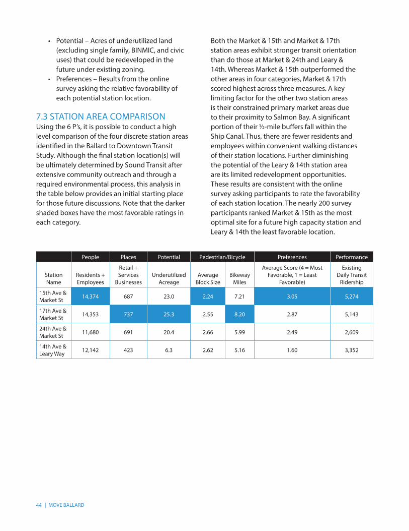
7.3 STATION AREA COMPARISONUsing the 6 P’s, it is possible to conduct a high level comparison of the four discrete station areas identified in the Ballard to Downtown Transit Study. Although the final station location(s) will be ultimately determined by Sound Transit after extensive community outreach and through a required environmental process, this analysis in the table below provides an initial starting place for those future discussions. Note that the darker shaded boxes have the most favorable ratings in each category.
Both the Market & 15th and Market & 17th station areas exhibit stronger transit orientation than do those at Market & 24th and Leary & 14th. Whereas Market & 15th outperformed the other areas in four categories, Market & 17th scored highest across three measures. A key limiting factor for the other two station areas is their constrained primary market areas due to their proximity to Salmon Bay. A significant portion of their ½-mile buffers fall within the Ship Canal. Thus, there are fewer residents and employees within convenient walking distances of their station locations. Further diminishing the potential of the Leary & 14th station area are its limited redevelopment opportunities. These results are consistent with the online survey asking participants to rate the favorability of each station location. The nearly 200 survey participants ranked Market & 15th as the most optimal site for a future high capacity station and Leary & 14th the least favorable location.
People Places Potential Pedestrian/Bicycle Preferences Performance
Station Name
Residents + Employees
Retail + Services
BusinessesUnderutilized
AcreageAverage
Block SizeBikeway
Miles
Average Score (4 = Most Favorable, 1 = Least
Favorable)
Existing Daily Transit
Ridership
15th Ave & Market St 14,374 687 23.0 2.24 7.21 3.05 5,274
17th Ave & Market St 14,353 737 25.3 2.55 8.20 2.87 5,143
24th Ave & Market St 11,680 691 20.4 2.66 5.99 2.49 2,609
14th Ave & Leary Way 12,142 423 6.3 2.62 5.16 1.60 3,352

MOVE BALLARD | 45
To give a sense of the order of magnitude differences between the station areas, the station scored for the 6 P’s were indexed on a scale of 1-100. The radar graphs below illustrate the relative balance across the evaluation criteria for each of the station areas.
People
Places
Potential
Ped/Bike
Preferences
Performance
15th + MarketPeople
Places
Potential
Ped/Bike
Preferences
Performance
17th + Market
People
Places
Potential
Ped/Bike
Preferences
Performance
24th + MarketPeople
Places
Potential
Ped/Bike
Preferences
Performance
14th + Leary
7.4 RESULTSBased on the station area assessment, stations in the vicinity of Market St and 15th Ave or 17th Ave are the preferred locations for future high capacity transit.

46 | MOVE BALLARD
The Seattle Department of Transportation700 5th Avenue, Suite 3800PO Box 34996Seattle, WA 98124-4996(206) 684-ROAD (7623)www.seattle.gov/transportation 5.2016


![The Seattle Star (Seattle, Wash.) (Seattle, Wash.) 1913-05-16 [p 10] · 2017. 12. 22. · TO SHERIFF EXPLAINS HIS INTERFERENCE WITH THE CITY POLICE AT BALLARD Nine deputy nhertfN](https://img.pdfslide.us/doc/110x75/600a18dccf52fb373d088bd6/the-seattle-star-seattle-wash-seattle-wash-1913-05-16-p-10-2017-12-22.jpg)