Embed Size (px)
Citation preview

Searching for salient locations in topographicmaps
Vassilios Krassanakis, Alexandra Lelli, Ismini-Eleni Lokka, Vassiliki Filippakopoulou and Byron Nakos
1 Introduction
Maps have proven to be of importance in everyday life tasks as well as in scien-tific studies in different research fields. A basic classification of maps includes two categories, static and animated maps. In animated maps the element of motion is dominant. Psychological literature suggests that motion is detected in a primary stage of vision during a visual scene perception (e.g. Wolfe and Horowitz 2004). The attributes that are processed pre-attentively (or in a bottom-up process) can be used to control the selective attention (Wolfe 2005). Bottom-up processes are oc-curred in any map reading task (Lloyd 2005). Hence, pre-attentive features have to be considered in map design (Sluter 2001). Example that indicates the importance of an immediate response from map users can be an animated map for navigation. In this case the symbols that are used must be processed rapidly for decision mak-ing. The evaluation of the effectiveness of graphic elements that are used to rep-resent geographic phenomena might lead to crucial suggestions for map design. Map readers’ reaction is crucial for such evaluation.
In a previous study, an eye tracking experiment was conducted in order to in-vestigate the reaction of map users in two different variables of map design; dura-tion and rate of change (Krassanakis et al. 2013). The experiment was based on a bottom-up process (free viewing conditions). In this study the duration of changes during the observation of a moving point symbol on two different backgrounds was tested, while the magnitude of change was held constant. Both a blank back-ground and a topographic map were used in order to examine how the detection of the moving symbol is affected due to the variety of spatial information. Despite the fact that moving targets pop out among stationary distractors (Wolfe 2000), the results indicated that the detection of the moving symbol is affected from the huge variety of graphic elements.
Extending the results of the experiment cited above, the principal aim of thepresent study is to investigate the subjects' post-reaction after the detection of the moving point symbol. The subjects’ post-reaction is meaningful in the case of the topographic map. The results of eye movement analysis are compared with the outcomes of the application of three saliency models (Itti et al. 1998, Harel et al. 2006, Hou et al. 2012). The comparison is essential in order to examine the possi-bility of applying saliency models, which have been developed in order to predict fixations in complex physical images, on topographic maps.
ll-
41

Searching for salient locations in topographic maps
2 Experimental design
Subjects are asked to observe a computer monitor during some stimuli projection without requiring the completion of any task. That means that the experiment is performed under free viewing condition (bottom-up process). The stimuli consist of a moving point symbol !n two different backgrounds; a blank background and a topographic map. Different durations of the moving symbols are examined. To-tally 32 subjects participated in the experiment for the observation of 98 different stimuli. A full description about the design of the stimuli can be found in the study described above (Krassanakis et al. 2013). Additionally, more information about the eye tracker equipment and the laboratory setup is presented by Krassanakis et al. (2011) and Krassanakis (2013).
The performance analysis includes fixations' computation for each visual scene. In order to examine fixations that correspond to locations in the backgrounds, which are not linked to the moving point symbol, a spatial buffer is applied to sep-arate fixations referring to these locations from fixations dedicated to the moving point symbol. Heatmaps based on fixations’ durations and not on fixations’ distri-bution are used to indicate a qualitative comparison of the relative dwell times on observed locations for both backgrounds. Heatmaps can be considered more ap-propriate than an approach that examines different regions (ROIs analysis) as the study aims to test the fixations in overall rather than in particular areas. Heatmaps have already used in the analysis of eye tracking experiments performed in carto-graphic research (e.g. Coltiken et al. 2009). Moreover it is difficult to define a way to relate the density of different information with the definition of discriminant re-gions on the topographic map.
3 Results
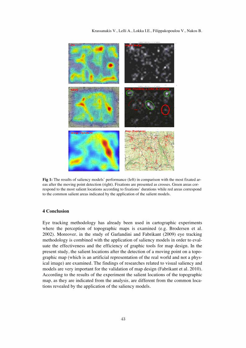
The qualitative results of the analysis are presented in Figure 1. Specifically, on the blank background the heat-map reveals a homogeneous distribution of fixa-tions, as it was expected. On the contrary, fixations are clustered at specific loca-tions in the case of topographic map. Additionally, the total number of fixations on the topographic map is significantly larger than the number on blank back-ground. This phenomenon indicates that there is a great influence on the percep-tion of the topographic map' s graphic elements. Moreover, the application of sali-ency models demonstrates a sole common salient area of the topographic map. This area differs from the salient locations suggested by the heatmaps. Especially, the red regions correspond to the common areas that are indicated by the applica-tion of the saliency models, while the green regions reveal the most salient loca-tions as they are indicated by the heatmap visualization. This means that the tested salient models cannot be applied directly in order to indicate salient locations.
42
Krassanakis V., Lelli A., Lokka I.E., Filippakopoulou V., Nakos B.
Fig 1: The results of saliency models’ performance (left) in comparison with the most fixated ar-eas after the moving point detection (right). Fixations are presented as crosses. Green areas cor-respond to the most salient locations according to fixations’ durations while red areas correspondto the common salient areas indicated by the application of the salient models.
4 Conclusion
Eye tracking methodology has already been used in cartographic experiments where the perception of topographic maps is examined (e.g. Brodersen et al. 2002). Moreover, in the study of Garlandini and Fabrikant (2009) eye tracking methodology is combined with the application of saliency models in order to eval-uate the effectiveness and the efficiency of graphic tools for map design. In the present study, the salient locations after the detection of a moving point on a topo-graphic map (which is an artificial representation of the real world and not a phys-ical image) are examined. The findings of researches related to visual saliency and models are very important for the validation of map design (Fabrikant et al. 2010). According to the results of the experiment the salient locations of the topographic map, as they are indicated from the analysis, are different from the common loca-tions revealed by the application of the saliency models.
43
Searching for salient locations in topographic maps
5 Future work
The present study is a first attempt to examine the post-reaction of map readers af-ter the detection of a moving point symbol. Additionally, the possibility of apply-ing three saliency models in topographic maps is examined. The analysis is mainly based on a qualitative approach. The performance of a quantitative analysis using specific metrics (e.g. number of fixations, mean fixations, number of saccadesetc.) would be much more promising in order to evaluate the influence in map reading process. Additionally the same methodology can be used in order to ex-amine corresponding reactions of different user groups on different types of carto-graphic backgrounds (e.g. maps for navigation, weather maps etc.).
References
1. Brodersen L., Andersen H.H.K., Weber S. (2002). Applying Eye-Movement Tracking fo thestudy of Map Perception and Map Design. Natinal Survey and Cadastre, Denmark 9(2).
2. Coltiken A., Heil B., Garlandini S., Fabrikant S.I. (2009). Evaluating the Effectiveness of In-teractive Map Interface Designs: A Case Study Integrating Usability Metrics with Eye-Movement Analysis. In: Cartography and Geographic Information Science, 36(1): 5-17.
3. Fabrikant S.I., Hespanha S.R., Hegarty M. (2010). Cognitively Inspired and Perceptually Sali-ent Graphic Displays for Efficient Spatial Inference Making. In: Annals of the Association ofAmerican Geographers, 100(1): 13-29.
4. Garlandini S., Fabrikant S. (2009). Evaluating the Effectiveness and Efficiency of Visual Var-iables for Geographic Information Visualization. In: Hornsby K.S. et al. (eds). 9th Internation-al Conference COSIT 2009 (pp. 195-211), Springer-Verlag Berlin.
5. Harel J., Koch C., Perona P. (2006). Graph-Based Visual Saliency. In: Advances in neural in-formation processing systems, 545-552.
6. Hou X., Harel J., Koch C. (2012), Image Signature: Highlighting Sparse Salient Regions,IEEE Transactions on Pattern Analysis and Machine Intelligence, 34(1): 194-201.
7. Itti L. Koch C., Niebur E. (1998). A model of saliency-based visual attention for rapid sceneanalysis, IEEE Transactions on Pattern Analysis and Machine Intelligence, 20(11): 1254-1259.
8. Krassanakis V., Filippakopoulou V., Nakos B. (2011). An Application of Eye Tracking Methodology in Cartographic Research, Proc. of the EyeTrackBehavior 2011(Tobii), Frankfurt. 9. Krassanakis V., Lelli A., Lokka I.E., Filippakopoulou V., Nakos B. (2013). Investigating dynamic variables with eye movement analysis. Proc. of the 26th International Cartographic Conference, Dresden. 10. Krassanakis V. (2013) Exploring the map reading process with eye movement analysis. Proc. of the 1st International Workshop on Eye Tracking for Spatial Research (In conjunction with COSIT 2013), Scarborough. 11. Lloyd R. (2005). Attention on Maps. In: cartographic perspectives, 52: 28-57.12. Sluter R.S. (2001). New theoretical research trends in cartography. Revista Brasileira de Cartografia, 53: 29-37. 13. Wolfe J.M. (2000). Visual Attention. In: De Valois K.K. (ed.). Seeing (pp. 335-386) Academic Press, San Diego. 14. Wolfe J.M. (2005). Guidance of visual search by preattentive information, Neurobiology of attention, 101-104. 15. Wolfe J.M., Horowitz T.S. (2004). What attributes guide the deployment of visual attention and how do they do it?. Nature Reviews Neuroscience, 5(6): 495-501.
44