Embed Size (px)
Citation preview

1 | P a g e
Seal Bay Nature Park Parking Improvements:
Environmental Management Plan
July 21, 2021
Brian Allaert
Comox Valley Regional District
770 Harmston Ave.
Courtenay, BC
V9N 0G8
PREPARED
FOR

Seal Bay: EMP July 21, 2021
2 | P a g e
TABLE OF CONTENTS
1. INTRODUCTION ..................................................................................................................................... 1
2. PROJECT DESCRIPTION .......................................................................................................................... 1
3. REGULATORY SETTING .......................................................................................................................... 1
4. BIOPHYSICAL OVERVIEW ...................................................................................................................... 2
4.1. Methods ................................................................................................................................................ 2
4.1.1. Desktop Review ................................................................................................................................. 2
4.1.2. Field Assessment ............................................................................................................................... 3
4.2. Results ................................................................................................................................................... 4
4.2.1. Environmental Setting ...................................................................................................................... 4
4.2.2. Species at Risk ................................................................................................................................... 5
4.2.3. Fish and Aquatic Habitat ................................................................................................................... 7
5. HIGH RISK ACTIVITIES ............................................................................................................................ 7
6. ENVIRONMENTAL PROTECTION PLAN .................................................................................................. 8
7. RESPONSIBILITIES ................................................................................................................................ 14
7.1. Comox Valley Regional District (CVRD) ............................................................................................... 14
7.2. Prime Contractor ................................................................................................................................ 14
7.3. Independent Environmental Monitor (EM) ........................................................................................ 14
8. COMMUNICATION PLAN..................................................................................................................... 15
9. ENVIRONMENTAL INCIDENT REPORTING ........................................................................................... 15
10. STATEMENT OF LIMITATIONS ............................................................................................................. 15
11. CLOSURE ............................................................................................................................................. 16
12. REFERENCES ........................................................................................................................................ 18

Seal Bay: EMP July 21, 2021
3 | P a g e
LIST OF TABLES
Table 1. Exotic species records from the IAPP (2021) within the area of Seal Bay Park. ............................. 4
Table 2. Wildlife Species at Risk likely of occurring within the Project Area. ............................................... 5
Table 3. Reportable Spill Criteria. ............................................................................................................... 15
LIST OF FIGURES
Figure 1: Site Overview ............................................................................................................................... 17
LIST OF APPENDICES
APPENDIX A: BC CDC Ecosystems Explorer Area Search Results APPENDIX B: Arborist’s Report APPENDIX C: Arborist’s Revisions APPENDIX D: Spill Response Plan APPENDIX E: Project Contact List APPENDIX F: Invasive Species Identification Tool APPENDIX G: Species at Risk Identification Tool

Seal Bay: EMP July 21, 2021
1 | P a g e
1. INTRODUCTION
The Comox Valley Regional District (CVRD) is proposing to expand the Bates Road parking area of Seal Bay
Nature Park (the Project). The expansion proposes to increase the parking capacity from approximately
30 stalls to 71 stalls as well as improve safety for traffic and pedestrians along Bates Road. Note that a
revised drawing was provided in June of 2021, this Environmental Management Plan (EMP) has been
updated to reflect these recent design changes. Note that EMPs should be treated as “living documents”
and may be updated as the project progresses to incorporate new information or design changes.
This Environmental Management Plan (EMP) describes the environmental performance standards and
responsibilities of all contractors in executing this Project.
2. PROJECT DESCRIPTION
The existing gravel parking lot on the east side of Bates Road will be expanded eastwards and designed
for improved safety (Figure 1). The expansion will be a one-way drive-through loop that has been routed
to retain the large veteran Douglas-fir (Pseudotsuga menziesii) trees along the edge of the existing parking
area and minimize clearing of other mature trees to the extent possible. A vegetation island in the center
of the loop will be retained and includes some large trees.
The Project will require approximately 17,000 m2 of clearing and grubbing to accommodate the new
parking area and drive-through access and will require some clearing of mature mixed forest. The new
parking area will be topped with gravel. At least two culverts will be installed under the east side of the
loop to maintain natural hydrology and ensure water does not impound in the vegetated center area. The
area is relatively level and drains eastwards. The project has been designed to utilize the existing parking
area as well as natural gaps in the mature forest.
Over the course of discussions on site, it has been advised that one or more footpaths be placed through
the vegetated island and that large woody debris from the site be positioned to deter pedestrian traffic
through the remainder of the vegetated area.
There are no watercourses or wetlands within the Project; however, there are areas where surface pooling
is relatively common.
3. REGULATORY SETTING
Seal Bay Nature Park is a regional park administered by the CVRD. The BC Ministry of Transportation must
approve the parking area design for safety considerations and compliance with provincial and federal
regulation. Other environmental acts and regulations potentially relevant to the project include:
BC Wildlife Act (Ministry of Forests, Lands and Natural Resource Operations);
BC Park (Regional) Act (Ministry of Forests, Lands and Natural Resource Operations);
BC Environmental Management Act (Ministry of Environment);
BC Heritage Conservation Act (Ministry of Forests, Lands and Natural Resource Operations);
BC Wildfire Act (Ministry of Forests, Lands and Natural Resource Operations);
Canada Migratory Bird Convention Act (Environment and Climate Change Canada);
Canada Species at Risk Act (Environment and Climate Change Canada); and,
Local Government Act and applicable bylaws.

Seal Bay: EMP July 21, 2021
2 | P a g e
4. BIOPHYSICAL OVERVIEW
A biophysical overview assessment was conducted in order to inform this EMP. Note that First Nation
engagement and assessment for archaeological or cultural resources were not included in the scope of
this report. It is understood that an archaeological assessment in support of this project was completed
by Jesse Morin at the direction of the CVRD. No cultural materials were identified on site during the course
of that assessment (Pers. Comm. B. Allaert 2020). The Environmental Protection Plan (EPP) provided in
Section 6.0 includes general standards and procedures related to protecting archaeological resources.
4.1. Methods
4.1.1. Desktop Review
For the purposes of focusing this assessment, the Project Area was defined as the boundaries of the
proposed development with an approximately 30 m buffer applied.
An initial list of species of conservation concern and legally-designated species that potentially occur in
the Project Area were gathered from BC Conservation Data Center (CDC) Species and Ecosystems Explorer
online application (2021) based on the following search criteria:
Animals OR Plants OR Ecosystem Realm-Groups: Mixed Forest; AND Regional Districts: Comox
Valley; AND occurring within the CWH Biogeoclimatic Zone
Once this initial list was compiled, the following information sources were reviewed for occurrence
records and habitat information:
iMapBC (DataBC, 2020);
Comox Valley Regional District iMap (CVRD 2020);
Invasive Alien Plant Program (IAPP 2020);
E-Fauna (Klinkenberg, 2019);
BC Species Summaries (BC CDC 2020); and
Committee on the Status of Endangered Wildlife in Canada (COSEWIC) reports.
The probability of wildlife species of management concern occurring within the Project Area was assessed
using the area-specific species lists compiled from the BC CDC, species information, available federal
recovery strategies, Species at Risk Act (SARA) Schedule 1 range maps, Committee on the Status of
Endangered Wildlife in Canada (COSEWIC) Status Reports, and previous professional experience in the
region. The known distribution and habitat requisites of each species was reviewed and the probability of
the species occurrence within the Project Area was assessed based on the mobility of the species, the
proximity of known occurrences, and by comparing habitat requisites of individual species with the habitat
suitability of the Project Area. Each listed species was then assigned a low, moderate, or high probability
of occurrence, based on the following definitions:
Low probability: those species whose known range does not correspond to the Project Area and/or
those species whose habitat requisites are absent from the Project Area (e.g., grassland, estuary,
tundra);

Seal Bay: EMP July 21, 2021
3 | P a g e
Moderate probability: those species whose range and habitat requisites are present in the Project
Area but are not known within 5 km of the Project Area (based on the BC CDC [2016b] and
professional knowledge of the Project Area); and
High probability: those species whose range and habitat requisites are present in the Project Area
and are known to the general area surrounding the Project Area.
Invertebrates in the query results were not assessed. Assessment of vegetation was limited to a desktop
search of known occurrence records and an assessment of the Project Area’s likelihood to support rare
plants. Due to the season of the field assessment, species-specific surveys were not appropriate and
incidental observations of rare species were unlikely.
Ecosystems at risk were assessed in the field based on the species assemblages and biophysical
descriptions provided.
The BC Invasive Alien Plan Program (IAPP, 2020) was queried for known records of invasive species that
may occur in or around the Project Area. The complete query results are provided in Appendix A.
4.1.2. Field Assessment
A site reconnaissance was conducted by Kim Poupard, R.P.Bio. (Calidris Ecological Services Ltd.) on
December 31, 2021. This included a site walk and discussion with Brian Allaert of the CVRD and Ryan
Murphy, consulting arborist, to review the project design and provide input into the plan.
A second site visit occurred on January 21, 2021 with Mr. Poupard, Mr. Allaert and Mike Hanson, P.Eng of
Onsite Engineering Ltd. to review recommendations made during the previous assessment and provide
input into the final design.
During the field reconnaissance, specific attention was paid to potential occurrences of the following:
Habitats likely to support species at risk (e.g., wetlands, riparian, old growth forest);
Ecosystems at risk;
Species at risk;
Invasive plants;
Wildlife habitat features (e.g., wildlife trees, stick nests, dens and burrows);
Important wildlife habitat (.g., wetlands, riparian, old growth forest);
Watercourses; and,
Potential adverse environmental interactions from the proposed Project.
A general description of the vegetation communities within the Project Area was compiled. Note that the
field reconnaissance was limited to visual observations of land cover types and chance encounters; no
species-specific inventories were conducted. Note that the timing of the assessment was outside of the
appropriate season for compiling comprehensive vegetation lists.
A geo-referenced PDF on a handheld GPS enabled device was used to navigate the site and georeference
important features. Observations were recorded with photographs and field notes.
A professional arborist (Mr. Murphy) was retained to conduct a detailed assessment of the trees
implicated in the project and inform this EMP. The arborist report is provided in Appendix B.

Seal Bay: EMP July 21, 2021
4 | P a g e
4.2. Results
4.2.1. Environmental Setting
The project is located within the Coastal Western Hemlock Very Dry Maritime (CWHxm1) biogeoclimatic
zone (iMapBC 2021). The area is dominated by mature mixed forest dominated by coastal Douglas-fir
(Pseudotsuga menziesii) with a lesser component of grand fir (Abies grandis), western redcedar (Thuja
plicata) and bigleaf maple (Acer macrophyllum) in the canopy. The understory is dominated by sword fern
(Polystichum munitum), regenerating western redcedar, western hemlock (Tsuga heterophylla) and grand
fir in the shrub layer. Scattered red alder (Alnus rubra) and black cottonwood (Populus trichocarpa) are
also present. Other common understory species include Salal (Gaultheria shallon), dull Oregon grape
(Berberis nervosa), red huckleberry (Vaccinium parvifolium), salmonberry (Rubus spectabilis), trailing
blackberry (Rubus ursinus) and bracken fern (Pteridium aquilinum).
The site is slightly wetter than zonal within the CWHxm1, with rich soil (site series 04 Fd – Swordfern). The
site has been modified by historical forest harvesting.
A review of the Invasive Alien Plant Program (IAPP) online map for known occurrences of invasive species
resulted in the identification of eight species in the vicinity of the project including four that are listed as
‘noxious’ under Schedule A of the Weed Control Act Regulation. These are mostly located along the park
boundaries with the exception of Himalayan blackberry (Rubus armeniacus) which has been recorded
within the park. A list of these occurrences is provided in Table 1. Note that none of these were noted on
the project site during the field visits. Yellow archangel (Lamium galeobdolon), a nuisance weedy species
was detected on the site, however. Mitigation to avoid further encroachment of this species has been
provided.
Table 1. Exotic species records from the IAPP (2021) within the area of Seal Bay Park.
Common Name Scientific Name Noxious1
Himalayan blackberry Rubus armeniacus No
Bull thistle Cirsium vulgare No
Japanese knotweed Reynoutria japonica Yes
Giant hogweed Heracleum mantegazzianum Yes
Scotch broom Cytisus scoparius No
Canada thistle Cirsium arvense Yes
Common tansy Tanacetum vulgare No
Purple loosestrife Lythrum salicaria Yes
1. As defined by the Weed Control Act. The act puts a duty on the ‘land occupier’ to control species
designated as ‘noxious’ on Schedule A of the Regulation.
Seal Bay: EMP July 21, 2021
5 | P a g e
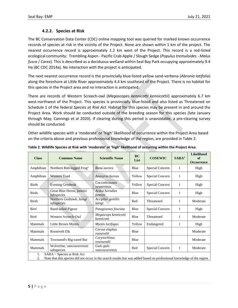
4.2.2. Species at Risk
The BC Conservation Data Center (CDC) online mapping tool was queried for marked known occurrence
records of species at risk in the vicinity of the Project. None are shown within 1 km of the project. The
nearest occurrence record is approximately 1.2 km west of the Project. This record is a red-listed
ecological community: Trembling Aspen - Pacific Crab Apple / Slough Sedge (Populus tremuloides - Malus
fusca / Carex). This is described as a deciduous wetland within Seal Bay Park occupying approximately 9.4
Ha (BC CDC 2014a). No interaction with the project is anticipated.
The next nearest occurrence record is the provincially blue-listed yellow sand-verbena (Abronia latifolia)
along the foreshore at Little River approximately 4.4 km southeast of the Project. There is no habitat for
this species in the Project area and no interaction is anticipated.
There are records of Western Screech-owl (Megascopes kennicotti kennicottii) approximately 6.7 km
west-northwest of the Project. This species is provincially blue-listed and also listed as Threatened on
Schedule 1 of the federal Species at Risk Act. Habitat for this species may be present in and around the
Project Area. Work should be conducted outside of the breeding season for this species (late January
through May; Cannings et al 2020). If clearing during this period is unavoidable, a pre-clearing survey
should be conducted.
Other wildlife species with a ‘moderate’ or ‘high’ likelihood of occurrence within the Project Area based
on the criteria above and previous professional knowledge of the region, are provided in Table 2.
Table 2. Wildlife Species at Risk with ‘moderate’ or ‘high’ likelihood of occurring within the Project Area.
Class Common Name Scientific Name BC
List COSEWIC SARA1
Likelihood
of
Occurrence
Amphibian Northern Red-legged Frog2 Rana aurora Blue Special Concern 1 High
Amphibian Western Toad Anaxyrus boreas Yellow Special Concern 1 High
Birds Evening Grosbeak Coccothraustes
vespertinus
Yellow Special Concern 1 High
Birds Great Blue Heron, fannini
subspecies
Ardea herodias
fannini
Blue Special Concern 1 High
Birds Northern Goshawk, laingi
subspecies
Accipiter gentilis
laingi
Red Threatened 1 Moderate
Bird Band-tailed Pigeon Patagioenas fasciata Blue Special Concern 1 High
Bird Western Screech-Owl Megascops kennicotti
kennicotti Blue Threatened 1 Moderate
Mammals Little Brown Myotis Myotis lucifugus Yellow Endangered 1 High
Mammals Roosevelt Elk Cervus elaphus
roosevelti
Blue Moderate
Mammals Townsend's Big-eared Bat Corynorhinus
townsendii
Blue Moderate
Mammals Wolverine, vancouverensis
subspecies
Gulo gulo
vancouverensis
Red Special Concern 1 Moderate
1. SARA = Species at Risk Act
2. Note that this species did not occur in the search results but was added based on professional knowledge of the region

Seal Bay: EMP July 21, 2021
6 | P a g e
There is no suitable breeding habitat for northern red-legged frog (Rana aurora) or western toad
(Anaxyrus boreas) in the Project Area. However, these species may also inhabit upland forest areas
outside of the breeding season and may be present in the Project Area.
Evening Grosbeak (Coccothraustes vespertinus) use a range of habitat types including coniferous and
mixed forest as well as riparian areas (BC CDC 1995). They are year-round residents in the region and may
occur in the project area.
Great Blue Heron (Ardea herodias fannini) may use large trees for nesting though none were noted during
the field assessment. Nests are usually conspicuous and relatively easy to detect, particularly if active.
There is no forage habitat for this species within the project area.
The Laingi subspecies of Northern Goshawk (Accipiter gentilis laingi) are associated with mature and old
growth forest. On Vancouver Island home ranges tend to be donated by Douglas-fir and western hemlock
with good canopy closure (BC CDC 2005). There is suitable habitat for this species within the Project Area;
however, the relatively small size of the forest and patchy nature are likely limiting for this species.
The habitat within the Project Area is suitable for Band-tailed Pigeon (Patagioenas fasciata). Attention
for the presence of these birds will be required during pre-clearing sweeps and/or breeding bird surveys.
Western Screech-owls (Megascops kennicotti) are generally associated with large diameter mixed forest
near water and commonly use riparian areas (Cannings et. al. 2020). For nesting, they require large
woodpecker tree cavities such as those commonly excavated by Northern Flicker or Pileated Woodpecker
(Cannings et. al. 2020). Habitat for this species may be present in and around the Project area. Work
should be conducted outside of the breeding season for this species (late January through May; Cannings
et al 2020). If clearing during this period is unavoidable, these should be identified during a pre-clearing
breeding bird surveys.
Little brown myotis use a wide range of habitat types including man-made structures as well as caves and
hollow trees (BC CDC 2015). Winter hibernation sites are more typically caves, tunnels, or other similar
sites with stable temperatures between 2 and 12°C (BC CDC 2015). Suitable trees to support this species
were not detected within the Project Area.
Townsend’s big-eared bat in the region tend to use forested areas as well as buildings in areas with a
matrix of woodlands, grasslands, and shrub-dominated habitats (BC CDC 2014b). They are a non-migratory
species that move moderate distances between summer foraging, breeding areas and winter hibernacula.
Overwintering and maternity colonies typically use caves and mine tunnels with buildings being used more
often for maternity roosts (BC CDC 2014b). The Project Area has limited potential habitat for this species
and overwintering is not expected.
The two large mammal species included in the list, Roosevelt elk (Cervus elaphus roosevelti) and
Vancouver Island wolverine (Gulo gulo vancouverensis), are highly mobile species with large ranges.
Though these species may travel in or around the Project Area on occasion, it is not expected to be an
important part of their habitat.
The Project Area contains suitable breeding habitat for migratory birds. The Migratory Bird Convention
Act prohibits harm to migratory birds or disturbance to their nests or eggs. The Project Area is within
nesting zone A1 which has a nesting period of March 26 to August 9 (Environment Canada 2020). Tree

Seal Bay: EMP July 21, 2021
7 | P a g e
and vegetation clearing should be avoided during this period. If it is unavoidable, a pre-clearing nesting
bird survey should be conducted by a qualified professional to assess compliance with the Migratory Bird
Convention Act.
4.2.3. Fish and Aquatic Habitat
There is no fish or aquatic habitat within the Project Area. The nearest stream is to the south and east of
the project and is greater than 30 m away (Figure 1). This stream (watershed code: 920-580900) channel
is deeply incised and appears to be prone to erosion. Recent slumps were noted along the banks just east
of the project.
According the provincial Habitatwizard database (2021), the stream is not fish-bearing. There is a portion
of the riparian area of this watercourse east of the project that has been identified in the regional Sensitive
Ecosystem Inventory (SEI, CVRD iMap 2021). No interaction with this habitat is anticipated as a result of
the project.
5. HIGH RISK ACTIVITIES
For the purpose of this EMP, the project activities that have a High-risk of adversely affecting
environmental resources include:
Activity Risk
Vegetation Clearing Interaction with species at risk, breeding birds and damage to tree roots.
Clearing may also have long-term impacts to trees retained along the edge.
Clearing may require the use of spark-inducing tools that may have an
associated fire hazard.
Soil Excavation Erosion, soil degradation, introduction of exotic species.
Mr. Murphy estimated that a total of 38 trees will require falling to accommodate the new parking area
(Appendix C: Table 1), the largest of which is 100 cm diameter-breast-height (DBH) and an estimated
height of 42 m. An additional ten trees were assessed as danger trees outside of the Project footprint (see
Appendix B of the Arborist’s Report). Treatment of the danger trees will be at the discretion of the CVRD
and the Contractor. Note that Mr. Murphy has been provisioned some field time in order to provide
recommendations for tree modifications to the contractor directly.
The retention and protection of veteran trees has been considered in the Project design. However, there
is considerable uncertainty regarding the long-term resiliency of trees retained along the edge of the
project as a result of root damage and changes in soil conditions, hydrology, and canopy structure. Note
that visible symptoms of stress may take some time to express. Annual monitoring of tree health over the
next five years is recommended to identify and address potential tree health issues.
Risks associated with soil excavation should be mitigatable. There are no watercourses or direct
connectivity from the site to any watercourses. The implementation of relevant environmental protection
measures (Section 6) is expected to effectively mitigate potential adverse effects associated with soil
excavation.

Seal Bay: EMP July 21, 2021
8 | P a g e
6. ENVIRONMENTAL PROTECTION PLAN
The environmental performance standards for the project are provided in the following tables.
Specification and requirements for the project are as follows:
Ref. General Specifications
A1 All activities must comply with applicable laws and regulation including local bylaws and related
orders.
A2 All permit and approval conditions, terms and requirements must be implemented.
A3 All site personnel, including sub-contractors, must review and understand this EMP and sign the
Project Orientation Record (Appendix A).
A4 Environmental considerations must be a component of regular tailboard meetings.
A5 A project Environmental Monitor (EM) will be hired by the CVRD (project owners) to advise on
environmental issues and monitor contractor compliance with this EMP.
A6 In case of an environmental incident, a report must be filed within 24 hours, as per the Spill Response
Plan provided in Appendix D.
A7 A pre-construction site meeting should be held on site that includes the prime contractor, CVRD and
the EM to discuss the project approach and environmental performance standards.
A8 Vehicles and machinery will not be left idling on site. When equipment is not being used it should be
turned off and parked in a suitable, designated area
Ref. Archaeological Resources
B1 In the event of a chance archaeological find, the contractor shall suspend work and immediately notify
the CVRD.
B2 Discovered artefacts or sites of archaeological interest at the site are protected under the Heritage
Conservation Act. Under this Act, the contractor and its employees are responsible for protecting
archaeological resources uncovered during the course of work, this may include but is not limited to
human bones, pit houses, stone tools, rock paintings, shell deposits (middens) or culturally modified trees.
B3 If suspected human remains are found, the contractor shall stop work immediately and notify the CVRD
who will notify police. Do not disturb the site, stake or flag off the affected location to prevent additional
disturbance. Treat the remains with full dignity and respect and do not allow anyone to touch or
photograph the remains. Cover any exposed bones until police arrive. Assign an employee to watch over
the remains until the police arrive. Do not backfill the area.
Ref. Vegetation Management
C1 Prevent the introduction and spread of invasive species by cleaning equipment before arriving to the site.
Remove all plant and soil material from equipment and vehicles prior to arriving on site to avoid the
spread of invasive species.

Seal Bay: EMP July 21, 2021
9 | P a g e
C2 Separate cleared material containing invasive species from other cleared material and dispose of it at an
approved facility. No noxious weeds identified on Schedule A of the Weed Control Act have been
identified on the site. However, field work was conducted outside of suitable timing for identifying some
of these species so, while unlikely, it is possible they are present on site. If noxious weeds are noted on
site they will removed prior to commencing work and brought to the Comox Valley Waste Management
Centre at 3699 Bevan Road in Cumberland; inform the attendant that the material is noxious weeds. They
must covered and secured during transport. Note that one exotic species (Lamium galeobdolon) was noted
on site. Safe removal and disposal of this species prior to conducting soil excavation work is required.
The EM can assist with identification and determining the extent. At present only a few small patches are
expected.
C3 Keep equipment within the designated project footprint and conduct activities in such a manner that
avoids unnecessary disturbance outside of the footprint.
C4 Project limits should be clearly demarcated on the ground prior to commencing clearing.
C5 If grass seeding is required, seed mix must be approved by the CVRD prior to application.
C6 Any occurrence of rare or listed plant species must be immediately reported to the CVRD or EM. The
habitat within the Project Area was assessed to have a low likelihood of supporting listed plants.
C7 Deck merchantable timber in a disturbed area or within the project footprint in an area that is well drained
and free of standing water.
C8 Restore areas of bare soil as quickly as possible. This may include re-contouring to final grade /
engineering specifications and grass seeding and/or planting with appropriate species.
C9 The CVRD will work with the contractor to re-locate any planted seedlings that conflict with the project.
Ref. Management of Mature Trees
D1 An arborist (Ryan Murphy) has been retained to provide on-site advice for management of large trees
and danger tree modifications. Work around large trees should be conducted under an arborist’s
supervision.
D2 When falling large mature trees, care should be taken to avoid causing harm to adjacent trees being
retained. It is advised that large trees that are likely to cause mechanical damage to adjacent trees if felled
conventionally, be felled by a climbing arborist and sectioned down. Trees should be felled into the
project footprint to the extent possible.
D3 Use extreme caution when clearing or grubbing within the root zone of trees to be retained. Use a suitably
sized excavator and bucket to minimize root damage. Hand grubbing between large structural roots may
be necessary to avoid damaging tree roots. Root zones for the original design are provided in Appendix
C of the Arborist’s report (Appendix B). The root plates overlain on the new design is provided in
Appendix C: Figure 1.
D4 Avoid unnecessary soil compaction within the critical root zones of trees (Appendix B: Figure 1). This
applied a considerable portion of the work site so care will be required throughout constructions.

Seal Bay: EMP July 21, 2021
10 | P a g e
D5 Special consideration should be made with respect to removal of stumps within the critical root zone of
retained trees. If stumps in these locations must be removed, grinding is recommended to avoid damaging
interconnected roots of retained trees.
D6 Upon completion of construction, monitoring of edge trees where roots have been altered as a result of
the project will be required. Some retained trees along the boundary may degrade as a result of mechanical
damage to roots, soil compaction, or additional exposure from clearing. Note that visible symptoms may
take many months to express. These trees may become danger trees over time and may require further
management. It’s recommended that annual monitoring of the health of these trees be conducted for a
period of five years post project completion.
Ref. Soil Management
E1 Excavated soil piles must be stockpiled within an area approved by EM at least 15 m from any drainage
features (i.e., natural drainages, ditches, etc.) and 30 m from any watercourse (i.e., stream). If this cannot
be met, the EM should be engaged to provide specific mitigation. Site selection should be approved and
may require installation of perimeter sediment fencing and/or poly cover for stocked soil.
E2 Surface organics (organic soil, litter, fibre and humus) and topsoil will be stripped and stored separately
from the mineral soil (sub soil). The EM can advise on stripping depths. They are typically denoted by a
colour change. Avoid mixing of mineral and organic soils (admixing).
E3 Sediment resulting from soil stockpiling or machine disturbance must be cleaned up immediately. Public
driving surfaces (Bates Rd) must be kept free of soil and organic material originating from the project.
E4 Minimize soil exposure and potential degradation by restoring disturbed soils as soon as possible
following construction.
E5 If soil is being moved off site, the receiving location must be pre-approved by the CVRD and project
EM.
E6 Any fill brought to site must clean and free of hazardous contaminant and free of seed or plant fragments
from invasive plants. The source of materials may be checked by the EM to ensure that it is weed free.
E7 Notify the EM immediately if suspected soil contamination is encountered (i.e., stained, unusual odour
or colour or suspect buried debris such as demolition waste, old tanks, etc.) and stop work in the area
until the material can be characterized.
E8 Apply water to exposed dry soils in the work area during periods of high winds or dry weather to control
dust.
E10 Avoid soil handling or equipment movement during periods of intense rainfall that result in saturated soil
conditions. Work with the EM to determine when rainfall warrants a stop work.
Ref. Erosion and Sediment Control
F1 Erosion and sediment control measures should be installed prior to starting work. At a minimum, the
eastern boundary (downslope) of the work area should have sediment fence installed to contain
disturbance to the footprint. Sediment fence should be buried a minimum of 10 cm into the soil. Based

Seal Bay: EMP July 21, 2021
11 | P a g e
on conditions and weather, continue to assess the need for and implement additional erosion and sediment
control measure and practices to prevent sediment from flowing off-site.
F2 Contingency supplies of erosion and sediment control materials shall be on site and workers shall be
sufficiently trained in their appropriate installation and maintenance. At a minimum, the following should
be available:
200 m of sediment fencing;
One 3-inch water pump, or two 1.5-inch water pumps with 50 m of hose; and
Adequate poly sheeting to cover soil piles.
F3 Ensure all drainage features in the project area are protected from the release or inflow of sediment-laden
water related to the Project.
F4 Regularly inspect sediment and erosion control measures and conduct an inspection after rainfall events
of 15 mm or more. Maintain and repair, as necessary.
Ref. Wildfire
G1 As per the Wildfire Act and Regulation, restrictions will be implemented for construction operations that
fall under the definition of a “high risk activity” of the Wildlife Regulations conducted between March 1
and November 1. ‘High risk activities’ include mechanical brushing or land clearing and use of fire or
spark inducting tools (e.g., chain saws). Restrictions are provided here:
https://www.bclaws.gov.bc.ca/civix/document/id/complete/statreg/11_38_2005#Schedule3
The nearest wildfire weather station to the Project is the Campbell River Airport, approximately 30 km
to the north-northwest. The contractor will be responsible for determining daily fire danger ratings and
restrictions from the Coastal Fire Centre during for all works between March 1 and November 1.
http://bcfireinfo.for.gov.bc.ca/hprScripts/DgrCls/index.asp?Region=2
G2 If clearing is to occur between March 1 and November 1, the contractor must prepare a Wildfire
Management Plan that should be submitted to the CVRD for review and acceptance. This plan should
include a contractor responsibilities for fire prevention, emergency response plan, reporting requirements,
training, provision of fire suppression equipment and tools to be provided and a description of any
additional procedures with regards to fire prevention.
G3 Restrictions placed on high risk construction operations may include:
Maintenance of a fire watch after work after three consecutive days of ‘moderate’ (or greater)
fire danger
Cessation of high risk activates between 13:00 and sunset after three consecutive days of ‘high’
(or greater) fire risk; and,
Cessation of high risk activities all day after three consecutive days of “extreme” fire risk.
Further detail regarding how to calculate Fire Danger Class Rating and applicable restriction son high
risk activities are provide in Schedule 1 to 3 of the Wildfire Act and Regulation.

Seal Bay: EMP July 21, 2021
12 | P a g e
Ref. Wildlife
H1 A pre-clearing walkthrough should be conducted to ensure that amphibians or other wildlife are not going
to be impacted by construction works. If amphibians are present abatement will be used to move them
out of the construction area and out of harm’s way. Depending on the result of the pre-clearing survey,
additional surveys during construction may be recommended.
H2 Identify and demarcate any resources that should be salvaged or protected (wildlife trees, nurse logs,
planted seedlings, etc.). Work with the CVRD and the EM to retain or relocate these features
appropriately before construction commences.
H2 Excavations must be fenced or covered to prevent wildlife entrapment and ensure public safety.
H2 Do not destroy, remove or clear any bird nests. If a bird nest is encountered, cease work at the site (a
minimum 30 m from the nest) and contact the EM.
H3 Clearing should be conducted outside of the migratory bird nesting window (March 26 to August 9) to
avoid non-conformance with the Migratory Bird Convention Act. If clearing cannot be conducted within
this period, a pre-clearing nesting bird survey must be conducted prior to clearing work. It is advised that
clearing works not be conducted between May and July as this corresponds to the peak of the breeding
period for this region and is likely to result in project delays.
H4 A pre-clearing walkthrough should be conducted to ensure that amphibians or other wildlife are not going
to be impacted by construction works. If amphibians are present abatement will be used to move them
out of the construction area and out of harm’s way.
H5 Ensure proper drainage of surface water during construction to avoid any pooling. Temporary pools and
surface water can attract breeding amphibians and cause conflicts with the project. Immediately contour
disturbed soils to effectively drain them.
H6 Implement Best Management Practices for Raptor Conservation during Urban and Rural Land
Development in BC:
http://www.env.gov.bc.ca/wld/documents/bmp/raptor_conservation_guidelines_2013.pdf
H7 Ensure proper storage of potential wildlife attractants such as food, garbage, petroleum products, or other
material with strong odours.
H8 Limit work to daytime hours, to the extent possible.
H9 Do not feed, disturb or harass wildlife. If wildlife are encountered allow to passively disperse, or if
necessary, contact EM for advice on abatement or relocation.
H10 Notify the EM of any evidence of bats using the area including observations of bats, potential roosts in
trees or guano (bat droppings). Cease work and maintain a 10 m distance from the observation until
further directed by the EM.
H11 All sightings of rare or endangered species (wildlife and plants) must be reported to the EM.
H12 Personnel pets are not allowed on the worksite.

Seal Bay: EMP July 21, 2021
13 | P a g e
H13 Wildlife observations should be recorded in an incidental wildlife log, kept on site and provided to the
EM and CVRD.
Ref. Water Quality
I1 Any water discharged from the site must meet the BC Water Quality Guidelines. Water to be discharged
must have a pH of between 6.5 and 9.0. If pumping of turbid water is required, the EM should be engaged
to determine a suitable pump-out location (generally, away from watercourses into well-vegetated areas
that can filter sediment).
Ref. Non-hazardous Waste
J1 Ensure all waste, litter and other construction-related materials are removed from the site and disposed
of appropriately.
J2 Keep the site clean and tidy. Clean up the site at the end of each work day and ensure that all waste
generated from construction is managed appropriately.
J3 Provide sanitary facilities for workers use if adequate facilities on site are not available. Facilities must
be secure and located at least 30 m from the top of the bank of any watercourse. These should be kept
clean and in good working order, and emptied regularly.
J4 Regularly inspect the site for general cleanliness and adherence to this EMP.
Ref. Fuel Handling
K1 Plastic containers used to carry petroleum products shall be designed and used for that sole purpose.
K2 Ensure proper containment for petroleum storage, transfer and refuelling facilities that may contain any
spillage or leakage.
K3 Any fuel or lubricants stored temporarily on site must have secondary containment capable of holding
110% of the contents of the container. Containment should be protected to prevent it from filling with
precipitation.
K4 Ensure fuel/oil storage containers are not placed within 30 m of a watercourse.
K5 Verify that containers do not leak and are sealed with a proper fitting cap or lid
K6 Label containers according to the Transportation of Dangerous Goods Act Regulations.
K7 Ensure equipment and machinery arriving on site is leak free.
K8 Perform construction activates in a manner that prevents the release of oil, fuel, coolant or other pollutants
into the environment.
Ref. Spill Response
L1 Report all spill and leaks, regardless of volume, to the EM as soon as possible.

Seal Bay: EMP July 21, 2021
14 | P a g e
L2 Keep a fully stocked emergency spill response kit appropriate to the work on site. Spill kits shall be
located in each piece of equipment at all times. Spill response material shall include an adequate inventory
of sorbent pads, socks and booms to sufficiently respond to petroleum leaks and spills from construction
related activities.
L3 Review and understand the Spill Response Plan provided in Appendix D.
7. RESPONSIBILITIES
7.1. Comox Valley Regional District (CVRD)
The CVRD is the Project owner and is responsible for application and approval of all necessary permits.
The CVRD may require or conduct surveillance of the Project throughout construction to ensure the work
is being carried out as per the contract requirements and conditions of this EMP and project
authorizations. The CVRD will lead, or delegate, communications with regulatory agencies, First Nations
and the public.
7.2. Prime Contractor
The prime contractor is responsible for constructing the project in a safe and appropriate manner as per
the requirements of the tenure including compliance with this EMP, relevant Best Management Practices
(BMPs) and any other requirements associated with project authorizations.
The prime contractor, its staff and any sub-contractors or other project personnel must read and
understand this EMP. The contractor will attend regular meetings to discuss environmental issues and will
respond and address any non-compliance issued raised by the EM. The Contractor is responsible for the
preparation of any incident reporting, as required. The contractor will communicate the construction
schedule with the EM and the CVRD.
The prime contractor must retain a copy of this EMP on site for reference while work is being conducted.
Copies of relevant permits and emergency contact information will also be kept on site and readily
available.
7.3. Independent Environmental Monitor (EM)
The EM will be hired by the CVRD to monitor and report compliance of the project with this EMP. The EM
will attend a pre-work start up meeting with the contractors to summarize the environmental
performance standards detailed herein. Periodic field inspections will be carried out during construction.
The EM has the authority to stop work if unauthorized damage to the environment is occurring or non-
compliance with applicable laws is observed.
EM duties will be split between a Registered Professional Biologist (Mr. Kim Poupard) and a Certified
Arborist (Mr. Ryan Murphy).

Seal Bay: EMP July 21, 2021
15 | P a g e
8. COMMUNICATION PLAN
The EM will communicate directly to the prime contractor’s onsite supervisor to provide feedback on
environmental performance. If non-compliance with the EMP is noted, the supervisor will be notified as
soon as possible. A stop work order will be given to the prime contractor’s supervisor to enforce.
If an agreement cannot be reached, the EM may bring issues to the attention of the CVRD.
The EM will communicate environmental performance to the CVRD on a bi-weekly basis and will provide
an overall summary at the conclusion of the construction phase of the project.
A project contact list is provided in Appendix E. This list should be kept up to date, as required.
9. ENVIRONMENTAL INCIDENT REPORTING
An environmental incident is one that has caused an adverse effect to the environment. An environmental
near miss is when an action had the potential to cause an impact to the environment.
Where required to report an environmental incident by law, regulation or local bylaws, the Contractor
will immediately notify the CVRD before reporting the incident. The EM should also be engaged to support
proper documentation and reporting.
It is the responsibility of the Contractor to report environmental incidents and near misses with as much
detail as possible, as soon as it is safe to do so.
The CVRD or designate will complete incident reporting and liaison with regulatory agencies, as required.
Reportable incidents are not always precisely defined. When in doubt, contact the project EM and the
CVRD to ensure compliance. Reportable spill criteria are provided in Table 3.
Table 3. Reportable Spill Criteria.
Substance Quantity
Any spill of a substance that may cause harm to the environment or any
quantity of a substance on the Schedule of the Spill Reporting Regulation that
enters or is likely to enter a body of water.
n/a
Class 1: Explosives, as defined in Section 2.9 of the Transportation of Dangerous
Goods Regulation
50 g, or less if the substance
poses a danger to public safety
Class 2.1: Flammable gases, other than natural gas as defined in Section 2.9 of
the Transportation of Dangerous Goods Regulation 10 kg
Waste oil as defined in section 1 of the Hazardous Waste Regulation 100 L
10. STATEMENT OF LIMITATIONS
The material in this report reflects the authors’ best judgement based on the information available at the
time of preparation. Any use which a third party makes of this information, or any reliance or decisions

Seal Bay: EMP July 21, 2021
16 | P a g e
made based on it, are the sole responsibility of such third party. Calidris accepts no responsibility for
damages, if any, suffered by any third party as a result of decisions or actions based on this report.
11. CLOSURE
We trust that the above meets your current requirements; should you have any questions or comments,
please contact the undersigned.
Yours truly,
CALIDRIS ECOLOGICAL SERVICES Ltd.
Report Prepared By,
Kim Poupard, R.P.Bio.
Reviewed By
Rhiannon Poupard, R.P.F.

/// /// ///
/////////
///
///
///
///
/////////
///
///////////////////////////
EXIT / ENTRANCE
B 106
B106
C 106
C 106
D 105
D 105
13.00m MIN
A 106
A 106
3.60
LAN
E1.
500.
60
ROAD DEDICATIONPROPERTY LINE
ROAD DEDICATIONPROPERTY LINE
ROAD DEDICATIONPROPERTY LINE
1.5m SHOULDER FOR FUTURE CYCLING LANE
Service Vehicle w 14' Trailer
0 5 15m1:250
NOT FOR CONSTRUCTION
CHECKED:
DRAWN:
DESIGNED:
DATE:
DRAWING NO.
OEL PROJECT NO.
SHEET: REV
SURVEYED:
CLIENT PROJECT NO.REV NO REVISIONS DATE DRAWN APPR'D
OF 12
SCALE:
1077-17-101
ENGINEERING LTD.
COURTENAY OFFICE#102- 307 5TH STREET
COURTENAY, BC, V9N 1J9PH.: 778-647-5643FAX: 866-235-6943
JLC
MH
JM
GRANT LANDSURVEYING
MAY 2021
COMOX VALLEY REGIONAL DISTRICT
BATES ROAD PARKING AREA DESIGN
0
0 ISSUED FOR TENDER JUNE 15, 2021 JLC MH ----
1077-17
4
PROPOSED UPGRADESSITE PLAN
SCALE OVERALL SITE PLAN
1:250
SCALE TYPICAL LANDSCAPING
NTS
PROPOSED PATH LOCATIONS
STACKED ROCKWALL (TYP.)
BIKE RACK TO BEREMOVED BY CVRD
MIN LANE WIDTH:5.5m LANE FOR 60°ANGLED PARKING
NOTES :CONTOURS
0.2m MINOR INTERVALS1.0m MAJOR INTERVALS
PARKING66 ANGLED STALLS5 UNIVERSAL(71 TOTAL)
TREE REMOVALS: 15 GRAND FIR
3 COTTONWOOD6 MAPLE3 ALDER19 DOUGLAS FIR1 CEDAR1 SPRUCE1 HAWTHORN49 TOTAL
NO POST BARRIERS: 33 ADDITIONAL CRB
LANDSCAPING BUFFER (TYP)
4 UNIVERSALSPACES
33 SPACES
VEHICLE CHARGE STATION(OPTIONAL - FUTURE)
PROPOSED BUS BAY AND STOPSEE GEOMETRY ON DWG 102
PROPOSED BIKE RACKRACK PROVIDED BY CVRDBASE PER DETAIL ON DWG 109
REINSTATE AND EXTEND NO POST GUARD RAILSSEE TYPICAL ROAD WIDENING SECTION FOR PLACEMENT
RECONSTRUCT DITCHAT CULVERT REMOVAL
PROPOSED GRAVEL - TRAILS
PROPOSED GRAVEL - PARKING
RESTORE TRAIL TO NATURAL CONDITIONS
EXISTING DECIDUOUS TREE
EXISTING CONIFEROUS TREE
SEE DETAIL FOR ROCK WALLAND ADDITIONAL GRADING
E106
GUARD LOGS AT TOPOF BANKS (TYP. ALL)SEE DETAIL DWG 109
TIRE STOP(TYP. ALL STALLS)
PROPOSEDASPHALT APRON
LANDSCAPED AREA
PROPOSED NO POST BARRIERS
PROPOSED GUARD LOG
PROPOSED PAVING
PROPOSED "POUROUS" BOULDERSFOR PEDESTRIAN ACCESS ONLY
F106
LEGEND:
PROPOSED SIGN
12m OUTER TIRETURNING DIAMETER
22 SPACES
PROPOSEDDRAINAGE PATH
PROPOSED ACCESSIBLEOUTHOUSE
REMOVE EXISTING OUTHOUSE
15 1
15:1 BARRIER TAPER15:1 BARRIER TAPER
151
4 SPACES7 SPACES
PROPOSED 13m - 300ØHDPE BOSS 2000CROSSDRAIN
DEAD HEMLOCK
PROPOSED PLANTING TO CREATE VISUALBARRIER BETWEEN PATH AND PARKING LOT
PROPOSED "SIT" ROCKS PER DETAIL ON DWG 107
REMOVABLE BOLLARD
RELOCATED SERVICE GATE
2.0m - 300Ø BOSS 2000HDPE CULVERT EXTENSION
PROPOSED 0.5mASPHALT APRON
FILL AREA WITH 10m³ OF TOPSOILAND LANDSCAPE WITH SALVAGEDSWORD FERNS
GARBAGE BIN BASEHID-A-BAG II CONCRETE MOUNTING PADPER DETAIL ON DWG 107 (TYP.)
RELOCATED KIOSKFROM COUPLAND LOOP
APPROXIMATE LOCATIONOF 'MELDA'S ROCK' TO BERELOCATED AS DIRECTEDBY THE CVRD.
PROPOSED 18m - 300ØHDPE BOSS 2000CROSSDRAIN
PROPOSED 10m - 300ØHDPE BOSS 2000CROSSDRAIN
SERVICE
ENTRANCE
MAINENTRANCE

Seal Bay: EMP July 21, 2021
18 | P a g e
12. REFERENCES
B.C. Conservation Data Centre. 1995. Species Summary: Coccothraustes vespertinus. B.C. Minist. of Environment.
Available: https://a100.gov.bc.ca/pub/eswp/ (accessed Dec. 28, 2020).
B.C. Conservation Data Centre. 2005. Species Summary: Accipiter gentilis laingi. B.C. Minist. of Environment.
Available: https://a100.gov.bc.ca/pub/eswp/ (accessed Dec. 28, 2020).
B.C. Conservation Data Centre. 2014a. Occurrence Report Summary, Shape ID: 27403, trembling aspen / Pacific crab
apple / slough sedge. B.C. Ministry of Environment. Available: http://maps.gov.bc.ca/ess/hm/cdc, (accessed
Feb 2, 2021).
B.C. Conservation Data Centre. 2014b. Species Summary: Corynorhinus townsendii. B.C. Minist. of Environment.
Available: https://a100.gov.bc.ca/pub/eswp/ (accessed Dec. 28, 2020).
B.C. Conservation Data Centre. 2015. Species Summary: Myotis lucifugus. B.C. Minist. of Environment. Available:
https://a100.gov.bc.ca/pub/eswp/ (accessed Dec. 28, 2020).
Cannings, R. J., T. Angell, P. Pyle, and M. A. Patten. 2020. Western Screech-Owl (Megascops kennicottii), version 1.0.
In Birds of the World (P. G. Rodewald, Editor). Cornell Lab of Ornithology, Ithaca, NY, USA.
CVRD (Comox Valley Regional District). 2020. Online mapping tool. Available at:
https://mapviewer.imaptoo.ca/secure/ (Accessed February 16, 2021).
DataBC. 2020. iMap online mapping tool. Available at: https://www2.gov.bc.ca/gov/content/data/geographic-data-
services/web-based-mapping/imapbc (Accessed February 16, 2021).
Environment Canada. 2021. General nesting periods of migratory birds. Available online:
https://www.canada.ca/en/environment-climate-change/services/avoiding-harm-migratory-birds/general-
nesting-periods/nesting-periods.html#_zoneA_calendar (Accessed February 11, 2021).
Habitat Wizard. 2020. Online application maintained by the Province of British Columbia. Available at:
https://www2.gov.bc.ca/gov/content/environment/plants-animals-ecosystems/ecosystems/habitatwizard
(Accessed November 8, 2020).
Invasive Alien Plant Program (IAPP). 2021. Online map tool. Available at:
https://www2.gov.bc.ca/gov/content/environment/plants-animals-ecosystems/invasive-species/iapp
(Accessed February 11, 2021).
Klinkenberg, Brian. (Editor) 2019. E-Fauna BC: Electronic Atlas of the Fauna of British Columbia [efauna.bc.ca]. Lab
for Advanced Spatial Analysis, Department of Geography, University of British Columbia, Vancouver.
Acts and Regulation
Migratory Bird Convention Act. 1994. C. 22. https://laws-lois.justice.gc.ca/eng/acts/m-7.01/. (Accessed November
16, 2020).
Weed Control Act: Weed Control Regulation. 2001. Reg. 66/85.
http://www.bclaws.ca/civix/document/id/loo72/loo72/10_66_85 (Accessed November 11, 2016).
Personal Communications
Allaert, B. 2020. Email summary of archaeological survey of the parking lot expansion area prepared by J. Morin and
provided to B. Allaert. Dated December 22, 2020.
APPENDIX A:
BC CDC Ecosystems Explorer Search
Result

Table A1: BC CDC Ecosystems Explorer Search Results for Plants.
Name Category English Name Scientific Name BC List SARA
Schedule SARA Status
Vascular Plant deltoid balsamroot Balsamorhiza deltoidea Red 1 Endangered
Vascular Plant leafy mitrewort Mitellastra caulescens Blue
Vascular Plant Washington springbeauty Claytonia washingtoniana Red
Vascular Plant western wahoo Euonymus occidentalis var. occidentalis Red
Vascular Plant white-top aster Sericocarpus rigidus Blue 1 Special Concern
Vascular Plant Nevada marsh fern Thelypteris nevadensis Red
Vascular Plant Smith's fairybells Prosartes smithii Blue Search Criteria: Plants, Ecosystem Realm-Groups: Forest AND provincially Red or Blue Listed and/or SARA listed AND 'Regional Districts: Comox Valley Regional District BEC Zone: CWHxm SARA = Species at Risk Act
Table A2: BC CDC Ecosystems Explorer Search Results for Wildlife and Likelihood of Occurrence Analysis Results
Class English Name Scientific Name BC List COSEWIC SARA
Schedule1
Likelihood of
Occurrence
Amphibians Northern Red-legged Frog2 Rana aurora Blue Special Concern ` 1 –SC High
Amphibians Western Toad Anaxyrus boreas Yellow Special Concern 1 - SC High
Birds Band-tailed Pigeon Patagioenas fasciata Blue Special Concern 1 - SC High
Birds Barn Owl Tyto alba Red Threatened 1 - T Low
Birds Barn Swallow Hirundo rustica Blue Threatened 1-T High
Birds Bay-breasted Warbler Setophaga castanea Red Low
Birds Black-throated Green Warbler Setophaga virens Blue Low
Birds Canada Warbler Cardellina canadensis Blue Special Concern 1-T Low
Birds Common Nighthawk Chordeiles minor Yellow Special Concern 1-T Low
Birds Connecticut Warbler Oporornis agilis Blue Low
Birds Evening Grosbeak Coccothraustes vespertinus Yellow Special Concern 1-SC High

Birds Great Blue Heron, fannini subspecies Ardea herodias fannini Blue Special Concern 1-SC Moderate
Birds Northern Goshawk, laingi subspecies Accipiter gentilis laingi Red Threatened 1-SC Moderate
Birds Northern Pygmy-owl, swarthi
subspecies Glaucidium gnoma swarthi Blue Moderate
Birds Olive-sided Flycatcher Contopus cooperi Blue Special Concern 1-T Moderate
Birds Pine Grosbeak, carlottae subspecies Pinicola enucleator carlottae Blue High
Birds Rusty Blackbird Euphagus carolinus Blue Special Concern 1-SC Low
Birds Western Screech-Owl, kennicottii
subspecies
Megascops kennicottii
kennicottii Blue Threatened 1-T Moderate
Birds Yellow-billed Cuckoo Coccyzus americanus Red Low
Birds Yellow-breasted Chat Icteria virens Red Endangered 1-E Low
Gastropods Blue-grey Taildropper Prophysaon coeruleum Blue Threatened 1-T Not
Assessed
Gastropods Broadwhorl Tightcoil Pristiloma johnsoni Blue Not
Assessed
Gastropods Evening Fieldslug Deroceras hesperium Red Data Deficient Not
Assessed
Gastropods Oregon Forestsnail Allogona townsendiana Red Endangered 1-E Not
Assessed
Gastropods Puget Oregonian Cryptomastix devia Red Extirpated 1-EX Not
Assessed
Gastropods Threaded Vertigo Nearctula sp. 1 Blue Special Concern 1-SC Not
Assessed
Gastropods Warty Jumping-slug Hemphillia glandulosa Red Special Concern 1-SC Not
Assessed

Gastropods Western Thorn Carychium occidentale Blue Not
Assessed
Insects Autumn Meadowhawk Sympetrum vicinum Blue Not
Assessed
Insects Common Ringlet, insulana subspecies Coenonympha tullia insulana Red Not
Assessed
Insects Propertius Duskywing Erynnis propertius Red Not
Assessed
Insects Silver-spotted Skipper Epargyreus clarus Blue Not
Assessed
Mammals Californian Myotis Myotis californicus Yellow Low
Mammals Ermine, anguinae subspecies Mustela erminea anguinae Blue Low
Mammals Fisher Pekania pennanti No Status Low
Mammals Grizzly Bear Ursus arctos Blue Special Concern 1-SC Low
Mammals Hoary Bat Lasiurus cinereus Yellow Low
Mammals Little Brown Myotis Myotis lucifugus Yellow Endangered 1-E High
Mammals Long-eared Myotis Myotis evotis Yellow Moderate
Mammals Long-tailed weasel, altifrontalis
subspecies Mustela frenata altifrontalis Red Low
Mammals Mountain Beaver Aplodontia rufa Yellow Special Concern 1-SC Low
Mammals Olympic Shrew Sorex rohweri Red Low
Mammals Roosevelt Elk Cervus elaphus roosevelti Blue Low
Mammals Snowshoe Hare, washingtonii
subspecies
Lepus americanus
washingtonii Red Low

Mammals Townsend's Big-eared Bat Corynorhinus townsendii Blue Moderate
Mammals Townsend's Mole Scapanus townsendii Red Endangered 1-E Low
Mammals Trowbridge's Shrew Sorex trowbridgii Blue Low
Mammals Wolverine, vancouverensis subspecies Gulo gulo vancouverensis Red Special Concern 1-SC Moderate
Reptiles Northern Rubber Boa Charina bottae Yellow Special Concern 1-SC Low
Search Criteria: Animals OR Plants OR Ecosystem Realm-Groups: Forest AND provincially Red or Blue Listed and/or COSEWIC Endangered Special Concern or Threatened, SARA listed AND 'Regional Districts: Comox Valley Regional District BEC Zone: CWH
Notes: 1. E = Endangered, SC = Special Concern; definitions for these classification can be found at: http://www.cosewic.gc.ca/eng/sct7/sct7_3_7_e.cfm; Definitions
are available at: http://www.env.gov.bc.ca/atrisk/help/list.htm; Schedule of the Species at Risk Act and COSEWIC designation (SC = Special Concern, T = Threatened)
2. This species was not included in the search results, it was added based on professional knowledge of the Project Area
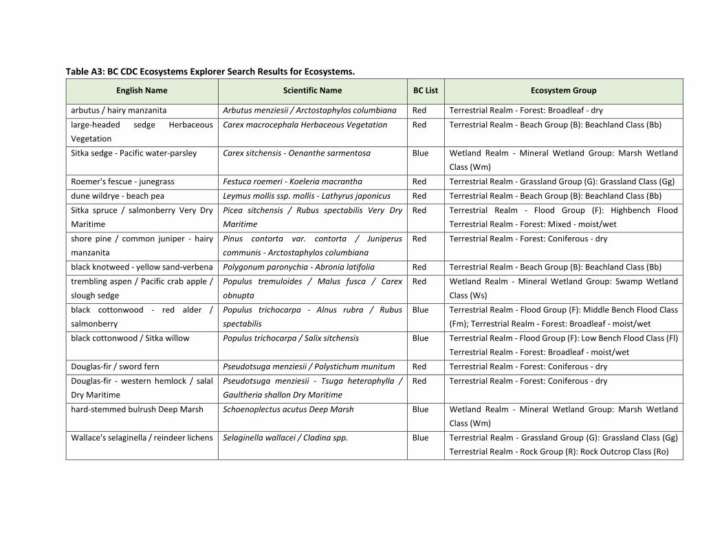
Table A3: BC CDC Ecosystems Explorer Search Results for Ecosystems.
English Name Scientific Name BC List Ecosystem Group
arbutus / hairy manzanita Arbutus menziesii / Arctostaphylos columbiana Red Terrestrial Realm - Forest: Broadleaf - dry
large-headed sedge Herbaceous
Vegetation
Carex macrocephala Herbaceous Vegetation Red Terrestrial Realm - Beach Group (B): Beachland Class (Bb)
Sitka sedge - Pacific water-parsley Carex sitchensis - Oenanthe sarmentosa Blue Wetland Realm - Mineral Wetland Group: Marsh Wetland
Class (Wm)
Roemer's fescue - junegrass Festuca roemeri - Koeleria macrantha Red Terrestrial Realm - Grassland Group (G): Grassland Class (Gg)
dune wildrye - beach pea Leymus mollis ssp. mollis - Lathyrus japonicus Red Terrestrial Realm - Beach Group (B): Beachland Class (Bb)
Sitka spruce / salmonberry Very Dry
Maritime
Picea sitchensis / Rubus spectabilis Very Dry
Maritime
Red Terrestrial Realm - Flood Group (F): Highbench Flood
Terrestrial Realm - Forest: Mixed - moist/wet
shore pine / common juniper - hairy
manzanita
Pinus contorta var. contorta / Juniperus
communis - Arctostaphylos columbiana
Red Terrestrial Realm - Forest: Coniferous - dry
black knotweed - yellow sand-verbena Polygonum paronychia - Abronia latifolia Red Terrestrial Realm - Beach Group (B): Beachland Class (Bb)
trembling aspen / Pacific crab apple /
slough sedge
Populus tremuloides / Malus fusca / Carex
obnupta
Red Wetland Realm - Mineral Wetland Group: Swamp Wetland
Class (Ws)
black cottonwood - red alder /
salmonberry
Populus trichocarpa - Alnus rubra / Rubus
spectabilis
Blue Terrestrial Realm - Flood Group (F): Middle Bench Flood Class
(Fm); Terrestrial Realm - Forest: Broadleaf - moist/wet
black cottonwood / Sitka willow Populus trichocarpa / Salix sitchensis Blue Terrestrial Realm - Flood Group (F): Low Bench Flood Class (Fl)
Terrestrial Realm - Forest: Broadleaf - moist/wet
Douglas-fir / sword fern Pseudotsuga menziesii / Polystichum munitum Red Terrestrial Realm - Forest: Coniferous - dry
Douglas-fir - western hemlock / salal
Dry Maritime
Pseudotsuga menziesii - Tsuga heterophylla /
Gaultheria shallon Dry Maritime
Red Terrestrial Realm - Forest: Coniferous - dry
hard-stemmed bulrush Deep Marsh Schoenoplectus acutus Deep Marsh Blue Wetland Realm - Mineral Wetland Group: Marsh Wetland
Class (Wm)
Wallace's selaginella / reindeer lichens Selaginella wallacei / Cladina spp. Blue Terrestrial Realm - Grassland Group (G): Grassland Class (Gg)
Terrestrial Realm - Rock Group (R): Rock Outcrop Class (Ro)

western redcedar / slough sedge Thuja plicata / Carex obnupta Red Terrestrial Realm - Forest: Coniferous - moist/wet
Wetland Realm - Mineral Wetland Group: Swamp Wetland
Class (Ws)
western redcedar / black twinberry Thuja plicata / Lonicera involucrata Red Terrestrial Realm - Forest: Coniferous - moist/wet
western redcedar - Sitka spruce /
skunk cabbage
Thuja plicata - Picea sitchensis / Lysichiton
americanus
Blue Terrestrial Realm - Forest: Coniferous - moist/wet
Wetland Realm - Mineral Wetland Group: Swamp Wetland
Class (Ws)
western redcedar / sword fern - skunk
cabbage
Thuja plicata / Polystichum munitum - Lysichiton
americanus
Blue Terrestrial Realm - Forest: Coniferous - moist/wet
Wetland Realm - Mineral Wetland Group: Swamp Wetland
Class (Ws)
western redcedar / sword fern Very
Dry Maritime
Thuja plicata / Polystichum munitum Very Dry
Maritime
Blue Terrestrial Realm - Forest: Coniferous - mesic
western redcedar / salmonberry Thuja plicata / Rubus spectabilis Red Terrestrial Realm - Forest: Coniferous - moist/wet
western redcedar / three-leaved
foamflower Very Dry Maritime
Thuja plicata / Tiarella trifoliata Very Dry
Maritime
Blue Terrestrial Realm - Forest: Coniferous - moist/wet
western hemlock - Douglas-fir /
Oregon beaked-moss
Tsuga heterophylla - Pseudotsuga menziesii /
Eurhynchium oreganum
Red Terrestrial Realm - Forest: Coniferous - mesic
western hemlock - western redcedar /
deer fern
Tsuga heterophylla - Thuja plicata /
Struthiopteris spicant
Red Terrestrial Realm - Forest: Coniferous - moist/wet
common cattail Marsh Typha latifolia Marsh Blue Wetland Realm - Mineral Wetland Group: Marsh Wetland
Class (Wm)
Search Criteria:
Ecosystem Realm-Groups: Forest AND BC Conservation Status: Red (Extirpated, Endangered, or Threatened) OR Blue (Special Concern) BGC : CWHxm1

APPENDIX B:
ARBORIST’S REPORT

RyanMurphy–ISACertifiedArborist,RBTech(250)465-2154,[email protected]
1
P r e - c o n s t r u c t i o n t r e e h a z a r d a n d i m p a c t a s s e s s m e n t a t S e a l B a y P a r k , C o u r t e n a y B C
Preparedfor:ComoxValleyRegionalDistrict Preparedby:RyanMurphy 410Urquhartplace CourtenayBC V9N3H1Date:Feb3,2020
Purpose:
AssessthetreesatSealBayparkinproximitytoproposedparkingexpansiontoassessviabilityofretainedtrees,numberoftreeslikelytorequireremoval,andassesspotentialimpactstoretainedtreesthroughconstructionactivities.
Background:
AlandsurveyperformedbyGrantLandSurveyingwasprovidedinearlyDecemberwhichcoveredtheareaofproposedparkingexpansionandincludedtopography,currentinfrastructure,andaninventoryoftreesonsite(species&diameter).AsitewalkwasconductedwithBrianAllaertfromtheComoxValleyRegionalDistrict(CVRD)andKimPoupard(CalidrisConsulting)onDecember31,2020todiscusssitelayoutandplanning.Atthistimetheroughlayoutofproposedinfrastructurewasmarkedwithpinkflaggingtape.Thereweresomediscussionsofpotentialalternateconstructionlayoutsandfinalassessmentswerepostponeduntilplanscouldbefinalized.BytheendofJanuarytheCVRDhadsettledbackontheoriginalparkingdesign.GeoreferencedsitemapswereprovidedbyOnsiteEngineeringwhichincludedtheoriginaltreeinventoryaswellasthelayoutoftheproposedroadwayandparking.
SiteDescription:
SealBayNatureParkisa642hectareparkonlongtermleasefromtheprovincialgovernment.Theareaissecondgrowthforest,havingbeenloggedin1913andearly1920’s.TheareaiswithintheCoastalWesternHemlock(EasternVeryDryMaritime)[CWHxm1]biogeoclimaticecosystemclassificationzone.ThedominanttreespeciesonsiteareDouglas-fir(Pseudotsugamenziesii),grandfir(Abiesgrandis),westernredcedar(Thujaplicata),andbigleafmaple(Acermacrophyllum)withblackcottonwood(Populustrichocarpa)alsopresentonwettersites.ThereareseveralaccesspointsfortheparkwiththeprimarybeingonBatesRd,whichbisectstheparkapproximatelyeast-west.

RyanMurphy–ISACertifiedArborist,RBTech(250)465-2154,[email protected]
2
Methods:
AsiteassessmentwasconductedonJanuary30,2021whereabasicvisualtreeassessment(VTA)wasconductedonalltreesforeseeablyimpactedbytheproposedparkingareaexpansion.Itwasfoundthatanumberoftreeswerenotincludedintheoriginalinventoryandseveralofthetreespecieswereincorrect.Alltrees>20cmdiameteratbreastheight(DBH)weremappedwithnewuniquenumberingandoriginalsurveyinventorynumberswereincludedwhereapplicable.Disagreementsofafewmeterswerefoundintreelocationdatabetweentheinventory/surveylocationsprovidedinearlyDecemberandthosewithinthegeoreferencedmapswhichincludedthesiteplans.Therewerealsodisagreementswithrespecttowhichtreeswerelocatedwithintheconstructionareawhencomparingthegeoreferencedmapstothepinkflaggingonsite.Forthepurposesofthisreportthegeoreferencedsitedrawingsareusedtodiscusstheboundariesoftheconstructionarea.
Giventhesizeoftheproperty,onlythosetreeswithareasonablyforeseeablepossibilityofconflictwith,orhazardtotheproposedconstructionareaweremappedandassessed(AppendixB).Foreachtreethefollowingmetricswerecollected:
• ID#• Species(scientificandcommonname)• Diameteratbreastheight(DBH)measuredat1.4mfromthehighestgroundandroundedup
tothenearestcm.• Condition(good,fair,poor,dead)• Recommendedaction
o ‘Remove’-Atreethateitherduetotheproximityofthehazardorpoorwildlifevalueisrecommendedberemovedtograde.
o ‘Wildlife’–Atreethatisrecommendedbereducedtoanon-viablestatebutisretainedforitswildlifevalue.FinalheightspecificationsaregiveninAppendixA
o ‘Modify’–Atreethatistobeprunedtoreducethedocumentedhazardbutcanberetainedasaviabletree.
o ‘RetainandMonitor’Atreethatdoesnotposeanimmediateandsignificanthazardandcanberetainedfortheshort-term
• Calculatedcriticalrootzone(CRZ)radius(m)[notrecordedfordeadtrees]• Calculatedtheoreticalrootplateradius(m)[notrecordedfordeadtrees]• Bylawprotectedspecies• Generalnotes
Results:
Atotalof111treeswereassessedthatwereincloseproximitytotheproposedparkingareaexpansion(AppendixA&B).Ofthese,atotalof31treeswerelocatedwithinthecurrentconstructionextentandwouldhavetoberemovedwiththeexceptionoftree#100whichislocatedinthecurrentparkinghardscape.Ofalltreesassessed,ninewerefoundtobeimmediatelyhazardous,eitherduetoseveredefectsorbecausetheyweredead.Thesehazardoustreeswerealllocatedoutsideofthe

RyanMurphy–ISACertifiedArborist,RBTech(250)465-2154,[email protected]
3
constructionarea.Atotalof21treesoutsideoftheconstructionareaweresituatedsuchthattheirestimatedstructuralrootplatewaslocatedwithintheconstructionzone(AppendixC).Atotalof52treeslocatedoutsidetheconstructionareaweresituatedsuchthattheircalculatedCRZoverlappedwiththeconstructionzone(AppendixD).Twoofthesetreeswereassessedashazardtreesandrecommendedforremovalorreductiontowildlifetrees.Sixtreeslocatedoutsideoftheconstructionareawerelocatedimmediatelyadjacenttotheflaggedboundaryonsite.
Noprotectedspecieswereidentifiedinthesurveyarea.
Discussion:
Therewassomeminordiscrepancywhencomparingtheflaggedboundarytothetechnicaldrawingswithrespecttothesurveyedtrees.Forexample,tree’s69,77,and86werenotedasbeingadjacenttotheflaggedboundaryhowevertheirestimatedrootplatearenotinconflictwhenconsideringtheconstructiondesigns.Tree#10wasalsolocatedimmediatelyontheflaggedlinebutis1.8mfromtheproposedroadwayinthesurveydrawings.Thisreportaddressesconflictsaspresentedinthetechnicaldrawingsastheprecisionoftheflaggingwasnotknown.Asplansarefinalizeditwillbepossibletofinetunetreeprotectionmeasuresasconstructionextentsareestablished.
The30treeslocatedwithintheconstructionareawillnotbeabletoberetainedunderanycircumstancesandwillhavetoberemoved.Thereareseveralfactorsnotyetdeterminedthatwillinfluencetheimpacttotreeslocatedoutsideoftheconstructionarea(includingthoseintheretentionisland).Mostnotablyisthefinalgraderequiredandthesurfacematerial(pavedorgravel)forthenewlyclearedareas.ItwouldseemlogicalthattheareaimmediatelyadjacenttoBatesRdwouldnotrequireregradingandthetreesimmediatelyadjacent(90,91,95,99,100,102,104,110,38,37,1)tothecurrentparkingareashouldnotseeanyadditionalimpact.
Thecriticalrootzoneandrootplatediameteraremeasurementstoaddressdifferentformsofpotentialimpact.Withrespecttocriticalrootzone,thisistheradiuswhichprovidestheoptimallevelofrootprotectiontoensurethelong-termhealthandviabilityofthetree.Whenaddressingtherootplatediameterwearediscussingtheareainwhichdisturbanceordamagemayresultinimmediateandacutestructuralinstability.Excavationposesthehighestpotentiallevelofdisturbancetoboththerootplateandcriticalrootzone.Presumablysomelevelofexcavationisrequiredtoremovethedufflayerandcoarsewoodydebris.Ifthefinalgradeishigherthantheexistinggrade,thiswillresultinlowerimpacttotreesimmediatelyadjacenttotheconstructionareathanifthegradeneedstobereduced.Theimmediaterootcrownshouldnotbeburiedhoweversomeoverburdeninthecriticalrootzoneistolerabledependingonthematerialsandmethodsused.Compactionofexistingsoilswithinthecriticalrootzonesofestablishedtreesisalsopotentiallydetrimental.
Recommendations:
• The30treesthatareindirectconflictshouldberemoved.Careshouldbetakentodoaslittledamagetoadjacenttreestoberetained.Manytreeswillbepossibletofallfromthegroundhoweverseveralwillrequireclimbingarboriststosectiondowntoavoidunnecessary‘brushing’ofadjacentretainedtreesorimpacttostructuralroots.

RyanMurphy–ISACertifiedArborist,RBTech(250)465-2154,[email protected]
4
• Severaltreesthatareimmediatelyadjacenttotheproposedconstructionwillrequireadditionalconsiderationoncefinalgradesaredeterminedandfinalized.Maturetree’ssuchas10,11,12,and14haverootcrownsthatextendwellabovetheexistinggradeandwillhavelargestructuralrootsthatarelikelytobedamagedbyaggressiveexcavation.
• Regardlessofthefinalhardscapeselected(asphalt,gravel)stepsshouldbetakentoavoidunnecessarycompactionofsoilsincriticalrootzones.Theuseofstructuralsoilstoformtheroadbaseinthesesituationsisrecommended.
• Whileexcavationisoccurringtheuseofthesmallestmachinepossibleissuggested.Asmallermachinewillgenerallyhavealowersurfacepressureresultinginlowersoilcompaction.Asmallermachinecanalsobeoperatedwithgreatersensitivitywhenworkingaroundlargestructuralroots.
o Acertifiedarboristshouldalsobepresenttosuperviseexcavationsnearmaturetreesprimarilysothatanydamagethatdoesoccurcanbeproperlyassessedbeforebeingreburied.
• Duringearlyclearingoperationsspecial considerationshouldbemadewithrespect to theremovalofstumps.StumpsofremovedtreesthatarewithintheCRZofretainedtreesshouldbenotberemovedwhereverpossible. If stumps in these locationsmustberemoved, thenpreference is towards grindingovermanual removalwith an excavator.Root systems areoften interconnected, and mechanical stump removal may cause unforeseen damage toadjacenttreesaswellasdisturbingnaturalsoilcomposition.
ReportpreparedbyRyanMurphy
ISACertifiedArboristPN-5779A
ISATreeRiskAssessorQualified

ID # Survey Number Species DBH (cm) CRZ (m) Root plate (m) Height (m) Health/condition Defects Hazard? Reccomendations Remediation Comments1 499 Douglas fir 105 12.6 3.35 38 Good Elongated laterals No Retain and monitor Prune2 - Grand fir 85 10.2 3.05 38 Poor Dead top Yes Remove/modify Reduce/wildlife3 601 Douglas fir 38 4.56 2.44 20 Good None No Retain and monitor - Within Construction area4 602 Grand fir 66 7.92 3.05 30 Poor Dead top Yes Remove/ modify -5 616 Douglas fir 56 6.72 2.74 32 Good None No Retain and monitor -6 617 Douglas fir 45 5.4 2.44 25 Good None No Retain and monitor -7 - Douglas fir 20 2.4 1.52 - Poor Dead top No Retain and monitor -8 603 Douglas fir 68 8.16 3.05 38 Good Small codominant top No Modify Prune Within Construction area9 604 Douglas fir 35 4.2 2.13 18 Good None No Retain and monitor - Within Construction area
10 614 Douglas fir 99 11.88 3.35 40 Good None No Retain and monitor - Very close to roadway. Potential for root disturbance
11 615 Douglas fir 80 9.6 3.05 38 Good None No Retain and monitor -12 613 Grand fir 55 6.6 2.74 35 Fair Poor structure No Retain and monitor -
13 630 Grand fir 95 11.4 3.35 40 Poor Dead top, broken top, resinosis at base
Yes Retain and monitor Reduce height
14 502 Douglas fir 116 13.92 3.35 42 Good None No Retain and monitor -15 501 Red alder 35 4.2 2.13 18 Fair Dead top No Retain and monitor -16 503 Douglas fir 57 6.84 2.74 28 Fair Poor stem structure No Retain and monitor - Within Construction area17 506 Douglas fir 100 12 3.35 42 Good None No Retain and monitor - Within Construction area18 507 Douglas fir 84 10.08 3.05 42 Good None No Retain and monitor - Within Construction area19 504 Douglas fir 75 9 3.05 40 Good None No Retain and monitor -20 608 Douglas fir 98 11.76 3.35 42 Good None No Retain and monitor -21 - Big leaf maple 38 4.56 2.44 22 Good None No Retain and monitor -22 - Douglas fir 65 7.8 3.05 40 Good None No Retain and monitor -23 - Grand fir 85 10.2 3.05 42 Good None No Retain and monitor -24 609 Sitka spruce 85 10.2 3.05 45 Good None No Retain and monitor -25 611 Grand fir 65 7.8 3.05 10 Dead Snag Yes Remove/ modify Reduce/wildlife26 645 Douglas fir 50 6 2.74 40 Good None No Retain and monitor -27 Grand fir 24 2.88 1.52 22 Good None No Retain and monitor - Within Construction area28 350 Red alder 33 3.96 2.13 26 Good None No Retain and monitor - Within Construction area29 510 Red alder 50 6 2.74 25 Good Heavy lean No Retain and monitor -30 508 Douglas fir 80 9.6 3.05 40 Good None No Retain and monitor -
31 509 Douglas fir 100 12 3.35 40 Poor Codominant tops, thinning canopy
Yes Remove/ modify Reduce/wildlife
32 - Grand fir 40 4.8 2.44 22 Dead Dead Yes Remove/ modify Reduce/wildlife
33 - Big leaf maple 65 7.8 3.05 38 Fair Lean Yes Modify Prune Asymetcic crown due to previous failure. Leaning towards proposed disabled parking area
34 511 Douglas fir 95 11.4 3.35 35 Good None No Retain and monitor -35 - Big leaf maple 55 6.6 2.74 30 Good None No Retain and monitor -36 515 Douglas fir 101 12.12 3.35 40 Good None No Retain and monitor -37 - Grand fir 30 3.6 1.83 18 Good Old basal crack No Retain and monitor -38 - Grand fir 28 3.36 1.83 10 Good None No Retain and monitor -39 464 Big leaf maple 60 7.2 2.74 26 Good None No Retain and monitor - Within Construction area40 466 Western hemlock 26 3.12 1.83 17 Good None No Retain and monitor -41 - Douglas fir 85 10.2 3.05 40 Fair Thinning crown No Retain and monitor -42 469 Douglas fir 73 8.76 3.05 40 Good None No Retain and monitor -43 455 Douglas fir 60 7.2 2.74 26 Good Poor stem structure No Retain and monitor - Within Construction area44 454 Black cottonwood 90 10.8 3.05 40 Good None No Retain and monitor -45 468 Douglas fir 50 6 2.74 26 Good None No Retain and monitor -46 448 Black cottonwood 85 10.2 3.05 40 Good None No Retain and monitor -47 449 Grand fir 45 5.4 2.44 30 Fair Thin crown No Retain and monitor -48 450 Douglas fir 80 9.6 3.05 40 Good None No Retain and monitor -49 - Big leaf maple 35 4.2 2.13 22 Good None No Retain and monitor -50 - Big leaf maple 35 4.2 2.13 28 Good None No Retain and monitor -51 451 Western redcedar 35 4.2 2.13 12 Good Stem sweep No Retain and monitor - Within Construction area52 452 Sitka spruce 38 4.56 2.44 22 Fair Thin crown No Retain and monitor - Within Construction area53 - Douglas fir 30 3.6 1.83 22 Fair Thin crown No Retain and monitor - Within Construction area54 453 Big leaf maple 40 4.8 2.44 28 Fair None No Retain and monitor - Within Construction area55 - Grand fir 25 3 1.68 18 Fair Thin crown No Retain and monitor - Within Construction area56 442 Douglas fir 80 9.6 3.05 38 Good Swelling on mid stem at 15m No Retain and monitor -57 443 Grand fir 34 4.08 2.13 25 Fair Thin crown No Retain and monitor -59 444 Big leaf maple 37 4.44 2.13 17 Poor Broken top No Retain and monitor -60 445 Big leaf maple 37 4.44 2.13 22 Good None No Retain and monitor -
Appendix A: Trees assessed in proximity to proposed parking expansing at Seal Bay Park, Courtenay BC.

61 446 Black cottonwood 50 6 2.74 35 Good None No Retain and monitor - Within Construction area62 - Big leaf maple 20 2.4 1.52 18 Good None No Retain and monitor - Within Construction area63 447 Black cottonwood 84 10.08 3.05 38 Good None No Retain and monitor - Within Construction area64 - Grand fir 21 2.52 1.52 12 Poor Thin crown No Retain and monitor - Within Construction area65 324 Big leaf maple 45 5.4 2.44 30 Good None No Retain and monitor -
66 340 Western redcedar 55 6.6 2.74 26 FairGrowing on rotting stump.
Potentially unstable long term No Modify Reduce height Within Construction area
67 326 Douglas fir 100 12 3.35 40 Good None No Retain and monitor - Growing immediately adjacent to flagged line. Likely severe root disturbance from grading
68 - Grand fir 28 3.36 1.83 17 Good None No Retain and monitor -69 327 Grand fir 35 4.2 2.13 26 Good None No Retain and monitor - Growing on flagged line70 - Douglas fir 24 2.88 1.52 22 Fair None No Retain and monitor - Within Construction area71 - Grand fir 24 2.88 1.52 22 Fair Thin crown No Retain and monitor - Within Construction area72 - Grand fir 28 3.36 1.83 22 Fair Thin crown No Retain and monitor - Within Construction area73 - Grand fir 24 2.88 1.52 22 Fair None No Retain and monitor - Within Construction area74 325 Grand fir 40 4.8 2.44 28 Good None No Retain and monitor - Within Construction area75 - Grand fir 21 2.52 1.52 12 Fair Thin crown No Retain and monitor -76 323 Big leaf maple 65 7.8 3.05 32 Good Multi stemmed No Retain and monitor -77 321 Grand fir 45 5.4 2.44 35 Good None No Retain and monitor - Adjacent to flagged line78 - Big leaf maple 38 4.56 1.52 30 Good None No Retain and monitor -79 320 Red alder 34 4.08 2.13 30 Fair Stem decay No Retain and monitor -80 319 Grand fir 35 4.2 2.13 28 Dead Dead Yes Remove/ modify Reduce/wildlife81 318 Douglas fir 70 8.4 3.05 38 Good None No Retain and monitor -82 314 Douglas fir 62 7.44 3.05 32 Good None No Retain and monitor -83 313 Douglas fir 95 11.4 3.35 42 Good None No Retain and monitor -84 311 Grand fir 41 4.92 2.44 28 Fair None No Retain and monitor -85 310 Black cottonwood 85 10.2 3.05 40 Good None No Retain and monitor -86 309 Douglas fir 100 12 3.35 42 Good None No Retain and monitor - On flagged line. Likely root impact87 330 Grand fir 35 4.2 2.13 25 Good None No Retain and monitor -88 - Grand fir 30 3.6 1.83 22 Good None No Retain and monitor -89 308 Grand fir 60 7.2 2.74 35 Dead Dead Yes Remove/ modify Reduce/wildlife
90 307 Douglas fir 100 12 3.35 42 Good None No Retain and monitor - On flagged line in existing parking. Should not require regrading or root disturbance
91 - Big leaf maple 33 3.96 2.13 20 Good None No Retain and monitor -
92 333 Douglas fir 58 6.96 2.74 25 Fair Broken top, burried root crown, basal trunk swelling.
No Retain and monitor - Within Construction area
93 334 Douglas fir 80 9.6 3.05 42 Good None No Retain and monitor - Within Construction area94 336 Douglas fir 50 6 2.74 25 Good None No Retain and monitor - Within Construction area95 335 Douglas fir 100 12 3.35 42 Good None No Retain and monitor -96 337 Douglas fir 30 3.6 1.83 25 Good None No Retain and monitor -97 - Douglas fir 30 3.6 1.83 20 Good None No Retain and monitor -98 338 Grand fir 60 7.2 2.74 40 Good None No Retain and monitor -99 342 Douglas fir 95 11.4 3.35 42 Good None No Retain and monitor -
100 341 Douglas fir 90 10.8 3.05 42 Good None No Retain and monitor - Within Construction area101 - Big leaf maple 70 8.4 3.05 35 Good Dead tops No Modify Prune102 458 Douglas fir 90 10.8 3.05 42 Good None No Retain and monitor -103 456 Grand fir 50 6 2.74 38 Good None No Retain and monitor -104 459 Douglas fir 110 13.2 3.35 40 Good Compacted soils, lean No Retain and monitor -105 457 Douglas fir 38 4.56 2.44 32 Good None No Retain and monitor -106 460 Douglas fir 100 12 3.35 38 Good Lean No Retain and monitor -107 461 Grand fir 60 7.2 2.74 12 Dead Snag No Retain and monitor -108 462 Douglas fir 88 10.56 3.05 45 Good None No Retain and monitor -109 463 Douglas fir 100 12 3.35 45 Good None No Retain and monitor -110 - Red alder 40 4.8 2.44 22 Good Lean No Retain and monitor -111 329 Grand fir 60 7.2 2.74 40 Fair Thin crown No Retain and monitor - Within Construction area112 328 Grand fir 60 7.2 2.74 40 Faior Thin crown No Retain and monitor - Within Construction area

Constructionarea
Rootplate
CRZ
TreesHazard
NoHazard
Legend
AppendixB:SealBayParkingExpansionOverview

Constructionarea
Rootplate
CRZ
TreesHazard
NoHazard
Legend
AppendixC:SealBayParkingExpansionOverviewwithes matedrootplateradius.

Constructionarea
Rootplate
CRZ
TreesHazard
NoHazard
Legend
AppendixD:SealBayParkingExpansionOverviewwithes matedCRZ

APPENDIX C:
ARBORIST’S REVISIONS

ID # Survey Number Species DBH (cm) CRZ (m) Root plate (m) Height (m) Health/condition Defects Hazard? Reccomendations Remediation Comments3 601 Douglas fir 38 4.56 2.44 20 Good None No Remove - Within Construction area5 616 Douglas fir 56 6.72 2.74 32 Good None No Remove - Within Construction area7 Douglas fir 20 2.4 1.52 Poor Dead top No Remove - Within Construction area8 603 Douglas fir 68 8.16 3.05 38 Good Small codominant top No Remove - Within Construction area9 604 Douglas fir 35 4.2 2.13 18 Good None No Remove - Within Construction area
16 503 Douglas fir 57 6.84 2.74 28 Fair Poor stem structure No Remove - Within Construction area17 506 Douglas fir 100 12 3.35 42 Good None No Remove - Within Construction area18 507 Douglas fir 84 10.08 3.05 42 Good None No Remove - Within Construction area19 504 Douglas fir 75 9 3.05 40 Good None No Remove - Within Construction area27 - Grand fir 24 2.88 1.52 22 Good None No Remove - Within Construction area28 350 Red alder 33 3.96 2.13 26 Good None No Remove - Within Construction area39 464 Big leaf maple 60 7.2 2.74 26 Good None No Remove - Within Construction area40 466 Western hemlock 26 3.12 2.74 17 Good None No Remove - Within Construction area43 455 Douglas fir 60 7.2 2.74 26 Good Poor stem structure No Remove - Within Construction area48 450 Douglas fir 80 9.6 3.05 40 Good None No Remove - Within Construction area50 - Big leaf maple 35 4.2 2.13 28 Good None No Remove - Within Construction area51 451 Western redcedar 35 4.2 2.13 12 Good Stem sweep No Remove - Within Construction area52 452 Sitka spruce 38 4.56 2.44 22 Fair Thin crown No Remove - Within Construction area53 - Douglas fir 30 3.6 1.83 22 Fair Thin crown No Remove - Within Construction area54 453 Big leaf maple 40 4.8 2.44 28 Fair None No Remove - Within Construction area55 - Grand fir 25 3 1.68 18 Fair Thin crown No Remove - Within Construction area61 446 Black cottonwood 50 6 2.74 35 Good None No Remove - Within Construction area62 - Big leaf maple 20 2.4 1.52 18 Good None No Remove - Within Construction area63 447 Black cottonwood 84 10.08 3.05 38 Good None No Remove - Within Construction area64 - Grand fir 21 2.52 1.52 12 Poor Thin crown No Remove - Within Construction area
66 340 Western redcedar 55 6.6 2.74 26 Fair Growing on rotting stump. Potentially unstable long term
No Remove - Within Construction area
70 - Douglas fir 24 2.88 1.52 22 Fair None No Remove - Within Construction area71 - Grand fir 24 2.88 1.52 22 Fair Thin crown No Remove - Within Construction area72 - Grand fir 28 3.36 1.83 22 Fair Thin crown No Remove - Within Construction area73 - Grand fir 24 2.88 1.52 22 Fair None No Remove - Within Construction area74 325 Grand fir 40 4.8 2.44 28 Good None No Remove - Within Construction area75 - Grand fir 21 2.52 1.52 12 Fair Thin crown No Remove - Within Construction area
92 333 Douglas fir 58 6.96 2.74 25 Fair Broken top, burried root crown, basal trunk swelling.
No Remove - Within Construction area
93 334 Douglas fir 80 9.6 3.05 42 Good None No Remove - Within Construction area94 336 Douglas fir 50 6 2.74 25 Good None No Remove - Within Construction area
100 341 Douglas fir 90 10.8 3.05 42 Good None No Remove - Within Construction area111 329 Grand fir 60 7.2 2.74 40 Fair Thin crown No Remove - Within Construction area112 328 Grand fir 60 7.2 2.74 40 Faior Thin crown No Remove - Within Construction area
2 - Grand fir 85 10.2 3.05 38 Poor Dead top Yes Remove/modify Reduce/wildlife4 602 Grand fir 66 7.92 3.05 30 Poor Dead top Yes Remove/ modify -
13 630 Grand fir 95 11.4 3.35 40 Poor Dead top, broken top, resinosis at base
Yes Remove/ modify Reduce height
25 611 Grand fir 65 7.8 3.05 10 Dead Snag Yes Remove/ modify Reduce/wildlife
31 509 Douglas fir 100 12 3.35 40 Poor Codominant tops, thinning canopy
Yes Remove/ modify Reduce/wildlife
32 - Grand fir 40 4.8 2.44 22 Dead Dead Yes Remove/ modify Reduce/wildlife
33 - Big leaf maple 65 7.8 3.05 38 Fair Lean Yes Modify PruneAsymetcic crown due to previous failure. Leaning towards proposed disabled parking area. Reduce
crown end weight and inspect previous failure point.80 319 Grand fir 35 4.2 2.13 28 Dead Dead Yes Remove/ modify Reduce/wildlife89 308 Grand fir 60 7.2 2.74 35 Dead Dead Yes Remove/ modify Reduce/wildlife
101 - Big leaf maple 70 8.4 3.05 35 Good Dead tops Yes Modify Prune Remove dead tops1 499 Douglas fir 105 12.6 3.35 38 Good Elongated laterals No Retain and monitor Prune5 616 Douglas fir 56 6.72 2.74 32 Good None No Retain and monitor -
6 617 Douglas fir 45 5.4 2.44 25 Good None No Retain and monitor - To be monitored during excavation and/or grading for potential root damage
7 - Douglas fir 20 2.4 1.52 - Poor Dead top No Retain and monitor -
10 614 Douglas fir 99 11.88 3.35 40 Good None No Retain and monitor -
11 615 Douglas fir 80 9.6 3.05 38 Good None No Retain and monitor -
12 613 Grand fir 55 6.6 2.74 35 Fair Poor structure No Retain and monitor -
14 502 Douglas fir 116 13.92 3.35 42 Good None No Retain and monitor - To be monitored during excavation and/or grading for potential root damage
15 501 Red alder 35 4.2 2.13 18 Fair Dead top No Retain and monitor -19 504 Douglas fir 75 9 3.05 40 Good None No Retain and monitor -
20 608 Douglas fir 98 11.76 3.35 42 Good None No Retain and monitor -
Appendix A-2: Trees assessed in proximity to proposed parking expansing at Seal Bay Park, Courtenay BC.
To be monitored during excavation and/or grading for potential root damage. May require removal
depending on grade changes and root damage. Root flare should not be buried. Good candidate for
structural soils if retained.
To be monitored during excavation and/or grading for potential root damage. May require removal
depending on grade changes and root damage. Root flare should not be buried. Good candidate for
structural soils if retained.

21 - Big leaf maple 38 4.56 2.44 22 Good None No Retain and monitor -
22 - Douglas fir 65 7.8 3.05 40 Good None No Retain and monitor -23 - Grand fir 85 10.2 3.05 42 Good None No Retain and monitor -24 609 Sitka spruce 85 10.2 3.05 45 Good None No Retain and monitor -26 645 Douglas fir 50 6 2.74 40 Good None No Retain and monitor -29 510 Red alder 50 6 2.74 25 Good Heavy lean No Retain and monitor -30 508 Douglas fir 80 9.6 3.05 40 Good None No Retain and monitor -34 511 Douglas fir 95 11.4 3.35 35 Good None No Retain and monitor -35 - Big leaf maple 55 6.6 2.74 30 Good None No Retain and monitor -36 515 Douglas fir 101 12.12 3.35 40 Good None No Retain and monitor -37 - Grand fir 30 3.6 1.83 18 Good Old basal crack No Retain and monitor -38 - Grand fir 28 3.36 1.83 10 Good None No Retain and monitor -
40 466 Western hemlock 26 3.12 1.83 17 Good None No Retain and monitor -
41 - Douglas fir 85 10.2 3.05 40 Fair Thinning crown No Retain and monitor - To be monitored during excavation and/or grading for potential root damage
42 469 Douglas fir 73 8.76 3.05 40 Good None No Retain and monitor -
44 454 Black cottonwood 90 10.8 3.05 40 Good None No Retain and monitor - To be monitored during excavation and/or grading for potential root damage
45 468 Douglas fir 50 6 2.74 26 Good None No Retain and monitor -46 448 Black cottonwood 85 10.2 3.05 40 Good None No Retain and monitor -
47 449 Grand fir 45 5.4 2.44 30 Fair Thin crown No Retain and monitor - To be monitored during excavation and/or grading for potential root damage
48 450 Douglas fir 80 9.6 3.05 40 Good None No Retain and monitor -
49 - Big leaf maple 35 4.2 2.13 22 Good None No Retain and monitor - To be monitored during excavation and/or grading for potential root damage
50 - Big leaf maple 35 4.2 2.13 28 Good None No Retain and monitor -56 442 Douglas fir 80 9.6 3.05 38 Good Swelling on mid stem at 15m No Retain and monitor -57 443 Grand fir 34 4.08 2.13 25 Fair Thin crown No Retain and monitor -59 444 Big leaf maple 37 4.44 2.13 17 Poor Broken top No Retain and monitor -
60 445 Big leaf maple 37 4.44 2.13 22 Good None No Retain and monitor - To be monitored during excavation and/or grading for potential root damage
65 324 Big leaf maple 45 5.4 2.44 30 Good None No Retain and monitor -
67 326 Douglas fir 100 12 3.35 40 Good None No Retain and monitor - Growing immediately adjacent to flagged line. Not in close proximity to construction based on drawings.
68 - Grand fir 28 3.36 1.83 17 Good None No Retain and monitor -69 327 Grand fir 35 4.2 2.13 26 Good None No Retain and monitor - Growing on flagged line75 - Grand fir 21 2.52 1.52 12 Fair Thin crown No Retain and monitor -76 323 Big leaf maple 65 7.8 3.05 32 Good Multi stemmed No Retain and monitor -77 321 Grand fir 45 5.4 2.44 35 Good None No Retain and monitor - Adjacent to flagged line78 - Big leaf maple 38 4.56 1.52 30 Good None No Retain and monitor -79 320 Red alder 34 4.08 2.13 30 Fair Stem decay No Retain and monitor -81 318 Douglas fir 70 8.4 3.05 38 Good None No Retain and monitor -82 314 Douglas fir 62 7.44 3.05 32 Good None No Retain and monitor -83 313 Douglas fir 95 11.4 3.35 42 Good None No Retain and monitor -
87 330 Grand fir 35 4.2 2.13 25 Good None No Retain and monitor -
88 - Grand fir 30 3.6 1.83 22 Good None No Retain and monitor -
90 307 Douglas fir 100 12 3.35 42 Good None No Retain and monitor - On flagged line in existing parking. Should not require regrading or root disturbance
91 - Big leaf maple 33 3.96 2.13 20 Good None No Retain and monitor - On flagged line in existing parking. Should not require regrading or root disturbance
95 335 Douglas fir 100 12 3.35 42 Good None No Retain and monitor - To be monitored during excavation and/or grading for potential root damage
96 337 Douglas fir 30 3.6 1.83 25 Good None No Retain and monitor -97 - Douglas fir 30 3.6 1.83 20 Good None No Retain and monitor -98 338 Grand fir 60 7.2 2.74 40 Good None No Retain and monitor -
99 342 Douglas fir 95 11.4 3.35 42 Good None No Retain and monitor - To be monitored during excavation and/or grading for potential root damage
102 458 Douglas fir 90 10.8 3.05 42 Good None No Retain and monitor -103 456 Grand fir 50 6 2.74 38 Good None No Retain and monitor -104 459 Douglas fir 110 13.2 3.35 40 Good Compacted soils, lean No Retain and monitor -105 457 Douglas fir 38 4.56 2.44 32 Good None No Retain and monitor -106 460 Douglas fir 100 12 3.35 38 Good Lean No Retain and monitor -107 461 Grand fir 60 7.2 2.74 12 Dead Snag No Retain and monitor -108 462 Douglas fir 88 10.56 3.05 45 Good None No Retain and monitor -109 463 Douglas fir 100 12 3.35 45 Good None No Retain and monitor -110 - Red alder 40 4.8 2.44 22 Good Lean No Retain and monitor -
To be monitored during excavation and/or grading for potential root damage. May require removal
depending on grade changes and root damage. Root flare should not be buried. Good candidate for
structural soils if retained.
To be monitored during excavation and/or grading for potential root damage. May require removal
depending on grade changes and root damage. Root flare should not be buried. Good candidate for
structural soils if retained.
Remove Modify/Remove Special Consideration Retain and monitor

TreesHazard
NoHazard
Constructionarea
Rootplate
Legend
SealBayparkingexpansionoverviewwithes matedrootplatediameter

APPENDIX D:
SPILL RESPONSE PLAN

Spill Contingency Plan
EMERGENCY (OSC) ON-SITE COORDINATOR:
o Project Superintendent See contact list
GENERAL REQUIREMENTS:
o Identify the nature of the spill, locate the source and type of products spilled, check for placards (TDG) or
check cab of vehicle for Material Safety Data Sheet (MSDS)
o Shut off, plug or contain the source of the spill if it can be done in a safe manner
o Deploy containment and/or sorbent material
o Clear the area of non-trained or non-authorized personnel
o Notify all personnel downstream and downwind
o Contact (OSC) if they are not on site for instructions
NOTIFICATION OF EMERGENCY RESPONSE GROUPS, IN ORDER FOLLOWING:
o Fire, Ambulance, Police 911
o Emergency Services BC 1 – 800 – 663 – 3456
o Ministry Representative See contact list
o RDCO Emergency Operation Center (EOC) 1 – 877 – 569 – 8490
COMPANY NOTIFICATIONS:
o Project Superintendent/Project Supervisor See contact list
o Manager, Health & Safety See contact list
ENVIRONMENTAL MONITOR:
o Kim Poupard, Calidris Consulting 1 – 250 – 327 – 3139
RESOURCE MATERIALS LISTED AND STORAGE:
o On-site Spill Kit Locations:
o All trucks and equipment
o Service truck
o Subcontractors equipment
o On-site Safety and Monitoring Supplies
Ambulance at site
Trucks

Spill Report Form
Pursuant to the Spill Reporting Regulation of the Waste Management Act. All non-authorized releases or
discharges of contaminants to the environment must be reported immediately to Emergency Services
BC (formerly Provincial Emergency Program) at 1 800 663 3456.
Name of reporter: Telephone:
Name of company causing spill: Telephone:
Location of spill: Date/time of spill:
Substance spilled: Quantity:
Cause and effect of spill: Measures taken to stop/contain/minimize spill:
Description of spill location and surrounding area: Further action required:
Agencies on site: Others notified of spill:
DATED:
REPORT COMPLETED BY:

APPENDIX E:
PROJECT CONTACT LIST

Project Contact List (To be updated once contract selected)
Role Name Primary
Phone
Secondary
Phone
Email Address
CVRD Contact Brian Allaert 250-334-6032 250-703-6524
(cell)
Prime
Superintendent
TBD - - -
Project EM Kim Poupard 250-338-1520 250-327-3139
(cell)
Project Arborist Ryan Murphy 250-465-2154 - [email protected]

APPENDIX F:
IDENTIFICATION TOOL FOR INVASIVE
PLANTS THAT MAY OCCUR ON THE SITE

Himalayan Blackberry (Rubus armeniacus)
Medium to tall, coarse shrub, 2-5 m or more long, thicket-forming; stems 5-15 mm in diameter,
erect to ascending, then high-arching, sprawling and trailing along the ground, some rooting at the
ends, five-angled, with stout, flattened, hooked prickles. Produces white flowers then black berries
1 to 1.5 cm wide.

Bull Thistle (Cirsium vulgare)
Biennial herb from a fibrous root, 0.3-2.0 m tall; stems erect, branched, the branches spreading
and ascending, stiff, ridged, sparsely to densely hairy, conspicuously spiny-winged at the base of
the leaves.

Japanese knotweed (Reynoutria japonica)
Perennial herb from a rhizome; stems erect, numerous, branched, 1-3 m tall, reddish-brown. Head
of numerous white, off-white or greenish flowers.

Scotch Broom (Cystisus scoparius)
Medium to tall shrub, up to 3 m tall; stems usually erect, branched; twigs strongly 5-angled, green,
somewhat hairy when young, becoming glabrous. Inflorescence of solitary or sometimes 2 or 3
pea-like flowers, usually yellow sometimes purple-tinged or two-toned yellow and red.
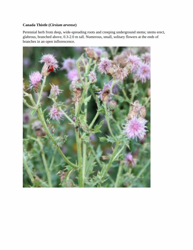
Canada Thistle (Cirsium arvense)
Perennial herb from deep, wide-spreading roots and creeping underground stems; stems erect,
glabrous, branched above, 0.3-2.0 m tall. Numerous, small, solitary flowers at the ends of
branches in an open inflorescence.

Common Tansy (Tamacetum vulgare)
Perennial herb from a stout rhizome; stems erect, solitary, branched, glabrous to sparsely hairy,
dotted with glands, 0.4-1.5 m tall. Numerous flowering head on terminus of branches.

APPENDIX G:
IDENTIFICATION TOOL FOR SPECIES AT
RISK THAT MAY OCCUR ON THE SITE

Northern Red-legged Frog (Rana aurora)
Brown to reddish or copper-brown medium-sized frog with black spots scattered over its back. The
underbelly of the species is whitish, with a reddish colouration appearing on the lower belly and undersides
of the hind legs as the frog gets older.

Western Toad (Anaxyrus boreas)
A true toad with warty skin that typically appear as spots on the body. Size can be extremely variable.
Behind the eyes are prominent parotoid glands (large bumps) which can exude a toxin as a defensive
measure. Toads are more terrestrial than frogs, and can be found relatively far from permanent bodies of
water.

Band-tailed Pigeon (Patagioenas fasciata)
Medium-sized pigeon with a dark eye, yellow bill, white collar and a light gray tipped tail. Tail band is
more discernable during flight. Often seen perching solitarily or in small groups along tree line edges.

Western Screech-owl (Megascops kennicotti kennicotti)
Small, stalky owl with dark streaked chest, yellow eyes and ear-tuffs. Likely to be using tree cavities.