Embed Size (px)
Citation preview
1
SEABED MINING: A technical review
Erry, B., Johnston, P. & Santillo, D. (2000)
Greenpeace Research Laboratories Technical Note 24/2000
Table of Contents
1 SUMMARY ..................................................................................................................................... 3
2 INTRODUCTION .......................................................................................................................... 6
2.1 Exploration for marine minerals ...................................................................... 7 2.1.1 Political considerations ..................................................................................................... 7 2.1.2 General economic considerations ..................................................................................... 7
2.2 Polymetallic nodules ......................................................................................... 8 2.3 Ferromanganese crusts .................................................................................... 8 2.4 Methane Hydrates ............................................................................................. 8 2.5 Seafloor Massive Sulphides .............................................................................. 9 2.6 Marine placer deposits, hot brines and phosphorites ...................................... 9 2.7 Marine bioresources ......................................................................................... 9 2.8 Environmental impacts ..................................................................................... 9
3 POLYMETALLIC NODULES ................................................................................................... 10
3.1 What are they? ................................................................................................ 10 3.2 How are they formed? .................................................................................... 10 3.3 Where are they found? .................................................................................... 10 3.4 Chemical composition of nodules ................................................................... 11 3.5 Who owns them? ............................................................................................. 12 3.6 What mining techniques might be employed for their extraction? ................. 12 3.7 How close is commercial exploitation? .......................................................... 19 3.8 What are the environmental impacts of mining polymetallic nodules? .......... 20
4 FERROMANGANESE CRUSTS ................................................................................................ 21
4.1 What are they? ................................................................................................ 21 4.2 Where are they found? .................................................................................... 23 4.3 What is their chemical composition? .............................................................. 23 4.4 What mining techniques might be employed to recover ferromanganese crusts? ....................................................................................................................... 23 4.5 What are the environmental consequences of exploiting ferromanganese crusts? ....................................................................................................................... 24
5 SEAFLOOR MASSIVE SULPHIDES ........................................................................................ 24
5.1 What are they? ................................................................................................ 24 5.2 How are they formed? .................................................................................... 25 5.3 How do you find them? ................................................................................... 27 5.4 Who owns them? ............................................................................................. 28 5.5 What mining techniques might be employed for their extraction? ................. 28 5.6 Economic resource potential .......................................................................... 30 5.7 How close is commercial exploitation? .......................................................... 31
2
5.8 What are the environmental impacts of mining marine massive sulphides? .. 31
6 METHANE HYDRATES ............................................................................................................ 32
6.1 What are they? ................................................................................................ 32 6.2 How are they formed? .................................................................................... 33 6.3 Where are they found? .................................................................................... 34 6.4 Who owns them? ............................................................................................. 34 6.5 What mining techniques might be employed for their extraction? ................. 36 6.6 How close is commercial exploitation? .......................................................... 36 6.7 What are the environmental impacts of mining methane hydrates? .............. 38
7 OTHER MARINE MINERAL RESOURCES ........................................................................... 39
7.1 Hot brines and metalliferous muds ................................................................. 39 7.1.1 What are they? ................................................................................................................ 39 7.1.2 How are they formed? .................................................................................................... 39 7.1.3 Where are they found? .................................................................................................... 39 7.1.4 What is the current state of their exploitation? ............................................................... 39 7.1.5 What are the environmental impacts of extracting hot brines and metalliferous muds? . 40
7.2 Mineral Placers .............................................................................................. 40 7.2.1 What are they? ................................................................................................................ 40 7.2.2 How do placers get where they are found? ..................................................................... 43 7.2.3 What is the current state of their exploitation? ............................................................... 44 7.2.4 What are the environmental impacts of recovering mineral placers? ............................. 44
7.3 Marine Phosphorites ...................................................................................... 44 7.3.1 What are they? ................................................................................................................ 44 7.3.2 Where are they found? .................................................................................................... 45 7.3.3 What is the current state of their exploitation? ............................................................... 45 7.3.4 What are the environmental impacts of recovery of marine phosphorites? .................... 45
8 MARINE BIORESOURCES ....................................................................................................... 45
8.1 What are they? ................................................................................................ 46 8.2 What is currently being exploited? ................................................................. 46 8.3 What is expected in the future? ....................................................................... 46
9 LEGISLATIVE CONSIDERATIONS ....................................................................................... 46
9.1 The International Seabed Authority ............................................................... 46 9.2 National mining legislation experiences ........................................................ 47
10 CONCLUSIONS ....................................................................................................................... 47
10.1 What is the overall state of marine mineral mining? .................................. 47 10.2 How great a threat to marine biota and the marine environment is the exploitation of marine minerals? .............................................................................. 47 10.3 Opportunities ............................................................................................... 48
11 REFERENCES ......................................................................................................................... 48
12 GLOSSARY .............................................................................................................................. 51
3
SEABED MINING
1 S U M M A R Y
The scientific community was made to re-think its view of the potential resources which might be found on the seabed when plate tectonic theory was born in the 1960s. Before then no-one had thought of the ocean basins as anything other than passive containers of water. Since the realisation that the earth’s surface was separated into discrete areas this thinking has changed to regarding ocean basins as active sources of minerals.
There are a number of different types of marine minerals. The ones which are most well known are the fossil fuels, oil and gas. But less well known are the non-fossil fuels such as methane hydrates, and the various non-fuel minerals which exist under the sea.
Marine mineral resources include a large number of metallic, non-metallic and fuel energy minerals that occur throughout the seas and oceans from shallow or beach deposits to those which occur on the deep seafloor at a depth of more than 5000 m. The non-fuel mineral deposits of the seabed in deep water comprise polymetallic nodules (containing manganese, copper, nickel and cobalt in different amounts) found at water depths of 4,000-5,000 m; cobalt-rich crusts (containing manganese, cobalt, nickel and platinum) found at water depths of 500-2,000 m; polymetallic massive sulphides (containing predominantly copper, iron, zinc, silver and gold) found at water depths between 2,000-4,000 m; and hot brines and marine placers (containing various metals) found as beach deposits and through all intervening water depths to those greater than 1,000 m. There are marine phosphorite deposits which have potential for the production of phosphates for agricultural use. In addition there are non-fossil fuel reserves in the form of methane hydrates, usually found at continental margins and which are reputed to contain more than twice the world’s currently known fossil fuel reserves.
Polymetallic nodules were discovered over a hundred years ago, but the potato sized lumps of mineral were regarded as little more than a curiosity until their commercial potential was more seriously considered in the 1960s and 1970s. At that time it was thought that a Klondike type rush would begin in order to harvest the nodules from the deep sea bed at depths greater than 5,000 m. Thirty years later there is still no sign of an impending rush to begin commercial mining of nodules.
There are a number of reasons why seabed mining of polymetallic nodules has not yet become a reality. The prices of metals on the world market have not risen as some predicted in the days of ‘nodule mining fever’. Conversely, most authors agree that in real terms metal prices have fallen over the last thirty years. There has not, therefore, been a driver for researching and developing the technology required to harvest the nodules. A further hindrance to the economics of seabed mining of nodules has been the rise in interest throughout the scientific community and beyond in environmental matters. It is standard practice in the year 2000 for any large engineering project to require an Environmental Impact Assessment (EIA) exercise to be undertaken in advance of any other work and the cost of a full scale EIA is a not inconsiderable addition to the mounting budget required. Nor should it be forgotten that seabed mining at the depths required for recovery of nodules is something never before attempted commercially. The highest continued interest in mining nodules is among nations with little in the way of mineral resources. Nations such as Japan and Korea, it can be argued, would benefit most from securing both the technology for other nations to purchase in the future, and the security of controlling their ‘own’ mineral reserves.
The upsurge of interest in mining nodules which occurred in the 1970s had one further consequence of note. The formation of the International Seabed Authority (ISA) as an arm of the United Nations. Although the overall benefit to the international community of this organisation could be put forward, it is probable that, should nodule mining ever take place in the area of seabed under its jurisdiction, such mining would at least not benefit only the industrialised nations.
The technical considerations of mining ferromanganese crusts are similar to that surrounding the collection of nodules from the seabed, except that crusts are at shallower depths (in the region 800 – 2,500 m) but might be more difficult to separate from their substrate than are nodules. Although they contain a variety of metals as do nodules, and are formed by essentially the same hydrogenetic processes, they may be enriched in cobalt to a greater extent than nodules. The economics of mining crusts might, however, be more variable than for nodule mining as crusts occur predominantly within national control. National interests may, therefore, have a significant impact on the price of mining
4
crusts. Potentially economic crusts are found mostly in the southwestern Pacific and are owned by the United States, the Marshall Islands, Kiribati, the Federated States of Micronesia and French Polynesia.
Seafloor massive sulphides are lens shaped bodies laid down by the expulsion of metal rich solutions from the earth’s crust through what are commonly known as ‘black smokers’. These are the most recent discovery of seabed mineral types. They are found randomly and infrequently spaced in areas at the edges of tectonic plates either at seafloor spreading centres in mid-ocean ridges, or in front of or behind island volcanic chains such as those found in the southwestern Pacific. Seafloor massive sulphides are thought to be the precursors of the terrestrial massive sulphides which are the source of large amounts of mined metals.
The timescales over which these orebodies can form are very variable, ranging from a few hundred to many thousands of years. This is governed by the rate at which the hydrothermal fluid passes through the system. There has been a recent upsurge in interest in the mining of these deposits which are found at water depths from 2-5,000 m. An Australian mining company has been investigating the deposits found in a back arc basin north (but within the territorial waters) of Papua New Guinea. A test drilling of at least one, and possibly two, orebodies in the Manus Basin is due to take place as part of the prestigious Ocean Drilling Programme (ODP) in December/January 2000/2001. Despite this, it is believed that it will take a minimum of five years, and probably considerably longer, before commercial mining of these deposits becomes a reality.
Methane hydrates are an ice-like cage of water surrounding methane gas which are found under certain specific temperature and pressure regimes usually on the margins of continental shelves and within national Economic Exclusion Zones (EEZs). There is little in the way of known hydrate deposits which exist within the aegis of the ISA. The gas, once released from its cage, can expand to more than 150 times the original volume and methane hydrate reserves are, as a consequence, believed to contain more than twice as much fuel energy as all currently known fossil fuel reserves. The methods by which methane hydrates can be located are improving, but are still not infallible. Continental deposits of methane hydrates are currently being exploited for fuel in Siberia. But the technological capability to extract methane from hydrate deposits under the sea have not yet been perfected. A number of difficulties exist, the most dangerous of which is considered to be a massive and uncontrolled release of methane gas which could result in the sinking of any vessels floating on the sea above, slumping of the continental slope under which most deposits are located and the injection of a large volume of a greenhouse gas, with many times the warming potential of carbon dioxide, into the atmosphere.
An area of hot metalliferous brine and large reserves of metalliferous muds exist in the Red Sea and are jointly owned by Saudi Arabia and Sudan. They bear certain resemblances to seafloor massive sulphides in the manner of their formation, but the existence of large salt deposits through which the hydrothermal fluids must pass has led to what is believed to be a unique geological system. The reserves have been investigated intensively and mining systems for the exploitation of the muds and brines have been developed. But the low price of metals worldwide has lowered expectations of commercial production in the foreseeable future.
In contrast metal placers are probably the most exploited of all known undersea mineral reserves. These deposits are unlike the others so far mentioned in that they do not originate under the sea. Rather they are small particles that have been washed, usually by rivers, from continental land masses into the sea. As a result they are rarely found except on continental shelves. A number of different minerals are mined in depths ranging from beach level to several hundred metres. Gold placers have been mined in Alaska for some years, tin in Indonesia and Thailand and diamonds (the most commercially valuable mineral placer) off Namibia and South Africa. Other less valuable minerals such as sand and gravel are also mined from placer deposits.
Marine phosphorites are potential sources of phosphates for use in agriculture and deposits are known in a number of locations including the most well known off New Zealand. The very low bulk value of phosphate, however, and large known terrestrial sources of similar material, mean that little energy has been expended on discovering much more about the commercial potential of these deposits. It seems unlikely even that they will be investigated much further in the foreseeable future, and mining of the deposits is, therefore, still much further in the future.
Marine bioresources have already exhibited enormous commercial potential, even when fisheries are excluded. Marine organisms have a unique and diverse chemistry that can be very different from that found in terrestrial organisms. New compounds of marine origin continue to be discovered, and new uses for known compounds found. The vent communities found around black smokers have been a particular source for stable high temperature enzymes such as Taq polymerase without which our
5
understanding of molecular biology would be vastly reduced. Other compounds of potential medicinal use are being researched. From the production of an enzyme to harvesting and culturing Spirulina as a health food supplement, marine bioresources are potentially of enormous commercial value. But it should be borne in mind that commercial mineral exploitation and commercial bioresource exploitation could have different requirements and the exploitation of minerals, which is potentially a source of considerable seafloor destruction and, as yet, unknown levels of pollution, could in certain instances be mutually exclusive. This is particularly the case where the exploitation of seafloor massive sulphides would destroy any active vent biota.
There are many thousands, perhaps millions, of marine species as yet unidentified. These potential marine biological resources should not be forgotten in any drive towards exploiting the mineral resources of the seabed. If seabed mining were to begin today it would not be possible to determine the extent of the damage caused to marine organisms. Before any commercial mining activity takes place, therefore, an adequate database of the organisms present at any potential mine site will need to be compiled, and the extent of the damage caused by mining should take into account the cost to the environment that such activity would necessarily engender.
6
2 I N T R O D U C T I O N
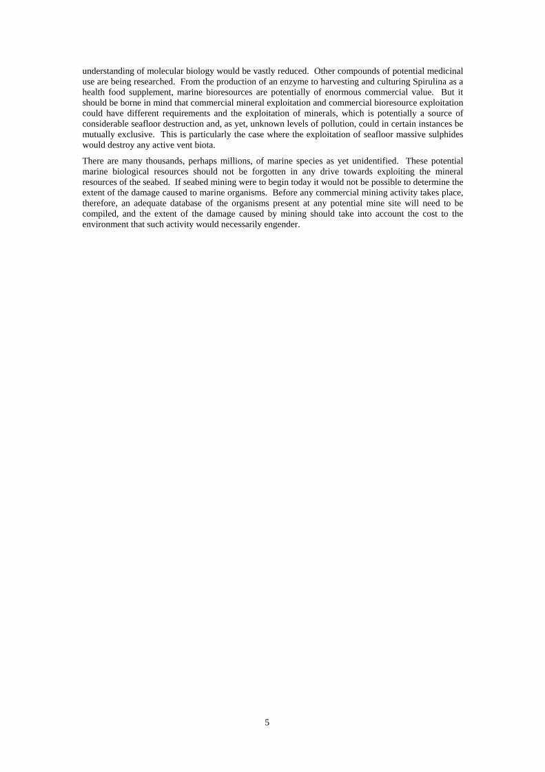
Our knowledge of the oceans is rapidly expanding, but it is still often said that we know more about the surface of the moon than we do about the bottom of the sea. Until the 1960s when plate tectonic theory was first promulgated ocean basins were regarded as just that, containers that held water. The presence of metal and non-metal fuel reserves in ocean basins were considered to have come about primarily as a result of the erosion of continental rocks carried into the ocean as sediment or in dissolved form. This theory explained the then known marine minerals which comprised beach and placer deposits of various heavy minerals containing metals and non-metals of terrigenous origin. River input is still considered to be the source of dissolved chemicals that form manganese nodules and crusts, phosphorite, and other types of deposits precipitated from seawater (Rona 1986, Rona 2000). But the advent of plate tectonic theory changed scientific thinking about ocean basins and their potential as repositories of commercially valuable mineral deposits.
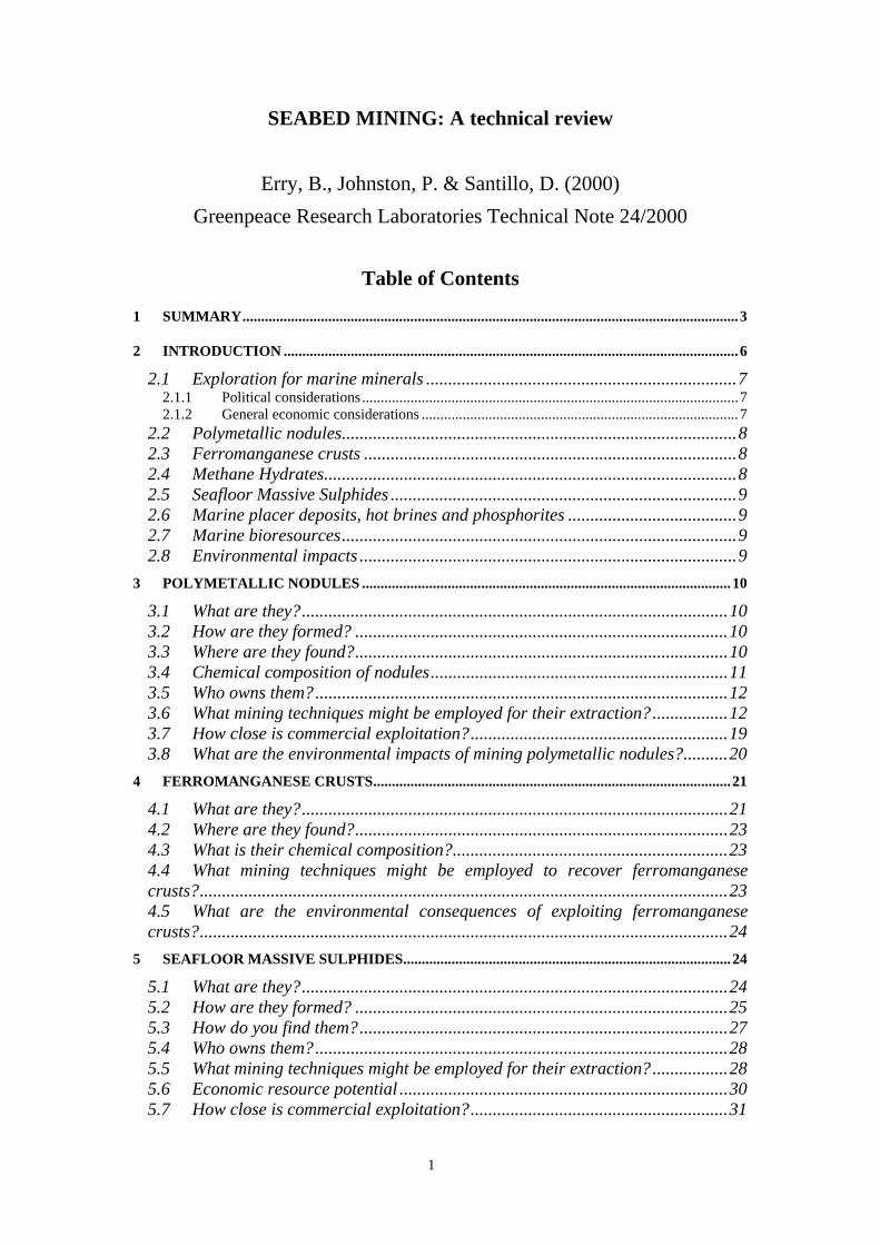
Plate tectonic theory caused geologists to move focus from the continental land masses to the oceans. It showed that the Earth’s outermost layer, the lithosphere (which is about 100 km thick), is segmented into some 10 major, and numerous minor, plates. The boundaries between plates are areas of high earthquake activity. Earthquakes are induced by the movement of plates, and occur predominantly below the ocean. Spreading centres occur in the centre of oceans as a long chain of submerged
Fig 1: Map of the ocean floor showing its age. The areas outlined in red refer to the extended legal continental shelf (Murton et al. 2000)
volcanic mountain ranges that extend more or less continuously through all the ocean basins of the world. Molten rocks (magma) upwell from the Earth’s interior beneath this submerged mountain chain, cool, congeal and construct the lithosphere which spreads apart to either side of the chain forming two diverging conveyor belts of new lithosphere (Figs 1 & 2). The rate at which this spreading occurs varies spatially around the planet, but at fast spreading centres can amount to new seafloor being produced at a rate of > 20 cm yr-1 (Fig 1) (Rona 2000).
0
Age map for oceanic crust based on magnetic anomalies (in Ma).
20 40 60 80 100 120 140Continental basement
7
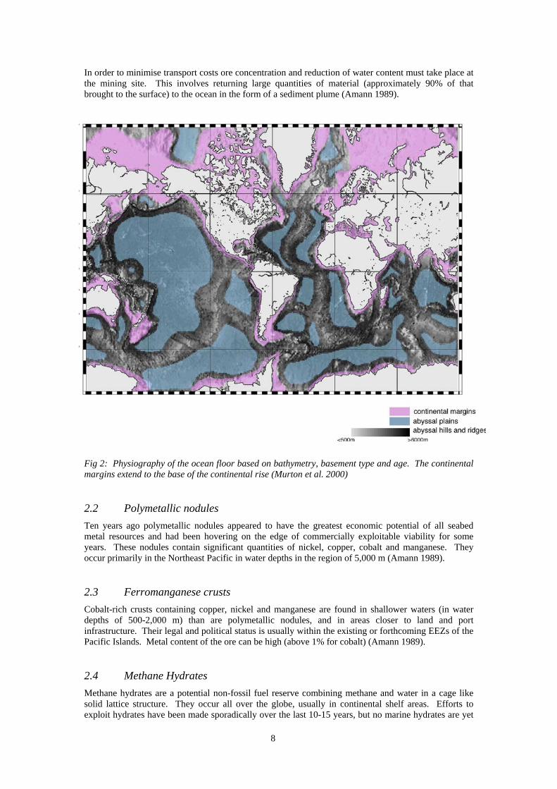
As a consequence of knowledge gained since the theory of plate tectonics was first put forward, ocean basins are no longer considered as passive sinks for materials washed from land, but as active sources of heat and materials that create marine mineral resources. The formation of marine metal deposits is now viewed as a product of both continental sources external to the ocean and of sources at submerged plate boundaries internal to the ocean (Rona 2000). The plate boundary at submerged volcanic mountain ranges constitutes a global system of exchange of heat and materials from the Earth’s interior to the lithosphere and into the ocean in amounts that impact on the ocean environment and contribute to global change. Hydrothermal mineral deposits and geothermal energy are byproducts of this system. The ocean basin is no longer regarded as a passive sink for material washed into it from land, but as an active source of heat and materials (Rona 2000).
A number of international projects were initiated during the 1970s and 1980s covering exploration, research and development into the recovery of minerals from the deep seabed. In theory the reserves are vast, and the technical skills required to mine these reserves are available. However the economics of ocean mining (as of most new land mining projects) are questionable while metal prices are low and overheads (energy, transport, manpower) are high (Amann 1989). It is for this reason that seabed mining has, even some thirty years later, not yet become a commercial reality for the majority of deposit types, although there are some developments which suggest that seabed mining of marine massive sulphides might begin within the next ten years.
2.1 Exploration for marine minerals
2.1.1 Political considerations
Exploration for marine minerals is a costly exercise. As a result the majority of research and exploration has been undertaken by the richer industrial nations of the United States, Europe and Japan (Glasby 1982). A number of these industrialised countries (although not all) are net importers of minerals and in the past it has been suggested that a fundamental commercial reason existed for entering into marine minerals prospecting i.e. to locate reserves outside national jurisdiction and, therefore, outside the control of cartels and political pressure (Glasby 1982).
The ownership of seabed mineral resources at a time of extensive minerals prospecting could have been the cause of intense international disagreement. But the long delay between initial prospecting in the 1960s and 1970s and any mining actually taking place has allowed rules to be put in place in advance. Under the United Nations Convention on the Law of the Sea (UNCLOS), seabed outside the jurisdiction of national governments (usually outside the 200 mile EEZ) is regarded as ‘the common heritage of mankind’.
The ISA is an autonomous international organization established under the 1982 UNCLOS and the 1994 Agreement relating to the Implementation of Part XI of the UNCLOS. The Authority is the organization through which States Parties to the Convention organize and control activities in the international seabed area, particularly with a view to administering its resources. The Authority came into existence on 16 November 1994, on the entry into force of the 1982 Convention. The first Secretary-General of the Authority, Satya Nandan (Fiji) was elected in March 1996, and the Authority became fully operational as an autonomous international organization in June 1996, when it took over the premises and facilities in Kingston, Jamaica previously used by the United Nations Kingston Office for the Law of the Sea.
2.1.2 General economic considerations
Polymetallic nodules, cobalt-rich crusts, mineral placers and polymetallic sulphides all occur at different depths and contain differing metals. Ore metal content is also variable. The way in which these deposits occur is also very different one from the other. Whereas polymetallic nodules are small potato sized lumps of mineral lying, generally, on otherwise flattish, sediment covered seabed, cobalt-rich crusts comprise a relatively thin (5-15 cm) coating over the seabed substrate, and sulphides occur as lens-shaped intrusions in the seabed substrate or as chimneys or vents (Clark & Li 1991). Given these very different physical characteristics it might be expected that the costs of extraction are also very different, whereas in fact any extraction of these deposits depends, to a large extent, on transport costs (Amann 1989).
8
In order to minimise transport costs ore concentration and reduction of water content must take place at the mining site. This involves returning large quantities of material (approximately 90% of that brought to the surface) to the ocean in the form of a sediment plume (Amann 1989).
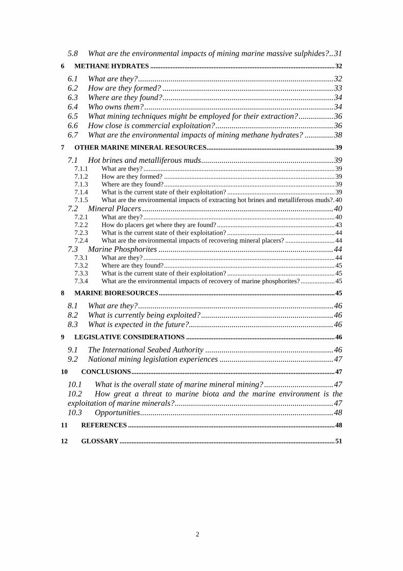
Fig 2: Physiography of the ocean floor based on bathymetry, basement type and age. The continental margins extend to the base of the continental rise (Murton et al. 2000)
2.2 Polymetallic nodules
Ten years ago polymetallic nodules appeared to have the greatest economic potential of all seabed metal resources and had been hovering on the edge of commercially exploitable viability for some years. These nodules contain significant quantities of nickel, copper, cobalt and manganese. They occur primarily in the Northeast Pacific in water depths in the region of 5,000 m (Amann 1989).
2.3 Ferromanganese crusts
Cobalt-rich crusts containing copper, nickel and manganese are found in shallower waters (in water depths of 500-2,000 m) than are polymetallic nodules, and in areas closer to land and port infrastructure. Their legal and political status is usually within the existing or forthcoming EEZs of the Pacific Islands. Metal content of the ore can be high (above 1% for cobalt) (Amann 1989).
2.4 Methane Hydrates
Methane hydrates are a potential non-fossil fuel reserve combining methane and water in a cage like solid lattice structure. They occur all over the globe, usually in continental shelf areas. Efforts to exploit hydrates have been made sporadically over the last 10-15 years, but no marine hydrates are yet
9
being exploited. Fears remain that a massive release, and subsequent injection, of methane (a potent greenhouse gas) into the atmosphere could occur through uncontrolled dissociation of methane hydrate.
2.5 Seafloor Massive Sulphides
Seafloor massive sulphide deposits containing copper, zinc and silver occur along spreading centres at the edges of tectonic plates in connection with submarine volcanism, seafloor spreading and rifting. Water depth of these deposits is typically 2,000-3,000 m. The contents of valuable metals tends to be variable and in small quantities (Amann 1989). It has recently become clear that, contrary to original thinking on seabed mining issues, it is massive sulphide deposits that may be the first to be exploited commercially rather than polymetallic nodules.
2.6 Marine placer deposits, hot brines and phosphorites
Marine placer deposits are currently the only form of marine mineral deposit in commercial production. Tin placers off Thailand and Indonesia are being exploited, but more importantly in commercial terms is the mining of marine placer diamonds by De Beers Marine off the west coast of Namibia.
Metalliferous muds containing zinc, copper, silver and gold have only so far been discovered in the Red Sea in association with hot brine metal deposits (Amann 1989). The physical geological conditions which have caused their occurrence are particular to the Red Sea environment and it is not thought that similar deposits will be discovered elsewhere.
Phosphorite deposits occur, mainly in the form of nodules of P2O5, in sedimentary layers, and have been found off New Zealand (Chatham Rise) and Mexico (Isla de Cedros). They occur in shallow to medium deep waters (50-500 m) (Amann 1989). At present the cheap availability of phosphates from terrestrial deposits, and the small unit value of phosphates make their exploitation unlikely in the foreseeable future.
Sand and gravel extraction from the sea has been taking place for over 100 years and constitutes the oldest marine placer mining operation.
2.7 Marine bioresources
The oceans cover more than 70% of the earth’s surface and represent more than 95% of the biosphere.
Marine organisms are already of great economic importance. Apart from fisheries, which represent the longest-lived exploitation of marine bioresources by man, marine organisms are instrumental as a source (or in the production) of a range of chemicals. Phyco-colloids (primarily agar and agarose) are essential for the relatively new science of molecular biology and for microbiology and plant tissue culture (Borowitzka 1995).
2.8 Environmental impacts
The deep sea is the largest and probably the least understood environment on earth. Less than 1% of the area 4,000 m or more below sea level has been investigated during more than 130 years of deep sea research. The seabed is remote and difficult to observe and sample. As a result, knowledge of the ecology and ecosystem dynamics of the deep seabed is poor. Mining the seabed may result in the disruption of ecosystems and species of which we are as yet unaware.
The potential environmental impacts of deep seabed mining are, however, becoming better defined. A considerable period of time has elapsed since the prospect of mining nodules was first promulgated and during this period researchers have undertaken some work on the environmental impacts of mining nodules.
Benthos biology should be protected. Disposal of tailings in a controlled way is particularly important if the benthic biota are to remain uncompromised. Surface disposal of tailings is largely unconsidered as it would hamper the growth of plankton which migrate between 200 and 500 m water depth. But disposal of tailings, even at depth, cannot but disturb benthic organisms, primarily through burial.
10
3 P O L Y M E T A L L I C N O D U L E S
In 1965 John Mero published his book ‘The Mineral Resources of the Sea’ (Mero 1965). Since then manganese nodules have been the quintessential deep ocean mineral. Mero’s estimates of the in situ value of these nodules (which did not account for the cost of their location, extraction and refining) created a gold rush mentality about marine minerals that contributed to the development of the UNCLOS.
3.1 What are they?
Polymetallic nodules are small, potato sized (from millimetres to tens of centimetres in diameter), lumps of material precipitated from seawater and sediment pore water at slow rates over millions of years. They lie on top of a layer of sediment as discrete concretions with abundances varying from <1-10 kg m-2 (Murton et al. 2000). Manganese nodules were first dredged during the HMS Challenger expedition in the Pacific Ocean in 1872-76 (Murton et al. 2000). The nodules consist predominantly of very fine grained amorphous hydrated manganese and iron oxide minerals with variable amounts of silica, carbonate and detrital and biological materials. The major mineral phases of iron and manganese oxides control the uptake and retention in the nodules of minor elements such as nickel, copper, cobalt, molybdenum, platinum and rare earth elements, which may, nonetheless, be present in commercially valuable concentrations. Identification of specific mineral phases is difficult because of the intimate intergrowth of the different mineral phases and associated detrital material. Of the large number of complex hydrous manganese oxide mineral phases identified in nodules todorokite and birnessite are the most common (Murton et al. 2000).
3.2 How are they formed?
The manner in which these nodules are formed has not yet been determined conclusively, although a number of models have been proposed. The simplest model theorises that organic remains, including faecal material containing metals extracted from surface waters in the region of high biological productivity, sink towards the ocean floor. Although some of this material dissolves as it sinks, siliceous remains, some faecal material and probably a portion of gelatinous organic material reach the ocean floor. The decay of the organic material results in chemical reactions in the topmost sediments which liberate manganese, nickel and copper and result in the formation of todorokite-rich nodules which become rich in those minerals. Surprisingly it does not appear to be high metal concentrations which drive these reactions, rather the excess of organic carbon which, while decaying, drives the chemical reaction leading to metal enrichment (Cronan et al. 1991). The portion of the nodule that protrudes above the surface of the seafloor sediment is precipitated from metals dissolved in seawater (authigenic or hydrogenous origin), while the underside of the nodule accumulates from metals dissolved in the pore water of the sediment (diagenetic origin) (Rona 2000). The metals come from two sources. Manganese and other metals are dissolved by weathering of continental rocks and are then transported into the ocean by rivers. At the same time hot springs at sites along submerged volcanic mountain chains (divergent plate boundaries) discharge dissolved metals into the ocean. The result is a mixture of copper, nickel, manganese, cobalt and iron in the nodules that varies in composition in different regions of the ocean as a factor of proximity to sources of the metals (Rona 2000).
3.3 Where are they found?
Polymetallic nodules are found in the abyssal areas of the oceans basins of the world. The currently known distribution of manganese nodules (and ferromanganese crusts: See Section 4) on the ocean floor (Fig 3) is based on information acquired by sidescan sonar, drill cores, dredged samples, seafloor photos, video camera records and direct observation from submersibles. The most recent information on locations, their compositions and abundance has been compiled by the USGS, NOAA and US Mineral Management Service (Murton et al. 2000). The most extensive nodule fields are on oceanic crust that is Mesozoic or younger in age. At present, nodules are forming at a slow rate of one to a few tens of millimetres per million years. Their formation appears to be related to active tectonic belts such as spreading ridges and deep-ocean trenches. They are found chiefly below the carbonate
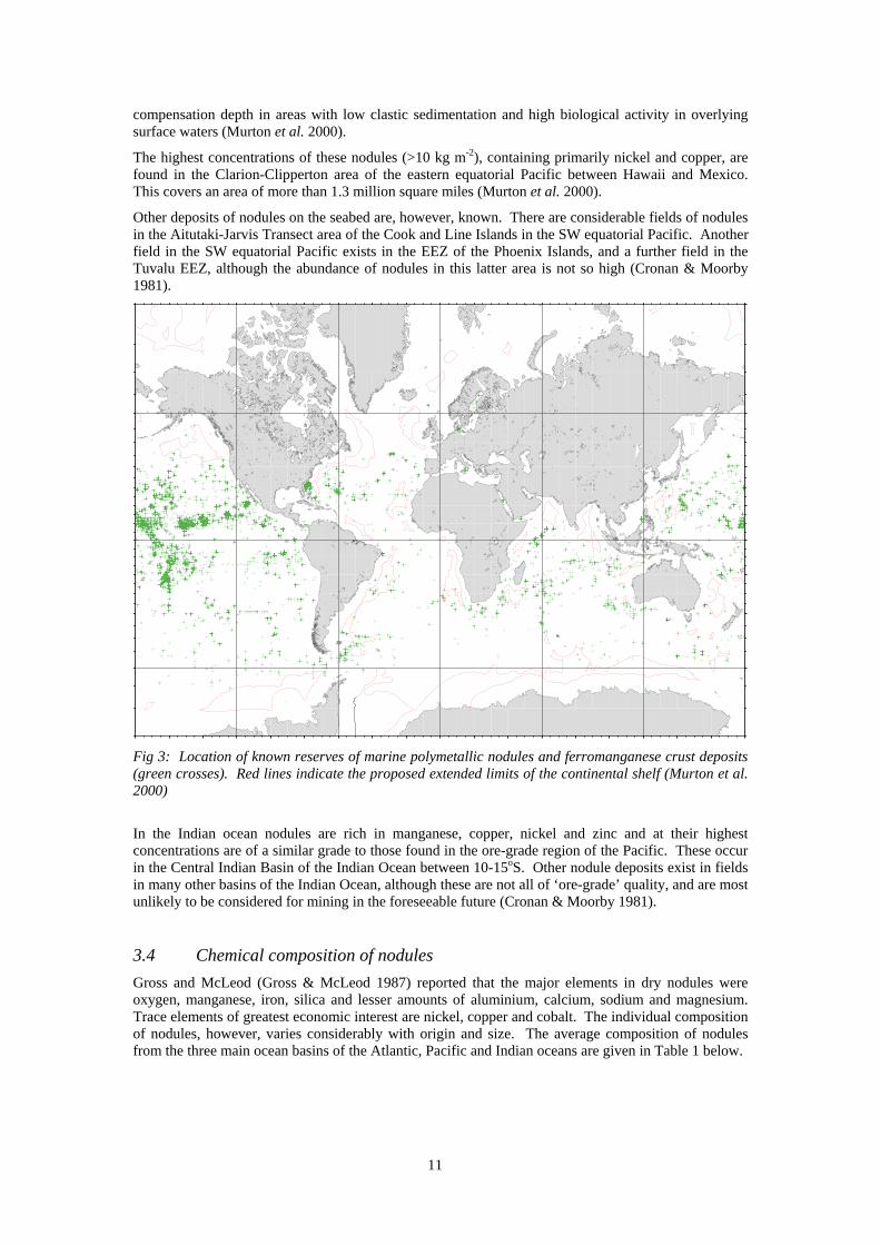
11
compensation depth in areas with low clastic sedimentation and high biological activity in overlying surface waters (Murton et al. 2000).
The highest concentrations of these nodules (>10 kg m-2), containing primarily nickel and copper, are found in the Clarion-Clipperton area of the eastern equatorial Pacific between Hawaii and Mexico. This covers an area of more than 1.3 million square miles (Murton et al. 2000).
Other deposits of nodules on the seabed are, however, known. There are considerable fields of nodules in the Aitutaki-Jarvis Transect area of the Cook and Line Islands in the SW equatorial Pacific. Another field in the SW equatorial Pacific exists in the EEZ of the Phoenix Islands, and a further field in the Tuvalu EEZ, although the abundance of nodules in this latter area is not so high (Cronan & Moorby 1981).
Fig 3: Location of known reserves of marine polymetallic nodules and ferromanganese crust deposits (green crosses). Red lines indicate the proposed extended limits of the continental shelf (Murton et al. 2000)
In the Indian ocean nodules are rich in manganese, copper, nickel and zinc and at their highest concentrations are of a similar grade to those found in the ore-grade region of the Pacific. These occur in the Central Indian Basin of the Indian Ocean between 10-15oS. Other nodule deposits exist in fields in many other basins of the Indian Ocean, although these are not all of ‘ore-grade’ quality, and are most unlikely to be considered for mining in the foreseeable future (Cronan & Moorby 1981).
3.4 Chemical composition of nodules
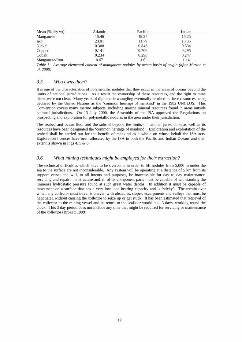
Gross and McLeod (Gross & McLeod 1987) reported that the major elements in dry nodules were oxygen, manganese, iron, silica and lesser amounts of aluminium, calcium, sodium and magnesium. Trace elements of greatest economic interest are nickel, copper and cobalt. The individual composition of nodules, however, varies considerably with origin and size. The average composition of nodules from the three main ocean basins of the Atlantic, Pacific and Indian oceans are given in Table 1 below.
12
Mean (% dry wt) Atlantic Pacific Indian Manganese 15.46 19.27 15.25 Iron 23.01 11.79 13.35 Nickel 0.308 0.846 0.534 Copper 0.141 0.706 0.295 Cobalt 0.234 0.290 0.247 Manganese/Iron 0.67 1.6 1.14 Table 1: Average elemental content of manganese nodules by ocean basin of origin (after Murton et al. 2000)
3.5 Who owns them?
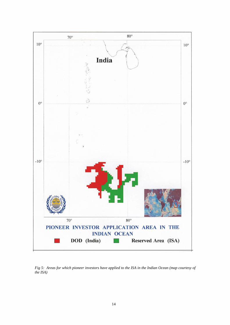
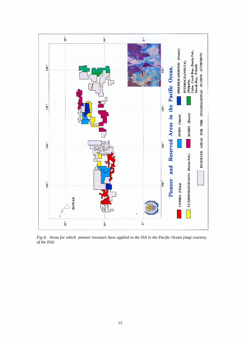
It is one of the characteristics of polymetallic nodules that they occur in the areas of oceans beyond the limits of national jurisdictions. As a result the ownership of these resources, and the right to mine them, were not clear. Many years of diplomatic wrangling eventually resulted in these resources being declared by the United Nations as the ‘common heritage of mankind’ in the 1982 UNCLOS. This Convention covers many marine subjects, including marine mineral resources found in areas outside national jurisdictions. On 13 July 2000, the Assembly of the ISA approved the Regulations on prospecting and exploration for polymetallic nodules in the area under their jurisdiction.
The seabed and ocean floor and the subsoil beyond the limits of national jurisdiction as well as its resources have been designated the ‘common heritage of mankind’. Exploration and exploitation of the seabed shall be carried out for the benefit of mankind as a whole on whose behalf the ISA acts. Exploration licences have been allocated by the ISA in both the Pacific and Indian Oceans and their extent is shown in Figs 4, 5 & 6.
3.6 What mining techniques might be employed for their extraction?
The technical difficulties which have to be overcome in order to lift nodules from 5,000 m under the sea to the surface are not inconsiderable. Any system will be operating at a distance of 5 km from its support vessel and will, to all intents and purposes, be inaccessible for day to day maintenance, servicing and repair. Its structure and all of its component parts must be capable of withstanding the immense hydrostatic pressure found at such great water depths. In addition it must be capable of movement on a surface that has a very low load bearing capacity and is ‘sticky’. The terrain over which any collector must travel is uneven with obstacles, slopes, escarpments and valleys that must be negotiated without causing the collector to seize up or get stuck. It has been estimated that retrieval of the collector to the mining vessel and its return to the seafloor would take 3 days, working round the clock. This 3 day period does not include any time that might be required for servicing or maintenance of the collector (Brokett 1999).
13
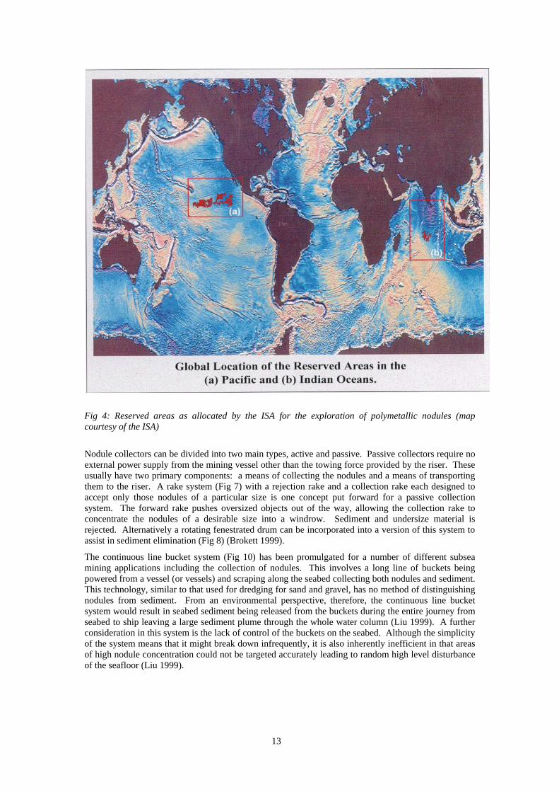
Fig 4: Reserved areas as allocated by the ISA for the exploration of polymetallic nodules (map courtesy of the ISA)
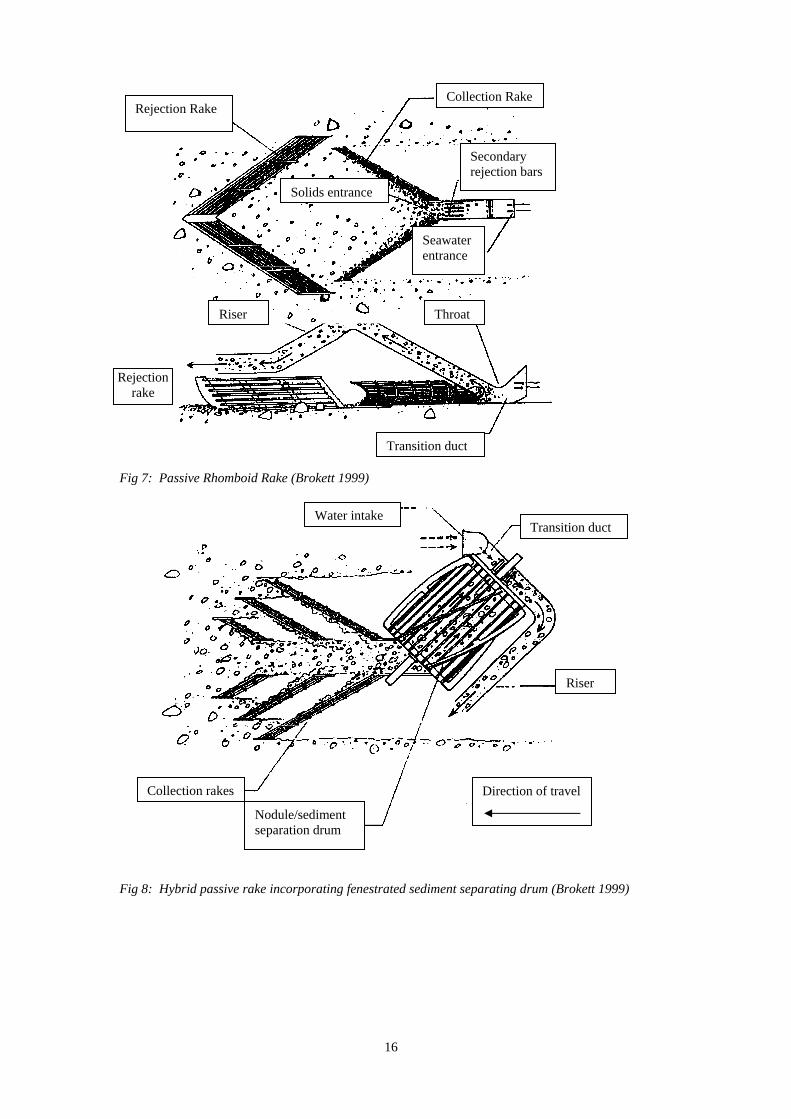
Nodule collectors can be divided into two main types, active and passive. Passive collectors require no external power supply from the mining vessel other than the towing force provided by the riser. These usually have two primary components: a means of collecting the nodules and a means of transporting them to the riser. A rake system (Fig 7) with a rejection rake and a collection rake each designed to accept only those nodules of a particular size is one concept put forward for a passive collection system. The forward rake pushes oversized objects out of the way, allowing the collection rake to concentrate the nodules of a desirable size into a windrow. Sediment and undersize material is rejected. Alternatively a rotating fenestrated drum can be incorporated into a version of this system to assist in sediment elimination (Fig 8) (Brokett 1999).
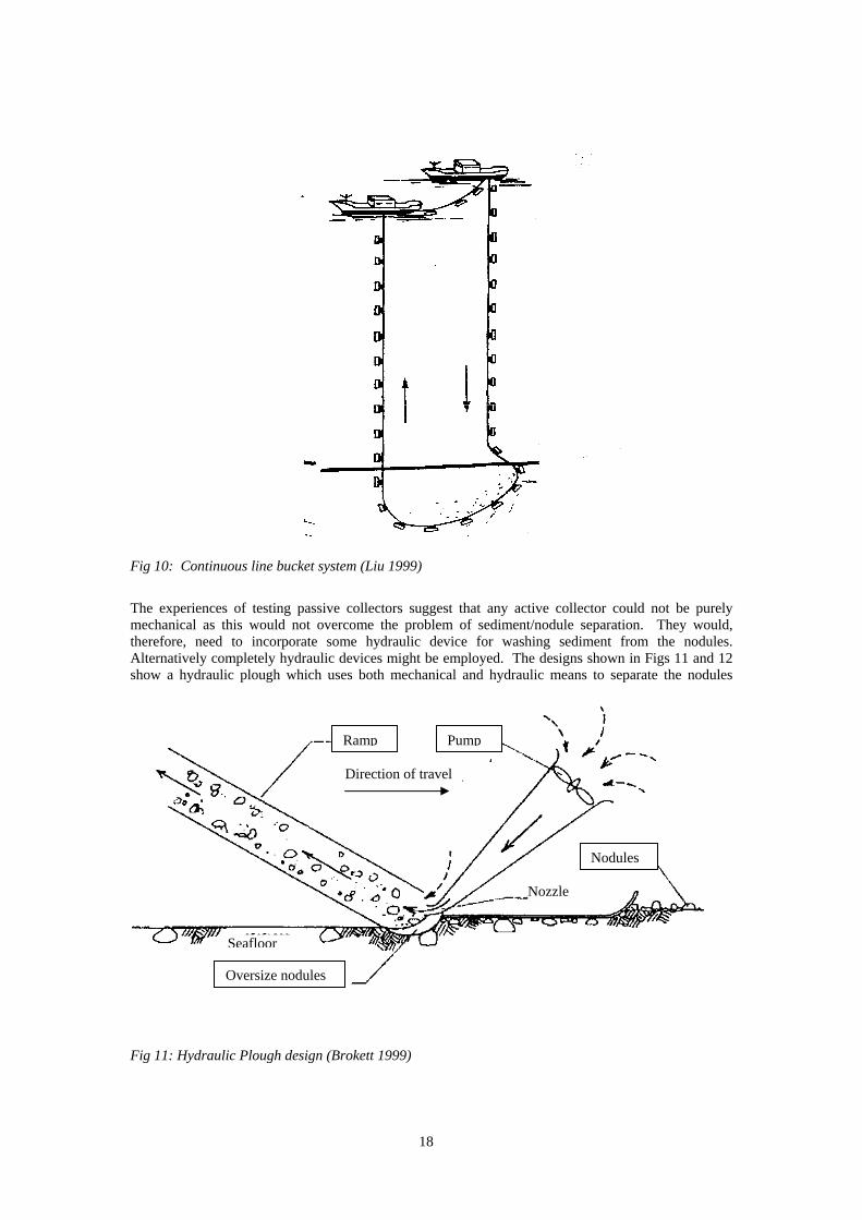
The continuous line bucket system (Fig 10) has been promulgated for a number of different subsea mining applications including the collection of nodules. This involves a long line of buckets being powered from a vessel (or vessels) and scraping along the seabed collecting both nodules and sediment. This technology, similar to that used for dredging for sand and gravel, has no method of distinguishing nodules from sediment. From an environmental perspective, therefore, the continuous line bucket system would result in seabed sediment being released from the buckets during the entire journey from seabed to ship leaving a large sediment plume through the whole water column (Liu 1999). A further consideration in this system is the lack of control of the buckets on the seabed. Although the simplicity of the system means that it might break down infrequently, it is also inherently inefficient in that areas of high nodule concentration could not be targeted accurately leading to random high level disturbance of the seafloor (Liu 1999).
14
Fig 5: Areas for which pioneer investors have applied to the ISA in the Indian Ocean (map courtesy of the ISA)
15
Fig 6: Areas for which pioneer investors have applied to the ISA in the Pacific Ocean (map courtesy of the ISA)
16
Fig 7: Passive Rhomboid Rake (Brokett 1999)
Fig 8: Hybrid passive rake incorporating fenestrated sediment separating drum (Brokett 1999)
Collection RakeRejection Rake
Seawater entrance
Secondary rejection bars
Solids entrance
Riser Throat
Transition duct
Rejection rake
Water intakeTransition duct
Riser
Collection rakes
Nodule/sediment separation drum
Direction of travel

17
Fig 9: Passive inverted plough (after Brokett 1999)
Other passive designs have also been formulated, including the passive inverted plough shown in Fig 9. This operates slightly differently from the other passive devices so far described in that a large base plate effectively pushes the nodules down into the sediment before the plough skims off a layer of sediment and nodules. The sediment is then forced out of the fenestrations before the nodules enter an inlet aperture and subsequently the riser (Brokett 1999).
Although passive collectors may have a simple, reliable design, experience has shown that those tested so far have been unable to separate sediment and nodules effectively leading to excess sediment entering the riser. The stickiness of the sediment had a further effect in forming a bow wave in front of the collector lowering its efficiency (Brokett 1999).
Active collectors require an external power source, whether it be for propulsion or for nodule collection. Active collectors can be further sub-divided by the technology used for lifting nodules. This can be mechanical, hydraulic or a combination of both (a hybrid) (Brokett 1999).
B B
A A
Body Orifice Flow Blade
Direction of Travel Fenestrations
Section AA
Section BB
Riser
Inlet orifice
18
Fig 10: Continuous line bucket system (Liu 1999)
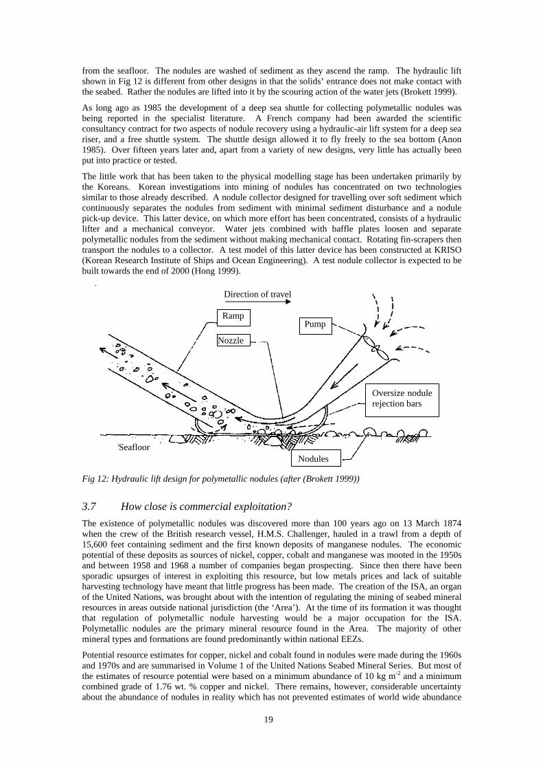
The experiences of testing passive collectors suggest that any active collector could not be purely mechanical as this would not overcome the problem of sediment/nodule separation. They would, therefore, need to incorporate some hydraulic device for washing sediment from the nodules. Alternatively completely hydraulic devices might be employed. The designs shown in Figs 11 and 12 show a hydraulic plough which uses both mechanical and hydraulic means to separate the nodules
Fig 11: Hydraulic Plough design (Brokett 1999)
Ramp Pump
Nodules
Oversize nodules
Direction of travel
Seafloor
Nozzle
19
from the seafloor. The nodules are washed of sediment as they ascend the ramp. The hydraulic lift shown in Fig 12 is different from other designs in that the solids’ entrance does not make contact with the seabed. Rather the nodules are lifted into it by the scouring action of the water jets (Brokett 1999).
As long ago as 1985 the development of a deep sea shuttle for collecting polymetallic nodules was being reported in the specialist literature. A French company had been awarded the scientific consultancy contract for two aspects of nodule recovery using a hydraulic-air lift system for a deep sea riser, and a free shuttle system. The shuttle design allowed it to fly freely to the sea bottom (Anon 1985). Over fifteen years later and, apart from a variety of new designs, very little has actually been put into practice or tested.
The little work that has been taken to the physical modelling stage has been undertaken primarily by the Koreans. Korean investigations into mining of nodules has concentrated on two technologies similar to those already described. A nodule collector designed for travelling over soft sediment which continuously separates the nodules from sediment with minimal sediment disturbance and a nodule pick-up device. This latter device, on which more effort has been concentrated, consists of a hydraulic lifter and a mechanical conveyor. Water jets combined with baffle plates loosen and separate polymetallic nodules from the sediment without making mechanical contact. Rotating fin-scrapers then transport the nodules to a collector. A test model of this latter device has been constructed at KRISO (Korean Research Institute of Ships and Ocean Engineering). A test nodule collector is expected to be built towards the end of 2000 (Hong 1999).
Fig 12: Hydraulic lift design for polymetallic nodules (after (Brokett 1999))
3.7 How close is commercial exploitation?
The existence of polymetallic nodules was discovered more than 100 years ago on 13 March 1874 when the crew of the British research vessel, H.M.S. Challenger, hauled in a trawl from a depth of 15,600 feet containing sediment and the first known deposits of manganese nodules. The economic potential of these deposits as sources of nickel, copper, cobalt and manganese was mooted in the 1950s and between 1958 and 1968 a number of companies began prospecting. Since then there have been sporadic upsurges of interest in exploiting this resource, but low metals prices and lack of suitable harvesting technology have meant that little progress has been made. The creation of the ISA, an organ of the United Nations, was brought about with the intention of regulating the mining of seabed mineral resources in areas outside national jurisdiction (the ‘Area’). At the time of its formation it was thought that regulation of polymetallic nodule harvesting would be a major occupation for the ISA. Polymetallic nodules are the primary mineral resource found in the Area. The majority of other mineral types and formations are found predominantly within national EEZs.
Potential resource estimates for copper, nickel and cobalt found in nodules were made during the 1960s and 1970s and are summarised in Volume 1 of the United Nations Seabed Mineral Series. But most of the estimates of resource potential were based on a minimum abundance of 10 kg m-2 and a minimum combined grade of 1.76 wt. % copper and nickel. There remains, however, considerable uncertainty about the abundance of nodules in reality which has not prevented estimates of world wide abundance
Direction of travel
Ramp
Nozzle
Seafloor Nodules
Oversize nodule rejection bars
Pump
20
being calculated from 14–99 billion tonnes (Murton et al. 2000). Accepting the uncertainties and limitations of resource estimates Murton et al. (2000) calculated the resources held by various countries in the form of manganese nodules (including ferromanganese crusts – see Section 4 below). The 10 countries with the highest average grades of nodules and crusts (in tonnes per km2) are: the Philippines, Japan and Guam (~ 2,000); the USA (~ 1,500); Madagascar, Mozambique, Argentina, Fiji (~ 1,000); and South Africa (~900). The Yemen, Pakistan and Oman all have approximately 75 tonnes per km2.
3.8 What are the environmental impacts of mining polymetallic nodules?
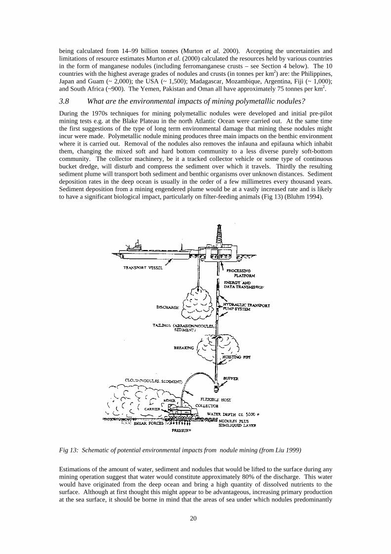
During the 1970s techniques for mining polymetallic nodules were developed and initial pre-pilot mining tests e.g. at the Blake Plateau in the north Atlantic Ocean were carried out. At the same time the first suggestions of the type of long term environmental damage that mining these nodules might incur were made. Polymetallic nodule mining produces three main impacts on the benthic environment where it is carried out. Removal of the nodules also removes the infauna and epifauna which inhabit them, changing the mixed soft and hard bottom community to a less diverse purely soft-bottom community. The collector machinery, be it a tracked collector vehicle or some type of continuous bucket dredge, will disturb and compress the sediment over which it travels. Thirdly the resulting sediment plume will transport both sediment and benthic organisms over unknown distances. Sediment deposition rates in the deep ocean is usually in the order of a few millimetres every thousand years. Sediment deposition from a mining engendered plume would be at a vastly increased rate and is likely to have a significant biological impact, particularly on filter-feeding animals (Fig 13) (Bluhm 1994).
Fig 13: Schematic of potential environmental impacts from nodule mining (from Liu 1999)
Estimations of the amount of water, sediment and nodules that would be lifted to the surface during any mining operation suggest that water would constitute approximately 80% of the discharge. This water would have originated from the deep ocean and bring a high quantity of dissolved nutrients to the surface. Although at first thought this might appear to be advantageous, increasing primary production at the sea surface, it should be borne in mind that the areas of sea under which nodules predominantly
21
lie are oligotrophic (i.e. low nutrient) systems which could be destroyed by such a disturbance (Anon 1998). Very few authors, however, suggest that surface disposal of tailings would be acceptable practice. Most are of the opinion that tailings should be disposed of below the euphotic zone.
The megabenthic communities of polymetallic nodule sites in the Pacific (the area so far best categorised) comprise animals from hard and soft-bottom communities. The nodules are the main hard substrate for these animals, which do not tend to congregate on the other available hard surfaces (sparsely scattered rock and whale bones). The nodule epifauna are primarily from the taxa Porifera (sponges), Crinoidea (feather stars and sea lilies), Gorgonaria (sea fans and horny corals) and Antiphatharia (black corals). In turn these animals are themselves colonised by members of the taxa Gorgonaria, Porifera, Cirripedia (barnacles), Amphipoda (water lice), Isopoda (crustaceans with dorso-ventrally compressed bodies and no carapace), and Ophiuroidea (brittle stars). Other epifaunal nodule taxa include the Serpulidae (tube worms), Brachiopoda (lamp shells), Actiniaria (sea anemones), Corallimorpharia (anemone-like polyps lacking a skeleton) and Ascidiacea (sea squirts). The soft-bottom taxa consist primarily of members of the Holothuroidea (sea cucumbers), Echinoidea (sea urchins), Asteroidea (star fish), Ophiouroidea and Crustacea (crabs, lobsters and shrimps) (Bluhm 1994). These large taxa demonstrate the high biodiversity which exists at polymetallic nodule sites, with an extraordinary species richness which is highest on the nodules themselves.
The density of marine life found in polymetallic nodule fields varies with the density and size of the nodules themselves. A shift in megabenthic community structure towards higher densities of soft-bottom taxa in large-scale topographically diverse areas has been noted. Calculations of the number of individuals present per unit area suggest that there are in the order of 1-1.6 million animals per km2 (Bluhm 1994). An increase in the total numerical abundance and biomass of the megabenthos occurs travelling from west to east in the Clarion-Clipperton Fracture Zone (CCFZ). It is possible that this comes about as a result of higher food density in areas closer to the continental shelves, allowing higher density colonisation by megabenthic organisms (Bluhm 1994).
Efforts to determine how marine mining would affect these benthic communities have been made. The first long-term, large-scale experiment (named DISCOL after ~DISturbance and reCOLonisation~) was undertaken in 1989 in the tropical southeastern Pacific. The idea of the experiment was to mimic the impact of commercial mining of polymetallic nodules and through this to achieve a better understanding of the rate, sequence and direction of benthic community re-establishment after a severe anthropogenic disturbance (Bluhm et al. 1995). Three years after the disturbance was created in the test area the animal community consisted predominantly of highly motile scavenging animals with low taxonomic diversity. The hard bottom taxa could not recolonise because of lack of suitable substrate (the nodules themselves). As the polymetallic nodules grow only very slowly over many thousands of years recovery of the original biodiversity of the nodule fields could not be expected to occur until the nodules themselves reformed.
4 F E R R O M A N G A N E S E C R U S T S
4.1 What are they?
Ferromanganese crusts are similar in composition to polymetallic nodules, but instead of forming discrete lumps usually resting on sediment in extremely deep water, the ferromanganese crusts occur as sheets varying in thickness from millimetres to about 25 centimetres in water depths from 400-4,000 m with the thickest crust developing in water depths from 800-2,500 m (Halbach et al. 1989, Hein 2000, Murton et al. 2000). They are deposited on sand grains, pebbles, rock fragments and bedrock, or blanket unconsolidated sediments. They occur as coatings or incrustations on hard rock surfaces, on seamounts and the submerged portions of islands and can be enriched in cobalt by up to 2% (Hein 2000, Murton et al. 2000). Gravity processes, sediment cover, submerged and emergent reefs and currents control the distribution and thickness of crusts. In cross section crusts are generally layered, much as are nodules, with characteristic regional similarities. Cobalt, nickel, titanium and platinum decrease and iron/manganese, silicon and aluminium increase in continental margin crusts and in crusts with proximity to western Pacific volcanic arcs. Other elements such as copper and iron also increase in concentration with water depth (Hein 2000). The seamounts on which they occur most abundantly obstruct the flow of oceanic water masses, creating local currents with enhanced energy relative to their surroundings. The effects of these currents are greatest at the outer rim of the summit region of seamounts, which is where the thickest crusts are generally found (Fig 14) (Hein 2000).
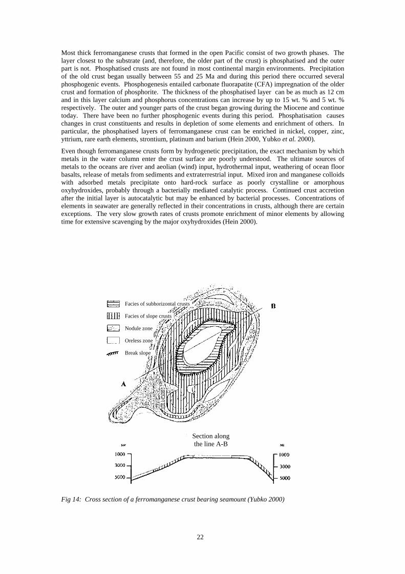
22
Most thick ferromanganese crusts that formed in the open Pacific consist of two growth phases. The layer closest to the substrate (and, therefore, the older part of the crust) is phosphatised and the outer part is not. Phosphatised crusts are not found in most continental margin environments. Precipitation of the old crust began usually between 55 and 25 Ma and during this period there occurred several phosphogenic events. Phosphogenesis entailed carbonate fluorapatite (CFA) impregnation of the older crust and formation of phosphorite. The thickness of the phosphatised layer can be as much as 12 cm and in this layer calcium and phosphorus concentrations can increase by up to 15 wt. % and 5 wt. % respectively. The outer and younger parts of the crust began growing during the Miocene and continue today. There have been no further phosphogenic events during this period. Phosphatisation causes changes in crust constituents and results in depletion of some elements and enrichment of others. In particular, the phosphatised layers of ferromanganese crust can be enriched in nickel, copper, zinc, yttrium, rare earth elements, strontium, platinum and barium (Hein 2000, Yubko et al. 2000).
Even though ferromanganese crusts form by hydrogenetic precipitation, the exact mechanism by which metals in the water column enter the crust surface are poorly understood. The ultimate sources of metals to the oceans are river and aeolian (wind) input, hydrothermal input, weathering of ocean floor basalts, release of metals from sediments and extraterrestrial input. Mixed iron and manganese colloids with adsorbed metals precipitate onto hard-rock surface as poorly crystalline or amorphous oxyhydroxides, probably through a bacterially mediated catalytic process. Continued crust accretion after the initial layer is autocatalytic but may be enhanced by bacterial processes. Concentrations of elements in seawater are generally reflected in their concentrations in crusts, although there are certain exceptions. The very slow growth rates of crusts promote enrichment of minor elements by allowing time for extensive scavenging by the major oxyhydroxides (Hein 2000).
Fig 14: Cross section of a ferromanganese crust bearing seamount (Yubko 2000)
Facies of subhorizontal crusts
Facies of slope crusts
Nodule zone
Oreless zone
Break slope
Section along the line A-B
23
4.2 Where are they found?
Ferromanganese crusts rich in cobalt are widely distributed on the slopes and summits of seamounts and islands in the equatorial Pacific, on the Blake Plateau in the northwest Atlantic and it is possible that they are associated with dense concentrations of polymetallic nodules in ocean basins (Fig 3). Crusts are, however, more difficult to determine using remotely sensed data than are nodules as they occur on a wide variety of substrate rocks making it difficult to distinguish crust from substrate. The distribution of the crusts appear to be controlled by:
Elevated biological activity and extraction of cobalt from seawater by organisms
Water depths less than 2,000 m in the vicinity of seamounts
Manganese enrichment at certain ocean depths related to zones of minimum oxygen
Low rates or an absence of turbidite sedimentation
The Marshall Islands, Johnston Islands (U.S. EEZ), Kiribati, the Federated States of Micronesia and French Polynesia are the Pacific Island areas with probably the greatest ferromanganese crust resource, but at present only the Marshall Islands have been studied in any detail (Hein 2000, Murton et al. 2000). Crusts have also been recovered from seamounts and ridges as far north as the Aleutian Trench in the Pacific and Iceland in the Atlantic. Their southerly extent reaches the circum-Antarctic Ridge. The Atlantic and Indian Oceans have fewer seamounts than the Pacific and as a consequence the majority of ferromanganese crusts are found in the Pacific. Less than 15 of the 50,000 or so seamounts in the Pacific have, however, been mapped or sampled in any detail and none of the larger ones, which can be comparable to continental mountain ranges in extent, have been studied (Hein 2000). Crusts are thickest on the oldest and most stable rocks because on these the crusts have had the requisite time for growth and have not been reworked by geological processes (Hein 2000).
The distribution of crusts on individual seamounts and ridges is poorly known. The thickest crusts tend to occur on summit outer-rim terraces and on broad saddles on the summits. In these areas the slope is usually quite steep, and appears to prevent excessive sedimentation. Although crusts are commonly covered by a thin sediment, which may be thicker in the central areas of the seamount summit and prevent crust formation, it is not known how much sediment can accumulate before the crusts cease to grow (Hein 2000, Yubko et al. 2000).
4.3 What is their chemical composition?
Ferromanganese crusts vary in composition from 15 – 31 wt. % manganese, 7 – 18 wt. % iron and have manganese/iron ratios ranging from 1.0 – 3.4. Generally the cobalt content of crusts is higher than is found in nodules, up to 2 wt. % in samples from seamount summit areas less than 1,500 m below sea level. The average cobalt percentage is, however, considerably lower at 0.8 wt. %. The crusts may also contain significant amounts of nickel, lead, cerium, molybdenum, vanadium and other metals including those in the platinum group of elements (Murton et al. 2000). Until the late 1970s crusts were not distinguished from polymetallic nodules and, if a distinction was made, crusts were called ‘seamount nodules’. But there are distinct differences between the two formations. Nodules form on small bits of rock, bone or old nodule fragments on the surface of sediments and derive some of their constituents from the sediments. In contrast crusts have no substrate input and are regarded as purely hydrogenetic in origin (Hein 2000).
4.4 What mining techniques might be employed to recover ferromanganese crusts?
The technology required for mining of ferromanganese crusts is much more complicated than would be required for the recovery of polymetallic nodules. Whereas nodules are discrete, small, entities which merely required lifting from a soft sediment, crusts are more or less firmly bonded to their substrate rock and would require breaking from it. They have a knobbly surface texture when in slow moving water, although the crusts that form on the summit edges of seamounts in faster currents may be smoother (Halbach et al. 1989) and this could have consequences for their ability to be broken up mechanically during the mining process. Any method which brought substrate to the surface along
24
with crust would result in much depleted ore grade. The mining of crusts would probably include at least five stages: fragmentation, crushing, lifting, pick-up and separation. (Hein 2000).
A number of different methods for implementation of these different stages have been suggested, although none have so far been built.
A bottom-crawling vehicle attached to a surface mining vessel by means of a hydraulic pipe lift system and an electrical umbilical. The mining machine is self propelled at about 20 cm s-1 and has articulated cutters that would allow crusts to be harvested while minimizing the amount of substrate collected. Suction dredges then move the fragmented material into a gravity separator before lifting to the mining vessel.
A continuous line bucket system could be used where crusts are only loosely attached to the substrate rock (Fig 10)
Water-jet stripping of crusts
In situ leaching techniques
Heavy duty rollers to crush crusts and separate them from the substrate
4.5 What are the environmental consequences of exploiting ferromanganese crusts?
Very little study has been concentrated on the biological communities that inhabit the seamounts where ferromanganese crusts occur most frequently. The seamount biota are themselves governed by physical processes which determine the localised currents around the seamount itself. Communities can vary from seamount to seamount, even when these are adjacent to one another. On bare rock the organisms consist mostly of attached (sessile) creatures which are characterised by relatively low density and low biodiversity. This is unsurprising given that the thickest crusts form in the oxygen minimum zone (OMZ). Above and below the OMZ greater numbers and a greater species diversity is present (Hein 2000).
With so little in the way of base-line knowledge of the communities that inhabit crust covered seamounts, it is difficult to determine what the impact of mining these crusts might be. It is clear, however, that collection of a crust from a single seamount would result in the complete destruction of any community inhabiting it. Similar problems also occur to those arising from the exploitation of polymetallic nodules in respect to the dispersal of a sediment plume from any mining vessel at the surface.
5 S E A F L O O R M A S S I V E S U L P H I D E S
Ocean basins are not particularly sound containers. They contain fractures that allow cold, heavy seawater to flow some kilometres downwards below the seafloor into the rocks of the Earth’s interior over much of an ocean basin. The further under the seabed the water travels, particularly in areas of high volcanic activity where magma exists close to the surface, the more the seawater is heated, expands and begins to rise. Heated water, which may reach temperatures above 400oC and is regularly heated to 350oC, is able to dissolve very much more material than is possible in its cold state (think of how much better sugar dissolves in a hot cup of tea than in a glass of cold water). This is particularly true for metals that are present at low concentrations in the rocks through which the seawater flows. These dissolved metals combine with sulphur from seawater and other sources to precipitate as metallic sulphide deposits beneath and on the seafloor. Any remaining high-temperature metal rich solution discharges at the seafloor and, as it hits the cold seawater, immediately precipitates the metallic sulphides to discharge the cloud of black particles that form ‘black smokers’ (Rona 2000).
5.1 What are they?
Seafloor Massive Sulphides (SMS), also known variously as polymetallic massive sulphides, volcanogenic massive sulphides (VMS) and marine massive sulphides, are deposited from seafloor hydrothermal vents (hot springs or black smokers) on submerged volcanic mountain ranges and are part of a global exchange system of heat and materials from the Earth’s interior to the lithospheric plates.
25
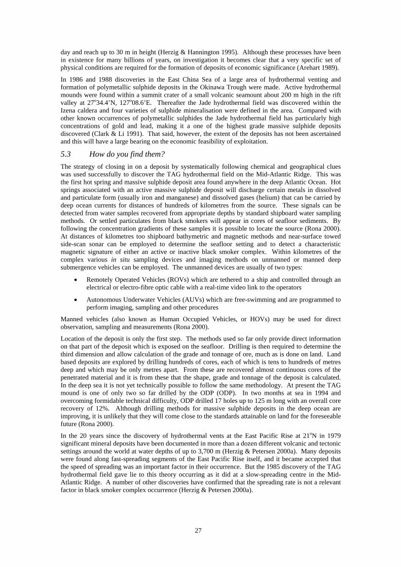
They do not, however, occur continuously along the axis of the mid-ocean mountain ranges but are highly localised at specific sites where conditions are right for their occurrence (Rona 2000). They are typically lenticular stratiform orebodies comprising more than 60% sulphide minerals (sometimes as high as 85%). The orebodies range in size from small pods a metre or less in width, to huge deposits containing several tens of millions of tons of material (Herzig & Hannington 1995, Arehart 1989). From a mineralogical standpoint the orebodies are quite simple, consisting mostly of pyrite, chalcopyrite and sphalerite, with variable amounts of pyrrhotite and magnetite, galena, sulfosalt minerals and, occasionally, gold. The orebodies are typically zoned from the base to the top with copper-rich followed by zinc-rich and lead-rich layers overlain by a sediment layer. Below the orebodies lies a pipe-like structure which is thought to be the fluid conduit (Figs 15 & 16) (Arehart 1989, Herzig & Petersen 2000a).
5.2 How are they formed?
Polymetallic mineral deposits on the seafloor are intimately related to the formation of new oceanic crust by seafloor spreading (Murton et al. 2000). Thermally driven seawater circulation in either mid-ocean ridges or back arc basins creates conditions favourable for the extraction, transportation and deposition of ore metals in the form of massive sulphide deposits. Downwelling of seawater marginal to the geothermal heat source results in the removal of Mg2+ and OH- into alteration minerals in basalt. The consequent generation of acid allows mobilisation of ore metals, primarily through complexation with chloride ions. The rapid adiabatic rise of low pH, low Eh metal-bearing solutions through permeable conduits and their eventual injection into the cooler, less acidic environment of ocean bottom seawater results in dramatically decreased stability of the chloride complexes and geologically instantaneous precipitation of metal sulphides (Yates et al. 1986, Arehart 1989, Herzig & Petersen 2000a). At temperatures above 350oC and depths in excess of 2,500 m black smoker chimneys are formed. Metal-rich hydrothermal fluids at temperatures up to 350oC have been sampled from black smokers on the East Pacific Rise. Sulphide-rich sediment from the precipitation of sulphides is present surrounding some of the vents (Arehart 1989). Lower temperature systems are also present. In the southern Lau Basin, for example, the first examples of actively forming, visible primary gold in seafloor sulphides were documented at ‘white smoker’ chimneys (Murton et al. 2000).
The physical parameters required for the formation of seafloor hydrothermal systems (hot rocks at depth beneath the seafloor as a heat source; seawater as the circulating fluid; and permeable pathways through the volcanic rocks that contain metals) are present on both sides of volcanic island chains: the front, or seaward facing side and the back, behind the volcanic islands. The conditions favourable for the formation of massive sulphide deposits are found in the calderas (collapsed centres) of seafloor volcanoes, and seafloor spreading centres in the back arc basins. These seafloor spreading centres are similar to, but generally much smaller than, those found in submerged volcanic mountain ranges at divergent plate boundaries. Examples of front and back side volcanic island chains are, respectively: the Sunrise deposit in the caldera of an active seafloor volcano in the forearc side of the Isu-Ogasawara Arc south of Japan and the PACMANUS hydrothermal field in the Manus back arc basin on the north side of Papua New Guinea. The latter field is currently under development for mining by the Nautilus Minerals Corporation of Australia (Rona 2000). A characteristic of these mineralised seafloor sites in the western Pacific is that they lie not only within the 200 mile EEZ of adjacent coastal states, but very often in overlapping EEZs (Rona 2000).
Massive sulphide deposits are known to have formed in a sub-sea environment at the ocean/rock interface. Several attempts have been made to classify these deposits based on their tectonic setting or their major metal contents. It is evident, however, that two general environments can be defined. These are delineated by their tectonic setting as the island-arc-associated type and the ophiolite-associated type. If delineated by their metal content, three types emerge: a zinc-copper-rich group, a zinc-lead rich group, and a copper-rich group (Arehart 1989).
Discoveries of extensive hydrothermal deposits at several mid-ocean ridge sites has allowed a greater insight into the formation processes of some of these volcanogenic massive sulphides. Small oceanic basins related to deep-ocean trenches are important sites for SMS mineralisation (Murton et al. 2000).
It is generally accepted that the hydrothermal fluid responsible for the generation of most massive sulphides is seawater, although there are indications that magmatic water may be important in certain deposits. Seawater contains most of the ions required for the formation of massive sulphides as well as minor concentrations of most other elements. The major rock type through which the hydrothermal
26
fluid must pass is basalt. The interaction between the seawater and the basalt rock is, therefore, important in determining the final composition of the hydrothermal fluid (Arehart 1989).
The mineralogy of seafloor sulphide deposits (Table 2) usually includes assemblages that formed at temperatures ranging from about 300-400oC to less than 150oC. High temperature fluid channels of black smokers and the interiors of sulphide mounds commonly consist of pyrite and chalcopyrite along with pyrrhotite, isocubanite and, locally, bornite. Black smoker chimneys are typically capable of ejecting approximately 250 tons of massive sulphide each year (Herzig & Hannington 1995). The outer parts of chimneys and mounds are commonly composed of lower temperature precipitates such as sphalerite or wurtzite, marcasite and pyrite which are also the principal components of low temperature white smoker chimneys (Herzig & Petersen 2000a). Sulphide mineralisation at back arc spreading centres is similar to that found at mid-ocean spreading centres. Commonly pyrite and sphalerite are the dominant sulphides. Many of the deposits that form in back arc rifts are characterised by a variety of minor and trace minerals such as galena, tennantite, tetrahedrite, cinnabar, realgar, orpiment and complex, non-stoichiometric lead-arsenic-antimony sulpho-salts (Herzig & Petersen 2000a).
Compounds Back arc deposits Mid-ocean ridge deposits Fe-sulphides Pyrite, marcasite, pyrrhotite Pyrite, marcasite, pyrrhotite Zn-sulphides Sphalerite, wurtzite Sphalerite, wurtzite Cu-sulphides Chalcopyrite, isocubanite Chalcopyrite, isocubanite Silicates Amorphous silica Amorphous silica Sulphates Anhydrite, barite Anhydrite, barite Pb-sulphides Galena, sulpho-salts As-sulphides Orpiment, realgar Cu-As-Sb sulphides Tennantite, tetrahedrite Native metals Gold Table 2: Mineralogical composition of seafloor polymetallic sulphide deposits (from Herzig & Petersen 2000a)
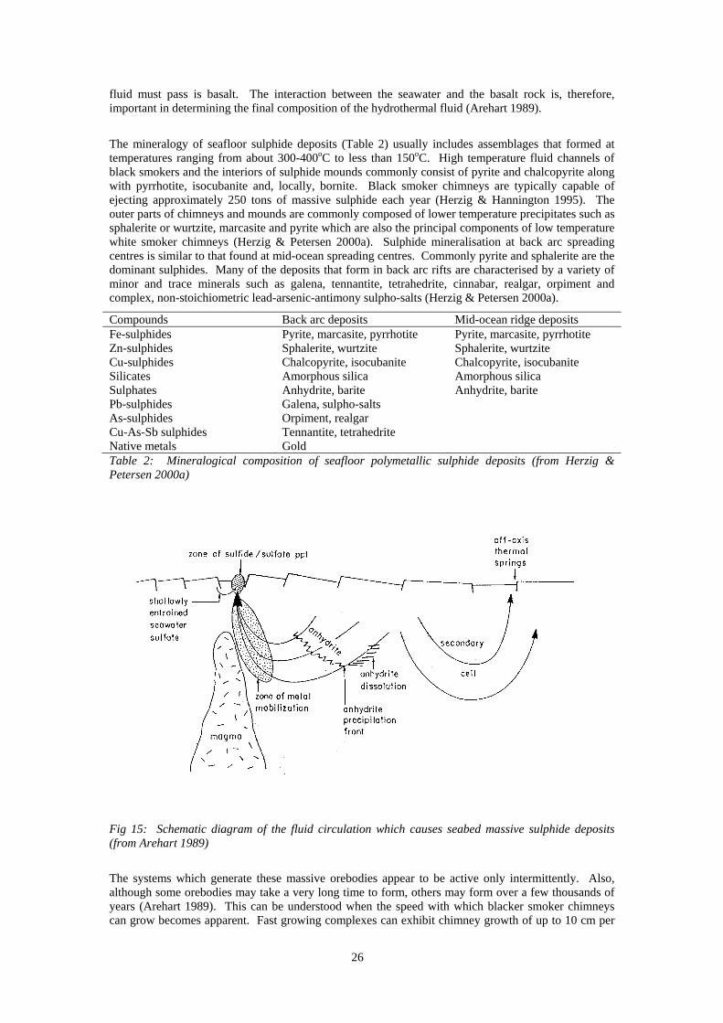
Fig 15: Schematic diagram of the fluid circulation which causes seabed massive sulphide deposits (from Arehart 1989)
The systems which generate these massive orebodies appear to be active only intermittently. Also, although some orebodies may take a very long time to form, others may form over a few thousands of years (Arehart 1989). This can be understood when the speed with which blacker smoker chimneys can grow becomes apparent. Fast growing complexes can exhibit chimney growth of up to 10 cm per
27
day and reach up to 30 m in height (Herzig & Hannington 1995). Although these processes have been in existence for many billions of years, on investigation it becomes clear that a very specific set of physical conditions are required for the formation of deposits of economic significance (Arehart 1989).
In 1986 and 1988 discoveries in the East China Sea of a large area of hydrothermal venting and formation of polymetallic sulphide deposits in the Okinawa Trough were made. Active hydrothermal mounds were found within a summit crater of a small volcanic seamount about 200 m high in the rift valley at 27o34.4’N, 127o08.6’E. Thereafter the Jade hydrothermal field was discovered within the Izena caldera and four varieties of sulphide mineralisation were defined in the area. Compared with other known occurrences of polymetallic sulphides the Jade hydrothermal field has particularly high concentrations of gold and lead, making it a one of the highest grade massive sulphide deposits discovered (Clark & Li 1991). That said, however, the extent of the deposits has not been ascertained and this will have a large bearing on the economic feasibility of exploitation.
5.3 How do you find them?
The strategy of closing in on a deposit by systematically following chemical and geographical clues was used successfully to discover the TAG hydrothermal field on the Mid-Atlantic Ridge. This was the first hot spring and massive sulphide deposit area found anywhere in the deep Atlantic Ocean. Hot springs associated with an active massive sulphide deposit will discharge certain metals in dissolved and particulate form (usually iron and manganese) and dissolved gases (helium) that can be carried by deep ocean currents for distances of hundreds of kilometres from the source. These signals can be detected from water samples recovered from appropriate depths by standard shipboard water sampling methods. Or settled particulates from black smokers will appear in cores of seafloor sediments. By following the concentration gradients of these samples it is possible to locate the source (Rona 2000). At distances of kilometres too shipboard bathymetric and magnetic methods and near-surface towed side-scan sonar can be employed to determine the seafloor setting and to detect a characteristic magnetic signature of either an active or inactive black smoker complex. Within kilometres of the complex various in situ sampling devices and imaging methods on unmanned or manned deep submergence vehicles can be employed. The unmanned devices are usually of two types:
Remotely Operated Vehicles (ROVs) which are tethered to a ship and controlled through an electrical or electro-fibre optic cable with a real-time video link to the operators
Autonomous Underwater Vehicles (AUVs) which are free-swimming and are programmed to perform imaging, sampling and other procedures
Manned vehicles (also known as Human Occupied Vehicles, or HOVs) may be used for direct observation, sampling and measurements (Rona 2000).
Location of the deposit is only the first step. The methods used so far only provide direct information on that part of the deposit which is exposed on the seafloor. Drilling is then required to determine the third dimension and allow calculation of the grade and tonnage of ore, much as is done on land. Land based deposits are explored by drilling hundreds of cores, each of which is tens to hundreds of metres deep and which may be only metres apart. From these are recovered almost continuous cores of the penetrated material and it is from these that the shape, grade and tonnage of the deposit is calculated. In the deep sea it is not yet technically possible to follow the same methodology. At present the TAG mound is one of only two so far drilled by the ODP (ODP). In two months at sea in 1994 and overcoming formidable technical difficulty, ODP drilled 17 holes up to 125 m long with an overall core recovery of 12%. Although drilling methods for massive sulphide deposits in the deep ocean are improving, it is unlikely that they will come close to the standards attainable on land for the foreseeable future (Rona 2000).
In the 20 years since the discovery of hydrothermal vents at the East Pacific Rise at 21oN in 1979 significant mineral deposits have been documented in more than a dozen different volcanic and tectonic settings around the world at water depths of up to 3,700 m (Herzig & Petersen 2000a). Many deposits were found along fast-spreading segments of the East Pacific Rise itself, and it became accepted that the speed of spreading was an important factor in their occurrence. But the 1985 discovery of the TAG hydrothermal field gave lie to this theory occurring as it did at a slow-spreading centre in the Mid-Atlantic Ridge. A number of other discoveries have confirmed that the spreading rate is not a relevant factor in black smoker complex occurrence (Herzig & Petersen 2000a).
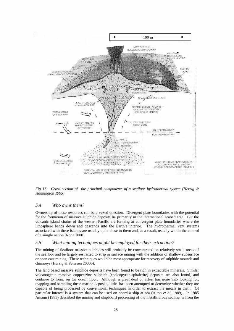
28
Fig 16: Cross section of the principal components of a seafloor hydrothermal system (Herzig & Hannington 1995)
5.4 Who owns them?
Ownership of these resources can be a vexed question. Divergent plate boundaries with the potential for the formation of massive sulphide deposits lie primarily in the international seabed area. But the volcanic island chains of the western Pacific are forming at convergent plate boundaries where the lithosphere bends down and descends into the Earth’s interior. The hydrothermal vent systems associated with these islands are usually quite close to them and, as a result, usually within the control of a siingle nation (Rona 2000).
5.5 What mining techniques might be employed for their extraction?
The mining of Seafloor massive sulphides will probably be concentrated on relatively small areas of the seafloor and be largely restricted to strip or surface mining with the addition of shallow subsurface or open cast mining. These techniques would be most appropriate for recovery of sulphide mounds and chimneys (Herzig & Petersen 2000b).
The land based massive sulphide deposits have been found to be rich in extractable minerals. Similar volcanogenic massive copper-zinc sulphide (chalcopyrite-sphalerite) deposits are also found, and continue to form, on the ocean floor. Although a great deal of effort has gone into looking for, mapping and sampling these marine deposits, little has been attempted to determine whether they are capable of being processed by conventional techniques in order to extract the metals in them. Of particular interest is a system that can be used on board a ship at sea (Alton et al. 1989). In 1985 Amann (1985) described the mining and shipboard processing of the metalliferous sediments from the
100 m
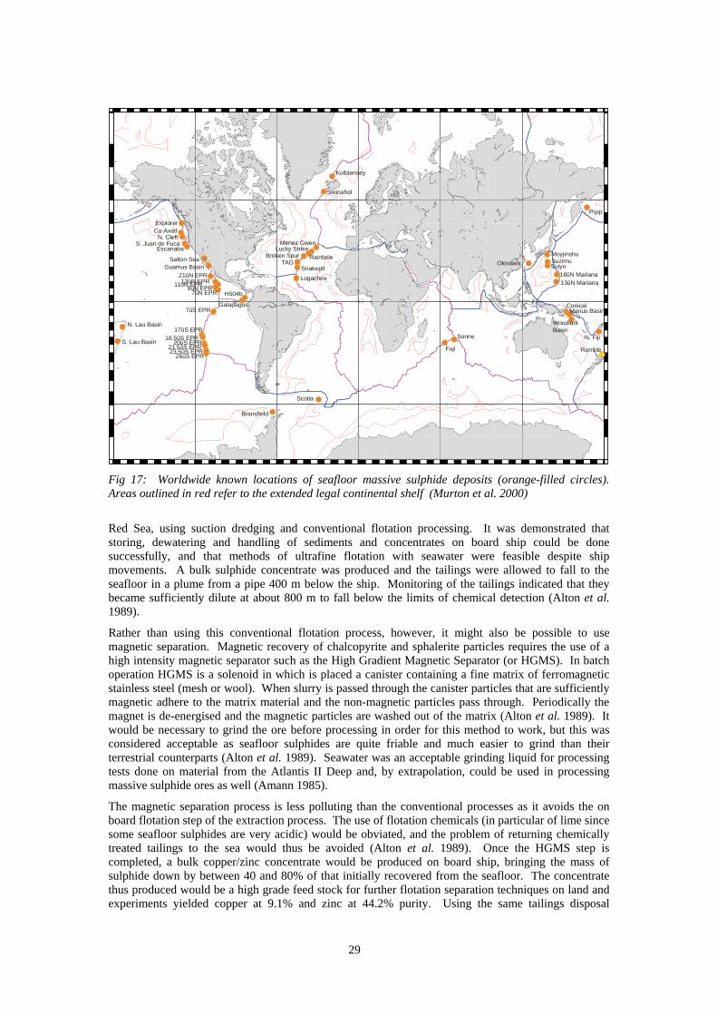
29
ExplorerCo-Axial
N. CleftS. Juan de Fuca
Escanaba
Salton SeaGuamus Basin
21ûN EPR13ûN EPR11ûN EPR
9ûN EPR7ûN EPR H504b
Galapagos7ûS EPR
N. Lau Basin
S. Lau Basin
Scotia
Bransfield
17ûS EPR18.5ûS EPR
20ûS EPR21.5ûS EPR23.5ûS EPR
26ûS EPR
Logachev
SnakepitTAG
Broken Spur Rainbow
Lucky StrikeMenez Gwen
Steinahol
Kolbiensey
Sonne
Fuji Rumble
Woodlark Basin
N. Fiji
Manus BasinConical
13ûN Mariana18ûN Mariana
Okinawa SuiyoSuzimuMoyjinshu
Piyip
Fig 17: Worldwide known locations of seafloor massive sulphide deposits (orange-filled circles). Areas outlined in red refer to the extended legal continental shelf (Murton et al. 2000)
Red Sea, using suction dredging and conventional flotation processing. It was demonstrated that storing, dewatering and handling of sediments and concentrates on board ship could be done successfully, and that methods of ultrafine flotation with seawater were feasible despite ship movements. A bulk sulphide concentrate was produced and the tailings were allowed to fall to the seafloor in a plume from a pipe 400 m below the ship. Monitoring of the tailings indicated that they became sufficiently dilute at about 800 m to fall below the limits of chemical detection (Alton et al. 1989).
Rather than using this conventional flotation process, however, it might also be possible to use magnetic separation. Magnetic recovery of chalcopyrite and sphalerite particles requires the use of a high intensity magnetic separator such as the High Gradient Magnetic Separator (or HGMS). In batch operation HGMS is a solenoid in which is placed a canister containing a fine matrix of ferromagnetic stainless steel (mesh or wool). When slurry is passed through the canister particles that are sufficiently magnetic adhere to the matrix material and the non-magnetic particles pass through. Periodically the magnet is de-energised and the magnetic particles are washed out of the matrix (Alton et al. 1989). It would be necessary to grind the ore before processing in order for this method to work, but this was considered acceptable as seafloor sulphides are quite friable and much easier to grind than their terrestrial counterparts (Alton et al. 1989). Seawater was an acceptable grinding liquid for processing tests done on material from the Atlantis II Deep and, by extrapolation, could be used in processing massive sulphide ores as well (Amann 1985).
The magnetic separation process is less polluting than the conventional processes as it avoids the on board flotation step of the extraction process. The use of flotation chemicals (in particular of lime since some seafloor sulphides are very acidic) would be obviated, and the problem of returning chemically treated tailings to the sea would thus be avoided (Alton et al. 1989). Once the HGMS step is completed, a bulk copper/zinc concentrate would be produced on board ship, bringing the mass of sulphide down by between 40 and 80% of that initially recovered from the seafloor. The concentrate thus produced would be a high grade feed stock for further flotation separation techniques on land and experiments yielded copper at 9.1% and zinc at 44.2% purity. Using the same tailings disposal
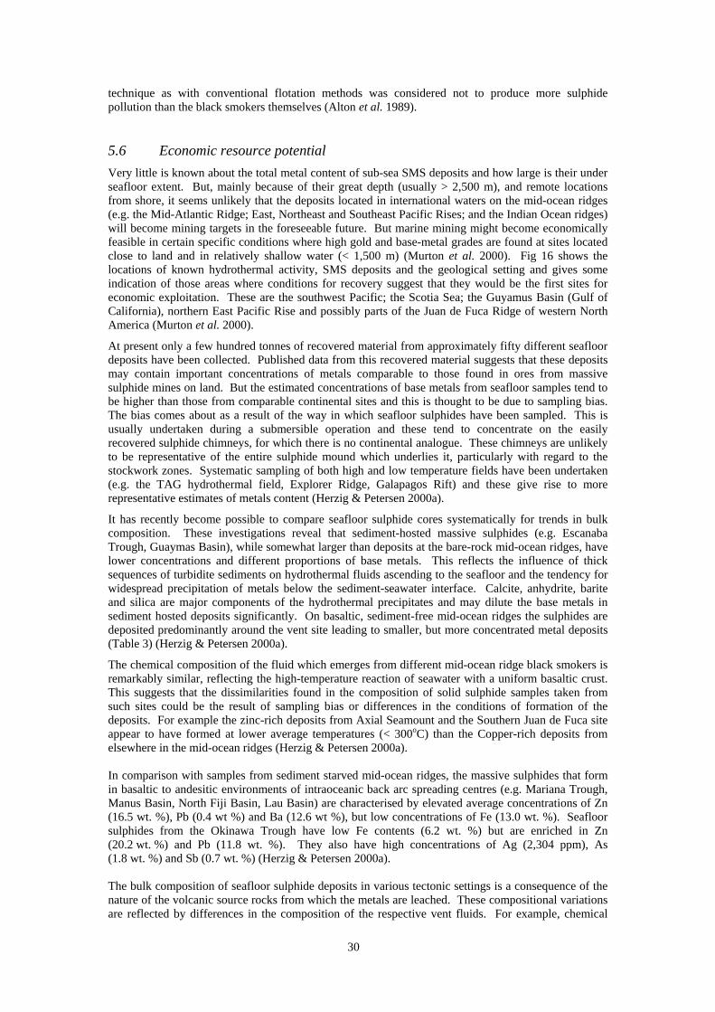
30
technique as with conventional flotation methods was considered not to produce more sulphide pollution than the black smokers themselves (Alton et al. 1989).
5.6 Economic resource potential
Very little is known about the total metal content of sub-sea SMS deposits and how large is their under seafloor extent. But, mainly because of their great depth (usually > 2,500 m), and remote locations from shore, it seems unlikely that the deposits located in international waters on the mid-ocean ridges (e.g. the Mid-Atlantic Ridge; East, Northeast and Southeast Pacific Rises; and the Indian Ocean ridges) will become mining targets in the foreseeable future. But marine mining might become economically feasible in certain specific conditions where high gold and base-metal grades are found at sites located close to land and in relatively shallow water (< 1,500 m) (Murton et al. 2000). Fig 16 shows the locations of known hydrothermal activity, SMS deposits and the geological setting and gives some indication of those areas where conditions for recovery suggest that they would be the first sites for economic exploitation. These are the southwest Pacific; the Scotia Sea; the Guyamus Basin (Gulf of California), northern East Pacific Rise and possibly parts of the Juan de Fuca Ridge of western North America (Murton et al. 2000).
At present only a few hundred tonnes of recovered material from approximately fifty different seafloor deposits have been collected. Published data from this recovered material suggests that these deposits may contain important concentrations of metals comparable to those found in ores from massive sulphide mines on land. But the estimated concentrations of base metals from seafloor samples tend to be higher than those from comparable continental sites and this is thought to be due to sampling bias. The bias comes about as a result of the way in which seafloor sulphides have been sampled. This is usually undertaken during a submersible operation and these tend to concentrate on the easily recovered sulphide chimneys, for which there is no continental analogue. These chimneys are unlikely to be representative of the entire sulphide mound which underlies it, particularly with regard to the stockwork zones. Systematic sampling of both high and low temperature fields have been undertaken (e.g. the TAG hydrothermal field, Explorer Ridge, Galapagos Rift) and these give rise to more representative estimates of metals content (Herzig & Petersen 2000a).
It has recently become possible to compare seafloor sulphide cores systematically for trends in bulk composition. These investigations reveal that sediment-hosted massive sulphides (e.g. Escanaba Trough, Guaymas Basin), while somewhat larger than deposits at the bare-rock mid-ocean ridges, have lower concentrations and different proportions of base metals. This reflects the influence of thick sequences of turbidite sediments on hydrothermal fluids ascending to the seafloor and the tendency for widespread precipitation of metals below the sediment-seawater interface. Calcite, anhydrite, barite and silica are major components of the hydrothermal precipitates and may dilute the base metals in sediment hosted deposits significantly. On basaltic, sediment-free mid-ocean ridges the sulphides are deposited predominantly around the vent site leading to smaller, but more concentrated metal deposits (Table 3) (Herzig & Petersen 2000a).
The chemical composition of the fluid which emerges from different mid-ocean ridge black smokers is remarkably similar, reflecting the high-temperature reaction of seawater with a uniform basaltic crust. This suggests that the dissimilarities found in the composition of solid sulphide samples taken from such sites could be the result of sampling bias or differences in the conditions of formation of the deposits. For example the zinc-rich deposits from Axial Seamount and the Southern Juan de Fuca site appear to have formed at lower average temperatures (< 300oC) than the Copper-rich deposits from elsewhere in the mid-ocean ridges (Herzig & Petersen 2000a). In comparison with samples from sediment starved mid-ocean ridges, the massive sulphides that form in basaltic to andesitic environments of intraoceanic back arc spreading centres (e.g. Mariana Trough, Manus Basin, North Fiji Basin, Lau Basin) are characterised by elevated average concentrations of Zn (16.5 wt. %), Pb (0.4 wt %) and Ba (12.6 wt %), but low concentrations of Fe (13.0 wt. %). Seafloor sulphides from the Okinawa Trough have low Fe contents (6.2 wt. %) but are enriched in Zn (20.2 wt. %) and Pb (11.8 wt. %). They also have high concentrations of Ag (2,304 ppm), As (1.8 wt. %) and Sb (0.7 wt. %) (Herzig & Petersen 2000a). The bulk composition of seafloor sulphide deposits in various tectonic settings is a consequence of the nature of the volcanic source rocks from which the metals are leached. These compositional variations are reflected by differences in the composition of the respective vent fluids. For example, chemical
31
analyses of endmember fluids from the Vai Lili hydrothermal field in the southern Lau Basin indicate much higher concentrations of Zn, Pb, As and other elements compared with typical mid-ocean ridge fluids. High Pb and Ba contents of sediment-hosted seafloor sulphides simply reflect the elevated Pb and Ba contents of individual components in the sediment (Herzig & Petersen 2000a). Element Intraoceanic back arc ridges Intracontinental back arc ridges Mid-ocean ridges Pb (wt. %) 0.4 11.8 0.1 Fe (wt. %) 13.0 6.2 26.4 Zn (wt. %) 16.5 20.2 8.5 Cu (wt. %) 4.0 3.3 4.8 Ba (wt. %) 12.6 7.2 1.8 As (ppm) 845 17,500 235 Sb (ppm) 106 6,710 46 Ag (ppm) 217 2,304 113 Au (ppm) 4.5 3.1 1.2 n = 573 40 1,259 Table 3: Chemical composition of seafloor massive sulphides by geological location (Herzig & Petersen 2000a)
5.7 How close is commercial exploitation?
Of the more than 100 sites of hydrothermal mineralisation which are at present known about, it seems possible that 10 are potential candidates for commercial exploitation. These potential sites include Middle Valley, Explorer Ridge, Galapagos Rift and the East Pacific Rise 13oN , the Manus Basin, the Lau Basin, the Okinawa Trough and the North Fiji Basin in the Pacific Ocean and the TAG hydrothermal field in the Atlantic Ocean. Except for the East Pacific Rise 13oN and the TAG hydrothermal field all these sites are located in the EEZs of coastal states including Canada, Ecuador, Papua New Guinea, Tonga, Japan and Fiji. In December/January 2000/2001 leg 193 of the ODP is scheduled to explore the Eastern Manus Basin off Papua New Guinea (Herzig & Petersen 2000a).
Exploration licences have been issues to an Australian mining company (Nautilus Minerals Corporation) for gold bearing deposits of sulphide minerals within the territorial waters of Papua New Guinea (PNG). The two licences, which cover more than 5,000 sq km of seafloor of the Manus Basin are the first licences ever to have been issued for the exploration and development of Seafloor massive sulphides. The deposits were discovered by multinational research teams aboard Japanese and German ships at spreading centres in the area of the Manus Basin in water depths of about 1,500 m. Although some deposits lie more than 150 miles from shore, they are nonetheless within the archipelagic boundary of PNG and are included within its territorial waters (Cruickshank 1999a). That said, the Acting Director of the Mining Division, Department of Mining, PNG, in June 2000 regarded the prospect of actual mining in the Manus Basin as being ‘still way off yet’, and was not sure even that trial mining, let alone actual mining, would definitely take place. It should be said, however, that these were his personal views rather than the official position of the Government of PNG (Wanjik 2000).
At the moment it seems unlikely that deposits such as the TAG hydrothermal field located in international waters at the Mid-Atlantic Ridge, the 13oN Seamount at the East Pacifc Rise or the Sonne Hydrothermal field at the Rodriguez Triple Junction in the Southern Indian Ocean will become mining targets in the near future. The same is true for many of the deposits along the East, North-east and South-east Pacific Rises (Herzig & Petersen 2000a)
5.8 What are the environmental impacts of mining marine massive sulphides?
The hot springs with which these deposits are associated are the habitat of heat-tolerant bacteria at the base of a food chain of newly discovered life forms. The bacteria and other life forms, which vary in community structure from ocean to ocean, but include such macro-organisms as tube-worms and crabs, are being investigated separately from the mineral deposits to test their suitability for industrial processes including those involved with genetic engineering. As a result there is a conflict of interest between the mineral miners and those interested in the biological aspects of these newly discovered ecosystems. The mining technology for marine massive sulphides has not yet been developed, and the environmental implications of mining these areas has not yet been fully investigated. Nonetheless, there can be no doubt that the proposed test drilling being undertaken later this year, under the aegis of an ODP cruise, with the President of the Nautilus Minerals Corporation (Julian Malnic) aboard,
32
represents the closest approach to commercial exploitation of these resources so far attempted (Malnic 2000).
The biological communities which have arisen at active hydrothermal sites (black smokers) live in a catastrophic and extreme environment. The sulphides erupt in areas of volcanic activity at high temperatures and at depth where extreme pressures exist. These organisms are reliant on sulphur as the base medium for biological activity as opposed to the majority of life on the planet which exists in food chains based on carbon (initially captured by photosynthesis using the sun’s energy). Hydrothermal sites may exists for tens to thousands of years and may cease to exist abruptly. Such relatively short timescales do not permit biological evolution to take place and this suggests, therefore, that communities must be able to move relatively easily from site to site in order for their evolution to have taken place (Juniper 2000). It is not known over what distances the larval forms of the communities which exist at these sites can travel. It is thought, however, that they must be able to travel at least tens of kilometres. Provided, therefore, active hydrothermal communities remain in existence in the environs of a disturbed hydrothermal site, recolonisation should occur quickly. Some sites examined have recolonised within one year (Juniper 2000). The depth at which these sites exist, however, have not permitted adequate base-line studies of the biological communities to be undertaken and knowledge of their structure, and the means by which they function, remains in its infancy.
Although environmental impact studies have yet to be carried out for individual sites where seabed mining is likely to occur many researchers believe that only a relatively small disturbance of the ecosystem would occur were Seafloor massive sulphides to be exploited for commercial gain (Herzig & Petersen 2000a). The high density of sulphide particles (approximately 4 gm cm-3) mean that they would settle quickly after disturbance. Acid mine drainage, which is a perpetual problem with land based mines, would not be a consideration due to the diluting effect of the surrounding seawater (Herzig & Petersen 2000a). It should be noted, however, that the Manus Basin, where the first test drilling of a massive sulphide mound is due to take place at the end of this year, is also providing the biological community with new data. A new species of tube worm found in the Basin was described for the first time in 1997. This vestimentiferan was placed in a new genus and a new family (Southward & Galkin 1997) indicating that it is biologically very different from any other known organism and is quite distinct from the two vestimentiferan genera already known from the Lau Basin in the western Pacific (Southward & Galkin 1997). Until a proper base-line environmental survey of the region is undertaken, however, it is not possible to predict how large an impact mining there will have.
6 M E T H A N E H Y D R A T E S
6.1 What are they?
These are solid, ice-like substances composed of a mixture of methane and water typically in a ratio of 1:5.75 (Brewer et al. 1997). They consist of a three-dimensional lattice framework of water ice with open cages into which various gas molecules can fit (Gornitz & Fung 1994). Disassociated hydrates (also called gas clathrates) give rise to the proportional composition shown in Fig 18. They occur only under certain conditions of low temperature and high pressure or moderate temperature and high pressure. Unlike the other compounds under discussion, methane hydrates are a potential fuel, rather than a mineral, resource.
Gas hydrate was discovered by Sir Humphrey Davy in 1811, but was purely of academic interest until the 1930s when the problem of gas pipeline blocking by massive hydrate formation was found to be an industrial nuisance which required an energetic research effort to resolve (Desa 2000, Brewer et al. 1997). In the 1960s large-scale naturally occurring gas hydrate formations were discovered in Russia, followed by the discovery of large sub-sea reserves.
Much of the current interest in gas hydrates stems from the estimation that they represent the largest hydrocarbon fuel reservoir on earth exceeding by a factor of two all other fossil fuel sources combined (Brewer et al. 1997, Bidle et al. 1999, Gornitz & Fung 1994). In addition they pose a potential geohazard in submarine slopes and, further, may be a source of atmospheric methane, a known ‘greenhouse gas’ (Bidle et al. 1999).
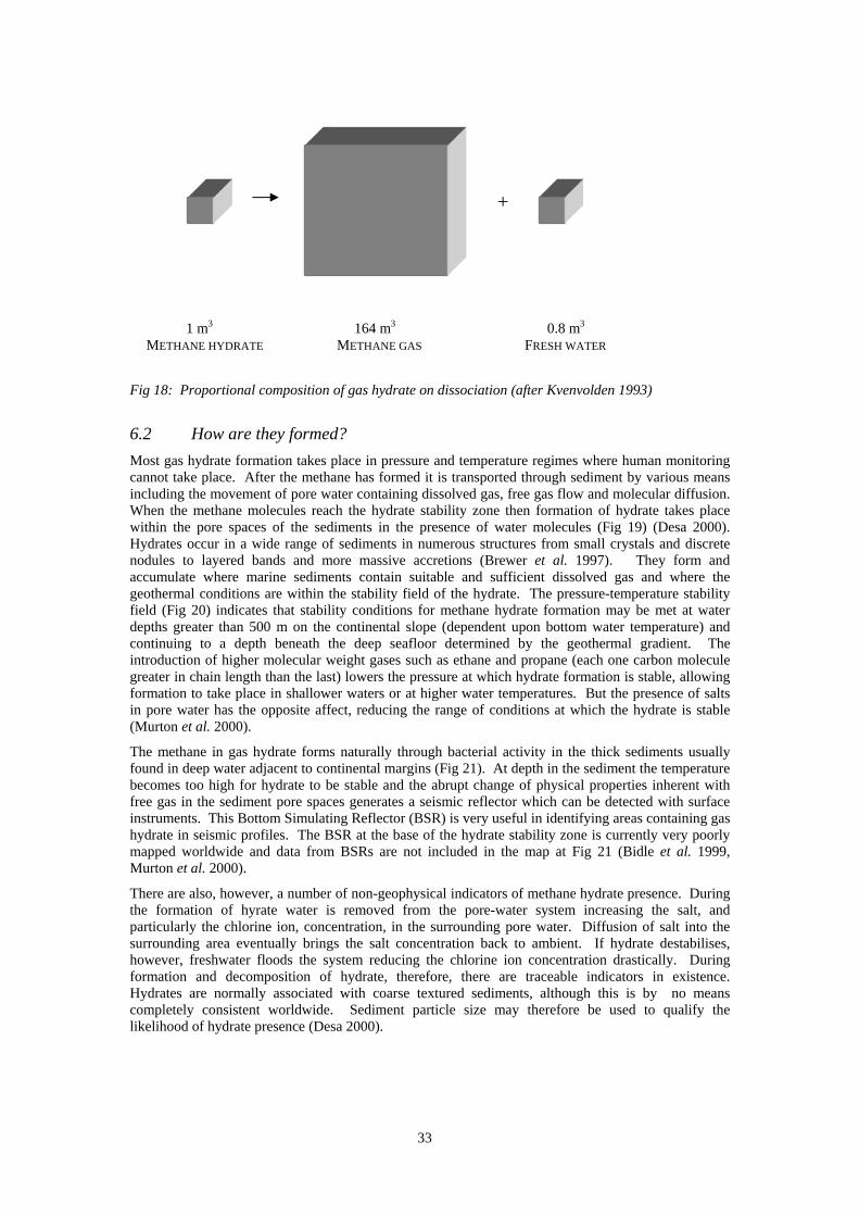
33
Fig 18: Proportional composition of gas hydrate on dissociation (after Kvenvolden 1993)
6.2 How are they formed?
Most gas hydrate formation takes place in pressure and temperature regimes where human monitoring cannot take place. After the methane has formed it is transported through sediment by various means including the movement of pore water containing dissolved gas, free gas flow and molecular diffusion. When the methane molecules reach the hydrate stability zone then formation of hydrate takes place within the pore spaces of the sediments in the presence of water molecules (Fig 19) (Desa 2000). Hydrates occur in a wide range of sediments in numerous structures from small crystals and discrete nodules to layered bands and more massive accretions (Brewer et al. 1997). They form and accumulate where marine sediments contain suitable and sufficient dissolved gas and where the geothermal conditions are within the stability field of the hydrate. The pressure-temperature stability field (Fig 20) indicates that stability conditions for methane hydrate formation may be met at water depths greater than 500 m on the continental slope (dependent upon bottom water temperature) and continuing to a depth beneath the deep seafloor determined by the geothermal gradient. The introduction of higher molecular weight gases such as ethane and propane (each one carbon molecule greater in chain length than the last) lowers the pressure at which hydrate formation is stable, allowing formation to take place in shallower waters or at higher water temperatures. But the presence of salts in pore water has the opposite affect, reducing the range of conditions at which the hydrate is stable (Murton et al. 2000).
The methane in gas hydrate forms naturally through bacterial activity in the thick sediments usually found in deep water adjacent to continental margins (Fig 21). At depth in the sediment the temperature becomes too high for hydrate to be stable and the abrupt change of physical properties inherent with free gas in the sediment pore spaces generates a seismic reflector which can be detected with surface instruments. This Bottom Simulating Reflector (BSR) is very useful in identifying areas containing gas hydrate in seismic profiles. The BSR at the base of the hydrate stability zone is currently very poorly mapped worldwide and data from BSRs are not included in the map at Fig 21 (Bidle et al. 1999, Murton et al. 2000).
There are also, however, a number of non-geophysical indicators of methane hydrate presence. During the formation of hyrate water is removed from the pore-water system increasing the salt, and particularly the chlorine ion, concentration, in the surrounding pore water. Diffusion of salt into the surrounding area eventually brings the salt concentration back to ambient. If hydrate destabilises, however, freshwater floods the system reducing the chlorine ion concentration drastically. During formation and decomposition of hydrate, therefore, there are traceable indicators in existence. Hydrates are normally associated with coarse textured sediments, although this is by no means completely consistent worldwide. Sediment particle size may therefore be used to qualify the likelihood of hydrate presence (Desa 2000).
+
1 m3 164 m3 0.8 m3 METHANE HYDRATE METHANE GAS FRESH WATER
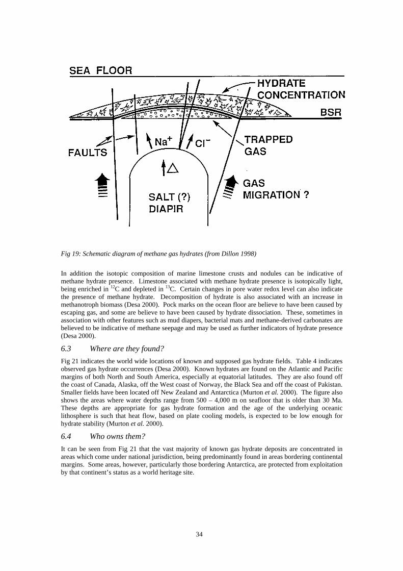
34
Fig 19: Schematic diagram of methane gas hydrates (from Dillon 1998)
In addition the isotopic composition of marine limestone crusts and nodules can be indicative of methane hydrate presence. Limestone associated with methane hydrate presence is isotopically light, being enriched in 12C and depleted in 13C. Certain changes in pore water redox level can also indicate the presence of methane hydrate. Decomposition of hydrate is also associated with an increase in methanotroph biomass (Desa 2000). Pock marks on the ocean floor are believe to have been caused by escaping gas, and some are believe to have been caused by hydrate dissociation. These, sometimes in association with other features such as mud diapers, bacterial mats and methane-derived carbonates are believed to be indicative of methane seepage and may be used as further indicators of hydrate presence (Desa 2000).
6.3 Where are they found?
Fig 21 indicates the world wide locations of known and supposed gas hydrate fields. Table 4 indicates observed gas hydrate occurrences (Desa 2000). Known hydrates are found on the Atlantic and Pacific margins of both North and South America, especially at equatorial latitudes. They are also found off the coast of Canada, Alaska, off the West coast of Norway, the Black Sea and off the coast of Pakistan. Smaller fields have been located off New Zealand and Antarctica (Murton et al. 2000). The figure also shows the areas where water depths range from 500 – 4,000 m on seafloor that is older than 30 Ma. These depths are appropriate for gas hydrate formation and the age of the underlying oceanic lithosphere is such that heat flow, based on plate cooling models, is expected to be low enough for hydrate stability (Murton et al. 2000).
6.4 Who owns them?
It can be seen from Fig 21 that the vast majority of known gas hydrate deposits are concentrated in areas which come under national jurisdiction, being predominantly found in areas bordering continental margins. Some areas, however, particularly those bordering Antarctica, are protected from exploitation by that continent’s status as a world heritage site.
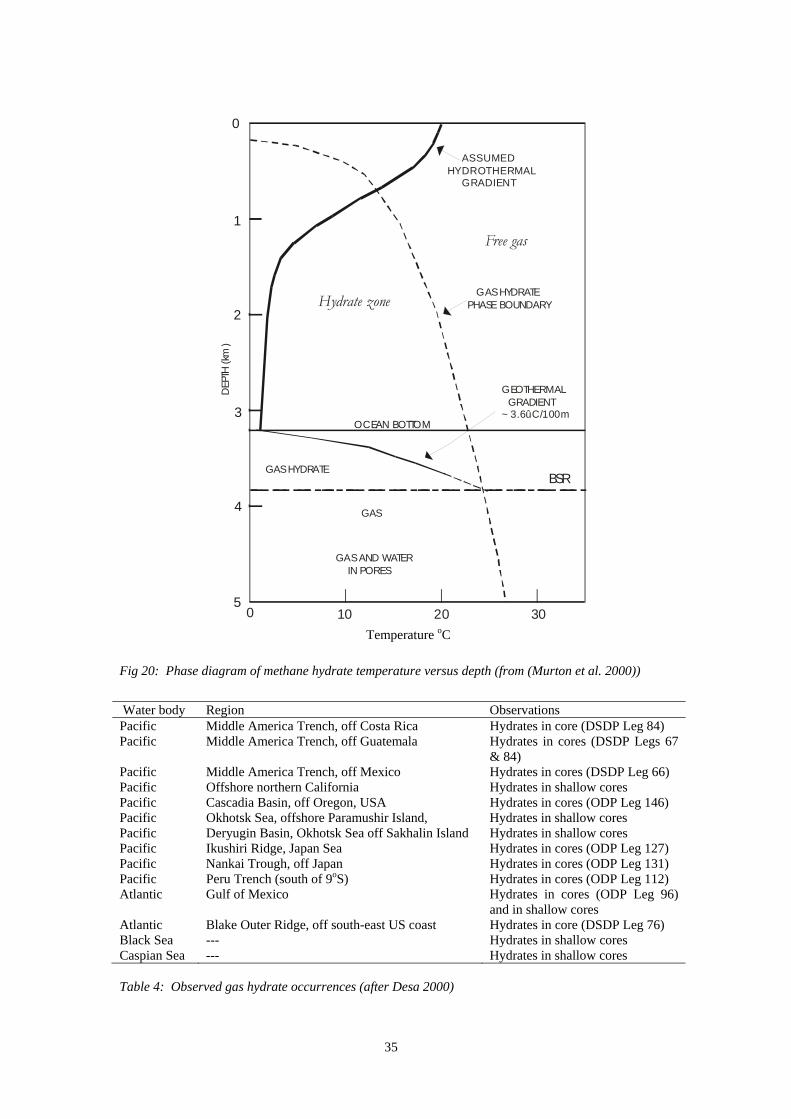
35
Fig 20: Phase diagram of methane hydrate temperature versus depth (from (Murton et al. 2000))
Water body Region Observations Pacific Middle America Trench, off Costa Rica Hydrates in core (DSDP Leg 84) Pacific Middle America Trench, off Guatemala Hydrates in cores (DSDP Legs 67
& 84) Pacific Middle America Trench, off Mexico Hydrates in cores (DSDP Leg 66) Pacific Offshore northern California Hydrates in shallow cores Pacific Cascadia Basin, off Oregon, USA Hydrates in cores (ODP Leg 146) Pacific Okhotsk Sea, offshore Paramushir Island, Hydrates in shallow cores Pacific Deryugin Basin, Okhotsk Sea off Sakhalin Island Hydrates in shallow cores Pacific Ikushiri Ridge, Japan Sea Hydrates in cores (ODP Leg 127) Pacific Nankai Trough, off Japan Hydrates in cores (ODP Leg 131) Pacific Peru Trench (south of 9oS) Hydrates in cores (ODP Leg 112) Atlantic Gulf of Mexico Hydrates in cores (ODP Leg 96)
and in shallow cores Atlantic Blake Outer Ridge, off south-east US coast Hydrates in core (DSDP Leg 76) Black Sea --- Hydrates in shallow cores Caspian Sea --- Hydrates in shallow cores Table 4: Observed gas hydrate occurrences (after Desa 2000)
0
1
2
3
4
5
OCEAN BOTTOM
Hydrate zone
Free gas
ASSUMED HYDROTHERMAL GRADIENT
GAS HYDRATEPHASE BOUNDARY
DEP
TH (k
m)
0 10 20 30TEMPERATURE (ûC)
GAS HYDRATEBSR
GEOTHERMAL GRADIENT~ 3.6ûC/100m
GAS
GAS AND WATER IN PORES
Temperature oC
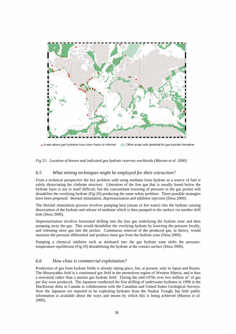
36
Fig 21: Location of known and indicated gas hydrate reserves worldwide (Murton et al. 2000)
6.5 What mining techniques might be employed for their extraction?
From a technical perspective the key problem with using methane from hydrate as a source of fuel is safely dissociating the clathrate structure. Liberation of the free gas that is usually found below the hydrate layer is not in itself difficult, but the concomitant lowering of pressure in the gas pocket will destabilise the overlying hydrate (Fig 20) producing the same safety problem. Three possible strategies have been proposed: thermal stimulation, depressurisation and inhibitor injection (Desa 2000).
The thermal stimulation process involves pumping heat (steam or hot water) into the hydrate causing dissociation of the hydrate and release of methane which is then pumped to the surface via another drill hole (Desa 2000).
Depressurisation involves horizontal drilling into the free gas underlying the hydrate zone and then pumping away the gas. This would destabilise the overlying hydrate by lowering the pressure locally, and releasing more gas into the pocket. Continuous removal of the produced gas, in theory, would maintain the pressure differential and produce more gas from the hydrate zone (Desa 2000).
Pumping a chemical inhibitor such as methanol into the gas hydrate zone shifts the pressure-temperature equilibrium (Fig 20) destabilising the hydrate at the contact surface (Desa 2000).
6.6 How close is commercial exploitation?
Production of gas from hydrate fields is already taking place, but, at present, only in Japan and Russia. The Messoyahka field is a continental gas field in the permafrost region of Western Siberia, and is thus a terrestrial rather than a marine gas hydrate field. During the mid-1970s over two million m3 of gas per day were produced. The Japanese conducted the first drilling of underwater hydrates in 1998 in the MacKenzie delta in Canada in collaboration with the Canadian and United States Geological Surveys. Now the Japanese are reported to be exploiting hydrates from the Nankai Trough, but little public information is available about the ways and means by which this is being achieved (Murton et al. 2000).
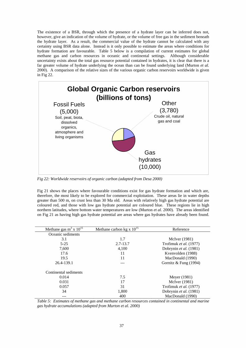
37
The existence of a BSR, through which the presence of a hydrate layer can be inferred does not, however, give an indication of the volume of hydrate, or the volume of free gas in the sediment beneath the hydrate layer. As a result, the commercial value of the hydrate cannot be calculated with any certainty using BSR data alone. Instead is it only possible to estimate the areas where conditions for hydrate formation are favourable. Table 5 below is a compilation of current estimates for global methane gas and carbon resources in oceanic and continental settings. Although considerable uncertainty exists about the total gas resource potential contained in hydrates, it is clear that there is a far greater volume of hydrate underlying the ocean than can be found underlying land (Murton et al. 2000). A comparison of the relative sizes of the various organic carbon reservoirs worldwide is given in Fig 22.
Global Organic Carbon reservoirs(billions of tons)
Other (3,780)
Crude oil, natural gas and coal
Fossil Fuels(5,000)
Soil, peat, biota, dissolved organics,
atmosphere and living organisms
Gas hydrates (10,000)
Fig 22: Worldwide reservoirs of organic carbon (adapted from Desa 2000)
Fig 21 shows the places where favourable conditions exist for gas hydrate formation and which are, therefore, the most likely to be explored for commercial exploitation. These areas lie in water depths greater than 500 m, on crust less than 30 Ma old. Areas with relatively high gas hydrate potential are coloured red, and those with low gas hydrate potential are coloured blue. These regions lie in high northern latitudes, where bottom water temperatures are low (Murton et al. 2000). The areas identified on Fig 21 as having high gas hydrate potential are areas where gas hydrates have already been found.
Methane gas m3 x 1015 Methane carbon kg x 1015 Reference Oceanic sediments
3.1 1.7 McIver (1981) 5-25 2.7-13.7 Trofimuk et al. (1977) 7,600 4,100 Dobrynin et al. (1981) 17.6 11 Kvenvolden (1988) 19.5 11 MacDonald (1990)
26.4-139.1 --- Gornitz & Fung (1994)
Continental sediments 0.014 7.5 Meyer (1981) 0.031 17 McIver (1981) 0.057 31 Trofimuk et al. (1977)
34 1,800 Dobrynin et al. (1981) --- 400 MacDonald (1990)
Table 5: Estimates of methane gas and methane carbon resources contained in continental and marine gas hydrate accumulations (adapted from Murton et al. 2000)
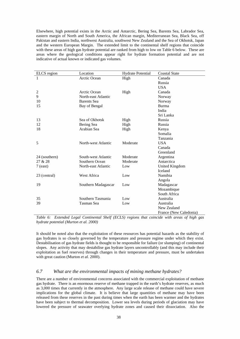
38
Elsewhere, high potential exists in the Arctic and Antarctic, Bering Sea, Barents Sea, Labrador Sea, eastern margin of North and South America, the African margin, Mediterranean Sea, Black Sea, off Pakistan and eastern India, northwest Australia, southwest New Zealand and the Sea of Okhotsk, Japan and the western European Margin. The extended limit to the continental shelf regions that coincide with these areas of high gas hydrate potential are ranked from high to low on Table 6 below. These are areas where the geological conditions appear right for hydrate formation potential and are not indicative of actual known or indicated gas volumes.
ELCS region Location Hydrate Potential Coastal State 1 Arctic Ocean High Canada Russia USA 2 Arctic Ocean High Canada 9 North-east Atlantic Norway 10 Barents Sea Norway 15 Bay of Bengal Burma India Sri Lanka 13 Sea of Okhotsk High Russia 12 Bering Sea High Russia 18 Arabian Sea High Kenya Somalia Tanzania 5 North-west Atlantic Moderate USA Canada Greenland 24 (southern) South-west Atlantic Moderate Argentina 27 & 28 Southern Ocean Moderate Antarctica 7 (east) North-east Atlantic Low United Kingdom Iceland 23 (central) West Africa Low Namibia Angola 19 Southern Madagascar Low Madagascar Mozambique South Africa 35 Southern Tasmania Low Australia 39 Tasman Sea Low Australia New Zealand France (New Caledonia) Table 6: Extended Legal Continental Shelf (ECLS) regions that coincide with areas of high gas hydrate potential (Murton et al. 2000)
It should be noted also that the exploitation of these resources has potential hazards as the stability of gas hydrates is so closely governed by the temperature and pressure regime under which they exist. Destabilisation of gas hydrate fields is thought to be responsible for failure (or slumping) of continental slopes. Any activity that may destabilise gas hydrate layers uncontrollably (and this may include their exploitation as fuel reserves) through changes in their temperature and pressure, must be undertaken with great caution (Murton et al. 2000).
6.7 What are the environmental impacts of mining methane hydrates?
There are a number of environmental concerns associated with the commercial exploitation of methane gas hydrate. There is an enormous reserve of methane trapped in the earth’s hydrate reserves, as much as 3,000 times that currently in the atmosphere. Any large scale release of methane could have severe implications for the global climate. It is believe that large quantities of methane may have been released from these reserves in the past during times when the earth has been warmer and the hydrates have been subject to thermal decomposition. Lower sea levels during periods of glaciation may have lowered the pressure of seawater overlying hydrate zones and caused their dissociation. Also the
39
instability of continental slopes may have caused large-scale catastrophic release of methane gas from hydrates. In the Gulf of Mexico there have been a number of incidents of slumping and gas release in the vicinity of drilling and pipeline operations (Cruickshank 1999b, Desa 2000).
Methane is a powerful greenhouse gas with 10 times the climate change potential of carbon dioxide. Rapid climate change in the past has been correlated with methane gas concentrations in ice cores, which contain a record covering up to 200,000 years. Climate models suggest that a positive feedback loop is caused by methane dissociation, which warms the climate and causes further release of methane to the atmosphere. Eventually the warmed climate induces melting of the ice caps, which increases sea level and inhibits further release of methane from hydrates (Desa 2000). The connection is, however, not well understood and the quantitative contribution of different elements cannot yet be calculated without considerable further research (Desa 2000).
There is limited information available on the microbial communities which are the predominant biota in gas hydrate fields. In a study by Bidle et al. (Bidle et al. 1999) it was found that sulphur-utilizing bacteria were the dominant micro-organism found in the sediments and fluids of a gas hydrate field. This suggests a possible role for methane oxidation by sulphate reducers. Also, elevated methane levels, particularly in the sediment pore fluids, suggest that communities of methanotrophs and bacterial species related to those commonly found in other hydrocarbon environments can be and are supported in methane hydrate fields (Bidle et al. 1999).
7 O T H E R M A R I N E M I N E R A L R E S O U R C E S
7.1 Hot brines and metalliferous muds
7.1.1 What are they?
The largest known marine sulphide deposit is the Atlantis II Deep in the Red Sea, which was discovered more than 10 years before the first black smoker at the East Pacific Rise. The mineralisation at the Atlantis II Deep consists largely of metalliferous muds instead of massive sulphides (Herzig & Petersen 2000a). These deposits are exceptional in size and character.
7.1.2 How are they formed?
The formation of hot brines and metalliferous muds come about as a consequence of the high salinity acquired by the hydrothermal fluid as it passes through thick Miocene evaporates at the edges of the Red Sea rift. Metals are precipitated from stratified brine pools which are fed by hydrothermal vents at the bottom of very deep, anoxic, basins. Because seawater circulates through a concentrated salt deposit the metal bearing solutions are highly saline and consequently denser than the surrounding water. Their increased density causes them to sink to the bottom of the basin which ensures that any metals are also deposited there (Herzig & Hannington 1995). The metalliferous sediments form a think layer at the base of the brine pool and may cover an area as large as 40 km2 (the size of the Atlantis II Deep) (Herzig & Hannington 1995). In the Kebrit and Shaban Deeps of the Red Sea sulphide chimneys have also been found expelling a geyser-type discharge (Herzig & Hannington 1995).
7.1.3 Where are they found?
The Red Sea contains deposits of metalliferous hot brines and sediments containing high concentrations of silver, zinc, copper and gold. There are a total of 18 brine pools and associated mud deposits that have been discovered since the 1960s, the largest of which is the Atlantis II Deep with a surface area of 60 km2 (Amann 1989, Yates et al. 1986). The reserves are owned jointly by Saudi Arabia and Sudan for whom they are of potentially large economic value (Amann 1989).
7.1.4 What is the current state of their exploitation?
The Red Sea Pilot Project ran through the 1970s and 1980s and undertook ocean test mining, including the detailed exploration, environmental research beneficiation and metallurgical engineering required for putting Red Sea hot brine extraction into effect. The German company Preussag and the French Bureau de Recherche Geologique et Miniere (BRGM) were engaged by the Saudi Arabian Government to undertake the detailed investigations (Yates et al. 1986). Results of the pre-pilot mining operation showed that the Atlantis II Deep deposits could produce 920,000 tons of zinc, 182,000 tons of copper, 1,635 tons of silver and 13 tons of gold. Mining tests were undertaken using a specially adapted cutter-suction head, a large diameter pipe and two submerged pump stations equipped with centrifugal pumps.

40
A vertically vibrating screen broke up the consolidated muds (Yates et al. 1986). But although these operations were technically and (according to the authors) environmentally, successful, they could not continue beyond the mid-1980s when the high cost of oil and the low prices being offered for metals made extraction of the Red Sea brines uneconomical (Amann 1989).
7.1.5 What are the environmental impacts of extracting hot brines and metalliferous muds?
As with all other deep sea mining operations it is essential that an adequate base-line survey of the impacted environment is first undertaken. With so little detailed knowledge of the environment and ecology of the deep sea bed it is often the first proper survey of biota that will have taken place in a particular environment.
The area of greatest environmental concern, as with so many other proposed marine mining operations is the sediment plume created by dumping tailings overboard. During the pilot mining test for the extraction of the Red Sea metalliferous muds acoustic and geochemical monitoring of the tailings plume was undertaken. Tailings were rejected in deep water (> 600 m) in order to minimise impact on creatures in the euphotic zone. It was reported that there was no observed harm to the biology of the area (Amann 1989), although the methods employed were not detailed.
7.2 Mineral Placers
There are many sites on continental shelves around the world where heavy minerals containing metals and non-metals are concentrated. But very few of these have ever been mined. These materials are eroded from rocks exposed on land and transported by rivers to the ocean where they are concentrated by waves, tides and currents to form placer deposits. As far as metals are concerned, the major resource is tin, which is dredged from shallow water (< 30 m) at several sites offshore of Thailand, Indonesia, Malaysia and Myanmar (Burma). The tin bearing mineral cassiterite is the main ore bearing substance (Rona 2000). In addition commercial exploitation of diamonds from placer deposits off south-west Africa is taking place. Sand and gravel, gold and bauxite are all mined as placer deposits around the world. Figure 23 shows the worldwide disposition of known placer deposits.
7.2.1 What are they?
There are two main groups of marine placers. Recently formed placers occur in the midst of an active layer of building sediment. The second group comprise placers which occur under more recently formed sedimentary layers and are in a stable form (Bruyakin 1989). Industrial minerals can often be found in near shore areas in sands containing small percentages of gold, platinum, tin or precious gemstones which are derived from the breakdown of continental rocks by weathering. The valuable constituent is separated from the sediment or sand and the bulk of the material is then returned to the mining site as waste. The most economically important of these minerals are: casserite (tin), ilmenite (titanium), rutile (titanium), zircon (zirconium), chromite (chromium), monazite (thorium), magnetite (iron), gold and diamonds (Murton et al. 2000).
7.2.1.1 Tin
One of the earlier instances of seabed mining was the recovery of tin as a placer deposit. Thailand has dredged for tin in offshore areas since 1907 (Yates et al. 1986) and tin was dredged for a short period off Hayle in Cornwall, UK during the 1960s, when a suction dredge preconcentrated ore on board a small vessel before delivering the material to a process plant at Lelant Quay. The plant did not stay open long due to low tin recovery (Harriss 1983).
7.2.1.2 Diamonds
After the discovery of diamonds in the main deflation basin of the Namib Desert in 1908 further discoveries were made in the preserved palaeo-valleys of the Orange River and on raised marine beaches. These deposits represent part of the most valuable placer concentration of high quality gem diamonds on earth. Later discoveries of offshore diamonds in shallow water were made during 1959 and shallow water mining (< 30 m depth) began in 1962. Diamonds were then discovered in water depths exceeding 70 m in the mid-1970s and after a substantial period of test mining and development, commercial marine diamond mining began leading to current annual production in excess 500,000 carats (Corbett 2000a).
The Orange River has been largely responsible for the introduction of diamonds to the southwestern continental margin of Namibia. The river has eroded kimberlite pipes within the interior of southern
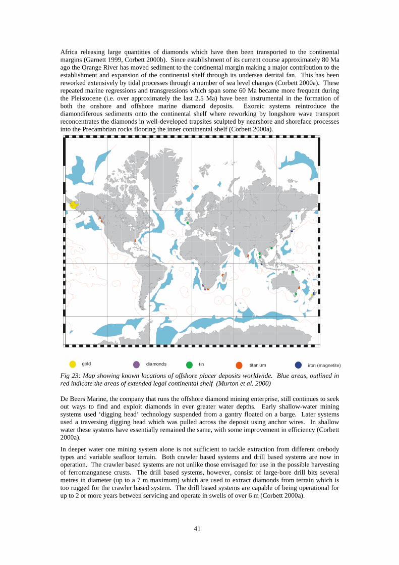
41
Africa releasing large quantities of diamonds which have then been transported to the continental margins (Garnett 1999, Corbett 2000b). Since establishment of its current course approximately 80 Ma ago the Orange River has moved sediment to the continental margin making a major contribution to the establishment and expansion of the continental shelf through its undersea detrital fan. This has been reworked extensively by tidal processes through a number of sea level changes (Corbett 2000a). These repeated marine regressions and transgressions which span some 60 Ma became more frequent during the Pleistocene (i.e. over approximately the last 2.5 Ma) have been instrumental in the formation of both the onshore and offshore marine diamond deposits. Exoreic systems reintroduce the diamondiferous sediments onto the continental shelf where reworking by longshore wave transport reconcentrates the diamonds in well-developed trapsites sculpted by nearshore and shoreface processes into the Precambrian rocks flooring the inner continental shelf (Corbett 2000a).
Fig 23: Map showing known locations of offshore placer deposits worldwide. Blue areas, outlined in red indicate the areas of extended legal continental shelf (Murton et al. 2000) De Beers Marine, the company that runs the offshore diamond mining enterprise, still continues to seek out ways to find and exploit diamonds in ever greater water depths. Early shallow-water mining systems used ‘digging head’ technology suspended from a gantry floated on a barge. Later systems used a traversing digging head which was pulled across the deposit using anchor wires. In shallow water these systems have essentially remained the same, with some improvement in efficiency (Corbett 2000a).
In deeper water one mining system alone is not sufficient to tackle extraction from different orebody types and variable seafloor terrain. Both crawler based systems and drill based systems are now in operation. The crawler based systems are not unlike those envisaged for use in the possible harvesting of ferromanganese crusts. The drill based systems, however, consist of large-bore drill bits several metres in diameter (up to a 7 m maximum) which are used to extract diamonds from terrain which is too rugged for the crawler based system. The drill based systems are capable of being operational for up to 2 or more years between servicing and operate in swells of over 6 m (Corbett 2000a).
gold tindiamonds titanium iron (magnetite)
42
The continental shelf of Namibia is an area of high biological activity characterised by the upwelling Benguela current. Important fisheries are associated with this area and provide potential for conflicting interests between the diamond mining and fisheries industries. Biological productivity in the region is recognised as being among the highest in the world with values in excess of 180 g Carbon m-2 yr-1. Two major fisheries exist in the region. The pelagic fisheries harvest primarily anchovy and sardine and the demersal fisheries target hake, which is the more valuable catch by weight. These fisheries combined have over 200 bottom trawling vessels which operate off the western coasts of South Africa and Namibia. Two environmentally complicating factors also exist. The formation of low-oxygen water along the south-western coast and the periodic flooding of the Orange River catchment. The former can have survival implications for the benthos biota as can the deposition of suspended sediment from the latter event. These factors must be taken into account when studying the environmental impact of diamond mining in the region (Corbett 2000b).
The amount of seafloor impacted by diamond mining annually is approximately 2.5 km2. So far 10 km2 have been mined. This represents a very small fraction (0.00002%) of the area under licence for mining by De Beers Marine. Mining extracts usually only the top 1 m of unconsolidated sediment from the seabed and utilises precise positioning equipment. The sediment is air-lifted to the mining vessel, screened, sized, processed using the addition of ferrosilicon. The waste is treated to remove the majority of ferrosilicon and the remaining waste (approximately 99.99% of that initially raised from the seabed) is then dumped overboard (Corbett 2000b).
The method by which De Beers Marine undertook their environmental investigations bears closer examination as it may be the model on which further marine EIAs are based. The EIA for diamond mining off Namibia and South Africa, as with all EIAs, required a baseline survey of the environment which would sustain the impact. This took six years to complete and used researchers from academia as well as De Beers Marine resources. There were a number of key areas which required investigation:
The surrounding sea – the influence on seawater of discharging overboard sediment produced from the mining process, and the influence of the descending sediment and the use of mining tools on the bottom waters (Corbett 2000b).
Fine grained sediments descending through the water column affect the availability of light for photosynthesis and cause a reduction in productivity. The fine-grained particles, containing an enhanced nutrient supply, in the sediment plume may also be filtered by zooplankton and affect their growth and consequently the entire food web. The sediment originates from the Orange River and therefore contains dissolved trace elements and pesticides, these could bioaccumulate in the food web if taken up. A fraction of the ferrosilicon introduced in the separation process is also dumped overboard with the tailings and could have a potential effect on the water quality and benthic communities. Lowered levels of oxygen in the bottom water as a result of bacterial decomposition of organic matter in the tailings could affect benthic communities (Corbett 2000b).
The findings of the study suggested that the extent of any problems as a result of these disturbances was minimal and limited in extent to the area in the immediate vicinity of the mining vessel. Lowered oxygen in the bottom water was not measurable as a result of tailings disposal, but resedimentation did result in the burial of sessile organisms (Corbett 2000b).
The seabed and resident biological communities – the effect of removing and returning seabed sediments and the consequences for the biota living in and on these sediments.
The mining operation destroys the habitat of infaunal communities and others are smothered by resedimentation. Recolonisation of this chronically disturbed region by benthic organisms and the re-establishment of a stable biological community was found to take between 4 and 8 years (Corbett 2000b). It should be noted that this community is not necessarily the same as the pre-disturbance community.
Fish and marine mammals – the presence of mining operations on their distribution and behaviour
The fisheries in the area are further out to sea than the mining operation and there is no overlap. Fish spawning areas do not exist in the mining area and there are relatively few fish species present. Nor was the inshore rock lobster fishery affected as habitat and fishing areas did not overlap with the areas scheduled for mining (Corbett 2000b).
43
Marine mammals were potentially affected by some sonar equipment used but it was not possible to determine whether this was taking place without further investigation (Corbett 2000b).
Birds in the Orange River estuary – the consequences of frequent flights over the area which is a RAMSAR site (designated as being a wetland of international importance)
Flight paths for helicopters were changed to avoid overflight of the river mouth (Corbett 2000b).
It is worth noting that subsequent work has been undertaken in part to verify the actual impact caused by offshore diamond mining. Comparisons between unmined and mined areas indicated that the seabed looked similar whether the area had been mined or not, but that there was a complete absence of epifauna in the mined areas and a lack of biogenic holes in the sediment. Also the mining disturbance caused a reduction in the number of nekton (free swimming organisms) both in terms of species and numbers. An area of approximately 200 m beyond the actual mine site is impacted on by mining activity where a reduction in the epifaunal species diversity and abundance is found. The density of infaunal burrows is also reduced in this area and it has been inferred from this that infaunal species are also affected by the mining disturbance (Corbett 2000b). The work performed by submersibles also, however, gave an insight into the natural disturbances and sediment entrainment that occurs in the ecosystem of the Benguela Current where visibility can be severely reduced by swells at the seabed causing sediment disturbance. The differences between natural catastrophism and anthropogenic mining disturbance are not always clearly defined and the latter may mimic the former in some marine habitats (Corbett 2000b).
7.2.1.3 Sand and Gravel
The most widely recovered marine placers are sand and gravel dredged from beaches and shallow offshore bars at numerous sites worldwide for use in the construction industry and for the replenishment of beaches (Rona 2000). A number of countries are involved in dredging for aggregates, including the United Kingdom and Japan (Woolsey 1991). Their occurrence is as a result of hydrodynamic forces. Sand and gravel were probably the first minerals to be recovered from the sea and they constitute the earliest marine mining effort. Aggregates were being recovered from the North Sea off the United Kingdom more than 100 years ago. Aggregate recovery from marine sources has increased in recent years as land based supplies dwindle and stricter environmental controls are placed on terrestrial aggregate extractors. Of all the minerals discussed in this paper, sand and gravel have the lowest bulk value. A large amount of their cost is for transportation, and as transportation by sea is generally cheaper than by land, the increased cost of marine mining is offset by the cheaper transportation costs (Yates et al. 1986). Prime markets for marine derived aggregates are large coastal metropolitan areas, as the cost of aggregates can double on a terrestrial journey of only 50 km. Sand and gravel extraction are usually confined to water depths of < 30 m although it is expected that technological improvements in dredge design will see this depth increase in the future (Yates et al. 1986).
7.2.2 How do placers get where they are found?
The placer minerals are washed with sediment in rivers to the sea and, as a result, tend to occur on continental shelves in near shore areas. Larger, denser grains tend to be deposited closest to the original source (Yates et al. 1986, Murton et al. 2000). Although their deposition may have taken place when coastlines were different from today, shelf deposits large enough to survive marine transgression tend to form disseminated deposits of low grade and little economic value (Murton et al. 2000). The more concentrated, recent and, therefore, more economically interesting, deposits usually come under national jurisdiction within a country’s EEZ and in water less than 120 m deep (Murton et al. 2000).
Fig 23 shows the presently known placer deposits of economic significance. In most placer deposits, economically valuable minerals have been mechanically concentrated in rivers along beaches, fan-aprons and river deltas as a result of their higher density (> 3.2 g cm-3) compared with the bulk of detrital minerals which consist mostly of quartz and feldspar (with a density of 2.7 g cm-3). These placer minerals are derived from weathering of continental rocks of mostly volcanic, plutonic, or metamorphic origin and have a broad compositional range.
Many marine deposits of useful grade minerals exist along the sea boundaries of the former USSR, abutting approximately 47,000 km of shoreline. In the Baltic Sea titanium-bearing placers occur in
44
submarine bars forming a band extending along recent coastlines for many tens of kilometres and approximately 0.5 – 0.7 km from the shore. Known occurrences of iron and phosphorite nodules also occupy considerable areas of the seafloor in the bays of the Baltic Sea. Amber-bearing rock outcrops on the sea-bottom have also been found near the Sambiy Peninsula (Bruyakin 1989).
On the Black Sea bottom between the Chorohi and Bziyib river estuaries there is a deposit of magnetite (iron-bearing) sands extending for about 250 km. These sands have an iron content averaging 6.3%. In Carkinit Bay of the Asov Sea iron ore outcroppings occur at water depth of 5-15 m and have an iron content of 53% (Bruyakin 1989).
In the recent sediments bordering the Sea of Japan there are industrial grade concentrations of heavy minerals. The minerals are concentrated in the well-graded sand fraction, with a grain size less than 0.25 mm. There are also deposits of titanium and magnetite bearing sands near Sakhalin Island. Similarly there are extractable grade ores found along the Kamchatka peninsula coastline (Bruyakin 1989).
Exploration has shown the presence of modern marine placers along virtually the entire eastern seaboard of China, including in the East China Sea. In almost all cases, it can be shown that the marine placers were derived from the adjacent on-land rocks (Clark & Li 1991).
There are various marine placers on the rim of the Arctic Ocean, where heavy minerals are found both on the beach and on the submarine slope (Bruyakin 1989).
7.2.3 What is the current state of their exploitation?
The first large-scale mining of marine deposits of titanium-bearing sands was undertaken in the Baltic Sea in 1966. This used a hopper dredge with two trailing suction pipes to mine the submarine placer. Once the hopper was full the dredge ship took the extracted sand into port for further preparation (Bruyakin 1989).
Trial extraction of magnetite sands was conducted in the Black Sea between the Sypsa and Kintrishi rivers in water depths ranging from 5 – 16 m. Mining was undertaken using two separate processes. The sand and sediment having been dredged was first passed through a screen to separate out the coarse sand fraction. The remaining smaller particles were then passed through a magnetic separator. After final cleaning the concentrate produced contained more than 50% iron, and lesser percentages of silicon, calcium, mercury, titanium, vanadium and phosphorus compounds (Bruyakin 1989).
The most valuable (per unit weight) marine mineral placers are probably the diamonds mined by De Beers and others off southwestern Africa. Highly sophisticated bulk sampling and mining equipment has been developed to allow recovery of the stones from depths as great as 300 m. In 1998 recoveries of diamonds from offshore operations were estimated to be worth more than US$ 1 billion, predominantly in gem quality diamonds (Cruickshank 1999a).
7.2.4 What are the environmental impacts of recovering mineral placers?
The physical processes involved in the mining of marine placers causes changes in hydrological and ecological conditions in the sea and on the seabed and can have undesirable environmental consequences. Physical contamination shows in the increased turbidity in areas of mining and marine dumping which changes the electroproductivity and optical properties of seawater, can suffocate hydrobiota, and causes mechanical damage to their cover in turn disturbing the conditions required for the reproduction of some fish species. Chemical contamination by oil products, detergents, heavy metals and other substances causes chemical changes in water quality which can affect marine life. Ecosystems thus disrupted can undergo major changes in species composition and dominance (Bruyakin 1989).
7.3 Marine Phosphorites
7.3.1 What are they?
Phosphorite deposits are naturally occurring compounds containing phosphate in the form of a cement binding sediments in tropical to sub-tropical regions. They tend to occur in waters of medium depth and are widely distributed on the continental shelves and upper slopes in areas of upwelling currents. They also occur on oceanic islands, seamounts or the flanks of atolls (Murton et al. 2000). Phosphates in the form of phosphorites are composed of calcium phosphate which is an important fertiliser. They are, therefore, of principal value to agriculture.
45
7.3.2 Where are they found?
Relatively rich deposits are known to occur in areas such as off the coast of Baja California, southern California, and east of New Zealand. In many places, however, they consist of discrete nodules scattered within sediments and are too sparsely distributed to be recoverable. The phosphate concentration within the deposits is also variable but is seldom more than 29% (Murton et al. 2000). There are large, commercially valuable, deposits on Nauru, Ocean and Christmas Islands in the Pacific and there is potential for similar deposits to occur on shallow (less than 120 m deep) submerged seamounts, within the Pacific region. There are potential and low grade phosphorite deposits on the Chatham Rise off New Zealand (~ 5% phosphate) and offshore from Cochin and Mumbai (Bombay), India. Other major deposits occur off south and south-western Africa, north-western Africa, the western and eastern margins of South America and western Australia (Murton et al. 2000).
7.3.3 What is the current state of their exploitation?
It has been estimated that world sub-sea deposits of phosphorite are in the order of hundreds of billions of tonnes. But phosphates from terrestrial sources remain readily available and cheap and, as a result, there has been little effort directed at exploitation of marine phosphorite deposits. This situation may change in small areas where on-shore deposits are far removed but this has not, so far, taken place.
7.3.4 What are the environmental impacts of recovery of marine phosphorites?
As these resources remain largely unexamined from a commercial standpoint due to their low current value, there has been little drive to examine any marine communities which occur in and above them. Any disturbance of the phosphorite environments as a result of mining cannot, therefore, be readily quantified although it would not be unreasonable to suggest that any release of phosphate into the marine environment would constitute an increase in available nutrients. The diverse latitudes at which these deposits occur, and their prominence in relatively near-shore environments where the highest concentrations of marine biomass tend to occur suggest that biological communities may be well disturbed by any phosphorite recovery attempt. Unlike hydrothermal vent communities, however, which occur in close association with the potential mineral resource, there is no suggestion that a particular biological community exists in conjunction with phosphorite deposits. The likelihood is that the biological communities occurring in and above phosphorite deposits are as diverse as any given their shallow water environment and large geographical range.
8 M A R I N E B I O R E S O U R C E S
The marine environment is home to a very large number of diverse organisms. Conservatively there are about 200,000 species of marine invertebrates alone, at least 30,000 species of marine algae and an unknown number of species of prokaryotic (usually bacterial) organisms. All but two of the animal phyla are found in aquatic environments and eight animal phyla are exclusively aquatic and largely marine (Borowitzka 1995). Similarly all the algal divisions have marine representatives and several are almost exclusively marine. The marine environment therefore represents an immense, and largely unexploited, reservoir of biological and genetic diversity (Borowitzka 1995). Over the last 25 years there has also come the recognition that marine organisms have a unique and very diverse chemistry different from that of terrestrial organisms. Not only are halogenated compounds common in marine biota, but there are a wide range of many novel chemical structures not seen in terrestrial organisms (Borowitzka 1995). Systematic screening of marine organisms for biologically active molecules began in earnest in the mid-1970s and is now commonplace. Although the original investigations concentrated on the macrofauna and flora, more recently it has been recognised that marine bacteria, microalgae and other micro-organisms can also be the source of such novel molecules (Borowitzka 1995).
In accordance with UNCLOS the international seabed is the ‘common heritage of mankind’. Measures are, therefore, in place to ensure that biological diversity of the seabed are not disturbed or diminished by anthropogenic operations within the international seabed area. Rules suggested at the 1999 meeting of the ISA provide for the conservation of biological diversity, the advocation of the precautionary principle and the sustainable use of the international seabed, although whether these rules will be adopted has yet to be decided (Anon 1999).
46
8.1 What are they?
Any biological organism could be described as a bioresource, but the term tends to be applied to organisms which can be used for commercial profit. Marine bioresources have become of immense commercial importance with the development of biotechnology and in particular of molecular biology. Marine biotechnology uses marine, riverine or estuarine organisms in products and processes. Of these the riverine and estuarine organisms are, unsurprisingly, the most studied. Marine microbes are now known to be a source of potential antibiotics, anti-tumour agents, pain relief and related pharmaceuticals (Pramik 1998, Colwell 1999).
Most important commercially have been the relatively recent discovery of thermophiles and psychrophiles, organisms that thrive in extreme temperature regimes. Thermophiles grow in extremely hot water, and are often associated with hot springs be they terrestrial (e.g. Yellowstone National Park in the US) or marine (in the environs of black smokers in volcanic regions of the seabed). Psychrophiles like it cold, preferring freezing habitats such as the waters in and beneath the polar ice (Colwell 1999).
8.2 What is currently being exploited?
Enzymes produced by thermophiles have been widely used in biotechnology. In particular they are a fundamental ingredient in the process known as PCR, or polymerase chain reaction, which underlies practically all techniques in biotechnology, and allows the amplification of DNA in the laboratory at temperatures far in excess of those at which DNA from the majority of organisms normally replicates. And uses are also being found for psychrophiles. ‘Cold shock’ proteins from one such organism are being used to make artificial snow and further applications are in development (Cruickshank 1999a).
Commercial food supplements and food colouring agents are also produced from marine organisms. Two Hawaiian companies produce food supplements from Spirulina, and astaxanthin for giving farmed salmon their deep pink colour. Extracts of marine organisms are also used in cosmetics. Neophenicol is an anti-microbial extract from a sea whip and is used in Estee Lauder’s natural cosmetic line (Pramik 1998).
8.3 What is expected in the future?
Mining the many types of marine mineral resource outlined in this paper would clearly have very different impacts both due to the diversity of geographical locations under investigation as marine mineral resources and their occurrences from shallow beach placer deposits to minerals on the oceans’ abyssal plains. Each mineral deposit is likely to have its own unique set of associated biota and each would need to be examined individually to determine the potential impact.
The greatest conflict of interest in commercial terms is likely to occur where potential bioresources are found in the same area as a marine mineral resource. There is some scope for this to occur between shallow water mining and inshore fisheries, but greater scope in areas where unique biota are part of a marine mineral deposit. This is particularly true of hydrothermal vent communities, where unique biological communities occur directly on seabed massive sulphide deposits.
9 L E G I S L A T I V E C O N S I D E R A T I O N S
9.1 The International Seabed Authority
The existence of polymetallic manganese nodules was the driver for a huge and long running legal process to determine ownership of the resource. There were three possible ways forward: 1) First come first served; 2) joint ownership by a number of nations (as with the Antarctic Treaty) or 3) joint ownership by all nations. After a great deal of talk over many years the United Nations General Assembly announced in 1970 that the deep seabed and its resources beyond the limits of national jurisdiction should be declared the ‘common heritage of mankind’ and be used in the interests of all nations. It took a further 12 years until, on 30 April 1982, the Third United Nations Conference on the Law of the Sea adopted the text of the Law of the Sea Convention, which opened for signature in December 1982. A great deal of the effort that had been put into the text of the LOS over that intervening 12 years had been spent working out an equitable system for the development of that heritage.
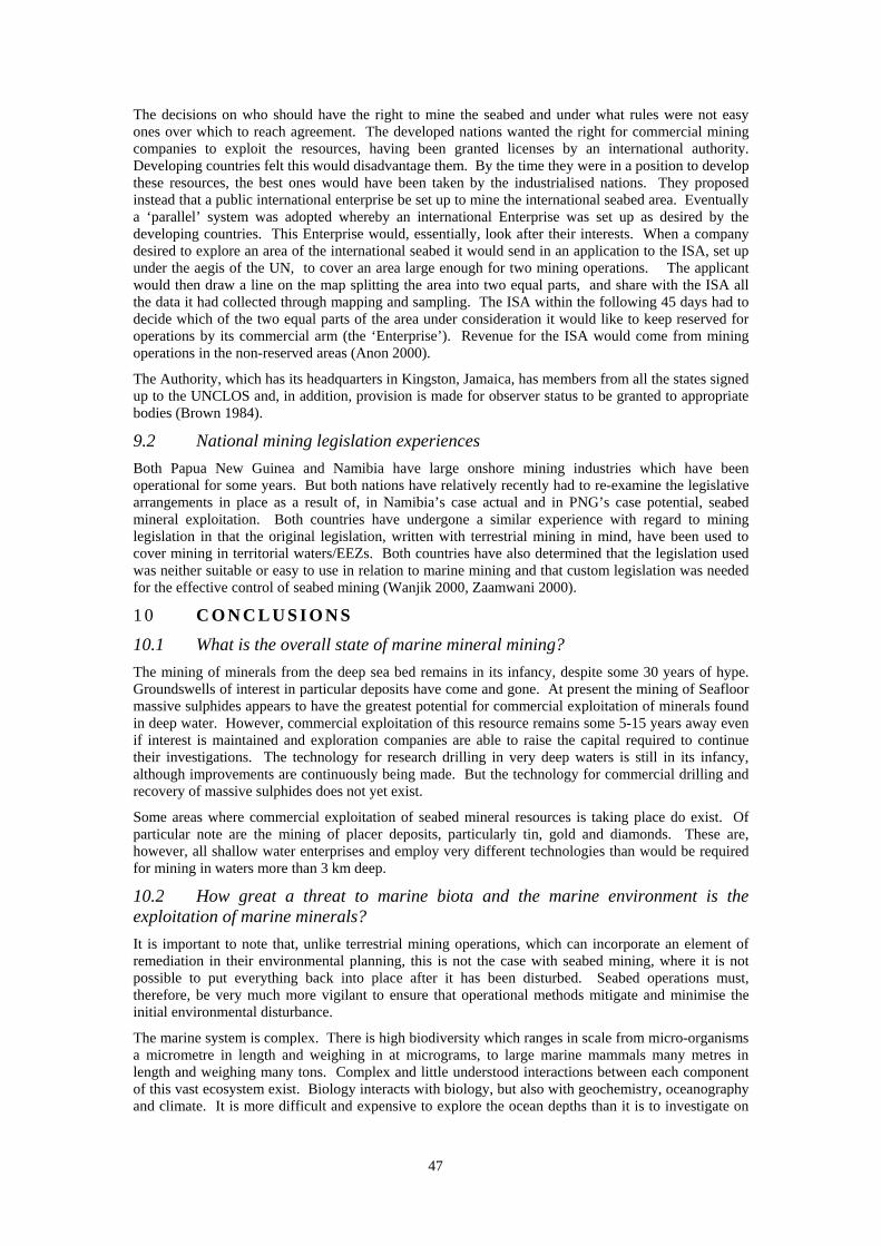
47
The decisions on who should have the right to mine the seabed and under what rules were not easy ones over which to reach agreement. The developed nations wanted the right for commercial mining companies to exploit the resources, having been granted licenses by an international authority. Developing countries felt this would disadvantage them. By the time they were in a position to develop these resources, the best ones would have been taken by the industrialised nations. They proposed instead that a public international enterprise be set up to mine the international seabed area. Eventually a ‘parallel’ system was adopted whereby an international Enterprise was set up as desired by the developing countries. This Enterprise would, essentially, look after their interests. When a company desired to explore an area of the international seabed it would send in an application to the ISA, set up under the aegis of the UN, to cover an area large enough for two mining operations. The applicant would then draw a line on the map splitting the area into two equal parts, and share with the ISA all the data it had collected through mapping and sampling. The ISA within the following 45 days had to decide which of the two equal parts of the area under consideration it would like to keep reserved for operations by its commercial arm (the ‘Enterprise’). Revenue for the ISA would come from mining operations in the non-reserved areas (Anon 2000).
The Authority, which has its headquarters in Kingston, Jamaica, has members from all the states signed up to the UNCLOS and, in addition, provision is made for observer status to be granted to appropriate bodies (Brown 1984).
9.2 National mining legislation experiences
Both Papua New Guinea and Namibia have large onshore mining industries which have been operational for some years. But both nations have relatively recently had to re-examine the legislative arrangements in place as a result of, in Namibia’s case actual and in PNG’s case potential, seabed mineral exploitation. Both countries have undergone a similar experience with regard to mining legislation in that the original legislation, written with terrestrial mining in mind, have been used to cover mining in territorial waters/EEZs. Both countries have also determined that the legislation used was neither suitable or easy to use in relation to marine mining and that custom legislation was needed for the effective control of seabed mining (Wanjik 2000, Zaamwani 2000).
1 0 C O N C L U S I O N S
10.1 What is the overall state of marine mineral mining?
The mining of minerals from the deep sea bed remains in its infancy, despite some 30 years of hype. Groundswells of interest in particular deposits have come and gone. At present the mining of Seafloor massive sulphides appears to have the greatest potential for commercial exploitation of minerals found in deep water. However, commercial exploitation of this resource remains some 5-15 years away even if interest is maintained and exploration companies are able to raise the capital required to continue their investigations. The technology for research drilling in very deep waters is still in its infancy, although improvements are continuously being made. But the technology for commercial drilling and recovery of massive sulphides does not yet exist.
Some areas where commercial exploitation of seabed mineral resources is taking place do exist. Of particular note are the mining of placer deposits, particularly tin, gold and diamonds. These are, however, all shallow water enterprises and employ very different technologies than would be required for mining in waters more than 3 km deep.
10.2 How great a threat to marine biota and the marine environment is the exploitation of marine minerals?
It is important to note that, unlike terrestrial mining operations, which can incorporate an element of remediation in their environmental planning, this is not the case with seabed mining, where it is not possible to put everything back into place after it has been disturbed. Seabed operations must, therefore, be very much more vigilant to ensure that operational methods mitigate and minimise the initial environmental disturbance.
The marine system is complex. There is high biodiversity which ranges in scale from micro-organisms a micrometre in length and weighing in at micrograms, to large marine mammals many metres in length and weighing many tons. Complex and little understood interactions between each component of this vast ecosystem exist. Biology interacts with biology, but also with geochemistry, oceanography and climate. It is more difficult and expensive to explore the ocean depths than it is to investigate on
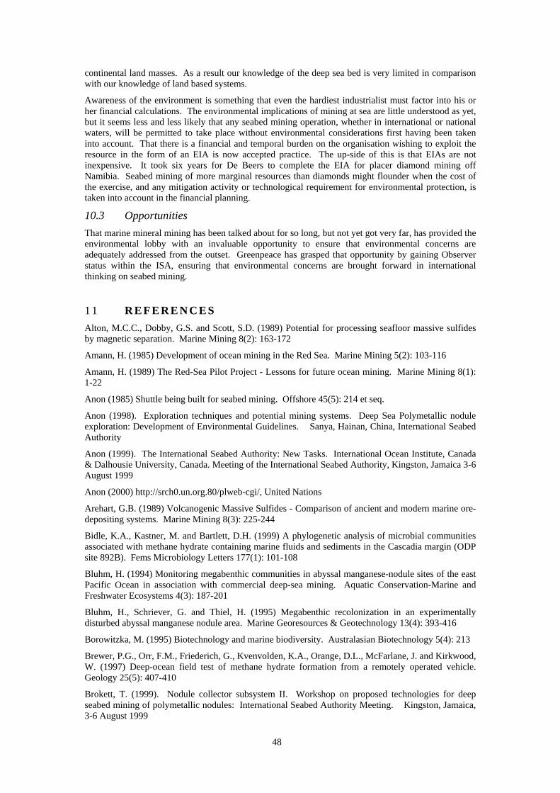
48
continental land masses. As a result our knowledge of the deep sea bed is very limited in comparison with our knowledge of land based systems.
Awareness of the environment is something that even the hardiest industrialist must factor into his or her financial calculations. The environmental implications of mining at sea are little understood as yet, but it seems less and less likely that any seabed mining operation, whether in international or national waters, will be permitted to take place without environmental considerations first having been taken into account. That there is a financial and temporal burden on the organisation wishing to exploit the resource in the form of an EIA is now accepted practice. The up-side of this is that EIAs are not inexpensive. It took six years for De Beers to complete the EIA for placer diamond mining off Namibia. Seabed mining of more marginal resources than diamonds might flounder when the cost of the exercise, and any mitigation activity or technological requirement for environmental protection, is taken into account in the financial planning.
10.3 Opportunities
That marine mineral mining has been talked about for so long, but not yet got very far, has provided the environmental lobby with an invaluable opportunity to ensure that environmental concerns are adequately addressed from the outset. Greenpeace has grasped that opportunity by gaining Observer status within the ISA, ensuring that environmental concerns are brought forward in international thinking on seabed mining.
1 1 R E F E R E N C E S
Alton, M.C.C., Dobby, G.S. and Scott, S.D. (1989) Potential for processing seafloor massive sulfides by magnetic separation. Marine Mining 8(2): 163-172
Amann, H. (1985) Development of ocean mining in the Red Sea. Marine Mining 5(2): 103-116
Amann, H. (1989) The Red-Sea Pilot Project - Lessons for future ocean mining. Marine Mining 8(1): 1-22
Anon (1985) Shuttle being built for seabed mining. Offshore 45(5): 214 et seq.
Anon (1998). Exploration techniques and potential mining systems. Deep Sea Polymetallic nodule exploration: Development of Environmental Guidelines. Sanya, Hainan, China, International Seabed Authority
Anon (1999). The International Seabed Authority: New Tasks. International Ocean Institute, Canada & Dalhousie University, Canada. Meeting of the International Seabed Authority, Kingston, Jamaica 3-6 August 1999
Anon (2000) http://srch0.un.org.80/plweb-cgi/, United Nations
Arehart, G.B. (1989) Volcanogenic Massive Sulfides - Comparison of ancient and modern marine ore-depositing systems. Marine Mining 8(3): 225-244
Bidle, K.A., Kastner, M. and Bartlett, D.H. (1999) A phylogenetic analysis of microbial communities associated with methane hydrate containing marine fluids and sediments in the Cascadia margin (ODP site 892B). Fems Microbiology Letters 177(1): 101-108
Bluhm, H. (1994) Monitoring megabenthic communities in abyssal manganese-nodule sites of the east Pacific Ocean in association with commercial deep-sea mining. Aquatic Conservation-Marine and Freshwater Ecosystems 4(3): 187-201
Bluhm, H., Schriever, G. and Thiel, H. (1995) Megabenthic recolonization in an experimentally disturbed abyssal manganese nodule area. Marine Georesources & Geotechnology 13(4): 393-416
Borowitzka, M. (1995) Biotechnology and marine biodiversity. Australasian Biotechnology 5(4): 213
Brewer, P.G., Orr, F.M., Friederich, G., Kvenvolden, K.A., Orange, D.L., McFarlane, J. and Kirkwood, W. (1997) Deep-ocean field test of methane hydrate formation from a remotely operated vehicle. Geology 25(5): 407-410
Brokett, T. (1999). Nodule collector subsystem II. Workshop on proposed technologies for deep seabed mining of polymetallic nodules: International Seabed Authority Meeting. Kingston, Jamaica, 3-6 August 1999
49
Brown, E.D. (1984) Seabed Mining - From UNCLOS to Prepcom. Marine Policy 8(2): 151-164
Bruyakin, Y.V. (1989) Marine mining on the continental-shelf. Marine Mining 8(4): 391-403
Clark, A.L. and Li, C. (1991) Marine mineral-resources of the East-China-Sea - Scientific and Economic Opportunities. Marine Mining 10(2): 117-144
Colwell, R. (1999) Marine biotechnology. Sea Technology 40(1): 50-51
Corbett, I. (2000a). A case study in the development of an environmental baseline in a large open-ocean system off southern Namibia by De Beers Marine. Workshop on mineral resources of the International Seabed Area: International Seabed Authority Meeting. Kingston, Jamaica, 26-30 June 2000
Corbett, I. (2000b). A case study in the development of the offshore diamond mining industry in Namibia. Workshop on mineral resources of the International Seabed Area: International Seabed Authority Meeting. Kingston, Jamaica, 26-30 June 2000
Cronan, D.S., Hodkinson, R.A. and Miller, S. (1991) Manganese nodules in the EEZs of island countries in the Southwestern Equatorial Pacific. Marine Geology 98(2-4): 425-435
Cronan, D.S. and Moorby, S.A. (1981) Manganese nodules and other ferromanganese oxide deposits from the Indian-Ocean. Journal Of the Geological Society 138(SEP): 527-539
Cruickshank, M. (1999a) Conferences and workshops planned as US research reduction continues. Sea Technology 40(2): 90
Cruickshank, M. (1999b) Mining: a significant non-action. Sea Technology 40(1): 48-50
Cruickshank, M.J. (1999c). Methane hydrate research and development. Workshop on Proposed Technologies for Deep Seabed Mining of Polymetallic Nodules: International Seabed Authority Meeting. Kingston, Jamaica, 3-6 August 1999
Desa, E. (2000). Submarine methane hydrates - potential fuel resource of the 21st century. Workshop on mineral resources of the International Seabed Area: International Seabed Authority Meeting. Kingston, Jamaica, 26-30 June 2000
Dillon, W.P. (1998) Gas Gydrate as a potential Resource - what do we need to know? JNOC-Japan 20-22 October 1998: 13-15
Dobrynin, V.N.M., Korotajev, Y.P. and Plyuschev, D.V. (1981) Gas hydrates – a possible energy resource. In: Myeter, R.F. and Olson, J.C. (Eds) Long-term energy resources. Publ: Pitman, Boston: 727-729
Garnett, R.H.T. (1999). New, proven, mining systems for placer deposits on the continental shelf. Workshop on Proposed Technologies for Deep Seabed Mining of Polymetallic Nodules: International Seabed Authority Meeting. Kingston, Jamaica, 3-6 August 1999
Glasby, G.P. (1982) Marine Mining and Mineral Research Activities In Europe. Marine Mining 3(3-4): 379-409
Gornitz, V. and Fung, I. (1994) Potential distribution of methane hydrates in the worlds oceans. Global Biogeochemical Cycles 8(3): 335-347
Gross, G.A. and McLeod, C.R. (1987). Metallic minerals on the deep seabed. Geological Survey of Canada, 65pp. 86/21
Halbach, P.E., Sattler, C.D., Teichmann, F. and Wahsner, M. (1989) Cobalt-rich and platinum-bearing manganese crust deposits on seamounts - nature, formation, and metal potential. Marine Mining 8(1): 23-39
Harriss, K.W. (1983) Earliest use of suction dredge for seabed mining. Engineering and Mining Journal 184(1): 5
Hein, J. (2000). Cobalt-rich ferromanganese crusts: global distribution, composition, origin and research activities. Workshop on mineral resources of the International Seabed Area: International Seabed Authority Meeting. Kingston, Jamaica, 26-30 June 2000
Herzig, P.M. and Hannington, M.D. (1995) Polymetallic massive sulfides at the modern seafloor - A review. Ore Geology Reviews 10(2): 95-115
50
Herzig, P.M. and Petersen, S. (2000a). Polymetallic massive sulphide deposits on the modern seafloor and their resource potential. Workshop on mineral resources of the International Seabed Area: International Seabed Authority Meeting. Kingston, Jamaica, 26-30 June 2000
Herzig, P.M. and Petersen, S. (2000b). Technical requirements for exploration and mining of seafloor massive sulphide deposits and cobalt-rich ferromanganese crusts. Workshop on mineral resources of the International Seabed Area: International Seabed Authority Meeting. Kingston, Jamaica, 26-30 June 2000
Hong, S. (1999). Research and development of deep seabed mining technologies for polymetallic nodules in Korea. Workshop on Proposed Technologies for Deep Seabed Mining of Polymetallic Nodules: International Seabed Authority Meeting. Kingston, Jamaica, 3-6 August 1999
Juniper, K. (2000). Vent biology. Workshop on mineral resources of the International Seabed Area: International Seabed Authority Meeting. Kingston, Jamaica, International Seabed Authority, 26-30 June 2000
Kvenvolden, K.A. (1988) Methane hydrate – a major reservoir of carbon in the shallow geosphere? Chemical Geology 71: 51-51
Kvenvolden, K.A. (1993) Gas hydrates - geological perspective and global change. Reviews Of Geophysics 31(2): 173-187
Liu, F. (1999). Environmentally friendly deep seabed mining system. Workshop on Proposed Technologies for Deep Seabed Mining of Polymetallic Nodules: International Seabed Authority Meeting. Kingston, Jamaica, 3-6 August 1999
MacDonald, G.J. (1990) The future of methane as an energy resource. Annual Review of Energy 15: 53-83
Malnic, J. (2000). Factors in the financing of seafloor massive sulphide exploration. Workshop on mineral resources of the international seabed area: International Seabed Authority meeting. Kingston, Jamaica, 26-30 June 2000
McIver, R.D. (1981) Gas hydrates. In: Meyer, R.F. and Olson, J.C. (Eds) Long-term Energy Resources. Publ: Pitman, Boston: 713-726
Mero, J.L. (1965) Mineral Resources of the Sea. Amsterdam, Elsevier
Meyer, R.F. (1981) Speculations on oil and gas resources in small fields and unconventional deposits. In: Meyer, R.F. and Olson, J.C. (Eds) Long-term Energy Resources. Publ: Pitman, Boston: 49-72
Murton, B.J., Parson, L.M., Hunter, P.J. and Miles, P.R. (2000). Evaluation of the non-living resources of the continental shelf beyond the 200-mile limit of the world's margins. Workshop on mineral resources of the International Seabed Area: International Seabed Authority Meeting. Kingston, Jamaica, 26-30 June 2000
Pramik, M.J. (1998) Bioresources from the sea - Renewed interest in the world's most organically diverse environment. Genetic Engineering News 18(5): 8 et seq.
Rona, P.A. (1986) Mineral deposits from seafloor hot springs. Scientific American 254(1): 84-92
Rona, P.A. (2000). Metallogenesis of marine mineral deposits. Workshop on mineral resources of the International Seabed Area: International Seabed Authority Meeting. Kingston, Jamaica, International Seabed Authority, 26-30 June 2000
Southward, E.C. and Galkin, S.V. (1997) A new vestimentiferan (Pogonophora: Obturata) from hydrothermal vent fields in the Manus Back arc Basin (Bismarck Sea, Papua New Guinea, Southwest Pacific Ocean). Journal Of Natural History 31(1): 43-55
Trofimuk, A.A., Cherskii, N.V. and Tsaryov, V.P. (1977) The role of continental glaciation and hydrate formation on petroleum occurrence. In: Meyer, R.F. (Ed) The future supply of nature-made petroleum and gas. Publ: Pergamon, New York: 919-926
Wanjik, J. (2000). Status report on the data and reporting requirements of Papua New Guinea's polymetallic massive sulphides. Workshop on mineral resources of the International Seabed Area: International Seabed Authority Meeting. Kingston, Jamaica, 26-30 June 2000
51
Woolsey, J.R. (1991) Marine placer mining systems .1. Adaptations of traditional dredge designs and new mechanical concepts for continental-shelf applications. Marine Mining 10(2): 145-154
Yates, J., Spagni, D. and Keane, J. (1986) Marine mining - birth of a new industry. Endeavour 10(1): 44-49
Yubko, V.M., Melnikov, M.E., Hazmin, Y.B. and Glumov, A.I. (2000). The regional and local variability of spatial distribution of cobalt-rich ferromanganese crust accumulation of the world ocean. Workshop on mineral resources of the International Seabed Area: International Seabed Authority Meeting. Kingston, Jamaica, 26-30 June 2000
Zaamwani, I.K. (2000). Status report on the data and reporting requirements of Namibia's offshore mining policy as it relates to prospecting and exploration (information and data requirements during prospecting and exploration and degrees of compliance). Workshop on mineral resources of the International Seabed Area: International Seabed Authority Meeting. Kingston, Jamaica, 26-30 June 2000
1 2 G L O S S A R Y
Adiabatic Processes of heating and cooling of (usually) gases as a consequence of expansion or compression
Aeolian Pertaining to, or caused by wind.
Andesite Fine-grained dark coloured volcanic rock.
Anhydrite Anhydrous calcium sulphate CaSO4. Common in evaporite deposits
Archipelago Sea with a group of many islands.
Authigenic (of mineral constituents) formed in a rock at the site where the rock is found, applied mainly to sedimentary material.
AUV Autonomous Underwater Vehicle.
Barite Also called baryte or heavy spar. BaSO4. Principal ore of barium and used in drilling mud, paint manufacture and filler for paper/textiles.
Birnessite A type of manganese oxide.
Bornite (peacock ore). CuFeS4, a common copper-iron sulphide and ore of copper. When freshly exposed it is bronze in colour but readily tarnishes in air to a purple iridescence.
BSR Bottom Simulating Reflector
Caldera A very large bowl-shaped volcanic depression, having a larger horizontal dimension than vertical dimension.
Calcite Stable form of calcium carbonate (CaCO3). Chief constituent of limestone and marble.
Cassiterite SnO2, the major ore of tin. It is a red, brown or black mineral which can occur in high-temperature hydrothermal veins and in placers
Chalcopyrite CuFeS2 is the most important ore of copper, which is brassy or golden-yellow in colour.
Cinnabar HgS, the principal ore of mercury.
Clastic Pertains to a sediment or rock composed mainly of pieces and fragments derived from pre-existing rocks or minerals. The texture of such rock.
Clathrates Compound in which one component is enclosed in the structure of another.
Diagenesis The sum of all changes (physical, chemical and biological) to which a sediment is subjected after deposition (excluding weathering or metamorphism).
Diapir A vertical columnar plug of less dense rock or magma that is forced through a more dense rock.
52
EEZ Economic Exclusion Zone
ELCS Extended Legal Continental Shelf
Eh The oxidation/reduction potential of an aqueous environment.
End-member One of the two extremes of a series e.g. types of sedimentary or igneous rocks, minerals or fossils.
Fluorapatite A phosphate bearing mineral
Galena PbS is the main ore of lead. It is a grey, metallic mineral typically found in medium-temperature hydrothermal deposits.
HOV Human Occupied Vehicle.
Hydrogenetic Having its origin in water
Isocubanite CuFe2S3. A copper containing mineral.
Kimberlite A volatile-rich ultramafic igneous rock, containing a variety of minerals, but particularly known for its diamonds
Lithosphere The solid outer shell of the Earth, including the crust and uppermost rigid layer of the mantle.
Ma One million (106) years
Mafic Magnesium and iron rich minerals
Magnetite (Fe,Mg)Fe2O4. The most important ore of iron. It is a shiny black mineral with strong magnetic properties and is found in a variety of rocks, especially in contact metasomatic conditions.
Marcasite FeS2 dimorphous with pyrite. It is pale-yellow in colour and occurs in low-temperature hydrothermal veins and in sedimentary environments.
Massive (of rocks) having a homogenous structure or texture.
Metasomatism The metamorphic process by which existing minerals are transfomed totally or partially into new minerals by the replacement of their chemical constituents.
Orpiment As2O3, Arsenic trioxide. Lemon-yellow to orange mineral occurring in veins of lead, sulphur and gold ores.
Ophiolite A series of mafic and ultramafic rocks associated with pelagic sediments and sometimes now found as intrusions in continental landmasses. The Troodos ophiolite in Cyprus is an example
ppm Parts per million
pH The symbol for hydrogen-ion concentration, i.e. the degree of acidity or alkalinity of a substance in solution.
Phyco-colloid A plant substance consisting of two homogenous phases or parts, one of which is dispersed in the other.
Placer A deposit of heavy minerals in streambeds, in which the valuable substances have been concentrated as the lighter-weight minerals have been carried away by the stream. Placers are economically important as they can be mined easily.
Polymerase An enzyme that catalyses the joining of DNA or RNA nucleotides.
Psychrophile An organism showing optimal growth at temperatures between 0oC and 20oC
Pyrite (Fool’s gold). FeS2 is an important ore of sulfur and is dimorphous with marcasite. It is a yellow-gold mineral (hence fool’s gold) and forms under a wide range of pressure-temperature conditions.
Pyrrhotite (magnetic pyrites). Fe1-xS (x=0-0.2) is a yellowish-brown mineral, very close in composition to that of iron sulphide, but it is deficient in iron. Some pyrrhotite is magnetic and nickle-bearing deposits are among the main sources of nickle.
53
Orpiment
Realgar As2S2, arsenic sulphide is an important ore of arsenic, however it is an unstable and uncommon mineral usually found in compact aggregates and brilliant red-orange films. It is deposited in hot springs and low-temperature hydrothermal veins.
ROV Remotely Operated Vehicle.
Sphalerite (Zn,Fe)S. An isomeric sulphide mineral. Its colour varies from yellow to reddish brown to blackish and it is the principle ore for zinc with byproducts of cadmium and other minerals. It mainly occurs in course grained igneous rock pneumatolytic veins and in hydrothermal veins associated with galena, argentite and chalcopyrite.
Tennantite (Cu,Fe)12As4S13, a dark, lead-grey mineral which is rare and is the arsenic end-member of the tetrahedrite-tennantite series.
Tetrahedrite (Cu,Fe)12Ab4S13, is an isometric mineral which is isomorphous with tennantite. It occurs in veins associated with copper, silver zinc and lead, it is also an important ore of copper.
Terrigenous Of land-derived origin.
Thermophiles An organism showing optimal growth above 450C.
Todorokite A type of manganese oxide
Turbidites (turbidity currents or density currents). Currents caused by an excess density, the result of a suspended load of sediment, since horizontal differences in density within gaseous or fluid bodies can cause currents. These currents flow downslope at great speed and spread along the horizontal. Velocity and turbulence determines the distance travelled. As the current slackens and the water comes to rest the sedimentary load is dropped and such deposits are called turbidites.
Ultrmafic Containing more than 90% mafic minerals
Wurtzite GaN. A gallium containing mineral.
Wt. % Percentage weight