Embed Size (px)
Citation preview
Seabed Investigations & Engineering for Gulf of Maine Offshore Wind
Melissa Landon Maynard, Ph.D.Civil & Environmental Engineering, University of Maine

Seabed Investigation Requirements
Identify bathymetric featuresSeafloor topography
Identify sub-seafloor geology and materialsPresence and type of sediment or rockNatural hazards (gas, slope failures)
Identify cultural resources for avoidance/protectionHistorical relics water depth dependentHistorical relics – water depth dependentShipwrecks, lighthouses.
Identify seabed engineering propertiesIdentify seabed engineering properties
1/25/20112 Seabed Investigations & Engineering - Maine Wind Energy Conference
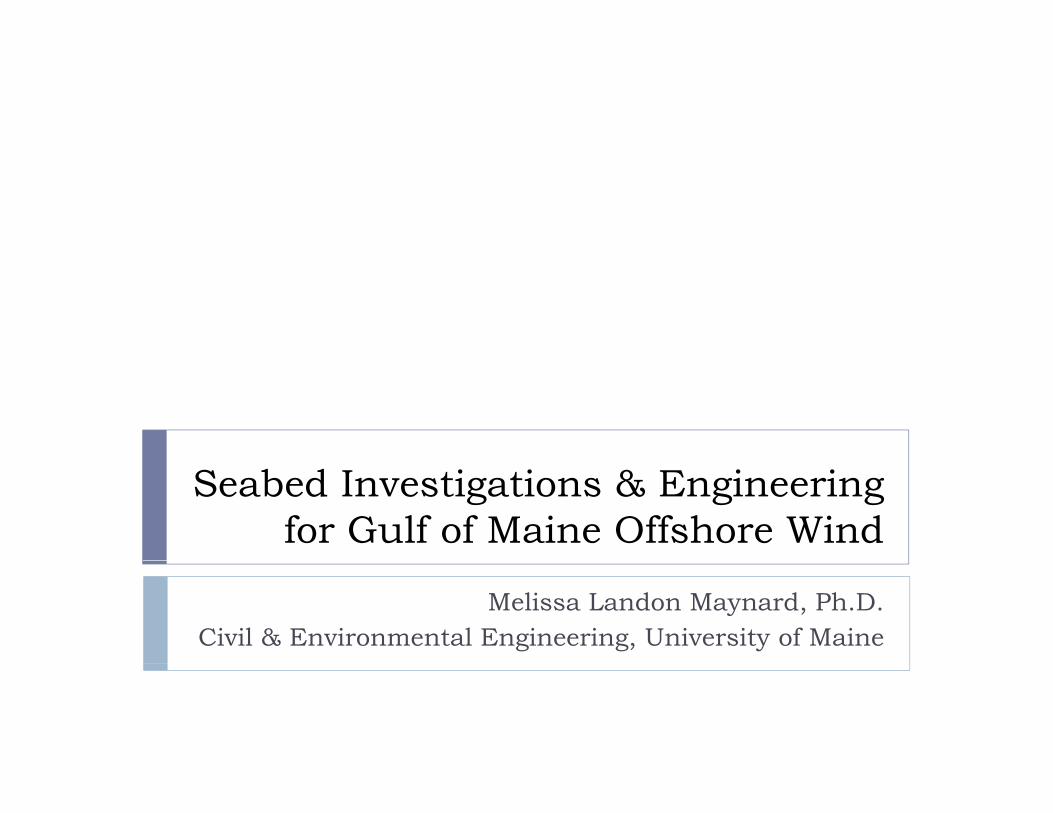
Bathymetry
NOAA’s Office of Coast Survey Charts
Example: Chart 13288: Monhegan Island to Cape ElizabethExample: Chart 13288: Monhegan Island to Cape Elizabeth
1/25/20113 Seabed Investigations & Engineering - Maine Wind Energy Conference
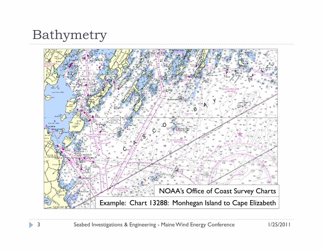
Bathymetry
USGS Coastal Marine Geology Program GIS data
1/25/20114 Seabed Investigations & Engineering - Maine Wind Energy Conference
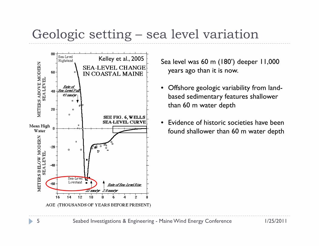
Geologic setting – sea level variation
Sea level was 60 m (180’) deeper 11,000 years ago than it is now.
Kelley et al., 2005
• Offshore geologic variability from land-based sedimentary features shallower than 60 m water depthp
• Evidence of historic societies have been found shallower than 60 m water depth
1/25/20115 Seabed Investigations & Engineering - Maine Wind Energy Conference
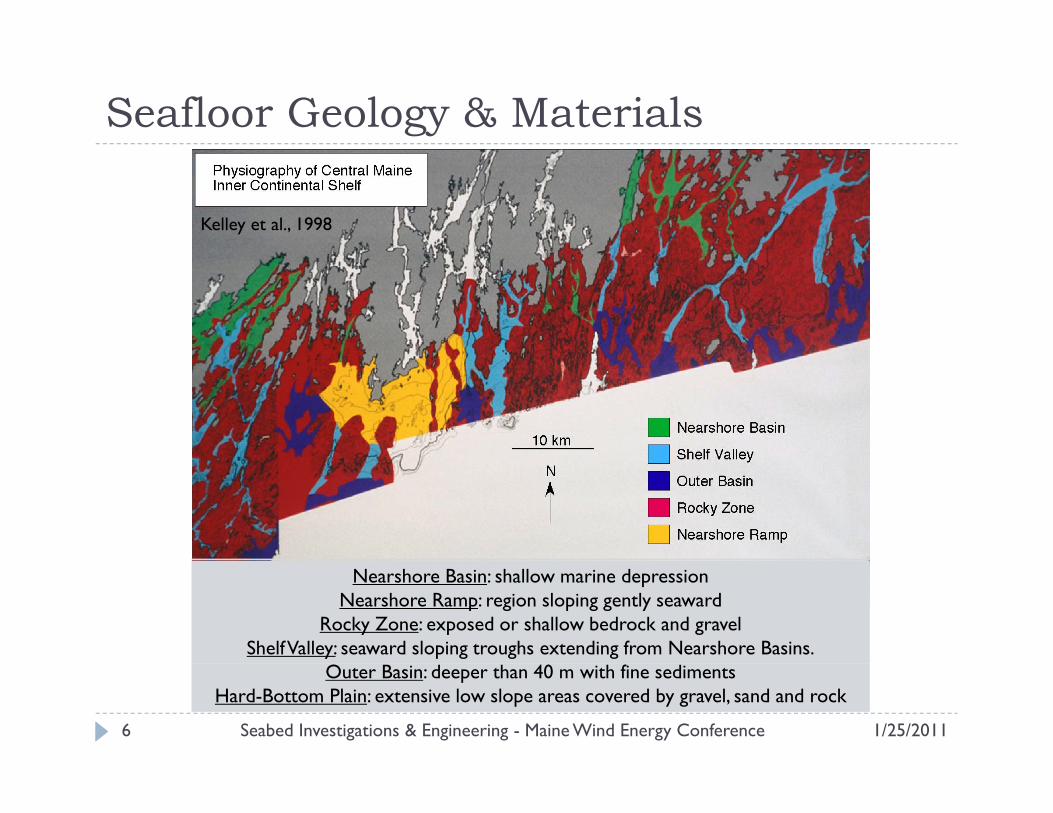
Seafloor Geology & Materials
Kelley et al., 1998
Nearshore Basin: shallow marine depressionNearshore Ramp: region sloping gently seaward
Rocky Zone: exposed or shallow bedrock and gravelShelf Valley: seaward sloping troughs extending from Nearshore Basins.
1/25/20116 Seabed Investigations & Engineering - Maine Wind Energy Conference
Outer Basin: deeper than 40 m with fine sedimentsHard-Bottom Plain: extensive low slope areas covered by gravel, sand and rock
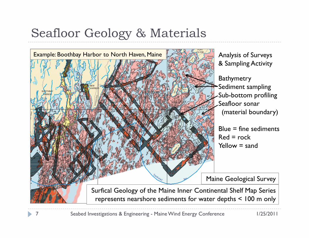
Seafloor Geology & MaterialsExample: Boothbay Harbor to North Haven, Maine Analysis of Surveys
& Sampling Activity
Bathymetry Sediment samplingSub-bottom profilingSeafloor sonar Seafloor sonar (material boundary)
Blue = fine sedimentsRed = rockYellow = sand
Maine Geological Survey
Surfical Geology of the Maine Inner Continental Shelf Map Seriesgy prepresents nearshore sediments for water depths < 100 m only
1/25/20117 Seabed Investigations & Engineering - Maine Wind Energy Conference
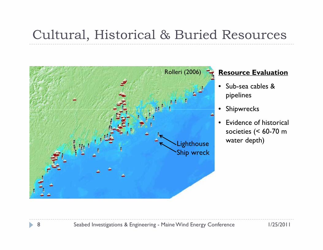
Cultural, Historical & Buried Resources
Resource EvaluationRolleri (2006)
• Sub-sea cables & pipelines
• Shipwrecks• Shipwrecks
• Evidence of historical societies (< 60-70 m water depth)Lighthouse
Ship wreck
water depth)
1/25/20118 Seabed Investigations & Engineering - Maine Wind Energy Conference
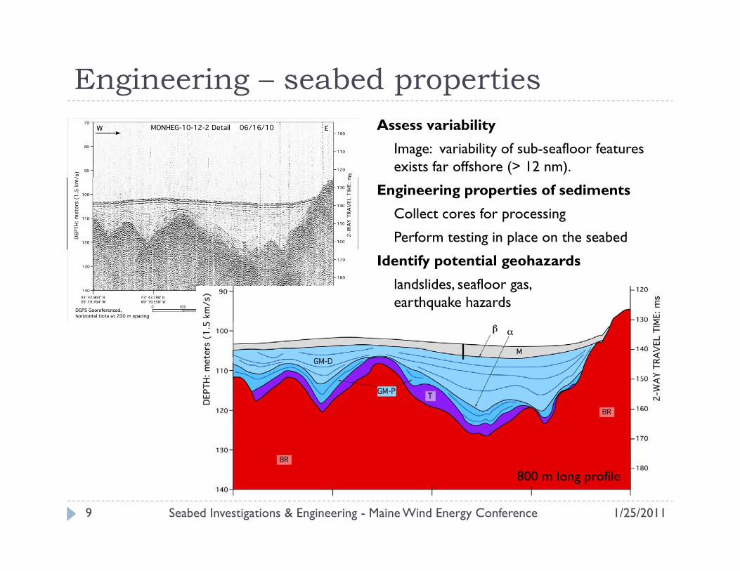
Engineering – seabed propertiesAssess variability
Image: variability of sub-seafloor features exists far offshore (> 12 nm).
Engineering properties of sediments
Collect cores for processing
Perform testing in place on the seabed
Identify potential geohazards
landslides, seafloor gas, earthquake hazards
800 m long profile
1/25/20119 Seabed Investigations & Engineering - Maine Wind Energy Conference
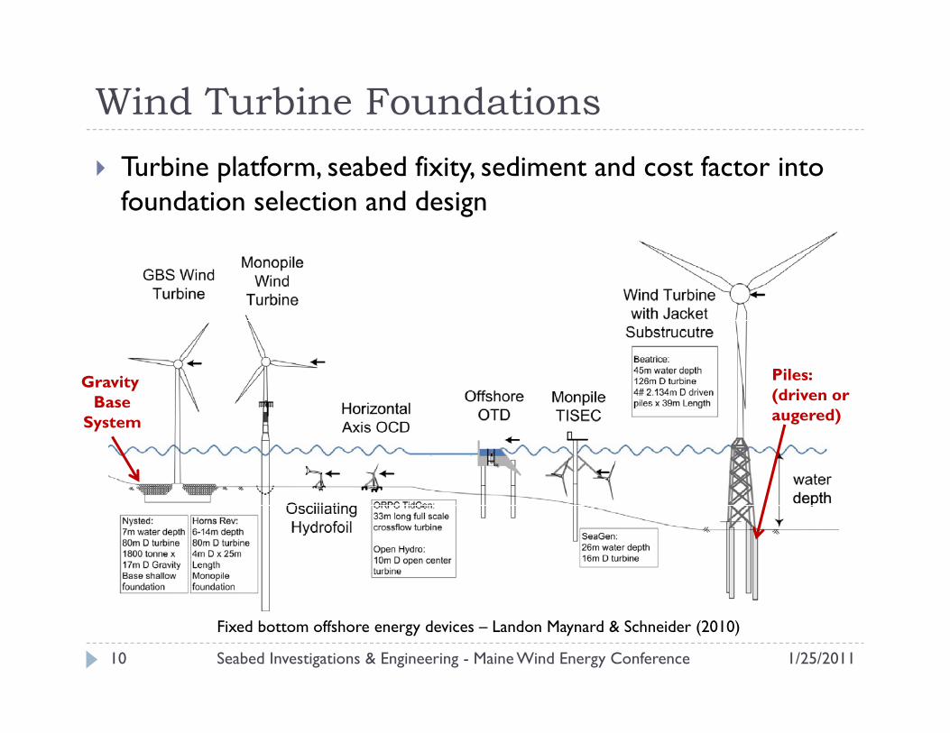
Wind Turbine FoundationsTurbine platform, seabed fixity, sediment and cost factor into foundation selection and design
GravityBase
Piles: (driven or augered)System augered)
1/25/201110 Seabed Investigations & Engineering - Maine Wind Energy Conference
Fixed bottom offshore energy devices – Landon Maynard & Schneider (2010)
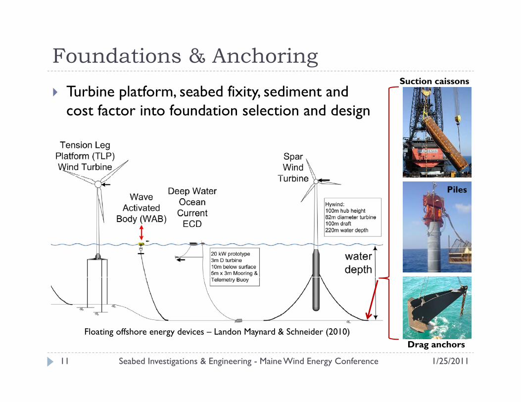
Foundations & AnchoringTurbine platform, seabed fixity, sediment and cost factor into foundation selection and design
Suction caissons
Piles
1/25/201111 Seabed Investigations & Engineering - Maine Wind Energy Conference
Floating offshore energy devices – Landon Maynard & Schneider (2010)Drag anchors
ReferencesBarnhardt, W. A., Belknap, D. F., Kelley, A. R., Kelley, J. T., and Dickson, S. M. (1996a). Surficial Geology of the Maine inner continental shelf. Maine Geological Survey, Geologic Map 96-6 to 96-12, scale 1:100,000. http://www.maine.gov/doc/nrimc/mgs/pubs/online/ics/ics.htm.
Kelley, J.T., Barnardt, W.A., Belknap, D.F., Dickson, S.M., Kelley, A.R., (1998). The Seafloor Revealed: The geology of Maine’s inner continental shelf. A Report on the Regional Marine Research Program, Maine Geological Survey Open-File Report 98-6, 55p. http://www.state.me.us/doc/nrimc/mgs/explore/marine/seafloor/contents.htm
Kelley, J.T. , Dickson, S.M., and Belknap, D.F. (2005). Maine's History of Sea-Level Changes. http://www.maine.gov/doc/nrimc/mgs/explore/marine/facts/sealevel.htm (accessed Jan. 20, 2011).http://www.maine.gov/doc/nrimc/mgs/explore/marine/facts/sealevel.htm (accessed Jan. 20, 2011).
Landon Maynard, M. and Schneider, J. (2010). "Geotechnics for developing offshore renewable energy infrastructure industries in the US." 2nd Int. Symp. on Frontiers in Offshore Geotechnics (ISFOG), University of Western Australia, Perth, Western Australia, 8-10 November.
NOAA coastal chart 13288: http://www.charts.noaa.gov/OnLineViewer/13288.shtml (accessed Jan. 20, 2011)
Rolleri, J. (2006) “Lighthouses and Shipwrecks of Maine,” Atlas of Maine Series. http://arcims.colby.edu/website/aom06_lighthouse/viewer.htm (accessed Jan. 20, 2011)
Foundation images:
Suction caisson: Andersen, K.H., Murff, J.D., Randolph, M.F., Clukey, E., Erbrich, C., Jostad, H.P., Hansen, B., Aubeny, C., Sharma, P. and Supachawarote, C. (2005): Suction anchors for deepwater applications. Proc., ISFOG, Int. Symp. on Frontiers in Offshore Geotech., 13-30. Perth, Australia.
Drag anchor: http://www.vryhof.com/products/anchors/stevpris_mk5.html
Pil h // f l / ff h iPile: http://www.fnapl.com/offshore_equipment.asp
1/25/201112 Seabed Investigations & Engineering - Maine Wind Energy Conference