Embed Size (px)
Citation preview
Proceedings of the TWAM2013 International Conference & Workshops
Transboundary water management across borders and interfaces: present and future challenges 1
Sea level rise impact in Lagrangean transport at Tagus estuary and Ria de Aveiro lagoon
J.M.Valentim(a), L.Vaz
(a), B.Duarte
(c), N.Vaz
(a), H.Silva
(b), I.Caçador
(c), J.M.Dias
(a)
(a) Physics Department, Centre for Environmental and Marine Studies (CESAM). University of Aveiro, Campus de Santiago, 3810-193 Aveiro, Portugal [email protected]
(b) Biology Department, Centre for Environmental and Marine Studies (CESAM). University of Aveiro, Campus de Santiago, 3810-193 Aveiro, Portugal
(c) Centre of Oceanography, Faculty of Sciences, University of Lisbon, Campo Grande, 1749-016 Lisbon, Portugal
INTRODUCTION The knowledge of estuaries and lagoons hydrodynamic
features is a crucial feature to recognize the systems behaviour itself as well as the ecosystems that depend on it. Sediment transport or phytoplankton and organic matter dispersion are essential to understand the aquatic ecosystems dynamics and could be investigated through the analysis of some hydrodynamics features of these coastal systems. Nowadays, there is a special concern about the possible impact of sea level rise in the actual hydrodynamic patterns of coastal systems and consequently in coastal ecosystems like salt marshes (Valentim, 2012). Salt marshes are among the most productive ecosystems
of the biosphere. They represent a critical interface between land and sea, providing a unique habitat for a large number of species, being essential elements in the ecological structure of estuarine systems. However, it is still difficult to understand some physical and biological interactions at salt marshes, as well as their response to climate change. Sea level rise (SLR) is one of the most important climate change effect in coastal systems. Its impact might induce important modifications in these systems circulation and consequently in their ecological and biological values (Sousa et al., 2010). The main aim of this research is to assess the sea level
rise impact in the Lagrangean transport in two Portuguese coastal systems (Tagus estuary and Ria de Aveiro lagoon), namely, in their salt marshes. The Tagus Estuary (Fig.1) is a mesotidal coastal plain
estuary with a surface area of about 320 km2 and a mean volume of 1900×106 m3. About 40% of the estuary’s total area is tidal flats (Fortunato et al., 1999; Dias and Valentim, 2011). The estuary width varies between 2 and 15 km and the average depth is 10.6 m. (Fortunato et al., 1997). The tidal propagation and fluvial discharge from the major tributaries modulate the hydrology of the estuary (Vaz et al., 2011). The Tagus river is the major source of freshwater with an annual average flow of approximately 400 m3/s
(Neves, 2010). Other freshwater inputs to the estuary, the Sorraia and Trancão rivers, are comparatively small, with average annual discharges of about 35 and 2.5 m3/s, respectively (Neves, 2010). Tagus estuary is ebb dominated, with floods typically one hour longer than ebbs (stronger velocities during ebbs), and thus inducing a net export of sediments (Fortunato et al., 1999). The area affected by tides reaches 80 km landward of Lisbon and the maximum tidal currents achieve about 2.0 m/s (Gameiro et al., 2007). The Ria de Aveiro (Fig.1) is a mesotidal lagoon located in
the Northwestern Portuguese coast. It presents a very complex geometry and is characterized by large areas of intertidal flats and a web of narrow channels (Dias and Picado, 2011). The lagoon covers an area of 83 km2 at high tide (spring tide) and 66 km2 at low tide, is 45 km long, 10 km wide and is connected to the sea by a 350 m wide inlet, fixed by two jetties (Dias & Lopes, 2006). Four main branches radiate from this sea entrance: Mira, S. Jacinto, Ílhavo and Espinheiro channels (Picado et al., 2010). This system is also characterized by a large number of other smaller channels between which lie significant intertidal areas, essentially mudflats, salt marshes and old salt pans (Picado et al., 2010). The average depth of the lagoon relative to the mean sea level is about 3 m (Picado et al., 2010). The lagoon hydrodynamics is tidally dominated and the strongest currents are observed at the inlet channel, reaching values higher than 2 m/s (Vaz et al., 2009a). Dias (2001) and Lopes et al. (2006) characterized the first half of the main channels of the Ria de Aveiro lagoon as ebb dominated and the second half as flood dominated. As the lower lagoon is ebb dominated there is a trend to export sediments to the ocean (Picado et al., 2010). The total mean estimated freshwater input is approximately 1.8×10⁶
m3 during a tidal cycle, being the major fluvial input the Vouga (50 m3/s average flow), which is very small (2.5%), when compared to the mean tidal prism at the mouth of
ABSTRACT
The main aim of this research is to assess the sea level rise impact in the Lagrangean transport in two Portuguese coastal systems (Tagus estuary and Ria de Aveiro lagoon), namely in their salt marshes, throughout the application of the 2D hydrodynamic numerical model MOHID, coupled with a Lagrangean particle-tracking module. The hydrodynamic model was previously implemented and validated to Tagus estuary and Ria de Aveiro lagoon. The models were used to determine the Lagrangean paths of passive particles released in selected areas of both estuaries. In order to determinate the sea level rise impact in particles transport two scenarios were adopted: actual sea level and local sea level rise projection. The results indicate that Lagrangean trajectories are changed by sea level rise, revealing that nutrient and cohesive sediments dispersion might be affected in the future scenario, both in the Tagus estuary and in the Ria de Aveiro lagoon. Consequently, changes in hydrodynamics could influence the actual equilibrium of the systems behaviour and affect the normal state of the contingent biological communities, namely salt marshes. KEY WORDS: Numerical modelling, Lagrangean transport, sea level rise, salt marshes.
Proceedings of the TWAM2013 International Conference & Workshops
2 Valentim et al.
approximately 70×106 m3 (Moreira et al., 1993; Picado et al., 2010). Lagrangean transport is a very useful tool to understand
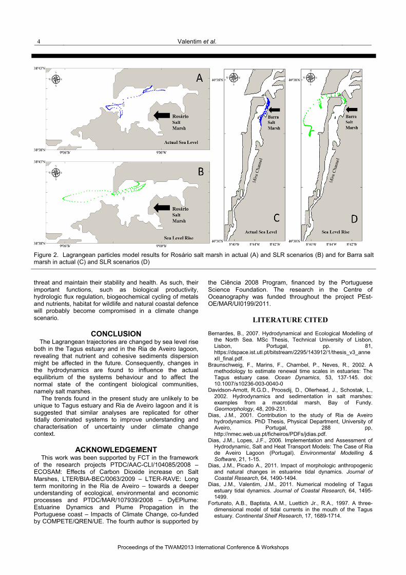
estuarine dynamics, allowing the analysis of particles fate through the estimate of its trajectory, being extremely valuable in the sediment and nutrient transport interpretation, by simply following the tracks of selected particles (Lopes et al., 2006). This study comprises the application of the 2D hydrodynamic numerical model MOHID, coupled with a Lagrangean particle-tracking module. The hydrodynamic models were previously implemented and validated to Tagus estuary and Ria de Aveiro lagoon. In order to determine the sea level rise impact in the particles transport, two scenarios were adopted: actual sea level and local sea level rise (SLR) projection. The results were focused in specific areas of the systems, one salt marsh in each estuary. With that performance, it is possible to analyse in detail the SLR impact in two salt marshes previously identified as endangered ecosystems: Rosário salt marsh, in Tagus
estuary, and Barra salt marsh, in Ria de Aveiro lagoon (Fig.1) (Valentim, 2012).
METHODS The numerical model used in this study is MOHID
(Martins et al., 2001), a three-dimensional baroclinic finite volume model, designed for coastal and estuarine shallow water applications (Vaz, 2007). MOHID solves the three-dimensional incompressible primitive equations, and assumes the hydrostatic equilibrium as well as the Boussinesq and Reynolds approximations. The model equations were presented in several studies and can be found in Vaz (2007). MOHID has been applied to different coastal and estuarine areas, showing its capability to simulate complex flows features (e.g. Trancoso et al., 2005; Santos et al., 2006; Vaz et al., 2005, 2007, 2009b, 2011; Bernardes, 2007; Malhadas et al., 2009). In this study, two previously validated set-ups of the
MOHID-2D model for the Tagus estuary (Vaz et al., 2011)
Figure 1. Tagus estuary (left) and Ria de Aveiro lagoon (right) locations. The arrow indicates the salt marsh area analysed in this work (Rosário salt marsh in Tagus estuary and Barra salt marsh in Ria de Aveiro).
Proceedings of the TWAM2013 International Conference & Workshops
Transboundary water management across borders and interfaces: present and future challenges 3
and Ria de Aveiro lagoon (Vaz et al., 2007) were applied. Details about the models accuracy to reproduce the tidal dynamics for both applications after the models calibration and validation are described in Vaz et al. (2007; 2011). The main forcing considered in the present application were the tide and river discharges for both coastal systems. A period of 32 days (May 2nd to June 3th 2011) was considered to perform the simulations. The numerical model of Tagus estuary includes a three
level nesting model (Vaz et al., 2009b). In the first domain (D1, that covers most of the Atlantic coast of Iberia and Morocco) is applied a tidal driven model, which uses the FES2004 global solution as forcing and has variable horizontal resolution (0.02° - 0.04°). The second domain (D2) has a horizontal resolution similar to D1. The third domain (D3) encompasses the whole extension of the Tagus estuary. The numerical grid of D3 presents 335 × 212 cells of 200 m each. On the open ocean boundary of D3, the model input was the tidal forcing from D2 (Vaz et al., 2011). Rivers inflow were imposed in the landward boundaries considering the mean discharges, 400 m3/s, 40 m3/s and 5 m3/s for the Tagus, the Sorraia and the Trancão rivers, respectively (Neves, 2010). The spin-up time was 2 days, the time step of the model was 15 s and a horizontal viscosity of 5 m2/s and a friction drag coefficient of 0.0025 were considered. Ria de Aveiro grid has 429 × 568 cells, with dimensions of
40 x 40 m in the central area of the lagoon and 40 × 100 m in the north and south areas. The time step of the model was 6 s and a horizontal viscosity of 5 m2/s as well as a varying Manning’s coefficient between 0.022 and 0.045 (m1/3/s) was considered. At the sea open boundary, water elevation over the reference level was imposed using tidal harmonic constituents determined using T_TIDE package (Pawlowicz et al., 2002). Rivers inflow were also imposed in the landward boundaries considering average discharges values (60 m3/s, 4.5 m3/s, 1.0 m3/s, 1.6 m3/s and 3.0 m3/s for Vouga, Antuã, Boco, Caster and Ribeira dos Moinhos rivers, respectively). River discharges values were obtained from the Ria de Aveiro Polis Litoral program, which considered the data presented in the Plano de Bacia Hidrográfica (www.arhcentro.pt). Moreover, a Lagrangean particle-tracking module was
coupled to the hydrodynamic model, which was used to determine the Lagrangean paths of passive particles released in the selected areas of both estuaries (Rosário salt marsh, in Tagus estuary, and Barra salt marsh, in Ria de Aveiro lagoon). The movement of the tracers is determined from the velocity field computed by the hydrodynamic model and by a random component of velocity (Braunschweig et al., 2003, Lopes et al., 2006). Since one of the main goals of the present work is to
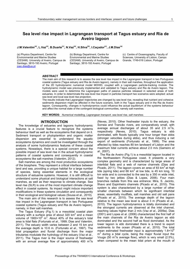
study the SLR effects in the Lagrangean particles trajectory, two scenarios in the numerical simulations were evaluated: actual and SLR. The model parameters were kept for both scenarios except the value of the mean sea level. For the actual sea level simulation, the value of 2.08 m was considered, while for the SLR scenario a mean sea level of 2.50 m was considered. This sea level rise value of 0.42 m was adopted based on local projections of the sea level rise in the Portuguese coast for the IPCC A2 storyline (Lopes et al., 2011b). The results of Lagrangean particles in both systems are
represented in Figure 2, showing the particles position
evolution throughout four tidal cycles, for actual and sea level scenario.
RESULTS AND DISCUSSION According to Sousa et al. (2010), global change will affect
salt marshes in terms of photosynthesis, growth, biomass allocation and nutrient uptake by plants and, consequently, salt marsh services are likely to be affected. Changes in the flow regime influence the extension and duration of inundation and consequently the vertical and horizontal extent over which salt marsh development takes place (Davidson-Arnott et al., 2002) as well as the rate of settlement and hence sediment deposition. Processes that influence the sediment supply to the marsh are likely to have some influence on marsh development (Townend et al., 2011). Consequently, it is anticipated that changes in relative sea level play an important role in the development, maintenance and long-term health of salt marshes (Kolker et al., 2008). Lagrangean transport investigation allows the analysis of
the particles fate, being extremely valuable in the sediment and nutrient transport interpretation (Lopes et al., 2006). In the present study, model results indicate that Lagrangean particles will present larger trajectories in a SLR scenario, possible induced by the changes in the flow regime due to the SLR effects. More precisely, model results indicate that in actual
scenario (Fig.2A,C), Lagrangean particles tend to remain close to the salt marshes areas. In SLR scenario, it is observed that the movement of the particles is larger. In Rosário salt marsh, the particles trajectory includes not only the inside channel area but also extends to the Tagus estuary bay (Fig.2B). In Barra salt marsh, the movement in the SLR scenario reaches the lagoon mouth and the particles exhibit a greater scatter in the adjacent coastal area (Fig.2C). As such, in a climate change scenario, the results suggest that Lagrangean particles scatter on a larger area, not being so centred in a particular zone, as a result of the higher water column high and consequently higher current velocity due to the SLR effects. In terms of salt marshes health, this situation could indicate lower nutrients and cohesive sediments supplement in these salt marshes. Such fact represents a concern because salt marsh production and zonation are influenced by nutrients and environmental characteristics, such as sediments availability or seawater inundation, which are associated, among other factors, with sea level rise (Valiela & Teal, 1974; Townend et al., 2011). Moreover, considering the salt marshes under study,
there are evidences that nowadays tidal currents and sediments exportation trends are increasing in Ria de Aveiro lagoon (Picado et al., 2010; Plecha et al., 2010, 2012; Martins et al., 2011a,b). Local studies show that they will be intensified in the future due to the SLR effects (Lopes et al., 2011a,b). Additionally, according to Valentim (2012), instantaneous velocity currents intensity will increase with SLR in both estuaries, and there is a rising trend for the sediments exportation outwards the systems. Accordingly, these facts together with the results of the present study show that SLR is a serious threat for the salt marshes stability and consequently for the surrounding ecosystems. Therefore, predictable higher rates of SLR represent a
concern about the salt marshes ability to respond to this
Proceedings of the TWAM2013 International Conference & Workshops
4 Valentim et al.
threat and maintain their stability and health. As such, their important functions, such as biological productivity, hydrologic flux regulation, biogeochemical cycling of metals and nutrients, habitat for wildlife and natural coastal defence will probably become compromised in a climate change scenario.
CONCLUSION The Lagrangean trajectories are changed by sea level rise
both in the Tagus estuary and in the Ria de Aveiro lagoon, revealing that nutrient and cohesive sediments dispersion might be affected in the future. Consequently, changes in the hydrodynamics are found to influence the actual equilibrium of the systems behaviour and to affect the normal state of the contingent biological communities, namely salt marshes. The trends found in the present study are unlikely to be
unique to Tagus estuary and Ria de Aveiro lagoon and it is suggested that similar analyses are replicated for other tidally dominated systems to improve understanding and characterisation of uncertainty under climate change context.
ACKNOWLEDGEMENT This work was been supported by FCT in the framework
of the research projects PTDC/AAC-CLI/104085/2008 – ECOSAM: Effects of Carbon Dioxide increase on Salt Marshes, LTER/BIA-BEC/0063/2009 – LTER-RAVE: Long term monitoring in the Ria de Aveiro – towards a deeper understanding of ecological, environmental and economic processes and PTDC/MAR/107939/2008 – DyEPlume: Estuarine Dynamics and Plume Propagation in the Portuguese coast – Impacts of Climate Change, co-funded by COMPETE/QREN/UE. The fourth author is supported by
the Ciência 2008 Program, financed by the Portuguese Science Foundation. The research in the Centre of Oceanography was funded throughout the project PEst-OE/MAR/UI0199/2011.
LITERATURE CITED
Bernardes, B., 2007. Hydrodynamical and Ecological Modelling of
the North Sea. MSc Thesis, Technical University of Lisbon, Lisbon, Portugal, pp. 81, https://dspace.ist.utl.pt/bitstream/2295/143912/1/thesis_v3_annexII_final.pdf.
Braunschweig, F., Marins, F., Chambel, P., Neves, R., 2002. A methodology to estimate renewal time scales in estuaries: The Tagus estuary case. Ocean Dynamics, 53, 137-145. doi: 10.1007/s10236-003-0040-0
Davidson-Arnott, R.G.D., Proosdij, D., Ollerhead, J., Schostak, L., 2002. Hydrodynamics and sedimentation in salt marshes: examples from a macrotidal marsh, Bay of Fundy. Geomorphology, 48, 209-231.
Dias, J.M., 2001. Contribution to the study of Ria de Aveiro hydrodynamics. PhD Thesis, Physical Department, University of Aveiro, Portugal, 288 pp, http://nmec.web.ua.pt/ficheiros/PDFs/jdias.pdf.
Dias, J.M., Lopes, J.F., 2006. Implementation and Assessment of Hydrodynamic, Salt and Heat Transport Models: The Case of Ria de Aveiro Lagoon (Portugal). Environmental Modelling & Software, 21, 1-15.
Dias, J.M., Picado A., 2011. Impact of morphologic anthropogenic and natural changes in estuarine tidal dynamics. Journal of Coastal Research, 64, 1490-1494.
Dias, J.M., Valentim, J.M., 2011. Numerical modeling of Tagus estuary tidal dynamics. Journal of Coastal Research, 64, 1495-1499.
Fortunato, A.B., Baptista, A.M., Luettich Jr., R.A., 1997. A three-dimensional model of tidal currents in the mouth of the Tagus estuary. Continental Shelf Research, 17, 1689-1714.
Figure 2. Lagrangean particles model results for Rosário salt marsh in actual (A) and SLR scenarios (B) and for Barra salt marsh in actual (C) and SLR scenarios (D)
Proceedings of the TWAM2013 International Conference & Workshops
Transboundary water management across borders and interfaces: present and future challenges 5
Fortunato, A.B., Oliveira, A., Baptista, A.M., 1999. On the effect of tidal flats on the hydrodynamics of the Tams estuary. Oceanologica Acta, 22 (1), 31-44.
Gameiro, C., Cartaxana, P., Brotas, V., 2007. Environmental drivers of phytoplankton distribution and composition in Tagus Estuary, Portugal. Estuarine, Coastal and Shelf Science, 75, 21-34.
Kolker, A., Engle, M.A., Orem, W.H., Bunnell, J.E., Lerch, H. E., Krabbenhoft, D.P., Olson, M.L., DeWild, J.F., Mc-Cord, J.D., 2008. Mercury, trace elements, and organic constituents in atmospheric fine particulate matter, Shenandoah National Park, Virginia, USA: A combined approach to sampling and analysis. Geostandards and Geoanalytical Research, 32, 279–293.
Lopes, J.F., Dias, J.M., Dekeyser, I. 2006. Numerical modelling of cohesive sediments transport in the Ria de Aveiro lagoon, Portugal. Journal of Hydrology, 319, 176-198.
Lopes, C.L., Silva, P.A., Rocha, A., Dias, J.M., 2011a. Sensitivity analysis of Ria de Aveiro hydro-morphodynamics to the sea level rise integration period. Journal of Coastal Research, 64, 230-234.
Lopes, C.L., Silva, P.A., Dias, J.M., Rocha A., Picado A., Plecha S., Fortunato A.B., 2011b. Local sea level change scenarios for the end of the 21st century and potential physical impacts in the lower Ria de Aveiro (Portugal). Continental Shelf Research, 31, 1515-1526.
Malhadas, M.S., Silva, A., Leitão P.C., Neves, R., 2009. Effect of the Bathymetric Changes on the Hydrodynamic and Residence Time in Óbidos Lagoon (Portugal). Journal of Coastal Research, 56, 549 - 553.
Martins, F., Leitão, P., Silva, A., Neves, R., 2001. 3D modelling in the Sado estuary using a new generic vertical discretization approach. Oceanologica Acta, 24, 1–12.
Martins, V., Grangeia, C., Abrantes, I., Jesus, C., Dias, J.M., Silva, P.A., Silva, E.F., Rocha, F., 2011a. Sediments flux through the Aveiro harbour jetties. Patterns of accretion and erosion. Journal of Coastal Research, SI64, 1784-1787.
Martins, V., Grangeia, C., Jesus, C.C., Martins, P., Laut, L.M., Sequeira, C., Dias, J.M., Silva, P.A., Abrantes, I., Ferreira da Silva, E., Rocha, F., 2011b. Erosion and accretion in the Ria de Aveiro inlet (N Portugal) and exportation of fine-grained sediments to the shelf. Journal of Iberian Geology, 37, 2, 215-230.
Moreira, M.H., Queiroga, H., Machado, M.M., Cunha M.R., 1993. Environmental gradients in a southern estuarine system: Ria de Aveiro, Portugal, implication for a soft bottom macrofauna colonization. Netherlands Journal of Aquatic Ecology, 27, 465-482.
Neves, F.J., 2010. Dynamics and hydrology of the Tagus estuary: results from in situ observations. PhD Thesis, University of Lisbon, Portugal, 210 pp, http://hdl.handle.net/10451/2003.
Pawlowicz, R., Beardsley, B., Lentz, S., 2002. Classical tidal harmonic analysis including error estimates in MATLAB using T_TIDE. Computers & Geosciences, 28, 929-937.
Picado, A., Dias, J.M., Fortunato, A., 2010. Tidal changes in estuarine systems induced by local geomorphologic modifications. Continental Shelf Research, 30 (17), 1854-1864.
Plecha, S., Silva, P.A., Vaz, N., Bertin, X., Oliveira, A., Fortunato, A.B., Dias J.M., 2010. Sensitivity analysis of a morphodynamic modelling system applied to a coastal lagoon inlet. Ocean Dynamics, 60, 2, 275-284.
Plecha, S., Silva, P.A., Oliveira, A., Dias, J.M., 2012. Establishing the wave climate influence on the morphodynamics of a coastal lagoon inlet. Ocean Dynamics, 62, 5, 799-814.
Santos, M., Neves, R., Leitão, P., Pereira, P., Pablo, H., Fernandes, L.D., Carvalho, S.M., Alves, C.P., 2006. Qualidade da água da Lagoa de Óbidos: Que futuro? XII Encontro Nacional de Saneamento Básico, Cascais 2006.
Sousa, A.I., Lillebø, A.I., Pardal, M.A., Caçador, I., 2010. Productivity and nutrient cycling in salt marshes: Contribution to ecosystem health. Estuarine, Coastal and Shelf Science, 87, 640-646.
Townend, I., Fletcher, C., Knappen M., Rossington, K., 2011. A review of salt marsh dynamics. Water and Envirnonment Journal, 25, 477-488.
Trancoso, A.R., Saraiva, S., Fernandes, L., 2005. Modelling macroalgae using a 3D hydrodynamic-ecological model in a shallow, temperate estuary. Ecological Modelling, 187, 232-246.
Valentim, J.M., 2012. Hydrodynamic effects in Ria de Aveiro and Tagus estuary salt marshes. MSc Thesis, Physical Department, University of Aveiro, Portugal, 81 pp, http://nmec.web.ua.pt/ficheiros/PDFs/jvalentim.pdf.
Valiela, I., Teal, J.M., 1974. Nutrient limitation in salt marsh vegetation. Ecology and halophytes. Reimold of W.H. Queen, 547-563. New York: Academic Press.
Vaz, N., 2007. Study of heat and salt transport processes in the Espinheiro Channel (Ria de Aveiro). PhD Thesis, Physical Department, University of Aveiro, Portugal, 151 pp, http://nmec.web.ua.pt/ficheiros/PDFs/nvaz.pdf.
Vaz, N., Dias, J.M., Leitão, P.C., Martins, I., 2005. Horizontal patterns of water temperature and salinity in an estuarine tidal channel: Ria de Aveiro. Ocean Dynamics, 55, 416–429.
Vaz, N., Dias, J.M., Leitão, P.C., Nolasco, R., 2007. Application of the Mohid-2D model to a mesotidal temperate coastal lagoon. Computers & Geosciences, 33, 1204-1209.
Vaz, N., Dias J.M., Leitão P.C., 2009a. Three-dimensional modelling of a tidal channel: the Espinheiro Channel (Portugal). Continental Shelf Research, 29, 29-41.
Vaz, N., Fernandes L., Leitão P.C., Dias J.M., Neves R., 2009b. The Tagus estuarine plume induced by wind and river runoff: Winter 2007 case study. Journal of Coastal Research, 56, 1090-1094.
Vaz, N., Mateus, M., Dias, J.M., 2011. Semidiurnal and spring-neap variations in the Tagus Estuary: Application of a process-oriented hydro-biogeochemical model. Journal of Coastal Research, 64, 1619-1623.