Embed Size (px)
Citation preview
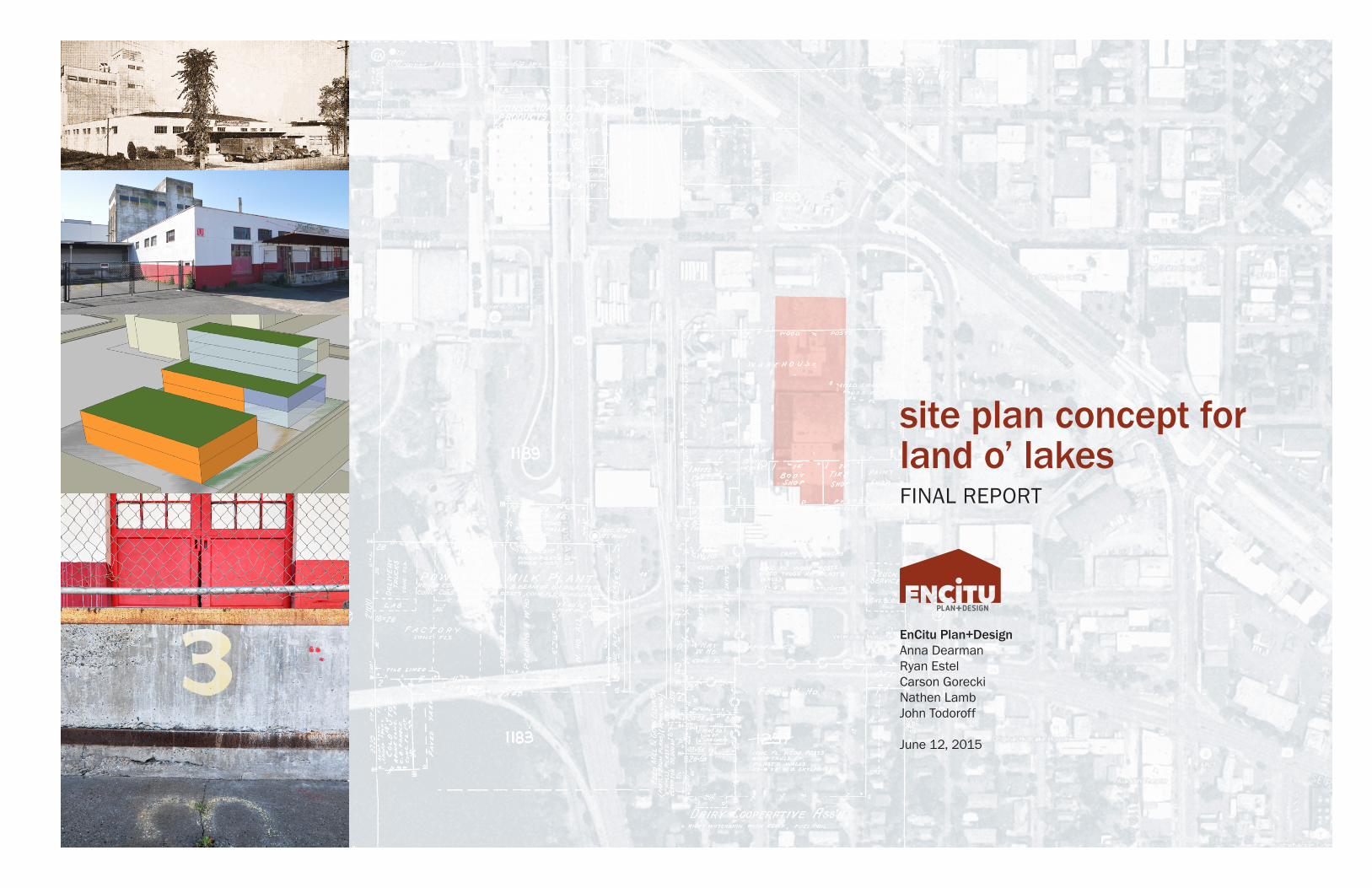
site plan concept for land o’ lakesFINAL REPORT
EnCitu Plan+DesignAnna DearmanRyan EstelCarson GoreckiNathen LambJohn Todoroff
June 12, 2015

1Final Report: Site Plan Concepts | Land O’ Lakes | ENCITU
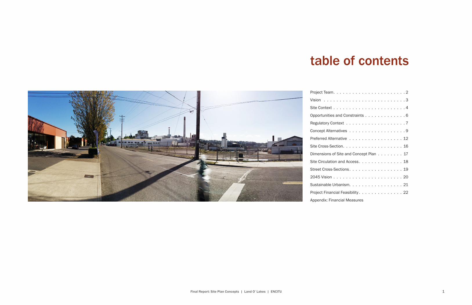
table of contents
Project Team . . . . . . . . . . . . . . . . . . . . . . . 2
Vision . . . . . . . . . . . . . . . . . . . . . . . . . . 3
Site Context . . . . . . . . . . . . . . . . . . . . . . . 4
Opportunities and Constraints . . . . . . . . . . . . . 6
Regulatory Context . . . . . . . . . . . . . . . . . . . 7
Concept Alternatives . . . . . . . . . . . . . . . . . . 9
Preferred Alternative . . . . . . . . . . . . . . . . . 12
Site Cross-Section . . . . . . . . . . . . . . . . . . . 16
Dimensions of Site and Concept Plan . . . . . . . . 17
Site Circulation and Access . . . . . . . . . . . . . . 18
Street Cross-Sections . . . . . . . . . . . . . . . . . 19
2045 Vision . . . . . . . . . . . . . . . . . . . . . . 20
Sustainable Urbanism . . . . . . . . . . . . . . . . . 21
Project Financial Feasibility . . . . . . . . . . . . . . 22
Appendix: Financial Measures
2 Final Report: Site Plan Concepts | Land O’ Lakes | ENCITU
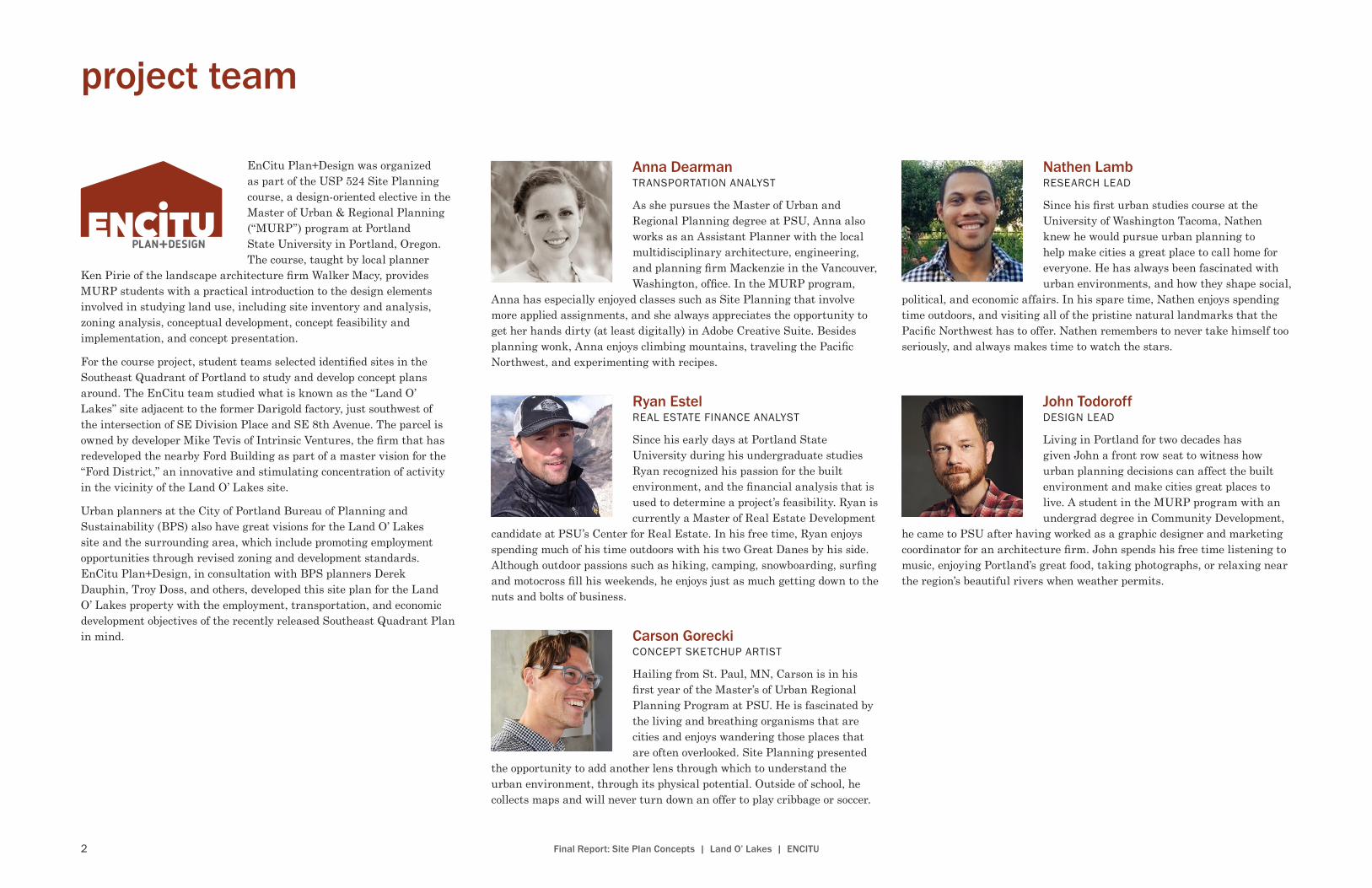
project team
Nathen LambRESEARCH LEAD
Since his first urban studies course at the University of Washington Tacoma, Nathen knew he would pursue urban planning to help make cities a great place to call home for everyone. He has always been fascinated with urban environments, and how they shape social,
political, and economic affairs. In his spare time, Nathen enjoys spending time outdoors, and visiting all of the pristine natural landmarks that the Pacific Northwest has to offer. Nathen remembers to never take himself too seriously, and always makes time to watch the stars.
John Todoroff DESIGN LEAD
Living in Portland for two decades has given John a front row seat to witness how urban planning decisions can affect the built environment and make cities great places to live. A student in the MURP program with an undergrad degree in Community Development,
he came to PSU after having worked as a graphic designer and marketing coordinator for an architecture firm. John spends his free time listening to music, enjoying Portland’s great food, taking photographs, or relaxing near the region’s beautiful rivers when weather permits.
Carson GoreckiCONCEPT SKETCHUP ARTIST
Hailing from St. Paul, MN, Carson is in his first year of the Master’s of Urban Regional Planning Program at PSU. He is fascinated by the living and breathing organisms that are cities and enjoys wandering those places that are often overlooked. Site Planning presented
the opportunity to add another lens through which to understand the urban environment, through its physical potential. Outside of school, he collects maps and will never turn down an offer to play cribbage or soccer.
Anna Dearman TRANSPORTATION ANALYST
As she pursues the Master of Urban and Regional Planning degree at PSU, Anna also works as an Assistant Planner with the local multidisciplinary architecture, engineering, and planning firm Mackenzie in the Vancouver, Washington, office. In the MURP program,
Anna has especially enjoyed classes such as Site Planning that involve more applied assignments, and she always appreciates the opportunity to get her hands dirty (at least digitally) in Adobe Creative Suite. Besides planning wonk, Anna enjoys climbing mountains, traveling the Pacific Northwest, and experimenting with recipes.
Ryan Estel REAL ESTATE FINANCE ANALYST
Since his early days at Portland State University during his undergraduate studies Ryan recognized his passion for the built environment, and the financial analysis that is used to determine a project’s feasibility. Ryan is currently a Master of Real Estate Development
candidate at PSU’s Center for Real Estate. In his free time, Ryan enjoys spending much of his time outdoors with his two Great Danes by his side. Although outdoor passions such as hiking, camping, snowboarding, surfing and motocross fill his weekends, he enjoys just as much getting down to the nuts and bolts of business.
EnCitu Plan+Design was organized as part of the USP 524 Site Planning course, a design-oriented elective in the Master of Urban & Regional Planning (“MURP”) program at Portland State University in Portland, Oregon. The course, taught by local planner
Ken Pirie of the landscape architecture firm Walker Macy, provides MURP students with a practical introduction to the design elements involved in studying land use, including site inventory and analysis, zoning analysis, conceptual development, concept feasibility and implementation, and concept presentation.
For the course project, student teams selected identified sites in the Southeast Quadrant of Portland to study and develop concept plans around. The EnCitu team studied what is known as the “Land O’ Lakes” site adjacent to the former Darigold factory, just southwest of the intersection of SE Division Place and SE 8th Avenue. The parcel is owned by developer Mike Tevis of Intrinsic Ventures, the firm that has redeveloped the nearby Ford Building as part of a master vision for the “Ford District,” an innovative and stimulating concentration of activity in the vicinity of the Land O’ Lakes site.
Urban planners at the City of Portland Bureau of Planning and Sustainability (BPS) also have great visions for the Land O’ Lakes site and the surrounding area, which include promoting employment opportunities through revised zoning and development standards. EnCitu Plan+Design, in consultation with BPS planners Derek Dauphin, Troy Doss, and others, developed this site plan for the Land O’ Lakes property with the employment, transportation, and economic development objectives of the recently released Southeast Quadrant Plan in mind.
3Final Report: Site Plan Concepts | Land O’ Lakes | ENCITU
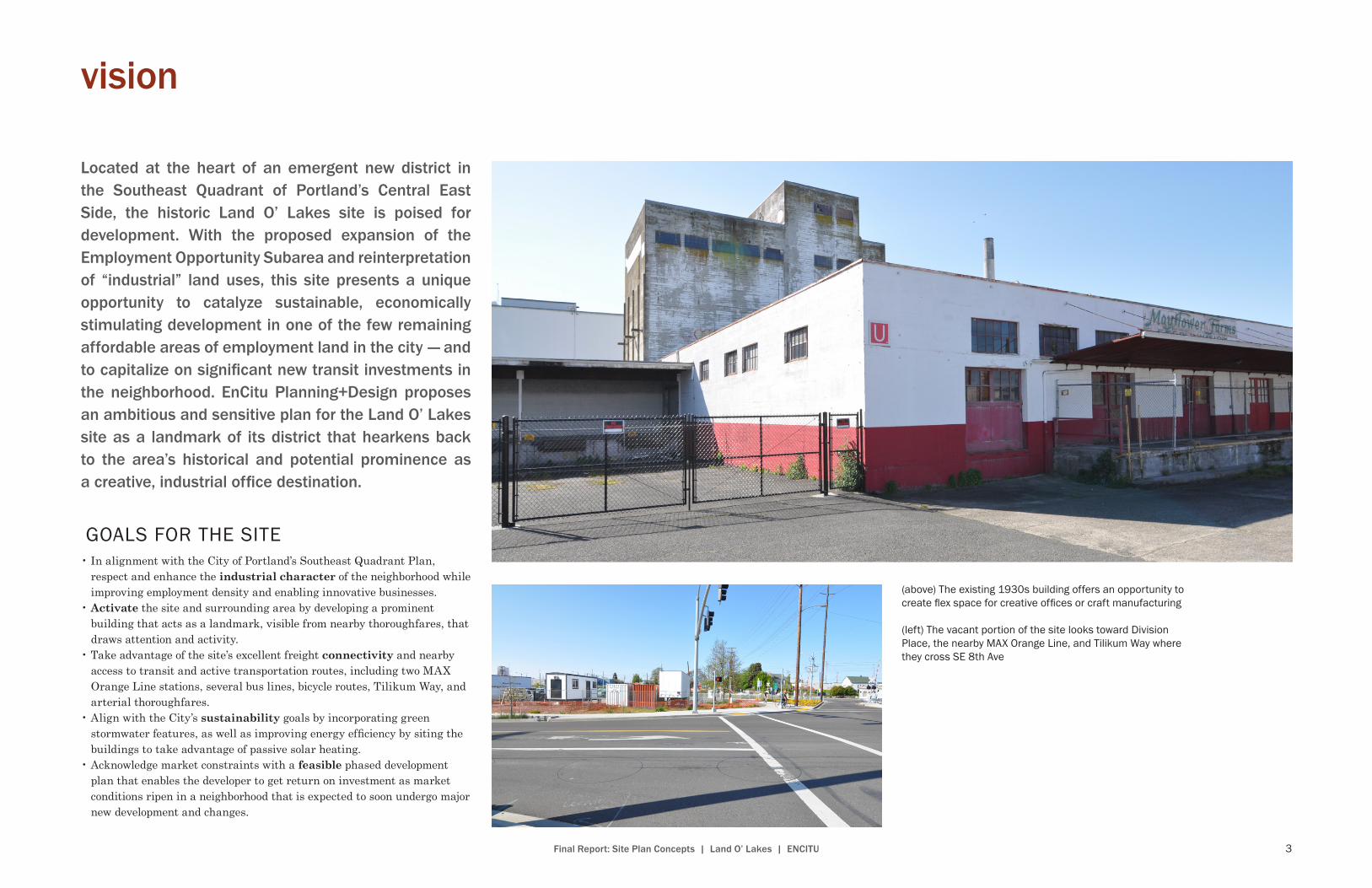
Located at the heart of an emergent new district in the Southeast Quadrant of Portland’s Central East Side, the historic Land O’ Lakes site is poised for development. With the proposed expansion of the Employment Opportunity Subarea and reinterpretation of “industrial” land uses, this site presents a unique opportunity to catalyze sustainable, economically stimulating development in one of the few remaining affordable areas of employment land in the city — and to capitalize on significant new transit investments in the neighborhood. EnCitu Planning+Design proposes an ambitious and sensitive plan for the Land O’ Lakes site as a landmark of its district that hearkens back to the area’s historical and potential prominence as a creative, industrial office destination.
GOALS FOR THE SITE
• In alignment with the City of Portland’s Southeast Quadrant Plan, respect and enhance the industrial character of the neighborhood while improving employment density and enabling innovative businesses.
• Activate the site and surrounding area by developing a prominent building that acts as a landmark, visible from nearby thoroughfares, that draws attention and activity.
• Take advantage of the site’s excellent freight connectivity and nearby access to transit and active transportation routes, including two MAX Orange Line stations, several bus lines, bicycle routes, Tilikum Way, and arterial thoroughfares.
• Align with the City’s sustainability goals by incorporating green stormwater features, as well as improving energy efficiency by siting the buildings to take advantage of passive solar heating.
• Acknowledge market constraints with a feasible phased development plan that enables the developer to get return on investment as market conditions ripen in a neighborhood that is expected to soon undergo major new development and changes.
vision
(above) The existing 1930s building offers an opportunity to create flex space for creative offices or craft manufacturing
(left) The vacant portion of the site looks toward Division Place, the nearby MAX Orange Line, and Tilikum Way where they cross SE 8th Ave

4 Final Report: Site Plan Concepts | Land O’ Lakes | ENCITU
site context
HISTORICAL CONTEXTDairy cooperativeLand O’ Lakes was owned and operated by the Dairy Cooperative Association and Mayflower Farms from the mid 1930s to the late 1980s. Mayflower farms began as a small family owned operation at the turn of the 20th century. In 1929, thousands of Dairymen in the region organized and incorporated their operations into the Dairy Cooperative Association, with Mayflower Farms as the forerunner. The existing building was a feed mill for the Dairy Co-op, where they processed and shipped cattle and chicken feed. Sometime in the 1940s, the co-op added a garage addition, where they serviced their own delivery trucks. In the 1980s the co-op merged with a branch of Darigold in Seattle, presumably ceasing operations at the site, though it is unclear when the site became vacant.
j
8TH
9TH
GRAN
D
6TH
DIVISION
4TH
POWELL
TILIKUM
GRANT
7TH
WAT
ER
CARUTHERS
SHERMAN
WOODWARD
MAR
TIN
LUTH
ER K
ING
JR
IVON
TAGGART
CLINTON
GRAN
D AV
E-IV
ON
ST
MCLO
UGHLIN
BROOKLYN
WO
ODW
ARD ST-GRAND AVE
6TH
7TH
DIVISION
IVON
8TH
TILIKUM
6TH
GRAND
GRAN
D
4TH
9TH
GRAN
D
CARUTHERS
LegendStreet Centerlines
Land O'Lakes
Building FootprintsYEAR_BUILT
0 - 1920
1921 - 1940
1941 - 1960
1961 - 1980
1980 +
0 400 800200Feet [
Willamette River
ROSS ISLAND BRIDGE
Year Built
Age of surrounding buildings
j
8TH
9TH
GRAN
D
6TH
DIVISION
4TH
POWELL
TILIKUM
GRANT
7TH
WAT
ER
CARUTHERS
SHERMAN
WOODWARD
MAR
TIN
LUTH
ER K
ING
JR
IVON
TAGGART
CLINTON
GRAN
D AV
E-IV
ON
ST
MCLO
UGHLIN
BROOKLYN
WO
ODW
ARD ST-GRAND AVE
6TH
7TH
DIVISION
IVON
8TH
TILIKUM
6TH
GRAND
GRAN
D
4TH
9TH
GRAN
D
CARUTHERS
LegendStreet Centerlines
Land O'Lakes
Building FootprintsYEAR_BUILT
0 - 1920
1921 - 1940
1941 - 1960
1961 - 1980
1980 +
0 400 800200Feet [
Willamette River
ROSS ISLAND BRIDGE
(above) The site in 1934, when the Dairy Cooperative Associations’ feed division was moved to the Land O’ Lakes site .
(right) This diagram created by the Sanborn Map Company accounts for structures on the site from 1908 to 1950 . Sanborn maps compiled in 1924–1928 show no structures existing on the site . Supplemental research reveals that the existing structure on the site was built sometime during the mid 1930s . The middle garage section was a mid-1940s addition, and the northern warehouse portion has since been demolished . It remains unclear when the warehouse was constructed and torn down . The existing structure at Land O’ Lakes
is one of the older buildings in the neighborhood, although even older structures do still exist in the area, such as the Ford Building and the Apple Foods warehouse .

5Final Report: Site Plan Concepts | Land O’ Lakes | ENCITU
Land uses, utilities and views Transportation connections
8TH
9TH
6TH
GRAN
D
POWELL
4TH
WOODWARD
7TH
TILIKUM
DIVISION
10TH
CLINTON
IVON
BROOKLYN
TAGGART
IVON
ST-
GRAN
D AV
E
GRAN
D AV
E-IV
ON
ST
WO
ODW
ARD ST-GRAND AVE
9TH
DIVISION
GRAND
4TH
10TH
IVON
GRAN
D
CLINTON
BROOKLYN
Ross Island Bridge
0 275 550Feet [
Legend
Street Centerlines
Land O'Lakes site
Building Uses
Commercial Office
Commercial Retail
Industrial
Single Family Residential
Vacant
Combined Gravity MainSanitary Gravity MainStorm Gravity Main
AB
Street Trees
CA. View of downtown and West HillsB. View of Ford Building and DivisionC. View of Mt. Hood
Willamette River
Direction of Slope
Ford Building
j
kj
kj
kj
SE DIVISION ST
SE 8
TH A
VE
SE 9
TH A
VE
SE FRANKLIN ST
SE 1
7TH
AVE
SE HARRISON ST
SE LINCOLN ST
SE GRANT ST
SE WATER AVE
SE 1
0TH
AVE
SE DIVISION PL
SE 7
TH A
VE
SE ELL
IOTT
AVE
SE IVON ST
SE STEPHENS ST
SE GIDEON ST
SE 6
TH A
VE
SE SHERMAN ST
SE 1
5TH
AVE
SE WOODWARD ST
SE 2
ND
PL
SE CARUTHERS ST
SE SPRUCE A
VE
SE 1
1TH
AVE
SE ORAN
GE AVE
SE 4
TH A
VE
SE TAGGART ST
SE L
ARCH
AVE
SE 1
2TH
AVE
SE BIRCH ST
SE G
RAN
D A
VE
SE 1
3TH
AVE
TILIKUM CROSSING BRG
SE M
ILW
AUK
IE A
VE
SE HICKORY ST
SE TILIKUM WAY
SE 1
4TH
AVE
SE 1
3TH
PL
SE PERSHING ST
SE LADD AVE
SE MULBERRY AVE
SE CLINTON ST
SE 3
RD A
VE
SE POWELL BLVD FRONTAGE RD
SE 4
TH P
L
SE 17TH AVE-POWELL BLVD RAMP
SE 1
6TH
AVE
SE BROOKLYN ST
SE KELLY ST
SE TAMARACK AVE
SE 1
5TH
AVE
SE ELL
IOTT
AVE
SE BROOKLYN ST
SE CLINTON ST
SE KELLY ST
SE 1
6TH
AVE
SE G
RAN
D A
VE
SE 1
3TH
AVE
SE 1
6TH
AVE
SE STEPHENS ST
SE CARUTHERS ST
SE IVON ST
SE HARRISON ST
SE 9
TH A
VE
SE 1
6TH
AVE
SE 7
TH A
VE
SE IVON ST
SE 8
TH A
VE
SE HARRISON ST
SE 6
TH A
VE
SE HARRISON ST
SE TAGGART ST
SE 1
4TH
AVE
SE 17TH AVE
SE 1
6TH
AVE
SE 1
0TH
AVE
SE TILI UM WAY
SE 6
TH A
VE
SE WOODWARD ST
SE BROOKLYN ST
SE DIVISION ST
SE G
RAN
D AV
E
SE 1
2TH
AVE
SE POWELL BLVD
SE 1
1TH
AVE
ROSS ISLAND BRG
SE M
ILW
AUKI
E AV
E
SE M
ARTI
N LU
THER
KIN
G JR
BLV
D
SE MCLOUGHLIN BLVD
SE 17TH AVE-POWELL BLVD RAM
P
SE 3RD AVE
I5 FW
Y
MARQUAM BRG
SE MCLOUGHLIN
BLVD-WOODW
ARD ST RAMP
SE MCLOUGHLIN BLVD
SE G
RAN
D AV
E
[
Bike Routes
Bus Lines
FigureGroundFigureGround
Streetcar
Street Centerlines
Orange Line
Orange Line Station
Land O’ Lakes Site
Willamette River
0 400 800200Feet
4,6,9,10,14,15, 31, 32, 33, 39
10 Minute Walk
j
j
8TH
9TH
6TH
GRAN
DPOWELL
4TH
WOODWARD
7TH
TILIKUM
DIVISION
10TH
CLINTON
IVON
BROOKLYN
TAGGART
IVON
ST-
GRAN
D AV
E
GRAN
D AV
E-IV
ON
ST
WO
ODW
ARD ST-GRAND AVE
9TH
DIVISION
GRAND
4TH
10TH
IVON
GRAN
D
CLINTON
BROOKLYN
Ross Island Bridge
0 275 550Feet [
Legend
Street Centerlines
Land O'Lakes site
Building Uses
Commercial Office
Commercial Retail
Industrial
Single Family Residential
Vacant
Combined Gravity MainSanitary Gravity MainStorm Gravity Main
AB
Street Trees
CA. View of downtown and West HillsB. View of Ford Building and DivisionC. View of Mt. Hood
Willamette River
Direction of Slope
Ford Building
j
500 Feet800 Feet
SITE CONTEXT DIAGRAMS
The site is located between the OMSI and Clinton Orange Line MAX Stations . SE Tilikum Way is within close walking distance of the site, making it easily accessible for pedestrians and cyclists coming from either direction on SE Tilikum Way . There are also several bus lines within a ten minute walking distance . Highways 99E and U .S . 26 are also in close proximity to the site .

6 Final Report: Site Plan Concepts | Land O’ Lakes | ENCITU
opportunities and constraints
(above) Dilapidated buildings in the area such as this one on SE Division Place and SE 6th Ave are an eyesore . Some of them have been designated as unsafe buildings to inhabit- with the distinguishable red “U” sign, placed by Portland Fire and Rescue .
(right) There are already functional storm, sanitary, and combined main sewer utility systems directly east of the site below SE 8th Ave, and directly north of the site below Se Division Place . Interestingly, the site is slightly sloped from the southwest corner to the northeast, presenting an opportunity to mitigate stormwater during heavy rainfall .
(above) This picture taken from SE 8th Ave . looking west, shows that future tenants of the site will have great views of downtown and the West Hills . With a tall enough building, tenants will also capture views of Mt . Hood .
(left) This view from SE Division Place, at a two-minute walking distance from the Ford Building, shows the north end of the site which has a direct view of activity in the Ford District, presenting a unique opportunity to capture the attention of future patrons and passersby traveling south from the Division St . commercial corridor .
(above) There is no vegetation on the site . Future redevelopment could take advantage of open space by incorporating landscape designs that deduct impermeable surfaces, and replace them with green infrastructure that include native trees and plants .
(above) Increased activity in the area could put pedestrians and active transportation commuters at risk due to the industries that use large freight trucks, such as the ones pictured here at Darigold . Also, noise from several types of freight trucks and trailers may be a nuisance for future use of the site .
7Final Report: Site Plan Concepts | Land O’ Lakes | ENCITU
regulatory contextZONINGIG1 ZoneThe Land O’ Lakes site falls within Portland’s IG1 (General Industrial 1) zone, which implements the Industrial Sanctuary designation of the Comprehensive Plan. The updated language to the Industrial Sanctuary designation allows for a broader, more contemporary, and forward-thinking interpretation of “industrial” uses—at least as the definition is applied to the city’s Southeast Quadrant, the location of the Land O’ Lakes site. Non-traditional manufacturing such as that of bike components and shoes, and industries such as distilling and high-tech, are being encouraged in addition to the heavy manufacturing and warehouse uses that have existed in the Southeast Quadrant since it was first developed.
IG1 represents older industrial areas of the General Industrial zoning designation, which are, according to the City of Portland zoning code, “intended to allow new development which is similar in character to existing development. The intent is to promote viable and attractive industrial areas.” Table 1 on this page includes uses allowed outright or conditionally in the IG1 base zone.
Employment Opportunity SubareaWe can also assume that the Land O’ Lakes site will fall within the expanded Employment Opportunity Subarea (EOS). In the EOS, up to 5,000 square feet of the floor area plus the exterior display and storage areas on a site may be in retail sales and service; however, more than 5,000 square feet in retail sales and service on a site is prohibited. The same allowances apply to the traditional office and industrial office uses, as well, though these are conditionally allowed at up to 60,000 square feet.
Despite the constraints of the zoning requirements, the Land O’ Lakes site is poised for development opportunity, like other notable buildings in the emerging Ford District and in the Central Eastside Industrial District.
It is quite possible that the uses we propose will be only conditionally allowed, meaning that our application would have to go through conditional use review and be subject to greater public exposure; however, considering the forward-thinking approach that city planners are taking with the Southeast Quadrant in general and the EOS in particular, we are optimistic that even a project that proposes to literally and figuratively push the development envelope on the Land O’ Lakes site would have a good chance of being successful, is certainly viable, and should be risked in an area with such great, yet unrealized, potential.
Table 1: Allowed Uses in IG1 Base Zone
Use Category Allowance
Household Living Conditional Use
Retail Sales and Service Limited/Conditional Use
Office Limited/Conditional Use
Quick Vehicle Servicing Allowed
Vehicle Repair Allowed
Commercial Parking Conditional Use
Self-Service Storage Allowed
Commercial Outdoor Recreation Conditional Use
Major Event Entertainment Conditional Use
Manufacturing and Production Allowed
Warehouse and Freight Movement Allowed
Wholesale Sales Allowed
Industrial Service Allowed
Railroad Yards Allowed
Waste-Related Limited/Conditional Use
Basic Utilities Allowed/Conditional Use
Parks and Open Areas Allowed
Daycare Limited/Conditional Use
Agriculture Limited
Aviation and Surface Passenger Terminals Conditional Use
Detention Facilities Conditional Use
Mining Conditional Use
Radio Frequency Transmission Facilities Limited/Conditional Use
Rail Lines and Utility Corridors Allowed
Community Service Limited/Conditional Use
Source: City of Portland Zoning Code Title 33
Pertinent zoning requirements for IG1 + EOS
Floor-Area-Ratio (FAR) limit: 3:1Maximum coverage: 100% of site area Maximum height: No limitMinimum/maximum setbacks: None Landscaping: No requirements (site does not abut an R zone)Exterior display setback: 5 feet; exterior goods, storage, and work activities allowedProjections: AllowedGround floor window standards: NoneParking requirements: NoneTree protection: n/aView corridor restrictions: n/a
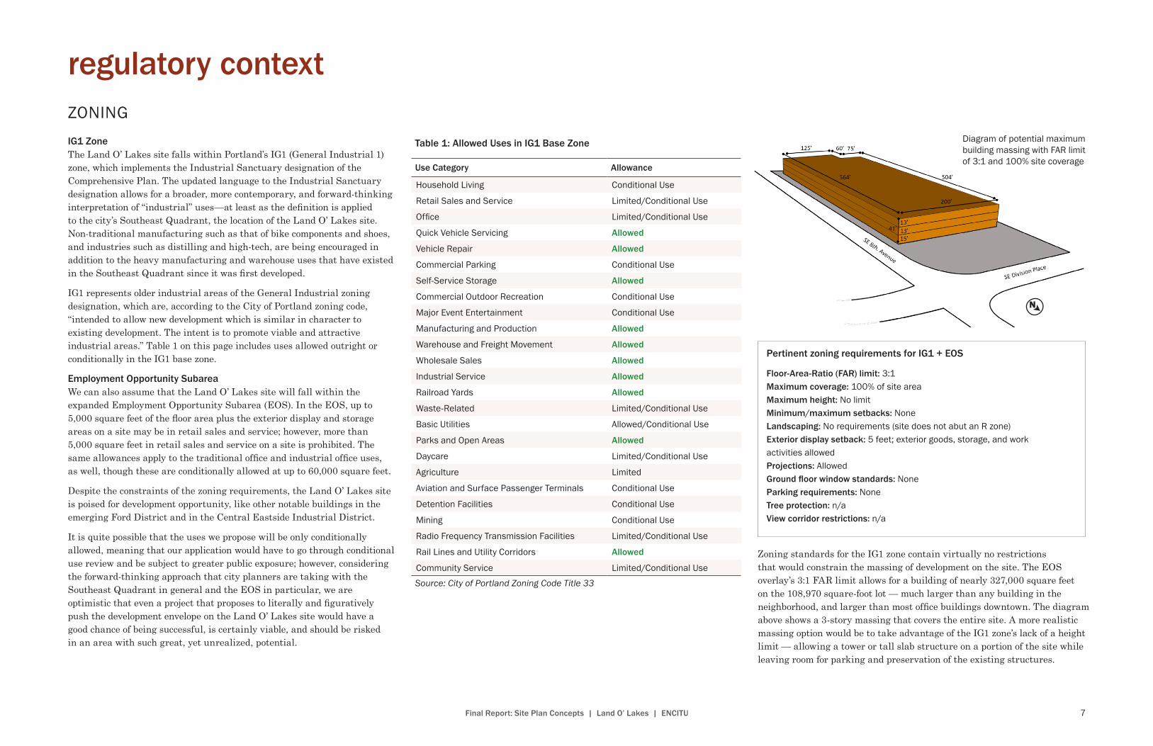
Diagram of potential maximum building massing with FAR limit of 3:1 and 100% site coverage
Zoning standards for the IG1 zone contain virtually no restrictions that would constrain the massing of development on the site. The EOS overlay’s 3:1 FAR limit allows for a building of nearly 327,000 square feet on the 108,970 square-foot lot — much larger than any building in the neighborhood, and larger than most office buildings downtown. The diagram above shows a 3-story massing that covers the entire site. A more realistic massing option would be to take advantage of the IG1 zone’s lack of a height limit — allowing a tower or tall slab structure on a portion of the site while leaving room for parking and preservation of the existing structures.
8 Final Report: Site Plan Concepts | Land O’ Lakes | ENCITU
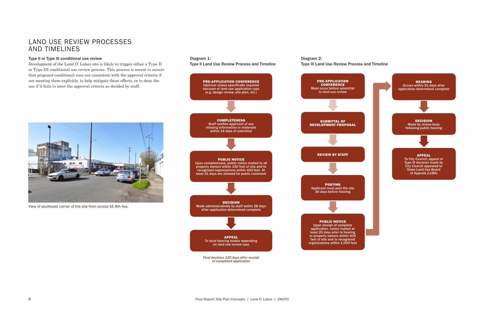
Type II or Type III conditional use reviewDevelopment of the Land O’ Lakes site is likely to trigger either a Type II or Type III conditional use review process. This process is meant to ensure that proposed conditional uses are consistent with the approval criteria if not meeting them explicitly, to help mitigate those effects, or to deny the use if it fails to meet the approval criteria as decided by staff.
LAND USE REVIEW PROCESSES AND TIMELINES
PRE-APPLICATION CONFERENCE
Must occur before submittal to land use review
SUBMITTAL OF DEVELOPMENT PROPOSAL
REVIEW BY STAFF
POSTINGApplicant must post the site
30 days before hearing
PUBLIC NOTICEUpon receipt of complete
application, notice mailed at least 20 days prior to hearing to property owners within 400 feet of site and to recognized
organizations within 1,000 feet
HEARINGOccurs within 51 days after
application determined complete
DECISIONMade by review body
following public hearing
APPEALTo City Council; appeal of Type III decision made by City Council appealed to
State Land Use Board of Appeals (LUBA)
Diagram 2: Type III Land Use Review Process and Timeline
PRE-APPLICATION CONFERENCEOptional unless specifically required because of land use application type
(e.g. design review, site plan, etc.)
COMPLETENESSStaff notifies applicant of any
missing information or materials within 14 days of submittal
PUBLIC NOTICEUpon completeness, public notice mailed to all property owners within 150 feet of site and to recognized organizations within 400 feet. At
least 21 days are allowed for public comment
DECISIONMade administratively by staff within 28 days
after application determined complete
APPEALTo local hearing bodies depending
on land use review type
Diagram 1: Type II Land Use Review Process and Timeline
Final decision 120 days after receipt of completed application
View of southeast corner of the site from across SE 8th Ave .

9Final Report: Site Plan Concepts | Land O’ Lakes | ENCITU
concept alternatives
1 LOW-INTENSITY DEVELOPMENT
SE POW
ELL BLVD
SE GRAND AVESE GRAND AVE
SE 8TH AVE
Renovate existing building
OutdoormarketPa
rkin
g
SE POW
ELL BLVD
SE GRAND AVESE GRAND AVE
SE 8TH AVE
Renovate existing building
Shipping container structures
Cont
aine
rs
Cont
aine
rs
Shared plazaPa
rkin
g
Our first alternative is envisioned as a low-intensity activation of the undeveloped northern part of the site. The existing building would remain and be renovated as a flex space. The existing unused surface parking lot would be converted to an outdoor venue and utilized as a market or light industrial makerspace. One intriguing possibility is the utilization of upcycled shipping containers or cargotecture.
Shipping containers have the benefits of affordability and flexible of configuration. They would reflect the industrial character, aesthetic, and history of the district. Most importantly, the low-intensity and low-risk nature of this alternative allows for the market to mature, potentially supporting more intensive development in the future, while simultaneously activating the site. The industrial nature of the area may also make the viability of a retail use uncertain. The lack of parking capacity in the immediate vicinity is another downside to this alternative.
Outdoor market concept
Renovation of the existing building for flexible office space should keep a raw aesthetic and open floorplans to appeal to creative office tenants
Shipping containers can be upcycled and flexibly configured to create a lively outdoor-oriented cluster of retail or light manufacturing spaces
With minimal investment, the existing parking lot can be put to use hosting outdoor markets or other events
“Cargotecture” concept

10 Final Report: Site Plan Concepts | Land O’ Lakes | ENCITU
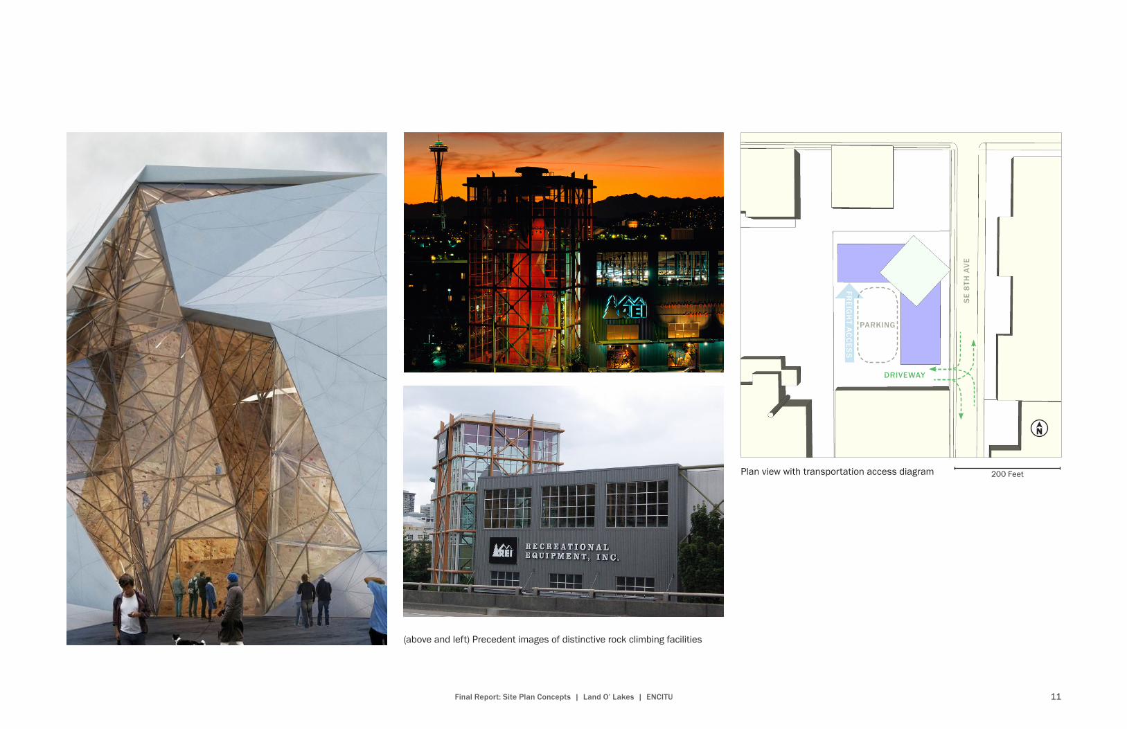
2 INDUSTRIAL OFFICE BUILDING ANCHORED BY LANDMARK ROCK CLIMBING TOWER
(above) View from northeast(left) View from southeast
Street-level view from northeast
Our second alternative also employs a renovation of the existing building. On the north end of the site, a new development would center around a tall, all glass tower which is envisioned as a iconic district landmark. Flanking the rock climbing tower are two wings of flexible industrial office space. Attention will be drawn to the northeast corner of the site, which looks to the intersection of SE 8th Ave and Division Place as well as the MAX Orange Line. Visitors to the nearby emerging Ford District will be drawn toward this unique design feature.
This alternative would align with the City goal of increased employment density in the SE Quadrant. The distinctive nature of the proposed building would serve to increase the visibility of the district and the rock climbing center would create a unique amenity. However, the retail/commercial component of the alternative could adversely affect the industrial character as well as freight movement of the area. Similarly, a lack of sufficient parking capacity could create issues of congestion. There are also questions regarding the ability to find tenants to fill the large and somewhat distinctive space that would be created.
11Final Report: Site Plan Concepts | Land O’ Lakes | ENCITU
(above and left) Precedent images of distinctive rock climbing facilities
Plan view with transportation access diagram
FREIG
HT A
CC
ESS
PARKING
SE
8TH
AVE
DRIVEWAY
200 Feet
12 Final Report: Site Plan Concepts | Land O’ Lakes | ENCITU
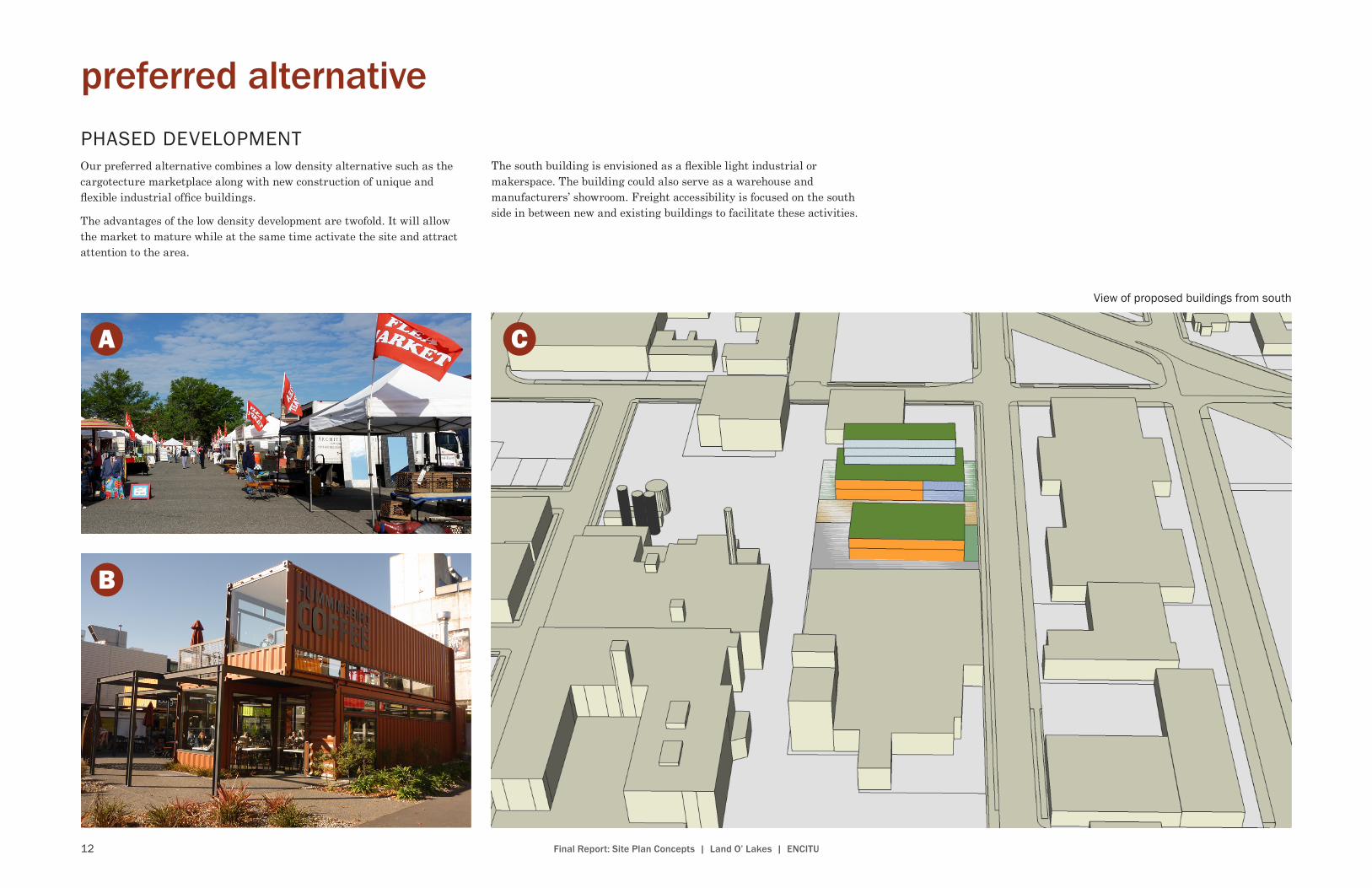
preferred alternativePHASED DEVELOPMENTOur preferred alternative combines a low density alternative such as the cargotecture marketplace along with new construction of unique and flexible industrial office buildings.
The advantages of the low density development are twofold. It will allow the market to mature while at the same time activate the site and attract attention to the area.
The south building is envisioned as a flexible light industrial or makerspace. The building could also serve as a warehouse and manufacturers’ showroom. Freight accessibility is focused on the south side in between new and existing buildings to facilitate these activities.
View of proposed buildings from south
13Final Report: Site Plan Concepts | Land O’ Lakes | ENCITU
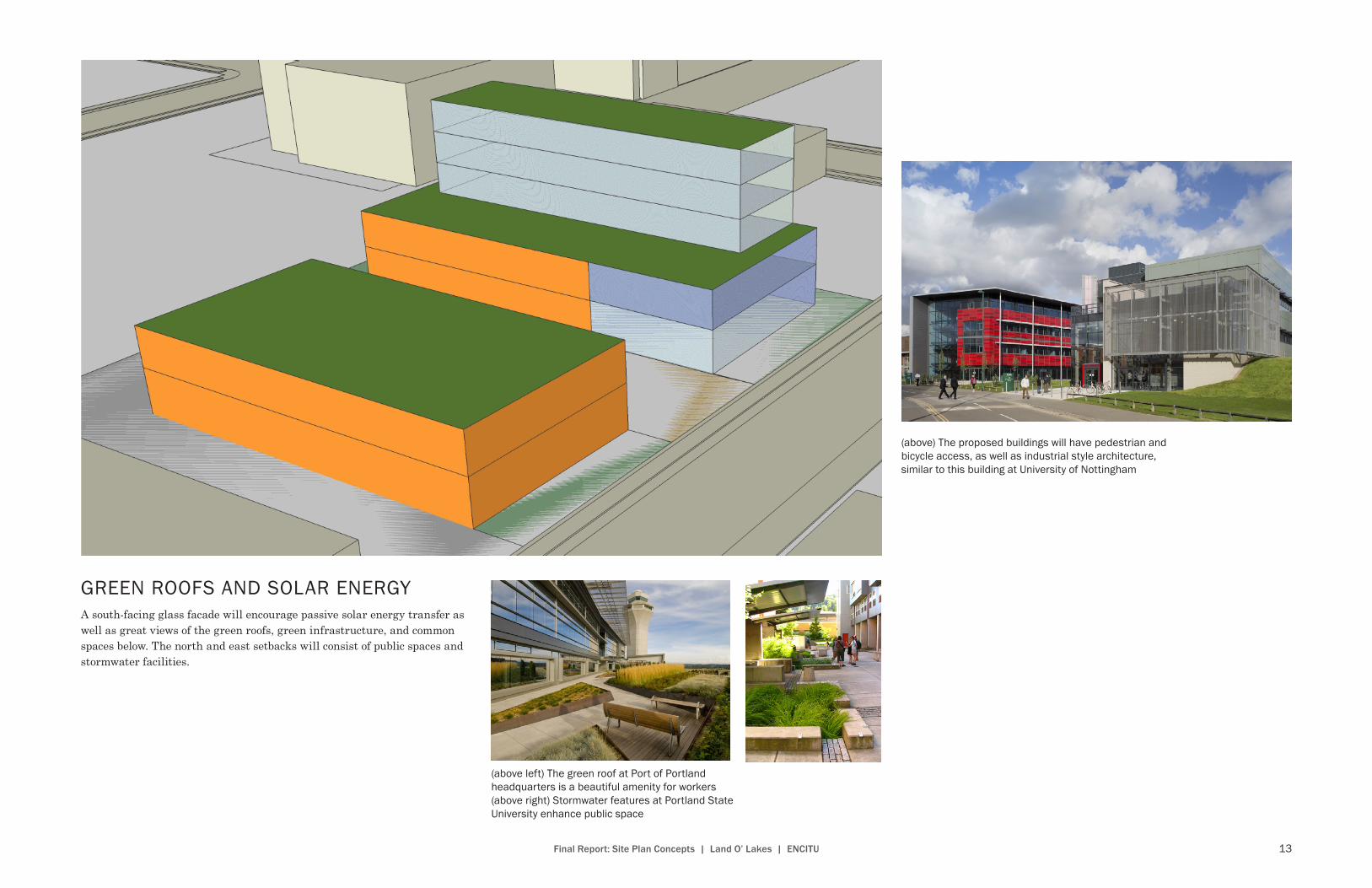
GREEN ROOFS AND SOLAR ENERGYA south-facing glass facade will encourage passive solar energy transfer as well as great views of the green roofs, green infrastructure, and common spaces below. The north and east setbacks will consist of public spaces and stormwater facilities.
(above left) The green roof at Port of Portland headquarters is a beautiful amenity for workers(above right) Stormwater features at Portland State University enhance public space
(above) The proposed buildings will have pedestrian and bicycle access, as well as industrial style architecture, similar to this building at University of Nottingham
14 Final Report: Site Plan Concepts | Land O’ Lakes | ENCITU
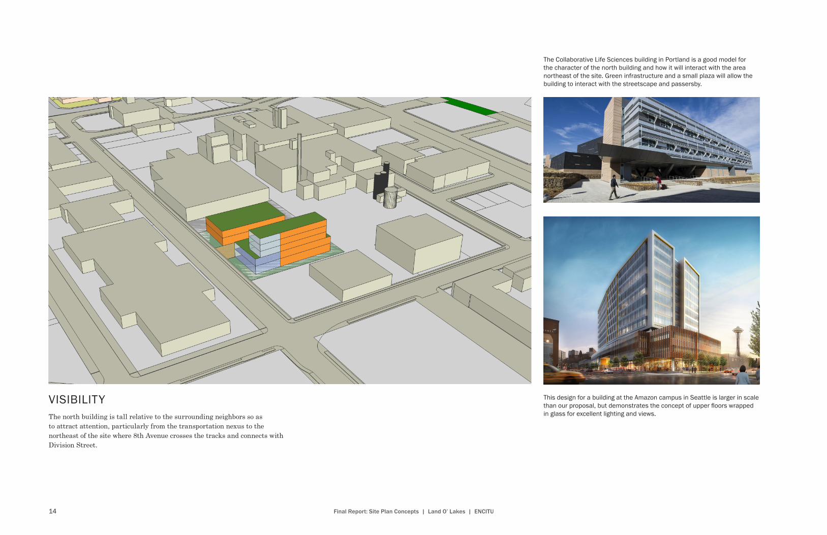
VISIBILITYThe north building is tall relative to the surrounding neighbors so as to attract attention, particularly from the transportation nexus to the northeast of the site where 8th Avenue crosses the tracks and connects with Division Street.
This design for a building at the Amazon campus in Seattle is larger in scale than our proposal, but demonstrates the concept of upper floors wrapped in glass for excellent lighting and views .
The Collaborative Life Sciences building in Portland is a good model for the character of the north building and how it will interact with the area northeast of the site . Green infrastructure and a small plaza will allow the building to interact with the streetscape and passersby .

15Final Report: Site Plan Concepts | Land O’ Lakes | ENCITU
In Washington DC, removable bollards and a paved surface will help create the atmosphere as required, inviting or utilitarian .
AN INDUSTRIAL WOONERFThe space between the two buildings is the focal point of activity on the site. Envisioned as a type of “industrial woonerf,” it will facilitate the mixing of commercial activity, both loading activities and pedestrians.
The south building will evoke a new industrialism with open well-lit spaces that are both flexible and easily accessible for various potential users . Our proposed building will feature functional loading spaces like this building at Southern California Institute of Architecture .
16 Final Report: Site Plan Concepts | Land O’ Lakes | ENCITU
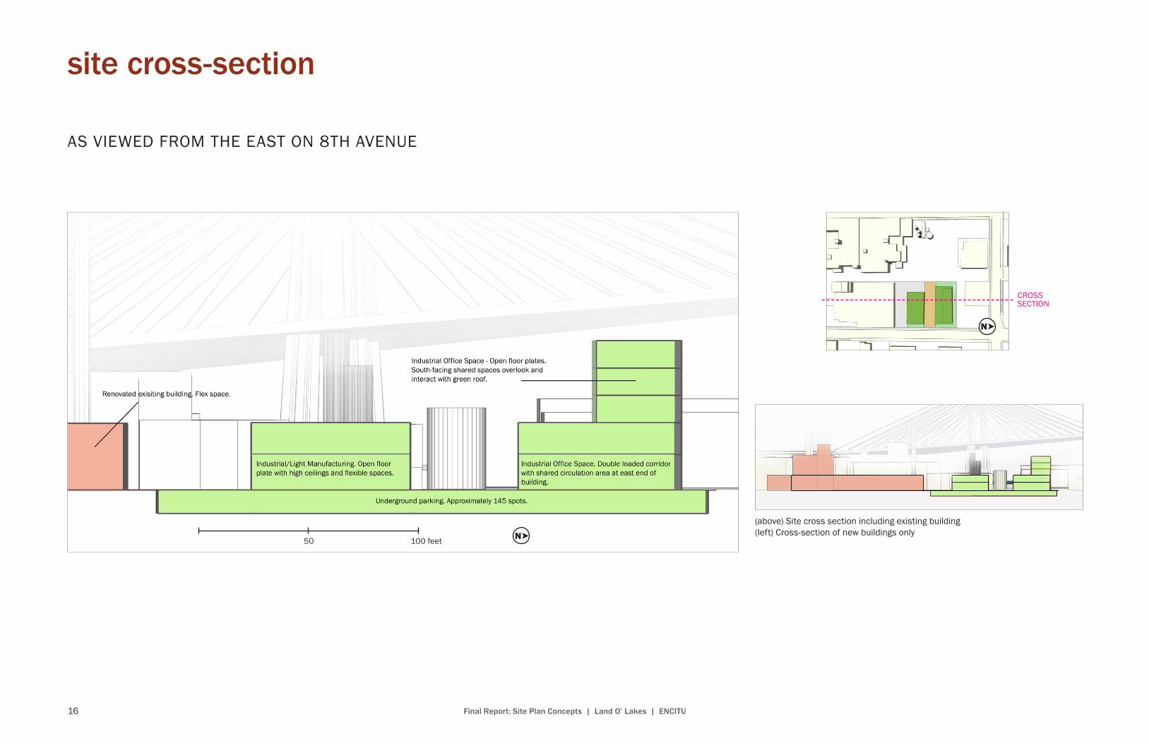
AS VIEWED FROM THE EAST ON 8TH AVENUE
CROSSSECTION
50 100 feet
(above) Site cross section including existing building(left) Cross-section of new buildings only
site cross-section
17Final Report: Site Plan Concepts | Land O’ Lakes | ENCITU
SE 8TH AVE
SE 6TH AVE
SE 7TH AVE
LP
NOI
SIVID E
S
SE DIV
ISIO
N ST
SE
WO
OD
WA
RD
ST
0 100 200 FT.
500'
196'
dimensions of site and concept plan
1 2 3 4 5
Entire parcel 500 x 196 ft.
1. Existing building 190 x 250 ft.
2. South driveway 54 ft. wide
3. South building 138 x 70 ft.
4. Woonerf 50 ft. wide
5. North building 158 x 75 ft.
1
2
3
4
5

18 Final Report: Site Plan Concepts | Land O’ Lakes | ENCITU
site circulation and access
**
Bike-ped route
Freightturnaround
Passenger vehiclesright-in, right-out;freight 2-way
**
Parking entrance
Loading bays
100 200 feet**
Parking entrance
Loading bays

19Final Report: Site Plan Concepts | Land O’ Lakes | ENCITU
existing and proposed street cross-sections
Location of cross-sectionon SE 8th Ave.
12' sidewalk
12' sidewalk
12' sidewalk
12' sidewalk
6'parking
lane
6'parking
lane
6'parking
lane
5'parking
lane
12'driving lane
12'driving lane
12'driving lane
11'driving lane
60' parking lot to fence
60' right of way
2' bike lane
buffer
EXISTING
PROPOSED
Existing Street Only one street is adjacent to the Land O’ Lakes site—SE 8th Avenue. Currently, the street features the usual 60-foot building-to-building (or, in this case, parking lot-to-fence) frequently seen in Portland streetscapes. With 12-foot sidewalks and 6-foot seemingly semi-official parking spaces on either side of the 12-foot driving lanes, SE 8th Avenue is accessible to freight vehicles and is becoming more and more frequented by bike commuters headed toward the even more frequented bike commute corridor of SE Division Street.
Proposed StreetBecause the Land O’ Lakes site is within a designated freight district, it is most important to preserve freight vehicle accessibility to and through the site with any proposed redesign. It is also important to promote active modes of transportation such as biking, so the project team has come up with the following compromise in order to meet both the goals of freight and cyclists at the site: the team proposes narrowing the southbound (west) driving lane to the minimum requirement of 11 feet and providing a 5-foot bike lane and 2-foot bike lane buffer (note: the bike lane and buffer could be provided on either or both sides of the right-of-way, depending on parking and freight needs).
As with on-site parking, the team is actually proposing that the developer of the Land O’ Lakes site provide the minimum required parking, rather than attempting to over-provide on-site parking to meet district demand, which the team recommends should be provided through a different development first.
Looking south on SE 8th Avenue
20 Final Report: Site Plan Concepts | Land O’ Lakes | ENCITU
2045 vision
THE SITEIn 2045 all phases of the preferred alternative will be complete, with full occupancy in the existing flex space building, new makerspace building, and in the new landmark industrial office building—each functioning at a healthy capacity. The redevelopment of Land O’ Lakes in phases gave the site ample time to activate the neighborhood, attract anchor tenants, and leverage compatibility. The site has grown to support hundreds of jobs in specialty manufacturing, light industrial uses, and the pharmaceutical and biomedical research industry. Increased activity in the neighborhood is synchronized with conjunct logistical operations from the various industries, allowing the Land O’ Lakes site to thrive. The circulation of the site balances the needs of small freight trucks, cars, active transportation, and is pedestrian friendly for employees and passersby.
Streetscape redevelopment incorporated a boulevard-type design along SE 8th Avenue which contains appealing facades, ground floor windows, bioswales, vegetation, and wide sidewalks that emphasize pedestrian use. Employees and pedestrians are able to walk five minutes to the Clinton Station to catch the MAX Orange Line westbound, or southbound. Industry at Land O’ Lakes has created knowledge spillovers, and contributed social and economic capital, as the Orange Line helped facilitate new linkages between the SE Quadrant, South Waterfront and downtown.
Employees utilize the woonerf and ecoroof on their breaks, while pedestrians and cyclists stop to admire the ecoroof from a distance, or stop to take a break in the woonerf on the way to their destination. The site has helped the city enhance wayfinding in the industrial eastside, by facilitating orientation to the waterfront with signage, and aesthetically pleasing infrastructure in the woonerf. In addition, Land O’ Lakes has reduced its concrete ground coverage since redevelopment in 2015 by planting native plants and trees in bioswales, which achieve effective stormwater management while mitigating environmental contamination from industrial pollutants after heavy rainfall. The green infrastructure in the building setbacks blend well with the streetscape, and provide green space for the industrial neighborhood.
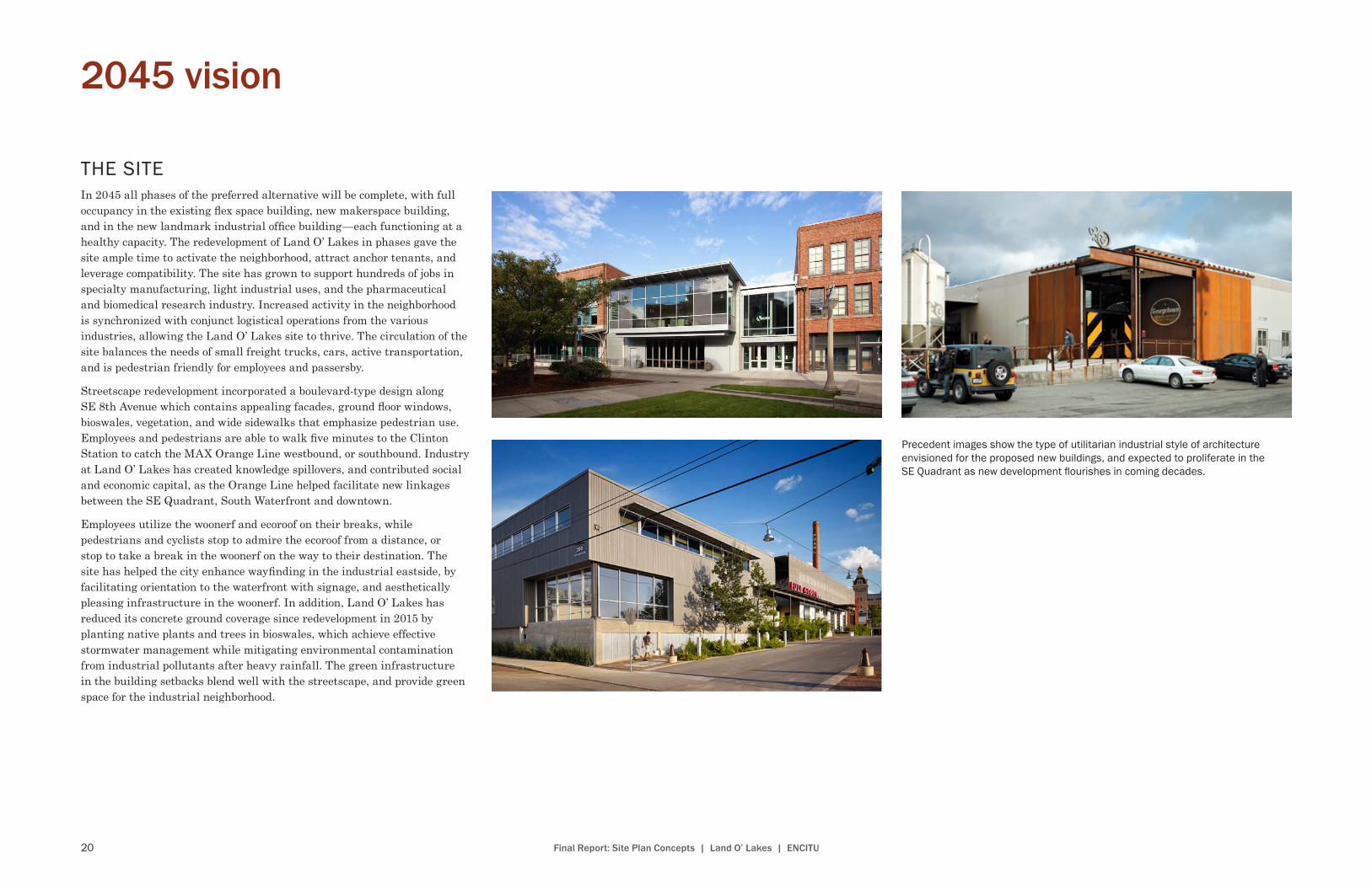
Precedent images show the type of utilitarian industrial style of architecture envisioned for the proposed new buildings, and expected to proliferate in the SE Quadrant as new development flourishes in coming decades .
21Final Report: Site Plan Concepts | Land O’ Lakes | ENCITU
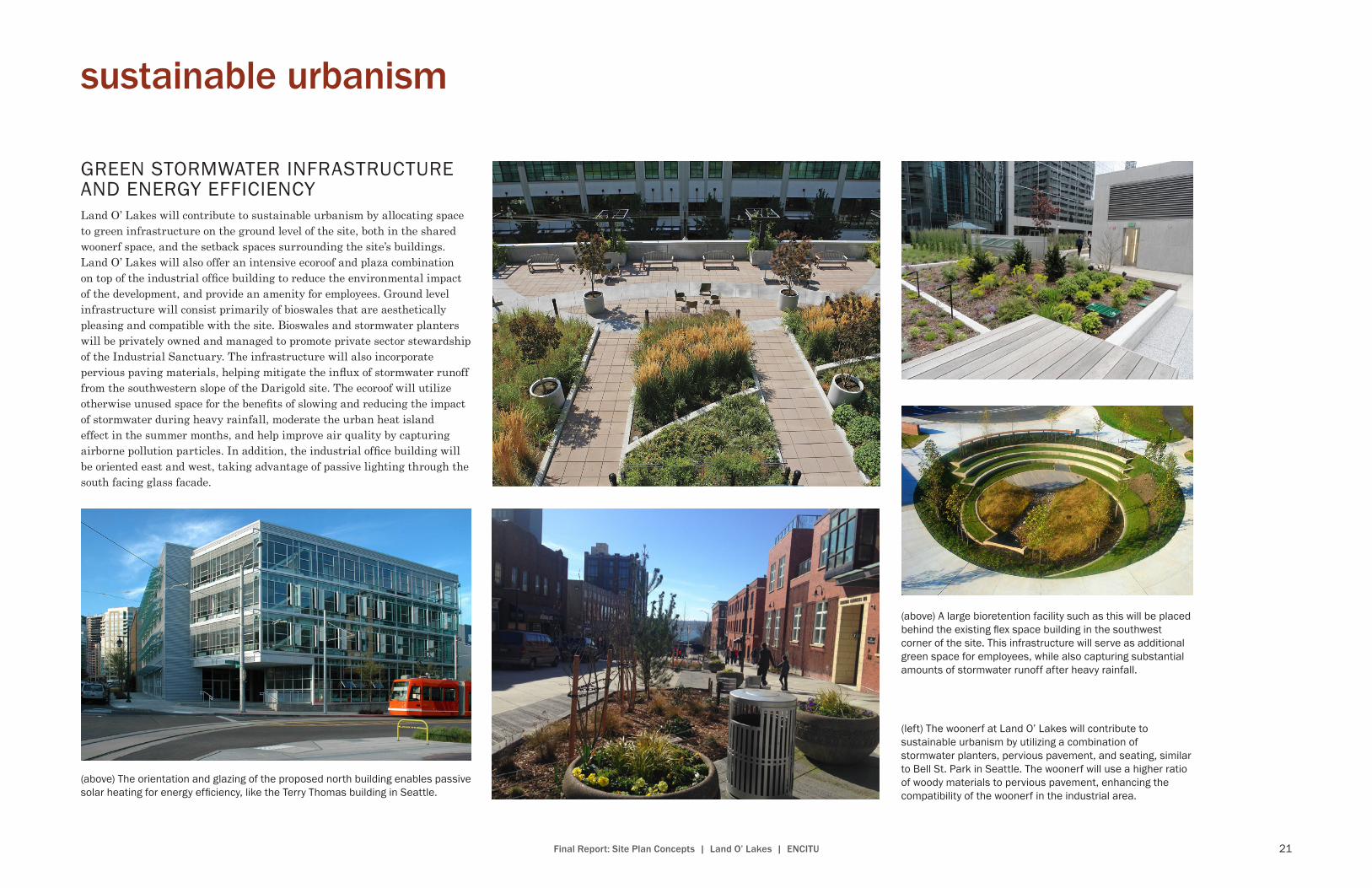
GREEN STORMWATER INFRASTRUCTURE AND ENERGY EFFICIENCYLand O’ Lakes will contribute to sustainable urbanism by allocating space to green infrastructure on the ground level of the site, both in the shared woonerf space, and the setback spaces surrounding the site’s buildings. Land O’ Lakes will also offer an intensive ecoroof and plaza combination on top of the industrial office building to reduce the environmental impact of the development, and provide an amenity for employees. Ground level infrastructure will consist primarily of bioswales that are aesthetically pleasing and compatible with the site. Bioswales and stormwater planters will be privately owned and managed to promote private sector stewardship of the Industrial Sanctuary. The infrastructure will also incorporate pervious paving materials, helping mitigate the influx of stormwater runoff from the southwestern slope of the Darigold site. The ecoroof will utilize otherwise unused space for the benefits of slowing and reducing the impact of stormwater during heavy rainfall, moderate the urban heat island effect in the summer months, and help improve air quality by capturing airborne pollution particles. In addition, the industrial office building will be oriented east and west, taking advantage of passive lighting through the south facing glass facade.
sustainable urbanism
(above) A large bioretention facility such as this will be placed behind the existing flex space building in the southwest corner of the site . This infrastructure will serve as additional green space for employees, while also capturing substantial amounts of stormwater runoff after heavy rainfall .
(left) The woonerf at Land O’ Lakes will contribute to sustainable urbanism by utilizing a combination of stormwater planters, pervious pavement, and seating, similar to Bell St . Park in Seattle . The woonerf will use a higher ratio of woody materials to pervious pavement, enhancing the compatibility of the woonerf in the industrial area .
(above) The orientation and glazing of the proposed north building enables passive solar heating for energy efficiency, like the Terry Thomas building in Seattle .

22 Final Report: Site Plan Concepts | Land O’ Lakes | ENCITU
The 240 Clay building in Portland, soon to begin construction, is an example of a comparable project that is similar to the buildings in the proposed plan, with new industrial office space at a similar scale and at a location in the central eastside near the Land O’ Lakes site .
project financial feasibility
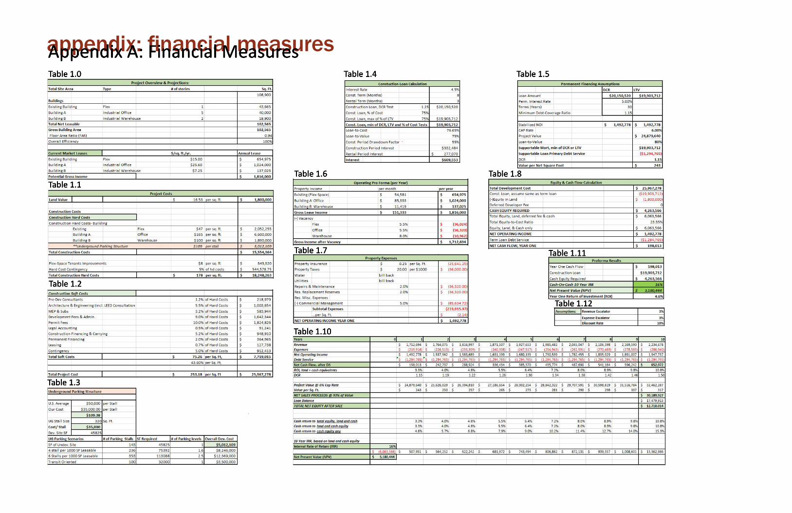
FINANCIAL PROJECTIONSAt EnCitu Plan + Design, after we decide a sites program and confirm that it correlates with the city wide goals and vision the next step is determining the likelihood that the project will be a success. To do this involves a fair amount of due diligence, followed by bringing in the bean-counters. Ultimately, to project possible financial outcomes given what we know about an areas financial markets, real estate markets, demographics, zoning, and a variety of other variables.
With the Land-O-Lakes site, our designers, architects, and planners wanted to utilized the existing structures on the site and develop two new structures to maximize the footprint of the site. The existing building would be integrated into industrial flex-space, a newly developed industrial warehouse/manufacturing building, another 5 story industrial office building, and an entire level of underground parking providing 143 spaces. The firm’s objective is to build, hold, and sell the property at end of year 10. To start we identify what the market will bear and what are the demand drivers. This is followed by using data from local and national commercial real estate companies to determine achievable rents, for specific use types (Appendix A: Table 1.0). Third, data derived from our local builders to identify construction cost, both to retrofit existing structures and to build new, shedding light on overall cost of the project (Appendix A: Tables 1.1-1.3).
Consequently, when we use institutional capital we mitigate risk and actually achieve greater returns, so at this stage we turn to lenders and investors to finance the bulk of the project.
This project is estimated to cost approximately $26 million, of which we plan on financing 80% at a favorable 30 year fixed-rate mortgage loan of 5%. Due to EnCitu’s outstanding relationship with our lender we are required to meet a debt coverage ratio (DCR) of only 1.15, of which we project to make just that. DCR is the ratio between our property’s net operating income for the year and our annual debt service (Appendix A: Tables 1.4 & 1.5).
Taking into account the above mentioned, our financial team projects the property’s net operating income for year one. This one year projection takes into account a variety of variables; operating expenses, vacancy rates, insurance, tenant improvements, property taxes and so on (Appendix A: Tables 1.6-1.8). This provides what should be a positive cash flow for year one. In the case of Land-O-Lakes, there is a positive outcome of $200,000 (Appendix A: Table 1.8).
The final stage of determining financial feasibility, and given it is a build, hold, sell project is to project the properties financial performance during and at the end of 10 years (Appendix A: Table 1.10). What is derived from this 10 year projection, taking into account assumptions made in Appendix A: Table 1.12, is that the project has a 16% internal rate of return, and a positive net present value of cash flows amounting to $3.2 million, and positive return on investment for all 10 years. Overall, the Land-O-Lakes project is financially feasible dependent upon our market trends and assumption remain in close correlation.
appendix: financial measures
Table 1.12
Appendix A: Financial MeasuresTable 1.0
Table 1.1
Table 1.2
Table 1.3
Table 1.4 Table 1.5
Table 1.6
Table 1.7 Table 1.11
Table 1.8
Table 1.10