Embed Size (px)
Citation preview
Se" ISTORY
.~ Discovery
~
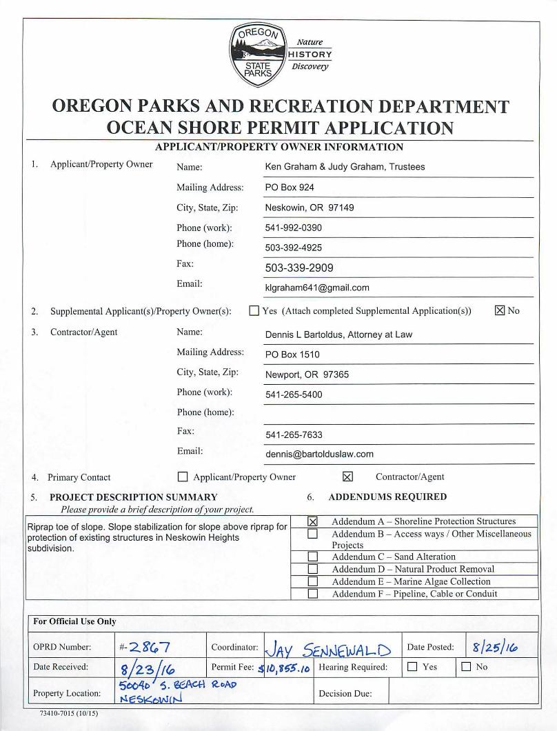
OREGON PARKS AND RECREATION DEPARTMENT OCEAN SHORE PERMIT APPLICATION
APPLICANT/PROPERTY OWNER INFORMATION
I. ApplicantlProperty Owner Name: Ken Graham & Judy Graham, Trustees
Mailing Address: PO Box 924
City, Slate, Zip: Neskowin, OR 97149
Phone (work): 541-992-0390
Phone (home): 503-392-4925
Fax: 503-339-2909 Email: [email protected]
2. Supplemental Applicam(s)/Property Owner(s): o Yes (Attach compleled Supplemental Application(s)) ~ No
3. Contractor/Agent Name: Dennis L Bartoldus, Attorney at Law
Mailing Address: PO Box 1510
City, State, Zip: Newport, OR 97365
Phone (work): 541 -265-5400
Phone (home):
Fax: 541-265-7633
Email: [email protected]
4. Primary Contact o Applicant/Property Owner ~ Contractor/Agent
5. PROJECT DESCRIPTION SUMMARY 6. ADDENDUMS REQUIRED Please provide a brief description ofyollr project.
Riprap toe of s lope. S lope stabilization for s lope above riprap for ~ Addendum A - Shoreline Protection Structures
protection of existing structu res in Neskowin He ights 0 Addendum B - Access ways / Other Miscellaneous
subdivision. Proiects
0 Addendum C - Sand Alteration
0 Addendum 0 - Natural Produci Removal
0 Addendum E - Maline Algae Collection
0 Addendum F - Pipeline, Cable or Conduit
For Officiat Use Only
aPRD Number: #- 2.g" 7 Coordinator: JAV 5ENr-.\fWA 1.-D Date Posted: g /2.5/ /(P
Date Received : s!z31/{p Permit Fee: !! ILJJf~5. 10 Hearing Required: D Yes I D No
500'{0 I S . ~ ~oAl1 Property Location: ",,:::sv· ..• (,j- Decision Due:
734 10·70 15 ( 10115)
Nature
HISTORY ~~---11
Discovery
OREGON PARKS AND RECREATION DEPARTMENT OCEAN SHORE PERMIT APPLICATION
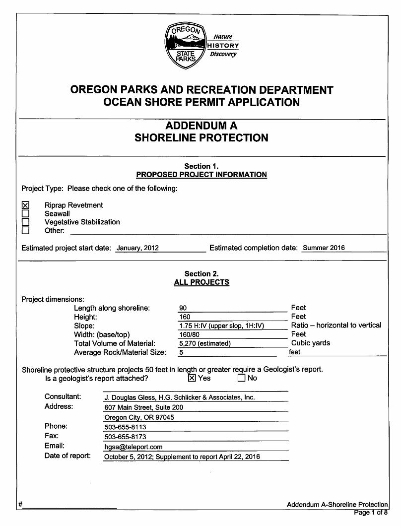
ADDENDUM A SHORELINE PROTECTION
Section 1. PROPOSED PROJECT INFORMATION
Project Type: Please check one of the following:
~ Riprap Revetment D Seawall D Vegetative Stabilization D Other:
Estimated project start date: _J_an_u_a.,Lry..:...., 2_0_1_2 _____ Estimated completion date: Summer 2016
Section 2. ALL PROJECTS
Project dimensions: Length along shoreline: _9_0 __________ Feet Height: 160 Feet Slope: 1.75 H:IV (upper slop, 1 H:IV) Ratio - horizontal to vertical Width: (base/top) 160/80 Feet Total Volume of Material: 5,270 (estimated) Cubic yards Average Rock/Material Size: 5 _fe_e_t _________ 1
Shoreline protective structure projects 50 feet in length or greater require a Geologist's report. Is a geologist's report attached? [8] Yes D No
Consultant: J. Douglas Gless, H.G. Schlicker & Associates, Inc. Address: 607 Main Street, Suite 200
Oregon City, OR 97045 Phone: 503-655-8113 Fax: 503-655-8173 Email: [email protected] Date of report: October 5,2012; Supplement to report April 22, 2016
# Addendum A-Shoreline Protection
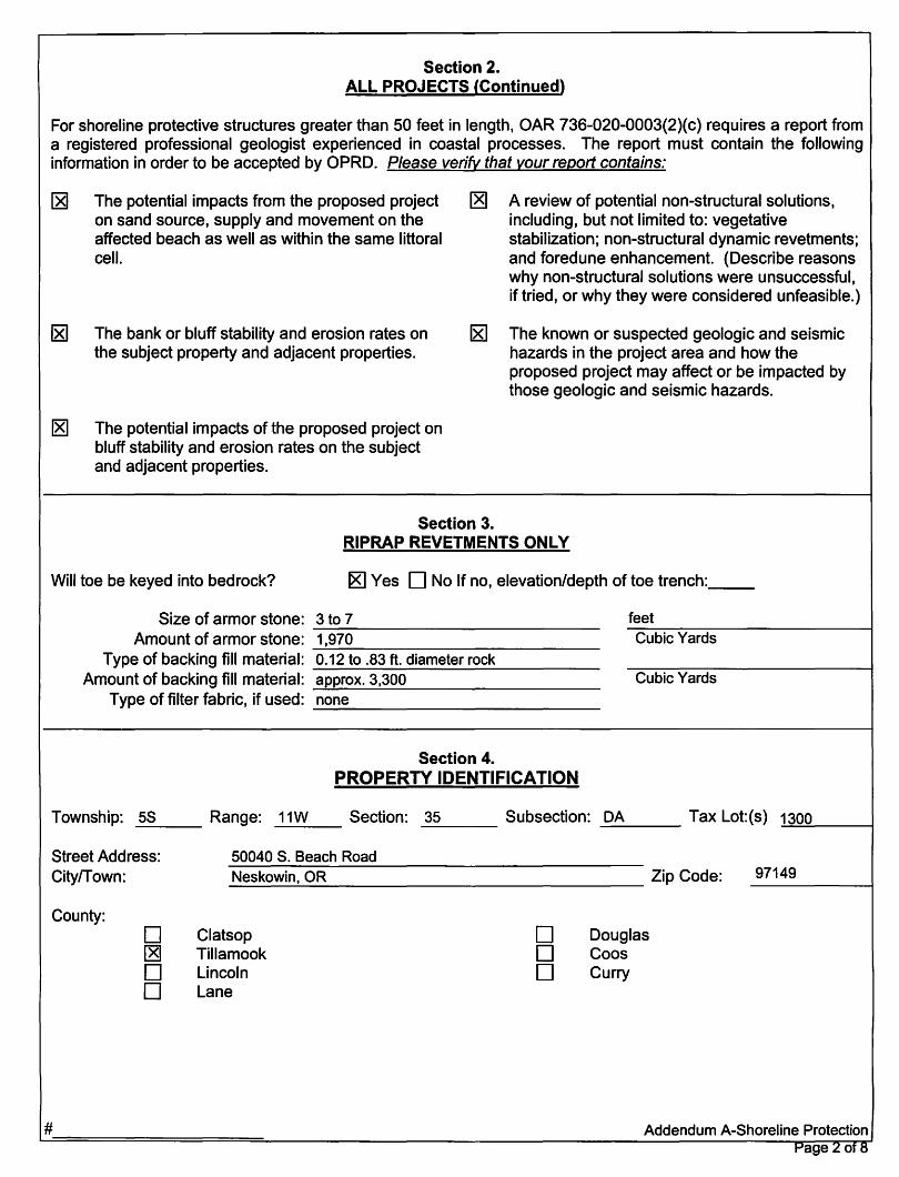
Section 2. ALL PROJECTS (Continued)
For shoreline protective structures greater than 50 feet in length, OAR 736-020-0003(2)(c) requires a report from a registered professional geologist experienced in coastal processes. The report must contain the following information in order to be accepted by OPRD. Please verify that your report contains:
~ The potential impacts from the proposed project on sand source, supply and movement on the affected beach as well as within the same littoral cell.
[2g A review of potential non-structural solutions, including, but not limited to: vegetative stabilization; non-structural dynamic revetments; and foredune enhancement. (Describe reasons why non-structural solutions were unsuccessful, if tried, or why they were considered unfeasible.)
~ The bank or bluff stability and erosion rates on the subject property and adjacent properties.
~ The known or suspected geologic and seismic hazards in the project area and how the proposed project may affect or be impacted by those geologic and seismic hazards.
~ The potential impacts of the proposed project on bluff stability and erosion rates on the subject and adjacent properties.
Section 3. RIPRAP REVETMENTS ONLY
Will toe be keyed into bedrock? 18] Yes D No If no, elevation/depth of toe trench: __
Size of armor stone: 3 to 7 feet -------------------------------Amount of armor stone: 1,970 ~-------------------------------
Cubic Yards
Type of backing fill material: 0.12 to .83 ft. diameter rock Amount of backing fill material: approx.3,300
--~--~---------------------Cubic Yards
Type of filter fabric, if used: none ---------------------------------
Section 4. PROPERTY IDENTIFICATION
Township: 5S Range: 11W Section: 35 Subsection: DA Tax Lot:(s) 1300 ------- ----- ~~-~ ----
Street Address: CitylTown:
County:
#
D ~ D D
50040 S. Beach Road Neskowin, OR Zip Code: ----------~--------------------------------------------
Clatsop Tillamook Lincoln Lane
D D D
Douglas Coos Curry
97149
Addendum A-Shoreline Protection Page 2 of8
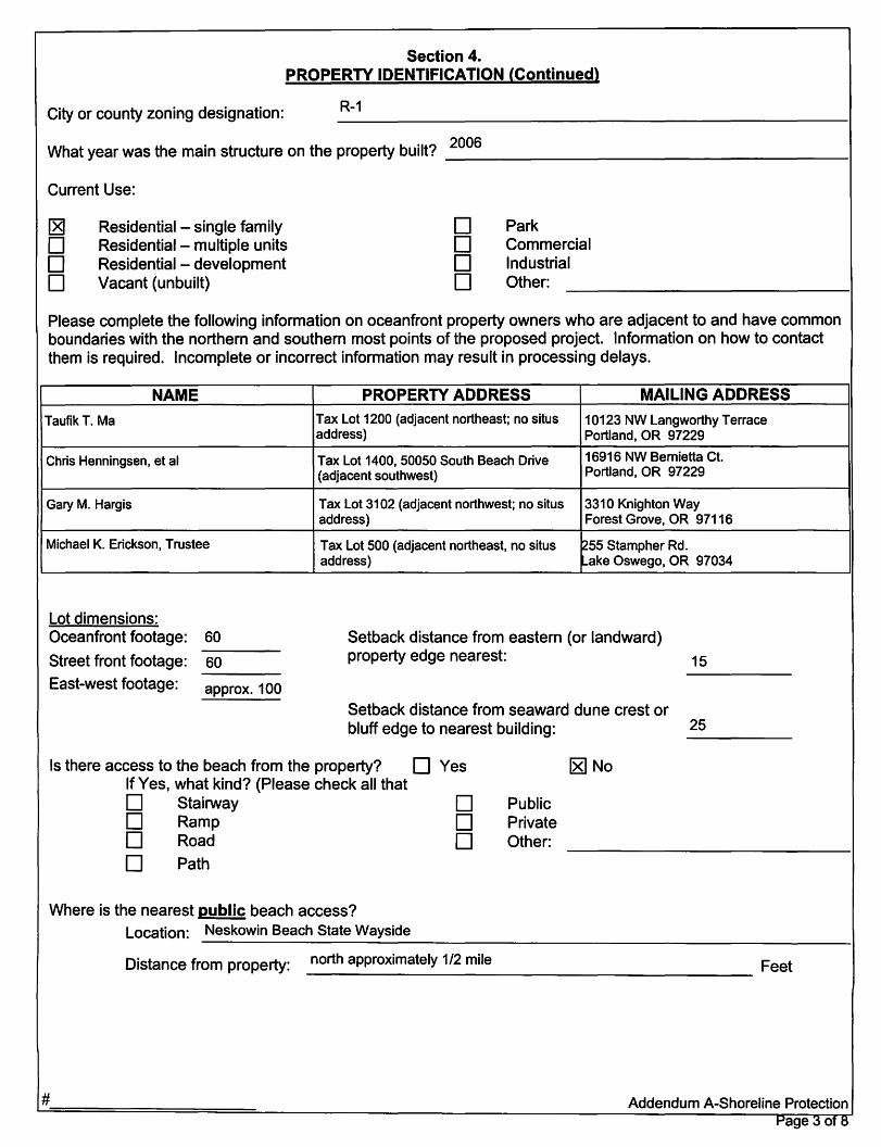
Section 4. PROPERTY IDENTIFICATION (Continued)
City or county zoning designation: R-1
Wh~ye~wasfuemainstrudureonfueprope~bui~? _2_0_06~~~~~~~~~~~~~~~~~~_1
Current Use:
~ D D D
Residential - single family Residential - multiple units Residential - development Vacant (unbuilt)
D D D D
Park Commercial Industrial Other:
Please complete the following information on oceanfront prope~ owners who are adjacent to and have common boundaries with the northern and southern most points of the proposed project. Information on how to contact them is required. Incomplete or incorrect information may result in processing delays.
NAME PROPERTY ADDRESS MAILING ADDRESS
Taufik T. Ma
Chris Henningsen, et al
Gary M. Hargis
Michael K. Erickson, Trustee
Lot dimensions: Oceanfront footage: 60
~~~-
Street front footage: 60 ~~~-
East-west footage: approx. 100
Tax Lot 1200 (adjacent northeast; no situs 10123 NW Langworthy Terrace address) Portland, OR 97229
Tax Lot 1400,50050 South Beach Drive 16916 NW Bernietta Ct. (adjacent southwest) Portland, OR 97229
Tax Lot 3102 (adjacent northwest; no situs 3310 Knighton Way address) Forest Grove, OR 97116
Tax Lot 500 (adjacent northeast, no situs ~55 Stampher Rd. address) ~ake Oswego, OR 97034
Setback distance from eastern (or landward) property edge nearest:
Setback distance from seaward dune crest or
15
bluff edge to nearest building: 25 ~----
Is there access to the beach from the property? DYes ~No If Yes, what kind? (Please check all that D Stairway D D Ramp D D Road D
D Path
Where is the nearest public beach access? Location: Neskowin Beach State Wayside
Public Private Other:
D~~nce~mproperty: _n_o_rt_h_a_pp_r_oX_i_m_a_~_~_1_~~m_il_e~~~~~~~~~~~~~ Fe~
# Addendum A-Shoreline Protection Page 3 of 8
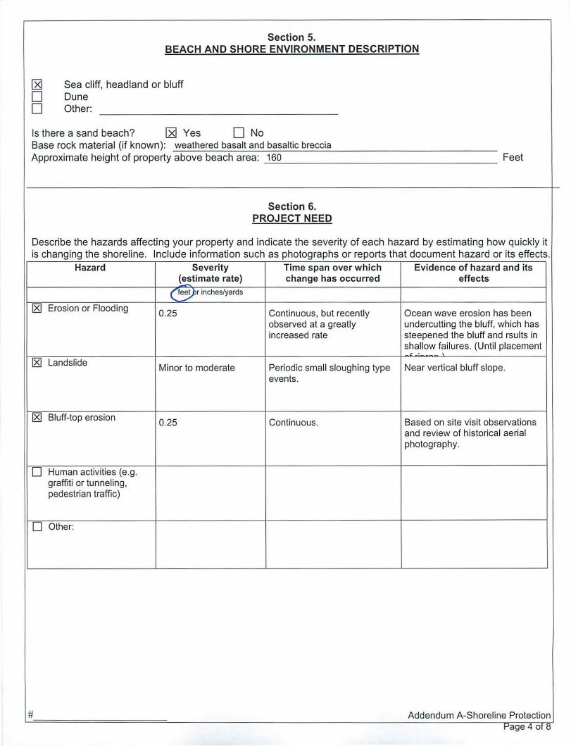
Section 5. BEACH AN D SHORE ENVIRONMENT DESCRIPTION
I2$l Sea cl iff, headland or bluff
0 Dune
0 Other:
Is there a sand beach? I2$l Yes o No Base rock material (if known): weathered basalt and basaltic breccia Approximate height of property above beach area: 160 Feet
Section 6. PROJECT NEED
Describe the hazards affecting your property and ind icate the severity of each hazard by estimating how quickly it is changing the shore line. Include information such as photographs or reports that document hazard or its effects .
Hazard Severity Time span over which Evidence of hazard and its (estimate rate) change has occurred effects
( fe~r inches/yards
~ Erosion or Flooding 0.25 Continuous, but recently Ocean wave erosion has been observed at a greatly undercutti ng the bluff, which has increased rate steepened the bluff and rsul ts in
shallow fa ilures. (Until placement ., ., ~ Landslide Minor to moderate Periodic small sloughing type Near vertical bluff slope.
events.
~ Bluff-top erosion 0.25 Continuous. Based on site visit observations
and review of historica l ae ri al photography.
0 Human activities (e .g. graffiti or tunneling, pedestrian traffic)
0 Other:
# Addendum A-Shoreline Protection t-'a e 4 01 tl g
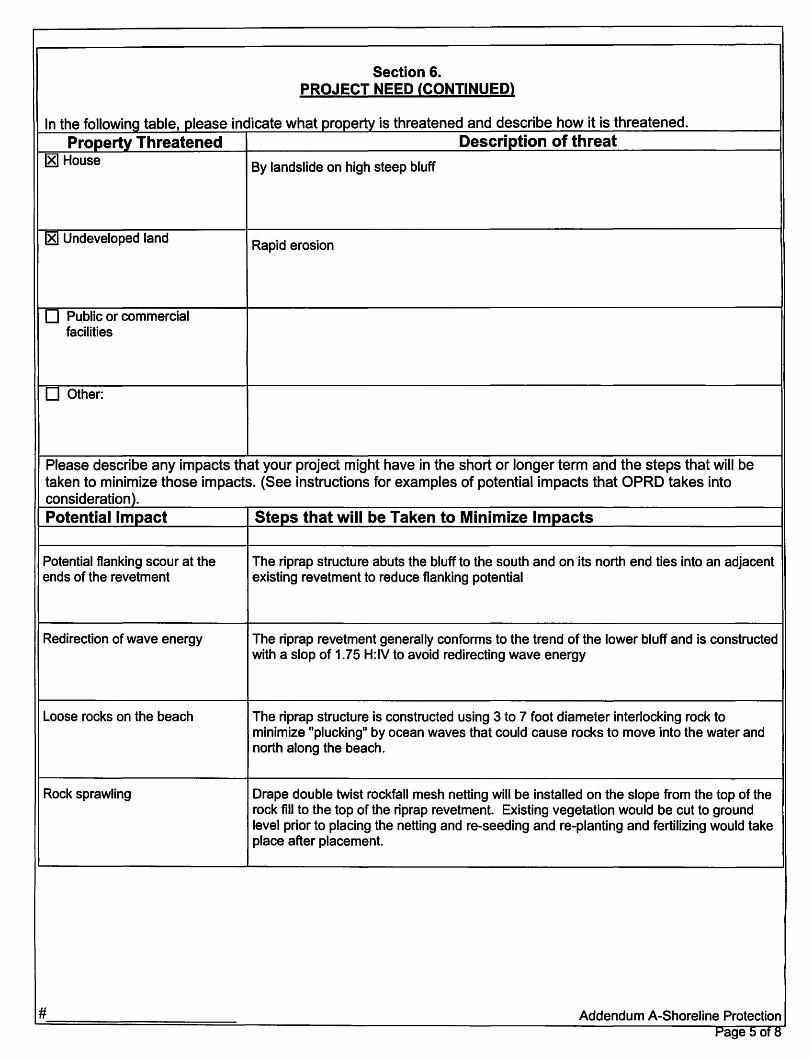
Section 6. PROJECT NEED (CONTINUED)
In the following table, please indicate what property is threatened and describe how it is threatened. Property Threatened Description of threat
181 House
181 Undeveloped land
D Public or commercial facilities
D Other:
By landslide on high steep bluff
Rapid erosion
Please describe any impacts that your project might have in the short or longer term and the steps that will be taken to minimize those impacts. (See instructions for examples of potential impacts that OPRD takes into consideration ). Potential Impact Steps that will be Taken to Minimize Impacts
Potential flanking scour at the ends of the revetment
Redirection of wave energy
Loose rocks on the beach
Rock sprawling
#
The riprap structure abuts the bluff to the south and on its north end ties into an adjacent existing revetment to reduce flanking potential
The riprap revetment generally conforms to the trend of the lower bluff and is constructed with a slop of 1.75 H:IV to avoid redirecting wave energy
The riprap structure is constructed using 3 to 7 foot diameter interlocking rock to minimize "plucking" by ocean waves that could cause rocks to move into the water and north along the beach.
Drape double twist rockfall mesh netting will be installed on the slope from the top of the rock fill to the top of the riprap revetment. Existing vegetation would be cut to ground level prior to placing the netting and re-seeding and re-planting and fertilizing would take place after placement.
Addendum A-Shoreline Protection Page 5 of 8

#
Section 7. EVALUATION OF HAZARD ALLEVIATION METHODS
Hazard Alleviation Category
Technique(s} Was alternative used? considered (describe)
Description of why alternative was not
feasible
Hazard Avoidance
Relocation of existing buildings or other infrastructure?
Hazard Avoidance
Increase of setbacks for new construction or infrastructure
Non-structural shore protection
Vegetative stabilization, sand alteration
Dynamic_revetments
Sand bags, gravel mounds, logs, composite revetment
Other:
DYes ~ No There is no room on property 1--------lI------1 to relocate house
If cost is a factor, cost estimates included?
DYes D No
D Yes ~ No r-----~---~
If yes, date:
DYes D No
N/A
Would not be sufficient to slow or halt erosion due to high waver energy. See attached geologic report for discussion
DYes (2g No Unlikely to perform r------L.....----~ adequately during storm
If yes, date:
date:
events and over longer perios of time at this location. See attached geologic report for further discussion
Addendum A-Shoreline Protection page (:j Of H

r--------------... -~-. ,---_._ ... _---Section 8.
COASTAL ZONE CERTIFICATION
Large-scale projects below mean high water may require a federal pennit from the U.S. Army Corps of Engineers. The Oregon Coastal Management Program reviews proposed federal permits for consistency with state and focal programs. Applicants who need to obtain a federal permit must certify the statement below:
I certify that, to the best of my knowJedge and belief, the proposed activity described In this application complies with the approved Oregon Coastal Zone Management Program and will be completed consistent with the program.
o ~ o o
Section 9. CITY/COUNTY PLANNING DEPARTMENT AFFIDAVIT
(To be completed by local planning official)
This project is not regulated by the local comprehensive plan and zoning ordinance. This project has been r~viewed and is 90nsistent with the 19cal comprehensl~e pJ~n and zoning ordinance.*~t~ ~ tlu.tiN\ ~ .,af t'4f ~,zA:l-lW'-lsu. a. This project has been revIewed and is notJconsistellt ~h the local comprehensive plan and zoning ordinance. ConSistency of this pro jed with local planning ordinance cannot be determined until the following local approvat(s) are obtained:
o Conditional Use Approval o Zone Change
o Plan Amendment o Other: ~-------------------~-------o Development Permit
jappncation 0 has 0 has not been made for local approvals checked above.
City/County Pfanning Official Signature c1~~dDllA
Date
~
Application Is hereby made for the activities described on the attachment(s) Identified. I certify that I am familiar with the Information contained In the application, and, to the best of my knowledge and belief, this information is true, complete and accurate. I further certify that I possess the authority to undertake the proposed activities. I understand that the grantrng of other permits by local. state or federal agencIes does not rei ease me from the requirement of obtaining the permits requested before commencing the proJect. I understand that local permits may be required before the state permit Is Issued. I understand that payment of any required state processing fee does not guarantee Issuance of a permit.
I certify that I am a duly authorized agent acting on behalf of the applicant.
Contractor I Agent Signature #
Date Addendum A-5horeline Protection
)
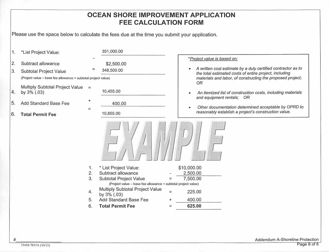
OCEAN SHORE IMPROVEMENT APPLICATION FEE CALCULATION FORM
Please use the space below to ca lculate the fees due at the time you submit your application.
1. ' List Project Value:
2. Subtract allowance
3. Subtotal Project Va lue =
351,000.00
$2,500.00 348,500.00
'Project value is based on:
(Project value - base fee allowance = subtotal project value)
• A written cost estimate by a duly certified contractor as to the total estimated costs of entire project, including materials and labor, of constructing the proposed project; OR
Multiply Subtotal Project Value 4. by 3% (.03)
5. Add Standard Base Fee
6. Total Permit Fee
# 734 10-70 15A ( I Oil 5)
= 10,455.00
+ 400.00
= 10,855.00
1. • List Project Va lue: 2. Subtract allowance 3. Subtotal Project Va lue
• An itemized list of construction costs, including materials and equipment rentals; OR
• Other documentation determined acceptable by OPRD to reasonably establish a project's construction value.
$10,000.00 2,500.00
= 7,500.00 (Project value - base fee allowance = subtotal project va lue)
4.
5.
Multiply Subtotal Project Value by 3% (.03) Add Standard Base Fee
6. Total Permit Fee
= 225.00
+ 400.00 = 625,00
Addendum A-Shoreline Protection
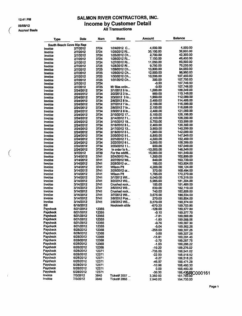
12:41 PM SALMON RIVER CONTRACTORS, INC.
09/05112 Income by Customer Detail ( Accrual Basts All Transactions
Type Date Num Memo Amount Balance
South Beach Cove Rip Rap 4,500.00 Invoice 21712012 3724 112412012 C ... 4,500.00
Invoice 21712012 3724 112512012 m ... 35,100.00 39,600.00 Invoice 21712012 3724 112512012 Ch ..• 2,700.00 42,300.00 Invofce 21712012 3724 112612012 m ... 7,150.00 49.450.00 Invoice 2/712012 3724 1/2712012 Ri... 11,050.00 60,500.00 Invoice 21712012 3725 112812012 Ri... 9,750.00 70,250.00 Invoice 21712012 3725 1/2812012 Ch ... 13,800.00 84,050.00 fnvoice 21712012 3725 112912012 Ch ••• 12,900.00 96,950.00 Invoice 21712012 3725 113012012 Ch ... 10,500.00 107.450.00 Invoice 21712012 3725 113112012 Ch ... 300.00 107,750.00 Invoice 21712012 3724 ..(J.50 107,749.50 Invoice 21712012 3725 Mr Mas onlin_. ..(J.50 107,749!00 Invoice 212412012 3734 211120125 10 ... 1,500.00 109,249.00 InvoIce 212412012 3734 212/2012310 ... 900.00 110,149:00 Invoice 212412012 3734 21312012 3 10 ... 1,950.00 112,099.00 Invoice 212412012 3734 21612012 8 10 ••. 2,400.00 114,499.00 Invoice 212412012 3734 21712012710 •.. 2,100.00 116,599.00 Invoice 212412012 3734 21812012 7 fo ... 2,100.00 118,699.00 Invoice 212412012 3734 21912012 8 10 ... 2,400.00 121,099.00 Invoice 212412012 3734 21101201217 ... 5,100.00 126,199.00 Invoice 212412012 3734 2114120127 J... 2,100.00 128,299.00 Invotce 212412012 3734 21151201219 •.• 5,700.00 133,999.00 Invoice 212412012 3734 2116120128 L. 2,400.00 136,399.00 Invoice 2/2412012 3734 21171201213 ... 3,900.00 140,299.00 Invoice 212412012 3734 21181201261... 1,800.00 142,099.00 Invoice 212412012 3734 212012012 9 I... 5,850.00 147,949.00 Invoice 212412012 3734 2121120127 L.. 4.550.00 152,499.00 Invoice 212412012 3734 2122120126 L.. 3,900.00 156,399.00 Invoice 212412012 3734 21231201211.. 650.00 157,049.00
( (nvoice 212412012 3734 In order to h ... -10,500.00 146,549.00 Invoice 31712012 3739 For the additi ... 15,000.00 161,549.00 Invoice 311412012 3741 212412012 Po ... 1.350.00 162,899.00 Invoice 311412012 3741 212712012 WI... 840.00 163,739.00 'nvoice 311412012 3741 212812012 cr ... 185.00 163,924.00 Invoice 311412012 3741 Wilson Pit 4,200.00 168,124.00 Invorce 3/1412012 3741 212912012 cr ... 370.00 168,494.00 Invoice 311412012 3741 WDson Pit 1,785.00 170.279.00 Invoice 311412012 3741 311/2012 Wit.. 5,040.00 175.319.00 Invoice 311412012 3741 31212012 WH ... 5,985.00 181,304.00 Invoice 311412012 3741 Crushed rock. •. 185.00 181.489.00 Invoice 311412012 3741 31612012 Wit ... 630.00 182,119.00 Invoice 311412012 3741 Crushed rock. .. 740.00 182,859.00 Invoice 311412012 3741 31712012 Wit.. 3,675.00 186,534.00 Invoice 311412012 3741 318/2012 Pos ... 270.00 186,804.00 Invoice 311412012 3741 3/9/2012 Wit.. 3,570.00 190,374.00 Bill 611812012 Neskowin slide -670.20 189,703.80 Paycheck 612112012 12355 -126.00 189.577.80 Paycheck 612112012 12355 -D.10 189.577.70 Paycheck 612112012 12355 -7.81 189,569.89 Paycheck 612112012 12355 -1.83 189,568.06 Paycheck 612112012 12355 -0.76 189,567.30 Paycheck 612112012 12355 -5.04 189,562.26 Paycheck 6128/2012 12368 -255.00 189,307.26 Paycheck 6/28/2012 12368 0.00 189,307.26 Paycheck 612812012 12368 -15.81 189,291.45 Paycheck 612812012 12368 -3.70 189,287.75 Paycheck 612812012 12368 -1.53 189,286.22 Paychedc 612812012 12368 -10.20 189,276.02 Paycheck 612812012 12371 -735.00 188,541.02 Paycheck 612812012 12371 -22.50 188,518.52 Paycheck 612812012 12371 -a.27 188,518.25 Paycheck 612812012 12371 -46.97 188,471.28 Paycheck 612812012 12371 -10.98 188,460.30 Paycheck 6/2812012 12371 0.00 188,460.30 Paycheck 612812012 12371 -30.30 ~~:~OOO161 Invoice 71312012 3840 TIcket# 3557 ... 3,36000 Invoice 71312012 3840 TIcket# 2865 ... 2,940.00 194,730.00
Pagel
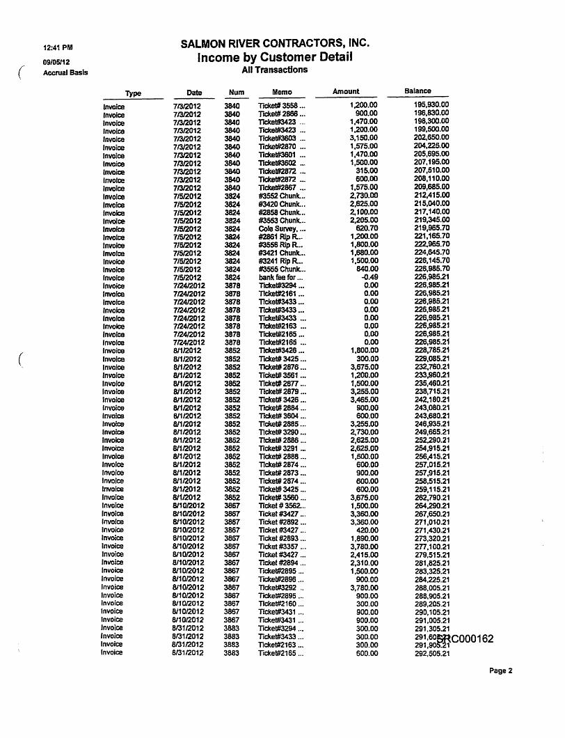
12:41 PM SALMON RIVER CONTRACTORS, INC.
09/05112 Income by Customer Detail ( Accrual Basis All Transactions
Type Date Num Memo Amount Balance
Invoice 71312012 3840 Ticket# 3558 ... 1,200.00 195,930.00 Invoice 71312012 3840 TIcket# 2886 ... 900.00 196,830.00 Invoice 71312012 3840 TICket#3423 '" 1,470.00 198,300.00 Invoice 71312012 3840 TICkel#3423 ... 1,200.00 199,500.00 Invoice 71312012 3840 Trcket#3603 ... 3,150.00 202,650.00 Invoice 71312012 3840 TrcketR2870 ... 1.575.00 204,225.00 Invoice 71312012 3840 llcket#3601 ... 1,470.00 205,695.00 Invoice 71312012 3840 Tfcket#3602 ... 1,SOO.OO 207,195.00 Invoice 71312012 3840 Ticket#2872 .•. 315.00 207,510.00 InvoIce 71312012 3840 TJCkettI2872 ... 600.00 208,110.00 Inwia! 71312012 3840 Ticlcet#2867 ... 1.575.00 209,685.00 InvoIce 7/512012 3824 #3552 Chunk. .. 2,730.00 212,415.00 Invoice 71512012 3824 #3420 Chunk ... 2,625.00 215,040.00 Invoice 7/512012 3824 #2858 Chunk. •• 2.100.00 217.140.00 InvoIce 7/512012 3824 #3553 Chunk. .. 2.205.00 219,345.00 Invoice 7/512012 3824 Cole Survey •.•• 620.70 219,985.70 Invoice 71512012 3824 ~1 RfpR. •. 1.200.00 221,165.70 Invoice 7/512012 3824 #3556 Rip R.oo 1,800.00 222.965.70 InvoIce 7/512012 3824 #3421 Chunk. •• 1,680.00 224,645.70 Invoice 7/512012 3824 #3241 Rip Roo 1.500.00 226,145.70 Invoice 7/512012 3824 #3555 Chunk. .. 840.00 226,985.70 Invoice 7/512012 3824 bank fee for ." ~.49 226.985.21 Invoice 712412012 3878 Ticket#3294 .•. 0.00 226,985.21 Invoice 712412012 3878 Ticket#2161 ... 0.00 226,98521 Invoice 712412012 3878 Ticket#3433 ". 0.00 226.985.21 Invoice 712412012 3878 TIckel#3433 ... 0.00 226,985.21 Invoice 712412012 3878 Tickel#3433 ... 0.00 226,985.21 Invoice 712412012 3878 Ticket#2163 ... 0.00 226,985.21 Invoice 712412012 3878 Tickef#2165 ... 0.00 226,985.21 lnvorce 712412012 3878 Tlcket#2165 ... 0.00 226,985.21
( Invoice 81112012 3852 Ticket#3426 ... 1,800.00 228,785.21 Invoice 811/2012 3852 Tccket# 3425 .•. 300.00 229,085.21 Invoice 81112012 3852 11cket# 2876 ... 3,675.00 232,760.21 Invoice 811/2012 3852 Tickel# 3561 .•. 1,200.00 233,960.21 Invoice 81112012 3852 Ticket# 28n ... 1,500.00 235,460.21 Invoice 81112012 3852 Ticket# 2879 ... 3,255.00 238.715.21 Invoice 81112012 3852 Ticket# 3426 ... 3,465.00 242.'80.21 Invoice 81112012 3852 TIcket# 2884 ... SOO.OO 243,080.21 Invoice 81112012 3852 Ticket# 3604 ... 600.00 243,680.21 Invoice 81112012 3852 Ticket# 2885 ... 3.255.00 246,935.21 Invoice 81112012 3852 TIcket# 3290 .•• 2,730.00 249,665.21 Invoice 81112012 3852 Tickel# 2886 _. 2,625.00 252.290.21 Invoice 81112012 3852 Tlcket# 3291 ... 2,625.00 254,915.21 Invoice 81112012 3852 TIckel# 2888 ... 1,500.00 256,415.21 Invoice 81112012 3852 Ticket#2874 ... 600.00 257,015.21 Invoice 81112012 3852 TIcket# 2873 .•• 900.00 257,915.21 Invoice 81112012 3852 Ticketi# 2874 ... SOO.OO 258,515.21 Invoice 81112012 3852 TlCket# 3425 ... 600.00 259,115.21 Invoice 81112012 3852 Ticket# 3560 ... 3,675.00 262,790.21 Invoice 811012012 3867 Ticket 1# 3562. .. 1,500.00 264,290.21 Invoice 811012012 3867 Ticket #3427 ... 3,360.00 267,650.21 Invoice 811012012 3867 Ticket #2892 ... 3,360.00 271,010.21 Invoice 811012012 3867 Ticket #3427 ... 420.00 271,430.21 Invoice 8/1012012 3867 Ticket #2893 ... 1,890.00 273,320.21 Invoice 811012012 3867 Ticket #3357 ... 3,780.00 2n,100.21 Invoice 811012012 3867 TiCket #3427 ... 2,415.00 279.515.21 Invoice 811012012 3867 Ticket #2894 ... 2,310.00 281,825.21 Invoice 811012012 3867 Ticket#2895 ... 1,500.00 283,325.21 Invoice 811012012 3867 TlCketl2898 ." 900.00 284.225.21 Invoice 811012012 3867 Tlckel:#3292 " 3,780.00 288,005.21 Invoice 811012012 3867 TlCket#2895 ... 900.00 288.905.21 Invoice 811012012 3867 Tlcket#2160 ... 300.00 289,205.21 Invoice 811012012 3867 Tfcket#3431 '" 900.00 290,105.21 Invoice 811012012 3867 Tickett#3431 ... 900.00 291,005.21 Invoice 813112012 3883 ncket#3294 ... 300.00 291.30521 Invoice 813112012 3883 Ticket#3433 ... 300.00 291,60mCOOO162 Invoice 813112012 3883 Ticket#2163 .,. 300.00 291,90 • 1 Invoice 8/3112012 3883 Ticket#2165 ... 600.00 292,505.21
Page 2
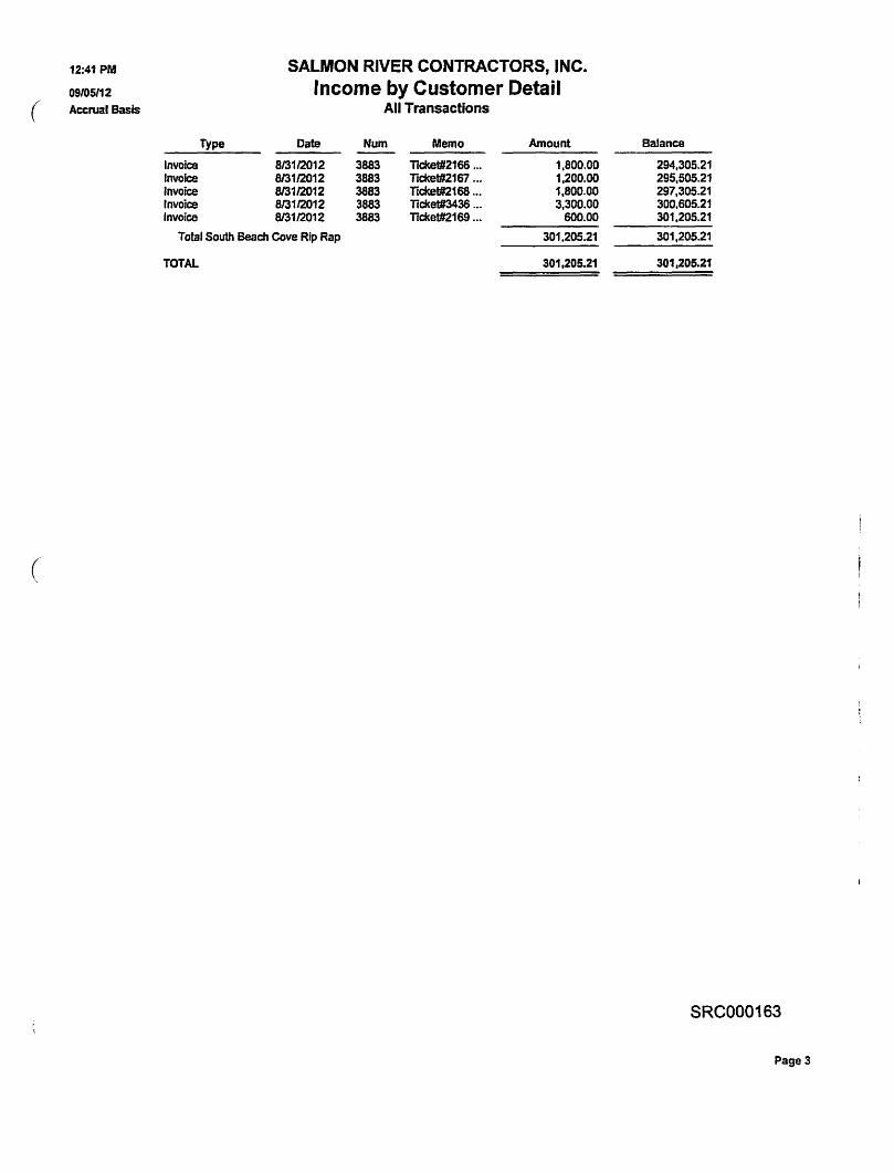
(
(
12:41 PM
09105112 Accrual Basis
Invoice Invoice Invoice Invoice Invoice
Type
SALMON RIVER CONTRACTORS, INC. Income by Customer Detail
All Transactions
Date Num Memo Amount
813112012 3883 Ticket#2166 ... 1,800.00 813112012 3883 Ticket#2167 ... 1,200.00 813112012 3883 TIcket#2168 .•. 1,800.00 813112012 3883 TIcket#3436 ... 3,300.00 813112012 3883 Tickel#2169 ... 600.00
Total South Beach Cove Rip Rap 301.205.21
TOTAL 301,205.21
Balance
294,305.21 295,505.21 297,305.21 300.605.21 301,205.21
301,205.21
301,205.21
SRC000163
Page 3
SUPPLEMENTAL INFORMATION IN SUPPORT OF OCEAN SHORE PERMIT APPLICATION SUBMITTED BY KEN AND JUDY GRAHAM
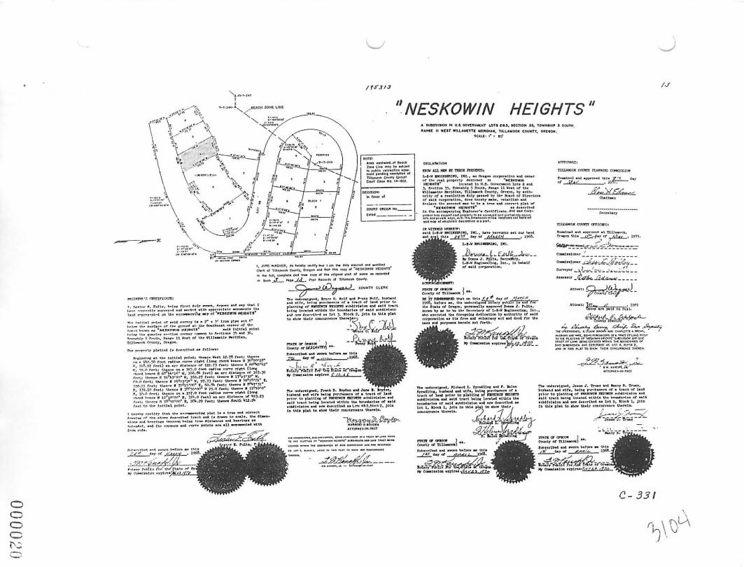
Ken Graham and Judy Graham as trustees of their respective trusts own property located at 50040 S. Beach Road in Neskowin, Oregon. Originally, the property consisted of Lot 4, Block 2, Neskowin Heights, in Tillamook County. The lot was created in 1971. A copy of the plat of Neskowin Heights is enclosed. The Grahams constructed a house on the property in 2006.
In January of 2012, there was a massive and sudden landslide on the property west of the Grahams house that came onto the Graham's propelty. The Grahams, along with others, applied for and received an emergency permit on January 30, 2012 (Permit #BA-677-12). Pursuant to the approval received by the State of Oregon, the Grahams and others spent substantial sums of money to place riprap at the toe of the slope and to place armor rock up the slope. The work was done in 2012.
A geotechnical report was prepared by Douglas Gless of Schlicker and Associates dated October 5, 2012. A copy of that report is included with this submittal.
In October of 2012, there was a failure of part of the armor rock that was placed on the slope. Since that time more rock has slid, however the riprap has remained fmnly in place and is protecting the toe of the slope. Pursuant to a requirement of Oregon State Parks, the Grahams hired Dan Kauffman to remove the armor rock that had fallen from the slope. The work has been completed and the Grahams have received a letter from State Parks stating that State Parks is satisfied with the work.
The Grahams recently requested a reinspection of the site by Mr. Gless. Mr. Gless visited the site and issued a supplement to his report dated April 22, 2016. A copy of his supplemental report is included.
To further assure safety in the area and to mitigate any additional rockfall. The April 22 supplemental report provided various alternatives. Of the options, the Grahams intend to pursue Alternative 2 which provides as follows:
2. Drape double twist rockfall mesh netting on the slope from the top on the rock fill to the top of the riprap revetment. Existing vegetation would need to be cut to ground level prior to placing netting. Re-seed, re-plant and fertilize after placement, as necessary, to promote vigorous growth. This rockfall mesh netting can be anchored into the rock fill with closely spaced anchors which are tensioned to greatly increase performance and help stabilize the slope, but this also substantially increases the costs.
One of the reasons it has taken so long to bring this permit to a conclusion is because narrow piece of property lying between Graham's property and the ocean was owned by Gary and Mary Hargis. Much of the property that slid \vas the Hargis property. The Hargis' and
Page 1· SUPPLEMENTAL INFORMATION IN SUPPORT OF OCEAN SHORE PERMIT APPLICATION SUBMITTED BY KEN AND JUDY GRAHAM
Grahams canle to an agreement for Hargis to convey to Grahams an area of the Hargis property, that property being essentially the property that slid and the property on which the work had to be done. The Hargises had a mortgage on their property with Chase Bank and in order to be able to convey good title to the property, the Hargises had to obtain the consent of Chase. This process took an incredible length of time. Additionally, the Hargises and the Grahams also had to accomplish a property line adjustment through Tillamook County. This also took a long time. However, the property line adjustment has been accomplished and the Hargises have deeded property to the Grahams to accomplish the property line adjustment. A copy of the deed and survey are submitted with this application.
The Tillamook County Planning and Community Development Department has determined that the project of shoreline stabilization is consistent with the local comprehensive plan and zoning ordinance. The County found that the property was developed prior to January 1, 1977. A copy of the approval from. Tillamook County is included. The County's verification was dated January 24, 2012.
It is significant to note that the Graham property is located at the south end of Neskowin Beach where the beach turns into a sea cliff. Allor virtually all of Neskowin has been riprapped previously. The area in front of the Graham property is the only - or one of very few -properties that was not riprapped. The adjoining property to the north and south of the Graham property is a sea cliff. This can be seen on the photos that are submitted.
The undermining of the toe of the slope and the landslide was through no fault of Grahams. While it is true the Grahams had an interest in protecting their house, the riprap has also protected the beach and the public's use of the beach. If the Grahams had done nothing after the slide, the hillside, a very steep bluff, which is about 160 feet high, would continue to slide and deposit slide material onto the beach which would probably cover the beach and begin to erode the property to the north and constitute an ongoing safety hazard. Although rock placed on the slope by the contractor in large part failed, that rock has been picked up and hauled away at Graham's expense and the riprap has held the toe of the slope in place. It appears that the slope behind the riprap generally speaking has reached its angle of repose. As part of this permit, the Grahams are seeking approval to install alternative 2 in the Gless letter of April 22, 2016 to further stabilize the slope and to primarily provide for public safety. The failure to maintain the riprap and return the land to its natural condition would cause further slope failure and create safety concerns.
The work that has been done and that will be done under alternative 2 will also protect property owned by Taufik Ma which is immediately north of the Graham property and the property of the Henningsens whose property adjoins the Graham property to the south.
Page 2- SUPPLEMENTAL INFORMATION IN SUPPORT OF OCEAN SHORE PERMIT APPLICATION SUBMJTTED BY KEN AND JUDY GRAHAM
Project #Y123547
Engine,erfug Geologic Investigation, Recommendations for Oceanfront Protection
and Application f~r ShorellD.e Protection . Fo.r.';I'ax Lot '1300, Map SS-11-35PA
NeskoWin; Tillamook Co~~ty, 9regon'
---P.repart:d for: l\fr. Ken Gr,aham
P.O. Box 924 NeskOlvin, Oregon 9.7149
October 5,2012
. * H.G. ~chlicker & Assodotes, "'<
H.G. Schlicker & Associates, 607 Main Street, Suite 200 . Oregon City, Oregon 97045
(503) 655-8113 • FAX (503) 655-8173
Project #Y123547
To:
Subject:
MF. Ken Graham P.O. Box 924 NesItowin, Oregon 97149
EngineeJ;ing Geologic Investigation, Recomniendations for Oceanfront Protection and Application for Shoreline Protection For Tax Lot 1300, Map SS ... II-35DA Neskowin, Tillamook County, Oregon
De~r Mr. Graham;
Inc.
October 5, 201 ~
The accompanying report presents the results of our engineering geologic investigation of the aboye subject site, and provides riprap revetment recommendations and permit application
. fonns for shoreline protection.
Ailer you have reviewed bur report, we w~uld be pleased to discuss the report and to answer any questions you might have.
This opportunity to be of service is sincerely.appreciated. Ifwe can be of any further assistance, please contac
J. D glas Gless, MSc, RG, CEO, LHG esidentlPrincipal Engineering geologist.
JDG:cjh
GEOLOGISTS • ENGINEERS • ENVIRONMENTAL SCIENTISTS
Project #Y123547 October 5, 2012
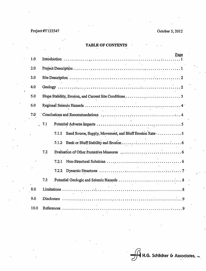
TABLE OF CONTENTS
Page 1.0 futroduction ............ 0 ..... 0 ••••• 0 0 • 0 ••••• 0 ••• 0 0 0 ••• 0 • 0 0 • : 0.0 : , , 0 0 , • , • , 1
20 P ·· D 0 of '1 o roJect escnpti.on 0 0 ••• 0 •••• 0 0 • 0 •• , •• 0.' 0 • 0 0 •• 0 ••••• 0 •••• ~ •• 0 • 0 0 0 ••• 0 0 0 •• 0 •
3 0 S't D 0 ti" . 2' ole escnp on 0 0 •••• 0 • 0 ••• 0 0 ••••••• 0 • 0 0 •• 0 •••••• 0 ' ••• 0 •• 0 • : .', ........... 0
. . 4.0 Geology ...... 0 ~ • :. '. 0 • ' •••••• ' •••••• 0 ••••••••••••••••• ', •••••••••••••• : •••• 2
5.0 Slope Stability, Ero~ion, and Current Site Conditions ................. ~ ... 0 ••••••••• 3
6.0 R:egionai Seismic Hazards ....... 0 •• 0 ••••• 0 • 0 ••••••• 0 •••••••• 0 '0' 0 ••••• , •••• 4 .
7.0 . Conclusions and Recomiilendations ......... 0 •••••• ' ••••••••••• ~ ••••••••• ':0 •• 4 . .. ... . .
" 7 .1 Potenti~ '~dverse impacts .............. 0 •••••••••••• <I •• : ••••••••••••• 5
7.1.1 Sand. Source, Supply, Movement, and BluffErosionrRate' ........... ·.5
. . .. . 7-.1.2 Bank or Bluff Stability and Erosion ... : .. .' . : .... ' ........• ~ .. ~ ..... 0 6
7.2 Evaluation of Other ProteCti~e Measures . _ ............ '.' .... ., .. : ......... 6
7 .~.1 Non-Structural Solutions ... '.' . . . . .. . . .. . . . .. . . . . . . . . . .. .. . ..... 6
7.2.2 DytlamiC Structures ............................. 0 • o· ••• ~ •• ; ~ ••• 7 .
7.3 Potential Geologlc. and Seismiq Haz~ds .............. t ........... 0 • : 0 .. 8 .
8.0 Limitatiol1S ........ 0 ••••••• ".: •••••••••••••••••••••••••••••••••••••••••••• 8
9.0 Disclosure ......................... '.' 0 •••••• 0 •••••••••••• ' ••••••••••• ' ••• 9
10.0 Referellces ...................................................... 0 ........ 9
. * H.G. Schlicker (;, Ass.odotes, I~.
i .
I i i I , I ! I I .
.. ,
Project #Y123547
TABLE OF CONTENTS (continued)
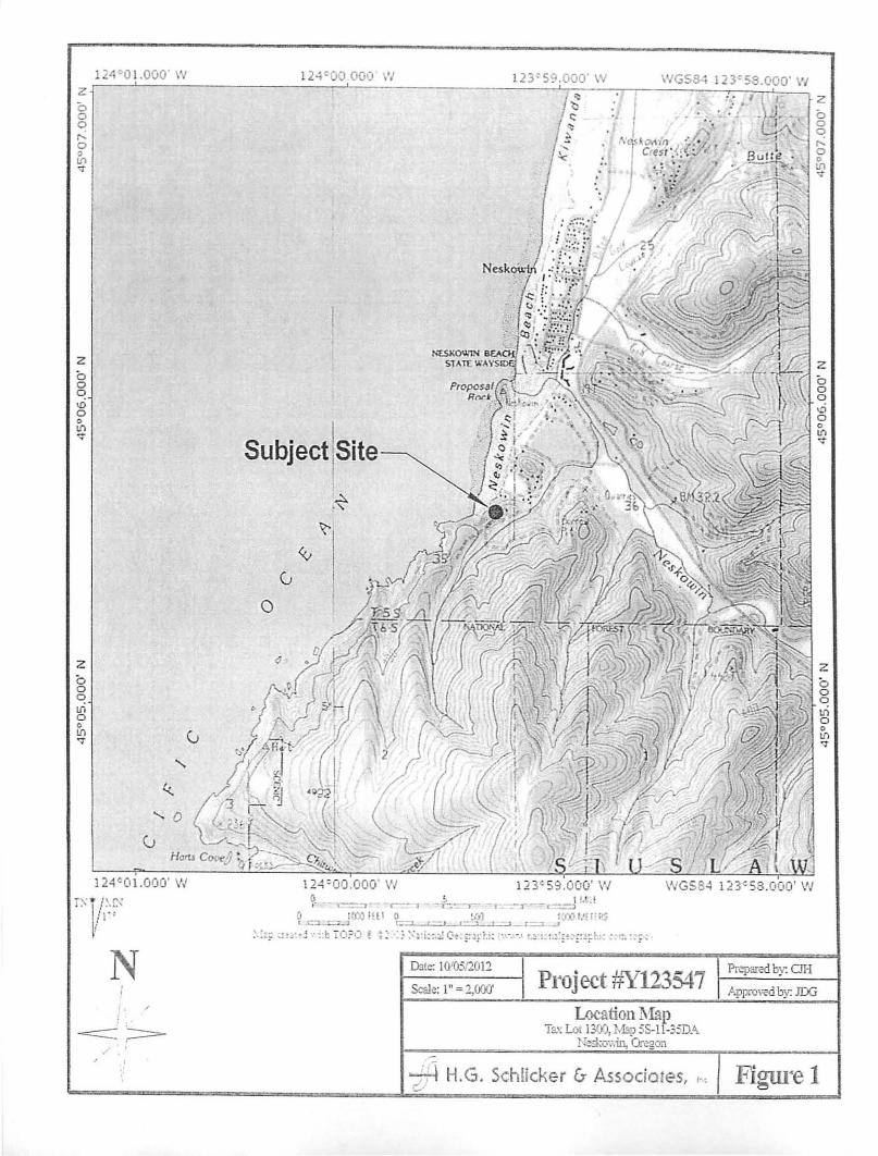
FIGURES Figure 1 - LQcati.on Map
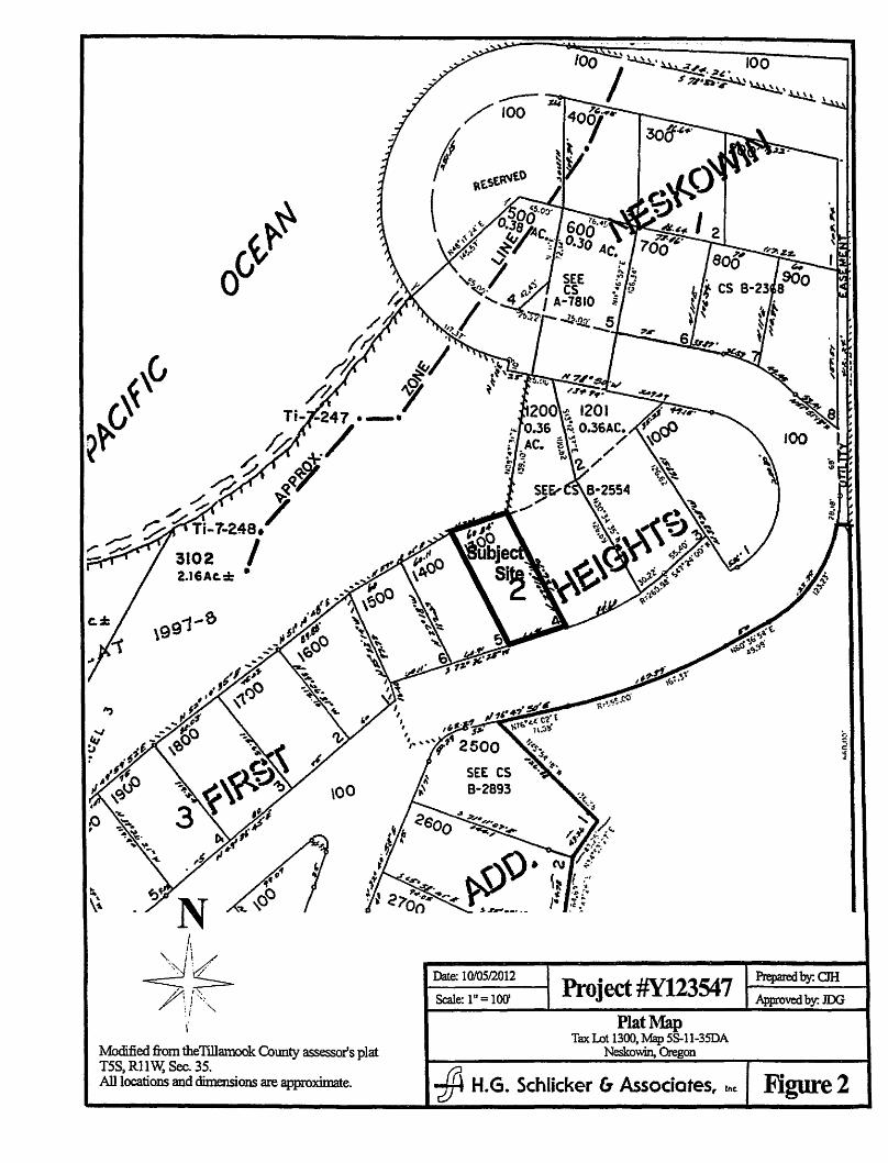
Figure 2 - PlB:t Map' Figure'3' - ~iie=M~p ,
. Figure 4 - Proposed Riprap Revetment
APPENDICES App.endix A,· Site P~()togqlpbS
Appen~.:8· - Oregon ParkS and Recreation Department, Ocean Shore Pennit Application Fonns
"
October 5, 2012
* H.G. Schlicker &- Associates, I~
H •. G. Schlicker {7 Associates, In(.
607 Main Street, Suite 200 • Oregon City, Oregon 97045 (503) 655-8113 • FAX (503) 655-8173
Project #Y123547
To:
Subject:
Mr. Ken Graham P.O. Box 924 Neskowin, Oregon 97149
Engineering Geologic Investigation, Recommendations for Oceanfront Protection and AppHcati()n for S40reline Protection For Tax Lot 1300, Map SS-11-35DA Neskowin, Tillamook County, Oregon
Dear Mr. Graham:
1.0 Introduction
October 5, 2012
At your request ana authorization.; we visited ·the subject site (Figures 1 and 2; AppenQix A) on February 9, March 13, July 2, and August 2Q, 2012 to complete an engineering.geologic investigation for the p~opos~d shoreline protection. You are C<?nstructing a new oceanfront protective structure along the shoreline and bluff stope at the site. .
This report addresses the engirieering geology at the site with respect to construction of the r~vetnient. The scope of our work cQnsisted of site visits, site observations an4 measurements, review of our previous geologic hazards reports for the site (HOSA Project #s 95211 and Y(42396), a limited reyiew of the geologic literature, interpretation of topographic maps and aeri~l photographs, preparation of this report of our findings, conclusions an~ recommendations, apd preparation pf Ocean Shore Pennit Application Forms (Appendix B).
~.O Project Descliption
The supject site is comprised of Tax Lot 1300, a residential lot with an existing hotne which is threatened by biuff recession due to erosion and mass wasting (lalldsliding) as a result of an increase in these bluff recession propesses since the time ofholne construction (FigUr~s 1, 2, and 3; Appendix A). ,A riprap revetment and roek blanket fill slope on the adjacent northwest Tax Lot 3102 is being constructed unaer an emergency pennit to protect the home on Tax Lot 1300 (Eigure 4; Appendix B - Ocean Shore Pennit Application). The revetment will abut an e~sting revetment to the north, and will abut the steep bluff slope to tlie south.
GEOLOGISTS • ENGINEERS • ENVIRONMENTAL SCIENTISTS
Project #Y123547
3.0 Site Description
'Fax Lot 1300 consists ofa 0.18 acre, generallyredangularptoperty~easuring approximately 126 feet deep, northwe,st to southeast, and 60 feet wide, nQrtheaSt to''Southwest, 10cate4 in soutpem NeSkQ~ OregGn (Figures 1 and 2~ A-ppe.ndix A). Tax Lot 1300 was platted in 1971.. The site overloo}(;s the'Pacific Ocean to its northwest, and.Iies·nea~the nortl1ea"St end o~ a ridge which tren.ds nort1reast~southwest along the northern foothills of Casca .. de·~ead 'at an approximate elevation of 150 to 195 feet MSL. The ridge on the lQt rises to apPJ;oXimately 195 feet elevation at its high~(poi.nt. The subject lot slop'es at app~oximately ·11 to 30 degrees,t~ tile northwest and southeast from th~ north~t~rly ~endirig'riage line,- and a steep. oceanfront 1;>luff slope is locateq :itnn1.~diately ,northwest of the iQt ; A riprap revetment is preseilt along ~e1ow~r blUff o~ the adjacent property north of the site; Tax Lot 500; no' ocean;tront protective strU~tures . are present nearby to the .south of the site. - .
. The existing ho~~ on T~ Lot 1300.was bui1~ ip. 2q06., ~d is i?r~ent1y located : appioxima~ely 20 feet son1:heast of the upper bluff edge,' and appto~ately 21 feet northw~t of the lot'.s southeas~er.n property boundary ·along South Beach ~oad (Figure 3). The house's westerly facing wood deck is pres.ently.located appIoxPnately·I.2 "feef ito~ tlie upper bluff ~ge
, (FigUre 3; ::Apperidix A,). The subject lot is'bound to its nort,heast by the vac~t Tax Lot ~ZOO, to its southweSt by Tax· Lo~ 1400 which has.an existing home, to its northwest by Tax 1013102 whichli~ on the steep'bluff .stope anc;l ,further west .by t1;le P~cific O~an, and to its southeast by th~ platted South Beach Road which provides driveway access. Tax Lots'1200 and 1400 were. also ~latted in 1971~ and Tax Lot 3102 w~ p~atted in 1997. Vegetat;ion at the subject lot cOnsists. of shore pine tre~s; grasses, sala!, fem, and other brqsh; the bluff slope is Ul'lvegetate4 whei~ i~ has failed. '. . .
4.0 ~eology . . .
The site lies in ali area which has be.eil mapped ~ undifferentiated Eocene volcanic roc1;cs (Syhlicker et ~., lQ72). These volcanics generally consist of -up to several thousand fee~ of chloritiied basalt flows -and basalt breccias, and are characterized by wide variabilitY in type and s!l°ength. Snavely and others· (1996) 'mapped these material·s as Basalt ef Cascade Head. In the Cascade Head are'a these rocks display widespread r.ed baked zones and scoriaceouS upper flow surfaces ~at are indicative of a subaerial origin (S~lilicker et at, 1972). .
We observed severalqptcrops to 'detennine the site .soils and verify bedrock typeso A cut' in the main road just south of the site exposed up to 10 vertical fee~ of variable volcanic deposits consistU:tg of highly fractured basal~ wit~ zones of sev~re 'weathering and brecciation. These weathered zones varied from thin planar beds to large, irregularly shaped areas .. Although jointirig and fracturing was typically random, a dominant near vertically dipping Joint s~t with a strike ofN85° to N65° west was evidellt in approxilnately half of the road outcrop. Overlying the volcanic deposits in the outcrop 'was -approximately 10 feet of colluvium: with an organic-rich zone in contact with the volcanics: We interpret this soil sequence to be due to past construction
* H.G. Schlicker & Associates. I~
Project #Y123547 Page 3
of a gravei road between the main road and the ·site, and no~ indicative of native soil.types at the site. Exposed soi)s obsel:Ved along the gravel road south and east of the site consisted of low p1asticio/ organic silts and' clays approxiin~ly.l to ~ f~t thick. Soi~ 'units near the northw~t edge of the lot consisted of organic clays and silts similar to, ,but thicker than" soils on the tidge. Along the subject lot's so\tth~ property line a graded cut exposed fftlldoInly fractur¢ to. brecciated bas~fprior to construction of the exi.sting wall. F~achl:r~ spacing was general~y less th~ 12 inches, with sha11Qw exposed rock less than 3 feet below the ground surface which was pnmarily slightly to. ~6de~atelY weaiher~.· _'. . .. , o.
Northwest qfthe subject lot, the o~anfrol\t bluffhitd two. do111i:nailt rock types with a lari.dslide sca,tp occurring at their contact. The Inore riorthern part of the slide's<?8rP and the pluff to the east were compose~ of a thick deposit of angwat rock fraitnents·in a cl~y/silt".t!latrix, which we interpret to be ancient eoJ)uvial deposits possibly ofl~dslide·ori~. The~e colluvial deposits 40 ~6t 'appear to underli.e the subje.~t lot. The southerlypart of the scarp tm-d the western bluff contained hi~y variable and fractt;rred volcanic rocks, similar to tho~e in t4e ~utcrops nQted at ~e sit~ (brecoias, agglomerateS and alter¢ rock). At sea lev¢l, areas immeOiately',north and°n.orthwest ofth~ sit~ ge~erallyhave a sandybeach-whil~ ar~as attheb~e. of the bluff. and contin~g several hundred, feet to .the soutbwO~t of the sit~ have I9ck exposed afthe level oft!te b~uff toe wi~ cliff~lik.e conditions (Appe:ndix A). :'
Structures . ,
. Strtl9~ defonnatio~. and fault41i along the Or,egon. Coast i~ dom.ii)~ted by the Cascadia Subdti~on zone (C~Z) which is a convergent plate'bound~ extending for appfo~im~tely 689
- miles from northern Vancouver Island to. 'noftbem California. This Convel:"gelit plate boundary is defined by the BlibductionoftheJuan de FUGa plate boerleath the North America Plate, and forms an· offshore north-south' trench appreximately 60 rnile~'weSt..ofthe Oregon coast sbor~lin.~. A . resulting def~ima~~n front consistipg of north-south orient~ r,ev:ers~ faults i~ present along .~e we~tem edge of'~ aCcretionary wedge east of the trench, and a z6ne.o~~argb;i-ob1ique folQfug and 'faulting extends from. the treQ.cb to the OregQn .Coast (Geomatrix, 1995). .
An east-,vest tren~irig nonnal fault has been m~pped within, a few lil.l11dr~d feet north of the site (Snavelyet aI., 1996). This fau1t cuts Terti811' rock units with no indications of recent movement ..
5.0 Slope Stability, Erosion, and Current Site Conditions
The 38 to 45 degrees sloping bluffilorthwest of~e subject lot fonned as the result of erosion and landsliding caused bY,continuous wind, rain and ocean wave activity. This erosion and landsliding has had a su1;>stantial rate increase in the last couple of yeats. We obse~ved indicati~ns ofr<?cent rock fall, sloughing and shallow landsliding along tQe 1'1uff (Appendix A). These f~lures appeared to have failed back 1 to 7 feet at a time, and have also gradually increased the overall width of t~le bluff landslide area at the site. Cont~ued recession of the bluff
-ffi H.G. Schlick~r & Associates, I~
. i
Proj~t #Y123547 Page 4
is &nticipated, and this recession Wili eventually imp,act,the deck on Tax lot 1300 unless it is protec~ed. ' Future landslid~ that fail back up .to i 0 feet can occur alQng the bluff. Large . andslides can a1~o occut, pamcularly along weak bedding planes or fr~cture zones iliat may be present within the rock units. Predicting the siz~ of future failures along the bluff is diffi.cult, and cannot be fully quantified even with 'extenSive subsurface ,exp~oration, testing and modeling.
The lower part o:(the bluff ~xperience~ c9ntinuous wave erosion. The eoastlihe geometry· and prevailing direction of stonns in the area of t4e site impact" the lower bluff from the westsouthwest, 'w~ch causes relatively greater rem,oval of softer Colluvial bluff materials at the ' northern ~nd of the ~1ide. Volcanic bedroc~ is exposoo,at the base of the bluff for nearly the entire north to south expanse of the site beachfrollt, except for the area to .the north which is protected by ri1?rap (Appendix A); .
6~O Regional Seismic Hazards " .
. "
, Abundant ~vidence indicates that a $eries of geologically recent large earthquakes related to the CasGadia Subducti~n Z6Jie have occurred along the co'aStllne of the Pacific No{thwest -EVio:enee sUggests tha~ l!'t least ~een major earthquak~s have occurred in about the last 7,700 years (P.xiest e~ al., 1997). TheSe -earthquakeS WeFe accompanied by widespread su"bsiden~e of ':\ few inches to a few feet~ Tsunamis (s~ismic induced oeean waves) appear to have been assoCiated with 1l;lany of these earthqualces. In addition, -settleJ;11ent, ~qQefacl:ion and Hmdslic1ing of some eaitli mat~alS is believed to have peen cpmmonly a&sociated with these Sejsmic events~
Th~se earthquaJees were likely of magnitude 8.0 to 9.0, and ~e believed to have had a me~Iecl;lrien~ il:J.teryal of500 to-600 years, however some ofth~ past eart:l1;q~es llavy had intervals ~ess ~an. 390. years (Clague et ~., 2000). Eviaenc~"~s~ggests the'last major earthquake' occurred in . ~ 700 and may have been of ~~gmtude 9.0 (Chi.gue et aI., 2000), Ris~ associated. with these major-earthquakes should be considered hi ligllt of the low probability of one
. o~currip.g in any given year and the high consequences resUlting from such an occurrence. :
Other' earthquakes relatea. to shallow ~nista1 movements or ~quakes related to ~e Juan de Fuca p'Iate "have the pot~ntiai to gel1erate magnitude 6.0 to 7.5 earthq~es. The recurt~nce 'interv~ for th~e types o.f ~quakes is di:ffi~ult !o detennine from p'res~nt data, but estimates of 100 to 200 years have beell given in the literature (Rpgers et aI., 1996).
7.0 Conciusions and'Recommendations
Th~ bluff slope at the site has recently b~ell rapidly receding as a result of"eiosion and landsliding due to continuous wind, rain and oce~ wave impacts. this recession is encroaching toward and endangeling the existing home on Tax LOt 1300, and will also impact Tax Lots'liOO and 1400 in the near fufure if not mitigated for. Constructioll of tIle revetment on Tax Lot 3102 (post-January 1, 1977 development) is necessarY to protect the home on Tax Lot 1300 (pre~ January 1, 1977 develop!11ent).
~ H.G. Schlicker & Associates, In<.
. .
i 1 I I
Project #Y123547 Page.S
To mitigate for future ocean wave erosion and,sliding along the bluff under static conditi,ons at the site, a rlpr~ revetment is proposed to ~e copstructed (cOnstnIction i~ currently , proceeding under .at). emerg~ncy pennit) as s~own o,n Figures 3 ~d 4. The rip~ap revetm~t is propos~ ~o o~ located on the lower part of the' bluff, and a free dtai11ing rock fill bl~et wiU extend up the slope. The revetment and rock blanket ~e prirriarily located on Tax LOt 3 t02; how~ver, it is our understanding that this p~)1tion QfTai Lot 3102 may undergo a lot line . adjustment' .'
We have recommended that the revetnient be ,embedded a mininium of 2 feet into hard na~ve rock;, aJ;ld the rlprap should Consi~t o{hard, durable, anguI~ basal~c rock, ~ppr{)xima~ely 3 to 7 feef diameter, place4 in an interlocking state (Figur~, 4). Filter tock (quarrY run 'bedding) should ~~ placed betWeen the riprap armor·and the ~ative ro~k s~ope as sho:wp. en the ' accompanyjng figures. The ripr~p on the lower part pfthe bluff should not sio.p~ steeper'than 1.75 horizQntai to i vertical (1.15H:IV). A 1 horizontal to 1 vertical (1~:1V) maXimum slope is proposed fo~ rQck fi11,~n the miqdle alld upp'et, parts of the bll;l~ aboye the riprap rev~tment (Figures 3 aad 4).' We have recommended tIlat tock fill consist of clean (no fines) pit nu.1 " material o:FpredOm.4tantly 2U to',8~' diameter. We alSo recomme~d that a 1 foot thick: ho~ontaJ.
. dr~age l~yer. of approxi1l}ately III to 6ti ' select. angular ,cl1lshe4 rock b~ placed every five v~rtlcal . feef to' aSsure ~age of the rock fill. The face of the rpeK fill is to Consist of ~ armoring lay'er of 8" tQ 24" diameter'stOne approXimately 2Y2 fee~ thick to pr~vent erosion. . The ~evetn1ent Will need to.oe mamtained and rep~ed, as necessary. Wer~commend that a s'afety fence be' ' . constructed ,at the top .of the slope. Wh~n cbnstrQcied as reComlnended, t1\e rock fill glope will have a rela~vely lqw fa~for of safety du~ tQ its steep slope. ,Plattemng Q:fthe ,slope to ichieve a h:igher facto~ of safety w~uld require ,Substantial encroachment o~to the be~h and into the ocean.
7 .1. ~~tentia~ Adverse Inlpacts ,
The following. discusses the potential ad~erse nnpacts as the result: of the prop~sed riprap revetment '
, 7.1.1 Sand Source, Supply, Movement. and Bluff Erosioil Rate'
. Sand supplies along the Oregon coast' ar~ derived primarily from ~o
~ources" (1) from erosion of bluffs, headlands and dun.es, and to a less~r ,extent (2) from sediments carned·by stream,s and rivers that disc.hargeto coastal areas. We believe that the loss of sand: to the beach in this littoral cell due tq this protective structure will be mj.nimal during the life of the structure because the weathered volcanic roqks that are being protected ~orp eroslon have a low sand content, . approximately 8%. Erosion here is episodic and primarily due to mass wastmg of the bluff slope. Estimating recession of the bluff in this area is .difficult because the area of the bluff is often in shadow on historical aerial photographs. Although recent bluff recession has been drmnatic, we have estitnated a long te1m recession rate of 0.25 feetlyea.r:. Assuming an average annual ~rosion rate of 0.25 feet per
~ H.G. Schlicker & Associates, '"

Project #Y123541 ~age6
year, and an anticipated life af the reyetment of 60 yeaTs, we estimate that the maxunum totailoss of sand s.uppiy to the beacl~ as a r~sult of the reyehllent will b'~ approximately 199 cubic yards in 60 years or an annuaT,average ~oss of3.3 '
. cubic yar9s ,of sang. This estimated loss of sand was calculated'by multiplying the 'average annual ero~ion rate (,0.25 f~tper year) by 69 years, multiplied by the ' heighi.(28 feet) and length (160 feet) of the effected bluff segment, and using 8% of this 'to account for the sand content of the rock. ' . . .:.
'the rev~tment has heen d~igned to miniini46 Qbstructl.op.$ to san4 movement .along the 'beach, by following the geneml trend of·the bluff and ConPe<?ting "into, the e?,isting a~jac~nt reyetmen~ at the n~rth ~d. The revetri;lent essentially fills in a small 'CO¥~" in the bluff, straighten'ing the shoreline for a short distance. We do net ~ticipate that sand movement along the $hore will be a4ver~ely impa9teq. by the riptap revep.nent as its westward exte11:f is ininimal, and the wa~er deep'~ns qUic14yat and to the south of the :fev~tment. ~ere are no nearby existing revetnien~ off 'Of the subject propet}y south of the sit~. The n.ew 'revetinent protects 'a sectlon of the shoreline whibh was previously unprotected.
, ,
7-.1.2 Bank or. Bluff Stability and Erosion ,
t. ~,:the nprap,reyetniel?-t and rQclf filll?lanket will increase the stability of the . ,bluff slop~, and Will. help protect the bluff fr-om continUed ocean wave erosion and
the erosive effects ofwind.:driven rain. :rJie riprap structure will abut an existing rfprap', revetment to the north and the rocky bluff to the south, therefore end-effects will be miriimlZed. '
7.2 Evaluation of Other' P-l·ote~tive Measures
The following discUsses other ifrltigation'measures that were evaluated but hQt implemented. ' ,
7.2.1 Non-Structural Solutions
Non-stnictural solutions were not attempted for tins site, however four poten~a1 nOJi-,structural solutions were consid~red as pot~tia1 alternatives, arid iticlude (i) relocation of the home; (2) improving s10m water control, (3) vegetation stabilization, and (4) beach filling or nourishment.
(1) Relocation of the Hotne -'t~e limited dimensions of the subject lot and its proximity to SOUtIl Beach Road do not provide room to' relocate the h<;>me
, eastward and ~way from the upper'bluff e9ge. .
-# H.G. Schlicker (; Assodotes, I~
Project#Y123547 Page 7
(2) Improving Stonn Water Control- Er9sion along the bll;lff i~ primarily the result of oc~an wav~ utldercu~g, with.wind and rajn. activitY. :being a . relatively lesser concern. We observed· 110 iri9jcations that stonn water J.1.lnofffrom the subject-site ha4 caused signific~t erosion alongtbe slope. Therefor~, ~e believe t4at improvement qf stomi ~ater· control systeins at the site WOilld not· sigilificantly i.rilprove bluff stability.
• -I ••• ,
. .
(3) Vegetation Stabilization - Due to the high energy'enviro~ent along this section of the coastlip.e, the.steepluilv~getat~ slop~, and wind-driven rain· impacts we ~o not ~elieve that veg~tatio~ ~abi1ization of the bluff co~d be successfully iniple1l1:ented nor would it be adequate to p~ot~t the site from· future o~ean wave e~osion._ ...
(4) Beach filling or nourishment - Beach noUrishment, by placing san~ ~ong . the bacKb~ch envitOnnient,· 'can teinporaruy protecf exposed bluffs. ttoni Continued oCean wave attack. But added saild in front of the bluff·is also likely to be eroded ~apidiyo because the ad'qed .sand is .not in :a stat~ of equilibriUm with the beach. system. Therefore, beach noiuishinent may.
. need to be repeated ~~ery year, .or even after a single l¥ge ston:n ~veD.t.·
'I'ypi~y, beach nourbhinent is n.ot effective for any ~bs~tiall~ngth ol . time· when used for· a smati., discrete. sectiO:rl of a beach,· particularly one . wi~ 1?gb. eiJ.ergy waves ~ ocetir at tins site. A1t~g th~ bea~h pr~fi1e by placing or inQving sand can alter wave patterns along the beach which can impact adjace~t properties. Because a natural beach prottle is near the . . state of dyn~c· eqU$bri\Ul'i with waves, currents, 'and winds t1?-at ~ove sediments along the beach, altering the beach profile along ·cine section of sqorei.ine by adding 6r moving ·sand can c~-qse increased 10~liz{d erosion· c:>r deposition in o~er areas of the beach.
7.2.2 Dynamic Structures.
Dynamic revetments are structures in. which the movement of construction materials is a fundam~ntal design concept ~rang, 1994). Unlike riprap . l"evetments wliiG~ ~ie desi.gned to be static, 4ynamic structures consist of~and, sand bags, gravel mounds, logs or composite materials which are. designed to mimic the na~ dyn~c beach envir~:)lnnent.
There are few examples of dynarilic revetments worldwide, at}d few . studies of their l~ng term effectiveness (Allan et aI., 2005}. Several dyn~c
revetnlent design configurations have been ~tudied in Oregon, and preliminary findhigs have suggested-that these types of structures maybe a: viable alternative to hardened riprap revetments. There remain a number of uncertaintieS
. * H.G. Schlicker 6 Associates, ,~

Project #Y123547 Page·g
~onceming the physic3I design of dynamic revetments, especially on high-energy beaches such as that obseryed at the subject site (All~ et .a1., 2005). It is also . unclear if dYnamic revetments can be effective in a limited shoreliDe zone, such as . a shoreline zorie confined within the area of a few lots~
, To evaluate the potential of dynamic structures at the site, we utilized tlie "decisio~ ma~" qie~odo19gy suggested by ~r~g (1994). In. this methodology, a sQOre is. detenniiled by comparing possible erosion sCenarios ~~ the freqUency of the erosion eventS. The. unprotected bluff's~gment a~ the site lies in an area that e~periences frequent wave attack. Based on the s~re obtained using thiS . met~odology,a substantial stm9ture is warrarited for the site to m:iti~a~e for erosion, which includes the use of static· stnictures' such as a'boulder revetment (i.e. riprap revetment). .
7.3 Pot~ntial Geologic and Seisn~c Hazards
. p~ Wave actiy~ty on the base o~the.blu~will eventD:a;11y d~~~ any riprap struqtures piace4 along the bluff. Therefore, th~ riprap :t;evetment should be maintaP1ed and repaired .. a~ neooed~ The rockiill sJope can. h.e damaged by storms and earthquakeS an~ may require occilsio~al repair. ' .
. ' The lower bluff lies in an area that is subject to possible tSunami hazards. In the . event -of a ~ami ,the riprap revetment .may b~ d~aged. This would requiie .that die revetmen(be repaired following the tsunami event The pres~nce ofth~ riprap revetment, along the bl}lff during a tsunami event would lessen any erosive damage to the bluff s~ope resulting from the tsunami. '
The site h~s experienced landsliaing in the past and can be affected by landsliding . in the future. .
8.0:~irnitatiol1s
The Oregon Coast is a dynamic environment with inherent unavoidab1e risks to deve~opment" Landsliding, ~rosibn, tsun~s, storms, earthq,uakes .arid other natural eyents can cause severe impac~s to structures built within tlns environment and can detrimentally impact the h~lth arid welfare of-those who'-choose to place themselves within this envrromnent. The client is warned that, ~though this report is intended to identify t4e geol!lgic hazards causing tbese risks, the scientifi~ and engineer4.lg commUnities lrnowledge an4 und~rstandlng of geologic hazard processe~ is not .complete. This report pertains to the subject ~ite only, and is not
. applicable to adjacent sites nor is it vaiid for types of development othel: than that to 'Yhieh it refers. Geologic conditions including matelials, proc~ses and rate$ can change with time .and therefore a review of the site andl.or this report may be necessary as time passes to assure its aCCijracy and adequacy.
* H.G. Schlicker (,. Associates, I~
Project #Y123547 . Page9
, Our investigation w~~. based ,on engineering geological r~nnaissance and a limited ~eview of published information. Th~ data presented in t¥s report are be~ey.ed to be represeritative:ofthe site. The conclusions.herein are professional opinions ~erived in ac~rdance With current staridar~ of professional practice and no warranty is e.xpressoo or implied., The performance ·ofihis site dtuing a seismic event has ilot been evaluated. If you wo~d"like us to do so, please contact us. This report may"only be cOpied in its entirety.
9.0 Disclosure
. H.G. ,Sch1ic~er & As~9Ciates, Inc: and the undersigned.:Certified Engineering Geologist .have no financial interest itfth~ subject site, the proj~ct or 'the CIlent?s "Qrgarii28:tion.· "
10.0 References
Allan, J. C., Geitgey, R., and Hart, R., 2005, Dyrtamic revetmep.ts for coast~ ero~ion , . st~Uization: A feasibility analysis for application on the Oregon Coast: O~ego;n
Deparbllel)t of Geology and Mitieral Ind'l.}strfes, SpeciSl Paper SP-37~
,"
Allan, j. C., ~d Priest, Go R., 2901, Evaluation'ofC9astal erosionhaiatd zones' along d~e and " bluff"backed shoreline in the Tillamoo~ County; Oregon;' Cascade Head to Cape Falcon:
Oregon I?epartment of Geology and Minera1.:rndustries~ d.pen-rile Report 0-01-03, 126 p ..
Clague~ J. J., Atwater; B~ F., Wang, K.., Wang, Y., an~ Wong, I., 2000, Penrose Conference 2000 - Great Cascadia Earthquake Trr~ntennial, Programs ~llmmary and A'b.stracts: Oregon
.' . Deparbnent of Geology and Mineral.rndus~es, Special-Paper 33., 15~ p.
;SP 4" 19981 Climate Change and 0regQn; Envit~nme1.1t~ Protection Agency, EPA 236.;98 ... 007u, 4p..
Geom~trix Consultants, 1995, Seismic design mapping, State of Oregon, finai report: Prq1ared for the Oregon Deparflnent of Transportation, Project No. 2442. . . "
Good, J. W.; 1992, Ocean shore protection policy and practices in Oregon: An evaluation .of imp~elnentation success: Oregon State UJ?iversity;Ph.D. thesis, 276 p.
Kelsey, H. M;, Ticknor, R. L., Bockheim, J. G., and Mitchell, C. E., 199Q, Qua!emary upper plate defonnation in coastal Oregon: Geological Society of America Bulletin, v. 108, no. 7,p.843-860: '.
Lorang, M. S., 1994, Coastal erosion and shore protection~ Conceptual alternatives to cOllvent~onaI rip-rap shore protection structUres: Prepared for the Oregon Parks and Recreation Department, 19 p., appendices.
* H.G. Schlicker {7 Associates, ""-
Project #Y123547 Page 10
Madin, I. P.,.and Wang, Z., 1999, Relatiye earthquake hazard maps for selected. urban areas ill western Oregon; Orego~ Depamnel:1t of Geology and Mineral Industries, Interpretive Map Series I1MS~ 1 O. .
Priest, G. R., Myers, E., Baptista, A. M., Fleuclc, P., Wang, K.~ Kamphaus, R: A, and~eterson, ·C. D~; 1997, Cascadia Subducti9n Zon~ ~~is:' H~ard mapping at Yaquina Bay, .
. Oi"egon~. ~al tecllnical repoq to the Nation~ Earthquake Hazarp R'eductio~ Program; Oregon Department of Geology ~d Mineralliidustries; Open-File R~port6-97-34,
. -Priest, G. R:, 1995,-Tsunami hazard map of the Neskowin Quadrangle, Tillatnook and Lin90ln
Counties; Oregon: Oregon Deparbne~t of Geology and Mineral Industrles~ Open File Report 0-95-24~ map.
Rogers;A. M., Walsh, T.l, Kockelman, J.,.andPriest, G. R., 1996, E~qba:Ice'hazards in the P~cific NorthweSt .. an overview: U.S. QeOloiical SurVey, ProfessionaJ P~per 1560, p. 1-54.
Satake, ~, Shim~ald, I<",. Tsuji, Y.~.and Ueda, K.; 1996, Time 'and siz~ 'of 8: gi.ant earthquake iri. Cascadia inferred from r apanese tsunami recor~ of JanuarY 1700: Nature; v. 379, p. 246-249.
, Scblicker~ H. G., D~~on, R. J., Beaulieu;l. b.,' ~d Olcott, ct W., 1972; ~nvironmental geOlogy of the coastal region ofTillarit6qk and Clatsop CoUnties, Oregon: Oregon Department of Geology and ~eral indUstries, Bulletin 74, 16~ p.~ maps. .
Seed, 'H. B.; an.d Idris~, I. M.~ 1982, Gr-ound motlens and soil liquefaction during earthquakes: E~qUake Engineering Researci!'fustitute, 134 p. . ' . . ,
, . .
Snavely, P. D., Niein;.A.., W~g, F. L., Mac~d, N~ S:, and ca1hoUn~ T. ~., 1996,:Geoiogicmap of the Cascade Head Area, Northwest~ni Oregon Coast Range'(Neskowjn, Nestucca Bay, He1?o, and 1;)qlph: 7.5 minute Quadrangles): u.s. Geologi.ca1 Survey, Open File Report 96-0534; 1'6 p., maps.
USDA Soil Conservation Service, and Oregon Coastal Con~ervation and Development Conni1ission, 1~75, Beaches and dunes of1:h:e Oregon Coast:.161 p.
Wells, R. E., -Snavely, P. D., MacLeod, N. S., Kelly, M. M. and Parker, M. J., 1994, Geologic Map <?fthe Till~mook Hig1u~ds~ Northwest Oregon C9ast 'Range: u.s. d.~olo~cal SurVey, Open-File Report 94-21.
-fA H.G. Schlicker (7 Associates, 1=
1 .1 I
. i
Project #t12l547 Page 11
It has been our pleasure to 'serve you. If you have any questions concerning this repOlt, or the site, please eonta~t us. "
Respect::fuUy submitted,
'OCIATEs, JN~.
'EXPIRES: 10/31/2012 J., Douglas Gle$s, Mg'c; RG, CEO, LHG, Ptesid~nt/Principa1 Engineering Geol~gist
JD~:cjh ".
* H~G. SchUcker & Assodotes. I~
1 4°0 .000' W 124<00000 \./ 12 3'59.000' IV I'IGS8~ z~~~~~----------~~~~~~----------~~~~~~-.~~~~;-~~~z
, ~ b : . , o o '" o o L~ ..
z
z (:) o o 111 o o LI\ .,. v
..... 0
124'01.000' W
r.-'Y
1
t ,rs ./1 ' : ,
N
Subject i="'IT~--..
o
124 ' 00.000' VI 123' 59 .000' IV WGS84 123' oo .. c·c'u' W ~. - r--:=:..., r-'~ 1 _cl~_.~"I· . I. -r--t~j M.I
!.r l@ iHI 0 :m lp' l,' t r:t1-l..L,."":l---t:.;JJ C-, r '-'~L--' _r....:....:l...J
~ ~~; d~.·~~ .. :b TCl?O ~ ;~ :: ~;:)'i:;,:J 0t ; f: ~fl.: : -, ' , ' ,t !.~ · l:: ,:·;~ ~ ; :.!~ t.::: ': . . : :; ~
Date: 10.'0512012
Scale: 1"::::. 2,OCMT Project #Y123547 Location Map
Tax Lot 1300, lYhp 55-11-35DA Ne-ske,'win. Oregon
...iiI H.G. Schlicker & Associa tE's, ,., v
Approved by: .JDG
Figure 1
2.16Ac.:J:
Modified from theTillamook County assessor's plat T5S, Rll W, Sec. 35. All locations and dimensions are approximate.
Date: 1010512012
Scale: 111 = 100' Project #Y123547 Plat Map
Tax Lot 1300, Map 5S-11-35DA Neskowin, Oregon
Prepared by: CJH
Approved by: JDG
-ffi H.G. Schlicker & Associates, ,.. Figure 2

N {\ "
v r. ~ ~ lii,, ·.1 r. . ~ ", OJ ''' I \ 1' .... 1" ,,· l :1:-; 1l\'1"UI;~ t\ 1I 1' '''~ lh'''t ; ; H~ l lilll l(" l """Wl'; 111 0 rll'!lIl,\ ill ~HC.
I'" I . 11'\( " .=.1 .. r" '01K'$C11 rillltll' =In~ul L • 1_' A
r==-I .. Allpnnin\:lle (U-e:J. of",qlOlled 1:1 rock fiU s!llI)C
Scale: ." .. 5Il'
SUcl\tbl) Tu ltA I300. ","" S5- II·3SDA
~in.~'
.;ffi H.G. Schlicker & Assodates. ~ F if,'lIJ'e 3
TOE OF '~"".'V' \
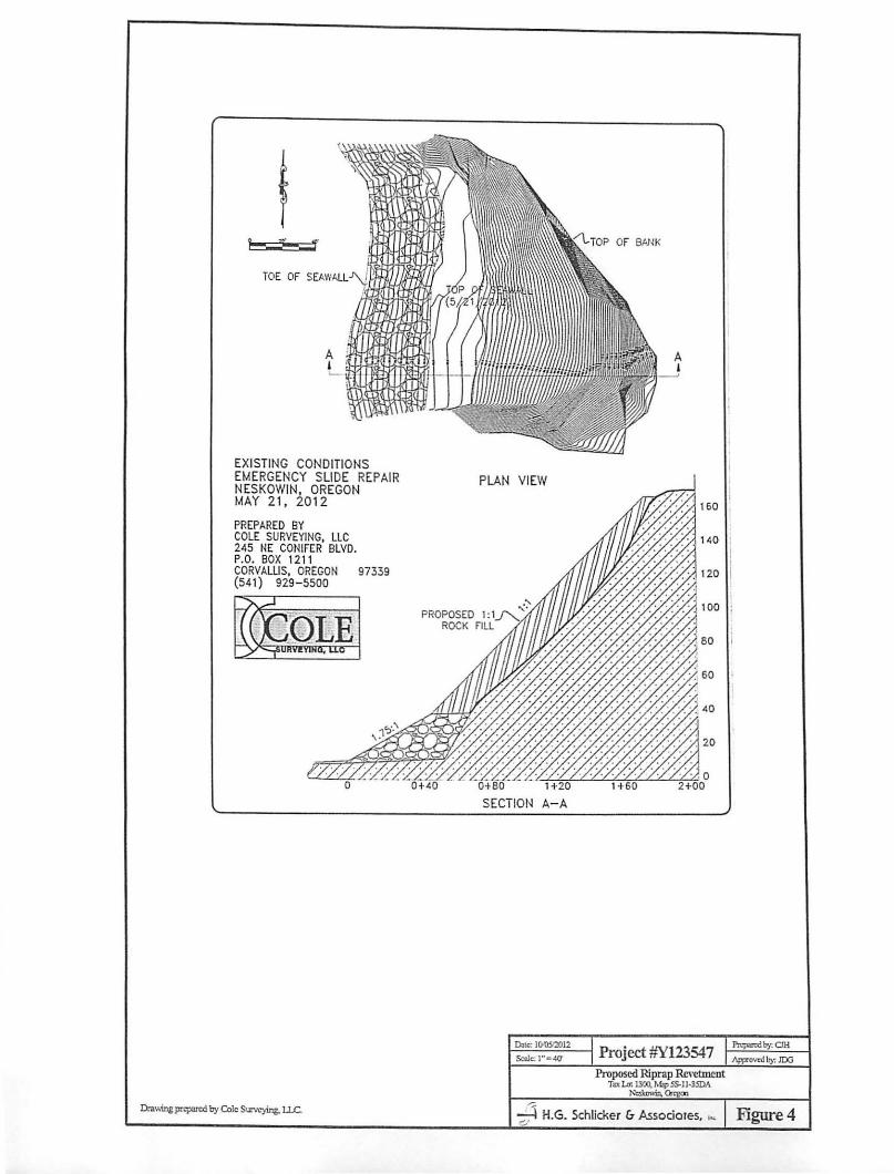
EXISTING CONDITIONS EMERGEN CY SLIDE REPAIR NESKOWIN, OREGON MAY 21, 2012
PREPARED BY COLE SURVEYING, LLC 245 NE CONIFER BLVD. P.O. BOX 1211 CORVALLIS, OREGON 97339 (541) 929 - 5500
~l9.Rf»1
o
Ihwing ~ by Cole SUNe)'ins, l.l.C
ROCK
PLAN VI EW
20
0:' 80' . '-. Li"""+"'20,fCCLcz.;!'nOf-.w.'-L'B;:
SECTION A- A
Da~ JOlOSI2012
Scale:l~"4()' Project #Y123547 Proposed Riprap Revetment
To:I..ot 1300, M.1pSS-1l.35DA ~in,~
-.c\ H.G. Schlicker (, Associoles. ~ Figure 4 ""

Appendix A - Site Photographs -
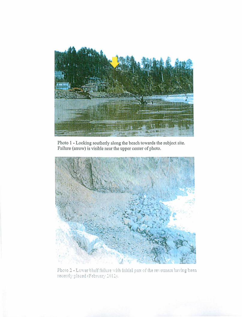
Photo 1 - Looking southe.rly along the beach towards the subject site. Failure (arrow) is visible near the upper center of photo.
F!i( V) ~ - L.: ,,·tr Uu!'!' fai!Lr~ "'. illl inili::.! ~ '~n .: i' the r~'" ;\111O,', l It ; \"iEg- t t :-11
rcc':-l'.rl:' ~: i:ic.:-d (F t;-1: n.: :'1~. ' : 01 ':' I ,
~ ....
• .!. ,.~ < , . ,
~ ~ ' . ., • ' . , .
~ .
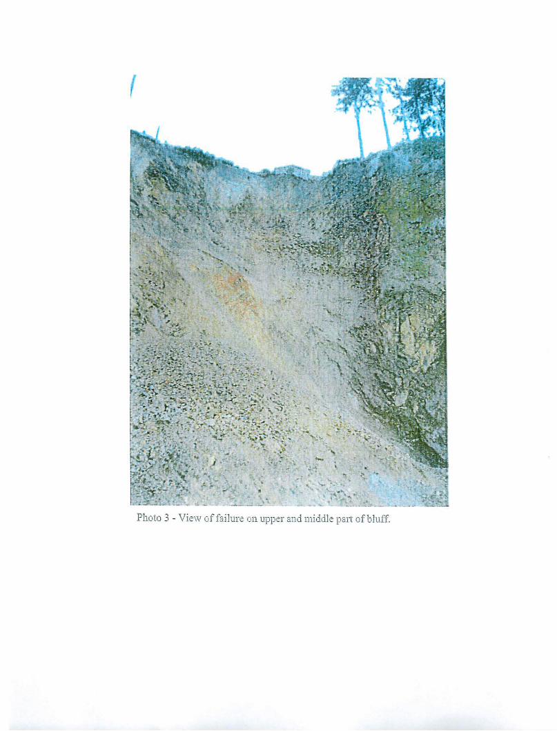
Photo 3 . View of fa ilure on upper and middle palt of bluff,
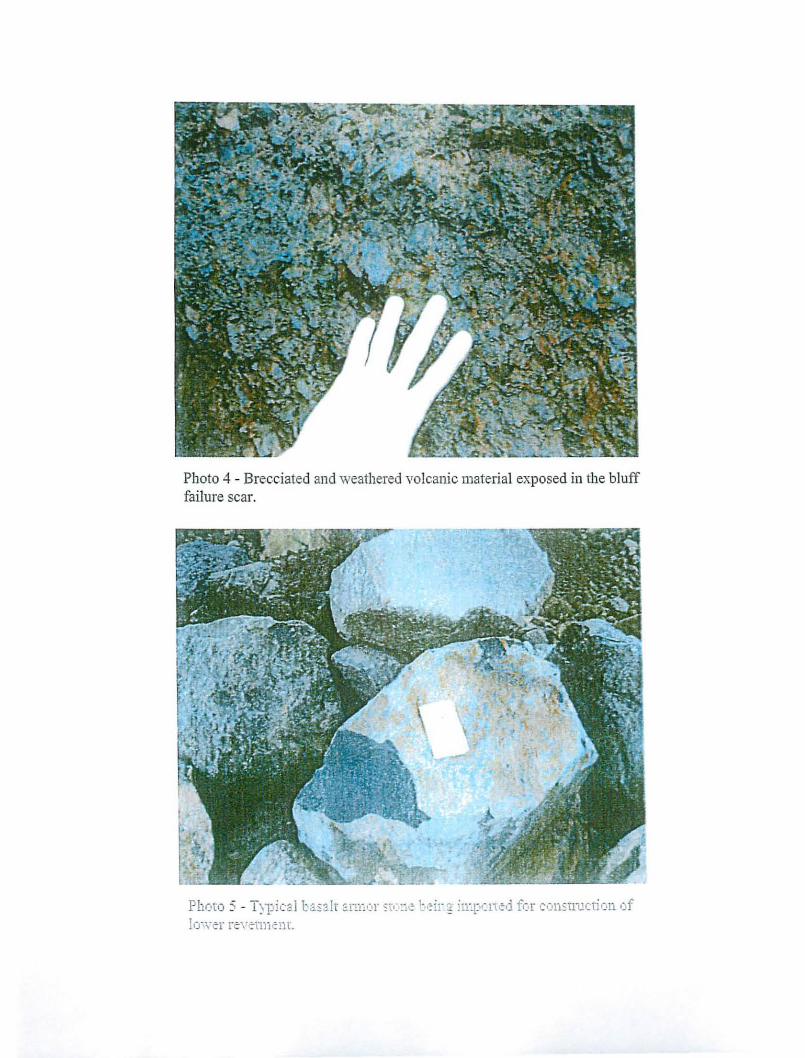
Pboto 4 - Brec.c.iated and weathered volcanic material exposed in tbe bluff failure scar.
Photo :; - 1 )1)ical b;:.salr ::'l-:.Eor ~t(:11! be-ir g ill".pC It ¢d for constlUcti l)ll of lo"\\·cT rtV tlTJ)¢Ut.
•
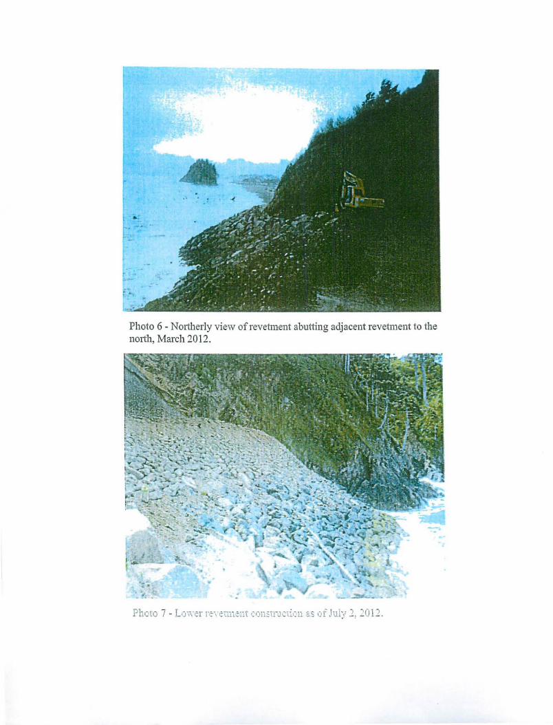
Photo 6 - NOltberly view of revetment abuttlllg adjacent revetment t.o the 1101t11, March 2012.

Photo 8 - Trackhoe bucket casting impOlted material down the bluff to be used in the rock fil l. Subject lot' s house and western wood deck is seen at upper left ofphoto.
Photo 9 - \ ~it·· .. fr(U) q: pcr bluff cdg~ '.( .~. ads lbf!' r~' cuntnt to.: (·11 Jlliy 2: 2fj 12.
r-------------------------------------------
H.G·. Schlicker" & Associates, Inc.
607 Main Street, Suite 200 . Oregon City, Oregon 97045 (503) 655-8113 . FAX (503) 655-8173
To: Mr. Ken Graham P.O.~ox924 Neskowin, Oregon 97149
Subject: Site Observations of Oceanfront Revetment . . . Tax Lot 1300, Map 5S-11-35DA Tillamook County, Ore~on
Dear Mr. Graham:
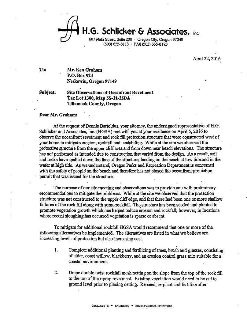
April 22, 2016 . .
At the request of'Dennis Bartoldus, your attorney, the uildersigned representative ofH.G. Schlicker and Associates, Inc. (HGSA) met willi you at your residence on April 5, 2016 to observe the oceanfronfrevetment and rock fill protection structure 'that were constructed west of your home to mitigate erosion; ~ockfa11 and land.sliding. While at the site we observ~ the protective $Ucture from the upper cliff area and ~m down near beach" elevations. The structure has Rot performed as intended due to .co~truction that varied from the d~ign. As a result, soil and rocks have spalled down the face 'of the structure, landing on the beach at low ~de .and in the water at high tide. A$ we understan~ Oregon Parks 'and Reqreatioll: Deparbnent is ooncemed with the safety of people on the beach and therefore ~ not closed the oceanfront·protection permit tI;tat waS issued for the structure. .
The purp,?se .of our site meeting and obs~ations was to provide- you .with preliminary recommendati9ns to mitigate the problems. While at the site we observed that the protection s~cture was not COI),structed to the upper cliff edge, and that there had b~n one or more shallow f~ures' of the rock fill along with some rockf~. The. structure has been seeded and planted to . promote vegetation growth which has helped reduce erosion and rockfall; however, in locations whefe recent s~oughing has occurred vegetation is sparse or abse~t . .
To mitigate for additional rockfall HGSA would recommend that one or more of the. following attematives be. implemented. The alternatives are listed in what we believe are increasing level;:; of protection but also increasing cost
1. Complete additional planting and fertilizing of trees, brush and grasses, consisting of alder, coast willow, blackberry, and an erosion control grass mix suitable for a coastal environment .
2. Drape double twist rockfall 111esh netting on the slope from the top of the rock fill to the top of the riprap revetment. Existing vegetation would need to be cut to ground level prior to placing netting. Re-seed, re-plant and fertilize after
GEOLOGISTS • ENGINEERS • ENVlRONMENT.AL SCIENTISTS
Page 2
placement, as necessary! to promote vigorpus growth. T.his rockfall mesh netting can be anchored into the rock fill with closely spaced anchors which are te~ioned to greatly increase perfonnance and help stabilize th~ slope, but this also substantially increases costs.
3. ,C~nstruct a rockfall: barrier (fence) slightly uphill from the top ~fthe riprap revetment Screen by planting trees and bl~ckberries on poth-sides of it.
4. Face the' existing revetment and slope ~th additional rock materials which would need to be about the width of a trackhoe, and 'extend much or all of the way-up the ' slope.
5. Other-~tems are available, and total costs of these vary depending upon. numerous. factors inoluding mate#als and instail~tion costs. '
If you wouid l~~ to pru.s1:le one of these options please Contact us to discuss the next . -steps.
Respectfully submitte4,
EXPIRES: 10/31/2016
J. Douglas oiess, MSc, RG, CEO, LHO PresidentiPrincipaI Engineering Geologist
JDG:cjh
* H.G. Schlicker (7 Associates, In<.
r
1£[ -;)
-,.-!~:?;'!'!f';.f" ? '----.. '0''''"'(\ ., ... "" ..... "'" _, P> ,_[01 ','11 " _,or " .. t,. '~I,., .. """,., .. , -..... """"'",,'
t,_ p .. ",._ .", _'''' ......... , .. , .. T'''' " .. .... ... ,.,.,_, -.,_ ................ " .. ,. G, ... ,>4 .... f ¥> ..... ,. "" .............. , .. 'U'A _ , ..... _ '.--&,I; .~ b_ ....• ~ .~ .... t '_1"' __
-------.~~~~----
Jll>ft.nr ....... __ .... - ... !--n_~) ... ~ (~-=
., .......... _., ......... ,._- ~.,:::."W~:~:'!l:.::~.!.~-;.:.*.~~.~ •• ..;1 ........... ", ... ) ., ..... , ....... ,l._ ...... , ., """ .... ,.. .'''101111 1I1.0~'1M. ~ .. " ~ ...... ", .......... ~ .. -............... " .. , .............. ' ..... .tot, ....... _ •• ",--JI .. ~
........ 111 JO "'..,. ... .tot, ..... "" ,,0' ""'le .... 10 ." .... ""l. '" ' ..... -'0 .,, __ II" , •• ,~u"" .n_II'" OIl' ,. '"'' n ...... 'q._, .,~._, 'tt ""1>'" ·t ..... '\O'l • ..-.._ "'11 ~I " ...... 1 111''''''
01"0 .. 3.. .. _ .............. " .... ..., p .. _ ", ... n ............... __ '.".1 '0-1-'-_ ..... "'1
,~'~u_""''''a
.... " .. n:lJa
.'I' '.' '1'''''' . 'HOtllHl ·~.I.no~ 'OOIl."U '01"0"'1" "UM.,,.. ~Il. II u+ln 1WlO~ • '''011110.0.1. 'If 01011'11 'tll 1101 1+l3." ... lAo-"'n 11\ wo.,n.l,lll'M ...
... -.... -...... -~ .. -... ,...~ .. , .. ._ .. _ ... _-_ ........ _ ... -...... , = ::'~":::'::'. -:'::!:.;.-=.; .:':';::::.~ ~ :;.::;;:.:.::.:
"' ..... ~ ... -,. -..,yf..;g ~~k .. ~'t!t~;'L . . ..,.. ...... , ... vo .. ,_ n' ..... ,."" ...... """ .......... '~l ,.. •. \ .... ,.,
II .... ,, __ •• _ .. , ........ , ... -.. ........ ,.-,... -"
___ It ..... 'Of ... '" --'.', .... 1' .......... "' •••• _, .... i" -"._, •• .....-.... -... •• II •• , .... ~_ ...... 1'~' ~1I1""'" ....... -1 ,
...... _ '('-:' _If" • .. ,PI .... ",'_11M'''' I" 1O'fI1I .,....~ ...... ~ ~ ~I~-'r,( _ " .... ,l" ...... _ .................. u ............ , ••
"I~ ';!.~~!.~-; ...... "'$ ..n~,' ... ~.::.:':.~~!·~~.;;n:--:~ ::;"..: .; '0' 0.1 ....... , ,( •• ~ • II .~. " •• ~ ~.,...,j ,.,,,., .... ,I1I1IIJ01 lI,aon,.. J.O ,. "{, .. _ •• "'" "" ~1~.''''~''' 1'''1
.'" .,._ .1.' .......... "' ........ _ "" .... l .... no "n"'"'' .... , \ ,.", ~ ............. ,'"""-~1.'. "'jJ ""-< "II·~ " •• , •• \ "
'I~ _ ,. Of .... W ,ow 7r·· ... Jr .... . .. _ .... _.,.. """""",,",,,,,,-, ... , ...... -.~ ...... .. ..s.II ........ OOC_.'" __ .... _ • ... 00 '._.-.u I' .MtI __ ..... ,. .... __ • _."" ..... , .... ·W .... ~ ... :JoifV',
, ..... ,"1 "'OI$r.lJG
"taI,OI'," ,,1')-=0 ~.~-.. .... _ .. 1"'_ ...... ..... _, ... ,._ .. """" ... -.......... 1 -.... -.. ~ .. .. .. ~
/I SJ.H913H NIMO>lS3N~1 {' I I' ,.N I

RECORDING COVER SHEET (Please Prillt or Type) This cover sheet was prepared by the person presenting the instrument for recording. The information on th is sheet is a reflection of the attached instrument and was added for the I purpose of meeting first page recording requirements in the State I of Oregon, ORS 205.234, and does NOT affect the instrument. I ------------------------------------------------------------------------------ I AFTER RECORDING RETURN TO: I ~M~r~a~n~d~M~r~s~K~en~n~e~th~L~.~G~m~h~am~ ___________________ 1 ~5~OO~4~0~S~.B~e~ac~h~R~d _________________________ 1
~N~e~sk~· 0~w~in~. ~O~R29~7~14~9 _________________________ 1
-----------------------------------_1
TIllamook County, Oregon 2012-004969 091061201211 :49:42 AM DEED-DWARR f~5 00 $11 00 116 00 $ 10 00· Tota: = S62 00
11II111 II I 1111111 I hereby certify that the >'Athln ~ Instrument was received for record and recordod In the County of TIllamook, stale of Oregon.
Tassi O'Neil, Tillamook County Clerk
I) TlTLE(S) OF THE TRANSACTlON(S) ORS 205.234(a) WARRANTY DEED
2) DIRECT PARTY / GRANTOR(S) ORS 205.125(1)(b) and 205.160
KENNETH L. GRAHAM and JUDY A. GRAHAM, husband and wife
3) INDIRECT PARTY / GRANTEE(S) ORS 205.125(1)(a) and 205.160
KENNETH L. GRAHAM - as Trustee of the Kenneth L. Graham Trust dated June 24, 2008. as to
undivided one-half interest and JUDY A. GRAHAM - as Trustee of the Judy A. Graham Trust
dated June 24. 2008. as to an undivided one -halfinterest.
4) TRUE AND ACTUAL CONSIDERATION ORS 93.030(5) - Amount in dollars or other
$ ________ (1""--_ _ _ DOther
6) SATISFACTION of ORDER or WARRANT
CHECK ONE: (If applicable)
ORS 205.125(1)(e) DFULL o PARTIAL
5) SEND TAX STATEMENTS TO: Mr and Mrs Kenneth L. Graham 50040 S. Beach Rd Neskowin, OR 97149
7) The amount of the monetary obligation imposed by the order or warrant. ORS 205.125(1)(c)
s -----------------8) If this instrument is being Re-Recorded, complete the following statement, in
accordance with ORS 205.244: "RERECORDED TO CORRECT :::-:-:-:-::-====~
:::-::::-::-:-::-----:-:--=:-::--::=------,.,-,:----,.-=-==c-,.,...,,- PRE VI 0 U SLY RECO RD ED IN BOOK AND PAGE ,OR AS FEE NUMBER "
" "
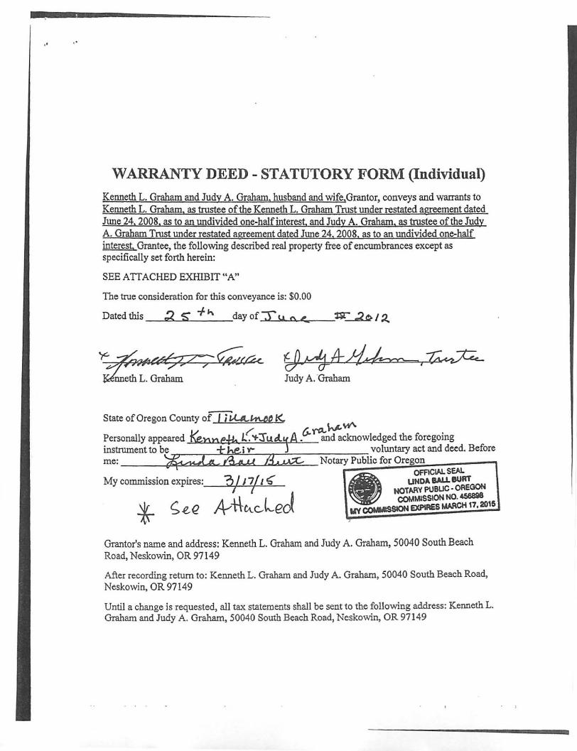
WARRANTY DEED - STATUTORY FORM (Individual)
Kenneth L. Graham and Judy A. Graham. husband and wife,Grantor, conveys and warrants to Kenneth L, Graham. as trustee of the Kenneth L. Graham Trust under restated agreement dated June 24. 2008, as to an undivided one-half interest, and Judy A. Graham, as trustee of the Judy A. Graham Trust under restated agreement dated June 24. 2008. as to an undivided one-half interest Grantee, the following described real property free of encumbrances except as specifically set forth herein:
SEE ATTACHED EXHIBIT "A"
The true consideration for this conveyance is: $0.00
Dated this :J S +.... day of III 0 ' -
fJ~4-~ ,~ Judy A. 'Graham
State of Oregon County orr; lA...A..~p K. /' c;.~\4""
Personally appeared k'e.nne-u. L:. ",::r u.t'( A . and acknowledged the foregoing instrument to be + ~i y- J voluntary act and deed. Before
me: ~ d&! ' ~ A, L¥C.- Notaryy!P~u~bli~'c~~~~;;;:~~:L'""_-' ;. OffICIAl. SEAL
My commission expires: 3 1 17/1 .;; UNDA 8A1L BURT r r NOTARYPUBUC·QREGON J I l I COMt.IISSION NO. 456888
~e.e A-nc.-..G ed
Grantor's name and address: Kenneth L. Graham and Judy A. Graham, 50040 South Beach Road, Neskowin, OR 97149
After recording return to: Kenneth L. Graham and Judy A, Graham, 50040 South Beach Road, Neskowin, OR 97149
Until a change is requested, all tax statements shall be sent to the following address: Kenneth L. Graham and Judy A. Graham, 50040 South Beach Road, Neskowin, OR 97149
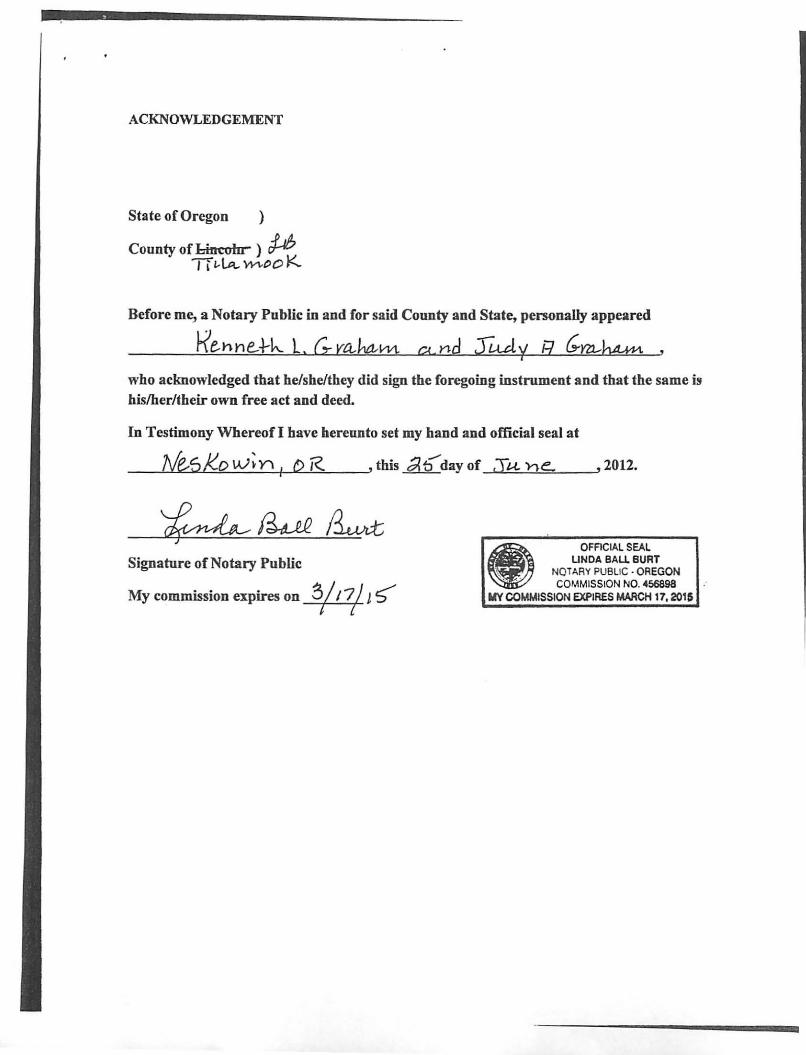
ACKNOWLEDGEMENT
State of Oregon )
County of l.iucoln ) # TI ~ LA.. \-1-'\-00 K
Before me, a Notary Public in and for said County and State, personally appeared
k'e.hhe...J.-k. L. (.,.. vaJ'Itl-m C! nd rt.uty R c;m..hMn
who acknowledged that he/she/they did sign the foregoing instrument and that the same is hislher/their own free act and deed.
In Testimony Whereof I have hereunto set my hand and official seal at
_-L.Mue..""So,LJ<,-"""o,-,W:.::....:..; .!...Y\':"'II--""Dc..!R-,>-_-" this 01 b day of .Tun e. ,2012.
Signature of Notary Public
My commission expires on -¥q 1 5"'
OFACIAL SEAL UNDA BAU BURT
NOTARY PUBLIC· OREGON COMMISSION NO. 456898
MY COMMISSION EXPIRES MARCH 17. 2015
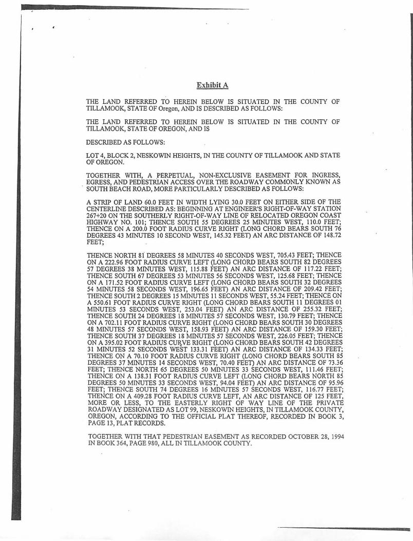
Exhibit A
THE LAND REFERRED TO HEREIN BELOW IS SITUATED IN THE COUNTY OF TILLAMOOK, STATE OF Oregon, AND IS DESCRIBED AS FOLLOWS:
THE LAND REFERRED TO HEREIN BELOW IS SITUATED IN THE COUNTY OF TILLAMOOK, STATE OF OREGON, AND IS
DESCRIBED AS FOLLOWS:
LOT 4, BLOCK 2, NESKOWIN HEIGHTS, IN THE COUNTY OF TILLAMOOK AND STA TE OF OREGON.
TOGETHER WITH, A PERPETUAL, NON-EXCLUSIVE EASEMENT FOR INGRESS, EGRESS, AND PEDESTRIAN ACCESS OVER THE ROADWAY COMMONLY KNOWN AS
. SOUTH BEACH ROAD, MORE PARTICULARLY DESCRIBED AS FOLLOWS:
A STRIP OF LAND 60.0 FEET IN WIDTH LYING 30.0 FEET ON EITHER SIDE OF THE CENTERLINE DESCRIBED AS: BEGINNING AT ENGINEER'S RIGHT-OF-WAY STATION 267+20 ON THE SOUTHERLY RIGHT-OF-WAY LINE OF RELOCATED OREGON COAST HIGHWAY NO. 101; THENCE SOUTH 55 DEGREES 25 MINUTES WEST, 110.0 FEET; THENCE ON A 200.0 FOOT RADIUS CURVE RIGHT (LONG CHORD BEARS SOUTH 76 DEGREES 43 MINUTES 10 SECOND WEST, 145.32 FEET) AN ARC DISTANCE OF 148.72 FEET;
THENCE NORTH 81 DEGREES 58 M1NUTES 40 SECONDS WEST, 705.43 FEET; THENCE ON A 222.96 FOOT RADIUS CURVE LEFT (LONG CHORD BEARS SOUTH 82 DEGREES 57 DEGREES 38 MINUTES WEST, 11 5.88 FEET) AN ARC DISTANCE OF 117.22 FEET; THENCE SOUTH 67 DEGREES 53 MINUTES 56 SECONDS WEST, 125.68 FEET; THENCE ON A 171.52 FOOT RADIUS CURVE LEFT (LONG CHORD BEARS SOUTH 32 DEGREES 54 MINUTES 58 SECONDS WEST, 196.65 FEET) AN ARC DISTANCE OF 209.42 FEET; THENCE SOUTH 2 DEGREES 15 MINUTES 11 SECONDS WEST, 55 .24 FEET; THENCE ON A 550.61 FOOT RADIUS CURVE RIGHT (LONG CHORD BEARS SOUTH 11 DEGREES 01 MINUTES 53 SECONDS WEST, 253.04 FEET) AN ARC DISTANCE OF 255.32 FEET; THENCE SOUTH 24 DEGREES 18 MINUTES 57 SECONDS WEST, 130.79 FEET; THENCE ON A 702.11 FOOT RADIUS CURVE RIGHT (LONG CHORD BEARS SOUTH 30 DEGREES 48 MINUTES 57 SECONDS WEST, 158.93 FEET) AN ARC DISTANCE OF 159.30 FEET; THENCE SOUTH 37 DEGREES 18 MINUTES 57 SECONDS WEST, 226.05 FEET; THENCE ON A 395.02 FOOT RADIUS CtmVE RIGHT (LONG CHORD BEARS SOUTH 42 DEGREES 31 MINUTES 52 SECONDS WEST 133.31 FEET) AN ARC DISTANCE OF 134.33 FEET; THENCE ON A 70.10 FOOT RADIUS CURVE RIGHT (LONG CHORD BEARS SOUTH 85 DEGREES 37 MINUTES 14 SECONDS WEST, 70.40 FEET) AN ARC DISTANCE OF 73.36 FEET; THENCE NORTH 65 DEGREES 50 MINUTES 33 SECONDS WEST, 111.46 FEET; THENCE ON A 138.31 FOOT RADIUS CURVE LEFT (LONG CHORD BEARS NORTH 85 DEGREES 50 MINUTES 33 SECONDS WEST, 94.04 FEET) AN ARC DISTANCE OF 95.96 FEET; THENCE SOUTH 74 DEGREES 16 MINUTES 57 SECONDS WEST, 11 6.77 FEET; THENCE ON A 409.28 FOOT RADIUS CURVE LEFT, AN ARC DISTANCE OF 125 FEET, MORE OR LESS, TO THE EASTERLY RIGHT OF WAY LINE OF THE PRIVATE ROADWAY DESIGNATED AS LOT 99, NESKOWIN HEIGHTS, IN TILLAMOOK COUNTY, OREGON, ACCORDING TO THE OFFICIAL PLAT THEREOF, RECORDED IN BOOK 3, PAGE 13, PLAT RECORDS.
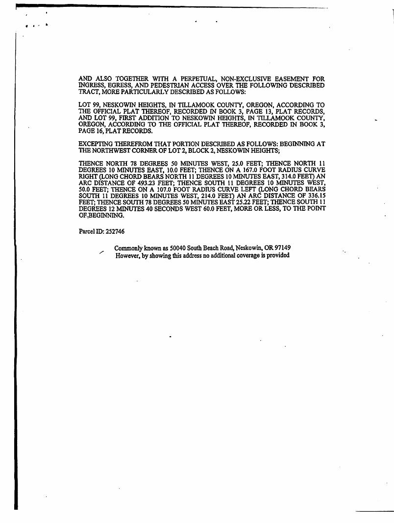
TOGETHER WITH THAT PEDESTRIAN EASEMENT AS RECORDED OCTOBER 28,1994 IN BOOK 364, PAGE 980, ALL IN TILLAMOOK COUNTY.
f .' •
AND ALSO TOGETHER WITH A PERPETUAL, NON-EXCLUSIVE EASEMENT FOR INGRESS, EGRESS, AND PEDESTRIAN ACCESS OVER THE FOLLOWING DESCRIBED TRACT, MORE PARTICULARLY DESCRIBED AS FOLLOWS:
LOT 99, NESKOWIN HEIGHTS, IN TILLAMOOK COUNTY, OREGON, ACCORDING TO TIlE OFFICIAL PLAT THEREOF, RECORDED IN BOOK 3, PAGE 13, PLAT RECORDS, AND LOT 99, FIRST ADDmON TO NESKOWIN HEIGHTS, IN TILLAMOOK COUNTY, OREGON, ACCORDING TO THE OFFICIAL PLAT THEREOF, RECORDED IN BOOK 3, PAGE 16, PLAT RECORDS.
EXCEPTING THEREFROM THAT PORTION DESCRIBED AS FOLLOWS: BEGINNING AT 1HE NORTHWEST CORNER OF LOT 2, BLOCK 2, NESKOWIN HEIGHTS;
THENCE NORTH 78 DEGREES 50 MINUTES WEST, 25.0 FEET; THENCE NORTII 11 DEGREES 10 MINUTES EAST, )0.0 FEET; THENCE ON A 167.0 FOOT RADIUS CURVE RIGHT (LONG CHORD BEARS NORTH 11 DEGREES 10 MINUTES EAST, 314.0 FEET) AN ARC DISTANCE OF 493.23 FEET; THENCE SOUTH 11 DEGREES 10 MINUTES WEST, 50.0 FEET; THENCE ON A )07.0 FOOT RADIUS CURVE LEFT (LONG CHORD BEARS SOUTH 11 DEGREES 10 MINUTES WEST, 214.0 FEET) AN ARC DISTANCE OF 336.15 FEET; THENCE soum 78 DEGREES 50 MINUTES EAST 25.22 FEET; THENCE SOUTH 11 DEGREES 12 MINUTES 40 SECONDS WEST 60.0 FEET, MORE OR LESS, TO THE POINT OF~BEGINNING.
Parcel ID: 252746
Commonly known as 50040 South Beach Road, Neskowin, OR 97149 However, by showing this address no additional coverage is provided
(
(
I illallll)O" COUll I:
-
DEPART:-'IEN r or CO~I~It.:NII y I)E\"ELOr~IENT BULD/.vG, PL-I ,\XI.vr;,~ o.\~SrrE ~~· I.I'!T I TlI).1 S!XTi().I:\'
_. ---------- ---------- - ... _-- ' .. _--- - -- - - . "----f t . :'. ; I I ( -", , '. .fi-.. ,-', .~ :.1' i ) , c: :1 /; 1 : , ".- . ,
PROPERTY LIN E ADJ liSHIENT
REVIEW: LLA-13-13
Ministerial Review Rcport Date: February 27, 2014
Prcpared by: Timothy J. ~[urphy, Associate Planncr
!. GENERAL INFORi\[ATIO N:
I) I O· B Third SIIWI Tii\allh)l.,k. Or('g\~ n 97 1~ I
Buiklill:! (503J S·t~-3·t07 Planning ( 503)8-L!-3-l 0~
l'n-Sill! 5~m ila!ion (SOJ) 8·.t1-J .. H)9 FAX (503)Q2·I SI9
T" n fr« I ( SOOH~'·~2'1)
UNIT A: APPLICANT LEGAL OWNER (IF DIFFERENT) 8:ln1c: Kame:
Kl!llih!lh L. &. Judy A. Graham, Trustees same
;\I :l iling Aaurcss (Stree t or PO l:Sox): .\l :lIlmg Adurcss (Street or PO lJox):
P.O. Bo'\ 294 Si'lnll!
City/SlntciLip <..ode: City/State/Zip Code:
Ncsk.)win, OR 971 ~9 S2.me
PROPERTY INFORMATION & LOCATION: Lot 4 in the Neskowin Heights subdivision located in the Neskowin Community Gro\\1h Boundary on the nOl1hem side of Souib Beach Road, a Public Road. I OWllS llip Range Section Tax Lot Zone
5 Sonl h 11 W W.~L 35DA 1300 Ne.skowin Low D~nsilY Resid;:,ntial lNeskR-I ) --
UNIT B: APPUCAt'lT LEGAL OWNER (IF DIFFERENT) ;\ame: N:lIne:
Gary ~1.H:Lrgi~ Gary :\'1.& 1\'{ary U:'<l H:lrgi$
~ I ail lllg Ad<1reSS (:;f reer or PU Uox): !\I :lil ing ACldress l~trcH or 1'0 Box) :
3310 Knigh;(lll W'J.y 3310 Knig.hton Wuy
Cityfsr:lte!Zip Code: CilyiSrlltefZip Code:
F c:re~ l Gr~)\"e. 0 R C) 71 ! 6 r 0re:;1 (irO\·e. OR (17116
PROPERTY [NFOR~[ATION & LOCATION: Parcel 3 on Parii tion Plat No. ! 997·03 it'<akd in Ih~ NC$ko\\'ln (\lnlnlllllil y GnJ'.nh BOUlld3.ry 0 11 the n\)nh~m sid~ \.)f South BI!i1('h Road. a Public Road. Township H.ange Section T ax Lot Lone
5 S011 th II \\' \\.~ J. 33D.\ 3102 N~A(~ '>\in L,\\\' Iki1:=:it: Residt:!itbl (~I!s.kR·! i -----.--- -_ .-._- .-. _ .. _-. .. _____ L_ -----------------
\.: I ',I ; :· 1 1 1; 'i'l 'i, ! I ', [! ', I \ lJ !' 1\ 1 :'
(
(
1\1 atcrhlls Submitted:
1. Application Sketeh /01' Propt?I'(V Line Adjustment f()r Tax Lots 1300 and 3102 located in Section 350A of Township 5 South, Range II \Vest of the \Villamette ~-leridian, TiJImllook County, Oregon, prepared by Cole Surveying, LLC (Exhibit B).
II. APPROVAL STANDARDS:
1. All properties involved ill the property line adj tlstnlent must be legally created parcels unless the property line adjustnlent is necessary to establish units of land consistent '''ith tIte lot size requirements of the zone. New parcels shall not be created as a result of a property line adjustnlent.
Findings: Unit A is identified 011 the Tillamook County Assessor's wrap as Ta"{ Lot 1300, is rectangular in shape, and is 0.18 acres in size (Exhibit A). The subject property is accessed via South Beach Road. Tillalnook County records indicate Unit A is an itnproved lot created by the Neskowin Heights plat (Exhibit A).
Unit B, id~ntified as Tax. Lot 3102, is irregular in shape, and is 2.16 acres in size (Exhibit B). The subject property has access to South Beach Road at the sout1nvest portion of the property. Tillalnook County records indicate Unit B is an unimproved parcel created by Partition Plat # 1997-8 (Exhibit A).
Per the submitted narrative, the lot line adjustlnent is proposed as a result of a slide on the Hargis property (Exhibit B). The Grahan1's obtained an emergency pennit from Oregon State Parks to stabilize the elnbankment and i\.1r. Hargis has subsequently agreed to convey the slide area to the Grahrull's to allow for continued maintenance (Exhibit B). The submitted plat confinns the lot line adjushnent will add the slide area to Unit A frOin Unit B (Exhibit B). The lot line adjustment will not result in the creation of a ne\v property since the slide area on Unit B will be added to Unit A which is an existing lot.
2. All parcel sizes, property-line setbacks, and other dhllensional attributes resulting frolll a prOpel"ty line adjustnlent sball confornl to the provisions of the Tillanlook County Land Use Ordinance.
Findings: The subject propcliies are loc.ated in the Neskowin Low Density Residential tNeskR-I) zone (Exhibit A). Per TCLUO Section 3.322(4)(a), "The minimum lot si=efor permitted llses shall be 7,500 square !eel." The table below provides the existing and proposed prop~rty areas based 011 in f01111ation provided in • Exhibit B'.
11:- . lTn it I Existing Area I Proposed A-~~ (sq. ft.) _____ L ___ (sq. ft.) ~
I A (Tax Lot 1300) I 7.583 I 36,996 LEY_TThxLOt}] 02) L. 73.262 '-.'--~J.-=~- -- 43,847 --~_
000414
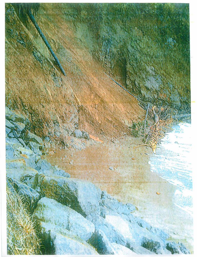
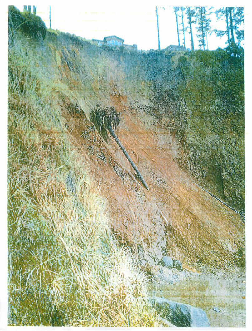
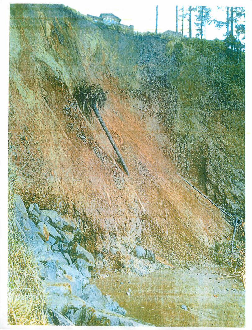
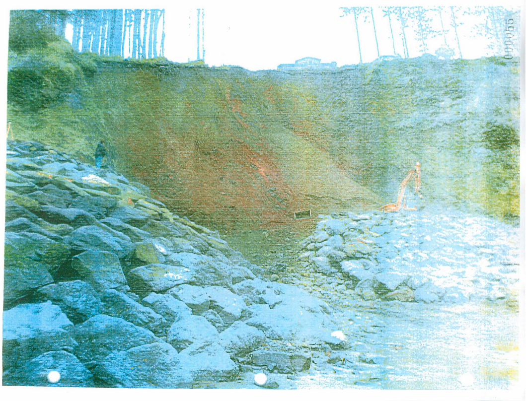
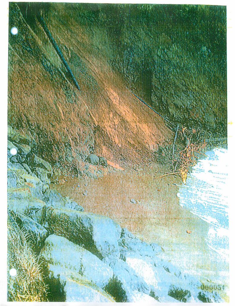
>' , , .
- .. . ,. ... ""'# • ~
- .~
00054 ~ I
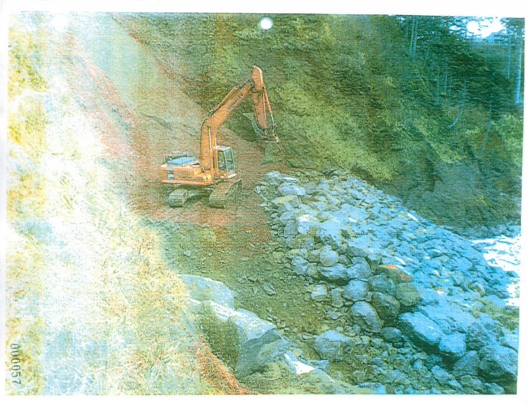
>
-•
,
OQ57
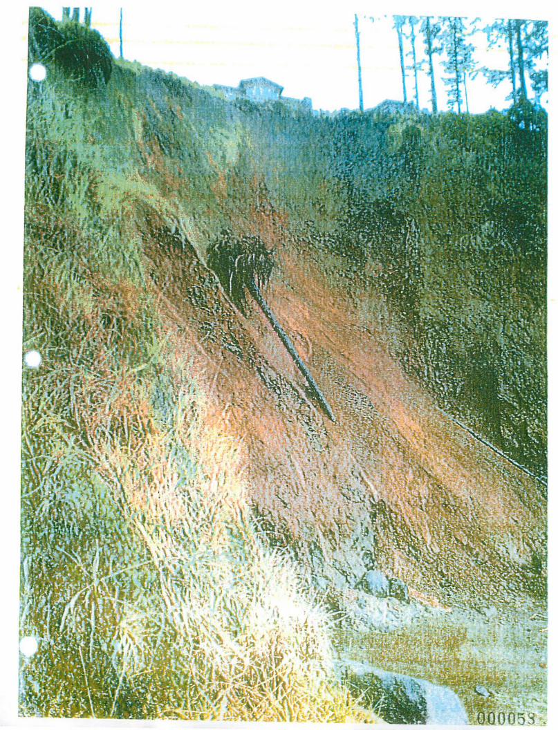
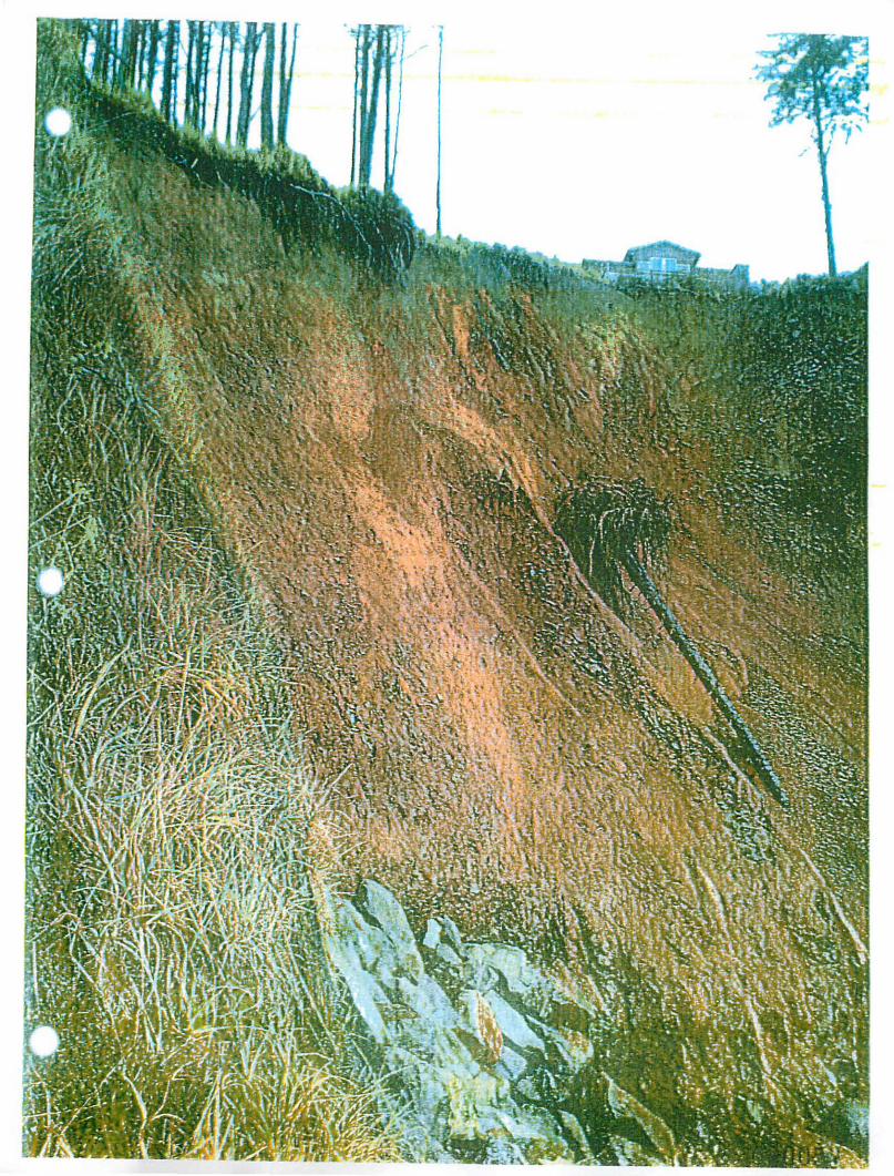
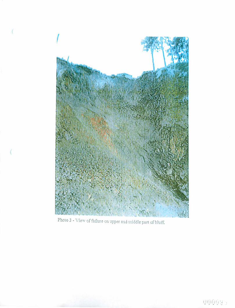

Township: :5S
Street Address: CitylTown:
County: 0 ~ 0 0
o
o
OREGON PARKS AND RECREATION DEPARTMENT EMERGENCY OCEAN SHORE PERMIT
INFORMATION FORM Page 2
Range: IIW Section: _3S~ Subsection Df\ Tax lot(s)
500 '-to S , P, <::: 0-- ",h, fZd 13 0 0
tic > Kcnv ) " or Zip Code: 92/"1'l ,
Clatsop 0 Douglas Tillamook 0 Coos Lincoln 0 Cuny Lane
cm'/COUNTY PLANNING DEPARTMENT AFFIDAVIT (To be completed by local plruUling officinl)
This project is not regulated by the local c<>mprehensive plan and zoning ordinance.
This project has been reviev·,1ed and is consistent with the local comprehensive plan and zoning ordinance.
The property was developed prior to January I, 1977, under the definition of development in Statewide Planning Goal J 8. (Development means houses, commercial and industrial buildings, and vacant subdivision lots which are physically improved through construction of streets and provision of utilities to the lot. * Set C\ ~",(..~ tJ..~O
This project has been reviewed and is not consistent wiib Ule local comprehensive plan and zoning ordinance.
Consistency of this project with the local plonning ordinance cannot be determined untillhe following local approval(s) fire obtained:
o Conditional Use Approval o Development Permit
o Plan Amendment o Zone Change
o Otoer:
Emergency Permit Ocean Shore Information Form Pa£e 2 of 2
000010