Embed Size (px)
Citation preview

SDI for Support of
Urban Development
Istanbul - Turkiye
Arif Cagdas AYDINOGLU
Assoc. Prof. Dr., Gebze Technical University, Turkey
www.arifcagdas.com
Data archive Geojson Python Plugin Java script Object oriented programming Java Web application
Geoprocessing Html5 Smartphone mobile GPRS RESTful Semantic web Harmonization Geoportal
ISO/TC211 standards 19107, 19109 OSM (Open Street Map) UAV (Unmanned Aerial Vehicle) Drone GNSS (Global
Navigation Satellite System) Mass data Open data Crowd sourcing VGI (Voluntary Geographic Information)
Big data Radar Remote Sensing, SAR (Sidelooking Airborne Radar) Geomarketing 2D Semantics
OBIA (Object Based Image Analysis) 4D BIM (Building Information Model) Data archive Augmented reality
Indoor GML / City GML 4D Web platforms System architectur e OGC services (Open GIS Consortium)
Web processing services SDI service components UAV LiDAR (Light Detection and Ranging) Mobile GISPoint cloud
analysis Programming in Python UML (Unified Modelling Language) XML (Extensible Markup Language) Qualitative
GIS Open source software Citizen Science Data Quality SDI TUCBS TRGUS KBS Smart Cities ….
Overview
Introduction with Urban Development
Turkey SDI projects related to INSPIRE
Case application for TRGIS and INSPIRE
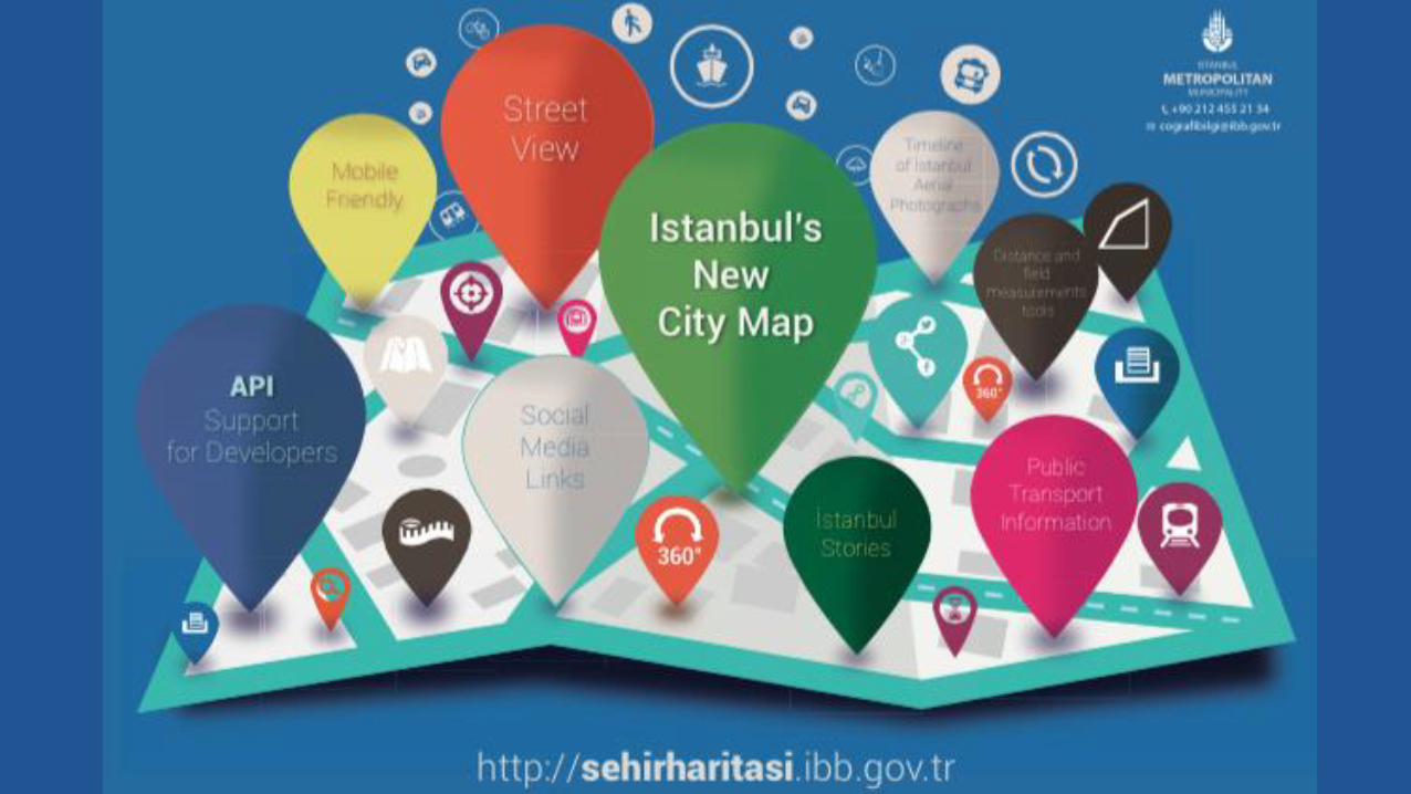
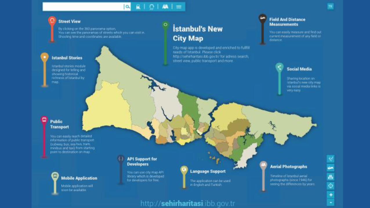
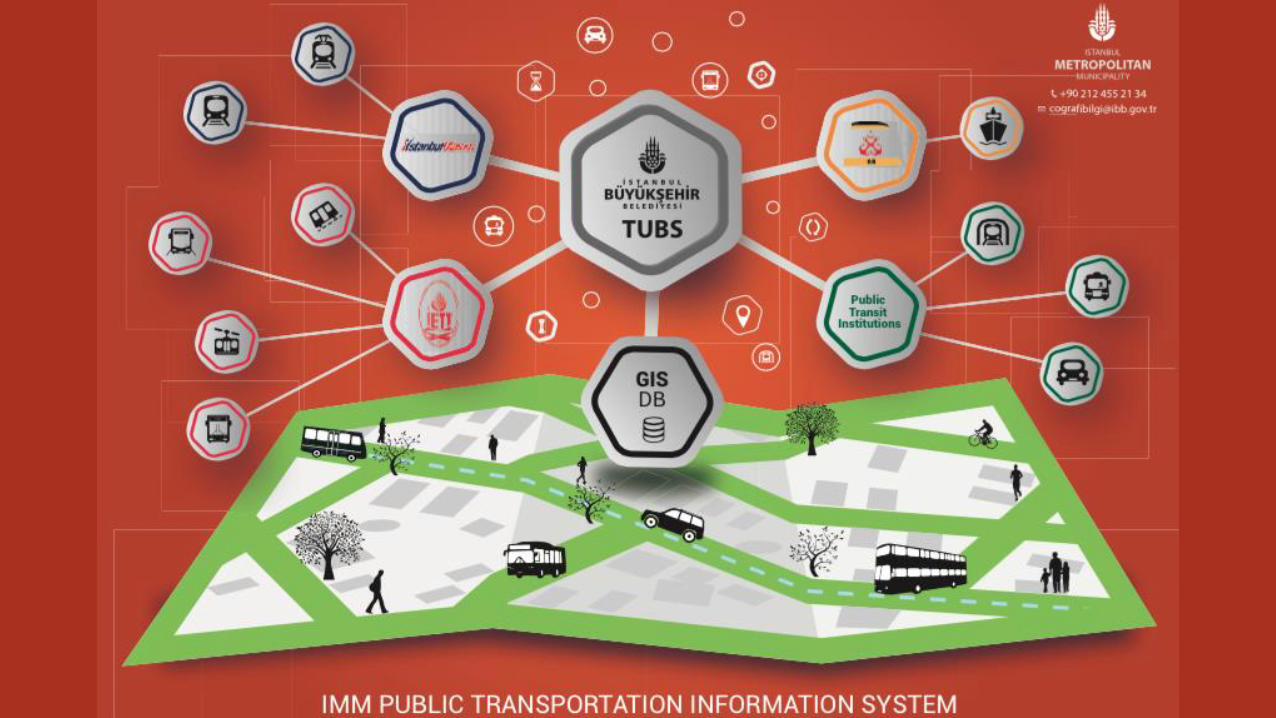
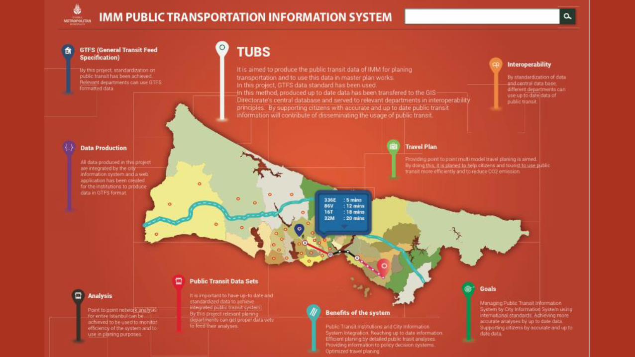
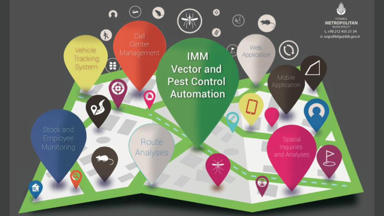
Projects in Istanbul Metropolitan Municipality
Discussion and Conclusion
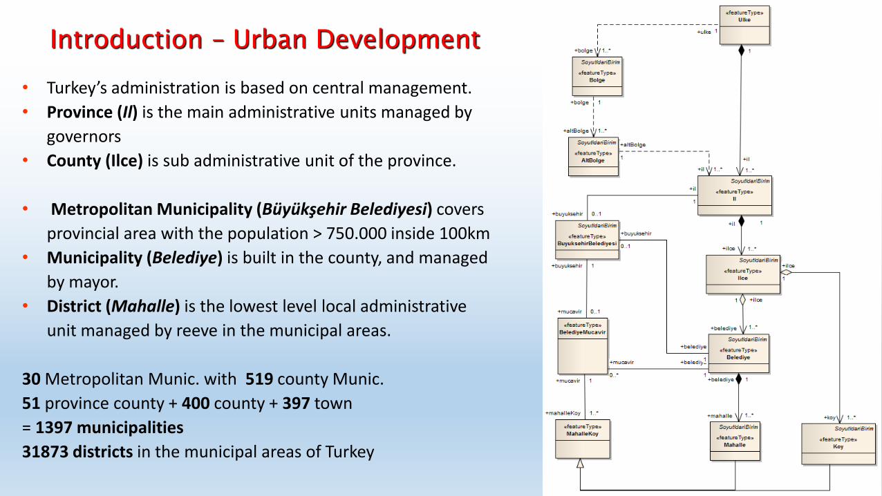
• Turkey’s administration is based on central management.
• Province (Il) is the main administrative units managed by
governors
• County (Ilce) is sub administrative unit of the province.
• Metropolitan Municipality (Büyükşehir Belediyesi) covers
provincial area with the population > 750.000 inside 100km
• Municipality (Belediye) is built in the county, and managed
by mayor.
• District (Mahalle) is the lowest level local administrative
unit managed by reeve in the municipal areas.
30 Metropolitan Munic. with 519 county Munic.
51 province county + 400 county + 397 town
= 1397 municipalities
31873 districts in the municipal areas of Turkey
Introduction – Urban Development
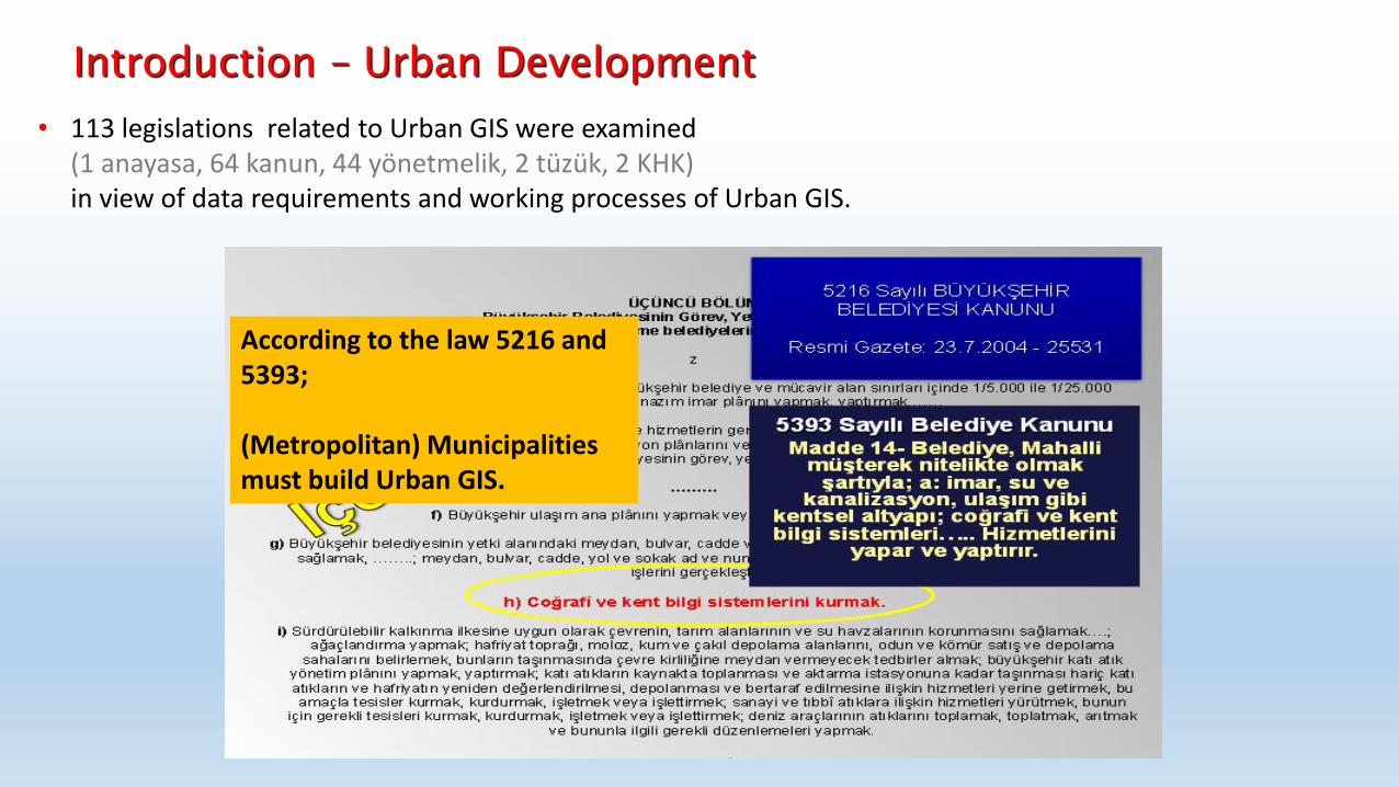
According to the law 5216 and 5393; (Metropolitan) Municipalities must build Urban GIS.
• 113 legislations related to Urban GIS were examined (1 anayasa, 64 kanun, 44 yönetmelik, 2 tüzük, 2 KHK) in view of data requirements and working processes of Urban GIS.
Introduction – Urban Development
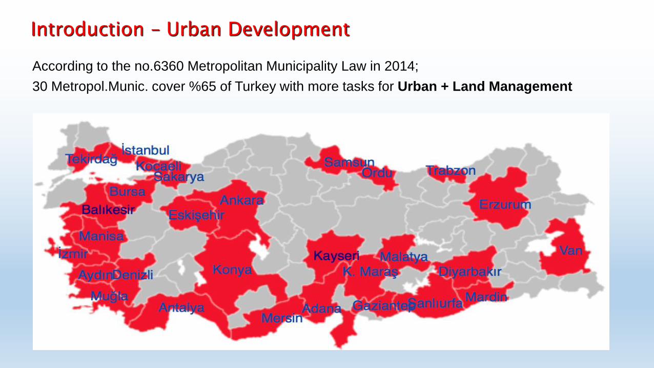
According to the no.6360 Metropolitan Municipality Law in 2014;
30 Metropol.Munic. cover %65 of Turkey with more tasks for Urban + Land Management
Introduction – Urban Development
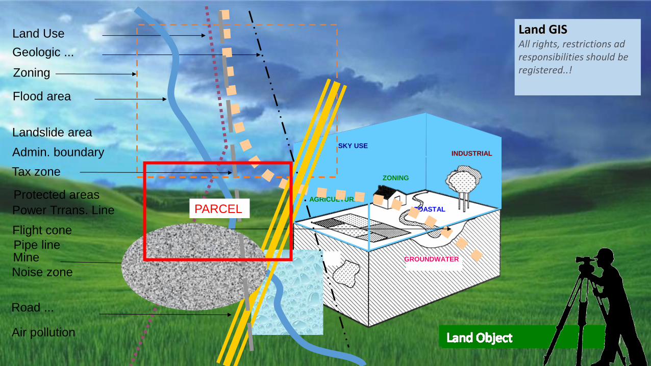
AGRICULTURAL
ZONING
GROUNDWATER
MINE
SKY USE
INDUSTRIAL
COASTAL
Mine
Landslide area
Admin. boundary
Power Trrans. Line
Pipe line
Flight cone
Noise zone
Land Use
Geologic ...
Flood area
Zoning
Protected areas
Road ...
Air pollution
Tax zone
Land GIS All rights, restrictions ad responsibilities should be registered..!
PARCEL
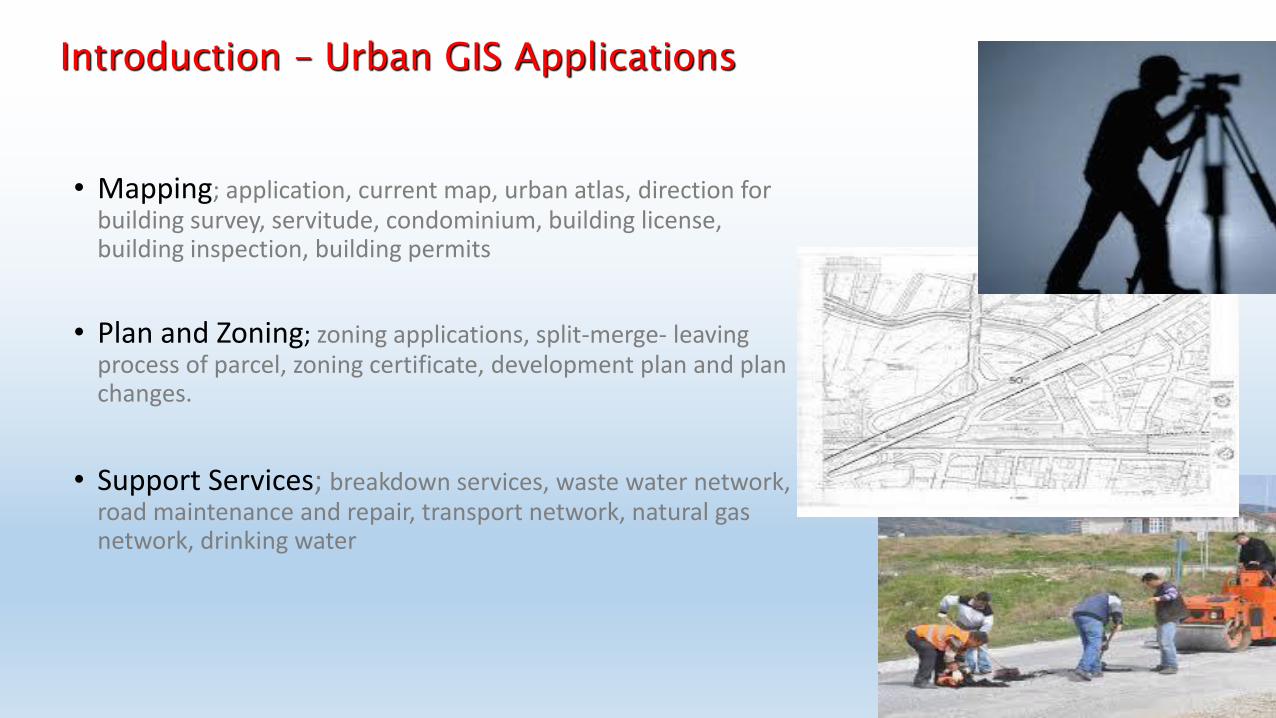
• Mapping; application, current map, urban atlas, direction for building survey, servitude, condominium, building license, building inspection, building permits
• Plan and Zoning; zoning applications, split-merge- leaving process of parcel, zoning certificate, development plan and plan changes.
• Support Services; breakdown services, waste water network, road maintenance and repair, transport network, natural gas network, drinking water
Introduction – Urban GIS Applications
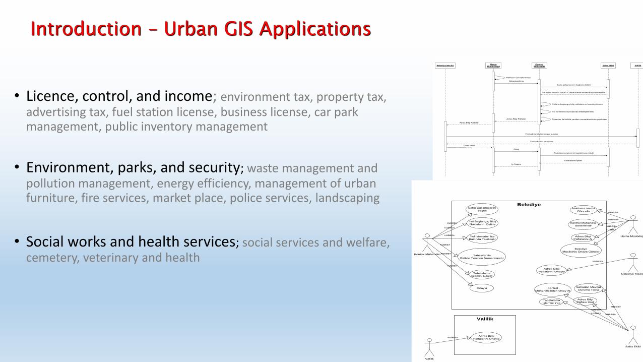
• Licence, control, and income; environment tax, property tax, advertising tax, fuel station license, business license, car park management, public inventory management
• Environment, parks, and security; waste management and pollution management, energy efficiency, management of urban furniture, fire services, market place, police services, landscaping
• Social works and health services; social services and welfare, cemetery, veterinary and health
Belediye Meclisi
Harita Müdürlüğü
Kontrol Mühendisi
Saha Ekibi
Valilik
Halihazır Harita
Güncelle
Kontrol Mühendisi
Görevlendir
Adres Bilgi
Paftalarını Al
Saha Çalışmalarını
Başlat
Yol Başlangıç Bitiş
Noktalarını Belirle
Yol İsimlerini İlçe
Bazında Tekilleştir
Tahsisler ile
Birlikte Yeniden Numaralandır
Sahadan Mevcut
Durumu Topla
Adres Bilgi
Paftası Üret
Kontrol
Mühendisinden Onay Al
Tabelalama
İşlemini Yap
Tabelalama
İşlemini Başlat
Onayla
«uses»
«uses»
«uses»
«uses»
«uses»
«uses»
«uses»
«uses»
«uses»
«uses»
«uses»
«uses»
«uses»
«uses»
«uses»
Belediye
Valilik
«uses»
Adres Bilgi
Paftalarını Onayla
Adres Bilgi
Paftalarını Onayla
Belediye
Meclisinie Onaya Gönder
Harita
MüdürülüğüValilik
Halihazır Güncellenmesi
Kontrol
MühendisiSaha Ekibi
Görevlendirme
Saha çalışmasının başlama talebi
Sahadaki mevcut durum. Cadde/Sokak isimleri Kapı Numaraları
Yolların başlangıç bitiş noktalarının kesinleştirilmesi
Yol isimlerinin ilçe bazında tekilleştirilmesi
Tahsisler ile birlikte yeniden numaralandırma yapılması
Belediye Meclisi
Adres Bilgi Paftaları
Onay Verilir
Yeni adres bilgileri onaya sunulur
Yeni adresler onaylanır
Tabelalama işleminin başlatılması isteği
İş Teslimi
Adres Bilgi Paftaları
Onay
Tabelalama İşlemi
Introduction – Urban GIS Applications
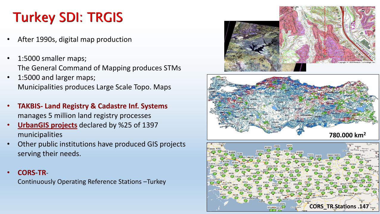
• After 1990s, digital map production
• 1:5000 smaller maps; The General Command of Mapping produces STMs
• 1:5000 and larger maps; Municipalities produces Large Scale Topo. Maps
• TAKBIS- Land Registry & Cadastre Inf. Systems manages 5 million land registry processes
• UrbanGIS projects declared by %25 of 1397 municipalities
• Other public institutions have produced GIS projects serving their needs.
• CORS-TR- Continuously Operating Reference Stations –Turkey
780.000 km2
CORS_TR Stations .147
Turkey SDI: TRGIS
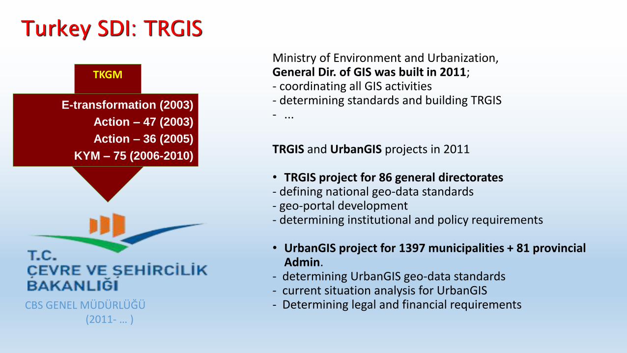
TKGM
E-transformation (2003)
Action – 47 (2003)
Action – 36 (2005)
KYM – 75 (2006-2010)
CBS GENEL MÜDÜRLÜĞÜ (2011- … )
Ministry of Environment and Urbanization, General Dir. of GIS was built in 2011; - coordinating all GIS activities - determining standards and building TRGIS - ...
TRGIS and UrbanGIS projects in 2011 • TRGIS project for 86 general directorates - defining national geo-data standards - geo-portal development - determining institutional and policy requirements • UrbanGIS project for 1397 municipalities + 81 provincial
Admin. - determining UrbanGIS geo-data standards - current situation analysis for UrbanGIS - Determining legal and financial requirements
Turkey SDI: TRGIS
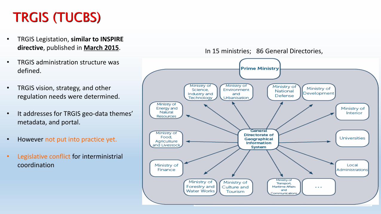
• TRGIS Legistation, similar to INSPIRE directive, published in March 2015.
• TRGIS administration structure was defined.
• TRGIS vision, strategy, and other
regulation needs were determined.
• It addresses for TRGIS geo-data themes’ metadata, and portal.
• However not put into practice yet.
• Legislative conflict for interministrial
coordination
In 15 ministries; 86 General Directories,
TRGIS (TUCBS)
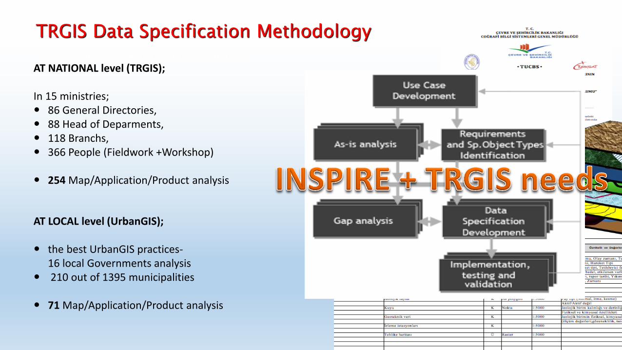
AT NATIONAL level (TRGIS); In 15 ministries; 86 General Directories, 88 Head of Deparments, 118 Branchs, 366 People (Fieldwork +Workshop) 254 Map/Application/Product analysis
AT LOCAL level (UrbanGIS); the best UrbanGIS practices-
16 local Governments analysis 210 out of 1395 municipalities
71 Map/Application/Product analysis
Data requirement and institutional analysis
TRGIS Data Specification Methodology
TRGIS Data Specification Methodology
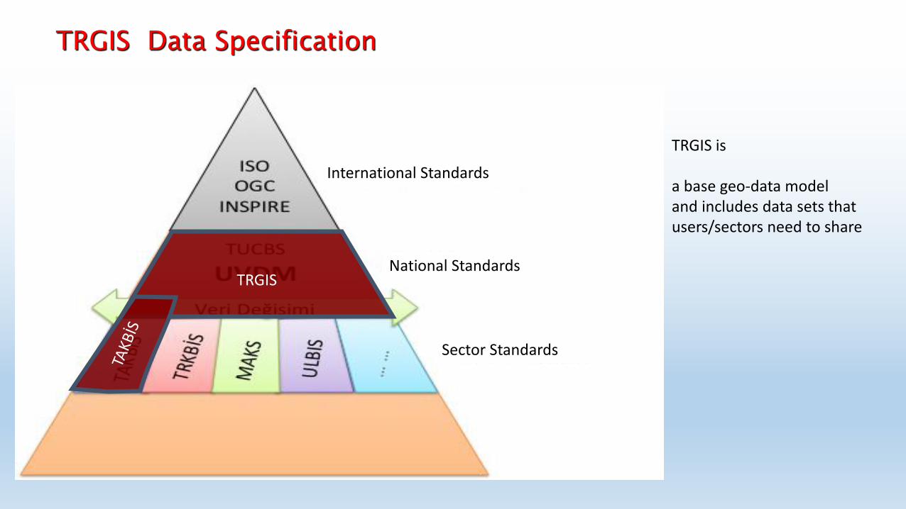
TRGIS is a base geo-data model and includes data sets that users/sectors need to share
TRGIS Data Specification
TRGIS
International Standards
National Standards
Sector Standards
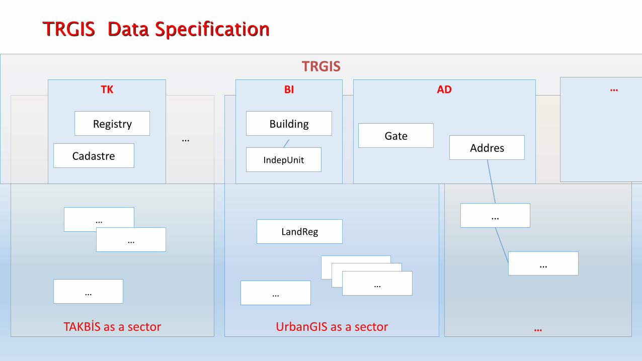
TAKBİS as a sector
TRGIS
UrbanGIS as a sector …
AD BI TK
… … Gate Addres
Building
… …
…
Cadastre IndepUnit
Registry
LandReg
… …
… …
…
…
…
TRGIS Data Specification
Geo. Reference System Geo. Grid System Temel/Sıklaştırma Ağları
Geodesy JD
Lake / Pond River Sea/ regions
HI Hydrography
Fizyografya/Hipsografya Digital elevation Bathymetry Coastline
TO Topography
Land Cover / Use
Land Cover AR
Administrative Units Institutional Regions
IB Admin. Unit
Land registry/Cadastre TK Cadastre
Road Railroad Seaway Airline Transportation Infrast.
Transportation UL
Jeoloji Jeo-morfoloji Toprak
JF Geology
Bitki Örtüsü Biyocografik Bölgeler Habitat Bölgeleri Türlerin Dağılımı (Bitki/Hayvan)
BI Biovariety
Meteorolojik Hava ve atmosferik durum İklim Bölgeleri
HA Weather/Climate
İçmesuyu Kanalizasyon Haberleşme Doğalgaz Petrol Boru Elektrik Jeo Termal
AL Infrastructure
Bölge Planı Çevre Düzeni Planı İl Çevre Düzeni Planı İmar Planı
PL Plan
Tarihi-Doğal Özel Çevre Koruma Bölg. Askeri Yasak Bölg. Kentsel Koruma Bölg. Havza Bölg.
YA Protected/Rest.
Ekosistem Kaynakları Su Kaynakları Tarımsal/ToprakKaynaklarıOrman Kaynakları Balıkçılık Kaynakları Jeolojik Kaynaklar Yenil. Enerji Kaynakları
DO Natural Resources
Kentsel ve Kırsal Yerleşim Nüfus Dağılımı /Demografi Turizm Varlıkları Kültür Varlıkları İnsan Sağlığı ve Güvenliği
SO Social/Culture
BA
SE D
ATA
TH
EMES
THEM
ATIC
DAT
A T
HEM
ES
Orthophoto Satellite Images
Ortophoto OR
Adres Yer İsimleri Numarataj
AD Address
Building Public/Agri./Indust. Serv. Commercial Services
BI Building TRGIS Data Specification
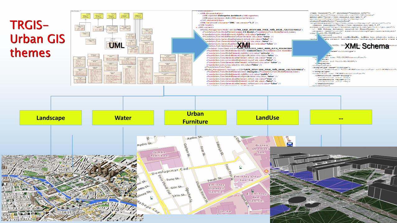
Base data themes were designed and accepted in 2011.
Conceptual Model Components for - the development of data standards and - interoperability of geo- data sets
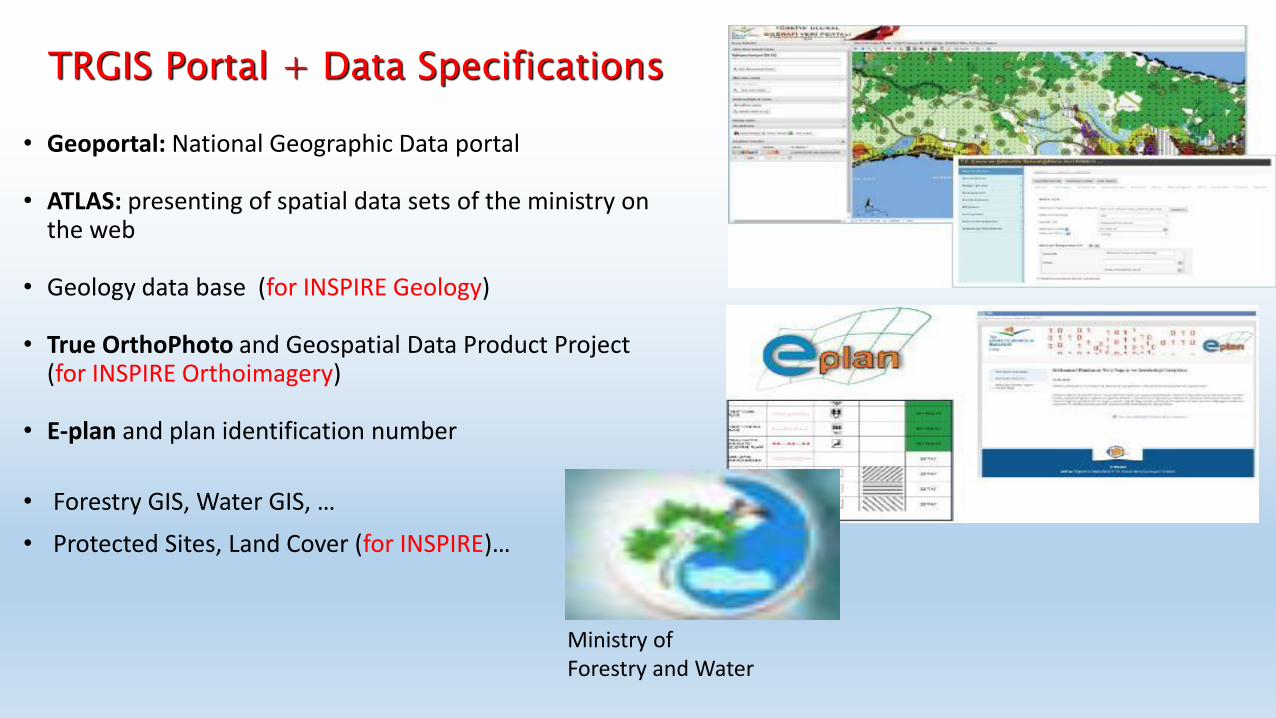
• Geoportal: National Geographic Data portal
• ATLAS: presenting of spatial data sets of the ministry on
the web • Geology data base (for INSPIRE Geology)
• True OrthoPhoto and Geospatial Data Product Project
(for INSPIRE Orthoimagery) • E-plan and plan identification number
• Forestry GIS, Water GIS, …
• Protected Sites, Land Cover (for INSPIRE)…
TRGIS Portal + Data Specifications
Ministry of Forestry and Water
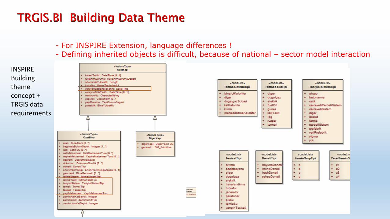
TRGIS.BI Building Data Theme
INSPIRE Building theme concept + TRGIS data requirements
- For INSPIRE Extension, language differences ! - Defining inherited objects is difficult, because of national – sector model interaction
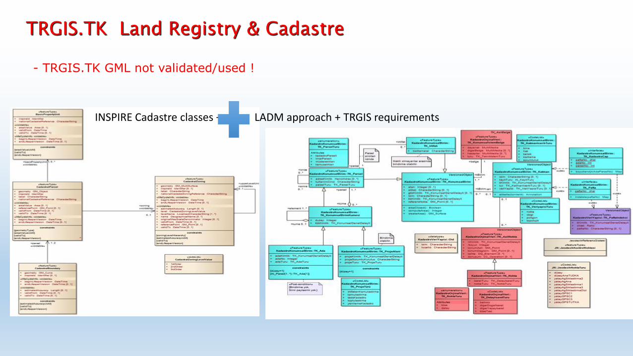
TRGIS.TK Land Registry & Cadastre
INSPIRE Cadastre classes + LADM approach + TRGIS requirements
- TRGIS.TK GML not validated/used !
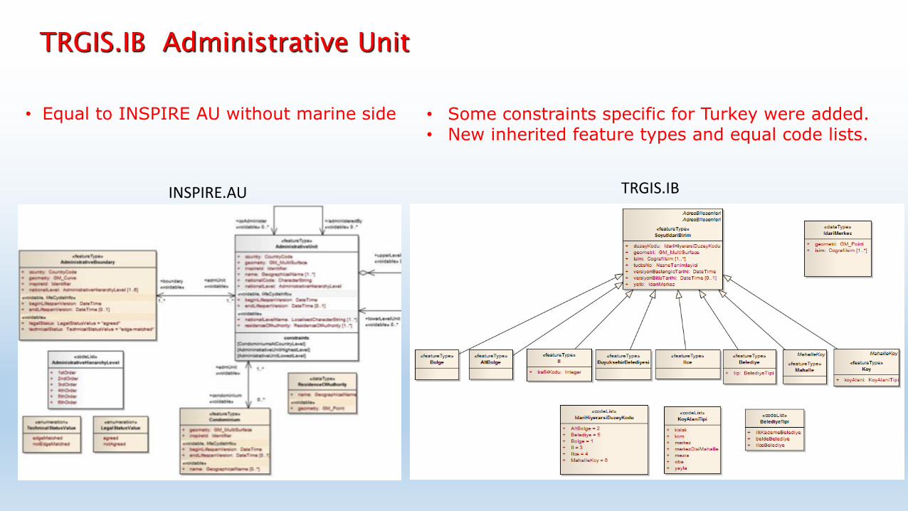
• Equal to INSPIRE AU without marine side
TRGIS.IB Administrative Unit
INSPIRE.AU
• Some constraints specific for Turkey were added. • New inherited feature types and equal code lists.
INSPIRE.AU TRGIS.IB
TUCBS:BI
TUCBS:TK TUCBS:ID TUCBS:UL
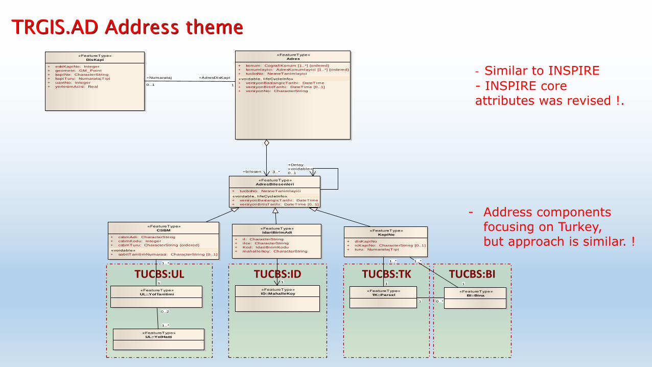
class Capraz Iliski
«FeatureType»
Adres
+ konum: CografiKonum [1..*] {ordered}
+ konumlayici: AdresKonumlayici [1..*] {ordered}
+ tucbsNo: NesneTanimlayici
«voidable, l ifeCycleInfo»
+ versiyonBaslangicTarihi: DateTime
+ versiyonBitisTarihi: DateTime [0..1]
+ versiyonNo: CharacterString
«FeatureType»
DisKapi
+ eskiKapiNo: Integer
+ geometri: GM_Point
+ kapiNo: CharacterString
+ kapiTuru: NumaratajTipi
+ uavtNo: Integer
+ yerlesimAcisi: Real
«FeatureType»
AdresBilesenleri
+ tucbsNo: NesneTanimlayici
«voidable, l ifeCycleInfo»
+ versiyonBaslangicTarihi: DateTime
+ versiyonBitisTarihi: DateTime [0..1]
«FeatureType»
CSBM
+ csbmAdi: CharacterString
+ csbmKodu: Integer
+ csbmTuru: CharacterString {ordered}
«voidable»
+ sabitTanitimNumarasi: CharacterString [0..1]
«FeatureType»
IdariBirimAdi
+ il: CharacterString
+ ilce: CharacterString
+ Kod: IdariBirimKodu
+ mahalle/koy: CharacterString
«FeatureType»
KapiNo
+ disKapiNo
+ icKapiNo: CharacterString [0..1]
+ turu: NumaratajTipi
«FeatureType»
ID::MahalleKoy
«FeatureType»
UL::YolHatti
«FeatureType»
UL::YolTanitimi«FeatureType»
TK::Parsel«FeatureType»
BI::Bina
+Numarataj
0..1
+AdresDisKapi
1
+bilesen 3..*
1 0..*
+Detay
«voidable»
0..1
1
1..*
1
1..*
1
0..2
1..*
1..*
1
TRGIS.AD Address theme
- Similar to INSPIRE
- INSPIRE core attributes was revised !.
- Address components focusing on Turkey, but approach is similar. !
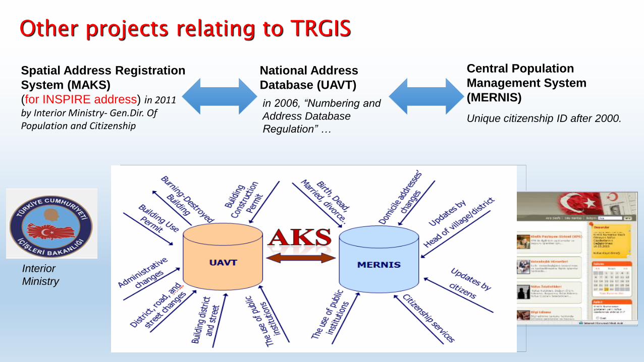
Spatial Address Registration
System (MAKS)
(for INSPIRE address) in 2011 by Interior Ministry- Gen.Dir. Of Population and Citizenship
Central Population
Management System
(MERNIS)
Unique citizenship ID after 2000.
Other projects relating to TRGIS
Interior
Ministry
National Address
Database (UAVT)
in 2006, “Numbering and
Address Database
Regulation” …
7
2. 3D CITY MODELLING
Nowadays it is possible to create 3D city models at a reasonable cost due to the rapid
development of computer hardware, and possibility of data acquisition from stereo
aerial images. This development has increased several application of three
dimensional spatial information in a variety of fields including urban planning,
telecommunications, ecology, tourism and entertainment [5].
A common understanding is that every 3D city model consists of a digital elevation
model with ground height and 3D building data with building heights. Usually a 3D
city model represents an existing city but in some applications, especially in gaming
and entertainment, it may have no counterpart in the real world [5]. For instance, in
the virtual 3D City Model of Berlin (Fig.2.1) several data sources has been used such
as cadastral data, digital terrain model, aerial image, building models and different
variants of city object colections [6].
Figure 2.1 : A view from 3D City Model of Berlin [6].
kentBIS_nesne
Landscape Water Urban
Furniture LandUse …
International Journal of Geographical Information Science 11
Figure 2. Triangulated terrain integrated with IMGeo objects (Emgård and Zlatanova 2008).
Figure 3. Example of the employed 2.5D topological principle (Oude Elberink and Vosselman2009).
Another Dutch data set, that is, the 2.5D topographical data set of Rijkswaterstaat
(DTB), already supports a similar 2.5D topological structure of topography. Examples are
shown in Figure 4 (Rijkswaterstaat 2011). Although this data set shows that such 2.5D
data structures are already in existence and therefore feasible, it does not yet contain
height information within the polygon surfaces, in contrast to the LOD0 representations
of CityGML–IMGeo.
3.2.5. Define the reference system
CityGML–IMGeo uses the Spatial Reference System (SRS) EPSG:7415. This is
a combined SRS of x, y coordinates in the national reference system (called
Dow
nloa
ded
by [I
stan
bul T
echn
ical
Uni
vers
ity] a
t 16:
53 1
1 Ju
ne 2
012
UML XMI XML Schema
TRGIS- Urban GIS themes
A challenging ETL
A simple ETL
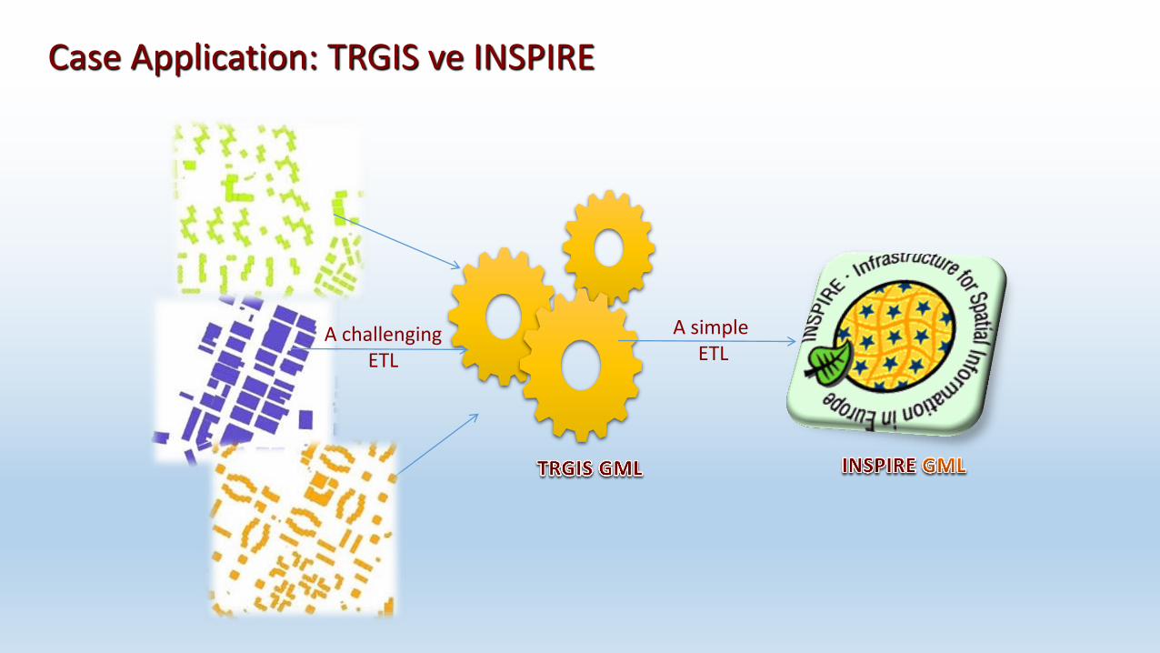
Case Application: TRGIS ve INSPIRE
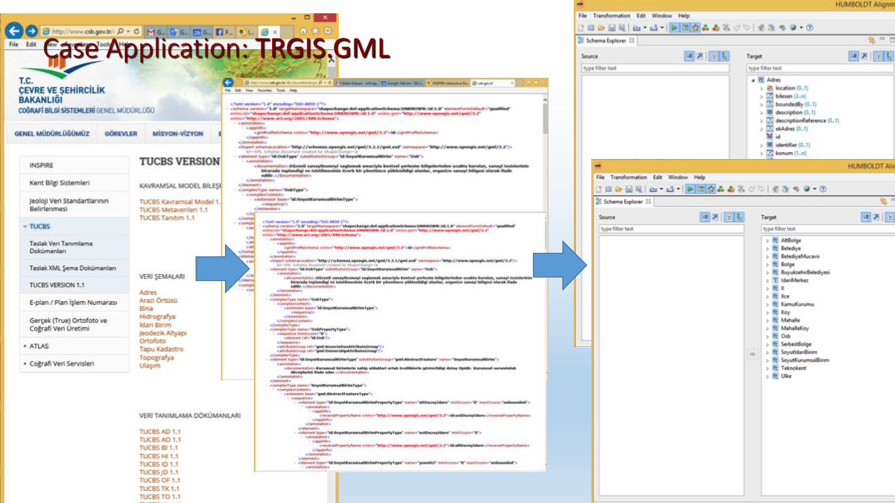
Case Application: TRGIS.GML
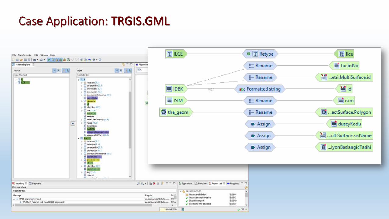
Case Application: TRGIS.GML
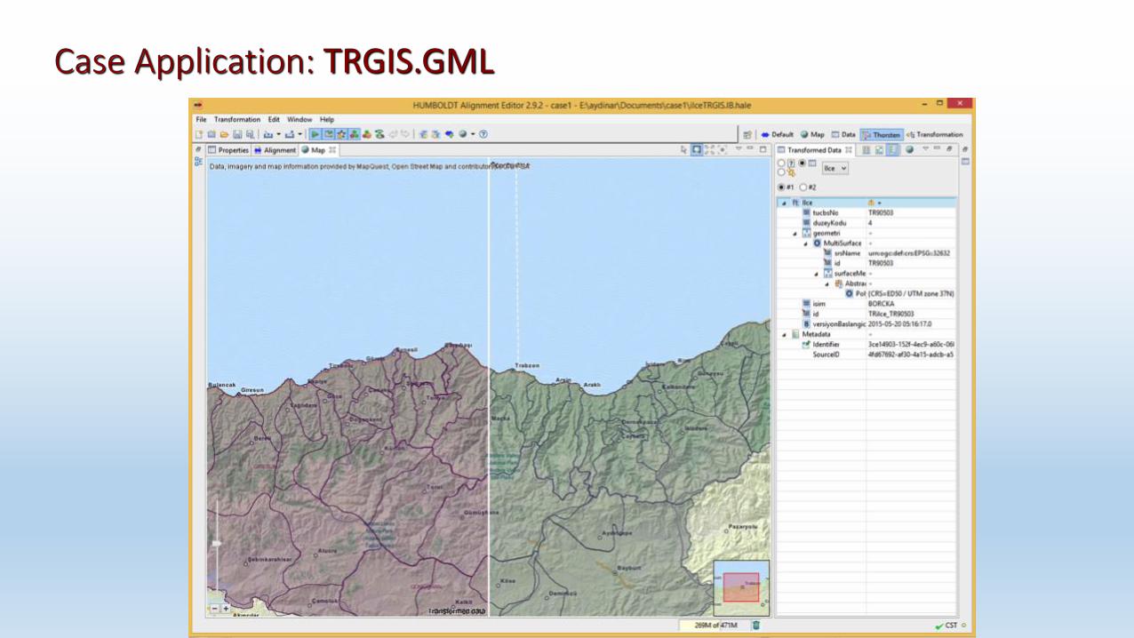
Case Application: TRGIS.GML
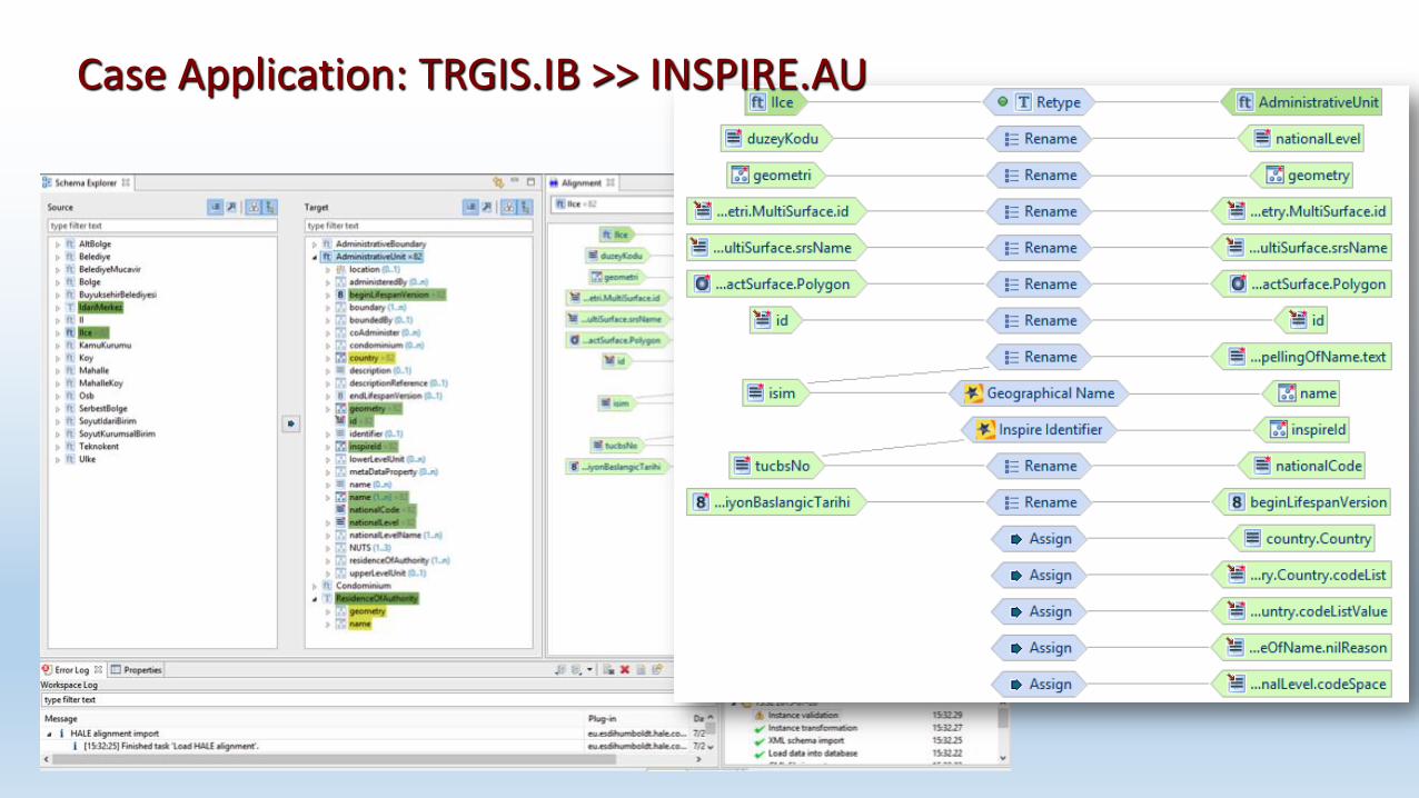
Case Application: TRGIS.IB >> INSPIRE.AU

Case Application: TRGIS.IB and INSPIRE.AU datasets in QGIS
DISCUSSION • TRGIS can be compatible with INSPIRE without extra work,
but data production do not touch application needs.!
• SDI stakeholders are at national, but applications at local level.
• Small municipalities have difficulty for know-how, experience, and sources.
• Well-organized coordination roles should be defıned clearly for SDI stakeholders, encouraging their partnership with the private sector.
• No real Urban GIS standard and implementation directive.
• Regulations for all municipalities, but different needs and capacity in the municipalities.
• Data specification guidelines and detailed cookbook are required to develop data specifications.
• Open data interoperability and data transformation need capacity building activities, because people are familiar with traditional GIS software.
• Best practices for INSPIRE should be presented to data providers as an example.
• To develop data policy, More open data More services.
• User needs and value-added are priorities for INSPIRE.
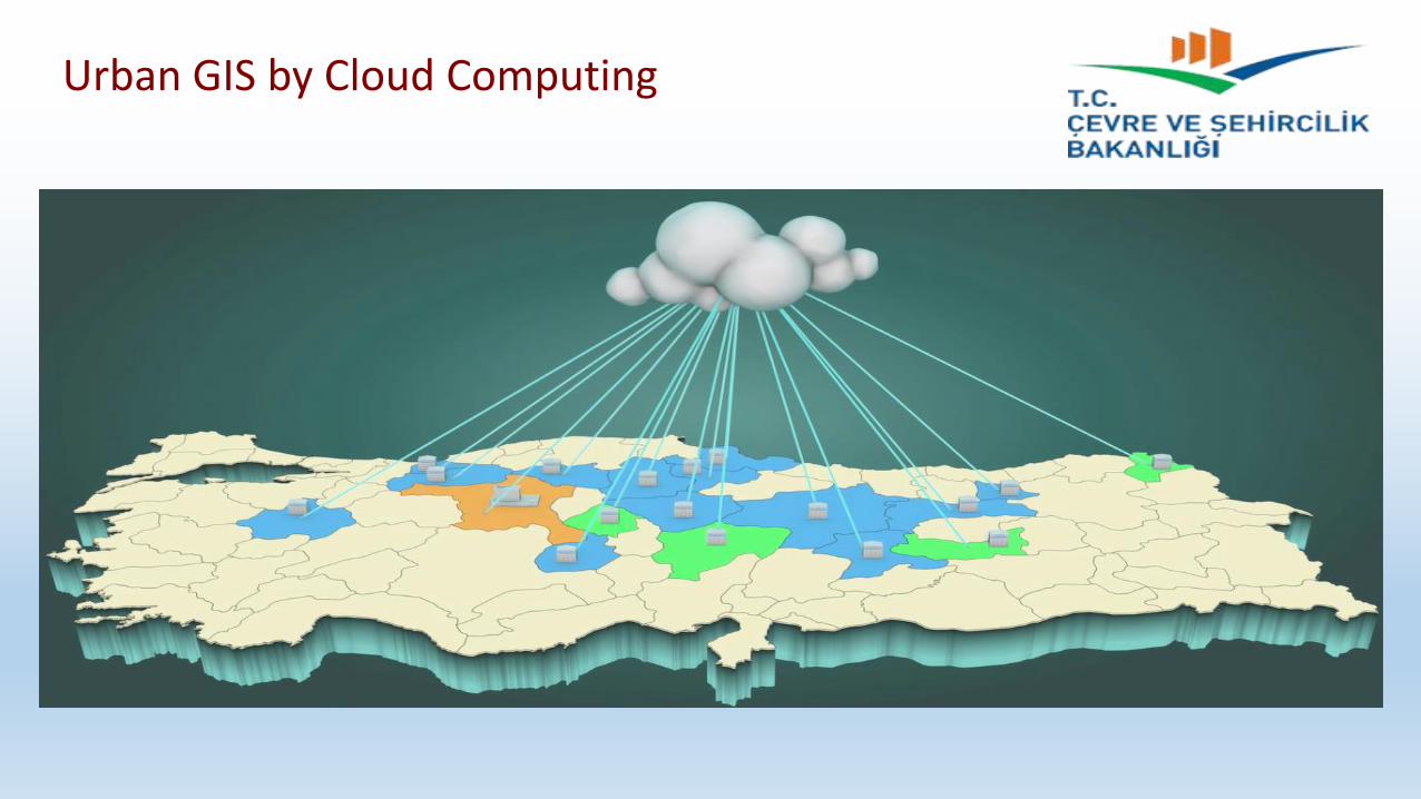
Urban GIS by Cloud Computing

Data Collection Data Preperation Software Development
Urban GIS by Cloud Computing
GIS SDK,
Server/desktop software
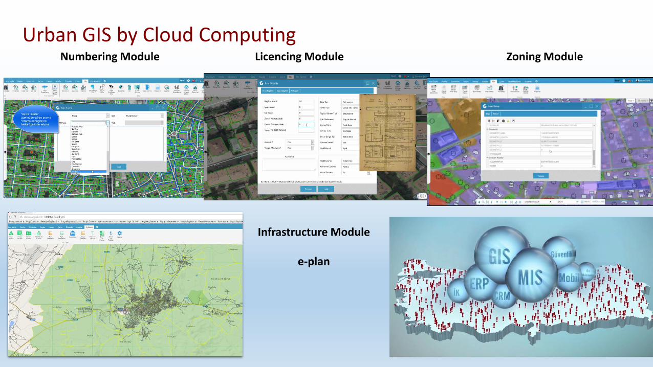
Numbering Module Licencing Module Zoning Module
Infrastructure Module
e-plan
Urban GIS by Cloud Computing

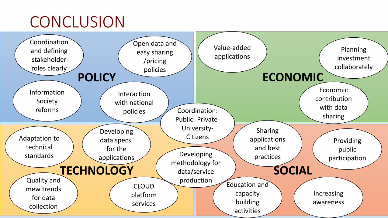
POLICY
TECHNOLOGY
ECONOMIC
SOCIAL
Coordination: Public- Private-
University- Citizens
Open data and easy sharing
/pricing policies
Coordination and defining stakeholder roles clearly
Adaptation to technical standards
Quality and mew trends
for data collection
CLOUD platform services
Information Society reforms
Interaction with national
policies
Value-added applications
Planning investment
collaborately
Providing public
participation
Education and capacity building activities
Increasing awareness
Sharing applications
and best practices
Economic contribution
with data sharing
Developing methodology for
data/service production
Developing data specs.
for the applications
CONCLUSION

Thanks...
Assoc. Prof. Dr. Arif Cagdas AYDINOGLU Gebze Technical University
TURKEY
web: www.arifcagdas.com
e-mail: [email protected]