Embed Size (px)
Citation preview

Scottish MPA Programme
Data confidence assessment
SEA OF THE HEBRIDES POSSIBLE MPA
JUNE 2019
Further information on the Scottish MPA network and protected areas management is available at -
www.scotland.gov.uk/Topics/marine/marine-environment/mpanetwork
For the full range of MPA site documents and more on the fascinating range of marine life to be found in Scotland’s seas, please visit -
www.nature.scot/mpas or www.jncc.defra.gov.uk/scottishmpas
Document version control
Version Date Author Reason / Comments
Version 1 29/01/2014 Laura Clark Revised MPA proposal format, updating MPA search location version (ver. 11 - 14/01/2013).
Version 2 17/02/2014 Morven Carruthers Revised text and mapping, name change.
Version 3-4
26/03/2014-23/04/2014
Morven Carruthers, Suz Henderson & Katie Gillham
Revisions to address comments from SAC and mapping updates.
Version 5 21/07/2014 John Baxter QA review and sign-off.
Version 6 22/07/2014 Katie Gillham Edits to address QA comments.
Version 7 26/03/2015 Ben James & Graham Epstein
Updated into possible MPA format.
Version 8 13/03/2015 John Baxter QA review and sign-off.
Version 9 07/04/2015 Katie Gillham, Ben James and Graham Epstein
Address comments from QA ready for Scientific Advisory Committee.
Version 10 18/09/2018 Sam Black & Katie Gillham
Review and Update.
Version 11 21/09/2018 Ben James QA Review.
Version 12 27/09/2018 Sam Black Refinements in response to initial QA review. Finalisation for SNH Scientific Advisory Committee.
Version 13 17/10/2018 Sam Black and Katie Gillham
Review and Update.
Version 14 17/10/2018 Ben James QA Review.
Version 15 18/10/2018 Sam Black and Katie Gillham
Refinement in response to initial QA review. Finalisation for SNH Senior Leadership Team review.
Version 16 02/11/2018 Sam Black Finalisation for SNH Protected Areas Committee.
Version 17 05/04/2019 Sam Black, Sarah Cunningham
Updating scale bar on adjusted density maps for minke whale and basking shark following SAC comments. Final review of text.
Distribution list
Format Version Issue date Issued to
Electronic SL11 14/01/2013 SNH web publication [B1149441 / 28(#49)]
Electronic 2 17/02/2014 SNH SAC MPA Sub-group
Electronic 5 23/07/2014 Marine Scotland officials

Electronic 6 24/07/2014 SNH web publication [A1185177 / 21(#26)]
Electronic 9 13/04/2015 SNH SAC MPA Sub-group
Electronic 9 16/11/2015 SNH web publication [A1581182 / 7(#11)]
Electronic 10 20/09/2018 Ben James
Electronic 11 27/09/2018 Sally Thomas
Electronic 11 28/09/2018 SNH Scientific Advisory Committee
Electronic 14 18/10/2018 Sally Thomas (SLT)
Electronic 15 02/11/2018 SNH Protected Areas Committee
Electronic 17 05/04/2019 Marine Scotland officials.
SEA OF THE HEBRIDES POSSIBLE MPA - DATA CONFIDENCE ASSESSMENT
1
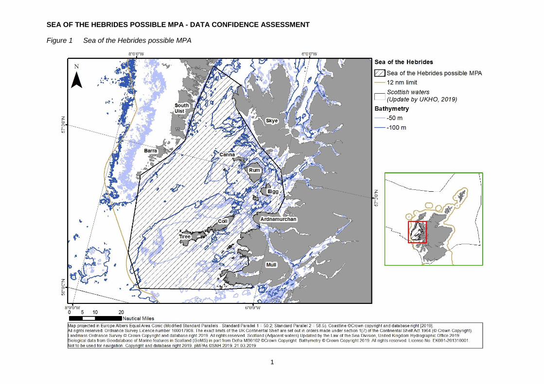
Figure 1 Sea of the Hebrides possible MPA
SEA OF THE HEBRIDES POSSIBLE MPA - DATA CONFIDENCE ASSESSMENT
2
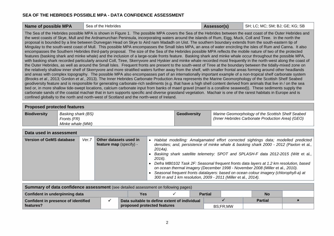
Name of possible MPA Sea of the Hebrides Assessor(s) SH; LC; MC; SM; BJ; GE; KG; SB
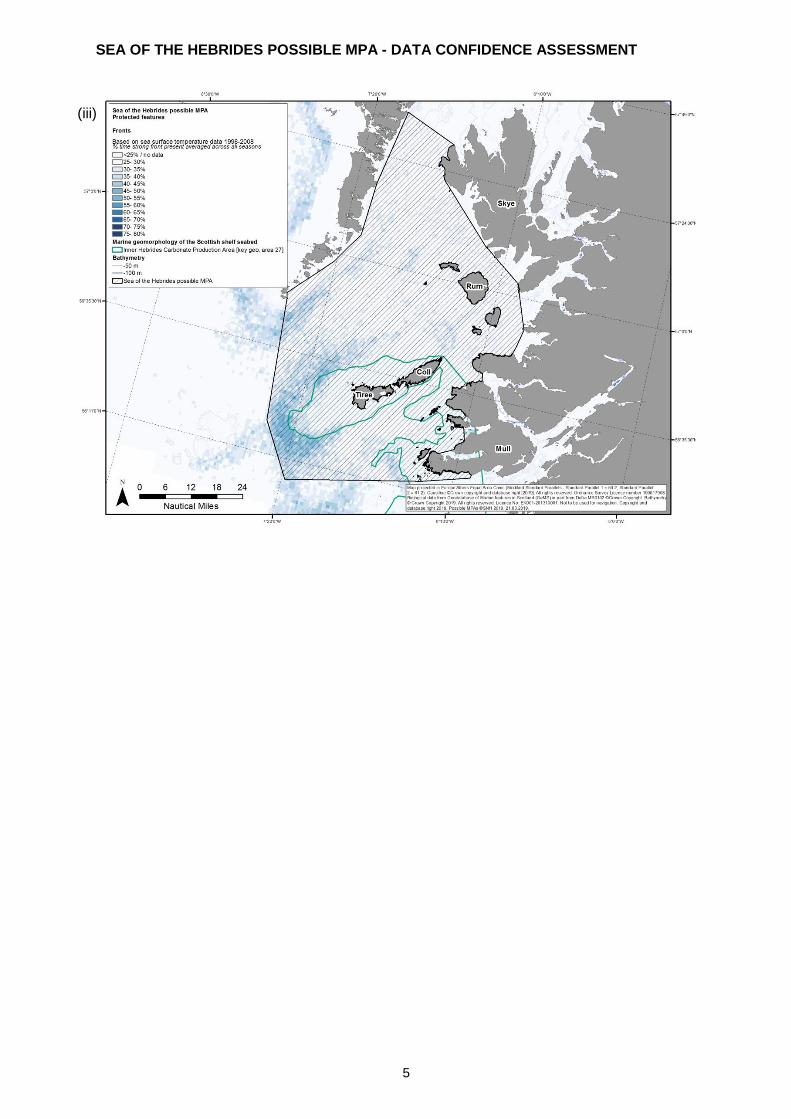
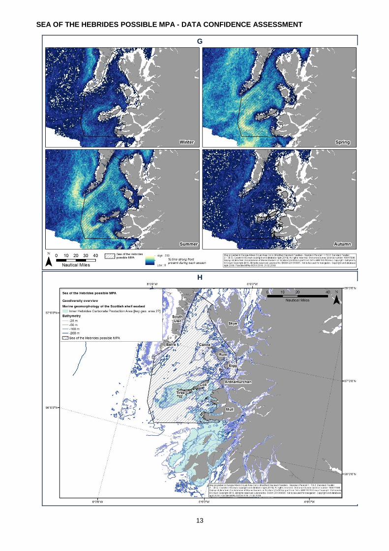
The Sea of the Hebrides possible MPA is shown in Figure 1. The possible MPA covers the Sea of the Hebrides between the east coast of the Outer Hebrides and the west coasts of Skye, Mull and the Ardnamurchan Peninsula, incorporating waters around the islands of Rum, Eigg, Muck, Coll and Tiree. In the north the proposal is bounded by a line between Dunvegan Head on Skye to Aird nam Madadh on Uist. The southern boundary extends from the south-eastern tip of Mingulay to the south-west coast of Mull. This possible MPA encompasses the Small Isles MPA, an area of water encircling the isles of Rum and Canna. It also encompasses the Southern Hebrides third-party proposal. The size of the Sea of the Hebrides possible MPA reflects the mobile nature of two of the protected features (basking shark and minke whale) and the inclusion of a large-scale fronts feature. Basking shark and minke whale occur throughout the possible MPA, with basking shark recorded particularly around Coll, Tiree, Skerryvore and Hyskier and minke whale recorded most frequently in the north-west along the coast of the Outer Hebrides, as well as around the Small Isles. Frequent fronts are present to the south-west of Tiree at the boundary between the tidally-mixed zone on the relatively shallow inner shelf of Skerryvore and more stratified waters further away from the shelf, with smaller frontal areas forming around other headlands and areas with complex topography. The possible MPA also encompasses part of an internationally important example of a non-tropical shelf carbonate system (Brooks et al., 2013; Gordon et al., 2013). The Inner Hebrides Carbonate Production Area represents the Marine Geomorphology of the Scottish Shelf Seabed geodiversity feature and is responsible for generating carbonate-rich sediments (e.g. that have a high shell content derived from animals that live in / on the sea bed or, in more shallow tide-swept locations, calcium carbonate input from banks of maerl gravel (maerl is a coralline seaweed)). These sediments supply the carbonate sands of the coastal machair that in turn supports specific and diverse grassland vegetation. Machair is one of the rarest habitats in Europe and is confined globally to the north and north-west of Scotland and the north-west of Ireland.
Proposed protected features
Biodiversity Basking shark (BS)
Fronts (FR)
Minke whale (MW)
Geodiversity Marine Geomorphology of the Scottish Shelf Seabed (Inner Hebrides Carbonate Production Area) (GEO)
Data used in assessment
Version of GeMS database Ver.7 Other datasets used in feature map (specify) -
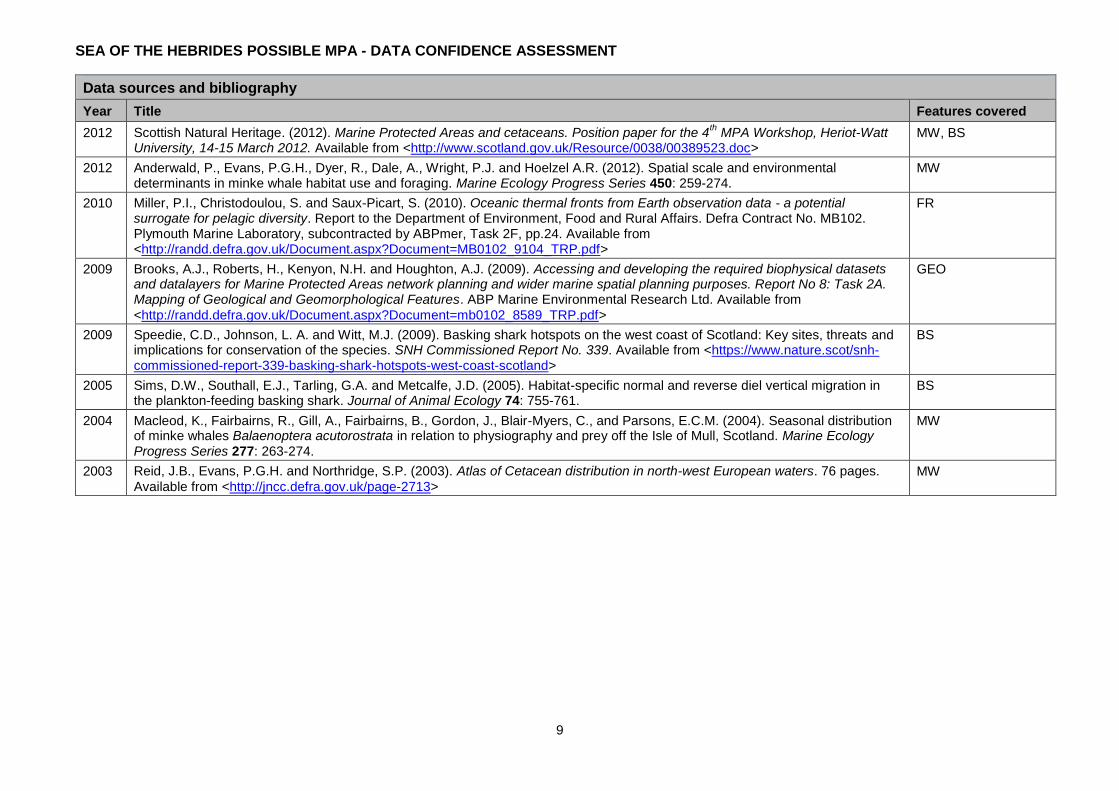
Habitat modelling: Amalgamated effort corrected sightings data; modelled predicted densities; and, persistence of minke whale & basking shark 2000 - 2012 (Paxton et al., 2014a).
Basking shark satellite telemetry: SPOT and SPLASH-F data 2012-2015 (Witt et al., 2016).
Defra MB0102 Task 2F: Seasonal frequent fronts data layers at 1.2 km resolution, based on ocean thermal imagery (December 1998 - November 2008 (Miller et al., 2010).
Seasonal frequent fronts datalayers: based on ocean colour imagery (chlorophyll-a) at 300 m and 1 km resolution, 2009 - 2011 (Miller et al., 2014).
Summary of data confidence assessment (see detailed assessment on following pages)
Confident in underpinning data Yes Partial No
Confident in presence of identified features?
Data suitable to define extent of individual proposed protected features
Partial
BS;FR;MW
SEA OF THE HEBRIDES POSSIBLE MPA - DATA CONFIDENCE ASSESSMENT
3
Summary of data confidence assessment (see detailed assessment on following pages)
Summary We are confident in the presence of the proposed protected features within the possible MPA and the underpinning data. The data on these features are shown in Figures 2i - iii overleaf.
Frequent front maps derived from satellite ocean thermal imagery have been used to assess the presence and distribution of seasonal fronts within the possible MPA and highlight the presence of a strong front in the area to the south-west of Tiree. Simplified tidal mixing maps (based on depth and tidal speeds) similarly highlight regions of strong mixing around headlands or in areas with complex topography, and areas of increased stratification further offshore, with fronts forming at the boundaries (Miller et al., 2010; 2014).
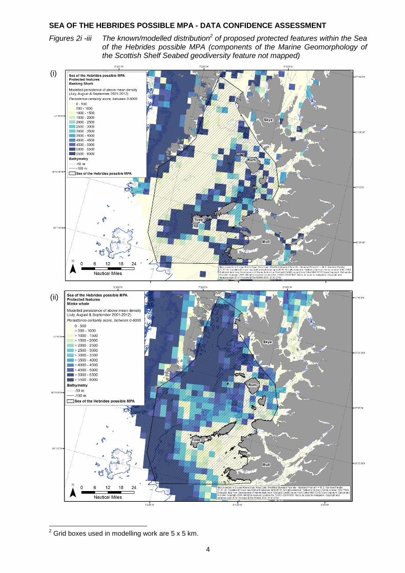
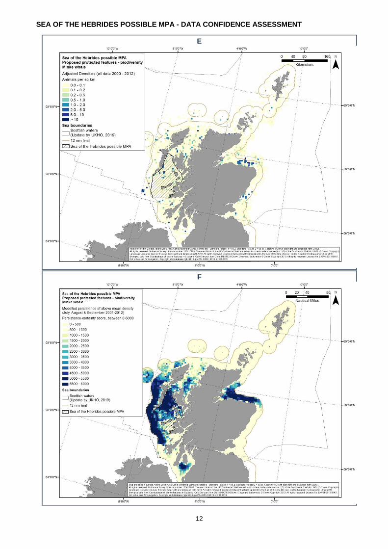
For both minke whale and basking shark, there is high confidence in the presence of the features based on effort-corrected sightings data collated for the Joint Cetacean Protocol (JCP)
1 and analysed by Paxton et al. (2014a) as part of spatial modelling undertaken to inform the
Scottish MPA Programme. The spatial modelling used survey data (2000 - 2012) from 23 distinct datasets and includes data (up to 2012) from Hebridean Whale and Dolphin Trust (HWDT) that runs a series of surveys throughout summer on the west coast, including in the area of the possible MPA. It also includes data available from Wave Action/The Wildlife Trust basking shark project that had a study area overlapping the possible MPA. For minke whale, the spatial models particularly highlight an area in the north-west of the possible MPA, predicting that it supports persistently higher than average densities of the species. These predictions are backed up by effort corrected data that indicate that minke whales are observed seasonally throughout the possible MPA, but particularly frequently in the north and west. Basking sharks are predicted to occur consistently at higher than average densities in the south and east of the possible MPA, particularly around Coll and Tiree. Again, these predictions are backed up by effort-corrected sightings data. For both species, the analyses used data from spring, summer and autumn, as very limited records of minke whale and basking shark are available for winter months in Scottish waters. This is partly a result of surveys being targeted at times when weather is less likely to be a limiting factor but also linked to seasonal changes in distribution of the species, both of which are recorded in the possible MPA most frequently during summer months.
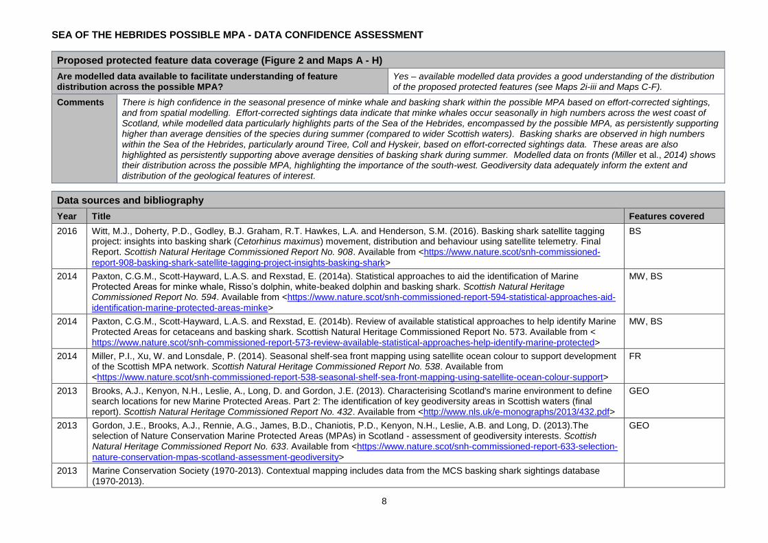
For basking sharks, there are also data available from an SNH-commissioned basking shark tagging research project (July 2012 - 2014) in partnership with the University of Exeter (Witt et al., 2016). SPOT (Smart Position Only Tag) and SPLASH-F data indicate that all 33 basking sharks (8 sharks in 2012, 15 sharks in 2013, 10 sharks in 2014) tagged with these devices showed a degree of site fidelity within the possible MPA, particularly around the areas of SW Tiree, Gunna Sound and Hyskeir during the months of July, August and September.
1 While basking sharks were not included in the JCP, in many cases this species had been recorded by JCP data providers and so the relevant datasets were
included by Paxton et al. (2014a) in the spatial modelling undertaken to inform the Scottish MPA Programme.
SEA OF THE HEBRIDES POSSIBLE MPA - DATA CONFIDENCE ASSESSMENT
4
Figures 2i -iii The known/modelled distribution2 of proposed protected features within the Sea of the Hebrides possible MPA (components of the Marine Geomorphology of the Scottish Shelf Seabed geodiversity feature not mapped)
2 Grid boxes used in modelling work are 5 x 5 km.
(i)
(ii)
SEA OF THE HEBRIDES POSSIBLE MPA - DATA CONFIDENCE ASSESSMENT
5
(iii)
SEA OF THE HEBRIDES POSSIBLE MPA - DATA CONFIDENCE ASSESSMENT
6
Data confidence assessment Our assessment of data confidence is based on consideration of the age and sources of the data, sampling methods used and overall coverage across the possible MPA (see also Maps A - H). Existing protected areas are shown on Map J.
Age of proposed protected feature data (Figure 2 and Maps A - H)
Number of records collected within last 6 years
Many BS;FR;MW
Number of records collected 6-12 years ago
Many BS;FR;MW
Number of records >12 years old Few BS;MW
Comments The age of the proposed protected feature data in the possible MPA vary, with many records from the last 6 years, as well as from 6 - 12 and >12 years ago. Ocean thermal imagery was used to determine the presence and distribution of seasonal frontal systems in a study which used data from between December 1998 and November 2008 (Miller et al., 2010; 2014).
Data for minke whale and basking shark comprise datasets collated for the Joint Cetacean Protocol (JCP) and additional datasets, as analysed by Paxton et al. (2014a) as part of spatial modelling undertaken to inform the MPA project. Twenty-three distinct datasets (with records from between 2000 - 2012) were used to inform the analysis, including HWDT data (2002 - 2012) and data from Wave Action/The Wildlife Trust basking shark project data (2003 - 2006). The basking shark tagging research project has data from July 2012 - 2015 (Witt et al., 2016).
Source of proposed protected feature data (Figure 2 and Maps A - H)
Targeted data collection for nature conservation purposes
Statutory monitoring (marine licensing etc.)
Fisheries survey work
Data collection associated with development proposals (EIA etc.)
Recreational / volunteer data collection Other (specify) -
Comments Minke whale and basking shark data comprise datasets collated for the Joint Cetacean Protocol (JCP) and additional datasets, as analysed by Paxton et al. (2014a) as part of spatial modelling undertaken to inform the MPA programme. The analysis used 23 different datasets including: the SCANS & SCANS-II projects coordinated by the Sea Mammal Research Unit; the European Seabirds at Sea studies coordinated by the Joint Nature Conservation Committee; University of Aberdeen data; and data from Sea Watch Foundation, The Wildlife Trust and Hebridean Whale and Dolphin Trust surveys (the former led by Colin Speedie from Wave Action) from various different projects including data collected by volunteers. The full list of datasets used in the analysis is described in Paxton et al. (2014a & b). A joint research project between SNH and the University of Exeter collected data on basking shark movements using satellite telemetry between 2012 and 2015 (Witt et al., 2016). Data on fronts were collated and analysed as part of a Defra-led contract to map frequent thermal fronts based on satellite derived ocean thermal imagery (Miller et al., 2010; 2014). The geodiversity features were derived through the same Defra-led data collation project (Brooks et al., 2009) with the key geodiversity areas subsequently identified through an SNH and JNCC commissioned desk-based review (Brooks et al., 2013).
SEA OF THE HEBRIDES POSSIBLE MPA - DATA CONFIDENCE ASSESSMENT
7
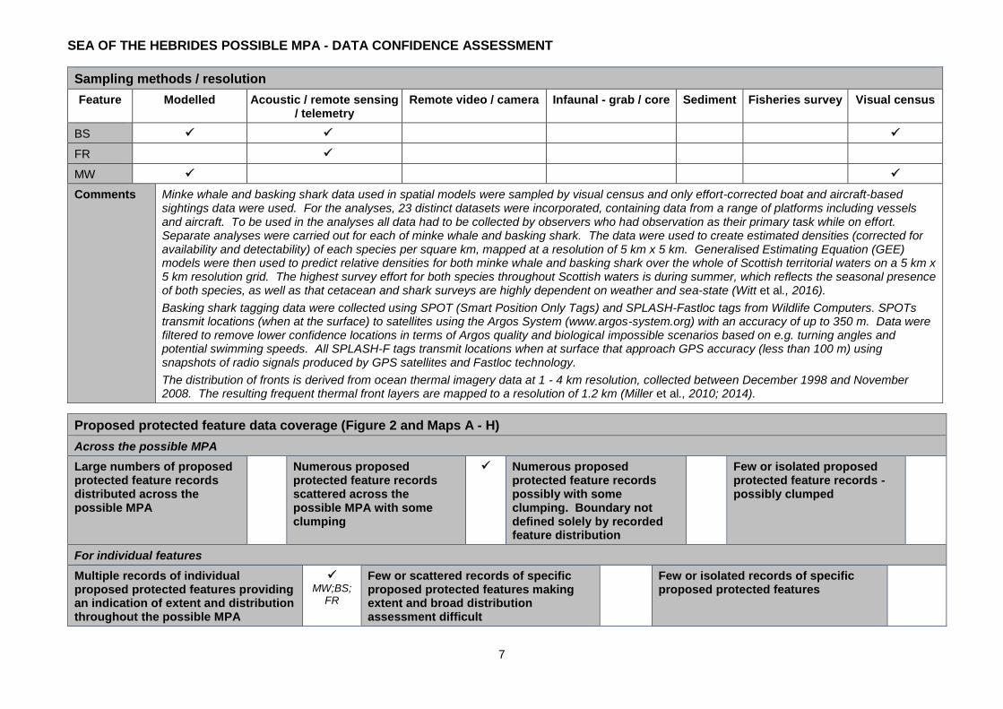
Sampling methods / resolution
Feature Modelled Acoustic / remote sensing / telemetry
Remote video / camera Infaunal - grab / core Sediment Fisheries survey Visual census
BS
FR
MW
Comments Minke whale and basking shark data used in spatial models were sampled by visual census and only effort-corrected boat and aircraft-based sightings data were used. For the analyses, 23 distinct datasets were incorporated, containing data from a range of platforms including vessels and aircraft. To be used in the analyses all data had to be collected by observers who had observation as their primary task while on effort. Separate analyses were carried out for each of minke whale and basking shark. The data were used to create estimated densities (corrected for availability and detectability) of each species per square km, mapped at a resolution of 5 km x 5 km. Generalised Estimating Equation (GEE) models were then used to predict relative densities for both minke whale and basking shark over the whole of Scottish territorial waters on a 5 km x 5 km resolution grid. The highest survey effort for both species throughout Scottish waters is during summer, which reflects the seasonal presence of both species, as well as that cetacean and shark surveys are highly dependent on weather and sea-state (Witt et al., 2016).
Basking shark tagging data were collected using SPOT (Smart Position Only Tags) and SPLASH-Fastloc tags from Wildlife Computers. SPOTs transmit locations (when at the surface) to satellites using the Argos System (www.argos-system.org) with an accuracy of up to 350 m. Data were filtered to remove lower confidence locations in terms of Argos quality and biological impossible scenarios based on e.g. turning angles and potential swimming speeds. All SPLASH-F tags transmit locations when at surface that approach GPS accuracy (less than 100 m) using snapshots of radio signals produced by GPS satellites and Fastloc technology.
The distribution of fronts is derived from ocean thermal imagery data at 1 - 4 km resolution, collected between December 1998 and November 2008. The resulting frequent thermal front layers are mapped to a resolution of 1.2 km (Miller et al., 2010; 2014).
Proposed protected feature data coverage (Figure 2 and Maps A - H)
Across the possible MPA
Large numbers of proposed protected feature records distributed across the possible MPA
Numerous proposed protected feature records scattered across the possible MPA with some clumping
Numerous proposed protected feature records possibly with some clumping. Boundary not defined solely by recorded feature distribution
Few or isolated proposed protected feature records - possibly clumped
For individual features
Multiple records of individual proposed protected features providing an indication of extent and distribution throughout the possible MPA
MW;BS;
FR
Few or scattered records of specific proposed protected features making extent and broad distribution assessment difficult
Few or isolated records of specific proposed protected features
SEA OF THE HEBRIDES POSSIBLE MPA - DATA CONFIDENCE ASSESSMENT
8
Proposed protected feature data coverage (Figure 2 and Maps A - H)
Are modelled data available to facilitate understanding of feature distribution across the possible MPA?
Yes – available modelled data provides a good understanding of the distribution of the proposed protected features (see Maps 2i-iii and Maps C-F).
Comments There is high confidence in the seasonal presence of minke whale and basking shark within the possible MPA based on effort-corrected sightings, and from spatial modelling. Effort-corrected sightings data indicate that minke whales occur seasonally in high numbers across the west coast of Scotland, while modelled data particularly highlights parts of the Sea of the Hebrides, encompassed by the possible MPA, as persistently supporting higher than average densities of the species during summer (compared to wider Scottish waters). Basking sharks are observed in high numbers within the Sea of the Hebrides, particularly around Tiree, Coll and Hyskeir, based on effort-corrected sightings data. These areas are also highlighted as persistently supporting above average densities of basking shark during summer. Modelled data on fronts (Miller et al., 2014) shows their distribution across the possible MPA, highlighting the importance of the south-west. Geodiversity data adequately inform the extent and distribution of the geological features of interest.
Data sources and bibliography
Year Title Features covered
2016 Witt, M.J., Doherty, P.D., Godley, B.J. Graham, R.T. Hawkes, L.A. and Henderson, S.M. (2016). Basking shark satellite tagging project: insights into basking shark (Cetorhinus maximus) movement, distribution and behaviour using satellite telemetry. Final Report. Scottish Natural Heritage Commissioned Report No. 908. Available from <https://www.nature.scot/snh-commissioned-
report-908-basking-shark-satellite-tagging-project-insights-basking-shark>
BS
2014 Paxton, C.G.M., Scott-Hayward, L.A.S. and Rexstad, E. (2014a). Statistical approaches to aid the identification of Marine Protected Areas for minke whale, Risso’s dolphin, white-beaked dolphin and basking shark. Scottish Natural Heritage Commissioned Report No. 594. Available from <https://www.nature.scot/snh-commissioned-report-594-statistical-approaches-aid-
identification-marine-protected-areas-minke>
MW, BS
2014 Paxton, C.G.M., Scott-Hayward, L.A.S. and Rexstad, E. (2014b). Review of available statistical approaches to help identify Marine Protected Areas for cetaceans and basking shark. Scottish Natural Heritage Commissioned Report No. 573. Available from < https://www.nature.scot/snh-commissioned-report-573-review-available-statistical-approaches-help-identify-marine-protected>
MW, BS
2014 Miller, P.I., Xu, W. and Lonsdale, P. (2014). Seasonal shelf-sea front mapping using satellite ocean colour to support development of the Scottish MPA network. Scottish Natural Heritage Commissioned Report No. 538. Available from <https://www.nature.scot/snh-commissioned-report-538-seasonal-shelf-sea-front-mapping-using-satellite-ocean-colour-support>
FR
2013 Brooks, A.J., Kenyon, N.H., Leslie, A., Long, D. and Gordon, J.E. (2013). Characterising Scotland's marine environment to define search locations for new Marine Protected Areas. Part 2: The identification of key geodiversity areas in Scottish waters (final report). Scottish Natural Heritage Commissioned Report No. 432. Available from <http://www.nls.uk/e-monographs/2013/432.pdf>
GEO
2013 Gordon, J.E., Brooks, A.J., Rennie, A.G., James, B.D., Chaniotis, P.D., Kenyon, N.H., Leslie, A.B. and Long, D. (2013).The selection of Nature Conservation Marine Protected Areas (MPAs) in Scotland - assessment of geodiversity interests. Scottish Natural Heritage Commissioned Report No. 633. Available from <https://www.nature.scot/snh-commissioned-report-633-selection-
nature-conservation-mpas-scotland-assessment-geodiversity>
GEO
2013 Marine Conservation Society (1970-2013). Contextual mapping includes data from the MCS basking shark sightings database (1970-2013).
SEA OF THE HEBRIDES POSSIBLE MPA - DATA CONFIDENCE ASSESSMENT
9
Data sources and bibliography
Year Title Features covered
2012 Scottish Natural Heritage. (2012). Marine Protected Areas and cetaceans. Position paper for the 4th MPA Workshop, Heriot-Watt
University, 14-15 March 2012. Available from <http://www.scotland.gov.uk/Resource/0038/00389523.doc> MW, BS
2012 Anderwald, P., Evans, P.G.H., Dyer, R., Dale, A., Wright, P.J. and Hoelzel A.R. (2012). Spatial scale and environmental determinants in minke whale habitat use and foraging. Marine Ecology Progress Series 450: 259-274.
MW
2010 Miller, P.I., Christodoulou, S. and Saux-Picart, S. (2010). Oceanic thermal fronts from Earth observation data - a potential surrogate for pelagic diversity. Report to the Department of Environment, Food and Rural Affairs. Defra Contract No. MB102. Plymouth Marine Laboratory, subcontracted by ABPmer, Task 2F, pp.24. Available from <http://randd.defra.gov.uk/Document.aspx?Document=MB0102_9104_TRP.pdf>
FR
2009 Brooks, A.J., Roberts, H., Kenyon, N.H. and Houghton, A.J. (2009). Accessing and developing the required biophysical datasets and datalayers for Marine Protected Areas network planning and wider marine spatial planning purposes. Report No 8: Task 2A. Mapping of Geological and Geomorphological Features. ABP Marine Environmental Research Ltd. Available from
<http://randd.defra.gov.uk/Document.aspx?Document=mb0102_8589_TRP.pdf>
GEO
2009 Speedie, C.D., Johnson, L. A. and Witt, M.J. (2009). Basking shark hotspots on the west coast of Scotland: Key sites, threats and implications for conservation of the species. SNH Commissioned Report No. 339. Available from <https://www.nature.scot/snh-commissioned-report-339-basking-shark-hotspots-west-coast-scotland>
BS
2005 Sims, D.W., Southall, E.J., Tarling, G.A. and Metcalfe, J.D. (2005). Habitat-specific normal and reverse diel vertical migration in the plankton-feeding basking shark. Journal of Animal Ecology 74: 755-761.
BS
2004 Macleod, K., Fairbairns, R., Gill, A., Fairbairns, B., Gordon, J., Blair-Myers, C., and Parsons, E.C.M. (2004). Seasonal distribution of minke whales Balaenoptera acutorostrata in relation to physiography and prey off the Isle of Mull, Scotland. Marine Ecology Progress Series 277: 263-274.
MW
2003 Reid, J.B., Evans, P.G.H. and Northridge, S.P. (2003). Atlas of Cetacean distribution in north-west European waters. 76 pages.
Available from <http://jncc.defra.gov.uk/page-2713> MW
SEA OF THE HEBRIDES POSSIBLE MPA - DATA CONFIDENCE ASSESSMENT
10
THE EVIDENCE-BASE
A
B
SEA OF THE HEBRIDES POSSIBLE MPA - DATA CONFIDENCE ASSESSMENT
11
C
D
SEA OF THE HEBRIDES POSSIBLE MPA - DATA CONFIDENCE ASSESSMENT
12
E
F
SEA OF THE HEBRIDES POSSIBLE MPA - DATA CONFIDENCE ASSESSMENT
13
G
H

SEA OF THE HEBRIDES POSSIBLE MPA - DATA CONFIDENCE ASSESSMENT
14
I
J


![Valve terminal MPA-S - Festo USA · Pneumatic components description Valveterminalwith MPA-Spneumatics Type: MPA-FB MPA-CPI MPA-MPM-…and MPA-ASI-… 534241 1309f [8028624] Valve](https://img.pdfslide.us/doc/110x75/5c5bd85409d3f236368c6efe/valve-terminal-mpa-s-festo-usa-pneumatic-components-description-valveterminalwith.jpg)