Embed Size (px)
Citation preview
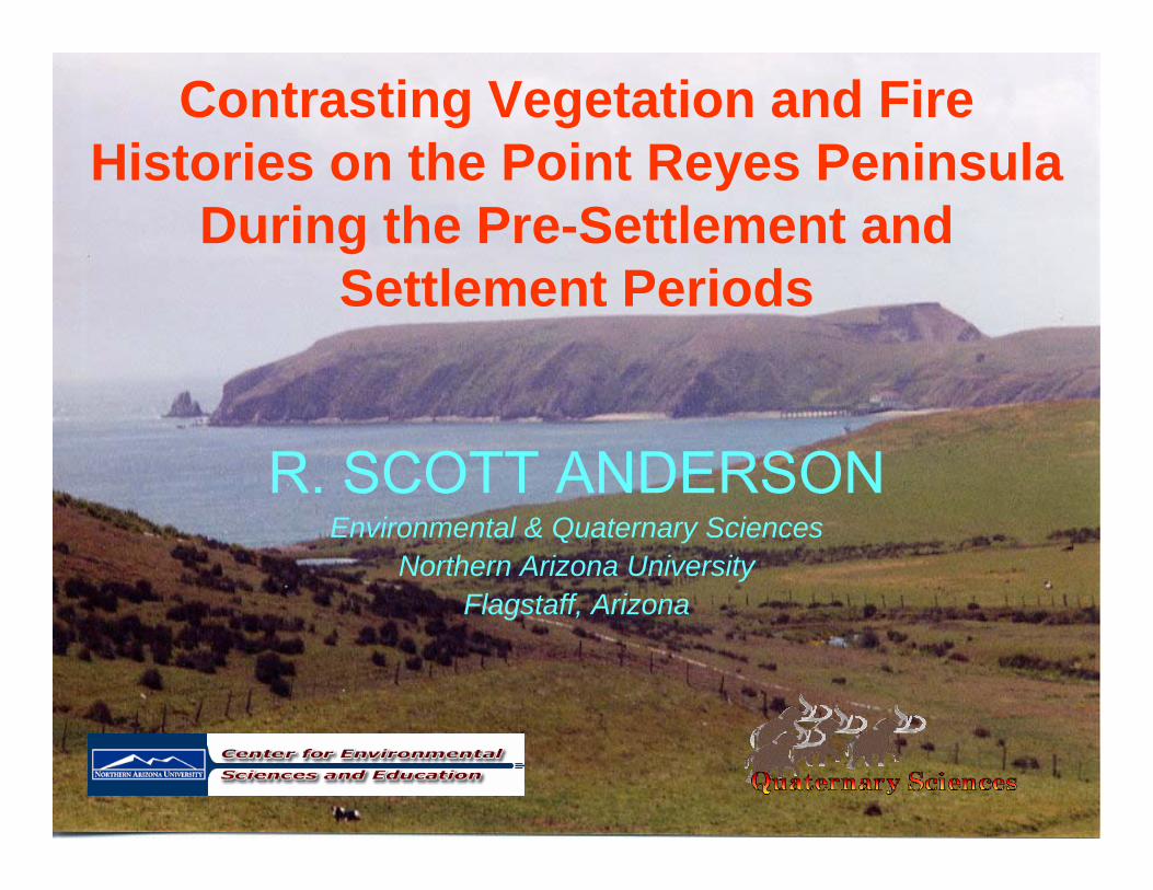
Contrasting Vegetation and Fire Histories on the Point Reyes Peninsula
During the Pre-Settlement and Settlement Periods
R. SCOTT ANDERSONEnvironmental & Quaternary Sciences
Northern Arizona UniversityFlagstaff, Arizona
Primary Collaborator:Peter Brown (RMTRR)
Supported by:National Park Service
(Point Reyes National Seashore)
Outline of Talk
• Introduction to Paleoecological Research• Physical Setting of the Study Sites• Vegetation & Fire Histories
– Previous Research– Present Research
• Comparison with Other Sites along Coastal California
• General Considerations & Conclusions
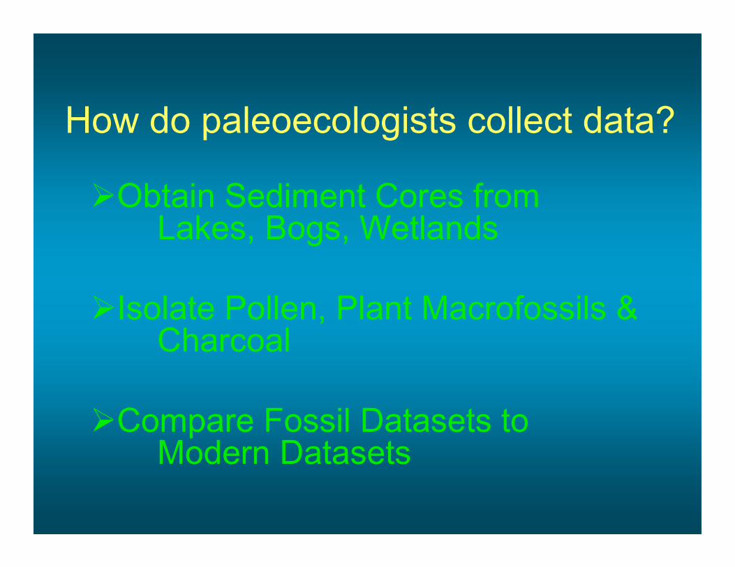
How do paleoecologists collect data?
Obtain Sediment Cores from Lakes, Bogs, Wetlands
Isolate Pollen, Plant Macrofossils & Charcoal
Compare Fossil Datasets to Modern Datasets

Sediment Coring – Lakes & Bogs
“Tools” of the Paleoecologist

“Tools” of the Paleoecologist: Pollen Macrofossils
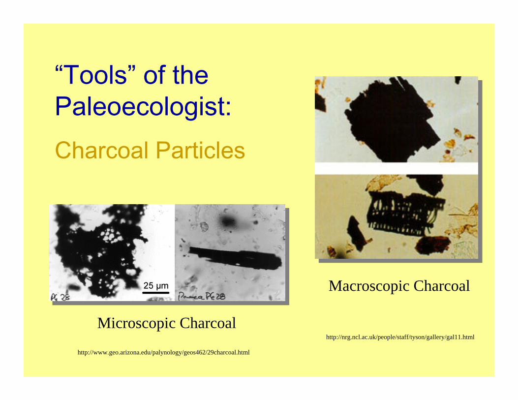
http://www.geo.arizona.edu/palynology/geos462/29charcoal.html
http://nrg.ncl.ac.uk/people/staff/tyson/gallery/gal11.html
“Tools” of the Paleoecologist:Charcoal Particles
Microscopic Charcoal
Macroscopic Charcoal

Charcoal Production & Transport
Production
Transport
Deposition
+
Production & Transport, Clockwise from upper left: http://www.atmos.umd.edu/~zli/Info/crown_fire-copy%20copy.jpg; http://www.fs.fed.us/rm/hayman_fire/text/03romme/03_fig11.html; http://www.wapa.gov/media/cct/sept6/images/hayman4.jpg; http://www.kwphoto.com/Resources/Images/94_0007-20.jpg
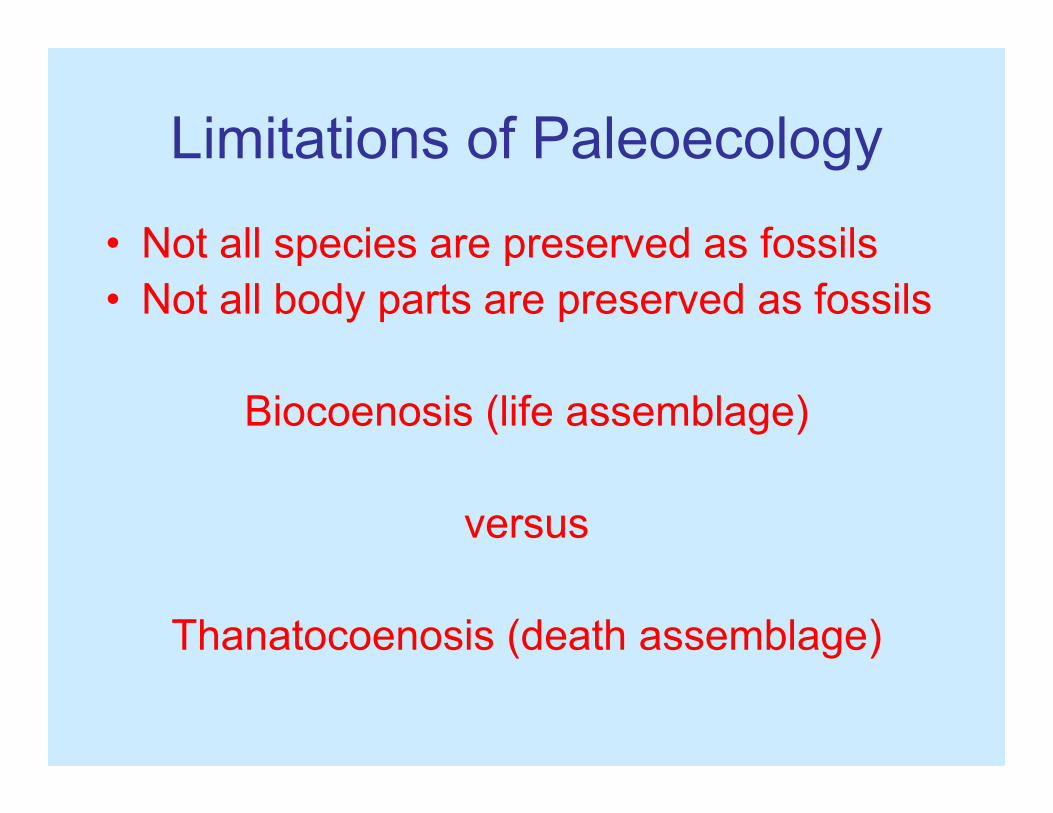
Limitations of Paleoecology
• Not all species are preserved as fossils• Not all body parts are preserved as fossils
Biocoenosis (life assemblage)
versus
Thanatocoenosis (death assemblage)
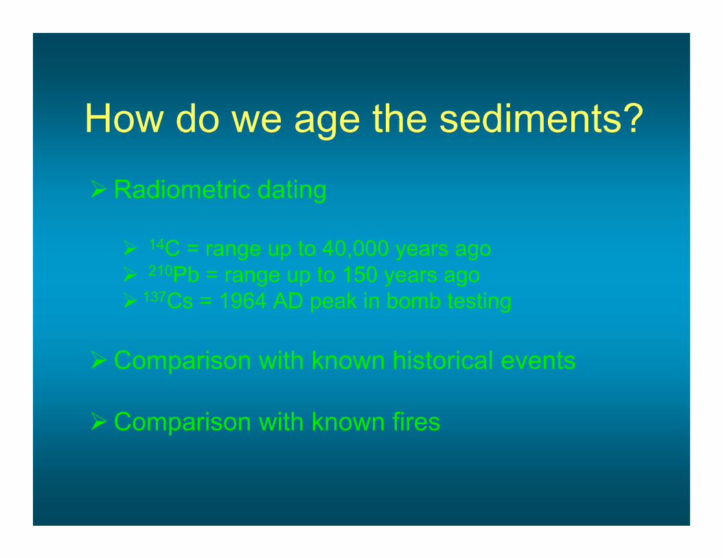
How do we age the sediments?Radiometric dating
14C = range up to 40,000 years ago210Pb = range up to 150 years ago
137Cs = 1964 AD peak in bomb testing
Comparison with known historical events
Comparison with known fires

History of Settlement & Use of Pollen for Dating
1817 - Spanish influence commenced here by establishment of San Rafael Franciscan mission (Brown et al.1999)
After 1821 - Point Reyes opened to land claims, with the first granted in 1836 in the Olema Valley
The area was subsequently opened for grazing and dairy ranching (Livingston 1994, 1995)
The settlement period identified by increases in pollen indicators of grazing and land disturbance (i.e., dock [Rumex], plantain [Plantago], filaree[Erodium]), planted trees (Eucalyptus)
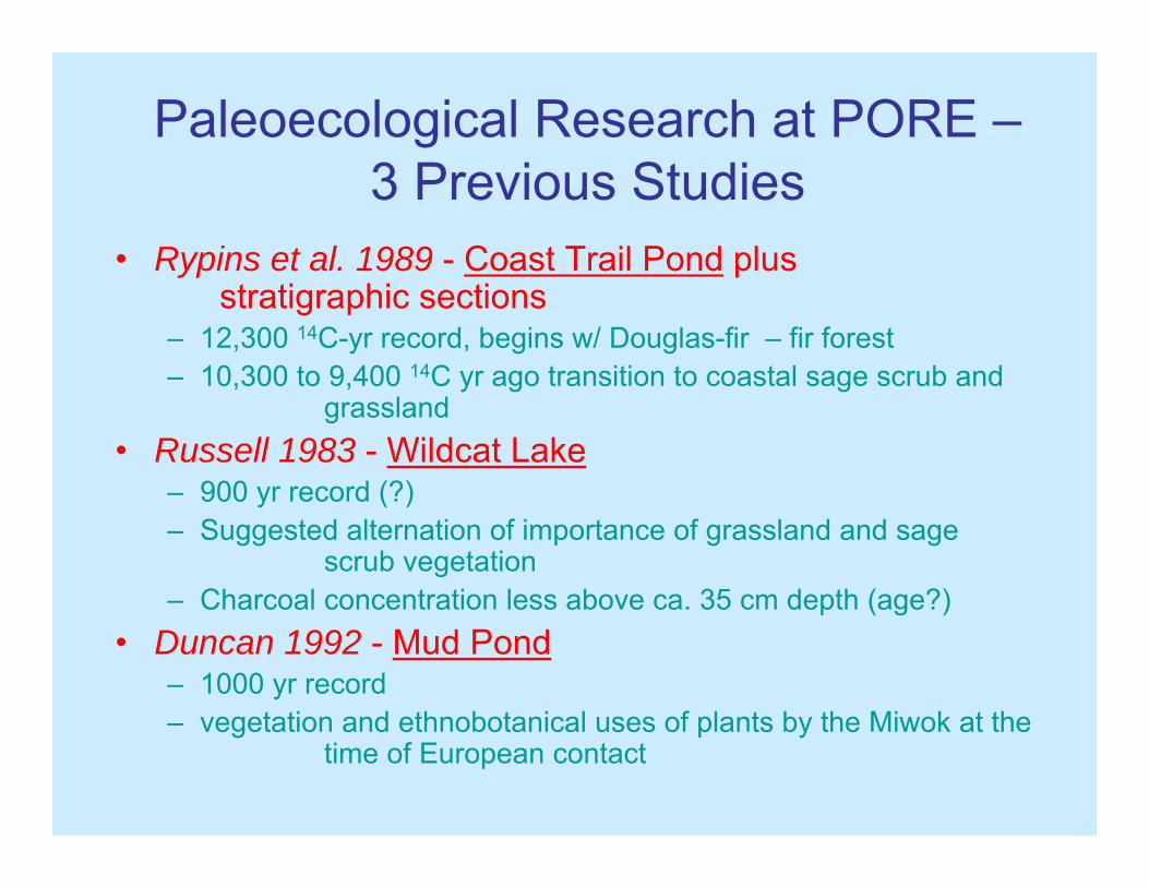
Paleoecological Research at PORE –3 Previous Studies
• Rypins et al. 1989 - Coast Trail Pond plus stratigraphic sections
– 12,300 14C-yr record, begins w/ Douglas-fir – fir forest– 10,300 to 9,400 14C yr ago transition to coastal sage scrub and
grassland • Russell 1983 - Wildcat Lake
– 900 yr record (?)– Suggested alternation of importance of grassland and sage
scrub vegetation– Charcoal concentration less above ca. 35 cm depth (age?)
• Duncan 1992 - Mud Pond– 1000 yr record– vegetation and ethnobotanical uses of plants by the Miwok at the
time of European contact

Terminology(Ages Approximate)
• Late Pleistocene = prior to 11,500 years ago
• Holocene = since 11,500 years ago– Early Holocene = to 7000 years ago– Middle Holocene = 7000 to 4500 years ago– Late Holocene = 4500 years ago to 1850 AD– Settlement Period = after 1850 AD

5000
1000015000200002500030000
3500040000
45000500005500060000
65000
Age
200
300
400
500
600
700
800
900
1000
Dep
th
20 40
CYPRESS Family
100 200 300 400
PINE (a
ll typ
es)
20
DOUGLAS-FIRFIR
20 40 60
SEQUOIA
OAKTANOAKALD
ER
20
COYOTE BRUSH &
Othe
rsLaguna de las Trancas (near Santa Cruz)
The Last 65,000 Years Along the Coast

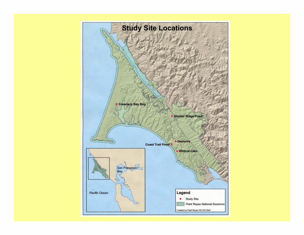
Studies Sites on Point Reyes
• Coast Trail Pond• Glenmire
• Creamery Bay Bog• Wildcat Lake
• Shutter Ridge Pond
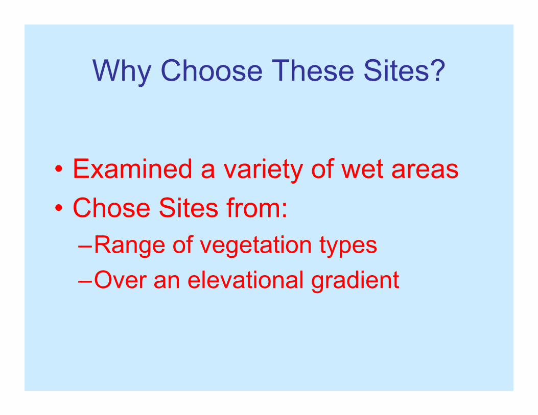
Why Choose These Sites?
• Examined a variety of wet areas• Chose Sites from:
–Range of vegetation types–Over an elevational gradient
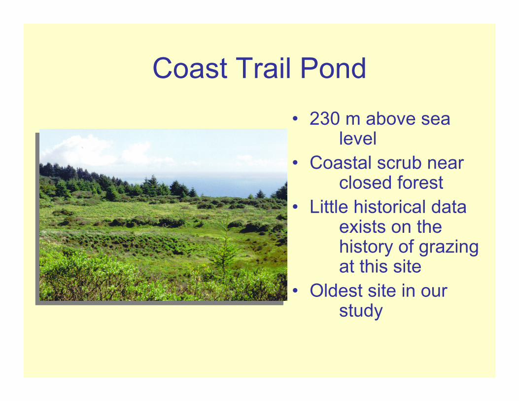
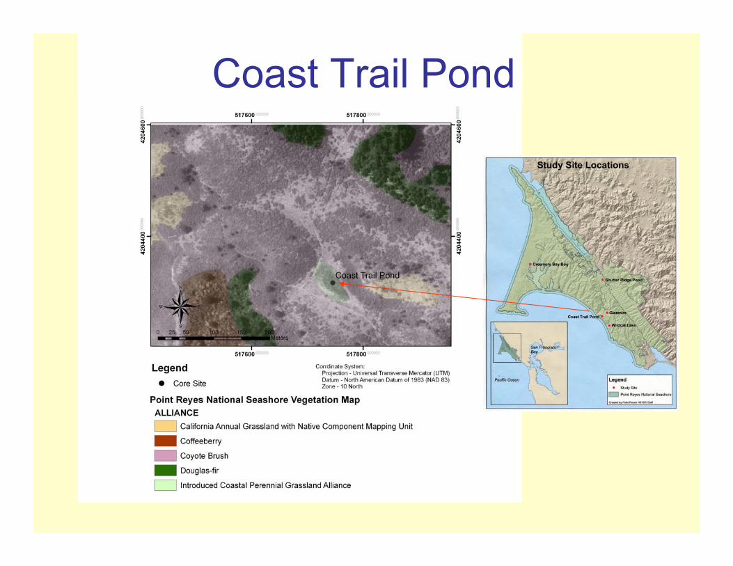
Coast Trail Pond• 230 m above sea
level• Coastal scrub near
closed forest• Little historical data
exists on the history of grazing at this site
• Oldest site in our study
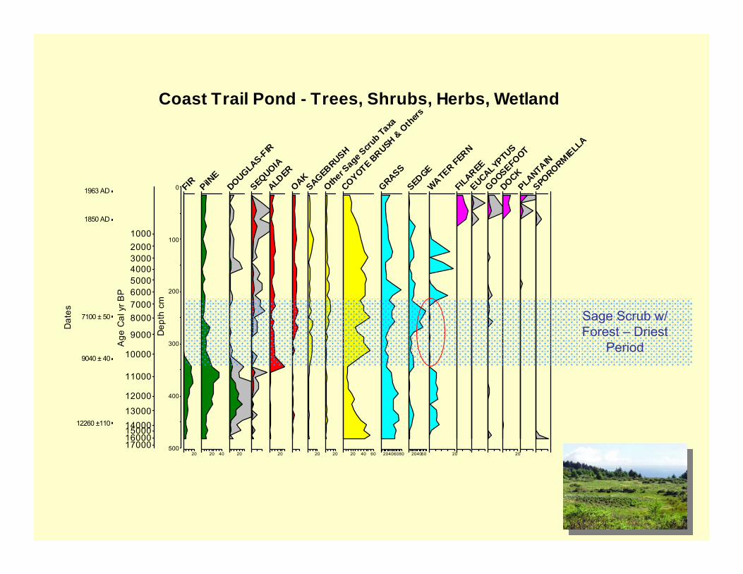
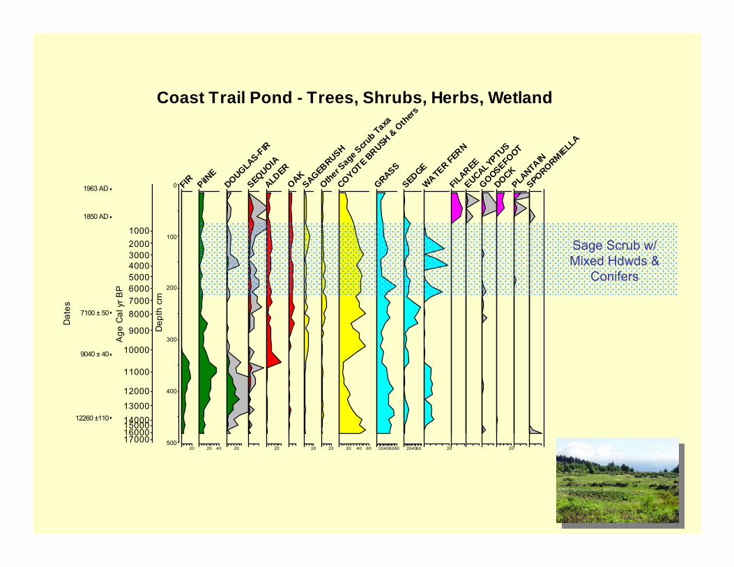
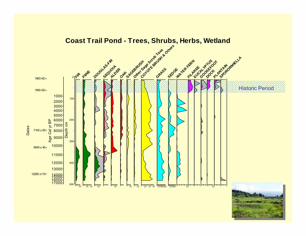
Coast Trail Pond

0
100
200
300
400
500
Dep
th c
m
10002000300040005000600070008000
9000
10000
11000
12000
1300014000150001600017000
Age
Cal
yr B
P
12260 ±110
9040 ± 40
7100 ± 50
1850 AD
1963 AD
Dat
es
20
FIR
20 40
PiINE
20
DOUGLAS-FIR
SEQUOIA20
ALDEROAK
20
SAGEBRUSH
20
Other Sage S
crub Taxa
20 40 60
COYOTE BRUSH &
Oth
ers
20406080
GRASS
204060
SEDGE
20
WATER FERNFILAREEEUCALYPTUS
GOOSEFOOT
20
DOCKPLANTAINSPORORMIELLA
Coast Trail Pond - Trees, Shrubs, Herbs, Wetland
Forest and Sage Scrub
0
100
200
300
400
500
Dep
th c
m
10002000300040005000600070008000
9000
10000
11000
12000
1300014000150001600017000
Age
Cal
yr B
P
12260 ±110
9040 ± 40
7100 ± 50
1850 AD
1963 AD
Dat
es
20
FIR
20 40
PiINE
20
DOUGLAS-FIR
SEQUOIA20
ALDEROAK
20
SAGEBRUSH
20
Other Sage S
crub Taxa
20 40 60
COYOTE BRUSH &
Oth
ers
20406080
GRASS
204060
SEDGE
20
WATER FERNFILAREEEUCALYPTUS
GOOSEFOOT
20
DOCKPLANTAINSPORORMIELLA
Coast Trail Pond - Trees, Shrubs, Herbs, Wetland
Sage Scrub w/ Forest – Driest
Period
0
100
200
300
400
500
Dep
th c
m
10002000300040005000600070008000
9000
10000
11000
12000
1300014000150001600017000
Age
Cal
yr B
P
12260 ±110
9040 ± 40
7100 ± 50
1850 AD
1963 AD
Dat
es
20
FIR
20 40
PiINE
20
DOUGLAS-FIR
SEQUOIA20
ALDEROAK
20
SAGEBRUSH
20
Other Sage S
crub Taxa
20 40 60
COYOTE BRUSH &
Oth
ers
20406080
GRASS
204060
SEDGE
20
WATER FERNFILAREEEUCALYPTUS
GOOSEFOOT
20
DOCKPLANTAINSPORORMIELLA
Coast Trail Pond - Trees, Shrubs, Herbs, Wetland
Sage Scrub w/ Mixed Hdwds &
Conifers
0
100
200
300
400
500
Dep
th c
m
10002000300040005000600070008000
9000
10000
11000
12000
1300014000150001600017000
Age
Cal
yr B
P
12260 ±110
9040 ± 40
7100 ± 50
1850 AD
1963 AD
Dat
es
20
FIR
20 40
PiINE
20
DOUGLAS-FIR
SEQUOIA20
ALDEROAK
20
SAGEBRUSH
20
Other Sage S
crub Taxa
20 40 60
COYOTE BRUSH &
Oth
ers
20406080
GRASS
204060
SEDGE
20
WATER FERNFILAREEEUCALYPTUS
GOOSEFOOT
20
DOCKPLANTAINSPORORMIELLA
Coast Trail Pond - Trees, Shrubs, Herbs, Wetland
Historic Period

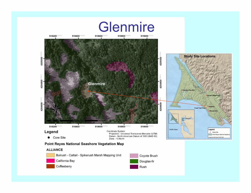
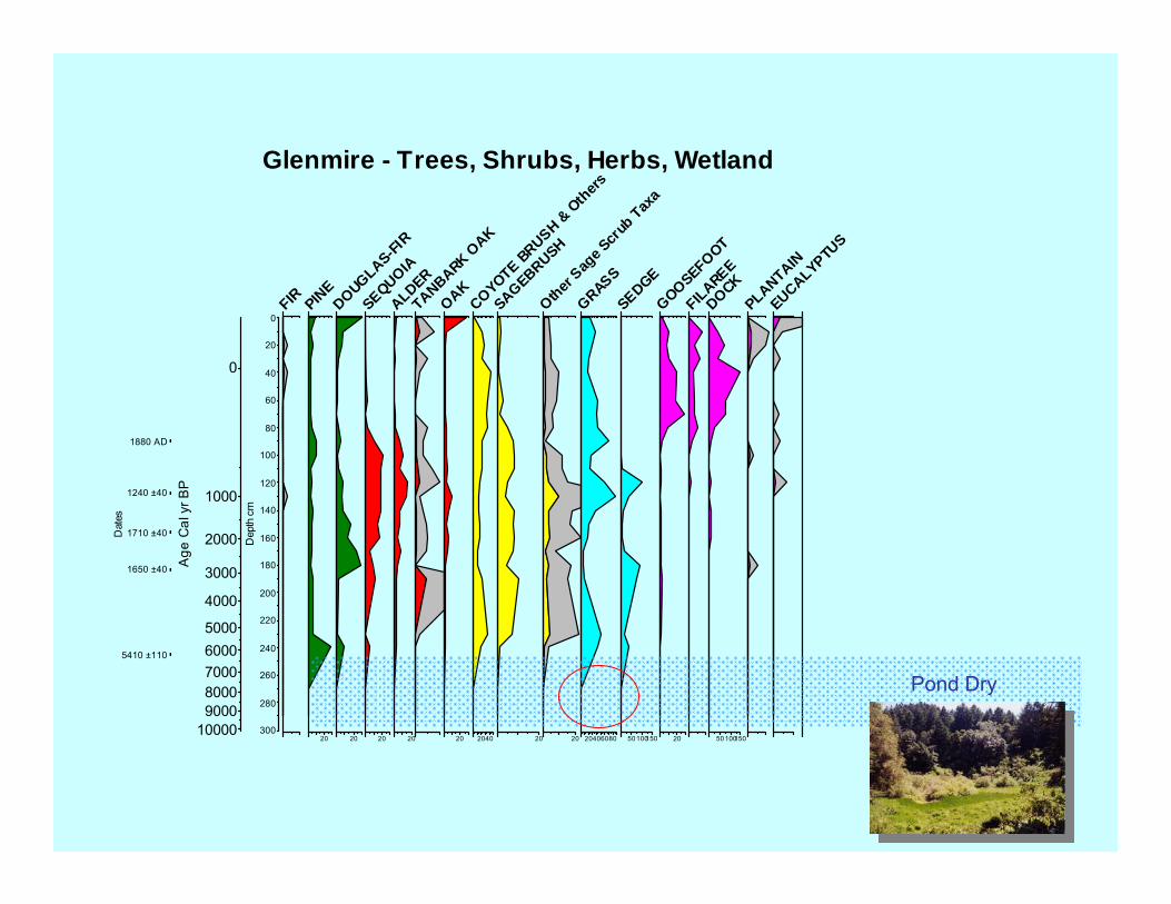
Glenmire• 167 m above sea level• Wetland NW of Glen
Campground• Closed Douglas-fir forest
with California bay and oak
• Part of the Shafter Ranches, South End Tract (Livingston 1994). By 1879 a thriving dairy farm
• Cored in 30 cm of water
Glenmire
0
20
40
60
80
100
120
140
160
180
200
220
240
260
280
300
Dep
th c
m
0
1000
2000
3000
4000
50006000700080009000
10000
Age
Cal
yr B
P
5410 ±110
1650 ±40
1710 ±40
1240 ±40
1880 AD
Dat
es
FIR
20
PINE
20
DOUGLAS-FIR
20
SEQUOIA20
ALDERTANBARK O
AK
20
OAK
2040
COYOTE BRUSH &
Oth
ers
20
SAGEBRUSH
20
Other Sag
e Scr
ub Tax
a
20406080
GRASS
50100150
SEDGE
20
GOOSEFOOT
FILAREE
50 100150
DOCKPLANTAINEUCALYPTU
S
Glenmire - Trees, Shrubs, Herbs, Wetland
Pond Dry

0
20
40
60
80
100
120
140
160
180
200
220
240
260
280
300
Dep
th c
m
0
1000
2000
3000
4000
50006000700080009000
10000
Age
Cal
yr B
P
5410 ±110
1650 ±40
1710 ±40
1240 ±40
1880 AD
Dat
es
FIR
20
PINE
20
DOUGLAS-FIR
20
SEQUOIA20
ALDERTANBARK O
AK
20
OAK
2040
COYOTE BRUSH &
Oth
ers
20
SAGEBRUSH
20
Other Sag
e Scr
ub Tax
a
20406080
GRASS
50100150
SEDGE
20
GOOSEFOOT
FILAREE
50 100150
DOCKPLANTAINEUCALYPTU
S
Glenmire - Trees, Shrubs, Herbs, Wetland
Mixed Conifer and Hardwood Forest
w/ Sage Scrub

0
20
40
60
80
100
120
140
160
180
200
220
240
260
280
300
Dep
th c
m
0
1000
2000
3000
4000
50006000700080009000
10000
Age
Cal
yr B
P
5410 ±110
1650 ±40
1710 ±40
1240 ±40
1880 AD
Dat
es
FIR
20
PINE
20
DOUGLAS-FIR
20
SEQUOIA20
ALDERTANBARK O
AK
20
OAK
2040
COYOTE BRUSH &
Oth
ers
20
SAGEBRUSH
20
Other Sag
e Scr
ub Tax
a
20406080
GRASS
50100150
SEDGE
20
GOOSEFOOT
FILAREE
50 100150
DOCKPLANTAINEUCALYPTU
S
Glenmire - Trees, Shrubs, Herbs, Wetland
Historic Period

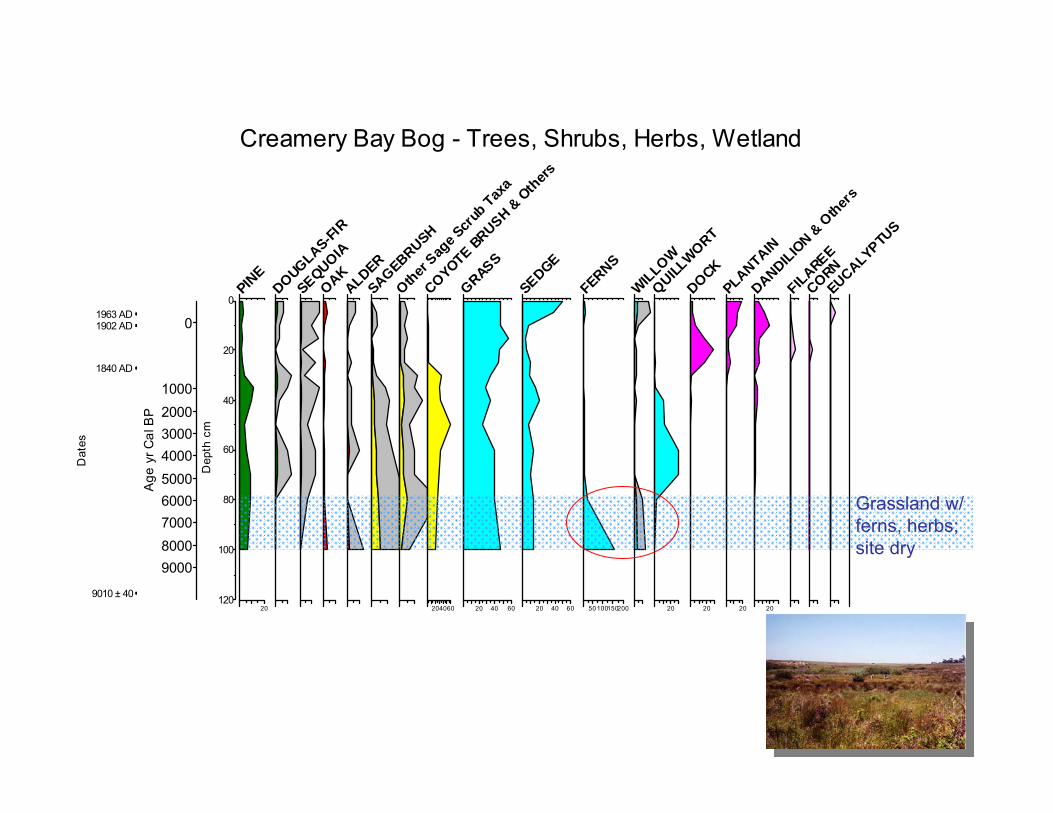
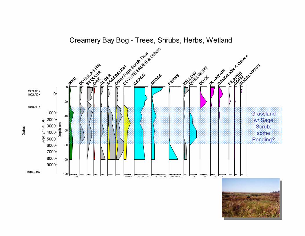
Creamery Bay Bog• 6 m above sea level• At the head of
Creamery Bay• Site of “K” Ranch
dairy farm• Oldest ranch site on
the Point (Livingston 1994)
• Presently the site is a wet meadow

Creamery Bay Bog
0
20
40
60
80
100
120
Dep
th c
m
0
100020003000400050006000700080009000
Age
yr C
al B
P
9010 ± 40
1840 AD
1902 AD1963 AD
Dat
es
20
PINE
DOUGLAS-FIR
SEQUOIAOAKALDERSAGEBRUSH
Other Sag
e Scr
ub Tax
a
204060
COYOTE BRUSH &
Oth
ers
20 40 60
GRASS
20 40 60
SEDGE
50100150200
FERNSWILLOW
20
QUILLWORT
20
DOCK
20
PLANTAIN
20
DANDILION &
Other
s
FILAREECORNEUCALYPTU
SCreamery Bay Bog - Trees, Shrubs, Herbs, Wetland
Grassland w/ ferns, herbs; site dry
0
20
40
60
80
100
120
Dep
th c
m
0
100020003000400050006000700080009000
Age
yr C
al B
P
9010 ± 40
1840 AD
1902 AD1963 AD
Dat
es
20
PINE
DOUGLAS-FIR
SEQUOIAOAKALDERSAGEBRUSH
Other Sag
e Scr
ub Tax
a
204060
COYOTE BRUSH &
Oth
ers
20 40 60
GRASS
20 40 60
SEDGE
50100150200
FERNSWILLOW
20
QUILLWORT
20
DOCK
20
PLANTAIN
20
DANDILION &
Other
s
FILAREECORNEUCALYPTU
SCreamery Bay Bog - Trees, Shrubs, Herbs, Wetland
Grassland w/ Sage Scrub; some
Ponding?

0
20
40
60
80
100
120
Dep
th c
m
0
100020003000400050006000700080009000
Age
yr C
al B
P
9010 ± 40
1840 AD
1902 AD1963 AD
Dat
es
20
PINE
DOUGLAS-FIR
SEQUOIAOAKALDERSAGEBRUSH
Other Sag
e Scr
ub Tax
a
204060
COYOTE BRUSH &
Oth
ers
20 40 60
GRASS
20 40 60
SEDGE
50100150200
FERNSWILLOW
20
QUILLWORT
20
DOCK
20
PLANTAIN
20
DANDILION &
Other
s
FILAREECORNEUCALYPTU
SCreamery Bay Bog - Trees, Shrubs, Herbs, Wetland
Historic Period

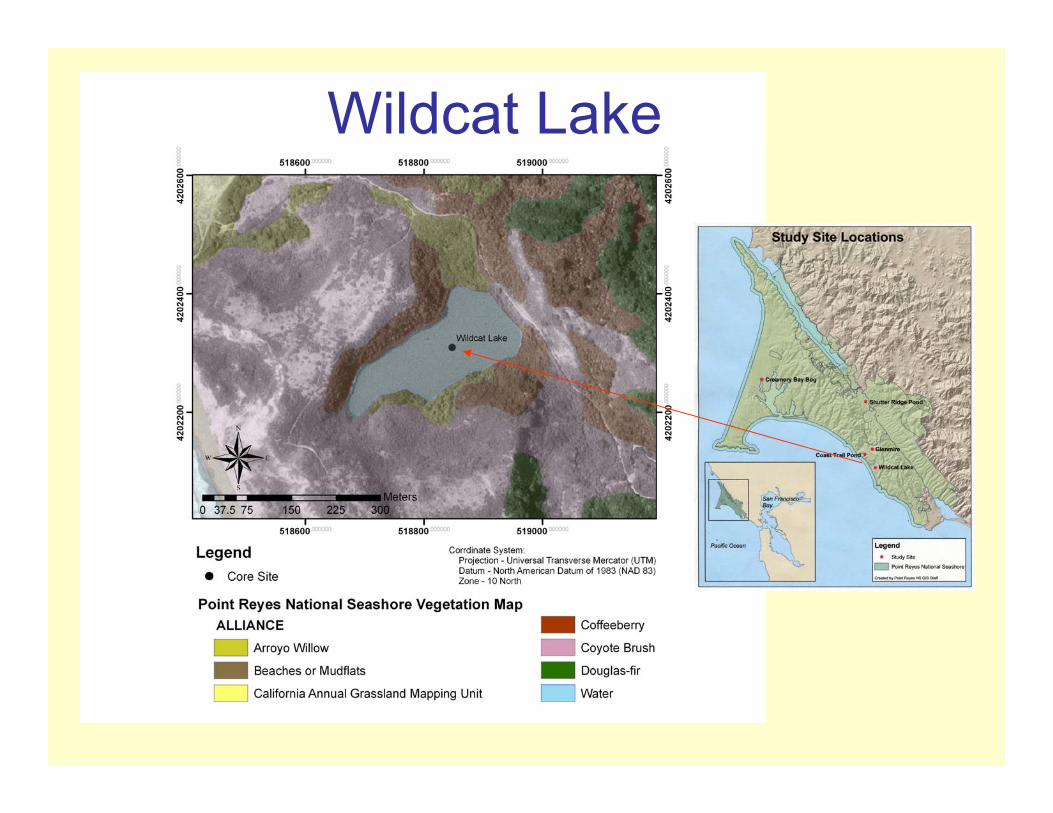
Wildcat Lake• 62 m above sea level• Sits on a complex
landslide deposit • Coastal scrub • Area NW of lake
(Wildcat Ranch) was occupied as early as 1858 (Livingston 1994)
• Cored in 8.75 m of water
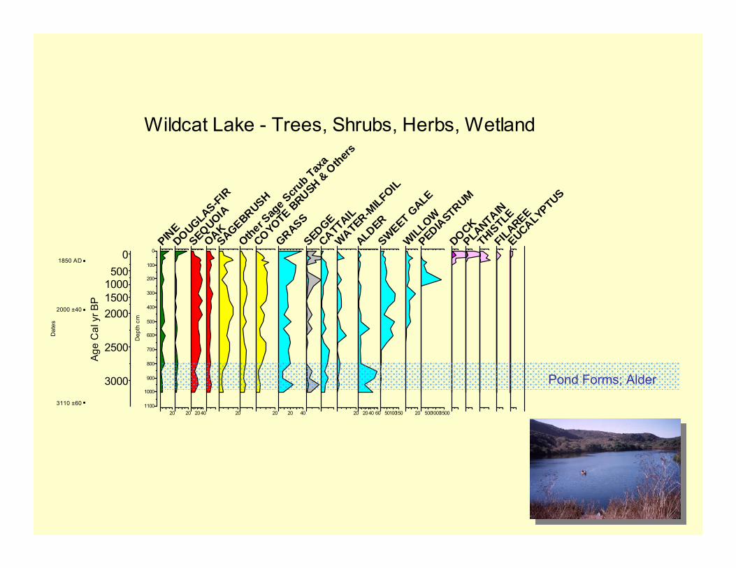
Wildcat Lake
0
100
200
300
400
500
600
700
800
900
1000
1100
Dep
th c
m
0500
100015002000
2500
3000
Age
Cal
yr B
P
3110 ±60
2000 ±40
1850 AD
Dat
es
20
PINE
20
DOUGLAS-FIR
2040
SEQUOIAOAK
20
SAGEBRUSH
Other Sag
e Scru
b Taxa
20
COYOTE BRUSH &
Others
20 40
GRASSSEDGECATTAIL
20
WATER-MILFOIL
2040 60
ALDER
50100150
SWEET GALE
20
WILLOW
50010001500
PEDIASTRUM
DOCKPLANTAIN
THISTLE
FILAREEEUCALYPTUS
Wildcat Lake - Trees, Shrubs, Herbs, Wetland
Pond Forms; Alder

0
100
200
300
400
500
600
700
800
900
1000
1100
Dep
th c
m
0500
100015002000
2500
3000
Age
Cal
yr B
P
3110 ±60
2000 ±40
1850 AD
Dat
es
20
PINE
20
DOUGLAS-FIR
2040
SEQUOIAOAK
20
SAGEBRUSH
Other Sag
e Scru
b Taxa
20
COYOTE BRUSH &
Others
20 40
GRASSSEDGECATTAIL
20
WATER-MILFOIL
2040 60
ALDER
50100150
SWEET GALE
20
WILLOW
50010001500
PEDIASTRUM
DOCKPLANTAIN
THISTLE
FILAREEEUCALYPTUS
Wildcat Lake - Trees, Shrubs, Herbs, Wetland
Coastal Sage Scrub w/ minor
Grassland & Mixed Forest

0
100
200
300
400
500
600
700
800
900
1000
1100
Dep
th c
m
0500
100015002000
2500
3000
Age
Cal
yr B
P
3110 ±60
2000 ±40
1850 AD
Dat
es
20
PINE
20
DOUGLAS-FIR
2040
SEQUOIAOAK
20
SAGEBRUSH
Other Sag
e Scru
b Taxa
20
COYOTE BRUSH &
Others
20 40
GRASSSEDGECATTAIL
20
WATER-MILFOIL
2040 60
ALDER
50100150
SWEET GALE
20
WILLOW
50010001500
PEDIASTRUM
DOCKPLANTAIN
THISTLE
FILAREEEUCALYPTUS
Wildcat Lake - Trees, Shrubs, Herbs, Wetland
Historic Period

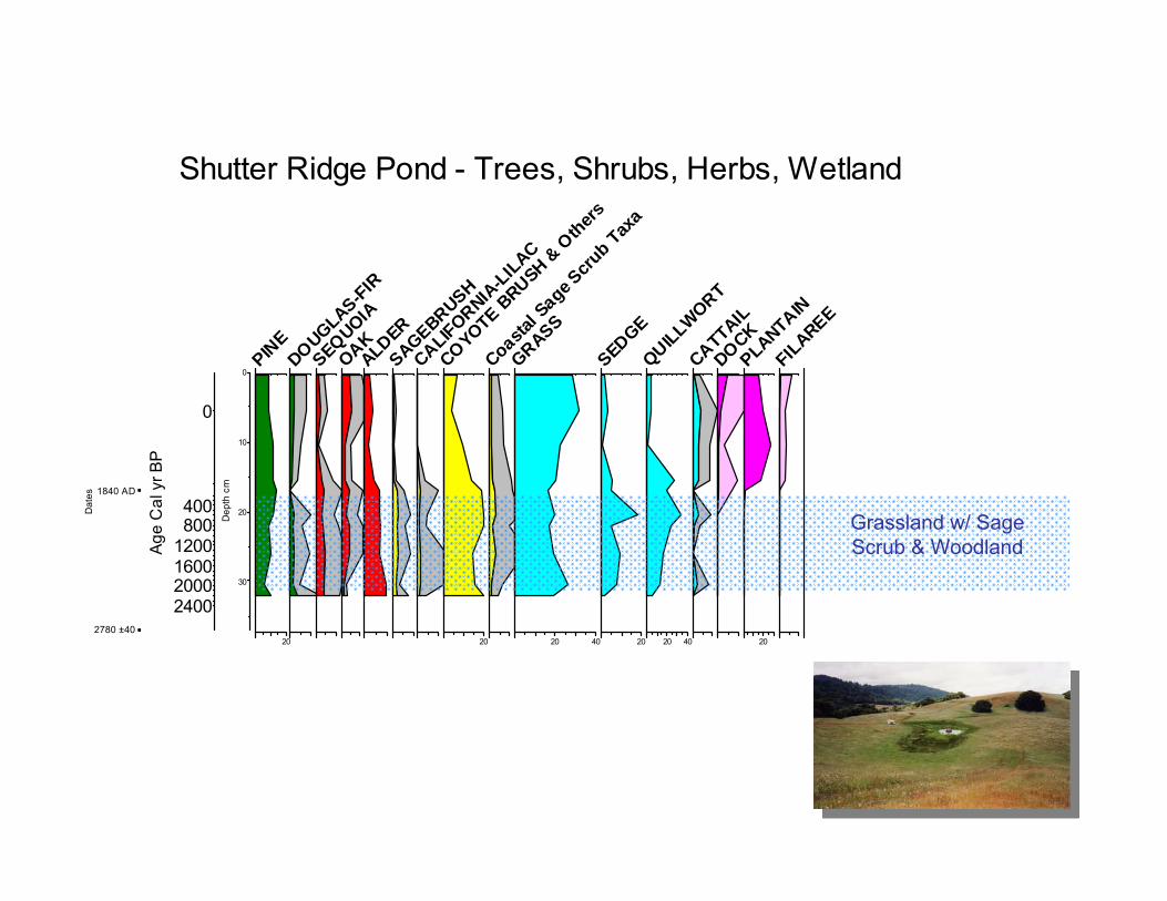
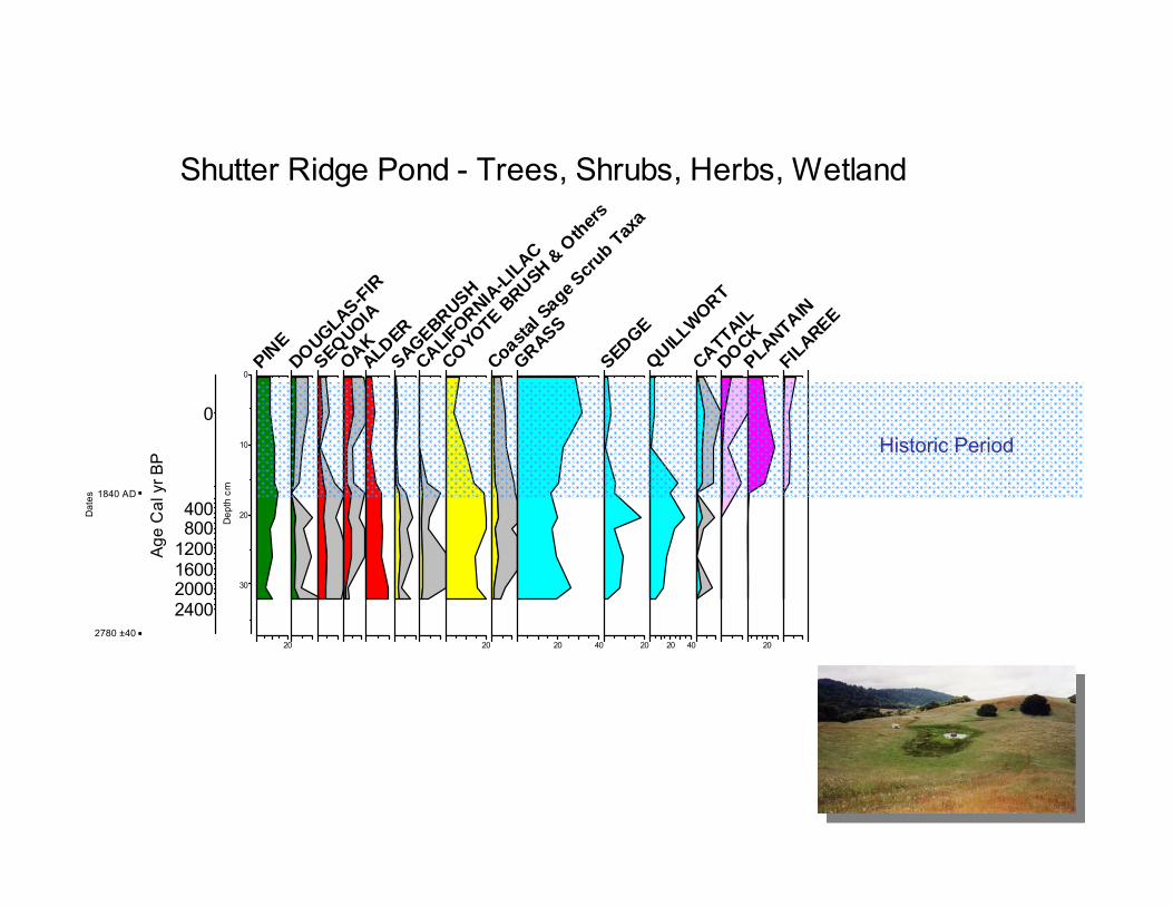
Shutter Ridge Pond• 35 m above sea level• In California annual
grassland• Situated on a push ridge• Site originally settled by
Garcia family• Probably became part of
Shafter’s “W” Ranch in the 1860’s (Livingston 1994)
• 1 m deep, but dries out

Shutter Ridge Pond
0
10
20
30
Dep
th c
m
0
400800
1200160020002400
Age
Cal
yr B
P
2780 ±40
1840 AD
Dat
es
20
PINE
DOUGLAS-FIR
SEQUOIAOAKALDERSAGEBRUSH
CALIFORNIA-LILAC
20
COYOTE BRUSH &
Others
Coastal S
age Scru
b Taxa
20 40GRASS
20
SEDGE
20 40
QUILLWORTCATTAILDOCK
20
PLANTAINFILAREE
Shutter Ridge Pond - Trees, Shrubs, Herbs, Wetland
Grassland w/ Sage Scrub & Woodland
0
10
20
30
Dep
th c
m
0
400800
1200160020002400
Age
Cal
yr B
P
2780 ±40
1840 AD
Dat
es
20
PINE
DOUGLAS-FIR
SEQUOIAOAKALDERSAGEBRUSH
CALIFORNIA-LILAC
20
COYOTE BRUSH &
Others
Coastal S
age Scru
b Taxa
20 40GRASS
20
SEDGE
20 40
QUILLWORTCATTAILDOCK
20
PLANTAINFILAREE
Shutter Ridge Pond - Trees, Shrubs, Herbs, Wetland
Historic Period
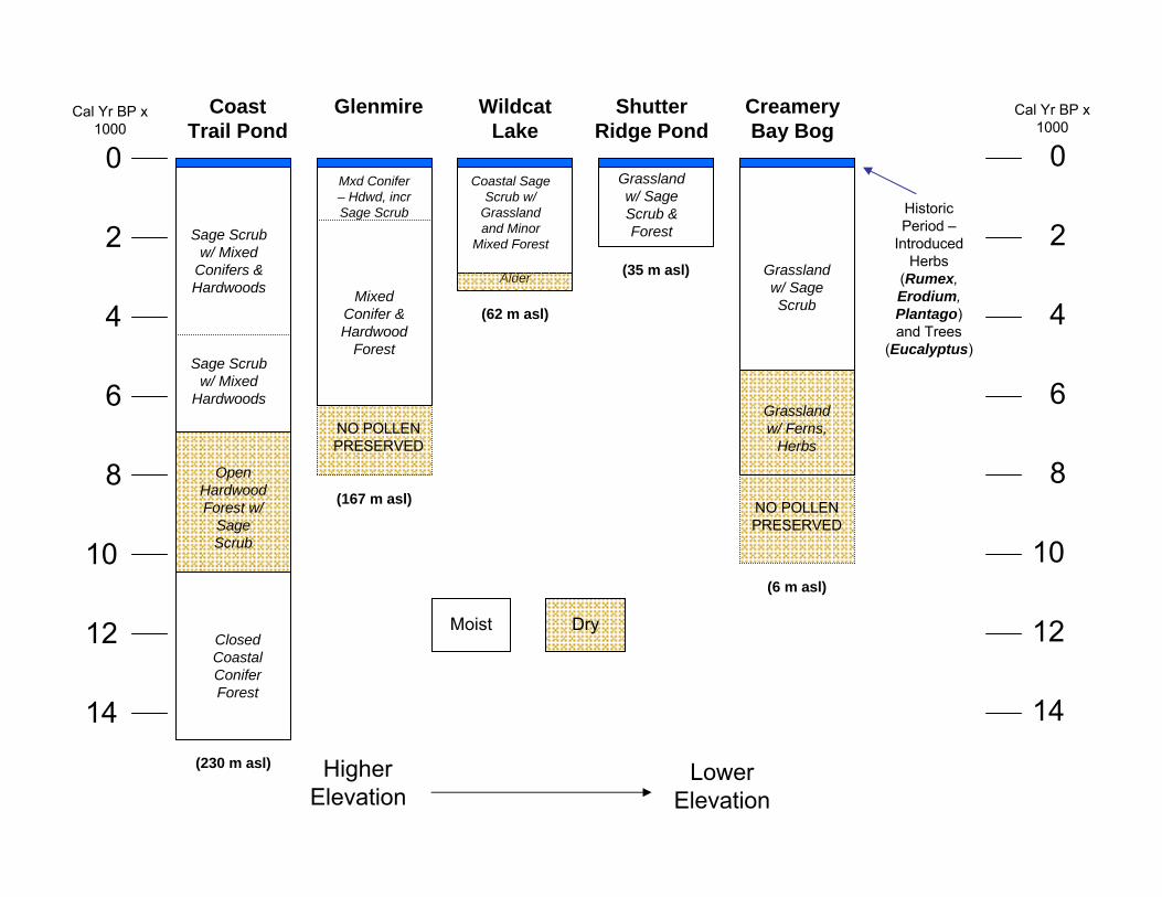
NO POLLEN PRESERVED
Coast Trail Pond
Shutter Ridge Pond
Creamery Bay Bog
Glenmire Wildcat Lake
Sage Scrub w/ Mixed
Conifers & Hardwoods
Sage Scrub w/ Mixed
Hardwoods
Open Hardwood Forest w/
Sage Scrub
Closed Coastal Conifer Forest
Grassland w/ Sage Scrub & Forest
Grassland w/ Sage Scrub
Grassland w/ Ferns,
Herbs
NO POLLEN PRESERVED
Mixed Conifer & Hardwood
Forest
Mxd Conifer – Hdwd, incrSage Scrub
Coastal Sage Scrub w/
Grassland and Minor
Mixed Forest
0
2
4
6
8
10
12
14
Cal Yr BP x 1000
0
2
4
6
8
10
12
14
Cal Yr BP x 1000
Higher Elevation
Lower Elevation
Alder
Historic Period –
Introduced Herbs
(Rumex, Erodium, Plantago) and Trees
(Eucalyptus)
(230 m asl)
(167 m asl)
(62 m asl)
(35 m asl)
(6 m asl)
Moist Dry

Solar Maximum in early Holocene
Kutzbach & Guetter 1986
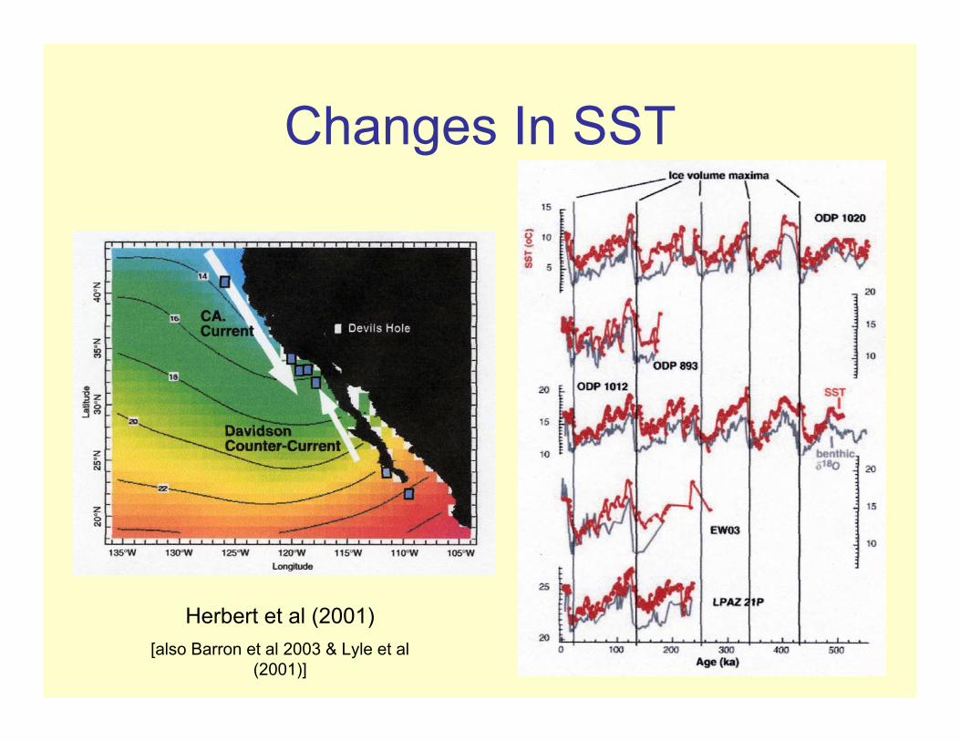
Changes In SST
Herbert et al (2001)[also Barron et al 2003 & Lyle et al
(2001)]

CA Sea Surface Temp & δ18O
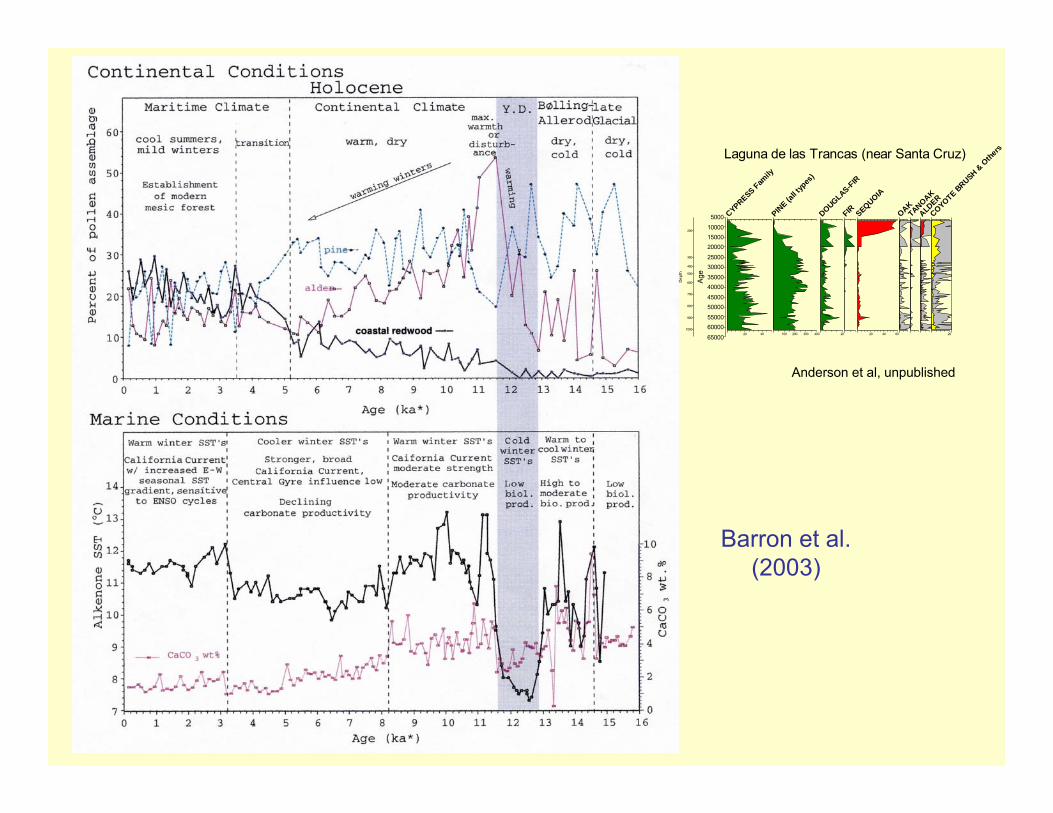
Barron et al. (2003)

Simulated Precipitation
for
Jan & July,
21K, 16K, 14K, 11K, 6K
& Present
Bartlein et al., 1998
Barron et al. (2003)
5000
100001500020000
2500030000
3500040000
4500050000
5500060000
65000
Age
200
300
400
500
600
700
800
900
1000
Dep
th
20 40
CYPRESS Family
100 200 300 400
PINE (a
ll typ
es)
20
DOUGLAS-FIRFIR
20 40 60
SEQUOIA
OAKTANOAKALD
ER
20
COYOTE BRUSH &
Othe
rsLaguna de las Trancas (near Santa Cruz)
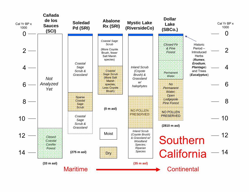
Anderson et al, unpublished

Northern Channel Islands & Inland
Empire
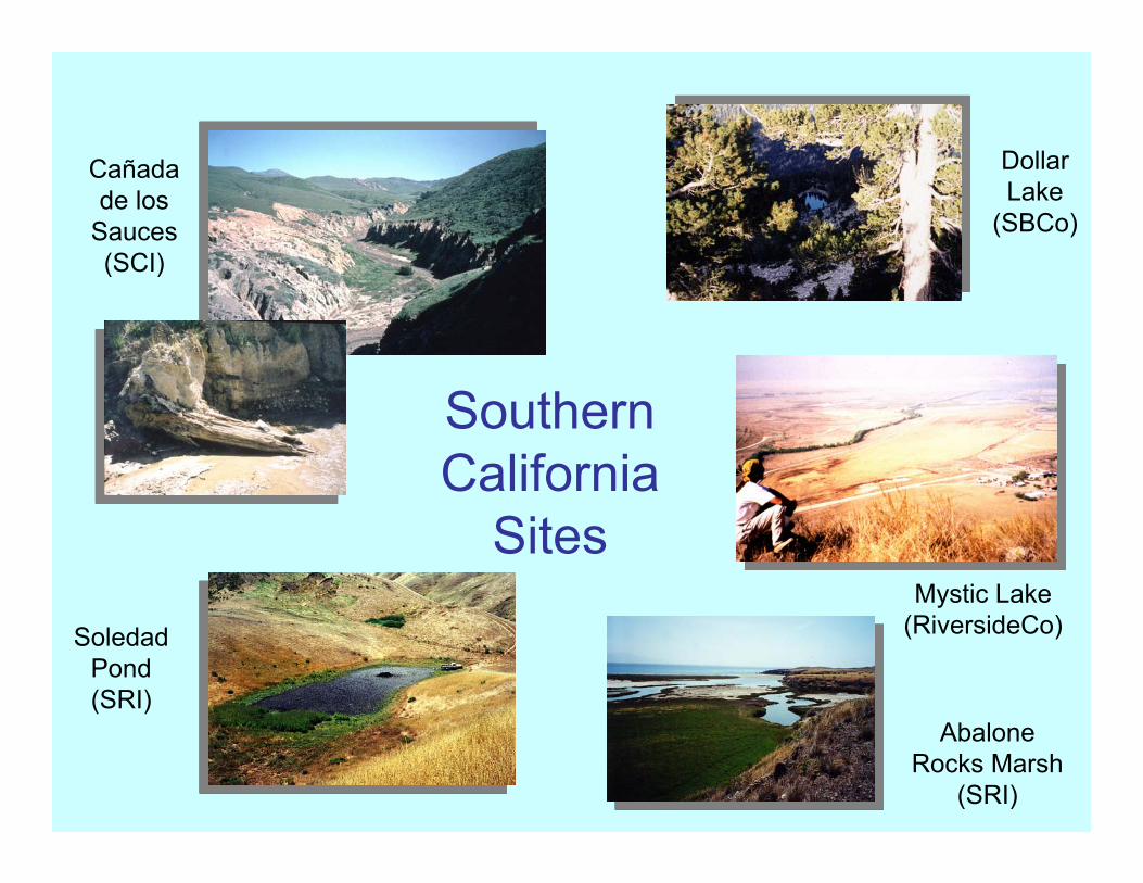
Southern California
Sites
Cañadade los
Sauces (SCI)
Soledad Pond (SRI)
Abalone Rocks Marsh
(SRI)
Mystic Lake (RiversideCo)
Dollar Lake
(SBCo)
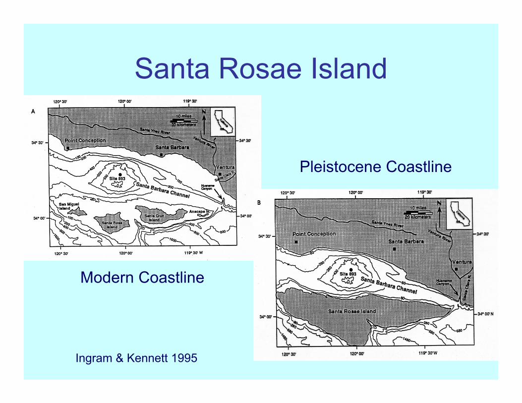
Santa Rosae Island
Ingram & Kennett 1995
Modern Coastline
Pleistocene Coastline
Cañadade los
Sauces (SCI)
Mystic Lake (RiversideCo)
Dollar Lake
(SBCo.)Soledad Pd (SRI)
Abalone Rx (SRI)
Not Analyzed
Yet
Closed Coastal Conifer Forest
Inland Scrub (Coyote Brush) &
Grassland w/
halophytes
Closed Fir & Pine Forest
NO POLLEN PRESERVED
Coastal Sage
Scrub & Grassland
Coastal Sage Scrub
(More Coyote Brush, fewer Salt Marsh species)
0
2
4
6
8
10
12
14
Cal Yr BP x 1000
0
2
4
6
8
10
12
14
Cal Yr BP x 1000
Maritime Continental
Historic Period –
Introduced Herbs
(Rumex, Erodium, Plantago) and Trees
(Eucalyptus)
(33 m asl)
(275 m asl)
(0 m asl)
(35 m asl)
(2810 m asl)
Moist
Dry
Coastal Sage Scrub(More Salt
Marsh species,
Less Coyote Brush)
Sparse Coastal Sage Scrub
Coastal Sage
Scrub & Grassland
No Permanent
Water; Open
LodgepolePine Forest
Permanent Water
NO POLLEN PRESERVED
Southern California
Inland Scrub (Coyote Brush) & Grassland w/
Woodland Species; Riparian Species

Fire History Studies• Critical to our understanding of the
centennial and millennial-scale fire history is the history of fire over the last two centuries
• Little was known about the pre-Historic fire regimes on the Point Reyes Peninsula until the work of Finney (1990) and Brown et al. (1999)
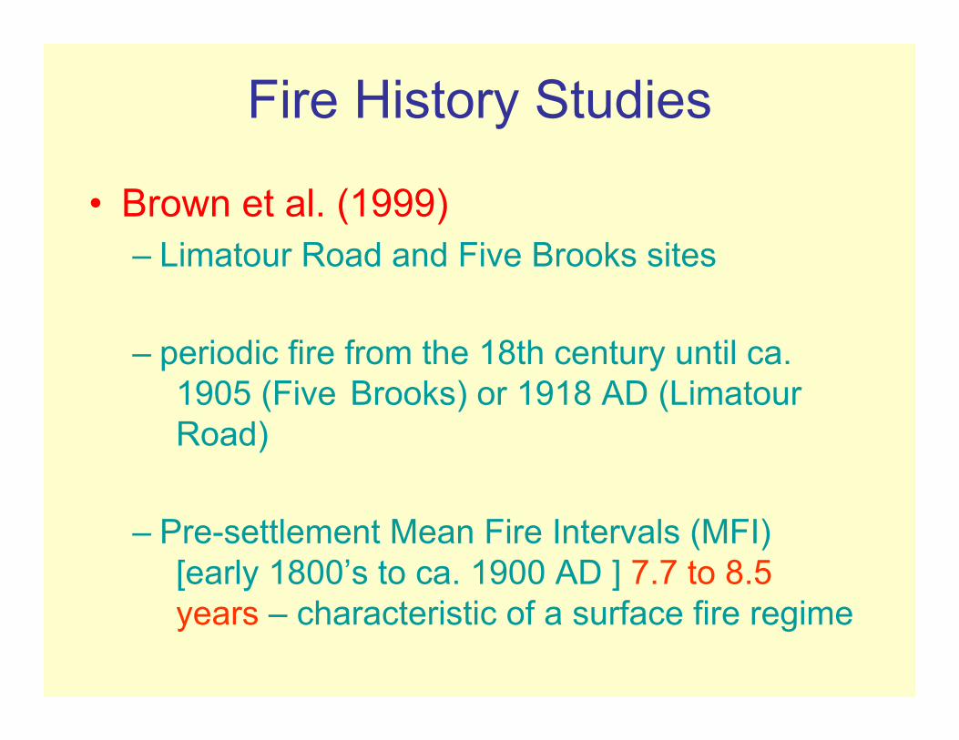
Fire History Studies
• Brown et al. (1999)– Limatour Road and Five Brooks sites
– periodic fire from the 18th century until ca. 1905 (Five Brooks) or 1918 AD (LimatourRoad)
– Pre-settlement Mean Fire Intervals (MFI) [early 1800’s to ca. 1900 AD ] 7.7 to 8.5 years – characteristic of a surface fire regime
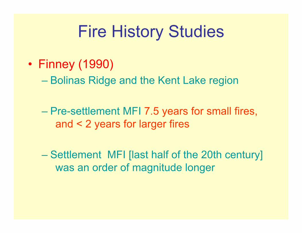
Fire History Studies
• Finney (1990)– Bolinas Ridge and the Kent Lake region
– Pre-settlement MFI 7.5 years for small fires, and < 2 years for larger fires
– Settlement MFI [last half of the 20th century] was an order of magnitude longer

Fire History Studies
• Change in fire regime in 20th century due to cessation of surface fire regime (Finney 1990; Brown et al. 1999) that probably existed during the pre-Historic period.
16000
15500
15000
14500
14000
13500
13000
12500
12000
11500
11000
10500
10000
9500
9000
8500
8000
7500
7000
6500
6000
5500
5000
4500
4000
3500
3000
2500
2000
1500
1000
500
0
0.001 0.01 0.1 1 10
Age
(cal
enda
r yea
rs B
P)
16000
15500
15000
14500
14000
13500
13000
12500
12000
11500
11000
10500
10000
9500
9000
8500
8000
7500
7000
6500
6000
5500
5000
4500
4000
3500
3000
2500
2000
1500
1000
500
0
0.001 0.01 0.1 1 10
Age
(cal
enda
r yea
rs B
P)
16000
15500
15000
14500
14000
13500
13000
12500
12000
11500
11000
10500
10000
9500
9000
8500
8000
7500
7000
6500
6000
5500
5000
4500
4000
3500
3000
2500
2000
1500
1000
500
0
0.01 0.1 1 10
Age
(cal
enda
r yea
rs B
P)
16000
15500
15000
14500
14000
13500
13000
12500
12000
11500
11000
10500
10000
9500
9000
8500
8000
7500
7000
6500
6000
5500
5000
4500
4000
3500
3000
2500
2000
1500
1000
500
0
0.01 0.1 1 10
Age
(cal
enda
r yea
rs B
P)
16000
15500
15000
14500
14000
13500
13000
12500
12000
11500
11000
10500
10000
9500
9000
8500
8000
7500
7000
6500
6000
5500
5000
4500
4000
3500
3000
2500
2000
1500
1000
500
0
0.001 0.01 0.1 1 10A
ge (c
alen
dar y
ears
BP
)
Creamery Bay Bog(6 m asl)
particles/cm2/year
Glenmire(167 m asl)
Wildcat Lake(62 m asl)
Coast Trail Pond(230 m asl)
Shutter Ridge Pond(35 m asl)

16000
15500
15000
14500
14000
13500
13000
12500
12000
11500
11000
10500
10000
9500
9000
8500
8000
7500
7000
6500
6000
5500
5000
4500
4000
3500
3000
2500
2000
1500
1000
500
0
0.001 0.01 0.1 1 10
Age
(cal
enda
r yea
rs B
P)
16000
15500
15000
14500
14000
13500
13000
12500
12000
11500
11000
10500
10000
9500
9000
8500
8000
7500
7000
6500
6000
5500
5000
4500
4000
3500
3000
2500
2000
1500
1000
500
0
0.001 0.01 0.1 1 10
Age
(cal
enda
r yea
rs B
P)
16000
15500
15000
14500
14000
13500
13000
12500
12000
11500
11000
10500
10000
9500
9000
8500
8000
7500
7000
6500
6000
5500
5000
4500
4000
3500
3000
2500
2000
1500
1000
500
0
0.01 0.1 1 10
Age
(cal
enda
r yea
rs B
P)
16000
15500
15000
14500
14000
13500
13000
12500
12000
11500
11000
10500
10000
9500
9000
8500
8000
7500
7000
6500
6000
5500
5000
4500
4000
3500
3000
2500
2000
1500
1000
500
0
0.01 0.1 1 10
Age
(cal
enda
r yea
rs B
P)
16000
15500
15000
14500
14000
13500
13000
12500
12000
11500
11000
10500
10000
9500
9000
8500
8000
7500
7000
6500
6000
5500
5000
4500
4000
3500
3000
2500
2000
1500
1000
500
0
0.001 0.01 0.1 1 10A
ge (c
alen
dar y
ears
BP
)
Creamery Bay Bog(6 m asl)
particles/cm2/year
Glenmire(167 m asl)
Wildcat Lake(62 m asl)
Coast Trail Pond(230 m asl)
Shutter Ridge Pond(35 m asl)
General Low Fire during Period of Coastal
Forest – Wet?
Grassland
Open Sage Scrub
Douglas-fir

16000
15500
15000
14500
14000
13500
13000
12500
12000
11500
11000
10500
10000
9500
9000
8500
8000
7500
7000
6500
6000
5500
5000
4500
4000
3500
3000
2500
2000
1500
1000
500
0
0.001 0.01 0.1 1 10
Age
(cal
enda
r yea
rs B
P)
16000
15500
15000
14500
14000
13500
13000
12500
12000
11500
11000
10500
10000
9500
9000
8500
8000
7500
7000
6500
6000
5500
5000
4500
4000
3500
3000
2500
2000
1500
1000
500
0
0.001 0.01 0.1 1 10
Age
(cal
enda
r yea
rs B
P)
16000
15500
15000
14500
14000
13500
13000
12500
12000
11500
11000
10500
10000
9500
9000
8500
8000
7500
7000
6500
6000
5500
5000
4500
4000
3500
3000
2500
2000
1500
1000
500
0
0.01 0.1 1 10
Age
(cal
enda
r yea
rs B
P)
16000
15500
15000
14500
14000
13500
13000
12500
12000
11500
11000
10500
10000
9500
9000
8500
8000
7500
7000
6500
6000
5500
5000
4500
4000
3500
3000
2500
2000
1500
1000
500
0
0.01 0.1 1 10
Age
(cal
enda
r yea
rs B
P)
16000
15500
15000
14500
14000
13500
13000
12500
12000
11500
11000
10500
10000
9500
9000
8500
8000
7500
7000
6500
6000
5500
5000
4500
4000
3500
3000
2500
2000
1500
1000
500
0
0.001 0.01 0.1 1 10A
ge (c
alen
dar y
ears
BP
)
Creamery Bay Bog(6 m asl)
particles/cm2/year
Glenmire(167 m asl)
Wildcat Lake(62 m asl)
Coast Trail Pond(230 m asl)
Shutter Ridge Pond(35 m asl)
Dry Climate –
Sage Scrub or
Grassland

16000
15500
15000
14500
14000
13500
13000
12500
12000
11500
11000
10500
10000
9500
9000
8500
8000
7500
7000
6500
6000
5500
5000
4500
4000
3500
3000
2500
2000
1500
1000
500
0
0.001 0.01 0.1 1 10
Age
(cal
enda
r yea
rs B
P)
16000
15500
15000
14500
14000
13500
13000
12500
12000
11500
11000
10500
10000
9500
9000
8500
8000
7500
7000
6500
6000
5500
5000
4500
4000
3500
3000
2500
2000
1500
1000
500
0
0.001 0.01 0.1 1 10
Age
(cal
enda
r yea
rs B
P)
16000
15500
15000
14500
14000
13500
13000
12500
12000
11500
11000
10500
10000
9500
9000
8500
8000
7500
7000
6500
6000
5500
5000
4500
4000
3500
3000
2500
2000
1500
1000
500
0
0.01 0.1 1 10
Age
(cal
enda
r yea
rs B
P)
16000
15500
15000
14500
14000
13500
13000
12500
12000
11500
11000
10500
10000
9500
9000
8500
8000
7500
7000
6500
6000
5500
5000
4500
4000
3500
3000
2500
2000
1500
1000
500
0
0.01 0.1 1 10
Age
(cal
enda
r yea
rs B
P)
16000
15500
15000
14500
14000
13500
13000
12500
12000
11500
11000
10500
10000
9500
9000
8500
8000
7500
7000
6500
6000
5500
5000
4500
4000
3500
3000
2500
2000
1500
1000
500
0
0.001 0.01 0.1 1 10A
ge (c
alen
dar y
ears
BP
)
Creamery Bay Bog(6 m asl)
particles/cm2/year
Glenmire(167 m asl)
Wildcat Lake(62 m asl)
Coast Trail Pond(230 m asl)
Shutter Ridge Pond(35 m asl)
Transition Period

16000
15500
15000
14500
14000
13500
13000
12500
12000
11500
11000
10500
10000
9500
9000
8500
8000
7500
7000
6500
6000
5500
5000
4500
4000
3500
3000
2500
2000
1500
1000
500
0
0.001 0.01 0.1 1 10
Age
(cal
enda
r yea
rs B
P)
16000
15500
15000
14500
14000
13500
13000
12500
12000
11500
11000
10500
10000
9500
9000
8500
8000
7500
7000
6500
6000
5500
5000
4500
4000
3500
3000
2500
2000
1500
1000
500
0
0.001 0.01 0.1 1 10
Age
(cal
enda
r yea
rs B
P)
16000
15500
15000
14500
14000
13500
13000
12500
12000
11500
11000
10500
10000
9500
9000
8500
8000
7500
7000
6500
6000
5500
5000
4500
4000
3500
3000
2500
2000
1500
1000
500
0
0.01 0.1 1 10
Age
(cal
enda
r yea
rs B
P)
16000
15500
15000
14500
14000
13500
13000
12500
12000
11500
11000
10500
10000
9500
9000
8500
8000
7500
7000
6500
6000
5500
5000
4500
4000
3500
3000
2500
2000
1500
1000
500
0
0.01 0.1 1 10
Age
(cal
enda
r yea
rs B
P)
16000
15500
15000
14500
14000
13500
13000
12500
12000
11500
11000
10500
10000
9500
9000
8500
8000
7500
7000
6500
6000
5500
5000
4500
4000
3500
3000
2500
2000
1500
1000
500
0
0.001 0.01 0.1 1 10A
ge (c
alen
dar y
ears
BP
)
Creamery Bay Bog(6 m asl)
particles/cm2/year
Glenmire(167 m asl)
Wildcat Lake(62 m asl)
Coast Trail Pond(230 m asl)
Shutter Ridge Pond(35 m asl)
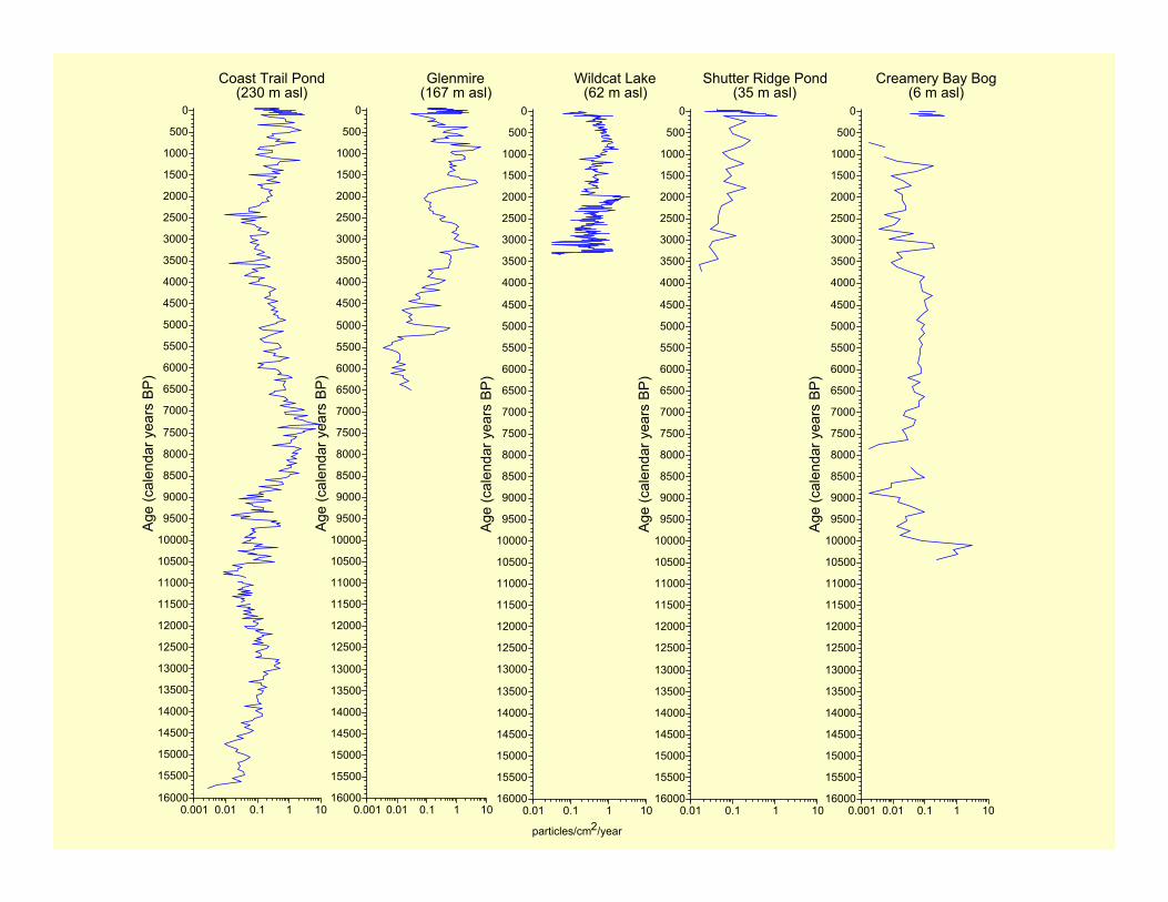
Consistently Higher Fire Occurrence – Humans ?

Why Synchronous Increase ?• Climate changes → wetter conditions, more biomass
• Human activities– Native American burning ethnographies
– Human habitation of Peninsula by coastal Miwok by 5000 years ago
– 14C dates on archaeological sites on and near Point Reyes increases after ca. 3500 years ago suggesting expanding human population
– These data are not conclusive of Human Burning, but are at least suggestive

16000
15500
15000
14500
14000
13500
13000
12500
12000
11500
11000
10500
10000
9500
9000
8500
8000
7500
7000
6500
6000
5500
5000
4500
4000
3500
3000
2500
2000
1500
1000
500
0
0.001 0.01 0.1 1 10
Age
(cal
enda
r yea
rs B
P)
16000
15500
15000
14500
14000
13500
13000
12500
12000
11500
11000
10500
10000
9500
9000
8500
8000
7500
7000
6500
6000
5500
5000
4500
4000
3500
3000
2500
2000
1500
1000
500
0
0.001 0.01 0.1 1 10
Age
(cal
enda
r yea
rs B
P)
16000
15500
15000
14500
14000
13500
13000
12500
12000
11500
11000
10500
10000
9500
9000
8500
8000
7500
7000
6500
6000
5500
5000
4500
4000
3500
3000
2500
2000
1500
1000
500
0
0.01 0.1 1 10
Age
(cal
enda
r yea
rs B
P)
16000
15500
15000
14500
14000
13500
13000
12500
12000
11500
11000
10500
10000
9500
9000
8500
8000
7500
7000
6500
6000
5500
5000
4500
4000
3500
3000
2500
2000
1500
1000
500
0
0.01 0.1 1 10
Age
(cal
enda
r yea
rs B
P)
16000
15500
15000
14500
14000
13500
13000
12500
12000
11500
11000
10500
10000
9500
9000
8500
8000
7500
7000
6500
6000
5500
5000
4500
4000
3500
3000
2500
2000
1500
1000
500
0
0.001 0.01 0.1 1 10A
ge (c
alen
dar y
ears
BP
)
Creamery Bay Bog(6 m asl)
particles/cm2/year
Glenmire(167 m asl)
Wildcat Lake(62 m asl)
Coast Trail Pond(230 m asl)
Shutter Ridge Pond(35 m asl)
Historic Period –General
Decline in Fire
Occurrence (especially at Coast Trail
Pond, Wildcat Lake
& Shutter Ridge Pond)

Summary – General Considerations
• A complex relationship between vegetation, climate, human settlement & fire occurrence– Abundant charcoal produced, but conifer forest and
sage scrub produced more charcoal than did grassland during the Holocene.
– Climate affects the characteristics of each sedimentary basin – determining whether that basin will be perennially wet or periodically dry.
– Local conditions, in turn, affect the local vegetation at each site.
– Human activities can have a potentially large effect on both vegetation and fire history.

Summary – Vegetation Changes• Closed coastal conifer forest until ca. 10,200 yr
ago• Driest Period commenced ca. 10,000 yr ago• Early Holocene established Mixed forest &/or
coastal sage scrub (most locales) and grassland (CBB)
• Still reasonably dry until ca. 6500 yr ago• Modern vegetation established during late
Holocene• Greatest vegetation change is in Historic Period
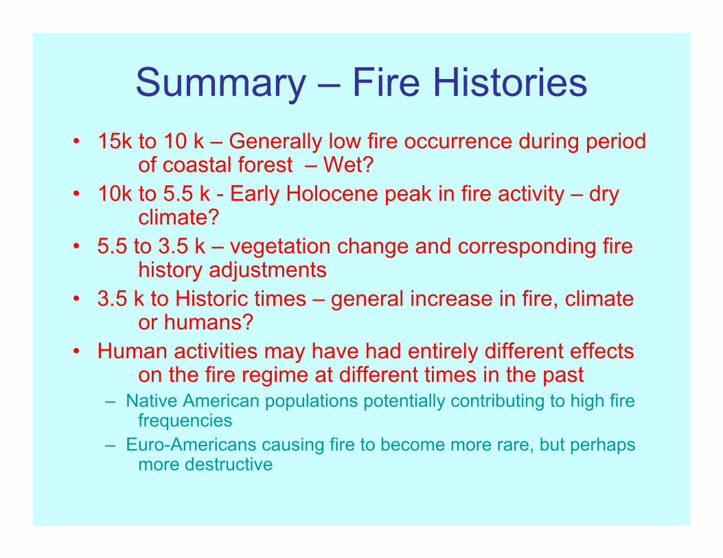
Summary – Fire Histories• 15k to 10 k – Generally low fire occurrence during period
of coastal forest – Wet?• 10k to 5.5 k - Early Holocene peak in fire activity – dry
climate?• 5.5 to 3.5 k – vegetation change and corresponding fire
history adjustments• 3.5 k to Historic times – general increase in fire, climate
or humans?• Human activities may have had entirely different effects
on the fire regime at different times in the past– Native American populations potentially contributing to high fire
frequencies– Euro-Americans causing fire to become more rare, but perhaps
more destructive
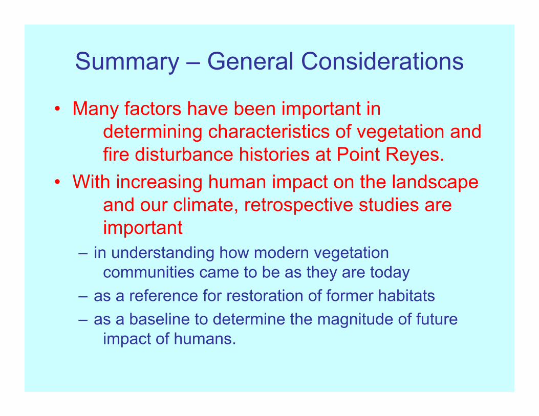
Summary – General Considerations
• Many factors have been important in determining characteristics of vegetation and fire disturbance histories at Point Reyes.
• With increasing human impact on the landscape and our climate, retrospective studies are important
– in understanding how modern vegetation communities came to be as they are today
– as a reference for restoration of former habitats– as a baseline to determine the magnitude of future
impact of humans.
Heartfelt Thanks to: Douglas Hallett (NAU), Mitch Power (Univ Oregon), Dan Buckley (NPS),
Barbara Moritsch (NPS), Jane Rodgers (NPS), Wende Rehlaender (NPS),
Heather Adkins, (NAU), Allison Bair (NAU), Mark Daniels (ERI-NAU),
Kirsten Ironside (NAU), Renata Jass (NAU), Taylor Joyal (NAU), Caitilin
McCracken (NAU), Rob Richardson (NAU), Jaime Toney (NAU), Alison Forrestel
(NPS), Point Reyes GIS Staff