Embed Size (px)
Citation preview

Scoping Study to Assess Hydrogeological Support to WaterAid Tanzania
Groundwater Management Programme
Commissioned Report CR/05/174C


BRITISH GEOLOGICAL SURVEY
GROUNDWATER MANAGEMENT PROGRAMME
COMMISSIONED REPORT CR/05/174C
Scoping Study to Assess Hydrogeological Support to WaterAid Tanzania
J Davies
The National Grid and other Ordnance Survey data are used with the permission of the Controller of Her Majesty’s Stationery Office. Ordnance Survey licence number Licence No:100017897/2005.
Keywords
WaterAid, Tanzania, Rural water supply.
Front cover
Maasai women waiting for water from the borehole at Ndaleta, Kiteto, Tanzania
Bibliographical reference
DAVIES J. 2005. Scoping Study to Assess Hydrogeological Support to WaterAid Tanzania. British Geological Survey Commissioned Report, CR/05/174C. 88pp.
Copyright in materials derived from the British Geological Survey’s work is owned by the Natural Environment Research Council (NERC) and/or the authority that commissioned the work. You may not copy or adapt this publication without first obtaining permission. Contact the BGS Intellectual Property Rights Section, British Geological Survey, Keyworth, e-mail [email protected] You may quote extracts of a reasonable length without prior permission, provided a full acknowledgement is given of the source of the extract.
© NERC 2005. All rights reserved
Keyworth, Nottingham British Geological Survey 2005

The full range of Survey publications is available from the BGS Sales Desks at Nottingham, Edinburgh and London; see contact details below or shop online at www.geologyshop.com
The London Information Office also maintains a reference collection of BGS publications including maps for consultation.
The Survey publishes an annual catalogue of its maps and other publications; this catalogue is available from any of the BGS Sales Desks.
The British Geological Survey carries out the geological survey of Great Britain and Northern Ireland (the latter as an agency service for the government of Northern Ireland), and of the surrounding continental shelf, as well as its basic research projects. It also undertakes programmes of British technical aid in geology in developing countries as arranged by the Department for International Development and other agencies.
The British Geological Survey is a component body of the Natural Environment Research Council.
British Geological Survey offices
BRITISH GEOLOGICAL SURVEY
Keyworth, Nottingham NG12 5GG
0115-936 3241 Fax 0115-936 3488 e-mail: [email protected] www.bgs.ac.uk Shop online at: www.geologyshop.com
Murchison House, West Mains Road, Edinburgh EH9 3LA 0131-667 1000 Fax 0131-668 2683
e-mail: [email protected]
London Information Office at the Natural History Museum (Earth Galleries), Exhibition Road, South Kensington, London SW7 2DE
020-7589 4090 Fax 020-7584 8270 020-7942 5344/45 email: [email protected]
Forde House, Park Five Business Centre, Harrier Way, Sowton, Exeter, Devon EX2 7HU
01392-445271 Fax 01392-445371
Geological Survey of Northern Ireland, Colby House, Stranmillis Court, Belfast BT9 5BF
028-9038 8462 Fax 028-9066 2835 e-mail: [email protected]
Maclean Building, Crowmarsh Gifford, Wallingford, Oxfordshire OX10 8BB
01491-838800 Fax 01491-692345 e-mail: [email protected]
Columbus House, Greenmeadow Springs, Tongwynlais Cardiff, CF15 7NE
029–2052 1962 Fax 029–2052 1963
Parent Body
Natural Environment Research Council, Polaris House, North Star Avenue, Swindon, Wiltshire SN2 1EU
01793-411500 Fax 01793-411501 www.nerc.ac.uk

CR/05/174C
Foreword This report reviews the current state of knowledge of the hydrogeology of several areas of north central Tanzania. It is based on data and reports provided by WaterAid Tanzania and the Government of Tanzania. The study was undertaken by BGS for the Department for International Development (DFID) through the Oasis Resource Centre in collaboration with WaterAid Tanzania. This project aims to assess current procedures and options for the rapid development of groundwater sources
i

CR/05/174C
Acknowledgements This report is the result of a short-term scoping study by BGS of the water resources of the Precambrian Basement Complex rocks of north-central Tanzania. While there the author enjoyed the hospitality of and stimulating discussions with WaterAid Tanzania and the Ministry of Water. The members of staff at WaterAid Tanzania are thanked for providing photocopies of reports and maps and access to digitised data.
ii

CR/05/174C
Contents Foreword i
Acknowledgements ii
Contents iii
Summary v
1 Introduction 1 1.1 The British Geological Survey Study 1 1.2 Groundwater Development in North Central Tanzania 1 1.3 Previous Studies and Reports 3
2 Background Information on Groundwater Occurrence 5 2.1 Physiography 5 2.2 Geology and Geomorphology 5 2.3 Hydrogeology 6
3 Observations During Field Visits (Appendix 2) 12 3.1 14 November 2004. 12 3.2 15 November 2004. 12 3.3 16 November 2004. 17 3.4 17 November 2004. 18 3.5 18 November 2004. 21 3.6 19 November 2004. 25 3.7 20 November 2004. 26 3.8 Data Collected or noted 28
4 Results 34
5 Options for Development 41 5.1 Introduction 41 5.2 Project Steps with Gaps and Training Needs Analysis 41 5.3 Water Resources Assessment – Case Studies 43 5.4 Possible BGS inputs into the National Rural Water Survey, Tanzania 44
6 Conclusions and Recommendations 50 6.1 Background 50 6.2 Conclusions 50 6.3 Recommendations 53
References 54
Appendix 1 Contacts 55
Appendix 2 Diary 56
iii

CR/05/174C
Appendix 3 List of maps for Kiteto held at the WaterAid office in Kiyaba 59
Appendix 4 National Water Policy Summary 60
Appendix 5 The World Bank RWSS Project Summary 67
Appendix 6 Reports collected in PDF format 74
Glossary 78
FIGURES Figure 1.1. Map showing the location of the Urambo, Nzega and Singida areas ............... 2
Figure 1.2. Map showing the location of Kiteto. ................................................................. 3
Figure 4.1 Institutional Map of Stake Holders in Groundwater Development for Rural Water Supply - Initial functions and linkages ................................................. 37
Figure 4.2 Revised Institutional Map of Preferred Stakeholder Linkages under the World Bank Sponsored Rural Water Supply and Sanitation Programme .................. 38
Figure 4.3 Potential Linkages and Barriers to Project Development ............................... 39
Figure 4.4 Stakeholders in Groundwater Development ................................................... 40
iv

CR/05/174C
Summary The WaterAid rural water supply and sanitation programme in north central Tanzania aims to improve the quality of life of people in parts of Manyara, Singida and Tabora regions through provision of safe water supplies, adequate sanitation and hygiene promotion. Since 1995, WaterAid has worked with central government agencies and local NGOs to develop the limited groundwater resources of the weathered and fractured Precambrian Basement rock aquifers in these areas through installation of wells and boreholes, with varying degrees of success. Emerging problems include:
• occurrence of fluoride in groundwater; and
• difficulties with the location of wells and boreholes capable of yielding sustainable quantities of water sufficient to meet community needs.
At the request of WaterAid a BGS hydrogeologist, funded by the DFID/OASIS scheme, visited Tanzania to undertake a scoping study with the following terms of reference:
1. Scope methods used by staff and consultants employed by WaterAid to site and drill boreholes.
2. Scope the need and approach for conducting assessment of groundwater resources and water quality, particularly with respect to fluoride distribution.
3. Scope the requirement for data collection, databasing and resource monitoring and methodologies to be used
4. Scope the training needs of project staff and partners for improved development of water points.
The BGS hydrogeologist accompanied WaterAid project managers to field sites observing geophysical survey, borehole drilling and water point development methods used in Urambo, Nzega, Singida and Kiteto Districts. Discussions were held with representatives of partner NGOs, regional government and Ministry of Water staff in Tabora, Nzega, Kibaya and Dar es Salaam. At a meeting with Ministry of Water staff in Dar es Salaam the groundwater development activities of WaterAid and the Ministry were discussed within the context of the ongoing World Bank led Rural Water Supply Programme.
The main conclusions of this visit include:
• Information collected by WaterAid suggest that the water supply needs of rural communities can only be part met by the limited groundwater resources available.
• WaterAid use GPS equipment to geo-reference village and water supply point locations; these baseline data can be used within a GIS system to map groundwater resources and their availability for use by rural communities.
• WaterAid employ local geophysical survey teams, who use ABEM Terrameter, EM34 and surface magnetic equipment to locate borehole drilling sites.
• Experienced ex-government hydrogeologists are employed by WaterAid to supervise and acquire geological and hydrogeological data during borehole drilling and testing.
• Junior geophysicists and hydrogeologists need to be trained in basic field techniques to provide government and private sector consultancies with the capacity to undertake future survey work, data collection and supervision.
v

CR/05/174C
A hydrogeological training course and needs assessment undertaken by BGS for UNICEF Nigeria identified a similar skills shortage amongst field staff there. The training needs identified included:
• Geophysical survey methods including equipment use and maintenance, data collection and interpretation.
• Understanding the main drilling methods and how to acquire geological and hydrogeological data during drilling.
• Simple methods of borehole test pumping.
• Methods of borehole design and construction.
• Assessment of water quality to ensure that water produced is of adequate quality for domestic consumption.
WaterAid hydrogeological information could be used to inform the ongoing World Bank sponsored RWSS project in the Kiteto area. Geodata using ArcView 3.2. and digitised Tanzania district maps are producing a GIS of water supply points for WaterAid. This GIS could be extended with geological and hydrogeological information layers to produce groundwater reconnaissance and resources maps to assist the World Bank/District drilling programme in the Kiteto area.
The following recommendations are made:
1. Update the training concept note on the basis of the BGS/UNICEF Nigeria training course experience.
2. Contact the Japanese International Cooperation Agency team undertaking an integrated water resources study the central basin area.
3. Assist WaterAid with groundwater development in Tanzania for rural water supplies in Tabora, Nzega, Singida and Manyara regions by production of water resources maps of Urambo, Tabora, Nzega and Kiteto Districts.
4. Use hydrogeological data to produce project area case studies to address:
• Groundwater source/resource sustainability.
• Water quality.
• Alternative sources of water.
5. The training and mapping exercises would inform national water policy guidelines on groundwater development aimed at:
• meeting the Millennium Development Goals.
• informing the processes for IWRM as identified in the NWDP.
• helping achieve the goals of the World Bank led NRWSSP.
vi

CR/05/174C
1 Introduction
1.1 THE BRITISH GEOLOGICAL SURVEY STUDY The British Geological Survey (BGS), through the DFID funded Oasis Resource Centre Scheme, was commissioned to provide hydrogeological support to WaterAid Tanzania. A brief review of WaterAid Tanzania’s current activities and past achievements in water resource provision is provided and problem areas associated with the development of groundwater resources in north-central Tanzania identified.
The terms of reference (TOR) for this scoping exercise included:
• Scope methods used by staff and consultants employed by WaterAid to site and drill boreholes – compare these with the basic methods demonstrated by the BGS team in 2001.
• Scope the requirement and approach for conducting assessment of groundwater resources and water quality, particularly with respect to fluoride distribution.
• Scope the requirement for data collection, databasing and resource monitoring and methodologies to be used – for the creation of groundwater resource maps and georeferenced GIS for marginal areas
• Scope the training needs of project staff and partners for improved development of water points given the future work programme.
A BGS hydrogeologist accompanied by WaterAid project managers visited the WaterAid project areas in north-central Tanzania during November 2004. Field visits included observing the survey, drilling and water point development methods in Urambo, Nzega, Singida and Kiteto Districts (Appendix 2). These visits were made at the end of the dry season when water supply systems are usually under stress. Discussions were held with representatives of partner NGOs, regional government and Ministry of Water staff in Tabora, Nzega, Kibaya and Dar es Salaam (Appendix 1). At a meeting with Ministry of Water staff in Dar es Salaam the groundwater development activities of WaterAid and the Ministry were discussed within the context of the National Water Policy (The United Republic of Tanzania, 2002) (issues relating to groundwater summarized in Appendix 4) and the ongoing World Bank led Rural Water Supply and Sanitation Project (World Bank, 2002) (Groundwater inputs summarised in Appendix 5).
1.2 GROUNDWATER DEVELOPMENT IN NORTH CENTRAL TANZANIA The WaterAid rural water supply and sanitation programme in north central Tanzania aims to improve the quality of life of poor people in parts of Manyara, Singida and Tabora regions through provision of safe water supplies, adequate sanitation and hygiene promotion. Emerging problems in these areas include:
• occurrence of fluoride in groundwater; and
• difficulties with the location of wells and boreholes capable of yielding sustainable quantities of water sufficient to meet community water supply needs.
1.2.1 The Tabora Region (Figure 1). In 2001, a Government of Tanzania survey ranked Tabora as being the third least served region for community water supply in the country. This problem could be attributed to the
1

CR/05/174C
lack of suitable water sources and the remoteness of the Tabora region from other parts of the country. WaterAid first implemented its rural water supply programme in Tabora region of central Tanzania in 1995. Since then, WaterAid has developed groundwater sources to meet the domestic water needs of nearly 400 000 people.
In the Tabora Region, of the 150 or more boreholes that have been drilled by WaterAid, some 113 had sufficient yields to be used for the provision of sustainable community water points. There are fears that this level of success may reduce when the programme is expanded into the more hydrogeologically difficult Districts of Urambo and Nzega (Bwena, Athanasio and Mrisho, 2000; Bwena, Athanasio and Mrisho, 2001; Bwena and Mrisho, 2003; Drilling and Dam Construction Agency, 2000; Mrisho and Makamba, 2004; Mrisho and Mpangala, 2004; Sangija, 2001and 2003; WaterAid, 2001 and 2003).
Key
WaterAid project areas
1 – Urambo
2 – Nzega
3 - Singida3
2
1
Figure 1.1. Map showing the location of the Urambo, Nzega and Singida areas
1.2.2 The Singida Region (Figure 1). In 2002, with funding support from DFID, WaterAid implemented a water and sanitation project within the peri-urban communities of the Singida area. This project aims to supply 57 000 people living in 19 villages with adequate water and sanitation by 2005. In common with Tabora, Singida has no surface water sources and is, therefore, reliant upon the development of groundwater to meet community needs. In Singida, the project, which is in its second year of implementation, hopes to complete 115 sustainable community water points in three years. Initial plans to install shallow hand dug wells proved not to be feasible due to the difficult hydrogeological conditions found in many communities. The programme has been changed to the development of deep groundwater sources through the installation of boreholes. The greatest emerging challenge is to overcome the problem of locating boreholes that yield sufficient water but do not contain fluoride.
2

CR/05/174C
Key
WaterAid Project Area
4 - Kiteto
4
Figure 1.2. Map showing the location of Kiteto.
1.2.3 The Manyara Region (Figure 2). Since 1995 WaterAid has been working in the Kiteto area of Manyara Region implementing a water and sanitation project within rural communities of the District. The Programme has worked in six villages to date, but progress has been slow in part due to lack of groundwater resources and salinity problems. In common with Tabora and Singida, Kiteto has few surface water sources and is, therefore, mainly reliant upon the development of deep groundwater sources to meet community needs. Trying to address the very different and often conflicting water requirements of the nomadic pasturalist Maasai and more settled agriculturalists has been a major challenge. Village communities are much larger and scattered in form that elsewhere in Tanzania.
In Kiteto WaterAid and partners face problems due to the difficult hydrogeological conditions found in many communities. The programme has focused on the development of deep groundwater sources through the installation of boreholes equipped with motorised pumps and piped reticulation systems to stand pipes. Again one of the greatest emerging challenges is to overcome the problem of locating successful boreholes that yield sufficient water of an acceptable quality in terms of fluoride levels and salinity (Water Source Ltd, 1996). WaterAid has been requested to expand the Programme to work in other districts of Manyara Region where similar conditions prevail.
1.3 PREVIOUS STUDIES AND REPORTS The occurrence of groundwater within the Tabora, Singida and Arusha (including Manyara) regions is described in Regional Water Master Development Plans produced during the 1980s
3

CR/05/174C
and 1990s (Arusha Regional Water Master Plan, 2000). The value of these compilations of existing data with limited exploration data is dependent upon the quality and amount of information available and the ability of the compiling consultants. According to user groups at Ministry and District levels these can be very variable. Since the compilation of the Regional Water Development Plans, rural groundwater development has proceeded primarily as a partnership between the Ministry of Water, its former nominally privatised component parts (such as the DDCA) and international NGOs such as WaterAid and World Vision.
Large regional groundwater studies were undertaken by the Dutch (DHV) in Shinyanga and Japanese (JICA) in Singida.
BGS assisted WaterAid in Tabora with the installation of water supply boreholes in the Tabora and Nzega areas as part of the DFID funded KAR project R7353 – Groundwaters from low permeability rocks in sub-Saharan Africa (Davies and Ó Dochartaigh, 2002) and Singida as part of KAR project R8033 – Minimising fluoride in drinking water in problem aquifers (Smedley et al, 2003).
4

CR/05/174C
2 Background Information on Groundwater Occurrence
2.1 PHYSIOGRAPHY The semi-arid savannah dryland areas of north-central Tanzania include the Tabora, Dodoma and Singida regions and parts of Mwanza, Shinyanga, Mara, Iringa and Arusha regions. Groundwater is the main source of domestic and livestock water in these rural areas of internal drainage; areas that experience frequent water shortages and water quality problems and are increasingly threatened by desertification (Maganga et al., 2002; The United Republic of Tanzania, 1999). Water supply is the main problem in dryland areas. The future development and supply of water in dry land areas will include educating inhabitants in methods of water resource sustainability. Water resource development and supply are recognised core needs in the Arusha, Dodoma, Singida and Tabora regions in the National Action Programme on Desertification (The United Republic of Tanzania, 1999).
The areas visited in the Tabora and Singida Regions and Kiteto District lie at an altitude of between 1000 and 1800 m. amsl. The Tabora region lies in the Plateau agro-ecological zone, the Singida Region in the semi-arid lands agro-ecological zone and Kiteto District lies in the arid land agro-ecological zone that includes the Maasai Steppe. These areas of North-central Tanzania are generally hot and arid with average monthly temperatures of 20–26ºC and have distinct wet and dry seasons with average annual rainfall of 600 and 800 mm. occurring between November and April, with virtually no rainfall between June and September.
Traditional water sources include ephemeral rivers, ponds, hand-dug wells and open pits and valley-side springs. The valley-side springs, are important sources of rural community for domestic water sources that are also used for small-scale irrigation. These sources are vulnerable to contamination by effluent carried by surface runoff or leaking from pit latrines. Water-related health problems include malaria, cholera and diarrhoeal diseases, often peaking at the onset of the rainy season. During the dry season these sources often dry up so that women and children have to walk to more distant water sources.
The natural vegetation cover of north-central Tanzania is predominantly miombo woodland, with acacia/cambretum woodland in the drier northeast and east. Today however, the region is dominated by bushed grassland with eroded gullies, due to the degradation of natural forests through felling, land cultivation and overgrazing. The broad, flat valleys are floored by mbuga (black cracking clay) soils, and in places support dense vegetation. Much of the native valley vegetation has been cleared for wet season rice and cotton cultivation. Interfluve areas are mantled by thin to thick red lateritic sandy to clayey soils.
The rapid population increase since 1980 has occurred mainly due to the influx of farmers, attracted by fertile soils and improving infrastructure, and mine workers, attracted by diamond and gold mining developments. Each region is divided into administrative districts, which are subdivided into divisions, each comprising wards that in turn include a number of villages. Access to the area is by rail, air and road. The roads are in a poor state and are often impassable during the wet season.
2.2 GEOLOGY AND GEOMORPHOLOGY Much of Tanzania is underlain by Precambrian basement rocks (mainly granite, gabbro and metasediments). Karroo age sediments occur in southern Tanzania. Volcanic rocks are associated with the East African Rift Valley which divides in Tanzania, the western limb passing through Lake Tanganyika and the eastern limb running via Arusha and Moshi to Morogoro. Young, mainly unconsolidated alluvial and lacustrine sediments derived from the
5

CR/05/174C
weathering of granitic and metasedimentary rocks infill depressions and grabens associated with the rifting.
The Tabora/Singida/Kiteto area can be split into two main geomorphological units. A high plateau in the south-east (about 1500 m amsl) is underlain by granitic and metasedimentary basement rocks of the Archean Granite Shield. These either occur at shallow depths below the rolling countryside surface or crop-out as numerous prominent weathered granite whalebacks. Sandy soils occur with ferricretes on hillsides and heavy mbuga clays (black vertisol soils) in valleys. The north-east comprises a flat plain formed by weathered Precambrian metasedimentary basement rocks of the Archaean Greenstone Belt, Cenozoic lacustrine sediments interbedded with volcanic rocks that overlie the older basement landscape, and Holocene to recent alluvial and lacustrine deposits infilling the down-faulted rifts occupied by the proto Lakes Eyasi and Victoria. Alluvial fan deposits fringe these often wide down faulted valleys infilled with thick near surface mbuga clays and deep alluvial and lacustrine deposits.
• Archaean Granite Shield: much of the study area is underlain by granite with variable grainsize and composition. Pegmatite is found in some areas. The granite has been intruded by many Palaeozoic and Proterozoic age dolerite dykes and sills. Younger (Cainozoic) intrusions may also be present in the area, though reliable dating has not been carried out.
• Archaean Greenstone Belt: the Greenstone Belt within the study area comprises a complex mixture of metasediments and acidic and basic volcanic rocks. These rocks are being explored for gold and some areas have small-scale mining activities. The metasediments comprise metamorphosed shale, phyllite, greywacke, quartzite and schist. One quartzitic unit is easily distinguishable and is named the ‘Banded Ironstone Formation’ due to its characteristic iron cementation. Acidic volcanic rocks (e.g. rhyolite, dacite) and associated tuffs are present along with basic volcanic rocks and tuffs. Some of the basic rocks have been altered to form greenschists which give the formation its name.
• Cenozoic lacustrine deposits: the lake deposits of the former Lake Eyasi comprise consolidated and unconsolidated sand, gravel, clay, limestone and tuff. Some evaporite deposits are also thought to be present
• Holocene alluvial fans and lake deposits: alluvial fans around the eastern escarpment of the plain form shallow slopes and comprise poorly-sorted and cross-bedded alluvium. No detailed profiles are available for the sequence, but the sediments are likely to be up to 50 m thick. Mbuga clay can be present at depth.
2.3 HYDROGEOLOGY The shortage of surface water supplies and growing regional population require the location and development of sustainable groundwater resources. Groundwater development is hindered by lack of understanding of groundwater occurrence in the geological units present. Limited quantities of groundwater occur in the near surface weathered zone, along fractures within the Precambrian crystalline basement rocks, in Pleistocene alluvial sands and gravels, and Cainozoic sediments. Such limited resources are best developed using properly sited and constructed boreholes and hand-dug wells.
The groundwater resources of the Tabora Region were first reported by the Geological Survey Department in the 1920s (Wade, 1927) as abstracted using hand-dug wells, valley-side springs collection trenches, sumps and sub-surface dams. Detailed investigation of groundwater resources of the region undertaken in the 1970s are reported in the Tabora Water
6

CR/05/174C
Master Plan (Brokonsult, 1980). WaterAid, local NGOs, the Ministry of Water, and private concerns currently develop groundwater resources. The WaterAid programme, with partner NGOs TAHEA and the Anglican Church, is currently the largest rural groundwater development project in the region. Since 1990 some 67 boreholes in ten villages have been drilled and fitted with hand pumps. Unfortunately, a large number of the boreholes drilled have been unsuccessful: either dry, or producing too little water to support a hand pump. Some borehole exhibit declining yields and deteriorating water quality due to seasonal variations, the effects of droughts or long-term groundwater mining. Although many boreholes have been drilled there has been no attempt to update the database held in the regional master plans. There has been little or no testing of newly drilled boreholes, and no long-term monitoring of borehole water levels or groundwater quality. There is little understanding of the yield potential of boreholes or sustainability of the groundwater resources. Many of the problems faced in siting and maintaining successful boreholes in the Tabora Region could be addressed by simple hydrogeological and data management techniques, most of which could be easily incorporated into water supply projects.
• In the rocks of the Archaean Granite Shield, groundwater occurs in both the fractured and weathered zones of the granite. Drilling records indicate that groundwater is often found at the base of the weathered zone, typically 20–40 m below ground surface. Drilling success rates are of the order of 50–70%. Yields tend to be sufficient for hand pumps (generally less than 30 m3 day–1), and occasionally for higher-yielding motorised pumps. Shallow boreholes and wells that only penetrate 10 m of the weathered zone can decline in yield by the middle of the dry season. Boreholes tend to be few and far between and water-point queues are common.
• In the Archaean Greenstone Belt, weathered and fractured phyllites, lavas and quartzites are likely to have the highest groundwater development potential. The development potential of these groundwater resources is poorly understood.
• Cainozoic lacustrine sands and gravels contain some groundwater mainly exploited at shallow depths (1–5 m) and from dugouts in riverbeds, providing the main sources of water during the dry season. Boreholes drilled into these deposits have produced saline water. The thick mbuga clays form aquacludes.
• The Quaternary alluvial fan deposits form good aquifers. Boreholes drilled at the foot of the escarpment can have good sustainable yields and low-salinity water. However, in some of the smaller alluvial aquifers (e.g. to the south-east of Kiombio) the alluvium can be thin and patchy and groundwater availability is controlled by bedrock geology. The hydrogeologic characteristics of the lacustrine deposits of the proto Lake Victoria in this area and proto Lake Eyasi are poorly understood.
In 2000 BGS conducted joint field investigations with WaterAid and Ministry of Water staff in four villages in the Tabora Region (Davies and Dochartaigh, 2002). The bulk of investigations were done in Kabale village, Nzega District, in the northern part of the Tabora Region. Additional work was carried out in Mtakuja, Ibiri and Lunguya villages, all within 20 kilometres of Tabora town. In Kabale, field investigations focused on seven new borehole sites. In the villages near Tabora, six proposed borehole sites, selected to replace unsuccessful boreholes, were investigated using EM34 surveys and six completed boreholes were test pumped. Groundwater samples for hydrochemical analysis were collected from boreholes and traditional wells in all four villages. Available data for ten villages in which WaterAid have worked in the Tabora Region to that time were also collated. The conclusions and recommendations made in that report are reproduced below.
7

CR/05/174C
2.3.1 Aspects relating directly to the WaterAid programme in the Tabora region The data collected during the BGS surveys in the Nzega and Tabora areas, and the collation of existing data, provide a framework for the development of groundwater resources in the region. The hydrogeological characteristics of the low permeability rocks that underlie the Tabora Region are complex. Groundwater potential depends on geology, structure (fracture patterns), geomorphology, and past climates. All the geological units are low yielding. Groundwater occurs in zones of weathering and in discrete fracture zones within bedrock. Shallower aquifer units contain young, recently recharged water, which flows rapidly downslope to discharge in valleys. This rapid movement of water can lead to rapid transport of contaminants in shallow zones, as seen in the high levels of nitrate in some of the shallow wells tested. Older, more mineralised water is often present in fracture zones. In Nyanzian rocks, water bearing fracture zones are often too deep beneath Mesozoic and Quaternary sediments to be detected using geophysical survey methods. Water from most of the boreholes and hand dug wells tested had high levels of iron, aluminium, fluoride or barium.
The installation of water supply boreholes should not be done in isolation, but as part of a groundwater development programme. Such a programme comprises (i) identification of the groundwater potential of an area; (ii) selection of suitable sites for borehole and hand dug well installation; and (iii) appropriate design and construction of boreholes and wells.
Most of the necessary techniques for assessing the groundwater potential of an area can be carried out relatively easily, cheaply and quickly, and useful information can be gathered during ongoing drilling programmes. The combined use of data gathered from maps, field geological information, remotely sensed data and geophysical surveys, produces a first assessment of groundwater potential, and aids the siting of successful water supply boreholes. Additional data collected during borehole drilling and test pumping will refine this assessment. All boreholes are important sources of information, wet or dry, and the locations of, and data from, these should be recorded. Once a water supply borehole is in operation, the monitoring of borehole yields, water levels, and water quality, will provide information for assessing the long-term sustainability of the aquifer, and provide early warning of water supply problems, such as over-abstraction or the effects of drought. It is currently not possible to monitor water levels in operating boreholes, because there is no access for water level dippers. Borehole completion designs should be amended to allow such access.
An understanding of the groundwater resources of the Tabora Region was obtained which should be updated as new information is collected. The groundwater potential maps produced provided a summary of available information for field use.
Given the nature of current and emerging problems associated with water supply in the Tabora Region, the 2001 BGS work brought to light several issues concerning groundwater exploration and development which deserve further discussion:
2.3.2 The importance of accurate site recording and location In the past, water supply development projects have failed to locate borehole and other survey sites accurately, relying only on place names. Many dry boreholes drilled and then abandoned are not recorded. Ambiguously located or unrecorded sites are difficult to geo-reference, hampering the production of accurate water resource planning or groundwater development maps. GPS systems provide the most accurate means of locating boreholes, villages, rivers, roads and other data points. Alternatively, borehole sites should be located using 1:50 000 scale topographic maps or 1:40 000 scale aerial photography where available. Accurately located (spatially referenced) data points can be plotted on a map for location and future
8

CR/05/174C
inclusion in a geographical information system (GIS). The WaterAid use GPS sets to accurately locate sites in the Tabora Region.
• Use of geophysical surveys for borehole siting. Electrical resistivity surveys are used to determine the thickness of the weathered zone for borehole site location but the geophysical survey sites are not accurately recorded making the correlation of lithological data with geophysical survey data difficult. BGS demonstrated that geophysical surveys need to be undertaken in conjunction with the interpretation of aerial photography (to locate linear fault zones) with sites located on a 1:50 000 topographic map using a GPS set for the location of drilling data and geophysical survey results. BGS also demonstrated the use of EM34 equipment for the rapid location of lineaments; with electrical resistivity being used to investigate depths of weathering on the fault zone.
• Data gathered during borehole drilling: Geological and hydrogeological data gathered during borehole drilling include geological logs, penetration rates, and flow rates. These data are used to assess the borehole potential, so that low yielding boreholes can be abandoned, and higher yielding boreholes identified for further development. Digital photographs of pseudo-core sections are used to record rock colour changes with depth to identify zones of weathering, fracturing and water strike.
• Test pumping: The test pumping of boreholes is rarely done. The bail test developed by BGS, demonstrated during the field study in Tabora, provides a rapid, simple method to assess the potential of a borehole. Fractured aquifer systems pumped at high yields can be dewatered and so fail. If the borehole is believed to be in a fracture system a longer-term pump test should be carried out to allow a more accurate assessment of borehole potential and sustainable pumping rate.
• Hydrochemical sampling: Hydrochemical sampling for determine inorganic groundwater quality can provide information about recharge and contamination. Water quality monitoring of new and operating water supply boreholes should be carried out. Indication of water quality change can be provided by the routine measurement of borehole water specific electrical conductance. The data obtained can be used to show areas or depths of different water quality.
• Borehole monitoring: Some boreholes in the Tabora Region have declining yields or have failed after periods of abstraction lasting from a few months to several years. The monitoring of borehole yields, undertaken by the borehole users, could warn of this problem. Yield monitoring could also be used to identify construction problems such as pump failure. Water level monitoring and water conductivity measurements would provide very useful hydrogeological information.
• Hydrogeological database: The construction of a hydrogeological database, accurately geo-referenced, should be a priority for the region. This will help to improve drilling success rates and inform the expectations of development workers and communities. A good database can also be the basis for a groundwater potential map for the Tabora Region, perhaps using the preliminary maps developed in this project as a basis. These maps could show average aquifer yields, depths to groundwater, modes of groundwater occurrence, and water quality information.
2.3.3 Wider Aspects of Groundwater Development in Tanzania NGOs such as WaterAid are leading some of the largest groundwater development projects currently being undertaken in Tanzania. These water supply projects are often the first drilling
9
CR/05/174C
programmes to be undertaken within remote rural areas, where hydrogeological conditions are little understood. The initial success and long-term sustainability of such projects, and of subsequent projects, will be improved by the acquisition of appropriate data during the siting, drilling and testing of new water supply boreholes. However, acquisition of the data needed to assess groundwater resources or their long-term sustainability is at times seen as wasteful of capital resources and beyond the capabilities of NGOs. It is, therefore, important that the relevant national institutions be encouraged to participate in NGO-led water supply projects, to ensure that good quality data are acquired and recorded. Government institutions such as the Geological Survey and DDCA should be involved with such projects, if only to update their own databases.
Where borehole success rates remain low, or to increase their capacity to provide sustainable water supplies, NGOs should be able to call upon the assistance of local and international experts who are familiar with the local hydrogeological situations. Areas of local expertise relevant to groundwater development in the Tabora Region could include: the University of Dar es Salaam (satellite image and aerial photograph interpretation); the Geological Survey (mapping of rock exposures and logging of rock core and chip samples); the Ministry of Water (borehole test pumping and hydrochemical analysis); the DDCA (borehole construction); and the Land Survey Department (digitised 1:50 000 maps). Local NGOs could monitor water levels, rainfall and borehole operation in association with community groups. These inputs could result in the collection of better quality data to be fed back into central and regional databases, which could be used to inform optimum groundwater resource development. These activities will require extra funding, which should be channelled through the lead NGO who could co-ordinate activities for the greatest benefits to the user community. Some institutional capacity building will also be needed, including the provision of transport, equipment, staff training and operational costs.
Future groundwater studies could usefully investigate the following:
• the density of abstraction boreholes,
• optimum borehole depths,
• optimum borehole design,
• risk of aquifer pollution,
• realistic estimates of borehole yield and resource expectations by communities and planners, and
• realistic minimum distances between abstraction boreholes and user communities.
2.3.4 Earlier Recommendations (Davies and Ó Dochartaigh, 2002).
• Work on a common database and a groundwater development map for the Tabora Region. The techniques used are easily transferable to other areas in Tanzania.
• Conjunctive use of surface, rain and groundwaters needs to be explored, particularly in areas with unpromising groundwater development potential.
• The application of geophysical techniques needs to be better understood, especially their use for borehole siting.
• The groundwater database and gazetteer of village locations, needs to be field checked and updated on a regular basis.
10

CR/05/174C
• The report and database are dynamic documents that should be added to on completion of drilling programmes to produce an up to date statement of the hydrogeology of the Tabora Region.
• Increased co-operation between different stakeholders, such as NGOs and government institutions would be advantageous.
The view amongst national institutions, consultants and international non-governmental organisations that data are confidential needs to be challenged.
11

CR/05/174C
3 Observations During Field Visits (Appendix 2)
3.1 14 NOVEMBER 2004. In Tabora met by Mr Muganizi Ndyamukama (WaterAid Tabora Project Manager). Reviewed reports describing the development of rural water supplies by WaterAid and associated Government Institutions, local NGOs, contractors and consultants in the Tabora region during 2000-2004.
3.2 15 NOVEMBER 2004.
3.2.1 Observations at Itundu Village, Urambo District Drove west along the Urambo Road to Intundu village where three abstraction points (two boreholes and a hand dug well) were inspected. Intundu Village is composed of six sub-villages each of which provides six members to the village water committee. Four boreholes have been installed by WaterAid of which two are currently in use. One has not been used since installation as it produces brackish water from the weathered rock saprolite layer that is of unacceptable taste to the community.
Point 1 (Plate 1) (S5˚05’35.2”/E032˚09’21.8”) The Shallow well at Johanna Macumbi was constructed to a depth of 5.5m using five concrete rings each 1.1m deep and 1m diameter. Much water was reported to occur in weathered rock saprolite layer when dug. During the current dry season 30-40 buckets of milky water are produced during each pumping session. By morning the water level rises to the base of ring four and is reduced to the base of ring five during a pumping session effectively emptying the well. The bottom of the well is in soft weathered rock and so could easily be deepened. The hand pump is not in use as the water table lies below the pump element and so water is lifted by bucket. The user group prefers the taste of the water produced regardless of its turbidity. A nearby borehole has not been used since installation due to the brackish taste of the water.
Plate 3
Plate 2
Plate 1
Point 2 (Plate 2) (S5˚05’07.1”/E032˚09’35.4”) The Godown borehole was installed in October 2001. Due to difficulties accessing funds the water committee is not able to carry out needed maintenance even though there is reported to be Tsh85 000 (£45-21p) in the fund. This borehole is used by 100 households, with and average of six people per household. This borehole is the community’s preferred source of water from the point of view of taste.
12

CR/05/174C
Point 3. (Plate 3) (S5˚05’05.0”/E032˚09’07.6”) The Mariseli Mathew borehole, although in use is badly in need of maintenance as the pump seals are worn. Users reported that the water pumped initially has a milky colour that decreases in turbidity after two days of pumping by which time clear water is produced with mica flakes in suspension. Initially water is obtained from the upper laterite zone, that yields white milky water with suspended kaolin clay (Plate 4). As this zone is dewatered with pumping so the amount of kaolin declines as more water is drawn from the underlying weathered rock saprolite zone until all water produced is drawn from the deeper zone as indicated by the clear water with white mica fragments in suspension. The water from the deeper zone is brackish in
comparison with the softer water in the laterite zone. It is the upper laterite zone that is rapidly recharged during the wet season and it is this zone that is most vulnerable to contamination by effluent from nearby pit latrines. John Kapongo, the community extension worker reported that the incidence of diarrhoea within the community had declined with the provision of borehole water.
Plate 4
3.2.2 Observations at Urambo Town
At Urambo town elements of the largely defunct town water supply distribution system inspected included a distribution point, several abandoned hand pumps and several probably contaminated hand dug wells.
3.2.3 Observations at Songambele (S4˚56’03.2”/E032˚05’40.8”) In the Songambele area north of Urambo WaterAid aims to install water supply and sanitation systems in four villages, including Kalemela and Muyngano, where the Sekuma people are the majority. Within this recently occupied area, there was a large abandoned well source, now collapsed, installed by a former groundnut scheme plantation. At Songambele met Mr Valerian Makusaro, a former Ministry water engineer now employed by SEMA of Singida, undertaking geophysical surveys for the location of borehole drilling sites for WaterAid. He was using an ABEM Terrameter SAS-300C with an ABEM SAS-2000 booster transmitter to undertake Schlumberger vertical electrical resistivity soundings. Analysis of the generated electrical resistivity curve data was undertaken manually. The geophysicist needs a portable laptop computer and necessary software to conduct data analysis by curve matching in the field. He also has access to a GEM GSM-19 Overhauser Magnetometer but has so far failed to obtain sensible readings from the equipment. The VES sites are accurately located using a Geographical Positioning System (GPS) set, in terms of the UTM grid reference rather than in degrees of latitude and longitude. However the locations cannot be plotted due to the lack of access to 1:50 000 scale topographic maps or suitable aerial photography of the area. Copies of maps and aerial photography should be available from the planning department at the Tabora RAS office. WaterAid have so-far drilled seven boreholes at sites located using the results of a village/water sources baseline survey undertaken by the Anglican Church. WaterAid now plan to install up to 40 boreholes and hand dug wells within the Songambele area using the results of the geophysical surveys.
13
CR/05/174C
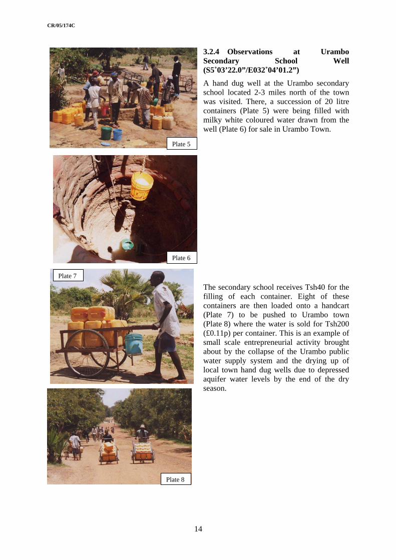
3.2.4 Observations at Urambo Secondary School Well (S5˚03’22.0”/E032˚04’01.2”)
Plate 8
Plate 7
Plate 6
Plate 5
A hand dug well at the Urambo secondary school located 2-3 miles north of the town was visited. There, a succession of 20 litre containers (Plate 5) were being filled with milky white coloured water drawn from the well (Plate 6) for sale in Urambo Town.
The secondary school receives Tsh40 for the filling of each container. Eight of these containers are then loaded onto a handcart (Plate 7) to be pushed to Urambo town (Plate 8) where the water is sold for Tsh200 (£0.11p) per container. This is an example of small scale entrepreneurial activity brought about by the collapse of the Urambo public water supply system and the drying up of local town hand dug wells due to depressed aquifer water levels by the end of the dry season.
14

CR/05/174C
3.2.5 Observations at Tabora west (S5˚06’31.6”/E032˚30’36.5”)
Plate 10
Plate 9
A series of shallow water supply pits were inspected south of the main road and mid-way between Urambo and Tabora. The pits have been excavated in an mbuga area into a tubular ferrecrete layer some 1.5 m. thick. These pits form the dry season source of water for villagers within a 5 km radius, where local water sources have dried up. Water is collected in 20 litre capacity containers for transportation to user communities (Plate 9). The water is for cultivation of tobacco nursery plants in the vicinity of the mbuga area and domestic use in the community. During the wet season the area is normally flooded after heavy rainfall. Rainwater recharges the near surface tubular laterite layer (Plate 10) that supplies water to the shallow pits during the dry season. As the dry season progresses so the water level falls and the rate of flow to the wells diminishes. This source could be developed using a trench with horizontal screen and sump similar to that installed by WaterAid at a camp for Rwandan refugees at Kashishi. That scheme intercepts water flowing through a thin layer at the base of the laterite zone to provide sustainable domestic water throughout the dry season. A system of augered observation holes could be easily installed across the area to determine the direction and rate of water flow.
3.2.6 Tabora Meeting with Anglican Church Development Coordinator and the District Hydrogeologist At Tabora met Mr Christoph Nyamwanji, the Development Coordinator for the Diocese of Tabora, The Anglican Church in Tanzania and Mr Benard Chikarabani, Hydrogeologist, Water Department to discuss the rural and urban water supply situation in Tabora, Urambo and Nzega Districts. At national level, poverty alleviation is being addressed through the World Bank financed National Rural Water Supply and Sanitation Programme (RWSSP). As part of this project, funds arranged at government level are transferred to District level where private companies and NGOs are required to bid for project finance. No funds are being made available for the decentralised government departments to upgrade equipment or training of personnel yet they remain the main link between central government and NGOs. Prior to the National RWSSP there was little development of rural water supplies other than through the NGOs. WaterAid are better equipped than most NGOs but they have to rely upon former and
15

CR/05/174C
present government officers to undertake the siting of boreholes, the monitoring and supervision of borehole drilling and construction, and collection of relevant data. The two principal hydrogeologists of the Department of Water, Dr Mpanda and Mrs Mcharo, were employed by WaterAid in Nzega and Singida to undertake such field duties in the absence of junior staff with relevant field experience. The issue of staff training in techniques of field surveys and supervision methods is becoming more acute. The training of staff in up-to-date methods in GIS may be left to consultants but they also lack staff able to undertake fieldwork.
The National Water Policy documents appear not to adequately address ecological or environmental concerns. So far four villages in Nzega have submitted proposals through Anglican Church for rural water supply and sanitation infrastructure works in association with SIMAVI, a Netherlands based NGO. Similarly three villages in Urambo are being completed and works at three more villages have been proposed. Again the Anglican Church has sought funding from SIMAVI who are now trying to integrate with water supply work with WaterAid. WaterAid have recently undertaken work in Sojo and Kabala in Nzega District. Baseline surveys have been undertaken by the Anglican Church for WaterAid in Luso ward and Songambele Ward. The Anglican Church has also been looking at the development of school gardens in association with Seeds for Africa at ten primary and ten secondary shools. All of these projects will need to have reliable water sources but the Anglican Church does not yet have the funds. The Anglican Church has also been active in HIV/AIDS work especially in the main problem areas of Tabora, Nzega and Urambo.
Comments on procedures to be followed for RWSS projects:
• Must inform government that funding has been obtained – must then work within the district plans,
• Under the new National Water policy all expressions of interest are to be submitted to District Level. Received photocopies of reports at the WaterAid office,
• In the rural water supply sector WaterAid are the main players.
Comments on procedures to be followed for Urban water supply projects:
• Case studies include water supplies to Nzega, Tabora and Urambo towns,
• Consultant engineers funded by Aid agencies or vested interests tend not to understand the groundwater resource or they understand the limitations of the surface resource only too well and so impose costs and conditions that mean that only the proportion of the population that can be supplied are so done at the expense of the poor who are forced to exist off contaminated supplies.
• Government funds town supplies.
• Resolute Mine funded the Nzega water distribution system – for those who can afford to pay for the water supplies.
• WEDCO funded the Shinyanga water distribution system – for those who can afford to pay for it?
• Tabora – DFID funded the main delivery main from the reservoir and some of distribution system but did not increase the resource – just reduced the leaks and demand by charging for water.
• Urambo – town distribution system almost defunct
16

CR/05/174C
3.2.7 Tabora Meeting with Moravian Church At the Tabora Hotel met with a representitive of the Moravian Church, Mr Dick L Mlimuka, who is an advisor with the Tabora Development Foundation Trust. Discussed the occurrence and use of groundwater at Sekongi Mission, south of Tabora. This is a poor area for surface water, a small groundwater source being abstracted by borehole for the hospital at Sekongi. He described the history of the mission at Sekongi. The Anglican Church funds the hospital that was originally established in the 1920’s as a leprosy mission. Some funds are still received from the Anglican Church although the hospital now run by the Moravians who specialise in the treatment of HIV/AIDS.
3.3 16 NOVEMBER 2004.
3.3.1 Observations at Bojulu gulu village in the Kabale area
Villa e, Nzega District (S4˚02’06.1”/ E33˚13’55.9”) Drove north of Nzega to Bojwhere met Dr Samson Mpanda, Principle Hydrogeologist at the Ministry of Water, at a borehole drilling site north of the Resolute Gold mine. Observed borehole drilling using a DDCA Schraam drilling rig (Plate 11). Lithological samples were collected at 2 m. intervals and placed in a sample box for analysis by Dr Mpanda (Plate 12). He did not have a camera available to record changes in lithology colour with depth. Discussed the occurrence of groundwater and geology with Dr Mpanda then visited the site of a completed borehole at Mitwndu (bh No. 1) (Plate 13) located at S4˚04’38.4”/ E33˚14’16.4”. There noted that the borehole is located in a valley downstream of the main tailings dumps of the Resolute Gold mine, where cyanide is used for gold extraction from milled ore. There maybe some potential for future pollution of village water supplies with contaminated water draining from the tailings dump.
17
Plate 12
Plate 13
p
Plate 11
Resolute Mine tailings dum
Water supply borehole located down dip of the dump
CR/05/174C
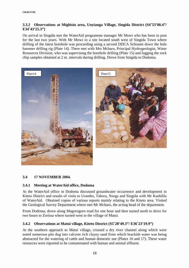
3.3.2 Observations at Mighisiu area, Unyianga Village, Singida District (S4˚53’08.4”/ E34˚43’25.3”)
years. With Mr Mowi to a site located south west of Singida Town where
.4 17 NOVEMBER 2004.
Meeting at WaterAid office, Dodoma ma discussed groundwater occurrence and development in
Kiteto District and results of visits to Urambo, Tabora, Nzega and Singida with Mr Kashilila t rts mainly relating to the Kiteto area. Visited
r channel along which were noted numerous pits dug into calcrete rich clayey sand from which brackish water was being abstracted for the watering of cattle and human domestic use (Plates 16 and 17). These water resources were reported to be contaminated with human and animal effluent.
On arrival in Singida met the WaterAid programme manager Mr Mowi who has been in post for the last two drilling of the latest borehole was proceeding using a second DDCA Schraam down the hole hammer drilling rig (Plate 14). There met with Mrs Mcharo, Principal Hydrogeologist, Water Resources Division, who was supervising the borehole drilling (Plate 15) and logging the rock chip samples obtained at 2 m. intervals during drilling. Drove from Singida to Dodoma.
Plate14 Plate15
3
3.4.1At the WaterAid office in Dodo
of Wa erAid. Obtained copies of various repothe Geological Survey Department where met Mr Mcharo, the acting head of the department.
From Dodoma, drove along Magorogoro road for one hour and then turned north to drive for two hours to Zorissa where turned west to the village of Matui.
3.4.2 Observations at Matui village, Kiteto District (S5˚28’49.3”/ E36˚23’19.9”) At the southern approach to Matui village, crossed a dry rive
18

CR/05/174C
Plate16
3.4.3 Observations at Matui Village powered borehole (S5˚28’34.5”/ E36˚23’03.0”). At the top of the hill, on which Matui village is located,
r Andy Singida and funded by WaterAid (Plate 18). The
tank twice a day in 4 hour
viewed theM
village borehole water source as located by
borehole is equipped with a Mono 440 aqualift pump powered by a 2 cylinder Lister engine that is used to pump water to a 40 000 litre capacitysessions from which water is reticulated to two stand pipes. The population of the village is about 20 000 including a large migrant population associated with the buying and selling of maize.
Plate17
Plate18
Plate 19
19

Plate19
CR/05/174C
3.4.4 Observations at Matui Village shallow water supply pits (S5˚28’47.2”/ E36˚24’20.3”). East of the village an earthen dam breached during the floods caused by the 1998 El Nino effect was noted. Upstream of dam many shallow pits have been dug into calcrete/clay base of local river channel from which ‘fresh’ water is abstracted by bucket (Plates 19 and 29). Along the valley, water is sold in 20 litre containers at Tsh50 (£0-03p) each to be resold in town a couple of miles away for Tsh 250 (£0-13p) per container. One man reported that he sold Tsh10 000 –15 000 (£5-32 to £7-98) worth of water per day during the current dry season. The valley is the main dry season source from May onwards each year and is flooded during the wet season. Rains were due to start soon so water levels were at their lowest. Noted some brown mottling of teeth due to fluorosis in the local people, but most teeth are very white. Some change in salinity reported between pits. Abstractors tend to supply water only to their own ethnic groups, each pit is owned by a separate person. Commonly a pit water level recovers by 0.5 m. following the cessation of pumping at 22:00 hrs.
From Matui drove north-eastwards to Kiteto where spent the night at the WaterAid guest house/office. There, looked at groundwater development reports and topographic and geological maps. Down-loaded data files from the office computer. Discussed rural water supply problems in the Kiteto area with Mr Kashililah. The main problem appears to be how to supply water to the Maasai when they are not a static population, more concerned about the supply of water to their animals that to themselves.
Plate20
20

CR/05/174C
3.5 18 NOVEMBER 2004.
3.5.1 Meeting at office of Water engineer, Kibaya. At WaterAid office in Kibaya, compiled a
list of topographic and geological maps held at the office. Visited the District Water Engineer with whom discussed the proposed World Bank funded Rural Water Supply and Sanitation Programme. Studied the feasibility study produced by COWI International for the installation of ten production boreholes within the southern half of the district, where the main settlements are located. A further ten boreholes are already being discussed. There is little in the report about the hydrogeology of the area, only information derived from the Arusha Region Water Master Plan. There is a great need to obtain as much information from these new boreholes as possible if the World Bank funded rural water supply programme is to be meaningful.
Plate 23
Plate 22
Plate 21
3.5.2 Observations at Ndaleta Village Drove south from Kibaya to the village of Ndaleta where at S5˚13’25.0”/ E36˚29’43.4” viewed the low lying area to the north, occupied by the Maasai due to the prevalence of saline water (Plate 21). The Maasai need access to near surface water holes, springs and dams capable of watering may hundreds of cattle per day at 40 litres per beast on their migration routes around the area looking for pasture.
Observed the effects of bush clearance including the silting up of local streams near Ndaleta (Plate 22). At Ndaleta village met the village elders to whom I was described as the ‘witch that can find water’! Visited a water supply point and part of the water supply distribution system. Water is pumped twice a day from the village borehole to a 20 000 litre capacity tank to be reticulated to two stand pipes. A large queue of empty mainly 22 litre water containers was seen at the standpipe at S5˚13’20.7”/ E36˚29’48.5” (Plate 23). Of these only a third to half will be filled during a water delivery session, the
21

CR/05/174C
rest will have to wait 12 hours until the next delivery. Visited the borehole pump house at S5˚13’38.2”/ E36˚29’45.2” (Plate 24) where, according to the local pump operator, in the wet season it takes three hours to fill the 20 000 litre tank then two hours for the water level in the borehole to recover; in the dry season it takes three hours to fill the tank and five hours for the water level in the borehole to recover; presently, at the end of the dry season it takes five hours to fill the tank, water level falls to the level of the pump which then pumps air with water – has to operate the pump until the tank overflows, then takes five hours for the water level in the borehole to recover. This forms a simple example of community monitoring of a borehole scheme where there is poor understanding of the resource system. Three boreholes were drilled in the village but only one was successful. This happened to be located in the middle of main access road to village. An unsuccessful borehole was seen located in a depression within the village (Plate 25). On the return to Kibaya noted the location of Njuro village to the north and the village water supply, a borehole in hills to the south. (Plate 26).
Plate 25
Plate 24
Plate 26
22

CR/05/174C
3.5.3. Observations at Kibaya Sand Dam, spring and borehole.
Plate 29
Plate 28
Plate 27 On the southern edge of Kibaya village on the main road to the south, visited the main sources of water supply for the village. These included a sand dam (Plates 27 and 28), a spring and a borehole (Plate 29), all located in or adjacent to a river bed. The sand dam is newly installed by WaterAid at a point downstream of the spring zone. The dam has yet to be filled with sand that should be derived from the erosion of recently deforested areas upstream in the catchment. The borehole is located upon a small fault zone that is crossed by the river valley. A pump located in a hut near to where the road crosses the river lifts water to the village. Local people were filling plastic water containers from the outflow from the spring/sand dam (Plate 28). Also noted are leather bags used by Maasai to carry water on backs of donkeys.
23

CR/05/174C
24
Plate 31
Plate 30
Plate 33
Plate 32
3.5.3 Observations at Songambele village water supply scheme. From Kibaya drove south through semi-arid bush covered region to Dosi Dosi noting the poor state of the straight all weather road (Plate 30).
At Songambele, at the southern boundary of the district, again noted a long queue of plastic water containers waiting to be filled with water at a water supply point (Plates 31 and 33). There inspected the motorised borehole pumping and reticulation system installed by WaterAid (Plates 32 and 33). The borehole is equipped with a Mono 440 aqualift pump powered by a 2 cylinder Lister diesel engine.

CR/05/174C
3.6 19 NOVEMBER 2004. its with Ms Vivienne Abbott, the WaterAid
try aterAid office in Dar es Salaam. The WaterAid head office
Discussed th
ojects in Tabora, Singida and Kibaya,
ken in Nigeria, and
d Water structure is
f ten per district. This
where COWI have undertaken an initial assessment of water requirements and produced ten
Discussed the results and findings of field viscoun representative, at the Whas been moved from Dodoma to Old Bagamoyo Road, Dar es Salaam. Part of the office space is occupied by COWI International, the main water consultants in Tanzania.
With Mr Kashililah, attended a meeting with various Directors of Ministry of Water at the conference center, Maji Ubungu in Dar es Salaam at 9:00 am. There met:
• Mr Lister Kongola, Assistant Director, Water Resources, Groundwater,
• Mr Mihayo, Assistant Director, Water Resources, Surface-water,
• Mr Shirima, Senior Planning Officer, Water Master Plans, and
• Eng Mkumwa, Engineer, Rural Water Supply.
e following with them:
• The findings of visits to WaterAid pr
• The manual of simple hydrogeological methods being produced for publication,
• The content of a concept note outlining a prospective water resources mapping project to be undertaken in Uganda,
• The content of a concept note outlining a fieldwork procedure training course for hydrogeologists to be underta
• The occurrence of fluoride in the north-central regions of Tanzania
Mr Kongola described the impact of the National Water Policy and the World Bank financeNational Rural Water Supply and Sanitation Programme. The National being reorganisation from the 26 administrative regions into nine river basins. There will be three main tiers of operation at National, river basin and district levels with three zonal offices between national and river basin level. Existing hydrogeological capacity at regional level is being reorganised into the nine river basin level offices. Mr Kongola stated that he is losing 1-2 hydrogeologists per year to retirements and the effects of HIV/AIDs and that these are replaced by two newly qualified MSc level hydogeologists per year. 20 MSc level hydrogeologists are produced per year by the hydrogeology course run by the University of Dar es Salaam. A separate Institute of Natural Resources has been reorganised as a new university located adjacent to the University of Dar es Salaam campus.
As part of the World Bank led National Rural Water Supply and Sanitation Programme water supply points are to be developed in 125 districts at an average rate odensity will depend on the requirements of each district. According to Mr Kongola the bulk of these water points will be boreholes. Under the current arrangements the DDCA undertakes most of the drilling with its fleet of elderly Schramm drilling rigs. Some work is undertaken by private drillers but they tend to be inexperienced at water borehole drilling. Seven large capacity Ingersol Rand rigs are reportedly being imported from the USA by a new contractor who sounds as though he has been promised much of the World Bank project work. Even though the World Bank funds are a loan to the Government of Tanzania, the World Bank appears to control the appointment of consultants and contractors much to the frustration of Mr Kongola who feels that the Ministry of Water is being sidelined. To date RWSS pilot projects have been undertaken in three districts, one in each of Dodoma, Manyara and Coastal regions. Plans for 38 district projects are being prepared. One of these is in Kiteto District
25

CR/05/174C
sites for a first phase of drilling with a further ten to be undertaken later. Little appears to be understood about the geology or hydrogeology of that district; what is described in their feasibility report mainly came from the limited data in the Regional Water Master Plan for the Arusha area.
According to Mr Kashililah and Mr Kongola the hydrogeological contents of the regional water master plans are variable: depending upon when the study was undertaken and the consultants who undertook the work.
he period of the World Bank programme, it was agreed
luoride occurrence and remediation
The content of two concept notes describing possible BGS inputs into the WB strategy programme were discussed. Although the meeting felt that the topics covered by the concept notes needed to be addressed during tthat the concept notes needed to be redrafted inline with the requirements of the National Water Policy document and the latest assessment of World Bank led National Rural Water Supply and Sanitation project before formal submission.
Mr Kongola suggested that the short lived BGS fluoride study undertaken in the Nzega and Singida areas could be extended by inclusion within the scope of the proposed JICA study the northern interior basin that is seen as a continuation of fstudy. The proposed JICA study will include assessment of the groundwater resources development and management in the internal basin and rural water supply in the Mwanza and Manyara regions. The e-mail contact address of the contact person is [email protected] who is the assistant JICA representative in Tanzania.
Following the close of the meeting, returned to the WaterAid office where discussed the results of the meeting with Ms Abbott.
With Mr de Waal (WaterAid) and Mr Kashililah to the office of Geodata where met with Mr Charles Buderwa (databases) and Mr Vedastus Makota (maps) to look at GIS being set up for the Kiteto area. Currently Geodata use ArcView3.2 with excel spreadsheets and access
retation and assessment of social issues related to how the Maasai herd,
me e reported that the water supply system at Shinyanga is ess n water supply schemes to be developed and co funded by
databases.
At the WaterAid office discussed water supplies for the Maasai and village populations of the Kiteto area with Ms Abbott. Water resources mapping in northern Kiteto district requires Landsat image interpgraze and water cattle. Geodata promised to supply an Autocad digital map of Kiteto district.
3.7 20 NOVEMBER 2004. Discussed the Shinyanga town water supply scheme with a British water engineer visiting the sche on behalf of Oxfam. Hsucc ful and is one of 18 towgovernment as Public Private Partnerships (PPPs). They are not strictly privatised but are funded using revenues collected from the tariffs paid by the user community. He suggested that the best system is that at Tanga, one of three grouped in the upper grade 1 level with Arusha and Mwanza. These three schemes are fully funded using finance collected from tariffs and they are allowed to fully invest profits in development of water treatment and distribution networks. Others have achieved level 2 status where they receive some support from government, but most are still at level 3 status where they remain fully funded by central government. Shinyanga is a level 3 system. At Shinyanga, the water engineer will put in place a reorganised tariff structure based upon the installation of water meters. He reckons that as people become aware of the amount of water they are using, especially in the semi arid environment at Shinyanga, they will reduce levels of consumption. This coupled with leak reduction will lead to a more efficient use of limited water resources. Shinyanga town is based
26

CR/05/174C
on the mining of diamonds and gold. The quantity of water consumed is increasing with population growth. Currently water is obtained from a reservoir, that tends to run dry by the end of the dry season, supplemented by water from a borehole field in a basement complex aquifer with limited recharge potential. A water transfer pipeline is being constructed to supply water from Lake Victoria at Mwanza to Shinyanga.
At Dar es Salaam airport met Mr Kongola with whom discussed the following:
Current research: He was enroute to an IAEA meeting in Vienna to look at the effects of e of stratified d palaeo-lake
with radiocarbon dates of
new district level and basin level offices.
Water organising water database,
a,
. Where World Vision hydrogeologist undertakes site supervision. ists with the Department if water, some at
Traininprogramexperie te (FTC) from the Rural Water
ective.
rse structure,
WaterAid, and
nia.
e tra of appropriate data from boreholes (to be outlined in ms o d outputs).
climate change and water abstraction from Lake Victoria. He is studying the agwaters with in Lake Victoria and in sediments associated with the current anusing isotopes spun from samples, for the Nile Basin organisation.
He is also assessing the age of waters in the basin aquifer that supplies Dodoma with water where recently installed boreholes are pumping water at up to 100,000 gph (123 l sec-l). He is concerned about the sustainability of this resource which has waters3000 years BP.
Staffing levels: Kongola also discussed the present state of water development in Tanzania. He has a staff of 26 professional hydrogeologists located at regional level. These will be transfered to the
International aid organization activities in groundwater include:
• GTZ office embedded within the DDCA/Ministry of
• Dutch groundwater project is ongoing in the Shinyanga are
• DANIDA have pulled out of water work,
• UNICEF are active in some areas as are World Visionundertakes drilling a Water department There are currently about 26 hydrogeologregional level with some at headquarters in Dodoma.
g inputs: Mr Kongola would like to see a training course that addresses the me strategy, and should be aimed at his 26 hydrogeologists all of whom lack field
nce. Technicians who obtain a full technical certificaResources Institute (RWEGALURIRA) are needed for site supervision where they should be regarded as assistant hydrogeologists.
Mr Kongola expressed interest in working with BGS looking at groundwater conceptual models of the river sub-basins possibly using systems developed for those being undertaken as part of the EU Water Framework dir
He needs:
• timing and costs,
• Cou
• Inputs from BGS/
• Inputs from Tanza
Th ining is needed for the generation ter f objectives, methods an
27

CR/05/174C
Assumptions:
• That the curriculum meets the requirements of Tanzania.
e power point images and course content can be amended to reflect the
nationa
Many data have been collected in digital or hard copy formats during the siting and ce 2000 in the Tabora and Singida Regions and
Comments
• That thenvironments found in Tanzania and working practices.
• That suitable siting/drilling/test pumping programmes can be identified including borehole drilling, well sinking and gravity fed schemes.
Other activities: Mr Kongola stated that the Geological Survey of Tanzania has produced a l geological map that is available in digital format. This was not apparent during visit
to the Geological Survey. Mr Mcharo had replaced Mr Konyenko as head of the Geological survey in Dodoma.
3.8 DATA COLLECTED OR NOTED
installation of water production boreholes sinfrom Kiteto District of Manyara region. Reports copied or noted containing groundwater data collected in these regions are listed in the tables below. These are similar in format to those on the BGS Tabora region hydrogeological study CD. Each regional office of WaterAid holds original data files and reports. Borehole data are copied to the Rural Water Supply Department in Dodoma for entry into their central database. However, gaps in the records need to recognised by identifying the types of data not collected during water supply and sanitation projects undertaken in these areas
Tabora Region - Urambo District: Reports
Village Report
Itundu Bwena, P , Athanasio, J and Mrisho, M , 2000. ater exploration for Itundu Village,
83 VES at 6 ger Groundw
Urambo District, Sept 2000. sites, 16 auholes
Itundu drilled in Itundu cations
WaterAid, 2001. Borehole completion certificates for boreholes Village, Urambo, 2001.
13 bh sheets no GPS lo
Kashishi es drilled at Kashishi,
o GPS locations
WaterAid Tanzania, 2003. Borehole completion certificates for boreholUrambo District in 2003.
3 Bh sheets n
Kashishi Nzega District and
d test pumping
Sangija, A F , 2003. Drilling programme in Sojo and Kanolo Villages, Kashishi Village, Urambo District.
Bh drilling an
data
Songombele, Uyogo, Igunguli and
nyewe Songambele he water
Jionee Mwevillages
Mrisho, M and Mpangala, G , 2004. Water Resources Assessment Report, Ward, Urambo District, Tabora. Sept 2004.
Baseline survey of tsources of 4 villages
28

CR/05/174C
Tabora Region – Nzega District: Reports
Village Report Comments
Kabale Drilling and Dam construction agency, 2000. Borehole completion certificates for boreholes drilled at Kabale in 2000.
7 bhs drilled
Lusu Mrisho, M and Makamba, D , 2004. Water Resources Survey Sheets for Mwaluzwilo Village. Lusu Ward, Nzega Jan 2004..
Baseline survey of water sources
Sojo Bwena, P , Athanasio, J and Mrisho, M , 2001. Groundwater investigation for Sojo Village, Nzega District, Oct 2001.
53 VES at 16 sites, 15 bhs drilled
Sojo Bwena, P and Mrisho, M , 2003. Groundwater investigation for boreholes at Sojo Village in Nzega District. Oct 2003.
7 VES at 3 sites, 2 bh sires
Sojo and Kanolo
Sangija, A F , 2001 Hydrogeological report review of Kanolo and Sojo villages.
Summary of water sources, ves surveys and new Bhs
Sojo and Kanolo
Sangija, A F , 2003. Drilling programme in Sojo and Kanolo Villages, Nzega District and Kashishi Village, Urambo District.
Bh drilling and test pumping data
Singida Region – Singida District: Reports
District Village Report
Singida Various Smedley, P L, Nkotagu, H , Pelig-Ba, K , Macdonald, A M , Tyler-Whittle, R , Whitehead , E J and Kinniburgh, D G , 2002. Fluoride in groundwater from high-fluoride areas of Ghana and Tanzania. British Geological Survey Commissioned Report, CR/02/316. 72 pp.
Manyana Region – Kiteto Didtrict: Reports
Village Report Comments
Water Source Ltd, 1996. Water Resources and Supply Study for Kiteto District. For SIDA, November 1996.
Summary of water sources and development sites
WaterAid Tanzania, 2002. Water Quality Report. KINNAPA/KDC/WaterAid, Kiteto programme projects. Up to early May 2002. By Sarah House.
Water quality data from all bh sites
Ameri WaterAid Tanzania, 2000. Specification for Pumping Tests to be undertaken by Koagro with support from WaterAid, Kiteto in Matui, Ndaleta and Amei villages of Kiteto during September 2000
Test pumping specs
29
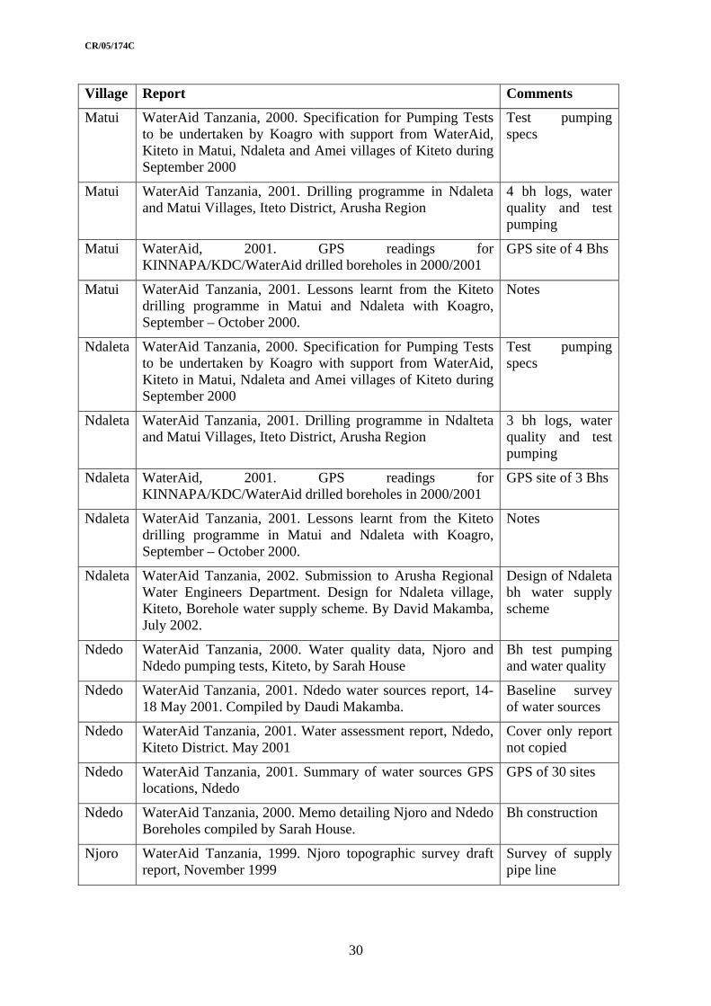
CR/05/174C
Village Report Comments
Matui WaterAid Tanzania, 2000. Specification for Pumping Tests to be undertaken by Koagro with support from WaterAid, Kiteto in Matui, Ndaleta and Amei villages of Kiteto during September 2000
Test pumping specs
Matui WaterAid Tanzania, 2001. Drilling programme in Ndaleta and Matui Villages, Iteto District, Arusha Region
4 bh logs, water quality and test pumping
Matui WaterAid, 2001. GPS readings for KINNAPA/KDC/WaterAid drilled boreholes in 2000/2001
GPS site of 4 Bhs
Matui WaterAid Tanzania, 2001. Lessons learnt from the Kiteto drilling programme in Matui and Ndaleta with Koagro, September – October 2000.
Notes
Ndaleta WaterAid Tanzania, 2000. Specification for Pumping Tests to be undertaken by Koagro with support from WaterAid, Kiteto in Matui, Ndaleta and Amei villages of Kiteto during September 2000
Test pumping specs
Ndaleta WaterAid Tanzania, 2001. Drilling programme in Ndalteta and Matui Villages, Iteto District, Arusha Region
3 bh logs, water quality and test pumping
Ndaleta WaterAid, 2001. GPS readings for KINNAPA/KDC/WaterAid drilled boreholes in 2000/2001
GPS site of 3 Bhs
Ndaleta WaterAid Tanzania, 2001. Lessons learnt from the Kiteto drilling programme in Matui and Ndaleta with Koagro, September – October 2000.
Notes
Ndaleta WaterAid Tanzania, 2002. Submission to Arusha Regional Water Engineers Department. Design for Ndaleta village, Kiteto, Borehole water supply scheme. By David Makamba, July 2002.
Design of Ndaleta bh water supply scheme
Ndedo WaterAid Tanzania, 2000. Water quality data, Njoro and Ndedo pumping tests, Kiteto, by Sarah House
Bh test pumping and water quality
Ndedo WaterAid Tanzania, 2001. Ndedo water sources report, 14-18 May 2001. Compiled by Daudi Makamba.
Baseline survey of water sources
Ndedo WaterAid Tanzania, 2001. Water assessment report, Ndedo, Kiteto District. May 2001
Cover only report not copied
Ndedo WaterAid Tanzania, 2001. Summary of water sources GPS locations, Ndedo
GPS of 30 sites
Ndedo WaterAid Tanzania, 2000. Memo detailing Njoro and Ndedo Boreholes compiled by Sarah House.
Bh construction
Njoro WaterAid Tanzania, 1999. Njoro topographic survey draft report, November 1999
Survey of supply pipe line
30

CR/05/174C
Village Report Comments
Njoro WaterAid Tanzania, 2000. Njoro water supply options; Report to Njoro water committee. KINNAPA/WaterAid, Kiteto, 23/2/2000
Options for water supply design after bh drilling
Njoro WaterAid Tanzania, 2000. Njoro pump test, 29/2/00-2/3/00; results and considerations for pump selection. Compiled by Sarah House.
Pumping test results summary
Njoro WaterAid Tanzania, 2000. Njoro water supply implementation phases; Report to Njoro water committee. KINNAPA/WaterAid, Kiteto, 19/4/2000
Bh and water supply development
Njoro WaterAid Tanzania, 2000. Water quality data, Njoro and Ndedo pumping tests, Kiteto, by Sarah House
Bh test pumping and water quality
Njoro WaterAid Tanzania, 2000. Memo detailing Njoro and Ndedo Boreholes compiled by Sarah House.
Bh construction
In addition to the above a list of topographic and geological maps held by WaterAid in Kiteto are presented in Appendix 3.
Met Mr Mohamed Maghembe, the Kiteto District Water Engineer at his office in Kibaya, who reported that COWIE international had, as part of the Rural Water Supply and Sanitation Project, undertaken a feasibility study for the preparation and updating of district water supply and sanitation plans. This included preparation of bidding documents and construction supervision for the first year of the RWSS programme, included the drilling of ten village boreholes in the southern half of Kiteto district (COWIE International, 2004.)
Although this report recommends the drilling of ten village water supply boreholes it does not describe the geology or the hydrogeology of the area. It reproduces the limited description found in the Arusha Regional Water Master Plan. A second group of borehole drilling sites have already been identified (Arusha Regional Water Master Plan, 2000).
Several reports, digital data sets, topographic maps and geological maps are stored at the WaterAid office in Kibaya. These include Water Source Ltd (1996), Arusha Regional Water Master Plan (2000), Water Consultant’s Report (1938), and Water Development in the Northern Area of Southern Maasailand (1948).
Additional information on soils, vegetation, climatology and land use are available from the District Land Use office in Kibaya.
Dar es Salaam
Other National Policy Documents, reports and academic papers of relevance, mainly derived in electronic format from web sources are listed below.
Year Groundwater
1997 National Environmental Policy, Dec 1997
1997 The Mineral Policy of Tanzania, Oct 1997.
1998 The National Poverty Eradication Strategy, June 1998
1998 The Wildlife Policy of Tanzania, March 1998.
31

CR/05/174C
Year Groundwater
1999 National Action Programme to Combat Desertification, Aug 1999
2000 Poverty Reduction Strategy Paper (PRSP), Oct 2000.
2000 Tanzania Assistance Strategy, draft, Oct 2000
2001 Rural Water Supply and Sanitation Project, Report E492, vol 1
2001 Rural Water Supply and Sanitation Project, Report E492, vol 2, Environmental Assessment Report for Rufiji District
2001 Rural Water Supply and Sanitation Project, Report E492, vol 3, Environmental Assessment Report for Mpwapwa District
2001 Rural Water Supply and Sanitation Project, Report E492, vol 4, Environmental Assessment Report for Kilosa District
2001 Agricultural Sector Development Strategy, Oct 2001.
2001 Rural Development Strategy, Main Report-Final, Dec 2001
2001 World Bank, Rural Water Supply and Sanitation Project
2002 National Water policy, July 2002 TZ43
2002 World Bank, Rural Water Supply and Sanitation Project, Feb 2002. TZ56
2003 The Tanzanian Development Vision 2025.
3.8.1 Regional reports and papers Mjengera, H and Mkongo, G , 2003. Appropriate defluoridation technology for use in fluoritic areas in Tanzania. Physics and Chemistry of the Earth, vol 28, pp 1097-1104.
Quinn, C H , Huby, M , Kiwasila, H and Lovett, J C , 2003. Local perceptions of risk to livelihood in semi-arid Tanzania. Journal of Environmental Management, vol 68, pp 111-119.
Sjoholm, H and Luono, S , 2002. The green forest pastures of Suledo – Maasai communities organise to save their forests and secure their livelihoods. Forests, Trees and People, Newsletter No. 46, pp 13-32
Maganga, F P , Butterworth, J A and Moriarty, P , 2002. Domestic water supply, competition for water resources and IWRM in Tanzania: a review and discussion paper. Physics and Chemistry of the Earth, vol 27, pp 919-926.
van Straaten, P , 2000. Mercury contamination associated with small scale gold mining in Tanzania and Zimbabwe. The Science of the Total Environment, vol 259, pp 105-113.
Maganga, F P , 2003. Incorporating customary laws in implementation of IWRM: some insights from Rufiji River Basin, Tanzania. Physics and Chemistry of the Earth, vol 28, pp 995-1000.
Yhdego, M , 1995. Environmental pollution management for Tanzania: towards pollution prevention. Journal of Cleaner Production, vol 3, No. 3, pp 143-151.
Meertens, H C C , Ndege, L J and Lupeja, P M , 1999. The cultivation of rainfed, lowland rice in Sukumaland, Tanzania. Agriculture, Ecosystems and Envuronment, vol 76, pp 31-45.
Madulu, N F , 2003. Linking poverty levels to water resource use and conflicts in rural Tanzania. Physics and Chemistry of the Earth, vol 28, pp 911-917
32

CR/05/174C
Nelelya, S , Mafuru, A and House, S , 2001. Rebuilding partnerships, Kiteto District, Tanzania. 27th WEDC Conference, Lusaka, Zambia, 2001. People and Systems for Water, Sanitation and Health. Pp 115-118
Mbonile, M J , 2005. Migration and intensification of water conflicts in the Pangani Basin, Tanzania. Habitat International, vol 29, pp 41-67.
Ngana, J O , Mwalyosi, R B B , Yanda, P and Madulu, N F , 2004. Strategic development plan for integrated water resources management in Lake Manyara sub-basin, North-Eastern Tanzania. Physics and Chemistry of the Earth, vol 29, pp 1219-1224.
Kusiluka, L J M , Mlozi, M R S , Munishi, P K T , Karimuribo, E D , Luoga, E J , Mdegela, R H and Kambarage, D M , 2004. Preliminary observations on accessibility and utilisation of water in selected villages in Dodoma Rural and Bagamoyo Districts, Tanzania. Physics and Chemistry of the Earth, vol 29, pp 1275-1280
Nelson, F, 2000. Sustainable development and wildlife conservation in Tanzanian Maasailand. Environment, Development and Sustainability, vol 2, pp 107-117.
Eriksson, M , Reutersward, K and Christiansson, C , 2003. Changes in the fluvial system of the Kondoa Irangi Hills, central Tanzania, since 1960. Hydrological Processes, vol. 17, pp 3271–3285
Basalirwa, C P K , Odiyo, J O , Mngodo, R J and Mpeta, E J , 1999. The Climatological Regions of Tanzania Based on the Rainfall Characteristics. International Journal of Climatology, vol 19, pp 69–80.
Franks, T , Lankford, B and Mdemu, M , 2004. Managing Water Amongst Competing Uses: The Usangu Wetland in Tanzania. Irrigation and Drainage, vol 53, pp 277–286
Sellen, D W , 2000. Seasonal Ecology and Nutritional Status of Women and Children in a Tanzanian Pastoral Community. American Journal of Human Biology, vol 12, pp 758–781.
33

CR/05/174C
4 Results According to the terms of reference, during this brief study the BGS hydrogeologist was required to scope the needs of WaterAid to update methods used by them and their consultants to:
• site and drill boreholes – as compared with the basic methods demonstrated by BGS team in 2001.
• assess groundwater resources and water quality, particularly in respect of fluoride abundance and distribution.
• collect appropriate data, construct databases and monitor resource use - for the creation of groundwater resource maps and georeferenced GIS for marginal areas.
The BGS hydrogeologist was then required to scope the training needs of project staff and partners for improved development of water points.
In Tanzania, WaterAid facilitates rural water supply projects through employment of local consultants, contractors and NGOs to meet regional and district level requirements. These projects are funded by district and regional government, NGO, WaterAid and major donor (eg DANIDA, DFID and JICA) sources.
The BGS input into WaterAid projects in the Nzega and Tabora areas in 2001 aimed to demonstrate basic methods commonly used for the siting, drilling, construction and test pumping of boreholes. These methods included geophysical methods for borehole siting, the collection and evaluation of data during borehole drilling for borehole construction, the test pumping of boreholes and collection of water quality data used for evaluation of water resources. In addition, simple community monitoring methods for identification of areas with diminishing water resources were also demonstrated. A manual describing application of these methods was distributed to WaterAid projects in sub-Saharan Africa.
During the rapid survey component of the current visit opportunity was taken to observe the degree of uptake of the methods described. Comments below are based upon observations made in the field and the nature of reports and databases inspected at Tabora, Dodoma and Kibaya.
WaterAid introduce procedures for improvement of water sources after successfully inducting a community in use of methods of sanitation. This procedure involves the following components:
• Baseline community and water source surveys – these baseline surveys are typically undertaken by a combination of WaterAid, a local NGO such as the Anglican Church or TAHEA and a local consultant. Survey teams use GPS to locate water sources, survey sites and boreholes. Such a survey generates georeferenced locations of communities, facilities and water sources along with population levels and types of water use. Standard questionnaires are completed and data recorded on excel spread-sheets. Baseline surveys that include Demand Response Approach surveys were noted. While good quality baseline data may be collected the sites are not located on maps due to lack of basic 1:50 000 scale topographical maps, aerial photography or satellite imagery for field use.
• Borehole site location using geophysical surveys – Geophysical surveys are undertaken by teams from the Ministry of Water or from local consultants such as SEMA of Singida (staffed by ex Ministry of Water personnel). At Urambo electrical
34

CR/05/174C
resistivity vertical electrical soundings (VES) and traversing are being used with EM34 traversing and surface magnetics traversing. Surveyors use GPS to locate water sources, survey sites and boreholes. A report detailing field data and interpretations including apparent layer thicknesses and recognition of fracture zones at georeferenced sites are produced. While good quality geophysical survey data are produced using up-to-date equipment, these data are being analysed in the field on inaccurate photocopied graph paper sheets. Data analysis could be undertaken on lap-top computers using simple to use curve matching software. As noted above, the georeferenced sites cannot be located on survey maps due to lack of 1:50 000 scale topographical maps, aerial photography or satellite imagery for field use.
• Borehole drilling, construction and test pumping – Boreholes are drilled using Drilling and Dam Construction Agency (DDCA) Schraam down the hole hammer percussion drilling rigs. Details of formations penetrated and borehole construction are presented on DDCA borehole completion certificates. GPS are used to accurately locate boreholes. Each successful borehole is supposed to be test pumped and the details recorded on the borehole completion certificate. The results obtained from Kiteto and the Tabora/Nzega area still indicate that test pumping methods are poorly applied with little attempt to interpret data collected. Test-pumping data area needed for an initial evaluation of the resource and the production pump system design.
• Supervision of drilling and test-pumping – An experienced hydrogeologist is needed on site to supervise drilling and collect data, and design borehole. WaterAid have obtained the services of Ministry of Water hydrogeologists Dr Mpanda and Mrs Mcharo and private consultant Andy Singida but there is a lack of staff trained in field techniques who are able to do this work. The hydrogeologist is required to describe the colour and lithology of rock chip samples obtained at 1m depth intervals and record drill penetration rates. Summaries of geophysical and drilling results are presented in the hydrogeologist reports. Such reports contain few test pumping or water quality data. They also monitor changes in blown water discharge during drilling to recognise water production zones. Lithological samples were stored in a sample box, some attempts had been made to photograph the samples. Borehole sites are located using a GPS. The collection of data has improved in line with methods described in the manual but more staff need to be trained in these techniques. This maybe a shortcoming within the water development consultants.
• Water quality testing – Few hydrochemical data have been reported. Water samples should be obtained on site and analysed at the Ministry of Water laboratory in Dar es Salaam especially for fluoride content. Other laboratories are located in the University College of Lands and Architecture Studies and the Tanzania Bureau of Standards. Use has been made of Hatch/Paqua lab kits by WaterAid for local analysis of samples. The presence of fluoride in the Nzega, Tabora and Singida areas has been studied by BGS and JICA. At these three centres WaterAid have supplied laboratory equipment for basic chemical and physical parameter determination.
• Groundwater Information System – WaterAid recognises that there is a need to create a GIS that could be used to produce water resource maps showing water source locations and density, village locations, demands, areas of shortage.
• Groundwater System Monitoring - Data collection including water level and discharge rate measurement post borehole installation, are required for resource sustainability evaluation. This should include the monitoring of abstraction, water level changes and water quality changes. Unfortunately none of these factors are routinely measured
35

CR/05/174C
The above comments and observations produced during this short visit identify distinct groundwater related skills and knowledge gaps, especially field work skills and a lack of sufficient data for the compilation of an effective groundwater information system and water resources maps.
There appears to be only a limited number of experienced staff available and the reliance upon their skills appears to be growing from all groundwater related sector stakeholders including:
• WaterAid and other NGOs – procedures in place but lack of trained staff with correct field experience to collect data for resource assessment
• Ministry of Water – Lack of field trained staff to do the work – present staff need to be trained in field work procedures. Expertise is declining due to role models to pass on necessary knowledge.
• Consultants – obtain staff from ministry with all their shortcomings including local and regional staff
• NGOs –reliant upon consultants with their limitations
• Universities and technical colleges – have courses that teach the theory and basic methods
• International Donors – do not field the correct staff – either use local consultants who do not have the correct groundwater resource experience or international consultants who do not have the necessary local experience and find it difficult to operate in the field
The question has to be asked how to enhance the groundwater knowledge base when most of the above stakeholders do not consider groundwater resource assessment. The barriers erected due to lack of funding and short circuits in the development cycle due to lack of experienced field staff need to be recognised and appropriate interventions proposed. Figure 4.1 is an attempt to produce a basic map of institutions involved in groundwater development for rural water supply. The past functions of each stakeholder are identified in Figure 4.2 and the planned function transfer to conform to the new water policy guidelines are shown in Figure 4.3. Are these changes in structure possible given constraints due to lack of personnel and lack of data? In Figure 4.3 an attempt is made to identify the pools of expertise and potential barriers to development, i.e. the points of potential breakdown. In Figure 4.4 stake holders with most groundwater experience, limited groundwater experience and preferred rural water infrastructure implementers are identified.
36

CR/05/174C
WHERE WATERAID CURRENTLY SITS IN THE SCHEME OF THINGS
Figure 4.1 Institutional Map of Stake Holders in Groundwater Development for Rural Water Supply - Initial functions and linkages
37

CR/05/174C
Figure 4.2 Revised Institutional Map of Preferred Stakeholder Linkages under the World Bank Sponsored Rural Water Supply and Sanitation Programme
38

CR/05/174C
Figure 4.3 Potential Linkages and Barriers to Project Development
39
University of Oar es Salaam MSc Hydrogeology course
20 students per annum
t M inistry of Water Resources
~ Barrier4 1 Staff of 26 professional hydrogeologists but
/c most with little field experience; Main offices in Dar es Salaam and Dodoma,
also regional offices Parastatials such as the ... '1< Drilling and Dam Construction Agency
. .! I fornlcr drilling unit of , , Mini stry of Water Resources , River Basin , I , :"'f-_(, , offices . , , I . . I Banier 11 ___________ ....1 . . .
I . . . . . . I . . . .
" .. ' . . . Regional Government . . . . . AID Donors; .. ~
District Government World Bank, DFID, >'" DAN IDA, JlCA etc. / I Communities , /
'" ~/" /
/
I Barrier 2 r- /
l """" x .... / I /
k"" ",, 1 / < , t
Local and International ,
/ ....... / Local and International NGOs including TAHEA, k/ ...... ~ Water Consultants Churches, WaterAid, World .. ' . .....
Vision, UN ICEF etc . ..........
~ ,.. , I Barrier 3
~ ~ )I.'
Local and International drill ing and Bh siting contractors
NB: The NGDs and consultants could end up with better links to the practical side of water resources development than the Ministry of Water. Min istry of Water would be dependent upon them for now and accuracy of data -major problem due to lack of trained staff
KEY: Links with central Government ~ Staff and equipment supply ~ Links with international donors ~ Service supply - - - - - - --,.. Links with NODs ~ Potential service supply ................... ~ Links with consultants ~ KEY: Barrier Barrier I:
Lack of fund ing, pool of trained staff diminishes, eITects of HI VIA lDS, lack of fi e ld experience/exposure Barrier 2:
Lack of staIT experienced in field procedures and appreciation of groundwater resource limits Barrier 3:
Lack of appropriate data, trust may break down Barrier 4:
Lack of data now for planning

CR/05/174C
Figure 4.4 Stakeholders in Groundwater Development
40
Main data gathering and planning agencies with most groundwater project experience in Tanzania
University of Oar es Salaam. MSc and technical college students have basic hydrogeological theory but liule practical field experience.
Ministry of Water Resources. Responsible for policy issues. Drilling and Dam Construct ion Agency.
MWR hydrogeologists fomlthe main pool DDCA are the main source of groundwater of local hydrogeological experience. borehole drilling experience.
MWR hold the main groundwater database.
Main planning agencies but with limited groundwater project experience
River Basin Offices. RBOs arc responsible for rcgulation and
managcmcnt of water rcsourccs and
Regional Government -limited to no watcr project input
dcvelopmcnt groundwater. Experience limitcd to Ministry of Water Resourccs
hydrogeologists on staff.
District Government -main water project planning agency with
consultant assistance
A ID Donors. Donors havc variablc expericnce of
groundwatcr projccts
Communities -have to bc consulted under DRA
Main planning agencies but with limited groundwater project experience
Local and Intcrnational NGOs are the Local and International Water Consultants
main sources of sociological data and have have limited expcrience of ground water
most experience at implementation of rufal rcsource cvaluation and development.
water supply projects based on ground water.
Local and International drilling contractors have limited expericnce of installing ground water boreholes. Borehole siting contractors who are mainly
ex Ministry of Water staffhavc much fi eld experience but poor cquipment and analytical methods.

CR/05/174C
5 Options for Development
5.1 INTRODUCTION As illustrated and identified in Section 4 there is an urgent need to improve skills and reduce data gaps present within the WaterAid related project structure.
The methodology employed by WaterAid to execute a typical water supply and sanitation project, as shown by linkages to stake holders in the institutional mapping involves:
• Communities,
• Government institutions at district, regional and national level,
• Local and international NGOs,
• Parastatal organisations,
• Consultants, and
• Contractors.
WaterAid aims to facilitate and manage projects through mobilisation and involvement of the above agencies and so are dependent upon their own limited capacity and the capacities and levels of expertise present within these agencies. In Tanzania, WaterAid has displayed expertise in the areas of community mobilisation and participation and the engineering of water supply and sanitation facilities. In the areas of groundwater development including borehole and well site location, drilling, construction and testing they are totally dependent upon the capacities and levels of expertise of local agencies. It is in these areas that equipment and knowledge gaps are present and these gaps appear to be widening as the services of the limited pool of experienced field personnel is increasingly in demand but is diminishing in size. This pool of expertise is limited to the collective institutional memory of former and present senior government employees. The impression gained is that recently employed hydrogeologists and geophysicists do not like to do field work preferring to remain in the office. There is a lack of funding for fieldwork and the purchase of new equipment within government.
5.2 PROJECT STEPS WITH GAPS AND TRAINING NEEDS ANALYSIS The project process structure includes the following steps:
Step 1. Mobilisation of the community to accept sanitation and improved water supplies involving the DRA methodology.
Step 2. Baseline surveys of water sources and communities.
Step 3. Location of prospective borehole and well sites using geophysical methods.
Step 4. Drilling, construction and test pumping of boreholes and assessment of water quality.
Step 5. Groundwater resource assessment – requires adequate data collection.
Step 6. Analysis of hydrogeological and social data.
Step 7. Construction and operation of distribution systems.
Step 8. Monitoring of systems to assess sustainability.
41

CR/05/174C
5.2.1 Steps 1 and 2 WaterAid have developed good systems to undertake steps 1 and 2.
5.2.2 Step 3 WaterAid are totally dependent upon the expertise and capacity of a geophysical survey consultant who has the basic up-to-date survey equipment but lacks the aerial photography and topographic and geological maps to undertake basic initial site interpretation for the location of siting targets in Basement rock terrains. Also lack curve interpretation software and a laptop computer.
• Gaps: Lack of certain basic skills including knowledge of up-to-date geophysical siting methods and aerial photograph interpretation skills
• Training (see Concept Note 1): The consultant needs some basic training and the acquisition of basic equipment.
5.2.3 Step 4 WaterAid is dependent upon the expertise and capacity of DDCA drillers. These drillers have the local knowledge of drilling conditions but their equipment needs to be updated and working systems modified to improve drilling efficiency. Although well motivated, the hydrogeologists lack field experience, equipment and funding. There are very few hydrogeologists available with the necessary field skills to supervise drilling activities and collect relevant hydrogeological and geological data during drilling. These data are the basic requirements for the construction and test pumping of the borehole. Methods of test pumping are poor and the data produced are unreliable. Detailed water quality analyses need to be undertaken upon samples submitted to the DDCA laboratories as well as initial determinations undertaken on site. There is a need to conform fully to WHO standards for provision of drinking water. WaterAid are totally reliant upon former and current Ministry of Water senior hydrogeologists to undertake this work. WaterAid have attempted to use other drilling contractors but with poor results.
• Gaps: The basic drilling skills need to be improved, equipment standards need to be improved and the local knowledge needs to be transferred to younger personnel.
• Training (see Concept Note 1): There are few hydrogeologists present in Tanzania with the required skills and field experience. Junior hydrogeologists need to be trained in basic field methods to ensure the collection of adequate basic data from test and production boreholes so that sustainable abstraction systems can be constructed and the knowledge of the nature and resources of groundwater systems obtained. There is a need to increase the number of hydrogeologists available to staff offices at River Basin level and technical officers at District level.
5.2.4 Step 5 For Step 5 to be undertaken is dependent totally upon the nature and quality of data collected during Step 4. The failure to collect adequate data usually means that assessment of the nature of the groundwater system investigated and its resources available for development cannot be undertaken. This element is frequently omitted from feasibility study recommendations since it is rarely possible to achieve given the current poor levels of expertise applied to groundwater development projects.
42

CR/05/174C
• Gaps: Massive – need to train local hydrogeologists in basic methods to ensure adequate data is collected for this type of fundamental analysis.
• Training: see Concept Note 1.
5.2.5 Step 6 This requires the integration of socio-economic and hydrogeological data. The first is well understood but the second is poorly understood. Therefore, decisions on the nature of water supply distribution systems are undertaken primarily on the basis of socio-economic factors due to a lack of knowledge of the basic resource to be developed.
• Gaps: Greater emphasis needs to be placed on the nature of the resource as without this basic unit any attempt at development will fail, thus increasing the lack of confidence in groundwater resources. Data from both areas need to be entered into a basic GIS for interpretation and production of water resource maps that can be used to communicate limitations of the resource use to user community members. Such a GIS should for a basic planning tool at ministerial level but the data required can only be acquired at field level through the activities of agencies such as WaterAid – need to be more effective data and information pathways between various agencies including the communities.
• Training (see Concept Note 2): required in the formation of databases to be incorporated within a GIS and the production and use of water resources maps.
5.2.6 Step 7 This involves not only the installation of the water supply distribution system, be it a hand pump or a motorised pump with reticulation system with storage tanks and stand pipes, but also the design of the operating system. The latter usually ends up as a suck it and see system especially in areas of deep low permeability aquifers where groundwater availability varies with season and there is a tendency to over pump and, therefore, mine the limited resources due to a lack of adequate data upon which to base sustainable pumping rates. These are best assessed using data derived from the drilling and testing of the borehole and the monitoring of water levels and abstraction rates during operation. Such monitoring is rarely carried out in a rural water supply setting and so there is a tendency for systems to fail after several years of operation to the resource exhaustion and / or equipment failure.
• Gaps and training: Not part of present scoping study
WaterAid project staff need to be made fully aware of the nature of work activities that should be undertaken during each step and the types of data that have to be collected if subsequent steps are to properly undertaken. There is need the manual and a course of training.
5.3 WATER RESOURCES ASSESSMENT – CASE STUDIES A series of water resource assessment case studies could be produced for different hydrogeological and sociological environments based on the earlier experiences in the Tabora, Nzega and Singida areas. Such studies would include the impact of finding groundwater contaminated with high levels of fluoride in these areas.
A similar case study could be produced for the Kiteto area where there is competition between livestock and people for water as at Matui. There, in the pasturalist area the main population group are the Maasai who are mainly concerned with the supply of grazing and water for their herds of up to 1000 cattle or more, each requiring 40 litres per day. To have
43

CR/05/174C
achieved this they must observe seasonal pattern of grazing and visits to water points especially during periods of drought. Efforts have been made by government to restrict the movement of the Maasai through the establishment of permanent settlements with borehole water supplies and schools for children. It has proved difficult to stop the Maasai from their nomadic existance. In their absence agriculturalists move into areas adjacent to borehole water sources and take over the land, clear the bush to eradicate tsetse fly and cultivate maize and sorgum thus upsetting the previous balance with nature. A case study of the water resources of the northern Maasai areas could be used to illustrate aspects of technical project inputs required to WaterAid and other project staff. Water resources maps of the project area based upon past surveys could be produced within a simple GIS of the area. How does this pattern of land use conflict relate to the World Bank financed National Water Resources Project and the development of rural water supplies that are mainly derived from groundwater sources especially in the dryland areas?
5.4 POSSIBLE BGS INPUTS INTO THE NATIONAL RURAL WATER SURVEY, TANZANIA
5.4.1 Concept Note 1 - Groundwater Resource Mapping – pilot studies
BACKGROUND
The National Rural Water Survey (NRWS) is part of the National Investment plan funded by the World Bank. The NRWS aims to assess rural water resources (principally obtained from groundwater). The main consultants are Cowater of Calgary, Canada. A major element of the NRWS is the planned installation of 1000 boreholes, with an average of ten boreholes in each of 100 districts. The distribution of boreholes will have a bearing on how the Survey programme will proceed. Data obtained from these boreholes would be used to update information presented in the series of regional Water Master Plans that cover most of the country. The Water Master Plans are used as the main sources of hydrogeological information to inform the water sector and, therefore, need to be updated. Information is needed to focus investment to avoid going back into areas that have produced negative results.
A BGS case study in Tabora/Nzega demonstrated to the DDCA and WaterAid that rural water supply programmes can now generate georeferenced hydrogeological data as good as those generated by the Water Master Plan programmes. The latter includes exploration borehole siting, drilling and testing but the BGS study demonstrated that this could be achieved at reduced cost by linking such studies to rural water supply programmes and using simpler methods of investigation. WaterAid have been collecting data since the demonstration study in the Tabora and Singida areas. The data obtained are stored in a series of hard copy borehole completion forms and digitally on Excel spread sheets. The latter data are georeferenced and can be used to provide the data within a GIS to generate groundwater resource maps similar to those generated by the RUWASSA project in Uganda. District groundwater resources maps would then be made available for planning purposes such as identification of areas of poor groundwater resources where alternative sources of water need to be obtained thus avoiding the expense of drilling yet more boreholes.
The main sources of existing groundwater data are:
• Ministry of Water, Hydrogeology Section, Dodoma,
• Regional Water Master Plans,
• Regional studies undertaken by JICA,
44

CR/05/174C
• WaterAid Tanzania data base, and
• BGS Knowledge and Resource (KAR) studies in Tabora, Nzega and Singida.
OBJECTIVES
The main objective of the project is to develop tools for efficient and cost effective water resources planning and development at both national and district levels for equitable and sustainable development. The main aims of the suggested BGS input are:
• Production of a Groundwater Information System based upon Excel/Access and ArcView for use at National and District levels.
• The digitisation and updating of the Regional Water Master Plans.
• Production of a series of simple conceptual groundwater models showing how groundwater occurs within geological environments typically found in Tanzania.
• Generation of a series of groundwater resource maps for information delivery at district and community levels based upon the formats developed by RUWASSA in areas where sufficient data occur and on the BGS reconnaissance maps with indicative tables in areas where there are limited data including water point density maps.
• The devising of approaches to groundwater system monitoring by communities related to their water use so that areas that experience water supply stress during periods of prolonged drought can be identified.
• Address water quality issues such as the distribution of fluoride.
METHODOLOGY
To produce an effective groundwater information system as much groundwater data as possible would need to be integrated into a central database. Possible sources of data in Tanzania would include:
• Groundwater Data Assessment Programme – this may already be underway at the Ministry of Water under German guidance to produce a groundwater data base based upon a GEODIN software package. The data held at the Ministry of Water, Hydrogeology Branch in Dodoma include drilling and geophysical survey data generated by Ministry of water borehole drilling and siting teams when undertaking work for NGOs such as WaterAid on a contract basis.
• Copies of the Regional Water Master Plans are held in the DDCA library. Data held in these reports need to be digitised as they constitute the largest volume of good quality hydrogeological data held in Tanzania.
• Community water supply drilling programmes as undertaken by WaterAid in areas around Tabora, Nzega, Singida, Dodoma, Arusha and Dar es Salaam.
• Regional water study investigations undertaken by JICA in areas such as Singida.
• DFID funded KAR studies undertaken by BGS in Tabora, Singida and Nzega that include detailed hydrogeological and hydrochemical data.
• Possible regional databases held by RAS and regional water engineers, but doubtful if these exist.
45

CR/05/174C
Within the context of the NRWS the BGS would be able to contribute expertise gained studying aquifer conditions within Tanzania and adjacent countries through a series of inputs that would increase in scale as the project progresses. These would include:
• General advice on hydrogeological data collection and manipulation within a GIS.
• Advice on groundwater resource map production for a small number of areas that would act as a series of case studies utilising different densities of hydrogeological data to produce different types of map.
• Participating in the production of groundwater resources maps based upon upgrades GIS for the whole of Tanzania.
Base map data in digital format could be obtained from the Survey Department who are currently digitising the 1:50 000 scale topographic maps, the Geological Survey in Dodoma who hold a digital geological map of Tanzania, and the University of Dar es Salaam who hold remotely sensed data and the base map data used for the generation of a series of national forestry maps at 1:250 000 scale. The last would be a useful scale for any district level groundwater resource mapping.
The project would seek to use available data to create an Excel – Access - ArcView linked Groundwater Information System for the generation of a series of district level groundwater resource maps that can be used for planning purposes and to inform stakeholders at district and community level of the nature of the groundwater resources that form their main sources of water supply and how best to utilise them in a sustainable way.
Two types of maps can be produced, dependent upon the amount and density of hydrogeological information available.
1. In areas where few hydrogeological data are available simple groundwater development potential maps based upon local geological knowledge can be produced with guidance tables on the reverse. Such maps were produced for community level guidance to WaterAid teams by BGS in the Tabora and Nzega areas to provide initial guidance on what siting, drilling and testing methods should be employed.
2. In areas where more hydrogeological data are available a series of simple groundwater resource maps showing different aspects of groundwater development and occurrence can be generated. These can be used to inform planners, groundwater developers, communities and other stakeholders about how groundwater occurs, provide options for development and risks of over development or pollution.
EXPECTED OUTPUTS
The expected outputs of the project are:
• District level GIS systems that can be up-dated as data become available.
• Groundwater development potential maps for areas with low density of hydrogeological data.
• Groundwater resources maps for areas with a moderate to good density of hydrogeological data including:
o District groundwater resource potential maps, o District water quality maps , o Groundwater development technology options maps, o Water supply coverage maps,
46

CR/05/174C
o Water point density maps, o Hydraulic characteristics maps, and o District groundwater resources reports.
5.4.2 Concept Note 2 - The Training of Supervision Teams in Borehole Siting and Construction The purpose of this technical assistance is to strengthen the capacity of the WES to undertake groundwater resource evaluation and development based on Nigerian experience with UNICEF.
BACKGROUND
Over recent years the Tanzanian Ministry of Water has installed rural water supply boreholes on behalf of WaterAid and other organisations. Some boreholes have performed poorly or even failed completely. The reasons for failure and/or sub-standard operation have been identified, and include poor siting methods, inadequate design and poor workmanship during construction. Approaches used to improve the situation by empowering rural communities have been developed culminating in so called demand driven process. This requires that communities wishing to have improved water and sanitation facilities need to apply for them and to establish water committees who will then be involved in all stages of the project cycle including the management and supervision of contracts.
To facilitate this process the capacity of local communities and project staff needs be improved so that common quality standards applicable to each stage of the project cycle can be developed and applied. A pilot training programme could be undertaken to facilitate increased community and private sector participation in the development and management of water and sanitation facilities.
The BGS undertook the curriculum development and initial presentation of a training course for Supervision Teams. In Borehole Construction for the improved implementation of rural water supplies as part of the National Water Development Programme (NWDP) of the Government of Malawi. This concept note outlines the background, objectives, methodology, of developing a similar course for the National Rural Water Survey programme of Tanzania.
OBJECTIVE
The overall objective of the National Rural Water Survey Programme is to increase the capacity to deliver sustainable potable water supplies and improved sanitation facilities to rural communities in Tanzania. The specific objective of this training programme is to build the capacity at community and district level to manage and supervise construction contracts to an acceptable quality.
METHODS
Phase 1: Prepare Training Curricula
To do this, the BGS team will:
• Review the background working documents on the rural water supply programme. This will be undertaken initially in the UK using relevant documents supplied to BGS prior to the first visit to Tanzania. The outcome of this initial review will be an understanding by the BGS team of the required skills of field staff for successful implementation of the rural water supply programme.
47

CR/05/174C
• Review the present knowledge and skills in the technical areas of the staff who will be trainees. This will be done initially in the UK from feedback on training needs and existing skills from the Ministry of Water. An assessment of the present level of knowledge and skills will need to be obtained during an initial visit.
• Adapt the current training curriculum to needs identified in Tanzania from the two above assessments. Account will be taken of BGS experience gained in Malawi. The outline training programme will be sent to Tanzania for consideration.
Phase 2: Visits to Tanzania
The second phase will comprise an initial mission to Tanzania of one to two weeks’ duration by the BGS team to:
• Link up with the NRWS programme to discuss and review the proposed curriculum with all involved agencies and stakeholders. This will include consideration of the suitability and potential availability of a local consultant and/or existing Government staff to act as resource persons to support the BGS team in specific aspects of the curriculum. Assuming a suitable local consultant can be identified, his input and Terms of Reference will be agreed at this stage. There may be several potential sources for a suitable local consultant – NGOs, Universities, Government Departments. The BGS team believe that obtaining the right local input on social, community and institutional issues is key to the success of the consultancy, and this will, therefore, be a key task for the initial mission.
• Assess more precisely the present knowledge and skill levels of the candidates for training by examining construction standards, discussion with stakeholders, field visits and discussion with the candidates themselves.
• Following these discussions, the team will prepare an agreed schedule for the training seminar, and initiate the production of suitable training materials.
• Review arrangements for the training made by NRWS programme and assist in refining them as required. Consideration will be given to the design of suitable training materials for the seminar to be produced by NRWS programme, based on the agreed contents of the seminar. Other issues to be reviewed will be the location of the seminar, number of participants, accommodation, options and opportunities for field visits and hands-on experience, including provision of suitable equipment (geophysical instruments, for example) for training.
• The BGS team will then return to UK while final arrangements for the training seminar are made and the training materials prepared. Two-three weeks are allocated for this as a minimum, and the BGS team would be guided by NRWS programme in this respect. The proposal assumes that the cost of production of training materials will be met by NRWS programme outside of this consultancy.
• A two man BGS team will return to Tanzania to lead the three week training seminar, as agreed with the NRWS programme. It is considered that the precise duration of the training seminar should be determined during the initial visit, and should be guided by the findings concerning training requirements.
• Undertake, with the local consultant, the initial stages of review and evaluation of the training by obtaining immediate feedback from the participants, from NRWS programme and from other stakeholders.
48

CR/05/174C
OUTCOMES
On return to UK the BGS team will:
• Review and make any necessary amendments to the training curriculum in the light of experience gained in the seminar.
• Document the evaluation of the training.
• Prepare a final report on the consultancy, including recommendations for the type, scale and scope of future training within the rural water supply programme.
49

CR/05/174C
6 Conclusions and Recommendations
6.1 BACKGROUND This scoping exercise comprised the following tasks:
1. Scope methods used by staff and consultants employed by WaterAid to site and drill boreholes – as related to basic methods demonstrated by BGS team in 2001.
2. Scope the requirement and approach for conducting assessment of groundwater resources and water quality, particularly in respect of fluoride abundance and distribution.
3. Scope the requirement for data collection, databasing and resource monitoring and methodologies to be used – for the creation of groundwater resource maps and georeferenced GIS for marginal areas
4. Scope the training needs of project staff and partners for improved development of water points given future work programme.
To address Tasks 1-3 visits were made to field areas and area offices to observe field methods and obtain copies of field reports and databases. These visits were made at the end of the dry season when water supply systems were under stress.
To further address Task 3 discussions were held with WaterAid Tanzania and their GIS consultants in Dar es Salaam about the composition and production of GIS based groundwater resource maps.
To address Task 4 discussions were held with WaterAid Tanzania and representatives from the Ministry of Water about the composition of an appropriate training course for hydrogeologists in field techniques.
6.2 CONCLUSIONS Rural society in Tanzania went through a period of collectivisation when rural communities were formed into large village units. That policy has now been reversed with rural communities being resettled within smaller dispersed villages. It is these rural communities located in semi-arid to savannah environments that now need sustainable sources of safe drinking water as well as sanitation to protect their health and well-being. Within the Tabora and Singida districts such villages are small compact units whereas the Kiteto area villages tend to have large populations spread over a wide area reflecting the semi-nomadic lifestyle of the Maasai communities of that area. Provision of adequate water supplies during the annual dry season is a major problem especially in the Kiteto area. In the Tabora region this can be further exacerbated by the use of groundwater for limited irrigation of rice in dambo areas following the wet season.
With the expansion of the rural population a growing number of people are obliged to live in marginal areas. Unfortunately, such populations need to live in an area for an appreciable length of time to develop coping strategies for the management of limited water resources especially during periods of drought. In the short term, when groundwater is made available development of this resource tends to produce a static society leading to population growth that may not be sustainable due to other factors such as lack of fodder or inadequate crop production. Therefore, rural water supply projects dependent upon groundwater provision need to assess the following to assess their sustainability:
50

CR/05/174C
• Where and how does the groundwater resource occur and has it suitable quantity and quality?
• Can the groundwater resource be recharged annually?
• What are the consequences of the use of the groundwater resource on:
o Surface water sources? o Population growth? o Land use? o The groundwater resource itself? o Will it contribute to the breakdown of society and conflict?
In their operations to date WaterAid have sought to acquire answers to these questions. Unfortunately in the project areas visited the information collected by WaterAid and their collaborators suggest that the water supply needs of the rural communities can only be partially met by the limited groundwater resources available. Only in recent years, with the advent of GPS equipment for the accurate geo-referencing of villages and water supply points coupled with the use of GIS computer software have planning tools become available for the mapping of groundwater resources and their availability for use by rural communities.
The locations of recently settled villages and connecting roads do not exist on the available 1:50 000 scale topographic maps produced in the 1960’s. Government is currently digitising and upgrading the 1:50 000 maps but such maps are not available to baseline or geophysical survey field parties.
Baseline surveys as well as locating all water sources are used to assess the wet and dry season water supply coping strategies of rural communities. These would include the incidence of water borne diseases during the wet season and how far people have to walk during the dry season to known reliable water sources. Have there been additional pressures on land resources such as the removal of bush for firewood supply and clearance of lands for cultivation. Competition between potential water users needs to be resolved.
The geophysical survey teams are provided by SEMA, an NGO based in Singida that was also employed by WaterAid in the Singida and Nzega areas. SEMA employs former government geologists retrained as geophysicists and uses ex-government equipment that is getting quite old. Some new equipment in the form of the latest state of the art Terrameters have been introduced but due to the non-availability of laptops and adequate software the survey results are still plotted and analysed by hand in the field. Limited use is also made of EM34 and magnetometry although as with the resistivity equipment it looks as though the geophysicists are currently experiencing difficulties with the operation of the equipment and interpretation of data produced.
Senior government and ex-government hydrogeologists with sufficient field geological and hydrogeological experienced are employed by WaterAid to supervise the activities of drilling teams. The senior hydrogeologists are able to acquire adequate geological and hydrogeological data during the drilling and testing of boreholes for the optimum design and construction of the borehole.
There is a distinct need to train junior geophysicists and hydrogeologists in basic field techniques to ensure that government and private sector consultancies have both the institutional memory and capacity to undertake basic survey work, data collection and supervision in the future. A recently conducted hydrogeological training course and needs assessment undertaken by BGS for UNICEF Nigeria identified a similar potential skills shortage amongst field staff. There training needs identified included:
51

CR/05/174C
• Geophysical survey methods including equipment use and maintenance, data collection and interpretation.
• Understanding the main drilling methods and how to acquire geological and hydrogeological data during drilling.
• Simple methods of borehole test pumping.
• Methods of borehole design and construction.
• Assessment of water quality to ensure that water produced is of adequate quality for domestic consumption.
A two-week practical field based course, designed around the content of the recently produced manual entitled:
MacDonald, A , Davies, J , Calow , R and Chilton , J , 2005. Developing Groundwater: A guide for Rural Water Supply. ITDG Publishing
was presented in Jos, Central Nigeria, where some 34 participants received training. The course was funded by DFID as part of the OASIS programme.
WaterAid have amassed significant quantities of hydrogeological information but these data have only been partially analysed and the information derived has not been used to inform the ongoing World Bank sponsored RWSS project. How can this best be achieved? A GIS is being set up by WaterAid to map water point density in the Kiteto area. This work is being undertaken by local consultant, Geodata, using ArcView 3.2. They are aware of the availability of ArcView 8.2 and ArcView 9 but cannot yet afford them. Geodata have located a source of digitised Tanzania district maps in Kenya. Most districts are available, although rather dated. They were produced using Autocad software and so need to be converted to ArcView. The results of this exercise could be extended with the addition of some layers of geological and hydrogeological parameter information to produce a series of hydrogeological reconnaissance and water resources maps for the Kiteto area as a pilot study. These maps could incorporate data produced by the World Bank/District drilling programme if sufficient appropriate hydrogeological data were obtained from the boreholes drilled. A survey of water point sources of Kiteto, especially in the northern third of the district where only the Maasai live in areas thought to be predominantly underlain be deep saline water deposits, would need to be undertaken. Patterns of groundwater seepage to the surface, on a seasonal basis could be ascertained and the potential of these points to produce groundwater in a more sustainable way needs to be determined possibly using interpretation of remotely sensed data with ground truthing.
Considering that the main water resources to be developed for rural water supply are groundwater based, suggested information and data gaps not adequately addressed by the World Bank Rural Water Supply and Sanitation Project include:
• Groundwater exploration.
• Groundwater resource potential assessment.
• Monitoring of the nature of groundwater resources and the impact of abstractions.
• Vulnerability of groundwater resources to contamination by agro-chemicals and pollution from pit latrines.
• The recharge potentials to aquifers that may be exploited and assess the viability and sustainability of village level water supply schemes.
52

CR/05/174C
District and community level water supply projects would appear to proceed on a drill first then pump and see principal on the assumption that sufficient groundwater exists – but will it in the short or long term?
6.3 RECOMMENDATIONS 1. Upgrade the training concept note on the basis of the BGS/UNICEF Nigeria training
course experience.
2. Make contact with the JICA team re work done on the central basin area that they are now looking at as an integrated water resources study.
3. Assist WaterAid with continuing groundwater development in Tanzania for rural water supplies in Tabora, Nzega, Singida and Manyara regions through production of water resources maps of Urambo, Tabora, Nzega and Kiteto Districts.
4. Use available hydrogeological data to produce case studies of each projects area to address problems of :
• Groundwater source/resource sustainability.
• Water quality.
• Alternative sources of water.
Such studies would form integral parts of any socio-economic assessments of how to meet the water needs of similar rural communities in Tanzania.
5. The training and mapping exercises would help address national water policy guidelines on groundwater development aimed at:
• meeting the Millennium Development Goals.
• informing the processes for IWRM as identified in the NWDP.
• helping achieve the goals of the World Bank led NRWSSP.
53

CR/05/174C
References ARUSHA REGIONAL WATER MASTER PLAN, 2000. Part III of the Plan: Methods , Data and Analysis: Volume 14: Groundwater Resources (Hydrogeology), Volume 15 Water Quality and Volume 16: Water Engineering, Final Report, December 2000.
BROKONSULT AB, 1980. Tabora Region Water Master Plan.
BWENA, P , ATHANASIO, J AND MRISHO, M , 2000. Groundwater exploration for Itundu Village, Urambo District, September 2000. Hydrogeology Section, Regional Water Department, Tabora.
BWENA, P , ATHANASIO, J AND MRISHO, M , 2001. Groundwater investigation for Sojo Village, Nzega District, September 2000. Hydrogeology Section, Geophysical Surveys – Results. Regional Water Department, Tabora.
BWENA, P AND MRISHO, M , 2003. Groundwater investigation for boreholes at Sojo Village in Nzega District. Report on survey conducted in October 2003. Regional Consulting Unit, Hydrogeology Section, P O Box 307, Tabora, Ministry of Water and livestock Development. For WaterAid.
COWIE INTERNATIONAL, 2004. Preparation of the first year RWSS programme and related bidding documents and construction supervision of the first year programme. Final Scoping Study Report, Vol 1, Water Supply and Sanitation, July 2004, Tender KDC/2003/02. For Kiteto District Council; Rural Water Supply and Sanitation Project; Preparation and Updating District Water Supply and Sanitation Plans.
DAVIES J AND Ó DOCHARTAIGH B E , 2002. Low Permeability Rocks in Sub-Saharan Africa. Groundwater development in the Tabora Region, Tanzania. British Geological Survey Internal Report, CR/02/191N.
DRILLING AND DAM CONSTRUCTION AGENCY, 2000. Borehole completion certificates for boreholes drilled at Kabalae in 2000.
MAGANGA, F P , BUTTERWORTH, J A AND MORIARTY, P , 2002. Domestic water supply, competition for water resources and IWRM in Tanzania: a review and discussion paper. Physics and Chemistry of the Earth, vol 27, pp 919-926.
MRISHO, M AND MAKAMBA, D , 2004. Water Resources assessment – report. Lusu Ward, Nzega District, Tabora. 24-31 January 2004. Water Sources Assessment Survey Sheets for Mwaluzwilo Village.
MRISHO, M AND MPANGALA, G , 2004. Water Resources Assessment Report, Songambele Ward, Urambo District, Tabora. 6 – 13 September 2004. Regional Water Department, Tabora and WaterAid, Singida.
SANGIJA, A F , 2001 Hydrogeological report review of Kanolo and Sojo villages. For WaterAid Tanzania
SANGIJA, A F , 2003. Drilling programme in Sojo and Kanolo Villages, Nzega District and Kashishi Village, Urambo District. Groundwater Exploration and Wells Construction Co. Ltd., for WaterAid Tabora.
SMEDLEY, P L, NKOTAGU, H , PELIG-BA, K , MACDONALD, A M , TYLER-WHITTLE, R , WHITEHEAD , E J AND KINNIBURGH, D G , 2002. Fluoride in groundwater from high-fluoride areas of Ghana and Tanzania. British Geological Survey Commissioned Report, CR/02/316. 72 pp.
THE UNITED REPUBLIC OF TANZANIA, 1999. Proposed National Action Programme to Combat Desertification. Vice President’s Office, August, 1999.
THE UNITED REPUBLIC OF TANZANIA, 2002. National Water policy. Ministry of Water and Livestock Development, July 2002.
WADE F B. 1927. No.1 – Water Supplies in the region between Tabora and the Speke Gulf. Bulletins of the Geological Survey Department, Tanganyika Territory.
WATERAID, 2001. Borehole completion certificates for boreholes drilled in Itundu Village, Urambo, 2001.
WATERAID TANZANIA, 2003. Borehole completion certificates for boreholes drilled at Kashishi, Urambo District in 2003.
WATERAID TANZANIA, 2003. Water quality standards and testing policy. January 2003.
WATER SOURCE LTD, 1996. Water Resources and Supply Study for Kiteto District. For SIDA, November 1996.
WORLD BANK, 2002. Project Appraisal Document on a Proposed Credit in the Amount of SDR 20.6 Million (US$26.0 Million Equivalent) to the United Republic of Tanzania for the Rural Water Supply and Sanitation Project. Report No. 22875-TA, 21 February 2002.
54

CR/05/174C
Appendix 1 Contacts Lister Kongola, e-mail: [email protected], [email protected]
Regional Water Department, Box 307, Tabora. Mr Benard Chikarabhani, Hydrogeologist,
Mr Mohamed Maghembe, District Water Engineer, Kiteto
WaterAid Tanzania, P.O. Box 33759, Dar es Salaam, Tanzania. Vivienne Abbott, Country Representative tel +255 (0) 22 2701609, mobile: +255 (0) 744 324246, Email: [email protected], [email protected], website: www.wateraid.org.uk
WaterAid Tanzania, 59B Biringi Avenue, Kilimani, 2190 Dodoma, Tanzania. Eng. Herbert J Kashililah, Senior Programme Manager, Tel/Fax: +255 (0) 26 2324246, mobile: +255 (0) 744 464120, E-mail: [email protected].
Diocese of Tabora, The Anglican Church of Tanzania, P O Box 1408, Tabora, Tanzania. Mr C M M Nyamwanji, Development Coordinator, tel: 026 260 4899, Fax: 026 260 4899, mobile: 0744 505387, e-mail: [email protected]
Tabora Development Foundation Trust, Manyema Street, P O Box 1498, Tabora, Tanzania. Mr Dick L Mlimuka, Advisor, tel/fax: +255 26 2604062, e-mail: [email protected], [email protected]
Sustainable Environment Management Action (SEMA), P.O. Box 365, Singida, Tanzania. Mr Valerian Makusaro, Water and Sanitation Engineer, tel off: 026 2502335, tel res: 026 2502833, mobile: 0744528061, e-mail: [email protected]
GeoData Consultants Limited, A.H. Mwinyi Road, Nyarenda Bus Station, BM Group Centre House, 1st Floor, P.O. Box 32859, Dar es Salaam, Tanzania. Charles B Buberwa, Managing Director, tel: +255 22 2774009, mobile: 0748 678043, e-mail: [email protected], Mr Vedastus Makota (maps)
WaterAid Tanzania, PO Box 409, Tabora, Mr Muganyizi Ndyamukama - Engineer, Tel. 255-62-4504, Fax. 255-62-4505, email. [email protected]
Mineral Resources Department (Geological Survey of Tanzania (Madini site)) PO Box 903, Dodoma, Mr Mcharo, Geophysicist, Tel: 255-61-24945, Fax. 255-61-24943, email. [email protected], [email protected]
Hydrogeology Section, Water Resources Division , Ministry of Water, and Livesock, PO Box 412, Dodoma. Fax 255 – 026 – 2320060 (Also contact via Mr Ruhumbika, DSM)
Dr Samson Mpanda – Principal Hydrogeologist, Water Resources Division Ministry of Water, Dodoma
Mrs Elder B Mcharo, Principal Hydrogeologist, Water Resources Division
Water Resources Division, Ministry of Water Resources, PO Box 35066, Dar es Salaam. Eng Mkumwa, Rural water supply engineer, Rural Water Supply
Mr Mihayo, Assistant Director, Water Resources (Surface Water)
Mr Shirima, Planning Officer (Water Master Plans)
Mr Ruhumbika – Director, Email [email protected]
Mr Lister Kongolo, Assistant Director, Water Resources (Groundwater)
55

CR/05/174C
Appendix 2 Diary November 2004.
13 Travelled from London via Amsterdam to Dar es Salaam.
14 Met by Mr Kashilila of WaterAid. Travelled from Dar es Salaam to Tabora where met by Mr Muganizi from WaterAid (Tabora Project Manager). Reviewed reports on the development of rural water supplies by WaterAid in the Tabora area during the last four years.
15 From the WaterAid office drove to Intundu to view two boreholes and a hand dug well. Discussed groundwater occurrence and abstraction with the local community and WaterAid staff. Drove to Urambo town to view the town water supply distribution system, several abandoned hand pumps and some contaminated hand dug wells. Drove to Songambele where met a SEMA geophysicist engaged in the siting of borehole sites at four villages for WaterAid. He has modern Terrameter equipment but needs software to interpret Schlumberger data. Visited a hand dug well at a secondary school where 20 litre containers were being filled with water at Tsh40 each. These containers were then transported to Urambo town two miles away by pushcart to be sold for Tsh200 each. Stopped mid-way between Urambo and Tabora to view shallow pits excavated in an mbuga area. These pits are the dry season source of water for villagers within a 5 to 10 km radius. The water is used to cultivate tobacco nursery plants and domestic use. This source could be developed using a trench with horizontal screen and sump, as at Kashishi. At Tabora discussed the water supply situation in Tabora and Nzega with a representative of the Anglican Church and the regional hydrogeologist. At the Tabora Hotel discussed groundwater use and occurrence at Sekongi, south of Tabora with a representative of the Moravian Church.
16 Travelled from Tabora to Nzega and on to Kabale where met Dr Samson Mpanda at a drill site north of the Resolute Gold mine. Discussed groundwater occurrence and the geology of the area of his first borehole located in a valley downstream of the mine tailings dump. Travelled from Kabale to Singida where met the WaterAid programme manager Mr Mowi who guided us to a drill site to meet Mrs Mcharo to discuss the supervision of borehole drilling and data collection. Travelled from Singida to Dodoma.
17 At the WaterAid Dodoma office discussed groundwater occurrence in Kiteto District and results of visits to Urambo, Tabora, Nzega and Singida with Mr Kashilila. Visited the geological survey to meet Mr Mcharo, head of the department. Travelled from Dodoma to Matui where south of the village noted numerous shallow pits from which brackish water contaminated with human and animal effluent was being abstracted for the watering of cattle and domestic use. In the village inspected a motorised borehole funded by WaterAid. The borehole is equipped with a Mono 440 aqualift pump powered by a 2-cylinder Lister engine. This unit is used to fill a 20,000 litre capacity tank twice a day from which water is reticulated to two standpipes to supply the village population of about 20,000. To the east of the village noted a breached dam that collapsed during the floods caused by the last El Nino event. Upstream of dam noted many shallow pits dug into calcrete/clay base of local river channel from which ‘fresh’ water was being abstracted by bucket. Water sold in 20 litre containers at site for Tsh50 each to be resold in town a couple of miles away for Tsh250 per container. One man reported that he sold about Tsh10 000 – Tsh15 000 worth of water per day. This source forms a dry season source from May until the start of the rains in
56

CR/05/174C
November. Rains are due to start so water levels are depressed. Travelled from Matui to the WaterAid guest house/office at Kibaya. Discussed the rural water supply situation in the Kiteto District with Mr Kashililah. How can WaterAid supply water to the Maasai, who are not a static population and are more concerned with the supply of water to their animals than to themselves?
18 Viewed maps and reports maps held at WaterAid office in Kibaya. Visited the District Water Engineer to discuss the proposed World Bank funded water supply project. Looked at a feasibility study produced by COWI International for the installation of ten borehole sites in the southern 60% of the district where the main settlements are located. A further ten boreholes are being discussed. The brief description of the hydrogeology of the area in the report was derived from the Arusha regional water master plan. Stressed the need to obtain as much information from these boreholes as possible. Travelled from Kibaya to the village of Ndaleta where viewed the topographic depression to the north presently occupied only by the Maasai due to lack of water resources. To Ndaleta village where met village elders to whom I was described as the ‘witch that can find water’. Inspected parts of the village water supply distribution system. Water is pumped from the borehole to 20 000 litre capacity tank to be reticulated to two stand pipes. Long queues of containers were seen at both sites. Water is supplied twice a day and only a third to half of these will be filled in a session, the rest will have to wait 12 hours. Discussed wet and dry season pumping conditions with the local pump operator. Three boreholes drilled but only one was successful. Travelled back to Kibaya. Travelled from Kibaya to Dar es Salaam. Visited the site of a WaterAid funded sand dam south of Kibaya village, and a nearby spring and borehole in riverbed. At Songambele at the southern edge of the district inspected a WaterAid funded motorised pump and reticulation system.
19 At the WaterAid Dar es Salam office met Vivienne Abbott the WaterAid country representative. To the Ministry of Water at the Maji Ubungu where met:
o Mr Lister Kongola, Assistant Director, Water Resources, Groundwater o Mr Mihayo, Assistant Director, Water Resources, Surface-water, o Mr Shirima, Senior Planning Officer, Water Master Plans o Eng Mkumwa, Engineer, Rural Water Supply
Discussed with them:
o The findings of visit to WaterAid projects. o The manual of simple methods being produced to publication, o The water resources maps project planned for Uganda o The training course for UNICEF hydrogeologists in Nigeria. o The occurrence of fluoride in Tanzania and the restart of the BGS project o The new JICA project to be undertaken to map the northern interior basin of
internal drainage and fluoride occurrence. This project is planned to start in 2005.
Groundwater resources development and management in the internal basin and rural water supply in Mwanza and Manyara regions by JICA. Need to look at programme development as part of strategy. Contact person – [email protected] - assistant representative Tanzania. Seen as a continuation of fluoride occurrence and remediation study. Discussed the content of two concept notes describing possible BGS inputs into the WB strategy programme. Agreed that the concept notes need to be redrafted inline with the requirements of the National Water Policy document and the latest assessment of WB National Rural Water Supply and Sanitation project. This
57

CR/05/174C
to include the production of water reconnaissance / water resources maps production dependant upon data availability.
At the WaterAid office where discussed the results of the meeting with Ms Abbott. With Mr de Waal (WaterAid) and Kashililah to the office of Geodata where met with Mr Charles Buderwa (databases) and Mr Vedastus Makota (maps) to look at GIS being set up for the Kiteto area. Currently use Arc View 3.2 with excel spreadsheets and access database. Discussed water supplies for the Maasai and village populations of the Kiteto area with Ms Abbott. Water resources mapping in northern Kiteto district, requires satellite interpretation, also assess social issues of how Maasai herd, graze and water cattle. Geodata promised to supply Autocad map of Kiteto district.
20 Discussions with water engineer about Shinynga town water supply. At Dar es Salaam airport discussed present state of water development in Tanzania with Kongola. He has 26 professional hydrogeologists on staff located at regional level. These will be transferred to district level and to new basin level offices. How does the training course address the programme strategy – see draft proposals – should be aimed at his 26 hydrogeologists. Technicians obtain FTC – full technical certificate from the Rural Water Resources Institute – needed for site supervision – regarded as assistant hydrogeologists.
Need: o timing and costs o Course structure – of the two options (hydrogeologists course and technicians
course) o Inputs from BGS/WaterAid etc o Inputs from Tanzania
Why training is needed – data from boreholes – in terms of objectives, methods and outputs.
Assumptions: o That the curriculum meets the requirements of Tanzania o That the images and course content can be amended to reflect the environments
found in Tanzania and working practices o That suitable siting/drilling/test pumping programmes can be identified including
borehole drilling, well sinking and gravity fed schemes.
21 Travelled from Dar es Salaam via Amsterdam to London
58

CR/05/174C
Appendix 3 List of maps for Kiteto held at the WaterAid office in Kiyaba Geology maps – 1:125 000 scale
125 – Mrijo (dyeline) 126 – Kibaya (dyeline) 127 – Kijungo (dyeline) 144 – Zoissa (coloured) 145 – Njoge (dyeline) 146 – Kwekivu (dyeline)
Topographic maps – 1:50 000 scale
105/4 – Emesira 106/2 – Engerrini 106/3 – Oldonyo Mkutani 106/4 – Ndedo 107/3 – Loloigumaishi 125/2 – Mrijo 125/3 – Kimaha Mbuga 125/4 – Nondoto 126/1 – Olungabolo 126/2 – Olgira 126/3 – Kibaya 126/4 – Kisima 127/1 – Lembae 127/3 – Kijungu 127/4 – Kiberashi 144/2 – Zoissa 145/1 – Taiga 145/2 – Makuyu 145/3 – Njoge 145/4 – Kiteto 146/1 – Samatwa 146/2 – Songe 146/3 – Ngeza 146/4 – Kibati
59

CR/05/174C
Appendix 4 National Water Policy Summary The United Republic of Tanzania, 2002. National Water policy. Ministry of Water and Livestock Development, July 2002. (TZ09)
Summary of issues related to groundwater
Water scarcity, due to unreliable rainfall, multiplicity of competing uses, degradation of sources and catchments, threatens food security, energy production and environmental integrity. Hence water use conflicts occur between sectors of the economy. Inadequate monitoring of groundwater resources development has led to their underutilization or over exploitation. The goal of the 1991 National Water Policy was provision of clean and safe water to the population within 400m of their households by the year 2002. By 2002 about 50% of the rural population had access to a reliable water supply service. Due to poor operational and maintenance arrangements, over 30% of the rural water schemes are not functioning properly.
Tanzania’s annual renewable water resources are 89 km3 or 2,700 m3 of water per person per year (World Resources 2000- 2001). Based on projected population from estimated 33 million in 2001 to about 59.8 million by 2025, annual average available water per capita will be reduced by 45% to about 1,500 m3 per person per year which shows that the country will face a water stress situation, considering that below 1,700 m3 per person per year signifies water scarcity.
Water resources in the country include rivers, lakes, wetlands, springs, reservoirs and groundwater aquifers. Many water bodies are shared with neighbouring countries. The monsoon climate prevailing in the country causes temporal variability in rainfall and variability in river flows. The eastern coastal areas receive over 1000mm of rainfall per annum while most of the drier interior receives less than 600mm.
Groundwater occurs in geologically discrete aquifers such as low permeability Precambrian Basement complex rocks underlie about 75% of the country. These rocks form aquifers where they are weathered, fractured or faulted with borehole yields of the order of 0.3-1 l/sec (1-3.5 cubic metres per hour). Coastal Karroo and younger age sedimentary aquifers are composed of limestones and sandstones. Inland alluvial and volcanic aquifers are composed off clays, silts, sands and gravels, and volcanic rocks occur in northern and southern Tanzania. Some boreholes drilled in the volcanic areas have yields up to 800 cubic meters per hour and those in sedimentary coastal areas yield about 50 cubic meters per hour. However, groundwaters often have high salinity and fluoride concentrations, that are unsuitable for human use. Groundwater is a major supplement for surface water for many parts of the country and is a vital source of water in semi-arid water scarce areas. Water resources depletion and rising demand on limited water supplies result in reduced water levels, yields and water availability with many rural water supplies being put at risk.
The national water resources management system is based upon nine river basins. These are:
(i) Pangani
(ii) Wami/Ruvu
(iii) Rufiji
(iv) Ruvuma and Southern Coast, all of which drain into the Indian Ocean, and
(v) Lake Nyasa
(vi) Lake Rukwa
60

CR/05/174C
(vii) Lake Tanganyika
(viii) Lake Victoria, and
(ix) the Internal drainage basins of Lake Eyasi, Manyara and Bubu depression.
Domestic Water Supply - The 2002 population is estimated at about 34 million, of which 80% live in the rural areas. The projected population in the year 2025 is estimated to double, with 60% living in the rural areas. The growth in population will have a negative impact on domestic water supply and in sanitation and sewerage services if appropriate measures are not taken. Presently water services coverage for municipal and industrial water supply is 73% and for rural water supply it is 50% (the bulk of which comes from ground water). This coverage in the provision of safe water is undesirably low. In many areas of the dry central part of the country water is so scarce that even water for personal hygiene cannot easily be found. The people, especially women and children, walk long distances to fetch water. The national economy suffers because of inadequate water supplies to the urban and rural population.
Livestock - Forty percent (40%) of the agricultural households are involved in crops and livestock production. Livestock is concentrated in water scarce areas of dry open grasslands or wooded grasslands where rainfall is marginal for cultivation. Livestock migration and overstocking result in water and land conflicts between pastoralists and other water users. Scarce grazing lands and distribution of livestock watering points, especially during the dry season, forces heavy traffic patterns in livestock densely populated areas, which impact upon water resources and the environment. The issue in this sector is how to ensure availability of adequate and reliable water for livestock so as to reduce conflicts.
Industry - The Tanzania development vision 2025 envisages transforming the economy from a low productivity agricultural economy to a semi-industrialized country. Adequate and reliable water supply is needed for growth of this sector. Growth in the industrial sector will impact on the water supply in terms of potential pollution and degradation of water resources due to disposal of industrial solid wastes and effluents allowed into water bodies without adequate treatment.
Mining - The Government will provide an environment for the rapid expansion of large and small-scale mining operations which are environmentally sound. The large quantities of water used during processing and then discharged, can, if contaminated pollute water sources.
Water Resources Management Challenge - To ensure that water resources data are available and accessible to all and an effective infrastructure and information system is operational.
For water not to be a constraint to national development integrated water resources management is needed. This needs:
(i) A holistic approach to integrate sectors and objective planning and management to minimizes outside effects, to ensure resource sustainability and protection,
(ii) putting responsibility for decision making to the lowest practicable level, that involves stakeholders in the planning, design, implementation, and
(iii) decision making in the public, private and community sectors on effective water use should reflect the scarcity, value and cost of water.
The objective of the Water Resources Management Policy is development of a framework for promoting sustainable and equitable development and use of water resources for the benefit of all Tanzanians, based on clear guiding principles. These principles are:
(i) equal and fair procedures in access and allocation of the water resources.
61

CR/05/174C
(ii) ensure that social and productive sectors, and the environment receive adequate share of water resources.
(iii) ensure effectiveness and efficiency of water resources use.
(iv) promote the management of water quality and conservation.
(v) improve the management and conservation of ecosystems and wetlands.
(vi) promote integrated planning and management of water resources.
(vii) raise public and stakeholder participation in water resources planning and management.
(viii) ensure financial sustainability and autonomy of Basin Water Boards,
(ix) promote regional and international cooperation in water use planning and management.
(x) provide an institutional framework and legislation for water resource management.
Objective: Water Conservation to ensure sustainable groundwater resources for the present and future generations.
Groundwater is a viable source of domestic, livestock and irrigation, and industrial water, etc. for many areas in the country. In other places which have persistent water shortages such as Shinyanga, Coast, Mwanza, Arusha, Mara, Tabora, Dodoma, Singida, Mtwara and Lindi Regions, it is a better and secure alternative to surface water. The on-going groundwater resources development in the country is being carried out without sufficient knowledge of the resource potential, in terms of quantity and quality, due to lack of data and adequate regulations to monitor the activity. This has led to under utilization of the resource, and in some places overexploitation and interference in the existing groundwater sources, notably in coastal areas, may result in saltwater intrusion. The role of the private sector in groundwater development, especially in providing consultancy services and private drilling companies are involved directly in the development of this resource. However, there are no comprehensive procedures and guidelines governing the development of this resource, thus threatening its sustainability.
In order to have systematic and sustainable development of groundwater resource, the following will be undertaken:
(i) Groundwater will be managed on the basis of aquifer boundaries and in conjunction with the river basin.
(ii) An effective system for controlling pollution will be developed and implemented.
(iii) Vulnerable recharge areas and potential groundwater sources, and areas with poor water quality will be identified, delineated and declared as protected areas.
(iv) Assessment, research, and monitoring and controlling groundwater exploration and drilling activities will be strengthened.
(v) Procedures and guidelines governing groundwater development and management, including exploration and drilling activities as well as operation of projects, which use groundwater resources will be reviewed and disseminated.
62

CR/05/174C
Objective: To have appropriate and sustainable procedures for management and preparation of water use plans and resource assessments
Water resource assessment, of both surface water and groundwater, quantitatively and qualitatively, is a very fundamental element of the water resources planning process. Generally, effective planning cannot proceed without a thorough assessment of the water resources available. The assessment refers to all sector-wide basin and national level comprehensive collection and assembly of information on the quantity, quality, character, location and patterns of use, and response of the resource to use and user demands, pollution and water quality degradation processes. This assessment also includes water use projects and those for mitigating water related disasters such as floods and droughts. Currently the data collection networks are in a state of near total collapse due to lack of adequate resources and tools. This has led to operational weaknesses in implementing comprehensive water resources assessment, which has resulted in under-designing of projects which could cause their failure and thus loss to nation, or over-design which are not cost effective.
In order to have an appropriate basis for sustainable planning and development of water resources the following will be done:
(i) Water resources assessment will be done on the basis of sound scientific and technical information and understanding.
(ii) The status of surface and groundwater resources in terms of quantity and quality and its use will be defined regularly on the basis of river basin and in conjunction with aquifer boundaries; and the information made easily accessible to users, stakeholders and decision makers.
Objective: To have sustainable plans and development of water resources.
Water resources development projects have been sectorally oriented without due consideration of the demands of other users. This has led to failure to realize the objectives by some of the projects, or face frequent water shortages to the extent of considering inter-basin water transfers. Implementation of interbasin water transfers could have serious negative impacts if no procedures, guidelines and standards are in place to govern it. In addition, operation of hydropower reservoirs and large irrigation schemes do not take adequate consideration of the environment thus threatening sustainability of the ecosystems and biodiversity. Planning is one of crucial aspects in water resources management. The various technical and policy issues are incorporated in the development and management plans. For a long time water resources planning has been sectoral oriented, regionally based or project specific, resulting in conflicts among users.
In order to have appropriate water utilization plans the following will be done:
(i) Water resources planning will be on the basis of river basins; and will be done in an integrated multi-sectoral approach. The main levels of planning are National, Basin, District and Community or User level. In addition the plans will take into consideration land use-water-environmental linkages.
(ii) Development of both surface and groundwater resources will conform to basin or catchment water resources development and management plans.
(iii) Development of large water schemes including construction of dams, large rainfall harvesting schemes, water intakes, river diversion works, pumping stations, water well drilling, groundwater abstraction and use, and inter-basin water transfers must meet objectives of water resources management, and will be subject to a permit and an Environmental Impact Assessment (EIA).
63

CR/05/174C
Objective: To have correct and timely data and information for design, construction and operation of different projects.
A sound information and knowledge base is needed for assessment, preparation of plans, construction and operation of projects. In addition, data are required for decision making and management, allocation and development of water resources. An effective integrated water resource management system must be able to provide timely and correct information on the quantity, quality and resource use. Presently data gathering networks have deteriorated due to lack of resources and tools, thus affecting the system of collecting data and information. This lack of water resources data leads to unsustainable, non cost effective and inefficient projects. Lack of data has led to an inability to prepare and effectively implement disaster mitigation plans. There is no unified, coordinated information management for water resource management.
In order to obtain correct and timely data and information the following will be implemented:
(i) The existing system of data collection, processing, storage and dissemination of various water resources information will be strengthened at National and Basin levels. The operational capacity for data collection, management of information and assessment of water resources will be strengthened.
(ii) An effective system of local and international exchange of information will be strengthened, to increase knowledge and experience, efficiency, and collaboration.
(iii) Regulatory authorities will be empowered by law to obtain information from water users and developers.
Objective: Research and Technological Development to Increase knowledge, information and communication between community and resource users.
Integrated Water Resources Management takes into account environmental, ecological and socio-economic concerns in the planning and management of the resource, to solve the problems of supply, demand and control. It involves research, technical works and administrative and legal controls for the purpose of preserving and allocating the available water resources to the needs of society There is lack of sectoral coordination, and research findings are not disseminated to users.
In order to improve water resources research the following will be implemented:
(i) Determination of research and technological development needs.
(ii) Water resources research and technological development centers will be established, and local research initiatives recognized and encouraged.
(iii) Collaboration with local and international research institutions will be strengthened.
Objective: Training and Human Resources Development to have adequate staff to implement different water resources activities.
Water resources management functions include data collection, processing and analysis, assessment, water allocation, monitoring and control, basin planning and development, research and various administrative controls and legal enforcement. These activities need specialized expertise to implement. Presently implementation of the activities is affected by lack of qualified staff and absence of in-service staff training. The number of experts in the various fields has continued to dwindle due to some leaving their jobs, retirement or death. Expertise on water issues among water resources experts, water users and decision-makers at all levels is essential for effective water resources management. There is need to have qualified experts in the fields of hydrology, hydrogeology, water quality, water law, water
64

CR/05/174C
conflict resolution who can identify and implement the best water technologies, as well as socio-economic aspects of water resources planning and management. Presently, the capability to deal with various water resource management issues is declining due to lack of adequate number of graduates from technical and higher learning institutions.
In order to have adequate number of qualified staff the following measures will be taken:
(i) Inventory of expertise and needs assessment will be prepared, and training programs prepared and implemented.
(ii) A succession plan for the sector staff will be developed and implemented.
Objective: Disasters Management to minimize the negative impacts of droughts.
Recent droughts caused losses to crops and livestock, reducing food security. Reduced river flows and reservoir capacities impacted on power production. Need to assess the impact of drought upon shallow and deep aquifer systems as these are the main sources of supply to rural communities.
To reduce the impacts of drought the following measures to be taken:
(i) Drought monitoring and mitigation plans to be prepared with other departments and agencies.
(ii) Procedures and guidelines for water allocations during droughts modified to reduce potential impacts.
Objective: an effective institutional framework for management of water resources. Water resources management needs an institution setup to perform core functions of
(a) water resources exploration,
(b) water resources assessment of quantity and quality, monitoring and evaluation,
(c) water allocation,
(d) pollution control; cross-sector catchment management, basin planning and development.
Institutional set-up will be responsible for enforcement of water legislation.
(i) The institutional setup will be reviewed and improved to meet challenges in water resources management and planning. Roles and responsibilities of stakeholders to be defined.
(ii) The management system to involve authorities at different levels and promote autonomy at Basin level.
National Level - The Ministry with the mandate for water is responsible for managing the nation’s water resources.
Basin Level - Water resource management and development at river basin level includes data collection, processing and analysis, water allocation, pollution control, preparation of water use plans and resolution of water related conflicts.
Catchment Level - Catchment and sub-catchment Water Committees include members of the public and private sector, and Water User Associations.
District Level - District Councils plan and develop water resources including basin plans, natural resource protection and conservation, water resource management bye-laws and conflict resolution.
65

CR/05/174C
Community Level - Water User Associations or Water User Groups are the lowest level of management. Communities are the primary users, guardians and managers of water sources.
The rural water supply policy objectives are to improve health and alleviate poverty through access to adequate and safe water. The objectives are:
• provide adequate, affordable and sustainable water supply services,
• define roles and responsibilities of various stakeholders,
• community to pay part of capital cost and full cost recovery of operation and maintenance,
• promote demand-responsive approach in service provision,
• manage water supplies at the lowest appropriate level,
• promote private sector delivery of goods and services,
• improve health through better water supply, sanitation and hygiene education.
Goal: Sustainable water supplies legally owned by communities
Water supply units provided without user group participation in planning and management will not be properly operated or maintained, as ownership is not legally vested in the user community. Communities need to initiate, own and manage water supply schemes. For communities to become legal owners of water supply schemes the following must be undertaken:
• Legal registration of water users be instituted to ensure that communities are the legal owners of their water supply schemes including water wells,
• Roles, responsibilities, rights and limits of authority of water users to be defined,
• Communities provided with technical and management skills.
Goal: A mechanism enabling communities to make appropriate choices of technology
Failure of rural water supply schemes has been blamed on inappropriate technology, poor location, and lack of social acceptability and affordability. To enable communities to make informed choices of technology the following will be done:
• Communities will be informed how to make appropriate technology choices, that require low investment and low operation and maintenance costs,
• Use of environmentally friendly technologies including gravity, solar and wind power for pumping will be promoted.
Goal: Communities to feel ownership of sustainable water supply schemes
To motivate communities to participate in the planning and managing of their water schemes to create a sense of ownership and build capacity, communities should let and supervise design and construction contracts.
• Communities to call on district authorities for help in letting contracts including preparation and supervision (Communities will be trained in letting and supervision of design and construction contracts).
• Communities to be responsible for letting and supervising design and construction contracts awarded to private consultants and contractors. (Design manuals will be reviewed and disseminated)
66

CR/05/174C
Appendix 5 The World Bank RWSS Project Summary Notes from The World Bank, 2002. Project Appraisal Document on a Proposed Credit in the Amount of SDR 20.6 Million (US$26.0 Million Equivalent) to the United Republic of Tanzania for the Rural Water Supply and Sanitation Project. Report No. 22875-TA, 21 February 2002.
The Project development objective is to ensure access to improved and sustained water and sanitation services in rural communities in Tanzania. This would be accomplished through the implementation of the new Rural Water Supply and Sanitation (RWSS) sector policy and the preparation of a National RWSS Program. To this end, the Project would support a decentralized and demand responsive delivery mechanism and help build the institutional foundation for implementing the National RWSS Program both at the central and local governments levels.
Main sector issues and government strategy include redefinition of the role of MWLD that would evolve towards that of:
(a) a facilitator and coordinator of sector policies and investment programs;
(b) a supporting agency for local governments and communities; and
(c) an enabling agency for NGOs and private consultants, contractors, suppliers and operators.
This would need redefinition of MWLD mandate, new skills and operational arrangements.
Capacity building would be required at the district level to enable communities, with the assistance of NGOs and consultants, to select, design and implement RWSS projects. District Water and Sanitation Teams (DWST), under the Districts Councils (DCs), would be developed to prepare district RWSS plans, appraise RWSS projects presented by communities and assist in implementing them.
Sector issues to be addressed by the Project and strategic choices would include implementation issues such as:
• Decision making process: ... Communities, with the help of NGOs, would select options related to their preference and willingness to pay and formulate sub-project proposals and management plans;
• District Council contracting: ... DCs would let and supervise contracts such as siting and drilling of boreholes;
• Linkages with water resource management: ... Issues such as competing demand for domestic water supply, livestock water supply, irrigation, protection of water source and the environment, health impacts, hygiene promotion, would be addressed as part the planning and implementation;
Project Description Summary
The Project would have three main components:
1. Establishment of the district implementation model (US$1.20 million): This would start in the districts of Rufiji (Coastal Region), Mpwapwa (Dodoma region), and Kilosa (Morogoro Region) and expand to 12 districts. Activities would include:
(a) provide equipment and training to establish and strengthen operational capacity of DWSTs to prepare RWSS plans and appraise RWSS projects;
67

CR/05/174C
(b) establishment of district RWSS Funds to finance the construction of new, and the rehabilitation and expansion of existing RWSS systems, and
(c) help communities manage and operate systems through hygiene education and HIV/AIDS mitigation and prevention.
2. Construction of RWSS community sub-projects (estimated at US$21.30 million): Grants to 250 communities located in 12 districts to improve WSS service; for construction or rehabilitation of dug or drilled wells, boreholes with handpumps or powered pumps, and spring systems. DWSTs would use NGOs for community facilitation and extension and engineering consultants for sub-project design and construction supervision.
3. Institutional strengthening and development of a National RWSS Program:(estimated at US$3.55 million); Includes:
(a) support to stakeholder consultative process on the National RWSS Program;
(b) technical assistance for preparation of the National RWSS Program;
(c) development of a management information system (MIS);
(d) assistance for restructuring RWSS institutions in MWLD and building the capacity of stakeholders (MWLD, NGOs, consultants and contractors); and
(e) assistance to MWLD for overall project management.
Key policy and institutional reforms to be sought by the project
1. Community management and demand-based investments: Despite investment in the RWSS sector since 1970, less than 50% of the rural population has access to a reliable water supply. Due to poor maintenance many RWSS systems do not function.
The revised National Water Policy developed in 2001 emphasizes:
(a) a. a demand-responsive approach whereby communities choose service levels based on their perceived needs and ability to pay;
(b) b. an upfront contribution to capital costs and the full financing of O&M costs by communities as a means to foster ownership of the project; and
(c) c. implementation and management of schemes by communities with the assistance of local government, NGOs and the private sector.
2. New roles for GOT and the private sector: The disengagement of MWLD from the identification, management, construction and operation of RWSS schemes and the development of capacities within DWSTs, NGOs, consultants and contractors are institutional reforms supported by the Project.
Institutional and implementation arrangements would include:
Project implementation arrangements. The Rural Water Supply Department (RWSD) will manage the implementation of the Project by assigning staff and local technical assistance to support participating districts in:
(a) establishing a DWST;
(b) preparing a District WSS Plan (DWSP) endorsing policy principles; and
(c) establishing a District WSS Fund to which the Project would contribute.
68

CR/05/174C
The regional offices of RWSD would provide specialised services (support in preparation of District WSS Plans and establishment of MIS, technical oversight of implementation agents, quality assurance of sub-projects and water quality monitoring). Communities would be given funds and be responsible for identifying and designing sub-projects. Except in cases where communities are judged capable of contracting directly for simple construction (eg. hand dug wells, spring protection and rainwater catchment systems) as well as for subprojects under the innovation window but outside the Project districts, the DCs would contract on behalf of communities and obtain assistance of local consultants for supervising construction in Project districts.
Communities would provide 5% of the estimated sub-project cost and prepare a management plan, emphasizing financial sustainability. Local intermediaries or facilitation service providers, such as national NGOs (preferably supported by international NGOs specialized in WSS) and small consulting firms, would assist communities. DWSTs would appraise community applications. Sub-projects would also be appraised against environmental and social criteria. A community sub-project agreement will be signed between the community and the DC. The RWSD would in parallel engage specialized consultants (local and international) for: (a) consulting stakeholders during the preparation of the National RWSS Program; (b) redefining MWLD's mandate in the RWSS sector; (c) building the capacity of implementing agents and intermediaries; and (d) putting in place a MIS for documenting lessons learned during Project implementation.
Implementation of the Project is expected to take about four years. During the first year of implementation, construction activities would be initiated in participating communities of the first three districts and active promotion, stakeholders consultation, and the identification and design of the first year investment program in the nine other Project districts. During the next 36 month period the focus would be on expanding the district implementation model and building RWSS schemes in all 12 Project districts. The strategy for scaling up to other districts and implementing the National RWSS Program would be developed based on actual implementation experience and the outcome of the stakeholder consultation during the second and third years.
Project Rationale The Project was expanded to generate experience and to build the necessary capacity and institutional arrangements for a future National RWSS Program.
Project Analyses To assess the magnitude of benefits, an indicative economic analysis was conducted for various alternatives in the Kilosa district. This analysis suggests that benefits from time savings are large and are often, in themselves, sufficient to justify investments in improved water supply. Specifically, internal rates of return (IERR) and net present values (NPV) were calculated for the following improvements: spring protection, hand-dug or drilled well fitted with hand pump, shallow borehole fitted with hand pump, mechanized deep borehole, and a mechanized deep borehole with a piped scheme.
Technologies used for RWSS in Tanzania are well-known and standardized. Water supply schemes would mostly consist of hand-dug wells, hand drilled tube wells, boreholes fitted with pumps, and small piped systems, fed either by gravity or by pumping. Sanitation schemes would mostly include latrines. Unit costs used for these technologies are based on similar on-going projects and have been confirmed during the preparation of the first year investment program. In accordance with GOT policy of standardizing pumping equipment handpumps, powered pumps and submersible pumps which are already installed in large
69

CR/05/174C
numbers in the Project area would be selected. Existing handpumps (Nira AF85, SWN80/8 1, Afridev) are manufactured locally and in other countries as well. Spare parts for handpumps and maintenance services would be available to communities through a network of private zonal supply agents, district spare parts outlets and certified installation and repair technicians to be established by handpumps suppliers. The viability of solar pumping, lower-cost lifting devices, and rain water catchment systems other than those currently used by households could be tested under the "innovation window".
The Project would provide training to small private contractors and operators/ caretakers. RWSD would arrange for annual independent technical audits of sub-projects including designs, procurement procedures, construction quality, management arrangements by communities and private sector participation; these audits would also review implementation of the environmental management plan and achievement of social objectives.
The RWSD of MWLD would be responsible for managing the Project. International technical assistance would be provided to the RWSD over most of the Project implementation period to develop general project management and procurement capacities, the MIS and help prepare the National RWSS Program. The RWSD would in addition recruit short term consultants, as appropriate, to strengthen its technical and financial management capacities. The key implementation agencies, however, would be the participating District Councils. Support to DWST would be provided through the regional offices of the RWSD; the latter are currently being strengthened by MWLD, by mirroring the skill mix and staff profile at headquarters. Technical assistance would be provided to DWSTs by facilitation service providers (specialized NGOs) for community extension services and technical service providers (local consulting firms) for design and construction supervision. The regional RWSD office would assist participating districts to establish the DWST, prepare a DWSP and provide other specialised services, such as water quality control, on demand.
Steps undertaken for the preparation of the environmental assessment and mitigation plan. An environmental assessment (EA) was carried out and a mitigation plan was prepared before appraisal for the first three participating districts. Issues investigated include primarily: (a) protection and regulation of water sources; (b) protection of water intakes; (c) proper disposal of waste water and sludge from pit latrines; (d) impact of construction; and (e) over grazing near newly developed water points. Particular attention was paid to the incremental effects of increased water supplies in small towns.
Main features and adequacy of EMP. No major environmental issues associated with the Project are anticipated; environmental risks are mostly associated with the potential for future inadequate maintenance of facilities. The Project would basically involve the rehabilitation of existing schemes, development of point sources for and construction of new point or small piped WS systems and pit latrines. Groundwater mining is not envisaged, and the additional waste water generated would be disposed off safely through on-site facilities. The environmental management plan (EMP) which is part of the POM includes procedures for screening sub-projects and a checklist of mitigation measures, as well as for provisions for community education on environmental issues. The EMP is applicable to all districts that would eventually participate in the Project.
Annexes
Detailed Project Description - Project Components Construction of RWSS Community Sub-projects (estimated at US$ 21.30 million) – sectoral conditional grants to about 250 communities in up to 12 districts including the construction or the rehabilitation of existing open wells, drilled boreholes equipped with handpumps,
70

CR/05/174C
powered pumps and solar pumps, spring tapping, transmission lines, distribution systems, reservoirs, latrines and community sanitation facilities in villages and small town. The procurement of handpumps would include the establishment of private sector zonal supply agencies with spare parts outlets and certified installation and repair agent in Project districts. Facilitation services providers (NGOs) for community facilitation and extension services as well technical services providers (engineering consultants) for sub-project design and construction supervision would be financed under this component as well as an "innovation window" for exploring community contracting where possible, and untested technologies and management arrangements in Tanzania. The sub-project rules and project cycle is described below.
Grants for RWSS facilities: Eligible areas of investment would include the rehabilitation/ construction of small piped systems, gravity schemes, shallow wells, spring protection, borehole drilling and sanitation facilities.
Technical Design Criteria: For point sources (such as hand-dug wells and boreholes), the grants for water supply would finance a basic level of service of 20 liters per capita per day with one water point serving a maximum of 300 persons within 400 meters. In the case of small towns, the current population and demand would be used in sizing the distribution system with an estimated consumption of 0.75 cum/day for yard tap and 2.5 cum/day for standpost with 10-20% allowance for non-domestic consumption. However, the design should consider a 10-15-year population accompanied by a 5 year financial forecast and a business plan.
Institutional Strengthening and Development of National RWSS Program:(estimated at US$ 3.55 million) including: (a) support to stakeholder consultative process on the strategy for scaling up towards a National RWSS Program; (b) technical assistance to the preparation of the National RWSS Program and the development of a management information system (MIS) for tracking lessons learned from the Project; (c) assistance to the RWSS sector institutional restructuring and building of the capacity of key stakeholders (MWLD, NGOs, consultants and private sector suppliers of goods and services); and (d) Project management costs.
* Technical Assistance Inputs into Preparation National RWSS Program. This would include specialist inputs (local and international) into the definition of the National RWSS Program. This would entail the carrying out of a demand assessment and preparation of a longer term investment plan. Various monitoring tools and evaluation procedures would be developed for implemented under the Project. It would also include the development of a MIS for tracking implementation lessons and feedback into the formulation of the National RWSS Program formulation. Significant attention would be given to the review, discussion and formulation of a proposal for a legal and institutional framework for decentralized and autonomous community management and ownership of RWSS schemes. This would also involve the provision of input for restructuring the water sector/civil service reform (while the civil service reform addresses issues such as the restructuring of the MWLD, it is expected that the restructuring at the district level would require more detailed analysis). Specific attention would also be given to ensuring that the financing of RWSS projects is rationally integrated into the overall intergovernmental fiscal framework as this evolves under the decentralisation process.
* Technical assistance for Capacity Building Of Key Implementing Agents:
General Sector Capacity Building: Given the limited capacity of the various actors, a sector-wide capacity building strategy would be prepared and implemented under the Project: targeted stakeholders include communities, District Councils staff, DWST staff, MWLD staff,
71

CR/05/174C
NGOs, engineering consultants, suppliers and contractors. It is crucial for these groups to play the roles assigned by the policy. This sub-component would entail the assessment of training needs, preparation of training materials, channels and selection of trainers. The following training packages are envisaged: (a) community level: training of water committees covering planning and management oversight of the system operation, including preventive maintenance, collection of tariffs, payments for repairs, keeping records of financial transactions, manuals and blueprints, sanctioning people for non-payment, and ensuring that repairs are undertaken; and (b) private sector and NGOs: support would be provided in three ways: training, logistical support and simplification of procedures to encourage participation of small-scale entrepreneurs. The long-term objective is to ensure that a competitive and efficient private sector is available at the district level to provide quality goods, works and services to communities. The Project would therefore seek to increase the number of providers, as well as ensure the quality and competitiveness of their work. Specifically, support would be provided to drilling contractors, drilling consultants and supervisors, hand-dug well contractors, spare parts suppliers, sanitation contractors, area mechanics, small town water system operators and community development services. The training would be contracted out by MWLD to qualified training institutes, firms or individuals in-country or in the region.
Dedicated Capacity Building to TASAFProject: This would be a complement to the water component of the IDA funded Tanzania Social Action Fund (TASAF). The Project would provide a range of capacity building to selected districts under the TASAF project to strengthen RWSS planning and management of RWSS subprojects. This capacity building package would focus of RWSS sector training and equipment support to DWSTs as well as support in establishing post-construction maintenance arrangements for community sub-projects in TASAF project districts. This dedicated support is to ensure consistency in subproject rules between the two complementary project especially in districts that the two project interface.
* Support to Private Sector: The Project would earmark resources to selected local private sector firms (handpump suppliers and retailers, drilling companies, consulting firms) and sanitation artisans to establish a firm basis for sustained delivery of specialized after-sales services to communities. This would be in the form of equipment such as spare parts inventory for community handpump maintenance, operational vehicles for local implementation agents (consultants, NGOs or contractors), borehole siting equipment, drilling equipment accessories, and artisan start-up kits. These would be provided either as a grant (initial inventory) or under a lease financing arrangement (equipment) after the necessary due diligence in selecting the respective implementation agents.
* Support to Project Management: part of the Project resource would be allocated to the cost of Project management. This would cover, selected staff costs for dedicated short-term technical assistance staff to augment the capacity of the RWSD, office rehabilitation, field supervision cost, office management, vehicles and their operations, office equipment and evaluation costs.
Cost Benefit Analysis Summary The main benefits of the Project would be:
(a) improved WSS to 650,000 people living in about 250 rural communities and small towns in 12 project districts; and
(b) enable the launching a RWSS Program at the national level.
72

CR/05/174C
Women and children living in rural communities who spend long hours fetching water of doubtful quality would be the main beneficiaries of the Project.
The Project would finance water and sanitation improvements to communities, through a demand-driven approach. Baseline data on the current water supply situation was collected in three of the twelve districts. Surveys of 110 households surveyed in each of Kilosa, Rufiji and Mpwapwa confirm that the current water supply situation is difficult - households are consuming small amount of water (about 10 litres per capita per day), they are spending a significant amount of time in collecting water (often 2-3 hours per day), and suffer frequently from water-borne diseases such as diarrhoea and dysentery. If water from all sources is replaced by water from improved sources provided by the sub-project then water consumption is expected to increase from 10 litres per capita per day with a reduction in the incidence of diarrhoea and dysentery.
Analysis of alternatives in Kilosa district suggests that benefits are sufficient to justify investment in improved water supply. Improvements included: spring protection, hand-dug or drilled well with hand pump, shallow borehole with hand pump, mechanized deep borehole, and a mechanized deep borehole with a piped scheme.
73

CR/05/174C
Appendix 6 Reports collected in PDF format TZ01 United Republic of Tanzania, 2001. Agricultural Sector Development Strategy, October 2001.
TZ02 Kyessi, A G , 2005. Community-based urban water management in fringe neighbourhoods: the case of Dar-es Salaam, Tanzania. Habitat International, vol 29, pp 1-25.
TZ03 Nkotagu, H , 1996. Application of environmental isotopes to groundwater recharge studies in a semi-arid fractured crystalline basement area of Dodoma, Tanzania. Journal of African Earth Sciences, vol 22, No. 4, pp 443-457
TZ04 United Republic of Tanzania, 2000. Poverty Reduction Strategy Paper (PRSP), Dar es Salaam, October 2000.
TZ05 Smedley, P L, Nkotagu, H , Pelig-Ba, K , Macdonald, A M , Tyler-Whittle, R , Whitehead , E J and Kinniburgh, D G , 2002. Fluoride in groundwater from high-fluoride areas of Ghana and Tanzania. British Geological Survey Commissioned Report, CR/02/316. 72 pp.
TZ06 Mjengera, H and Mkongo, G , 2003. Appropriate defluoridation technology for use in fluoritic areas in Tanzania. Physics and Chemistry of the Earth, vol 28, pp 1097-1104.
TZ07 Quinn, C H , Huby, M , Kiwasila, H and Lovett, J C , 2003. Local perceptions of risk to livelihood in semi-arid Tanzania. Journal of Environmental Management, vol 68, pp 111-119.
TZ08 United Republic of Tanzania , 1997. National Environmental Policy. Vice President’s Office, Dar es Salaam. December 1997.
TZ09 The United Republic of Tanzania, 2002. National Water policy. Ministry of Water and Livestock Development, July 2002.
TZ10 The United Republic of Tanzania, 2001. Rural Development Strategy, Cover
TZ11 The United Republic of Tanzania, 2001. Rural Development Strategy, Main Report-Final. Prime Minister’s office, 19th December 2001.
TZ12 Sjoholm, H and Luono, S , 2002. The green forest pastures of Suledo – Maasai communities organise to save their forests and secure their livelihoods. Forests, Trees and People, Newsletter No. 46, pp 13-32
TZ13 Mkwizu, Y B , 2003. Balancing abstraction and natural groundwater recharge as a mechanism of sustainable water use: a case study of the Kizinga catchment in Dar es Salaam region, Tanzania. Physics and Chemistry of the Earth, vol 28, pp 907-910
TZ14 United Republic of Tanzania, 2000. Tanzania Assistance Strategy (A medium term framework for promoting local ownership and development partnerships). Consultation daft 1. 26 October 2000.
TZ15 World Bank, 2002. Project Appraisal Document on a Proposed Credit in the Amount of SDR 20.6 Million (US$26.0 Million Equivalent) to the United Republic of Tanzania for the Rural Water Supply and Sanitation Project. Report No. 22875-TA, 21 February 2002.
TZ16 World Bank, 2001. Tanzania – Rural Water Supply and Sanitation Project. Report No. PID9771.
TZ17 Maganga, F P , Butterworth, J A and Moriarty, P , 2002. Domestic water supply, competition for water resources and IWRM in Tanzania: a review and discussion paper. Physics and Chemistry of the Earth, vol 27, pp 919-926.
74

CR/05/174C
TZ18 van Staaten, P , 2000. Mercury contamination associated with small scale gold mining in Tanzania and Zimbabwe. The Science of the Total Environment, vol 259, pp 105-113.
TZ19 Maganga, F P , 2003. Incorporating customary laws in implementation of IWRM: some insights from Rufiji River Basin, Tanzania. Physics and Chemistry of the Earth, vol 28, pp 995-1000.
TZ20 The United Republic of Tanzania, 1999. Proposed National Action Programme to Combat Desertification. Vice President’s Office, August, 1999.
TZ21 Yhdego, M , 1995. Environmental pollution management for Tanzania: towards pollution prevention. Journal of Cleaner Production, vol 3, No. 3, pp 143-151.
TZ22 Meertens, H C C , Ndege, L J and Lupeja, P M , 1999. The cultivation of rainfed, lowland rice in Sukumaland, Tanzania. Agriculture, Ecosystems and Envuronment, vol 76, pp 31-45.
TZ23 Madulu, N F , 2003. Linking poverty levels to water resource use and conflicts in rural Tanzania. Physics and Chemistry of the Earth, vol 28, pp 911-917
TZ24 The United Republic of Tanzania, 2001. Rural Water Supply and Sanitation Project (RWSSP), Environmental Analysis and Environmental Management Plan – Summary. Ministry Of Water and Livestock Development. Report No. E492, volume 1.
TZ25 The United Republic of Tanzania, 2001. Rural Water Supply and Sanitation Project (RWSSP), Environmental Assessment Report for Rufiji District. Ministry of Water and Livestock Development. Report No. E492, volume 2, March 2001. Prepared by: AML Ako, Serviceplan Ltd, Dar es Salaam.
TZ26 The United Republic of Tanzania, 2001. Rural Water Supply and Sanitation Project (RWSSP), Environmental Assessment Report for Mpwapwa District. Ministry of Water and Livestock Development. Report No. E492, volume 3, March 2001. Prepared by: AML Ako, Serviceplan Ltd, Dar es Salaam.
TZ27 The United Republic of Tanzania, 2001. Rural Water Supply and Sanitation Project (RWSSP), Environmental Assessment Report for Kilosa District. Ministry of Water and Livestock Development. Report No. E492, volume 4, March 2001. Prepared by: AML Ako, Serviceplan Ltd, Dar es Salaam.
TZ28 United Republic of Tanzania, 1997. The Mineral Policy of Tanzania. Ministry of Energy and Minerals, October 1997.
TZ29 United Republic of Tanzania, 1998. The National Poverty Eradication Strategy. Vice President’s Office, Dar es Salaam, June 1998.
TZ30 United Republic of Tanzania, 2003? The Tanzanian Development Vision 2025. Planning Commission.
TZ31 Nelelya, S , Mafuru, A and House, S , 2001. Rebuilding partnerships, Kiteto District, Tanzania. 27th WEDC Conference, Lusaka, Zambia, 2001. People and Systems for Water, Sanitation and Health. Pp 115-118
TZ32 Mbonile, M J , 2005. Migration and intensification of water conflicts in the Pangani Basin, Tanzania. Habitat International, vol 29, pp 41-67.
TZ33 Ngana, J O , Mwalyosi, R B B , Yanda, P and Madulu, N F , 2004. Strategic development plan for integrated water resources management in Lake Manyara sub-basin, North-Eastern Tanzania. Physics and Chemistry of the Earth, vol 29, pp 1219-1224.
75

CR/05/174C
TZ34 Kusiluka, L J M , Mlozi, M R S , Munishi, P K T , Karimuribo, E D , Luoga, E J , Mdegela, R H and Kambarage, D M , 2004. Preliminary observations on accessibility and utilisation of water in selected villages in Dodoma Rural and Bagamoyo Districts, Tanzania. Physics and Chemistry of the Earth, vol 29, pp 1275-1280
TZ35 Nelson, F , 2000. Sustainable developemtn and wildlife conservation in Tanzanian Maasailand. Environment, Development and Sustainability, vol 2, pp 107-117.
TZ36 United Republic of Tanzania, 1998. The Wildlife Policy of Tanzania. Ministry of Natural Resources and Tourism
WaterAid and other project reports collected in Word format
TZ37 WaterAid Tanzania, 2001. Drilling programme in Ndalteta and Matui Villages, Iteto District, Arusha Region
TZ38 WaterAid, 2001. GPS readings for KINNAPA/KDC/WaterAid drilled boreholes in 2000/2001
TZ39 WaterAid Tanzania, 2001. Summary of water sources GPS locations, Ndedo
TZ40 WaterAid Tanzania, 2001. Methodologies for hydrogeological study
TZ41 WaterAid Tanzania, 2002. Water Quality Report. KINNAPA/KDC/WaterAid, Kiteto programme projects. Up to early May 2002. By Sarah House.
TZ42 WaterAid Tanzania, 2001. Lessons learnt from the Kiteto drilling programme in Matui and Ndaleta with Koagro, September – October 2000.
TZ43 National Water Policy – groundwater summary
TZ44 WaterAid Tanzania, 2001. Ndedo water sources report, 14-18 May 2001. Compiled by Daudi Makamba.
TZ45 WaterAid Tanzania, 2001. Memo detailing Njoro and Ndedo Boreholes compiled by Sarah House.
TZ46 WaterAid Tanzania, 2000. Njoro water supply implementation phases; Report to Njoro water committee. KINNAPA/WaterAid, Kiteto, 19/4/2000
TZ47 WaterAid Tanzania, 2000. Njoro pump test, 29/2/00-2/3/00; results and considerations for pump selection. Compiled by Sarah House.
TZ48 WaterAid Tanzania, 2000. Njoro water supply options; Report to Njoro water committee. KINNAPA/WaterAid, Kiteto, 23/2/2000
TZ49 WaterAid Tanzania, 1999. Njoro topographic survey draft report, November 1999
TZ50 WaterAid Tanzania, 2000. Specification for Pumping Tests to be undertaken by Koagro with support from WaterAid, Kiteto in Matui, Ndaleta and Amei villages of Kiteto during September 2000
TZ51 WaterAid Tanzania, various. Urambo Reports
TZ52 WaterAid Tanzania, 2000. Water quality data, Njoro and Ndedo pumping tests, Kiteto, by Sarah House
TZ53 WaterAid Tanzania, 2004. Water Sourcas assessment report, Songambele Ward, Urambo District, Tabora. 6-13 September 2004. Compiled by M Mrisho and G Mpangala
TZ54 WaterAid Tanzania, 2001. Water assessment report, Ndedo, Kiteto District. May 2001
76

CR/05/174C
TZ55 WaterAid Tanzania, 2002. Submission to Arusha Regional Water Engineers Department. Design for Ndaleta village, Kiteto, Borehole water supply scheme. By David Makamba, July 2002.
TZ56 World Bank, 2002. Project Appraisal Document, Report Summary
TZ57 Eriksson, M , Reutersward, K and Christiansson, C , 2003. Changes in the fluvial system of the Kondoa Irangi Hills, central Tanzania, since 1960. Hydrological Processes, vol 17, pp 3271-3285.
TZ58 Basalirwa, C P K , Odiyo, J O , Mngodo, R J and Mpeta, E J , 1999. The climatological regions of Tanzania based on the rainfall characteristicts. International Journal of Climatology, vol 19, pp 69-80.
TZ59 Franks, T , Lankford, B and Mdemu, M , 2004. Managing water amongst competing uses: The Usangu wetland in Tanzania. Irrigation and Drainage, vol 53, pp 277-286.
TZ60 Sellen, D W , 2000. Seasonal ecology and nutritional status of women and children in a Tanzanian pastoral community. American Journal of Human Biology, vol 12, pp 758-781.
77

CR/05/174C
Glossary BGS British Geological Survey
DDCA Drilling and Dam Construction Agency
DFID Department fir International Development (UK)
EM Electro-magnetic
GIS Geographical Information System
GPS Global Positioning System
JICA Japanese International Cooperation Agency
KAR Knowledge and Research
NGO Non-government organisation
NRWS National Rural Water Survey
RAS Regional Administrative Secretariat
RUWASSA Rural Water Supply and Sanitation
RWSSP Rural Water Supply and Sanitation Project
TOR Terms of reference
Tsh Tanzania Shilling
VES Vertical electrical sounding
78