Embed Size (px)
Citation preview
Document Number: OD/002January 2013
EIA Scoping ReportA160/A180 Port of Immingham Improvement

Document Control
Revision History
Document Title A160/A180 Port of Immingham Improvement EIA Scoping Report
Author Sharon Woodruff, Jacobs Owner Document Status Final
Version Date Description Author 0 25/01/13 Draft Sharon Woodruff 1 30/01/13 Final Sharon Woodruff

A160/A180 Port of Immingham Improvement EIA Scoping Report
Rev.: 1 Issued: 30/01/13
Contents 1 Introduction ............................................................................................................... 1 1.1 A160/A180 Port of Immingham Improvement ............................................................. 1 1.2 Purpose of this Scoping Report .................................................................................. 1 2 The Project................................................................................................................. 3 2.1 The Need for the Scheme ........................................................................................... 3 2.2 The Preferred Option .................................................................................................. 3 3 Consideration of Alternatives .................................................................................. 4 3.1 Development of Options.............................................................................................. 4 3.2 Consultation on Options, 2009.................................................................................... 4 3.3 Development of Option 9 ............................................................................................ 5 4 Proposed Consultation............................................................................................. 7 4.1 Consultation Strategy.................................................................................................. 7 4.2 Scoping Consultation .................................................................................................. 7 5 Approach to Assessment......................................................................................... 9 5.1 The Design Manual for Roads and Bridges ................................................................ 9 5.2 Study Area .................................................................................................................. 9 5.3 Existing, Baseline and Future Conditions and the ‘Do Minimum’ Scenario................. 9 5.4 Data Gathering ........................................................................................................ 10 5.5 Identifying Potential Impacts ..................................................................................... 10 5.6 Significance of Impacts ............................................................................................. 10 5.7 Mitigation, Enhancement and Residual Impacts ....................................................... 11 6 Air Quality ................................................................................................................ 13 6.1 Introduction ............................................................................................................... 13 6.2 Existing and Baseline Knowledge ............................................................................. 14 6.3 Value of the Environmental Resources and Receptors............................................. 16 6.4 Potential Effects ........................................................................................................ 16 6.5 Proposed Level and Scope of Assessment .............................................................. 16 6.6 Proposed Assessment Methodology......................................................................... 16 7 Cultural Heritage ..................................................................................................... 19 7.1 Introduction ............................................................................................................... 19 7.2 Existing and Baseline Knowledge ............................................................................. 19 7.3 Value of the Environmental Resources and Receptors............................................. 29 7.4 Potential Effects ........................................................................................................ 32 7.5 Proposed Level and Scope of Assessment .............................................................. 32 7.6 Proposed Assessment Methodology......................................................................... 32 7.7 References................................................................................................................ 33 8 Landscape ............................................................................................................... 35 8.1 Introduction ............................................................................................................... 35 8.2 Existing and Baseline Knowledge ............................................................................. 35 8.3 Value of the Environmental Resources and Receptors............................................. 38 8.4 Potential Effects ........................................................................................................ 39 8.5 Proposed Level and Scope of Assessment .............................................................. 40 8.6 Proposed Assessment Methodology......................................................................... 40 9 Ecology and Nature Conservation ........................................................................ 45 9.1 Introduction ............................................................................................................... 45 9.2 Existing and Baseline Knowledge ............................................................................. 45 9.3 Value of the Environmental Resources and Receptors............................................. 50 9.4 Potential Effects ........................................................................................................ 51 9.5 Proposed Level and Scope of Assessment .............................................................. 51 9.6 Proposed Assessment Methodology......................................................................... 54 10 Geology and Soils................................................................................................... 55 10.1 Introduction ............................................................................................................... 55
A160/A180 Port of Immingham Improvement EIA Scoping Report
Rev.: 1 Issued: 30/01/13
10.2 Existing and Baseline Knowledge ............................................................................. 55 10.3 Value of the Environmental Resources and Receptors............................................. 57 10.4 Potential Effects ........................................................................................................ 57 10.5 Proposed Level and Scope of Assessment .............................................................. 57 10.6 Proposed Assessment Methodology......................................................................... 58 11 Materials................................................................................................................... 59 11.1 Introduction ............................................................................................................... 59 11.2 Existing and Baseline Knowledge ............................................................................. 59 11.3 Environmental Resources and Receptors................................................................. 60 11.4 Potential Effects ........................................................................................................ 60 11.5 Proposed Level and Scope of Assessment .............................................................. 61 11.6 Proposed Assessment Methodology......................................................................... 61 12 Noise and Vibration ................................................................................................ 65 12.1 Introduction ............................................................................................................... 65 12.2 Existing and Baseline Knowledge ............................................................................. 66 12.3 Value of the Environmental Resources and Receptors............................................. 66 12.4 Potential Effects ........................................................................................................ 66 12.5 Proposed Level and Scope of Assessment .............................................................. 68 12.6 Proposed Assessment Methodology......................................................................... 68 12.7 Assessment of Significance of Effects ...................................................................... 69 13 Effects on All Travellers ......................................................................................... 73 13.1 Introduction ............................................................................................................... 73 13.2 Existing and Baseline Knowledge ............................................................................. 73 13.3 Value of the Environmental Resources and Receptors............................................. 74 13.4 Potential Effects ........................................................................................................ 74 13.5 Proposed Level and Scope of Assessment .............................................................. 75 13.6 Proposed Assessment Methodology......................................................................... 75 14 Community and Private Assets ............................................................................. 77 14.1 Introduction ............................................................................................................... 77 14.2 Existing and Baseline Knowledge ............................................................................. 77 14.3 Value of the Environmental Resources and Receptors............................................. 78 14.4 Potential Effects ........................................................................................................ 79 14.5 Proposed Level and Scope of Assessment .............................................................. 79 14.6 Proposed Assessment Methodology......................................................................... 80 15 Road Drainage and the Water Environment ......................................................... 81 15.1 Introduction ............................................................................................................... 81 15.2 Existing and Baseline Knowledge ............................................................................. 81 15.3 Value of the Environmental Resources and Receptors............................................. 82 15.4 Potential Effects ........................................................................................................ 82 15.5 Proposed Level and Scope of Assessment .............................................................. 83 15.6 Proposed Assessment Methodology......................................................................... 83 16 Cumulative Effects.................................................................................................. 88 16.1 Introduction ............................................................................................................... 88 16.2 Interactions between Topics ..................................................................................... 88 16.3 Interaction with Other Projects .................................................................................. 88 16.4 Scope ........................................................................................................................ 88 16.5 Methodology.............................................................................................................. 89
Appendices Appendix A Glossary Appendix B Figures Appendix C Non-Designated Heritage Assets
A160/A180 Port of Immingham Improvement EIA Scoping Report
Rev.: 1 1 Issued: 30/01/13
1 Introduction
1.1 A160/A180 Port of Immingham Improvement 1.1.1 The scheme involves upgrading the existing single-carriageway section of the
A160 to dual carriageway, with associated junction improvements. Figure 1.1 shows the site location.
1.1.2 The A160 is a nationally important strategic route to and from the Port of Immingham. Together with the port of Grimsby, these are the largest ports in the UK by tonnage. The A160 is located on the South Humber bank which also contains approximately one quarter of the UK’s oil and gas refining capacity and remains the largest area of undeveloped land fronting a deep water estuary in the UK.
1.1.3 The primary objective of the scheme is to improve road access to the Port of Immingham so that it meets the needs of the current traffic flows and predicted growth in traffic resulting from planned and approved development at the port.
1.1.4 The Secretary of State’s overall objectives for this Project are to develop a scheme to:
• Provide improved access to the Port of Immingham
• Relieve congestion on the A160
• Improve safety
1.2 Purpose of this Scoping Report 1.2.1 The scheme will require an Environmental Impact Assessment (EIA) in line
with the Infrastructure Planning (Environmental Impact Assessment) (Amendment) Regulations 2012 (The EIA Regulations).
1.2.2 The EIA will be carried out in line with the guidance set out in the Design Manual for Roads and Bridges (DMRB) (Volume 11, Environmental Assessment).
1.2.3 This scoping report sets out the proposed scope of work and methods to be applied in carrying out the EIA, and the proposed structure and coverage of the Environmental Statement (ES). Figure 1.2 in Appendix B is an environmental features map of the area surrounding the site location.
1.2.4 The EIA will build on previous environmental assessment work carried out as part of the options assessment in 2009, and more recent draft work on the preferred option, carried out up until 2011.
1.2.5 The EIA will be carried out by a team of specialists who will work closely with the design team in order to maximise opportunities to mitigate impacts through design.

A160/A180 Port of Immingham Improvement EIA Scoping Report
Rev.: 1 3 Issued: 30/01/13
2 The Project
2.1 The Need for the Scheme 2.1.1 The A160/A180 Port of Immingham Improvement would enable the
development of the Port of Immingham and the South Humber Bank. Future growth of the Port of Immingham could be restricted if the Improvement were not to go ahead.
2.1.2 The A160 is known to suffer congestion. Traffic queues occur in the peak hours and congestion also occurs when a number of freight ferries unload from the Port of Immingham at the same time.
2.1.3 Predictions indicate that, without the scheme, congestion would increase over time at a number of junctions along the route.
2.2 The Preferred Option 2.2.1 The preferred option for the scheme was announced in March 2010. Chapter
3 of this scoping report explains the options that were considered and consulted upon prior to the selection of the preferred option. Nine options were considered, including eight options that were consulted upon, and a ninth option that was developed as a result of the findings of the consultation. That ninth option (option 9) became the preferred option.
2.2.2 The scheme involves the following key elements:
• Upgrade of Brocklesby Interchange to an oval two bridge roundabout layout, including a dedicated left turn lane for vehicles travelling from the eastbound A180 to the A160;
• Upgrade the single carriageway section of the A160 to dual carriageway standard;
• Relocation of Habrough Roundabout to the west of its current position, with new link roads provided from the A160 to Ulceby Road, Top Road and Habrough Road;
• Closure of the central reserve gaps at the junction with Town Street and the entrance to the oil refinery;
• Provision of a new road bridge at Town Street to provide vehicle and pedestrian access between the two parts of South Killingholme;
• Provision of a new gyratory carriageway system between Manby Road Roundabout, Rosper Road Junction and the Port of Immingham, requiring the construction of a new link road and bridge beneath the railway; and
• Possible localised diversion of third-party fuel pipelines that cross beneath the existing A160.
2.2.3 At this stage, the locations of proposed temporary land-take for the construction period and possible permanent land-take for environmental mitigation cannot be identified with certainty. These will be identified later in 2013, and will be reflected in the ES.
A160/A180 Port of Immingham Improvement EIA Scoping Report
Rev.: 1 4 Issued: 30/01/13
3 Consideration of Alternatives
3.1 Development of Options 3.1.1 In 2007, an initial option was identified that would accommodate the predicted
increased traffic flows. This became the base option (later known as ‘option 5’), and alternatives to it were developed by the Highways Agency (HA) and its consultants, for consideration.
3.1.2 In 2008, the project team considered three options (now known as 1, 2 and 5), and added another three options during an options workshop in July 2008. This gave a set of six options, numbered 1-6.
3.1.3 In November 2008, the team added two options to be considered. Option 7 was the ‘value engineering’ option, and option 8 was a low cost option.
3.1.4 Although eight options were listed, there were a number of common ‘segments’ that appeared in more than one option.
3.1.5 The eight options were appraised in terms of a number of factors including estimated cost, environmental impacts, and benefit-cost ratio. This work led to the list being reduced to four ‘recommended’ options. These were options 1, 2, 4 and 7.
3.1.6 A ninth option (option 9) was developed following feedback from the public consultation events held in July 2009.
3.1.7 An environmental assessment of the five options (1, 2, 4, 7 and 9) was completed in October 2009, and published in an Environmental Assessment Report. Each of the EIA topics was assessed for each option, based upon the information available at the time.
3.1.8 The Scheme Assessment Report published in November 2009 considered the findings of the environmental assessment, together with information about technical issues, traffic, economics, costs, and the results of the public consultation (see section 3.2 below).
3.2 Consultation on Options, 2009 3.2.1 Four recommended options and four non-recommended options were
consulted upon during the 12-week Public Consultation period from June to August 2009. The recommended options that were consulted upon were options 1, 2, 4 and 7, with options 3, 5, 6 and 8 being non-recommended.
3.2.2 A consultation leaflet was produced to explain the scheme proposals and to invite feedback. The consultation was publicised in the local press and radio, and through leaflet drops to the residents of South Killingholme, North Killingholme, Immingham, Ulceby, Habrough, Brocklesby and Wooton.
3.2.3 Leaflets were also sent to key stakeholders, including local MPs and MEPs, councillors and parish councillors, local authorities, the Environment Agency, Natural England, English Heritage, utility companies, local businesses and other interest groups.
3.2.4 Information was also made available at ‘deposit points’ in local post offices, public buildings, the port, refineries and Ulceby Truck Stop.
A160/A180 Port of Immingham Improvement EIA Scoping Report
Rev.: 1 5 Issued: 30/01/13
3.2.5 A public exhibition was held in South Killingholme for two days in July 2009. 317 people attended the event.
3.2.6 460 questionnaires were completed and returned. Written consultation responses were also received from 19 key stakeholders and ten members of the public.
3.2.7 Overall, option 7 received the highest level support of the four options. The responses also indicated concerns regarding the location of the Ulceby Road junction, and the implications of that junction for access to South Killingholme and the introduction of rat-running routes. In addition, concerns were raised regarding severance of the two parts of South Killingholme as a result of closing the central reserve gap at Town Street.
3.3 Development of Option 9 3.3.1 Option 9 was announced in 2010 as the preferred option. 3.3.2 In order to take account of the concerns, a further option (option 9) was
developed, based on option 7. It was developed to address the concerns regarding the Ulceby Road junction, by moving the junction closer to the existing Habrough Road roundabout and combining it with the Top Road / Habrough Road junction at a new Habrough Roundabout. Option 9 also addressed the severance of South Killingholme, by replacing the proposed footbridge with a road bridge linking the two parts of Town Street.

A160/A180 Port of Immingham Improvement EIA Scoping Report
Rev.: 1 7 Issued: 30/01/13
4 Proposed Consultation
4.1 Consultation Strategy 4.1.1 A consultation strategy for the project will be developed early in 2013. The
strategy will set out responsibilities and a programme for the various consultation exercises that will be carried out. This will include consultation both on the environmental impact assessment and on wider scheme issues.
4.1.2 It is expected that the public will be consulted on the proposed scheme in April 2013, and appropriate consultation information will be made available to them, including the environmental information contained within this scoping report.
4.1.3 Relevant bodies, local authorities and affected landowners will be consulted separately to discuss specific information, issues and concerns as appropriate. The bodies to be consulted will cover a wide range of interests, and will be identified in line with the guidance provided by the Planning Inspectorate for Nationally Significant Infrastructure Projects (NSIPs).
4.2 Scoping Consultation 4.2.1 This Scoping Report will be used by the Planning Inspectorate to consult
relevant bodies on the proposed scope of the EIA. Consultees will be invited to provide feedback to the Planning Inspectorate, and such feedback will be used by the Planning Inspectorate in formulating their scoping opinion for the EIA. It is expected that this scoping consultation will take place in the first quarter of 2013.


A160/A180 Port of Immingham Improvement EIA Scoping Report
Rev.: 1 9 Issued: 30/01/13
5 Approach to Assessment
5.1 The Design Manual for Roads and Bridges 5.1.1 All aspects of the development and design of major highway projects are
governed by guidance set out in the 15 volumes of the Highways Agency’s Design Manual for Roads and Bridge (DMRB). Guidance on EIA for highway projects is given in Volume 11, with guidance on environmental mitigation in Volume 10.
5.1.2 DMRB Volume 11 advises on the environmental topics to be included in an EIA, and the methods to be used in the assessment for each of those topics. The topics identified in sections 6 to 16 of this scoping report are those required by the DMRB.
5.1.3 The EIA will use the most up-to-date, relevant guidance contained in DMRB or as Interim Advice Notes (IANs). More details of the methods to be used for each individual topic are provided in sections 6 to 16 of this scoping report.
5.1.4 Should any IANs or revisions to DMRB be issued between scoping and reporting of the EIA, they will be adopted where appropriate, provided that it is reasonable to do so within the programme for the project.
5.2 Study Area 5.2.1 Study areas are defined individually for each environmental topic, according
to the guidance in DMRB and the geographic scope of the potential impacts or of the information required to assess those impacts.
5.2.2 Whilst some topics have study areas extending beyond 1km from the scheme, all topics will use a study area of at least 1km from the scheme for their desk-based studies.
5.3 Existing, Baseline and Future Conditions and the ‘Do Minimum’ Scenario
5.3.1 In order to assess the impacts of the proposed scheme on the environment, the baseline conditions that would be affected by the scheme will be identified.
5.3.2 The baseline conditions are not necessarily the same as those that exist at the current time; they are the conditions that would exist in the absence of the proposed scheme either (a) at the time that construction is expected to start, for impacts arising from construction or (b) at the time that the scheme is expected to open to traffic, for impacts arising from the operation of the scheme. Therefore, the identification of the baseline conditions involves predicting changes that are likely to happen in the intervening period, for reasons unrelated to the proposed scheme.
5.3.3 For some topics, impacts are predicted for the baseline year, as defined above, and for a future year (usually 15 years after opening). For the future year, the impacts of the scheme are compared against the ‘do minimum’ conditions, which are the conditions that would exist in that year in the absence of the scheme.
A160/A180 Port of Immingham Improvement EIA Scoping Report
Rev.: 1 10 Issued: 30/01/13
5.4 Data Gathering 5.4.1 Data already collected at earlier stages of the project, between 2009 and
2011 will be used as a starting point for the EIA. However, it is recognised that up-to-date data is important for a robust assessment. Therefore, updated data will be gathered for each topic, where relevant.
5.4.2 The scope of data collection, including surveys to be carried out, is defined in each specialist chapter. In most cases, this work involves four elements:
• Consultation of third-party organisations to obtain factual information;
• Consultation of third-party organisations (including statutory consultees) for comment on the scope of work required, on the prediction and assessment of impacts, and in relation to mitigation requirements;
• Desk-based surveys; and
• Field surveys.
5.5 Identifying Potential Impacts 5.5.1 The EIA will consider both direct and indirect impacts arising from the
scheme. Direct impacts are caused by the scheme itself. Indirect impacts are caused by changes that happen in part due to pressure arising from the scheme, but not as a direct consequence of it.
5.5.2 Cumulative effects will be identified. There are two types of cumulative effects. The first are those caused only by the proposed scheme, and arise when an individual receptor or group of receptors would experience multiple impacts as a result of the scheme, for example, an individual property experiencing noise, air quality and visual amenity impacts. Other cumulative effects arise due to receptors being affected by the proposed scheme and by other planned developments. In both cases, cumulative effects may be of greater significance than the individual significance of any of the identified non-cumulative impacts.
5.5.3 Relevant developments to be considered in the assessment of cumulative effects will be identified through consultation with the HA and with the relevant local authorities.
5.6 Significance of Impacts 5.6.1 Impacts will be expressed in terms of their significance. Significance is
derived through consideration of the sensitivity of a receptor (sometimes referred to as its value or importance) and the magnitude of the impact. Therefore, the significance of an impact is influenced by both of these variables.
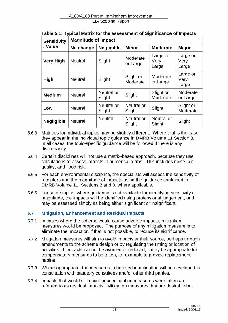
5.6.2 The significance of any particular impact can typically be calculated through the use of a matrix, with the sensitivity of the receptor on one axis and the magnitude of impact on the other. A typical matrix is found in Table 2.4 of DMRB Volume 11, Section 2 Part 5, and is reproduced in Table 5.1 below.
A160/A180 Port of Immingham Improvement EIA Scoping Report
Rev.: 1 11 Issued: 30/01/13
Table 5.1: Typical Matrix for the assessment of Significance of Impacts Magnitude of impact Sensitivity
/ Value No change Negligible Minor Moderate Major
Very High Neutral Slight Moderate or Large
Large or Very Large
Large or Very Large
High Neutral Slight Slight or Moderate
Moderate or Large
Large or Very Large
Medium Neutral Neutral or Slight Slight Slight or
Moderate Moderate or Large
Low Neutral Neutral or Slight
Neutral or Slight Slight Slight or
Moderate
Negligible Neutral Neutral
Neutral or Slight
Neutral or Slight Slight
5.6.3 Matrices for individual topics may be slightly different. Where that is the case, they appear in the individual topic guidance in DMRB Volume 11 Section 3. In all cases, the topic-specific guidance will be followed if there is any discrepancy.
5.6.4 Certain disciplines will not use a matrix-based approach, because they use calculations to assess impacts in numerical terms. This includes noise, air quality, and flood risk.
5.6.5 For each environmental discipline, the specialists will assess the sensitivity of receptors and the magnitude of impacts using the guidance contained in DMRB Volume 11, Sections 2 and 3, where applicable.
5.6.6 For some topics, where guidance is not available for identifying sensitivity or magnitude, the impacts will be identified using professional judgement, and may be assessed simply as being either significant or insignificant.
5.7 Mitigation, Enhancement and Residual Impacts 5.7.1 In cases where the scheme would cause adverse impacts, mitigation
measures would be proposed. The purpose of any mitigation measure is to eliminate the impact or, if that is not possible, to reduce its significance.
5.7.2 Mitigation measures will aim to avoid impacts at their source, perhaps through amendments to the scheme design or by regulating the timing or location of activities. If impacts cannot be avoided or reduced, it may be appropriate for compensatory measures to be taken, for example to provide replacement habitat.
5.7.3 Where appropriate, the measures to be used in mitigation will be developed in consultation with statutory consultees and/or other third parties.
5.7.4 Impacts that would still occur once mitigation measures were taken are referred to as residual impacts. Mitigation measures that are desirable but

A160/A180 Port of Immingham Improvement EIA Scoping Report
Rev.: 1 12 Issued: 30/01/13
that cannot be committed to as part of the scheme will not be taken into account in the assessment of residual impacts.
5.7.5 If it is possible for the scheme to provide measures that would enhance the environment, rather than just mitigate the adverse impacts of the scheme, the beneficial impacts of the enhancements will be assessed.
A160/A180 Port of Immingham Improvement EIA Scoping Report
Rev.: 1 13 Issued: 30/01/13
6 Air Quality
6.1 Introduction
Topic Definition 6.1.1 This topic is comprised of three sub-topics:
• Local air quality, which relates to pollutants with potential to affect human health and ecosystems at a local level;
• Regional air quality, which relates to pollutants dispersing over a larger area, with potential to affect human health and ecosystems; and
• Climate change, which is related to emissions of greenhouse gases.
Study Area 6.1.2 The study area for the assessment of local air quality will be defined in line
with the guidance contained in DMRB Volume 11, Section 3, Part 1 (HA207/07). It will comprise all land within 200m of the centre line of the existing road, land within 200m of the centre line of the improvement scheme, and land within 200m of any other ‘affected roads’.
6.1.3 Affected roads are identified in HA207/07 as follows:
• Roads where the alignment would move by more than 5m;
• Daily traffic flows would change by 1000 Annual Average Daily Traffic (AADT) or more;
• Heavy Duty Vehicle (HDV) flows would change by 200 AADT or more;
• Daily average speed would change by 10 km/hour or more; or
• Peak hour speed would change by 20 km/hour or more. 6.1.4 The study area for the assessment of regional air quality will take into account
all roads meeting the following criteria:
• A change of more than 10% in AADT;
• A change of more than 10% in the number of HDVs; or
• A change in daily average speed of more than 20 km/hour. 6.1.5 Data from the traffic model will be used to define the study area. It is
anticipated that the study area will include North Lincolnshire Council (NLC) and North East Lincolnshire Council (NELC).
Receptors 6.1.6 Within the study area, two types of receptors will be considered, as follows:
• Residential properties and other sensitive receptors (such as schools, nursing homes, etc.); and
• Nature conservation sites designated at International, European or National level.
A160/A180 Port of Immingham Improvement EIA Scoping Report
Rev.: 1 14 Issued: 30/01/13
6.2 Existing and Baseline Knowledge 6.2.1 NLC and NELC regularly review and assess air quality within their
administrative boundaries, and both have declared Air Quality Management Areas (AQMAs) for measured and predicted exceedances of Air Quality Strategy1 (AQS) objectives.
6.2.2 Both local authorities monitor pollutant concentrations from a network of continuous monitoring stations and diffusion tubes.
NLC 6.2.3 NLC have declared two AQMAs for exceedances of AQS objectives for fine
particulate matter (PM10). These are the Scunthorpe AQMA and the Low Santon AQMA. Both AQMAs are located over 18 km west of the proposed scheme.
6.2.4 NLC operate a continuous analyser measuring nitrogen dioxide (NO2), PM10, sulphur dioxide and benzene and also deploy NO2 diffusion tubes in the vicinity of the potential study area. There was also a temporary survey of NO2 diffusion tubes deployed in 2010 in South Killingholme on behalf of the Highways Agency.
6.2.5 Table 6.1 presents the annual mean concentrations of NO2 recorded at the Killingholme continuous analyser site from 2008 to 20102. The number of exceedances of the 1 hour mean objective for NO2 and 24 hour mean objective for PM10 are shown in parenthesis. Table 6.1: Annual Mean NO2 and PM10 Concentrations (µg/m3) from the Killingholme Continuous Monitor ID Pollutant 2008 2009 2010
NO2 21.9 (0) 18.7 (0) 21.0 (0) Killingholme
PM10 21 (11) 22 (4) 21 (3)
6.2.6 Table 6.1 shows that annual mean NO2 and PM10 concentrations have been below AQS objectives (40 µg/m3 for both substances) at the monitor from 2008 to 2010. There were no exceedances of the 1 hour mean NO2 objective recorded (200 µg/m3), whilst the number of exceedances of the 24 hour mean PM10 objective (50 µg/m3) is always less than the 35 permitted per year.
6.2.7 However, based on the results of the diffusion tube monitoring in the vicinity of the scheme at South Killingholme, NLC have identified that there may be exceedences of the NO2 annual mean objective in South Killingholme at a property adjacent to the A160 scheme area. NLC have committed to undertaking a detailed assessment to determine whether an AQMA needs to be declared in this area.
6.2.8 Monitoring data indicates the concentrations of PM10, sulphur dioxide and benzene are not in exceedence of AQS objectives.
1 Defra, The Air Quality Strategy for England, Scotland, Wales and Northern Ireland, July 2007 2 NLC, 2011 Air Quality Progress Report for North Lincolnshire Council (Draft), July 2011
A160/A180 Port of Immingham Improvement EIA Scoping Report
Rev.: 1 15 Issued: 30/01/13
NELC 6.2.9 NELC have declared two AQMAs. The Immingham AQMA encompasses
parts of Kings Road, Pelham Road and Hawthorn Avenue in Immingham, and has been declared for exceedances of the 24 hour AQS objective for PM10. Immingham AQMA is located over 2km from the proposed scheme.
6.2.10 Grimsby AQMA has been declared for exceedances of the annual mean AQS objective for NO2, and is located over 12 km south east of the proposed scheme.
6.2.11 NELC operate two continuous monitoring stations in Immingham, in the vicinity of the proposed scheme. Kings Road monitoring station is present at a roadside location within the Immingham AQMA. Immingham Woodlands Avenue monitoring station is located at an urban background site, approximately 1.75km from the proposed scheme. Annual mean NO2 and PM10 concentrations obtained from the Immingham monitoring stations between 2007 and 2011 are shown in Table 6.23. The number of exceedances of short-term objectives for each pollutant are shown in parenthesis. Table 6.2: Annual Mean NO2 and PM10 Concentrations (µg/m3) from the NELC Continuous Monitors in Immingham ID Pollutant 2007 2008 2009 2010 2011
NO2 21.9 (3) 26.1 (0) 38.5 (0) 31.4 (7) 30.9 (0)Kings Road PM10 34.7 (-) 35.1
(56) 25.2 (24) 20.7 (3) 19.5 (6)
NO2 21.2 (0) 29.2 18.7 (0) 35.1 (0) 20.5 (0)Woodland Avenue PM10 19.7 (4) 27.4
(17) 26.3 (12) 26.0 (9) 28.2
(22)
6.2.12 Table 6.2 shows that the annual mean NO2 and PM10 concentrations obtained from the two Immingham monitoring stations between 2007 and 2011 were below the air quality objective value (40 µg/m3 for both substances).
6.2.13 There were a maximum of seven exceedances of the hourly NO2 objective recorded (200 µg/m3) at Kings Road, which is less than the 18 permitted per year.
6.2.14 The number of exceedances of the 24 hour mean PM10 objective (50 µg/m3) is always less than the 35 permitted per year at Woodland Avenue. However, the Kings Road monitor, which is located within the Immingham AQMA, recorded 56 exceedences of the 24 hour mean PM10 objective in 2008. NELC identify that there has been a reduction in exceedences at Kings Road from 2009 onwards; considered to be due to the implementation of the specific measures in the NELC Air Quality Action Plan. NELC are mindful that a significant downward trend in PM10 concentrations has been measured over the last three years within the AQMA boundaries to levels that are well within the objective levels. Over the next 12 months NELC will explore the possibility of revoking the Immingham AQMA.
3 NELC, 2012 Air Quality Updating & Screening Assessment, April 2012
A160/A180 Port of Immingham Improvement EIA Scoping Report
Rev.: 1 16 Issued: 30/01/13
6.3 Value of the Environmental Resources and Receptors 6.3.1 The spatial extent of the air quality study area cannot be determined until
traffic data for the ‘with’ and ‘without’ scheme scenarios are available. Representative human health receptor locations will be included in the assessment such as houses, schools and hospitals. Each type of human health receptor is considered to be of equal value. It is not anticipated that any designated habitat sites will be located within the study area.
6.4 Potential Effects
Construction Effects 6.4.1 There is the potential for impact on receptors within 200m of construction sites
and haulage routes associated with the proposed scheme. It is likely that potential impacts would be limited to dust nuisance and increases in PM10 concentrations from construction activities, traffic and plant, plus increases and NO2 concentrations due to emissions from construction traffic and plant, and that these impacts would be temporary. Following the implementation of appropriate mitigation measures it is considered likely that there will be no significant impacts on air quality during the construction phase.
Operational Effects 6.4.2 Following implementation of the scheme, it is anticipated that the
improvements to the A160 will lead to an increase in flows on the A160 Humber Road and Ulceby Road. There is likely to be a reduction in flow on the A1173 through Immingham, and on other alternative local routes. The scheme is likely to lead to changes in vehicle emissions of oxides of nitrogen (NOx), NO2 and PM10. Whilst there is anticipated to be an increase to traffic on the A160 Humber Road, overall emission rates from the A160 are also dependent on changes to vehicle speeds and the locations of queues at road junctions.
6.5 Proposed Level and Scope of Assessment 6.5.1 The scope of the assessment during the construction phase will include
emissions of NO2 and PM10 from construction plant and vehicles, and dust arising from construction activities. The operational phase will include assessment of NO2 and PM10 concentrations associated with vehicle traffic on the road network, there is not considered to be a risk of significant impact from other substances included in the AQS.
6.5.2 In order to provide a more robust basis for assessment and model verification, a six month NO2 diffusion tube monitoring survey will be carried out. The location of the diffusion tubes will be agreed in consultation with NLC.
6.5.3 Jacobs consulted the NLC and NELC EHOs and agreed the scope of the assessment methodology and monitoring.
6.6 Proposed Assessment Methodology 6.6.1 An air quality assessment of demolition and construction activities will be
undertaken using an approach consistent with the HA’s DMRB methodology, and Institute of Air Quality Management’s (2012) Guidance on the
A160/A180 Port of Immingham Improvement EIA Scoping Report
Rev.: 1 17 Issued: 30/01/13
Assessment of the Impacts of Construction on Air Quality and the Determination of Significance. Potential mitigation measures consistent with the level of risk will be identified.
6.6.2 Air quality modelling of the likely effects during the operational phase will be undertaken following Defra’s Local Air Quality Management Technical Guidance LAQM.TG(09)4 and the HA’s DMRB5 for the assessment of local air quality, where appropriate.
6.6.3 Existing and future pollutant concentrations will be predicted using detailed air dispersion modelling of emissions from road traffic sources using ADMS Roads. The results will be compared with the results of representative roadside monitoring and, if appropriate, a correction factor will be determined and applied. The potential air quality effects of the scheme will be evaluated considering the predicted pollutant concentrations in the ‘with’ and ‘without’ proposed scheme scenarios, at representative sensitive receptors.
6.6.4 The criteria set out in the HA’s draft Interim Advice Note ‘Updated Air Quality Advice on the Application of the Test for Evaluating Significant Effects’6 will be used to assess the impacts of the scheme. Consideration will also be given to the National Planning Policy Framework, specifically Paragraph 124 and the local authorities Local Development Plan and Air Quality Action Plans, where appropriate.
4 Defra, Local Air Quality Management Technical Guidance LAQM.TG(09), 2009 5 Highways Agency, Design Manual for Roads and Bridges (DMRB) Volume 11, Section 3, Part 1, HA207/07 Air Quality 6 Highways Agency, DRAFT Interim Advice Note ‘Updated Air Quality Advice on the Application of the Test for Evaluating Significant Effects’, 2012

A160/A180 Port of Immingham Improvement EIA Scoping Report
Rev.: 1 19 Issued: 30/01/13
7 Cultural Heritage
7.1 Introduction
Topic Definition 7.1.1 This chapter has been prepared in accordance with the guidance contained in
Volume 11, Section 3, Part 2 of the Design Manual for Roads and Bridges (DMRB) (Highways Agency 2007), which defines the objectives of a scoping study as follows:
• to determine whether further study is required beyond desk-based collection and analysis of readily available information, and
• to define the level of detail required for any further study. 7.1.2 Under the guidance provided in DMRB, Cultural Heritage is divided into three
sub-topics:
• Archaeological Remains;
• Historic Buildings; and
• Historic Landscapes.
Study Area and Receptors 7.1.3 Following the guidance provided in DMRB, a study area was defined
extending 300m from the footprint of the proposed development (DMRB, para. 5.4), extended where necessary to consider particular types of impact, as follows:
• The zone of visual influence (as defined for the landscape and visual impact assessment) will be used to identify receptors outside the study area, the setting of which could be impacted on by the scheme, and
• Any designated heritage assets within 300m of any ‘affected roads’ (as defined for the air quality and noise assessments) will be identified as receptors for the assessment of impacts caused by changes in traffic flows.
7.2 Existing and Baseline Knowledge 7.2.1 Baseline data has been derived from the Options Assessment report prepared
in 2009 (Pell Frischmann 2009, Section 4), appendix reports on geophysical surveys and fieldwalking conducted between 2008 and 2011, and archaeological trial trenching conducted in 2010 (Archaeological Services WYAS 2008, 2009, 2010 and 2011). The following source was also consulted for new or updated information on designated assets:
• The National Heritage List for England for information on statutorily and non-statutorily designated heritage assets including scheduled monuments, listed buildings, registered historic parks and gardens, and registered historic battlefields (http://www.english-heritage.org.uk/professional/protection/process/national-heritage-list-for-england - consulted on 18/01/2013).
A160/A180 Port of Immingham Improvement EIA Scoping Report
Rev.: 1 20 Issued: 30/01/13
7.2.2 Asset reference numbers identified in the text are derived from the Options Assessment report and have been retained for clarity and ease of reference to the previous studies (Pell Frischmann 2009).
7.2.3 One designated asset was identified within the 300m study area; The Nook (HB1) is a Grade II Listed Building located in South Killingholme close to the centre of the proposed scheme.
7.2.4 Consultation with English Heritage undertaken during the Options Assessment also identified 10 designated assets at a greater distance but where it was perceived that there was potential for impacts on their setting during construction or operation (Pell Frischmann 2009, Appendix 8.9). The designated assets are shown on Figure 7.1 summarised in Table 7.1 below.
7.2.5 One additional designated asset has been identified from the sources consulted for this report:
• Brocklesby Park (HL1) – A Grade I Registered park or Garden, situated immediately south of the proposed junction with the A180.
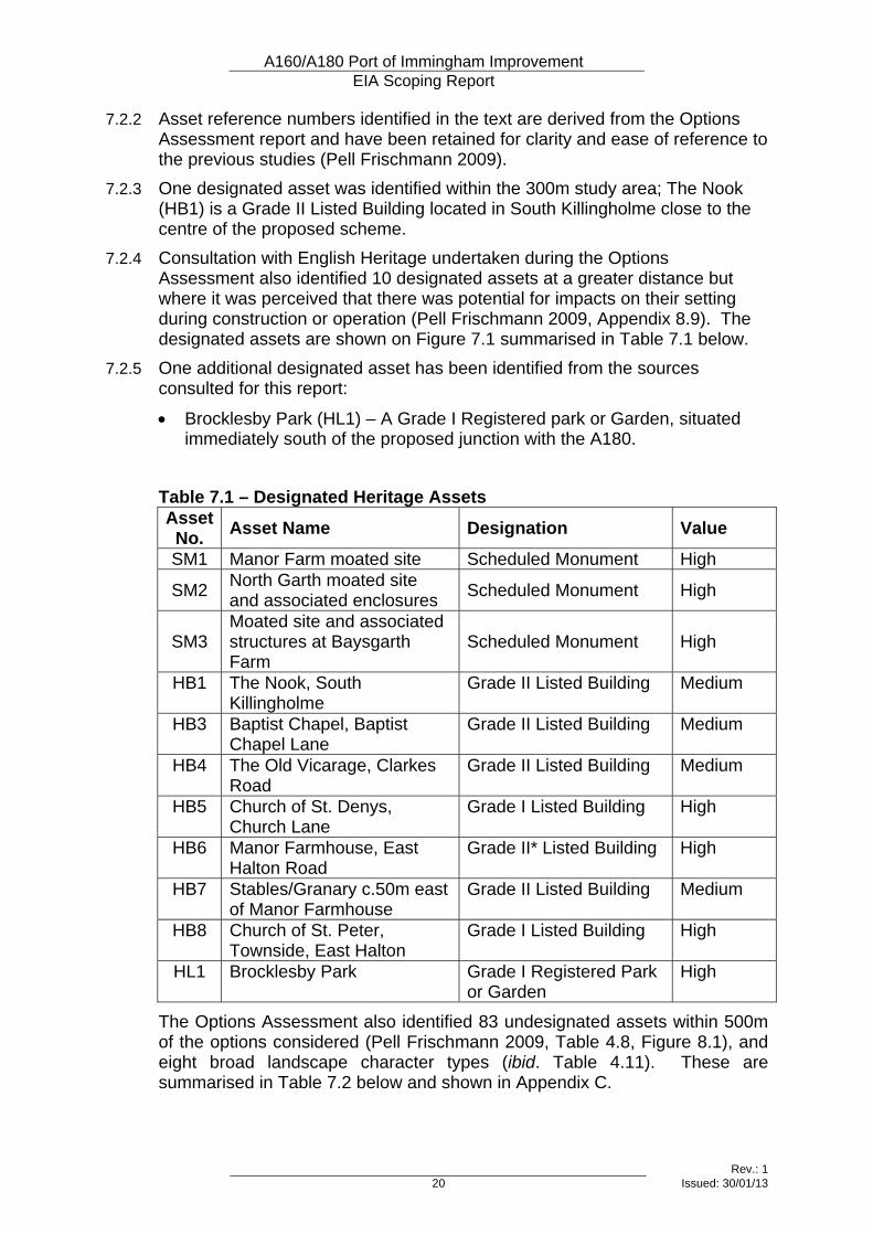
Table 7.1 – Designated Heritage Assets Asset No. Asset Name Designation Value
SM1 Manor Farm moated site Scheduled Monument High
SM2 North Garth moated site and associated enclosures Scheduled Monument High
SM3 Moated site and associated structures at Baysgarth Farm
Scheduled Monument High
HB1 The Nook, South Killingholme
Grade II Listed Building Medium
HB3 Baptist Chapel, Baptist Chapel Lane
Grade II Listed Building Medium
HB4 The Old Vicarage, Clarkes Road
Grade II Listed Building Medium
HB5 Church of St. Denys, Church Lane
Grade I Listed Building High
HB6 Manor Farmhouse, East Halton Road
Grade II* Listed Building High
HB7 Stables/Granary c.50m east of Manor Farmhouse
Grade II Listed Building Medium
HB8 Church of St. Peter, Townside, East Halton
Grade I Listed Building High
HL1 Brocklesby Park Grade I Registered Park or Garden
High
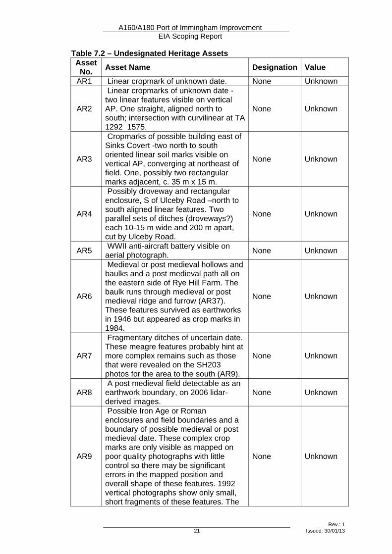
The Options Assessment also identified 83 undesignated assets within 500m of the options considered (Pell Frischmann 2009, Table 4.8, Figure 8.1), and eight broad landscape character types (ibid. Table 4.11). These are summarised in Table 7.2 below and shown in Appendix C.
A160/A180 Port of Immingham Improvement EIA Scoping Report
Rev.: 1 21 Issued: 30/01/13
Table 7.2 – Undesignated Heritage Assets Asset No. Asset Name Designation Value
AR1 Linear cropmark of unknown date. None Unknown
AR2
Linear cropmarks of unknown date -two linear features visible on vertical AP. One straight, aligned north to south; intersection with curvilinear at TA 1292 1575.
None Unknown
AR3
Cropmarks of possible building east of Sinks Covert -two north to south oriented linear soil marks visible on vertical AP, converging at northeast of field. One, possibly two rectangular marks adjacent, c. 35 m x 15 m.
None Unknown
AR4
Possibly droveway and rectangular enclosure, S of Ulceby Road –north to south aligned linear features. Two parallel sets of ditches (droveways?) each 10-15 m wide and 200 m apart, cut by Ulceby Road.
None Unknown
AR5 WWII anti-aircraft battery visible on aerial photograph. None Unknown
AR6
Medieval or post medieval hollows and baulks and a post medieval path all on the eastern side of Rye Hill Farm. The baulk runs through medieval or post medieval ridge and furrow (AR37). These features survived as earthworks in 1946 but appeared as crop marks in 1984.
None Unknown
AR7
Fragmentary ditches of uncertain date. These meagre features probably hint at more complex remains such as those that were revealed on the SH203 photos for the area to the south (AR9).
None Unknown
AR8 A post medieval field detectable as an earthwork boundary, on 2006 lidar-derived images.
None Unknown
AR9
Possible Iron Age or Roman enclosures and field boundaries and a boundary of possible medieval or post medieval date. These complex crop marks are only visible as mapped on poor quality photographs with little control so there may be significant errors in the mapped position and overall shape of these features. 1992 vertical photographs show only small, short fragments of these features. The
None Unknown
A160/A180 Port of Immingham Improvement EIA Scoping Report
Rev.: 1 22 Issued: 30/01/13
Asset No. Asset Name Designation Value
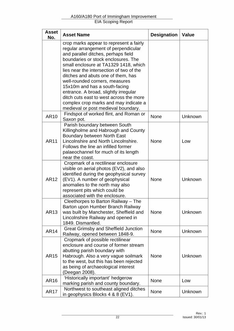
crop marks appear to represent a fairly regular arrangement of perpendicular and parallel ditches, perhaps field boundaries or stock enclosures. The small enclosure at TA1329 1418, which lies near the intersection of two of the ditches and abuts one of them, has well-rounded corners, measures 15x10m and has a south-facing entrance. A broad, slightly irregular ditch cuts east to west across the more complex crop marks and may indicate a medieval or post medieval boundary.
AR10 Findspot of worked flint, and Roman or Saxon pot. None Unknown
AR11
Parish boundary between South Killingholme and Habrough and County Boundary between North East Lincolnshire and North Lincolnshire. Follows the line an infilled former palaeochannel for much of its length near the coast.
None Low
AR12
Cropmark of a rectilinear enclosure visible on aerial photos (EV2), and also identified during the geophysical survey (EV1). A number of geophysical anomalies to the north may also represent pits which could be associated with the enclosure.
None Unknown
AR13
Cleethorpes to Barton Railway – The Barton upon Humber Branch Railway was built by Manchester, Sheffield and Lincolnshire Railway and opened in 1849. Dismantled.
None Unknown
AR14 Great Grimsby and Sheffield Junction Railway, opened between 1848-9. None Unknown
AR15
Cropmark of possible rectilinear enclosure and course of former stream abutting parish boundary with Habrough. Also a very vague soilmark to the west, but this has been rejected as being of archaeological interest (Deegan 2008).
None Unknown
AR16 ‘Historically important’ hedgerow marking parish and county boundary. None Low
AR17 Northwest to southeast aligned ditches in geophysics Blocks 4 & 8 (EV1). None Unknown
A160/A180 Port of Immingham Improvement EIA Scoping Report
Rev.: 1 23 Issued: 30/01/13
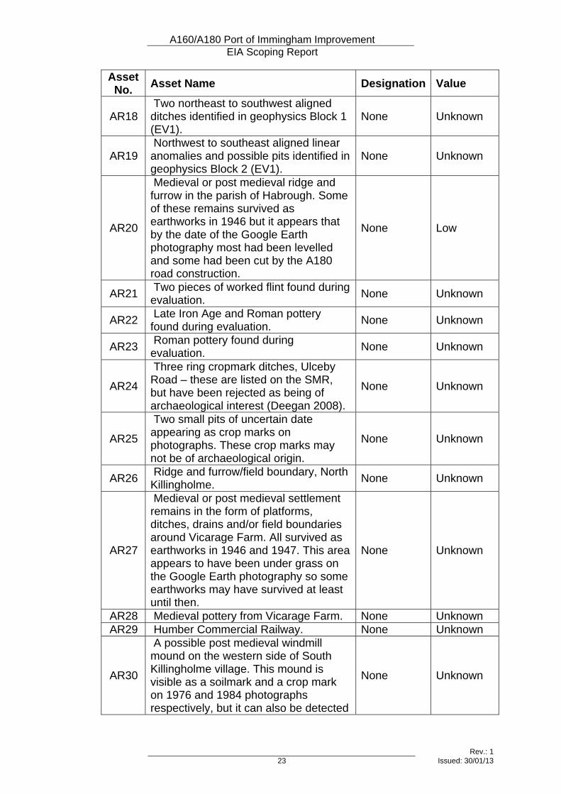
Asset No. Asset Name Designation Value
AR18 Two northeast to southwest aligned ditches identified in geophysics Block 1 (EV1).
None Unknown
AR19 Northwest to southeast aligned linear anomalies and possible pits identified in geophysics Block 2 (EV1).
None Unknown
AR20
Medieval or post medieval ridge and furrow in the parish of Habrough. Some of these remains survived as earthworks in 1946 but it appears that by the date of the Google Earth photography most had been levelled and some had been cut by the A180 road construction.
None Low
AR21 Two pieces of worked flint found during evaluation. None Unknown
AR22 Late Iron Age and Roman pottery found during evaluation. None Unknown
AR23 Roman pottery found during evaluation. None Unknown
AR24
Three ring cropmark ditches, Ulceby Road – these are listed on the SMR, but have been rejected as being of archaeological interest (Deegan 2008).
None Unknown
AR25
Two small pits of uncertain date appearing as crop marks on photographs. These crop marks may not be of archaeological origin.
None Unknown
AR26 Ridge and furrow/field boundary, North Killingholme. None Unknown
AR27
Medieval or post medieval settlement remains in the form of platforms, ditches, drains and/or field boundaries around Vicarage Farm. All survived as earthworks in 1946 and 1947. This area appears to have been under grass on the Google Earth photography so some earthworks may have survived at least until then.
None Unknown
AR28 Medieval pottery from Vicarage Farm. None Unknown AR29 Humber Commercial Railway. None Unknown
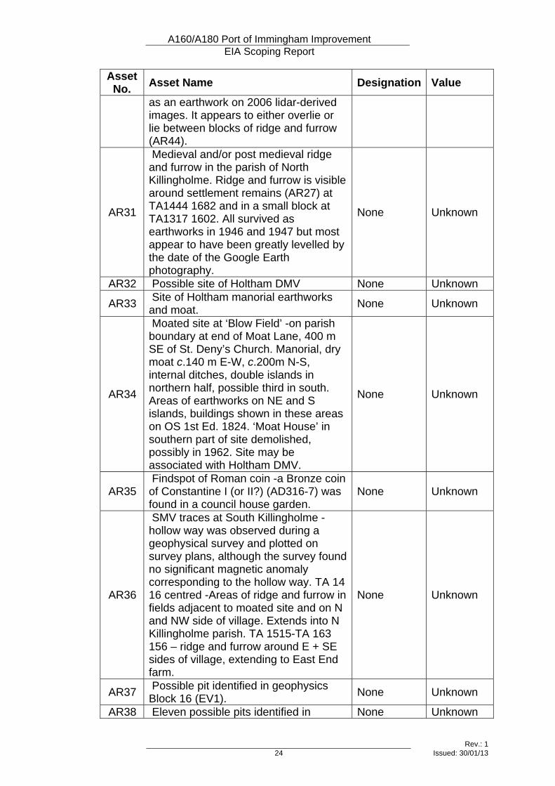
AR30
A possible post medieval windmill mound on the western side of South Killingholme village. This mound is visible as a soilmark and a crop mark on 1976 and 1984 photographs respectively, but it can also be detected
None Unknown
A160/A180 Port of Immingham Improvement EIA Scoping Report
Rev.: 1 24 Issued: 30/01/13
Asset No. Asset Name Designation Value
as an earthwork on 2006 lidar-derived images. It appears to either overlie or lie between blocks of ridge and furrow (AR44).
AR31
Medieval and/or post medieval ridge and furrow in the parish of North Killingholme. Ridge and furrow is visible around settlement remains (AR27) at TA1444 1682 and in a small block at TA1317 1602. All survived as earthworks in 1946 and 1947 but most appear to have been greatly levelled by the date of the Google Earth photography.
None Unknown
AR32 Possible site of Holtham DMV None Unknown
AR33 Site of Holtham manorial earthworks and moat. None Unknown
AR34
Moated site at ‘Blow Field’ -on parish boundary at end of Moat Lane, 400 m SE of St. Deny’s Church. Manorial, dry moat c.140 m E-W, c.200m N-S, internal ditches, double islands in northern half, possible third in south. Areas of earthworks on NE and S islands, buildings shown in these areas on OS 1st Ed. 1824. ‘Moat House’ in southern part of site demolished, possibly in 1962. Site may be associated with Holtham DMV.
None Unknown
AR35 Findspot of Roman coin -a Bronze coin of Constantine I (or II?) (AD316-7) was found in a council house garden.
None Unknown
AR36
SMV traces at South Killingholme -hollow way was observed during a geophysical survey and plotted on survey plans, although the survey found no significant magnetic anomaly corresponding to the hollow way. TA 14 16 centred -Areas of ridge and furrow in fields adjacent to moated site and on N and NW side of village. Extends into N Killingholme parish. TA 1515-TA 163 156 – ridge and furrow around E + SE sides of village, extending to East End farm.
None Unknown
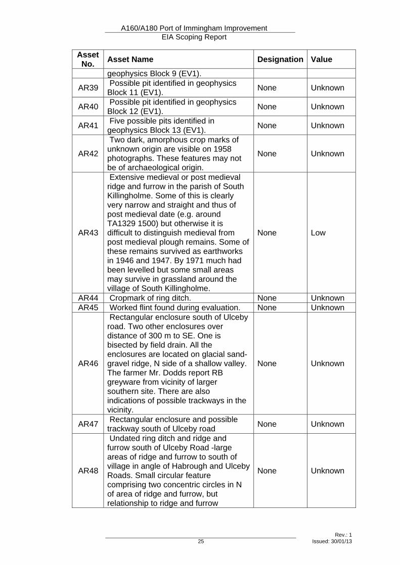
AR37 Possible pit identified in geophysics Block 16 (EV1). None Unknown
AR38 Eleven possible pits identified in None Unknown
A160/A180 Port of Immingham Improvement EIA Scoping Report
Rev.: 1 25 Issued: 30/01/13
Asset No. Asset Name Designation Value
geophysics Block 9 (EV1).
AR39 Possible pit identified in geophysics Block 11 (EV1). None Unknown
AR40 Possible pit identified in geophysics Block 12 (EV1). None Unknown
AR41 Five possible pits identified in geophysics Block 13 (EV1). None Unknown
AR42
Two dark, amorphous crop marks of unknown origin are visible on 1958 photographs. These features may not be of archaeological origin.
None Unknown
AR43
Extensive medieval or post medieval ridge and furrow in the parish of South Killingholme. Some of this is clearly very narrow and straight and thus of post medieval date (e.g. around TA1329 1500) but otherwise it is difficult to distinguish medieval from post medieval plough remains. Some of these remains survived as earthworks in 1946 and 1947. By 1971 much had been levelled but some small areas may survive in grassland around the village of South Killingholme.
None Low
AR44 Cropmark of ring ditch. None Unknown AR45 Worked flint found during evaluation. None Unknown
AR46
Rectangular enclosure south of Ulceby road. Two other enclosures over distance of 300 m to SE. One is bisected by field drain. All the enclosures are located on glacial sand-gravel ridge, N side of a shallow valley. The farmer Mr. Dodds report RB greyware from vicinity of larger southern site. There are also indications of possible trackways in the vicinity.
None Unknown
AR47 Rectangular enclosure and possible trackway south of Ulceby road None Unknown
AR48
Undated ring ditch and ridge and furrow south of Ulceby Road -large areas of ridge and furrow to south of village in angle of Habrough and Ulceby Roads. Small circular feature comprising two concentric circles in N of area of ridge and furrow, but relationship to ridge and furrow
None Unknown
A160/A180 Port of Immingham Improvement EIA Scoping Report
Rev.: 1 26 Issued: 30/01/13
Asset No. Asset Name Designation Value
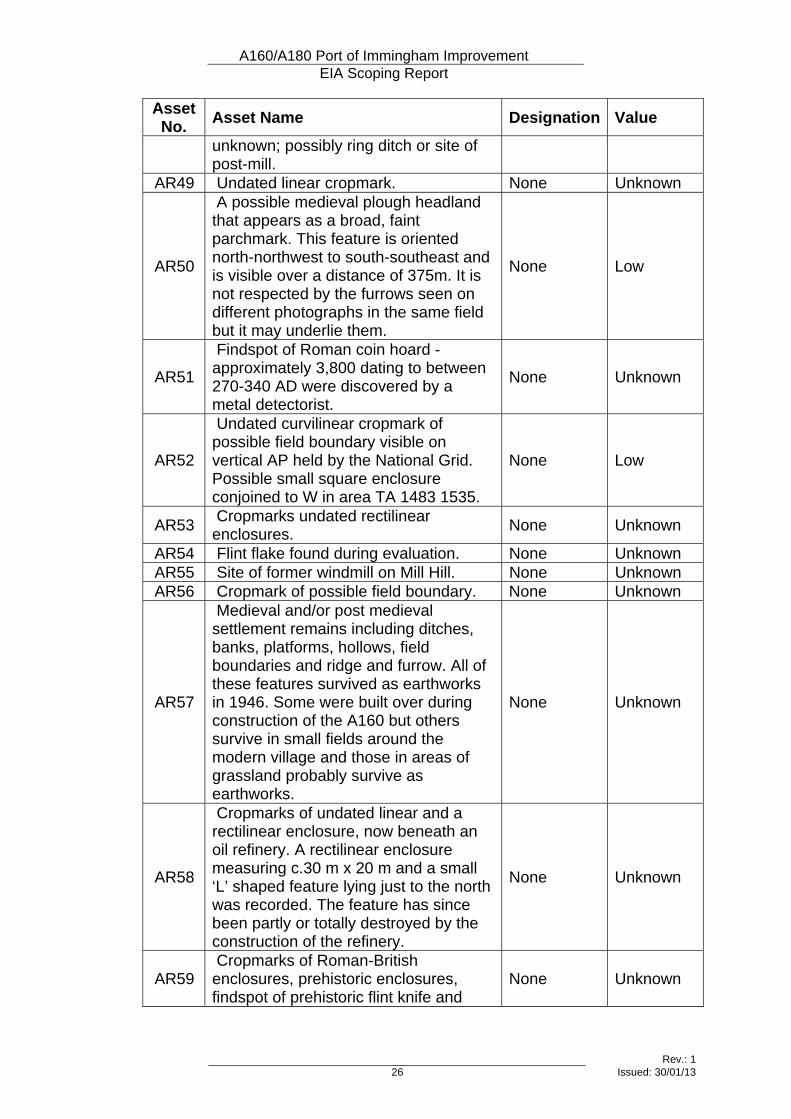
unknown; possibly ring ditch or site of post-mill.
AR49 Undated linear cropmark. None Unknown
AR50
A possible medieval plough headland that appears as a broad, faint parchmark. This feature is oriented north-northwest to south-southeast and is visible over a distance of 375m. It is not respected by the furrows seen on different photographs in the same field but it may underlie them.
None Low
AR51
Findspot of Roman coin hoard - approximately 3,800 dating to between 270-340 AD were discovered by a metal detectorist.
None Unknown
AR52
Undated curvilinear cropmark of possible field boundary visible on vertical AP held by the National Grid. Possible small square enclosure conjoined to W in area TA 1483 1535.
None Low
AR53 Cropmarks undated rectilinear enclosures. None Unknown
AR54 Flint flake found during evaluation. None Unknown AR55 Site of former windmill on Mill Hill. None Unknown AR56 Cropmark of possible field boundary. None Unknown
AR57
Medieval and/or post medieval settlement remains including ditches, banks, platforms, hollows, field boundaries and ridge and furrow. All of these features survived as earthworks in 1946. Some were built over during construction of the A160 but others survive in small fields around the modern village and those in areas of grassland probably survive as earthworks.
None Unknown
AR58
Cropmarks of undated linear and a rectilinear enclosure, now beneath an oil refinery. A rectilinear enclosure measuring c.30 m x 20 m and a small ‘L’ shaped feature lying just to the north was recorded. The feature has since been partly or totally destroyed by the construction of the refinery.
None Unknown
AR59 Cropmarks of Roman-British enclosures, prehistoric enclosures, findspot of prehistoric flint knife and
None Unknown
A160/A180 Port of Immingham Improvement EIA Scoping Report
Rev.: 1 27 Issued: 30/01/13
Asset No. Asset Name Designation Value
Roman pottery.
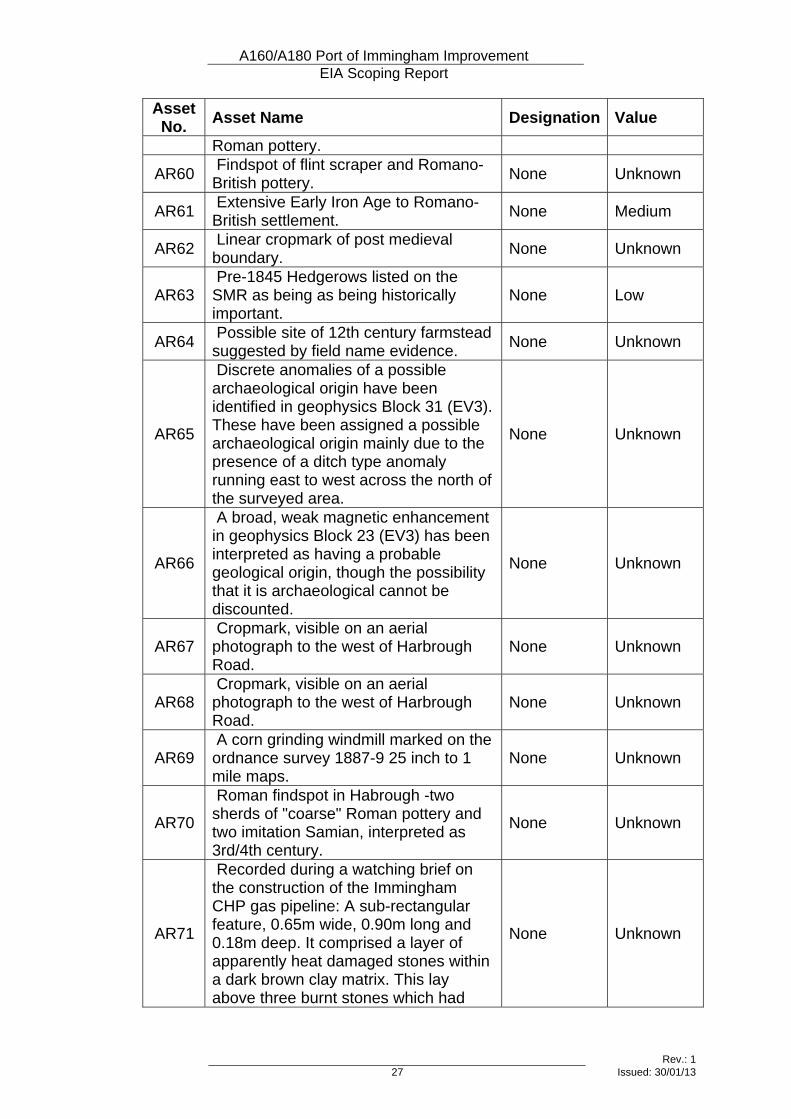
AR60 Findspot of flint scraper and Romano-British pottery. None Unknown
AR61 Extensive Early Iron Age to Romano-British settlement. None Medium
AR62 Linear cropmark of post medieval boundary. None Unknown
AR63 Pre-1845 Hedgerows listed on the SMR as being as being historically important.
None Low
AR64 Possible site of 12th century farmstead suggested by field name evidence. None Unknown
AR65
Discrete anomalies of a possible archaeological origin have been identified in geophysics Block 31 (EV3). These have been assigned a possible archaeological origin mainly due to the presence of a ditch type anomaly running east to west across the north of the surveyed area.
None Unknown
AR66
A broad, weak magnetic enhancement in geophysics Block 23 (EV3) has been interpreted as having a probable geological origin, though the possibility that it is archaeological cannot be discounted.
None Unknown
AR67 Cropmark, visible on an aerial photograph to the west of Harbrough Road.
None Unknown
AR68 Cropmark, visible on an aerial photograph to the west of Harbrough Road.
None Unknown
AR69 A corn grinding windmill marked on the ordnance survey 1887-9 25 inch to 1 mile maps.
None Unknown
AR70
Roman findspot in Habrough -two sherds of "coarse" Roman pottery and two imitation Samian, interpreted as 3rd/4th century.
None Unknown
AR71
Recorded during a watching brief on the construction of the Immingham CHP gas pipeline: A sub-rectangular feature, 0.65m wide, 0.90m long and 0.18m deep. It comprised a layer of apparently heat damaged stones within a dark brown clay matrix. This lay above three burnt stones which had
None Unknown
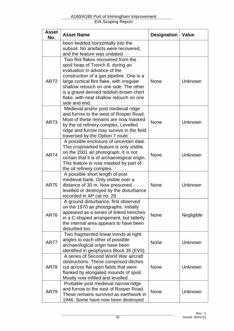
A160/A180 Port of Immingham Improvement EIA Scoping Report
Rev.: 1 28 Issued: 30/01/13
Asset No. Asset Name Designation Value
been bedded horizontally into the subsoil. No artefacts were recovered, and the feature was undated.
AR72
Two flint flakes recovered from the spoil heap of Trench 8, during an evaluation in advance of the construction of a gas pipeline. One is a large cortical flint flake, with irregular shallow retouch on one side. The other is a gravel derived reddish-brown chert flake, with neat shallow retouch on one side and end.
None Unknown
AR73
Medieval and/or post medieval ridge and furrow to the west of Rosper Road. Most of these remains are now masked by the oil refinery complex. Levelled ridge and furrow may survive in the field traversed by the Option 7 route.
None Unknown
AR74
A possible enclosure of uncertain date. This cropmarked feature is only visible on the 2001 air photograph. It is not certain that it is of archaeological origin. This feature is now masked by part of the oil refinery complex.
None Unknown
AR75
A possible short length of post medieval bank. Only visible over a distance of 30 m. Now presumed levelled or destroyed by the disturbance recorded in AP cat no. 29
None Unknown
AR76
A ground disturbance, first observed on the 1970 air photographs. Initially appeared as a series of linked trenches in a C-shaped arrangement, but latterly the internal area appears to have been disturbed too.
None Negligible
AR77
Two fragmented linear trends at right angles to each other of possible archaeological origin have been identified in geophysics Block 35 (EV3).
None Unknown
AR78
A series of Second World War aircraft obstructions. These comprised ditches cut across flat open fields that were flanked by elongated mounds of spoil. Mostly now infilled and levelled.
None Unknown
AR79
Probable post medieval narrow ridge and furrow to the east of Rosper Road. These remains survived as earthwork in 1946. Some have now been destroyed
None Unknown
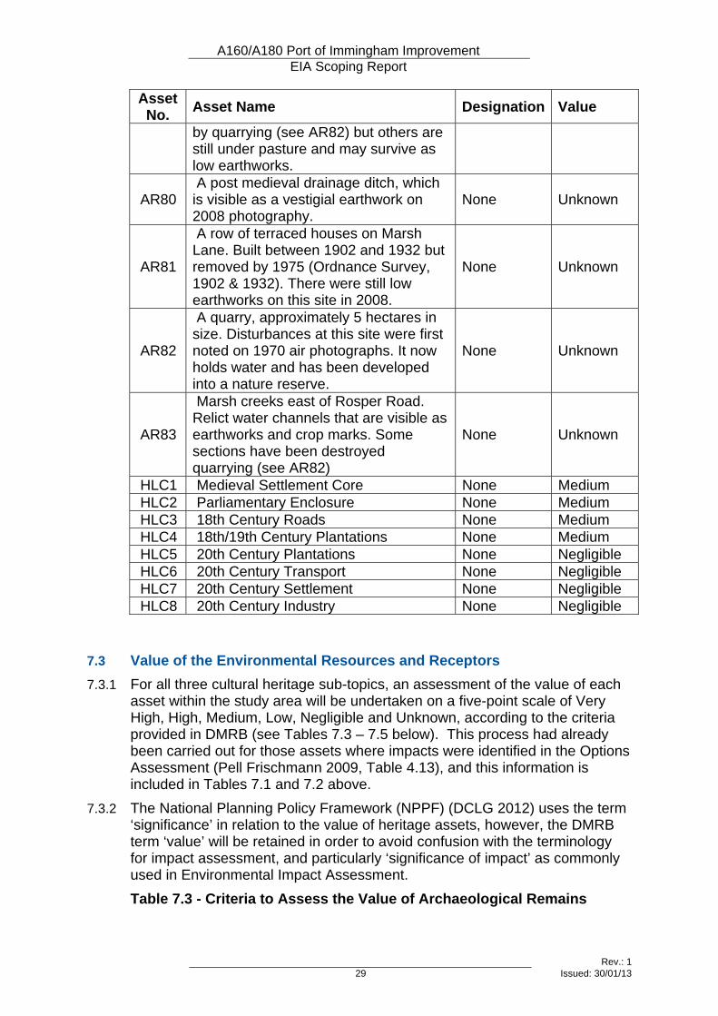
A160/A180 Port of Immingham Improvement EIA Scoping Report
Rev.: 1 29 Issued: 30/01/13
Asset No. Asset Name Designation Value
by quarrying (see AR82) but others are still under pasture and may survive as low earthworks.
AR80 A post medieval drainage ditch, which is visible as a vestigial earthwork on 2008 photography.
None Unknown
AR81
A row of terraced houses on Marsh Lane. Built between 1902 and 1932 but removed by 1975 (Ordnance Survey, 1902 & 1932). There were still low earthworks on this site in 2008.
None Unknown
AR82
A quarry, approximately 5 hectares in size. Disturbances at this site were first noted on 1970 air photographs. It now holds water and has been developed into a nature reserve.
None Unknown
AR83
Marsh creeks east of Rosper Road. Relict water channels that are visible as earthworks and crop marks. Some sections have been destroyed quarrying (see AR82)
None Unknown
HLC1 Medieval Settlement Core None Medium HLC2 Parliamentary Enclosure None Medium HLC3 18th Century Roads None Medium HLC4 18th/19th Century Plantations None Medium HLC5 20th Century Plantations None Negligible HLC6 20th Century Transport None Negligible HLC7 20th Century Settlement None Negligible HLC8 20th Century Industry None Negligible
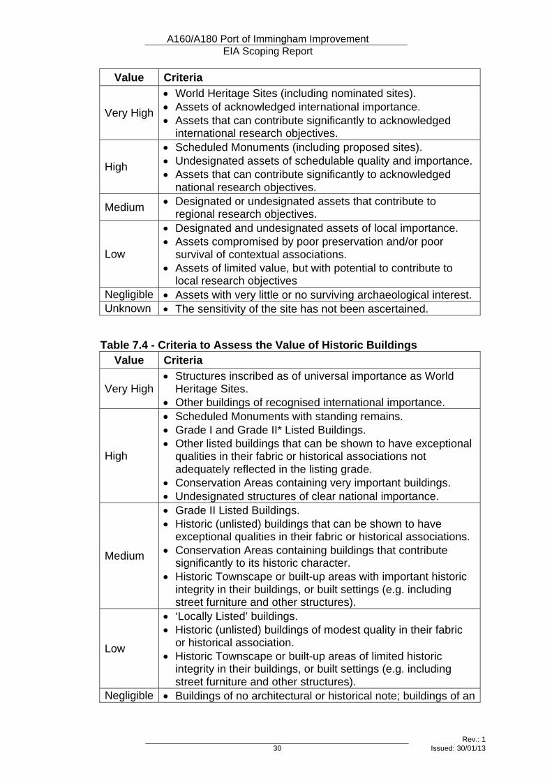
7.3 Value of the Environmental Resources and Receptors 7.3.1 For all three cultural heritage sub-topics, an assessment of the value of each
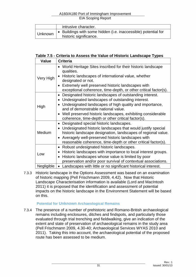
asset within the study area will be undertaken on a five-point scale of Very High, High, Medium, Low, Negligible and Unknown, according to the criteria provided in DMRB (see Tables 7.3 – 7.5 below). This process had already been carried out for those assets where impacts were identified in the Options Assessment (Pell Frischmann 2009, Table 4.13), and this information is included in Tables 7.1 and 7.2 above.
7.3.2 The National Planning Policy Framework (NPPF) (DCLG 2012) uses the term ‘significance’ in relation to the value of heritage assets, however, the DMRB term ‘value’ will be retained in order to avoid confusion with the terminology for impact assessment, and particularly ‘significance of impact’ as commonly used in Environmental Impact Assessment. Table 7.3 - Criteria to Assess the Value of Archaeological Remains
A160/A180 Port of Immingham Improvement EIA Scoping Report
Rev.: 1 30 Issued: 30/01/13
Value Criteria
Very High
• World Heritage Sites (including nominated sites). • Assets of acknowledged international importance. • Assets that can contribute significantly to acknowledged
international research objectives.
High
• Scheduled Monuments (including proposed sites). • Undesignated assets of schedulable quality and importance. • Assets that can contribute significantly to acknowledged
national research objectives.
Medium • Designated or undesignated assets that contribute to regional research objectives.
Low
• Designated and undesignated assets of local importance. • Assets compromised by poor preservation and/or poor
survival of contextual associations. • Assets of limited value, but with potential to contribute to
local research objectives Negligible • Assets with very little or no surviving archaeological interest. Unknown • The sensitivity of the site has not been ascertained.
Table 7.4 - Criteria to Assess the Value of Historic Buildings Value Criteria
Very High • Structures inscribed as of universal importance as World
Heritage Sites. • Other buildings of recognised international importance.
High
• Scheduled Monuments with standing remains. • Grade I and Grade II* Listed Buildings. • Other listed buildings that can be shown to have exceptional
qualities in their fabric or historical associations not adequately reflected in the listing grade.
• Conservation Areas containing very important buildings. • Undesignated structures of clear national importance.
Medium
• Grade II Listed Buildings. • Historic (unlisted) buildings that can be shown to have
exceptional qualities in their fabric or historical associations. • Conservation Areas containing buildings that contribute
significantly to its historic character. • Historic Townscape or built-up areas with important historic
integrity in their buildings, or built settings (e.g. including street furniture and other structures).
Low
• ‘Locally Listed’ buildings. • Historic (unlisted) buildings of modest quality in their fabric
or historical association. • Historic Townscape or built-up areas of limited historic
integrity in their buildings, or built settings (e.g. including street furniture and other structures).
Negligible • Buildings of no architectural or historical note; buildings of an
A160/A180 Port of Immingham Improvement EIA Scoping Report
Rev.: 1 31 Issued: 30/01/13
intrusive character.
Unknown • Buildings with some hidden (i.e. inaccessible) potential for historic significance.
Table 7.5 - Criteria to Assess the Value of Historic Landscape Types
Value Criteria
Very High
• World Heritage Sites inscribed for their historic landscape qualities.
• Historic landscapes of international value, whether designated or not.
• Extremely well preserved historic landscapes with exceptional coherence, time-depth, or other critical factor(s).
High
• Designated historic landscapes of outstanding interest. • Undesignated landscapes of outstanding interest. • Undesignated landscapes of high quality and importance,
and of demonstrable national value. • Well preserved historic landscapes, exhibiting considerable
coherence, time-depth or other critical factor(s).
Medium
• Designated special historic landscapes. • Undesignated historic landscapes that would justify special
historic landscape designation, landscapes of regional value.• Averagely well-preserved historic landscapes with
reasonable coherence, time-depth or other critical factor(s).
Low
• Robust undesignated historic landscapes. • Historic landscapes with importance to local interest groups. • Historic landscapes whose value is limited by poor
preservation and/or poor survival of contextual associations. Negligible • Landscapes with little or no significant historical interest.
7.3.3 Historic landscape in the Options Assessment was based on an examination of historic mapping (Pell Frischmann 2009, 4.42). Now that Historic Landscape Characterisation information is available (Lord and MacIntosh 2011) it is proposed that the identification and assessment of potential impacts on the historic landscape in the Environment Statement will be based on this.
Potential for Unknown Archaeological Remains
7.3.4 The presence of a number of prehistoric and Romano-British archaeological remains including enclosures, ditches and findspots, and particularly those evaluated through trial trenching and fieldwalking, give an indication of the extent and state of preservation of archaeological remains in the study area (Pell Frischmann 2009, 4.30-40; Archaeological Services WYAS 2010 and 2011). Taking this into account, the archaeological potential of the proposed route has been assessed to be medium.
A160/A180 Port of Immingham Improvement EIA Scoping Report
Rev.: 1 32 Issued: 30/01/13
7.4 Potential Effects 7.4.1 The impacts of highway construction and operation on heritage assets may
include physical impacts leading to the removal of heritage assets, or impacts on their setting or amenity value.
7.4.2 Physical impacts can result in the partial or complete removal of an asset during construction of a road and any associated activities. All such impacts would occur during construction, and would be long-term in nature. Such impacts can include:
• Removal of archaeological deposits during construction;
• Compaction of archaeological deposits by construction traffic and structures; and,
• Changes in groundwater levels leading to the drying out of waterlogged archaeological deposits.
7.4.3 Impacts on the setting of heritage assets can result from the construction and/or operation of a new road. In most cases, they would be long-term in nature. They would commence during construction and continue during operation, although the degree of impact may vary between phases. Such impacts can include:
• Interruption or improvement of important views to or from an asset;
• Introduction or removal of large, prominent or intrusive structures within the setting of an asset;
• Introduction or removal of visual intrusion, such as moving vehicles, the presence of road signs or lighting;
• Significant changes in noise, dust, odour or air quality affecting the appreciation of their archaeological context; and,
• Severance or restoration of relationships between associated assets.
7.5 Proposed Level and Scope of Assessment 7.5.1 Detailed baseline information is provided in the Options Assessment (Pell
Frischmann 2009, Chapter 4), including the results of a detailed desk-based assessment, specially commissioned aerial photograph interpretation, geophysical and fieldwalking surveys, and targeted trial trenching. It is not proposed to repeat any of this work, however, the Historic Environment Records for North Lincolnshire and North East Lincolnshire will be consulted for assets identified since 2009 to ensure that baseline information is up to date.
7.5.2 The results of the previous studies and evaluation will be used to make an accurate assessment of the value of archaeological remains and of the magnitude and significance of impacts from the scheme upon them.
7.6 Proposed Assessment Methodology 7.6.1 A “Detailed Assessment” for the archaeological remains sub-topic and
“Simple Assessment” for the historic buildings and historic landscape sub-topics, as defined by DMRB, are recommended for the next stage of works.
A160/A180 Port of Immingham Improvement EIA Scoping Report
Rev.: 1 33 Issued: 30/01/13
7.6.2 In accordance with the guidance provided in DMRB, data will be gathered for a study area extending 200m to either side of the scheme footprint in order to ensure that assets identified since the production of the Options Assessment are included and assessed. In order to assess impacts on designated heritage assets, and undesignated historic buildings, the study area will be extended to encompass:
• The zone of visual influence (as defined for the landscape and visual impact assessment) will be used to identify receptors outside the study area, the setting of which could be impacted on by the scheme; and
• Any designated heritage assets within 300m of any ‘affected roads’ (as defined for the air quality and noise assessments) will be identified as receptors for the assessment of impacts caused by changes in traffic flows.
7.6.3 The assessment would comprise the following tasks:
• an updated search of the North Lincolnshire and North East Lincolnshire HERs to identify assets identified and archaeological works undertaken since 2009, and to obtain detailed Historic Landscape Characterisation Data;
• a walkover survey to determine the impact of the proposed scheme on archaeological remains, historic buildings and historic landscape assets, and
• production of an Environmental Statement Cultural Heritage chapter using the methodology identified above and including an assessment of the value of assets within the study area, the magnitude of impacts upon them, recommendations for mitigation of impacts and an assessment of the significance of predicted impacts from the scheme upon them.
7.6.4 Consultation will be undertaken with the following organizations during the preparation of the Environmental Statement:
• English Heritage Inspector of Ancient Monuments for the East of England;
• County Archaeologists for North Lincolnshire and North East Lincolnshire, and
• the North Lincolnshire and North East Conservation Officers. 7.6.5 Assessment of the settings of heritage assets, and its contribution to historic
legibility and capacity for change will be undertaken in line with guidance issued by English Heritage (2011).
7.7 References Archaeological Services WYAS, 2008, A160 - A180 Improvements, South Killingholme/Habrough, North Lincolnshire/North-East Lincolnshire: Geophysical Survey, ASWYAS Report No. 1896
Archaeological Services WYAS, 2009, A160 - A180 Improvements, South Killingholme/Habrough, North Lincolnshire/North-East Lincolnshire: Additional Geophysical Survey, ASWYAS Report No. 1993
A160/A180 Port of Immingham Improvement EIA Scoping Report
Rev.: 1 34 Issued: 30/01/13
Archaeological Services WYAS, 2010, A160 - A180 Improvements, South Killingholme/Habrough, North Lincolnshire/North-East Lincolnshire: Archaeological Evaluation, ASWYAS Report No. 2087
Archaeological Services WYAS, 2011, A160 - A180 Improvements, South Killingholme/Habrough, North Lincolnshire/North-East Lincolnshire: Geophysical Survey and Fieldwalking, ASWYAS Report No. 2215
DCLG, 2012, National Planning Policy Framework, Department for Communities and Local Government
English Heritage, 2011, The Setting of Heritage Assets
Highways Agency, 2007, Design Manual for Roads and Bridges, Volume 11, Section 3, Part 2, ‘Cultural Heritage’, HA 208/07
Lord, J., and MacIntosh, A., 2011, The Historic Character of the County of Lincolnshire, Lincolnshire County Council and English Heritage
Pell Frischmann, 2009, A160-A180 Improvements – Immingham, Environmental Assessment: Option Selection Stage, Chapter 4, “Cultural Heritage” (4.1-4.67)
A160/A180 Port of Immingham Improvement EIA Scoping Report
Rev.: 1 35 Issued: 30/01/13
8 Landscape
8.1 Introduction
Topic Definition 8.1.1 This topic considers the two related sub-topics of landscape and visual
amenity. 8.1.2 Landscape takes its character from a combination of elements, including
landform, watercourses, land use and pattern, land cover / vegetation, open space and cultural heritage influences. Landscapes are a key component of the distinctiveness of any local area. Within this assessment, no distinction is made between landscape and townscape, and the topic therefore covers potential changes in any of these components both in the countryside and in built-up areas.
8.1.3 To a large extent, people experience the landscape visually, and the quality of views can affect the quality of life. This assessment addresses potential changes in the quality of existing views, taking into account the extent to which the scheme would be visible from surrounding houses, farms, footpaths and bridleways, open spaces and offices.
8.1.4 This assessment will be carried out in accordance with the latest published guidance from the Highways Agency, Interim Advice Note 135/10, ‘Landscape and Visual Effects Assessment’, November 2010 (IAN 135/10)7.
Study Area 8.1.5 The study area will cover the whole ‘zone of visual influence’ (ZVI or visual
envelope) of the proposed scheme. The ZVI represents the area of land within which there would be a view of any part of the proposed scheme, and is based on guidance in IAN 135/10. A description of the ZVI is provided below in the Visual Amenity part of Section 8.2.
8.1.6 In line with the guidance in IAN 135/10, the study area will include the full extent of any neighbouring features of special value, such as Conservation Areas, to reflect the setting of such features.
8.2 Existing and Baseline Knowledge
Landscape Features 8.2.1 The study area is predominantly made up of flat, low lying, arable farmland
with medium to large, regularly shaped fields bordered by clipped native hedgerows, ditches and timber fences. Vegetation is relatively sparse and predominantly found around transport routes, settlements and industrial buildings where it acts as a screen or shelterbelt. The vegetation blocks are made up of native, deciduous species with some coniferous species in screening belts.
7 The assessment also takes account of the GLVIA guidelines; Landscape Institute/ Institute of Environmental Management and Assessment (LI/ IEMA), 2002, Guidelines for Landscape and Visual Impact Assessment, 2nd Edition, Spon Press;
A160/A180 Port of Immingham Improvement EIA Scoping Report
Rev.: 1 36 Issued: 30/01/13
8.2.2 The farmland is crossed by infrastructure including major road routes such as the A180 and A160, railways and power lines. Industry dominates the north east of the study area, especially around Immingham Docks, and there are numerous tall buildings and stacks.
8.2.3 South Killingholme is the largest settlement in the study area, which the existing A160 passes through. There are also the villages of North Killingholme to the north of the study area, Habrough to the south and Ulceby to the west. The town of Immingham lies approximately 1km to the south east. Scattered farmsteads are present within the farmland and are connected by minor roads and private access tracks.
8.2.4 There are several public rights of way within the study area, the majority of which are located within farmland to the south of South Killingholme. There are also footpaths located to the north of South Killingholme and a couple around Habrough village.
Landscape Character 8.2.5 The study area is covered by two of Natural England’s National Character
Areas8; Area 41 Humber Estuary and Area 42 Lincolnshire Coast and Marshes.
8.2.6 Area 41 is characterised by a flat, low lying landscape strongly influenced by the open water of the River Humber. Productive arable farming takes place in large rectilinear fields bounded by drains and embankments. Vegetation cover is sparse and when combined with the flat landscape, creates big skies and open views. Rural areas are quiet which contrasts with the busy industry around the ports.
8.2.7 Area 42 is characterised by flat, low lying land in the east which gently rises towards undulating land at the foot of the Lincolnshire Wolds. Mixed arable and pastoral farming is present within a medium scale agricultural landscape. Vegetation is sparse in the east with woodland and hedge cover increasing towards the Wolds. Settlements of brick and pantile vernacular are dispersed throughout with larger settlements towards the coast. The coastal strip is influenced by 20th century development, in particular industry, caravan parks and seaside resorts.
8.2.8 The study area is also covered by two character areas in the North Lincolnshire Landscape Character Assessment9 (Lincolnshire Drift & Humber Estuary), two character areas in the North East Lincolnshire Landscape Character Assessment10 (Humber Estuary & Lincolnshire Coast and Marshes) and one character area in the West Lindsey Landscape Character Assessment11 (Wolds’ Estates).
8.2.9 The Lincolnshire Drift and Lincolnshire Coast and Marshes character areas (North and North East Lincolnshire respectively) have similar characteristics to National Character Area 42 Lincolnshire Coast and Marshes, in that they
8 Information obtained from http://www.naturalengland.org.uk/publications/nca (Accessed January 2013. At time of research, Area 42 was being reformatted) 9 Information obtained from North Lincolnshire Council, Landscape Character Assessment and Guidelines (September 1999) 10 Information obtained from North East Lincolnshire Council, Landscape Character Assessment (February 2010) 11 Information obtained from West Lindsey Council, Landscape Character Assessment (August 1999)
A160/A180 Port of Immingham Improvement EIA Scoping Report
Rev.: 1 37 Issued: 30/01/13
are made up of gently undulating to flat arable agricultural fields with vegetation limited to clipped hedgerow field boundaries and screening belts around settlements and industry.
8.2.10 The Humber Estuary character areas (North and North East Lincolnshire) have similar characteristics to National Character Area 42 Humber Estuary, in that they contain areas of agricultural land and settlements with a strong vernacular, both of which are heavily influenced by industry along the coast.
8.2.11 The Wolds’ Estates character area is characterised by medium scale, arable agricultural fields influenced by belts of deciduous and coniferous woodland, particularly in the parkland landscape near Brocklesby, which gives the area more of an enclosed feel. Larger, more open fields are found in the east.
8.2.12 The study area is characteristic of National Character Area 41 Humber Estuary (and therefore the Humber Estuary character areas in North and North East Lincolnshire) and the eastern half of National Character Area 42 Lincolnshire Coast and Marshes (and therefore the Lincolnshire Drift and Lincolnshire Coast and Marshes character areas in North and North East Lincolnshire). This is because it exhibits many of the key characteristics including low lying agricultural fields, sparse vegetation, big skies, open views and the presence of industry. Only the eastern edge of the Wolds’ Estates character area shares characteristics with the study area.
Landscape Designations 8.2.13 There are no statutory landscape designations in the study area. Brocklesby
Park Grade I Registered Park and Garden is approximately 2km to the south of the study area. Alder Wood Ancient Woodland is situated to the north of Brocklesby Park and forms the southern edge of the study area, 1km south of the proposed road. The study area lies within the South Humber Bank Landscape Area as designated by both North and North East Lincolnshire Council, although the policy governing this landscape area has not been saved by North East Lincolnshire Council.
Visual Amenity 8.2.14 The flat topography and low vegetation cover of the study area creates big
skies and open panoramic views over agricultural fields. Views are heavily influenced by the tall stacks and buildings of industrial land use along the banks of the River Humber estuary, particularly around Immingham Docks. Even though views are panoramic they are often not long distance due to the flat topography and the screening effect of vegetation and built form, resulting in a relatively limited ZVI / visual envelope.
8.2.15 Views from the north are restricted by Sinks Covert, vegetation along the railway embankment, the village of North Killingholme and industrial buildings along the A160. Views from the east are also restricted by the industrial buildings along the A160 as well as those around Immingham Docks. Vegetation along the A180, around Habrough village, at Newsham Lake, along the railway and around Brocklesby Interchange restricts views from the south. Finally, views from the west are restricted by vegetation along the A180, along the railway and by the village of Ulceby.

A160/A180 Port of Immingham Improvement EIA Scoping Report
Rev.: 1 38 Issued: 30/01/13
8.2.16 There are many detractors in the landscape which are visible from most of the study area due to the open views in the flat and sparsely vegetated landscape. Detractors include power lines, industrial buildings, buildings at Immingham Docks and transportation routes such as the A180, A160 and railways.
Visual Receptors 8.2.17 Visual receptors of the scheme would predominantly be located in and around
South Killingholme where there are residential properties and public rights of way with views towards the scheme. Some of the views from these receptors would be close, open and direct. The truck stop on Ulceby Road would also have close, open direct views towards the scheme as would the industrial buildings along the existing A160.
8.2.18 Visual receptors with more long distance views towards the scheme would include residential properties in Ulceby to the west, North Killingholme to the north and Habrough village to the south. Rye Hill Farm south of Ulceby and Hill Farm on Killingholme Road are also likely to have long distance views towards the scheme, as well as public rights of way around Habrough village.
8.3 Value of the Environmental Resources and Receptors 8.3.1 The value of environmental resources and receptors has been based on the
methodology discussed in section 8.6. 8.3.2 There are no statutory landscape designations within the study area.
However, in the past it has been designated as part of the South Humber Bank Landscape Area by both North and North East Lincolnshire Councils, suggesting its key characteristics are important locally.
8.3.3 In the study area, the flat arable fields with sparse vegetation cover maintain open, panoramic views. If this openness was lost, this would result in a negative effect on the landscape and visual amenity. However, these flat arable fields are common in this part of Lincolnshire. In addition, the landscape is heavily influenced by industry along the banks of the River Humber estuary. For these reasons, the overall landscape character is considered to be of ‘moderate’ sensitivity.
8.3.4 Vegetation in the study area is sparse and on the whole could be replaced by mitigation planting if removed as part of the scheme. Clipped, native hedgerows along roads and field boundaries are the most important vegetation type as they reinforce field edges and contribute to the overall landscape pattern. Vegetation is therefore considered to be of ‘moderate’ sensitivity. Similarly, landscape pattern is also considered to be of ‘moderate’ sensitivity due to the evident field pattern reinforced by hedgerows, fences and ditches.
8.3.5 The topography of the study area is one of the most important features of the landscape as it creates big skies and open panoramic views. The introduction of raised features would interrupt this openness, therefore, topography is considered to be of ‘high’ sensitivity.
8.3.6 IAN 135/10 states that all residential properties, public rights of way and recreational facilities should be regarded as being of ‘high’ sensitivity. Those
A160/A180 Port of Immingham Improvement EIA Scoping Report
Rev.: 1 39 Issued: 30/01/13
receptors closest to or with most open and direct views towards the scheme would be of the highest sensitivity, for example, residential properties and public rights of way in South Killingholme. Those receptors in villages such as Ulceby and North Killingholme, for example, would have more long distance views of the scheme and would be less sensitive.
8.3.7 Outdoor workplaces, scenic roads and schools should be regarded as being of ‘moderate’ sensitivity. This would include minor roads such as Ulceby Road and Killingholme Road and schools such as Killingholme Primary School in South Killingholme.
8.3.8 Indoor workplaces, main roads and sports facilities should be regarded as being of ‘low’ sensitivity. This would include the industrial buildings along the existing A160 and around the Port of Immingham as well as main roads such as the A180.
8.4 Potential Effects
Construction Effects 8.4.1 Construction works and associated site compounds and storage areas would
result in a permanent loss of vegetation along the existing A160, Brocklesby Interchange and Rosper Road. Mitigation for vegetation loss would be proposed in the landscape and visual impact assessment. Agricultural land would be lost, some permanently and some temporarily depending on whether land could be handed back after construction. There would also be temporary loss of a ditch along the southern section of the existing A160, which would be replaced as part of the scheme.
8.4.2 There would be temporary visual impacts during the construction of the scheme due to the presence of construction compounds, construction vehicles, and materials storage areas, and due to the removal of vegetation and stripping of soil where required prior to construction works. Such impacts would be short-term, and could be reduced through mitigation measures identified through the Environmental Impact Assessment.
Operational Effects 8.4.3 There would be a permanent loss of agricultural land where areas cannot be
handed back after construction. Vegetation loss due to the scheme would continue to be noticeable in the landscape as any mitigation planting would not establish for a number of years after completion.
8.4.4 Visual impacts due to the scheme would reduce on completion of construction. There would continue to be significant visual impacts for receptors with views towards new road elements such as the proposed roundabout and road bridge at South Killingholme. Traffic movement would be more noticeable on the A160 due to the removal of vegetation.
8.4.5 Mitigation planting would be proposed in the landscape and visual assessment to help to reduce landscape and visual impacts in the long term. Planting would aim to filter views towards moving traffic and new road elements such as the proposed roundabout and road bridge at South Killingholme. Planting would also aim to replace vegetation lost with similar vegetation and be in keeping with the local landscape character.
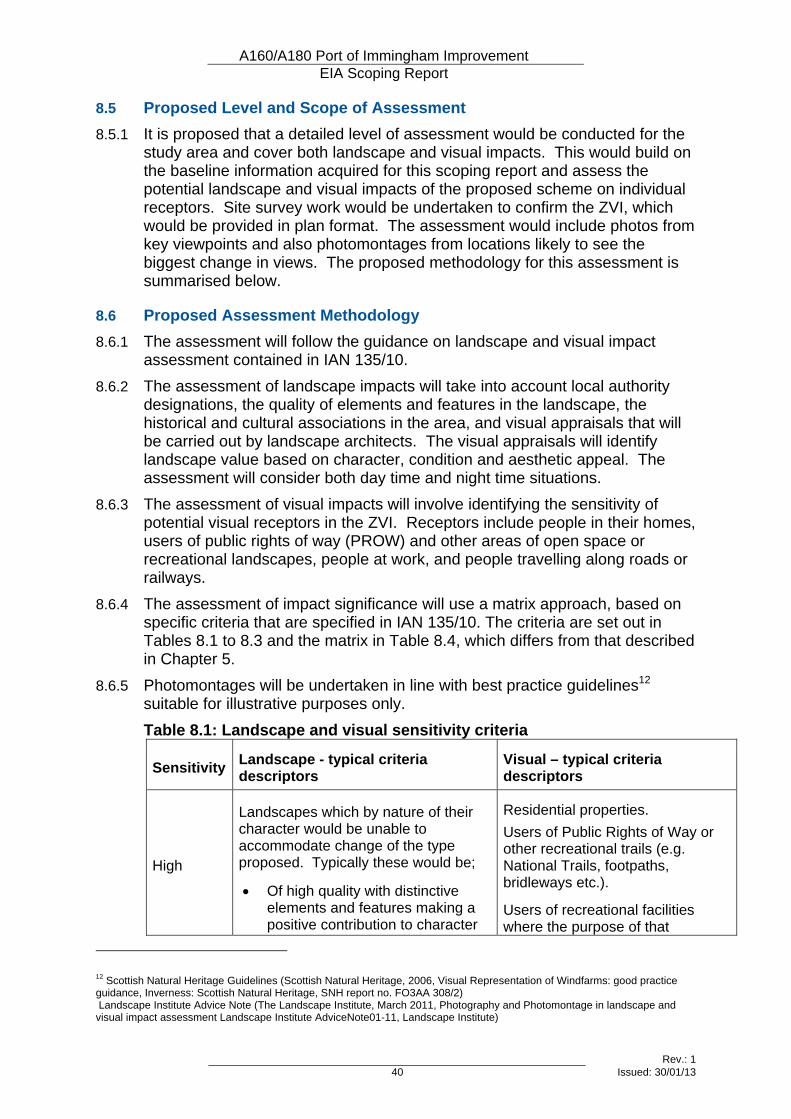
A160/A180 Port of Immingham Improvement EIA Scoping Report
Rev.: 1 40 Issued: 30/01/13
8.5 Proposed Level and Scope of Assessment 8.5.1 It is proposed that a detailed level of assessment would be conducted for the
study area and cover both landscape and visual impacts. This would build on the baseline information acquired for this scoping report and assess the potential landscape and visual impacts of the proposed scheme on individual receptors. Site survey work would be undertaken to confirm the ZVI, which would be provided in plan format. The assessment would include photos from key viewpoints and also photomontages from locations likely to see the biggest change in views. The proposed methodology for this assessment is summarised below.
8.6 Proposed Assessment Methodology 8.6.1 The assessment will follow the guidance on landscape and visual impact
assessment contained in IAN 135/10. 8.6.2 The assessment of landscape impacts will take into account local authority
designations, the quality of elements and features in the landscape, the historical and cultural associations in the area, and visual appraisals that will be carried out by landscape architects. The visual appraisals will identify landscape value based on character, condition and aesthetic appeal. The assessment will consider both day time and night time situations.
8.6.3 The assessment of visual impacts will involve identifying the sensitivity of potential visual receptors in the ZVI. Receptors include people in their homes, users of public rights of way (PROW) and other areas of open space or recreational landscapes, people at work, and people travelling along roads or railways.
8.6.4 The assessment of impact significance will use a matrix approach, based on specific criteria that are specified in IAN 135/10. The criteria are set out in Tables 8.1 to 8.3 and the matrix in Table 8.4, which differs from that described in Chapter 5.
8.6.5 Photomontages will be undertaken in line with best practice guidelines12 suitable for illustrative purposes only. Table 8.1: Landscape and visual sensitivity criteria
Sensitivity Landscape - typical criteria descriptors
Visual – typical criteria descriptors
High
Landscapes which by nature of their character would be unable to accommodate change of the type proposed. Typically these would be;
• Of high quality with distinctive elements and features making a positive contribution to character
Residential properties. Users of Public Rights of Way or other recreational trails (e.g. National Trails, footpaths, bridleways etc.).
Users of recreational facilities where the purpose of that
12 Scottish Natural Heritage Guidelines (Scottish Natural Heritage, 2006, Visual Representation of Windfarms: good practice guidance, Inverness: Scottish Natural Heritage, SNH report no. FO3AA 308/2) Landscape Institute Advice Note (The Landscape Institute, March 2011, Photography and Photomontage in landscape and visual impact assessment Landscape Institute AdviceNote01-11, Landscape Institute)
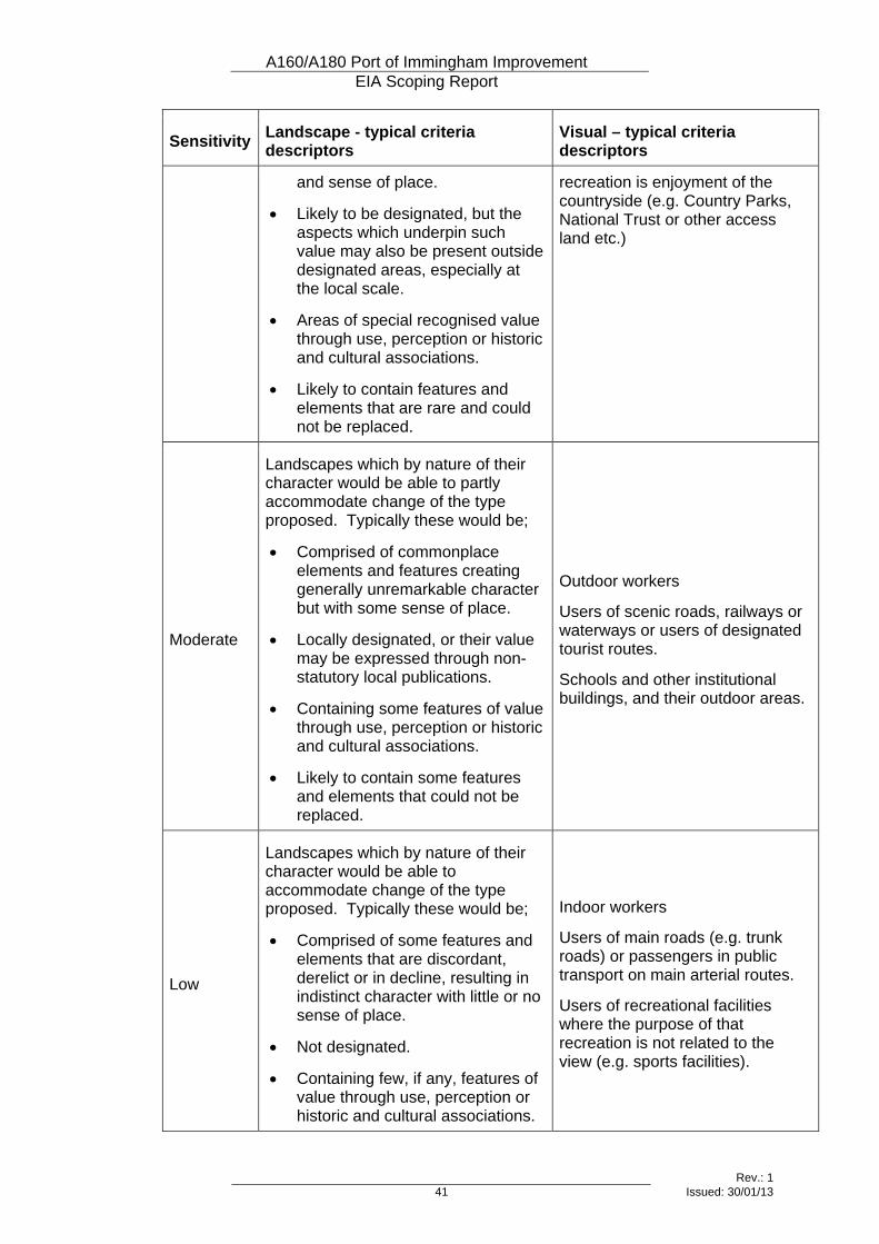
A160/A180 Port of Immingham Improvement EIA Scoping Report
Rev.: 1 41 Issued: 30/01/13
Sensitivity Landscape - typical criteria descriptors
Visual – typical criteria descriptors
and sense of place.
• Likely to be designated, but the aspects which underpin such value may also be present outside designated areas, especially at the local scale.
• Areas of special recognised value through use, perception or historic and cultural associations.
• Likely to contain features and elements that are rare and could not be replaced.
recreation is enjoyment of the countryside (e.g. Country Parks, National Trust or other access land etc.)
Moderate
Landscapes which by nature of their character would be able to partly accommodate change of the type proposed. Typically these would be;
• Comprised of commonplace elements and features creating generally unremarkable character but with some sense of place.
• Locally designated, or their value may be expressed through non-statutory local publications.
• Containing some features of value through use, perception or historic and cultural associations.
• Likely to contain some features and elements that could not be replaced.
Outdoor workers
Users of scenic roads, railways or waterways or users of designated tourist routes.
Schools and other institutional buildings, and their outdoor areas.
Low
Landscapes which by nature of their character would be able to accommodate change of the type proposed. Typically these would be;
• Comprised of some features and elements that are discordant, derelict or in decline, resulting in indistinct character with little or no sense of place.
• Not designated.
• Containing few, if any, features of value through use, perception or historic and cultural associations.
Indoor workers
Users of main roads (e.g. trunk roads) or passengers in public transport on main arterial routes.
Users of recreational facilities where the purpose of that recreation is not related to the view (e.g. sports facilities).
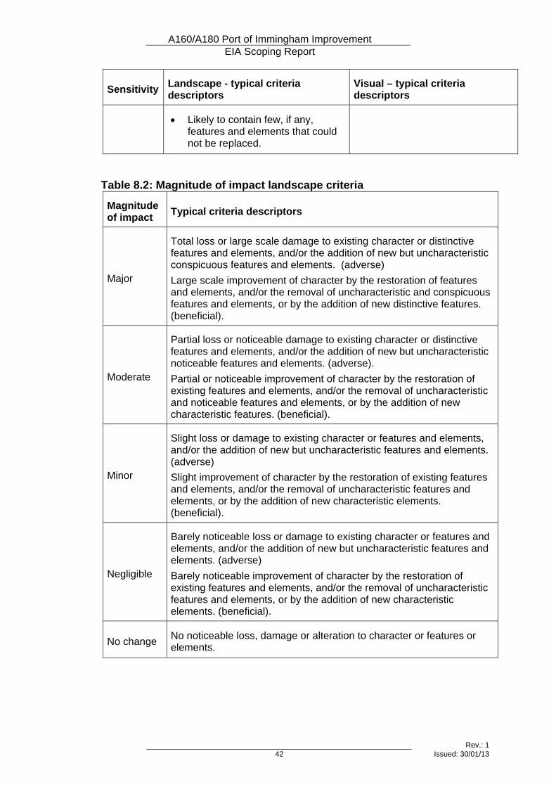
A160/A180 Port of Immingham Improvement EIA Scoping Report
Rev.: 1 42 Issued: 30/01/13
Sensitivity Landscape - typical criteria descriptors
Visual – typical criteria descriptors
• Likely to contain few, if any, features and elements that could not be replaced.
Table 8.2: Magnitude of impact landscape criteria
Magnitude of impact Typical criteria descriptors
Major
Total loss or large scale damage to existing character or distinctive features and elements, and/or the addition of new but uncharacteristic conspicuous features and elements. (adverse) Large scale improvement of character by the restoration of features and elements, and/or the removal of uncharacteristic and conspicuous features and elements, or by the addition of new distinctive features. (beneficial).
Moderate
Partial loss or noticeable damage to existing character or distinctive features and elements, and/or the addition of new but uncharacteristic noticeable features and elements. (adverse). Partial or noticeable improvement of character by the restoration of existing features and elements, and/or the removal of uncharacteristic and noticeable features and elements, or by the addition of new characteristic features. (beneficial).
Minor
Slight loss or damage to existing character or features and elements, and/or the addition of new but uncharacteristic features and elements. (adverse) Slight improvement of character by the restoration of existing features and elements, and/or the removal of uncharacteristic features and elements, or by the addition of new characteristic elements. (beneficial).
Negligible
Barely noticeable loss or damage to existing character or features and elements, and/or the addition of new but uncharacteristic features and elements. (adverse) Barely noticeable improvement of character by the restoration of existing features and elements, and/or the removal of uncharacteristic features and elements, or by the addition of new characteristic elements. (beneficial).
No change No noticeable loss, damage or alteration to character or features or elements.
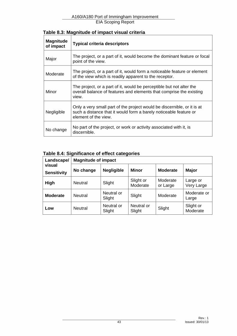
A160/A180 Port of Immingham Improvement EIA Scoping Report
Rev.: 1 43 Issued: 30/01/13
Table 8.3: Magnitude of impact visual criteria
Magnitude of impact Typical criteria descriptors
Major The project, or a part of it, would become the dominant feature or focal point of the view.
Moderate The project, or a part of it, would form a noticeable feature or element of the view which is readily apparent to the receptor.
Minor The project, or a part of it, would be perceptible but not alter the overall balance of features and elements that comprise the existing view.
Negligible Only a very small part of the project would be discernible, or it is at such a distance that it would form a barely noticeable feature or element of the view.
No change No part of the project, or work or activity associated with it, is discernible.
Table 8.4: Significance of effect categories Magnitude of impact Landscape/
visual Sensitivity No change Negligible Minor Moderate Major
High Neutral Slight Slight or Moderate
Moderate or Large
Large or Very Large
Moderate Neutral Neutral or Slight Slight Moderate Moderate or
Large
Low Neutral Neutral or Slight
Neutral or Slight Slight Slight or
Moderate

A160/A180 Port of Immingham Improvement EIA Scoping Report
Rev.: 1 45 Issued: 30/01/13
9 Ecology and Nature Conservation
9.1 Introduction
Topic Definition 9.1.1 Ecology is the scientific study of living organisms and their inter-relationships.
Nature conservation is concerned with maintaining a viable population of an area’s characteristic fauna, flora and wildlife communities.
Study Area 9.1.2 The study area will vary for different aspects of the assessment, as follows:
• Statutory and non-statutory designated sites and records of protected species: 2km from the centre-line of the scheme, with reference to DMRB guidance on assessing the effects on sites protected at a European level (DMRB Volume 11, Section 4, Part 10) and Planning Inspectorate Guidance on Habitat Regulation Assessment (Advice note ten, Version 3, October 2012);
• Phase 1 habitat survey: 500m to either side of the improvements, in accordance with guidance contained in the JNCC Handbook for Phase 1 Habitat Survey (JNCC, 2010); and
• Protected species and specific habitats: survey areas will be defined in accordance with standard survey methods for each species.
9.2 Existing and Baseline Knowledge 9.2.1 Existing baseline knowledge of the scheme has been derived from ecological
assessment work undertaken by Golder Associates and Pell Frischmann as part of the options assessment in 2009, and more recent draft work on the preferred option, carried out by the same organisations up until 2011. The following is a summary of the baseline information gathered during this work.
Site Context 9.2.2 The desk-study area is situated within a low-lying area of land to the south
and west of the Humber Estuary, which is characterised predominantly by arable agriculture to the west and urban and heavy industrial development to the east
9.2.3 The habitats in the A160/180 study area are generally homogenous in structure with no particularly diverse areas of floral interest. Habitats mainly consist of arable land, species poor semi-improved neutral grassland, broad-leaved plantation woodland, rank tall ruderal vegetation and scattered/dense scrub.
Designated Sites 9.2.4 The desk study identified two statutory designated sites with 2km of the
scheme. These are:
A160/A180 Port of Immingham Improvement EIA Scoping Report
Rev.: 1 46 Issued: 30/01/13
• Humber Estuary RAMSAR Site/Special Area of Conservation (SAC)/ Special Protection Area (SPA)/Site of Special Scientific Interest (SSSI), and:
• North Killingholme Haven Pits SSSI. 9.2.5 The Humber estuary designations are collectively referred to as The Humber
European Marine Site (HEMS). The term 'European Marine Site (EMS) (as defined by the Habitats Regulations, 2010) refers to those marine areas of both SACs and SPAs, which are protected under the EC Habitats and Birds Directives. These areas range from entirely subtidal to exclusively intertidal. An EMS can be an entire SAC or SPA, or only part of one (the SAC/SPA may also include terrestrial areas). However, EMS is not a statutory site designation.
9.2.6 Twelve non-statutory sites occur within 2km of the scheme. These sites are referred to as either Sites of Nature Conservation Interest (SNCI) or Local Wildlife Sites (LWS). These sites are:
• Rosper Road Pools LWS;
• Brocklesby Park LWS;
• Eastfield Road Railway Embankment LWS*;
• Homestead Park Pond LWS;
• Burkinshaw’s Covert LWS;
• Station Road Field LWS;
• Houlton’s Covert SNCI;
• Thomas Wood SNCI;
• Alder Carr Wood SNCI;
• Homestead Park SNCI;
• North Killingholme Airfield SNCI, and;
• Ulceby Meadow SNCI. * Eastfield Road Railway Embankment is also a Lincolnshire Wildlife Trust
Reserve 9.2.7 SNCIs and LWSs represent sites and features that have significant value for
wildlife at the county level. Some sites that were previously designated as SNCIs have been reassessed and where they meet the criteria are now designated as LWSs. Both types of sites receive protection through the planning system.
9.2.8 There are three Ancient Woodlands located within the 2km of the scheme and these are listed below:
• Alder Carr Wood;
• Alder Wood, and
• Thomas Wood.
A160/A180 Port of Immingham Improvement EIA Scoping Report
Rev.: 1 47 Issued: 30/01/13
9.2.9 Alder Carr Wood and Thomas Wood are also designated as SNCIs. Ancient Woodland inventories are lists, by county, of sites greater than two hectares in size that are thought to have been continuously wooded since 1600 AD. They include both ancient semi-natural stands and plantations on Ancient Woodland sites (Goldberg, 2006).
9.2.10 The locations of designated sites in the study area are shown on Figure 1.2.
Protected and Notable Species 9.2.11 To inform the option appraisal and subsequent detailed assessment work for
the preferred option Golder Associates undertook detailed ecological survey/assessment work for the following ecological receptors from 2008 onwards;
• Phase 1 Habitat Survey
• Wintering/Breeding Birds;
• Amphibians;
• Badgers;
• Bats;
• Water Vole;
• Reptiles, and
• Terrestrial and Aquatic Invertebrates. 9.2.12 Table 9.1 below provides a summary of the existing baseline knowledge for
habitats and protected/notable species. Table 9.1: Summary of Current Baseline Data
Receptor Data of Survey Summary of Baseline Data
Phase 1 Habitat Survey
September 2008 then updated in 2011.
Semi natural habitats in the study area consist of: arable land, species poor semi-improved neutral grassland, broad-leaved plantation woodland, rank tall ruderal vegetation and scattered/dense scrub, which occur mainly in the western section of the proposed scheme. The eastern section of the proposed scheme is mostly abutted by industrial development on either side.
Wintering Birds
November 2008 – March 2009
A total of 40 species with a recognised conservation status (Schedule 1 species, BAP species (UK and Lincolnshire), red and amber listed birds of conservation concern (Eaton et al., 2009), and species listed as qualifying features of the Humber Estuary SPA) were recorded within the study area during the over-wintering bird survey. Bittern, a qualifying feature of the Humber
A160/A180 Port of Immingham Improvement EIA Scoping Report
Rev.: 1 48 Issued: 30/01/13
Receptor Data of Survey Summary of Baseline Data
Estuary SPA, was recorded on a single occasion in February 2009 at Rosper Road Pools LWS. This was thought to be one individual on passage thorough the study area. Specific surveys for barn owl revealed hunting activity in and around Rosper Road Pools during the winter surveys but no signs of breeding activity
Breeding Birds
April – June 2009
A total of 41 species with a recognised conservation status (Schedule 1 species, BAP species (UK and Lincolnshire), red and amber listed birds of conservation concern (Eaton et al., 2009), and species listed as qualifying features of the Humber Estuary SPA) were recorded within the Study Area during the breeding bird survey. Two non-breeding golden plover Pluvialis apricaria, a qualifying feature of the Humber Estuary SPA, were also recorded on one occasion during the breeding bird survey in fields to the east of Brocklesby Interchange. It is thought that these birds were on passage through the study area. Surveys for kingfisher revealed no evidence of this species during winter or the breeding season. Checks of potential hobby nest sites during the breeding season revealed no evidence of breeding activity.
Amphibians March – June 2009
Eight waterbodies within 500m of the scheme were subject to amphibian surveys in line with standard methodologies (English Nature 2001). This included three ponds, 4 ditches and waterbodies at Rosper Road Pools LWS. A single GCN was recorded in a pond located c.470m west of Brocklesby Interchange.
Badger
Seven site visits between January and August 2009
A total of 25 badger setts were recorded in the study area. Three active setts and nine inactive setts were recorded within 100 m of the proposed scheme. Other signs of badger activity, such as latrines, footprints and trails, were also recorded.
Bats Bat Activity - No roost sites were identified within a 100m
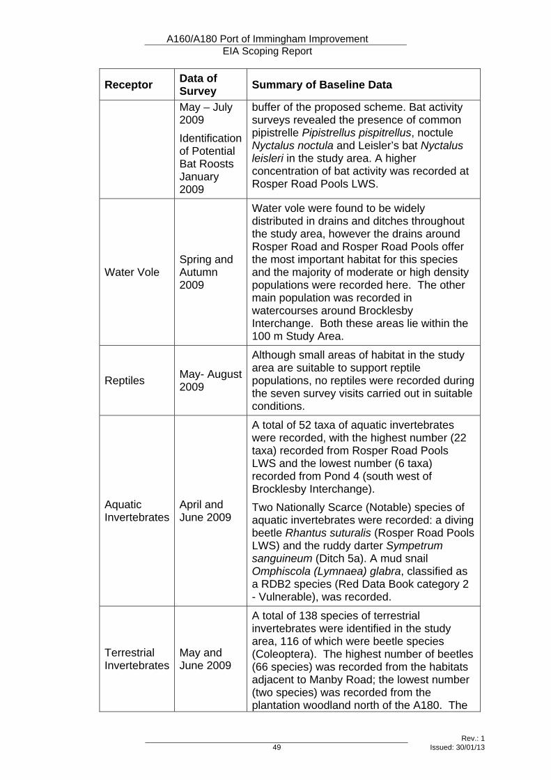
A160/A180 Port of Immingham Improvement EIA Scoping Report
Rev.: 1 49 Issued: 30/01/13
Receptor Data of Survey Summary of Baseline Data
May – July 2009 Identification of Potential Bat Roosts January 2009
buffer of the proposed scheme. Bat activity surveys revealed the presence of common pipistrelle Pipistrellus pispitrellus, noctule Nyctalus noctula and Leisler’s bat Nyctalus leisleri in the study area. A higher concentration of bat activity was recorded at Rosper Road Pools LWS.
Water Vole Spring and Autumn 2009
Water vole were found to be widely distributed in drains and ditches throughout the study area, however the drains around Rosper Road and Rosper Road Pools offer the most important habitat for this species and the majority of moderate or high density populations were recorded here. The other main population was recorded in watercourses around Brocklesby Interchange. Both these areas lie within the 100 m Study Area.
Reptiles May- August 2009
Although small areas of habitat in the study area are suitable to support reptile populations, no reptiles were recorded during the seven survey visits carried out in suitable conditions.
Aquatic Invertebrates
April and June 2009
A total of 52 taxa of aquatic invertebrates were recorded, with the highest number (22 taxa) recorded from Rosper Road Pools LWS and the lowest number (6 taxa) recorded from Pond 4 (south west of Brocklesby Interchange). Two Nationally Scarce (Notable) species of aquatic invertebrates were recorded: a diving beetle Rhantus suturalis (Rosper Road Pools LWS) and the ruddy darter Sympetrum sanguineum (Ditch 5a). A mud snail Omphiscola (Lymnaea) glabra, classified as a RDB2 species (Red Data Book category 2 - Vulnerable), was recorded.
Terrestrial Invertebrates
May and June 2009
A total of 138 species of terrestrial invertebrates were identified in the study area, 116 of which were beetle species (Coleoptera). The highest number of beetles (66 species) was recorded from the habitats adjacent to Manby Road; the lowest number (two species) was recorded from the plantation woodland north of the A180. The
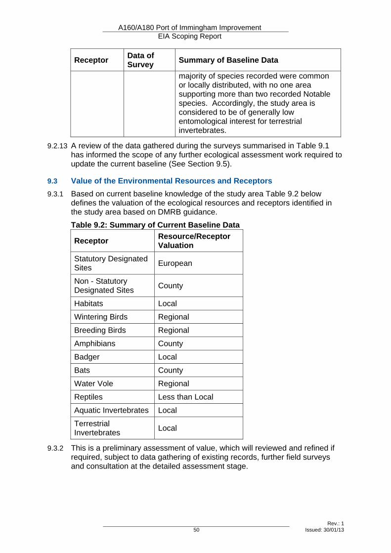
A160/A180 Port of Immingham Improvement EIA Scoping Report
Rev.: 1 50 Issued: 30/01/13
Receptor Data of Survey Summary of Baseline Data
majority of species recorded were common or locally distributed, with no one area supporting more than two recorded Notable species. Accordingly, the study area is considered to be of generally low entomological interest for terrestrial invertebrates.
9.2.13 A review of the data gathered during the surveys summarised in Table 9.1 has informed the scope of any further ecological assessment work required to update the current baseline (See Section 9.5).
9.3 Value of the Environmental Resources and Receptors 9.3.1 Based on current baseline knowledge of the study area Table 9.2 below
defines the valuation of the ecological resources and receptors identified in the study area based on DMRB guidance. Table 9.2: Summary of Current Baseline Data
Receptor Resource/Receptor Valuation
Statutory Designated Sites European
Non - Statutory Designated Sites County
Habitats Local
Wintering Birds Regional
Breeding Birds Regional
Amphibians County
Badger Local
Bats County
Water Vole Regional
Reptiles Less than Local
Aquatic Invertebrates Local
Terrestrial Invertebrates Local
9.3.2 This is a preliminary assessment of value, which will reviewed and refined if required, subject to data gathering of existing records, further field surveys and consultation at the detailed assessment stage.
A160/A180 Port of Immingham Improvement EIA Scoping Report
Rev.: 1 51 Issued: 30/01/13
9.4 Potential Effects 9.4.1 The construction and operation of highways can affect site-specific receptors
(habitats or wild flora) and mobile receptors (populations of wildlife). Impacts can occur through several mechanisms, including:
• Disturbance or hydrological effects on European designated sites (HEMS) or qualifying features of the designated site;
• Direct loss of wildlife habitats through land-take;
• Indirect harm through disturbance (noise, vibration);
• Changes in air quality
• Severance, by dividing habitats or wildlife corridors;
• Direct mortality through construction activities and traffic accidents;
• Disruption of local watercourses and drainage patterns;
• Polluted road runoff affecting the water environment;
• Impacts on bats, birds and invertebrates through road lighting; and
• Impacts on vegetation from polluted spray from road traffic.
9.5 Proposed Level and Scope of Assessment 9.5.1 The scope of further assessment work has been determined based upon
current baseline knowledge of the study area and a review of current best practice survey guidance and nature conservation legislation/policy frameworks (i.e. NPPF, UK BAP).
9.5.2 To ensure that subsequent detailed ecological assessment work is based on up-to-date baseline information, surveys will be undertaken at an appropriate time of year for the following receptors.
• Wintering Birds;
• Breeding Birds;
• Amphibians;
• Badger;
• Bats, and
• Water vole. 9.5.3 The following survey methods will be used:
• Breeding and Wintering bird survey: Gilbert G., Gibbons D.W., Evans J. (1998), Bird Monitoring Methods, RSPB. Surveys will be completed along specific transects at the required frequency and across the winter and spring/summer.
• Barn owl survey: Barn Owl Trust (2010), Survey techniques, Leaflet no. 8, The Barn Owl Trust, Ashburton, Devon; and Shawyer (2011), Barn Owl Survey Methodology and Techniques for use in Ecological Assessment. A habitat suitability assessment will be completed. Farm buildings within
A160/A180 Port of Immingham Improvement EIA Scoping Report
Rev.: 1 52 Issued: 30/01/13
500m of the route alignment will be surveyed by a licensed ecologist to assess their potential to support roosting/nesting barn owl. This will comprise an external ground based inspection and, where practical, an internal inspection of suitable buildings. It is recommended that an internal inspection of those buildings that exhibit the appropriate features is completed during February to ascertain actual status.
• Great Crested Newt survey: English Nature (2001) Great Crested Newt Mitigation Guidelines. English Nature, Peterborough; and Oldham, R.S., Keeble, J., Swan, M.J.S. & Jeffcote, M. (2000), Evaluating the suitability of habitat for the Great Crested Newt (Triturus cristatus), Herpetological Journal 10(4), 143-155. All ponds within 250m of the scheme will be subject to presence/absence surveys for great crested newts. It is proposed that the need to survey ponds which are between 250m and 500m of the scheme will be based on historic records, connectivity, HSI scores and likely impacts. These surveys would also identify the presence and population status of other amphibian species within the surveys area.
• Badger survey: Harris S, Cresswell P and Jefferies D (1989), Surveying Badgers, Mammal Society. A badger survey will be carried out up to 250m either side of the proposed alignment. The survey will focus on identifying evidence indicating the presence of badger. Where evidence is identified, it may be necessary to extend the survey area (e.g. to locate a sett where a path indicates use by badger). It is recommended that a winter survey is completed to ascertain the number and status of setts.
• Bat survey: Mitchell-Jones AJ (2004), Bat Mitigation Guidelines, English Nature; Bat Conservation Trust (2012), Bat Surveys: Good Practice Guidelines, Bat Conservation Trust, London. Trees and structures identified as being under the scheme footprint or likely to be directly affected by the scheme (up to 50m) will be surveyed by a suitably qualified ecologist to assess their potential to support roosting bats. This will comprise an external/ground based inspection and, where practical, an internal inspection of roof spaces. Where evidence of or potential for bat roosts is identified further, surveys will be required (emergence/re-entry activity surveys or climb-and-inspect surveys) to confirm roost status. A winter survey will be completed on those trees and structures within the footprint and up to 50m from it. It is optimal to undertake surveys on trees during the winter period as they are not in leaf and this provides greater certainty in observing their roosting potential features. This is not the case for buildings; however, if moderate potential or above is identified, a winter survey provides early notice that approximately 3 bat activity surveys would be required during May-September.
• Water vole survey: Water Vole Conservation Handbook (Strachan & Moorhouse, 2006). Surveys will include all ditches/drains crossed by the scheme for 250m both upstream and downstream of the proposed crossing points.
9.5.4 At this time no further surveys are proposed for reptiles or terrestrial/aquatic invertebrates as the habitats in the study area have not changed in composition or suitability for these species groups therefore the baseline data from previous survey work in 2009 is likely to be valid.
A160/A180 Port of Immingham Improvement EIA Scoping Report
Rev.: 1 53 Issued: 30/01/13
9.5.5 At it nearest point, the proposed A160/A180 Port of Immingham Improvement is c.1.4km from the HEMS. In addition, previous survey work in the study area has identified the presence of qualifying features of the HEMS (wintering and breeding birds) in habitats adjacent to proposed improvements, especially Rosper Road Pools.
9.5.6 The European Community Directive 92/43/EEC on the Conservation of Natural Habitats and of Wild Fauna and Flora (EC 1992a) (the Habitats Directive) is the primary European legislation for protecting biodiversity. Resultant from this legislation European Union (EU) Member States are required to implement a network of protected sites and maintain their ecological integrity. This network of sites is collectively termed ‘Natura 2000 Sites’, which include RAMSARs, SPAs and SACs. The aim of the Natura 2000 network of Sites is to maintain long-term survival of Europe’s most valuable and threatened species and habitats.
9.5.7 The core requirements of the Habitats Directive in respect of Natura 2000 Sites are given in Article 6 (3): “Any plan or project not directly connected with or necessary to the management of the site but likely to have a significant effect thereon, either individually or in combination with other plans or projects, shall be subject to appropriate assessment of its implications for the site in view of the site’s conservation objectives. In the light of the conclusions of the assessment of the implications for the site and subject to provisions of paragraph 4, the competent national authorities shall agree to the plan or project only after having ascertained that it will not adversely affect the integrity of the site concerned and, if appropriate, after having obtained the opinion of the general public.”
9.5.8 In England and Wales this Directive is transposed into UK law through the Conservation of Habitats and Species Regulations, 2010. Regulations 60 to 67 of the Habitat Regulations 2010 require the effect on a European site to be considered before the granting of consents or authorisations of a kind specified in regulations 68 to 101, including planning permission.
9.5.9 Under the Planning Act 2008 and 2010 Habitats Regulations (as amended) and carried forward by the APFP Regulations (Applications: Prescribed Forms and Procedures) an application for a nationally significant infrastructure project (NSIP) which is likely to affect a European site(s) requires a report to be provided with the application to enable the decision maker to make an appropriate assessment. Therefore a Habitat Regulation Assessment (HRA) Stage 1 (screening) assessment will be required to determine any likely significant effects on the HEMS. The results of the Stage 1 assessment will determine the requirement for any further assessment (see section 9.6 below).
9.5.10 The proposed scope of the HRA will be agreed in consultation with Natural England (NE). A pre-application consultation process to seek assurances from NE that all potential impacts have been properly addressed in sufficient detail can be submitted prior to applying for development consent.
A160/A180 Port of Immingham Improvement EIA Scoping Report
Rev.: 1 54 Issued: 30/01/13
9.6 Proposed Assessment Methodology
EIA
9.6.1 The ecological assessment will be undertaken using guidance from the Guidance for Ecological Impact Assessment in the United Kingdom (IEEM 2006) and Highways Agency’s Interim Advice Note Ecology and Nature Conservation: Criteria for Impact Assessment (IAN 130/10) which supplements the earlier DMRB chapter in Volume 11, Section 3, Part 4 (dated 1993). Both are relevant to this assessment. The guidance includes illustrative criteria for use in the assessment, which can be adapted based on professional judgement.
HRA 9.6.2 HRA (also termed appropriate assessment when it passes through the
scoping stage) is a recognised step-by-step process which helps to determine the likely significant effect and (where appropriate) assess adverse impacts on the integrity of a European site, examines alternative solutions, and provides justification for Imperative Reasons of Over-riding Public Interest (IROPI). The four stage process, as applied to NSIPs, is summarised below:
• HRA Stage 1 (Screening): Identifies the likely significant effects of a project upon the integrity of a European Site, either alone or in combination with other plans and projects, and consider whether the impacts are likely to be significant;
• HRA Stage 2: Having identified that there are likely significant effects on the integrity of a European Site, this stage ascertains the effect on site integrity, either alone or in combination with other plans and projects, by assessing the effects of the plan or project on the conservation objectives of any European Site. Where there are adverse effects, an assessment of mitigation options is carried out to determine adverse effect on the integrity of the site. If these mitigation options cannot avoid adverse effects then development consent can only be given if stages 3 and 4 are followed;
• HRA Stage 3: Examines alternative solutions to achieve the objectives of the project where adverse effects are identified at HRA Stage. The project should be altered so that all adverse effects would avoid or have a lesser effect on European sites;
• HRA Stage 4: .This is an assessment where no alternative solution exists and where adverse impacts remain. The process to assess whether the development is necessary for imperative reasons of over-riding public interest (IROPI) and, if so, the potential compensatory measures needed to maintain the overall coherence of the site or integrity of the European site network.
9.6.3 Based on the current baseline knowledge of the study area and its use by qualifying features of the HEMS, notably breeding and over-wintering bird species, it is anticipated that the assessment of likely significant effects on the HEMS will be addressed through a HRA Stage 1 (Screening) report and the outcome of this will be discussed with NE.
A160/A180 Port of Immingham Improvement EIA Scoping Report
Rev.: 1 55 Issued: 30/01/13
10 Geology and Soils
10.1 Introduction
Topic Definition 10.1.1 Soils and geology are key factors in determining the environmental character
and quality of an area. Underlying rocks are key determinants of landform, while the physical and chemical properties of rocks and soils influence the type and variety of vegetation, agricultural quality, flood risk and water storage capacity.
10.1.2 Geological conditions and resources can also determine the distribution and scale of industries, such as mining, quarrying and other industries that are dependent upon extracted materials.
10.1.3 Highway construction can have significant effects on geological and soil resources, while the characteristics of soil and underlying rocks can be key constraints on scheme design. Under some circumstances, construction work can mobilise pollutants from land contaminated by previous activity.
Study Area 10.1.4 The study area will extend to the whole footprint of the scheme and
immediately adjacent land, as it is considered that this is the only area that would be affected in terms of soils and geology.
10.2 Existing and Baseline Knowledge 10.2.1 The following is based on the A160 Improvements Ground Investigation
Report (GIR) by Pell Frischmann, dated March 2011 (Report Reference W11231/PCF3/11.3 Revision 1). This report summarises published information and the findings of a ground investigation undertaken in 2010.
10.2.2 Ground conditions are identified as glacial till underlain by chalk at depth, with localised deposit of alluvium at the eastern end of the site.
Topsoil 10.2.3 Outside the existing highway boundaries, topsoil varying between 100mm and
400mm in thickness, typically averaging 300mm in thickness, was encountered along the majority of the route and at all locations within agricultural fields.
Made Ground 10.2.4 Made ground was identified to 4.5m below ground level. However, a number
of exploratory holes terminated within this, without proving natural soils beneath and thus did not prove the maximum depth of the made ground.
10.2.5 The made ground predominantly comprised re-worked glacial till. Brick, clinker and ceramic were observed locally. Cohesive made ground was typically encountered as engineered embankment fill along the A160 from Brocklesby Interchange to Ulceby Road and the railway embankment at the eastern end of the scheme.
A160/A180 Port of Immingham Improvement EIA Scoping Report
Rev.: 1 56 Issued: 30/01/13
10.2.6 Non-engineered deposits were also encountered near Town Street, Manby Road Junction and within the trial pits located over the numerous gas pipelines. Within the latter, this material was predominantly reworked till associated with the backfilling following gas pipeline installation.
10.2.7 Small quantities of granular made ground were encountered during the site investigation. These were associated with an upper layer within highway and railway embankments as either embankment fill material, backfill to services or as part of the pavement / ballast construction.
10.2.8 There was no visual or olfactory evidence of contamination identified during the site investigation. Limited geochemical sampling and analysis revealed a single location of elevated Polycyclic Aromatic Hydrocarbons (PAH) contamination at WS08 at a depth of 0.80m bgl, to the west of the railway embankment.
10.2.9 Due to the nature of the site there is the potential for more areas of contamination to occur. Further assessment is required.
Alluvium 10.2.10 Alluvial deposits were encountered in small quantities at the eastern
end of the site, to the west of Rosper Road and adjacent to the A160, to the east of Ulceby Road. The thickness ranged between 0.15m and 2m, encountered to a maximum depth of 2m bgl. It was encountered beneath topsoil and was underlain by glacial till.
Glacial Till 10.2.11 Glacial till underlies the whole of the proposed route. This was proved
to a maximum depth of 15.45m bgl. This material was predominantly cohesive in nature but with granular lenses and intermittent layers of varying thickness within the cohesive material. Thicker deposits of glacial sand were encountered underlying the embankment fill around Brocklesby Interchange and alongside the existing carriageway between Brocklesby Interchange and Ulceby Road.
Solid Geology 10.2.12 The Burnham Chalk Formation of the Upper Cretaceous Period is
indicated on the published geological maps to underlie the study area but does not outcrop at any location within the study area and is overlain by superficial deposits. Bedrock was not encountered during the site investigation works; exploratory holes were undertaken to a maximum depth of 15.45m bgl.
10.2.13 Three historical BGS boreholes encountered Chalk bedrock at depths of between 21.8m and 61.5m bgl (-10.5m to -58m AOD). These boreholes indicate that there is variable depth to rockhead across the study area.
Groundwater 10.2.14 The groundwater strikes were encountered predominantly within the
thicker granular deposits (Glacial Sand) and in thin granular horizons within the Glacial Till at depths of between 2.4 and 15m bgl (-4.7 to -11.9m AOD).
A160/A180 Port of Immingham Improvement EIA Scoping Report
Rev.: 1 57 Issued: 30/01/13
10.2.15 Sub-artesian groundwater conditions were noted in several locations during the ground investigation where groundwater was encountered within sand horizons beneath more impermeable layers of Glacial Till. Borehole water level rises of up to 8.3m were observed during the site investigation.
10.2.16 No long term monitoring of groundwater levels is recorded. The groundwater observations may not represent equilibrium conditions and groundwater levels may vary with seasonal or other effects. The groundwater regime will require further assessment.
10.3 Value of the Environmental Resources and Receptors 10.3.1 There is currently no agreed method of measuring the value or sensitivity of
the soils and geology receptors, and no agreed scale against which they should be measured. Therefore, each receptor will be considered on an individual basis, and the factors influencing its sensitivity will be taken into account in assessing the significance of impacts.
10.4 Potential Effects 10.4.1 The impacts on geology and soils are likely to be most significant during the
construction phase. Construction and operational phase impacts will be considered together. Potential effects are listed below:
• Impacts on underlying geology.
• Disturbance of groundwater flow paths and drainage pathways caused by earthworks.
• Earthworks balance: the ability of the scheme to use any material excavated from one part of the scheme for land-raising in other areas (e.g. for embankments or noise bunds). This part of the assessment will include consideration of contaminated land, the need for imported material and the associated impacts of the transport, use and disposal of material.
• Consolidation of underlying soils, which could potentially lead to changes in groundwater flow.
• Soil deterioration. This may occur during movement or storage of soils, as a result of their mixing with other materials, runoff of soil, dust blown by the wind, breakdown of soil due to handling, compaction by heavy machinery or potential contamination by vehicle fuel, cement, chemicals, etc.
• Disturbance of potentially contaminated land.
• Remobilisation of residual pollutants and creation of pollution pathways.
10.5 Proposed Level and Scope of Assessment 10.5.1 The depth of chalk was not proven in boreholes. The chalk is an aquifer. The
Ground Investigation Report suggests variable rockhead based on historic data (possibly between 22m and 60m depth). Therefore there is a potential risk of impacting aquifer if deep piles are needed.
10.5.2 Further investigation and assessment of the potential risk from contaminated land is required. On initial review, testing appears limited given the
A160/A180 Port of Immingham Improvement EIA Scoping Report
Rev.: 1 58 Issued: 30/01/13
surrounding industry (e.g. no groundwater testing). This needs confirming by the Contaminated Land specialists within Jacobs.
10.5.3 No Unexploded Ordnance (UXO) assessment has been undertaken. This is required (and identified as such in the GIR). This must be undertaken prior to any intrusive works on site.
10.5.4 No monitoring of groundwater has been undertaken. This is needed to confirm groundwater conditions for design. The GIR currently assigns a high risk to this element. Monitoring is required.
10.5.5 No gas monitoring has been reported. This is needed for any excavation work on safety grounds. This is particularly pertinent to the eastern end, where alluvium is suggested. Similarly given proximity of refineries, ground gas regime must be confirmed. Monitoring is required.
10.5.6 Exploratory hole log descriptions seem variable and inconsistent between different types of investigation. Boreholes identify some laminations in the till, especially near surface above a sand layer. This may be lake clay. Trial pits identify the till to be generally closely fissured, which may indicate sheared surfaces within the clay. Further assessment required, but from the initial review, it is likely that additional intrusive ground investigation is required. This uncertainty could be critical for earthworks stability.
10.5.7 Window Sample Hole WS19 identifies clinker in a soil identified as natural clay. Clinker implies the hole is in made ground rather than a natural soil. Additional SI will be required to resolve this uncertainty.
10.5.8 In summary, additional ground investigation is required for further definition of ground conditions and development of the assessment of risk from contamination.
10.6 Proposed Assessment Methodology 10.6.1 In respect of impacts on geology and soils, DMRB defines the scope of the
topic, but does not provide formal guidance on the assessment of impacts. Therefore, each potential impact will be assessed using professional judgement. It will be possible to distinguish between significant and insignificant impacts, but different levels of significance will not be assessed.
10.6.2 The assessment will include consideration of the following factors:
• The proximity of the site, and in particular any areas of contaminated land within the site, to towns and villages;
• The proximity of the site, and any areas of contaminated land within it, to any watercourse or other waterbody;
• Underlying aquifers;
• Any designated geological sites (SSSIs or RIGS);
• The nature of any contamination present, and how easily and to what extent those contaminants could be mobilised; and
• The extent to which any existing contamination would be remediated as a result of the project.
A160/A180 Port of Immingham Improvement EIA Scoping Report
Rev.: 1 59 Issued: 30/01/13
11 Materials
11.1 Introduction 11.1.1 There is not yet a chapter on Materials in the DMRB guidance (Volume 11).
However, Interim Advice Note 153/11 provides draft guidance on the environmental assessment of impacts from the use of materials in road projects.
11.1.2 The scope of the topic includes the assessment of impacts in relation to the use of material resources (including the embodied energy associated with the manufacture of materials) and the generation and management of waste.
11.1.3 Material resources include the materials and construction products required for the project. These include primary raw materials such as aggregates and minerals, and manufactured products. Material resources may originate off site or on site.
11.1.4 Waste is considered to include surplus materials which become waste during the construction of the scheme, as well as other substances discarded as waste. Surplus materials and waste will arise from two sources:
• Existing site materials (such as concrete from demolition of existing structures, or material excavated from earthworks); and
• Materials brought to site but not used for the original purpose (such as off-cuts, damaged items, and surplus).
11.1.5 For material resource use, the potential environmental effects are associated with the extraction and transport of primary raw materials, the manufacture of products and their subsequent transport to and use on construction sites. However, it is outside the scope of this assessment to assess the environmental impacts associated with the extraction of raw materials and the manufacture of products. Instead, the assessment covers the impacts of the use of primary, secondary and recycled raw materials and manufactured products in the construction of the scheme.
11.1.6 For surplus materials and waste, the potential environmental effects are associated with the production, movement, transport, processing and disposal of arisings from sites.
11.2 Existing and Baseline Knowledge 11.2.1 Construction of the scheme will require the production, procurement, transport
and use of construction materials including:
• Bulk materials for earthworks;
• Concrete, steel and other structural materials;
• Pre-cast or prefabricated concrete, steel or other components;
• Road surface materials;
• Timber for use in the temporary works (e.g. hoarding, shuttering) or in the permanent works (e.g. fencing); and
A160/A180 Port of Immingham Improvement EIA Scoping Report
Rev.: 1 60 Issued: 30/01/13
• Other materials as required. 11.2.2 Construction work will also result in the production of construction wastes
including:
• Surplus topsoil or subsoil materials arising from earthworks;
• Surplus materials not used as intended;
• Any hazardous or contaminated material found on site;
• Vegetation and other above-ground materials produced by site clearance, possibly including notifiable or injurious weeds; and
• Demolition wastes. 11.2.3 The design of the scheme will aim to achieve an earthworks balance (i.e. the
amount of material produced by excavation of cuttings etc. is matched by the amount of material required for construction of embankments etc.). If it is not possible to achieve an earthworks balance, any surplus material must be disposed of, and any shortfall must be made up by importing material from elsewhere.
11.3 Environmental Resources and Receptors 11.3.1 Resources and receptors will be identified in the assessment, although for this
particular topic there is no available guidance on their valuation. 11.3.2 Resources and receptors will include:
• The origins and sources of materials;
• The waste-management infrastructure in the local area; • The global climate, due to impacts associated with the embodied energy in
manufactured materials; and
• High level policy and strategy targets influencing resource use and waste.
11.4 Potential Effects
Construction Effects 11.4.1 Construction phase effects on the environment fit into the following three
categories:
• The depletion of natural resources;
• Effects on the global climate associated with energy used in the production and use of materials; and
• The sterilisation of waste-management or waste-disposal facilities, through using a significant proportion of their available capacity.
11.4.2 By maximising efficiencies, selecting materials appropriately and managing waste in line with the waste hierarchy, the potential adverse effects of the scheme with regard to materials can be minimised.
11.4.3 It is recognised that there are links to other chapters within the EIA, such as Road Drainage and the Water Environment, Geology and Soils, and Air Quality. The impacts in relation to those topics will not be duplicated in the
A160/A180 Port of Immingham Improvement EIA Scoping Report
Rev.: 1 61 Issued: 30/01/13
materials assessment, but consideration will be given to possible mitigation through careful choice of materials.
Operational Effects 11.4.4 Design choices and the choice of materials for the construction of the scheme
may make a significant contribution to the materials impacts of the operation of the scheme (for example, by influencing the required frequency of maintenance, the types of material to be used during such maintenance, and the waste to be generated during maintenance).
11.4.5 The quantity of materials and waste should be minimised where possible, in balance with choosing materials with minimal adverse environmental impacts and/or maximum benefits.
11.4.6 The direct energy associated with the operation of the scheme, such as the energy use from lighting, is beyond the scope of this assessment.
11.5 Proposed Level and Scope of Assessment 11.5.1 A detailed assessment will be carried out, based on the guidance contained in
IAN 153/11.
11.6 Proposed Assessment Methodology 11.6.1 The assessment will aim to identify and quantify the following:
• The types and quantities of materials required;
• Details of the source/origin of materials, including any site-won materials to replace virgin materials, any materials from secondary/recycled sources, and any virgin/non-renewable sources;
• The cut and fill balance;
• The types and quantities of forecast waste arisings from the project, including the identification of any forecast hazardous wastes;
• Surplus materials and waste falling under regulatory controls;
• Waste that requires storage on site prior to re-use, recycling or disposal;
• Waste to be pre-treated on site for re-use within the project;
• Wastes requiring treatment and/or disposal off site;
• The impacts that will arise from the issues identified in relation to materials and waste;
• A conclusion about the magnitude and nature of the impacts; and
• The identification of measures to mitigate the identified impacts. 11.6.2 The assessment will identify whether the impacts are positive/negative,
permanent/temporary and direct/indirect. Permanent impacts are likely to be significant in terms of their effect. The identification of quantities of materials to be used and waste to be produced will provide a basis for an assessment of the magnitude of change.
11.6.3 The main outputs from the assessment will be:
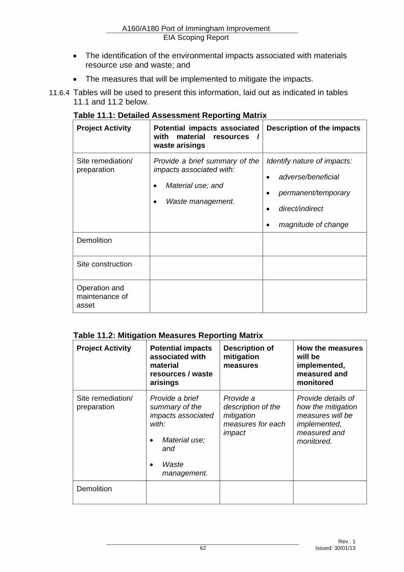
A160/A180 Port of Immingham Improvement EIA Scoping Report
Rev.: 1 62 Issued: 30/01/13
• The identification of the environmental impacts associated with materials resource use and waste; and
• The measures that will be implemented to mitigate the impacts. 11.6.4 Tables will be used to present this information, laid out as indicated in tables
11.1 and 11.2 below. Table 11.1: Detailed Assessment Reporting Matrix Project Activity Potential impacts associated
with material resources / waste arisings
Description of the impacts
Site remediation/ preparation
Provide a brief summary of the impacts associated with:
• Material use; and
• Waste management.
Identify nature of impacts:
• adverse/beneficial
• permanent/temporary
• direct/indirect
• magnitude of change
Demolition
Site construction
Operation and maintenance of asset
Table 11.2: Mitigation Measures Reporting Matrix Project Activity Potential impacts
associated with material resources / waste arisings
Description of mitigation measures
How the measures will be implemented, measured and monitored
Site remediation/ preparation
Provide a brief summary of the impacts associated with:
• Material use; and
• Waste management.
Provide a description of the mitigation measures for each impact
Provide details of how the mitigation measures will be implemented, measured and monitored.
Demolition

A160/A180 Port of Immingham Improvement EIA Scoping Report
Rev.: 1 63 Issued: 30/01/13
Project Activity Potential impacts associated with material resources / waste arisings
Description of mitigation measures
How the measures will be implemented, measured and monitored
Site construction
Operation and maintenance of asset

A160/A180 Port of Immingham Improvement EIA Scoping Report
Rev.: 1 65 Issued: 30/01/13
12 Noise and Vibration
12.1 Introduction
Topic Definition 12.1.1 A road project has the potential to cause increases and decreases in road
traffic noise and vibration either directly or on existing roads by altering the traffic flows and composition. The impact of a road project at any location can be reported in terms of changes in absolute noise and vibration levels, and the effects on people can be reported in terms of nuisance.
12.1.2 The construction and improvement of a road project can result in elevated noise and vibration levels for nearby receptors. Such impacts can be assessed in terms of noise and vibration change resulting from plant associated with the construction works.
Study Area 12.1.3 The study area for noise and vibration assessment will be defined in
accordance with the guidance provided in DMRB, Volume 11, Section 3, Part 7 (HD 213/11 – Revision 1), as follows: i) Identify the start and end points of the physical works associated with
the road project. ii) Identify the existing routes that are being bypassed or improved, and
any proposed new routes, between the start and end points. iii) Define a boundary one kilometre from the carriageway edge of the
routes identified in (ii) above. iv) Define a boundary 600m from the carriageway edge around each of
the routes identified in (ii) above and also 600m from any other affected routes within the boundary defined in (iii) above. This area is called the ‘calculation area’. An affected route is where there is the possibility of a change of 1 dB(A) or more.
v) Identify any affected routes (see 12.1.4) beyond the boundary defined in (iii) above.
vi) Define a boundary 50m from the carriageway edge of the routes identified in (v) above.
12.1.4 An affected route is where there is a possibility of a change of 1 dB LA10, 18h or more in the short term or 3 dB LA10, 18h or more in the long term.
12.1.5 The study area will be defined through details emanating from the traffic modelling process. However, it is expected to extend 1km from the A160 between the proposed Brocklesby Interchange and Rosper Road Junction improvements, i.e. between the start and end points of the physical works associated with the project.
A160/A180 Port of Immingham Improvement EIA Scoping Report
Rev.: 1 66 Issued: 30/01/13
12.2 Existing and Baseline Knowledge 12.2.1 The existing A160 consists of a section of single carriageway and a section of
dual 2 lane carriageway. The route runs as single carriageway through farmland from its junction with the A180 until it reaches South Killingholme at Habrough Road roundabout. At this point the route becomes dual carriageway as it runs through South Killingholme and on through the industrial area towards the port of Immingham.
12.2.2 The noise climate for the majority of properties in South Killingholme village and the surroundings areas are likely to be dominated by traffic noise from the A160. During the night-time the noise climate for properties in the northern areas of South Killingholme are likely to be effected by industrial sources to the east around Eastfield Road.
12.2.3 The noise climate in North Killingholme and for properties along East Halton Road is likely to be dominated by road traffic on the East Halton Road. During the night-time, i.e. when road traffic is reduced, noise emanating from the industrial units to the east around Eastfield Road is likely to contribute to the noise environment for these properties.
12.2.4 The noise climate at properties along Station Road and Killingholme Road in Habrough and the B1210 Immingham Road to the south of South Killingholme, are likely to be dominated by road traffic noise from the A180 dual carriageway. Trains on the mainline railway through Habrough will also contribute to the noise climate for a number of properties in this area.
12.2.5 Sensitive receptors currently located in close proximity to main roads such as the A160 and A180 are likely to be subject to perceivable levels of vibration.
12.3 Value of the Environmental Resources and Receptors 12.3.1 HD 213/11 – Revision 1 provides examples of sensitive receptors, including
dwellings, hospitals, schools, community facilities, designated areas (e.g. AONB, National Park, SAC, SPA, SSSI, SAM), and public rights of way. Of these, only residential properties exist in close proximity the proposed project.
12.3.2 Killingholme Primary School is located approximately 60 metres from the A160 in south Killingholme. However, this section of the A160 is unlikely to alter physically; although changes in traffic flow may result in noise changes at the school.
12.3.3 Other potentially sensitive receptors which could be affected include hotels in North Killingholme and Habrough, and South Killingholme Methodist Church.
12.4 Potential Effects
Construction Effects 12.4.1 The level of construction noise and its distribution will vary during the
construction period, and will depend on the contractor’s chosen method of working and on the timing and phasing of operations. The main potential sources of construction noise are expected to include:
• Plant engaged in earth-moving activities;
A160/A180 Port of Immingham Improvement EIA Scoping Report
Rev.: 1 67 Issued: 30/01/13
• Plant engaged in rock-breaking or breaking-out redundant sections of highway;
• Plant engaged in highway surfacing or in concrete pouring etc;
• Piling (for structures)
• Heavy Delivery Vehicles (HDV). 12.4.2 The narrow, linear nature of the project should ensure that the majority of
these activities are transient in any single location, as the construction process moves along the line of the road. However, work on structures such as the proposed Town Street overbridge will continue in one location for prolonged periods.
12.4.3 Vibration from construction projects is generally caused by general equipment operations and tends to be highest during soil compaction, earth-moving and piling. Although there is the potential for elevated vibration levels for receptors in close proximity to such activities, the short-term nature of the works would limit the exposure time.
12.4.4 The potential construction activities that would potentially generate both the greatest noise and vibration levels are breaking out redundant highways, earth compaction and piling. Sensitive receptors located in close proximity to such activities have the potential to be exposed to short-term significant impacts.
12.4.5 There is the potential for night-time working associated with the proposed Town Street overbridge, to minimise disruption to the A160. Significant impacts could result for nearby residential dwellings should such night-time working be necessary.
12.4.6 Heavy lorry movements on the local network associated with the construction works have the potential to result in elevated levels of noise and vibration for nearby receptors.
Operational Effects 12.4.7 Noise and vibration impacts will largely be restricted to any redistribution of
road traffic on the local road network as a result of the project. This may include an increase of road traffic on the A160, East Halton Road and Habrough Road as traffic is drawn in by the road improvements. Sensitive receptors located adjacent to such road links may experience an associated increase in levels of noise and vibration; albeit these are likely to be negligible.
12.4.8 The road improvement will potentially result in a release of congestion on the A160, which in turn could lead to an increase in average daily (06:00 to 00:00 hours) speed of road traffic. Any such increase in speed has the potential to result in an increase in noise and vibration for receptors located nearby to the A160.
12.4.9 The Top Road / Habrough Road junction improvement is likely to result in the alleviation of traffic from the section of Top Road adjacent to the west of South Killingholme. This will likely result in noise and vibration benefits for sensitive receptors located nearby to this section of Top Road. This junction
A160/A180 Port of Immingham Improvement EIA Scoping Report
Rev.: 1 68 Issued: 30/01/13
improvement is also likely to result in noise and vibration benefits for properties on Ulceby Road (between A160 and Top Road) due to the greater separation distance to the A160 carriageway.
12.4.10 The proposed Town Street overbridge will introduce a new source of noise and vibration for properties that are located nearby. It is likely that adverse impacts will result for such properties. In addition, as the overbridge provides a link across the A160 to South Killingholme, an increase in road traffic along Town Street and Greengate Lane may occur, which in turn may lead to adverse noise and vibration impacts for properties located nearby to these roads.
12.4.11 Figure 12.1 in Appendix B shows receptors that could potentially be affected by noise and vibration.
12.5 Proposed Level and Scope of Assessment 12.5.1 The assessment of noise and vibration will be undertaken in accordance with
DMRB, Volume 11 Section 3, Part 7 HD 213/11 – Revision 1. Subject to the provision of traffic flow information, it is likely that a ‘Detailed’ assessment will be undertaken in accordance with guidance contained within HD 213/11 – Revision 1.
12.6 Proposed Assessment Methodology
Assessment of potential construction impacts 12.6.1 HD213/11 – Revision 1 advises on the use of BS 5228 to assess and control
noise and vibration from construction activities. 12.6.2 BS 5228 – Part 1: Noise, contains details of construction noise prediction
methods and noise levels from different types and sizes of construction equipment. It contains a database on the noise emission from individual items of equipment and activities. The standard also provides routines to predict noise from demolition and construction methods, and suggests practical ways to mitigate excessive noise.
12.6.3 BS 5228 – Part 2: Vibration, contains guidance on vibration levels in structures. It provides a prediction methodology for mechanized construction works, such as compaction and tunnelling works, and piling works. The Standard also presents guidance for the control of vibration from construction works.
Assessment of potential operational impacts Noise Assessment
12.6.4 Noise level information shall be provided following the methodology contained with HD 213/11 – Revision 1. For a ‘Detailed’ assessment, this includes presenting day-time noise level changes in the short-term and long-term, night-time noise level change in the long-term, and noise nuisance change. The summary tables contained within HD 213/11 – Revision 1 will be used to present such information.
12.6.5 Noise calculations will be undertaken for all residential properties and ‘sensitive receptors’ within 600 m of any affected route. Calculations will be
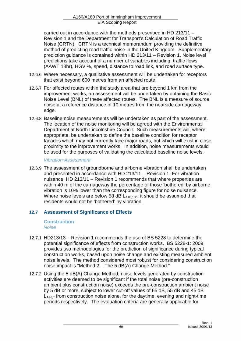
A160/A180 Port of Immingham Improvement EIA Scoping Report
Rev.: 1 69 Issued: 30/01/13
carried out in accordance with the methods prescribed in HD 213/11 – Revision 1 and the Department for Transport’s Calculation of Road Traffic Noise (CRTN). CRTN is a technical memorandum providing the definitive method of predicting road traffic noise in the United Kingdom. Supplementary prediction guidance is contained within HD 213/11 – Revision 1. Noise level predictions take account of a number of variables including, traffic flows (AAWT 18hr), HGV %, speed, distance to road link, and road surface type.
12.6.6 Where necessary, a qualitative assessment will be undertaken for receptors that exist beyond 600 metres from an affected route.
12.6.7 For affected routes within the study area that are beyond 1 km from the improvement works, an assessment will be undertaken by obtaining the Basic Noise Level (BNL) of these affected routes. The BNL is a measure of source noise at a reference distance of 10 metres from the nearside carriageway edge.
12.6.8 Baseline noise measurements will be undertaken as part of the assessment. The location of the noise monitoring will be agreed with the Environmental Department at North Lincolnshire Council. Such measurements will, where appropriate, be undertaken to define the baseline condition for receptor facades which may not currently face major roads, but which will exist in close proximity to the improvement works. In addition, noise measurements would be used for the purposes of validating the calculated baseline noise levels. Vibration Assessment
12.6.9 The assessment of groundborne and airborne vibration shall be undertaken and presented in accordance with HD 213/11 – Revision 1. For vibration nuisance, HD 213/11 – Revision 1 recommends that where properties are within 40 m of the carriageway the percentage of those ‘bothered’ by airborne vibration is 10% lower than the corresponding figure for noise nuisance. Where noise levels are below 58 dB LA10,18h, it should be assumed that residents would not be ‘bothered’ by vibration.
12.7 Assessment of Significance of Effects
Construction Noise
12.7.1 HD213/13 – Revision 1 recommends the use of BS 5228 to determine the potential significance of effects from construction works. BS 5228-1: 2009 provides two methodologies for the prediction of significance during typical construction works, based upon noise change and existing measured ambient noise levels. The method considered most robust for considering construction noise impact is “Method 2 – The 5 dB(A) Change Method.”
12.7.2 Using the 5 dB(A) Change Method, noise levels generated by construction activities are deemed to be significant if the total noise (pre-construction ambient plus construction noise) exceeds the pre-construction ambient noise by 5 dB or more, subject to lower cut-off values of 65 dB, 55 dB and 45 dB LAeq,T from construction noise alone, for the daytime, evening and night-time periods respectively. The evaluation criteria are generally applicable for
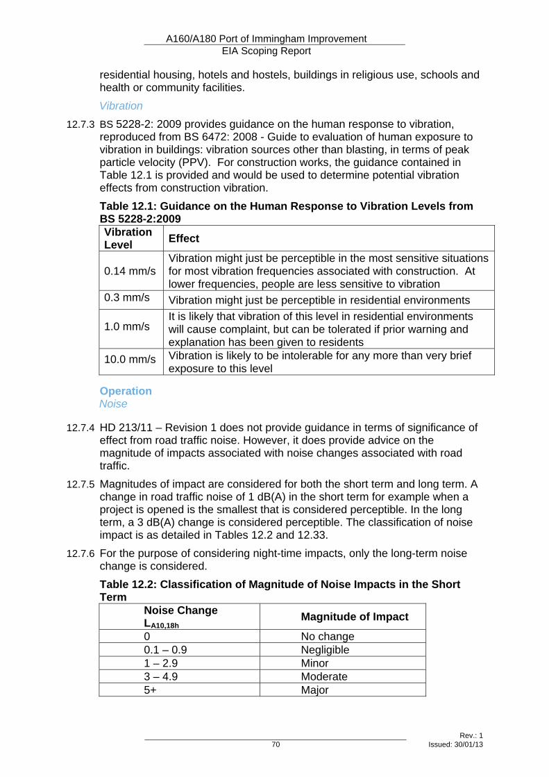
A160/A180 Port of Immingham Improvement EIA Scoping Report
Rev.: 1 70 Issued: 30/01/13
residential housing, hotels and hostels, buildings in religious use, schools and health or community facilities. Vibration
12.7.3 BS 5228-2: 2009 provides guidance on the human response to vibration, reproduced from BS 6472: 2008 - Guide to evaluation of human exposure to vibration in buildings: vibration sources other than blasting, in terms of peak particle velocity (PPV). For construction works, the guidance contained in Table 12.1 is provided and would be used to determine potential vibration effects from construction vibration. Table 12.1: Guidance on the Human Response to Vibration Levels from BS 5228-2:2009 Vibration Level Effect
0.14 mm/s Vibration might just be perceptible in the most sensitive situations for most vibration frequencies associated with construction. At lower frequencies, people are less sensitive to vibration
0.3 mm/s Vibration might just be perceptible in residential environments
1.0 mm/s It is likely that vibration of this level in residential environments will cause complaint, but can be tolerated if prior warning and explanation has been given to residents
10.0 mm/s Vibration is likely to be intolerable for any more than very brief exposure to this level
Operation Noise
12.7.4 HD 213/11 – Revision 1 does not provide guidance in terms of significance of effect from road traffic noise. However, it does provide advice on the magnitude of impacts associated with noise changes associated with road traffic.
12.7.5 Magnitudes of impact are considered for both the short term and long term. A change in road traffic noise of 1 dB(A) in the short term for example when a project is opened is the smallest that is considered perceptible. In the long term, a 3 dB(A) change is considered perceptible. The classification of noise impact is as detailed in Tables 12.2 and 12.33.
12.7.6 For the purpose of considering night-time impacts, only the long-term noise change is considered. Table 12.2: Classification of Magnitude of Noise Impacts in the Short Term
Noise Change LA10,18h Magnitude of Impact
0 No change 0.1 – 0.9 Negligible 1 – 2.9 Minor 3 – 4.9 Moderate 5+ Major
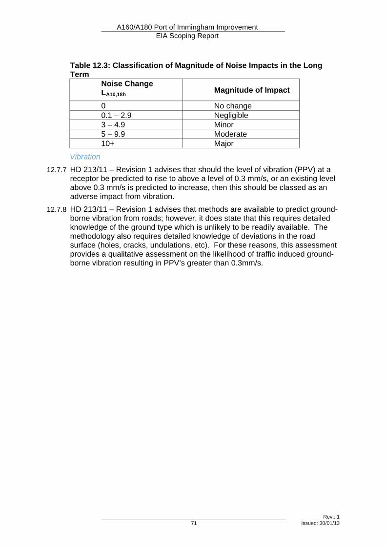
A160/A180 Port of Immingham Improvement EIA Scoping Report
Rev.: 1 71 Issued: 30/01/13
Table 12.3: Classification of Magnitude of Noise Impacts in the Long Term
Noise Change LA10,18h Magnitude of Impact
0 No change 0.1 – 2.9 Negligible 3 – 4.9 Minor 5 – 9.9 Moderate 10+ Major
Vibration 12.7.7 HD 213/11 – Revision 1 advises that should the level of vibration (PPV) at a
receptor be predicted to rise to above a level of 0.3 mm/s, or an existing level above 0.3 mm/s is predicted to increase, then this should be classed as an adverse impact from vibration.
12.7.8 HD 213/11 – Revision 1 advises that methods are available to predict ground-borne vibration from roads; however, it does state that this requires detailed knowledge of the ground type which is unlikely to be readily available. The methodology also requires detailed knowledge of deviations in the road surface (holes, cracks, undulations, etc). For these reasons, this assessment provides a qualitative assessment on the likelihood of traffic induced ground-borne vibration resulting in PPV’s greater than 0.3mm/s.

A160/A180 Port of Immingham Improvement EIA Scoping Report
Rev.: 1 73 Issued: 30/01/13
13 Effects on All Travellers
13.1 Introduction
Topic Definition 13.1.1 DMRB does not yet contain guidance for this topic under this particular
heading. However, the topic includes consideration of impacts on vehicle travellers (previously a topic in its own right) and impacts on pedestrians, equestrians and cyclists (also referred to as Non-Motorised Users or NMUs), (previously combined in a topic with community effects). Vehicle Travellers
13.1.2 The assessment of impacts on vehicle travellers considers both the quality of views from the road and the levels of stress experienced by drivers. Stress can be caused by frustration, route uncertainty and fear of accidents, and can be linked to congestion, slow-moving traffic, poor signage, busy traffic and complex junctions. Non-Motorised Users
13.1.3 NMUs can be divided into three main categories: pedestrians; equestrians (horse-riders) and cyclists. This will also include people with mobility problems, who may have needs that differ from those of other pedestrians.
13.1.4 Journeys made by NMUs may be for utility or recreational purposes, and the two types of journeys are likely to use different routes.
Study Area 13.1.5 The assessment will consider vehicle travellers and NMUs using routes that
meet or cross the area of the proposed scheme, and those that travel along the A160 itself.
13.2 Existing and Baseline Knowledge Vehicle Travellers
13.2.1 The existing A160 provides access from the Port of Immingham to the A180, and then on to the wider strategic road network. The eastern half of the A160 is dual carriageway, and the western half is single carriageway.
13.2.2 Existing gaps in the central reservation allow vehicular access between the two parts of the village of South Killingholme at Town Street, at Eastfield Road and at the oil refinery further to the east.
13.2.3 A high proportion of the traffic on the A160 is heavy goods vehicles (HGVs). Between 25% and 50% of the traffic travels to or from the port, and a large majority of the traffic travels to or from the A180, west of the A160.
13.2.4 Congestion occurs on the existing route, particularly at Ulceby Road roundabout during the morning peak. Non-Motorised Users
13.2.5 Routes suitable for non-motorised users in the study area include:
A160/A180 Port of Immingham Improvement EIA Scoping Report
Rev.: 1 74 Issued: 30/01/13
• A footpath leading east from Top Road (north of Habrough Road Roundabout) to give access to South Killingholme via School Road;
• An at-grade refuge point in the central reserve for pedestrians crossing the A160 to the east of Habrough Road roundabout;
• Two at-grade refuge points in the central reserve for pedestrians crossing the A160 at Town Street, South Killingholme
• A footway on the north side of the A160 between Town Street and Eastfield Road, separated from the main carriageway by a grass verge;
• At-grade refuge points in the central reserve for pedestrians crossing the A160 at Eastfield Road;
• Pedestrian crossing points at all three arms of Manby Road roundabout;
• A short section of footway on the north side of the A160 beneath the railway bridge; and
• A designated public footpath between Town Street and Eastfield Road, following a field boundary on the far side of the field from the A160.
13.3 Value of the Environmental Resources and Receptors 13.3.1 Pending publication of the new DMRB guidance for this topic, there is no
agreed method of measuring the value or sensitivity of travellers or the routes that they use. Therefore, each resource or receptor will be considered on an individual basis, and the factors influencing its sensitivity will be taken into account in assessing the significance of impacts.
13.4 Potential Effects
Construction Effects 13.4.1 The construction of the scheme would require temporary site compounds and
access routes, and will generate construction traffic. It may require temporary haul routes, temporary lane closures, or temporary diversions, all of which can have a negative impact on vehicle travellers or NMUs.
13.4.2 Construction traffic can add to congestion, particularly at peak times, affecting vehicle travellers and NMUs. Congestion, increased journey time and route uncertainty due to temporary lane closures or diversions can all add to driver stress.
13.4.3 For NMUs, increased journey time may dissuade some people from making journeys.
13.4.4 In addition, the temporary impacts of construction noise, vibration, visual impacts and potential air quality impacts can reduce the amenity value of recreational routes. Visual impacts can also adversely affect the views experienced by vehicle travellers.
Operational Effects 13.4.5 Vehicle travellers making through-journeys on the A160 are expected to
benefit from the scheme, as they would experience shorter and more reliable journey times and reduced congestion.
A160/A180 Port of Immingham Improvement EIA Scoping Report
Rev.: 1 75 Issued: 30/01/13
13.4.6 Travellers joining and crossing the A160 would be affected by altered junctions and the closure of gaps in the central reservation. There would be provision for NMUs on the proposed Town Street overbridge, which would increase journey time but improve safety by removing the need to cross the busy A160.
13.4.7 Users of any permanently diverted public rights of way (PRoW) would continue to be affected during the operation of the scheme.
13.5 Proposed Level and Scope of Assessment 13.5.1 The assessment will be based mainly on desk-study, considering the routes
used by vehicle travellers and NMUs within the study area, and how they would be affected by the proposed scheme.
13.5.2 Site visits carried out for the landscape and visual impact assessment would also inform the assessment of impacts on views from the road.
13.6 Proposed Assessment Methodology
Vehicle Travellers Drivers’ Stress
13.6.1 The assessment will use the method specified in DMRB, which grades stress as high / medium / low according to traffic volumes and speeds as well as considering route uncertainty and fear of accidents. This will be assessed using data from the traffic model for sections of road (links) in the study area. View from the Road
13.6.2 The assessment of impacts on views from the road will be assessed based on the guidance contained in the existing ‘vehicle travellers’ guidance in DMRB. Views will be categorised as no view / restricted view / intermittent view / open view. Changes to views from the road as a result of the scheme will be described.
Non-Motorised Users 13.6.3 The impacts on NMUs will be assessed using qualitative judgements. No
numerical predictions will be made of future changes. 13.6.4 The following considerations will be used to identify the value of the existing
facilities:
• Whether users of the routes make utility or recreational journeys;
• Whether the route is used by different types of NMU (pedestrians / cyclists / equestrians)
• Whether alternative routes can be taken with ease;
• Any barriers on the route, such as conflicts with traffic, stiles, fences, crossing points;
• The current condition of the routes;
• The amenity value of the routes;
A160/A180 Port of Immingham Improvement EIA Scoping Report
Rev.: 1 76 Issued: 30/01/13
• Levels of use of the routes, plus any suppressed demand that may exist for a particular route; and
• Comments received during public consultation. 13.6.5 The following types of impact will be identified:
• Any proposed permanent or temporary closures or diversions of NMU routes;
• The length and duration of any proposed diversions;
• The duration of any proposed temporary closures;
• Any new severance that would result from the scheme;
• Any proposed changes to highway crossing facilities;
• Any predicted changes to the amenity value of NMU routes;
• Any proposed changes to lighting. 13.6.6 Qualitative judgements will be made to assess the effects on NMUs.
A160/A180 Port of Immingham Improvement EIA Scoping Report
Rev.: 1 77 Issued: 30/01/13
14 Community and Private Assets
14.1 Introduction
Topic Definition 14.1.1 There is no guidance yet available in DMRB for this new topic. However, in
the interim, it is appropriate to consider the topic to be a combination of the previous Land Use topic and the Community Effects section of the previous Pedestrians, Equestrians, Cyclists and Community Effects topic. Therefore, that earlier guidance will be used, where relevant.
14.1.2 Community effects will be assessed in relation to effects on community assets. Access to those assets will not be considered under this topic heading, as it is covered in the assessment of effects on All Travellers. Community assets will be defined as:
• Any facilities within the local communities that are provided by public authorities, charities or non-governmental organisations;
• Any facilities within the local communities that are provided by private or commercial organisations for the use of the whole community; or
• Land that is available for use by the whole community or particular groups within the community.
14.1.3 Private assets will be considered in relation to effects on residential properties, on the economic viability of existing businesses, on potential development land and on agricultural land. Impacts on agricultural land will be considered principally in relation to the effects on the economic viability of farm units and the viability of the existing use of individual parcels of land.
14.1.4 Some businesses will be considered in terms of both their value to the community and their value as private assets. For example, a local shop or café may fall into this category.
Study Area 14.1.5 The study area will cover the village of South Killingholme and all other
community and private assets adjacent to the proposed scheme. In addition, any impacts on access routes between different areas of land within a farm unit or within a business premises will also be considered.
14.2 Existing and Baseline Knowledge 14.2.1 Summary information from an initial desk study is provided here. This
information will be added to as part of the baseline data collection for the EIA.
South Killingholme 14.2.2 The existing A160 cuts through the village of South Killingholme, severing the
southern extent of the village from the rest of the village. 14.2.3 Facilities in the village will be confirmed through a site visit, but are
understood to include a convenience store, fish and chip shop, primary school, chapel, church, community hall, public house and doctor’s surgery.
A160/A180 Port of Immingham Improvement EIA Scoping Report
Rev.: 1 78 Issued: 30/01/13
Residential Property 14.2.4 Residential property is concentrated in the community of South Killingholme.
The majority are to the north of the A160 and east of Top Road.
Land Used by the Community 14.2.5 There are areas of public open space within South Killingholme, including a
children’s play area located off Greengate Lane.
Agricultural Land 14.2.6 The western half of the scheme runs through an area of agricultural land,
which is mapped at a large scale under the Agricultural Land Classification (ALC) system as Class 3.
Business Premises / Industrial Land 14.2.7 Industrial premises are concentrated along the eastern half of the scheme, on
the approach to the Port of Immingham. This includes large-scale premises including an oil refinery.
14.2.8 A petrol station is located on the south-eastern corner of the junction of the A160 with Eastfield Road.
Development Land 14.2.9 The North Lincolnshire Local Plan indicates that much of the un-developed
land between the railway line and the Humber bank, to the north-east of the scheme, is proposed for industrial development.
14.3 Value of the Environmental Resources and Receptors 14.3.1 No guidance for this new DMRB topic has been published, while the guidance
for the two superseded topics does not include an agreed method of measuring the value or sensitivity of the community and private assets receptors, and there is no agreed scale against which they can be measured.
14.3.2 Therefore, each resource or receptor will be addressed on an individual basis and the factors influencing its sensitivity will be taken into account in assessing the significance of impacts.
14.3.3 In relation to the assessment of communities and community assets, judgements will be made in the light of the following considerations: • The extent to which a given community is ‘self-contained’. Self-contained
communities are those in which all essential local facilities are located within the area of the community, whereas communities that are not self-contained are dependent on access to facilities located elsewhere;
• The extent to which a given community asset is essential to the well-being or self-contained nature of the local community;
• The extent to which a given community asset is duplicated by alternative facilities to which members of the community have equally easy access; and
A160/A180 Port of Immingham Improvement EIA Scoping Report
Rev.: 1 79 Issued: 30/01/13
• The extent of the catchment area served by a given community asset, and the principal mode of transport used to access the facility.
14.3.4 In assessing the agricultural farm units, professional judgement will be made in relation to the agricultural quality of the land and the vulnerability of the farm units concerned to loss of economic viability. Factors influencing this will include (but are not necessarily limited to) the following: • The size of the farm unit; • The quality of the land; • The nature of the farming operations; • The extent to which the fields farmed are concentrated together or
dispersed over a larger area; • The location of the farmstead(s) in relation to the land farmed; • The routes used to access the land and the availability of alternative
routes; and • The extent, if any, to which the farm is operated through agricultural
contractors.
14.4 Potential Effects
Construction Effects 14.4.1 The construction of the scheme would require land-take from community and
private assets, including permanent land-take from agricultural land for the road widening. Consultation will be undertaken with those parties with an interest in the assets, and with the local communities, in order to identify appropriate mitigation measures.
14.4.2 In addition to the direct loss of land, there may be associated effects, such as disruption to drainage or irrigation networks.
14.4.3 Land-take from private assets can, in some cases, leave businesses non-viable, either temporarily or permanently.
Operational Effects 14.4.4 During operation, the temporary impacts associated with temporary land-take
during construction would cease. However, the permanent impacts would continue. No new impacts would be expected during the operational phase.
14.5 Proposed Level and Scope of Assessment 14.5.1 The agricultural assessment will be carried out as a stand-alone assessment,
which will be referred to in the community and private assets chapter, and will form an appendix to the chapter. The agricultural assessment will be designed to determine the impact of the proposed scheme on soils of different ALC grades, current and future access to fields, field drainage, water supplies, and gates and tracks that may be affected. Measurement of these factors will enable an assessment of the effect of the scheme on the overall viability of each affected farm unit. It will involve consultation with the farmers.
A160/A180 Port of Immingham Improvement EIA Scoping Report
Rev.: 1 80 Issued: 30/01/13
14.5.2 The agricultural assessment will also consider temporary impacts during construction.
14.5.3 Access routes to community facilities will not be assessed as part of this chapter, as to do so would double-count impacts identified in the ‘All Travellers’ chapter. However, any severance that would be caused between particular facilities and the communities that they serve will be identified. In addition, any impacts on premises will be considered, such as loss of parking spaces.
14.5.4 Potential changes to the ongoing viability of local businesses and employment opportunities within the local communities will be assessed. This may include beneficial impacts as the scheme would increase road capacity and potentially increase the likelihood of commercial development in the area, particularly associated with the port.
14.6 Proposed Assessment Methodology 14.6.1 In the absence of specific published guidance for the determination of impacts
and their significance, each potential impact associated with the scheme will be assessed using professional judgement. The assessment will distinguish between significant and insignificant impacts, but different levels of significance will not be assessed.
14.6.2 The assessment will include consideration of the following factors:
• Whether the impact would be permanent or temporary, and the duration of any temporary impacts;
• The time of day or day(s) of the week that the impact would occur;
• How essential the affected features are to the functioning of the business or facility.
14.6.3 In relation to agricultural land in particular, the following will be considered:
• The viability of a farm in a typical year under the current farming system;
• The extent of any major reorganisation of the holding that may be caused by the scheme;
• The extent of increased demands on management, as a result of the scheme; and
• Agri-environment schemes.
A160/A180 Port of Immingham Improvement EIA Scoping Report
Rev.: 1 81 Issued: 30/01/13
15 Road Drainage and the Water Environment
15.1 Introduction
Topic Definition 15.1.1 This topic addresses the potential effects of the construction and operation of
the scheme on surface water, groundwater and flood risk. 15.1.2 During construction, the principal risks to the water environment relate to
suspended solids in runoff from the site and accidental spillage of fuel, oil or other chemicals used on site. Construction work can also create new pathways by which pollution can reach the water environment.
15.1.3 During operation, impacts may be associated with pollutants washed from the road surface by rainwater, and spillages or fuel or other contaminants as a result of road traffic accidents.
15.1.4 Flood risk can be affected by increased areas of impermeable surfaces, construction within a floodplain, or by creating obstructions to existing flow patterns.
Study Area 15.1.5 There is no fixed study area for this topic. As a minimum, features of the
water environment within 1km of the scheme will be considered, but that area may extend as necessary in order to gather relevant data from upstream or downstream of the site.
15.2 Existing and Baseline Knowledge 15.2.1 The agricultural land in the study area is drained via a series of field drains,
many of which are managed by North East Lindsey Internal Drainage Board (IDB). The IDB manages water levels in their network of drains, and controls discharges from their network to the Humber Estuary.
15.2.2 Skitter Beck is a main river, situated to the west of the scheme, approximately 700m to the west of Brocklesby Interchange. This river flows northwards, becoming East Halton Beck, before discharging to the Humber Estuary, approximately 7km to the north of the proposed scheme. There is a sluice gate at the interface between the river and the Estuary.
15.2.3 Surface water drainage from the existing A160 is believed to be drained as three separate catchments, based upon information available from earlier stages in the development of the proposed scheme:
• At the western end, 200m of the A160, plus the Brocklesby Interchange, is drained together with a section of the A180, via a drainage pond, into Skitter Beck, a main river;
• The majority of the western part of the A160, starting 200m from Brocklesby Interchange and extending to Habrough Junction, is drained via a drainage ditch adjacent to Ulceby Road, from where it is discharged into Skitter Beck, at an unknown location; and
A160/A180 Port of Immingham Improvement EIA Scoping Report
Rev.: 1 82 Issued: 30/01/13
• The road east of Habrough Junction drains eastwards. This is thought to be via South Killingholme Drain (an IDB watercourse) to the Humber Estuary.
15.2.4 Land immediately north-east of the railway line, at the eastern end of the proposed scheme, is in a flood zone associated with the Humber Estuary. There is also a localised flood zone associated with Skitter Beck, although that zone does not extend into the area of the proposed works.
15.2.5 Sections of the proposed scheme lie within either the outer zone or total catchment of three groundwater source protection zones (SPZs). The whole study area is underlain by a principal aquifer in the bedrock. There is also a secondary aquifer in superficial deposits, close to the route of Skitter Beck. For the majority of the scheme, the underlying groundwater is of low vulnerability, due to the nature of the overlying soils. However, to the east of the railway line, that vulnerability is increased to high.
15.2.6 Groundwater quality in the study area is poor, in terms both of chemical quality and quantitative quality.
15.2.7 The Brocklesby tributary of Skitter Beck to the south of the A180 is of moderate ecological quality, reducing to poor ecological quality in Skitter Beck down to the Humber Estuary.
15.2.8 The Humber Estuary is classified as being of moderate ecological quality. 15.2.9 Abstractions and discharges in the study area have not been identified at this
stage, but will form part of the baseline data collection for the EIA.
15.3 Value of the Environmental Resources and Receptors 15.3.1 In accordance with DMRB volume 11, Section 3, Part 10 (HD45/09), any
given feature of the water environment will be identified as having one or several attributes, such as its use for water supply, conveyance of flow, or dilution of waste products. The value of each of those attributes is identified separately, rather than assigning just one value to a feature. Indicative measures for identifying the value of attributes are provided in table A4.3 of HD45/09.
15.3.2 The importance of attributes will be identified as part of the EIA. The Humber Estuary is particularly valued for its biodiversity, as an internationally designated site, and is therefore considered to be of particular importance. The low-lying nature of the surrounding land, and the network of drainage ditches, mean that conveyance of flows will be an important consideration.
15.4 Potential Effects
Construction Effects 15.4.1 Construction effects on the water environment are likely to include the
following:
• Diversion or alteration of field drains and construction of discharge points, with the potential to cause siltation or scour, or to affect flows;
A160/A180 Port of Immingham Improvement EIA Scoping Report
Rev.: 1 83 Issued: 30/01/13
• Risk of impacts on water quality as a result of accidental spillages or site runoff with high suspended solids; and
• Increased runoff into drainage ditches, with potential impacts on flood risk.
• Interception of groundwater, and localised groundwater flooding of the site during construction.
Operational Effects 15.4.2 There is the potential, without appropriate mitigation, for the increase in
hardstanding to lead to an increased flood risk in the surrounding area. There is also potential for the eastern extent of the scheme, within the floodplain, to be at risk of flooding.
15.4.3 Routine runoff from the road may carry an increased pollutant load, when compared to the existing road, because of the increased traffic that may be attracted to the route. Appropriate mitigation would be needed, perhaps in the form of treatment ponds, to prevent associated adverse impacts on water quality.
15.5 Proposed Level and Scope of Assessment 15.5.1 It is proposed that a simple assessment will be carried out, in line with the
guidance contained in DMRB. There will be no detailed field surveys or water quality monitoring.
15.5.2 A flood risk assessment (FRA) will be carried out and appended to the Environmental Statement. The FRA will be carried out in accordance with the technical guidance to the National Planning Policy Framework (NPPF).
15.6 Proposed Assessment Methodology 15.6.1 The assessment will be carried out in accordance with the guidance contained
in DMRB (HD45/09). This will include the use of the Highways Agency Water Risk Assessment Tool (HAWRAT) as one of the indicators of the likely impacts associated with routine runoff.
15.6.2 Method D of the DMRB guidance will be used to calculate spillage risk and the associated probability of a serious pollution incident.
15.6.3 The flood risk assessment will be carried out in line with the NPPF. It will look at changes in peak runoff from the site before and after the proposed development, and will include consideration of climate change. It will also assess the implications of the tidal floodplain that the scheme would extend into.
15.6.4 Tables 15.1 to 15.3 below are taken directly from DMRB and will be used in the assessment. The significance of impacts will be determined only for residual impacts following mitigation.
Table 15.1: Valuation of water environment attributes Importance Criteria Typical Examples Very high Attribute
has a high Surface water: EC designated salmonid / cyprinid fishery
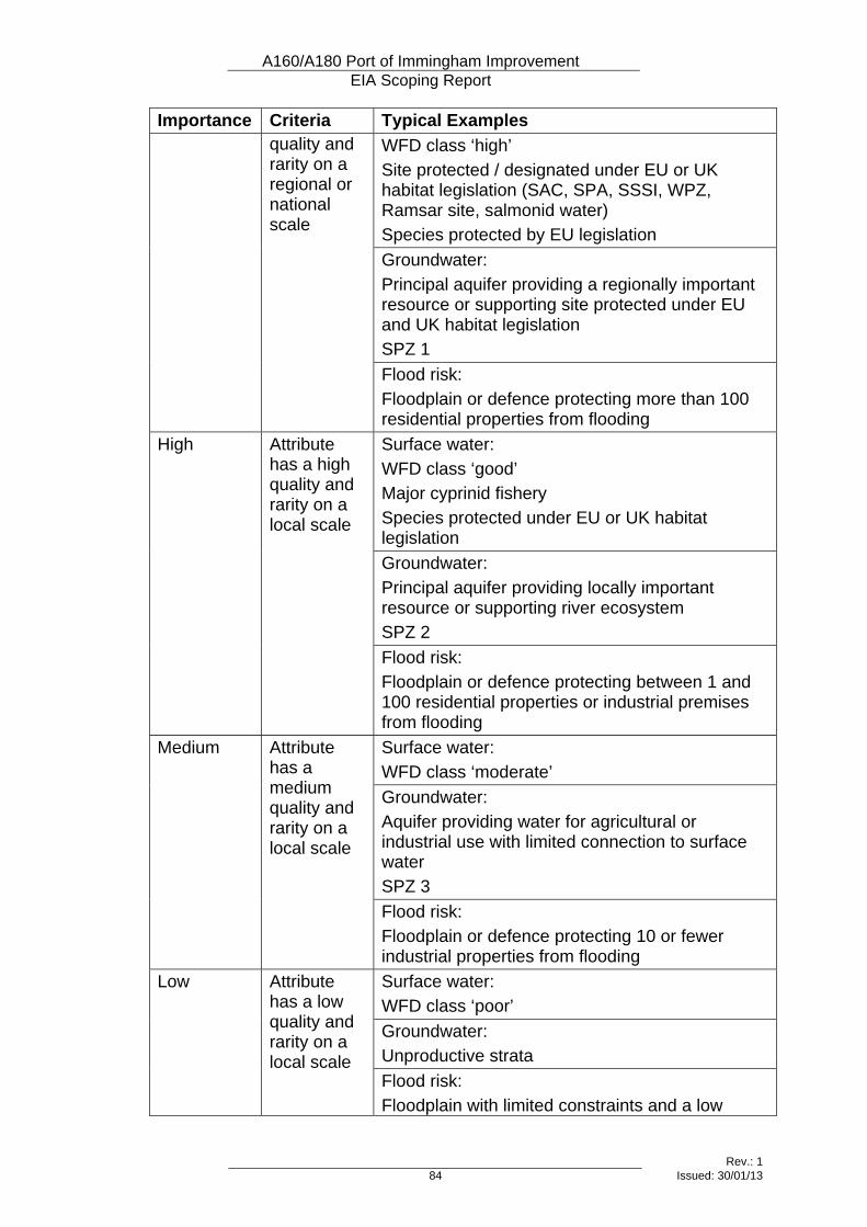
A160/A180 Port of Immingham Improvement EIA Scoping Report
Rev.: 1 84 Issued: 30/01/13
Importance Criteria Typical Examples WFD class ‘high’ Site protected / designated under EU or UK habitat legislation (SAC, SPA, SSSI, WPZ, Ramsar site, salmonid water) Species protected by EU legislation Groundwater: Principal aquifer providing a regionally important resource or supporting site protected under EU and UK habitat legislation SPZ 1
quality and rarity on a regional or national scale
Flood risk: Floodplain or defence protecting more than 100 residential properties from flooding Surface water: WFD class ‘good’ Major cyprinid fishery Species protected under EU or UK habitat legislation Groundwater: Principal aquifer providing locally important resource or supporting river ecosystem SPZ 2
High Attribute has a high quality and rarity on a local scale
Flood risk: Floodplain or defence protecting between 1 and 100 residential properties or industrial premises from flooding Surface water: WFD class ‘moderate’ Groundwater: Aquifer providing water for agricultural or industrial use with limited connection to surface water SPZ 3
Medium Attribute has a medium quality and rarity on a local scale
Flood risk: Floodplain or defence protecting 10 or fewer industrial properties from flooding Surface water: WFD class ‘poor’ Groundwater: Unproductive strata
Low Attribute has a low quality and rarity on a local scale
Flood risk: Floodplain with limited constraints and a low
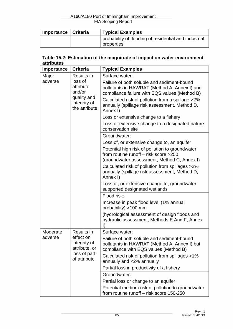
A160/A180 Port of Immingham Improvement EIA Scoping Report
Rev.: 1 85 Issued: 30/01/13
Importance Criteria Typical Examples probability of flooding of residential and industrial properties
Table 15.2: Estimation of the magnitude of impact on water environment attributes Importance Criteria Typical Examples
Surface water: Failure of both soluble and sediment-bound pollutants in HAWRAT (Method A, Annex I) and compliance failure with EQS values (Method B) Calculated risk of pollution from a spillage >2% annually (spillage risk assessment, Method D, Annex I) Loss or extensive change to a fishery Loss or extensive change to a designated nature conservation site Groundwater: Loss of, or extensive change to, an aquifer Potential high risk of pollution to groundwater from routine runoff – risk score >250 (groundwater assessment, Method C, Annex I) Calculated risk of pollution from spillages >2% annually (spillage risk assessment, Method D, Annex I) Loss of, or extensive change to, groundwater supported designated wetlands
Major adverse
Results in loss of attribute and/or quality and integrity of the attribute
Flood risk: Increase in peak flood level (1% annual probability) >100 mm (hydrological assessment of design floods and hydraulic assessment, Methods E And F, Annex I) Surface water: Failure of both soluble and sediment-bound pollutants in HAWRAT (Method A, Annex I) but compliance with EQS values (Method B) Calculated risk of pollution from spillages >1% annually and <2% annually Partial loss in productivity of a fishery
Moderate adverse
Results in effect on integrity of attribute, or loss of part of attribute
Groundwater: Partial loss or change to an aquifer Potential medium risk of pollution to groundwater from routine runoff – risk score 150-250
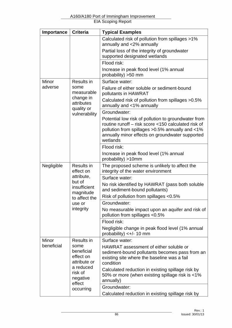
A160/A180 Port of Immingham Improvement EIA Scoping Report
Rev.: 1 86 Issued: 30/01/13
Importance Criteria Typical Examples Calculated risk of pollution from spillages >1% annually and <2% annually Partial loss of the integrity of groundwater supported designated wetlands Flood risk: Increase in peak flood level (1% annual probability) >50 mm Surface water: Failure of either soluble or sediment-bound pollutants in HAWRAT Calculated risk of pollution from spillages >0.5% annually and <1% annually Groundwater: Potential low risk of pollution to groundwater from routine runoff – risk score <150 calculated risk of pollution from spillages >0.5% annually and <1% annually minor effects on groundwater supported wetlands
Minor adverse
Results in some measurable change in attributes quality or vulnerability
Flood risk: Increase in peak flood level (1% annual probability) >10mm The proposed scheme is unlikely to affect the integrity of the water environment Surface water: No risk identified by HAWRAT (pass both soluble and sediment-bound pollutants) Risk of pollution from spillages <0.5% Groundwater: No measurable impact upon an aquifer and risk of pollution from spillages <0.5%
Negligible Results in effect on attribute, but of insufficient magnitude to affect the use or integrity
Flood risk: Negligible change in peak flood level (1% annual probability) <+/- 10 mm Surface water: HAWRAT assessment of either soluble or sediment-bound pollutants becomes pass from an existing site where the baseline was a fail condition Calculated reduction in existing spillage risk by 50% or more (when existing spillage risk is <1% annually)
Minor beneficial
Results in some beneficial effect on attribute or a reduced risk of negative effect occurring Groundwater:
Calculated reduction in existing spillage risk by
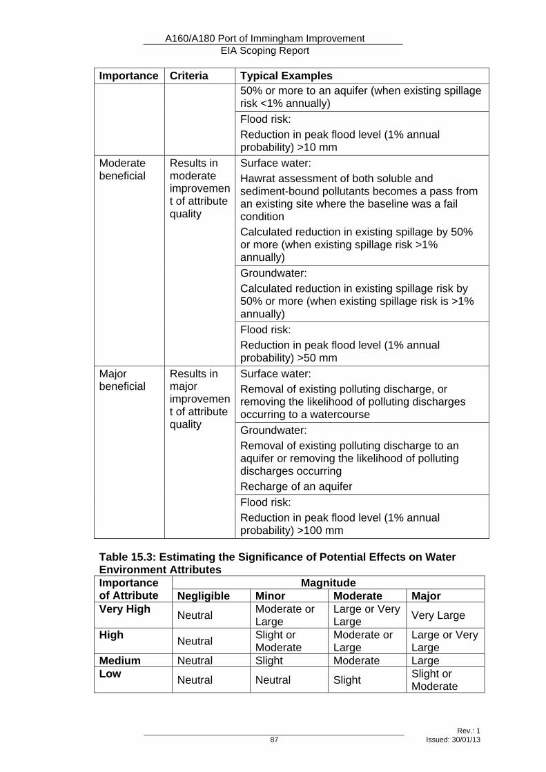
A160/A180 Port of Immingham Improvement EIA Scoping Report
Rev.: 1 87 Issued: 30/01/13
Importance Criteria Typical Examples 50% or more to an aquifer (when existing spillage risk <1% annually) Flood risk: Reduction in peak flood level (1% annual probability) >10 mm Surface water: Hawrat assessment of both soluble and sediment-bound pollutants becomes a pass from an existing site where the baseline was a fail condition Calculated reduction in existing spillage by 50% or more (when existing spillage risk >1% annually) Groundwater: Calculated reduction in existing spillage risk by 50% or more (when existing spillage risk is >1% annually)
Moderate beneficial
Results in moderate improvement of attribute quality
Flood risk: Reduction in peak flood level (1% annual probability) >50 mm Surface water: Removal of existing polluting discharge, or removing the likelihood of polluting discharges occurring to a watercourse Groundwater: Removal of existing polluting discharge to an aquifer or removing the likelihood of polluting discharges occurring Recharge of an aquifer
Major beneficial
Results in major improvement of attribute quality
Flood risk: Reduction in peak flood level (1% annual probability) >100 mm
Table 15.3: Estimating the Significance of Potential Effects on Water Environment Attributes
Magnitude Importance of Attribute Negligible Minor Moderate Major Very High Neutral Moderate or
Large Large or Very Large Very Large
High Neutral Slight or Moderate
Moderate or Large
Large or Very Large
Medium Neutral Slight Moderate Large Low Neutral Neutral Slight Slight or
Moderate
A160/A180 Port of Immingham Improvement EIA Scoping Report
Rev.: 1 88 Issued: 30/01/13
16 Cumulative Effects
16.1 Introduction
Topic Definition 16.1.1 It is possible for an individual receptor to be affected by a number of different
environmental impacts, which may have been identified in a number of different topic assessments (different chapters in the ES). In addition, it is possible for the predicted impacts of this project to be compounded by those of other projects in the surrounding area. In such circumstances, the affected receptors would experience what are known as cumulative effects.
16.2 Interactions between Topics 16.2.1 The topics that are most likely to interact with each other and have cumulative
effects are the water environment with nature conservation; noise with air quality and visual amenity; heritage with landscape and visual amenity; and all travellers with community and private assets.
16.2.2 All topics will be checked for interactions once the individual assessments have been carried out, and the cumulative effects assessment will be carried out towards the end of the EIA process.
16.3 Interaction with Other Projects 16.3.1 Other proposed highways projects in the vicinity of the scheme will be
identified, and the assessment will consider any that have a reasonable likelihood of being carried out within a reasonable timeframe.
16.3.2 Non-highways projects in the surrounding area will also be identified. Land allocations on their own will not be considered, as there is no certainty that developers will come forward with projects, and the nature and timing of such projects and their impacts cannot be known. However, any significant developments that have been submitted for planning approval or already have planning permission will be considered. In particular, checks will be made for any significant projects associated with industrial development close to the Port of Immingham.
16.3.3 Where neighbouring developments have already been factored into the traffic model, any traffic-related impacts (such as air quality, noise and water quality) will not be repeated in the cumulative effects section of the assessment, as to do so would involve double-counting of impacts.
16.4 Scope 16.4.1 The other projects to be considered will be limited to a geographic area within
which the impacts of those projects could affect the same receptors that would be affected by the A160/A180 scheme. This may extend a number of kilometres from the proposed scheme, but only significant development proposals will be considered.
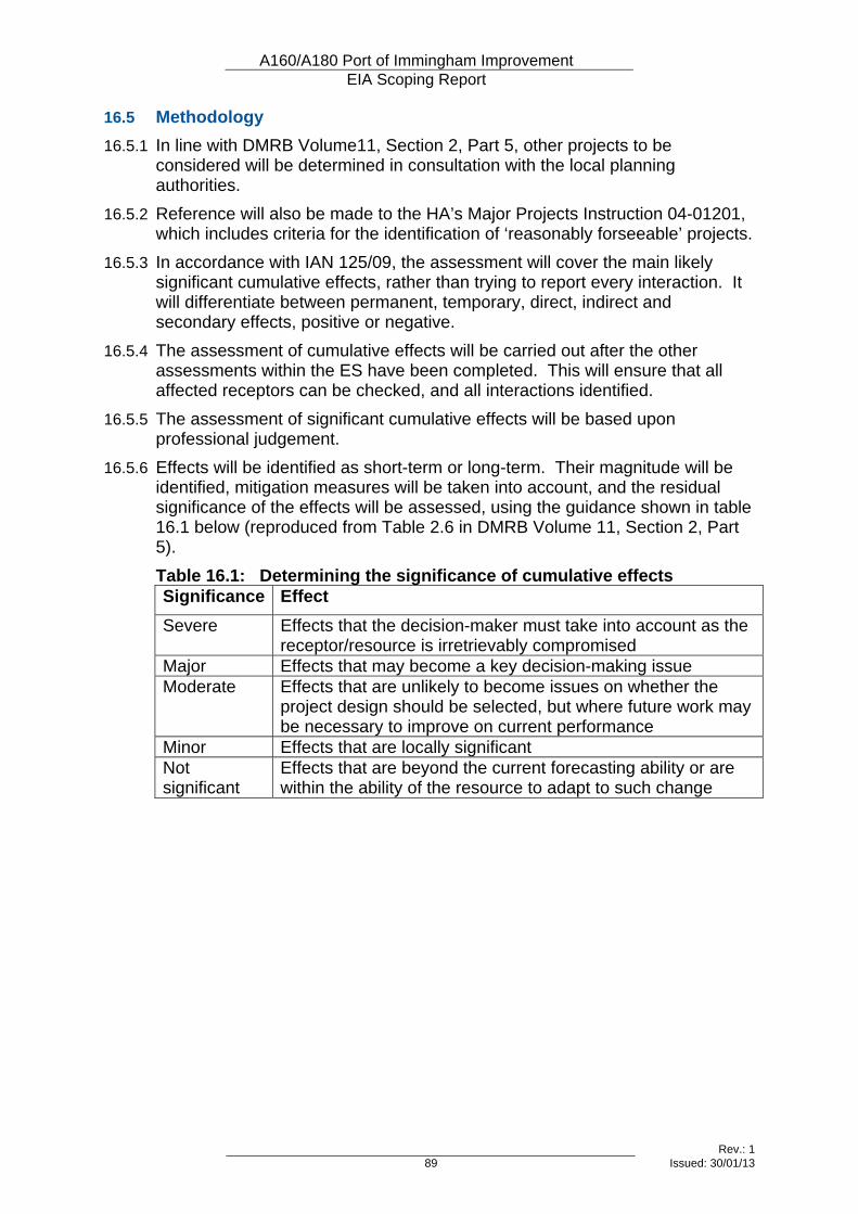
A160/A180 Port of Immingham Improvement EIA Scoping Report
Rev.: 1 89 Issued: 30/01/13
16.5 Methodology 16.5.1 In line with DMRB Volume11, Section 2, Part 5, other projects to be
considered will be determined in consultation with the local planning authorities.
16.5.2 Reference will also be made to the HA’s Major Projects Instruction 04-01201, which includes criteria for the identification of ‘reasonably forseeable’ projects.
16.5.3 In accordance with IAN 125/09, the assessment will cover the main likely significant cumulative effects, rather than trying to report every interaction. It will differentiate between permanent, temporary, direct, indirect and secondary effects, positive or negative.
16.5.4 The assessment of cumulative effects will be carried out after the other assessments within the ES have been completed. This will ensure that all affected receptors can be checked, and all interactions identified.
16.5.5 The assessment of significant cumulative effects will be based upon professional judgement.
16.5.6 Effects will be identified as short-term or long-term. Their magnitude will be identified, mitigation measures will be taken into account, and the residual significance of the effects will be assessed, using the guidance shown in table 16.1 below (reproduced from Table 2.6 in DMRB Volume 11, Section 2, Part 5). Table 16.1: Determining the significance of cumulative effects Significance Effect Severe Effects that the decision-maker must take into account as the
receptor/resource is irretrievably compromised Major Effects that may become a key decision-making issue Moderate Effects that are unlikely to become issues on whether the
project design should be selected, but where future work may be necessary to improve on current performance
Minor Effects that are locally significant Not significant
Effects that are beyond the current forecasting ability or are within the ability of the resource to adapt to such change

A160/A180 Port of Immingham Improvement EIA Scoping Report
Rev.: 1 91 Issued: 30/01/13
Appendix A Glossary AADT Annual Average Daily Traffic ALC Agricultural Land Classification AQMA Air Quality Management Area AQO Air Quality Objective AQS Air Quality Strategy BAP Biodiversity Action Plan BOD Biochemical oxygen demand CEMP Construction Environmental Management Plan CO2e Carbon Dioxide equivalent CPRE Campaign to Protect Rural England CRTN Calculation of Road Traffic Noise dB Decibel DCO Development Consent Order DMRB Design Manual for Roads and Bridges EA Environment Agency ECI Early Contractor Involvement EIA Environmental Impact Assessment ES Environmental Statement EQS Environmental Quality Standards EU European Union GLVIA Guidelines for Landscape and Visual Impact Assessment HA Highways Agency HAWRAT Highways Agency Water Risk Assessment Tool HER Historic Environment Records HDV Heavy Delivery Vehicle / Heavy Duty Vehicle HGV Heavy Goods Vehicle IAN Interim Advice Note IEEM Institute of Ecology and Environmental Management IEMA Institute of Environmental Management and Assessment LAF Local Access Forum LBAP Local Biodiversity Action Plan LNR Local Nature Reserve LVIA Landscape and Visual Impact Assessment
A160/A180 Port of Immingham Improvement EIA Scoping Report
Rev.: 1 92 Issued: 30/01/13
NE Natural England NGOs Non-Governmental Organisations NMR National Monuments Record NMU Non-Motorised User NNR National Nature Reserve NO2 Nitrogen Dioxide NVZ Nitrate Vulnerable Zone PINS Planning Inspectorate PM10 Particulate Matter with a diameter of 10 micrometres or less PPG Planning Policy Guidance PRoW Public Right of Way RBMP River Basin Management Plan RIGS Regionally Important Geological / Geomorphological Site SAC Special Area of Conservation SNCI Site of Nature Conservation Importance SOCC Statement of Community Consultation SPA Special Protection Area SPZ Source Protection Zone SSSI Site of Special Scientific Interest SWMP Site Waste Management Plan TAG Transport Appraisal Guidance UKBAP UK Biodiversity Action Plan WFD Water Framework Directive ZVI Zone of Visual Influence

A160/A180 Port of Immingham Improvement EIA Scoping Report
Rev.: 1 Issued: 30/01/13
Appendix B Figures Figure 1.1 Site Location Plan Figure 1.2 Environmental Features Map Figure 7.1 Cultural Heritage Assets Figure 8.1 Potential Visual Receptors Figure 12.1 Noise and Vibration – Potentially Affected Receptors