Embed Size (px)
Citation preview
Available online at www.sciencedirect.com
www.elsevier.com/locate/asr
ScienceDirect
Advances in Space Research 67 (2021) 812–823
Scientific objectives and payloads of Tianwen-1, China’s firstMars exploration mission
Zou Yongliao a,b,⇑, Zhu Yan a,⇑, Bai Yunfei a, Wang Lianguo a, Jia Yingzhuo a,⇑,Shen Weihua a, Fan Yu a, Liu Yang a,b, Wang Chi a,b, Zhang Aibing a, Yu Guobin c,Dong Jihong d, Shu Rong e, He Zhiping e, Zhang Tielong f, Du Aimin g, Fan Mingyi h,
Yang Jianfeng i, Zhou Bin j, Wang Yi k, Peng Yongqing l
aNational Space Science Center, Chinese Academy of Sciences, Beijing 100190, ChinabState Key Laboratory of Space Weather, National Space Science Center, Chinese Academy of Sciences, Beijing 100190,China
c Institute of Optics and Electronics, Chinese Academy of Sciences, Chengdu 610209, ChinadChangchun Institute of Optics, Fine Mechanics and Physics, Chinese Academy of Sciences, Changchun 130033, China
eShanghai Institute of Technical Physics, Chinese Academy of Sciences, Shanghai 200083, ChinafChinese Academy of Sciences Key Laboratory of Geospace Environment, School of Earth and Space Sciences,
University of Science and Technology of China, Hefei 230026, Chinag Institute of Geology and Geophysics, Chinese Academy of Sciences, Beijing 100029, China
hChina Electronics Technology Group Corporation-38, Hefei 230088, ChinaiXi’an Institute of Optics and Precision Mechanics of Chinese Academy of Sciences, Xi’an 710119, China
jAerospace Information Research Institute, Chinese Academy of Sciences, Beijing 100190, ChinakScience and Technology on Vacuum Technology and Physics Laboratory, Lanzhou Institute of Physics, Lanzhou 730000, China
lBeijing Research Institute of Telemetry, Beijing 100076, China
Received 11 August 2020; received in revised form 2 November 2020; accepted 5 November 2020Available online 13 November 2020
Abstract
This paper describes the scientific objectives and payloads of Tianwen-1, China’s first exploration mission to Mars. An orbiter, car-rying a lander and a rover, lifted-off in July 2020 for a journey to Mars where it should arrive in February 2021. A suite of 13 scientificpayloads, for in-situ and remote sensing, autonomously commanded by integrated payload controllers and mounted on the orbiter andthe rover will study the magnetosphere and ionosphere of Mars and the relation with the solar wind, the atmosphere, surface and sub-surface of the planet, looking at the topography, composition and structure and in particular for subsurface ice. The mission will alsoinvestigate Mars climate history. It is expected that Tianwen-1 will contribute significantly to advance our scientific knowledge of Mars.� 2020 COSPAR. Published by Elsevier Ltd. This is an open access article under the CC BY-NC-ND license (http://creativecommons.org/licenses/by-nc-nd/4.0/).
Keywords: China’s first Mars exploration; Scientific tasks; Scientific payloads
https://doi.org/10.1016/j.asr.2020.11.005
0273-1177/� 2020 COSPAR. Published by Elsevier Ltd.
This is an open access article under the CC BY-NC-ND license (http://creativec
⇑ Corresponding authors at: National Space Science Center, ChineseAcademy of Sciences, Beijing 100190, China (Y. Zou, Y. Zhu, Y. Jia).
E-mail addresses: [email protected] (Y. Zou), [email protected] (Y. Zhu), [email protected] (Y. Jia).
1. Introduction
China’s first Mars exploration mission, Tianwen-1, waslaunched on 23 July 2020 at 12:41 Beijing time from Wen-chang Space Launch Center in Hainan province. Tianwen-1 was delivered directly into the Earth-Mars transfer orbitand is expected to arrive at Mars in February 2021. The
ommons.org/licenses/by-nc-nd/4.0/).
Y. Zou et al. Advances in Space Research 67 (2021) 812–823
spacecraft will be inserted into a Mars parking orbit fol-lowing three periareon braking manoeuvers, from whereit will perform an initial survey of the landing area.Approximately 2–3 months later, the spacecraft will bebriefly placed in a deorbit and entry arc to release the land-ing capsule, from which the capsule with the rover will des-cend and land on the Mars surface. The rover will egressonto the Martian surface a few days after touchdown, fol-lowing an assessment of the terrain surrounding the lander.For at least 92 Martian days, the rover will conduct highresolution in situ surveys in a critical area of Mars.
After releasing the capsule, the orbiter will maneuverto enter into a data relay orbit (265 km � 12,500 km)for the duration of the rover surface mission. Thereafter,the orbiter will be placed on a 265 km � 12,000 kmelliptical orbit to conduct a global survey study for oneMartian year.
2. The scientific objectives of Tianwen-1
The scientific objectives of Tianwen-1 are as follows(Geng et al., 2018; Li et al., 2018):
(1) To study the characteristics of the Martian topogra-phy and geological structure.
(2) To study the characteristic of the soil on the Martiansurface and the distribution of water ice.
(3) To investigate the substance composition of the Mar-tian surface.
(4) To study the ionosphere, surface climate and environ-mental characteristics of Mars.
(5) To study the Martian physical fields (electromag-netic, gravitational) and internal structure.
To achieve the above scientific objectives, there are 13scientific payloads on Tianwen-1, 7 payloads on the orbi-ter, 6 payloads on the rover, and 2 payload controllers sep-arately installed on the orbiter and the rover, respectively.They constitute the scientific payload system.
The scientific payloads mounted on the orbiter include:Moderate Resolution Imaging Camera (MoRIC), High-Resolution Imaging Camera (HiRIC), Mars Orbiter Scien-tific Investigation Radar (MOSIR), Mars MineralogicalSpectrometer (MMS), Mars Orbiter Magnetometer(MOMAG), Mars Ion and Neutral Particle Analyzer(MINPA), Mars Energetic Particles Analyzer (MEPA).The location of the scientific payloads on the orbiter aredisplayed in Fig. 1.
The scientific payloads on the orbiter conduct a globalcomprehensive exploration from the orbit. Their scientificexploration tasks include:
(1) To analyse the Mars ionosphere and survey the inter-planetary environment.
(2) To detect Martian surface and subsurface water ice.(3) To survey the characteristics of soil and structures of
Mars.
813
(4) To survey the characteristics of Martian topographyand geomorphology.
(5) To analyse the composition of the Mars surfacematerial.
The scientific payloads mounted on the rover include:Navigation and Terrain Camera (NaTeCam), Multispec-tral Camera (MSCam), Mars Rover Penetrating Radar(RoPeR), Mars Surface Composition Detector (MarS-CoDe), Mars Rover Magnetometer (RoMAG) and MarsClimate Station (MCS). The location of the scientific pay-loads on the rover is shown in Fig. 2.
After the Mars rover moves away from the landing plat-form to the surface of Mars, its scientific payloads will bepowered on following ground command. The scientificexploration tasks of the Mars rover payloads are:
(1) To study topography and geological structure of theMars roving area.
(2) To survey the soil structure (profile) of the Mars rov-ing area and to search for water ice.
(3) To survey elements, minerals and rock types of theMars roving area.
(4) To survey the atmosphere physical characteristicsand the surface environment of Mars roving area.
The relationship between scientific objectives ofTianwen-1, exploration tasks and scientific payloads isshown in Table 1.
3. Landing area selection
In addition to the safety considerations of the landing,the landing area must meet the requirements of scientificexploration. Initially, two candidate landing locations wereconsidered for the Tianwen-1 rover. As a result of this eval-uation, the landing site has been selected to be in UtopiaPlanitia (Wan et al., 2020). The candidate landing areaon Mars of Tianwen-1 is shown in Fig. 3.
Utopia Planitia is the largest recognized impact basin inthe northern hemisphere of Mars (McGill, 1989). The geo-logical map (Tanaka et al., 2014) shows that the majorityof Utopia Planitia is covered by extensive sedimentarymaterials from Vastitas Borealis interior unit. Analysis ofroughness and slope data show that the Utopia basin ischaracterized by subdued and smooth morphology(Kreslavsky and Head, 2000). Several features in UtopiaBasin have been interpreted as morphological indicatorsof water/ice. The dielectric constant derived from observa-tions by the SHARAD radar of the Mars ReconnaissanceOrbiter (MRO) further confirms the existence of subsurfacewater/ice in the high latitude (Stuurman et al., 2016). TheAmazonian-aged lava flow and lahars emanating fromthe flank of northwest Elysium Rise superpose on the cen-ter of the Utopia basin.
Although currently available spectral data show thatthere are few water-bearing minerals in the roving area
Fig. 1. Location of the scientific payloads on the Orbiter.
Fig. 2. Installation position of scientific payloads on the rover.
Y. Zou et al. Advances in Space Research 67 (2021) 812–823
due to the low spatial resolution. This may be due to thelow spatial resolution of the observations and the presenceof such materials cannot be excluded. The in situ explo-ration by a suite of instruments on the Mars Rover (i.e.,MarSCode) with higher resolution can potentially detecthydrated minerals in the area, and can provide importantclues on the regional and global evolution of the Marsclimate.
4. Scientific payloads of Tianwen-1
4.1. Scientific payloads on the orbiter
4.1.1. Framework of scientific payloads system on orbiter
The scientific payloads system of the orbiter has the pay-load controller as the core, and 7 scientific payloads areintegrated into the system through an internal bus network.
814
The payload-controller interfaces with the orbiter plat-form, and provides electric power, thermal control, com-mand, data collection and processing. The scientificpayloads perform their scientific tasks under the controlof the payload controller. The payload system operatesautonomously and can monitor independently the statusof the system and fix its problems (Zhu et al., 2017). Theframework of scientific payloads system on the orbiter isshown in Fig. 4.
The payload controller can control the scientific pay-loads, execute the mission commands, reduce the data vol-umes, overcome communication bottlenecks and therebyexecute the scientific mission more efficiently. Furthermore,the payload controller is designed to deal with malfunc-tions and to control contingencies. It achieves fault detec-tion, isolation and recovery and system reconfigurationfor the healthy operation of the payload. The payload
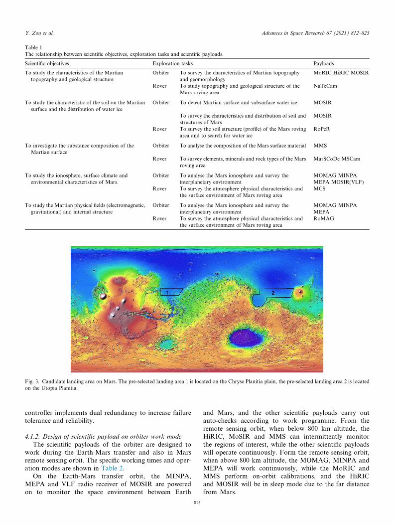
Table 1The relationship between scientific objectives, exploration tasks and scientific payloads.
Scientific objectives Exploration tasks Payloads
To study the characteristics of the Martiantopography and geological structure
Orbiter To survey the characteristics of Martian topographyand geomorphology
MoRIC HiRIC MOSIR
Rover To study topography and geological structure of theMars roving area
NaTeCam
To study the characteristic of the soil on the Martiansurface and the distribution of water ice
Orbiter To detect Martian surface and subsurface water ice MOSIR
To survey the characteristics and distribution of soil andstructures of Mars
MOSIR
Rover To survey the soil structure (profile) of the Mars rovingarea and to search for water ice
RoPeR
To investigate the substance composition of theMartian surface
Orbiter To analyse the composition of the Mars surface material MMS
Rover To survey elements, minerals and rock types of the Marsroving area
MarSCoDe MSCam
To study the ionosphere, surface climate andenvironmental characteristics of Mars.
Orbiter To analyse the Mars ionosphere and survey theinterplanetary environment
MOMAG MINPAMEPA MOSIR(VLF)
Rover To survey the atmosphere physical characteristics andthe surface environment of Mars roving area
MCS
To study the Martian physical fields (electromagnetic,gravitational) and internal structure
Orbiter To analyse the Mars ionosphere and survey theinterplanetary environment
MOMAG MINPAMEPA
Rover To survey the atmosphere physical characteristics andthe surface environment of Mars roving area
RoMAG
Fig. 3. Candidate landing area on Mars. The pre-selected landing area 1 is located on the Chryse Planitia plain, the pre-selected landing area 2 is locatedon the Utopia Planitia.
Y. Zou et al. Advances in Space Research 67 (2021) 812–823
controller implements dual redundancy to increase failuretolerance and reliability.
4.1.2. Design of scientific payload on orbiter work mode
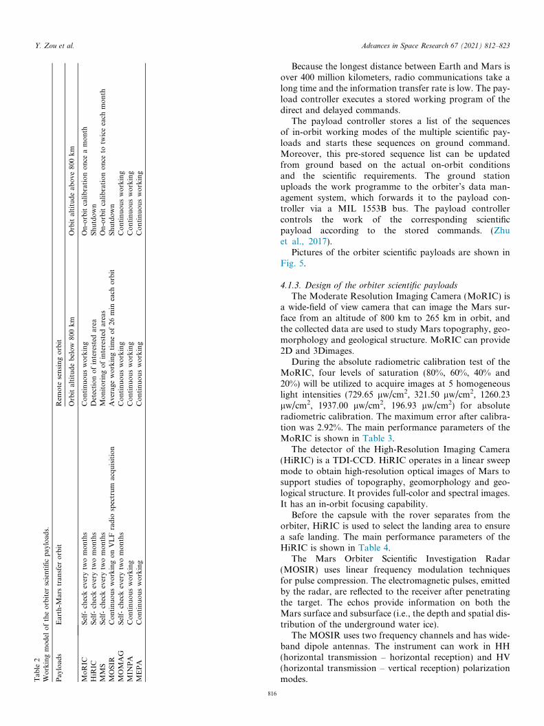
The scientific payloads of the orbiter are designed towork during the Earth-Mars transfer and also in Marsremote sensing orbit. The specific working times and oper-ation modes are shown in Table 2.
On the Earth-Mars transfer orbit, the MINPA,MEPA and VLF radio receiver of MOSIR are poweredon to monitor the space environment between Earth
815
and Mars, and the other scientific payloads carry outauto-checks according to work programme. From theremote sensing orbit, when below 800 km altitude, theHiRIC, MoSIR and MMS can intermittently monitorthe regions of interest, while the other scientific payloadswill operate continuously. Form the remote sensing orbit,when above 800 km altitude, the MOMAG, MINPA andMEPA will work continuously, while the MoRIC andMMS perform on-orbit calibrations, and the HiRICand MOSIR will be in sleep mode due to the far distancefrom Mars.
Tab
le2
Workingmodel
oftheorbiter
scientificpay
load
s.
Payload
sEarth-M
arstran
sfer
orbit
Rem
ote
sensingorbit
Orbitaltitudebelow
800km
Orbitaltitudeab
ove
800km
MoRIC
Self-
checkeverytw
omonths
Continuousworking
On-orbitcalibrationonce
amonth
HiR
ICSelf-
checkeverytw
omonths
Detectionofinterested
area
Shutdown
MMS
Self-
checkeverytw
omonths
Monitoringofinterested
areas
On-orbitcalibrationonce
totw
iceeach
month
MOSIR
ContinuousworkingonVLFradio
spectrum
acquisition
Average
workingtimeof26
min
each
orbit
Shutdown
MOMAG
Self-
checkeverytw
omonths
Continuousworking
Continuousworking
MIN
PA
Continuousworking
Continuousworking
Continuousworking
MEPA
Continuousworking
Continuousworking
Continuousworking
Y. Zou et al. Advances in Space Research 67 (2021) 812–823
816
Because the longest distance between Earth and Mars isover 400 million kilometers, radio communications take along time and the information transfer rate is low. The pay-load controller executes a stored working program of thedirect and delayed commands.
The payload controller stores a list of the sequencesof in-orbit working modes of the multiple scientific pay-loads and starts these sequences on ground command.Moreover, this pre-stored sequence list can be updatedfrom ground based on the actual on-orbit conditionsand the scientific requirements. The ground stationuploads the work programme to the orbiter’s data man-agement system, which forwards it to the payload con-troller via a MIL 1553B bus. The payload controllercontrols the work of the corresponding scientificpayload according to the stored commands. (Zhuet al., 2017).
Pictures of the orbiter scientific payloads are shown inFig. 5.
4.1.3. Design of the orbiter scientific payloads
The Moderate Resolution Imaging Camera (MoRIC) isa wide-field of view camera that can image the Mars sur-face from an altitude of 800 km to 265 km in orbit, andthe collected data are used to study Mars topography, geo-morphology and geological structure. MoRIC can provide2D and 3Dimages.
During the absolute radiometric calibration test of theMoRIC, four levels of saturation (80%, 60%, 40% and20%) will be utilized to acquire images at 5 homogeneouslight intensities (729.65 lw/cm2, 321.50 lw/cm2, 1260.23lw/cm2, 1937.00 lw/cm2, 196.93 lw/cm2) for absoluteradiometric calibration. The maximum error after calibra-tion was 2.92%. The main performance parameters of theMoRIC is shown in Table 3.
The detector of the High-Resolution Imaging Camera(HiRIC) is a TDI-CCD. HiRIC operates in a linear sweepmode to obtain high-resolution optical images of Mars tosupport studies of topography, geomorphology and geo-logical structure. It provides full-color and spectral images.It has an in-orbit focusing capability.
Before the capsule with the rover separates from theorbiter, HiRIC is used to select the landing area to ensurea safe landing. The main performance parameters of theHiRIC is shown in Table 4.
The Mars Orbiter Scientific Investigation Radar(MOSIR) uses linear frequency modulation techniquesfor pulse compression. The electromagnetic pulses, emittedby the radar, are reflected to the receiver after penetratingthe target. The echos provide information on both theMars surface and subsurface (i.e., the depth and spatial dis-tribution of the underground water ice).
The MOSIR uses two frequency channels and has wide-band dipole antennas. The instrument can work in HH(horizontal transmission – horizontal reception) and HV(horizontal transmission – vertical reception) polarizationmodes.
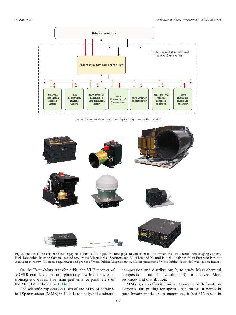
Fig. 4. Framework of scientific payloads system on the orbiter.
Fig. 5. Pictures of the orbiter scientific payloads (from left to right, first row: payload-controller on the orbiter, Moderate-Resolution Imaging Camera,High-Resolution Imaging Camera; second row: Mars Mineralogical Spectrometer, Mars Ion and Neutral Particle Analyzer, Mars Energetic ParticlesAnalyzer; third row: Electronic equipment and probes of Mars Orbiter Magnetometer, Master processor of Mars Orbiter Scientific Investigation Radar).
Y. Zou et al. Advances in Space Research 67 (2021) 812–823
On the Earth-Mars transfer orbit, the VLF receiver ofMOSIR can detect the interplanetary low-frequency elec-tromagnetic waves. The main performance parameters ofthe MOSIR is shown in Table 5.
The scientific exploration tasks of the Mars Mineralog-ical Spectrometer (MMS) include 1) to analyze the mineral
817
composition and distribution; 2) to study Mars chemicalcomposition and its evolution; 3) to analyze Marsresources and distribution.
MMS has an off-axis 3 mirror telescope, with free-formelements, flat grating for spectral separation. It works inpush-broom mode. As a maximum, it has 512 pixels in
Table 3Main performance parameters of the MoRIC.
Spectral range visible spectrum (430–690 nm)
Color standard R,G,BResolution better than 100 m@400 km;Imaging width 400 km@400 km orbit altitude;Effective pixel number 4096 � 3072Mass 3.5 kgPower 20 WData rate �16 Mbps
Y. Zou et al. Advances in Space Research 67 (2021) 812–823
the spatial dimension and 576 channels in the spectraldimension. The instrument can select suitable combina-tions of spatial and spectral dimensions as required bythe scientific needs. Calibration is achieved by means ofthe Sun and a lamp.
The radiometric calibration of MMS was measured byreference light sources (integrating sphere and black body)with different energy levels. The error in absolute radiomet-ric calibration for two integration time levels (5.15 ms and44.6 ms) in the V-NIR channel is below 7.5%, while the
Table 4Main performance parameters of the HiRIC.
Resolution (at 265 km orbit altitude) Panchromatic: bettColor: better than 1
Spectral bands Panchromatic: 0.45color: blue 0.45–0.5
Coverage width 9 km@265 kmMass 43 kgPower 127 WData rate �2254 Mbps
Table 5Main performance parameters of the MOSIR.
FrequencyDetecting depth
Thickness resolutionMassPowerData generation rate
*e: Dielectric constant, c: dielectric loss, ec represents the electromagnetic scpenetration depth of electromagnetic waves in soil or water ice.
Table 6Main performance parameters of the MMS.
Spectral region Visible-near infrared, 0.Near-infrared and mid-w
Spectral resolution visible-near infrared, beNear-infrared and mid-wbetter than 12 [email protected]–better than 20 [email protected]–
Spatial resolution 2.8 km@265 km, The saMass 7.2 kgPower 48 WDate rate �3.8 Mbps
818
error in absolute radiometric calibration for each integra-tion time (1.5–2.3 ms) in the N-MIR region is below8.5%. The main performance parameters of the MMS isshown in Table 6.
The Mars Orbiter Magnetometer (MOMAG) is a flux-gate magnetometer to measure the magnetic field. By mea-suring the magnetic field environment of Mars, MOMAGcan be used to study the interaction mechanism betweenthe Martian ionosphere, the magneto-sheath and the solarwind.
MOMAG has a dual fluxgate probe sensor mounted onthe special stretching pole, and uses a dual probes gradientmethod to eliminate the influence of the magnetic field ofthe Tianwen-1 spacecraft on the magnetometer measure-ments. The main performance parameters of the MOMAGis shown in Table 7.
The Mars Ion and Neutral Particle Analyzer (MINPA)is used to detect low energy ions and neutral particles in thespace plasma environment of Mars, and to understand howand why the Martian atmosphere escaped and the acceler-ation mechanism of neutral particles near the Martianshock wave.
er than 2.5 m, in key areas better than 0.5 m;0 m, in key areas better than 2.0 m;–0.9 um2 um, green 0.52–0.60 um, red 0.63–0.69 um, near-infrared 0.76–0.90 um
10–20 MHz, 30–50 MHz;Mars subsurface structure, ~100 m (soil, ec* = 3.0 ~ 4.0),ice, ~1000 m (ice, ec* = 3.0)
meter level28 kg67 W�1 Mbps
attering and radiation characteristics of a substance, used to retrieve the
45–1.05 um;ave infrared, 1.00–3.40 um;
tter than 6 nm;ave infrared:2.0 um,3.4 ummpling points in the field of view �3, Field of view for each point �0.6�
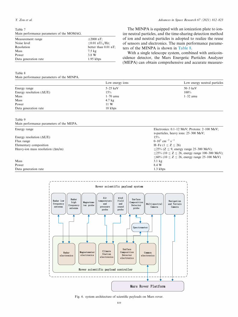
Table 7Main performance parameters of the MOMAG.
Measurement range ±2000 nT;Noise level �0.01 nT/
pHz;
Resolution better than 0.01 nT;Mass 7.5 kgPower 3.8 WData generation rate 1.95 kbps
Table 8Main performance parameters of the MINPA.
Low energy
Energy range 5–25 keVEnergy resolution (DE/E) 15%Mass 1–70 amuMass 4.7 kgPower 11 WData generation rate 18 kbps
Table 9Main performance parameters of the MEPA.
Energy range
Energy resolution (DE/E)Flux rangeElementary compositionHeavy-ion mass resolution (Dm/m)
MassPowerData generation rate
Fig. 6. system architecture of scien
Y. Zou et al. Advances in Space Research 67 (2021) 812–823
819
The MINPA is equipped with an ionization plate to ion-ize neutral particles, and the time-sharing detection methodof ion and neutral particles is adopted to realize the reuseof sensors and electronics. The main performance parame-ters of the MINPA is shown in Table 8.
With a single telescope system, combined with anticoin-cidence detector, the Mars Energetic Particles Analyzer(MEPA) can obtain comprehensive and accurate measure-
ions Low energy neutral particles
50–3 keV100%1–32 amu
Electronics: 0.1–12 MeV; Protons: 2–100 MeV;a-particles, heavy ions: 25–300 MeV;15%0–105 cm�2 s�1
H–Fe (1 � Z � 26)�25% (Z � 9, energy range 25–300 MeV);�25% (10 � Z � 26, energy range 100–300 MeV);�60% (10 � Z � 26, energy range 25–100 MeV)3.1 kg8.4 W1.3 kbps
tific payloads on Mars rover.
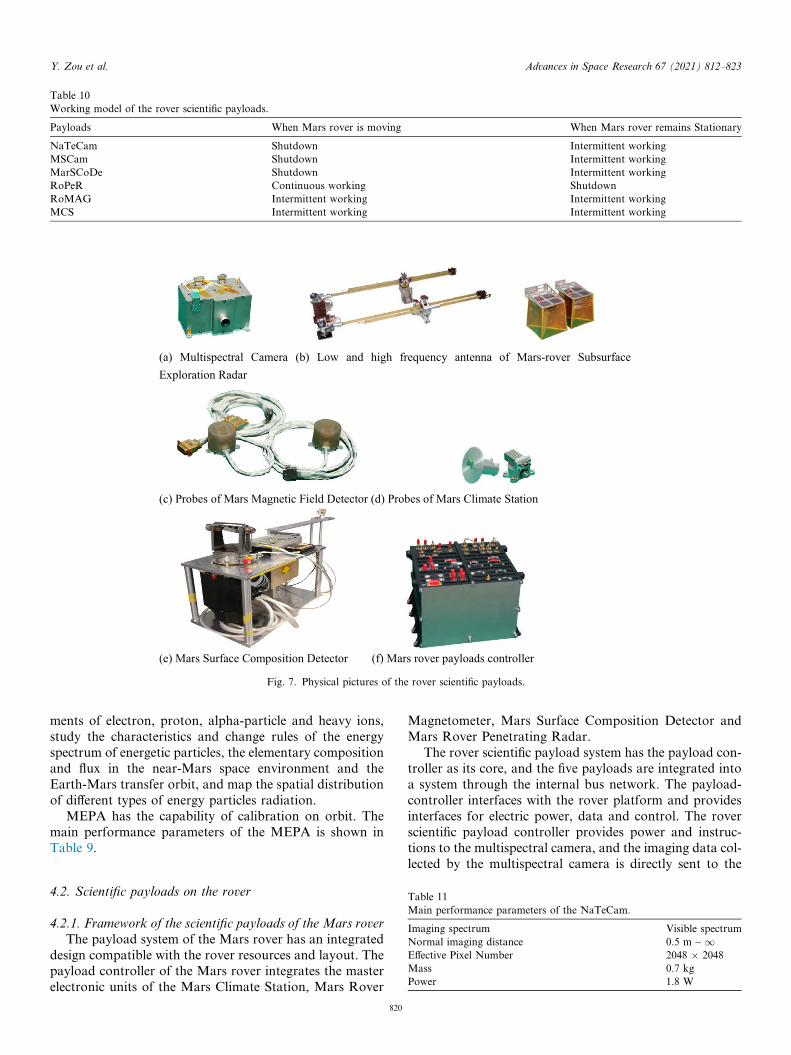
Fig. 7. Physical pictures of the rover scientific payloads.
Table 10Working model of the rover scientific payloads.
Payloads When Mars rover is moving When Mars rover remains Stationary
NaTeCam Shutdown Intermittent workingMSCam Shutdown Intermittent workingMarSCoDe Shutdown Intermittent workingRoPeR Continuous working ShutdownRoMAG Intermittent working Intermittent workingMCS Intermittent working Intermittent working
Y. Zou et al. Advances in Space Research 67 (2021) 812–823
ments of electron, proton, alpha-particle and heavy ions,study the characteristics and change rules of the energyspectrum of energetic particles, the elementary compositionand flux in the near-Mars space environment and theEarth-Mars transfer orbit, and map the spatial distributionof different types of energy particles radiation.
MEPA has the capability of calibration on orbit. Themain performance parameters of the MEPA is shown inTable 9.
Table 11Main performance parameters of the NaTeCam.
Imaging spectrum Visible spectrumNormal imaging distance 0.5 m ~ 1Effective Pixel Number 2048 � 2048Mass 0.7 kgPower 1.8 W
4.2. Scientific payloads on the rover
4.2.1. Framework of the scientific payloads of the Mars rover
The payload system of the Mars rover has an integrateddesign compatible with the rover resources and layout. Thepayload controller of the Mars rover integrates the masterelectronic units of the Mars Climate Station, Mars Rover
820
Magnetometer, Mars Surface Composition Detector andMars Rover Penetrating Radar.
The rover scientific payload system has the payload con-troller as its core, and the five payloads are integrated intoa system through the internal bus network. The payload-controller interfaces with the rover platform and providesinterfaces for electric power, data and control. The roverscientific payload controller provides power and instruc-tions to the multispectral camera, and the imaging data col-lected by the multispectral camera is directly sent to the
Y. Zou et al. Advances in Space Research 67 (2021) 812–823
rover platform. The Navigation and Terrain cameras aredirectly connected to the rover platform (Zhu et al.,2017). The system architecture of scientific payloads onMars rover is shown in Fig. 6.
The rover payload controller, like the orbiter payloadcontroller, is capable of autonomous operation, runninga stored working programme. The common electronics ofthe rover payload controller is redundant in design. It alsohas the autonomous capability of fault detection, isolationand recovery (FDIR) and system configuration.
The payload controller stores a list of the sequences ofin-orbit working modes of the scientific payloads and startsthese sequences on ground commands. Moreover, this pre-stored sequence list can be updated from the ground basedon actual in-situ conditions and the scientific requirements.The ground station uploads the working programme to therover’s data management system, which forwards it to therover payload controller via a MIL 1553B bus. The roverpayload controller controls the work of the correspondingscientific payload according to the stored commands andmanagement software.
4.2.2. Working mode of the scientific payloads on Mars rover
The scientific payloads of the Mars rover will choose thetime to work according to the environmental conditions.The NaTeCam, MSCam and MarSCoDe work while therover is in a stationary mode, and the RoPeR works whenthe rover is moving, and the RoMAG and MCS can beselected to work during the moving and stationary condi-tions of the rover. The in situ working modes of the Marsrover payloads are shown in Table 10. (Zhu et al., 2017).
Physical pictures of the rover scientific payloads areshown in Fig. 7.
4.2.3. Design of the scientific payloads of the Mars rover
There are two Navigation and Terrain Cameras (NaTe-Cam) with identical function, performance and interfaces.They are installed on the mast of the rover to conductthree-dimensional panoramic imaging of the Mars surface,study topography and geological structure of the rovingarea. They also have a navigation function. The main per-formance parameters of the NaTeCam is shown inTable 11.
The Multispectral Camera (MSCam) is installed on themast of the rover. According to the pointing direction of
Table 12Main performance parameters of the MSCam.
Spectral bands and resolution (nm) There are nine spectral bandsand panchromatic note: num
Normal imaging distance 1.5 m ~ 1Effective Pixel Number 2048 � 2048Mass 1.65 kgPower �8 WData rates 25 Mbps
821
the mast, the MSCam can get multispectral images of thelanding and roving areas and study the types of Mars sur-face materials and their distribution. The MSCam uses afilter wheel and has a compensation mirror for automaticfocusing. The MSCam calibration is achieved by imagingthe standard calibration board installed on the Mars rover.The main performance parameters of the MSCam is shownin Table 12.
The Mars Rover Penetrating Radar (RoPeR) can obtainfull-polarization echo data with ultra-wide band, which canbe used to study the soil and ice thickness and structure ofthe Mars surface and subsurface.
The RoPeR has two channels centered at 55 MHz and1300 MHz respectively. The low-frequency channel useslinear frequency modulation (LFM) signals and has a pairof monopole antennas to probe the Mars ground down to100 m depth with a vertical resolution of 1 m. The high-frequency channel uses frequency-modulated interruptedcontinuous wave (FMICW) signals and Vivaldi antennasto probe the superficial layers of Mars down to 10 m withcm level resolution. The main performance parameters ofthe RoPeR is shown in Table 13.
The Mars Surface Composition Detector (MarSCoDe)is a spectral detection instrument with a combination ofactive-passive detection techniques. MarSCode has alaser-induced breakdown spectroscopy (LIBS) spectrome-ter analyzing the laser-excited plasma from the ultraviolet(UV) to near-infrared ray (NIR). MarSCoDe also has apassive spectrometer operating from the NIR to theshort-wave infrared (SWIR), which uses Acousto OpticalTunable Filters (AOTF) for band selection. Combiningthese techniques MarSCoDe can analyze the compositionof the surface materials and identify the different types ofrocks.
The calibration of the LIBS instrument and the passivespectrometer is achieved using dedicated calibration tar-gets. The LIBS calibration board has 12 standard samples,including simple minerals as graphite, titanium and mixedminerals as obsidian, norite, picrite, kaolinite and chlorite.The main performance parameters of the MarSCoDe isshown in Table 14.
The Mars Rover Magnetometer (MoMAG) is a fluxgatemagnetometer. The probes are mounted on the mast of therover to detect the magnetic field of the landing and rovingarea. There are two probes to eliminate by subtraction the
: 480(20), 525(20), 650(12), 700(15), 800(25), 900(30), 950 (50), 1000 (50),bers with bracket is FWHM
Table 13Main performance parameters of the RoPeR.
First channel Second channel
Center frequency 55 MHz 1300 MHzBandwidth 15–95 MHz 450–2150 MHzResolution of thickness meter level(for ice) centimeter level,Detection depth �100 m(ice, ec* = 3.0)
�10 m(soil, ec* = 3.0–4.0)�10 m(ice, ec* = 3.0)�3 m(soil, ec* = 3.0–4.0)
Mass 6.1 kgPower 26.5 WData rate �1 Mbps
Table 14Main performance parameters of the MarSCoDe.
LIBS spectrometer
Types of element No less than 10 element (Si, Al, Fe, Mg, Ca, Na, O, C, H, Mn, Ti, S etc.)Spectral resolution 0.1 nm@240–340 nm
0.2 nm@340–540 nm0.3 nm@540–850 nm
Wavelength of the laser 1064 nm ± 15 nmPulse energy density �10 MW/mm2
Passive spectrometerSpectral range 850–2400 nmSpectral resolution 3–12 nmNumber of spectral bands 321 bands@5 nm samplingMass 16.4 kgPower 64 WData rate �1 Mbps
Table 15Main performance parameters of the MoMAG.
Measure range ±2000 nTResolution better than 0.01 nTNoise level �0.01 nT/
pHz
Mass 1.05 kgPower 5.5 WData rate �1 Mbps
Y. Zou et al. Advances in Space Research 67 (2021) 812–823
parasitic magnetic effects of the rover. RoMAG works withthe orbiter MOMAG to detect the Martian space magneticfield and retrieve the currents of the Martian ionosphere.
Table 16Main performance parameters of the MCS.
Temperature
Measure range �130 �C to +70 �CResolution 0.1 �C
Wind speedMeasure range 0–70 m/sResolution 0–10 m/s: Better than 0.2 m/s
10–20 m/s: Better than 0.3 m/s20–70 m/s: Better than 0.5 m/s
SoundFrequency range 20 Hz–2.5 kHz, 2.5–20 kHzDynamic range �90 dBMass 1.75 kgPower 11 WData rate �1 Mbps
822
The main performance parameters of the MoMAG isshown in Table 15.
The Mars Climate Station (MCS) uses micro electromechanical system (MEMS) capacitive type micro pressuretransducer, MEMS hot-film anemometer, a Fabry-Perotinterferometer (EFPI) optical fiber acoustic sensor, and aset of thermometric platinum resistors. MCS can obtainkey atmospheric state data such as temperature, pressure,wind speed and direction to monitor Martian surface mete-orology. The main performance parameters of the MCS isshown in Table 16.
Pressure
Measure range 1–2000 PaResolution 0.1 Pa
Wind directionMeasure range 0–360�Resolution 5�
Sensitivity Better than 50 mV/Pa
Y. Zou et al. Advances in Space Research 67 (2021) 812–823
5. Conclusions
The article introduces the exploration tasks, physical,functional, performance and operational design of theTianwen-1 scientific payloads. Through their flexible sys-tem and operational design, the payloads can perform theirtasks and thus achieve the mission objectives. All the scien-tific payloads have been tested and calibrated on theground and their performance results meet therequirements.
‘‘Tianwen-1” is the first mission of China’s deep explo-ration plan. It will carry out a comprehensive study ofMars by orbiting, landing and roving. It will achieve globaland locally detailed surveys from the orbiter and the rover,respectively. With the Tianwen-1 scientific data, studies willbe conducted on Mars magnetosphere and ionosphere, sur-face and sub-surface, and the results will make significantcontributions to Mars science.
Declaration of Competing Interest
We declare that we have no financial and personal rela-tionships with other people or organizations that can inap-propriately influence our work, there is no professional orother personal interest of any nature or kind in any pro-duct, service and/or company that could be construed asinfluencing the position presented in, or the review of, themanuscript entitled.
Acknowledgement
This work is supported by the National Science Founda-tion of China (Grant No. 41590851, 42072337, 11941001),
823
the Beijing Municipal Science and Technology Commis-sion (Grant No. Z191100004319001, Z181100002918003),and by the Pre-research project on Civil Aerospace Tech-nologies No. D020102 and No. D020101 funded by ChinaNational Space Administration (CNSA).
References
Geng, Y., Zhou, J.S., Li, S., et al., 2018. Review of first Mars explorationmission in China. J. Deep Space Explorat. 5 (05), 399–405.
Kreslavsky, M.A., Head, J.W., 2000. Kilometer-scale roughness of Mars:Results from MOLA data analysis. J. Geophys. Res. Planets 105,26695–26711.
Li, C.L., Liu, J.J., Geng, Y., et al., 2018. Scientific objectives and payloadconfiguration of China’s first Mars exploration mission. J. Deep SpaceExplorat. 5 (05), 406–413.
McGill, G.E., 1989. Buried topography of Utopia, Mars: Persistence of agiant impact depression. J. Geophys. Res. Solid Earth 94, 2753–2759.
Stuurman, C.M., Osinski, G.R., Holt, J.W., Levy, J.S., Brothers, T.C.,Kerrigan, M., Campbell, B.A., 2016. SHARAD detection and char-acterization of subsurface water ice deposits in Utopia Planitia, Mars.Geophys. Res. Lett. 43, 9484–9491. https://doi.org/10.1002/2016GL070138.
Tanaka, K.L., Robbins, S.J., Fortezzo Jr., C.M., Skinner, J.A., Hare, T.M., 2014. The digital global geologic map of Mars: Chronostrati-graphic ages, topographic and crater morphologic characteristics, andupdated resurfacing history q. Planet. Space Sci. 95, 11–24.
Wan, W.X., Wang, C., Li, C.L., et al., 2020. China’s first mission to Mars.Nat. Astron. 4, 721.
Zhu, Y., Bai, Y.F., Wang, L.G., et al., 2017. Integral technical scheme ofpayloads system for Chinese Mars-1 exploration. J. Deep SpaceExplorat. 4 (06), 510–514.