Embed Size (px)
Citation preview

Science Tutor: Earth & Space Science
ii© Mark Twain Media, Inc., Publishers
Table of Contents
Introduction/How to Use This Book .........1
Part 1: Earth—A Wild and Changing
Planet ....................................................2
A Planet in Constant, if Slow, Motion .....2
Shakin’ With Quakes ..............................3
Volcanic Cauldrons ................................4
Patterns of Earth Activity and
Plate Tectonics ..................................5
Minerals and Their Uses ........................6
Igneous, Sedimentary, and
Metamorphic Rocks ..........................7
The Rock Cycle ......................................8
Fossils: Images From Life’s Past ............9
Weathering, Erosion, and Deposition ...10
Putting It All Together ...........................11
Part 2: Energy and the Atmosphere .......13
Earth’s Heat Engine .............................13
Changes in Air Pressure ......................14
Blowin’ in the Wind ...............................15
Cloud Nine and Other Vaporous
Collections ......................................16
Making Sense of Weather Patterns ......17
Predicting the Weather .........................18
Persistent Weather: Climate .................19
Climate by the Zone .............................20
Putting It All Together ...........................21
Part 3: Sailing in the Hydrosphere .........23
Water—A Unique Compound ...............23
Water’s Changing Phases ....................24
Earth’s Water Reservoirs .....................25
Salt Water Tales ...................................26
Tides and Currents ...............................27
The Water Cycle: Travels With Dripp ....28
Pollution of Water Resources ...............29
Human Impact on Water Reserves ......30
Putting It All Together ...........................31
Part 4: Earth’s Cosmic Neighborhood ...33
The Parts of a Solar System .................33
Our System’s Place in the Cosmos ......34
Sizes and Distances in Our Solar
System ............................................35
Planets, Moons, and Rings ..................36
The Earth-Moon “Double Planet”
System ............................................37
Impacts and Collisions, Past and
Present ...........................................38
Rotations and Revolutions: Days and
Seasons ..........................................39
The Phases of the Moon ......................40
Eclipses—Solar and Lunar ...................41
Gravity and the Movements of the
Planets ............................................42
Putting It All Together ...........................43
Answer Keys ............................................45
Table of Contents
Science Tutor: Earth & Space Science
1© Mark Twain Media, Inc., Publishers
Introduction/How to Use This Book
Introduction/How to Use This Book
Science Tutor: Earth & Space Science explores the nature of our amazing planet Earth and its place within the solar system and universe at large. Part 1: Earth—A Wild and Chang-ing Planet looks at Earth’s physical resources and internal structure, covering such topics as earthquakes, volcanoes, plate movements, the rock cycle, and fossils. Part 2: Energy and the Atmosphere reveals how solar energy churns through our atmosphere and provides the weath-er and climates so important to the biosphere. Part 3: Sailing in the Hydrosphere focuses on the critical importance of water in its several forms, how it cycles over time and space, and how human activities impact its quality. Part 4: Earth’s Cosmic Neighborhood surveys other planets and objects in our immediate neighborhood, illustrates the causes of days and seasons, exam-ines our moon’s impact on tides and other phenomena, and looks at Earth’s place in the larger universe. All of these topics parallel national science teaching standards for the Earth Sciences in middle school and above. Key terms appear boldfaced in the text. Absorb sections introduce new concepts. Apply sections allow the reader to exercise his or her knowledge of the content and concepts by answering questions, filling in the blanks, and engaging in short activities. A few exercises will require additional paper. A calculator may also be useful, especially for Sizes and Distanc-es in the Solar System. At the end of each section, the student is invited to “put it all together” and test his or her understanding of that section. Because a lot of ground is covered in a short space, the visuals become especially important. Good illustrations and diagrams certainly do convey a large portion of the informa-tional content and serve to organize ideas in a readily absorbable form. Some of the activities suggested in Part 4 will require a light source, an apple, a pushpin, a soccer ball, and a tennis ball to help students visualize movements and relationships between Earth, the sun, and the moon. Add other visuals, like a map of the solar system and galaxy. If available, and if time permits, lead students to relevant websites, such as the following: United States Geological Service at www.usgs.gov/ and www.usgs.gov/education and National Aeronautics and Space Administration at www.nasa.gov/.

Science Tutor: Life Science
2© Mark Twain Media, Inc., Publishers
Part 1: Earth—A Wild and Changing Planet in Constant, if Slow, Motion
Part 1: Earth—A Wild and Changing PlanetA Planet in Constant, if Slow, Motion
Earth rocks! It also slips, folds, tilts, and breaks in a process called defor-mation. Over periods of years, centuries, and millennia, these Earth move-ments can result in earthquakes, volcanic eruptions, and other processes hu-
man beings sometimes witness directly. Over long periods of time, entire mountain ranges can rise, valleys can form, and rivers can sculpt rock into strange and delightful forms. All of this motion results from stress induced from heat deep within Earth’s core acting on the relatively cool and brittle layer of rocks forming Earth’s crust. Continental crust averages 32 kilometers (km) in thickness, although it can be 70 km thick beneath mountains. Oceanic crust tends to be about 8 km thick. Stress can result in forces of compression, tension, or shear-ing. When rocks are compressed, put under tension by being pulled apart, or sheared from side to side, the rocks may fracture, fault, or fold. Fractures are simple cracks like the kind that form when mud dries, but on a much larger scale. Faults are places where rocks break and then slide against one another—usually either up and down or side to side. When compression causes one side of a faulted rock to slide over the other, a thrust fault results, which may change the normal layered pattern of rocks.
Sometimes, as in an area of western North America called the Cordilleran mountain region, entire fault-block mountain ranges may rise. Down-dropped blocks may create rift valleys, like Death Valley in California. When rocks are hot enough or under enough pressure, they may fold instead of break. An anticline folds upward, while a syncline dips downward. The Appalachian Mountains of eastern North America display many anticlines and synclines. Hot liquefied rock called magma beneath the crust may cause rock to form a dome,rather like a rocky zit. Many of the rounded peaks found in the Black Hills of South Dakota are dome mountains of this sort.
Plateaus are large areas of flat land raised above the general level of surrounding land. Plateaus may result from domes whose tops have been gnawed flat by the forces of erosion or from large blocks of land thrust up between faults, as is the case for an area in the Rocky Mountains called the Colorado Plateau, which includes parts of Colorado, New Mexico, Utah, and Arizona. Satellites provide pictures that clearly show that Earth resembles a very wrinkled hide upon which we humans crawl, like ants on an elephant’s back. Let’s look more closely at some of the surprises our “elephant” provides as it twitches and squirms beneath us.
Normal Fault Reverse Fault Thrust Fault
Science Tutor: Earth & Space Science
3© Mark Twain Media, Inc., Publishers
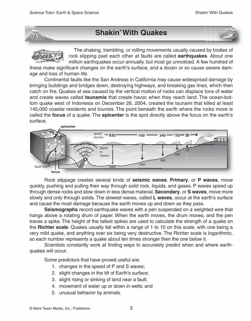
epicenter
focus
Shakin’ With Quakes
Shakin’ With Quakes
The shaking, trembling, or rolling movements usually caused by bodies of rock slipping past each other at faults are called earthquakes. About one million earthquakes occur annually, but most go unnoticed. A few hundred of
these make significant changes on the earth’s surface, and a dozen or so cause severe dam-age and loss of human life. Continental faults like the San Andreas in California may cause widespread damage by bringing buildings and bridges down, destroying highways, and breaking gas lines, which then catch on fire. Quakes at sea caused by the vertical motion of rocks can displace tons of water and create waves called tsunamis that create havoc when they reach land. The ocean-bot-tom quake west of Indonesia on December 26, 2004, created the tsunami that killed at least 145,000 coastal residents and tourists. The point beneath the earth where the rocks move is called the focus of a quake. The epicenter is the spot directly above the focus on the earth’s surface.
Rock slippage creates several kinds of seismic waves. Primary, or P waves, move quickly, pushing and pulling their way through solid rock, liquids, and gases. P waves speed up through dense rocks and slow down in less dense material. Secondary, or S waves, move more slowly and only through solids. The slowest waves, called L waves, occur at the earth’s surface and cause the most damage because the earth moves up and down as they pass.
Seismographs record earthquake waves with a pen suspended on a weighted wire that hangs above a rotating drum of paper. When the earth moves, the drum moves, and the pen traces a spike. The height of the tallest spikes are used to calculate the strength of a quake on the Richter scale. Quakes usually fall within a range of 1 to 10 on this scale, with one being a very mild quake, and anything over six being very destructive. The Richter scale is logarithmic, so each number represents a quake about ten times stronger then the one below it. Scientists constantly work at finding ways to accurately predict when and where earth-quakes will occur.
Some predictors that have proved useful are: 1. changes in the speed of P and S waves; 2. slight changes in the tilt of Earth’s surface; 3. slight rising or sinking of land near a fault; 4. movement of water up or down in wells; and 5. unusual behavior by animals.
Science Tutor: Earth & Space Science
4© Mark Twain Media, Inc., Publishers
Volcanic Cauldrons
Volcanic Cauldrons
The historian Will Durant used to say “Civilization exists by geologic con-sent, subject to change without notice.” This observation was inspired, in part, by volcanic eruptions that not only kill people close to them, but may
affect climate on a worldwide scale for many years, as did the eruption of Tambora in 1815 that made 1816 the “year without a summer,” especially in northern Europe and North America.
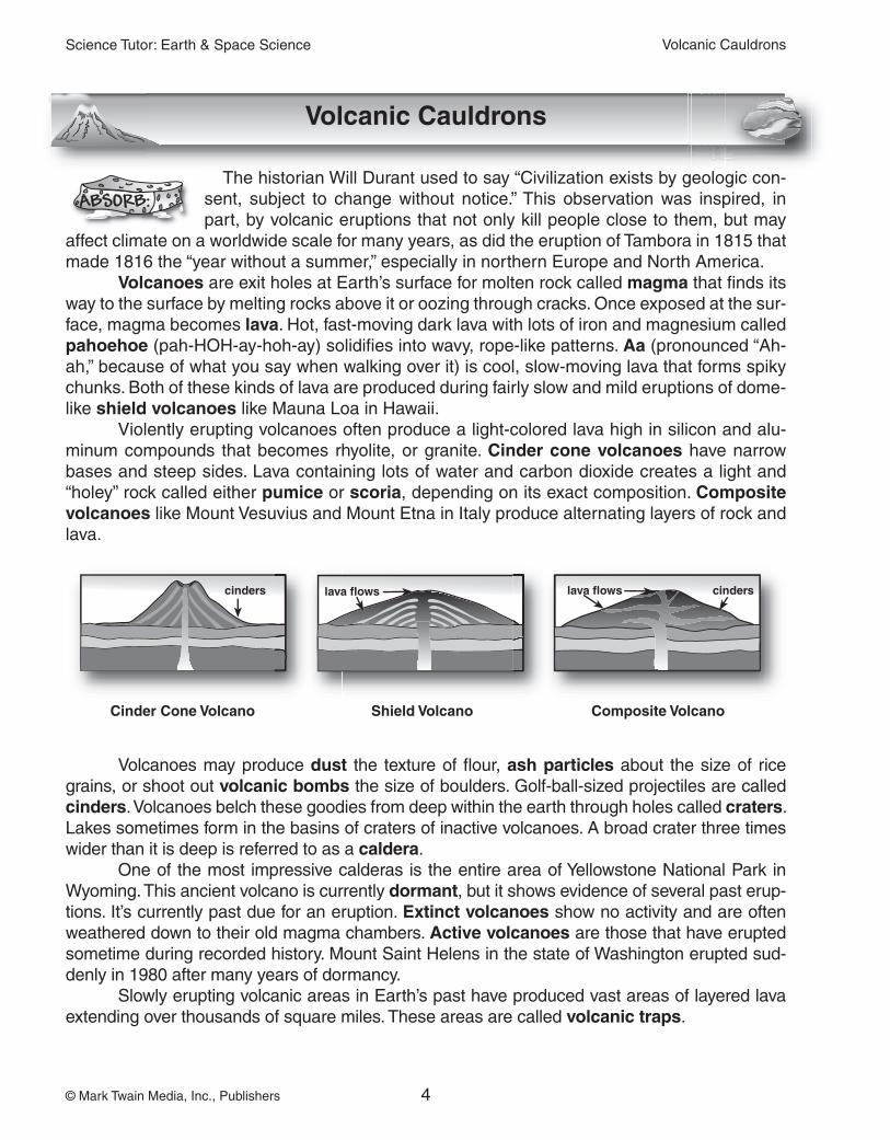
Volcanoes are exit holes at Earth’s surface for molten rock called magma that finds its way to the surface by melting rocks above it or oozing through cracks. Once exposed at the sur-face, magma becomes lava. Hot, fast-moving dark lava with lots of iron and magnesium called pahoehoe (pah-HOH-ay-hoh-ay) solidifies into wavy, rope-like patterns. Aa (pronounced “Ah-ah,” because of what you say when walking over it) is cool, slow-moving lava that forms spiky chunks. Both of these kinds of lava are produced during fairly slow and mild eruptions of dome-like shield volcanoes like Mauna Loa in Hawaii. Violently erupting volcanoes often produce a light-colored lava high in silicon and alu-minum compounds that becomes rhyolite, or granite. Cinder cone volcanoes have narrow bases and steep sides. Lava containing lots of water and carbon dioxide creates a light and “holey” rock called either pumice or scoria, depending on its exact composition. Composite volcanoes like Mount Vesuvius and Mount Etna in Italy produce alternating layers of rock and lava.
Volcanoes may produce dust the texture of flour, ash particles about the size of rice grains, or shoot out volcanic bombs the size of boulders. Golf-ball-sized projectiles are called cinders. Volcanoes belch these goodies from deep within the earth through holes called craters. Lakes sometimes form in the basins of craters of inactive volcanoes. A broad crater three times wider than it is deep is referred to as a caldera. One of the most impressive calderas is the entire area of Yellowstone National Park in Wyoming. This ancient volcano is currently dormant, but it shows evidence of several past erup-tions. It’s currently past due for an eruption. Extinct volcanoes show no activity and are often weathered down to their old magma chambers. Active volcanoes are those that have erupted sometime during recorded history. Mount Saint Helens in the state of Washington erupted sud-denly in 1980 after many years of dormancy. Slowly erupting volcanic areas in Earth’s past have produced vast areas of layered lava extending over thousands of square miles. These areas are called volcanic traps.
cinders lava flows lava flows cinders
Cinder Cone Volcano Shield Volcano Composite Volcano
Science Tutor: Earth & Space Science
5© Mark Twain Media, Inc., Publishers
Patterns of Earth Activity and Plate Tectonics
Patterns of Earth Activity and Plate Tectonics
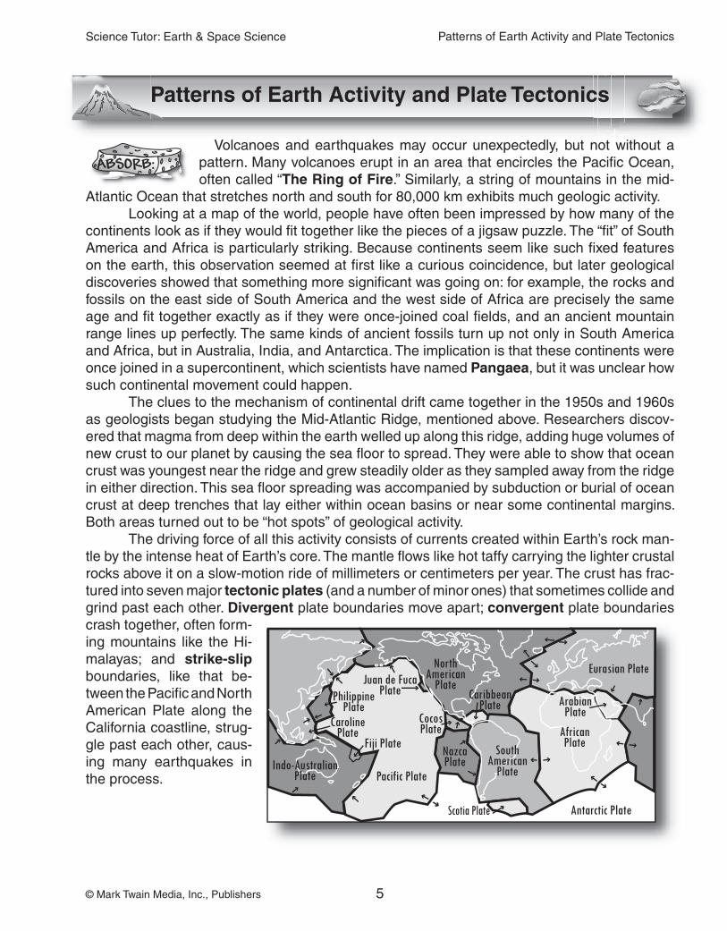
Volcanoes and earthquakes may occur unexpectedly, but not without a pattern. Many volcanoes erupt in an area that encircles the Pacific Ocean, often called “The Ring of Fire.” Similarly, a string of mountains in the mid-
Atlantic Ocean that stretches north and south for 80,000 km exhibits much geologic activity. Looking at a map of the world, people have often been impressed by how many of the continents look as if they would fit together like the pieces of a jigsaw puzzle. The “fit” of South America and Africa is particularly striking. Because continents seem like such fixed features on the earth, this observation seemed at first like a curious coincidence, but later geological discoveries showed that something more significant was going on: for example, the rocks and fossils on the east side of South America and the west side of Africa are precisely the same age and fit together exactly as if they were once-joined coal fields, and an ancient mountain range lines up perfectly. The same kinds of ancient fossils turn up not only in South America and Africa, but in Australia, India, and Antarctica. The implication is that these continents were once joined in a supercontinent, which scientists have named Pangaea, but it was unclear how such continental movement could happen. The clues to the mechanism of continental drift came together in the 1950s and 1960s as geologists began studying the Mid-Atlantic Ridge, mentioned above. Researchers discov-ered that magma from deep within the earth welled up along this ridge, adding huge volumes of new crust to our planet by causing the sea floor to spread. They were able to show that ocean crust was youngest near the ridge and grew steadily older as they sampled away from the ridge in either direction. This sea floor spreading was accompanied by subduction or burial of ocean crust at deep trenches that lay either within ocean basins or near some continental margins. Both areas turned out to be “hot spots” of geological activity. The driving force of all this activity consists of currents created within Earth’s rock man-tle by the intense heat of Earth’s core. The mantle flows like hot taffy carrying the lighter crustal rocks above it on a slow-motion ride of millimeters or centimeters per year. The crust has frac-tured into seven major tectonic plates (and a number of minor ones) that sometimes collide and grind past each other. Divergent plate boundaries move apart; convergent plate boundaries crash together, often form-ing mountains like the Hi-malayas; and strike-slipboundaries, like that be-tween the Pacific and North American Plate along the California coastline, strug-gle past each other, caus-ing many earthquakes in the process.
Science Tutor: Earth & Space Science
6© Mark Twain Media, Inc., Publishers
Minerals and Their Uses
Minerals and Their Uses
Our earth cooks minerals in her volcanic cauldrons. Minerals come to-gether to make the rock foundation of all her amazing and beautiful wrinkles. So, what’s a mineral? A mineral is any naturally occurring, non-living, solid
with a specific chemical composition and crystal structure. Although the industrious geologist can identify 2,500 different kinds of minerals, he or she will only see about 100 frequently. Less than 20 are widely distributed. This is partly because 98.5% of Earth consists of just eight ele-ments: oxygen (46.6%), silicon (27.7%), aluminum (8.1%), iron (5%), calcium (3.6%), sodium (2.8%), potassium (2.6%), and magnesium (2.1%). The most common rock-forming minerals are quartz (SiO2), calcite (CaCO3), augite (Ca, Na), hematite (Fe2O3 ), micas, and feldspars.
Minerals can be identified by several physical properties:
1. Many minerals possess specific colors like the green of malachite and the blue of azurite. Other colors vary with heat, cold, pollution, radiation, and the presence of im-purities in otherwise clear minerals like calcite.
2. Luster is the way in which a mineral reflects light. Metals shine with a metallic luster. Nonmetals may appear silky, pearly, dull, or even brilliant, but never shiny.
3. A mineral’s hardness is measured by its “scratchability” on a scale from 1 to 10 called the Mohs scale. Talc, given a number of 1, is very soft, while a diamond scores a per-fect 10. In the field, a geologist uses some common items to test hardness: a fingernail has a hardness of 2–2.5; a knife blade is 3–4; glass is 5–6; and a steel file or nail is 6.5–7.
4. Minerals produce a smudge, or streak, of a characteristic color when rubbed on an unglazed porcelain tile (like a bathroom tile).
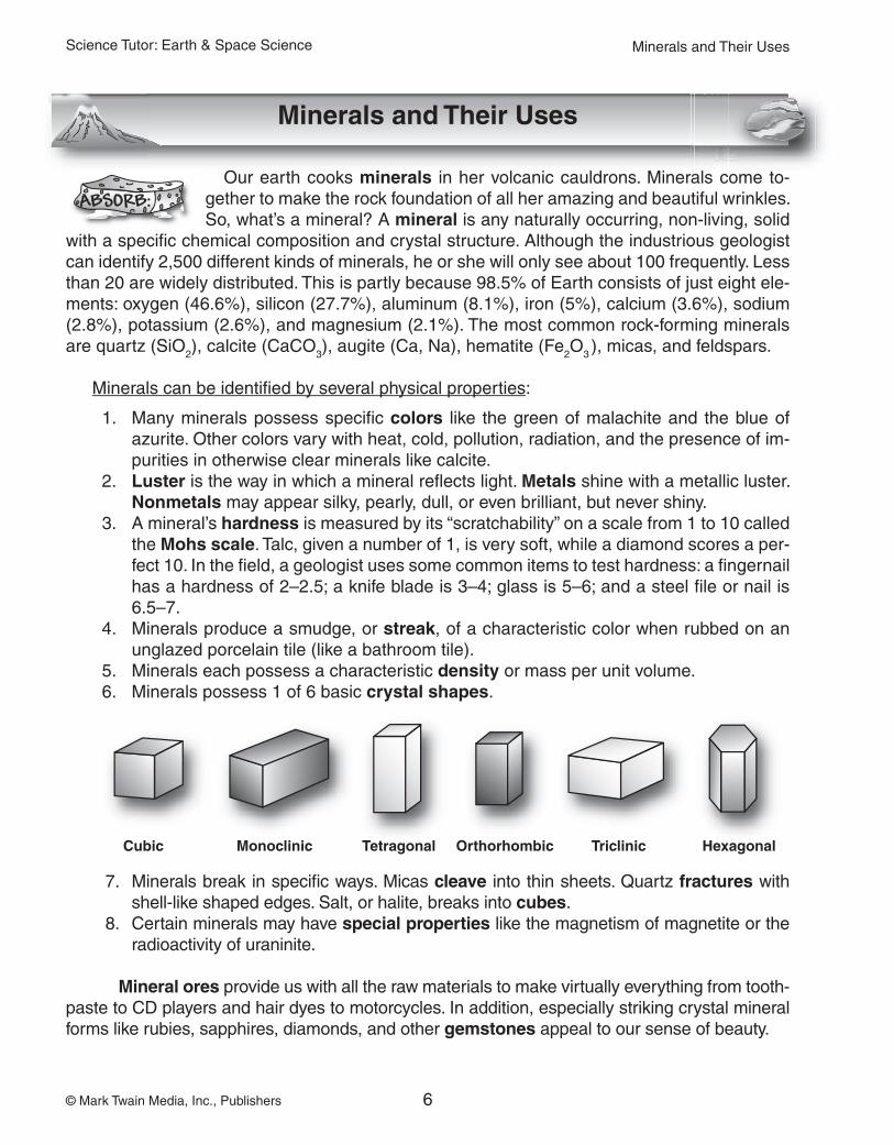
5. Minerals each possess a characteristic density or mass per unit volume.6. Minerals possess 1 of 6 basic crystal shapes.
7. Minerals break in specific ways. Micas cleave into thin sheets. Quartz fractures with shell-like shaped edges. Salt, or halite, breaks into cubes.
8. Certain minerals may have special properties like the magnetism of magnetite or the radioactivity of uraninite.
Mineral ores provide us with all the raw materials to make virtually everything from tooth-paste to CD players and hair dyes to motorcycles. In addition, especially striking crystal mineral forms like rubies, sapphires, diamonds, and other gemstones appeal to our sense of beauty.
Cubic Monoclinic Tetragonal Orthorhombic Triclinic Hexagonal

Science Tutor: Earth & Space Science
7© Mark Twain Media, Inc., Publishers
Igneous, Sedimentary, and Metamorphic Rocks
Igneous, Sedimentary, and Metamorphic Rocks
The minerals formed deep within the earth combine in various ways to form the hard solids we call rocks. Volcanic glass and opal also form rocks, although they don’t have a crystalline structure. Geologists classify rocks
based on how they form. Igneous rocks form from hot magma. Sedimentary rocks form from particles that settle out of water or collect through the action of wind, like sand dunes. The weight of accumulated particles, along with mineral-laden water cements everything together.Metamorphic rocks are rocks of any type that have been transformed by heat and pressure.
Igneous rocks: Geologists classify igneous rocks based on the kinds of minerals in them, along with their shape, size, arrange-ment, and distribution. Light-colored igneous rocks tend to possess more clear quartz, while dark-colored igneous rocks contain more augite, which displays gray-green colors. Extrusive rocks cool and harden on Earth’s surface. Examples include the noncrystalline volcanic glass called obsidian, as well as basalt, which has fine-grained interlocking crystals. Intrusive rocks cool more slowly be-neath the earth, producing coarse-grained rocks with easily seen crystals like pegmatites and granites. Porphyritic rocks look a bit like chocolate-chunk ice cream with big crystals scattered in a field of small crystalline minerals.
Sedimentary rocks: Take fragments of pre-existing rocks, mash them together, and you get clastic rocks like conglomer-ates, breccia, shale, and sandstone. Conglomerates are often called pudding stones because river-smoothed pebbles get ce-mented together like a very hard raisin pudding. Shales are called mudstones because they form from fine-grained muds. Organic rocks were once living organisms. Many limestones form from deposits of shells, and compressed plant remains become beds of coal. Chemical rocks result from minerals left behind after water evaporates. These include rock salt (halite), gypsum, and some limestones, like the beautiful deposits formed in caves. Metamorphic rocks: Take a rock, any rock, heat it up be-tween 100° and 800°C or so, squeeze it, and you get something new. Shale or volcanic tuff becomes slate. Granite turns into gneiss (pronounced “nice”). Chalk (fine-grained limestone) becomes mar-ble. Metamorphic rocks are often layered or foliated, like schists, slates, and gneisses. These rocks tend to break along these lay-ers, or bands. Unfoliated (unbanded) metamorphic rocks include marble and quartzite.
Igneous: basalt
Sedimentary: sandstone
Metamorphic: marble

Science Tutor: Earth & Space Science
8© Mark Twain Media, Inc., Publishers
Name: Date:
The Rock Cycle
The Rock Cycle
As you may have guessed from the discussion of rock types, rocks slowly transform
from one kind to another as they are beaten by the forces of wind and water, buried, pushed, and shoved back beneath the crust, and heated, re-cooked, and belched from an active volcano. The hardest granite mountains wear away to become washed into lakes and oceans at about the same rate as your fingernails grow. Ocean sedimenta-ry rocks last only a certain period of time before plate tectonics subducts them below the crust to be refashioned. This process is called the rock cycle, even though it is a cycle that follows no particular order.
Directions: Look at the diagram above and review page 7 to to fill in the blanks.
1. Igneous rocks become sedimentary rocks by:
A. and .
B. and .
2. Sedimentary rocks can become metamorphic rocks by applying
and , or they can be converted directly to igneous rocks if
they to become magma.
3. To become an igneous rock, magma must and
.
4. When an artist carves a marble statue, he is working with a kind of
rock.
5. T or F? Limestones are only formed from the remains of once-living creatures.
6. Rocks are composed of one or more .
7. Put some heat and pressure on granite and you’ll get .
(Isn’t that nice?)
8. A conglomerate is a kind of sedimentary rock, while
coal is an example of a(n) sedimentary rock.
Igneous
SedimentaryMetamorphic

Science Tutor: Earth & Space Science
45© Mark Twain Media, Inc., Publishers
Answer Keys
The Rock Cycle (p. 8)1. A. weathering and erosion B. compaction and cementation2. heat and pressure, melt 3. cool and harden 4. metamorphic5. F 6. minerals 7. gneiss 8. clastic, organic
Part 1: Earth—A Wild and Changing Planet: Putting It All Together (pgs. 11–12)CONTENT REVIEW1. (Any order) fault , fold, or fracture 2. F 3. T 5. (Any 4) color, streak, hardness, crystal shape, lus-
ter, density, cleavage, magnetism, radioactivity6. Igneous rocks have completely melted and cooled;
sedimentary rocks form from sedimentation and compression; metamorphic rocks can originally be igneous or sedimentary, but are changed by heat and pressure.
7. F 8. chemical 9. Stable
10. ExtrusiveCONCEPT REVIEW 1. More slowly because the interior of Mars is colder
and the atmosphere is thin (little weathering)2. Louisiana, because more deposition is occurring
there.3. A 4. (Any 3) Fingernail, iron nail, glass, knife blade,
steel file5. Convergent plate boundary6. Head for high ground in the case of a tsunami.7. F 8. T
Predicting the Weather (p. 18)Symbols are mixed and on the same side of the line be-cause occluded fronts are mixtures of warm and cold air masses moving in the same direction; stationary fronts have warm and cold front symbols on opposite sides of the line because warm and cold air masses are pushing against each, but going nowhere.
Part 2: Energy and the Atmosphere: Putting It All Together (p. 21–22)CONTENT REVIEW 1. (Any order) convection, conduction, and radiation 2. (Any order) temperature, altitude (or elevation), and
moisture content (or humidity) 3. F 4. dew point 5. T 6. B 7. latitude, sea level, water (in that order) 8. F 9. F10. windwardCONCEPT REVIEW 1. F 2. decrease 3. More ultraviolet radiation would reach Earth, harm-
ing some creatures. 4. Few winds for sailing in the doldrums 5. It compares the temperature difference between
wet bulb and dry bulb thermometers 6. Rain gear 7. From the southeast 8. It would get much colder. 9. Juanita, because water tends to moderate temper-
atures.10. T
Part 3: Sailing in the Hydrosphere: Putting It All To-gether (p. 31–32)CONTENT REVIEW 1. covalent, hydrogen, oxygen; polar 2. F 3. aquifers 4. T 5. B 6. spring 7. evaporates, condenses, precipitation 8. (Any order) fertilizers, pesticides 9. (Any 2, rivers and lakes preferred) rivers, lakes, ponds, streams, swamps, bogs10. density11. (Any order) moon, sun12. hydrogen bondsCONCEPT REVIEW 1. The water in an aquifer is more difficult to reach
and doesn’t recycle as quickly. 2. It absorbs excess water vapor.
Answer Keys