Embed Size (px)
Citation preview
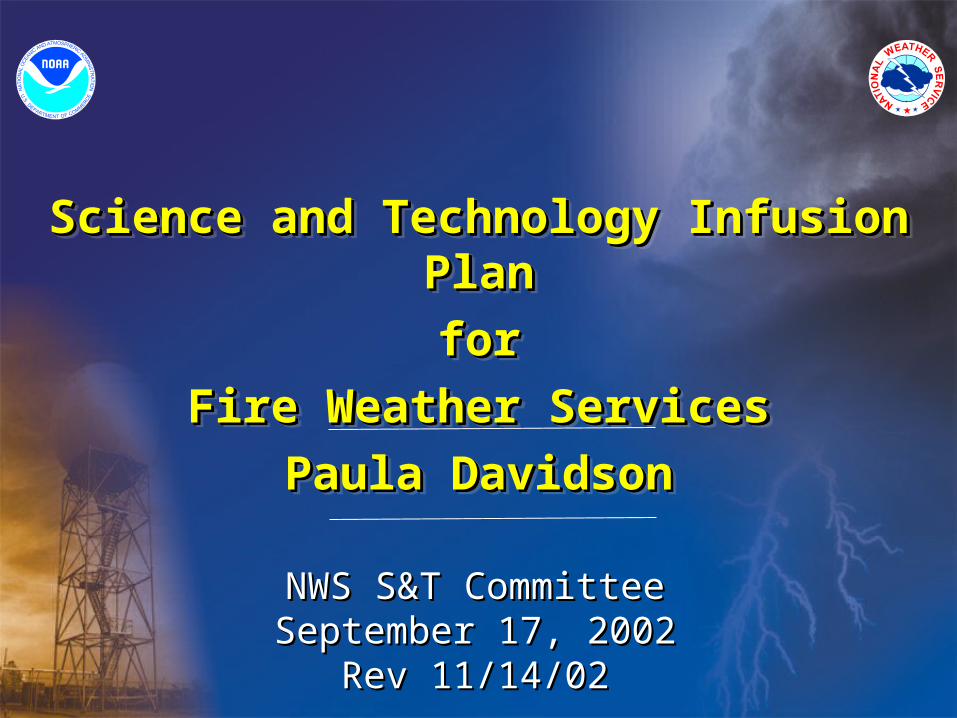
Science and Technology Infusion PlanScience and Technology Infusion Plan
forfor
Fire Weather ServicesFire Weather Services
Paula DavidsonPaula Davidson
Science and Technology Infusion PlanScience and Technology Infusion Plan
forfor
Fire Weather ServicesFire Weather Services
Paula DavidsonPaula Davidson
NWS S&T CommitteeNWS S&T CommitteeSeptember 17, 2002September 17, 2002
Rev 11/14/02Rev 11/14/02
OutlineOutline
• Team CompositionTeam Composition
• Vision/BenefitsVision/Benefits
• Goals/TargetsGoals/Targets
• Key Information Gaps Key Information Gaps
• Key SolutionsKey Solutions
• Outstanding R & D NeedsOutstanding R & D Needs
• SummarySummary
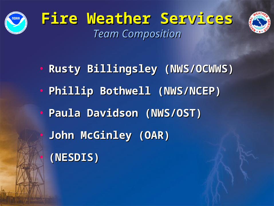
Fire Weather ServicesFire Weather ServicesTeam CompositionTeam Composition
• Rusty Billingsley (NWS/OCWWS)Rusty Billingsley (NWS/OCWWS)
• Phillip Bothwell (NWS/NCEP)Phillip Bothwell (NWS/NCEP)
• Paula Davidson (NWS/OST)Paula Davidson (NWS/OST)
• John McGinley (OAR)John McGinley (OAR)
• (NESDIS)(NESDIS)
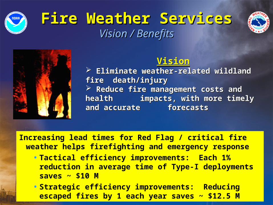
Fire Weather ServicesFire Weather ServicesVision / BenefitsVision / Benefits
Vision Eliminate weather-related wildland fire Eliminate weather-related wildland fire death/injurydeath/injury Reduce fire management costs and health Reduce fire management costs and health impacts, with more timely and accurate impacts, with more timely and accurate forecastsforecasts
Vision Eliminate weather-related wildland fire Eliminate weather-related wildland fire death/injurydeath/injury Reduce fire management costs and health Reduce fire management costs and health impacts, with more timely and accurate impacts, with more timely and accurate forecastsforecasts
Increasing lead times for Red Flag / critical fire weather helps firefighting and emergency response
• Tactical efficiency improvements: Each 1% reduction in average time of Type-I deployments saves ~ $10 M
• Strategic efficiency improvements: Reducing escaped fires by 1 each year saves ~ $12.5 M
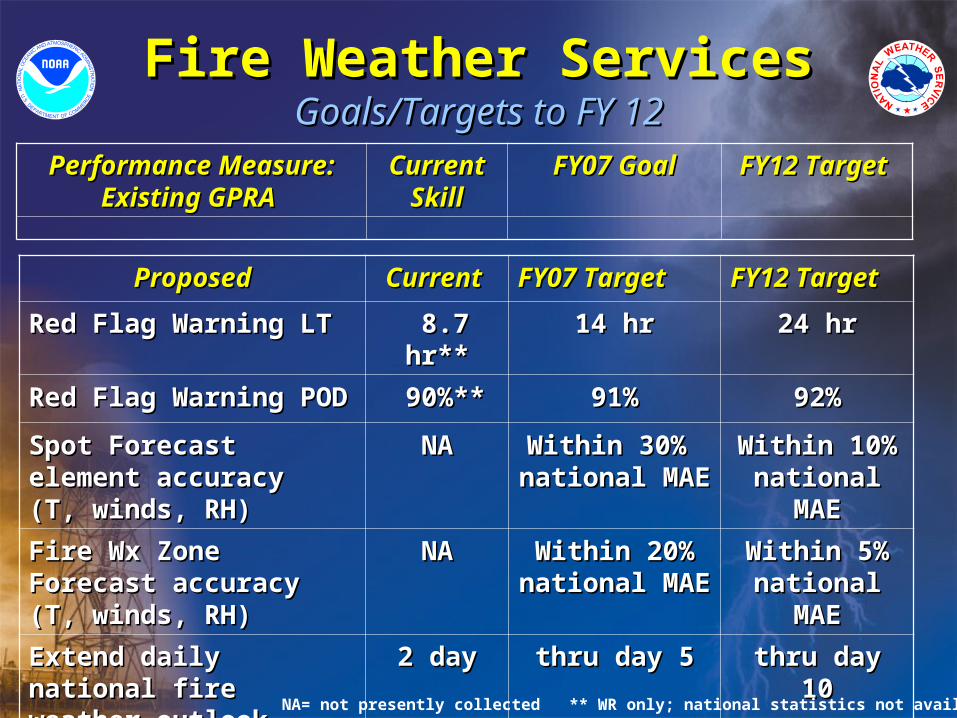
Fire Weather ServicesFire Weather ServicesGoals/Targets to FY 12Goals/Targets to FY 12
Performance Measure: Performance Measure: Existing GPRA Existing GPRA
Current Current SkillSkill
FY07 GoalFY07 Goal FY12 Target FY12 Target
ProposedProposed Current Current FY07 TargetFY07 Target FY12 TargetFY12 Target
Red Flag Warning LTRed Flag Warning LT 8.7 hr**8.7 hr** 14 hr14 hr 24 hr24 hr
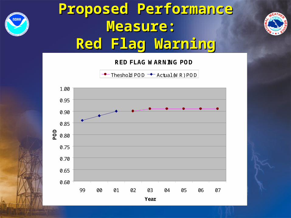
Red Flag Warning PODRed Flag Warning POD 90%**90%** 91%91% 92%92%
Spot Forecast element Spot Forecast element accuracy (T, winds, RH)accuracy (T, winds, RH)
NANA Within 30% Within 30% national MAEnational MAE
Within 10% Within 10% national MAEnational MAE
Fire Wx Zone Forecast Fire Wx Zone Forecast accuracy (T, winds, RH)accuracy (T, winds, RH)
NANA Within 20% Within 20% national MAEnational MAE
Within 5% Within 5% national MAEnational MAE
Extend daily national fire Extend daily national fire weather outlookweather outlook
2 day2 day thru day 5thru day 5 thru day 10thru day 10
National fire wx outlook:National fire wx outlook:POD critical fire wx at day 1POD critical fire wx at day 1
NANA 80% 80% 85%85%
NA= not presently collected ** WR only; national statistics not available
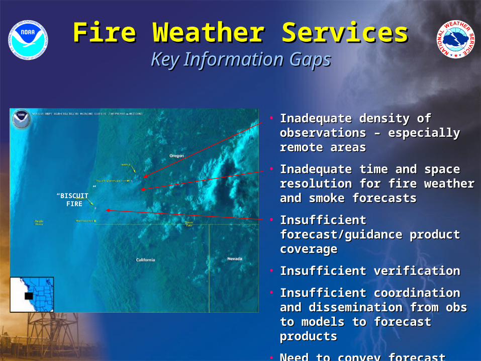
Fire Weather ServicesFire Weather ServicesKey Information GapsKey Information Gaps
• Inadequate density of Inadequate density of observations – especially remote observations – especially remote areasareas
• Inadequate time and space Inadequate time and space resolution for fire weather and resolution for fire weather and smoke forecastssmoke forecasts
• Insufficient forecast/guidance Insufficient forecast/guidance product coverageproduct coverage
• Insufficient verificationInsufficient verification
• Insufficient coordination and Insufficient coordination and dissemination from obs to models dissemination from obs to models to forecast productsto forecast products
• Need to convey forecast Need to convey forecast uncertaintyuncertainty
“BISCUIT” FIRE
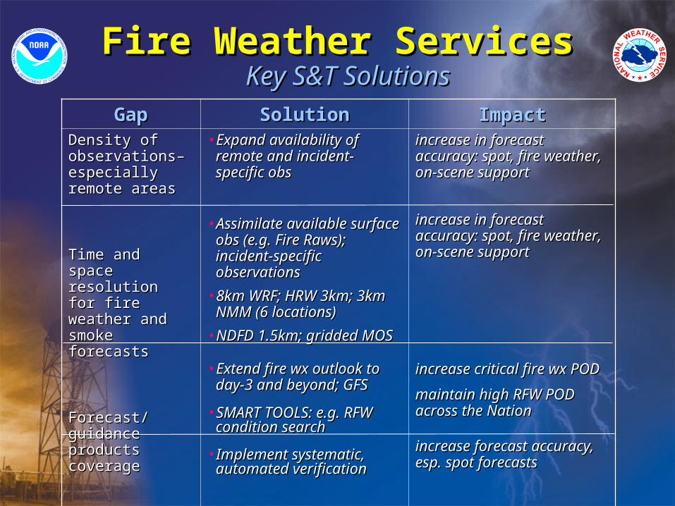
Fire Weather ServicesFire Weather Services Key S&T SolutionsKey S&T Solutions
GapGap SolutionSolution ImpactImpactDensity of Density of observations– observations– especially remote especially remote areasareas
Time and space Time and space resolution for fire resolution for fire weather and weather and smoke forecastssmoke forecasts
Forecast/guidance Forecast/guidance products coverage products coverage
VerificationVerification
• Expand availability of Expand availability of remote and incident-remote and incident-specific obsspecific obs
• Assimilate available surface Assimilate available surface obs (e.g. Fire Raws); obs (e.g. Fire Raws); incident-specific incident-specific observationsobservations
• 8km WRF; HRW 3km; 3km 8km WRF; HRW 3km; 3km NMM (6 locations)NMM (6 locations)
• NDFD 1.5km; gridded MOSNDFD 1.5km; gridded MOS
• Extend fire wx outlook to Extend fire wx outlook to day-3 and beyond; GFSday-3 and beyond; GFS
• SMART TOOLS: e.g. RFW SMART TOOLS: e.g. RFW condition searchcondition search
• Implement systematic, Implement systematic, automated verificationautomated verification
increase in forecast increase in forecast accuracy: spot, fire weather, accuracy: spot, fire weather, on-scene supporton-scene support
increase in forecast increase in forecast accuracy: spot, fire weather, accuracy: spot, fire weather, on-scene supporton-scene support
increase critical fire wx PODincrease critical fire wx POD
maintain high RFW POD maintain high RFW POD across the Nationacross the Nation
increase forecast accuracy, increase forecast accuracy, esp. spot forecasts esp. spot forecasts
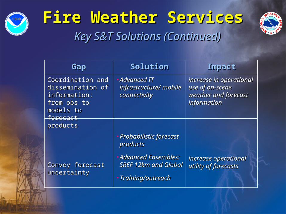
Fire Weather ServicesFire Weather Services Key S&T Solutions (Continued)Key S&T Solutions (Continued)
GapGap SolutionSolution ImpactImpact
Coordination and Coordination and dissemination of dissemination of information: from obs information: from obs to models to forecast to models to forecast productsproducts
Convey forecast Convey forecast uncertaintyuncertainty
• Advanced IT Advanced IT infrastructure/ mobile infrastructure/ mobile connectivityconnectivity
• Probabilistic forecast Probabilistic forecast productsproducts
• Advanced Advanced Ensembles: SREF Ensembles: SREF 12km and Global12km and Global
• Training/outreachTraining/outreach
increase in operational increase in operational use of on-scene use of on-scene weather and forecast weather and forecast informationinformation
increase operational increase operational utility of forecastsutility of forecasts
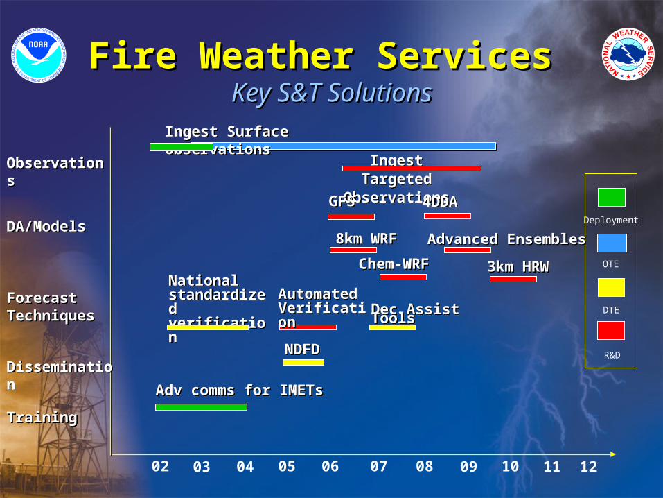
Fire Weather Services Fire Weather Services Key S&T SolutionsKey S&T Solutions
03 04 05 06 07 08 09 10 11 1202
Ingest Targeted Observations
Ingest Targeted Observations
Ingest Surface ObservationsIngest Surface Observations
8km WRF8km WRFDeployment
OTE
DTE
R&D
ObservationsObservations
DA/ModelsDA/Models
Forecast TechniquesForecast Techniques
TrainingTraining
Advanced EnsemblesAdvanced Ensembles
Chem-WRF Chem-WRF
Automated VerificationAutomated Verification
3km HRW3km HRW
Dec Assist ToolsDec Assist Tools
National standardized verification
National standardized verification
NDFDNDFD
Adv comms for IMETsAdv comms for IMETs
DisseminationDissemination
4DDA4DDAGFSGFS
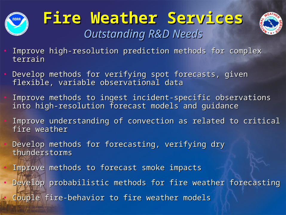
Fire Weather ServicesFire Weather ServicesOutstanding R&D NeedsOutstanding R&D Needs
• Improve high-resolution prediction methods for complex terrainImprove high-resolution prediction methods for complex terrain
• Develop methods for verifying spot forecasts, given flexible, variable Develop methods for verifying spot forecasts, given flexible, variable observational dataobservational data
• Improve methods to ingest incident-specific observations into high-Improve methods to ingest incident-specific observations into high-resolution forecast models and guidanceresolution forecast models and guidance
• Improve understanding of convection as related to critical fire weatherImprove understanding of convection as related to critical fire weather
• Develop methods for forecasting, verifying dry thunderstormsDevelop methods for forecasting, verifying dry thunderstorms
• Improve methods to forecast smoke impactsImprove methods to forecast smoke impacts
• Develop probabilistic methods for fire weather forecastingDevelop probabilistic methods for fire weather forecasting
• Couple fire-behavior to fire weather modelsCouple fire-behavior to fire weather models
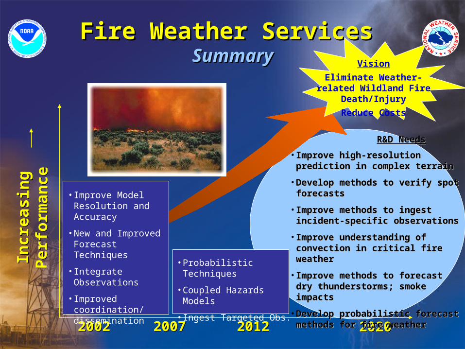
Fire Weather ServicesFire Weather Services SummarySummary
20072007 20122012
Incr
easi
ng
P
erfo
rman
ceIn
crea
sin
g
Per
form
ance
2020202020022002
R&D NeedsR&D Needs
• Improve high-resolution Improve high-resolution prediction in complex terrainprediction in complex terrain
• Develop methods to verify spot Develop methods to verify spot forecasts forecasts
• Improve methods to ingest incident-Improve methods to ingest incident-specific observationsspecific observations
• Improve understanding of convection Improve understanding of convection in critical fire weatherin critical fire weather
• Improve methods to forecast dry Improve methods to forecast dry thunderstorms; smoke impactsthunderstorms; smoke impacts
• Develop probabilistic forecast Develop probabilistic forecast methods for fire weathermethods for fire weather
• Improve Model Resolution and Accuracy
• New and Improved Forecast Techniques
• Integrate Observations
• Improved coordination/ dissemination
• Probabilistic Techniques
• Coupled Hazards Models
• Ingest Targeted Obs.
Vision
Eliminate Weather-related Wildland Fire Death/Injury
Reduce Costs
Fire Weather ServicesFire Weather Services
BACK-UPBACK-UP
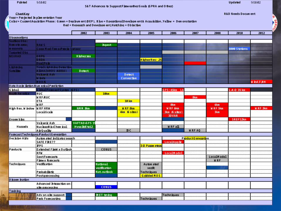
Printed 9/10/02 Updated 9/10/02S&T Advances to Support Fireweather Goals (GPRA and Other)
Chart Key R&D Needs DocumentYear = Projected Implementation YearColor = Current Aquistion Phase: Green = Deployment (DEP), Blue = Operational Development & Acquisition, Yellow = Demonstration Red = Research and Development, Hatching = Objective
2002 2003 2004 2005 2006 2007 2008 2010 2012
Observations
IngestCoop Mod-Temp/Precip Sensor 8000 Stations
Targeted ObsNEXRAD ORPG Higher res
ORDA Higher Res: .25 km Dual Pole
Lightning Total Lightning DetectionSatellite All-HAZARDS (ABBA) Detect
Volcanic Ash DetectWinds ConvectiveMODIS Wind,T,RH
Global Global Forecast System (GFS) GFS: 45km L64/384h/4x L-A-O 35 kmNorth America RUC 10km
WRF/RUC 8kmETA 10 kmWRF 8km 6kmWRF HRW NMM 8km WRF 8km WRF 6km WRF 5km WRF 3km
4km (6 sites) 3km (6 sites) 3km3DVAR
Ensembles SREF12kmVolcanic Ash VAFTAD/GFS 191 km
Hysplit/Eta12 WRF all Air Quality IOC WRF AQ
Forecast Techniques/Product GenerationDecision Aids Automated indicator search Product Generation
SAFE FIRE?? Local ApplicIFPS 3-D Parameters
Products Extended FireWx Outlook CONUSRFW Local ModelSpot Forecasts Local ModelFirewx forecasts WRF
Techniques Verification
Probabilistic Nat. outlook TechniquesPost-processing Gridded MOS
Dissemination
CONUSTraining
Adv on-site support IMET trning TechniquesProb Forecasting Techniques
Advanced Interactive on-site processing
National verification
Nuclear/Bio/Chemical
Automated verifc
Surface Obs: Remote area; mesonets
Hazards
High Res. WindowLocal-Scale
Data Assimilation/Numerical Prediction
RAWS
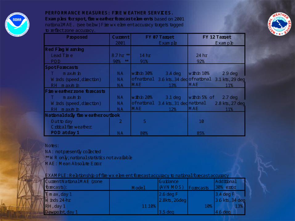
PERFORMANCE MEASURES: FIRE WEATHER SERVICES.
Proposed Current2001 Example Example
Red Flag Warning Lead Time 8.7 hr ** 14 hr 24 hrPOD 90% ** 91% 92%
Spot ForecastsT max/min NA 3.4 deg 2.9 degWinds (speed, direction) NA 3.6 kts, 34 deg 3.1 kts, 29 degRH max/min NA 13% 11%
Fire weather zone forecastsT max/min NA 3.1 deg 2.7 degWinds (speed, direction) NA 3.4 kts, 31 deg 2.8 kts, 27 degRH max/min NA 12% 11%
National daily fire weather outlookOut to day 2 5 10Critical fire weather: POD at day 1 NA 80% 85%
Notes:NA: not presently collected** WR only; national statistics not availableMAE: Mean Absolute Error
EXAMPLE: Relationship of fire wx element forecast accuracy to national forecast accuracyCurrent National MAE (zone forecasts): Model
Guidance (AVN MOS) Forecasts
Additional 30% error
T max, day 1 2.6 deg F 3.4 deg FWinds 24-hr 2.8kts, 26deg 3.6 kts, 34 degRH, day 1 11.10% 10% 13%Dewpoint, day 1 3.5 deg 4.6 deg
FY 12 Target
within 10% of national MAE
within 5% of national MAE
Examples for spot, fire weather forecast elements based on 2001 national MAE. (see below) Fire wx element accuracy targets tagged to reflect zone accuracy.
FY 07 Target
within 30% of national MAE
within 20% of national MAE
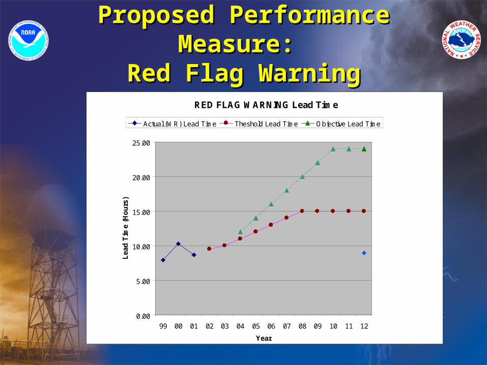
Proposed Performance Measure: Proposed Performance Measure: Red Flag WarningRed Flag Warning
RED FLAG WARNING Lead Time
0.00
5.00
10.00
15.00
20.00
25.00
99 00 01 02 03 04 05 06 07 08 09 10 11 12
Year
Lea
d T
ime
(Ho
urs
)Actual (WR) Lead Time Theshold Lead Time Objective Lead Time
Proposed Performance Measure: Proposed Performance Measure: Red Flag WarningRed Flag Warning
RED FLAG WARNING POD
0.60
0.65
0.70
0.75
0.80
0.85
0.90
0.95
1.00
99 00 01 02 03 04 05 06 07
Year
PO
D
Theshold POD Actual (WR) POD