Embed Size (px)
Citation preview
Sci. Rev. Reader ('02/02/10) 4-P1)_Ptolemy
1
*Preliminary draft for student use only. Not for citation or circulation without permission of edi-
tor.
That part of the Earth which is inhabited by us is bounded on the east by the unknown landwhich borders on the eastern races of Greater Asia, namely the Sinae [Chinese] and the Seres,and on the south by the likewise unknown land which encloses the Indian sea and which en-compasses Ethiopia south of Libya, the country called Agisymba, and on the west by the un-known land encircling the Ethiopian gulf of Libya and by the Western ocean bordering on thewestern-most parts of Africa and Europe, and on the north by the continuous ocean called theDucalydonian and Sarmatian which encompasses the British islands and the northern-mostpants of Europe, and by the unknown land bordering on the northern-most parts of GreaterAsia, that is to say on Sarmatia and Scythia and Senica.
- Ptolemy, Geography
4-P1) Ptolemy, "Geography" (ca. 160 C.E.)1
Book 1
1. On the Difference between World Cartography and Regional Cartography
World cartography is an imitation through drawing of the entire known part of the
world together with the things that are, broadly speaking, connected with it.2 It differs
from regional cartography chorography] in that regional cartography, as an independent
discipline, sets out the individual localities, each one independently and by itself, regis-
tering practically everything down to the least thing therein (for example, harbors, towns,
districts, branches of principal rivers, and so on), while the essence of world cartogra-
phy is to show the known world as a single and continuous entity, its nature and how it
1 Ptolemy. Ptolemy's Geography: An Annotated Translation of the Theoretical Chapters , trans.J. L. Berggren and Alexander Jones. Princeton, N.J.: Princeton University Press, 2000. Pp. 57-63, 70-74, 83-84, 108-111; Plates 129, 130.2 We thus translate geographia in accordance with the restricted sense that Ptolemy defines forthe word in this chapter. “Regional cartography” represents Ptolemy’s chorographia. OtherGreek authors, such as Strabo, use geographia to mean a written geographical work.
Sci. Rev. Reader ('02/02/10) 4-P1)_Ptolemy
2
is situated, taking account only of the things that are associated with it in its broader,
general outlines (such as gulfs, great cities, the more notable peoples and rivers, and
the more noteworthy things of each kind). The goal of regional cartography is an im-
pression of a part, as when one makes an image of just an ear or an eye; but the goal of
world cartography is a general view, analogous to making a portrait of the whole head.
That is, whenever a portrait is to be made, one has to fit in the main parts of the body in
a determined pattern and an order of priority. [ . . . ] Regional cartography deals above
all with the qualities rather than the quantities of the things that it sets down; it attends
everywhere to likeness, and not so much to proportional placements.3 World cartogra-
phy, on the other hand, deals with the quantities more than the qualities, since it gives
consideration to the proportionality of distances for all things, but to likeness only as far
as the coarser outlines of the features, and only with respect to mere shape. Conse-
quently, regional cartography requires landscape drawing, and no one but a man skilled
in drawing would do regional cartography. But world cartography does not require this at
all, since it enables one to show the positions and general configurations of features
purely by means of lines and labels.
For these reasons, regional cartography has no need of mathematical method,
but here in world cartography this element takes absolute precedence. Thus the first
thing that one has to investigate is the earth’s shape, size, and position with respect to
its surroundings—i.e., the heavens—so that it will be possible to speak of its known
part, how large it is and what it is like, and moreover so that it will be possible to specify
under which parallels of the celestial sphere each of the localities in this known part lies.
From this last, one can also determine the lengths of nights and days, which stars reach
the zenith or are always borne above or below the horizon, and all the things that we
3 This passage makes it clear that the “regional cartography” that Ptolemy has in mind not onlycovers smaller areas of the world than his world cartography, but also follows different princi-ples.
Sci. Rev. Reader ('02/02/10) 4-P1)_Ptolemy
3
associate with the subject of habitations.4
These things belong to the loftiest and loveliest of intellectual pursuits, namely to
exhibit to human understanding through mathematics both the heavens themselves in
their physical nature since they can be seen in their revolution about us, and the nature
of the earth through a portrait since the real earth, being enormous and not surrounding
us, cannot be inspected by any one person either as a whole or part by part).5
2. On the Prerequisites for World Cartography
We shall let this serve as a brief sketch of the purpose of anyone who would be a
world cartographer, and how he differs from the regional cartographer. Our present ob-
ject is to map our oikoumene6 as far as possible. But at the outset we think it is nece s-
sary to state clearly that the first step in a proceeding of this kind is systematic research,
assembling the maximum of knowledge from the reports of people with scientific training
who have toured the individual countries; and that the inquiry and reporting is partly a
matter of surveying, and partly of astronomical observation. The surveying component
is that which indicates the relative positions of localities solely through measurement of
distances. The astronomical component is that which does the same] by means of the
phenomena obtained from astronomical sighting and shadow-casting instruments.7 As-
tronomical observation is a self-sufficient thing and less subject to error, while surveying
is cruder and incomplete. [ . . . ]
4 ”Habitations” ( oikeseis) means the determination of the astronomical phenomena characteri s-tic for particular terrestrial latitudes. Book 2 of the Almagest is largely devoted to a theoreticaltreatment of this topic.5 I.e., we are inside the celestial sphere, and can behold half of it at once. By way of contrast,our position on the surface of the earth prevents us from taking in the earth’s form at a glance,and it is too large for any single person to explore.6 Literally, “the inhabited part of the world”.7 A sighting instrument ( astrolabon) is one that permits the direct measurement of the apparentposition of a heavenly body through a diopter, for example, Ptolemy’s armillary spheres (the as-trolabon described by Ptolemy in Almagest 5.1 or the meteoroskopeion mentioned below in1.3). A shadow-casting instrument could be a simple gnomon or upright stick, used to determinethe sun’s altitude.
Sci. Rev. Reader ('02/02/10) 4-P1)_Ptolemy
4
The method using the astronomical phenomena determines each of these things
direction and distance] accurately, since it shows the magnitudes of . . . ] the parallel
and meridian circles drawn through the given localities [ . . . ] The astronomical method
also reveals the size of the arc that the two localities cut off along the great circle drawn
through them on the earth. [ . . . ] For it has already been mathematically determined
that the continuous surface of land and water is (as regards its broad features) spherical
and concentric with the celestial sphere (Almagest 1.4—5) [Thus] every plane pro-
duced through the common center makes as its intersections with the aforesaid sur-
faces of the terrestrial and celestial spheres great circles on the spheres, and angles in
this plane at the center cut off similar arcs on the celestial and terrestrial great circles.
[TBA - Diagram of planes cutting terrestrial and celestial sphere] As it happens,
although the number of stades8 in intervals on the earth (if they are straight) can be d e-
termined from distance measurements, their ratio to the whole circumference cannot be
determined at all from distance measurements because of the impossibility of making
the comparison.9 But this ratio can be determined from the similar arc of the circle on
the surrounding celestial sphere, because one can determine the ratio of this similar arc
to the circumference i.e., the great circle to which it belongs, and this ratio is the same
as that of the similar segment along the surface of the earth to the great circle on the
earth.
3. How the number of stades in the earth’s circumference can be obtained from the
number of stades in an arbitrary rectilinear interval . . .
[ . . . ]
8 Define stade ???9 Ptolemy means that because of the immensity of the terrestrial globe, one cannot directlymeasure its circumference or apprehend that a given measured distance is a particular fractionof the whole circuit.
Sci. Rev. Reader ('02/02/10) 4-P1)_Ptolemy
5
Using the meteoroscope10 we can easily obtain, among many other extremely
useful things, the elevation of the north celestial pole at the place of observation on any
day or night, the direction of the meridian at any hour, and the directions of routes [to be
taken] with respect to the meridian. [ . . . ] With these quantities known we can show
right on the meteoroscope the arc in question of the great circle through the two loca-
tions as well as the arc on the equator that the two meridians (if they are distinct) cut off.
[TBA - diagram showing same] Hence by this procedure the total number of stades of
the earth’s circumference can be found from just one rectilinear interval measured on
the earth, and thereby also the number of stades of the other intervals without measur-
ing the distances. [ . . . ]
4. That it is necessary to give priority to the astronomical phenomena over data from
records of travel
These things being so, if the people who visited the individual countries had hap-
pened to make use of some such observations, it would have been possible to make
the map of the oikoumene with absolutely no error. But Hipparchus alone has trans-
mitted to us observed elevations of the celestial north pole for a few cities, i.e., few
when compared to the multitude of cities to be recorded in the world cartography, and
lists of the localities that are situated on the same parallels (on the celestial sphere). [ . .
. ] Most intervals, however, and especially those to the east or west, have been reported
in a cruder manner, not because those who undertook the researches were careless,
but perhaps because it was not yet understood how useful the more mathematical
mode of investigation is, and because no one bothered to record more lunar eclipses
that were observed simultaneously at different localities from which it would have been
clear how many equinoctial time units separated the localities to the east or west. [TBA
- diagram to explain use of eclipses} It would therefore also be reasonable for one
10 An armillary sphere Ptolemy designed with nine rings. [ . . . ] For an attempted reconstructionand discussion of how the instrument could have performed the tasks described in this chapter,see Rome 1927. ??complete reference.???
Sci. Rev. Reader ('02/02/10) 4-P1)_Ptolemy
6
who intended to practice world cartography following these principles to give priority in
his map to the features that have been obtained through the more accurate observa-
tions, as foundations, so to speak, but to fit the features that come from the other kinds
of data to these, until their positions with respect to each other and to the first features
stand as much as possible in agreement with those reports that are less subject to er-
ror.
5. That it is necessary to follow the most recent researches because of changes in the
world over time
The foregoing would provide a plausible basis for the project of drawing a map.
But in all subjects that have not reached a state of perfect knowledge, whether because
they are too vast, or because they do not always remain the same, the passage of time
always makes far more accurate research possible; and such is the case with world
cartography, too. For the consensus of the very reports that have been made at various
times is that many parts of our oikoumene have not reached our knowledge because its
size has made them inaccessible, while other parts have been described falsely be-
cause of the carelessness of the people who undertook the researches; and some parts
are themselves different now from what they were before because features have
ceased to exist or have changed. Hence here in world cartography, too, it is necessary
to follow in general the latest reports that we possess, while being on guard for what is
and is not plausible in both the exposition of current research and the criticism of earlier
researches. [ . . . ]
11. On the computations that Marinos improperly made for the longitudinal dimension of
the oikoumene
[ . . . ]
Marinos11 makes its longitudinal dimension [of the oikoumene] bounded within
11 Bio-note on Marinos.
Sci. Rev. Reader ('02/02/10) 4-P1)_Ptolemy
7
two meridians that cut off fifteen hour-intervals [i.e., 225°]. We think that he has also
extended the eastern part of this dimension more than necessary, and that when a rea-
sonable reduction has been applied here, too, the whole longitudinal extent does not
amount quite to twelve hour-intervals [180°], where we (like Marinos) set the Islands of
the Blest [Fortunate Islands, or Azores?] at the westernmost limit, and the farthest parts,
namely Sera, Sinai, and Kattigara, at the eastern limit.12
For in the first place one should follow the numbers of stades, from place to
place, set down by Marinos for the distance from the Islands of the Blest to the crossing
of the Euphrates at Hierapolis (as if the journey were made along the parallel through
Rhodes). This is both because it is continually being checked and because Marinos has
manifestly taken into account the amount by which the greater distances ought to be
corrected on account of diversions and variations in the itineraries. Furthermore, he has
taken into account the fact that one degree (of such as the great circle is 360°) contains
500 stades on the surface of the earth—in accordance with the surface measurements
that are generally agreed upon—while an arc similar to one degree of the equator on
the parallel through Rhodes (that is, the parallel 36° from the equator) contains ap-
proximately 400 stades. [ . . . ]
[Thus] we reduce according to the appropriate correction both the distance from
that crossing of the Euphrates to the Stone Tower,13 which amounts (according to him)
to 26,280 stades, and that from the Stone Tower to Sera, the metropolis of the Seres, a
journey of seven months, or according to Marinos 36,200 stades reckoned on the same
parallel through Rhodes. [ . . .]
12. The revision of the longitudinal dimension of the known world on the basis of jour-
neys by land
[ . . . ]
12 The last three place-names we may associate roughly with China.—SJFH.
Sci. Rev. Reader ('02/02/10) 4-P1)_Ptolemy
8
[In sum,] the first interval, by which I mean from the Euphrates to the Stone
Tower, must be reduced, because of the diversions in the routes, to just 24,000 stades.
[And] when the 60° that correspond to the 24,000 stades have been added to the 45
1/4° from the Stone Tower to the Seres, the distance from the Euphrates to the Seres
along the parallel through Rhodes would be 105 1/4°. [TBA -map with these place-
names marked with Ptolemy’s °-intervals] According to Marinos, on the basis of the
individual numbers of stades that he assumes, and reckoning as on the same parallel,
the distance from the meridian through the Fortunate Islands to the Sacred Cape of
Spain amounts to 2 1/2°; and that from thence to the mouth of the Baetis, and that from
the Baetis to the Straits of Herakles and Calpe each amounts again to 2 1/2°. And, of
the following intervals, that from the Straits to Caralis in Sardinia amounts to 25° that
from Caralis to Lilybaeum in Sicily to 4 1/2°, that from thence to Pachynus to 3° and
next that from Pachynus to Tainaros in Lakonia to 10°, that from thence to Rhodes to 8
1/4° that from Rhodes to Issos, 11 1/4°, that from Issos to Hierapolis on the Euphrates
to 2 1/2°. Thus the sum for this distance is 72°, and for the whole longitudinal extent of
the known earth [oikoumene], from the meridian of the Fortunate Islands to the Seres,
177 1/4° in total. [ . . . ]
19. On the convenience of our catalogue for making a map
We have thus taken on a twofold task: first to preserve Marinos’ opinions as ex-
pressed through the whole of his compilation, except for those things that need some
correction; second to see to it that the things that he did not make clear will be inscribed
as they should be, so far as is possible, using the researches of those who have visited
the places, or their positions as recorded in the more accurate maps. We have taken
care also that the method should be convenient. Hence we have written down for all the
provinces the details of their boundaries (i.e., their positions in longitude and latitude),
13 The “Stone Tower” would likely have been the location of a trading station where merchantsfrom China and from western Asia exchanged their goods.
Sci. Rev. Reader ('02/02/10) 4-P1)_Ptolemy
9
the relative situations of the more important peoples in them, and the accurate locations
of the more noteworthy cities, rivers, bays, mountains, and other things that ought to be
in a map of the oikoumene. By “locations” I mean the number of degrees (of such as the
great circle is 360°) in longitude along the equator between the meridian drawn through
the place and the meridian that marks off the western limit of the oikoumene, and the
number of degrees in latitude between the parallel drawn through the place and the
equator measured along the meridian. In this way we will be able to establish the posi-
tion of each, and through accuracy in particulars we will be able to establish the posi-
tions of the provinces themselves with respect to each other and to the whole
oikoumene. [ . . . ]
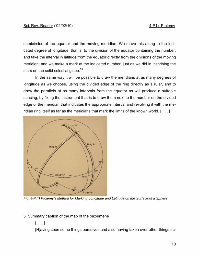
22. On how one should make a map of the oikoumene on a globe
The size of the globe should be determined by the number of things that the
map-maker intends to inscribe on it; and this depends on his competence and ambition,
since the larger the globe is, the more detailed and at the same time the more reliable
the map will prove to be. Whatever size it may be, we are to take its poles and accu-
rately attach through them a semicircle very slightly separated from the globe’s surface,
so that it only just avoids rubbing against it when it is turned. Let the semicircle be nar-
row in order not to obstruct many localities; and let one of its edges pass precisely
through the points representing the poles, so that we can use it to draw the meridians.
We divide this edge into 180 parts and label them with the corresponding numbers,
starting from the middle division, which is going to be at the equator. Similarly, we draw
the equator and divide one of its semicircles into the same number, 180, of divisions,
and inscribe their numbers on this semicircle too, starting from the endpoint through
which we are going to draw the most western meridian. [TBA - diagram of carto-
graphic globe]
Now we will make the map, on the basis of the degrees of longitude and latitude
recorded in the present writings for each marked locality, using the divisions of the
Sci. Rev. Reader ('02/02/10) 4-P1)_Ptolemy
10
semicircles of the equator and the moving meridian. We move this along to the indi-
cated degree of longitude, that is, to the division of the equator containing the number,
and take the interval in latitude from the equator directly from the divisions of the moving
meridian; and we make a mark at the indicated number, just as we did in inscribing the
stars on the solid celestial globe.63
In the same way it will be possible to draw the meridians at as many degrees of
longitude as we choose, using the divided edge of the ring directly as a ruler, and to
draw the parallels at as many intervals from the equator as will produce a suitable
spacing, by fixing the instrument that is to draw them next to the number on the divided
edge of the meridian that indicates the appropriate interval and revolving it with the me-
ridian ring itself as far as the meridians that mark the limits of the known world. [ . . . ]
Fig. 4-P.1) Ptolemy’s Method for Marking Longitude and Latitude on the Surface of a Sphere
5. Summary caption of the map of the oikoumene
[ . . . ]
[H]aving seen some things ourselves and also having taken over other things ac-
Sci. Rev. Reader ('02/02/10) 4-P1)_Ptolemy
11
curately from the earlier writers, we have taken forethought to sketch, as it were, a sort
of map of the entire oikoumene, so that none of those things that are specifically useful
and that [ . . . ] can adorn the soul and incite it to perspicacity concerning nature should
be unknown to lovers of knowledge.
The part of the world contained in our oikoumene is bounded to the east by the
unknown land that is situated next to the eastern peoples of Great Asia, namely the Si-
nai and the people in Serike. [T]o the south [it is bounded] likewise by the unknown
land that encloses the Sea of India and surrounds Ethiopia south of Libya (this part of
Ethiopia is called the country of Agisymba14). [T]o the west [it is bounded] by both the
unknown land surrounding the Ethiopian Bay of Libya and the adjacent Western Ocean,
which lies next to the most western parts of Libya and Europe. [A]nd to the north [it is
bounded] by the continuation of the Ocean that contains the islands of Britain and the
most northern parts of Europe (this sea is called the Duecalidonian and Sarmatian
Ocean15), and by the unknown land that is situated next to the most northern countries
of Great Asia, namely Sarmatia, Skythia, and Serike16.
These seas are contained by the oikoumene:
The Mediterranean, together with the bays that are connected to it, besides the
Adriatic Bay and the Aegean Sea, the Propontis and Pontos, and Lake Maiotis. It has
an opening to the Ocean only through the Straits of Herakles [Hercules, i.e. the Straits
of Gibraltar], in the manner of a peninsula, making the strait, as it were, an isthmus of
the sea. The Hyrkanian or Caspian Sea is enclosed on all sides by the land, like an is-
land in reverse. Likewise the whole [ . . . ] Sea of India, together with the bays con-
nected to it, besides the Arabian and Persian Bays, the Bay of Ganges, and the Bay
that is specifically called Great. This sea, too, is contained by land on all sides.17
Hence of the three continents, Asia is connected to Libya both by the land-strait
14 Modern place-name for “Agisymba” & locate same on a modern map.15 Modern place-names??.16 Modern place-names??.
Sci. Rev. Reader ('02/02/10) 4-P1)_Ptolemy
12
at Arabia, which also separates the Mediterranean Sea from the Arabian Bay, and by
the unknown land that surrounds the Sea of India. And Asia is connected to Europe by
the land-strait between Lake Maiotis and the Sarmatian Ocean where the river Tanais
crosses through.18 Libya is divided from Europe by just the Straits of Herakles, and is
not in itself attached to Europe at all, but only by way of Asia, since Asia is attached to
both of them, flanking them both on the east.
Moreover, Asia is the first of the continents in respect to size, Libya second,
Europe third. Likewise, of the seas that have been said to be contained by land, the Sea
of India is again the first in size, the Mediterranean Sea second, and the Hyrkanian or
Caspian third.
And among the more noteworthy bays:
• the first and greatest is the Bay of Ganges [Bengal],
• the second the Persian Bay,
• the third the Great Bay [??],
• the fourth the Arabian Bay,
• the fifth the Ethiopian Bay,
• the sixth the Bay that is the Pontos,
• the seventh the bay that is the Aegean Sea,
• the eighth the bay that is Lake Maiotis,
• the ninth the Adriatic,
• the tenth the bay that is the Propontis.
Among the more noteworthy islands or peninsulas:
• the first is Taprobane [Sri Lanka?],
• second Albion, one of the islands of Britain,
• third the Golden Peninsula [??],
• fourth Hibernia [Ireland?], one of the islands of Britain,
17 By enclosing the Indian Ocean with land on all sides, Ptolemy leaves the mainstream ofGreek geographical tradition, which made it part of the all-encircling Ocean.18 Place-names for “Lake Maiotis and the Sarmatian Ocean where the river Tanais”
Sci. Rev. Reader ('02/02/10) 4-P1)_Ptolemy
13
• fifth the Peloponnese [peninsula in southern Greece],
• sixth Sicily [like the remaining islands, in the Mediterranean]
• seventh Sardinia,
• eighth Corsica,
• ninth Crete,
• and tenth Cyprus.
The southern limit of the known world is bounded by the parallel 16 5/12° south
of the equator, such that the great circle is 360°. This is the same number of degrees by
which the parallel through Meroe is north of the equator. The northern limit is bounded
by the parallel 63° north of the equator, and is drawn through the island of Thule. Hence
the known latitudinal dimension of the oikoumene is 79 5/12°, or in round numbers, 80°;
which is approximately 40,000 stades on the assumption that one degree contains 500
stades (as has been determined by the more accurate distance measurements), and
that therefore the whole earth contains a perimeter of 180,000 stades.
Again, the eastern limit of the known world is bounded by the meridian drawn
through the metropolis of the Sinai, which is 119 1/2° on the equator, or approximately 8
equinoctial hours, east of the meridian drawn through Alexandria. The western limit is
bounded by the meridian drawn through the Fortunate Islands, which is 60 1/2°, or 4
equinoctial hours, from the meridian through Alexandria. It is thus 180° (i.e., a semicir-
cle), or 12 equinoctial hours, from the most eastern meridian.
Hence the known longitudinal dimension of the oikoumene amounts to:
90,000 stades on the segment along the equator, or, approximately 8,330 1/3
stades on the segment along the most southern parallel of the oikoumene [i.e., 16 5/12°
south of the equator, as noted above];
40,000 stades on the segment along the northernmost parallel [i.e., the parallel
through Thule 63° north of the equator];
approximately 72,000 stades on the parallel through Rhodes, along which the
distance measurements have most often been made, and which is 36° [north of] the
Sci. Rev. Reader ('02/02/10) 4-P1)_Ptolemy
14
equator;
and 82,336 stades on the parallel through Soene, which is 23 5/6° from the
equator, and situated about in the middle of the whole latitudinal dimension.19
[ . . . ]
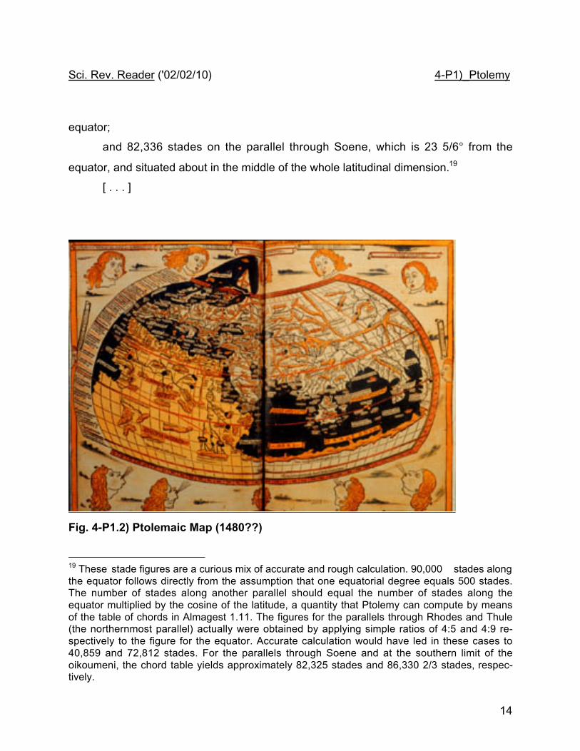
Fig. 4-P1.2) Ptolemaic Map (1480??)
19 These stade figures are a curious mix of accurate and rough calculation. 90,000 stades alongthe equator follows directly from the assumption that one equatorial degree equals 500 stades.The number of stades along another parallel should equal the number of stades along theequator multiplied by the cosine of the latitude, a quantity that Ptolemy can compute by meansof the table of chords in Almagest 1.11. The figures for the parallels through Rhodes and Thule(the northernmost parallel) actually were obtained by applying simple ratios of 4:5 and 4:9 re-spectively to the figure for the equator. Accurate calculation would have led in these cases to40,859 and 72,812 stades. For the parallels through Soene and at the southern limit of theoikoumeni, the chord table yields approximately 82,325 stades and 86,330 2/3 stades, respec-tively.

Sci. Rev. Reader ('02/02/10) 4-P1)_Ptolemy
15


![Sci. Rev. Reader (‘02/03/07) 03-P4 Tychosites.fas.harvard.edu/~hsci161/Sci._Rev._Reader/03-P4_Tycho.pdf · Tycho Brahe. De Mundi Etherei recentoribus phaenomenis. Uraniborg, 1588.]](https://img.pdfslide.us/doc/110x75/5fc1736a9cc0bf55071d0689/sci-rev-reader-a020307-03-p4-hsci161scirevreader03-p4tychopdf.jpg)