Embed Size (px)
Citation preview
Schemaless database storage (PostGIS) with FMEHans Gunnar Steen, GIS engineer – FME Certified Professional – Norkart as
Schemaless database storage (PostGIS) with FME
� Schemas in FME� Used on “all” readers/writers regardless of format� Defines the structure of the dataset such as:
� Feature Types� Attributes� Data types
� More or less strict – dependent on needs� Very important when using databases� So, why do we try to avoid it in some cases?
Schemaless database storage (PostGIS) with FME
� Background: DOK(Det Offentlige Kartgrunnlaget)� Tematic datasets – required by law� Critical in zoning and building planning� Supports decision making in accordance withNorwegian Planning and Building Act
� Contains data such as flooding, landslides, avalances, proteced areas and buildings, groundconditions, minerals…
� 92 datasets - and growing
Schemaless database storage (PostGIS) with FME
� Quality, structure and distribution� Variable quality. Most datasets still not approved.� Different structure and schemas� Different ways of distribution(download, service, phone calls…..)
� Many different formats – and coordinate systems.
� A hazzle to deal with � (But possible by FME!)� Want to collect, store, analyze and distributefrom a consistent PostGIS database
Schemaless database storage (PostGIS) with FME
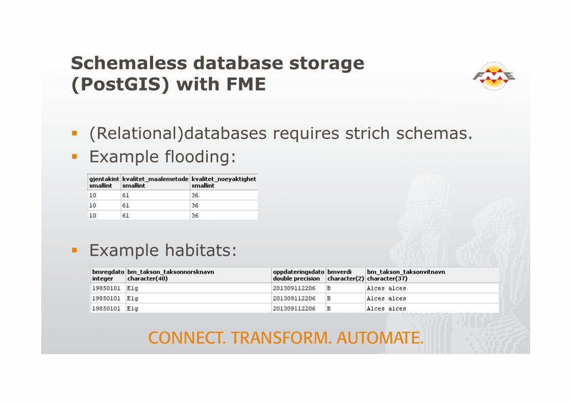
� (Relational)databases requires strich schemas.� Example flooding:
� Example habitats:
Schemaless database storage (PostGIS) with FME
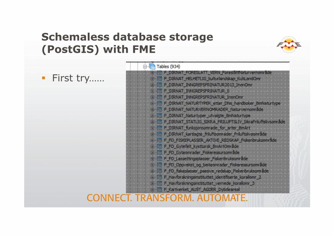
� First try……
Schemaless database storage (PostGIS) with FME
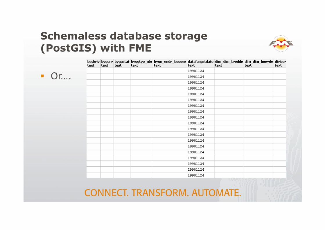
� Or….
Schemaless database storage (PostGIS) with FME
� Problem: A lot of tables – or a lot of attributes� Need common storeage of different schemas� MongoDB and some other DB’s allows this, but:
� Lack SQL query capabilities, as data is stored in json(javascript object notation)
� Very limited spatial data capabilities
� PostGIS has excellent spatial data capabilities� But need clearly defined schemas
� We need the best of both worlds, so…..
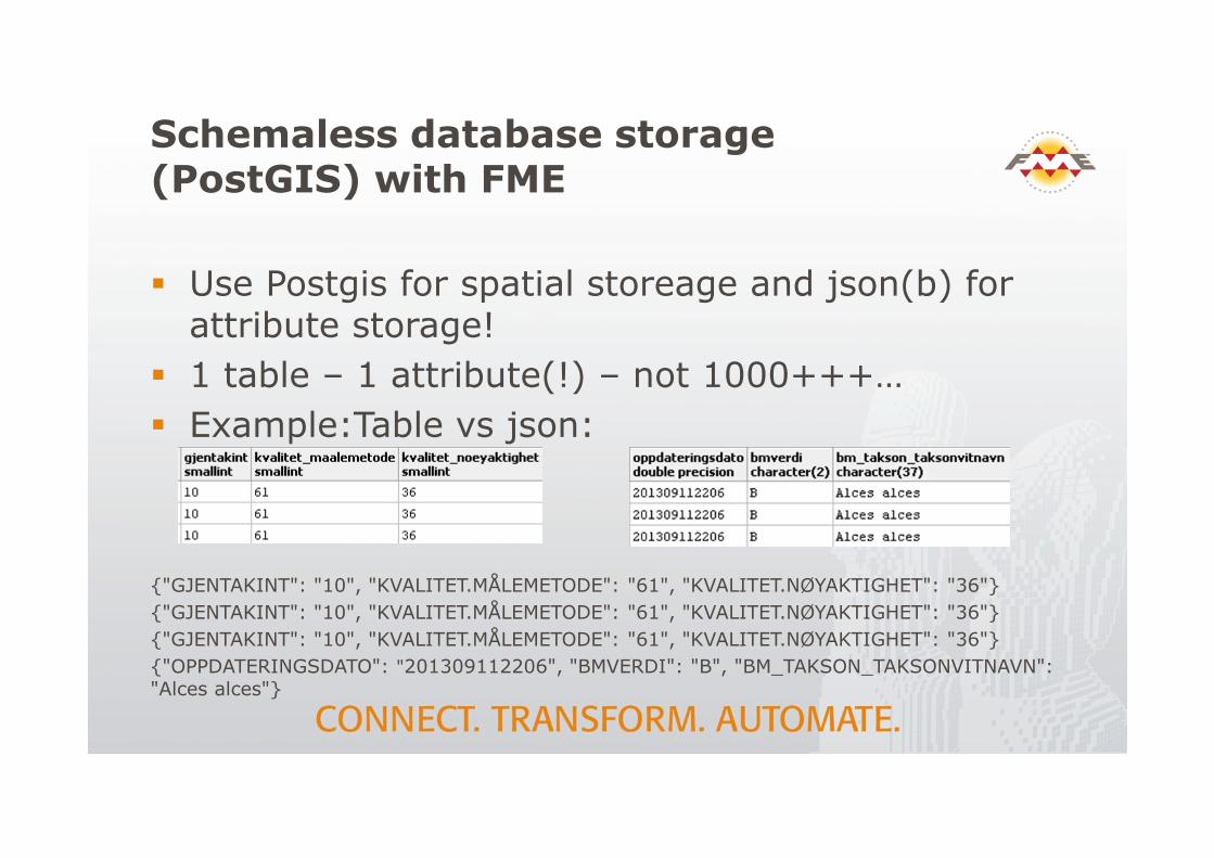
Schemaless database storage (PostGIS) with FME
� Use Postgis for spatial storeage and json(b) for attribute storage!
� 1 table – 1 attribute(!) – not 1000+++…� Example:Table vs json:
{"GJENTAKINT": "10", "KVALITET.MÅLEMETODE": "61", "KVALITET.NØYAKTIGHET": "36"}{"GJENTAKINT": "10", "KVALITET.MÅLEMETODE": "61", "KVALITET.NØYAKTIGHET": "36"}{"GJENTAKINT": "10", "KVALITET.MÅLEMETODE": "61", "KVALITET.NØYAKTIGHET": "36"} {"OPPDATERINGSDATO": "201309112206", "BMVERDI": "B", "BM_TAKSON_TAKSONVITNAVN": "Alces alces"}
Schemaless database storage (PostGIS) with FME
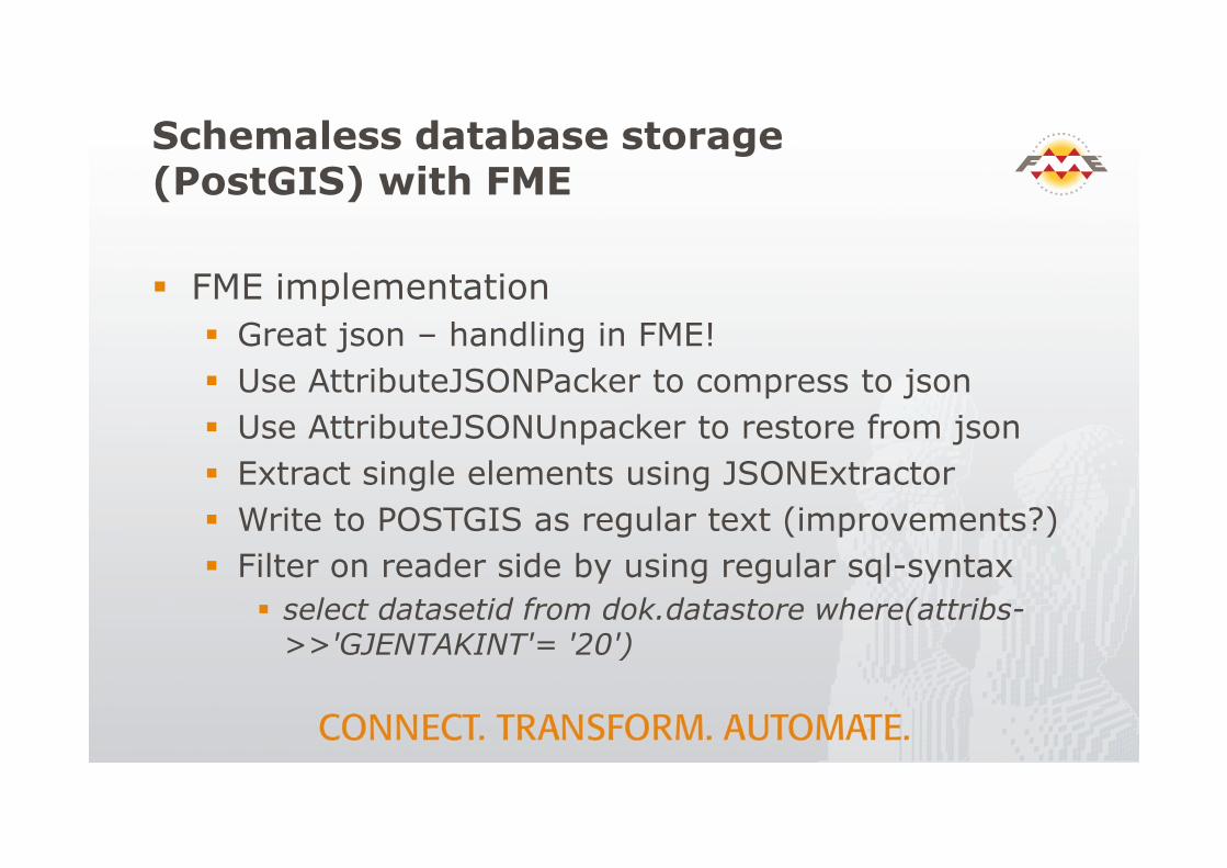
� FME implementation� Great json – handling in FME!� Use AttributeJSONPacker to compress to json� Use AttributeJSONUnpacker to restore from json� Extract single elements using JSONExtractor� Write to POSTGIS as regular text (improvements?)� Filter on reader side by using regular sql-syntax
� select datasetid from dok.datastore where(attribs->>'GJENTAKINT'= '20')
Schemaless database storage (PostGIS) with FME
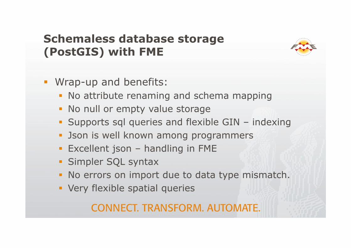
� Wrap-up and benefits:� No attribute renaming and schema mapping� No null or empty value storage� Supports sql queries and flexible GIN – indexing� Json is well known among programmers� Excellent json – handling in FME� Simpler SQL syntax� No errors on import due to data type mismatch.� Very flexible spatial queries