Embed Size (px)
Citation preview
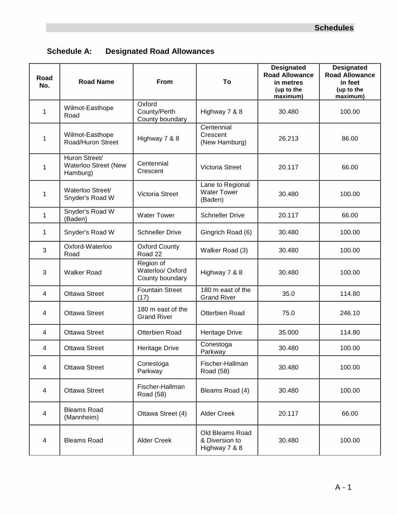
Schedules
Schedule A: Designated Road Allowances
Road No. Road Name From To
Designated Road Allowance
in metres (up to the maximum)
Designated Road Allowance
in feet (up to the maximum)
1 Wilmot-Easthope Road
Oxford County/Perth County boundary
Highway 7 & 8 30.480 100.00
1 Wilmot-Easthope Road/Huron Street
Highway 7 & 8
Centennial Crescent (New Hamburg)
26.213 86.00
1 Huron Street/ Waterloo Street (New Hamburg)
Centennial Crescent Victoria Street 20.117 66.00
1 Waterloo Street/ Snyder's Road W
Victoria Street Lane to Regional Water Tower (Baden)
30.480 100.00
1 Snyder's Road W (Baden)
Water Tower Schneller Drive 20.117 66.00
1 Snyder's Road W Schneller Drive Gingrich Road (6) 30.480 100.00
3 Oxford-Waterloo Road
Oxford County Road 22 Walker Road (3) 30.480 100.00
3 Walker Road Region of Waterloo/ Oxford County boundary
Highway 7 & 8 30.480 100.00
4 Ottawa Street Fountain Street (17)
180 m east of the Grand River
35.0 114.80
4 Ottawa Street
180 m east of the Grand River
Otterbien Road 75.0 246.10
4
Ottawa Street Otterbien Road Heritage Drive 35.000 114.80
4
Ottawa Street Heritage Drive Conestoga Parkway 30.480 100.00
4 Ottawa Street Conestoga Parkway
Fischer-Hallman Road (58)
30.480 100.00
4 Ottawa Street
Fischer-Hallman Road (58)
Bleams Road (4) 30.480 100.00
4
Bleams Road (Mannheim)
Ottawa Street (4) Alder Creek 20.117 66.00
4 Bleams Road Alder Creek
Old Bleams Road & Diversion to Highway 7 & 8
30.480 100.00
A - 1
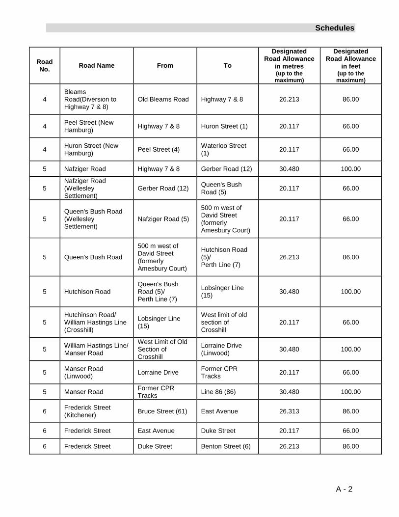
Schedules
Road No. Road Name From To
Designated Road Allowance
in metres (up to the maximum)
Designated Road Allowance
in feet (up to the maximum)
4
Bleams Road(Diversion to Highway 7 & 8)
Old Bleams Road Highway 7 & 8 26.213 86.00
4
Peel Street (New Hamburg)
Highway 7 & 8 Huron Street (1) 20.117 66.00
4
Huron Street (New Hamburg)
Peel Street (4) Waterloo Street (1) 20.117 66.00
5
Nafziger Road Highway 7 & 8 Gerber Road (12) 30.480 100.00
5 Nafziger Road (Wellesley Settlement)
Gerber Road (12)
Queen's Bush Road (5)
20.117 66.00
5 Queen's Bush Road (Wellesley Settlement)
Nafziger Road (5)
500 m west of David Street (formerly Amesbury Court)
20.117 66.00
5 Queen's Bush Road
500 m west of David Street (formerly Amesbury Court)
Hutchison Road (5)/ Perth Line (7)
26.213 86.00
5 Hutchison Road
Queen's Bush Road (5)/ Perth Line (7)
Lobsinger Line (15) 30.480 100.00
5
Hutchinson Road/ William Hastings Line (Crosshill)
Lobsinger Line (15)
West limit of old section of Crosshill
20.117 66.00
5 William Hastings Line/ Manser Road
West Limit of Old Section of Crosshill
Lorraine Drive (Linwood)
30.480 100.00
5
Manser Road (Linwood)
Lorraine Drive Former CPR Tracks 20.117 66.00
5
Manser Road Former CPR Tracks Line 86 (86) 30.480 100.00
6
Frederick Street (Kitchener)
Bruce Street (61) East Avenue 26.313 86.00
6
Frederick Street East Avenue Duke Street 20.117 66.00
6
Frederick Street Duke Street Benton Street (6) 26.213 86.00
A - 2
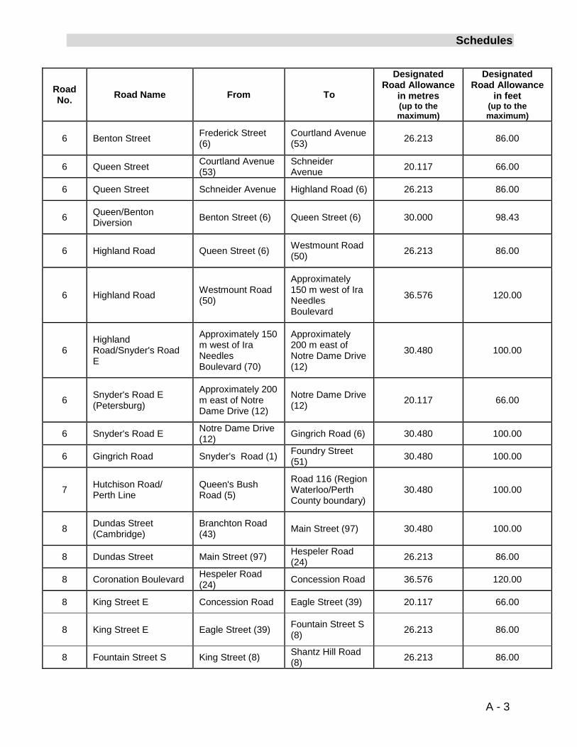
Schedules
Road No. Road Name From To
Designated Road Allowance
in metres (up to the maximum)
Designated Road Allowance
in feet (up to the maximum)
6 Benton Street Frederick Street (6)
Courtland Avenue (53)
26.213 86.00
6
Queen Street Courtland Avenue (53)
Schneider Avenue 20.117 66.00
6
Queen Street Schneider Avenue Highland Road (6) 26.213 86.00
6
Queen/Benton Diversion
Benton Street (6) Queen Street (6) 30.000 98.43
6 Highland Road Queen Street (6)
Westmount Road (50)
26.213 86.00
6 Highland Road Westmount Road (50)
Approximately 150 m west of Ira Needles Boulevard
36.576 120.00
6 Highland Road/Snyder's Road E
Approximately 150 m west of Ira Needles Boulevard (70)
Approximately 200 m east of Notre Dame Drive (12)
30.480 100.00
6 Snyder's Road E (Petersburg)
Approximately 200 m east of Notre Dame Drive (12)
Notre Dame Drive (12) 20.117 66.00
6
Snyder's Road E Notre Dame Drive (12) Gingrich Road (6) 30.480 100.00
6
Gingrich Road Snyder's Road (1) Foundry Street (51) 30.480 100.00
7 Hutchison Road/ Perth Line
Queen's Bush Road (5)
Road 116 (Region Waterloo/Perth County boundary)
30.480 100.00
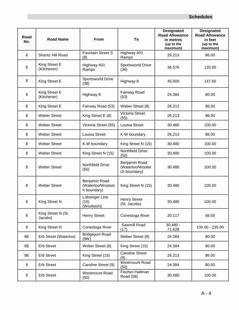
8
Dundas Street (Cambridge)
Branchton Road (43) Main Street (97) 30.480 100.00
8
Dundas Street Main Street (97) Hespeler Road (24) 26.213 86.00
8
Coronation Boulevard Hespeler Road (24) Concession Road 36.576 120.00
8
King Street E Concession Road Eagle Street (39) 20.117 66.00
8 King Street E Eagle Street (39)
Fountain Street S (8)
26.213 86.00
8
Fountain Street S King Street (8) Shantz Hill Road (8) 26.213 86.00
A - 3
Schedules
Road No. Road Name From To
Designated Road Allowance
in metres (up to the maximum)
Designated Road Allowance
in feet (up to the maximum)
8 Shantz Hill Road Fountain Street S (8)
Highway 401 Ramps 26.213 86.00
8 King Street E (Kitchener)
Highway 401 Ramps
Sportsworld Drive (38) 36.576 120.00
8 King Street E Sportsworld Drive (38) Highway 8 45.000 147.60
8 King Street E (Kitchener)
Highway 8 Fairway Road (53) 24.384 80.00
8 King Street E Fairway Road (53) Weber Street (8) 26.213 86.00
8 Weber Street King Street E (8) Victoria Street (55) 26.213 86.00
8 Weber Street Victoria Street (55) Louisa Street 30.480 100.00
8 Weber Street Louisa Street K-W boundary 26.213 86.00
8 Weber Street K-W boundary
King Street N (15) 30.480 100.00
8 Weber Street King Street N (15) Northfield Drive (50) 30.480 100.00
8 Weber Street Northfield Drive (50)
Benjamin Road (Waterloo/Woolwich boundary)
30.480 100.00
8 Weber Street Benjamin Road (Waterloo/Woolwich boundary)
King Street N (15) 30.480 100.00
8 King Street N Lobsinger Line (15) (Woolwich)
Henry Street (St. Jacobs) 30.480 100.00
8 King Street N (St. Jacobs) Henry Street Conestoga River 20.117 66.00
8 King Street N Conestoga River Sawmill Road (17)
30.480 - 71.628 100.00 - 235.00
9E Erb Street (Waterloo) Bridgeport Road
(9W) Weber Street (8) 24.384 80.00
9E Erb Street Weber Street (8) King Street (15) 24.384 80.00
9E Erb Street King Street (15) Caroline Street
(9) 26.213 86.00
9 Erb Street Caroline Street (9) Westmount Road (50)
24.384 80.00
9 Erb Street Westmount Road (50)
Fischer-Hallman Road (58) 30.480 100.00
A - 4
Schedules
Road No. Road Name From To
Designated Road Allowance
in metres (up to the maximum)
Designated Road Allowance
in feet (up to the maximum)
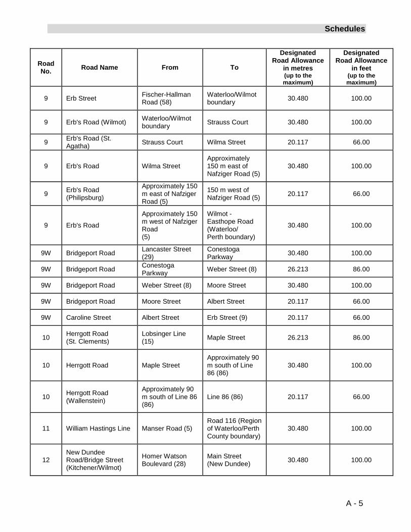
9 Erb Street
Fischer-Hallman Road (58)
Waterloo/Wilmot boundary 30.480 100.00
9 Erb's Road (Wilmot)
Waterloo/Wilmot boundary Strauss Court 30.480 100.00
9 Erb's Road (St. Agatha) Strauss Court Wilma Street 20.117 66.00
9 Erb's Road Wilma Street Approximately 150 m east of Nafziger Road (5)
30.480 100.00
9 Erb's Road (Philipsburg)
Approximately 150 m east of Nafziger Road (5)
150 m west of Nafziger Road (5) 20.117 66.00
9 Erb's Road
Approximately 150 m west of Nafziger Road (5)
Wilmot - Easthope Road (Waterloo/ Perth boundary)
30.480 100.00
9W Bridgeport Road Lancaster Street
(29) Conestoga Parkway 30.480 100.00
9W Bridgeport Road Conestoga
Parkway Weber Street (8) 26.213 86.00
9W Bridgeport Road Weber Street (8) Moore Street 30.480 100.00
9W Bridgeport Road Moore Street Albert Street 20.117 66.00
9W Caroline Street Albert Street Erb Street (9) 20.117 66.00
10
Herrgott Road (St. Clements)
Lobsinger Line (15) Maple Street 26.213 86.00
10 Herrgott Road Maple Street
Approximately 90 m south of Line 86 (86)
30.480 100.00
10 Herrgott Road (Wallenstein)
Approximately 90 m south of Line 86 (86)
Line 86 (86) 20.117 66.00
11 William Hastings Line Manser Road (5) Road 116 (Region of Waterloo/Perth County boundary)
30.480 100.00
12 New Dundee Road/Bridge Street (Kitchener/Wilmot)
Homer Watson Boulevard (28)
Main Street (New Dundee) 30.480 100.00
A - 5
Schedules
Road No. Road Name From To
Designated Road Allowance
in metres (up to the maximum)
Designated Road Allowance
in feet (up to the maximum)
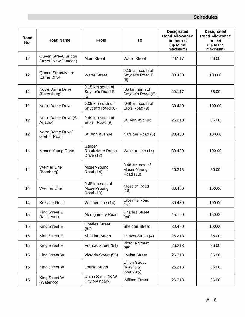
12
Queen Street/ Bridge Street (New Dundee) Main Street Water Street 20.117 66.00
12 Queen Street/Notre Dame Drive Water Street
0.15 km south of Snyder's Road E (6)
30.480 100.00
12 Notre Dame Drive (Petersburg)
0.15 km south of Snyder's Road E (6)
.05 km north of Snyder's Road (6) 20.117 66.00
12 Notre Dame Drive 0.05 km north of Snyder's Road (6)
.049 km south of Erb's Road (9) 30.480 100.00
12 Notre Dame Drive (St. Agatha)
0.49 km south of Erb's Road (9) St. Ann Avenue 26.213 86.00
12
Notre Dame Drive/ Gerber Road St. Ann Avenue Nafziger Road (5) 30.480 100.00
14 Moser-Young Road Gerber Road/Notre Dame Drive (12)
Weimar Line (14) 30.480 100.00
14 Weimar Line (Bamberg)
Moser-Young Road (14)
0.48 km east of Moser-Young Road (10)
26.213 86.00
14 Weimar Line 0.48 km east of Moser-Young Road (10)
Kressler Road (16) 30.480 100.00
14 Kressler Road Weimer Line (14) Erbsville Road (70) 30.480 100.00
15 King Street E (Kitchener)
Montgomery Road Charles Street (64) 45.720 150.00
15 King Street E Charles Street (64) Sheldon Street 30.480 100.00
15 King Street E Sheldon Street Ottawa Street (4) 26.213 86.00
15 King Street E Francis Street (64) Victoria Street (55) 26.213 86.00
15 King Street W Victoria Street (55) Louisa Street 26.213 86.00
15 King Street W Louisa Street Union Street (K-W City boundary)
26.213 86.00
15 King Street W (Waterloo)
Union Street (K-W City boundary) William Street 26.213 86.00
A - 6
Schedules
Road No. Road Name From To
Designated Road Allowance
in metres (up to the maximum)
Designated Road Allowance
in feet (up to the maximum)
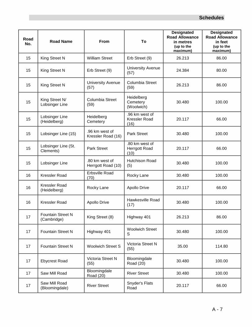
15 King Street N William Street Erb Street (9) 26.213 86.00
15 King Street N Erb Street (9)
University Avenue (57) 24.384 80.00
15 King Street N University Avenue (57)
Columbia Street (59) 26.213 86.00
15 King Street N/ Lobsinger Line
Columbia Street (59)
Heidelberg Cemetery (Woolwich)
30.480 100.00
15 Lobsinger Line (Heidelberg)
Heidelberg Cemetery
.96 km west of Kressler Road (16)
20.117 66.00
15 Lobsinger Line (15) .96 km west of Kressler Road (16) Park Street 30.480 100.00
15 Lobsinger Line (St. Clements) Park Street
.80 km west of Herrgott Road (10)
20.117 66.00
15 Lobsinger Line .80 km west of Herrgott Road (10)
Hutchison Road (5) 30.480 100.00
16
Kressler Road Erbsville Road (70) Rocky Lane 30.480 100.00
16
Kressler Road (Heidelberg) Rocky Lane Apollo Drive 20.117 66.00
16 Kressler Road Apollo Drive Hawkesville Road (17) 30.480 100.00
17 Fountain Street N (Cambridge) King Street (8) Highway 401 26.213 86.00
17 Fountain Street N Highway 401 Woolwich Street S
30.480 100.00
17 Fountain Street N Woolwich Street S
Victoria Street N (55) 35.00 114.80
17 Ebycrest Road Victoria Street N (55)
Bloomingdale Road (20) 30.480 100.00
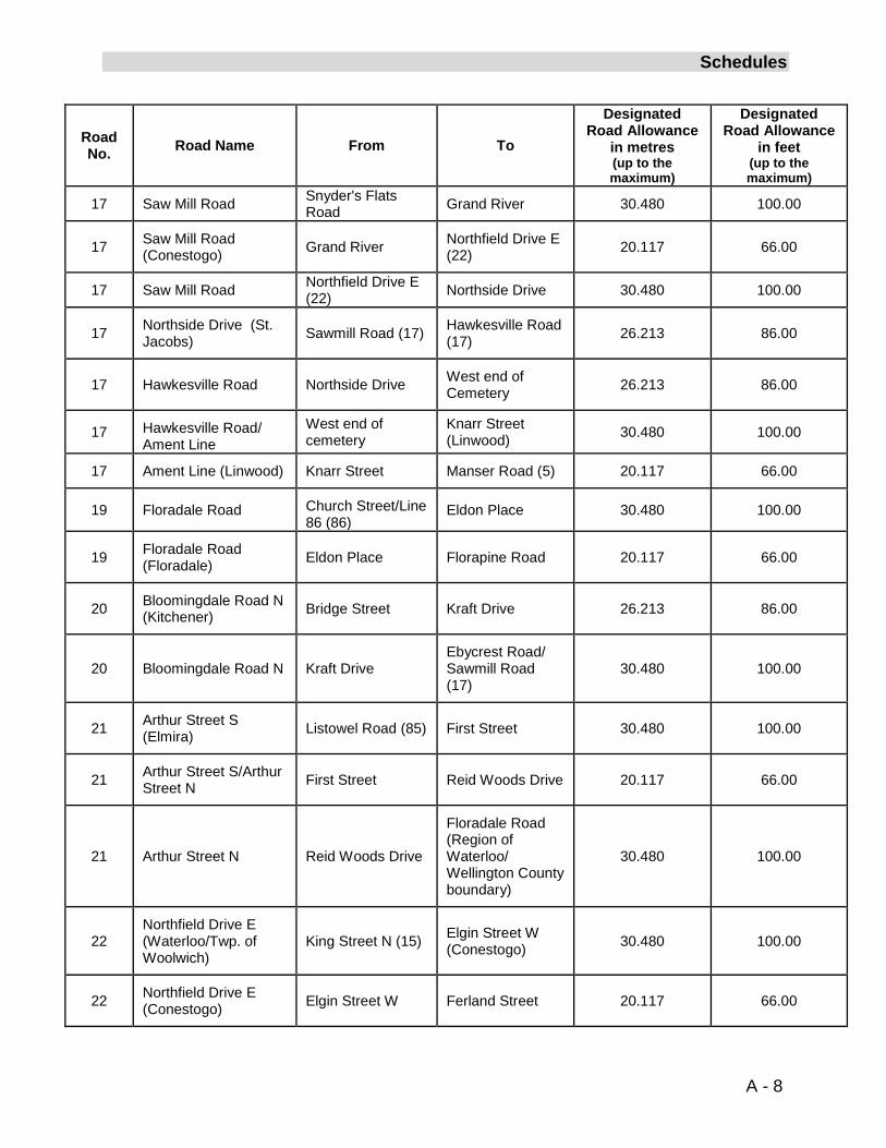
17 Saw Mill Road Bloomingdale Road (20) River Street 30.480 100.00
17 Saw Mill Road (Bloomingdale) River Street Snyder's Flats
Road 20.117 66.00
A - 7
Schedules
Road No. Road Name From To
Designated Road Allowance
in metres (up to the maximum)
Designated Road Allowance
in feet (up to the maximum)
17 Saw Mill Road Snyder's Flats Road Grand River 30.480 100.00
17 Saw Mill Road (Conestogo) Grand River Northfield Drive E
(22) 20.117 66.00
17 Saw Mill Road Northfield Drive E (22) Northside Drive 30.480 100.00
17 Northside Drive (St. Jacobs) Sawmill Road (17) Hawkesville Road
(17) 26.213 86.00
17 Hawkesville Road Northside Drive West end of Cemetery 26.213 86.00
17 Hawkesville Road/ Ament Line
West end of cemetery
Knarr Street (Linwood) 30.480 100.00
17
Ament Line (Linwood) Knarr Street Manser Road (5) 20.117 66.00
19 Floradale Road Church Street/Line 86 (86)
Eldon Place 30.480 100.00
19 Floradale Road (Floradale) Eldon Place Florapine Road 20.117 66.00
20
Bloomingdale Road N (Kitchener) Bridge Street Kraft Drive 26.213 86.00
20 Bloomingdale Road N Kraft Drive Ebycrest Road/ Sawmill Road (17)
30.480 100.00
21 Arthur Street S (Elmira) Listowel Road (85) First Street 30.480 100.00
21
Arthur Street S/Arthur Street N First Street Reid Woods Drive 20.117 66.00
21 Arthur Street N Reid Woods Drive
Floradale Road (Region of Waterloo/ Wellington County boundary)
30.480 100.00
22 Northfield Drive E (Waterloo/Twp. of Woolwich)
King Street N (15) Elgin Street W (Conestogo) 30.480 100.00
22 Northfield Drive E (Conestogo) Elgin Street W Ferland Street 20.117 66.00
A - 8
Schedules
Road No. Road Name From To
Designated Road Allowance
in metres (up to the maximum)
Designated Road Allowance
in feet (up to the maximum)
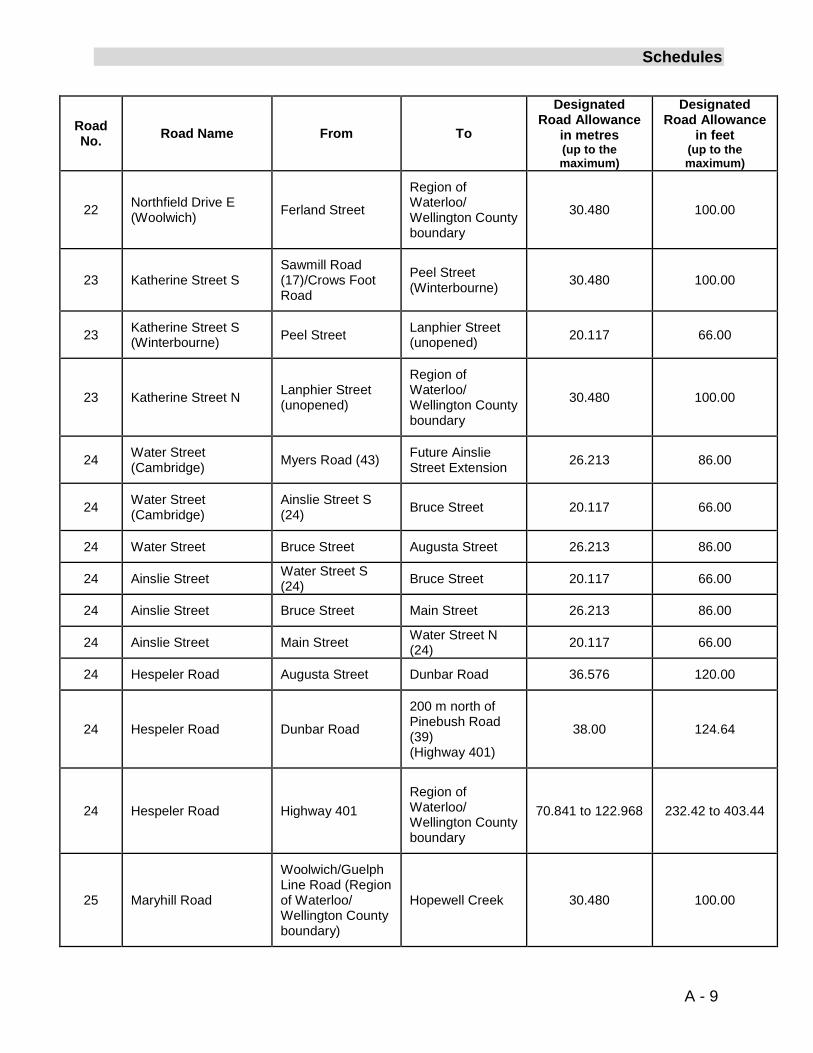
22 Northfield Drive E (Woolwich) Ferland Street
Region of Waterloo/ Wellington County boundary
30.480 100.00
23 Katherine Street S Sawmill Road (17)/Crows Foot Road
Peel Street (Winterbourne) 30.480 100.00
23 Katherine Street S (Winterbourne) Peel Street Lanphier Street
(unopened) 20.117 66.00
23 Katherine Street N Lanphier Street (unopened)
Region of Waterloo/ Wellington County boundary
30.480 100.00
24 Water Street (Cambridge) Myers Road (43) Future Ainslie
Street Extension 26.213 86.00
24
Water Street (Cambridge)
Ainslie Street S (24) Bruce Street 20.117 66.00
24 Water Street Bruce Street Augusta Street 26.213 86.00
24 Ainslie Street Water Street S (24) Bruce Street 20.117 66.00
24 Ainslie Street Bruce Street Main Street 26.213 86.00
24
Ainslie Street Main Street Water Street N (24) 20.117 66.00
24 Hespeler Road Augusta Street Dunbar Road 36.576 120.00
24 Hespeler Road Dunbar Road
200 m north of Pinebush Road (39) (Highway 401)
38.00 124.64
24 Hespeler Road Highway 401
Region of Waterloo/ Wellington County boundary
70.841 to 122.968 232.42 to 403.44
25 Maryhill Road
Woolwich/Guelph Line Road (Region of Waterloo/ Wellington County boundary)
Hopewell Creek 30.480 100.00
A - 9
Schedules
Road No. Road Name From To
Designated Road Allowance
in metres (up to the maximum)
Designated Road Allowance
in feet (up to the maximum)
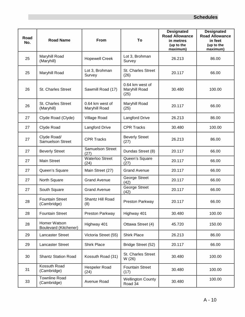
25 Maryhill Road (Maryhill) Hopewell Creek
Lot 3, Brohman Survey 26.213 86.00
25 Maryhill Road Lot 3, Brohman Survey
St. Charles Street (26) 20.117 66.00
26 St. Charles Street Sawmill Road (17)
0.64 km west of Maryhill Road (25)
30.480 100.00
26 St. Charles Street (Maryhill)
0.64 km west of Maryhill Road
Maryhill Road (25) 20.117 66.00
27 Clyde Road (Clyde) Village Road Langford Drive 26.213 86.00
27 Clyde Road Langford Drive CPR Tracks 30.480 100.00
27 Clyde Road/ Samuelson Street CPR Tracks Beverly Street
(27) 26.213 86.00
27
Beverly Street Samuelson Street (27) Dundas Street (8) 20.117 66.00
27 Main Street Waterloo Street (24)
Queen’s Square (27) 20.117 66.00
27 Queen’s Square Main Street (27) Grand Avenue 20.117 66.00
27 North Square Grand Avenue George Street (42) 20.117 66.00
27 South Square Grand Avenue George Street (42) 20.117 66.00
28 Fountain Street (Cambridge)
Shantz Hill Road (8) Preston Parkway 20.117 66.00
28 Fountain Street Preston Parkway Highway 401 30.480 100.00
28
Homer Watson Boulevard (Kitchener)
Highway 401 Ottawa Street (4) 45.720 150.00
29 Lancaster Street Victoria Street (55) Shirk Place 26.213 86.00
29 Lancaster Street Shirk Place Bridge Street (52) 20.117 66.00
30 Shantz Station Road Kossuth Road (31) St. Charles Street W (26) 30.480 100.00
31 Kossuth Road (Cambridge)
Hespeler Road (24)
Fountain Street (17) 30.480 100.00
33 Townline Road (Cambridge) Avenue Road Wellington County
Road 34 30.480 100.00
A - 10
Schedules
Road No. Road Name From To
Designated Road Allowance
in metres (up to the maximum)
Designated Road Allowance
in feet (up to the maximum)
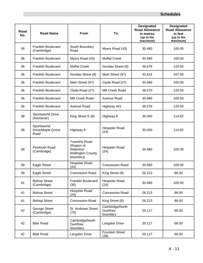
36
Franklin Boulevard (Cambridge)
South Boundary Road Myers Road (43) 30.480 100.00
36 Franklin Boulevard Myers Road (43) Moffat Creek 30.480 100.00
36 Franklin Boulevard Moffat Creek Dundas Street (8) 36.576 120.00
36 Franklin Boulevard Dundas Street (8) Main Street (97) 32.614 107.00
36 Franklin Boulevard Main Street (97) Clyde Road (27) 30.480 100.00
36 Franklin Boulevard Clyde Road (27) Mill Creek Road 36.570 120.00
36 Franklin Boulevard Mill Creek Road Avenue Road 30.480 100.00
36 Franklin Boulevard Avenue Road Highway 401 36.576 120.00
38 Sportsworld Drive (Kitchener) King Street E (8) Highway 8 35.000 114.82
38
Sportsworld Drive/Maple Grove Road
Highway 8 Hespeler Road (24) 35.000 114.82
39 Pinebush Road (Cambridge)
Townline Road (Region of Waterloo/ Wellington County boundary)
Hespeler Road (24) 30.480 100.00
39 Eagle Street Hespeler Road (24) Concession Road 30.480 100.00
39 Eagle Street Concession Road King Street (8) 26.213 86.00
41 Bishop Street (Cambridge)
Franklin Boulevard (36)
Hespeler Road (24) 30.480 100.00
41 Bishop Street Hespeler Road (24) Concession Road 26.213 86.00
41 Bishop Street Concession Road King Street (8) 26.213 86.00
42 George Street (Cambridge)
St. Andrews Street (75)
Cambridge/North Dumfries boundary
20.117 66.00
42 Blair Road Cambridge/North Dumfries boundary
Langdon Drive 20.117 66.00
42 Blair Road Langdon Drive Fountain Street (28) 20.117 66.00
A - 11
Schedules
Road No. Road Name From To
Designated Road Allowance
in metres (up to the maximum)
Designated Road Allowance
in feet (up to the maximum)
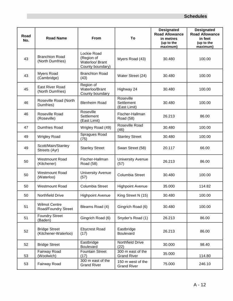
43 Branchton Road (North Dumfries)
Lockie Road (Region of Waterloo/ Brant County boundary)
Myers Road (43) 30.480 100.00
43 Myers Road (Cambridge)
Branchton Road (43) Water Street (24) 30.480 100.00
45
East River Road (North Dumfries)
Region of Waterloo/Brant County boundary
Highway 24 30.480 100.00
46 Roseville Road (North Dumfries) Blenheim Road
Roseville Settlement (East Limit)
30.480 100.00
46 Roseville Road (Roseville)
Roseville Settlement (East Limit)
Fischer-Hallman Road (58) 26.213 86.00
47 Dumfries Road Wrigley Road (49) Roseville Road (46) 30.480 100.00
49 Wrigley Road Spragues Road (75) Stanley Street 30.480 100.00
49 Scott/Main/Stanley Streets (Ayr) Stanley Street Swan Street (58) 20.117 66.00
50 Westmount Road (Kitchener)
Fischer-Hallman Road (58)
University Avenue (57) 26.213 86.00
50 Westmount Road (Waterloo)
University Avenue (57) Columbia Street 30.480 100.00
50 Westmount Road Columbia Street Highpoint Avenue 35.000 114.82
50 Northfield Drive Highpoint Avenue
King Street N (15) 30.480 100.00
51 Wilmot Centre Road/Foundry Street
Bleams Road (4) Gingrich Road (6) 30.480 100.00
51 Foundry Street (Baden) Gingrich Road (6) Snyder's Road (1) 26.213 86.00
52 Bridge Street (Kitchener-Waterloo)
Ebycrest Road (17)
Eastbridge Boulevard 26.213 86.00
52 Bridge Street Eastbridge Boulevard
Northfield Drive (22) 30.000 98.40
53
Fairway Road (Woolwich)
Fountain Street (17)
300 m east of the Grand River 35.000
114.80
53 Fairway Road 300 m east of the Grand River
150 m west of the Grand River 75.000 246.10
A - 12
Schedules
Road No. Road Name From To
Designated Road Allowance
in metres (up to the maximum)
Designated Road Allowance
in feet (up to the maximum)
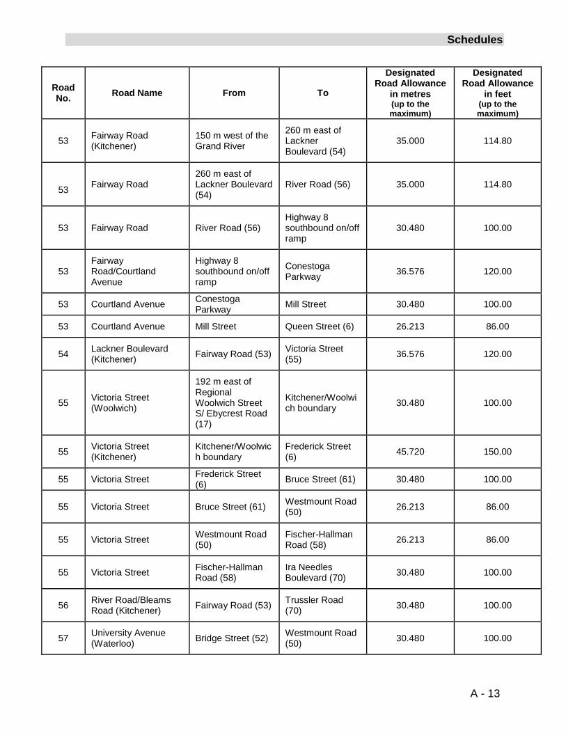
53 Fairway Road (Kitchener)
150 m west of the Grand River
260 m east of Lackner Boulevard (54)
35.000 114.80
53 Fairway Road 260 m east of Lackner Boulevard (54)
River Road (56) 35.000 114.80
53 Fairway Road River Road (56) Highway 8 southbound on/off ramp
30.480 100.00
53 Fairway Road/Courtland Avenue
Highway 8 southbound on/off ramp
Conestoga Parkway 36.576 120.00
53 Courtland Avenue Conestoga Parkway Mill Street 30.480 100.00
53 Courtland Avenue Mill Street Queen Street (6) 26.213 86.00
54 Lackner Boulevard (Kitchener) Fairway Road (53) Victoria Street
(55) 36.576 120.00
55 Victoria Street (Woolwich)
192 m east of Regional Woolwich Street S/ Ebycrest Road (17)
Kitchener/Woolwich boundary 30.480 100.00
55
Victoria Street (Kitchener)
Kitchener/Woolwich boundary
Frederick Street (6) 45.720 150.00
55 Victoria Street Frederick Street (6) Bruce Street (61) 30.480 100.00
55 Victoria Street Bruce Street (61) Westmount Road (50) 26.213 86.00
55 Victoria Street Westmount Road (50)
Fischer-Hallman Road (58) 26.213 86.00
55 Victoria Street Fischer-Hallman Road (58)
Ira Needles Boulevard (70) 30.480 100.00
56 River Road/Bleams Road (Kitchener) Fairway Road (53) Trussler Road
(70) 30.480 100.00
57
University Avenue (Waterloo) Bridge Street (52) Westmount Road
(50) 30.480 100.00
A - 13
Schedules
Road No. Road Name From To
Designated Road Allowance
in metres (up to the maximum)
Designated Road Allowance
in feet (up to the maximum)
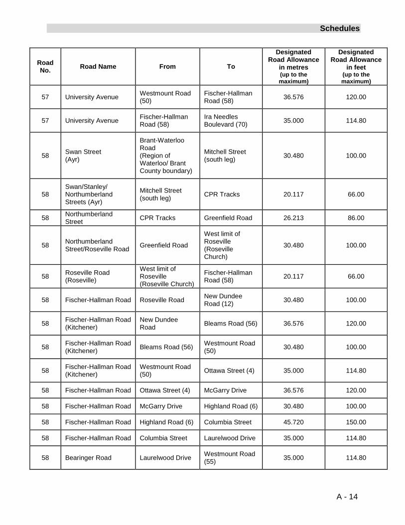
57 University Avenue Westmount Road (50)
Fischer-Hallman Road (58)
36.576 120.00
57 University Avenue Fischer-Hallman Road (58)
Ira Needles Boulevard (70) 35.000 114.80
58 Swan Street (Ayr)
Brant-Waterloo Road (Region of Waterloo/ Brant County boundary)
Mitchell Street (south leg) 30.480 100.00
58 Swan/Stanley/ Northumberland Streets (Ayr)
Mitchell Street (south leg) CPR Tracks 20.117 66.00
58 Northumberland Street CPR Tracks Greenfield Road 26.213 86.00
58 Northumberland Street/Roseville Road Greenfield Road
West limit of Roseville (Roseville Church)
30.480 100.00
58 Roseville Road (Roseville)
West limit of Roseville (Roseville Church)
Fischer-Hallman Road (58) 20.117 66.00
58 Fischer-Hallman Road Roseville Road New Dundee Road (12)
30.480 100.00
58
Fischer-Hallman Road (Kitchener)
New Dundee Road Bleams Road (56) 36.576 120.00
58 Fischer-Hallman Road (Kitchener) Bleams Road (56) Westmount Road
(50) 30.480 100.00
58 Fischer-Hallman Road (Kitchener)
Westmount Road (50) Ottawa Street (4) 35.000 114.80
58 Fischer-Hallman Road Ottawa Street (4) McGarry Drive 36.576 120.00
58 Fischer-Hallman Road McGarry Drive Highland Road (6) 30.480 100.00
58 Fischer-Hallman Road Highland Road (6) Columbia Street 45.720 150.00
58 Fischer-Hallman Road Columbia Street Laurelwood Drive 35.000 114.80
58 Bearinger Road Laurelwood Drive Westmount Road (55) 35.000 114.80
A - 14
Schedules
Road No. Road Name From To
Designated Road Allowance
in metres (up to the maximum)
Designated Road Allowance
in feet (up to the maximum)
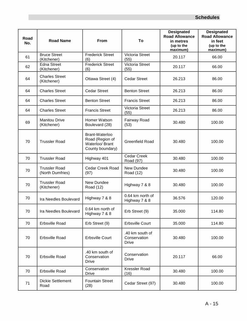
61 Bruce Street (Kitchener)
Frederick Street (6)
Victoria Street (55) 20.117 66.00
62 Edna Street (Kitchener)
Frederick Street (6)
Victoria Street (55) 20.117 66.00
64 Charles Street (Kitchener)
Ottawa Street (4) Cedar Street 26.213 86.00
64 Charles Street Cedar Street Benton Street 26.213 86.00
64 Charles Street Benton Street Francis Street 26.213 86.00
64 Charles Street Francis Street Victoria Street (55) 26.213 86.00
69 Manitou Drive (Kitchener)
Homer Watson Boulevard (28)
Fairway Road (53) 30.480 100.00
70 Trussler Road
Brant-Waterloo Road (Region of Waterloo/ Brant County boundary)
Greenfield Road 30.480 100.00
70 Trussler Road Highway 401 Cedar Creek Road (97) 30.480 100.00
70
Trussler Road (North Dumfries)
Cedar Creek Road (97)
New Dundee Road (12) 30.480 100.00
70 Trussler Road (Kitchener)
New Dundee Road (12) Highway 7 & 8 30.480 100.00
70 Ira Needles Boulevard Highway 7 & 8 0.64 km north of Highway 7 & 8 36.576 120.00
70 Ira Needles Boulevard 0.64 km north of Highway 7 & 8 Erb Street (9) 35.000 114.80
70 Erbsville Road Erb Street (9) Erbsville Court 35.000 114.80
70 Erbsville Road Erbsville Court
.40 km south of Conservation Drive
30.480 100.00
70 Erbsville Road .40 km south of Conservation Drive
Conservation Drive 20.117 66.00
70 Erbsville Road Conservation Drive
Kressler Road (16) 30.480 100.00
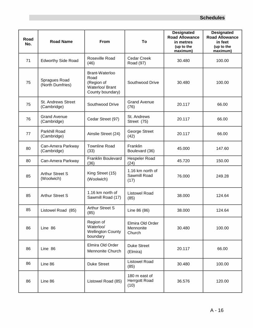
71 Dickie Settlement Road
Fountain Street (28) Cedar Street (97) 30.480 100.00
A - 15
Schedules
Road No. Road Name From To
Designated Road Allowance
in metres (up to the maximum)
Designated Road Allowance
in feet (up to the maximum)
71 Edworthy Side Road Roseville Road (46)
Cedar Creek Road (97) 30.480 100.00
75 Spragues Road (North Dumfries)
Brant-Waterloo Road (Region of Waterloo/ Brant County boundary)
Southwood Drive 30.480 100.00
75 St. Andrews Street (Cambridge) Southwood Drive Grand Avenue
(76) 20.117 66.00
76
Grand Avenue (Cambridge) Cedar Street (97) St. Andrews
Street (75) 20.117 66.00
77 Parkhill Road (Cambridge) Ainslie Street (24) George Street
(42) 20.117 66.00
80 Can-Amera Parkway (Cambridge)
Townline Road (33)
Franklin Boulevard (36) 45.000 147.60
80 Can-Amera Parkway Franklin Boulevard (36)
Hespeler Road (24) 45.720 150.00
85 Arthur Street S (Woolwich)
King Street (15) (Woolwich)
1.16 km north of Sawmill Road (17)
76.000 249.28
85 Arthur Street S 1.16 km north of Sawmill Road (17)
Listowel Road (85) 38.000 124.64
85
Listowel Road (85) Arthur Street S (85) Line 86 (86) 38.000 124.64
86 Line 86 Region of Waterloo/ Wellington County boundary
Elmira Old Order Mennonite Church
30.480 100.00
86 Line 86
Elmira Old Order Mennonite Church
Duke Street (Elmira)
20.117 66.00
86 Line 86 Duke Street Listowel Road (85) 30.480 100.00
86 Line 86 Listowel Road (85) 180 m east of Herrgott Road (10)
36.576 120.00
A - 16
Schedules
Road No. Road Name From To
Designated Road Allowance
in metres (up to the maximum)
Designated Road Allowance
in feet (up to the maximum)
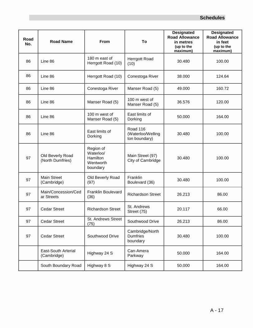
86 Line 86
180 m east of Herrgott Road (10)
Herrgott Road (10) 30.480 100.00
86 Line 86 Herrgott Road (10) Conestoga River 38.000 124.64
86 Line 86 Conestoga River Manser Road (5) 49.000 160.72
86 Line 86 Manser Road (5)
100 m west of Manser Road (5) 36.576 120.00
86 Line 86 100 m west of Manser Road (5)
East limits of Dorking 50.000 164.00
86 Line 86 East limits of Dorking
Road 116 (Waterloo/Wellington boundary)
30.480 100.00
97 Old Beverly Road (North Dumfries)
Region of Waterloo/ Hamilton Wentworth boundary
Main Street (97) City of Cambridge 30.480 100.00
97 Main Street (Cambridge)
Old Beverly Road (97)
Franklin Boulevard (36) 30.480 100.00
97 Main/Concession/Cedar Streets
Franklin Boulevard (36) Richardson Street 26.213 86.00
97 Cedar Street Richardson Street St. Andrews Street (75) 20.117 66.00
97 Cedar Street St. Andrews Street (75) Southwood Drive 26.213 86.00
97 Cedar Street Southwood Drive Cambridge/North Dumfries boundary
30.480 100.00
East-South Arterial (Cambridge) Highway 24 S Can-Amera
Parkway 50.000 164.00
South Boundary Road Highway 8 S Highway 24 S 50.000 164.00
A - 17
Schedules
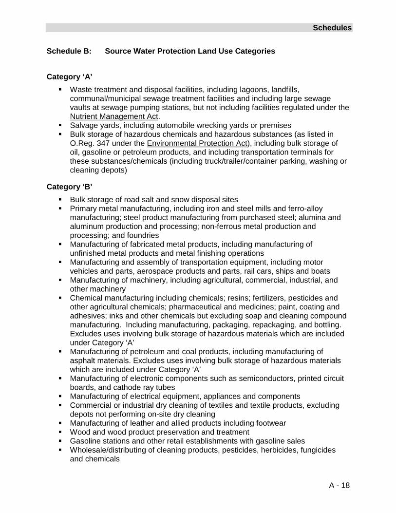
Schedule B: Source Water Protection Land Use Categories
Category ‘A’ Waste treatment and disposal facilities, including lagoons, landfills,
communal/municipal sewage treatment facilities and including large sewage vaults at sewage pumping stations, but not including facilities regulated under the Nutrient Management Act.
Salvage yards, including automobile wrecking yards or premises Bulk storage of hazardous chemicals and hazardous substances (as listed in
O.Reg. 347 under the Environmental Protection Act), including bulk storage of oil, gasoline or petroleum products, and including transportation terminals for these substances/chemicals (including truck/trailer/container parking, washing or cleaning depots)
Category ‘B’ Bulk storage of road salt and snow disposal sites Primary metal manufacturing, including iron and steel mills and ferro-alloy
manufacturing; steel product manufacturing from purchased steel; alumina and aluminum production and processing; non-ferrous metal production and processing; and foundries
Manufacturing of fabricated metal products, including manufacturing of unfinished metal products and metal finishing operations
Manufacturing and assembly of transportation equipment, including motor vehicles and parts, aerospace products and parts, rail cars, ships and boats
Manufacturing of machinery, including agricultural, commercial, industrial, and other machinery
Chemical manufacturing including chemicals; resins; fertilizers, pesticides and other agricultural chemicals; pharmaceutical and medicines; paint, coating and adhesives; inks and other chemicals but excluding soap and cleaning compound manufacturing. Including manufacturing, packaging, repackaging, and bottling. Excludes uses involving bulk storage of hazardous materials which are included under Category ‘A’
Manufacturing of petroleum and coal products, including manufacturing of asphalt materials. Excludes uses involving bulk storage of hazardous materials which are included under Category ‘A’
Manufacturing of electronic components such as semiconductors, printed circuit boards, and cathode ray tubes
Manufacturing of electrical equipment, appliances and components Commercial or industrial dry cleaning of textiles and textile products, excluding
depots not performing on-site dry cleaning Manufacturing of leather and allied products including footwear Wood and wood product preservation and treatment Gasoline stations and other retail establishments with gasoline sales Wholesale/distributing of cleaning products, pesticides, herbicides, fungicides
and chemicals
A - 18
Schedules
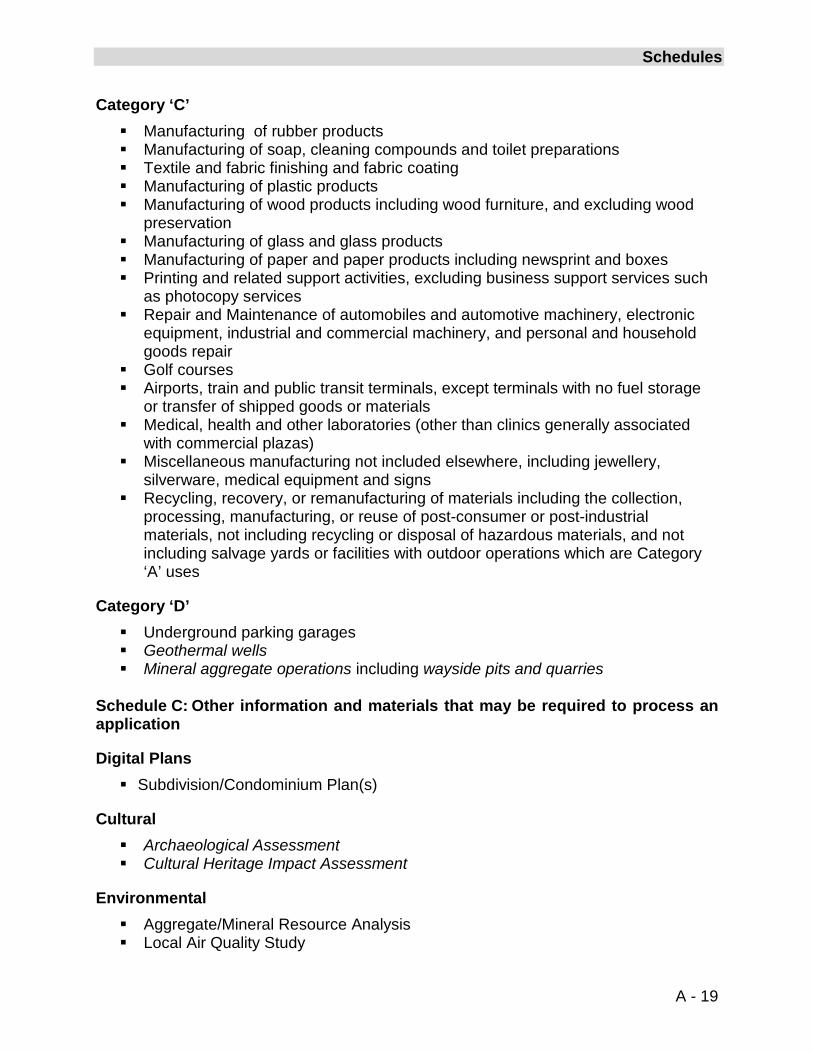
Category ‘C’ Manufacturing of rubber products Manufacturing of soap, cleaning compounds and toilet preparations Textile and fabric finishing and fabric coating Manufacturing of plastic products Manufacturing of wood products including wood furniture, and excluding wood
preservation Manufacturing of glass and glass products Manufacturing of paper and paper products including newsprint and boxes Printing and related support activities, excluding business support services such
as photocopy services Repair and Maintenance of automobiles and automotive machinery, electronic
equipment, industrial and commercial machinery, and personal and household goods repair
Golf courses Airports, train and public transit terminals, except terminals with no fuel storage
or transfer of shipped goods or materials Medical, health and other laboratories (other than clinics generally associated
with commercial plazas) Miscellaneous manufacturing not included elsewhere, including jewellery,
silverware, medical equipment and signs Recycling, recovery, or remanufacturing of materials including the collection,
processing, manufacturing, or reuse of post-consumer or post-industrial materials, not including recycling or disposal of hazardous materials, and not including salvage yards or facilities with outdoor operations which are Category ‘A’ uses
Category ‘D’ Underground parking garages Geothermal wells Mineral aggregate operations including wayside pits and quarries
Schedule C: Other information and materials that may be required to process an application
Digital Plans Subdivision/Condominium Plan(s)
Cultural Archaeological Assessment Cultural Heritage Impact Assessment
Environmental Aggregate/Mineral Resource Analysis Local Air Quality Study
A - 19
Schedules
Salt Impact Assessment Salt Management Plans Cut & Fill Analysis Environmental Impact Statement Comprehensive Environmental Impact Statement Natural Habitat Inventory Environmental Management Plan Tree Conservation and Planting Plans Provincial and Federal Requirements for Fish Habitat Slope Stability Study and Report Floodline Delineation Study/Hydraulics Study Hydrologic and Hydrogeologic Studies Source Water Protection Studies Best Management Practices for development within the Regional Recharge Area Best Management Practices (for golf courses) Environmental Site Assessment and/or Record of Site Condition Cumulative Impact Assessment Site Plan, Spill Protection Measures and other Best Management Practices for
Mineral Aggregate Operations Final Rehabilitation Plan (for mineral aggregate operations)
Construction, Servicing and Infrastructure Preliminary Grading Plan Preliminary Stormwater Management Report/Plan and/or update to an existing
Stormwater Management Plan Soils/Geotechnical Study Construction Methods and Spills Protection Measures Servicing Options Report Development Phasing Plan Water and Wastewater Servicing Plans and associated studies Hydrogeologic Studies for Privately Serviced Developments Impact on Existing Infrastructure Study
Land Use Compatibility Air Quality Assessment Dust Impact Analysis Land Use Compatibility Study Landfill Impact Study Agricultural Impact Assessment Minimum Distance Separation Noise Study Odour Impact Assessment Vibration Study Written Provincial approval (pursuant to the Environmental Protection Act for
development within former waste management facilities)
A - 20
Schedules
Provincial and Federal Requirements for Alternative and/or Renewable Energy Systems and Fish Habitat
Approval from the Grand River Conservation Authority
Planning Affordable Housing Report/Rental Conversion Assessment Detailed Property Assessment of Affordable Rental Housing Farm Viability Study Planning Report Land Use Study for Retail/Commercial Land Uses in Support of the Planned
Community Structure or Retail/Commercial Impact Analysis Retail Commercial Market Impact Study Urban Design Report/Brief
Transportation Transportation Impact Study Transportation System Impact Study Parking Analysis Pedestrian Route and Sidewalk Analysis Roundabout Feasibility Analysis Traffic Calming Options Report Transit Assessment Transportation Demand Management Options Report Provincial Requirements and Permits under the Public Transportation Act and
Highway Improvements Act Environmental Assessment and Other Appropriate Studies for development
adjacent to Proposed Regional and Provincial Corridors
A - 21