Embed Size (px)
Citation preview

07/01/2018 07:05 pm MT Page of1 Pike and San Isabel National Forests and Cimarron and Comanche National Grasslands
29
Projects Occurring in more than one Region (excluding Nationwide)
Pike and San Isabel National Forests and Cimarron and Comanche National Grasslands, Forestwide (excluding Projects occurring in more than one Forest)
Pike and San Isabel National Forests and Cimarron and Comanche National Grasslands, Occurring in more than one District(excluding Forestwide)
This report contains the best available information at the time of publication. Questions may be directed to the Project Contact.
Project PurposeProject Name DecisionPlanning Status Project ContactExpected
Implementation
07/01/2018 to 09/30/2018
R2 - Rocky Mountain Region
R2 - Rocky Mountain Region
- Special use management
- Facility management
On Hold
In Progress:Scoping Start 07/01/2016
N/A
Expected:04/2017
David [email protected]
Carin [email protected]
UNIT - Ashley National Forest All Units, Grand Valley Ranger District, Norwood Ranger District, Yampa Ranger District, Hahns Peak/Bears Ears Ranger District, Pine Ridge Ranger District, Sulphur Ranger District, East Zone/Dillon Ranger District, Paonia Ranger District, Boulder Ranger District, West Zone/Sopris Ranger District, Canyon Lakes Ranger District, Salida Ranger District, Gunnison Ranger District, Mancos/Dolores Ranger District. STATE - Colorado, Nebraska, Utah. COUNTY - Chaffee, Delta, Dolores, Eagle, Grand, Gunnison, Jackson, Lake, La Plata, Larimer, Mesa, Montrose, Routt, Saguache, San Juan, Dawes, Daggett, Uintah. LEGAL - Not Applicable. Linear transmission lines located in Colorado, Utah, and Nebraska.
UNIT - Pike and San Isabel National Forests and Cimarron and Comanche National Grasslands All Units. STATE- Colorado. COUNTY - Pueblo. LEGAL - Not Applicable. Timpas,Mt Rosa, Almagre, Indian Creek, Lake George, Sheep Mountain, Topaz Mountain, Adobe Peak, Bandito Cone, Jack Hall, and Green Timber.
Location:
Location:
N/A
05/2017
Western Area Power Administration Right-of-Way Maintenance and Reauthorization Project
Administrative Communication Towers
Schedule of Proposed Action (SOPA)
Update vegetation management activities along 278 miles of transmission lines located on NFS lands in Colorado, Nebraska, and Utah. These activities are intended to protect the transmission lines by managing for stable, low growth vegetation.
The Pike/San Isabel National Forests and Cimarron/Comanche National Grasslands (PSICC)proposes to install eleven versa communication towers for government administrative use.
Description:
Description:
Web Link:
Web Link:
http://www.fs.usda.gov/project/?project=30630
http://www.fs.usda.gov/project/?project=49850
Pike and San Isabel National Forests and Cimarron and Comanche National Grasslands
EIS
CE

07/01/2018 07:05 pm MT Page of2 Pike and San Isabel National Forests and Cimarron and Comanche National Grasslands
29
Pike and San Isabel National Forests and Cimarron and Comanche National Grasslands, Occurring in more than one District(excluding Forestwide)
Project PurposeProject Name DecisionPlanning Status Project ContactExpected
Implementation
R2 - Rocky Mountain Region
- Special area management - Special use management
- Vegetation management (other than forest products)
- Wildlife, Fish, Rare plants - Forest products - Vegetation management (other than forest products) - Watershed management
Developing ProposalEst. Scoping Start 09/2015
Developing ProposalEst. Scoping Start 04/2015
On Hold
Expected:09/2015
Expected:07/2015
N/A
John [email protected]
Angela [email protected]
UNIT - San Carlos Ranger District, South Park Ranger District, South Platte Ranger District, Leadville Ranger District, Pikes Peak Ranger District. STATE - Colorado. COUNTY - Chaffee, Custer, Douglas, El Paso, Fremont, Huerfano, Lake, Park, Teller. LEGAL - Legal description provided on attached maps. blank.
UNIT - Cimarron Ranger District, Comanche Ranger District. STATE - Colorado. COUNTY - Baca, Las Animas. LEGAL - Section 14, T32S, R53W.Section 7, T32S, R50W, Section 12, T33S,R49W ,Section 8, T33S, R47W,Section 18, T33S, R47W, Section 29, T33S, R47W,Section 15, T33S, R47W. Comanche National Grassland, Baca and Las Animas Counties.
UNIT - San Carlos Ranger District, South Park Ranger District, South Platte Ranger District, Leadville Ranger District, Salida Ranger District, Pikes Peak Ranger District. STATE - Colorado. COUNTY - Chaffee, Custer, Douglas, El Paso, Fremont, Jefferson, Lake, Park, Pueblo, Teller. LEGAL - PSICC National Forest. Buffalo Creek, Hayman, Hi Meadow, Mason Gulch Burns.
Location:
Location:
Location:
09/2015
08/2015
N/A
2015 Pike and San Isabel National Forests Special Use Authorization Permit Renewals CE
Comanche National GrasslandsPlaya Restoration
PSICC Wildfire/Reforestation Projects
Special use authroization renewals for the San Carlos, Pikes Peak, Leadville, South Park and South Platte RangerDistricts.
Restore 9 playas on the Comanche National Grassland to their original hydrology by filling in the pits and sealing the basin
Reforestation efforts of the Hayman, Mason Gulch, Hi Meadow, Buffalo Creek Fires through, planting, seeding, natural regeneration, and tsi.
Description:
Description:
Description:
Web Link: http://www.fs.usda.gov/project/?project=47192
CE
CE
EA

07/01/2018 07:05 pm MT Page of3 Pike and San Isabel National Forests and Cimarron and Comanche National Grasslands
29
Pike and San Isabel National Forests and Cimarron and Comanche National Grasslands, Occurring in more than one District(excluding Forestwide)
Pike and San Isabel National Forests and Cimarron and Comanche National Grasslands Cimarron Ranger District (excluding Projects occurring in more than one District)
Project PurposeProject Name DecisionPlanning Status Project ContactExpected
Implementation
R2 - Rocky Mountain Region
R2 - Rocky Mountain Region
- Road management
- Minerals and Geology - Special use management
- Special use management
In Progress:DEIS NOA in Federal Register 07/25/2016Est. FEIS NOA in Federal Register 06/2020
On Hold
On Hold
Expected:11/2020
N/A
N/A
John [email protected]
Shiloh [email protected]
Shiloh [email protected]
UNIT - San Carlos Ranger District, South Park Ranger District, South Platte Ranger District, Leadville Ranger District, Salida Ranger District, Pikes Peak Ranger District. STATE - Colorado. COUNTY - Chaffee, Clear Creek, Custer, Douglas, El Paso, Fremont, Huerfano, Jefferson, Lake, Las Animas, Park, Pueblo, Teller. LEGAL - Not Applicable. The proposal covers both the Pike and San Isabel National Forests.
UNIT - Cimarron Ranger District. STATE - Kansas. COUNTY - Morton. LEGAL - T33S R40W Section 6 NWNE and T32S R43W Section 33 NWSW. Cimarron National Grassland.
UNIT - Cimarron Ranger District. STATE - Kansas. COUNTY - Morton. LEGAL - Disposal wells - T34S R40WSec 9, T34S R41W Sec 11 and T34S R42W Sec 5 & 16 Associated pipelines in T34S R40W portions of Sec 8,9,17,20,21,29;T34S R41W Sec 10,11,15,32,33 and T34S R42W Sec 5,6. Cimarron National Grassland.
Location:
Location:
Location:
12/2020
N/A
N/A
Pike & San Isabel National Forests Motorized Travel Management (MVUM) Analysis
CIM100 Merit Energy Co. (Compressors)
CIM101 Merit Energy Co. (Saltwater Disposal Wells/Pipelines)
Analysis of roads and trails on the Pike and San Isabel National Forest
Merit Energy Co. recently acquired compressor stations from OXY USA Inc. The compressor stations were part of a Forest Service Special Use Permit to OXY USA on 11/30/1998. Merit Energy has requested a special use permit for these existing facilities.
Merit Energy Co recently acquired 4 disposal wells & 7.36 miles of associated pipelines from OXY USA Inc. The compressor stations were authorized via USFS SU permit to OXY USA Inc 10/18/1995. Merit Energy requested SUpermit for existing facilities.
Description:
Description:
Description:
Web Link: http://www.fs.usda.gov/project/?project=48214
EIS
CE
CE
07/01/2018 07:05 pm MT Page of4 Pike and San Isabel National Forests and Cimarron and Comanche National Grasslands
29
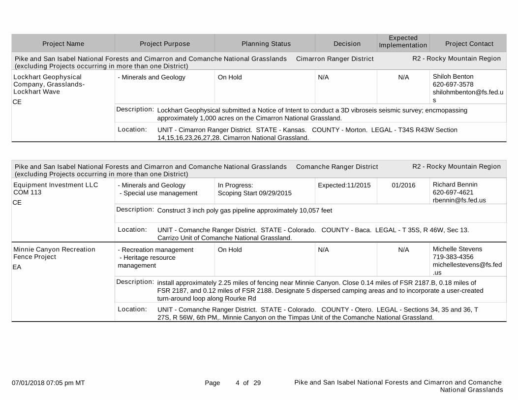
Pike and San Isabel National Forests and Cimarron and Comanche National Grasslands Cimarron Ranger District (excluding Projects occurring in more than one District)
Pike and San Isabel National Forests and Cimarron and Comanche National Grasslands Comanche Ranger District (excluding Projects occurring in more than one District)
Project PurposeProject Name DecisionPlanning Status Project ContactExpected
Implementation
R2 - Rocky Mountain Region
R2 - Rocky Mountain Region
- Minerals and Geology
- Minerals and Geology - Special use management
- Recreation management - Heritage resource management
On Hold
In Progress:Scoping Start 09/29/2015
On Hold
N/A
Expected:11/2015
N/A
Shiloh [email protected]
Richard [email protected]
Michelle [email protected]
UNIT - Cimarron Ranger District. STATE - Kansas. COUNTY - Morton. LEGAL - T34S R43W Section 14,15,16,23,26,27,28. Cimarron National Grassland.
UNIT - Comanche Ranger District. STATE - Colorado. COUNTY - Baca. LEGAL - T 35S, R 46W, Sec 13. Carrizo Unit of Comanche National Grassland.
UNIT - Comanche Ranger District. STATE - Colorado. COUNTY - Otero. LEGAL - Sections 34, 35 and 36, T 27S, R 56W, 6th PM,. Minnie Canyon on the Timpas Unit of the Comanche National Grassland.
Location:
Location:
Location:
N/A
01/2016
N/A
Lockhart Geophysical Company, Grasslands-Lockhart Wave
Equipment Investment LLC COM 113
Minnie Canyon Recreation Fence Project
Lockhart Geophysical submitted a Notice of Intent to conduct a 3D vibroseis seismic survey; encmopassing approximately 1,000 acres on the Cimarron National Grassland.
Construct 3 inch poly gas pipeline approximately 10,057 feet
install approximately 2.25 miles of fencing near Minnie Canyon. Close 0.14 miles of FSR 2187.B, 0.18 miles of FSR 2187, and 0.12 miles of FSR 2188. Designate 5 dispersed camping areas and to incorporate a user-created turn-around loop along Rourke Rd
Description:
Description:
Description:
CE
CE
EA

07/01/2018 07:05 pm MT Page of5 Pike and San Isabel National Forests and Cimarron and Comanche National Grasslands
29
Pike and San Isabel National Forests and Cimarron and Comanche National Grasslands Comanche Ranger District (excluding Projects occurring in more than one District)
Pike and San Isabel National Forests and Cimarron and Comanche National Grasslands Leadville Ranger District (excluding Projects occurring in more than one District)
Project PurposeProject Name DecisionPlanning Status Project ContactExpected
Implementation
R2 - Rocky Mountain Region
R2 - Rocky Mountain Region
- Special use management
- Recreation management - Special use management
- Research and Development
In Progress:Scoping Start 07/18/2013
Completed
Completed
Expected:08/2013
Actual: 04/23/2018
Actual: 09/20/2017
Richard [email protected]
Michelle [email protected]
David [email protected]
UNIT - Comanche Ranger District. STATE - Colorado. COUNTY - Baca. LEGAL - Section 7, T31S, R46W.
UNIT - Leadville Ranger District. STATE - Colorado. COUNTY - Eagle. LEGAL - T 8 S, R 80 W, Sec. 11-12. Cleared route will run south from the North Basin access route to the Central Basin gate, just outside of Ski Cooper's operational boundary.
UNIT - Leadville Ranger District. STATE - Colorado. COUNTY - Lake. LEGAL - Not Applicable. 6th Principal Meridian T8S, R80W, NW1/4 of SW1/4 of Section 35.
Location:
Location:
Location:
09/2013
04/2018
09/2017
Southeast Colorado Power Association (SECPA) - COM 86
Chicago Ridge Access Route
Colorado Mountain College Mt. Zion Weather Station
SECPA has submitted special use application for new communication use lease for site located in Section 7, T31S, R46W.
Clearing trees to provide over snow access to Chicago Ridge.
Colorado Mountain College Mt. Zion Weather Station Remove Option
Description:
Description:
Description:
Web Link:
Web Link:
http://www.fs.usda.gov/project/?project=53076
http://www.fs.usda.gov/project/?project=49012
*UPDATED*
CE
CE
CE

07/01/2018 07:05 pm MT Page of6 Pike and San Isabel National Forests and Cimarron and Comanche National Grasslands
29
Pike and San Isabel National Forests and Cimarron and Comanche National Grasslands Leadville Ranger District (excluding Projects occurring in more than one District)
Project PurposeProject Name DecisionPlanning Status Project ContactExpected
Implementation
R2 - Rocky Mountain Region
- Special use management
- Recreation management
- Minerals and Geology
In Progress:Scoping Start 08/10/2017
Developing ProposalEst. Scoping Start 10/2017
On Hold
Expected:09/2017
Expected:11/2017
N/A
David [email protected]
James [email protected]
UNIT - Leadville Ranger District. STATE - Colorado. COUNTY - Lake. LEGAL - Not Applicable. The proposedsite is located within sections 22 & 27, Township 12 S, Range 79 W, 6'th principal meridian. The site lies east of Highway 24 and west of the Arkansas River.
UNIT - Leadville Ranger District. STATE - Colorado. COUNTY - Lake. LEGAL - T 10 S, R 81 W Sec 25 and 26, 6 PM. T 10 S, R 81 W Sec 25 and 26, 6th PM.
UNIT - Leadville Ranger District. STATE - Colorado. COUNTY - Lake. LEGAL - T11S R82W S3. Leadville side of Independence Pass.
Location:
Location:
Location:
11/2017
05/2018
N/A
Colorado Parks and Wildlife- Numbers Launch Site
Elbert Creek Campground Nature Trail
Eureka Mining Plan of Operations
CPAW has proposed to rehabilitate and restore the existing launch site and old access road. They will construct a new launch site on CPAW property. They will utilize national forest system lands for access and parking to supportthe new launch site
Construction of .25 miles of trail from Elbert Creek Campground to Emerald Lake
To authorize a plan of operations to conduct exploratory drilling for gold and silver deposits on the Eureka claim block.
Description:
Description:
Description:
Web Link:
Web Link:
http://www.fs.usda.gov/project/?project=52350
http://www.fs.usda.gov/project/?project=52706
CE
CE
CE

07/01/2018 07:05 pm MT Page of7 Pike and San Isabel National Forests and Cimarron and Comanche National Grasslands
29
Pike and San Isabel National Forests and Cimarron and Comanche National Grasslands Leadville Ranger District (excluding Projects occurring in more than one District)
Project PurposeProject Name DecisionPlanning Status Project ContactExpected
Implementation
R2 - Rocky Mountain Region
- Special use management
- Special use management
- Special use management
In Progress:Scoping Start 07/18/2017
Completed
Completed
Expected:08/2018
Actual: 12/15/2017
Actual: 02/08/2017
David [email protected]
Tambi [email protected]
James [email protected]
UNIT - Leadville Ranger District. STATE - Colorado. COUNTY - Lake. LEGAL - Not Applicable. The existing Granite Communications Site.
UNIT - Leadville Ranger District. STATE - Colorado. COUNTY - Lake. LEGAL - Apex Mountain School: T8S, R79 W, Sec 9;T8S, R79W, Sec 20 6TH PM Sawatch Guides: T8S, R80W,Sec 14 ; T8S, R79W Mountain Mushers:6 PM T 9S R80 W Sections 19 and 30. Apex Mountain School: Fremont Pass Area, Mt. Zion, Mt Arkansas. Sawatch Backcountry Guides: Fremont Pass, Mt. Arkansas, Mt. Elbert, Monitor Rock Colorado Mountain Mushers: Sugarloaf Dam Area.
UNIT - Leadville Ranger District. STATE - Colorado. COUNTY - Lake. LEGAL - Township 11 South, Range 80 West, Sections 15, 16, 21, and 22. Township 11 South, Range 80 West, Sections 15, 16, 21, and 22. Dexter Boat Ramp Site on lower Twin Lakes. All activities occur in developed recreation sites or over the ice.
Location:
Location:
Location:
08/2018
12/2017
03/2017
Granite Communications Site.
Leadville Ranger District Recreation Special Use Authorizations
Leadville Rod and Gun Club Annual Fishing Derby
Colorado Central Telecom is proposing new construction to add a 40' tower and 6'x10' shed with .03 new disturbance. AT&T plans to replace their existing tower with a new tower. T-Mobile plans to add a new 6'x10' equipment shed.
Proposal to issue priority outfitter guide permits to Apex Mountain School and Sawatch Backcountry Guides as well as a five year recreation event permit to Colorado Mountain Mushers on the Leadville Ranger District.
Re-Issue a 5 year special use recreation event permit to the Leadville Rod and Gun Club for their annual ice fishing derby held on Twin Lakes. There are no changes to the scope, participant numbers or location of the event.
Description:
Description:
Description:
Web Link:
Web Link:
http://www.fs.usda.gov/project/?project=52236
http://www.fs.usda.gov/project/?project=52830
*UPDATED*CE
CE
CE

07/01/2018 07:05 pm MT Page of8 Pike and San Isabel National Forests and Cimarron and Comanche National Grasslands
29
Pike and San Isabel National Forests and Cimarron and Comanche National Grasslands Leadville Ranger District (excluding Projects occurring in more than one District)
Project PurposeProject Name DecisionPlanning Status Project ContactExpected
Implementation
R2 - Rocky Mountain Region
- Special use management
- Special use management
- Special use management
Completed
In Progress:Comment Period Public Notice 03/28/2018
Completed
Actual: 10/01/2015
Expected:03/2019
Actual: 09/21/2017
David [email protected]
Michelle [email protected]
David [email protected]
UNIT - Leadville Ranger District. STATE - Colorado. COUNTY - Lake. LEGAL - Not Applicable. R79W T8S Section 35.
UNIT - Leadville Ranger District. STATE - Colorado. COUNTY - Lake. LEGAL - T 8 S, R 80 W, Sec 17 - 19. Project area is southeast of and adjacent to the developed ski runs at Ski Cooper at the top of Tennessee Pass.
UNIT - Leadville Ranger District. STATE - Colorado. COUNTY - Lake. LEGAL - SW ¿ of section 13, T8 South, R80 West and the NE ¿ of section 14, T8 South, R80 West. 6th Principal Meridian. The proposed use will be located within the Ski Cooper Winter Sports Administrative Site. Fiber optic, power and microwave will be located on existing maintenance roads and lift towers.
Location:
Location:
Location:
11/2015
05/2019
10/2017
Mount Zion Communication Improvements
Ski Cooper Way Back Pod Improvement
Town of Red Cliff Single Use Communication Site at Ski Cooper.
Colorado Springs Utilities (CSU) has submitted an application to operate and maintain microwave antennas in support of Supervisory Control & Data Acquisition (SCADA) operations, used to monitor and control utility owned water sheds.
Adding a surface lift, four ski trails, one collector trail and two gladed areas to the southeast of the current ski runs. The mountaintop ski patrol outpost would be replaced.
Town of Red Cliff Single Use Communications Site at Ski Cooper. To include fiber optic line, microwave dish and microwave relay. To provide broadband internet service to town of Red Cliff and Ski Cooper Winter Sports Site.
Description:
Description:
Description:
Web Link:
Web Link:
http://www.fs.usda.gov/project/?project=53020
http://www.fs.usda.gov/project/?project=52128
CE
EA
CE

07/01/2018 07:05 pm MT Page of9 Pike and San Isabel National Forests and Cimarron and Comanche National Grasslands
29
Pike and San Isabel National Forests and Cimarron and Comanche National Grasslands Leadville Ranger District (excluding Projects occurring in more than one District)
Pike and San Isabel National Forests and Cimarron and Comanche National Grasslands Pikes Peak Ranger District (excluding Projects occurring in more than one District)
Project PurposeProject Name DecisionPlanning Status Project ContactExpected
Implementation
R2 - Rocky Mountain Region
R2 - Rocky Mountain Region
- Minerals and Geology
- Recreation management - Watershed management
- Special use management
Completed
In Progress:Scoping Start 06/18/2018
Developing ProposalEst. Scoping Start 06/2018
Actual: 02/27/2018
Expected:08/2018
Expected:10/2018
Jeff [email protected]
UNIT - Leadville Ranger District. STATE - Colorado. COUNTY - Lake. LEGAL - T11S R70W Section 6, 6th Principal Meridian. T11S, R70W, Section 6, 6th Principal Meridian.
UNIT - Pikes Peak Ranger District. STATE - Colorado. COUNTY - El Paso. LEGAL - Township 15 South, Range 67 West, Sections 20 and 28. Gray Back Peak Trail is located on the South Slope of Pikes Peak beginning on Forest Road 371 near Old Stage Road.
UNIT - Pikes Peak Ranger District. STATE - Colorado. COUNTY - Teller. LEGAL - Portions of sections 7, 18 and 19 of T.11S., R.69W., 6th P.M., Teller County, Colorado. The project area is located off of Teller County Road 78, approximately 2.1 miles south of Westcreek, Colorado.
Location:
Location:
Location:
02/2018
09/2018
02/2019
Willow Creek Mine Expansion
Gray Back Peak Trail Reroutes
IREA - Dyck Mountain Powerline Rebuild Project
The operator proposes to expand their current placer mining operation to the north and west and mine approximately 30 acres of NFS lands on the west side of Box Creek Canyon, between Herrington Creek and Corske Creek on the Leadville Ranger District.
Reroute sections of up to one mile of trail where erosion is occurring and the trail is entrenched.
Intermountain Rural Electric Association proposed to reconstruct an exiting powerline known as Dyck Mountain. The powerline project is approximately 2.1 miles in length located on both private and National Forest System lands.
Description:
Description:
Description:
Web Link:
Web Link:
http://www.fs.usda.gov/project/?project=52367
http://www.fs.usda.gov/project/?project=54173
*NEW LISTING*
EA
CE
CE

07/01/2018 07:05 pm MT Page of10 Pike and San Isabel National Forests and Cimarron and Comanche National Grasslands
29
Pike and San Isabel National Forests and Cimarron and Comanche National Grasslands Pikes Peak Ranger District (excluding Projects occurring in more than one District)
Project PurposeProject Name DecisionPlanning Status Project ContactExpected
Implementation
R2 - Rocky Mountain Region
- Special use management
- Special use management
- Special use management
In Progress:Scoping Start 06/01/2017
In Progress:Scoping Start 03/15/2018
In Progress:Objection Period Legal Notice 05/26/2018
Expected:01/2018
Expected:07/2018
Expected:07/2018
Jeff [email protected]
UNIT - Pikes Peak Ranger District. STATE - Colorado. COUNTY - Teller. LEGAL - Portions of sections 22 and 23 of T.11S., R.69W., 6th P.M., Teller County, Colorado. The project area is located approximately 7 miles north of Woodland Park, Colorado at the intersection of State Highway 67 North and Forest Road 377.
UNIT - Pikes Peak Ranger District. STATE - Colorado. COUNTY - Douglas, El Paso, Teller. LEGAL - Portionsof T. 10 S., R. 68-69 W.; T. 11 S., R. 67-70 W.; and T 12 S., R 67-70 W.;. Portions of Game Management Unit 511 and the southern end of Game Management Unit 51.
UNIT - Pikes Peak Ranger District. STATE - Colorado. COUNTY - Douglas, El Paso, Teller. LEGAL - Not Applicable. Forest Service roads and trails in the North Divide, Rainbow Falls and Rampart Range Road areas north of Woodland Park.
Location:
Location:
Location:
02/2018
07/2018
07/2018
IREA - Girl Scout Camp, Sky High Ranch 7.2 kV powerline rebuild project.
Issue a Priority Outfitter and Guide Special Use Permit to Storm Peak Outfitters
Issue new Priority Outfitter and Guide Special Use Permit to Great Outdoors Adventures
Intermountain Rural Electric Association is proposing to reconstruct an exiting electric distribution line known as Girl Scout Camp, Sky High Ranch. The powerline is 1.72 miles in length on both private and National Forest System lands.
Issue a priority outfitter and guide permit to Storm Peak Outfitters for guided deer, elk, bear, mountain lion, and turkey day hunting in GMU 511 and the southern end of GMU 51 on the Pikes Peak Ranger District.
Issue new priority outfitter and guide permit to Great Outdoors Adventures for guided OHV and e-bike tours and OHV and e-bike rental delivery for up to 4,000 service days annually.
Description:
Description:
Description:
Web Link:
Web Link:
http://www.fs.usda.gov/project/?project=53738
http://www.fs.usda.gov/project/?project=53564
*UPDATED*
*UPDATED*
CE
CE
EA

07/01/2018 07:05 pm MT Page of11 Pike and San Isabel National Forests and Cimarron and Comanche National Grasslands
29
Pike and San Isabel National Forests and Cimarron and Comanche National Grasslands Pikes Peak Ranger District (excluding Projects occurring in more than one District)
Project PurposeProject Name DecisionPlanning Status Project ContactExpected
Implementation
R2 - Rocky Mountain Region
- Special use management
- Special use management
- Special use management
In Progress:Objection Period Legal Notice 05/26/2018
In Progress:Scoping Start 01/26/2018
In Progress:Scoping Start 08/03/2017
Expected:07/2018
Expected:07/2018
Expected:07/2018
Jeff [email protected]
UNIT - Pikes Peak Ranger District. STATE - Colorado. COUNTY - Teller. LEGAL - Not Applicable. Hike for Life hiking tours would take place on Crags, Devils Playground, Horsethief Park, Red Rocks and Lovell Gulch Trails.
UNIT - Pikes Peak Ranger District. STATE - Colorado. COUNTY - El Paso. LEGAL - Township 14 South, Range 68 West, Sections 1, 2, 7-10, & 18. Event is held on Barr Trail on the east slope of Pikes Peak from Manitou Springs to the summit of Pikes Peak. Ascent participants are transported down the Pikes Peak highway.
UNIT - Pikes Peak Ranger District. STATE - Colorado. COUNTY - El Paso. LEGAL - SW1/4 Section 20, T.12S., R.67W., 6th P.M. SW1/4 Section 20, T.12S., R.67W., 6th P.M.
Location:
Location:
Location:
07/2018
07/2018
08/2018
Issue new Priority Outfitter and Guide Special Use Permit to Hike for Life, LLC.
Pikes Peak Ascent and Marathon 5-year Recreation Event Special Use Permit Re-issue
Pikes Peak Regional Communications Network Communication Tower Replacement
Issue a priority outfitter and guide permit to Hike for Life, LLC. for guided hiking tours for up to 300 service days annually.
Re-issue a 5-year recreation event permit for the annual Pikes Peak Ascent and Marathon on Barr Trail, #620. The Ascent and Marathon are held on the 3rd weekend in August with up to 1800 participants in the Ascent and 800 participants in the Marathon
Replace the existing 70 foot tower with a new 70 foot tower to meet wind, snow and ice loading standards.
Description:
Description:
Description:
Web Link:
Web Link:
http://www.fs.usda.gov/project/?project=53562
http://www.fs.usda.gov/project/?project=53330
*UPDATED*
*UPDATED*
*UPDATED*
EA
CE
CE

07/01/2018 07:05 pm MT Page of12 Pike and San Isabel National Forests and Cimarron and Comanche National Grasslands
29
Pike and San Isabel National Forests and Cimarron and Comanche National Grasslands Pikes Peak Ranger District (excluding Projects occurring in more than one District)
Project PurposeProject Name DecisionPlanning Status Project ContactExpected
Implementation
R2 - Rocky Mountain Region
- Recreation management - Heritage resource management - Special use management - Facility management
- Special use management
- Special use management
Completed
In Progress:Scoping Start 12/31/2017
Completed
Actual: 05/03/2018
Expected:08/2018
Actual: 06/11/2018
Jeff [email protected]
UNIT - Pikes Peak Ranger District. STATE - Colorado. COUNTY - El Paso. LEGAL - Portions of Sections 7 and 18, T. 14 S., R. 68 W., 6th Principal Meridian, El Paso County, Colorado. The project area is located west of Colorado Springs on the summit of Pikes Peak. Access to the summit of Pikes Peak from Cascade, Colorado via the 19-mile Pikes Peak Highway to the summit.
UNIT - Pikes Peak Ranger District. STATE - Colorado. COUNTY - El Paso. LEGAL - Not Applicable. RampartReservoir.
UNIT - Pikes Peak Ranger District. STATE - Colorado. COUNTY - El Paso, Teller. LEGAL - Township 13 South, Range 67-68 West, Township 15 South, Range 67-68 West. Adventures Out West-Roads and trails in theGold Camp Rd area & S. Rampart Range Rd, Pikes Peak Mountain Bike Tours-Gold Camp Rd, Old Stage Riding Stables-Trails near Old Stage Rd & Roads 369 & 371.
Location:
Location:
Location:
06/2018
08/2018
06/2018
Pikes Peak Summit Complex.
Pony Express Trail Run 5-year Recreation Event Permit Re-issue
Re-issue three 10-year priority outfitter and guide special use permits
The City of Colorado Springs proposes to reconstruct facilities on the summit of Pikes Peak. The project emphasizes protection of heritage resources and the National Historic Landmark status, alpine tundra restoration and interpretive elements.
Re-issue 5-year recreation event special use permit for the annual Pony Express Trail Run on the Rainbow Gulch(#714) and Rampart Reservoir (#700) Trails on the third Sunday in September with up to 150 participants.
Re-issue three 10-year priority outfitter and guide permits - Adventures Out West (jeep and hiking tours), Pikes Peak Mountain Bike Tours (mountain biking tours), and Old Stage Riding Stables (guided horse trail rides)
Description:
Description:
Description:
Web Link:
Web Link:
Web Link:
http://www.fs.usda.gov/project/?project=47229
http://www.fs.usda.gov/project/?project=53145
http://www.fs.usda.gov/project/?project=53071
*UPDATED*
*UPDATED*
*UPDATED*
EA
CE
CE

07/01/2018 07:05 pm MT Page of13 Pike and San Isabel National Forests and Cimarron and Comanche National Grasslands
29
Pike and San Isabel National Forests and Cimarron and Comanche National Grasslands Pikes Peak Ranger District (excluding Projects occurring in more than one District)
Pike and San Isabel National Forests and Cimarron and Comanche National Grasslands Salida Ranger District (excluding Projects occurring in more than one District)
Project PurposeProject Name DecisionPlanning Status Project ContactExpected
Implementation
R2 - Rocky Mountain Region
R2 - Rocky Mountain Region
- Watershed management - Special use management - Road management
- Special use management
- Land management planning
On Hold
In Progress:Scoping Start 07/16/2014
Developing ProposalEst. NOI in Federal Register 04/2017
N/A
Expected:06/2018
Expected:04/2020
Jeff [email protected]
Jeff [email protected]
John [email protected]
UNIT - Pikes Peak Ranger District. STATE - Colorado. COUNTY - Teller. LEGAL - Section 34, Township 11 South, Range 69 West, 6th P.M., Teller County, Colorado. The area is located about 5 miles north of Woodland Park, Colorado using NFSR 339.C.
UNIT - Pikes Peak Ranger District. STATE - Colorado. COUNTY - Teller. LEGAL - Portions of Section 36, T.11S., R.70W., and Sections 1 and 12, T.12S., R.70W.,6th P.M. Forest Road 365 is located in the Manchester Creek area approximately 8 miles north of Divide, Colorado.
UNIT - Salida Ranger District. STATE - Colorado. COUNTY - Chaffee. LEGAL - Not Applicable. Along the Arkansas River west of Buena Vista and Salida Colorado.
Location:
Location:
Location:
N/A
07/2018
05/2020
Replacement of bridge with bottomless culvert across TroutCreek on NFSR 339.
Rideout Property Owners Association FLPMA Forest Road Easement
Browns Canyon National Monument Plan
Forest Service proposes an amendment of Forest road special use permit issued to Trout Creek Road Users Association for installation of bottomless culvert.
Issuance of a new special use authorization to replace an existing authorization that expires in December 2014. The authorization is for the use and maintenance of Forest Road 365 to access private lands.
Browns Canyon National Monument Plan
Description:
Description:
Description:
Web Link: http://www.fs.usda.gov/project/?project=51098
CE
CE
EIS
07/01/2018 07:05 pm MT Page of14 Pike and San Isabel National Forests and Cimarron and Comanche National Grasslands
29
Pike and San Isabel National Forests and Cimarron and Comanche National Grasslands Salida Ranger District (excluding Projects occurring in more than one District)
Project PurposeProject Name DecisionPlanning Status Project ContactExpected
Implementation
R2 - Rocky Mountain Region
- Forest products - Vegetation management (other than forest products) - Fuels management
- Recreation management - Watershed management
- Recreation management
In Progress:Scoping Start 01/24/2018
In Progress:Scoping Start 09/01/2010
In Progress:Scoping Start 05/22/2017
Expected:09/2018
Expected:12/2017
Expected:05/2018
Andrew [email protected]
UNIT - Salida Ranger District. STATE - Colorado. COUNTY - Chaffee. LEGAL - T49N R8E Sec 19,20,29,30,31,32 T48N R8E Sec 5-6. National Forest System Lands southeast of the town of Poncha Springs, CO bound by BLM lands to the north and west, private land to the north and sharing a corner with CO state land.
UNIT - Salida Ranger District. STATE - Colorado. COUNTY - Chaffee. LEGAL - Section 36, T. 50 N., R. 6 E., NM P.M., Chaffee County, CO Sections 1, 2, 11, 26 & 35 T. 49 N., R. 6 E., NM P.M., Chaffee County, CO. PSICC, Salida Ranger District at Continental Divide National Scenic trail #531 and Junction of Colorado Trail #1776 at South Fooses Creek.
UNIT - Salida Ranger District. STATE - Colorado. COUNTY - Chaffee. LEGAL - Mildland Trail Extension: T14S, R77W, Sections 8 and 17, 6th PM; Vitamin B: T13S, R78W, Sections 26 and 35, 6th PM. Fourmile Travel Management Area north and east of Buena Vista, CO.
Location:
Location:
Location:
05/2019
06/2018
06/2018
Cleveland Mountain Forest Health and Hazardous Fuels Reduction Project
Colorado Trail #1776 at Fooses Creek
Fourmile Trail Proposals
The Forest Service proposes to use prescribed fire, mechanical and/or hand-thinning in multiple fuel-types on approximately 2,800 acres of NFS lands in order to reduce hazardous fuels and provide for forest resiliency against insect and disease.
Colorado Trail #1776: Construction of approximately 4.5 miles of trail. The new proposed 4.5 miles of trail will bewithin USDA Forest Service trail standard guidelines.
Fourmile Area - Midland Trail Extension: New trail construction (0.75 miles) and Vitamin B: New trail construction and re-route of existing trail (5.3 miles)
Description:
Description:
Description:
Web Link:
Web Link:
Web Link:
http://www.fs.usda.gov/project/?project=53814
http://www.fs.usda.gov/project/?project=23179
http://www.fs.usda.gov/project/?project=51859
*NEW LISTING*
*UPDATED*
CE
CE
CE

07/01/2018 07:05 pm MT Page of15 Pike and San Isabel National Forests and Cimarron and Comanche National Grasslands
29
Pike and San Isabel National Forests and Cimarron and Comanche National Grasslands Salida Ranger District (excluding Projects occurring in more than one District)
Project PurposeProject Name DecisionPlanning Status Project ContactExpected
Implementation
R2 - Rocky Mountain Region
- Forest products - Vegetation management (other than forest products)
- Grazing management
- Recreation management
Developing ProposalEst. Scoping Start 07/2018
Developing ProposalEst. Scoping Start 11/2017
Developing ProposalEst. Scoping Start 05/2017
Expected:01/2019
Expected:11/2018
Expected:06/2017
Lisa [email protected]
Joseph [email protected]
UNIT - Salida Ranger District. STATE - Colorado. COUNTY - Saguache. LEGAL - T48N, R6E, Sections 13, 24, 25; T48N, R7E, Sections 19, 29, 30. The project is located in the Marshall Pass area, approximately 9 miles southwest of Poncha Springs, Colorado.
UNIT - Salida Ranger District. STATE - Colorado. COUNTY - Custer, Fremont. LEGAL - Not Applicable. The allotment is approximately 6 miles south of Cotopaxi, CO.
UNIT - Salida Ranger District. STATE - Colorado. COUNTY - Chaffee. LEGAL - Gutz: T49N, R9E, Sections 20 and 29, NMPM; Sands Gulch: T49N, R8E, Section 23 and 24, NMPM. North side of Methodist Mountain, south of Salida, CO.
Location:
Location:
Location:
06/2019
06/2019
06/2017
Marshall Pass Vegetation Management Project
Maverick - Range Allotment Management Planning
Methodist Trail Proposals
Salvage dead beetle-killed spruce and create openings in lodgepole pine to improve forest health.
Range allotment management plan for the Maverick - Cattle and Horse allotment.
Methodist Mountain area: Gutz - New trail construction and re-route existing trail (1.3 miles) and Sands Gulch - New trail construction (~2.0 miles).
Description:
Description:
Description:
Web Link:
Web Link:
Web Link:
http://www.fs.usda.gov/project/?project=53613
http://www.fs.usda.gov/project/?project=52764
http://www.fs.usda.gov/project/?project=51858
EA
EA
CE

07/01/2018 07:05 pm MT Page of16 Pike and San Isabel National Forests and Cimarron and Comanche National Grasslands
29
Pike and San Isabel National Forests and Cimarron and Comanche National Grasslands Salida Ranger District (excluding Projects occurring in more than one District)
Project PurposeProject Name DecisionPlanning Status Project ContactExpected
Implementation
R2 - Rocky Mountain Region
- Recreation management - Special area management - Facility management
- Recreation management - Special use management - Facility management
- Recreation management
In Progress:Scoping Start 02/22/2016
In Progress:Scoping Start 05/11/2018
In Progress:Scoping Start 06/14/2018
Expected:03/2016
Expected:06/2018
Expected:09/2019
Calen [email protected]
Loretta [email protected]
UNIT - Salida Ranger District. STATE - Colorado. COUNTY - Chaffee. LEGAL - Section 8 T. 49N, R. 6 E., SW 1/4 6th NMPM., Chaffee County, CO UTM %u2013 Zone 13N 4263603, 383961 . Monarch Pass (Hwy 50) Monarch Colorado .
UNIT - Salida Ranger District. STATE - Colorado. COUNTY - Chaffee. LEGAL - Not Applicable. Location is within the Monarch Ski Area permitted use boundary.
UNIT - Salida Ranger District. STATE - Colorado. COUNTY - Chaffee. LEGAL - T 50N., R 7E., Section 5,6,9. Mt. Shavano is located 12 miles northwest of the town of Salida, Colorado on the Salida RD of the PSICC. Tabeguache Peak is connected to Mt. Shavano via a one mile ridgeline.
Location:
Location:
Location:
04/2016
06/2018
06/2020
Monarch Mountain Ski Area Maintenance Building
Monarch Ski Area Improvements
Mt. Shavano Trail Re-Routes
Construction of a new 40' x 125' maintenance building because existing shed is not large enough to both maintain vehicles as well house the vehicles to keep out of weather.
The project proposes the installation of a handle tow ski lift, 706-square foot yurt, storage facilities, two hydrants and diversion ditch on National Forest System Lands within the Monarch Ski Area permitted use boundary.
Trail #1428 provides hikers with access to the summits of Mt. Shavano and Tabeguache Peak. This project is needed due to trail widening, erosion, and braiding high rec use and user-created routes causing impacts to alpineplants and soils.
Description:
Description:
Description:
Web Link:
Web Link:
http://www.fs.usda.gov/project/?project=53995
http://www.fs.usda.gov/project/?project=54153
*NEW LISTING*
*NEW LISTING*
CE
CE
CE

07/01/2018 07:05 pm MT Page of17 Pike and San Isabel National Forests and Cimarron and Comanche National Grasslands
29
Pike and San Isabel National Forests and Cimarron and Comanche National Grasslands Salida Ranger District (excluding Projects occurring in more than one District)
Pike and San Isabel National Forests and Cimarron and Comanche National Grasslands San Carlos Ranger District (excluding Projects occurring in more than one District)
Project PurposeProject Name DecisionPlanning Status Project ContactExpected
Implementation
R2 - Rocky Mountain Region
R2 - Rocky Mountain Region
- Recreation management - Facility management
- Land management planning - Recreation management - Wildlife, Fish, Rare plants - Watershed management - Special use management
- Special use management
On Hold
In Progress:NOI in Federal Register 03/16/2007Est. DEIS NOA in Federal Register 08/2017
On Hold
N/A
Expected:12/2017
N/A
Neal [email protected]
Jessica [email protected]
UNIT - Salida Ranger District. STATE - Colorado. COUNTY - Chaffee. LEGAL - NMPM, T48n, R7e, sec 12. Salida Ranger District of the San Isabel National Forest.
UNIT - Salida Ranger District. STATE - Colorado. COUNTY - Chaffee. LEGAL - 1.) Section 5,T50N,R6E,NM P.M., Chaffee County, Colorado 2.) Section 29,T50N,R6E,NM P.M., Chaffee County, Colorado 3.) Section 12,T48N,R8E,NM P.M., Chaffee County, Colorado. 1.) North Fork reservoir 2.) Boss Lake 3.) O'Haver Lake / all facilities located in Chaffee County, Colorado.
UNIT - San Carlos Ranger District. STATE - Colorado. COUNTY - Fremont. T20S, R70W 6th P.M. adn T20S R71W 6th P.M.
Location:
Location:
Location:
N/A
12/2017
N/A
O'Haver Lake Campground and Day Use Area Capital Investment Project
UAWCD Reservoir Analysis
Black Hills Energy, Inc.
This project focuses on the renovation and re-construction of this 29 unit campground and the adjoining day-use facilities. New site furniture, an improved water system, level camping spurs, tent pads, new toilets, trail improvements are all include
EIS level analysis to authorize the issuance of term Special Use Permits to the Upper Arkansas Water Conservancy District (UAWCD) in order to operate and maintain the North Fork, Boss, and O'Haver water storage facilities.
Reissuance of a Special Use Permit SAN400901 for a power transmission line
Description:
Description:
Description:
Web Link: http://www.fs.usda.gov/project/?project=21520
CE
EIS
CE

07/01/2018 07:05 pm MT Page of18 Pike and San Isabel National Forests and Cimarron and Comanche National Grasslands
29
Pike and San Isabel National Forests and Cimarron and Comanche National Grasslands San Carlos Ranger District (excluding Projects occurring in more than one District)
Project PurposeProject Name DecisionPlanning Status Project ContactExpected
Implementation
R2 - Rocky Mountain Region
- Fuels management - Watershed management
- Wildlife, Fish, Rare plants - Vegetation management (other than forest products) - Fuels management
- Special use management
In Progress:Objection Period Legal Notice 05/13/2011
Developing ProposalEst. Scoping Start 12/2018
On Hold
Expected:12/2018
Expected:01/2020
N/A
Michael [email protected]
Lisa [email protected]
Jessica [email protected]
UNIT - San Carlos Ranger District. STATE - Colorado. COUNTY - Custer, Pueblo. LEGAL - T21SW68S30-32,T21S69WS17,19-21,25-36,T21S70WS23-26,34-36,t22S68WS3-10,15-22,27-32,T22S69WS1-29,32-36,T23S68WS5-8,17-20,27-34,T23S69wS1-18,21-27,35-36,T23S70WS11-15,22-24,T24S68WS4-9,16-21,27,34,T24S69. East-Central Wet Mouintain Area i.
UNIT - San Carlos Ranger District. STATE - Colorado. COUNTY - Custer, Fremont. LEGAL - T20S,R71W., Section 25, T20S,R70W., Section 28,29,30,31,32,33, and 34. T21S, R70W., Section 4,5,6,8, and 9. 15 miles South East of Canon City.
UNIT - San Carlos Ranger District. STATE - Colorado. COUNTY - Huerfano. T27S R 72W 6th P.M.
Location:
Location:
Location:
06/2019
06/2020
N/A
East - Central Wet Mountain
Locke Mountain ( Fuels)
San Isabel Electric, SAN402403
Conduct Fuels and Vegetation Treatments - Designed to reduce the threat of catastrophic fire and restore forest conditions.
Fuels reduction and Forest Health treatments, in the form of mechanical thinning/chipping followed-up by prescribed fire
San Isabel Electric Association, Inc. Permit Number SAN402404 - ROW, Power Trans Line - Renew Permit
Description:
Description:
Description:
Web Link:
Web Link:
http://www.fs.usda.gov/project/?project=30097
http://www.fs.usda.gov/project/?project=18541
*UPDATED*
*UPDATED*
EA
EA
CE

07/01/2018 07:05 pm MT Page of19 Pike and San Isabel National Forests and Cimarron and Comanche National Grasslands
29
Pike and San Isabel National Forests and Cimarron and Comanche National Grasslands San Carlos Ranger District (excluding Projects occurring in more than one District)
Project PurposeProject Name DecisionPlanning Status Project ContactExpected
Implementation
R2 - Rocky Mountain Region
- Special use management
- Special use management
- Special use management
- Special use management
On Hold
On Hold
On Hold
Developing ProposalEst. Scoping Start 06/2017
N/A
N/A
N/A
Expected:09/2017
Jessica [email protected]
Jessica [email protected]
Jessica [email protected]
John [email protected]
UNIT - San Carlos Ranger District. STATE - Colorado. COUNTY - Huerfano. LEGAL - San Carlos District - Different area on the district. T.31S. R.69W. 6th PM.
UNIT - San Carlos Ranger District. STATE - Colorado. COUNTY - Huerfano. LEGAL - San Carlos District - Different area on the district. T44S, R73W.
UNIT - San Carlos Ranger District. STATE - Colorado. COUNTY - Huerfano. LEGAL - San Carlos District - Different area on the district. T44S, R73W.
UNIT - San Carlos Ranger District. STATE - Colorado. COUNTY - Custer, Huerfano. LEGAL - Not Applicable.San Carlos Ranger District, Wet Mountain Area, Roads and Trails connecting to the Greenhorn, Dear Peak and Ophir Roads.
Location:
Location:
Location:
Location:
N/A
N/A
N/A
12/2017
San Isabel Electric, SAN402404
Sangre De Cristo Electric - SAN401610
Sangre De Cristo Electrict - SAN 401614
Sangre Snowrunners Snowmobile Club Trail Grooming Permit
San Isabel Electric Permit Number SAN402404 - ROW, Power Trans Line - Remewal Permit
ROW Power Trans Line -Permit number SAN 401610
ROW, Power Trans Line
Renew Special Use Permit that allows the club to groom trails for snowmobiling
Description:
Description:
Description:
Description:
CE
CE
CE
CE

07/01/2018 07:05 pm MT Page of20 Pike and San Isabel National Forests and Cimarron and Comanche National Grasslands
29
Pike and San Isabel National Forests and Cimarron and Comanche National Grasslands San Carlos Ranger District (excluding Projects occurring in more than one District)
Project PurposeProject Name DecisionPlanning Status Project ContactExpected
Implementation
R2 - Rocky Mountain Region
- Special use management
- Grazing management
- Wildlife, Fish, Rare plants
- Special use management
In Progress:Scoping Start 06/18/2016
Developing ProposalEst. Scoping Start 11/2017
On Hold
Developing ProposalEst. Scoping Start 10/2010
Expected:01/2017
Expected:11/2018
N/A
Expected:12/2010
Janine [email protected]
Joseph [email protected]
Jessica [email protected]
UNIT - San Carlos Ranger District. STATE - Colorado. COUNTY - Huerfano. LEGAL - T27S R72W Sections 31&32. Approximately 19 miles southwest of Gardner, CO in Huerfano county near the Sangre de Cristo wilderness area. Found on the Mosca Pass USGS quad map.
UNIT - San Carlos Ranger District. STATE - Colorado. COUNTY - Huerfano. LEGAL - Not Applicable. The allotment is approximately 9 miles southwest of Gardner, CO.
UNIT - San Carlos Ranger District. STATE - Colorado. COUNTY - Huerfano. LEGAL - Township 27S, Range 71W, Sections 31 and 32; Township 28S, Range 71W, Sections 3 and 4. Approximately 12 miles southwest of Gardiner, Colorado.
UNIT - San Carlos Ranger District. STATE - Colorado. COUNTY - Custer, Fremont, Huerfano, Las Animas, Pueblo. San Carlos Ranger District.
Location:
Location:
Location:
Location:
02/2017
06/2019
N/A
01/2012
Sierra Blanco Reservoir Irrigation Ditch Permit SAN361
Slide Mountain - Range Allotment Management Planning
Slide Mountain Parks - Wildlife Habitat Enhancement Prescribed Burn
Special Uses Permit Reissuances. Expired Existing Permits
Special use permit for use and maintenance of an irrigation ditch on the San Carlos Ranger District, Pike and San Isabel NF.
Update of range allotment management plan for the Slide Mtn. - Cattle and Horse allotment.
Prescribed burning in approximately 110 acres of montane meadows to improve wildlife habitat for big game and other wildlife species.
Issuance of a new special use authorization for a new term to replace an existing or expired special use authorization when the only changes are administrative.
Description:
Description:
Description:
Description:
Web Link: http://www.fs.usda.gov/project/?project=18670
CE
EA
CE
CE

07/01/2018 07:05 pm MT Page of21 Pike and San Isabel National Forests and Cimarron and Comanche National Grasslands
29
Pike and San Isabel National Forests and Cimarron and Comanche National Grasslands South Park Ranger District (excluding Projects occurring in more than one District)
Project PurposeProject Name DecisionPlanning Status Project ContactExpected
Implementation
R2 - Rocky Mountain Region
- Special use management
- Special use management
- Recreation management - Road management
- Minerals and Geology
Cancelled
In Progress:Scoping Start 05/15/2018
Completed
On Hold
N/A
Expected:09/2018
Actual: 06/14/2018
N/A
Janine [email protected]
Janine [email protected]
Josh [email protected]
UNIT - South Park Ranger District. STATE - Colorado. COUNTY - Park. LEGAL - Not Applicable. Multiple projects within Park County and Teller County, Colorado.
UNIT - South Park Ranger District. STATE - Colorado. COUNTY - Park. LEGAL - Not Applicable. Special UseAuthorizations located on the South Park Ranger District and San Carlos Ranger District.
UNIT - South Park Ranger District. STATE - Colorado. COUNTY - Park. LEGAL - Not Applicable. Badger Flats is located just northwest of Lake George, CO.
UNIT - South Park Ranger District. STATE - Colorado. COUNTY - Park. LEGAL - Sections 5 and 8 of Township 9 South Range 77 West. Beaver Creek approximately five miles North of the town of Fairplay, Colorado off of Forest Service Road 659.
Location:
Location:
Location:
Location:
N/A
09/2018
06/2018
N/A
2017 Special Use Authorization Re-Issuances
2018 Special Use Re-Issuancesfor South Park Ranger District
Badger Flats Management Project
Gold Prospectors of Colorado Beaver Creek Placer Mine
A proposal to re-issue expired existing special use permits on the South Park Ranger District
Special use authorization re-issuances for 2018 for South Park Ranger District and San Carlos Ranger District
The Forest Service is proposing to implement changes to the existing Forest road system within the Badger Flats management area
Group and club activity authorizing small scale placer mining using gold pans, sluice boxes and smaller motorized dredges. Occasional backhoe use.
Description:
Description:
Description:
Description:
Web Link:
Web Link:
http://www.fs.usda.gov/project/?project=52543
http://www.fs.usda.gov/project/?project=48069
*UPDATED*
*NEW LISTING*
*UPDATED*
CE
CE
EA
EA

07/01/2018 07:05 pm MT Page of22 Pike and San Isabel National Forests and Cimarron and Comanche National Grasslands
29
Pike and San Isabel National Forests and Cimarron and Comanche National Grasslands South Park Ranger District (excluding Projects occurring in more than one District)
Project PurposeProject Name DecisionPlanning Status Project ContactExpected
Implementation
R2 - Rocky Mountain Region
- Special use management
- Minerals and Geology
- Special use management
In Progress:Scoping Start 01/13/2017
In Progress:Scoping Start 01/08/2018
On Hold
Expected:07/2018
Expected:07/2018
N/A
Janine [email protected]
Jeff [email protected]
UNIT - South Park Ranger District. STATE - Colorado. COUNTY - Park. LEGAL - Not Applicable. Located south east of Jefferson, Colorado, within Park County. Along Park County Road 77.
UNIT - South Park Ranger District. STATE - Colorado. COUNTY - Teller. LEGAL - T12S R71W S10. The unpatented mining claims are found in Section 10, T12S, R71W, 6th Principal Meridian, approximately 5.0 miles northeast of Lake George, Colorado, in Teller County.
UNIT - South Park Ranger District. STATE - Colorado. COUNTY - Park. LEGAL - Sec 10, 11, T7S, R76W, 6th PM. Approximately 25 miles NE of Fairplay, Colorado, on Hwy 285, County Rd 35 and 37.
Location:
Location:
Location:
09/2018
07/2018
N/A
Intermountain Rural Electric Association Distribution Line Rebuild Park County Road 77
JJ Collecting Project
Jefferson Lake Dam Rehabilitation Project - City of Aurora
Rebuild of a 7.2kV distribution line along Park County Road 77. Distribution line currently exists, under special usepermit SPK145. Rebuild will consist of placement of new poles, in new locations, within the authorized right-of-way.
The operators will explore for and mine pegmatite gemstone crystals. The operators will excavate 4 trenches and disturb a maximum of 2.0 acres of National Forest System lands.
City of Aurora Water Resources Division requests an amendment to their special use permit to add rip-rap on the upstream face of Jefferson Lake dam, enlarge spillway, extend outlet pipe, level dam crest and extend the toe of the dam.
Description:
Description:
Description:
*UPDATED*
*NEW LISTING*
CE
CE
CE

07/01/2018 07:05 pm MT Page of23 Pike and San Isabel National Forests and Cimarron and Comanche National Grasslands
29
Pike and San Isabel National Forests and Cimarron and Comanche National Grasslands South Park Ranger District (excluding Projects occurring in more than one District)
Project PurposeProject Name DecisionPlanning Status Project ContactExpected
Implementation
R2 - Rocky Mountain Region
- Minerals and Geology
- Wildlife, Fish, Rare plants - Forest products - Vegetation management (other than forest products) - Fuels management - Watershed management
- Minerals and Geology
In Progress:Scoping Start 12/28/2015
In Progress:Comment Period Public Notice 07/01/2017
In Progress:Scoping Start 01/28/2016
Expected:03/2016
Expected:07/2019
Expected:03/2016
Deanna [email protected]
UNIT - South Park Ranger District. STATE - Colorado. COUNTY - Teller. LEGAL - T12S R71W Section 17. Crystal Creek mining area.
UNIT - South Park Ranger District. STATE - Colorado. COUNTY - Park, Teller. LEGAL - Not Applicable. The project area is near Lake George, CO, extending north to Webber Park and south to Fish Creek. Main travel routes are County Roads 77, 90, 92, and Highway 24. The project is located within 11 polys.
UNIT - South Park Ranger District. STATE - Colorado. COUNTY - Teller. LEGAL - T12S R71W Section 3. Crystal Creek mining area.
Location:
Location:
Location:
07/2016
07/2019
09/2016
LGPD #2 Plan of Operations
Lake George Area Fuels Management project
Lovely Lisa Plan of Operations
The Forest Service is proposing to authorize the operator a plan of operations to explore for and mine amazonite, smoky quartz and other pegmatite minerals using mechanized equipment.
The objective is primarily hazardous fuels mitigation through prescribed burning and mechanical thinning. Most locations involve WUI. Other benefits may include firewood generation, minor commercial forest products, and wildlife habitat improvements.
The Forest Service is proposing to authorize the operator a plan of operations to explore for and mine amazonite, smoky quartz and other pegmatite minerals using mechanized equipment.
Description:
Description:
Description:
Web Link:
Web Link:
Web Link:
http://www.fs.usda.gov/project/?project=48713
http://www.fs.fed.us/nepa/nepa_project_exp.php?project=45969
http://www.fs.usda.gov/project/?project=48712
*UPDATED*
CE
EA
CE

07/01/2018 07:05 pm MT Page of24 Pike and San Isabel National Forests and Cimarron and Comanche National Grasslands
29
Pike and San Isabel National Forests and Cimarron and Comanche National Grasslands South Park Ranger District (excluding Projects occurring in more than one District)
Project PurposeProject Name DecisionPlanning Status Project ContactExpected
Implementation
R2 - Rocky Mountain Region
- Wildlife, Fish, Rare plants - Watershed management - Road management
- Minerals and Geology
- Special use management - Road management
In Progress:Scoping Start 05/05/2014Est. 215 Comment Period LegalNotice 09/2014
In Progress:Scoping Start 01/07/2016
In Progress:Scoping Start 11/14/2014
Expected:08/2014
Expected:03/2016
Expected:06/2015
Michael Welker719-553-1515 [email protected]
Shiloh [email protected]
UNIT - South Park Ranger District. STATE - Colorado. COUNTY - Park. LEGAL - Not Applicable. The Michigan Creek Fish Passage Project is located in the NW1/4 of the SE1/4 of Section 28 at T.7S, R.76W, Park County, Colorado.
UNIT - South Park Ranger District. STATE - Colorado. COUNTY - Park. LEGAL - T12S R71W Section 5. north of Pulver Gulch which is 7.5 miles NW of Lake George.
UNIT - South Park Ranger District. STATE - Colorado. COUNTY - Park. LEGAL - Not Applicable. CR 23, CR 77, CR 46, CR 39.
Location:
Location:
Location:
09/2014
05/2016
08/2015
Michigan Creek Aquatic Organsim Passage
Puma City Plan of Operations
Road Permits South Park Ranger District
Replace a poorly placed, undersized, and damaged culvert at the intersection of Michigan Creek and County Road(FSR) 54 to improve aquatic organism passage while reducing sedimentation.
The proposal is to authorize the operator a plan of operations for mining. The operator proposes to use hand toolsto excavate and develop a previously back-filled mine shaft.
The South Park Ranger District of the Pike and San Isabel National Forests and Cimarron & Comanche National Grasslands is accepting comments on a proposal granting four road permits to private inholdings located within Forest Service lands in Park Co
Description:
Description:
Description:
Web Link: http://www.fs.usda.gov/project/?project=48711
CE
CE
CE

07/01/2018 07:05 pm MT Page of25 Pike and San Isabel National Forests and Cimarron and Comanche National Grasslands
29
Pike and San Isabel National Forests and Cimarron and Comanche National Grasslands South Park Ranger District (excluding Projects occurring in more than one District)
Project PurposeProject Name DecisionPlanning Status Project ContactExpected
Implementation
R2 - Rocky Mountain Region
- Recreation management
- Special use management
- Special use management
- Special use management
In Progress:Scoping Start 12/20/2015Est. Comment Period Public Notice 03/2016
In Progress:Scoping Start 05/04/2018
Developing ProposalEst. Scoping Start 07/2018
Developing ProposalEst. Scoping Start 06/2018
Expected:08/2016
Expected:07/2018
Expected:08/2018
Expected:08/2018
Joseph [email protected]
Janine [email protected]
Janine [email protected]
Janine [email protected]
UNIT - South Park Ranger District. STATE - Colorado. COUNTY - Park. LEGAL - T10S R78W S9-11, 14-16,22-24. Sheep Mountain Area - southwest of Fairplay.
UNIT - South Park Ranger District. STATE - Colorado. COUNTY - Park. LEGAL - T 14 S., R 74 W., Sec 35 SW 1/4 6th P.M. Along FSR 261.A, Park County, south east of Hartsel, CO, approx. 16 miles.
UNIT - South Park Ranger District. STATE - Colorado. COUNTY - Park. LEGAL - Not Applicable. North of Wilkerson pass, approx.5 miles, off of FSR 258.
UNIT - South Park Ranger District. STATE - Colorado. COUNTY - Park. LEGAL - Not Applicable. Near Fairplay,Colorado, approx. 5 miles, SW. FSR 429.
Location:
Location:
Location:
Location:
08/2016
07/2018
09/2018
09/2018
Sheep Mountain Management Project
South Park Telephone Company Amendment #1 to Special Use Authorization
Special Use Authorization at Badger Mt Communication Site;AT&T and American Tower
Special Use Authorization at Sacramento Communication Site to AT&T
The Forest Service is proposing to implement changes to some of the existing National Forest System Trails (NFST) and National Forest System Roads (NFSR) within the Sheep Mountain Management Project Area to support sustainable recreation practices.
South Park Telephone Company want to expand their site to accommodate more solar arrays and increase power available at the Dick's Peak Communication Site. Special use authorization, for a communication lease, SPK174.
Special Use Authorizations for use and maintenance of communication facilities at the Badger Mountain Communication Site, for AT&T and American Tower
Special Use Authorizations for use and maintenance of communication facilities at the Sacramento Ridge Communication Site to AT&T
Description:
Description:
Description:
Description:
Web Link: http://www.fs.usda.gov/project/?project=48896
*UPDATED*
*NEW LISTING*
*NEW LISTING*
EA
CE
CE
CE

07/01/2018 07:05 pm MT Page of26 Pike and San Isabel National Forests and Cimarron and Comanche National Grasslands
29
Pike and San Isabel National Forests and Cimarron and Comanche National Grasslands South Park Ranger District (excluding Projects occurring in more than one District)
Pike and San Isabel National Forests and Cimarron and Comanche National Grasslands South Platte Ranger District (excluding Projects occurring in more than one District)
Project PurposeProject Name DecisionPlanning Status Project ContactExpected
Implementation
R2 - Rocky Mountain Region
R2 - Rocky Mountain Region
- Special use management
- Special use management
Completed
In Progress:Scoping Start 05/15/2018
Actual: 10/05/2017
Expected:09/2018
Janine [email protected]
Janine [email protected]
UNIT - South Park Ranger District. STATE - Colorado. COUNTY - Park. LEGAL - Foxtail: T. 9 S., R. 78 W., Sec. 36, 6th PM & Wentworth: T. 11 S., R. 73 W., Sec. 5 NE 1/4, 6th PM. Foxtail project is located off of Park County Rd 14, 4 miles west of Fairplay, Park County Colorado. Wentworth project is located at the end of FSR 231, 30 miles NW of Lake George, Park County, CO.
UNIT - South Park Ranger District. STATE - Colorado. COUNTY - Park. LEGAL - 6th P.M., T. 11 S., R. 70 W., Sec. 7 SW 1/4 NE 1/4 and NW 1/4 SW 1/4; 6th P.M., T. 11 S., R. 70 W., Sec. 19 E ¿ NE ¿ & E ¿ SE 1/4; 6th P.M., T. 13 S., R. 72 W., Sec. 28 W ¿ NE¿,. Park and Teller Counties. Located within 20 miles northeast and southwest of Lake George, Colorado.
Location:
Location:
10/2017
09/2018
Special Use Authorizations for Road Permits for Foxtail Estates Ditch Co and Carver Wentworth
Special Use Authorizations for Road Use; LVRanch, LVRetreat,and Stringer Ranch
New special use authorizations for road use and maintenance located on National Forest System lands. Foxtail Estates proposes to use road to access a head gate and Carver Wentworth is proposing to use a road to access his private inholding.
Special Use Authorization for Road Use and Maintenance to Lutheran Valley Retreat, Lutheran Valley Ranch, and Stringer Ranch.
Description:
Description:
Web Link: http://www.fs.usda.gov/project/?project=54042
*UPDATED*
*NEW LISTING*
CE
CE

07/01/2018 07:05 pm MT Page of27 Pike and San Isabel National Forests and Cimarron and Comanche National Grasslands
29
Pike and San Isabel National Forests and Cimarron and Comanche National Grasslands South Platte Ranger District (excluding Projects occurring in more than one District)
Project PurposeProject Name DecisionPlanning Status Project ContactExpected
Implementation
R2 - Rocky Mountain Region
- Special use management
- Special use management
- Special use management
Completed
Completed
In Progress:Comment Period Public Notice 11/15/2017
Actual: 06/24/2016
Actual: 07/06/2017
Expected:10/2018
Kristin [email protected]
Kristin [email protected]
Brandon [email protected]
UNIT - South Platte Ranger District. STATE - Colorado. COUNTY - Douglas. LEGAL - T8S, R69W, Sec 4. Adjacent to Bear Cree and approximately 1.5 miles northeast of Moonridge, CO just north of Douglas County Route 67.
UNIT - South Platte Ranger District. STATE - Colorado. COUNTY - Douglas, Park, Teller. LEGAL - Not Applicable. Watersheds surrounding the Hayman Fire recovery area.
UNIT - South Platte Ranger District. STATE - Colorado. COUNTY - Park. LEGAL - Sections 7, 8 & 9 of Township 7S, Range 74W and Sections 11, 12, 14, 15, 22, 27, 28 & 33 of Township 7S, Range 75W, of the 6th Principal Meridian, Park County, Colorado. The rebuildarea involves approximately 6.1 miles length of National Forest System lands in a 50' width right of way, associated temporary access routes, and 2.4 miles of other lands.
Location:
Location:
Location:
07/2016
04/2018
10/2018
Colorado Mile High Clam & Lobster Club
Douglas County Public Works Weather Stations
IREA Kenosha Pass to Roberts Tunnel Powerline Rebuild
Issue an authorization for a new term for the operation and maintenance of existing facilities, parking, and road access utilized during an annual weekend long gathering of up to 500 persons by CMHCLC. The permitted area isapproximately 4.25 acres
Installation, operation, and maintenance of equipment utilized to monitor weather events.
IREA proposes to rebuild and upgrade an existing 44-kilovolt(kV) transmission line to 115 kV from the west side ofKenosha Pass near Jefferson, CO to the Roberts Tunnel Power Generation Station near Grant, CO.
Description:
Description:
Description:
Web Link:
Web Link:
Web Link:
http://www.milehighclambake.org/
http://www.fs.usda.gov/project/?project=42663
http://www.fs.usda.gov/project/?project=52798
*UPDATED*
*UPDATED*
*UPDATED*
CE
CE
EA

07/01/2018 07:05 pm MT Page of28 Pike and San Isabel National Forests and Cimarron and Comanche National Grasslands
29
Pike and San Isabel National Forests and Cimarron and Comanche National Grasslands South Platte Ranger District (excluding Projects occurring in more than one District)
Project PurposeProject Name DecisionPlanning Status Project ContactExpected
Implementation
R2 - Rocky Mountain Region
- Special use management
- Special use management
- Special use management
- Special use management
Completed
In Progress:Scoping Start 10/19/2017
In Progress:Comment Period Public Notice 09/21/2017
In Progress:Scoping Start 10/19/2017
Actual: 05/02/2018
Expected:01/2018
Expected:02/2018
Expected:11/2018
Kristin [email protected]
Kristin [email protected]
Kristin [email protected]
Kristin [email protected]
UNIT - South Platte Ranger District. STATE - Colorado. COUNTY - Douglas. LEGAL - 6th PM, T.9S, R.69W, w1/2 Section 26. Jackson Creek Summer Home Group.
UNIT - South Platte Ranger District. STATE - Colorado. COUNTY - Douglas. LEGAL - 6th PM, T.8S, R.69W, 1/4SW SE1/4 Section 3. Intersection of Hwy 67 and Rampart Range Road.
UNIT - South Platte Ranger District. STATE - Colorado. COUNTY - Douglas, Jefferson. LEGAL - American Tower Management Communication Tower T9S, R69W, Sec 16, 6thPM; North Fork Fire Station T8S, R70W, Sec 8, 6th PM. Devils Head Communication Site - Communication Tower; Hwy 126 Buffalo Creek - North Fork Fire Station #1.
UNIT - South Platte Ranger District. STATE - Colorado. COUNTY - Douglas. LEGAL - 6th PM, T.8S, R.70W, Section 13. Nighthawk recreation cabins.
Location:
Location:
Location:
Location:
05/2018
01/2018
02/2018
11/2018
Jackson Creek Summer Home Group Road Access Permits
Lands Special Use Permit Reissuance - Douglas County Sheriff's Office
Lands Special Use Permit Reissuance - North Fork Fire Station and American Tower Management
Lands Special Use Permit Reissuance - Well and Pipeline
Proposal to issue five special use authorizations (McKillip, Fletcher, Sanborn, troyer, DeBakey) to allow use and maintenance of existing roadways that access private lands.
Reissue permit for emergency payphone at the intersection of Hwy67 and Rampart Range Road.
Reissue special use permit to North Fork Fire Protection District for Fire Station #1. New permit to expire 12/31/36. Reissue new communication lease to American Tower Management for the communication tower located at DevilsHead Communication Site.
Reissue permit to Christopher Baker for a well house and pipeline that has been used and maintained by the family for approximately 70 years.
Description:
Description:
Description:
Description:
Web Link: http://www.fs.usda.gov/project/?project=52583
*UPDATED*
*UPDATED*
CE
CE
CE
CE

07/01/2018 07:05 pm MT Page of29 Pike and San Isabel National Forests and Cimarron and Comanche National Grasslands
29
Pike and San Isabel National Forests and Cimarron and Comanche National Grasslands South Platte Ranger District (excluding Projects occurring in more than one District)
The U.S. Department of Agriculture (USDA) prohibits discrimination in all its programs and activities on the basis of race, color, national origin, age, disability, and where applicable, sex, marital status, familial status, parental status, religion, sexual orientation, genetic information, political beliefs, reprisal, or because all or part of an individual's income is derived from any public assistance program. (Not all prohibited bases apply to all programs.) Persons with disabilities who require alternative means for communication of program information (Braille, large print, audiotape, etc.) should contact USDA's TARGET Center at (202) 720-2600 (voice and TDD).
To file a complaint of discrimination, write USDA, Director, Office of Civil Rights, 1400 Independence Avenue, SW, Washington, DC 20250-9410 or call (800) 795-3272 (voice) or (202) 720-6382 (TDD). USDA is an equal opportunity provider and employer.
This report contains the best available information at the time of publication. Questions may be directed to the Project Contact.
Project PurposeProject Name DecisionPlanning Status Project ContactExpected
Implementation
R2 - Rocky Mountain Region
- Special use management In Progress:Comment Period Public Notice 04/13/2017
Expected:01/2018 Kristin [email protected]
UNIT - South Platte Ranger District. STATE - Colorado. COUNTY - Douglas, Jefferson, Park. LEGAL - Not Applicable. All of the South Platte Ranger District.
Location:
01/2018New 10-year Outfitting and Guide Special Use Permits
Issue new 10-year outfitter guide special use permits to holders with currently expired permits. Activities include horseback riding, hiking, fishing, mountain bike riding, rock climbing, backpacking, jeep tours and driving instruction, and hunting.
Description:
Web Link: http://www.fs.usda.gov/project/?project=49458
CE