Embed Size (px)
Citation preview

Schedule 7 – Tourism Land
Item 1 – Description of Lucky Bay Land and Pink Lake Land
[Page intentionally left blank – see next page]
Schedule 7 - Tourism Land 341
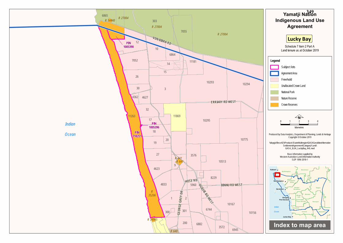
LUCKY BAY LAND
All that land and water commencing from the southernmost southwestern corner of Lot 11263 as shown on Deposited Plan 91188 (Reserve 35206) and extending generally easterly and generally northwesterly along the boundaries of that lot to the intersection with the southern boundary of Lot 4837 as shown on Deposited Plan 138004; Then northeasterly and westerly along the boundaries of that lot to the intersection of an eastern boundary of again Lot 11263 as shown on Deposited Plan 91188; Then generally northwesterly along the boundaries of that lot to the intersection with the westernmost northwestern corner of Lot 12 on Deposited Plan 64216; then easterly and northerly along the boundaries of that severance to the intersection of a southwestern boundary of Native Title Determination WAD6136/1998 WAD286/2018 Nanda People and Nanda #2 (WCD2018/011); then northwesterly along the boundary of that native title determination to the intersection of the northwesternmost boundary of Lot 11263 as shown on Deposited Plan 91188; then generally southwesterly and southeasterly along the boundaries of that lot back to the commencement point.
Schedule 7 - Tourism Land 342
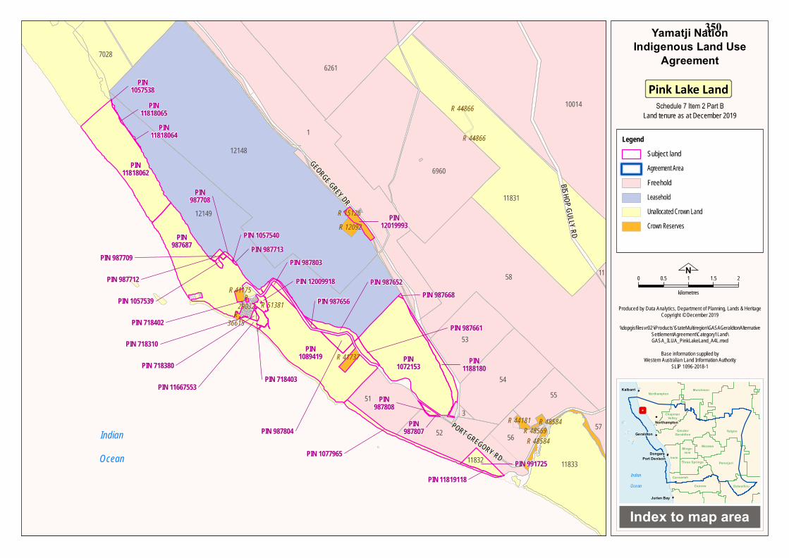
PINK LAKE LAND
Area One PINS 987652; 987656; 987661; 987668; 987687; 987689; 987690; 987691; 987694; 987696; 987708;
987709; 987712; 987713; 1057533; 1057534; 1057535; 1057536; 1057538; 1057539; 1057540;
1057972; 1072153; 1188180; 11818061; 11818062; 11818063; 11818064 and 11818065
All those lands and waters commencing at the northernmost corner of Lot 12148 as
shown on Deposited Plan 219785 (General Lease K995499) and extending
southwesterly along the boundary of that lot to the intersection with the
northwesternmost northwestern corner of Lot 12149 as shown on Deposited Plan
243263; then generally southeasterly and generally northeasterly along the boundaries of
that lot to intersection of the southwestern boundary of Lot 1 as shown on Deposited
Plan 409221; then southeasterly along the boundary of that lot to the intersection of the
northeastern boundary of Lot 12110 as shown on Deposited Plan 219382; then generally
southeasterly; southerly and westerly along the northern; eastern and southern
boundaries of that lot to an intersection with Unallocated Crown Land; then westerly
along the boundary of that Unallocated Crown Land to an intersection with a
northeastern boundary of Port Gregory Road; then generally northwesterly along the
boundary of that road and unnamed road to the intersection with a western boundary of
Williams Street; then southerly along the boundary of that latter road to an intersection
with Lot 192 as shown on Deposited Plan 189298 (Reserve 41175) then westerly;
southerly and easterly along the boundaries of that lot to the intersection with the
northwestern corner of Lot 91 as shown on Deposited Plan 16493; then generally
southerly along the eastern boundaries of that lot and Lots 92 and 93 to the northwestern
corner of Lot 70 as shown on Deposited Plan 205919; then southerly along the western
boundary of that lot to the northwestern corner of Lot 120 as shown on Deposited Plan
181787 (Reserve 25882); then southwesterly along the western boundary of that lot to
the northwestern corner of Lot 94 as shown Deposited Plan 164931 (Reserve 25882);
then southwesterly along the western boundary of that lot to the northwestern corner of
Lot 71 as shown on Deposited Plan 205919; then southwesterly along the northwestern
boundary of that lot to the northwestern corner of Lot 1 as shown on Deposited Plan
26101; then southwesterly along the northwestern boundary of that lot and Lot 2 to the
northwestern corner of Lot 74 as shown on Deposited Plan 205919; then southwesterly
along the northwestern boundary of that lot and Lots 75 and 76; to an intersection with a
northeastern corner of Lot 156 as shown on Deposited Plan 183706 (Reserve 36615);
Schedule 7 - Tourism Land 343
then generally westerly and southwesterly along the boundaries of that lot to an
intersection with High Water Mark; then generally northwesterly along High Water
Mark to an intersection with the southwestern boundary of Gregory Town Lot 55; then
northeasterly along the southern boundaries of that lot and Gregory Town Lots 4; 3; 2
and 1 to the intersection of the southern boundary of unnamed road; then northeasterly
along the southern boundary of that unnamed road to the intersection of the southern
boundary of Gregory Town Lot 5; then northeasterly along the southern boundary of
that lot and Gregory Town Lots 6 and 7 to the intersection of the southern boundary of
Gregory Town Lot 8; then northeasterly; northerly; southwesterly to the intersection of
the northern boundary of Gregory Town Lot 7; then southwesterly along the northern
boundary of that lot and Gregory Town Lots 6 and 5 to the intersection of the northern
boundary of unnamed road; then southeasterly along the northern boundary of that
unnamed road to the intersection of the northern boundary of Gregory Town Lot 1; then
southwesterly along the northern boundaries of that lot and Gregory Town Lots 2; 3 and
4 to the intersection of the northern boundary of Gregory Town Lot 55; then
southwesterly and southerly along the boundary of that lot to the intersection with again
High Water Mark; then generally northwesterly along High Water Mark to an
intersection with the westernmost southwestern corner of Lot 11263 as shown on
Deposited Plan 91188 (Reserve 35206); then westerly along the southern boundary of
that lot to an intersection with the northwestern corner of Lot 11221 as shown on
Deposited Plan 214049 (Reserve 34945); then southerly; easterly and northerly along
the boundaries of that lot to again an intersection with Lot 11263 as shown on Deposited
Plan 91188 (Reserve 35206); then easterly along the southern boundary of that lot to its
southernmost southeastern corner being the northernmost northeastern corner of Lot
7428 as shown on Deposited Plan 202683 (Unallocated Crown Land); then generally
southeasterly along the eastern boundaries of that lot to an intersection with a western
boundary of unnamed road at approximate Latitude 28.073416 South;; then generally
southeasterly along the western boundary of that unnamed road to an intersection with
the northwestern corner of Lot 12117 as shown on Deposited Plan 219414 (Reserve
640); then southerly and westerly along the boundaries of that lot to the intersection of
the southwestern boundary of unnamed road; then generally southeasterly along the
boundary of that unnamed road to an intersection with the northernmost northwestern
corner of the southern severance of Lot 6687 as shown on Deposited Plan 226863; then
generally southeasterly along the boundaries of that lot to its southwesternmost corner
being a northwestern corner of the western severance of Lot 6732 as shown on
Schedule 7 - Tourism Land 344
Deposited Plan 226864; then generally southeasterly along the boundaries of that latter
lot to the northwestern corner of a northwestern severance of Lot 1 as shown on
Deposited Plan 409221; then generally southeasterly along the boundary of that lot to
the intersection of its southeastern corner and Lot 12306 as shown on Deposited Plan
219377 (Unallocated Crown Land); then southeasterly along the western boundary of
Lot 12306 to a northwestern corner of a southwestern severance of Lot 1 as shown on
Deposited Plan 409221; then generally southeasterly and northeasterly along the
boundaries of that lot to an intersection with the northwestern corner of Lot 12670 as
shown on Deposited Plan 30931 (Reserve 46843); then generally southeasterly and
easterly along the boundary of that lot to its southwestern corner being a point on a
northeastern boundary of Lot 7028 as shown on Deposited Plan 202225 (Unallocated
Crown Land); then generally southeasterly along the boundaries of that lot back to the
commencement point.
EXCLUSIONS
Lot 211 as shown on Deposited Plan 243032 (General Lease K595886)
Area Two PINS 12019993
All those lands and waters comprising Lot 62 as shown on Deposited Plan 76144
(Reserve 15126).
Area Three PINS 718402
All those lands and waters comprising Lot 152 as shown on Deposited Plan 182169
(Reserve 29032).
Area Four PINS 718310; 718380; 718403; 987803; 987804; 991725; 1077965; 1089419; 11667553; 11819118 and
12009918
All those lands and waters commencing at the southeastern corner of Lot 350 as shown
on Deposited Plan 54052 (Unallocated Crown Land) being the Intersection of High
Water Mark and extending northwesterly along the High Water Mark to an intersection
with an eastern boundary of Lot 156 as shown on Deposited Plan 183706 (Reserve
36615); then northerly and southeasterly along that lot to an intersection with a
northwestern corner of Port Street; then southerly; easterly and northerly along the
boundary of Port Street to the southwestern corner of Lot 500 as shown on Deposited
Schedule 7 - Tourism Land 345
Plan 57805 (Reserve 50063); then easterly and northerly along the boundaries of that lot
to an intersection with Lot 84 as shown on Deposited Plan 20519; then easterly along
the southern boundary of that lot to a southwestern corner of Lot 216 as shown on
Deposited Plan 169828 (Unallocated Crown Land); then northerly; easterly and
southerly along the boundaries of that lot to an intersection with a southwestern
boundary of Lynton Ave; then easterly along the boundary of Lynton Ave to its
southeastern corner; then extending northeasterly along an eastern boundary of that road
and the eastern boundaries of Lots 106; 107 108; 109; 110; 111; 112 as shown on
Deposited Plan 169828 and Lot 213 as shown on Deposited Plan 191315; then
northeasterly and northwesterly along the boundaries of Lot 600 as shown on Deposited
Plan 44180 to the intersection with a westernmost southwestern corner of Lot 602 as
shown on Deposited Plan 74693 (Unallocated Crown Land); then generally northerly
and generally easterly along the boundaries of that lot to its northernmost northeastern
corner being a point on the southern boundary of Port Gregory Road; then generally
northeasterly and southeasterly along the boundary of that road to an intersection with
the northernmost corner of Lot 51 as shown on Deposited Plan 58867; then
southwesterly and generally southeasterly along the boundaries of that lot and Lot 52 to
an intersection with the southernmost southeastern corner of Unallocated Crown Land;
then generally southwesterly along the eastern boundary of that Unallocated Crown
Land to an intersection with High Water Mark; then generally northwesterly along the
High Water Mark to the intersection with the southeastern boundary of again Lot 350 as
shown on Deposited Plan 54052 (Unallocated Crown Land); then generally
northeasterly; westerly; and southwesterly along the boundaries of that lot back to the
commencement point.
EXCLUSIONS
Lot 211 as shown on Deposited Plan 243032 (General Lease K595886)
Lot 601 as shown on Deposited Plan 74693 (Reserve 51381)
Lot 210 as shown on Deposited Plan 189967 (Reserve 41737)
Lot 351 as shown on Deposited Plan 54052 (Unallocated Crown Land)
Area Five PINS 987807 and 987808
All those lands and waters commencing at the easternmost northeastern corner of Lot 51
as shown on Deposited Plan 58867 and extending northwesterly along the boundary of
Schedule 7 - Tourism Land 346
that lot to an intersection with a southwestern boundary of Port Gregory Road; then
southeasterly along the boundary of that road to an intersection with a northwestern
corner of Lot 52 as shown on Deposited Plan 58867; then generally westerly along the
boundaries of that lot back to the commencement point.
Area Six PIN 11863345
All those lands and waters comprising Lot 500 as shown on Deposited Plan 065746
(Unallocated Crown Land).
Note:; Geographic Coordinates provided in Decimal Degrees.
All referenced Deposited Plans and Diagrams are held by the Western Australian Land Information Authority, trading as Landgate.
Cadastral boundaries sourced from Landgate’s Spatial Cadastral Database dated 1st August 2019.
Datum: Geocentric Datum of Australia 1994 (GDA94)
Prepared By: Graphic Services (Landgate) 29th January 2020
Use of Coordinates:
Where coordinates are used within the description to represent cadastral or topographical boundaries or
the intersection with such; they are intended as a guide only. As an outcome to the custodians of cadastral
and topographic data continuously recalculating the geographic position of their data based on improved
survey and data maintenance procedures; it is not possible to accurately define such a position other than
by detailed ground survey.
G:\WAG\WAD0345_2019\Determination\Determination_TD\ External Boundary Description - Yamatji Nation Pink Lake Land.doc
Schedule 7 - Tourism Land
PART PIN 11818062All those lands and waters commencing at the at the northern corner of Unallocated Crown Land at coordinate point Latitude 28.150266 East Longitude 114.224381 South and extending generally southwesterly along the northeastern boundaries of that Unallocated Crown Land to its easternmost corner; then southwesterly along the southeastern boundary of that Unallocated Crown Land to its southernmost corner being a point on High Water Mark; then northwesterly along High Water Mark to coordinate point Latitude 28.155117 East Longitude 114.21822 South; then northeasterly back to the commencement point.
347
Schedule 7 – Tourism Land
Item 2 – Maps of Lucky Bay Land and Pink Lake Land
Part A – Map of Lucky Bay Land
Part B – Map of Pink Lake Land
[Page intentionally left blank – see next page]
Schedule 7 - Tourism Land 348
IndianOcean
PIN1005396
PIN718251
PIN1005390
301
200
5960
4362 4627
10295
2
6744
8229
32
20
9
3
11181
10294
3572
10167
18
303
3576
300
6945
26
30
15
11263
6882
6865
17
7055
10293
4833
10513
10775
10156
10
27
1
12
70526864
4623
19
14
11869
R 641R 641
R 27004
R 27004R 27004
R 640
R 14440
R35206
R 34945
GEOR
GE GR
EY DR
HOSE RD
VON BIBRA RD
OGILVIE RD WEST
BINNU RD WEST
ERRIARY RD WEST
0 1 2 3 4
kilometres
Produced by Data Analytics, Department of Planning, Lands & HeritageCopyright © October 2019
\\dopgisfilesvr02\iProducts\StateMultiregion\GASAGeraldtonAlternativeSettlementAgreement\Category1Land\
GASA_ILUA_LuckyBay_A4L.mxd
Base information supplied byWestern Australian Land Information Authority
SLIP 1096-2018-1
Index to map area
Murchison
Indian
Ocean
Morawa
ChapmanValley
Carnamah
Three Springs
Northampton
Coorow
PerenjoriIrwin
YalgooGreaterGeraldton
Minge-new
Dalwallinu
Dongara
Geraldton
Jurien Bay
Kalbarri
Northampton
Port Denison
Yamatji NationIndigenous Land Use
Agreement
Land tenure as at October 2019
LegendSubject lotsAgreement AreaFreeholdUnallocated Crown LandNational ParkNature ReserveCrown Reserves
Lucky Bay
N
Schedule 7 Item 2 Part A
349
12149
53
58
12148
52
51
1
11832
3
54
57
4467
6960
11831
10014
7028
11833
6261
56
55
R 48569R 44181
R 25882
R 41737
R 36615
R 29032R 41175
R 12092R 15126
R 44866
R 44866
R 48584
R 48584
GEORGE GREY DR
PORT GREGORY RD
BISHOP GULLY RD 0 0.5 1 1.5 2
kilometres
Produced by Data Analytics, Department of Planning, Lands & HeritageCopyright © December 2019
\\dopgisfilesvr02\iProducts\StateMultiregion\GASAGeraldtonAlternativeSettlementAgreement\Category1Land\GASA_ILUA_PinkLakeLand_A4L.mxd
Base information supplied byWestern Australian Land Information Authority
SLIP 1096-2018-1
Index to map area
Murchison
Indian
Ocean
Morawa
ChapmanValley
Carnamah
Three Springs
Northampton
Coorow
PerenjoriIrwin
YalgooGreaterGeraldton
Minge-new
Dalwallinu
Dongara
Geraldton
Jurien Bay
Kalbarri
Northampton
Port Denison
Yamatji NationIndigenous Land Use
Agreement
Land tenure as at December 2019
LegendSubject landAgreement AreaFreeholdLeaseholdUnallocated Crown LandCrown Reserves
Pink Lake Land
N
IndianOcean
PIN 987712
PIN11818065
PIN987808
PIN11818064
PIN 1077965
PIN1057538
PIN 1057539
PIN 718310
PIN 987652
PIN 987709
PIN 718380
PIN 987803
PIN 987656
PIN 718402
PIN 11667553
PIN987687
PIN 987804PIN
987807
PIN987708
PIN 1057540PIN 987713
PIN 718403
PIN 12009918
PIN 987661
PIN1072153
PIN 991725
PIN12019993
PIN1089419
PIN 987668
PIN1188180
PIN 11819118
PIN11818062
12149
53
58 11
12148
52
51
1
11832
3
54
57
6960
11831
10014
7028
11833
6261
56
55
R 48569R 44181
R 41737
R36615
R29032
R 41175R 51381
R 12092R 15126
R 44866
R 44866
R 48584
R 48584
GEORGE GREY DRPORT GREGORY RD
BISHOP GULLY RD
Schedule 7 Item 2 Part B
350
1
Schedule 7 – Tourism Land
Item 3 – Management of Lucky Bay Land and Pink Lake Land
[Page intentionally left blank – see next page]
Schedule 7 - Tourism Land 351
2
Management of Lucky Bay Land and Pink Lake Land
1. DEFINITIONS1.1 Definitions
ILUA means the Yamatji Nation ILUA to which this Schedule is annexed. Landholding Body has the same meaning as defined in Schedule 16 of the ILUA.
1.2 Interpretation Any defined terms, which are not defined in this Schedule, have the meaning set out in the ILUA.
2. ROLE OF THE YAMATJI ENTITIESClause 3.2 of Schedule 16 of the ILUA applies to this Schedule 17.
3. DEVELOPMENT OF THE LUCKY BAY MANAGEMENT PLAN(a) Within 6 months of the Execution Date, the Landholding Body and the
MWDC will work in partnership to develop and agree a Lucky BayManagement Plan addressing the following minimum requirements andsubmit to DPLH for consideration:(i) land management plan, including control of fire, feral animals and
weeds;(ii) use and development plan;(iii) environmental, including management of coastal erosion;(iv) public safety;(v) public camping;(vi) management and control of refuse;(vii) infrastructure maintenance and upgrades; and(viii) road maintenance and upgrades.
(b) Within 40 Business Days of receipt of the draft Lucky Bay ManagementPlan, pursuant to clause 3(a), DPLH will provide written notice to theLandholding Body as to whether the draft Lucky Bay Management Planmeets DPLH’s statutory and policy requirements.
(c) If DPLH provides written notice to the Landholding Body that the draftLucky Bay Management Plan:(i) meets DPLH’s statutory and policy requirements, then clause 4 of
this Schedule applies; or(ii) does not meet DPLH’s statutory and policy requirements, then the
matter will be referred to the Land Working Group for potentialresolution.
Schedule 7 - Tourism Land 352
3
4. CARE, CONTROL AND MANAGEMENT OF LUCKY BAY LAND(a) Subject to Conclusive Registration and within 40 Business Days of the later
of:(i) DPLH providing written notice to the Landholding Body in
accordance with clause 3(b)(i); or(ii) Conclusive Registration,DPLH will prepare and offer to the Landholding Body a draft Management Order and Management Order Deed, including any special conditions, with respect to the Reserve Allocation of the Lucky Bay Land (‘Lucky Bay Conditions’).
(b) Within 40 Business Days of DPLH offering the Lucky Bay Conditions,pursuant to clause 4(a), the Landholding Body must, by providing writtennotice to DPLH:(i) accept the Lucky Bay Conditions, in which case clause 4(f) applies;
or(ii) propose amendments to the Lucky Bay Conditions, in which case
clause 4(c) applies.(c) If the Landholding Body proposes amendments to the Lucky Bay Conditions,
DPLH must, by providing written notice to the Landholding Body within 30Business Days of receipt of the proposed amendments:(i) agree with the proposed amendments, in which case clause 4(f)
applies; or(ii) disagree with the proposed amendments, in which case clause 4(d)
applies.(d) If DPLH disagrees with the Landholding Body’s proposed amendments to
the Lucky Bay Conditions, then the Landholding Body must, by providingwritten notice to DPLH within 30 Business Days of receiving the noticeunder clause 4(c)(ii):(i) accept the Lucky Bay Conditions originally offered pursuant to
clause 4(a), in which clause 4(f) applies; or(ii) refer the matter to the Land Working Group for potential resolution.
(e) If the Landholding Body fails to provide written notice to DPLH inaccordance with clause 4(b) or 4(d), then DPLH:(i) will no longer be under an obligation to quarantine the Lucky Bay
Land; and(ii) is under no obligation to ensure the Lucky Bay Land remains
available for Allocation to the Landholding Body.(f) Within 40 Business Days of acceptance of the Lucky Bay Conditions
pursuant to clauses 4(b)(i), 4(c)(i) or 4(d)(i), DPLH must commence LandAssembly for the Lucky Bay Land.
Schedule 7 - Tourism Land 353
4
(g) Within 40 Business Days of the conclusion of Land Assembly for the Lucky Bay Land, DPLH must prepare and submit to the Landholding Body the following documents as agreed: (i) the Management Order Deed; (ii) the Management Order; and (iii) any ancillary documents.
(h) The reserve purpose will be “Yamatji Social, Cultural and/or Economic Benefit” or such other purpose as agreed between the State and the Landholding Body.
(i) The Landholding Body must execute and return the documents in clause 4(g) to DPLH within 40 Business Days of their receipt.
(j) Within 40 Business Days of receiving all relevant executed documents from the Landholding Body in accordance with clause 4(i), DPLH will arrange for execution and stamping (if necessary) of the documents and make all reasonable endeavours to lodge the documents for registration at Landgate.
(k) Within 5 Business Days of lodging the documents pursuant to clause 4(j), DPLH will notify the Landholding Body of the date on which the documents were lodged for registration and the document registration number shown on the Landgate lodging slip.
(l) Where the Landholding Body fails to deliver the duly executed documents to DPLH within the timeframe in clause 4(i), DPLH will provide the Landholding Body with a written notice of a further 40 Business Days to return the executed documents to DPLH.
(m) If the Landholding Body fails to deliver the duly executed documents to DPLH within the additional 40 Business Days in clause 4(l), then DPLH: (i) will no longer be under any obligation confer management of the
Lucky Bay Land on the Landholding Body; and (ii) is under no obligation to ensure the Lucky Bay Land remains
available for Allocation to the Landholding Body. (n) All timeframes in this clause may be extended by agreement of DPLH and
the Landholding Body. (o) The Parties acknowledge that, where circumstances beyond the control of the
State, materially prevent the State from giving effect to the conferral of a Management Order of the Lucky Bay Land on the Landholding Body: (i) the State will not be under an obligation to complete the conferral
of a Management Order; (ii) this will not amount to a Default on behalf of the State Parties; and (iii) the Landholding Body will not be entitled to any compensation.
5. APPROVAL OF THE LUCKY BAY MANAGEMENT PLAN (a) Within 40 Business Days of the conferral of a Management Order on the
Landholding Body for the Lucky Bay Land, the Landholding Body must submit the draft Lucky Bay Management Plan, for the development,
Schedule 7 - Tourism Land 354
5
management and use of the Lucky Bay Land, to the Minister for Lands for approval in accordance with subsections 49(1) and (3) of the LA Act.
(b) If the Landholding Body does not submit the draft Lucky Bay Management Plan, pursuant to clause 5(a), the Minister for Lands may request the Lucky Bay Management Plan in accordance with subsection 49(2) of the LA Act.
(c) The Lucky Bay Management Plan, once approved, forms part of the Lucky Bay Conditions and the development, management and use of the Lucky Bay Land by the Landholding Body must be in accordance with the Lucky Bay Management Plan as approved by the Minister for Lands.
(d) The Minister for Lands may from time to time request a review and subsequent variation of the approved Lucky Bay Management Plan to meet changing management requirements or circumstances.
6. CARE, CONTROL AND MANAGEMENT OF THE PINK LAKE LAND (a) Within 40 Business Days of Conclusive Registration DPLH will prepare and
offer to the Landholding Body a draft Management Order and Management Order Deed, including any special conditions, with respect to the Reserve Allocation of the Pink Lake Land (‘Pink Lake Conditions’).
(b) Within 40 Business Days of DPLH offering the Pink Lake Conditions pursuant to clause 6(a), the Landholding Body must, by providing written notice to DPLH: (i) accept the Pink Lake Conditions, in which case clause 6(f) applies;
or (ii) propose amendments to the Pink Lake Conditions, in which case
clause 6(c) applies. (c) If the Landholding Body proposes amendments to the Pink Lake Conditions,
DPLH must, by providing written notice to the Landholding Body within 30 Business Days of receipt of the proposed amendments: (i) agree with the proposed amendments, in which case clause 6(f)
applies; or (ii) disagree with the proposed amendments, in which case clause 6(d)
applies. (d) If DPLH disagrees with the Landholding Body’s proposed amendments to
the Pink Lake Conditions, then the Landholding Body must, by providing written notice to DPLH within 30 Business Days of receiving the notice under clause 6(c)(ii): (i) accept the Pink Lake Conditions originally offered pursuant to
clause 6(a), in which clause 6(f) applies; or (ii) refer the matter to the Land Working Group for potential resolution.
(e) If the Landholding Body fails to provide written notice to DPLH in accordance with clauses 6(b) or 6(d), then DPLH: (i) will no longer be under an obligation to quarantine the Pink Lake
Land; and
Schedule 7 - Tourism Land 355
6
(ii) is under no obligation to ensure the Pink Lake Land remains available for Allocation to the Landholding Body.
(f) Within 40 Business Days of acceptance of the Pink Lake Conditions pursuant to clauses 6(b)(i), 6(c)(i) or 6(d)(i), DPLH must commence Land Assembly for the Pink Lake Land.
(g) Within 40 Business Days of the conclusion of Land Assembly for the Pink Lake Land, DPLH must prepare and submit to the Landholding Body the following documents as agreed: (i) the Management Order Deed; (ii) the Management Order; and (iii) any ancillary documents.
(h) The reserve purpose will be “Yamatji Social, Cultural and/or Economic Benefit” or such other purpose as agreed between the State and the Landholding Body.
(i) The Landholding Body must execute and return the documents in clause 6(g) to DPLH within 40 Business Days of their receipt.
(j) Within 40 Business Days of receiving all relevant executed documents from the Landholding Body in accordance with clause 6(i), DPLH will arrange for execution and stamping (if necessary) of the documents, and make all reasonable endeavours to lodge the documents for registration at Landgate.
(k) Within 5 Business Days of lodging the documents pursuant to clause 6(j), DPLH will notify the Landholding Body of the date on which the documents were lodged for registration and the document registration number shown on the Landgate lodging slip.
(l) Where the Landholding Body fails to deliver the duly executed documents to DPLH within the timeframe in clause 6(i), DPLH will provide the Landholding Body with a written notice of a further 40 Business Days to return the executed documents to DPLH.
(m) If the Landholding Body fails to deliver the duly executed documents to DPLH within the additional 40 Business Days in clause 6(l), then DPLH: (i) will no longer be under any obligation confer management of the
Pink Lake Land on the Landholding Body; and (ii) is under no obligation to ensure the Pink Lake Land remains
available for Allocation to the Landholding Body. (n) All timeframes in this clause may be extended by agreement of DPLH and
the Landholding Body. (o) The Parties acknowledge that, where circumstances beyond the control of the
State, materially prevent the State from giving effect to the conferral of a Management Order of the Pink Lake Land on the Landholding Body: (i) the State will not be under an obligation to complete the conferral
of a Management Order; (ii) this will not amount to a Default on behalf of the State Parties; and
Schedule 7 - Tourism Land 356
7
(iii) the Landholding Body will not be entitled to any compensation.
7. DEVELOPMENT AND APPROVAL OF THE PINK LAKE MANAGEMENTPLAN(a) The Landholding Body and the MWDC will work in partnership to develop
and agree a Pink Lake Management Plan which is consistent with the PinkLake Master Plan developed in clause 14.7 of the ILUA, in relation to parcelscomprising the Pink Lake Land that are to be reserved in accordance withPart 4 of the LAA.
(b) Within 6 months of the conferral of a Management Order on the LandholdingBody for the Pink Lake Land, the Landholding Body must submit the draftPink Lake Management Plan, for the development, management and use ofthe Pink Lake Land, to the Minister for Lands for approval in accordancewith subsections 49(1) and (3) of the LA Act.
(c) If the Landholding Body does not submit the draft Pink Lake ManagementPlan, in accordance with clause 7(b), the Minister for Lands may request thePink Lake Management Plan in accordance with subsection 49(2) of the LAAct.
(d) The Pink Lake Management Plan, once approved, forms part of the Pink LakeConditions and the development, management and use of the Pink Lake Landby the Landholding Body must be in accordance with the Pink LakeManagement Plan as approved by the Minister for Lands.
(e) The Minister for Lands may from time to time request a review andsubsequent variation of the Pink Lake Management Plan to meet changingmanagement requirements or circumstances.
Schedule 7 - Tourism Land 357

[Page intentionally left blank – see next page]
358