Embed Size (px)
Citation preview

Schedule 2—Character Places
February 2012 SCH2-1
SCHEDULE 2—CHARACTER PLACES
Part 1—Historic and Miscellaneous Places
Address/Site Name Street No. Suburb RPD Description Extent of Significance
Albert Street 15 North Ipswich L31 RP14724 Dwelling Whole Lot
Alice Street 28-28A Goodna L4-5 RP22565 Dwelling Whole Lot
Alice Street
‘St. Alban's Anglican
Church’
69 Goodna L1 RP2461 Church Whole Lot excluding post
1946 buildings &
structures
Bailey Street
‘Westfalen Colliery
No. 3’
27 Collingwood Park L1 RP22440 Colliery Complex Colliery facilities of the
1970’s
Barclay Street 76-78 Bundamba L44-45 RP22527 Dwelling Whole Site
Barclay Street 82 Bundamba L46 RP22527 Dwelling House only
Bell Street 1 Ipswich L3 RP2654 Shop Whole Lot
Bell Street 1 Ipswich L4 RP2654 Shop Whole Lot
Bell Street 1 Ipswich L5 RP2654 Shop Whole Lot
Berlins Road
‘Muller private
cemetery’
223 Tallegalla L1 RP66966 Cemetery Fenced area containing
one headstone for the
Muller family
Blackall Street 100 Basin Pocket L31 RP23986 Dwelling Whole Lot
Blackstone Road 9 Eastern Heights L16 RP24157 Shops Whole Lot
Booval Street
‘Violetville’
16 Booval L22 RP23755
Dwelling Whole Lot
Boyles Rd
‘The Boghole’
Pine Mountain Part of road reserve Parkland Area outlined on attached
Plan No. 1
Bremer River
Barry Street
Road Reserve
‘Stone retaining wall’
Ipswich Stone retaining
wall supporting
the banks of the
Bremer River in
the area known as
the Swing Basin
To the extent of the
remains of the stone
retaining wall
Bremer Street
‘First Queensland
Railway Centenary
Memorial’
Ipswich Road Reserve Memorial The extent of its concrete
foundations in the Bremer
Bridge pier
Bremer Street
‘Railway Bridge’
Ipswich Railway Reserve Bridge Area outlined on attached
Plan No. 2
Bremer Street
‘Sesqui-Centenary
Discovery Memorial
Cairn within Transit
Centre Carpark’
10 Ipswich Memorial To the extent of the
memorial's concrete
foundations
Bremer Street
‘Johnston’s Brewery
Site’
14
Ipswich L1 RP54899
L1 RP812175
Archaeological
site
Original sandstone
foundations which can be
relocated but are to remain
on site

Schedule 2—Character Places
SCH2-2 October 2017
Address/Site Name Street No. Suburb RPD Description Extent of Significance
Bridge Street 28 North Booval L14 RP23802 Dwelling Whole Lot
Brisbane Road
Andrew Duce’s House
47-49 Bundamba L2 RP123379 Dwelling Main House
Brisbane Road
Cameron’s Park
‘ War Memorial &
Surrounds’
95A Booval L169 RP24111
Memorial
To the extent of the
concrete apron
surrounding the memorial
Brisbane Road
‘Bundamba War
Memorial & surrounds
Memorial Park’
17 Bundamba L10-11 B7002 Memorial To the extent of the
memorial's concrete apron
Brisbane Road
‘Bundamba Methodist
Church Hall’
20 Bundamba L1 RP170587 Church Hall Whole Lot excluding post
1946 buildings &
structures
Brisbane Road 73 Bundamba L2-3 RP22506 Dwelling Whole Site
Brisbane Road
‘Duce House and
Pergola’
88 and 90 East Ipswich L10 RP53682 &
L3 RP71500
Dwelling Whole Lot including
boundary fences, internal
stone retaining walls
Brisbane Road
Rotary Park: ‘Old
Ipswich Railway Bridge
Memorial’
258 Bundamba L507 SL6935 Memorial To the extent of the
concrete apron
surrounding the memorial
Brisbane Road
‘Dinmore Murri Baptist
Church’
38 and 38a Dinmore L78 and L79 RP22376 Church Church building
Brisbane Road 44 Dinmore L121 SP130149 Dinmore Railway
Station
Passenger Station
Building, Footbridge and
northern Timber Platform
Shelter.
Brisbane Road Ebbw Vale L131 SP130151 Ebbw Vale
Railway Station
Rail Passenger Station
Building, Timber Platform
Shelters and Footbridge
Brisbane Road
‘Ebbw Vale War
Memorial & surrounds’
11 Ebbw Vale L1 RP40461 Memorial To the extent of the
memorial's concrete apron
Brisbane Road
‘Sandhurst’
35 Ebbw Vale
L2 RP83652 Dwelling Whole Lot
Brisbane Road
Redbank Railway
Station
Redbank Railway Reserve Railway Station To the extent of the
original railway station
building
Brisbane Road
‘Ipswich – Brisbane
Road Distance Marker’
Redbank Outside the Redbank
Railway Station,
opposite 93 Brisbane
Road
Road Distance
Marker
Area outlined on attached
Plan No. 3
Brisbane Road
‘Stone Kerbing and
Gutters’
Redbank Road Reserve Stone kerbing and
gutters
Area outlined on attached
Plan No. 4
Brisbane Road
‘Redbank State School’
7 & 9 Redbank L8 RP22523
L390 SL6661
School building &
annexe
Whole Site excluding all
post 1960's buildings and
structures
Brisbane Road 34 Redbank L2 RP59354 Shop Whole Lot
Brisbane Road
‘Commercial Hotel’
70 Redbank L30 RP803123 Hotel Whole Lot excluding all
post 1946 buildings &
structures

Schedule 2—Character Places
August 2013 SCH2-3
Address/Site Name Street No. Suburb RPD Description Extent of Significance
Brisbane Road
‘Redbank School of Arts’
71 Redbank L13-14 RP22316 School of Arts Whole Site and street
awnings
Brisbane Road 89 Riverview L10 RP87341 Dwelling Whole Lot
Brisbane Street
‘QCWA Girls' Hostel’
5 Ipswich
L2 RP61206
Dwelling Whole Lot
Brisbane Street
‘Ulster Hotel’
25 Ipswich L10 I122412
Hotel Whole Lot and the street
awning
Brisbane Street
‘Suva House’
38 Ipswich L1 RP75715
Shop Whole Lot and the street
awning
Brisbane Street 80 Ipswich L1 RP80199 Shop Whole Lot and the street
awning
Brisbane Street 86 Ipswich L0 BUP289
L0 BUP 104426
L8 BUP104426
L1-4 BUP289
Shops Whole Site and the street
awning
Brisbane Street
‘Queensland National
Bank’
89 Ipswich L2 RP2652 Bank Whole Lot
Brisbane Street 91 Ipswich L1 RP2652 Shop Whole Lot
Brisbane Street 93 Ipswich L2 RP2653 Shop Whole Lot
Brisbane Street 94 Ipswich L3 RP93328 Shop Whole Lot
Brisbane Street 96 Ipswich L2 RP162302 Shop Whole Lot
Brisbane Street
‘Public Trustee’s Office’
97 Ipswich L203 I12241
L1 RP2653
Shop Whole Site and the street
awning
Brisbane Street 100 Ipswich L1 RP93328 Shop Whole Lot
Brisbane Street 102 Ipswich L3 RP166867 Bank Whole Lot
Brisbane Street
'Fox's Pharmacy'
106 Ipswich L1 RP46058 Shop Whole Lot
Brisbane Street
'Former Bank of
Australasia'
112 Ipswich L2 RP2713 Bank Whole Lot
Brisbane Street
Limestone Street
‘Ipswich Post Office’
114
63 & 65
Ipswich L9 RP68487
L24 I12244
L25 RP68487
Post Office Whole Lot
Brisbane Street
‘London Pharmacy’
114B Ipswich L1 RP2713 Shop Whole Lot
Brisbane Street
'School of Arts, Town
Hall, St Paul's Young
Men's Club'
116
Ipswich L12 SP103223
School of Arts
Hall
Whole Lot, excluding all
post 1946 buildings and
structures

Schedule 2—Character Places
SCH2-4 October 2017
Address/Site Name Street No. Suburb RPD Description Extent of Significance
Brisbane Street
‘St Paul’s Anglican
Church’
124 Ipswich L5 RP47364 Church, Rectory,
Memorial, Gates
& Walls
Whole Lot including the
Church, Rectory, Memorial
to Mavis Parkinson, the
entry gates & all
sandstone & limestone
walls. Excluding all post
1946 buildings and
structures
Brisbane Street 126 Ipswich L1 RP175271 Shop Whole Lot
Brisbane Street 130 Ipswich L1 RP2758 Shop Whole Lot
Brisbane Street 133 Ipswich L1-2 RP47496 Shop Whole Site
Brisbane Street 135 Ipswich L3 RP112220 Shop Whole Lot
Brisbane Street 137 Ipswich L2 RP112220 Shop Whole Lot
Brisbane Street
'Voglers'
138-140 Ipswich L1 RP47528
L2 RP2760
Shop Whole Lot and the street
awning
Brisbane Street 141 Ipswich L1 RP112220 Shop Whole Lot and the street
awning
Brisbane Street 141 Ipswich L4 RP101770 Shop Whole Lot
Brisbane Street 141 Ipswich L3 RP101770 Shop Whole Lot
Brisbane Street 142 Ipswich L38 RP214352 Shop Whole Lot and the street
awning
Brisbane Street
‘Former Motor Garage'
144 Ipswich L2 RP74367 Shop Whole Lot and the street
awning
Brisbane Street 146 Ipswich L2 RP48335 Shop Whole Lot and the street
awning
Brisbane Street 150 Ipswich L3 RP2762 Shop Whole Lot and street
awning
Brisbane Street 152 Ipswich L1 RP2762 Shop Whole Lot and the street
awning
Brisbane Street
'Big Whites'
160 Ipswich L80 I12245 Shop Whole Lot and the street
awning, excluding all post
1946 buildings and
structures
Brisbane Street
‘Hoey & Platz'
164 Ipswich L10 RP105860 Shop Whole Lot and the street
awning, excluding all post
1946 buildings and
structures
Brisbane Street
‘Bostock Chambers'
169 Ipswich L0-6 BUP249 Shop Whole Site and the street
awning
Brisbane Street 178 Ipswich L2 RP95228 Shop Whole Lot
Brisbane Street 183 Ipswich L1 RP2720 Shop Whole Lot and the street
awning
Brisbane Street
‘Lutvey’s shop’
185 Ipswich L2 RP2717 Shop Shop front only including
display windows
Brisbane Street 187 Ipswich L1 RP2717 Shop Whole Lot and the street
awning
Brisbane Street
'Baptist Church'
188 Ipswich L5 SP234330 Church &
Memorial Gates
Whole Site including the
retaining wall to Brisbane
Street and memorial gates,
excluding all post 1946
buildings and structures
Brisbane Street 189 Ipswich L1 RP2738 Shop Whole Lot and the street
awning
Brisbane Street 196 Ipswich L818 I12245 Shop Whole Lot

Schedule 2—Character Places
May 2016 SCH2-5
Address/Site Name Street No. Suburb RPD Description Extent of Significance
Brisbane Street 197 Ipswich L197 SP134638 Shop Whole Lot and the street
awning
Brisbane Street 199 Ipswich L199 SP134638 Shop Whole Lot and the street
awning
Brisbane Street 203 Ipswich L2 RP106090 Shop Whole Lot and the street
awning
Brisbane Street
'Emporium'
205 Ipswich L714 I12246 Shop Whole Lot and the street
awning
Brisbane Street 208 Ipswich L5 I1642 Shop Whole Lot
Brisbane Street 211 Ipswich L2 RP93097 Shop Whole Lot
Brisbane Street
‘Federal Hotel’
214 Ipswich L1 RP167693
Hotel Whole Lot excluding all
post 1946 buildings and
structures
Brisbane Street
'Settlers Inn'
215 Ipswich L2 RP2752 Hotel Whole Lot and the street
awning
Brisbane Street 219 Ipswich L2 RP43941 Shop Whole Lot
Brisbane Street 221 Ipswich L1 RP43941 Shop Whole Lot
Brisbane Street 223 Ipswich L2 RP91888 Shop Whole Lot including the
Loetzschs Cycle and
Motorcycle House Signage
located above the main
entrance and shop front
windows facing Brisbane
Street.
Brisbane Street
‘Ipswich Flour Milling
Co.’
227 Ipswich L1-2 RP2751
Flour mill building,
shops
Whole Lot and the street
awning
Brisbane Street 233 Ipswich L2 RP2749 Shop Whole Lot
Brisbane Street 235 Ipswich L4 RP41451 Shop Whole Lot
Brisbane Street 237 Ipswich L3 RP41451 Shop Whole Lot
Brisbane Street 239 Ipswich L3 RP71848 Shop Whole Lot
Brisbane Street 241 Ipswich L2 RP71848 Shop Whole Lot
Brisbane Street
'Prince of Wales'
243 Ipswich L2 RP2747 Hotel Whole Lot
Brisbane Street
‘Metropole Hotel’
253 Ipswich L1 CP896413 Hotel Whole Lot and the street
awning
Brisbane Street
‘City View Hotel’
277
West Ipswich L3 RP24063 Hotel Whole Lot and the street
awning, excluding all post
1946 buildings and
structures
Brisbane Terrace 84 Goodna L11 RP2452 Dwelling Main House
Brisbane Terrace 91 Goodna L3 RP2450 Dwelling Main House
Brisbane Terrace
‘Royal Mail Hotel’
92 Goodna L915 G152 Hotel Whole Lot and the street
awning
Brisbane Terrace 93 Goodna L2 RP2450 Dwelling Main House
Brisbane Terrace 95 Goodna L1 RP2450 Dwelling Main House
Brisbane Terrace 97 Goodna L1 RP2449 Dwelling Main House
Brisbane Terrace 99 Goodna L2 RP2449 Dwelling Main House
Brisbane Valley Highway 315–333 Pine Mountain L250 CH3113 Dwelling Main house in fenced
house yard
Brisbane Valley Highway 335–355 Pine Mountain L247 CH3113 Dwelling Main house in fenced
house yard

Schedule 2—Character Places
SCH2-6 October 2017
Address/Site Name Street No. Suburb RPD Description Extent of Significance
Brittains Road
'Oakleigh'
11 Augustine Heights L3 RP210082 Dwelling Main house
Burnett Street
‘Blair State School’
22 Sadliers Crossing L398 SL4745 School Blocks B, C & D
Byrne Street
‘Byrneville’
8 Bundamba L8 RP868820 Dwelling Whole Lot
Cairns Road
‘Ebbw Vale Triassic
Fossil Locality’
41 Ebbw Vale
L1 RP819367 Triassic fossil
localities
Whole Lot
Carara Avenue 59-63 Thagoona L33 RP138870 Dwelling Main house
Cemetery Road
Manson Park –
‘American War
Cemetery Memorial’
19 Raceview L21 I16249 Memorial Whole Lot
Chelmsford Avenue
‘Blackall Memorial
Drinking Fountain’
Ipswich Road Reserve Memorial To the extent of the
memorial's concrete apron
Chelmsford Avenue 7 Ipswich L38 I16270 Dwelling The main house excluding
all post 1946 buildings &
structures
Chelmsford Avenue
‘Denmark Hill Fossil
Insect Beds’ Denmark
Hill Environmental Park’
20 Ipswich L23 I16262 Fossil insect beds The extent of the fossil
beds as outlined on
attached Plan No. 5
Chelmsford Avenue
‘Denmark Hill Coal
Workings’. Denmark Hill
Environmental park’
20 Ipswich L23 I16262 Disused
quarry/mine site
To the extent of the coal
workings included in the
area outlined on attached
Plan No. 6
Chelmsford Avenue
‘Water reservoir’
22 Ipswich L24 I6262 Water reservoir 1928 domed reservoir
Chermside Road
‘Cribb & Foote
Centenary Memorial
Gates’
133 East Ipswich
L2 RP66535
Memorial The land 2 metres around
the base of the gates
Chermside Road
'Ipswich Girls Grammar
School'
82 Ipswich L167 SP139377 School Whole Lot excluding all
post 1946 buildings and
structures
Chermside Road
‘Gwennap’
68 Newtown L22 RP883000 Gwennap Historic
Dwelling
Whole Lot excluding all
post 1946 buildings and
structures
Church Street
‘Goodna War Memorial
& surrounds’
Goodna Road Reserve
Corner of Queen and
Church Streets
Memorial To the extent of the
memorial's concrete apron
Church Street
‘St Francis Xavier
Church’
6 Goodna L552 G153 Church Whole Lot excluding all
post 1946 buildings &
structures
Church Street
‘Police Complex’
14 Goodna L189 SL5041
Police Complex Former police barracks,
cells and residence
Church Street
'Police Complex'
75 Harrisville L75 CC2699 Police complex Whole Lot

Schedule 2—Character Places
December 2016 SCH2-7
Address/Site Name Street No. Suburb RPD Description Extent of Significance
Church Street
‘Tivoli Congregational
Church Hall’
42 Tivoli L21 SP175186 Hall Whole Lot excluding all
post 1946 buildings &
structures
Clifton Street 32 Booval L64 RP23818 Dwelling Whole Lot, including the
pressed metal ceiling in its
original paint scheme, and
the front door, fan lights
and side lights set in a
cedar frame.
Clifton Street
‘Buttonsville’
40A Booval L1 RP88852 Dwelling Whole Lot
Kruger Parade
'Redbank Rifle Range'
2-74
100
Redbank L2 SP229584
L1 SL11262
Rifle Range Whole Site
Collingwood Drive
‘Queensland's First
Labour Strike Memorial’
Namatjira Park
2A Collingwood Park
L184 RP147247
Memorial To the extent of the
memorial's foundations
Cothill Road
‘Booval House’
14 Booval L146 SP138166 Dwelling Whole Lot
Cothill Road
'Sacred Heart Church
and School'
19 Booval L20 RP211510 Church
Presbytery
School
Whole Lot including the
Church, Presbytery and
fence fronting Cothill Road
and excluding all post
1946 buildings &
structures
Cunningham Highway 2673 Willowbank L2 RP213075 Dwelling Main house excluding all
other buildings &
structures
Cyprus Street 22 North Ipswich L123 RP14651 Dwelling Whole Lot
D’arcy Doyle Place
‘Ipswich City Mall
Historical Obelisk’
Ipswich Road Reserve Memorial To the extent of the
memorial’s concrete apron
Darling Street East
‘family home of
d’Arcy Doyle’
39 Woodend L2 RP40364 Dwelling Whole Lot
Dinmore Railway
Pedestrian Overpass
Bridge
Dinmore Railway Reserve Bridge Wooden railway
pedestrian overpass
bridge including the three
sets of steps leading to the
platforms
Dinmore Street 1A Dinmore L2 RP99844 Dwelling Whole Lot
Downs Street
‘Hotel Cecil’
15 North Ipswich
L1 RP213980 Hotel Whole Site and the street
awning
Downs Street
'Sangster Memorial'
29 North Ipswich
L1 RP99677 Memorial The Sangster Memorial
located in Browns Park to
the extent of the
memorial's concrete apron

Schedule 2—Character Places
SCH2-8 February 2016
Address/Site Name Street No. Suburb RPD Description Extent of Significance
Downs Street
'Downs Street
Newsagency'
39 North Ipswich L1 RP62228 Shop Whole Lot and the street
awning
Downs Street 72 North Ipswich L1 RP43440 Shop Whole Lot and the street
awning
Downs Street
‘Salvation Army’
80 North Ipswich L78 I1626 Church Whole Lot excluding all
post 1946 buildings and
structures
Downs Street 101 North Ipswich L1 RP66039 Shop Whole Lot and the street
awning
Dudleigh Street 51 North Booval L1 RP75163 Dwelling Whole Lot
Dunns Avenue
'Royal Hotel'
Lot 1 Harrisville L1 RP209502 Hotel Whole Lot
Earls Road
'Kickbush Farmhouse'
47 Marburg L2 SP269084 Dwelling Fenced house yard
East Owen Street
‘Aberdere Extended
No. 1 Colliery’
Former General
Manager’s Office
Raceview L1 RP180890 Former General
Manager’s Office
Area outlined on attached
Plan No. 29
East Street
‘Ipswich & West Moreton
Building Society’
45 Ipswich
L1 I12244 Office building Whole Lot
East Street
‘Ipswich Court House’
75 Ipswich L527 CP893588 Court house Whole Lot
East Street
‘Ipswich Police Station’
77 Ipswich
L528 CP883325 Police Station Whole Lot, excluding all
post 1946 buildings &
structures
East Street
'Ipswich General
Hospital'
81 Ipswich L410 SL8088 A.E. Wilcox
School of nursing
building
To the extent of the A.E.
Wilcox School of nursing
building plus the area
outlined on attached Plan
No. 8
East Street
‘R.A.C.Q. Building’
82 Ipswich L51 I122421
Office building Whole Lot, excluding all
post 1946 buildings &
structures
East Street
Church & former ‘Central
Congregational Sunday
School Hall'
86 Ipswich L1 RP104836
Sunday School
Hall and New
Church
Whole Lot including 'new'
1960 Church building and
excluding all other post
1946 buildings &
structures
Ebenezer Road
'Spring Hill'
Ebenezer L1 RP176308 Farm House yard and
outbuildings in the area
outlined on attached Plan
No. 9
Edmond Street 7-17 Marburg L1 RP35855 Former Manse Whole Lot excluding all
post 1946 buildings and
structures
Edmond Street
'Marburg Trinity
Evangelical Lutheran
Church'
19-29 Marburg L1 CH312443 Church Whole Lot excluding all
post 1946 buildings and
structures

Schedule 2—Character Places
May 2016 SCH2-9
Address/Site Name Street No. Suburb RPD Description Extent of Significance
Edmond Street
‘Marburg Village Antique
Shop’
60 Marburg L2 RP88701 Shop Shop and the street
awning
Edmond Street
‘Shop and Post Office’
64-66 Marburg L1 RP197092 Shop Whole Lot and the street
awning
Edmond Street
‘Rosewood Lowood Blue
Nursing Service’
67 Marburg L1 RP51101 Shop Shop and the street
awning
Edmond Street
‘Marburg Hotel’
69 Marburg L2 RP52509 Hotel Whole Lot excluding all
post 1946 buildings &
structures
Edmond Street
‘Former National Bank &
War Memorials (Marburg
Community Centre)'
71 Marburg L1 RP72529 Former bank 5 metre wide area
surrounding the former
bank building and to the
extent of the memorials’
concrete aprons
Edmond Street
‘Former Walloon Shire
Council Hall’
73 Marburg L388 CC693 Public Hall 5 metre wide area
surrounding the Rosewood
Scrub Historical Society
Hall
Elizabeth Street
'St Mary's'
1B Woodend L10 C730291
L4 RP192946
L54 SP116137
Church & ancillary
buildings
Whole Site including
Church, Presbytery, Parish
Hall, Convent, Infant
School, Primary School &
Music Room, excluding all
1946 buildings &
structures. The locations
of the listed buildings with
shading are shown on
attached Plan No. 10
Elizabeth Street
'Hitching Rail'
2A Woodend L1 RP2798 Hitching Rail Area outlined on attached
Plan No. 11
Ella Street
Winding Engine ‘Jessie
Brown’
10 Blackstone L3 RP22475 Historic Mining
Site
To the extent of the
Winding Engine‘s
foundations and the
surrounding structure
Ellenborough Street
‘Halley's Bakery’
1/11 Woodend L1 SP172855 Bakery Bakery Building
Ellenborough Street 15 Ipswich L2RP2723 Shop Whole Lot
Ellenborough Street 17 Ipswich L2 RP2722 Shop Whole Lot
Ellenborough Street
‘Commercial Hotel’
7 Woodend L628 I122419 Hotel Whole Lot
Embrey’s Road 41-101 Tallegalla L1 RP143151 Farm Main house
F. Holts Road 21 Pine Mountain L317 CH3124 Dwelling Main house and slab barn
Fassifern Street 23 Peak Crossing L5 RP21401 Dwelling Whole Lot
Fassifern Street 25 Peak Crossing L1 RP175268 Dwelling Whole Lot
Fassifern Street
‘Catholic Church’
28-30 Peak Crossing L1 RP21397 Church Whole Lot
Fassifern Street 33-35 Peak Crossing L16-17 RP21401 Hall Whole Lot
Flinders Dolomite Road Lot 1 Peak Crossing L1 RP21476 Dwelling Whole Lot

Schedule 2—Character Places
SCH2-10 February 2009
Address/Site Name Street No. Suburb RPD Description Extent of Significance
Freeman Road
‘Rosewood Railway
Museum’
Ashwell L5 RP35934
L2 RP35744
L2 RP35867
L2 RP35849
L8 RP35934
L2 RP35745
L29-30 CP827087
L31-32 CP827307
L727 CC3542
L11 RP210771
Historic steam
railway
Area outlined on attached
Plan No. 12
French Street
‘Sacred Heart Primary
School’
23 Booval L1 RP48729 School Whole Lot excluding all
post 1946 buildings &
structures
Galah Street 9 Churchill L28 RP30080 Dwelling Whole Lot
George Street
‘St Peter’s Catholic
Church’
7 Grandchester L2 CC3579 Church Church + 10 metres
George Street 8 Grandchester L6 G12521 Dwelling Whole Lot
George Street 18 Grandchester L1 RP162965 Dwelling Whole Lot
George Street 11-23 Marburg L1 RP188001 Farmhouse Main house
Gimpels Road 257 Mutdapilly L18 RP893146 Farmhouse Main house
Gladstone Road 92 Coalfalls L68 I120729 Dwelling Whole Lot
Gladstone Road
‘Sadliers Crossing
Railway Bridge’
22-22A Sadliers Crossing L1/2 RP146583 Bridge To the extent of the railway
bridge
Glebe Road 32 Newtown L27 RP24096 Shop Whole Lot
Glebe Road 69 Silkstone L1 RP54621 Shop Whole Lot
Glebe Road 81 Silkstone L1 RP113901 Shop Whole Lot
Glebe Road
‘Silkstone State School’
95 Silkstone L15 RP24241 School building &
residence
E-shaped 1915 school
building and principal’s
residence as outlined with
shading on attached Plan
No. 13
Goebels Road
‘Calais Park Stud’
270 Mt Forbes L194 CC2606 Farm Main house
Gordon Road
‘Bigge’s Camp’
Lot 1 Grandchester L1 SP142791 Monument To the extent of the
Monument’s concrete
apron
Grandchester-Mt Mort
Road
‘Franklyn Vale’
Lot 2 Grandchester L2 CC1246 Homestead The main house &
outbuildings outlined on
attached Plan No. 14
Grandchester-Mt Mort
Road
Lot 10 Grandchester L10 CC3471 Dwelling Main house and detached
kitchen
Grandchester-Mt Mort
Road
‘Old Hidden Vale’
617 Grandchester L1 SP107980 Homestead
complex
The main house & the
buildings outlined on
attached Plan No. 15
Grandchester-Mt Mort
Road
‘Mt Mort Historical
Cemetery’
Lot 18 Mt Mort L18 CC933 Cemetery Whole Lot

Schedule 2—Character Places
February 2016 SCH2-11
Address/Site Name Street No. Suburb RPD Description Extent of Significance
Grandchester-Mt Mort
Road
‘Cardross’
1560-1580 Mt Mort L29 RP46754 Homestead The main house &
outbuildings outlined on
attached Plan No. 16
Gray Street 11 Ipswich L1 RP82341 Dwelling Whole Lot
Gray Street
‘Ipswich Club’
14 Ipswich L147-148 I1615 Club Whole Site
Grenville Street 9 Basin Pocket L159 RP24005 Dwelling Whole Lot
Haigslea Cemetery
Road
‘Haigslea Cemetery’
Lot 1 Haigslea L1 CH31319 Cemetery Whole Lot
Haigslea-Malabar Road Lot 397 Marburg L1 RP168155 Farmhouse Fenced House Lot
Haigslea-Amberley
Road
‘Station View’
426 Walloon L2 SP248933 Farmhouse Main house
Haigslea – Amberley
Road
‘Babies of Walloon’
Drowning Site
470-488 Walloon L22 CC2597 Waterhole Waterhole and surrounding
area measured five metres
from the edge of the
waterhole as outlined on
attached Plan No. 57
Hall Street
‘Uniting Church’
2-6 Harrisville L1 RP166440 Church Whole Lot
Hall Street
‘Harrisville State School’
9-21 Harrisville L80 CC2715 School The earliest remaining
school building on the
right-hand end of main
block as outlined with
shading on attached Plan
No.17
Hallett’s Road Lot 300 Redbank Plains L300 RP853941 Dwelling Whole Lot
Harrison Street
Parker Lane
‘Klondyke Coke Ovens’
North Ipswich
L5 AP3320 Coke oven battery
remains
Area outlined on attached
Plan No. 18
Harvey Street 6 & 6A Churchill L7/8 RP30084 Dwelling Whole Site
Hayes Street 8/10 Raceview L44/45 RP67693 Dwelling Whole Site
Heiner Road
‘Heiner Road Bridge’
North Ipswich
Road Reserve Bridge Abutments Area outlined on attached
Plan No. 19
High Street
‘Haig Street Quarry’
39 Brassall L695 CC2872
Triassic fossil
beds
The Triassic fossil bed
located in the northeast
face of the quarry where a
steeply dipping shale I
surface is exposed, as
outlined on attached Plan
No. 20
High Street 54 Blackstone L226 S312269 Former Principal’s
Residence
Main House
Hill Street 11 Blackstone L1 RP2433 Dwelling Whole Lot
Hill Street
‘Blackstone State
School’
14 Blackstone L25 SP161915 School Whole Site, excluding post
1946 buildings and
structures
Holdsworth Road 80 North Ipswich L24 RP3260 Dwelling Whole Lot
Holmes Street 9 North Ipswich L3 RP90515 Dwelling Main house, including
internal pressed metal
ceilings, walls and fittings
Schedule 2—Character Places
SCH2-12 February 2013
Address/Site Name Street No. Suburb RPD Description Extent of Significance
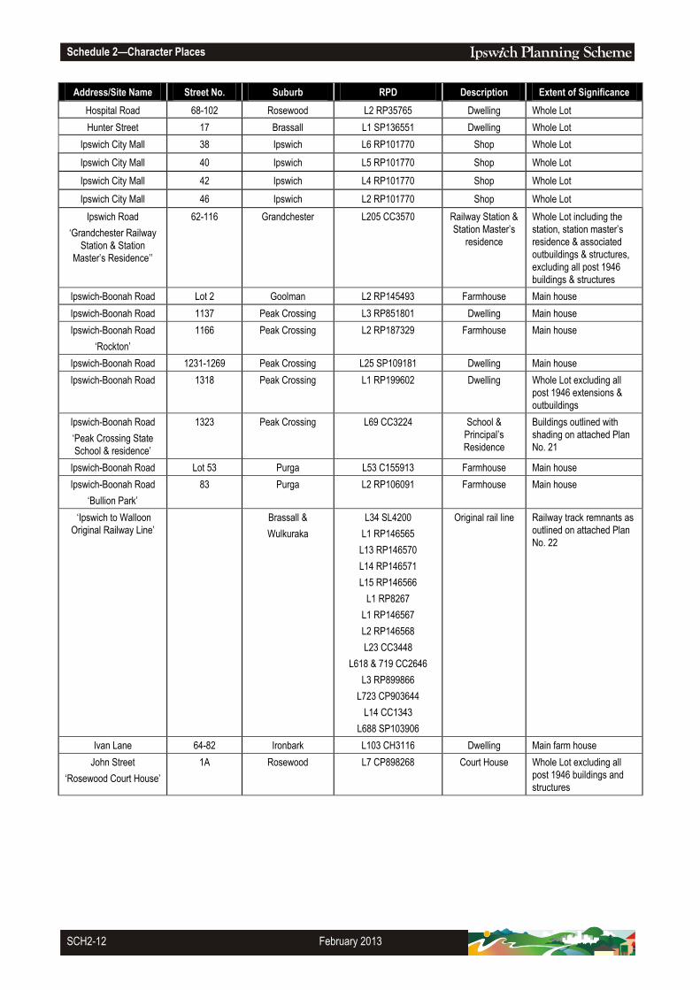
Hospital Road 68-102 Rosewood L2 RP35765 Dwelling Whole Lot
Hunter Street 17 Brassall L1 SP136551 Dwelling Whole Lot
Ipswich City Mall 38 Ipswich L6 RP101770 Shop Whole Lot
Ipswich City Mall 40 Ipswich L5 RP101770 Shop Whole Lot
Ipswich City Mall 42 Ipswich L4 RP101770 Shop Whole Lot
Ipswich City Mall 46 Ipswich L2 RP101770 Shop Whole Lot
Ipswich Road
‘Grandchester Railway
Station & Station
Master’s Residence’’
62-116 Grandchester L205 CC3570 Railway Station &
Station Master’s
residence
Whole Lot including the
station, station master’s
residence & associated
outbuildings & structures,
excluding all post 1946
buildings & structures
Ipswich-Boonah Road Lot 2 Goolman L2 RP145493 Farmhouse Main house
Ipswich-Boonah Road 1137 Peak Crossing L3 RP851801 Dwelling Main house
Ipswich-Boonah Road
‘Rockton’
1166 Peak Crossing L2 RP187329 Farmhouse Main house
Ipswich-Boonah Road 1231-1269 Peak Crossing L25 SP109181 Dwelling Main house
Ipswich-Boonah Road 1318 Peak Crossing L1 RP199602 Dwelling Whole Lot excluding all
post 1946 extensions &
outbuildings
Ipswich-Boonah Road
‘Peak Crossing State
School & residence’
1323 Peak Crossing L69 CC3224 School &
Principal’s
Residence
Buildings outlined with
shading on attached Plan
No. 21
Ipswich-Boonah Road Lot 53 Purga L53 C155913 Farmhouse Main house
Ipswich-Boonah Road
‘Bullion Park’
83 Purga L2 RP106091 Farmhouse Main house
‘Ipswich to Walloon
Original Railway Line’
Brassall &
Wulkuraka
L34 SL4200
L1 RP146565
L13 RP146570
L14 RP146571
L15 RP146566
L1 RP8267
L1 RP146567
L2 RP146568
L23 CC3448
L618 & 719 CC2646
L3 RP899866
L723 CP903644
L14 CC1343
L688 SP103906
Original rail line Railway track remnants as
outlined on attached Plan
No. 22
Ivan Lane 64-82 Ironbark L103 CH3116 Dwelling Main farm house
John Street
‘Rosewood Court House’
1A Rosewood L7 CP898268
Court House Whole Lot excluding all
post 1946 buildings and
structures

Schedule 2—Character Places
February 2015 SCH2-13
Address/Site Name Street No. Suburb RPD Description Extent of Significance
John Street
‘CWA Building’
4 Rosewood L6 SP145185 Community Hall Street awning and the
fenced area around the
CWA building
John Street
‘Rosewood Realty’
5 Rosewood L2 RP35583 Shop Whole Lot and the street
awning
John Street
‘Rosewood Hotel’
6 Rosewood L 4 RP45262 Hotel Whole Lot and the street
awning
John Street
‘Franklin’s Store’
8-10 Rosewood L2 RP45262 General store &
residence
Whole Lot and the street
awning
John Street 12 Rosewood L1 RP144461 Store & residence Whole Lot and the street
awning
John Street
‘Rosewood Post Office’
17 Rosewood L20 RP 179450 Post Office Whole Lot
John Street
‘Rosewood Uniting
Church Precinct’
19-23 Rosewood L2 RP35567 Church Whole of property
excluding all post 1946
buildings and structures
John Street
‘Royal George Hotel’
24 Rosewood L1 RP35514 Hotel Whole Lot, including the
main two storey section,
excluding the flat roofed
northern annexe and
excluding other post 1946
extensions and buildings
John Street
‘Rosewood Farmers
Hall’
25 Rosewood L1 RP35585 Hall Whole of site excluding all
post 1946 buildings and
structures
John Street
‘Rosewood Quality
Meats’
40 Rosewood L2 RP35512 Shop Whole Lot including the
front parapet and street
awning
John Street
‘Cross & Embrey Real
Estate Office & Blue
Nurses Office’
42 Rosewood L2 RP35511 Shop & residence Whole Lot and the street
awning
John Street 50 Rosewood L13 RP35508 Dwelling Whole Lot
John Street 58 Rosewood L2 RP159816 Dwelling Whole Lot
John Street 66 Rosewood L61 RP35509 Dwelling Whole Lot
John Street 68 Rosewood L2 RP55227 Dwelling Whole Lot
John Street
‘Anglican Church of St
Luke’
72-74 Rosewood L22 RP35497 &
L2 RP35517
Church & hall Whole Site excluding all
post 1946 buildings and
structures
Johnston Street
‘Langley’
83 Bellbird Park L12 SP238494 Farmhouse Main house
Jones Road
‘Redbank Plains Fossil
Site’
Bellbird Park L171 RP904872 Fossil Site Whole Site
Karrabin-Rosewood
Road
‘Walloon State School’
Lot 442 Walloon L442 SP131788 School To the extent of the
Administration Building
only
Karrabin-Rosewood
Road
‘Walloon Community
Hall’
534 Walloon L604 CC1818 Hall Whole Lot
Kells Road Lot 114 Walloon L114 CC3523 Dwelling Whole Lot

Schedule 2—Character Places
SCH2-14 October 2017
Address/Site Name Street No. Suburb RPD Description Extent of Significance
Kennedy Street 8 Marburg L31 RP35810 Dwelling Whole Lot
Kerwick Street
‘Kerwick Hotel’
1 Redbank L61 RP163040 Hotel Whole Lot excluding all
post 1946 buildings &
structures
Kerwick Street 10 Redbank L1 SP204710 Dwelling and
former ‘lock-up’
Police residence and ‘lock-
up’
Kingsmill Road
‘Coalfalls/Brassall
Bridge Memorial’
Coalfalls Road Reserve Memorial To the extent of the
memorial’s concrete apron
Kraatzs Road
‘Kraatz Farm’
Lot 2 Tallegalla L2 RP35879 Farm Main house and the
elevated barn
Lanefield Road
‘Daisy Park’
39-79 Rosewood L380 CH31320 Dwelling Main house
Lawrence Street
‘North Ipswich State
School’
10
North Ipswich
L13 I16254 School and
Principal’s
residence
Whole Lot, including
classrooms and Principal’s
residence and excluding
all post 1946 buildings and
structures
Lawrence Street
Lennon Lane
‘St. Thomas’ Anglican
Church’
15-17
12-14
North Ipswich
L1 RP3204
L28-30 RP3206
Church Whole Site, excluding post
1946 buildings and
structures
Lees Road 23 Ebenezer L23 RP123059 Dwelling House and rear wing
Limestone Street
‘St Stephens
Presbyterian Church’
22 Ipswich L9-10 C730571
L72 I122417
Church & Hall Whole Site
Limestone Street
Ellenborough St
‘Uniting Church Central
Mission’
77
27
Ipswich L32-34 RP159290 Church & Hall Whole Site, excluding post
1946 buildings and
structures
Limestone Street
‘Liberty Hall’/
‘Mary Tregaer Hostel’
84 Ipswich L2 RP100150
Dwelling Whole Lot excluding post
1946 buildings and
structures
Limestone Street
‘Queen Victoria Silver
Jubilee Memorial
Technical College’
88 Ipswich L1 I16237 College Whole Lot excluding post
1946 buildings and
structures
Limestone Street
‘Villa Maria’ Fence/ Wall
98 Ipswich L1 RP43916 Fence/ Wall To the extent of the
fence/wall’s foundations
along Limestone Street
and Wilson’s Lane
Limestone Street
Baines Park
‘Western Suburbs War
Memorial’
112 Ipswich L108 I16120
Memorial To the extent of the
memorial’s concrete apron
Lindsay Street
‘Brethren Hall’
14-14A Bundamba L15/16 RP438 Church Hall Whole Lot
Linnings Road 145-147 Haigslea L1 RP187839 Dwelling Whole Lot
Lloyd George Street
‘Doyle House’
6 Eastern Heights L20 RP24430 Dwelling Whole Lot
Long Gully Road
‘Railway dam and weir’
Grandchester L1 RP 22822
L224, 226-227 CC3466
Dam Whole Site

Schedule 2—Character Places
October 2017 SCH2-15
Address/Site Name Street No. Suburb RPD Description Extent of Significance
Lowry Street
‘Vietnam War Memorial’
5 North Ipswich
L2 RP150632 Memorial To the extent of the
memorial’s concrete apron
Lowry Street
‘Queenslands First
Railway Memorial’
5 North Ipswich
L21 SP175186 Memorial To the extent of the
memorial’s concrete apron
Main Street
‘Former Proudlocks
Drapery’
1 Marburg L2 RP85007 Shop & residence Whole Lot and street
awning
Maitland Street 13 Churchill L75 RP30071 Dwelling Whole Lot
Marian Street
‘Hebron Gospel Hall’
5 Booval L57 & L58 RP23757 Church Hall Whole Lot excluding all
post 1946 buildings &
structures
Mary Street
‘Blackstone
Congregational Church’
14 Blackstone L1 RP184263
Church Whole Lot
Mary Street 7 Bundamba L4 RP22411 Dwelling Whole Lot
Mary Street
‘St Edmunds College’
16 Woodend L3 RP889302 Christian
Brothers’
residence &
Pender House
Christian Brothers’
Residence’, Pender House
& Mary St Garden as
outlined within the shaded
areas on attached Plan
No. 23
Matthew Street
Railway Street
‘St Brigid’s Catholic
Church’
8, 10, 14A,
9A-9C, 11
Rosewood L5-6 RP35576
L14-18 RP35575
Church
Whole Site, including
Presbytery, Church, Hall
and School and excluding
all post 1946 buildings &
structures except the
Presbytery.
Matthew Street 28 Rosewood Lot 1 SP263258 Former Convent Whole Lot
Matthew Street
‘St Matthews Lutheran
Church’
63 Rosewood L29 RP35593 Church Whole Lot
McGill Street
‘Villa Esrum’
13 Basin Pocket L92 RP24005
Dwelling Whole Lot
McGrath Lane
‘Melrose’
20 Booval L1 RP49167 Dwelling Whole Lot
Meier Street 17 Peak Crossing L36 RP21401 Dwelling Whole Lot
Merton Street East Ipswich L144 SP130156 East Ipswich
Railway Station
Rail Footbridge and
Timber Platform Shelters
Middle Road Lot 1 Purga L1 RP168958 Farmhouse Main house
Milford Street
‘Queen’s Park’
Ipswich L1 SP135011 Park &
Incinerator
Complex
Whole Lot excluding all
post 1946 buildings and
structures
Milford Street
‘Claremont’
1A Ipswich L11 RP56444 Dwelling Whole Site
Milford Street
‘Oakdale Hospital –
Matron’s and Nurses’
Quarters’
4 Ipswich L1 RP899865 Dwelling Whole Lot
Milford Street
‘Oakdale Private
Hospital’
6 Ipswich L1 RP2951
L2 RP59551
L1 RP61206
Hospital Whole Site
Milford Street
“Ipswich Kindergarten’
12 Ipswich L428 SL3424 Kindergarten Whole Lot
Schedule 2—Character Places
SCH2-16 February 2009
Address/Site Name Street No. Suburb RPD Description Extent of Significance
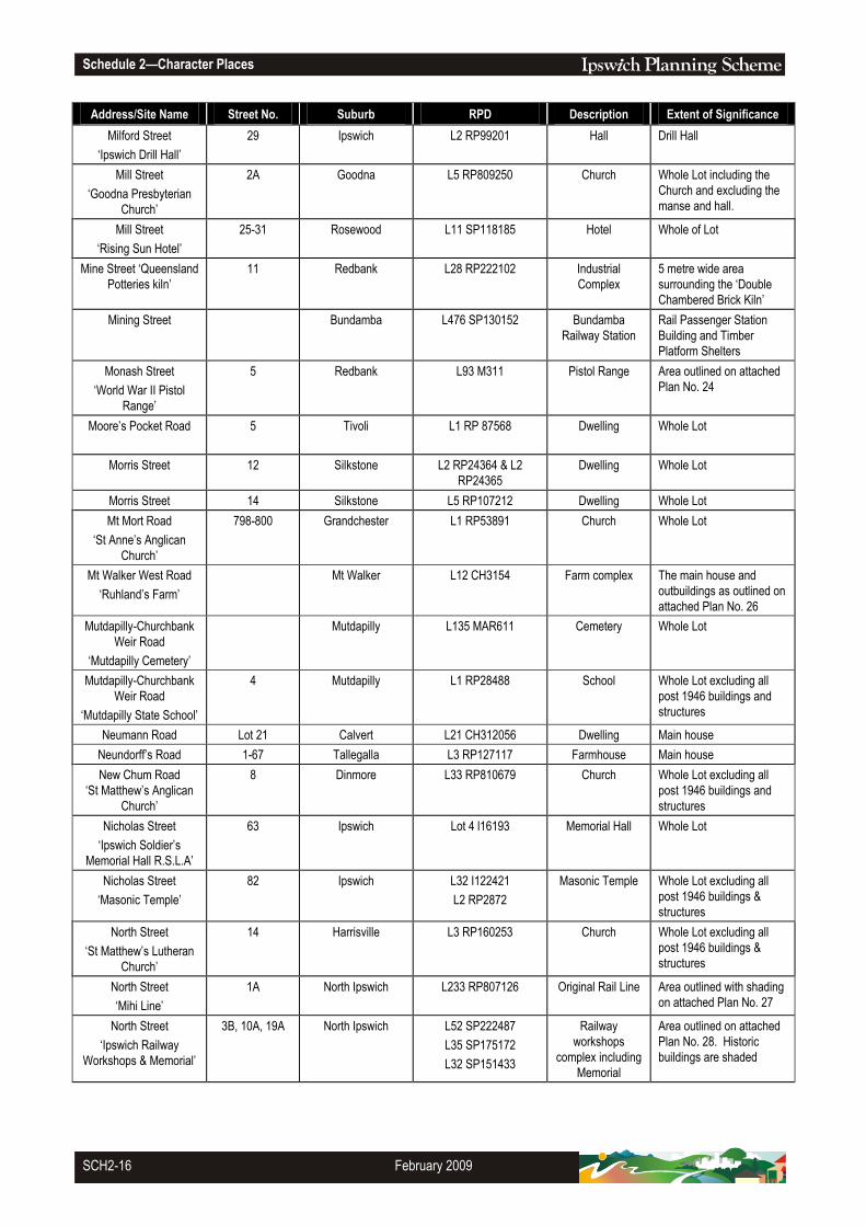
Milford Street
‘Ipswich Drill Hall’
29 Ipswich L2 RP99201 Hall Drill Hall
Mill Street
‘Goodna Presbyterian
Church’
2A Goodna L5 RP809250
Church Whole Lot including the
Church and excluding the
manse and hall.
Mill Street
‘Rising Sun Hotel’
25-31 Rosewood L11 SP118185 Hotel Whole of Lot
Mine Street ‘Queensland
Potteries kiln’
11 Redbank L28 RP222102 Industrial
Complex
5 metre wide area
surrounding the ‘Double
Chambered Brick Kiln’
Mining Street Bundamba L476 SP130152 Bundamba
Railway Station
Rail Passenger Station
Building and Timber
Platform Shelters
Monash Street
‘World War II Pistol
Range’
5 Redbank L93 M311 Pistol Range Area outlined on attached
Plan No. 24
Moore’s Pocket Road 5 Tivoli L1 RP 87568 Dwelling Whole Lot
Morris Street 12 Silkstone L2 RP24364 & L2
RP24365
Dwelling Whole Lot
Morris Street 14 Silkstone L5 RP107212 Dwelling Whole Lot
Mt Mort Road
‘St Anne’s Anglican
Church’
798-800 Grandchester L1 RP53891 Church Whole Lot
Mt Walker West Road
‘Ruhland’s Farm’
Mt Walker L12 CH3154 Farm complex The main house and
outbuildings as outlined on
attached Plan No. 26
Mutdapilly-Churchbank
Weir Road
‘Mutdapilly Cemetery’
Mutdapilly L135 MAR611 Cemetery Whole Lot
Mutdapilly-Churchbank
Weir Road
‘Mutdapilly State School’
4 Mutdapilly L1 RP28488 School Whole Lot excluding all
post 1946 buildings and
structures
Neumann Road Lot 21 Calvert L21 CH312056 Dwelling Main house
Neundorff’s Road 1-67 Tallegalla L3 RP127117 Farmhouse Main house
New Chum Road
‘St Matthew’s Anglican
Church’
8 Dinmore L33 RP810679 Church Whole Lot excluding all
post 1946 buildings and
structures
Nicholas Street
‘Ipswich Soldier’s
Memorial Hall R.S.L.A’
63 Ipswich Lot 4 l16193
Memorial Hall Whole Lot
Nicholas Street
‘Masonic Temple’
82 Ipswich L32 I122421
L2 RP2872
Masonic Temple Whole Lot excluding all
post 1946 buildings &
structures
North Street
‘St Matthew’s Lutheran
Church’
14 Harrisville L3 RP160253 Church Whole Lot excluding all
post 1946 buildings &
structures
North Street
‘Mihi Line’
1A North Ipswich
L233 RP807126 Original Rail Line Area outlined with shading
on attached Plan No. 27
North Street
‘Ipswich Railway
Workshops & Memorial’
3B, 10A, 19A North Ipswich
L52 SP222487
L35 SP175172
L32 SP151433
Railway
workshops
complex including
Memorial
Area outlined on attached
Plan No. 28. Historic
buildings are shaded

Schedule 2—Character Places
October 2017 SCH2-17
Address/Site Name Street No. Suburb RPD Description Extent of Significance
Old Logan Road 11 Gailes L1 RP36907 Dwelling Whole Lot
Old Logan Road 40 Gailes L1/2 RP36910 Dwelling Whole Lot
Old Toowoomba Road
‘West Ipswich & One
Mile War Memorial’
1A One Mile 402 CC895 Memorial To the extent of the
memorial's concrete apron
Old Toowoomba Road 13 One Mile L23 RP8332 Shop Whole Lot including the
street awning and
excluding all post 1946
buildings & structures
Omar Street
‘West Ipswich State
School’
12 West Ipswich L522 SL8755 School Whole Lot excluding all
post 1946 buildings &
structures
Palaszczuk Avenue
‘Verrall Family Pioneer
Graves’
7 Collingwood Park L900 SP266991 Cemetery Area outlined on attached
Plan No. 7
Pine Mountain Road
‘Brassall State School’
130 and
132A
Brassall L212 SP127608 School Blocks A, B & C
Pine Mountain Road
‘Boody’s Store’
145 Brassall L21 RP14755 Shop and
residence
Shop (excluding side
extensions) and attached
residence (excluding
extensions)
Pine Mountain Road
‘Anglican Cemetery’
841-863 Pine Mountain L1 & L2 SP103268 Cemetery Fenced Cemetery
Pine Mountain Road
‘Pine Mountain Public
Hall’
840 Pine Mountain L1 RP50699 Hall Whole Lot
Pine Mountain Road
‘St Michaels Catholic
Church’
850 – 856 Pine Mountain L1 RP8351
L2 RP50699
Church &
graveyard
Whole Site
Pine Mountain Road
'Congregational
Cemetery'
875-891 Pine Mountain L501 SP243525 Cemetery Whole Site
Pine Mountain Road
‘Ipswich – Gatton Road
Distance Marker’
North Ipswich On the footpath outside
the property at 48 Pine
Mountain Road
Road Distance
Marker
Area outlined on attached
Plan No. 30
Pine Mountain Road Lot 315 Pine Mountain L315 CH3124 Dwelling Main house
Pine Mountain Road 11 North Ipswich L90 SP165973 Shops Whole Lot
Pine Mountain Road
‘St Joseph’s Primary
School Fence balusters’
42 North Ipswich L1 SL837992 Fence Balusters only (four bays).
Excluding rendered
masonry fence along the
Pine Mountain Road
boundary
Pine Mountain Road 899-931 Pine Mountain L104 RP163025 Dwelling Main house
Pine Mountain Road
‘Watercress Creek’
978 Pine Mountain L2 RP198973 Dwelling Main house
Pine Mountain Road 1023-1049 Pine Mountain L316 CH3124 Dwelling Main house and detached
kitchen wing
Pine Mountain Road 1166 Pine Mountain L184 CH311658 Dwelling Main house
Pommer Street
‘Brassall Methodist
Church Buildings’
2 Brassall L170 I16155
Church buildings Whole Lot excluding all
post 1946 buildings &
structures
Poppy Lane 9 Tivoli L8/9 RP119035 Dwelling Whole Site
Post Office Lane 4 Harrisville L2 RP63088 Dwelling Whole Lot excluding all
post 1946 buildings &
structures

Schedule 2—Character Places
SCH2-18 October 2017
Address/Site Name Street No. Suburb RPD Description Extent of Significance
Purga School Road 68 Purga L52 CP868789 Church Fenced area within lot,
excluding all post 1946
buildings & structures
Purga School Road
‘Anna Bauer House’
(Purga State School)
72 Purga L25 CP868789 Former School Main house excluding all
post 1946 buildings &
structures
Queen Street 6 & 6a Goodna L3 RP2466
L2 RP223781
Sisters of Mercy
Building
Whole Lot excluding all
post 1946 buildings &
structures
Queen Street
‘Goodna Neighbourhood
House’
33 Goodna L2 RP2464 Dwelling Whole Lot excluding all
post 1946 buildings &
structures
Queen Street
‘The Meaney’s House’
51 Goodna L8 RP142973
Dwelling Whole Lot
Queen Street
‘Harrisville Butchery’
28 Harrisville L3 RP21439 Shop Whole Lot and the street
awning
Queen Street
‘Former Pugsleys Store’
30 Harrisville L2 RP21439 Shop Whole Lot and the street
awning
Queen Street
‘Commercial Hotel’
32-34 Harrisville L1 RP21439 Hotel Whole Lot and the street
awning
Queen Street
‘Jenny’s Country
Cottage’
33 Harrisville L16 RP21418 Shop Whole Lot and the street
awning
Queen Street 35 Harrisville L17 RP21418 Bank Whole Lot
Queen Street
‘Newsagency’
37 Harrisville L1 RP21462 Shop Whole Lot and the street
awning
Queen Street
‘Faulkners Store’
39-41 Harrisville L2 RP21463 Shop Whole Lot and the street
awning
Queen Street
‘Memorial Park’
43-47 Harrisville L2 RP48583 Entrance Gate &
memorials
Entrance Gate, Brick wall
with sundial, flagpole and
centenary plaque
Queen Street
‘Harrisville School of
Arts’
49 Harrisville L4 RP21456 Hall Whole Lot
Queen Street
‘Elanda House’
52 Harrisville L26 RP21439 Dwelling 5 metre wide area
surrounding Elanda House
Queen Street
‘Sacred Heart Catholic
Church’
54 Harrisville L36-37 RP21437 Church Whole Lot
Queen Street
‘Former Baptist Church
(All Things Country)’
89-93 Marburg L1 RP35808 Church Whole Lot excluding all
post 1946 buildings &
structures
Queen Street
‘All Saints Anglican
Church & Hall’
111 Marburg L1 RP51100 Church Whole of allotment
excluding all post 1946
buildings & structures
Queen Street
‘Marburg Court House
Precinct’
113-117 Marburg L551 CH31440 Court House
Residence
Lockup
Whole Lot

Schedule 2—Character Places
October 2017 SCH2-19
Address/Site Name Street No. Suburb RPD Description Extent of Significance
Queen Street
‘Walloon Saloon’
1-3 Walloon L1 RP42876 Hotel Whole Lot excluding all
post 1946 buildings and
structures
Queen Street 7 Walloon L3 RP35551 Dwelling Whole Lot
Queen Street 16 Walloon L8 RP35547 Dwelling Whole Lot
Queen Street 17 Walloon L5 RP35552 Dwelling Whole Lot
Queen Street 18-20 Walloon L9-10 RP35547 Dwelling Whole Lot
Queen Street
‘St Andrews Catholic
Church’
40 Walloon L4 RP168771 Church Whole Lot
Queen Victoria Parade
Milford Street
‘Former Ipswich Central
State School’
1
2A
Ipswich L1 RP24380
L407 N25605
School Whole Site Excluding all
post 1946 buildings and
structures
Queen Victoria Parade
‘Cunningham’s Knoll’
1A Ipswich L409 CP911396 Historic Lime Kiln
Site, monuments
Whole Site including lime
kilns, monuments and
stone walls
Rafters Road
‘Grandchester
Cemetery’
Lot 7-8 Grandchester Part of Lots 7 & 8
CC3502
Cemetery Whole Site
Railway Street
‘Crossing keeper’s
cottage’
1 Grandchester L1 G12520 Dwelling Whole Lot
Railway Street
‘Rosewood Railway
Station Complex’
Rosewood L231 M333225 Rosewood
Railway Station
Area including main
station, south platform
shelter, overhead
footbridge, Bondwood Hut
and turntable as outlined
on attached Plan 31.
Railway Street
‘Rosewood Police
Residence & Stables’
1A Rosewood L734 CP898268 Police Station Whole Lot, excluding all
post 1946 buildings and
structures
Railway Terrace
‘The Cross House’
11 Goodna L9 RP846606 Dwelling Whole Lot
Redbank Plains Road
‘Cooneana’
1041 New Chum L1 RP147956 Dwelling Whole Lot
Redbank Plains Road
‘Rhondda Office and
Carport’
1041 New Chum L1 RP147956 Office building Office building and carport
Redbank Plains Road
‘Turf Farm House’
639 Redbank Plains L1 RP102884 Dwelling Main house
Reinke Road
‘Ashwell Primary School
Precinct’
33-37 Ashwell L1 RP35846
L1 RP35761
School Whole Site
Riverside Drive 63 Muirlea L243 SL3149 Reservoir Precinct 1906 Reservoir, Steel
Surge Tower, Water
Officer’s House within the
area as outlined on
attached Plan No. 32
Richards Street 7 North Ipswich L114 RP75591 Dwelling Whole Lot

Schedule 2—Character Places
SCH2-20 October 2017
Address/Site Name Street No. Suburb RPD Description Extent of Significance
Riverside Drive
‘Blythe Villa’
Muirlea L3 RP103828 Dwelling Whole Lot
Riverview Road
‘Canaan’ and
‘Anchorage Farm
Manager’s Residence’
29 Riverview L2 RP22229 Hostel
To the extent of the 1897
fenced enclosure as
outlined on attached Plan
No. 33
Robertson Road
‘Fairy Knoll’
2A Eastern Heights L1 SP139414 Dwelling Whole Lot
Robertson Road
‘Our Lady of the
Miraculous Medal’
35A Eastern Heights L1 SP129729 Church Church building
Robertson Road 55 Eastern Heights L2 RP99868 Dwelling Whole Lot
Roderick Street 8 Ipswich L1 RP67771 Dwelling Whole Lot
Roderick Street
‘Keiraville’
20 Ipswich L1 RP193697
Dwelling Whole Lot
Roderick Street
‘St John’s Lutheran
Church’
32 Ipswich L95 I165 Church Church building
Roma Street 1 North Booval L4 RP23753 Dwelling Whole Lot
Roseberry Parade
‘Woodend War
Memorial’
Woodend Road Reserve Memorial To the extent of the
memorial’s concrete apron
Rosewood Road
‘Amberley RAAF Base’
1A Amberley Various RAAF Base Diamond Shaped
Command Precinct
including parade ground &
associated landscaping,
Guardhouse, 301 Air Base
Headquarters, The Base
Medical Flight Building, Air
Base support building,
Hangar 76, Ap1-1 semi
subterranean operations
building, 745 Bellman
Hangar, Riley Newsum
houses - Gannett St,
School House &
residence, Army Helicopter
& Fixed Wing training area
(Silver City), Emergency
Power Generator, Cinema,
Airmen’s Mess, Sargent’s
Mess, Bellman Hangars,
Air Safety Building as
outlined with shading on
attached Plan No. 34
Rosewood-Marburg
Road
‘Tallegalla Cemetery’
Lot 282 Tallegalla L282 C876 Cemetery Whole Lot
Rosewood-Marburg
Road
357-363 Tallegalla L674 CH31976 Former shop &
residence
The shop & residence
including the10 metre
setback from Rosewood-
Marburg Road
Rosewood-Marburg
Road
568-660 Tallegalla L5 RP856385 Farmhouse Main house

Schedule 2—Character Places
August 2016 SCH2-21
Address/Site Name Street No. Suburb RPD Description Extent of Significance
Rosewood-Marburg
Road
670-676 Tallegalla L5 RP841163 Farmhouse Whole Lot
Rosewood-Warrill View
Road
2-4 Rosewood L1 RP128580 Dwelling Whole Lot
Rosewood-Warrill View
Road
14-16 Rosewood L1 RP50227 Dwelling Whole Lot
Ross Llewellyn Drive
‘Mines Rescue Station’
2 Booval L402 SP183032 Mines Rescue
Complex
Mines Rescue Complex
excluding outbuildings
Russells Road 106 Pine Mountain L291 CH3123 Dwelling Main house
Salisbury Road
‘University of QLD
Ipswich Campus’
11 Ipswich L506 CP883330 University
‘Former Challinor
Centre’
Whole Lot excluding all
post 1946 buildings and
structures
School Road
‘Grandchester
Community Hall’
Lot 216 Grandchester L216 CC3251 Hall Whole Lot
School Road
‘Redbank Plains State
School’
39-53 Redbank Plains L466 CP891085 School Old classroom building
and play-shed as outlined
with shading on attached
Plan No. 35
School Road
‘Yarrow Centre’
55 Redbank Plains L1 SL8922 Former Church Whole Lot
School Road
‘Rhosmyne’
99-105 Redbank Plains L1 RP160000 Farmhouse Whole Lot
School Street
‘Marburg State Primary
School’
Lot 701 Marburg L701 CC2239 School Whole Lot excluding all
post 1946 buildings and
structures
School Street
‘The Palms’
35-37 Marburg L 2 RP152244 Dwelling Whole Lot
School Street
‘Rosewood Primary
School’
Lot 365 Rosewood L365 CC2765 School Teaching Blocks A & B
Schultzs Road 32 Ironbark L8 SP124708 Dwelling Fenced house Lot
Seminary Road
‘Anglican Cemetery’
Lot 1 Marburg L1 CC3183 Cemetery Whole Lot
Seminary Road
‘Woodlands’
Lot 12 Marburg L21 CC1898 House &
Outbuildings
Whole Lot excluding all
post 1946 buildings and
structures
Short Street 12 Ipswich L3 RP3006 Dwelling Whole Lot
Short Street 2-4 Walloon L1 RP35541 Dwelling Whole Lot
Sloman Street
‘Dun Edin’
9 Booval L2 RP50390
Dwelling Whole Lot
Smith Street ‘World War
II Ammunition magazine’
31 Redbank L90 M311 Ammunition
magazine
6 metre wide area
surrounding the
‘Ammunition magazine’
South Station Road 3 Booval L2 RP64616 Shop Whole Lot
South Station Road
‘Cambrian Centre’
8 Booval L7 RP23818
Hall Whole Lot
South Station Road 35 Booval L2 RP48302 Shop Whole Lot
South Station Road
‘Glenville House’
128 Silkstone L1 RP62232 Dwelling Whole Lot
South Station Road 129 Silkstone L1 GTP102703 Dwelling Whole Lot
South Station Road 143 Silkstone L1 RP118180 Dwelling Whole Lot

Schedule 2—Character Places
SCH2-22 October 2017
Address/Site Name Street No. Suburb RPD Description Extent of Significance
South Station Road 145 Silkstone L4 RP24265 Dwelling Whole Lot
South Street
‘Bowerlea’
2 Ipswich L1 RP47224
Dwelling Whole Lot
South Street
‘Salvation Army Citadel’
62 Ipswich L1 RP167671 Church Whole Lot excluding all
post 1946 buildings &
structures
Station Lane
‘Walloon Railway
Station’
Walloon L2 RP35557 &
L2 RP35540
Railway Station
North side platform
building and southern side
platform shelter only
Station Road Riverview L2 RP22337 and
L112 SP130148
Riverview Railway
Station
Footbridge and Timber
Platform Shelter
Stevens Road
‘Wycombe Lodge’
173-225 Ashwell L2 RP214351 Farm complex Farm complex outlined on
attached Plan No. 36
Stevens Road
‘Stoneleigh’
271 Ashwell L6 RP814613 Dwelling Main house
Stevens Road 1-85 Lanefield L2 RP217630 Farmhouse Fenced house yard
Stevens Road 174-220 Lanefield L2 RP22841 Farmhouse Main house
Stocks Lane 2-4 Walloon L23 RP35546 Dwelling Whole Lot excluding the
post 1946 additions and
extensions
Stokes Road
Also known as ‘Lady
Bowen Hill’
Grandchester L217 CC3466 Dwelling Main house
Stokes Road Lot 303 Pine Mountain L303 CH3123 Dwelling Original house and slab
hut
Stone Quarry Road Lot 305 Jeebropilly L305 CC3467 Cemetery Whole Lot
Swan Street
‘Jordan Village
Pensioners’ cottages’
27 Brassall L20 RP234480 Dwellings Whole Lot
Symes Street
‘Grandchester Sawmill’
Lot 5 Grandchester L407-408 CC3479 Sawmill Whole Site
Tallegalla Road
‘Former Station Master’s
Residence’
25-29 Tallegalla L2 CC2670 Dwelling Main house
Tallegalla-Two Tree Hill
Road
‘Pioneer Catholic
Cemetery’
Lot 1 Tallegalla L1 RP175693 Small bush
cemetery with
approx. 12 graves
still showing with
headstones
Area outlined on attached
Plan No. 37
Tallegalla-Two Tree Hill
Road
‘Tallegalla Primary
School Precinct’
2 Tallegalla L557 CC3651 School Whole Lot
Tallon Street 13 Sadliers Crossing L3 RP3068 Shop Whole Lot
Tantivy Street
‘Tivoli Hill Horse Trough’
Tivoli Road Reserve Horse Trough Area outlined on attached
Plan No. 25
Taylor Street 7 Bundamba L53 RP22506 Dwelling Whole Lot
Thagoona-Haigslea
Road
‘Haigslea State School’
752-766 Haigslea L263 CC2097 School The original classrooms

Schedule 2—Character Places
October 2017 SCH2-23
Address/Site Name Street No. Suburb RPD Description Extent of Significance
Thagoona-Haigslea
Road
‘Haigslea Uniting
Church’
761-767 Haigslea L1 RP 35713 Church Whole Lot excluding all
post 1946 buildings and
structures
The Terrace
‘Railways Store Building’
6 North Ipswich
L37 SP203402 Former Railway
Workshops
Administration
Building & former
Tarpaulin Shop
To the extent of the
Railways Store Building +
10 m around building
The Terrace
‘Strand Hotel’
12 North Ipswich L107 RP846750 Hotel Whole Lot excluding all
post 1946 buildings &
structures
The Terrace
‘Queensland Woollen
Manufacturing Company
Ltd’
42-42B North Ipswich
L1-2 RP137425 Industrial complex
&
‘World War II Air-
Raid Shelter’
Whole Site excluding all
post 1946 buildings and
structures
Thomas Street
‘Railway Station’
Sadliers Crossing L152 SL1126 Railway Station Platforms, shelter sheds
and the Thomas Street
Pedestrian Underpass
Thomas Street
‘United Welsh Church’
6 Blackstone L5 RP22448
Church
Whole Lot
Thorn Street
‘Colthup Home’
39 Ipswich L1 RP836941
Dwelling Original house
Thorn Street 42 Ipswich L4 RP2935 Dwelling Whole Lot
Union Place Mall
‘Commonwealth Hotel’
5 Ipswich L1 RP2677 Hotel Whole Lot
Unnamed Road off
Carmichaels Road
‘Purga Cemetery’
Lot 217 Purga L217 CP858790 Aboriginal
Cemetery
Whole Lot
Unnamed Road off
Sams Reserve
Lot 8 Redbank Plains L8 SP109237 Dwelling Main house
Warrego Highway 1445 Blacksoil L1 RP899036 Dwelling Original house and shed
Warrego Highway 2236-2302 Haigslea L2 CC2992 Dwelling Main house
Warrego Highway
‘Gerber’s Farmhouse’
Marburg L5 RP209497 Dwelling Main house
Warrego Highway
‘Trinity Lutheran
Cemetery’
Lot 1 Marburg L1 RP35866 Cemetery Whole Lot
Warrego Highway
‘The Hay Man’
2460-2486 Marburg L2 RP 159831 Farmhouse Main house
Warrego Highway
‘Haighmoor Coke
Ovens’
North Tivoli L2 RP885020 Industrial Item Area outlined on attached
Plan No. 38
Warrill View-Peak
Crossing Road
‘The Cedars’
Harrisville L2 RP97945 Farmhouse Main house
Warrill View-Peak
Crossing Road
‘Harrisville Cemetery’
Lot 81 Harrisville L81 C840 Cemetery Whole Lot

Schedule 2—Character Places
SCH2-24 October 2017
Address/Site Name Street No. Suburb RPD Description Extent of Significance
Warrill View-Peak
Crossing Road
‘Pump’
Peak Crossing Road Reserve Industrial item Road reserve adjacent to
L207 CH3165, within the
area outlined on attached
Plan No. 39
Warrill View-Peak
Crossing Road
‘Flinders Uniting Church’
Lot 1 Peak Crossing L1 RP21474 Church Whole Lot excluding all
post 1946 buildings and
structures
Warwick Road 220 Churchill L1 RP137547 Dwelling Whole Lot
Warwick Road
‘Churchill Honour Stone’
Lobley Park
243A Churchill L1 RP811294 Memorial To the extent of the
memorial’s concrete apron
Warwick Road
‘Nerita Memorial Gates,
Ipswich Showgrounds’
81 Ipswich L477 SL7290
Memorial 2 metre wide area
surrounding the memorial
gate
Warwick Road
‘Ipswich General
Cemetery’
124A Ipswich L543 I1683 Cemetery Whole Lot
Waterworks Road 1 North Ipswich L9 RP14735 Shop Whole Lot
Waterworks Road
‘North Ipswich Bible
Methodist Church’
1A North Ipswich L10 RP14736 Church Whole Lot excluding all
post 1946 buildings and
structures
Weedman Street
‘Redbank Mine’
6 Redbank L3 RP110496 Historic Mining
Site
Whole Lot
Wildey Street
‘Raceview State School
Memorial Gateway’
96 Raceview L460 SL8632 Gateway 2 metre wide area
surrounding the ‘S.J.
Dunsden Esq. Gateway’
Wildey Street
‘Raceview
Congregational Church’
117 Raceview L54 SP173935 Church Church building
Wildey Street 185 Raceview L1 RP64061 Dwelling Whole Lot
William Street
‘Penhelyg’
43 Goodna L4 RP96169
Dwelling Whole Lot
Williams Street
‘Inglemere’ and cottage
110 Coalfalls L1 RP880167 Dwellings Whole Lot
Woodend Road
‘Ipswich Grammar
School’
1A Sadliers Crossing L393 RP910070 Original School
buildings
Whole Lot excluding all
post 1946 buildings and
structures
Woodend Road 66 Woodend L2 RP3114 Shop Whole Lot
Woodend Road 90 Woodend L2 RP58502 Shop Whole Lot
Woogaroo Street
“Woogaroo Creek
Railway Bridge” at
eastern end of
Woogaroo Street
Goodna.
Goodna L91 SP130140
L94 SP130139
Bridge Bridge
World War II remains White Rock L246 NPW526
L4 RP217549
Ruins 10m around each site
within the area outlined on
attached Plan No. 40

Schedule 2—Character Places
December 2016 SCH2-25
Part 2—Trees and Vegetation
Address/Site Name Street No. Suburb RPD Description & Significance
Alice Street 118 Goodna L2 RP96538 Port Jackson Fig (Ficus rubiginosa)
Located on the Alice Street frontage of the Lot
Alice Street and
Spalding Crescent,
intersection
- Goodna Road Reserve Gum-topped Box (Eucalyptus moluccana)
Located in the road reserve on the north western
corner of the Alice Street and Spalding Crescent
intersection.
Augusta Parkway Lot 7 Springfield L7 SP143597 Ficus Species
1 small leaved Moreton Bay Fig (Ficus platy
poda) 1 small leaved fig (Ficus acroca var
petiolaris) as outlined on attached Plan No. 41
Brisbane Terrace,
between Short St &
Lower James St
‘Depression Work Relief
Plantings’
Road Reserve
135
Goodna Road Reserve
L128 SP178961
Depression Work Relief Plantings Precinct
Species include Queensland Kauri (Agathis
robusta), Bunya Pines (Araucaria bidwillii), Silky
Oaks (Grevillea robusta) and Jacaranda
(Jacaranda mimosaefolia). Listing boundary: the
footpath and road reserve as outlined on
attached Plan No. 42
Brisbane Street
‘Cunningham’s Knoll’
Ipswich 2 Ficus Species
Located on the top of Cunningham’s Knoll
Brisbane Street
Milford Street
‘Former Central State
School’
1
2A
Ipswich L1 RP24380
L407 N25605
Ficus Species
Perimeter Plantings along the street frontages
Byrne Street 22 Bundamba L503 CP910076 Lone Bunya Pine (Araucaria bidwillii) & stand
of Grass Trees (Xanthorroea johnstoni)
Area outlined on attached Plan No. 43
Chermside Road
‘Ipswich Girls Grammar
School’
82 Ipswich L167 SP139377 Ficus Species and Hoop Pines
along the Chermside Road street frontage
Jacarandas, Pinus Species and Camphor
Laurels
Located along the driveway between Queen
Victoria Parade and Chermside Road, within the
area outlined on attached Plan No. 44
Chermside Road 87 East Ipswich L1 RP155083 Weeping Fig (Ficus benjamina)
The Ficus species in the front yard
Church Street
14 Goodna L189 SL5041
Eucalyptus species
Large Grey Gum located on the Church Street
frontage
Cunningham Highway 2673 Willowbank L2 RP213075 Avenue of bunya pines (Araucaria bidwilli)
from the highway to the main house
Cyprus Street 40 Raymonds Hill L1 RP97883 Camphor Laurel Trees (Cinnamonum
camphora)
The camphor laurel trees located at the Cyprus
Street frontage of the Lot

Schedule 2—Character Places
SCH2-26 May 2018
Address/Site Name Street No. Suburb RPD Description & Significance
Glebe Road 7-7A Newtown L24-25 RP24128 Campbell Fig (Ficus species)
Located at the Glebe Road frontage of the Lot
Glebe Road
‘Silkstone State School
Plantings’
95 Silkstone L15 RP24241 Historic School Plantings
Perimeter plantings particularly the Ficus
Species & 3 Araucaria cunninghamii near the
Glebe Road frontage; the avenue of paired Figs,
Camphor Laurels & Jacaranda trees extending
from Glebe Road south to the school
quadrangle; & the Fig species bordering the
northern perimeter of the playing fields fronting
Blackstone Road
Griffith Road
‘Ipswich Central State
School Plantings’
2 Ipswich L442 SL4125 Hoop Pines
Row of mature Hoop Pines situated along the
Griffith Road Perimeter
Ipswich-Boonah Road
‘Bullion Park’
Purga L2 RP106091 Avenue of trees along driveway from Ipswich-
Boonah Road to the house
Jacaranda Street
111 North Booval L1 RP209454 Jacaranda Trees (Jacaranda mimosifolia)
Moreton Bay Fig Tree (Ficus macrophylla)
Canopy and root system to extent of 10m radius
from exterior of trunk at a height of 2m of
Moreton Bay Fig at 3 Roma Street.
Refer Plan No. 59 and Plan No. 60
John Street 7-9 Rosewood L9 RP906761 Hoop Pine (Araucaria cunninghamii)
Located at the John Street frontage of the Lot
John Street 17 Rosewood Fig (Ficus species) ‘Tree of Knowledge’
Located at the John Street frontage of the Lot
Limestone Street
88 Ipswich L1 I16237 Queen Victoria Silver Jubilee Memorial
Technical College Grounds
Two Ficus species located at the Ellenborough
Street frontage of the Lot
Mary Street
‘St Edmunds College
Plantings’
16 Woodend L3 RP889302 Camphor Laurel, Ficus Species and
Jacaranda Species
Located along the Mary Street frontage of the
site
Murphy Street 16-18 Ipswich L18 RP889299 Hoop Pine Trees (Aaraucaria cunninghamii)
Located along the rear alignment of the Lot
North Street
‘Ipswich Railway
Workshop Plantings’
1A North Ipswich L233 RP807126 Ficus species & Camphor Laurels
The two trees located in close proximity to the
World War I digger memorial are Camphor
Laurels. Two Ficus species are located to the
northwesterly and southerly borders of a
rectangular lawn area, divided by a concrete
roadway, and situated between the
administration building to the north and the tool
and gauge shop to the east and the Canteen to
the South. Areas outlined on attached Plan No.
46
Old Toowoomba Rd 22 One Mile L1 RP202579 Port Jackson Fig (Ficus rubiginosa)
Located at the Old Toowoomba Road frontage
of the Lot

Schedule 2—Character Places
May 2018 SCH2-27
Address/Site Name Street No. Suburb RPD Description & Significance
Olmai Avenue
Eastern Heights Road Reserve Former Bleak House Driveways’ Plantings
Camphor Laurels, Ficus and Poicianas located
on either side of the road reserve between
Blackstone Road and Marvin Street.
O’Sullivan Street 35 Woodend L17 RP24276 Camphor Laurel (Cinnamomum camphora)
Located at the O’Sullivan Street frontage of the
Lot
O’Sullivan Street 40 Woodend L5 RP24280 Ficus acrocarpa
2 small fruited figs
Pine Mountain Road 603-623 Muirlea L2 RP163572 Moreton Bay Fig (Ficus Macrophylla)
Area outlined on attached Plan No. 47
Pine Mountain Road &
Smith Street
Intersection
North Ipswich Road Reserve Ficus
Located within the Smith Street traffic island at
the Pine Mountain Road intersection
Pine Street & The
Terrace Intersection
North Ipswich Road Reserve Ficus
2 Figs located within the roundabout at the
intersection of Pine Street & The Terrace
Pine Street 60 North Ipswich L176 I1626 Poinciana Tree (Delonix regia)
Located at the Pine Street frontage of the Lot
Queen Victoria Parade Ipswich Ficus Microcarpa Var. Hilli interspaced with
Jacaranda (Jacaranda Mimosaifolia) and Fan
Palm (Livistona Species)
Situated on both sides of the Queen Victoria
Parade road reserve between Chermside Road
to Milford Street
Railway Street 29 Booval L1 RP44621 Johnson River Fig (Ficus acrocarpa)
Located at the rear of the Lot fronting Booval
Street
Riverview Road 29 Riverview L29 S151811 Bunya Pines (Araucaria bidwillii)
Driveway avenue plantings (2 rows) from
Riverview Road to the main house
Roderick Street 9 Ipswich L3 I1686 Bottle Tree (Brachychiton rupestris)
Located at the Roderick Street frontage of the
Lot
Roma Street
1 North Booval L4 RP23753 Moreton Bay Fig Tree (Ficus macrophylla)
Canopy and buttress roots to extent of 10m
radius from exterior of trunk at a height of 2m of
Moreton Bay Fig at 3 Roma Street.
Refer plan No. 60
Roma Street
3 North Booval L5 RP23753 Moreton Bay Fig Tree (Ficus macrophylla)
Canopy and buttress roots to extent of 10m
radius from exterior of trunk at a height of 2m.
Refer plan No. 60
Salisbury Road
'University of
Queensland Ipswich
Campus'
11 Ipswich L506 CP883330 Ficus Species and Araucaria Species
Located near the carpark off Parker Avenue as
outlined on attached Plan No. 49

Schedule 2—Character Places
SCH2-28 February 2014
Address/Site Name Street No. Suburb RPD Description & Significance
School Street Lot 701 Marburg L701 CC2239 Marburg State Primary School Environmental
Park & Perimeter/ Driveway Plantings
Driveway avenue plantings of Ficus Species and
the Environmental Park that includes Silky Oak
(Grevillea robusta) & Hoop Pines (Araucaria
cunninghamii) as outlined on attached Plan No.
50
School Street
‘Rosewood State
Primary School’
Lot 365 Rosewood L365 CC2765 Bunya Pine (Araucaria bidwilli)
Station Road 16-20 Riverview L56-58 RP22329 Fig Trees (Ficus microcarpa)
Two Fig Trees located at the Station Road
frontage of the Lots
Thomas Street 6 Blackstone L5 RP22448 United Welsh Church Camphor Laurel
(Cinnamonum caphora)
Located 20 metres along the northern boundary
of the site off the Thomas Street frontage of the
Lot
Thomas Street Sadliers Crossing Road reserve Thomas Street Railway Station Plantings on
the southern side of the Tallon Street road
reserve between Challinor Street and
Stephenson Street comprising Ficus Species,
Pinus Species, Eucalyptus Species, Jacaranda
mimosofli &Camphor Laurel (Cinnamonum
caphora) Species
Warwick Road 81 Ipswich L477 SL7290 Ipswich Showgrounds Border Plantings
Various species located at the Warwick Road
frontage of the Lot comprising the Bunya Pines
(Araucaria species), ,Ficus species and
Camphor Laurel
Western Creek
watercourse and Gipps
Street road reserve
- Calvert - Forest Red Gum (Eucalyptus tereticornis)
Located southeast of a bridge over the Western
Creek, and between the Western Creek
watercourse and the Gipps Street road reserve.
Refer Plan No. 58
Whitehill Road 34 Eastern Heights L26 RP24284 Weeping Fig (Ficus benjamina)
Located at the Whitehill Road frontage of the Lot
Wildey Street 102 Raceview L3 RP96509 Poinciana Tree (Delonix regia)
Located at the Wildey Street frontage of the Lot
Wildey Street 143 Raceview L4 RP90671 Fig (Ficus species) 'The Christmas Lights
Tree'
Refer Plan No. 51
Woodford Street 42 Leichhardt L1 RP123586 Camphor Laurel
Located at the Woodford Street frontage of the
Lot
Woodford Street 80A Leichhardt L3 RP8309 Port Jackson Fig & Moreton Bay Fig
Located at the Woodford Street frontage of the
Lot

Schedule 2—Character Places
August 2016 SCH2-29
Part 3—Indigenous
Address/Site Name Street No. Suburb RPD Description Extent of Significance
Kruger Parade
'Redbank Rifle Range'
2-74 Redbank L2 SP229584
Scatter To the extent of the scatter
outlined on attached Plan
No. 52
Deebing Creek Road
'Deebing Creek Mission'
Deebing Heights L218 CC2906 Former Mission Whole Lot
Emma Street 54 Bundamba L2 RP163917 Scatter To the extent of the scatter
outlined on attached Plan
No. 53
Flinders Peak Peak Crossing L166 CC3584 Geological
formation
Whole Lot
Graham Street Blackstone Road Reserve Scatter To the extent of the scatter
outlined on attached Plan
No. 54
Ipswich-Boonah Road
'Purga Mission'
587 Purga L60 CC1433 Former Mission Whole Lot excluding all
post 1946 buildings and
structures
Ivory's Rock Peak Crossing L132 SP114803 Geological
formation
Whole Lot
Kertes Road Lot 101 Camira L101 CP883328 Bora Ring Whole Lot
Naomai Street 21 Bundamba L162 SL5177 Scatter To the extent of the scatter
outlined on attached Plan
No. 55
Unnamed Road
'Deebing Creek
Cemetery'
Deebing Heights L228 CC2905 Cemetery Whole Lot
Unnamed Road Mt Marrow L1 RP102071
L2 RP130943
Stone
Arrangement &
Bora Ring
Whole Site
Unnamed road off
Carmichael's Road
'Purga Cemetery'
Purga L217 CP858790 Cemetery Whole Lot
Unnamed Road
Spring Mountain L246 NPW526 Scatters To the extent of the
scatters outlined on
attached Plan No. 56
White Rock White Rock L246 NPW526
L1 SP130834
L211 & 219 SL5454
Geological
formation
Whole Lot

Schedule 2—Character Places
SCH2-30 January 2006
Plan No. 1: 'The Boghole'
Plan No. 2: 'Bremer Road Railway Bridge'
Further details in relation to each site may be obtained from the Ipswich City Council Geographic Information System
RU
SS
EL
LS
R
OA
D
ROAD
PIN
EM
OUNTA
INBOYLES ROAD
EL
LE
NB
OR
OU
GH
ST
RE
ETPARADE
RO
SEB
ER
RY

Schedule 2—Character Places
January 2006 SCH2-31
Plan No. 3: 'Ipswich – Brisbane Road Distance Marker'
Plan No. 4: 'Stone Kerbing & Gutters'
Further details in relation to each site may be obtained from the Ipswich City Council Geographic Information System
4
93 95 97 99 101
381
2
1
4
89 9187
80
LE
WIS
ST
RE
ET
BRISBANE ROAD
A
64
60
41
5658
60
49
3944
48
5052
35
62
1
40
38
40A
40B
37
4345
47
54
4A
58A
2
42
46
33
ROAD
BRISBANE
TIL
E S
TR
EE
T

Schedule 2—Character Places
SCH2-32 January 2006
Plan No. 5: 'Denmark Hill Fossil Insect Beds'
Plan No. 6: 'Denmark Hill Coal Workings'
Further details in relation to each site may be obtained from the Ipswich City Council Geographic Information System
CHELMSFORD AVENUE
DE
EB
ING
ST
RE
ET
QUARRY STREET
STR
EET
OU
TR
IDG
E
QUARRY STREET
STR
EET
OU
TR
IDG
E
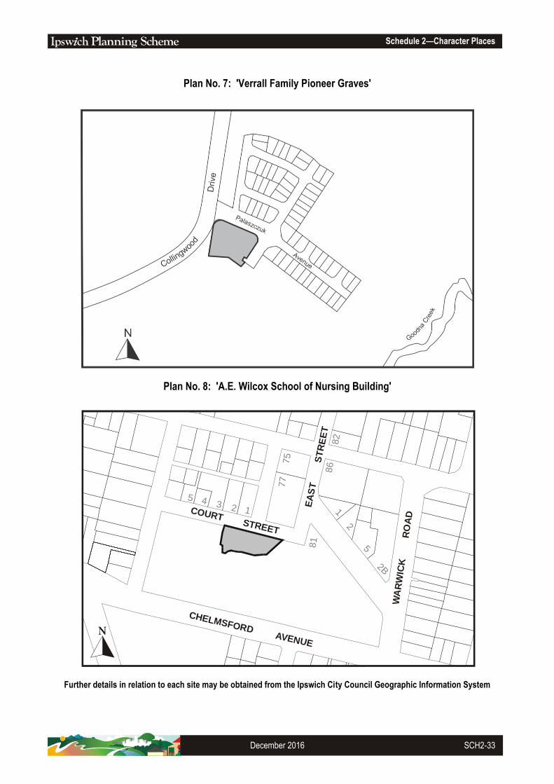
Schedule 2—Character Places
December 2016 SCH2-33
Plan No. 7: 'Verrall Family Pioneer Graves'
Plan No. 8: 'A.E. Wilcox School of Nursing Building'
Further details in relation to each site may be obtained from the Ipswich City Council Geographic Information System
COURT STREET
CHELMSFORD AVENUE
EA
ST
S
TR
EE
T
WA
RW
ICK
R
OA
D
81
77
75
86
82
1
2
5
2B
12345

Schedule 2—Character Places
SCH2-34 January 2006
Plan No. 9: 'Spring Hill'
Plan No. 10: 'St Mary's'
Further details in relation to each site may be obtained from the Ipswich City Council Geographic Information System
EBENEZER ROAD
EBEN
EZER
R
OAD
HIG
GS
RD WILKES ROAD
MA
RY S
TR
EE
T
RO
SEBER
RY
PARADE
ELIZABETH
STREET
BREM
ER R
IVER
ARTHUR STREET

Schedule 2—Character Places
January 2006 SCH2-35
Plan No. 11: 'Hitching Rail'
Plan No. 12: 'Rosewood Railway Museum'
Further details in relation to each site may be obtained from the Ipswich City Council Geographic Information System
MA
RY
STR
EE
T
STREET
ELIZABETH
BREMER
RIVER
RO
SEBERRY
PA
RA
DE
FREEMAN ROAD
KE
AT
ES
RO
AD
RO
SE
WO
O
D MARBURG ROAD

Schedule 2—Character Places
SCH2-36 January 2006
Plan No. 13: 'Silkstone State School'
Plan No. 14: 'Franklyn Vale'
Further details in relation to each site may be obtained from the Ipswich City Council Geographic Information System
GLEBE ROAD
MO
LL
OY
S
TR
EE
T
PR
OS
PE
CT
S
TR
EE
T
MA
CQ
UA
RIE
S
TR
EE
T
EA
ST
ON
S
TR
EE
T
FRANKLYN VALE
GRANDCHESTE
RM
T M
OR
T R
D
ROAD
-
FR
AN
KL
IN V
AL
EC
RE
EK

Schedule 2—Character Places
January 2006 SCH2-37
Plan No. 15: 'Old Hidden Vale'
Plan No. 16: 'Cardross'
Further details in relation to each site may be obtained from the Ipswich City CouncilGeographic Information System
HIDDENVALE ROAD
GR
AN
DC
HE
ST
ER
MT
MO
RT
RD
FRANKLIN
VALE CREEK
GR
AN
DC
HE
ST
ER
- M
T M
OR
T R
D
HODGES ROAD

Schedule 2—Character Places
SCH2-38 January 2006
Plan No. 17: 'Harrisville State School'
Plan No. 18: 'Klondyke Coke Ovens'
Further details in relation to each site may be obtained from the Ipswich City Council Geographic Information System
8
12
-14
9-2
1
18
16
10
HA
LL
S
TR
EE
T
PA
RK
ER
LA
NE
HARRIS
ON S
TREE
T
HALLE
TT S
TREET
MIH
ICREEK

Schedule 2—Character Places
January 2006 SCH2-39
Plan No. 19: 'Heiner Road Bridge Approach'
Plan No. 20: 'Haigh Street Quarry'
Further details in relation to each site may be obtained from the Ipswich City Council Geographic Information System
THE TERRACE
HEINER ROAD
HIG
H S
TR
EE
T
HAIGH STREET
EMERALD ST
HAYES ST

Schedule 2—Character Places
SCH2-40 January 2006
Plan No. 21: 'Peak Crossing State School & Residence'
Plan No. 22: 'Ipswich to Walloon Original Railway Line'
Further details in relation to each site may be obtained from the Ipswich City Council Geographic Information System
IPSW
ICH
B
OO
NAH
R
OAD
PURG
A
PU
RG
A
CREEK
CR
EE
K
BR
EM
ER
RIV
ER
HAIG STREET
WORKSHOPS STREET
GR
EG
OR
Y S
TR
EE
T
GRACE STREET

Schedule 2—Character Places
January 2006 SCH2-41
Plan No. 23: 'St Edmunds' College
Plan No. 24: 'World War II Pistol Range Wall'
Further details in relation to each site may be obtained from the Ipswich City Council Geographic Information System
ARTHUR
STREET
MA
RY S
TR
EE
T
WA
GH
OR
N S
TR
EE
T
MO
NA
SH
R
OA
D
MONTGOMERY ST

Schedule 2—Character Places
SCH2-42 January 2006
Plan No. 25: 'Tivoli Hill Horse Trough'
Plan No. 26: 'Ruhland's Farm'
Further details in relation to each site may be obtained from the Ipswich City Council Geographic Information System
MT
WA
LK
ER
WE
ST
RO
AD
RUHLAND ROAD
ST
OK
ES
CR
OS
SIN
G -
MT
MO
RT
RO
AD
TANTIV
Y
ST
RE
ET
MT
CR
OS
BY
RO
AD
MO
ORES P
OCKET R
OAD
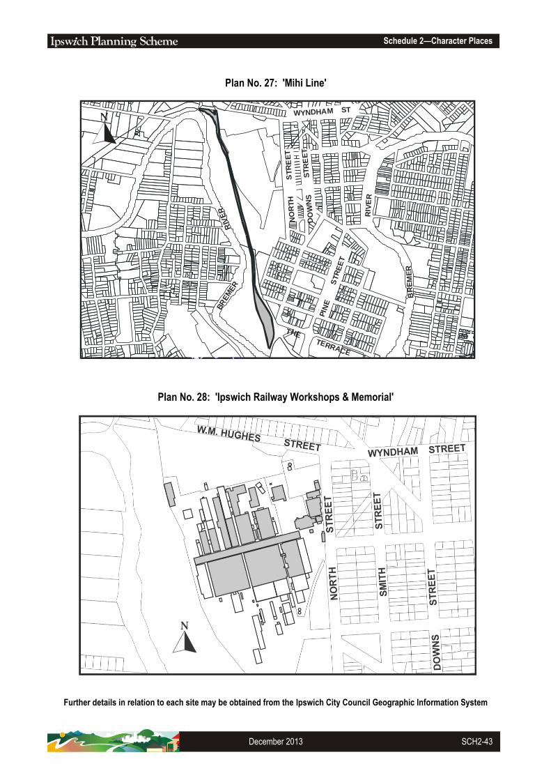
Schedule 2—Character Places
December 2013 SCH2-43
Plan No. 27: 'Mihi Line'
Plan No. 28: 'Ipswich Railway Workshops & Memorial'
Further details in relation to each site may be obtained from the Ipswich City Council Geographic Information System
RI V
ER
BR
EM
ER
RIV
ER
BR
EM
ER
THE TERRACE
PIN
E
ST
RE
ET
NO
RT
H
S
TR
EE
T
DO
WN
S
ST
RE
ET
WYNDHAM ST

Schedule 2—Character Places
SCH2-44 February 2016
Plan No. 29: 'Aberdere Extended No.1 Colliery former General Manager’s Office'
Plan No. 30: 'Ipswich – Gatton Road Distance Marker'
Further details in relation to each site may be obtained from the Ipswich City Council Geographic Information System
63
1
61
48 2
2
52
6765
108
63
A
44
50
46
54
8 64
32 34 36 38
CUSHING STREET
BARKELL STREET
HILL STREET
CARTER STREET
PIN
EM
OU
NTA
INR
OA
D
EAST OWEN STREET
CU
NN
ING
HA
M
HIG
HW
AY
PA
RK
HE
AD
ST
RE
ET

Schedule 2—Character Places
January 2006 SCH2-45
Plan No. 31: 'Rosewood Railway Station Complex'
Plan No. 32: 'Reservoir Precinct'
Further details in relation to each site may be obtained from the Ipswich City Council Geographic Information System

Schedule 2—Character Places
SCH2-46 January 2006
Plan No. 33: 'Canaan & Anchorage Farm Manager's Residence'
Further details in relation to each site may be obtained from the Ipswich City Council Geographic Information System
RIVERVIEW ROAD
KE
NN
ET
H S
TR
EE
T
BR
I SB
AN
E
RIV
ER
BREMER
RIVER

Schedule 2—Character Places
January 2006 SCH2-47
Plan No. 34: ‘Amberley RAAF Base'
Further details in relation to each site may be obtained from the Ipswich City Council Geographic Information System
RO
SE
WO
OD
RO
AD
GA
RR
ISO
N
ST
RE
ET
SOUTHERNAMBERLEY
ROAD

Schedule 2—Character Places
SCH2-48 January 2006
Plan No. 35: 'Redbank Plains State School'
Plan No. 36: 'Wycombe Lodge'
Further details in relation to each site may be obtained from the Ipswich City Council Geographic Information System
SC
HO
OL
R
OA
D
WILKIE
AVENU
E
VICKI STREET
CASHMERE ST
ST
EV
EN
S
REINKE ROAD
GREET ROAD
RO
AD

Schedule 2—Character Places
January 2006 SCH2-49
Plan No. 37: 'Pioneer Catholic Cemetery'
Plan No. 38: 'Haighmoor Coke Ovens'
Further details in relation to each site may be obtained from the Ipswich City Council Geographic Information System
MT
CRO
SBY R
OAD
WARREGO
CO
AL
R
D
HIGHWAY

Schedule 2—Character Places
SCH2-50 January 2006
Plan No. 39: 'Peak Crossing Pump'
Plan No. 40: 'World War II Remains'
Further details in relation to each site may be obtained from the Ipswich City Council Geographic Information System
WHITE ROCK
WO
OG
AR
OO
CR
EE
K

Schedule 2—Character Places
February 2009 SCH2-51
Plan No. 41: 'Eden's Homestead Plantings'
Plan No. 42: 'Depression Work Relief Plantings'
Further details in relation to each site may be obtained from the Ipswich City Council Geographic Information System
AUGUSTA
PA
RK
WA
Y

Schedule 2—Character Places
SCH2-52 January 2006
Plan No. 43: 'Lone Bunya Pine and Grass Trees – 22 Byrne Street, Bundamba'
Plan No. 44: 'Ipswich Girls Grammar School Plantings'
Further details in relation to each site may be obtained from the Ipswich City Council Geographic Information System
2
1
7
8
3 2 1A
10
1115
4
7
7A 9
2
4
6
9
3
17
6
84
85
86
88
82
5
4 6 8
3
3 5 7
2A
1
81
79A
79
80
87
83
88
A
1 1A
2
1
QUEEN VICTORIA PARADE
BRISBANE ROAD
CH
ER
MS
IDE
R
OA
D
GLEBE ROAD
MARY
RIV
ER
R
OA
D
BY
RN
E S
TR
EE
T
MIN
I NG
ST
AD
AM
S
T
ST
RE
ET
WIL
LIA
M
STREET
STREET
CREEK

Schedule 2—Character Places
December 2016 SCH2-53
Plan No. 45: This Plan is intentionally left blank
Plan No. 46: 'Ipswich Railway Workshop Plantings'
Further details in relation to each site may be obtained from the Ipswich City Council Geographic Information System
W.M. HUGHES STREET
NO
RT
H
S
TR
EE
T
SM
ITH
S
TR
EE
T
BR
EM
ER
RIV
ER
WYNDHAM STREET
DO
WN
S S
TR
EE
T

Schedule 2—Character Places
SCH2-54 February 2016
Plan No. 47: 'Moreton Bay Fig Tree'
Further details in relation to each site may be obtained from the Ipswich City Council Geographic Information System
Plan No. 48: This Plan is intentionally left blank

Schedule 2—Character Places
January 2006 SCH2-55
Plan No. 49: 'University of Queensland Ipswich Campus Plantings'
Plan No. 50: 'Marburg State Primary School Environmental Park & perimeter Driveway Plantings'
Further details in relation to each site may be obtained from the Ipswich City Council Geographic Information System
PARKER AVENUE
WARW
ICK
WA
RW
ICK
RD
SALISBURY ROAD
TH
OR
N S
TR
EE
T
CA
RR
ST
CEMETERY RD
ROAD
WARREGO
SC
HO
OL
ST
RE
ET
GE
OR
GE
ST
RE
ET
QU
EE
N S
TR
EE
T
LOUISA STREET
WILLIAM STREET
HIGHWAY

Schedule 2—Character Places
SCH2-56 January 2006
Plan No. 51: 'The Christmas Lights Tree'
Plan No. 52: 'Indigenous Cultural Heritage Site'
Further details in relation to each site may be obtained from the Ipswich City Council Geographic Information System
GO
OD
NA
CR
E
EK
IPSWICH MOTORWAY
COLLING
W
OO
DD
RIV
E
KR
UG
ER
PA
RA
DE
DR
IVE

Schedule 2—Character Places
January 2006 SCH2-57
Plan No. 53: 'Indigenous Cultural Heritage Site'
Plan No. 54: 'Indigenous Cultural Heritage Site'
Further details in relation to each site may be obtained from the Ipswich City Council Geographic Information System
ROBERTSON ROAD
SO
UT
H S
TA
TIO
NR
OA
D
GRAHAM STREET
BU
ND
AM
BA
CR
EE
K

Schedule 2—Character Places
SCH2-58 January 2006
Plan No. 55: 'Indigenous Cultural Heritage Site'
Plan No. 56: 'Indigenous Cultural Heritage Site'
Further details in relation to each site may be obtained from the Ipswich City Council Geographic Information System
BARCLAY STREET
BER
GIN
S H
ILL R
OA
D
NA
OM
I
BU
ND
AM
BA
CR
EE
K
ST
RE
ET
WHITE ROCK
O’D
EM
PS
EY
RO
AD
CU
MN
ER
RO
AD
WO
OG
AR
OO
CR
EE
K
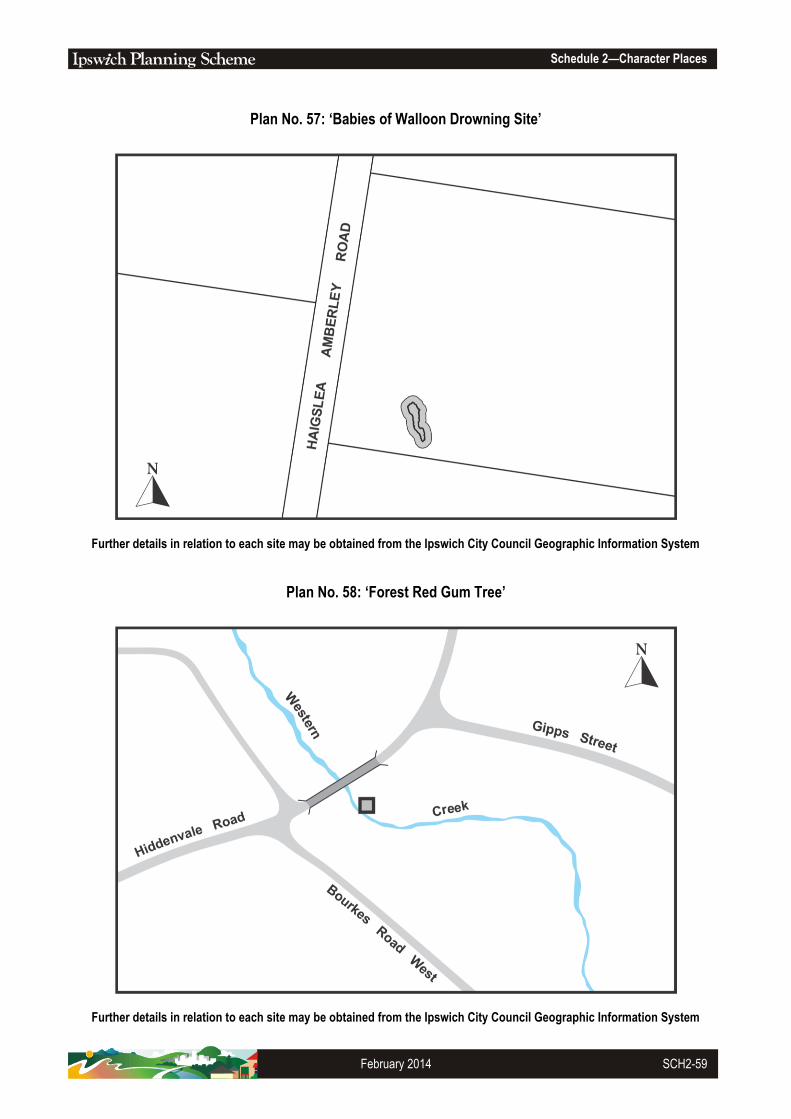
Schedule 2—Character Places
February 2014 SCH2-59
Plan No. 57: ‘Babies of Walloon Drowning Site’
Further details in relation to each site may be obtained from the Ipswich City Council Geographic Information System
Plan No. 58: ‘Forest Red Gum Tree’
Further details in relation to each site may be obtained from the Ipswich City Council Geographic Information System

Schedule 2—Character Places
SCH2-60 May 2018
Plan No. 59: ‘Jacaranda Trees’
Further details in relation to each site may be obtained from the Ipswich City Council Geographic Information System
Plan No. 60: ‘Moreton Bay Fig Tree’
Further details in relation to each site may be obtained from the Ipswich City Council Geographic Information System