Embed Size (px)
Citation preview
SCENIC DRIVE NETWORK MANAGEMENT PLAN
Volume 3
ASSESSMENT AND EVALUATION OF S1 AND S2 ROUTES IDENTIFICATION OF PROJECTS, PROGRAMMES AND MANAGEMENT POLICIES
City of Cape Town
May 2003
Final Report.
Content Page
Page
Executive Summary 1
Section A : Background
1. Introduction 2. City of Cape Town Vision Statement 3. Brief overview of Volume 1 and 2 reports 4. Volume 3 Project Brief
2 3
Section B : Policy Guidelines and Zoning Scheme Regulations
5. Scenic Drive Policies Guidelines 6. Scenic Drive Zoning Scheme Regulations and Bylaws
6 14
Section C : Assessment and Evaluation of S1 and S2 Routes
7. Scenic Drive Route Evaluation Criteria 8. Identification of Priority Routes 9. Detailed Assessment and Evaluation of S1 and S1 Routes
Assessment of Route Intrinsic Qualities
Land Use/Control Issues
Economic Issues
Transportation Issues
Existing Policy
Relevant Themes
Existing Projects and Programmes
Proposed Projects and Programmes
Proposed Management Policies/Plans
20 22 24
Section D : Proposals
10. Proposed Short Term Interventions 11. Proposed Medium/Long Term Interventions 12. Conclusion
94 96 97
Bibliography 98
Detailed Assessment and Evaluation of S1 and S2 Routes
Section Route No Route Name Page
9.1 1 Plateau Road 24
9.2 2 Main Road 26
9.3 3 Red Hill Road 33
9.4 4 Witsand Main Road 34
9.5 5 Soetwater Main Road 35
9.6 6 Slangkop Road 36
9.7 7 Glencairn Expressway 37
9.8 8 Boyes Drive 38
9.9 9 Ou Kaapse Weg 39
9.10 10 Noordhoek 41
9.11 11 Chapman's Peak Drive 42
9.12a 12a Steenberg Road 43
9.12b 12b Spaanschemat River Road 44
9.13a 13a Simon Van Der Stel Freeway 45
9.13b 13b Waterloo/Wolf Street 46
9.13c 13c Edinburgh Drive 47
9.14 14 Constantia Main Road 48
9.15 15 Hout Bay Main Road 49
9.16a 16a Victoria Road 51
9.16b 16b Princess Street 52
9.17a&b 17a&b Victoria Road 53
9.17c 17c Victoria Road & Beach Roads 55
9.18 18 Camps Bay Drive 57
9.19 19 Rhodes Avenue 58
9.20 20 Rhodes Drive 59
9.21 21 Eastern Boulevard 60
9.22a 22a De Waal Drive 61
9.22b 22b Orange/Mill Street 62
9.23a 23a Tafelberg Road 63
9.23b 23b Signal Hill Road 64
9.23c 23c&d Kloof Road 65
9.24 24a Kloof Nek Road 66
9.24 24b Buitengracht Street 67
9.25a 25a Atlantic/Royal Road 68
9.25b 25b Baden Powell Drive 69
9.26 26 N1 71
9.27a 27a Tygerberg Valley Road 72
9.27b 27b Tygerberg Valley Road 73
9.28a 28a Contermanskloof Road 74
9.28b 28b&c Vissershok Road 75
9.28d 28d St John’s /Race Course Road 76
9.29 29 Durbanville Road 77
9.30 30 R304 78
9.31 31 Lichtenburg Road 79
9.32 32 R304 80
9.33 33 N7 81
9.34a 34a R304 Mamre Road (South) 82
9.34b 34b R304 Mamre Road (North) 83
9.35 35 Melkbosstrand Road 84
9.36a&b 36a&b Otto Du Plessis Drive 85
9.36c&d 36c&d Marine Drive R27 87
9.37 37 N2 88
9.38a 38a R44 / Beach Road 89
9.38b 38b R44 / Beach Road 90
9.39 39 N2/Sir Lowry’s Pass 91
9.40 40 Sir Lowry's Pass 92
9.41 41 Faure Marine Drive 93

1
EXECUTIVE SUMMARY SCENIC DRIVE NETWORK MANAGEMENT PLAN VOLUME 3 IDENTIFICATION OF PROJECTS, PROGRAMMES AND MANAGEMENT POLICIES The overall aim and purpose of the Scenic Drive Network Study is to identify routes which traverse areas of outstanding scenic quality in the City of Cape Town and to establish a sustainable balance between the conservation of its associated natural and built amenities and the development of its tourism and recreational potential. The objective of the Volume 3 report is to identify programmes, projects and appropriate management policies for each scenic route or part(s) thereof and to prioritise these into immediate and medium to long-term intervention actions that are environmentally and economically sustainable. The focus area of intervention in Volume 3 report is on the Scenic Drive Envelope, which refers to the carriageway, the road reserve, immediately adjacent public land and the first erven abutting any of these. The type and form of intervention differ from area to area. In certain parts of the City, emphasis is placed on conservation and limiting any further development, while other areas highlight the need for direct project invention, in particular to generate economic opportunities for local communities. There are a number of projects, programmes and management policies where intervention processes are already underway or where other role players have the capacity to proceed immediately or are the custodians of those resources. In addition, certain of the routes need to be repaired/maintained urgently and therefore also require immediate attention.
The route specific projects, programmes and management policies identified are a result of a rigorous process of assessing and evaluating the scenic drive routes as well as careful consideration of the possible planning, environmental, economic and transportation constraints and opportunities. Ideally all actions identified should be attended to immediately. However, due to limited resources, short-term actions were identified and should be attended to as soon as possible. It is recommended that the City of Cape Town undertake the following:
Adoption of the Scenic Drive Policy Guidelines as reflected in Chapter 5.
Consideration of existing Scenic Drive Regulations (as synthesised in chapter 6) within the City of Cape Town’s Land Use Management Systems (LUMS) and zoning scheme review process.
Proceeding with the short-term interventions as proposed in chapter 10.
Implement the management policies identified for each route.
Interventions on those actions identified will ensure that the existing natural and built form qualities of the scenic drives are maintained and enhanced. Implementation of the management policies should not be underestimated as the greatest threat for the Scenic Drive Network is current and future developments that occur and impact along these routes because of their scenic value, but have no regard for or contribute or enhance the value and experience of the scenic route.

2
SECTION A: BACKGROUND 1. INTRODUCTION The overall aim and purpose of the Scenic Drive Network study is set out in the Scenic Drive Network Report: Volume 1 (October 1998) and it is to identify routes which traverse areas of outstanding scenic quality in order to:
Preserve and enhance the scenic resources through which the routes pass.
Establish a sustainable balance between conservation and development.
Establish a network of interconnected routes with the potential to spread and diversify the tourist experience.
Promote the tourism and recreational potential of the metropolitan area by enhancing the user's scenic experience and understanding.
Develop opportunity for local community involvement, empowerment and development.
This report follows on the following previous Scenic Drive Documents prepared by the CMC Administration:
Volume 1: (Oct. ’98)
Scenic Drive Network Report- Motivation & Conceptualisation of the Scenic Drive Network
Volume 2 (Oct. ’98)
Scenic Drive Network Report-Atlas and Matrix. Major constraints in Formulating the Network and Detailed Attributes of the Scenic Routes.
These reports should be regarded as sequential volumes on the Scenic Drive Network Study, with Volume 3 focussing on the preparation of a Scenic Drive Management Plan. The Scenic Drive Network Management Plan Volume 3 consists of four sections:
Section A: Introduction and Background to the Study
Section B: Review and identification of shortcomings existing Scenic Drive Policies and Zoning Scheme Regulations of relevance to Scenic Drives
Section C: Formulation of Evaluation Criteria and Identification of Priority Routes. Assessment of al 41 routes in terms of key issues and concerns of relevance to the S1 and S2 scenic routes.
Section D: Proposals and recommendations in terms of programmes, projects and relevant management guidelines.
The S1 and S2 scenic routes are identified on the accompanied map (page 5). S1 refers to routes which fulfil the definition of both “scenic” and “drive”: limited access routes which traverse areas of high scenic quality. S2 refers to routes which fulfil the definition of “scenic” but not of “drive”: roads which traverse areas of high scenic quality but which are frequently accessed.
2. CITY OF CAPE TOWN VISION STATEMENT The CCT has adopted the Council’s Vision, Goals and Priorities Statement for 2003 and it is imperative that these be incorporated into preparation of the Scenic Drive Management Plan. Parts of the Vision statement regarded as relevant to the Scenic Drive Study are highligted; 1. a sustainable City 2. a dignified City 3. an accessible City 4. a credible City 5. a competent City 6. a safe and caring City 7. a prosperous City 8. a City known for its leadership The economic development, tourism promotion and physical/infrastructure development strategy of Council are especially supported.
3. BRIEF OVERVIEW OF VOLUME 1 AND VOLUME 2 SCENIC DRIVE REPORTS
Previous documents completed as part of the Scenic Drive Network Study include Volume 1: Study Report and Volume 2: Route Description and Analysis. Volume 1: Study Report Volume 1 proposes that the scenic routes be assessed and designated in terms of the following Route Intrinsic Qualities:
Reveal outstanding scenic qualities defined in terms of views and experience of natural and cultural landscapes.
Traverse areas of representative scenic quality or which reveal a strong sense of place.
Traverse areas which provide a range of scenic qualities
Traverse areas of natural resource value
Traverse significant cultural landscapes
Provide linkages between major scenic, historical and recreational points or areas of interests.
Strategies identified include the following:
Retention and purchase of state, provincial or parastatal land where this is deemed necessary for the preservation and enhancement of critical views.
Purchase of scenic easements (partial rights in the land)
Zoning as a means to control the type, density or distribution of development.
Integrating the Scenic Drive Network with the CPNP and MOSS
Alien vegetation clearance programme
Urban design intervention in urban renewal programmes
Community empowerment programmes
Architectural, engineering and landscaping guidelines.
The control of signage
An appropriate management and funding system. Volume 2: Route Description and Analysis This volume included a description, analysis and assessment of each scenic route in terms of the following criteria of significance:
Degree of Significance
Visual quality
Historical/Socio-Political/Archaelogical Qualities
Botanical and Geological Qualities
Range of Experience
Intermodal qualities
Points of Attraction
Network Completion
Level of Convenience
Grade

3
The following diagram illustrates how Volume 1, 2 and 3 relate to each other:
Vol. 1
Vol. 2
Volume 3Principles &
criteria applied
route subset
(S1 & S2)extracted
for further assessment.
Recommend action for
prioritised routes
establish brief for/
implement suggested
action/policy/programme
Scenic Drive Network - Volume 1: Study ReportEstablished criteria for the identification of scenic routes and the intrinsic qualities of routes. Also included general principles for dealing with development along scenic routes.
Scenic Drive Network - Volume 2: Route Description and AnalysisEstablished scenic routes in terms of criteria of significance & established S1, S2 & L1, L2 categories of routes.
Scenic Drive Network Management Plan: Assessment andEvaluation of S1 and S2 Routes. Identification of Projects, Programmes and Management PoliciesAssesses and evaluates S1 & S2 routes in terms of key issues and concerns. Identifies routes requiring priority intervention; identifies andprioritises programmes and projects, and appropriate managemenpolicies for each prioritised scenic route or part thereof in terms of theScenic Drive Study conservation & development objective.
4. PROJECT BRIEF Phase A focused on an Assessment of the Key Issues and Concerns and the Identification of routes requiring priority intervention. Phase B required the Identification of Programmes, Projects, Remedial Measures and Relevant Management Guidelines. Diagram: Project Methodology The brief requires that the issues and concerns should be identified for the Corridor Action Areas, which includes the scenic envelopes and
scenic corridors. Scenic Drive Study Volume 1 defines a Scenic Corridor as " The unfolding area defined by a major edge condition such as ridge lines and coastlines which constitute a visual entity". Scenic Road Envelope is defined as “the carriageway, the road reserve, immediately adjacent public land and the first erven abutting any of these”. (Refer to Fig 1.1)
Fig 1.1 Scenic Corridor vs Scenic Envelope
4.1 Phase A: Demarcation, Evaluation and Assessment of Scenic Routes
4.1.1 Objective The overall objective of this phase is the demarcation of the Scenic Envelopes for the S1 and S2 routes, followed by an assessment/evaluation of the scenic routes in order to identify the key priority areas of intervention.
Compilation of General Information on Each Scenic Route
Demarcation of the Scenic Envelopes for the S1 and S2 routes for each identified scenic route.
Compilation and assessment of intrinsic qualities of each scenic drive in terms of the criteria identified in the Scenic Drive Volume 1 Report.
Description and assessment of the provision of current tourism amenities/facilities to meet current demands and expectations.
4.1.2 Policy, Land Use and Control Issues Activities undertaken during this Phase focused on the status quo and included the following:
Identification of current land uses as well as the appropriate precincts.
Identification of zoning and relevant legislative/regulative requirements relevant to each scenic envelope.
Identification of existing programmes/projects, important linkages with activities that support the development of scenic routes.
Identification of land ownership (private and institutional).
Identification of existing planning policy initiatives. The assessment used the databases of the City of Cape Town’s local administrations and was also based on discussions with knowledgeable institutions and individuals as well as site visitations. 4.1.3 Environmental Issues Environmental activities included the following:
Examining the identified routes and precincts in terms of constraints posed and opportunities presented, followed by an environmental sensitivity/suitability study.
Participation in the identification, information compilation, assessment and description of scenic routes.(Scenic Drive criteria: natural resource value; significant cultural landscapes; linkages)
Identification of relevant environmental regulations, establishment of continuity with planning initiatives, determination of conservation status pertaining to land ownership and environmental education.
4.1.4 Traffic Management, Road Development and Maintenance
Issues This aspect of the work encompassed the following:
Traffic Management Issues
Assessment of increased traffic demand and capacity to support and accommodate a variety of modes.
Conduct a broad “drive through” road safety assessment.
Assess existing informal business activities, developments and facilities along the route with regard to pedestrian and driver safety.
Road Development and Maintenance Programme
Conduct a broad “drive through” site investigation, photograph and document current road verge/reserve maintenance requirements.
The following, more detailed, traffic management and road development and maintenance issues is the subject of a separate report to the CMC Transportation and Traffic Directorate:
Assessment of available traffic information from CMC. Assessment of available Level of Service information, including preliminary volume / capacity ratio assessments where no information is available.
Source [from the CMC], collate and review available collision statistics.
Source [from the CMC], collate and assess available Pavement Management Systems (PMS) data on scenic routes.
Prioritise and Formulate
Proposals
Projects and Remedial Action
Demarcate, Assess Scenic
Routes
Land Use and Planning
Environmental Management
Traffic Management/Road Development and
Maintenance
Economics
Management Policy
Programmes
4
Identification of current initiatives and future infrastructural development requirements for tourism facilities.
4.1.5 Economic/Tourism Issues The general approach to be followed in the execution of the economic element of this study was to focus and explore the opportunities presented by the bi-directional flow and link between the scenic routes on the one end and the local economy on the other. The objective was to get a firm and clear perspective on the economic significance and function of the various routes (current and future), in terms of existing and new potential. This was determined by assessing issues such as:
The current land uses and associated land values within the influence sphere of the route.
The main and significant economic activities located along the route. Also, taking cognisance of the potential for new or additional economic activities in terms of the land use zoning. These economic activities not only refer to the formal type, but also the lower order and more informal type of activities such as stalls and curio outlets.
The location of places of interest along or near to the route. These places of interest not only refers to the well established tourism destinations, but also those places that may have more tourism potential if properly advertised and marketed.
The main economic use(s) of the route (e.g. tourism orientated, transportation of goods to Cape Town harbour, transportation of people from and to work).
This particular approach will allow for the identification and assessment of existing opportunities, as well as new potential. The assessment in terms of the issues listed above culminated in an informed perspective on the role, function, existing and potential opportunities.
4.2 Phase B : Identification of Projects, Programmes and Management Policies 4.2.1 Objective To identify and prioritise programmes and projects and appropriate management policies for each scenic route or part(s) thereof in terms of the Scenic Drive Study conservation and development objective. To facilitate strategic, co-ordinated intervention in the Scenic Drive Network, emerging action plans will be prioritised into immediate, medium/long-term intervention actions that are environmentally and economically sustainable. The focus area of intervention in Phase B is on the Scenic Drive Envelope, which refers to the “ carriageway, the road reserve, immediately adjacent public land and the first erven abutting any of these” (Volume 1). 4.2.2 Planning Policy/Regulation, Programme and Project Elements This focused on the formulation of the required regulations, policy, programmes and projects to be implemented and will include the following elements:
a) Assessment and synthesis of proposed land uses within or adjacent to the Scenic Drive Network Envelope as well as
proposals and recommendations contained in current planning documents.
b) Identification of scenic drive initiatives to promote appropriate forms of new development and enhance existing development within or adjacent to the Scenic Drive Network Envelope.
c) Assessment of the impact of current zoning scheme regulations on relevant sections of the scenic routes.
d) Recommended amendments (if required) to current planning policy and regulatory frameworks and scheme regulations.
e) Identification of appropriate programmes, projects and management policy that would direct and inform capital budget expenditure and also serve as pilot initiatives.
4.2.3 Environmental Programme/Project Elements
a) Identification of measures mitigation against poorly performing environments and the establishment of measures to enhance identified opportunities.
b) Recommendations on the proposed use or protection of identified natural, cultural and heritage resource base.
c) Identification of measures to reduce the environmental impact of land use, road and infrastructural interventions based on identified environmental constraints and opportunities.
4.2.4 Transportation Programme/Project Elements
a) Make recommendations on the need for detailed studies i.e. safety audits, route capacity, or further traffic survey/monitoring programmes.
b) Highlight route sections of strategic routes that require upgrading to enhance carrying capacity and/or safety.
c) Categorise recommended route improvements based on the following categories; emergency, safety related [pedestrian and vehicular], access / parking, delays [volume / capacity ratios] and routine road maintenance.
d) Develop criteria for allocation of scenic drive maintenance funds and prioritise [with the roads authority] the recommended route improvements of identified tourism/scenic routes.
e) General commentaries on road signage, road verge maintenance and road infrastructure design elements (gabions/guard rails).
4.2.5 Economic and Tourism Programme/Project Elements The essence of Phase B was to identify and describe the requirements and proposals to fully realise the opportunities (existing and potential), role and functions of each route as described in Phase A, in order to maximise the contribution of the routes to the regional and local economies. These requirements and potential may refer to:
Tourism promotion: established and less established tourism markets.
Informal market and stalls: opportunities for the local communities
Initial construction: opportunities for the local communities and entrepreneurs to become involved in the cleaning and / or maintenance programs of the routes.
Marketing: the manner in which the scenic routes are packaged and marketed as an integral part of the larger tourism packet (i.e. the total “tourism experience”).
These requirements and proposals were prioritised to distinguish between those elements that require immediate action, and those that could be performed at later stage. Typical criteria to be used in this evaluation process included:
Strategic importance of the project for the successful further development of the precinct.
Locational requirements.
The ability of the project to generate sustainable/ temporary employment opportunities.
The ability of the project to generate opportunities for the SMME sector through outsourcing (i.e. in support of economic empowerment).
Linkages with other projects, local economic activities and sectors to maximise the multiplier effect.
Capital gearing ratio. The application of these criteria enabled the detailing of the opportunities in terms of:
a) The priority of the various potential opportunities. b) The critical success factor or prerequisites to be satisfied for
the successful release of the existing and potential economic opportunities (e.g. tourism)
c) The optimal location of the opportunities. d) Resource requirements (skills, finance, etc.).
4.2.6 Guidelines, Prioritisation and Formulation of Proposals The assessment and evaluation during Phase A and the identification of possible policy/regulation, programme and projects in Phase B, were coupled with principles to guide their prioritisation in order to realise the objectives of the SDNS. 4.2.7 Phase B Deliverables Deliveries for this phase include:
a) The identification of priority programmes, projects and relevant management policies (i.e. area specific as well functional specific.
b) A detailed set of proposals for the practical implementation of the Scenic Drive Network Study to be used as the main inputs in the drafting of business plans in Phase C.

5
S1 and S2 Scenic Routes The following table identifies the start and beginning points of the routes. Route Route Name Start Point End Point
1 Plateau Road Smitswinkel S/borough Main Rd
2 Main Road Smithswinkel Muizenberg
3 Red Hill Road Plateau Rd Main Rd
4 Witsand Main Road Plateau Rd Slangkop Rd
5 Soetwater Main Road Witsand Rd Slangkop Rd
6 Slangkop Road Kommetjie Witsand Main Road
7 Glencairn Expressway Main Road Kommetjie Main Road
8 Boyes Drive Main Rd Main Rd
9 Ou Kaapse Weg N/Hoek intrsec. Steenberg Rd
10 Noordhoek Road Kommetjie Main Road Chapman’s Peak
11 Chapman's Peak Drive C. Peak Hotel Die Hoek Lookout
12a 12b
Steenberg Road Spaanschemat River Rd
Main Rd Ou Kaapse Weg
Ou Kaapse Weg Ldies Mile/Cnstntia Rd
13a 13b
Simon Van Der Stel Waterloo/Wolfe Street
Steenberg Rd Cnstntia Rd/ Alph Hill.
Top of Wynberg Hill Wynberg Hill
13c Edinburgh Drive Wynberg Hill Rhdes Ave/Prdise Rd
14 Constantia Main Road Alphen Hill Constantia Nek
15 16a 16b 17a
Hout Bay Main Road Victoria Road Princess Street Victoria Rd
Constantia Nek Victoria Rd inter. Victoria Rd Victoria Rd
Chapmans Peak Hout Bay Main Rd Hout Bay Main Rd Princess Street
17b Victoria Road Victoria Rd Bakoven
17c Victoria & Beach Roads Bakoven Portswood
18 Camps Bay Drive Kloof Nek Victoria Rd
19 Rhodes Avenue M3/Union Av Constantia Nek
20 Rhodes Drive M3/Union Av Hospital Bend
21 Eastern Boulevard Coen Steytler Ave M5
22a De Waal Drive Hospital Bend Mill Street
22b Orange/Mill Street Mill Street Buitengracht Street
23a Tafelberg Road Kloof Nek Cul-de sac
23b Signal Hill Road Kloof Nek Signal Hill
23c&d Kloof Road Kloof Nek Queens Road
24a 24b
Kloof Nek Road Buitengracht Street
Start of resid. area Carisbrook Rd
Coen Steytler
25a Atlantic & Roal Roads Atlantic/Main Rd Sunrise Circle
25b Baden Powell Drive Main Road CCT boundary
26 N1 Plattekloof Kuilsriver Freeway
27b Tygerberg Valley Road Durb’v Rd/Tger Vlly Rd Contermanskloof
28a Contermanskloof Road Vissershoek Durbanville Rd and N7
28b Vissershok Road N7 Wellington/Main Rd
29 30a 30b 31
Durbanville Road R302 Wellington Rd R302 Klipheuwel Rd Lichtenburg Road
N1 Main Street Klipheuwel Rd N1
End of D/v urban area Klipheuwel Main Rd R304/R302 junction Klipheuwel Main Rd
32 R304 Main Street Klipheuwel Main Rd
33 N7 Contermnsklf turnoff Study boundary
34a R304 Mmre Rd (South) N7 Morning Star turnoff Atlantis
34b Charel Uys Drive Atlantis Study Boundary
35 Melkbosstrand Road N7 West Coast Road R27
36a &b Otto Du Plessis Drive Melkbos urban area Marine Drive
36c&d Marine Drive R27 Ott Du Plessis Racecourse Rd
37 N2 Baden Pwl Drive R44
38a R44 / Beach Rd-North Study area boundary Lourens River Crossing
38b R44 / Beach Rd-East Lourens River Beach/Faure Mrine Dv
39 40
Sir Lowry's Pass Rd Sir Lowry’s Pass Rd
Sir Lowry’s Pass N2
Study area boundary Faure Marine Drive
41 Faure Marine Drive Sir Lowry’s Pass Rd Study Boundary
The Composite Map illustrates the start and beginning of all of The S1 and S2 routes.

6
SECTION B: POLICY GUIDELINES AND ZONING SCHEME REGULATIONS This section of the report synthesis and assesses the existing policy guidelines and zoning scheme regulations that impact on the management of Scenic Drives.
5. SCENIC DRIVE MANAGEMENT POLICIES
The following matrix provides a synthesis of the key policy issues, an assessment and recommended policy guidelines for development along scenic routes. These were extracted from the Scenic Drive
Volume 1 report. Additional policy factors identified as part of Volume 3
process is highlighted in italics and bold. Also indicated in italics are
proposed changes to text of the Volume 1 report.
Land Use/Issue
Concern Assessment Recommended Policy Guidelines
Land within the Scenic Envelope as well as the Scenic Corridor
Unrestricted development on erven within the Scenic Envelop as well as within the Scenic Corridor could impact negatively on the view from the route.
Although developments even further away (within the Scenic Corridor) could impact negatively on views, it would be impractical to set scenic drive conditions for all land and within the broader metropolitan area.
All development within the Scenic Envelope as well as the Scenic Corridor should be subjected to the policies and guidelines for scenic drives. These conditions should be reinforced through local development frameworks, structure plans and zoning regulations. Issues to be considered include the nature of the scenic amenity, the particular views to be preserved and enhanced etc. (Volume 1 focuses only on land within the scenic envelope)
Municipal owned land within the Scenic Envelop and the Scenic Corridor
Increasing development pressure to develop vacant municipal owned land, including land along scenic routes.
The City of Cape Town (CCT) should engage other public authorities (e.g. central government, PAWC and parastatals) to set aside and protect land adjacent to scenic routes and where development to do so in accordance with these guidelines.
Retain municipal ownership of portions of land above and below scenic routes. This land should be appropriately zoned (e.g. POS) to afford maximum protection.
Where municipal land is alienated, then this should be in accordance with restrictive conditions. These conditions refer to building heights and envelopes, architectural style, materials, etc and these should be included in the title deeds.
Protection of Downward Views
Existing zoning scheme regulations do not protect downward views, in particular along steep slopes.
Important views are blocked, by limiting the height of buildings adjacent to Scenic Drives to back of footway level, but not restricting the horizontal extensions of buildings from the road.
Sight angles should be established for all erven adjacent to scenic routes to frame permitted building envelopes. These should be developed within the new zoning scheme regulations. Particular site specific requirements should be applied when new development rights are allocated.
Protecting Upward Views
Existing regulations do not provide adequate protection against structures on the upper side of scenic routes on abutting erven and can have a negative impact, particularly on mountain views.
Present regulations allow boundary walls of 1.6 m measured from the upper pavement level.
Canyon effect is created and mountain views are impaired.
Regulations are manipulated and visually inappropriate development occurs in areas where natural or mean ground level is not defined.
Applications for sub-divisions on the mountainside of scenic routes should have site specific conditions imposed stipulating plot dimensions and front building lines.
Generally, long deep plots should allow staggered system of terraces, a more gradual vegetated slope and the preservation of mountain views.
No boundary wall on the upper side of a scenic drive should be higher than 1.5 m from the back of footway level.
An angle from the top of the boundary wall determined by maximum height above natural ground level (e.g. 6m) should be stipulated above which no development should be allowed to occur.
Slopes: Prevent the use of Roofs for parking
Shade covers, balustrades and shelters for parked cars obscure and have a negative impact on upward and downward views from scenic routes.
This phenomena is in particular prevalent along routes with steep slopes.
Measures could include prohibiting of parking on street level roof decks and consideration of alternatives such as parking inside buildings or parking below street level.
Where this has been permitted the impact should be softened though appropriate landscaping within the road reserve.

7
Land Use/Issue
Concern Assessment Recommended Policy Guidelines
Service Stations There is increasing pressure to locate service stations with extensive refreshment and restaurant facilities in rural contexts. Such facilities have already occurred on the N1, the N2 and the N7.
There are a number of service stations within the urban edge along scenic routes.
Petrol stations and their associated activities are not dependent on the scenic qualities of their location but depend almost entirely on the volume of passing traffic and access.
It is recommended that service stations should not locate beyond the defined urban edge.
Where service stations already exist beyond the urban edge, or where rights have already been obtained, or where S grade routes pass through urban areas, it is recommended that the following measures should be considered:
- corporate identity should be expressed within the structure of the building rather than through add-on elements;
- canopies with neon-lit corporate trimming should not be permitted; - free-standing advertising towers should not be permitted. - The structures should be accompanied with appropriate
landscaping.
Where service stations are located along scenic routes within the urban edge, this should be accompanied with appropriate landscaping to reduce their visual impact.
Schedule 3 of the CCT Advertising and Signage By-law aims to control signs displayed at service stations.
Informal Markets/trading
There is a proliferation of informal markets/trading adjacent scenic routes
In terms of Section 116 (b) (ii) of the Road Traffic Act (No. 29 of 1989), no person shall sell, display, offer for sale etc. any goods on or alongside any public road outside an urban area.
A number of scenic drives pass through areas outside urban areas and, in terms of this legislation, no informal trading is permitted along these roads.
It is evident, however, that such activity frequently occurs and is likely to increase.
Cons
This impacts on views and introduces a commercial element into what is essentially an attempt to enhance the natural environment.
In some instances, the extent of informal trading takes up most of the available parking space, thus limiting the opportunities for tourist buses to park.
Activities which are not essentially a function of the scenic environment are thus displacing those activities which are.
Pros
It creates access to job opportunities both for those operating in the formal and informal sectors.
It offers convenience to customers buying goods sold along the route.
Local studies should identify where such activities should be located, preferably at points of entry into scenic routes and at points of natural opportunity such as intersections and stop-over points for tourist buses where the visual impact would be minimized.
Such activities should preferably be integrated with other tourist facilities such as parking, toilet facilities and interpretation panels where applicable.
The activity should be restricted to arts and handicrafts and the area set aside should be clearly demarcated.
Retail activity should thus occur in a controlled and formally planned manner at specifically designated areas along the network.
Where informal traders are relocated, it is of critical importance that the affected traders are fully consulted in the process and that the alternative site provides equal or better trading opportunities and that the required support services are provided.

8
Land Use/Issue
Concern Assessment Recommended Policy Guidelines
Parking Cars parked along the viewing edge of Scenic Drives have a detrimental impact on the passing view from the road
Different requirements can be identified, with differing time spans and impacts.
As a general principle parking related to particular facilities should be provided in specific locations and should not be allowed to line a route.
The car parks should ideally be located at least 2m below back of footway level or should be screened from it.
Where the landform does not allow this, consideration should be given to roll-over kerbs to allow parking on the mountainside of the route. This should not be allowed on the seaside of scenic routes, if at all possible.
Traffic calming pads can be used to slow traffic and to demarcate pedestrian crossover areas on local routes.
Parking outside the demarcated areas should be made physically impossible.
If the road is alongside beside the facility, an adjacent screened car park should be provided.
If the facility is some distance from the road, cars should be parked in the car park near the road, leaving the sites free from vehicles.
Car parks should be sited and designed so that they are convenient for the place to be visited, but do not interfere with the landscape.
Except where there is a strong land formation which will allow the cars to be screened in a hollow, or an old quarry, tree planting is likely to be the most effective solution.
Consider the design and location of car parks in relation to the different functions they serve:
For viewing only, cars are parked for a relatively short time and the view should be accessible from inside the vehicle. They need to be located in relation to main viewpoints and should be restricted in scale. Parking bays should be clearly delineated in a suitable material to ensure parking occurs at a right angle to the road to minimise visual impact. This would apply to areas set off the Scenic Drive as no perpendicular parking is permitted off metropolitan roads.
In instances where tourist buses cannot utilize limited view sites, well constructed pedestrian pathways should be constructed between nearby bus drop-off points and the viewpoints.
Parking for facilities which are visited for a short period of time should be close to that facility, but screened from it, and screened from the road.
Parking related to picnicking, where direct and constant access to the vehicle is usually an issue should be within or close to the picnic site.
Other recreational activities, e.g. scuba diving, fishing and hiking are not car oriented. If the provision of adjacent parking is not easily provided, as is usually the case, consideration should be given to the provision of drop-off points, and the storage of vehicles in a more distant location where they can be more easily screened.
9
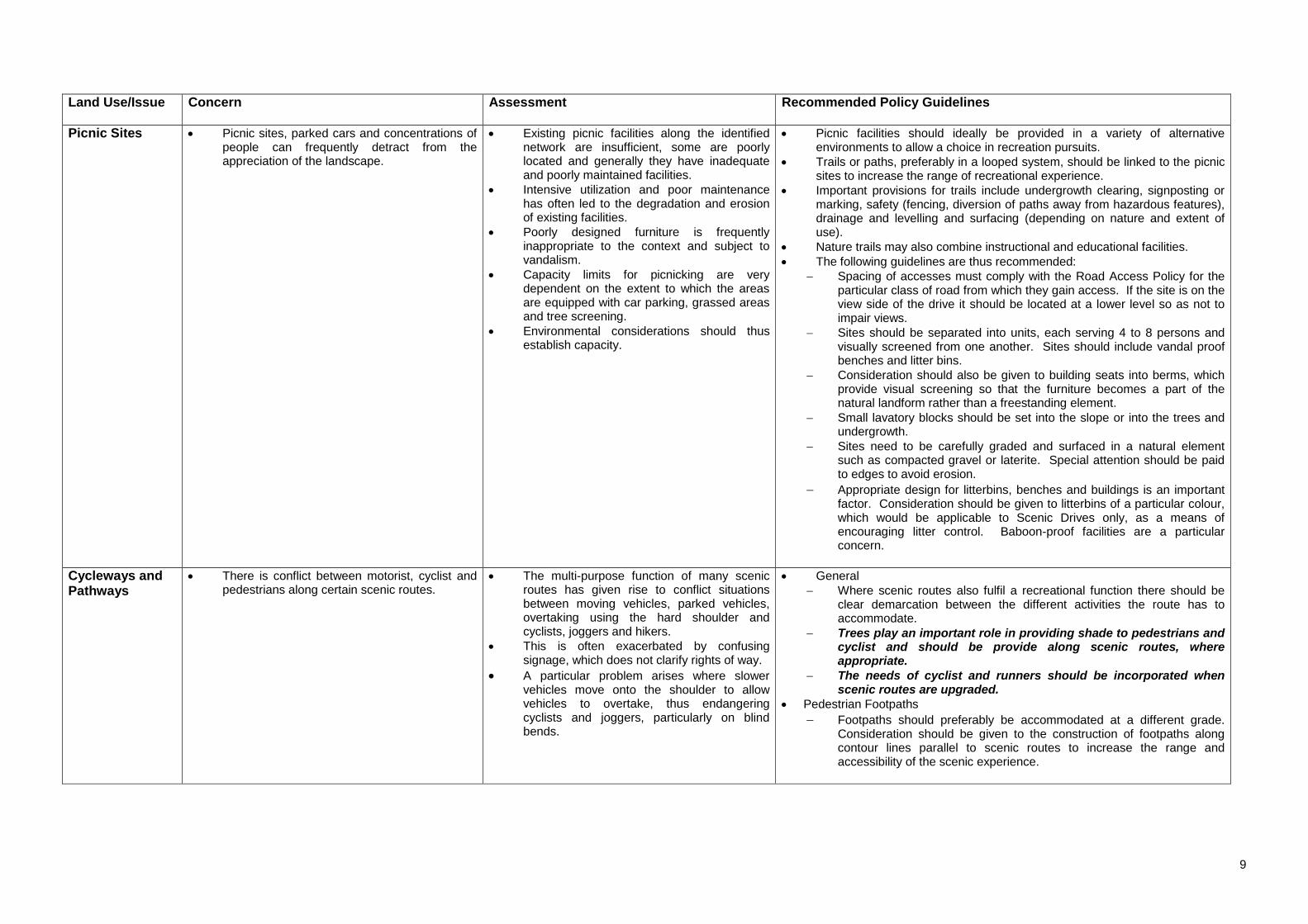
Land Use/Issue
Concern Assessment Recommended Policy Guidelines
Picnic Sites Picnic sites, parked cars and concentrations of people can frequently detract from the appreciation of the landscape.
Existing picnic facilities along the identified network are insufficient, some are poorly located and generally they have inadequate and poorly maintained facilities.
Intensive utilization and poor maintenance has often led to the degradation and erosion of existing facilities.
Poorly designed furniture is frequently inappropriate to the context and subject to vandalism.
Capacity limits for picnicking are very dependent on the extent to which the areas are equipped with car parking, grassed areas and tree screening.
Environmental considerations should thus establish capacity.
Picnic facilities should ideally be provided in a variety of alternative environments to allow a choice in recreation pursuits.
Trails or paths, preferably in a looped system, should be linked to the picnic sites to increase the range of recreational experience.
Important provisions for trails include undergrowth clearing, signposting or marking, safety (fencing, diversion of paths away from hazardous features), drainage and levelling and surfacing (depending on nature and extent of use).
Nature trails may also combine instructional and educational facilities.
The following guidelines are thus recommended:
Spacing of accesses must comply with the Road Access Policy for the particular class of road from which they gain access. If the site is on the view side of the drive it should be located at a lower level so as not to impair views.
Sites should be separated into units, each serving 4 to 8 persons and visually screened from one another. Sites should include vandal proof benches and litter bins.
Consideration should also be given to building seats into berms, which provide visual screening so that the furniture becomes a part of the natural landform rather than a freestanding element.
Small lavatory blocks should be set into the slope or into the trees and undergrowth.
Sites need to be carefully graded and surfaced in a natural element such as compacted gravel or laterite. Special attention should be paid to edges to avoid erosion.
Appropriate design for litterbins, benches and buildings is an important factor. Consideration should be given to litterbins of a particular colour, which would be applicable to Scenic Drives only, as a means of encouraging litter control. Baboon-proof facilities are a particular concern.
Cycleways and Pathways
There is conflict between motorist, cyclist and pedestrians along certain scenic routes.
The multi-purpose function of many scenic routes has given rise to conflict situations between moving vehicles, parked vehicles, overtaking using the hard shoulder and cyclists, joggers and hikers.
This is often exacerbated by confusing signage, which does not clarify rights of way.
A particular problem arises where slower vehicles move onto the shoulder to allow vehicles to overtake, thus endangering cyclists and joggers, particularly on blind bends.
General
Where scenic routes also fulfil a recreational function there should be clear demarcation between the different activities the route has to accommodate.
Trees play an important role in providing shade to pedestrians and cyclist and should be provide along scenic routes, where appropriate.
The needs of cyclist and runners should be incorporated when scenic routes are upgraded.
Pedestrian Footpaths
Footpaths should preferably be accommodated at a different grade. Consideration should be given to the construction of footpaths along contour lines parallel to scenic routes to increase the range and accessibility of the scenic experience.

10
Land Use/Issue
Concern Assessment Recommended Policy Guidelines
Cycleways and Pathways (cont.)
Public access across fragile frontal dunes should be controlled by formalised pathways, which should respect existing desire lines. Access should be by either raised boardwalks or some form of flexible or floating steps.
The identification and integration of footpaths and hiking trails with scenic drives should be a priority for structure and management plans.
Where possible, slopes should be used to separate pedestrians from vehicles, to provide a safer environment and to allow people on foot to look out over moving vehicles
Where the road is in cut, pedestrian footpaths should be located at the top rather than the bottom of the cut.
Where there is no alternative but for vehicular traffic and pedestrian pathways to be located on the same grade, consideration should be given to demarcated pedestrian areas, preferably with a different appropriate surface.
Roadway
Road markings should be used to inhibit the movement of vehicles on to the hard shoulder to enable over-taking, particularly on blind bends.
Consideration could be given to increasing the camber on the shoulder on blind bends.
Cycleways
Ideally, cycleways should be segregated from vehicular routes. However, in most instances along scenic routes, the landform and subsequent road reserve is unlikely to permit this. If the reserve is wide enough, cycleways could be permitted at the same grade. Rights of way should be clearly demarcated.
Cycleways should preferably be segregated from footpaths.
Utility Services The location and routing of electrical pylons and substations which form part of the national grid frequently have adverse visual impacts.
Similarly the proliferation of masts associated with the telecommunications industry is causing visual pollution.
It is evident that the location of these activities takes advantage of excessive road reserves and that space availability, rather than visual criteria, determine their location.
Electrical overhead cables should be relocated underground.
The policy and management guidelines identified for scenic routes should be taken into consideration when the required EIA’s are prepared for large-scale space extensive and highly visible utility facilities.
Road Aesthetics Inappropriately designed roads could have a significant negative visual impact on scenic routes.
The view of the road and the view from the road are two aspects, which are frequently incompatible. The road is essentially a linear element cutting through a range of environmental conditions (fields, forests, mountainous areas, towns, etc.) and is frequently out of scale with them.
Roads cannot vary in standards as safety is of paramount importance. Therefore every effort has to be made to reconcile this conflict between the unchanging linear road and the ever-changing landscape.
The road-landscape should be an intensification and simplification of the surrounding landscape and should serve to bring it in an unbroken flow to the line of the road, without the interpolation of a third elements and without the harsh lines of earthworks and parallel fences.
The road surface should reflect to the lie of the land to the greatest extent compatible with safe traffic requirements.

11
Land Use/Issue
Concern Assessment Recommended Policy Guidelines
Road Aesthetics (continued)
As design speed determines design standards and thus the geometry of road alignments, the design speed should be a function of the environment through which the road passes. Scenic landscapes should thus establish the parameters for design speeds and road geometrics.
In order to allow for the proper appreciation of the varying landscapes, the imposition of differential speed limits on scenic routes should be considered. Consideration should be given to the following to enhance the aesthetic appearance of the scenic routes:
preservation of natural environment; sense of fit with the character of the area traversed, natural roadside appearance, vegetation cover appropriate to locality;
curvilinear horizontal alignments and gently rolling profiles;
minimization of cut and fill and the adoption of curvilinear profiles rather than steep sided slopes and squared shoulders.
use of natural materials for street furniture & roadside walling
Edge Treatment The treatment of road edges can have a substantial visual impact, particularly for those travelling in vehicles at relatively slow speeds.
Standard concrete kerb and channel treatment, while appropriate in some urban contexts, is usually inappropriate in rural settings.
A range of edge treatments is evident throughout the proposed network. Most successful are those which use a shallow gutter to provide a softer transfer to the verge and which use local stone for the kerbs
Particular attention should be paid to the edge treatment in the design of Scenic Drives with the emphasis on the gentler transition between road surface and verge and the use of natural materials where appropriate.
Where possible the character of the area through which the route passes should be reflected in the treatment of its verges.
Edge treatment should take into consideration that cyclists also use Scenic Routes and that channels along narrow roads present a hazard.
Visually Sympathetic Crash-barriers
In many instances metal crash barriers, mounted on timber posts, are fixed at a level which tends to obscure the view from the car
They are often located at the important view sites such as the ridgelines on coastal routes, which are obviously more accident-prone.
In other instances concrete crash barriers on bridges appear to have maximum visual impact.
The provision of crash barriers is determined in accordance with criteria based on a combination of height, slope and distance from the edge of the roadway
While safety is obviously the primary consideration it is recommended that the feasibility of lowering crash barriers to the lowest possible level commensurate with the design criteria be investigated and that alternative means be explored with the aim of maximising visual permeability.
Improving road safety
A number of instances are evident within the network where potentially hazardous intersections impact on road safety.
Proposed measures include traffic calming, and that such measures be integrated with a range of possible interventions associated with an important gateway opportunity.
In other instances road carriageways appear to be excessive in terms of the role of the route in the metropolitan network and the volumes carried. Speeding is thus encouraged. In such instances road verges could be softened with natural edges encouraged to extend to the carriageway. In some cases redesign opportunities occur.
Appropriate treatment for embankments
Road engineering, based on an overemphasis on smooth traffic flow and easy gradients, particularly on steep gradients, frequently results in the need for substantial cut and fill and tendency to scar the landscape. Roads in these instances tend to be imposed upon the landscape rather than integrated with it.
In terms of route selection every effort should be made to select a route that is sympathetic to land form.
Scenic Drives should be formed as an interaction between the route and the landscape, the former being moulded by the latter. They should appear as inevitable and as much part of the whole as the elements of the natural environment.
When roads are in a cutting, the ground should be modelled on either side to make their positions appear as natural as possible. Steep sided slopes and squared shoulders and bases should be avoided wherever possible. An exception is the case of a cutting in rock where a steep face and sharp angles are natural to the material. In such instances, Chapman's Peak for example, the cut and the geological formation are a source of major interest and should thus be emphasized.
Particular attention should be paid to the visual impact of cut slopes. Wherever possible they should be planted in a suitable manner. On exceptionally steep slopes which require more permanent stabilization, or retaining walls, every effort should be made to reduce the impact of blank retaining walls or surfaces. Retaining walls should be terraced to allow planting beds and to reduce the canyon effect created by vertical elements. Construction methods could include the use of dry-padded stone for low retaining walls and concrete structures with stone facing for higher walls.
12
Land Use/Issue
Concern Assessment Recommended Policy Guidelines
Appropriate treatment for embankments (continued)
The use-of gabbions, in which local stone is utilised, should be encouraged in appropriate locations, for example around culverts and for general slope stabilization. Terraforce and Löffelstein could be used but care must be taken with the use of colour and appropriate plant material.
The position of fences on cross sections should be carefully considered. If not properly located they can emphasize a canyon effect and parallelism. In cuttings it is advisable not to locate fences at the top of the slope where they will be seen in silhouette from the road. They should preferably be located below the skyline where they will be less conspicuous. Alternatively, they should be positioned beyond the shoulder where they are not visible from the road. Fences should preferably be placed at the bottom of embankments.
Both cut and fill slopes should be included in the road reserve to enable the road authority to retain full control over these areas for maintenance purposes.
Ideally, effort should be made to remove fences adjacent to Scenic Drives. Where fences are required to demarcate private property, they should be regulated.
Landscaping Guidelines: (Use of planting to integrate the route into the landscape.)
Plant types are frequently chosen to decorate a highway and do not reflect the indigenous flora through which the route passes. Planting thus contributes to a disjointed and dissonant landscape. In some instances planting blocks views rather than framing them.
The visual roles of planting are to unite the road to the landscape seen both from without and within, and to increase the smoothness and interest with which the road unfolds before the driver's eye. The landscape should be brought as close as possible to the essential boundary of the road. Every effort should be made to build new planting into the structure of the existing vegetation. Plant communities should be established which are characteristic of the local ecology and plant communities and groupings are more important than individual species. The new planting should complement that which is already in existence. It should elucidate and sometimes emphasise land forms as well as being an integrating element for the road. There should be no place for decorative planting in the open countryside.
The formulation of municipal bylaws to govern the planting and removal of significant trees within the scenic road reserve. The establishment of appropriate mechanisms which engage property owners within the Scenic Drive corridor, the formulation of public awareness programmes and the development of planting programmes.
Surrounding vegetation should be investigated to reveal local soil types and the optimum range of species.
Specific attempts should be made to plant and protect indigenous species in the road reserves of Scenic Drives.
In general, planting should occur in colonies rather than single specimens of trees or shrubs. Uneven spacing and a mixture of different sized plants should be used to create a natural appearance.
Consideration should be given to framing view with different planting techniques.
A comprehensive programme should be developed for the eradication of invasive alien species.
Stands of trees can be planted in strategic positions to unify the disparate elements. For example filling the gaps between buildings with trees and replacing bollards with shrubs or trees could provide a sense of continuity and containment.
Planting can also be used to elucidate and sometimes emphasize land forms as well as integrating the road into the landscape
The range of plants and hard surface materials should be kept to a minimum to avoid visual clutter and to ensure that maintenance programmes are simple and straightforward.
Materials should be appropriate for the climate, ecology, texture and scale of the site and should be capable of weathering well over time. Traditional materials should be used where possible.
The apparent relative size of objects is a function of their distance from the observer. Trees used in rows or massed close to the road should be used to reduce the scale, if necessary, of large bulk or high rise buildings.
Where portions of the network have been significantly degraded they need to be effectively rehabilitated.
Appropriate landscaping in front of precast walls could be used to deter grafitti.

13
Land Use/Issue
Concern Assessment Recommended Policy Guidelines
Control of Alien and Intrusive Vegetation on Public land
Alien vegetation in many instances blocks important views, including panoramic views, along scenic drives.
Certain species of alien vegetation are intrusive and have a rapid growth rate and present a major threat to scenic views.
An eradication programme for invasive alien vegetation is required along the scenic routes.
This should include measures to identify and form partnerships with local communities to eradicate alien vegetation, as was done by the Department of Water Affairs for water catchment areas.
The emphasis of eradication programmes should, however be on invasive alien vegetation and the important role of exotic trees in local cutrual landscapes should be recognised and retained.
Signage and Information Interpretation
There has been limited experience of interpretation panels, for example historic recordings, whale watching, storey boards, etc.
The prime purpose of brown-signs is to inform tourists of significant tourist attractions that have cultural, political, historic and scenic significance.
Issues and criteria which need to be considered in the location and design of interpretation panels include:
The need to achieve a balance between visibility and sensitivity to the local environment;
The use of waterproof, non-fade UV resistant, scratch proof and shutter-proof materials;
The use of clear easily understood graphics in the official regional languages.
An Outdoor Advertising and Signage By-law for the City of Cape Town was promulgated in the Provincial Gazette Extraordinary on 5 December 2001. Relevant sections of the bylaw are reflected in Section 6.2 below. Current signage along scenic routes must be upgraded to conform with this by-law.
A study should be commissioned to develop a system of interpretation for the entire scenic network which could have a range of formats and whose purpose it would be to depict different perspectives of the metropolitan area’s cultural history as reflected in the network defined.
A major short-coming in terms of the above policies is with regard to fencing along scenic routes. The Volume 1 report also identifies a number of inappropriate land uses, in particular outside urban areas, which impact negatively on scenic routes. These include chicken batteries, petrol stations and informal markets. When preparing landscaping and architectural guidelines for developments outside urban areas, the following should be considered:
The whole site should be considered as an entity, with all elements of the development, buildings and outdoor spaces, being conceived and planned together.
Buildings blend more successfully with the landscape when aligned parallel to contours. Planting and walls can be used to tie buildings into the landscape.
Platforms on sloping sites should be kept to a minimum, and new levels should be designed to fit into the surrounding landform.
Outdoor spaces should be designed so that the landscape appears to flow through the site.
The layout and design of new buildings should respect local tradition and settlement patterns.
Design themes and functions of outdoor spaces should be kept to a minimum and there should be a clear distinction between public and private space. The emphasis should be on simplicity.
The scale of buildings should be appropriate for their uses and should relate to that of the neighbourhood.
Extensions and modifications to existing buildings should respect existing style, detail and materials.
Materials should be appropriate for the climate, ecology, texture and scale of the site and should be capable of weathering well over time.
Please refer to Sections 10 and 11 of the Scenic Drive Volume 1 report for further explanatory information pertaining to the management guidelines for scenic routes.
14
6.0 SCENIC DRIVE ZONING SCHEME REGULATIONS AND BYLAWS
The following bylaws and zoning schemes include regulations pertaining to scenic drives:
Municipality of Cape Town Zoning Scheme: Scheme Regulations - amended 9 October 1998
Tygerberg Zoning Scheme Regulations - May 2000
Western Cape Regional Services Council (WCRSC) Amended Scheme Regulations - 9 February 1990
These bylaws and regulations make varying provisions for the protecting of scenic routes. The purpose of this section of the report is to:
Briefly review current bylaws and zoning scheme regulations,
Identify possible issues, concerns and shortcomings, with reference to sections 10 and 11 of Scenic Drive Volume 1 Report. This will be forwarded as an input into the City of Cape Town’s process of preparing a new Land Use Management System (LUMS).
Excluded from this study is the actual preparation of Scenic Drive By-laws and regulations.
6.1 Zoning Scheme Regulations
City of Tygerberg Zoning Scheme Regulations. May 2000. Scenic Drive Overlay Zone
Municipality of the City of Cape Town Zoning Scheme Regulations. Amended 9 October 1998.
WCRSC. Cape Division. Amendment of Scheme Regulations. 9 February 1990.
Issues and Concerns identified by the Scenic Drive Network Study
1.0 General
Section 10.6.2: (a) Objective The objective of this (Scenic Drive) overlay zone is to protect the visual quality of scenic areas as experienced by tourists and motorists along important tourist routes. (b) Designation of a Scenic Drive (i) The Council may designate a public street or portion of a public street to a Scenic Drive, and may cancel such designation. (ii) The Council may modify the boundaries of a scenic drive corridor, after undertaking a Scenic Drive Corridor Study, in order to incorporate additional areas of important visual quality or delete areas which are not important for the visual quality of the scenic drive. (c) Application of these Regulations A land unit, or portion of a land unit, which is located within a scenic drive corridor, shall be subject to the development management provisions stipulated in this overlay zone.
Overlay zoning is an effective means to manage and control land uses along scenic routes that vary from rural and agricultural to business and residential uses. These land uses cannot be classifies under one zoning.
A distinction needs to be made in the scheme regulations between Scenic Corridor and Scenic Road Envelope. Volume 1 defines a Scenic Corridor as " The unfolding area defined by a major edge condition such as ridge lines and coastlines which constitute a visual entity". Scenic Road Envelope is defined as the carriageway, the road reserve, immediately adjacent public land and the first erven abutting any of these.
An overlay zone can be applied along a Scenic Envelope.

15
City of Tygerberg Zoning Scheme Regulations. May 2000. Scenic Drive Overlay Zone
Municipality of the City of Cape Town Zoning Scheme Regulations. Amended 9 October 1998.
WCRSC. Cape Division. Amendment of Scheme Regulations. 9 February 1990.
Issues and Concerns identified by the Scenic Drive Network Study
2.0 Erven on Lower Side of Scenic Drive
Section 10.6.2.b
(i) On the down-slope side of a scenic drive, no portion of a building shall project to a height greater than 1.2m above the footway in the public street, unless Council grants its consent on the basis that:
- exceptional circumstances exist which directly affect the land, building or use concerned,
- the building design is of a unique character or landmark as seen from the scenic drive,
- circumstances exist which make it impossible to erect a single story building on the land unit
Section 93 (2): Save as provided for in subsection (5) of this section, nothing shall be built, constructed, erected, fixed or placed, whether permanently or temporarily, on land which:
a) abuts the lower side of a Scenic Drive, or
b) abuts any land (including any street) owned by or vesting in the Council which abuts the lower side of Scenic Drive
so as to project above the level of the nearest point on the footway of such Scenic Drive.
Section 10(i) No building or structure shall be erected on a site abutting the lower side of a scenic drive so as to project above the road or street.
Need to protect not only horizontal, but also downward views. Preservation of critical views through negotiations with private landholders and through consideration of different building envelops and relaxation of building lines.
This condition should apply to all land located within the Scenic Envelope.
3.0 Erven on Upper Side of Scenic Drives
Section 10.6.2.b
(ii) On the up-slope side of a scenic drive, no portion of a building shall project so as to impair the view of a top of a ridge, hill or mountain when viewed from a point 1,2m above the centreline of the scenic drive at a position or positions to be determined by the Council.
Inappropriately scaled development above road and boundary walls more than the allowed 1.6 m above footway level create canyon effect and impairs mountain views.
Conditions should be imposed for sub-divisions which stipulate plot dimensions and maximum front building lines.
Boundary walls on upper side to be limited to 1.5 m from back of footway. Height restrictions to 45 degrees above road level, or 8 m above natural ground.
4.0 Buildings and Building Placement
Section 10.6.2.b
(iii) Building heights must, in Council’s opinion, be compatible with existing development and avoid creating sharp contrasts with neighbouring structures or with the landscape
(iv) All rooftop equipment, air conditioning units, elevator shafts and other mechanical equipment shall be screened from view as seen from the scenic drive
Section 10.6.2:a
(i) Buildings and structures shall be sited so as to limit alteration of natural topography, land forms, tree removal and earthworks
(ii) Buildings shall be designed to blend with the natural setting, or if applicable the cultural setting.
(iii) Buildings shall be located to retain existing panoramic and scenic views as seen from the scenic road.
Regulations/bylaws pertaining to the external finishing of buildings along scenic drives should also be considered. This could be specific for particular routes or portions thereof.

16
City of Tygerberg Zoning Scheme Regulations. May 2000. Scenic Drive Overlay Zone
Municipality of the City of Cape Town Zoning Scheme Regulations. Amended 9 October 1998.
WCRSC. Cape Division. Amendment of Scheme Regulations. 9 February 1990.
Issues and Concerns identified by the Scenic Drive Network Study
5.0 Parking and Loading
Section 10.6.2.d (i) For land use requiring large amounts of
parking, parking areas shall be limited in size to
(ii) no more than 50 parking bays per area , resulting in a series of smaller parking areas
(iii) Loading bays, refuse rooms and unsightly accessory equipment shall be located in such a manner as to be screened from view from a scenic drive
(ii) All surface parking areas visible from the scenic drive shall include at least one tree for every six parking bays, and such trees shall be located so as to help visually screen parked vehicles
Section 93(3): No vehicle of whatsoever description shall be parked on any land referred to in paragraphs (a) or (b) or subsection 2 of this section if the floor or ground level of any place used for such parking is not 2m or more below the level of the nearest point on the footway of such Scenic Drive.
Where possible parking areas should be screen through landscaping or located behind buildings (in urban areas) along scenic drives.
6.0 Fencing, Railings, gates and Similar Structures
Section 93(5) Fencing, railing, gates and similar structures which: a) do not exceed a maximum height at
any point of 1, 2 m above the nearest point on the footway of such Scenic Drive
b) have maximum finished external measurements:
(i) of not more than 80mm in the case of the diametre of any vertical or horizontal cylindrical element; and
(ii) not exceeding 80mm x 80mm in the case of the cross sectional measurement of any vertical or horizontal rectangular element;
c) have vertical elements which are not less than 1,5m from any other such vertical element;
d) have horizontal elements which are not less than 300m from any other horizontal element; and
e) have infill material between any horizontal and vertical elements which is of a mesh or mesh type material or a glass or glass type material and which:
Section 10 i) Provisions of subsection (i) shall not apply to any open fence, gate railing or pole which does not materially obstruct the view. ii) Subject to an appeal to the Council, the Engineer shall have the sole discretion as to whether an open fence, gate, railing or pole materially obstructs the view.
Care should be exercised in the use of steel rope or wire mesh as possible rusting is unsightly and will affect structural safety.
Low walls in local stone or stone cladded concrete walling. As evident along Gordon's Bay, Rooi Els road are regarded as the most appropriate system. They need to be designed for impact when expected to act as vehicle barriers. Wherever possible, vegetation should be used to provide a noise filter.
Section 10 of the WCRSC scheme regulations is inappropriate and should be excluded in new regulations pertaining to Scenic Routes.

17
City of Tygerberg Zoning Scheme Regulations. May 2000. Scenic Drive Overlay Zone
Municipality of the City of Cape Town Zoning Scheme Regulations. Amended 9 October 1998.
WCRSC. Cape Division. Amendment of Scheme Regulations. 9 February 1990.
Issues and Concerns identified by the Scenic Drive Network Study
6.0 Fencing, Railings, gates and Similar Structures (continued)
(i) in the case of a mesh or mesh type material is galvanised and non-plastic coated and is so constructed that the solid portions thereof do not exceed 5% of the total area thereof; and
(ii) in the case of a glass type material is colourless and permits of complete and unhindered vision through same;
may, with the consent of Council and in accordance with plans approved by Council, be built, constructed, erected, fixed or placed above the level of the nearest point on the footway of such Scenic Drive.
7.0 Landscaping/ Vegetation
Section 10.6 (e) i.) Plants, shrubs and trees shall be selected
to fit in with the predominant landscape character of the area, with the emphasis on indigenous, low maintenance species or locally appropriate species
(ii) Significant natural features shall be preserved and the development on a land unit shall respect ridge lines, gullies, streams, wetlands, rock outcrops, endangered plant species and large trees
(iii) Where existing trees and shrubs have to be removed, an equivalent number of trees and shrubs shall be replanted on the land unit and the type of plants to be replanted shall be compatible with the surrounding vegetation and micro-climate conditions to Council’s satisfaction
Section 93(5) Except with the consent of the Council, no owner or occupier of any land referred to paragraphs (a) or (b) of subsection 2 of this section shall grow, or permit the growing of, any vegetation that projects above the level of the nearest point on the footway of such Scenic Drive
No vegetation should be permitted within the scenic envelop to grow above footway level in such a manner that it would, in Council’s opinion, detrimentally impair the view from a scenic route.
The clause pertaining to vegetation promotion in the Cape Town City Council’s Conservation Area regulations should be applied to scenic routes, namely: ‘no person shall fell, uproot or cause to destroy a mature tree and/or hedgerow without prior written consent of the Council” (Section 108(1))
8.0 Buffer Areas
Section 10.6( c) (i) Buffer areas shall be provided along any street boundary which abuts a scenic drive, and the width of the buffer areas shall be not less than:
5m in urban areas
10m in suburban areas
30m in rural areas
and council shall determine what is an urban, suburban or rural area.
ii.) Building and parking shall not be permitted within a buffer area
(iii) Within a buffer area, any portion of a fence or wall which exceeds 1.2m in height shall be constructed of open work which allows visual permeability to Council’s satisfaction
(iv) Berms and landscaping may be used to provide privacy and screening
This requirement may need to be waived in certain historic built up areas.

18
City of Tygerberg Zoning Scheme Regulations. May 2000. Scenic Drive Overlay Zone
Municipality of the City of Cape Town Zoning Scheme Regulations. Amended 9 October 1998.
WCRSC. Cape Division. Amendment of Scheme Regulations. 9 February 1990.
Issues and Concerns identified by the Scenic Drive Network Study
9.0 Exterior Lighting
Section 10.6 (f)
(i) All exterior lighting shall be located and controlled so as to avoid direct illumination, glare or reflection onto any adjoining property or scenic drive
(ii) All non residential exterior lighting shall be turned off during non business hours, except lighting deemed necessary for public safety by the Council
This regulation is not applicable within urban areas.
The CCT’s Outdoor advertising and Signage By-law requires that:
Electronic signs may not have subliminal flashes (section E 27.2)
The light source emanating from floodlights shall not be visible to traffic travelling in either directions.
Floodlights shall not be positioned so as to create any undue light spillage beyond the surface area of the sign.
10. Eartworks and Grading
Section 10.6 (g)
(i) Grading shall be permitted only to the extent necessary to construct buildings and access roads, and shall not adversely affect views from the scenic drive
(ii) Graded slopes shall be rounded to blend with the existing topography, to fit in with the natural colours of the land, and to establish a transition between constructed and existing slopes
(iii) The natural surface drainage system shall be maintained
(iv) Cut and fill surfaces shall be stabilised by planting low maintenance, indigenous or locally appropriate ground cover and shrubs

19
6.2 Outdoor Advertising and Signage By- Law The Outdoor Advertising and Signage By-law for the City of Cape Town was promulgated in the Provincial Gazette Extraordinary on 5 December 2001. The by-law defines a scenic drive as “..a road designated as such on an approved zoning scheme or from which landscapes or features of aesthetic or cultural significance can be seen or viewed as designated by the Municipality from time to time”. The following by-law sections, although applicable to everywhere in the CCT area of jurisdiction (not exclusively scenic drives), will assist the control of advertising and signage along these routes:
B3: The Municipality may require the submission of an Environmental Impact Assessment, Heritage Impact Assessment and/or a Traffic Impact Assessment.
No sign or advertisement may be designed or displayed that will be detrimental to the environment or amenity of the neighbourhood by reason of either its size, intensity, frequency, illumination, quality of design, material, proposed graphic, locality or for any other reason.
Standards and criteria of specific relevance to scenic drives and included in the By-Law Schedules includes the following:
Schedule 1: Maximum control along scenic drives in natural, rural (outside urban edge) and urban areas.
Schedule 12: Estate agent signs may not be displayed along scenic drives and/or on any bridge, public park or public open space.
Annexure A identifies the S1 and S2 scenic routes along which no posters are to be displayed. 6.3 Conclusion All issues pertaining to scenic drives cannot be addressed through zoning scheme regulations, hence the requirement for the scenic drive management policy guidelines. The primary purpose of these guidelines is to assist the CCT when assessing development applications along scenic routes and it is recommended that these be adopted by the municipality. Generally, issues identified for which specific zoning scheme regulations should be prepared include development along slopes (horizontal and downward views), approval of consent and departure applications which compromises scenic drive scheme regulations, control and management of buildings, fencing, parking, vegetation and landscaping.
Current zoning scheme regulations are insufficient to provide the necessary protection for scenic routes and to guide development. Integration application and of the scenic drive regulations contained in the various zoning schemes (for the previous municipalities) across the entire City of Cape Town’s area of jurisdiction would provide more comprehensive protection. Of importance is to ensure that the regulations are clear, concise and easily understood and implementable so that opportunity for misinterpretation is reduced. An assessment of current scheme regulations and proposed amendments indicate that use of a Scenic Drive Overlay zone is the most effective means to manage scenic drives and it is therefore recommended. This will enable effective and consistent development control on erven with diverse zoning (and associated rights) ranging from business and commercial to agriculture and rural. It is recommended that the above overview of current scenic drive scheme regulations together with the issues and concerns raised, be used as in input to prepare a new Land Use Management System for the City of Cape Town.
20
SECTION C: ASSESSMENT AND EVALUATION OF S1 AND S2 ROUTES
7. SCENIC DRIVE ROUTE EVALUATION CRITERIA The sections outlines and applies the planning, environmental, economic and transportation criteria formulated for the study.
7.1 Planning Approach and Criteria The Planning Approach was not to duplicate, but rather to compliment the work completed for volumes 1 and 2. The assessment therefore included a synthesis of issues impacting on criteria identified in volume 2 such as:
Visual quality including views and gateways: Visual quality refers to the degree to which the route possesses outstanding intrinsic scenic resources relating to both the natural environment and the build form considered either unique to the region or representative of a particular regional character. Views refers to spectators visual experience of the surrounding landscape(s), while gateway experience refers to the location at which a continuous visual experience terminates and a second distinct continuous visual experience originates (volume 2).
In addition, particular focus was placed on issues impacting on criteria not explicitly identified in volumes 1 and 2, including:
The Image of the Route: This refers to the extend to which land use management and control actions have contributed to the image of the road as a scenic route
Availability of tourist facilities and amenities: This refers to extent to which tourist facilities and amenities can be maximised along the route without compromising the intrinsic scenic quality of the route.
Creation of local tourist/recreation employment opportunities: This refers to the extent to which the route could generate tourist related local economic opportunities, in particular for emerging entrepreneurs from disadvantaged communities, without compromising the intrinsic scenic quality of the route.
Particular emphasis were placed on the extent to which the adjacent land uses impact on the experience of the scenic route as well as the potential to generate tourist related local employment opportunities, in particular for disadvantaged communities. The later issue was largely ignored in volume 1 and volume 2.
7.2 Environmental Approach and Criteria Approach The approach adopted was to source and examine a wide array of information, from which an inductive analysis enabled the definition of “environmental issues”. Such an inductive approach implies that intuitive generalisations can be derived from numerous individual pieces of information (as opposed to deductive reasoning that
requires a major premise as the point of departure). The array of information examined comprised:
field notes collected during inspections of the routes;
GIS overlays relevant to core fynbos conservation sites, formally conserved areas and recognised cultural resources;
1:50 000 topographical sheets and some orthographic photographs;
the CPNP land tenure map; and
Scenic Drive Network, Volume 2: Route Description and Analysis (CMC, Oct 1998).
To provide structure for an otherwise disparate body of information, the environmental issues were categorised into land use, conservation status, biophysical elements, cultural resources, visual quality and viewpoint/interpretative opportunity, as presented in the Phase A draft report. Note that standardised terminology was used in the text descriptions, to facilitate the next level of detail in the study. To bring some value to the categorised environmental issues, a rating was applied and a nominal “environmental quality” measurement emerged. However, two of the six categories we had begun with were discounted in this exercise, to provide a proper comparative basis, ie. to do away with the “so what” questions related to some of the identified issues. The remaining four categories, contextualised as evaluative criteria in the application of an environmental quality rating, are described below. Evaluative Criteria To determine the environmental quality of the individual routes, the following criteria were used:
conservation status; ie. the presence, proximity or absence of formally proclaimed conservation land per route section,
cultural resources; ie. the presence, frequency or absence of formally recognised cultural resources per route section, in the form of valuable buildings, precincts and linear features,
visual quality; ie. the aesthetic appeal of each route section, based on a consolidated rating of visual characteristics comprising angle of view, near or distant vistas, character of landscape, open or interrupted views etc, per route section, and
viewpoint/interpretative opportunity; ie. the presence, frequency or absence of viewpoints that offer the potential for enhancement, based on availability of space and level of service provided by the particular road section.
A tabulation of these criteria as high, medium or low per route was undertaken, as presented synoptically to the Management Team Meeting held on 3 May 2001. However, the table can be interpreted differently if different questions need to be answered. For example, if it is decided that routes with viewpoint or interpretative opportunity should be prioritised, these can easily be identified in the table.
7.3 Economic Approach and Criteria The economic element of the study requires a broader approach than what would merely represent the intrinsic scenic value and the implied economic issues and opportunities. A too narrow approach has the inherent danger that the larger economic function of a route, or the implications of particular economic activities may not be appreciated to their full extent. As an example, a particular route may not only be important from a tourism perspective, but the route may also be used intensively in the film industry, by the local population for access to recreation and sport activities, for retail, of the route may have an important economic function (e.g. a major route for the transportation of goods). These possible economic uses are either a function of the scenic beauty of the route, or it impact upon maintaining the scenic beauty. Each of these economic uses has its own requirements, not only for the physical characteristics of they route, but also facilities and amenities located along the route. In order to be able to identify particular projects and initiatives to increase the economic value of the particular route (or section thereof), it is important that due cognisance be taken of all these current functions and the resultant requirements. On the basis of this interpretation, the general approach towards the economic inputs involved the following:
a) The economic role and status of the route: The economic role and status is mainly determined by the economic base of the region (e.g. wine industry, tourism, etc.), as well as the role of the route in the transportation of goods and people (e.g. daily commuting to and from work).
b) Particular economic activities located next to route: Certain
economic activities may be located next or near to the route. It is important that such activities be identified and assessed in order to establish their significance, as well as the potential for further development.
The following criteria were used to assess the various routes:
Economic function: The main economic use of the route – e.g. main transport route for goods, provides access to significant tourism facilities, or main access route to and from work.
Land value: This would refer to the envelope of land located immediately next to the route. The value of the land is mainly determined by variables such as the natural beauty of the area (e.g. a particularly scenic area), lack of alternative developable land, or zoning (i.e. the opportunities implied by the zoning).
Availability of economic infrastructure: Physical infrastructure and other facilities and rights required to perform economic certain activities. Typical examples include serviced industrial land, storage facilities, office space, etc. On another level, it also refers to land use rights and the opportunities implied by such rights (e.g. a parcel of land that is zoned Business).
Resource base: This refers mainly to the natural resource base that may present economic opportunities.
Growth opportunities: The latent economic possibilities that may present feasible options. Within the context and scale of this

21
study, the above criteria cannot be quantified, and the assessment is therefore largely a qualified statement.
7.4 Transportation Approach and Criteria The City of Cape Town and Provincial Roads authorities have for many years developed comprehensive data sets including conditional surveys, traffic volumes, and safety related information. These data sets are used in decision support systems to guide network planning, safety improvements and maintenance activities. Although the systems recognise the hierarchical structure of the road network there is currently no reporting tool, which is able to distil and present an assessment of the available data for the scenic drive network. The objective of the roads and transportation approach is to collate, assess and provide an overview of the current status of the S1 and S2 scenic roads. This in turn will provide the basis for informed decision making on prioritisation and future planning of individual roads in the context of the scenic drive network. To achieve the above the study focussed on the acquisition of all available data sets and the gathering of relevant supplementary information through previous reports, interviews and “drive through” field investigations.
Evaluative Criteria
In reporting on the current status of each route the following significant criteria were assessed:
Points of Attraction - Linkage between Tourist / Recreational destinations
Network Completion - Road Function and Classification
Operational Condition – Level of Convenience [volumes & delays]
Maintenance Condition – riding and visual quality
Safety – Pedestrian and Vehicular

22
8.0 IDENTIFICATION OF PRIORITY ROUTES The S1 and S2 routes were assessed in with the purpose of identifying routes and sections of routes that should be the focus of priority investment. This does not imply that those routes not identified for this purpose are not important as scenic routes. Emphasis is rather placed on those routes where the maximum opportunity can be realised (through projects, programmes and remedial action) in the short-term to medium term.
8.1 Weighting of Criteria Each discipline planning, environment, economic and transport) assessed all the routes in terms of the following criteria and have ranked the routes in order of priority. The following matrix summarises how the criteria were applied by each discipline.
High Priority Routes Medium and Low Priority Routes
Routes with Routes with
Planning Criteria
Visual Quality, Views and Gateways
Outstanding visual quality, views and significant gateways
Moderate and low visual quality and limited views and insignificant gateways
Route Image Attractive and Positive Route Image.
Unattractive and negative route image
Availability of Tourist Facilities and Amenities
High desirability for tourist facilities and amenities
Moderate to low desirability for tourist facilities and amenities
Creation of Local Employment Opportunities
High potential to create employment opportunities
Low potential to create employment opportunities.
Environmental Criteria Conservation Status Transection or
proximity of formally conserved land predominating.
Formally conserved land not predominating, or being absent.
Cultural Resources High frequency of formally recognised cultural resources on route alignment.
Formally recognised cultural resources being infrequent or absent.
Visual Quality
Significantly high level of aesthetic appeal presented by the landscape.
The level of aesthetic appeal presented by the landscape being less distinct.
Viewpoints/interpretative opportunity.
Sites that present conspicuous potential for enhancement, and that rate highly in other criteria.
Few or no sites of potential enhancement, and that do not rate highly in other criteria.
Economic Criteria
Economic Function
Routes with significant economic function and status
Routes of which the economic function is small and limited.
Land Value Routes along which the land envelope has considerable market value
Land envelope has medium to low market value.
Available Economic Infrastructure
Economic infrastructure is available and well maintained (should also have spare capacity)
No or very little economic infrastructure is available
Resource Base
Significant latent or unused natural resource base.
Limited resource base
Growth Opportunities
Significant latent development potential.
Limited potential for further development.
Transportation Criteria
Routes : Routes : Points of Attraction Which link major points
of attraction Which link lesser points of attraction
Network Completion Road function: High recreational mobility routes Classification Class 1 and class 2 metropolitan routes
Road function: relatively low traffic demand Class 3 routes
Operational Condition Which function at levels of service D and lower in recreational peak Which cannot accommodate the demand for parking
Which function at levels of service C and higher during recreational peak Where demand for parking is seldom exceeded
Maintenance Condition
With poor riding quality With poor directional signage and/or roadmarking Where lack of verge maintenance is impacting on the visual aesthetics of the route
With medium to good riding quality Which could do with some improvement to directional signage & roadmarking Where verge maintenance is required but is not detracting from the visual aesthetics of the route
Safety On which traffic-barriers are required or existing is deemed to be ineffective. Missing regulatory and warning signage With poor delineation at night With poor geometric standards Which has high collision statistics Which cannot safely accommodate tourist buses Which cannot safely accommodate pedestrians
Which require improvements to protective barriers Requiring improvements to existing recreational, regulatory and warning signage Which require minor improvements to improve delineation to an acceptable level Fair geometric standards Average collision statistics Minor improvements to accommodate tourist buses Where pedestrian activity and demand is not high.
In essence the planning, environmental and economic criteria focuses on those routes where the opportunities can be maximised, while the transportation criteria also emphasised routes requiring urgent attention in terms of maintenance, safety and related issues. The emphasis is on the identification of projects, programmes and remedial actions that could be implemented immediately and this approach has influenced the formulation and application of the sectoral criteria. Land use control and management issues will be addressed for the prioritised routes as a tool to implement the identified projects and programmes.

23
8.2 Prioritisation of Routes The following routes, highlighted with were identified in Phase A for short term intervention, while those highlighted with were identified for medium/long-term intervention. Those routes market with were identified by the specific disciplines. However, as an integrated approach was taken during this phase, all of these routes were assessed and considered for intervention by all of the specialist consultants.
Route
Hig
h R
ati
ng
in t
erm
s o
f all
cri
teri
a
Pla
nn
ing
En
vir
on
men
t
Eco
no
mic
Tra
ns
po
rt
No Name
1 Plateau Road
2 Main Road
3 Red Hill Road
4 Witsand Main Road
5 Soetwater Main Road
8 Boyes Drive
9 Ou Kaapse Weg
11 Chapman's Peak Drive
12a Steenberg Road
13a Simon Van Der Stel Freeway
13c Edinburgh Drive
14 Constantia Main Road
15 Hout Bay Main Road
17b Victoria Road
17c Victoria Road & Beach Roads
18 Camps Bay Drive
19 Rhodes Avenue
20 Rhodes Drive
22a De Waal Drive
23a Tafelberg Road
23b Signal Hill Road 23c&d Kloof Road
24c Kloof Nek Road
25b Baden Powell Drive
26 N1
27b Tygerberg Valley Road
28a Contermanskloof Road
28b Vissershok Road
29 Durbanville Road
32 R304
33 N7
34a R304 Mamre Road
34b Charl Uys Drive
Route H
igh
Rati
ng
in
term
s o
f
all c
rite
ria
Pla
nn
ing
En
vir
on
-
men
t
Eco
no
mic
Tra
nsp
ort
No Name
36a &b Otto Du Plessis Drive
36c&d Marine Drive R27
37 N2
38a R44 / Beach Road-North
38b R44 / Beach Road-East
39 Sir Lowry's Pass
41 Faure Marine Drive
These changes were made after discussion with the Scenic Drive Management Team
Please Note: Section 9 details the assessment and evaluation of all of the S1 and S2 Scenic Routes. The following is applicable to all of these routes:
All detail information pertaining to each route could not be displayed on the maps. This relates to zoning, ownership and existing uses. This information is available from the CMC Administration electronically for each route.
The Scenic Drive Volume 1 report provides a comprehensive urban design and planning analysis and assessment of each S1 and S1 route. This should be read in conjunction with this report.
The focus is on scenic roads identified as priority routes. These routes contain more detail in this report and are the focus of the proposals and recommendations.
Routes were assessed in terms of their S1 and S2 categorisation as they differ significantly in terms of their character and function.
A standard legend was used for all of the routes.

24
DETAILED ASSESSMENT AND EVALUATION OF S1 AND S2 ROUTES
9.1 Route 1: PLATEAU ROAD S1 (Perdekloof to Smitswinkel) Plateau Road together with Main Road, is one of the key access routes to the Cape of Good Hope section of the Cape Peninsula National Park (CPNP). This scenic route stretches from Smitswinkel Bay in the south to the Witsand Main Road/Red Hill Road intersection in the north at Perdekloof. 9.1.1 Assessment of Route Intrinsic Qualities The route traverses an area of representative scenic quality as well as of natural resource value, in terms of the botanical value and scenic views of the CPNP southwards and the CPPNE to the north. This route also functions as a gateway at the entrance to the Cape of Good Hope section of the CPNP. 9.1.2 Land use/Control Issues
Visual Quality: The representative scenic quality is partially fragmented, with gums, pines and other alien vegetation impeding views to the south and to the north.
Image of the Route: There is general concern that the farming activity (albeit of low intensity level) as well as requests for increased intensity of tourist facilities along the northern side of this route, compromises the area’s sensitive ecology and scenery.
Key Land Uses and Tourist Facilities/Amenities:
Wildschutbrand Farm: The vineyards recently were the subject of a legal challenge, where the Silvermine Valley Coalition was seeking a court ruling requiring a full EIA to be conducted. This concern was based on, inter alia, the visual appropriateness of the vineyard activity, given the context of the surrounding CPNP and the CPPNE. The Cape High Court ruled in favour of the landowner.
Africa Arts and Crafts Shop at Kilfinan Farm (CFM 983): The South Peninsula Administration (SPA) has recommended to PAWC that a temporary departure application be approved to permit a curio shop and craft seller for a limited time period, pending the outcome of the proposed Plateau Road Planning Framework (There is concern that tourist facilities is not appropriate along this route.)
Cape Point Ostrich Farm (CFM 1050 and 1050/1): This farm is operating in terms of a temporary departure for a tearoom and curio shop only.
CFM 1404: A departure application has been submitted to to SPA to permit a restaurant, backpacker’s accommodation and craft market. SPA is awaiting a record of decision with regard to the Environmental Impact Assessment (EIA).
Informal trading sites at the entrance to Cape of Good Hope section of the CPNP and at Wildschutsbrand Farm
(CFM 1404): These sites have been declared on a temporary basis until suitable alternative sites are found.
9.1.3 Environmental Issues
Land Use: Extensive rural /natural and limited agricultural activity to the north. Proclaimed conservation area to the south. CPNP regional office, staff housing and depot at Klaasjagersberg.
Conservation Status: Cape of Good Hope section of the CPNP. Eagles Rest private reserve and the CPPNE.
Biophysical elements: Gum and Pine trees along southern edge.
Cultural Resources: Wildschutsbrand homestead and other buildings and sites of significance.
Visual quality: Both foreground and extensive views. Pole-top electricity transformers in evidence.
Viewpoints & interpretative opportunities: Views southward of the Cape of Good Hope section of the CPNP.
9.1.4 Economic Issues
Economic Function: This road together with Main Road are important economic routes as they both provide access to Cape Point, which is one of the most visited places in Cape Town. Approximately 59,2% of international visitors to Cape Town visit Cape Point (3rd most key attraction visited). Also 48,8 % of domestic tourists to Cape Town visit Cape Point (2nd most important key attraction visited). (Summer ‘99/’00)
Land Value: The rural zoning of privately owned land to the north limits the market value of the land and this is further restricted by current policy to restrict further development along this route.
Availability of economic infrastructure: There are a number of economic enterprises along this route including: African Arts and Crafts Shops at Kilfinan Farm
These shops sell arts and crafts, such as wooden sculptures, mainly to passing tourists. Some of these sculptures are physically very big and heavy, which puts them in a somewhat different market to other arts and crafts markets.
Cape Point Ostrich Farm.
Facilities and services on this farm include guided tours, a restaurant and a curio shop.
Informal trading sites at the entrance to Cape of Good Hope section of the CPNP and at Wildschutsbrand Farm (CFM 1404):
These markets focus on foreign tourist with goods imported from countries such as the Democratic Republic of Congo, Congo, Zimbabwe, Malawi, Kenya, Swaziland and Gabon.
Cape of Good Hope Area of the CPNP
The Cape of Good Hope section of the CPNP has approximately 750 000 visitors per annum.
It also includes the Two Oceans Restaurant, curio shops and a funicular, which goes to the lighthouse.
Resource base: the resource base for the area is the botanical and environmental value of the CPPNE
9.1.5 Transportation Issues Route: M65 Proclaimed: PMR 103 Class: 3
Points of Attraction: Plateau Road is a primary link between the Cape Point Nature Reserve and Scarborough and Kommetjie.
Network Completion: Relatively low traffic demand in commuter and recreational peaks.
Operational Condition / Capacity: Plateau Road is operating at a high level of service with respect to capacity. There are no formal parking facilities for tourist busses or other vehicles at informal trading sites as traders are intended to be there on a temporary basis only.
Maintenance: The road pavement is considered to be in a good condition. Breaks do, however, occur at the edge of surfacing along some sections of the route, but these do not present a safety hazard at this stage. The verges along the route are in a fair condition but there are locations where vegetation and debris encroaches on the gravelled shoulder, which is also used for parking.
Safety: The activities associated with the informal trading market at the entrance to the Cape of Good Hope section of the CPNP could increase the risk of accidents. Trading takes place on the gravelled shoulder, which is also used for parking. Parking on the shoulder near the intersection obstructs sight distance for vehicles entering Plateau Road from the CPNP. Informal parking and trading on the gravelled shoulders at the Witsands Road intersection could present traffic problems during the peak recreational season.
9.1.6 Synthesis of Issues Plateau Road is an important scenic route and gateway to the Cape of Good Hope section of the CPNP. Issues that need to be resolved include identifying alternative locations for the informal trading at the entrance to the Cape of Good Hope section of the CPNP; achieving a balance between the private landowners (who wants to farm and/or develop tourist facilities) and the desired expansion of the CPNP. These issues need to be addressed within the context of the CDF. 9.1.7 Existing Policies
CPNP CDF. March 2001
The CDF proposes that tourism activity along Plateau Road be confined to a medium volume mixed use node at Smitswinkel Bay Forest Station and at a low intensity leisure node at the Perdekloof / Wildschutbrand Picnic area
The intention is that the road will remain a public road, while privately owned land on both sides of it will be incorporated or contracted into the CPNP.
Guide Plan, Volume 1 : Peninsula, 1988 _ Plateau Road falls entirely within designated “Nature
Area”, within which zone conservation and maintenance of the natural environment is the aim.
25
_ Development of tourism and recreation facilities must be located in such a way that the natural environment is marred as little as possible.
The South Peninsula Municipality. Plateau Road Synthesis of Existing Environmental Information, July 2000.
The entire study area along Plateau Road is classified as critically environmentally sensitive
9.1.8 Relevant Themes
Remoteness and quietness
Wilderness and Landscape
Biological Diversity
Nature trails and eco-tourism (limited and appropriate and subject to EIA)
9.1.9 Proposed Projects and Programmes
Landscaping
A programme for the clearing and thinning out of invasive alien trees at the interface with the Cape Point section of the CPNP should be established and implemented. Although non-invasive alien trees should be recognised as part of the cultural landscape, this should not be absolute.
Infrastructural Projects
A long-term programme of replacing pole top transformers and other overhead infrastructure should be instituted.
9.1.10 Proposed Management Policies/Plans
Site Development Plans
The preparation of site development frameworks for the Smitswinkel Bay Forest Station and Perdekloof / Wilsdchutbrand Picnic areas to guide the provision of recreation/tourist facilities and amenities in terms of the CDF. These should take into consideration aspects such as the placement, size and treatment of buildings and structures within the context of the CPNP.
This should include resolving temporary land use departure applications and informal trading for visitor facilities along Plateau Road.
Resolution of access into the Smitswinkel site is critical, with particular reference to the impact thereof on the scenic route.
Plateau Road Planning Framework.
A planning framework is urgently required for Plateau Road which should include development guidelines, with particular attention to be given to inter alia the placement, style, size and treatment of new additional buildings and structures. New/additional buildings and structures are to be located in close proximity to existing homesteads in order to limit visual intrusion into the landscape. Any obsolete structures (with no historical and/or architectural value) should be removed.
The inclusion of private land within the CPNP would transfer development control of this land to the Park.

26
9.2 Route 2 a to d: MAIN ROAD S1 and S2 (Smitswinkel Bay to Muizenberg)
(High Priority Route : ) Scenic Main Road stretches from Smitswinkel Bay in the south to Muizenberg in the north. This route is supported by the Simon’s Town to Cape Town CBD railway line, a major public transportation facility both for commuters as well as tourists. 9.2.1 Assessment of Route Intrinsic Qualities This route traverses an area of unique natural resource value as it hugs the coast with the mountain as a back-drop and provides dramatic views of False Bay and a number of beautiful beaches. Important towns from a scenic route and cultural resource perspective include Simons Town, Kalk Bay, St James and Muizenberg. There are also a number of historic houses declared as national monuments in these towns.
9.2.2 Route Section : 2a. Smitswinkel Bay to Murdoch Valley Land use/Control Issues
Visual Quality: High visual quality both regarding built and natural environment.
Image of the Route:
Smitswinkel Bay: As there is no vehicular access to Smitswinkel Bay, cottage owners and visitors use the informal parking area at the quarry above the bay, with some cottage owners also using the parking facility at the Forestry Station. This is not satisfactory due to poor sightlines and the absence of suitable embayments for tourist buses. The visual impact of the parking area also is a concern, with the area being fully utilised during the season. Vandalism of cars is also becoming a problem.
Castle Rock: Particular concern surrounds the erection of dwelling units on the privately owned erven (zoned rural) at Castle Rock as structures of an inappropriate scale, location and treatment will impact negatively on the visual qualities of the scenic route and the surrounding area. The provision of direct vehicular access to individual erven is also problematic due to the steep slopes, poor sightlines and traffic safety considerations. In addition, recreational parking arising from Castle Rock’s popularity as a scuba diving site also constrains off-road parking opportunities for cottage owners. This together with driveways and access arrangements of local residents can have further negative visual impact on the scenic route.
Rocklands: A large undeveloped area is within the urban edge at Rocklands.
Availability of tourist facilities and amenities: The potential exists to further improve tourist/recreational amenities at Millers Point.
Creation of local tourist/recreation employment opportunities: The implications of the future of informal trading at Millers Point need assessment.
Other Issues: Millers Point:
There is erosion of the embankments along the route to the north of Millers Point on the mountainside of Main Road.
Uneven and potholed gravelled parking embayments
Millers Point Tidal Pool - There are parking problems at this location,
especially during peak season (conflict between fishing boats and recreational traffic).
- The potential to further improve the tourist/recreational amenities at this facility should be investigated.
Environmental-Issues
Landuse: Largely rural with some recreation/holiday use.
Conservation status: Part of the CPPNE and proximity of CPNP in Smitswinkel Bay area. Marine Reserve at Castle Rock.
Biophysical elements: Unconsolidated substrate along road embankments and verges. Invasive alien vegetation on the seaside of Main Road obstructs views of the sea.
Cultural resources: None.
Visual quality: Descent from Smitswinkel Bay provides an unfolding vista of False Bay. Soft edge and ocean vista to east. Landward mountain views obscured by pediment and road embankment. High visual quality.
Viewpoints and interpretative opportunities: Enhancement potential along shoreline.
Economic/ Tourism Issues
Recreational Tourism: Recreational activities are offered along the beaches, walking on the mountains, whale watching and at the tidal pools.
Resource base: The primary resource base is the view of False Bay. Added to this is the quality and variety of urban fabric and the opportunities that this offers.
Existing Policy
CPNP CDF. March 2001
Smitswinkel to Rocklands is identified as a remote use zone
Millers Point is identified as a medium volume visitor site and with a mixed-use leisure role. Medium volume visitors sites are earmarked for 35 000 to 100 000 visits per annum.
SPSDF August 2001 - Castle Rock and Smitswinkel Bay are identified as
“Conservation Villages”.
Relevant Themes
Remoteness
Penguins (international significance)
Whales
Beach and Coastal Recreation
Existing Projects and Programmes
Additional development could occur at Rocklands that may impact on the scenic drive.
SPA has designed a scenic drive upgrade programme for this sections of this route which includes proposals such as:
Retaining the natural character and scenic quality of the area while also accommodating the needs of tourists and day-trippers;
A low-key approach to the provision of facilities is being followed which mainly involves the upgrading of existing sites;
Upgrading also includes the removal of invasive vegetation, broken picnic infrastructure and inappropriate signage;
A similar landscaping theme to that at Chapman’s Peak Drive is being promoted, with natural stonewalls and bollards, picnic tables recessing into stone seating walls etc. Only indigenous trees found in the area will be planted;
Engineering structures will involve natural stone gabions for slope stabilisation and erosion control; stone for surface water channels and edging to parking areas; and
Improvement of parking areas/embayments in a manner that deals with screening of the visual impact of cars.
Proposed Projects & Programmes
Landscaping and slope stabilisation:
The proposed landscaping and replacement of invasive aliens programme in the Smitswinkel Bay to Simons Town Local Structure Plan (1993), is supported
Stabilise the mountainside embankments to the south of Millers Point
Parking embayments - The opportunity exists to establish more parking
embayments along this section of Main Road. These embayments should however be appropriately landscaped in order to minimise their visual impact.
- Certain of the larger parking embayments could be formalised.
Proposed Management Policies/Plans
Smitswinkel Bay Parking Plan
Investigate and resolve issues pertaining to the parking area at this location.
Millers Point Site Development Plan. This plan should address the following (i.t.o the CPNP CDF):
Increased tourist and recreation facilities and amenities (including interpretative material) at the Miller Point Tidal Pool site. Additional development should however be visually unobtrusive and environmentally sensitive.
The parking problems during peak season should also be resolved.
Theme Route

27
The entire section of this route should be developed and marketed as a specific theme route. The route has a number of notable tourist attractions such as whale watching, cultural/historical sites and buildings, etc. The rationale is that the full economic potential of these facilities can be better utilised by consolidating them under one all-inclusive theme. In this sense the theme is used as a marketing vehicle to attract more visitors and to encourage them to stop along the route and to frequent the local businesses.
Smitswinkel Bay, Castle Rock and Rocklands Development Guidelines
Formulate guidelines to minimise the impact of single dwellings on the scenic route at Castle Rock and Smitswinkel Bay. This should include the form and scale of buildings, placing of buildings, use of construction materials, impact of driveway construction and the screening of structures. Further development at Smitswinkel Bay should be discouraged. Pursue the idea of shared access where possible at Castle Rock.
Should any further development on the mountainside at Rocklands be considered desirable, policy should be formulated to ensure that it does not compromise the scenic role of this route.
Any new development should be stepped way from the route.
- The sitting of new structures should be assessed in terms of slope, soil stability, drainage, visibility from significant vantage points etc.
- Scale and proportion of all structures: this is to be unobtrusive and small in scale, with minimised footprint. Roof pitches, building profiles and elevated ground floors are to be given careful consideration.
- Colour and texture of all materials and finishes should be in keeping with the natural setting and should not attract attention to the building.
- Construction/site management programme is required and which should ensure minimal disturbance to the natural environment.
- This should also apply to all earthworks, inclusive of road construction.
- No development should be permitted on the seaward side of the scenic route near Rocklands.
All existing signage to be rationalised. Signs should not break the skyline or detract from scenic views. Their design and appearance is to be in keeping with the environment. The message should be pictorial rather than written.
28
9.2.3 Route Section 2b Murdoch Valley to Red Hill Road (including Simon’s Town) Land use/Control Issues
Visual Quality: Gateway transitions from south into Simon’s Town.
Image of the Route: Sections of walling at the navy base are visually unappealing and obstruct views of the Bay.
Availability of tourist facilities and amenities: Jubilee Square and the Wharf is the focus of tourist activity along the Historic Mile.
Creation of local tourist/recreation employment opportunities: This should be linked to the tourism activity in the area, in particular in Simon’s Town.
Environmental-Issues
Landuse: Low density (ribbon), high-quality residential use interspersed with low-order commercial nodes. Industrial precinct at southern end. Railway corridor in parallel.
Conservation status: Simon’s Town is a proclaimed Urban Conservation Area
Cultural resources: Simon’s Town historic mile, offshore wreck sites, no longer visible (Clan Stuart, sank in 1917, just off Dido Valley).
Visual quality: Proximity to shoreline presents foreground appeal. Distant vistas of False Bay and mountains. High visual quality.
Viewpoints and interpretative opportunities: Several, possibly focussing on marine environment. Enhancement of pedestrian route.
Economic/ Tourism Issues
Recreational activities are offered along the beaches, the penguins at Boulders, walking on the mountains, whale watching and at the tidal pools and at the Simon’s Town Waterfront (visited by 21,2% of international tourists and is the 10th most visited key attraction).
Cultural Tourism: Most of the towns along this route date back to the 1800s and there are a number of museums and buildings of historic and cultural significance, including churches and mosques, in particular along the Simon’s Town historical mile.
Military tourism: The South African Navy is located in Simon’s Town and there are many related tourism activities such as Jubilee Square with the sculpture of Able Seaman, Just Nuisance and the SA Naval War Memorial. Once a year, the Navy hosts Naval Week, during which they give demonstrations to the public.
Navy operations and related activities still form an important component to Simon’s Town’s economy. There is also the navy museum.
Synthesis of Key Issues
Boulders Beach to Seaforth Beach
There are parking problems all year round at these facilities as these have limited capacities and overflow onto Main Road occurs.
The ablution facilities are inadequate and additional facilities should be provided (This is addressed by the Boulders-Simon’s Town Development Framework)
Boulders Navy Land
Determine the intended future use of Navy-owned land (on mountainside of Main Road) near Boulders. Ensure development occurs in line with scenic drive guidelines.
Simon's Town
Navy base: address negative visual impact of brick portion of navy fencing at entrance as well as razor wire on top of walls.
Jubilee Square: Parking area is inadequate. The pedestrian routes from the remote parking area are not integrated and poorly sign posted.
Relevant Existing Policy
Boulders -Simon's Town Development Framework, 2001
Seaforth - No busses will be accommodated at Seaforth.
Parking on SA navy property will be sought as permanent arrangement.
- The capacity will be increased by the acquisition of the old tank farm.
- The flow of traffic to and within the parking area will be improved.
- Measures will be introduced to exclude non-residential traffic from residential areas and also to close of the area when the capacity is reached.
Visitors Centre - This will be located along Willis walk between
Seaforth Beach and Boulders Beach. - Facilities to be provided include information on
penguins, toilets, vending machines and staff office accommodation.
Boulders Beach - Measures include improving traffic flow,
separation of pedestrians, improved access control to the beaches and toilet facilities.
Simon's Town Structure Plan
Millers Point to Fish Hoek – The scenic nature of this road has already been compromised through inappropriate development along the coast. Any re-development should be subject to strict aesthetic control so as not to further impact on the road.
If the golf course is to be considered for any alternative usage, then it should be compatible with the scenic quality of the area.
Erect appropriate signage to inform tourists about Simon’s Town’s history and unique cultural and environmental assets.
Although views are currently restricted by the dock walls, the removal, replacement or adaptation of these walls (with due recognition to its historic significance) to allow views onto the sea is very desirable.
No buildings should be permitted between Jubilee Square and the sea that could impede this important square/sea vista in any way.
The entrance to Simon’s Town, at the beginning of the Historic Mile, provides an opportunity to establish a gateway. This is proposed near the railway station.
Relevant Themes
Historic Mile
Cultural and Historic Resources
Beach and Nature Recreation
Navy Base
Whale watching
Penguins Existing Projects and Programmes
The new lease holder of the site for the old Seaforth Restaurant is Marketpro Properties (land and buildings are still owned by Council). The primary activity is the restaurant, with a curio shop as a secondary activity
A number of proposals have been formulated for the redevelopment of Simon’s Town rail station, however, none of these have implemented. This remains a development opportunity.
The Simon's Town Architectural Advisory Committee has formulated guidelines for signage along the historic mile.
A traffic study has been conducted for Simon’s Town, particular in response to the parking problems. There is also a parking plan for the Wharf Street/Jubilee Square/Cole Point Precinct, which is yet to be implemented.
A proposal for accommodation and guesthouse has been suggested at the Palace Barracks (opposite the station).
Proposed Projects & Programmes
Simon's Town Info Signage
Improve information and educational signage, especially to identify tourist attractions.
Proposed Management Policies/Plans
Boulders Navy Land
If considered for development, formulate guidelines for intended future use of Navy-owned Land (on mountain side of Main Road) near Boulders
Jubilee Square Parking and Pedestrian Plan
Consider intensifying the tourist related activities and emphasise pedestrian routes and linkages throughout Simon’s Town. Prepare and implement a parking and pedestrian plan for Jubilee Square and the surrounding area. The interpretative material at this location should be enhanced.
Simon's Town
Consider new tourist facilities and attractions for Simon’s Town, including cable way, etc.
Navy base

29
It remains desirable to investigate options with the SADF to increase the viewing opportunities and change aesthetics of the boundary wall.
Simon’s Town Railway Station Guidelines
The redevelopment of the station area should ensure that the architectural design and scale does not compromise the scenic role of the route and the design integrity of Simon's Town. This remains a development opportunity.
Simon’s Town Gateway Plan
Urban design measures should be identified and implemented to emphasise the gateway to Simon's Town (opposite the Rail Station).
Palace Barracks
If development of the Palace Barracks is to occur, then the feasibility of building a pedestrian bridge needs to be investigated

30
9.2.4 Route Section 2c Redhill Road to Fish Hoek Traffic Circle Relevant Existing Issues
The visual quality of the entire Main Road is compromised by the railway catenary as it impacts negatively on views of False Bay.
Dido Valley
Negative visual impact of the old Marine Oil refinery.
Glencairn Beach and Station - The sidewalk near Glencairn beach is in a poor condition. - The parking and ablution facilities at Glencairn station as
well as the ablution facility at the intersection of Main Road and Glencairn Express Way is also in a poor condition.
Elses Whale Watching Site - Ablution facilities are required at this location. The
parking surface area needs to be upgraded.
Glencairn quarry - The future use of the municipal owned quarry needs to be
resolved.
Sunny Cove - There is an approved, but undeveloped, residential
subdivision along the mountainside of Main road, to the north of the quarry. These sites are municipal owned.
- The railway fencing is in a poor condition along this route. Relevant Existing Policy
Simon's Town Structure Plan - May 1996 Millers Point to Fish Hoek - the scenic nature of the road has been already compromised through inappropriate development along the coast. Any re-development should be subject to strict aesthetic control so as not to further impact on the road.
Relevant Themes
Whale watching
Beach and coastal recreation Existing Projects and Programmes
There is a proposal to redevelop the Marine Refinery. Identified land uses include retail, tourism, commercial and high-density housing. The developer should be requested to formulate a set of urban design guidelines to ensure that the redevelopment of this site contributes positively to the scenic value of this route.
Proposed Projects & Programmes
Viewing Site - Consider providing additional viewing and parking facilities
above Main Road at the intersection with Red Hill Road for whale watchers.
Glencairn Beach Improvements - Improve the parking and ablution facilities at Glencairn
station. - Consider removing the ablution facility at the intersection of
Main Road and Glencairn Expressway to an improved Else’s Peak whale watching site.
- Upgrade the surface of the sidewalk near Glencairn Beach.
Improvement of Railway Fencing - Replace the railway fencing along this portion of the route.
Proposed Management Policies/Plans
Elses Whale Watching Site Develoment Plan - Formalise and surface the parking facilities at Elses Parking
area. - Provide and enhance interpretative material at this location. - Assess the need for additional facilities such as information
boards on whale species and feasibility of fixed binoculars.
Glencairn Quarry Site Development Plan - Whale watching and research facility is proposed with strong
educational component. - Consider enhancement of avifauna habitat and small raptors
in particular. - Addressing the traffic and site access issues is, however, a
critical prerequisite to use this site as well as the outcome of a traffic impact assessment.
Sunny Cove Development Guidelines - Formulate guidelines to ensure that the development of the
vacant residential land as well as other land along the urban edge above Main Road in Sunny Cove does not compromise the scenic importance of the route.

31
9.2.5 Route Section: 2d Clovelly to Muizenberg Relevant Existing Issues
Clovelly
The brick wall between the railway line and the road as well as the public seating is broken. Some of the public benches along the sidewalk have been vandalised.
Kalk Bay Fishing Village:
Need to explore the nature and extent of access of Kalk Bay Fishing Community to tourism market.
There have been a number of development proposals for The Point in Kalk Bay. Although space exists for additional (re) development, this is constrained by access issues & limited parking.
The roofing structure of the redeveloped railway station does not add to the scenic value of this fishing village.
There is traffic congestion during peak recreational season and peak hours between Kalk Bay and Muizenberg (particularly at the Atlantic Rd/Main Road intersection).
Muizenberg
A number of residential buildings along Main Road are in a poor condition and require structural repairs and repainting.
The rail fencing is in a poor condition.
The South Peninsula College building is unattractive visually, out of scale with the surrounding urban fabric and is not in character with buildings and structures further affield towards St James and Kalk Bay.
The surface of the parking area at Muizenberg railway station is in a poor condition.
The commercial development and associated parking area (located at the intersection with Atlantic Road) impacts negatively on the scenic route.
Severe traffic congestion occurs during the recreational peak season along the entire portion of this route.
Existing Policy
Kalk Bay, The Point: - South Peninsula Administration (SPA) has conducted a Traffic Impact Assessment for development of municipal owned vacant land in the harbour at Kalk Bay. The results of this study determined that the municipality should reconsider the feasibility of developing the site.
St James - Clovelly area is a declared Special Area in terms of the Municipality of Cape Town Zoning Scheme. - Building heights are restricted to two storeys. - There are provisions with regard to erection of hotels.
Relevant Themes
Fishing Village
Cultural and Historic Built Environment
Beach and Coastal Recreation
Existing Projects and Programmes
A redevelopment proposal for Clovelly station has been approved status. There are concerns however regarding access and parking.
Adventure Kalk Bay: A tourist information kiosk is being established at the Outspan at the intersection with Boyes Drive. This facility includes a restaurant/coffee shop. The kiosk is also used to market goods manufactured by the local community and the local fisherman can use this as a base to take tourists out on their boats.
An option to develop land adjacent to the railwayline (owned by intersite) has been taken up by the lessees of the Brass Bell Restaurant. There is concern regarding the impact and quality of structure(s) that may be erected and the impact on the scenic route.
There is a private initiative in Muizenberg to develop a Science, Maths and Environmental Centre. This initiative is still within the conceptual stage and options include the Empire State Building.
From a scenic drive perspective, views of the beach and harbour occurs in glimpses along this portion of the route.
A rezoning application for the redevelopment of the New Kings and Majestic Hotels into mixed development is currently being considered by Council.
Preparation of an urban renewal strategy for Muizenberg is currently underway.
There is an initiative to develop a Heritage Park precinct along Main Road, to include buildings such as Rhodes Cottage.
A Road Capacity Study is currently being undertaken for the entire route by the South Peninsula Administration.
Proposed Projects & Programmes
Clovelly Road Improvements - Repair of guard rail. - Repair the brick wall and public seating at Clovelly.
Muizenberg Urban Renewal Project - Upgrade the surface of the parking area at Muizenberg
railway station. - Landscaping (within the road reserve) of the commercial
development located at the intersection with Atlantic Road should be considered.
Proposed Management Policies/Plans
Muizenberg Urban Renewal Project - Facilitate upgrading of residential buildings along Main Road. - South Peninsula College building should be redesigned if
upgrade or improvements are considered.
Formulate Parking and Traffic Management Strategy - Focus on area between Kalk Bay and Muizenberg
Entire Route - Develop and promote the route as an end destination. - Consolidate existing market initiatives to promote the entire
route as one package with a strong theme, which strongly identifies with the uniqueness of the area. Marketing
measures could include route specific signage, theme restaurants and merchandise.

32
9.2.5 Other Transportation Considerations (Applicable to entire Main Road) Route: M4 Proclaimed: PMR 101 Class: Class 3 Muizenberg to Glencairn
Class 2 Glencairn to Red Hill intersection Class 3 Red Hill Intersection to Smitswinkel
Issues and Concerns
Points of Attraction: The route links major points of attraction, namely Muizenberg, Kalk Bay, Fish Hoek, Simon’s Town and Cape Point.
Network Completion: The traffic demand on the section of Main Road south of Fish Hoek during weekends and in the recreational season far exceeds that of the commuter peak.
Operational Condition: Severe traffic congestion occurs along the section from Muizenberg to Clovelly during commuter peak hours as well as on weekends and in the holiday season. Major bottlenecks occur on Main Road especially at the Boyes Drive and Kalk Bay Harbour intersections as well as at the Atlantic Road intersection. The demand for parking along this section far exceeds the supply.
Maintenance: Directional road signs have recently been replaced and are in a very good condition. Road reserve fences separating the road and railway line in the vicinity of Muizenberg and St James are either missing or in a poor condition. The face brick wall and railing between the rail line and road near Clovelly has been damaged. The benches on the sidewalk and the metal railings of the brick wall have also been vandalised. The section of Main Road between Fish Hoek and Simon’s Town has recently been resealed. The road markings on the remaining section of Main Road are in a poor condition.
Safety: The road is relatively narrow and there is conflict between pedestrians, cyclists, runners and vehicles. This increases the accident risk.
A high number of accidents have occurred at the sharp bend approaching Fish Hoek from the north.
Existing Projects
South Peninsula administration is currently busy with a Road Capacity Study of Main road from Military Road to Clovelly.
Proposed Projects and Programmes
Reconsider the approved Main road Widening Scheme. Abandonment of the approved scheme should at the same time investigate alternative measures to improve capacity at bottlenecks.
Scrapping of this approved scheme can only occur once an acceptable alternative is proposed.
9.2.7 Route Section: Entire Rail Way Line Simon's Town to
Muizenberg The railway is used for specialist tourist trips. Route performs an important commuter function. Relevant Existing Issues
Overhead infrastructure (catenary) of railway line is unattractive and a visual obstruction.
The railway fencing along the entire route is in a poor condition.
Holds considerable potential for increased tourism usage.
Concern that increased development at rail stations could compromise the scenic importance of the rail stations.
The railway fencing along the entire route needs replacement.
Development on Intersite owned land is problematic as it is not subject to scheme regulations.
Relevant Themes
Important commuter rail facility
Novelty route Proposed Projects & Programmes
Investigate the feasibility of removing the heavy rail system from Muizenberg to Simon’s Town and the introduction of light rail system. This could take the form of a concession or partnership with the private sector. Any system should however not reduce the current capacity of this route.
Investigate the feasibility of the development of a light rail system which could open up new opportunities for tourism and recreational use of the coastline, where appropriate.
Proposed Management Policies/Plans
Intersite Land: Urban Design Guidelines - Guidelines applicable to all Intersite owned land is urgently
required. The City should reach agreement with Intersite on a set of guidelines before new developments proceed at other rail stations. This should include aspects such as architectural design, height restrictions and screening. The design of the roofing structure of Kalk Bay station should be used as an example of undesirable intervention.

33
9.3 Route 3: RED HILL ROAD S1 (Main Road to Plateau Road) This route is the main access route to Simon’s Town from Scarborough and also provides access to the navy base. This route is also used as an alternative for travelling from Ocean View/Kommetjie to Simon’s Town. The Red Hill informal community is also located along this route. 9.3.1 Assessment of Route Intrinsic Qualities This route traverses parts of the CPPNE and provides dramatic views of Simon’s Bay and False Bay. It also provides views of the flats towards Cape Point and the Atlantic Ocean to the west. This route provides access to significant visual resources. The Just Nuisance grave at the Navy Base underscores the route’s cultural significance. 9.3.2 Land use/Control Issues
Visual Quality: High visual quality since an ever-changing range of vistas of mountain and False Bay is presented to the east. Westwards, glimpses of the Atlantic Ocean.
Image of the Route: Although partially screened from the road, the Red Hill informal settlement has a negative bearing on the scenic opportunities along the western part of the route. Presently, trees that screen the settlement restrict distant views across the Atlantic. Removal of the trees should, however, only occur when the settlement is upgraded or relocated. Existing housing development (Pine Haven) appears out of place in context of the surrounds. Buildings heights below the Main Lookout Point on the Simon’s Town side, need to be restricted in order to maintain excellent views.
Availability of tourist facilities and amenities: Unique views of the Bay (from Main Lookout Point) as road descends to Simon’s Town.
Creation of local tourist/recreation employment opportunities: These are limited to the main Lookout Point.
9.3.3 Environmental Issues
Land use: Largely undeveloped natural environment to both east and west. Some SANDF and smallholding use.
Conservation status: Located with CPPNE. Redhill Private Nature Reserve and others.
Biophysical elements: Alien vegetation. Reasonably healthy indigenous vegetation on watershed plateau.
Cultural resources: Just Nuisance grave at Navy Base, also ruins and abandoned buildings on watershed plateau.
Visual quality: Vistas obstructed by tall alien trees along western edge. Eastern aspect presents high-quality vistas of False Bay and distant mountains.
Viewpoints and interpretative opportunities: Opportunity above Simon’s Bay at Main Lookout Point.
9.3.4 Economic Issues
Economic function: The road section has a fairly low level economic function.
Land value: The market value of the land along the road can be considered fairly low.
Availability of economic infrastructure: The navy base and Just Nuisance grave remain tourist attractions for those interested in the navy and its history. There are walks through the CPNP that can be accessed from Red Hill Road.
Resource base: The primary resource accessible from this route are the excellent views of Simon’s Bay, False Bay and the distant Atlantic Ocean and Cape Point.
9.3.5 Transportation Issues Route: M66 Proclaimed: PMR 104 Class: 3
Points of Attraction: The route connects Simons Town to Scarborough, lesser points of attraction and with low demand.
Network Completion: Relatively low traffic demand and unsuitable for tourist buses.
Operational Condition: The route has sufficient capacity although passing opportunities are very limited. Capacity at the intersection of Main Road could be problematic during the high seasonal peaks.
Maintenance: The road verges are generally untidy and overgrown with vegetation. The road pavement is considered to be in a reasonable condition. There are edge-breaks along some sections of the route. There also appears to be insufficient road signage, especially warning signs.
Safety: The section of the route from the top of Red Hill to Main Road is narrow and has steep grades and very sharp curves. Access to the main view site, at the top of Red Hill overlooking False Bay, is located on the outside of a curve in a side cutting which seriously restricts forward sight distance and shoulder sight distance. This is highly unsafe. Poor delineation, such as faded road marking along the route is a concern in conditions where visibility is poor. Steep grades and very sharp bends suggest that large (and heavy) vehicles such as tourist buses and other large vehicles should not be permitted on this route. Problems such as brake-failure and encroachment on to on-coming traffic at sharp bends are generally associated with such geometry. The existing guard-railings are generally in a very poor condition, and in most cases they would be ineffective on impact.
9.3.6 Existing Policy
CPNP CDF. March 2001
Remote Area.
Simon’s Town Structure Plan. May 1996
The road (including viewing points along the road) should be investigated for declaration as a national monument.
The clearing of alien vegetation along this road should receive urgent attention.
New development close to this road, at places within the urban edge, should be subject to very careful design scrutiny so as to ensure its minimal visual impact.
No development should be allowed near (within 20m) the road as it could negatively impact on the value of this amenity.
9.3.7 Relevant Themes
Scenic splendour
Nature trails and eco-recreation
Naval History
Remoteness 9.3.8 Proposed Projects & Programmes
Landscaping.
Screening of Pine Haven.
Improvement of Facilities at the Main View Site.
Resurface existing view site and deal with access and egress issues.
Provide tourist interpretative material, to maximise unique view and vista experience.
Discourage busses and large vehicles from utilising this route.
Road Maintenance/Improvements
Trimming of vegetation in close proximity to road should form part of routine road maintenance programme.
Repair and if necessary replace damaged or corroded guard rails.
Improve directional signage from Main Road entrance to Red Hill Road.
9.3.9 Proposed Management Policies/Plans
Landscaping
Removal/replacement of pines along Red Hill settlement in long term (after relocation/upgrading of Red Hill settlement) to unlock vistas across Atlantic Ocean.
Investigate Second Viewing Site
A view of Cape Point exists at the top of Red Hill and potential to provide an additional view site at this location should be investigated.
Navy Battery Development
Develop as a place of military historic significance. This site can become part of a military history theme route and include other sites such as Simon’s Town and the Battle of Muizenberg
Promote this route as being suitable for light vehicles only.
Area above Main Road: Redevelopment or additional development within urban edge along eastern portion of the route should be subject to stringent height and design guidelines.
34
9.4 Route 4: WITSAND MAIN ROAD S1 (Plateau Road to Slangkop Road) A key access route from the Fish Hoek Valley to Cape Point with picturesque views of Scarborough and Misty Cliffs beaches. It is also an important commuter route for local residents, including from areas such Kommetjie, Ocean View and Scarborough. 9.4.1 Assessment of Route Intrinsic Qualities This route provides dramatic views of a relatively undeveloped coast with its small-scale settlements of Scarborough and Misty Cliffs and transverses an area of natural resource value. The dramatic view this route offers justify categorising this route as of outstanding scenic quality and requires the highest level of protection. 9.4.2 Land use/Control Issues
Visual Quality: High visual quality along the coastal stretch of the route with dominant ridge and slopes acting as natural amphitheatre. The persistent sea mist is a local phenomena.
Image of the Route: Generally good, however, inappropriate development at Scarborough and Misty Cliffs detracts from the pristine surrounding natural area. Protection of the largely unspoilt coastal experience, a major asset to the route, is an issue. Visually inappropriate guardrails and other infrastructure.
Availability of tourist facilities and amenities: Lack of adequate embayment facilities for vehicles along coastal section of the route. The facilities at the braai area near the intersection with Slangkop Road are informal.
Creation of local tourism/recreation employment opportunities: These are limited to Scarborough.
9.4.3 Environmental Issues
Land use: Largely rural undeveloped area with residential nodes at Scarborough and Misty Cliffs. Recreational facilities and old whaling station.
Conservation status: Entire area within CPPNE, except Misty Cliffs and Scarborough. Both these settlements have embraced the concept of Conservation Village and have identified various initiatives to promote this notion. Baskloof Private Nature Reserve. Although high conservation value, area comprises public and private land.
Biophysical elements: Coastal margin of high conservation value.
Cultural resources: None.
Visual quality: Pole-top electricity transformers in evidence. Foreground and distant ocean vistas. Significantly high visual quality.
Viewpoints and interpretative opportunities: Significant opportunities, notwithstanding torturous road alignment.
9.4.4 Economic Issues
Economic function: The road has a medium level economic function as it connects the Kommetjie and Scarborough areas with Plateau Road, which is an important tourism route.
Land value: The market value along the route can be considered low.
Availability of economic infrastructure: This route is characterised by residential development (which includes permanent residential and holiday houses) and tourism activities.
Scarborough: Comprises mainly holiday houses (increasing permanent residential), most of which are situated at the mouth of the Schuster River and on the mountain slope. The beach is used for walking, swimming and surfing and three picnic spots are provided.
Misty Cliffs: There are good views over the cliffs, however there is a lack of parking facilities. There is also a small community of mainly holiday residences.
Resource base: The resource base mainly refers to the views of the sea along the route, particularly from Misty Cliffs.
9.4.5 Transportation Issues Route: M65 Proclaimed: PMR 103 Class: 3
Points of Attraction: Lesser points of attraction are linked with medium demand.
Network Completion: Relatively low commuter traffic demand, but medium recreation mobility.
Operational Condition: Parking facilities in the vicinity of the popular surfing area are insufficient. The route has sufficient capacity to meet the recreational and commuter demand. There are, however, two locations in Scarborough where all-way stops exist. The need for these control measures is questionable.
Maintenance: The road verges are generally untidy and the road pavement is considered to be in a poor condition for most of the route. The existing traffic barriers are generally in a very poor condition, and in most cases they would be ineffective.
Safety: Parked vehicles encroach on the road in the vicinity of Misty Cliffs, creating a potentially hazardous condition during peak surfing conditions. It would appear that certain sections along the route in the vicinity of Misty Cliffs require guard-rails or alternative barriers that would provide the necessary safety precautions.
9.4.6 Existing Policy
CPNP CDF. March 2001
Scarborough beach parking area is identified as a transit area. In terms of the CDF, transit areas are the mode of Park access changes (e.g from car to foot) and which function as points of embarkation into the CPNP.
Schusterskraal picnic area is identified for low intensity leisure (less than 35 000 visits per annum)
SPSDF August 2001 - Misty Cliffs and Scarborough are identified as “Conservation Villages”.
Scarborough and Misty Cliffs Structure Plan, South Peninsula Municipality, 2000.
Approved 4(10) Structure Plan.
The Scarborough and Misty Cliffs area must have an identity which is in harmony with its setting within the CPPNE.
No development must impact negatively on the utilisation, management and accessibility of the CPPNE.
The scenic character of the area must be conserved.
The tourist potential of this area must be protected and enhanced.
Without actively promoting tourism, create an environment conductive to tourism, which will enhance the tourist experience and the user’s comprehension of the area.
Provide adequate parking areas and improve all view sites.
Provide an information facility at a suitable location.
Ensure that environmental educational facilities are easily accessible, if not located in Scarborough.
9.4.7 Relevant Themes
Scenic splendour
Coastal recreation
Alternative Lifestyles 9.4.8 Proposed Projects & Programmes
Improvement of parking and viewing facilities along the route.
Plan, design and construct well located parking areas along the seaward side of the route.
Upgrade Schusterskraal Picnic site.
Maintenance of the scenic carriageway needs to be undertaken.
The road surface needs to be upgraded and maintained.
The provision of visually appropriate guard railing along the coastal route portion needs to be implemented.
Consider removal of both 4-way stops in Scarborough.
Relocate overhead services
Electricity, telephone, etc: underground to minimise detraction from scenic character, and to be more ecologically suitable.

35
9.5 Route 5: SOETWATER MAIN ROAD S1 (Witsand Main Road to Slangkop Road) This route links Scarborough Main Road with Slangkop Road and Kommetjie Main Road. Its primary use is for recreation and tourist traffic and is highly utilised by tour operators and buses due to its scenic qualities. 9.5.1 Assessment of Route Intrinsic Qualities This route’s primary quality is its access and views of natural resources such as Soetwater Coastal Resort, Kommetjie Bay (Noordhoek Beach and the distant Hout Bay) as well as the area’s natural vegetation. The old crayfish factory at Witsand contributes to the areas cultural resources. 9.5.2 Land use/Control Issues
Visual Quality: High visual quality along the coastal stretch of the route which has a distinct local scenic route character.
Image of the Route: Increased sub-urbanisation of Kommetjie Village is eroding its historic sea-side character and sense of place experience.
Availability of tourist facilities and amenities: Lack of adequate embayment facilities to capitalise on views offered. Due to the elevation of the road, associated amenities (Soetwater resort) are accessible from southern end of the road only.
Creation of local tourist/recreation employment opportunities: Limited possibilities at Soetwater Resort and within Kommetjie.
9.5.3 Environmental Issues
Land use: Largely rural undeveloped area with significant residential area at Kommetjie. Recreational use south of Slangkop. Some commercial, recreational and institutional use within residential precinct at Kommetjie. Minor civil utility use (cellphone mast and telecommunications structure).
Conservation status: This area is within the CPPNE. High conservation value public and private land.
Biophysical elements: Coastal margin of high conservation value.
Cultural resources: Old whaling station (now crayfish factory) at Witsand. Slangkop Lighthouse.
Visual quality: Foreground and distant ocean vistas and view of Hout Bay and Chapmans Peak. Significantly high visual quality.
Viewpoints & interpretative opportunities: Several opportunities, along southwest facing slopes of Slangkop.
9.5.4 Economic Issues
Economic function: The road section has a medium economic function as it gives access to and from Kommetjie.
Land value: The market value of the land along the road can be considered of medium level.
Availability of economic infrastructure
Witsand: Up to 100 tons of crayfish per year are processed at the crayfish factory for export, mainly to the Far East. The factory employs 25 people, most of whom
come from Ocean View and Masiphumelele (Site 5). The factory caters for visits and educational programmes. There are opportunities to promote other activities such as surfing, especially as this is a very popular surfing spot. Baboons are a common feature along this road.
Soetwater Recreational Area: There are basic overnight camping facilities, with refreshment kiosks and a tidal pool. These facilities are mainly used in high season and largely under-utilised during the rest of the year.
Kommetjie Village: The village is famous for its crayfish, surfing and bird life. Long Beach is a popular surfing spot and is often used as a competition venue. Other surfing spots with international recognition due to their big waves include Outer Kom (200m off the lighthouse) and Sunset Reef.
9.5.5 Transportation Issues Route: M65 Proclaimed: PMR 103 Class: 3
Points of Attraction: The route offers attractive ocean views, otherwise no other points of interest depend on the route.
Network Completion: The demand for travel on this route is mainly recreational.
Operational Condition: Although the section of the route just south of Kommetjie has limited capacity due to the tight geometry, there is no apparent capacity problem.
Maintenance: The existing guard-railings are generally in a very poor condition, and in most cases they would be ineffective on impact. The riding surface is poor and the road verges are untidy and overgrown with vegetation. There also appears to be insufficient road signage, especially the warning signs.
Safety: The white-washed stones lining the steep edge of the road are ineffective. They improve delineation rather than provide protection to the motorist. These stones would not prevent a passenger vehicle from going over the edge of the cliff.
9.5.6 Existing Policy
CPNP CDF. March 2001
Soetwater is identified as a medium volume mixed use leisure area.
No further development at Witsand is envisaged. 9.5.7 Relevant Themes
Scenic splendour
Coastal resort
Surfing mecca
Historic seaside village
9.5.8 Proposed Projects & Programmes
Viewing Sites:
Investigation suitable lookout facilities along the narrow elevated route at Slangkop.
Road Improvements
Maintenance of the scenic carriageway needs to be undertaken.
Repair existing guardrails and investigate the need for additional barriers near Slangkop

36
9.6 Route 6: SLANGKOP ROAD S1 (Kommetjie to Witsand Main Road) The road functions as a linkage road between Kommetjie Main Road and Witsand/Soetwater Roads. It also provides access for the Ocean View community to Witsand and other places along the coast. 9.6.1 Assessment of Route Intrinsic Qualities The route provides dramatic views of Noordhoek Beach when travelling northwards and views of Witsand when travelling south. It traverses an area of representative scenic quality. 9.6.2 Land use/Control Issues
Visual Quality: Although the route passes through a predominantly pristine area, the dormitory suburb of Ocean View impacts negatively on the scenic quality.
Image of the Route: Visual impact of unsightly police station at intersection with Kommetjie Main Road. Upgrading of housing developments in Ocean View would contribute to overall scenic quality of the route. The Bokramspruit River is polluted and its canalised form impacts negatively on the route.
Availability of tourist facilities and amenities: None exist at present along the route but the potential exists with future community project at intersection with Kommetjie Road.
Creation of local tourism/recreation employment opportunities: The integration of tourism activities at Imhoff’s Gift and the intention of the Ocean View Community to develop Erf 306 at intersection of Slangkop Road and Kommetjie Main Road are proposed.
9.6.3 Environmental Issues
Land use: Undeveloped rural area. Ocean View residential precinct at northern end.
Conservation status: Road within CPPNE. High conservation value public and private land.
Biophysical elements: Indigenous vegetation with some alien infestation.
Cultural resources: None.
Visual quality: Distant ocean vistas. Foreground views of natural vegetation. High visual quality.
Viewpoints & interpretative opportunities: Some opportunity but secondary to Soetwater Road.
9.6.4 Economic Issues
Economic function: The road section has a fairly low economic function, as it is an alternative route to Soetwater Road to connect the Ocean View community with Witsand Road. Tourists prefer to use the Soetwater Road. It is also a commuter route to Scarborough.
Land value: The market value along this route can be considered low.
Availability of economic infrastructure: The Ocean View Settlement. The Ocean View community has expressed interest
in pursueing local economic development on Erf 306 at the intersection with Kommetjie Main Road.
9.6.5 Transportation Issues Route: M82 Proclaimed: DR 1002 (Divisional Road) Class: 3
Points of Attraction: Slangkop Road is a bypass linking Scarborough to Sun Valley.
Network Completion: The road carriers a relatively low recreational traffic demand.
Operational Condition: The route has adequate capacity with several passing opportunities. No traffic related problems were identified.
Maintenance: The road is in a fair condition.
Safety: No major safety concerns have been identified. 9.6.6 Conclusion This is in essence a linkage road. All issues pertaining to improving its visual quality is inter-linked with improving the interface between this Slangkop Road and the Ocean View settlement.

37
9.7 Route 7:GLENCAIRN EXPRESSWAY S1 (Main Road to Kommetjie Main Road)
The route is an important link between Noordhoek, Fish Hoek Valley and the deep south areas such as Glencairn, Simon’s Town and Cape Point. 9.7.1 Assessment of Route Intrinsic Qualities Glencairn Expressway provides dual perspectives of the Noordhoek and Fish Hoek Valley with its dramatic amphitheatre views of the Atlantic Ocean and Glencairn with its panoramic views of False Bay and the distant Simon's Town mountains. Over and above these views, it also provides access to the CPNP. It therefore traverses an area of representative scenic quality and important natural resource value. 9.7.2 Land use/Control Issues
Visual Quality: The high scenic quality of this route is enhanced by the unfolding views north (gateway) in contrast with the panoramic views southwards.
Image of the Route: Need for continued protection of ridgelines and visual impact of residential subdivision on elevated slopes above Glencairn. Guidelines are required to ensure that the future development of privately owned vacant land Serine Kaolin Mine (inside urban edge) do not compromise the scenic value of this route.
Availability of tourist facilities and amenities: None exist adjacent the route.
Creation of local tourism and recreation employment opportunities: Further commercialisation of the route’s intersection with Main Road along the coast should be avoided, as it would impact negatively on the scenic value of both of these routes.
9.7.3 Environmental Issues
Land use: Residential, commercial, recreation, undeveloped rural and some agriculture and mining.
Conservation status: High conservation value public and private land. Brakkloof entrance to CPPNE.
Biophysical elements: Glencairn wetland. Indigenous vegetation. Alien infestation.
Cultural resources: None.
Visual quality: Elevated vista of False Bay when travelling east. Elevated vista of Noordhoek basin when travelling west. High visual quality.
Viewpoints & interpretative opportunities: Optimise on existing Glencairn wetland interpretative facility. Opportunity at Black Hill crest.
9.7.4 Economic Issues
Economic function: The route has a high economic value as it is one of the major links between the Kommetjie and Noordhoek communities and the eastern seaboard of the peninsula.
Land value: The land value along the route can be considered to be relatively low.
Availability of economic infrastructure: Informal roadside trading occurs on the weekends at the intersection of Glencairn Expressway/ Ou Kaapse Weg and Kommetjie Road. This road also gives access to Sun Valley and Longbeach shopping malls, the largest shopping complex in the area. This centre mainly serves the Noordhoek and Kommetjie Valley
Resource base: The value of the resource base is fairly low. 9.7.5 Transportation Issues Route: M6 Proclaimed: PMR 106 Class: 1 Expressway
Points of Attraction: Connects the western parts of the peninsula, Sun Valley, with Glencairn and Simon’s Town in the east.
Network Completion: Classed as an expressway, with high recreation mobility.
Operational Condition: The route has high geometric standards with ample opportunities for passing. It operates at an acceptable level of service in both the commuter and recreational peaks. Traffic congestion does, however, occur at the major intersection in Sun Valley.
Maintenance: The existing guard-railings are in a fair condition. The road pavement is considered to be in a good condition.
Safety: The high geometric standards provide adequate safety standards. The high operating speeds on the road suggest that some of the traffic barrier systems may not perform effectively on impact. The road verges and side drains are not well defined in places and sheetflow over the road may occur during heavy rains.
9.7.6 Existing Policies
CPNP CDF
Area adjacent to this route identified as remote zone.
No explicit role in terms of visitor’s destination is identified for areas along this route.
Simon’s Town Structure Plan, May 1996:
Glencairn Expressway – The initial view of False Bay and Glencairn as one enters from Sun Valley are lasting and memorable. Development impacting on this road and the views from it needs to be controlled to ensure that the visual and aesthetic qualities are retained.
9.7.7 Conclusion This route has a high scenic value due to its views of the Atlantic and False Bay and because most of this route traverses the CPNP. Concern exists for development pressure at both ends of this route.

38
9.8 Route 8: BOYES DRIVE S1 (Main Road Kalk Bay to Main Road Lakeside) This route functions as a by-pass to Main Road for traffic between Muizenberg and Kalk Bay. A road scheme exists which includes linking Boyes Drive (at the Kalk Bay end) with Fish Hoek, by means of a tunnel in the long term. 9.8.1 Assessment of Route Intrinsic Qualities This route offer dramatic views of False Bay and its coastal areas, as well as the Helderberg mountains further east. The popular caves above Kalk Bay reinforce the natural resource assets of this route. 9.8.2 Land use/Control Issues
Visual Quality: The route exhibits high visual quality for most of its length.
Image of the Route: The inconsistent application of zoning scheme regulations along Boyes Drive needs to be addressed. The lack of commonality with regard to fencing material and heights along the seaward side of the route detracts from the image of the route. The distinctive old stone-wall along part of the route should be applied throughout. The garages and driveways above road level are a further unsightly impediment to the potential views across the bay. Similarly planting material hinders views along sections of the road. Vehicular access to privately owned properties on the mountain-side is not a right as garages impact negatively on this route. However there are existing approved vehicular access points. Although the declaration of this road as a scenic route does provide some protection of views towards the beach, such protection only applies to horizontal views and not to downward views. Street furniture along this route needs to be repaired.
Availability of tourist facilities and amenities: View embayments are not adequately provided for and viewing opportunities are provided in an ad hoc manner. The caves above Kalk Bay are accessed from this route.
Creation of local tourism/recreation employment opportunities: The route does not lend itself to realising these opportunities.
9.8.3 Environmental Issues
Land use: High-quality residential edges. Undeveloped natural environment to west. Recreation (Westlake Golf Course).
Conservation status: Edge of CPNP and CPPNE.
Biophysical elements: Healthy indigenous vegetation.
Cultural resources: Old buildings in Kalk Bay of historic significance. Also note proximity of numerous sites along Main Road.
Visual quality: Elevated vistas of False Bay and mountains but fragmented by tall alien vegetation (non-invasive) and some buildings. High visual quality.
Viewpoints & interpretative opportunities: No viewpoints due to limited road width.
9.8.4 Economic Issues
Economic function: The road has moderate economic value as it functions as a bypass for the busy Muizenberg to Kalk Bay section.
Land value: The market value along the road can be considered of medium level.
Availability of economic infrastructure: Although the route is fast moving and therefore has limited opportunities for economic activities, there are opportunities to provide stops for tourist buses along the route for activities such as whale watching. It is essential that these stops only be provided at strategic points along the route to ensure that tour buses do not interrupt traffic flow, thus interfering with the main function of the route.
Resource base: The value of the natural and scenic resource base can be considered medium.
9.8.5 Transportation Issues Route: M75 Proclaimed: PMR 106 Class: 3
Points of Attraction: The route offers scenic views and acts as a bypass to connect points of attraction.
Network Completion: This route is an attractive alternative to the parallel section of Main Road.
Operational Condition: The road has a relatively high geometric standard in the Lakeside area, but of a low standard for the section between Muizenberg and Kalk Bay and as a result the capacity of the route is low. There is insufficient parking along the route at view sites. Severe congestion occurs in commuter peak hours as well as over week-ends and week-days in the high seasonal peak at the intersections at Lakeside and also Kalk Bay.
Maintenance: Verges are untidy and fencing is either non-existent or in a very poor condition. Road signage is vandalised, but the road offers a reasonable level of service in terms of its rideability.
Safety: Parking occurs on the sidewalks, forcing pedestrians to walk in the road. Many of the lay-byes are on the mountain-side of the road which suggests that tourists need to cross the road to access the view sites. Furthermore, sight-distance at many of these stopping areas is inadequate.
9.8.6 Existing Policy
CPNP CDF. March 2001
Area adjacent to this route identified as remote zone.
Municipality of Cape Town Zoning Sceme, October 1998.
Boys Drive is a declared scenic drive.
Constantia/Tokai Growth Management Plan (1992)
The connection of Protea Road (through Silvermine Navy base) to Boyes Drive was proposed.
9.8.7 Relevant Themes
Scenic splendour
Whale watching
Nature trails and spelunking 9.8.8 Existing Projects and Programmes
The Kalk Bay Tunnel Scheme, Boyes Drive Arterial and M3 extension are being investigated for relevance as part of the SPA Road Capacity Study
Boyes Drive road widening scheme still has status and is also being re-evaluated in terms of the SPA Road Capacity Study.
9.8.9 Proposed Projects & Programmes
Safety barriers along seaward side of the route:
The distinctive old stonewall along part of the route could be applied throughout as alternative to guardrail.
Road Improvements
Any improvements to the geometric standards of the road will need to consider the associated impacts on the scenic route.
Fencing
Replace broken fencing were necessary
Investigate appropriate methods of addressing security needs while maintaining visual qualities.
Viewing Sites
An investigation into the potential for formal viewing sites on seaward side of the route, particularly above Muizenberg and St James.
Pedestrian opportunity by enhancing sidewalk path.
Signage
Signage guidelines need to be drawn up so that safety and information signs do not conflict with views.
Street Furniture
Replace broken street furniture. 9.8.10 Proposed Management Policies/Plans
Enforcing of Zoning Scheme Regulations
in terms of addressing building heights in viewing field
Any new departure from the scheme regulations that could impact negatively on the views from the scenic route should not be approved by Council.
Introduce Overlay Scenic Drive Zone
Formulate an overlay scenic drive zone for this scenic route, to include all properties within the scenic envelope. This should include aspects relating to placing of new structures, screening, architectural design, use of colour.
Vacant Municipal Land: Development Guidelines
Formulate guidelines for future development of municipal owned land vacant along Old Boys Drive. This should include a review of scenic drive regulations to ensure views downwards are retained.
Road Access Control
Consider restricting the size of busses and heavy vehicles utilising this route. This should be subject to access control to this route.

39
9.9 Route 9: OU KAAPSE WEG S1 (Steenberg Road to Noordhoek Main Road) (High Priority Route : ) The main function of this route is to link Noordhoek, Kommetjie, Scarborough, Fish Hoek, Glencairn and Simon’s Town with the southern suburbs. 9.9.1 Assessment of Route Intrinsic Qualities This route traverses an area of outstanding scenic quality due to the range of vistas and views it offers of the Atlantic Ocean, False Bay and the Boland Mountains as well as the good condition of the indigenous vegetation in the CPNP. 9.9.2 Policy/Land use/Control Issues
Visual Quality: The route exhibits outstanding visual quality at higher elevations but its descent into Sun Valley is marred by unattractive suburban development.
Image of the Route: Need to ensure that future development at Silvermine Naval Base (recently awarded to a developer after a proposal call process) does not compromise the integrity of this route. There is a need for interpretative/information signage with regard to the surrounding landforms and geomorphology. Travelling eastwards, Silvermine Retirement Village & Noordhoek Manor as well as the Sun Valley/Sunnydale section of this route have generally an intrusive visual impact on this route. Uncertainty of future of the Dassenberg residential rezoning which is still on review.
Availability of tourist facilities and amenities: Embayments at the 2nd lookout point, near Old Silvermine Shaft, should also be re-assessed.
Creation of local tourism/recreation employment opportunities: The informal wood sellers, initially located where the route descends into Noordhoek Valley, have been relocated to a new site (Closer to Sun Valley). This node is shared with other, namely beach recreational, informal traders.
9.9.3 Environmental Issues
Land use: Largely conservation area. Some residential use at southern end (retirement village).
Conservation status: Road transects CPNP. Alien vegetation removal presently taking place in lower section to north.
Biophysical elements: Healthy indigenous vegetation. Some alien infestation.
Cultural resources: Historic mine.
Visual quality: Several elevated vistas both north and south of most elements of Cape Peninsula and distant Boland mountains. Fore- and middleground views of relatively pristine portions of CPNP. Significantly high visual quality.
Viewpoints & interpretative opportunities: Significant enhancement potential at Silvermine. Some potential at Peer’s Cave.
9.9.4 Economic Issues
Economic function: The road has a high economic value as it is the main connector between Main Road and the Simon van der Stel Highway to and from the Noordhoek, Kommetjie and other communities on the southwestern side of the Peninsula. It is also the main access route to the major tourism attractions on that side of the Peninsula, including Cape Point.
Land value: The market value of the land along the route can be considered low.
Availability of economic infrastructure: The major tourist attraction along this route is Silvermine Nature Reserve.
Steenberg Viewing Station
There is an opportunity to provide a more formalised area for tour buses to stop as this view point provides sweeping views over the Cape Flats towards the Boland Mountain Ranges as well as some of False Bay.
The Silvermine Section of the CPNP
Approximately 10 000 visits a year are made to Silvermine (predominantly locals). Reduction of picnic area may impact on the number of visitors.
Silvermine is composed of two parts. The eastern part has no entrance fee, however there are no facilities provided here.
The western portion has an entrance fee. Before the fires in 2000, there were a number of facilities, however most of these were destroyed in the fires. Since then other facilities have been provided. There are now two areas with braai and picnic facilities.
The Informal Wood Sellers
The woodcutters may be causing unintentional ecological damage by removing indigenous species for firewood. However it is more likely that they are removing alien invasives, mainly on private land thus providing a conservation service.
Resource base: The value of the environmental and scenic resource base can be considered high.
9.9.5 Transportation Issues Route: M64 Proclaimed: PMR 115 Class: 1 Expressway
Points of Attraction: The route links major points of attraction, directly and efficiently.
Network Completion: Being a class 1 expressway and having high recreation mobility gives this route high network completion.
Operational Condition: The route has high geometric standards with opportunities for passing. However, the high traffic volumes recorded suggest that the road is operating near to capacity. Traffic congestion occurs at the major intersections in Noordhoek and Silvermine. Since the closure of Chapman’s Peak, this road has been carrying very high volumes of traffic throughout the day.
Maintenance: The road pavement is in a fair condition although there are sections that are in a poor condition. The existing guard-railings are in a very poor condition, and in most cases
they would be ineffective on impact. Road markings, particularly the yellow zig-zag shoulder line near the crest of the Ou Kaapse Weg does not conform to the application in the South African Road and Traffic Signs Manual.
Safety: The integrity of the guard rails is severely restricted. The hairpin bend on the steep gradient on the Tokai side of the mountain presents a serious safety problem. Numerous accidents have been recorded at this location. Reports of accidents have been recorded at the intersection at Silvermine, which links with Chapman’s Peak. The access to Peer’s Cave has limited sight-distance and therefore it is considered to be potentially hazardous.
9.9.6 Existing Policy
CPNP CDF. March 2001
Low volume visitors destination (less than 35 000 visits per annum) at the Silvermine Lookout Point.
Park entry and transit area at Silvermine South.
Mixed use leisure for low volume visitors at Sunbird Centre
9.9.7 Relevant Themes
Scenic splendour
Nature trails and recreation
Cultural-historic points of interest
Gateway to Southern Peninsula
Remoteness and Biological Corridor 9.9.8 Existing Projects and Programmes
The future development of Dassenberg site is still being considered.
Development of the Silvermine Naval Base site will now proceed after the award of the tender.
The SPA Road Capacity Study is currently underway to propose designs to improve the capacity of Ou Kaaspe Weg.
9.9.9 Proposed Projects & Programmes
Landscaping:
Review and enforce the landscaping programmes proposed to screen and soften the visual impact of the Silvermine Village & Noordhoek Manor.
Alternatively provide landscaping within the road reserve to screen these settlements.
Guardrail Systems
Repair/ replace damaged or ineffective guardrail systems
Change road markings
Yellow zig-zag painted lines on shoulders near Steenberg View Site to conform with SARTSM.
9.9.10 Proposed Management Policies/Plans
Steenberg View Site Development Plan.
Plan, design and construct appropriate tourist interpretative material, to maximise view and vista experience in accordance with CDF.

40
Old Silvermine Shaft/ Peers Cave View Site Development Plan
Formalise the view site and provide interpretative material.
Define and address sight distance issue.
Silvermine Naval Base Guideline
Developer to formulate guidelines to ensure that the development of this site does not compromise the scenic value of Ou Kaapse Weg.

41
9.10 Route 10: NOORDHOEK ROAD S2 (Kommetjie Main Road to Chapman’s Peak ) This route, together with Chapman’s Peak (before its closure), was an important link road between Hout Bay/Camps Bay/CBD and the Noordhoek/Fish Hoek/Simon’s Town. Currently this route only serves Noordhoek. 9.10.1 Assessment of Route Intrinsic Qualities Except for the mountain backdrop, and the sea view at its termination at Chapman’s Peak, this route has low scenic value and is in essence a linkage road. 9.10.2 Policy/Land use/Control Issues
Visual Quality: Views of the beach limited, particularly due to the prevalence of trees restricting views from most sections of the route. This area has a semi-rural character and associated equestrian activity.
Image of the Route: Absence of design guidelines has resulted in fragmented built form and an unsatisfactory mix of building styles and property fences. The importance of the continuity of the route as the extension of Chapman’s Peak Drive is not visually evident. There is considerable pressure for higher densities and more development in the Valley.
Availability of tourist facilities and amenities: The tourist facilities (resorts and restaurants) have severely been affected by the closure of Chapman’s Peak.
Creation of local tourism/recreation employment opportunities: The formalisation, and desirability thereof, of roadside traders is an issue.
9.10.3 Environmental Issues
Land use: Some residential but generally more extensive rural smallholding use. Equestrian activity. Undeveloped rural section in west. Commercial/recreational nodes.
Conservation status: Some public land pending incorporation into CPNP.
Biophysical elements: Wetland area at Sun Valley end. Mature alien trees.
Cultural resources: None known of.
Visual quality: Pleasing rural foreground views.
Viewpoints & interpretative opportunities: Interpretation possible at commercial “farm stall” node but not related to viewpoint.
9.10.4 Economic Issues
Economic function: At present with the closure of Chapman’s Peak Drive, the economic function can be considered to be of a medium scale as it only gives access the local properties and facilities (e.g. Noordhoek Farm Village). However, with the re-opening of the Chapman’s Peak drive, its economic function will become high as it is one of the most popular tourism routes in the CMA.
Land value: The market value of the properties can be considered high.
Availability of economic infrastructure: The availability of economic infrastructure can be considered high and it comprises the following:
The road is characterised by activities along it which are rural in nature and low density development, in particular residential housing.
Noordhoek
Noordhoek is well known for its beach and tidal lagoon, which provides particular tourism opportunities.
There are many B&Bs and tourism lodges and restaurants.
There are also well-known restaurants e.g. Monkey Valley and the Red Herring, which are well utilised, not only by tourists, but also the by local inhabitants and Capetonians who live in other areas in the Peninsula.
Noordhoek Farm Village
This is a cluster of activities, which include a farmstall, two restaurants, as well as about eight shops.
Resource base: The value of the scenic and natural resource base, which includes the lakes and the very popular Noorhoek Beach, can be considered medium.
9.10.5 Transportation Issues Route: M6 Proclaimed: PMR 103 Class: 2
Points of Attraction: The road is one of two roads linking Chapman’s Peak to the scenic road network.
Network Completion: High recreation mobility is sustained along with a metropolitan class 2 status.
Operational Condition: Traffic congestion occurs at the Ou Kaapseweg intersection during the peak holiday season and peak commuter times too.
Maintenance: The road surface varies between poor and good. Edge breaks occur along the route and evidence of patching on sections.
Safety: No major concerns have been identified with regard to safety although wood-cutters tend to trade on the gravelled shoulder.
9.10.6 Existing Policy
The CPNP CDF, March 2001, a park entry point at the start of Chapmans Peak. This area is identified as a transit zone.
Noordhoek Sunnydale Structure Plan Review, April 2001.
Prevent linear development along the road by separating the road into sections where tourist development can occur.
Along the scenic route: any tendencies towards ribbon like retail, commercial, industrial and piecemeal residential development should be prevented.
Limited and sensitive development opportunities should be focused at strategic locations and should occur in such a way that the scenic and public quality of the route is enhanced.
Vibracrete walling should be discouraged. 9.10.7 Conclusion The success of this route as a scenic drive is intricately linked to the future of Chapman’s Peak.

42
9.11 Route 11: CHAPMAN’S PEAK DRIVE S1 Chapman’s Peak Hotel to Die Hoek Lookout) (High Priority Route : )
This is most probably the scenic route of highest priority in the Western Cape that needs to be rehabilitated as soon as possible. This route has been closed to traffic, except for a small section on either side of the route, on one side from the Noordhoek side, and from the Hout Bay side. 9.11.1 Assessment of Route Intrinsic Qualities This route traverses an area of outstanding scenic quality with the breathtaking mountain cliffs, views of the Atlantic and Hout Bay as well as Noordhoek Valley. It remains one of the most desired routes for tourists. 9.11. 2 Policy/Land use/Control Issues
Visual Quality: Very high visual quality, a fact which is mirrored in the many formal lookout points and rest places provided along the route.
Image of the Route: The road itself has coherent and visually appropriate elements such as barriers and walls along the outer edge of the road constructed from on-site materials. Future proposals for reopening should take this sensitivity into account.
Availability of tourist facilities and amenities: As mentioned above, embayments and formalised vantage points are in abundance.
Creation of local tourism/recreation employment opportunities: The repair and restoration of this route is of critical importance to all of the South Peninsula suburbs as well as the Western Cape Tourism industry. Along the route, however, the provision of trading opportunities could become an issue (after reopening).
9.11.3 Environmental Issues
Land use: Undeveloped rural area with limited residential, commercial and recreation use on Hout Bay extent.
Conservation status: Public land pending incorporation into CPNP. Road itself qualifies for Heritage status.
Biophysical elements: Eroded embankments undermining substrate. Alien vegetation.
Cultural resources: Eastern Fort.
Visual quality: Distant ocean and shoreline vistas. Elevated views of Hout Bay and Sentinel. Significantly high visual quality
Viewpoints & interpretative opportunities: Significant enhancement potential.
9.11.4 Economic Issues
Economic function: The economic function of this route is high as it is one of the most popular and used tourism routes in the CMA.
Land value: The market value of the land can be considered low, mainly because no commercial development is allowed.
Availability of economic infrastructure: The current level of economic infrastructure is low as the road has been closed. However, with the re-opening of the road, the value will increase dramatically.
Resource base: The resource base in terms of the scenic beauty of the area is very high.
9.11.5 Transportation Issues Route: M6 Proclaimed: PMR 103 Class: 2
Points of Attraction: The route is of international significance and hence a high point of attraction, and its function in connecting major points of recreational attraction.
Network Completion: Recreation mobility is of a high demand, along with high commuter demand during the week.
Operational Condition: A major upgrading of the old section is planned to take place to protect users from rockfalls. Traffic management and road development and maintenance issues will be addressed in the planning for the rehabilitation and construction of this route. Although, the route operated close to capacity during the recreational peak prior to the closure, the proposed upgrading is not expected to provide increased capacity.
Maintenance: The section of Chapman’s Peak Drive peak from Hout Bay to the current point of closure, is in a good condition. However, in the south, from Noordhoek Road to the closure on Chapman’s Peak, the road is generally in a poor condition with vegetation encroaching onto the road, debris in the side drains, poor road condition and poor road markings.
Safety: The old section of Chapman’s Peak Drive (approximately 1,5km in length) will be upgraded to high safety standards.
9.11.6 Existing Policies
CPNP CDF, March, 2001:
Low volume visitors destination (less than 35 000 visits per annum) at East Fort.
Low volume, mixed use leisure role for Koeel Bay.
Chapman’s Peak Upgrade
The design and construction of picnic sites and parking areas is a good example to follow when upgrading other scenic routes.
9.11.7 Relevant Themes
Scenic splendour (of international significance)
Nature trails and recreation 9.11.8 Existing Projects and Programmes
The proposal to toll the road has been accepted and the operator is currently being decided on.
The route is now the subject of an extensive Environmental Impact Assessment study, which includes assessing the options available for reopening the route.
The recommendations suggest that Chapman’s Peak be reopened to two-way traffic, apart from buses, which will move in a north-south direction only.
Rock shelters and steel catch fences are to be built along the most unstable stretches, which total about 2,5 km.
This route is scheduled to re-open in 2003.
The Koeel Bay site has been put out on tender as a Concession Site.
This site was previously used as a youth camp.
Concession opportunities identified include a small-scale accommodation project with possible uses such as an adventure-based rest camp, family holiday accommodation, discrete upmarket lodge, environmental retreat, etc.
The design of buildings must mitigate against intrusion and disturbance and comply with SANParks' Environmental Guidelines.
9.11.9 Proposed Management Policies/Plans
Apply for Heritage Status.
Apply for listing of the road
Apply Existing Design Guidelines and Landscaping Programme
Ensure that the coherent and visually appropriate elements such as barriers and walls along the outer edge of the road are continued along the rehabilitated road section.
Use the design of current embayments and parking areas, in particular along the Hout Bay section, as examples for further provision of these facilities along the section to be rehabilitated.
Retention of mature (non invasive) exotic trees and programme for replanting new ones where mature trees are dying.
43
9.12. Route 12a: STEENBERG ROAD S1 (Main Road to Ou Kaapse Weg) This is a short linkage route connecting Simon van der Stel Freeway (M3) with Spaanschemat Road, Ou Kaapse Weg and Main Road. 9.12a.1 Assessment of Route Intrinsic Qualities As a linkage route this route has limited scenic value. 9.12a.2 Land Use/Control Issues
Visual Quality: The limited scenic value of this route is compromised by the security fencing along the Westlake Golf Course and Westlake Business Park. The signage at Westlake is also inappropriate for this road as a scenic route.
Image of the Route: The adjacent residential development (Kirstenhof) and associated vibracrete walls, do not contribute to its scenic value. Visual impact of poorly maintained and defined edges. Alien vegetation obstructs view up to Steenberg. Possible development of the Silvermine Naval Base is discussed in section 9.9.
Availability of tourist facilities and amenities: Westlake Golf Course.
Creation of local tourism/recreation employment opportunities: Informal trading at the Main Road intersection is an issue.
9.12a.3 Environmental Issues
Land use: Extensive and intensive residential, offices and some commercial use.
Conservation status: None.
Biophysical elements: None.
Cultural resources: None.
Visual quality: Hard edge presented by security fencing at Steenberg pediment. Pleasing foreground views of extensive urban land use. Distant mountain vistas. High visual quality.
Viewpoints & interpretative opportunities: None. 9.12a.4 Economic Issues
Economic function: The economic function of this road section can be considered medium as it links Main Road and van der Stel Freeway with Ou Kaapse Weg.
Land value: The market value of the land in this area can be considered medium to high (value is reduced to some extent by land uses such as Pollsmoor prison).
Availability of economic infrastructure: The availability of economic infrastructure can be considered good as it comprises the following:
The Westlake Development
This is a 95 ha development is multi-faceted and offers the residential, working, shopping and educational opportunities.
Westlake Golf Course
This is a popular and well established golf facility and employs members of the Westlake low income residential development.
Resource base: The value of the natural and scenic resource base can be considered low.
9.12a.5 Transportation Issues Route: M42 Proclaimed: PMR 115 Class: 2 (designated a class 1 expressway in the future)
Points of Attraction: The road links high network routes together, Ou Kaapseweg, M3 and M4
Network Completion: Class 2 completion with expressway standards planned for the future.
Operational Condition: Traffic congestion is experienced at the unsignalised ramp terminal of the M3 off-ramp and also at the signalised intersection with Main Road (M4) where severe delays are experienced by right-turning traffic both during the afternoon commuter peak and also over weekends.
Maintenance: The general condition of the road and its verges is fair.
Safety: The intersection of the M3 off-ramp with Steenberg Road has a high accident record. The bridge balustrade obstructs sight distance to the west and this is potentially hazardous.
9.12a.6 Relevant Themes
Gateway to Southern Peninsula 9.12a.7 Existing Projects and Programmes
Silvermine Naval Base has been awarded to developers.
SPA is proceeding with improving the intersection of the M3 and Steenberg Road (Transport Systems Management project).
. This includes the construction of a loop for north bound traffic coming from Main Road; installation of traffic lights for M3 traffic turning into Steenberg road and a slip lane for traffic from the M3 towards Main Road.
The extension of the M3 Freeway remains as an approved scheme.
The SPA Road Capacity Study covers the Main Road intersection.
The Steenberg Road extension eastward towards Prince George's Drive has been placed on short to medium term capital budgets.
9.12a.8 Proposed Projects & Programmes
Maintenance and cleaning
Clearing of roadside dumping between bridge and golf course.
Road Improvements
Investigate and implement alternative for bridge balustrades that obstruct sight distances.
Landscaping Programme
Consider removal of Oleander bushes in median and substitution with suitable vegetation.
Consider vegetation screening within road reserve along Westlake development.
9.12a.9 Proposed Management Policies/Plans
Silvermine Development Guidelines
should ensure suitable interface with the scenic route.
Fencing
A general management policy is needed regarding vibracrete walls along scenic routes.

44
9.12b Route 12b: SPAANSCHEMAT RIVER ROAD/ ORPEN ROAD S2 (Ou Kaapse Weg to Ladies Mile/ Constantia Main) This scenic route links Ou Kaapse Weg and Steenberg Road in the south with Constantia Main Road in the north. 9.12b.1 Assessment of Route Intrinsic Qualities This route traverse the scenic Tokai Forest and Constantia Valley and provides a range of scenic qualities and experiences. This includes the Tokai Forest and manor house, the extensive Porter Estate property and the world renowned historic Constantia Valley wine farms, as well as the high quality Constantia Village commercial node. 9.12b.2 Land use/Control Issues
Visual Quality: The visual quality is significant in terms of the background views westwards onto the Constantiaberg, Tokai Forests and vineyards.
Image of the Route: Appropriately scaled and designed low bridges over the numerous watercourses flowing under the road (Prinskasteel River, etc). Visual impact of different fences along road as a result of encroaching urban development. The fencing along Pollsmoor Prison compromises the scenic value of this route. The municipal dump at the intersection with Ladies Mile also detracts from the scenic value of this route.
Availability of tourist facilities and amenities: The route serves as part of the Constantia wine route and is thus well served by tourist amenities. Tokai Forest is a popular recreation/braai area.
Creation of local employment opportunities: Very limited opportunities exist at present.
Projects: The Department of Public Works has recently completed a development framework plan for the Porter Estate, which takes cognisance of the scenic value of Spaanschemat Road.
9.12b.3 Environmental Issues
Land use: Extensive and intensive residential, urban and extensive agricultural, recreational and some commercial use. High-quality well-wooded residential area. Some intensive agricultural use (vineyards).
Conservation status: Tokai State Forest. Spaanschemat River open space corridor.
Biophysical elements: Silviculture. Spaanschemat River drainage line.
Cultural resources: Vineyards-cultural landscape element. Tokai Manor House. Stone church. Kramat.
Visual quality: Hard edge presented by security fencing at Steenberg pediment. Pleasing foreground views of extensive urban and agricultural landuse. Distant mountain vistas. Pleasing foreground views of well-wooded residential area and some vineyards. High visual quality.
Viewpoints & interpretative opportunities: Tokai State Forest recreational area offers enhancement potential.
9.12b.4 Economic Issues
Economic function: The economic function of this road section can be considered medium as it links Ou Kaapse Weg with Constantia Main Road, through the Constantia area, which has a number of established wine farms as well as the Constantia Village Shopping Centre.
Land value: The market value of this section of the route can be considered high, as it includes established wine farms and a very affluent residential area.
Availability of economic infrastructure: This route is rural in character, with lots of vineyards and farms along the route as well as low density residential areas. The availability of economic infrastructure can be considered medium. The Constantia Wine Route includes Steenberg Vineyards, Constantia Uitsig ,Buitenverwachting and Klein Constantia.
Resource base: The natural resource base along this route can be considered medium (wine producing environment).
9.12b.5 Transportation Issues Route: M42 Proclaimed: DR 1010 (divisional road) Class: 3
Points of Attraction: The route serves as a scenic alternative to the M3 expressway.
Network Completion: The closure of Chapman’s Peak has resulted in increased traffic on this route, which is considered to form part of the alternative to using Chapman’s Peak in the commuter and recreational peaks.
Operational Condition: The route carries high volumes of traffic during commuter peak hours since the closure. Currently this route is operating near capacity.
Maintenance: The road surface is in a fair condition. Destination signage vandalised.
Safety: A high number of accidents have been recorded at Tokai traffic circle, otherwise the route operates safely.
9.12b.6 Existing Policy
CPNP CDF, March, 2001:
Tokai Picnic area is identified high volume, low intensity leisure area.
Tokai Manor House is identified as a mixed use leisure area.
9.12b.7 Conclusion
Further urban development should be avoided along this route. Where this has occurred this has included unsightly fencing which projects an image of enclosed and isolated development that contradicts the rural image of Constantia Valley.

45
9.13 Route 13a: SIMON VAN DER STEL FREEWAY (M3) S1 (Steenberg Road to Top of Wynberg Hill) This is an important north-south limited access road linking the Southern Suburbs with the CBD and supporting Main Road and the railway line. 9.13a.1 Assessment of Route Intrinsic Qualities This route offers a range of scenic qualities, as it descends from Wynberg Hills with its views of False Bay down along the foothills of the magnificent Constantia Mountains and terminates at the foothill of Muizenberg Mountain. 9.13a.2 Policy/Land use/Control Issues
Visual Quality: The visual quality is high due to the range of scenic quality and could be enhanced by extending the ‘pilot project’ of indigenous planting on the banks to the whole length of the route.
Image of the Route: There are large sections of undesirable residential fencing along this route. The termination of this route at the intersection with Steenberg Road is unsightly. There are a number of undeveloped land parcels within the scenic envelop (outside the road reserve, but within the scenic envelope) and guidelines are required to ensure that if these are developed that they enhance the role of this scenic route. Inadequate maintenance of landscaped embankments.
Availability of tourist facilities and amenities: Not applicable since the route is a limited access freeway.
Creation of local tourism/recreation employment opportunities: Not applicable since the route is a limited access freeway.
9.13a.3 Environmental Issues
Land use: High-quality residential use with some urban agriculture and recreation.
Conservation status: Open space drainage line corridor.
Biophysical elements: Spaanschemat River and Keysers River drainage lines. Desirability of Oleander trees in median is an issue.
Cultural resources: Alphen. Dreyersdal.
Visual quality: Distant vistas of mountains. Foreground views of hard edges (property walls) and bridge abutments not pleasing. Landscaping enhancement opportunity at southern end.
Viewpoints & interpretative opportunities: Constrained by the high speed of travel on limited access arterial highway.
9.13a.4 Economic Issues
Economic function: The highway has got a very high economic function as it is the main access between the city area and False Bay, particularly referring to the peninsula area.
Land value: The market value of the land along the route can be considered medium.
Availability of economic infrastructure: The availability of economic infrastructure can be considered high as the route offers access to facilities such as Constantia and Blue Route
shopping centres, Westlake Business Park and Capricorn Industrial Park.
Resource base: The value of the natural and scenic resource base can be considered low.
9.13a.5 Transportation Issues Route: M3 Proclaimed: PMR 106 Class: 1 Expressway
Points of Attraction: The route links high points of attraction to the suburbs and City.
Network Completion: Classed an expressway with high recreation mobility, in order to access the southern peninsula.
Operational Condition: During the morning commuter peak, severe congestion exists on the M3 in the peak direction, which occurs as a result of the bottleneck along Edinburgh Drive. However, during the off-peak, this section of the M3 operates at an acceptable level of service.
Maintenance: The guard-rails is considered to be ineffective and unsafe for the high operating speeds. Road signage and bridge abutments and piers along the entire route have been vandalised with graffiti. The road verges are in a fair condition. Fences lining the expressway are in a poor condition and there are sections where fencing has been removed. There are three instances just south of Constantia where the grassed embankments on both the eastern and western sides of the M3, have slipped.
Safety: The severe subsidence of the road that has occurred in the Tokai vicinity and this is extremely unsafe. Reports indicate that flooding sometimes occurs at this location, making it even more dangerous. Instances of pedestrians crossing informally north of the Westlake development occurs.
9.13a.6 Synthesis of Issues As a scenic route this road level of operation is generally good. The appearance of this route in terms of fencing, road signage, graffiti and termination in the south, detracts, however, from the visual importance of this route. 9.13a.7 Relevant Themes
Views of Constantia Mountains. 9.13a.8 Proposed Projects & Programmes The importance of this route as the major link to the Southern Peninsula natural assets needs to be reinforced, and consequently the visual integrity of the scenic envelope has to be continuously maintained, through a landscaping programme, cleaning of graffiti and clearing of verges.
Road Maintenance
Remove graffiti from bridge abutments and signage
Repair Guardrail Systems
Landscaping
Consider landscaping the space where the route intersects with Steenberg Road.
Provide appropriate landscaping within the road reserve in order to screen inappropriate residential fencing along this route.
A uniform landscaping theme should be compiled along the route, and particularly the large tracts of public owned land along the route need to be landscaped.
Stabilisation of the three grassed berms that have subsided.
Removal of Oleander bushes in median and substitution with suitable vegetation.
Better maintenance of landscaped embankments.
Provide appropriate landscaping in front of precast walls to deter graffitti.
9.13a.9 Proposed Management Policies/Plans
Investigate the possibility of introducing a uniform fencing policy along this route.
46
9. 13b Route 13b: WATERLOO/WOLF STREET S2 (Constantia Main Road to Top of Wynberg Hill) This route is a diversion from Simon van der Stel Freeway and provides the options for tourist to visit Wynberg Park, Maynardville and Chelsea Village. 9.13b.1 Assessment of Route Intrinsic Qualities This is an important linkage route and also provide access to Chelsea Village which is of historic and cultural importance. 9.13b.2 Policy/Land use/Control Issues
Visual Quality: The visual quality is limited and of value only in the cultural sense as this route winds through Wolfe Street’s historical precinct.
Image of the Route: Although Chelsea Village exists as a coherent entity the remainder of the route is fragmented, for example the land uses along Alphen Hill Road past the military hospital, while Waterloo Road’s northern boundary is backed onto by residential development.
Availability of tourist facilities and amenities: Wynberg Park is under-utilised as a recreational venue and options should be explored as to how to increase the role of this amenity as a regional facility for tourists. Chelsea Village along Wolf Street is a significant tourist destination
Creation of local tourism/recreation employment opportunities: The potential exists for Wynberg Park to supplement the use of Ardene Gardens as a venue for wedding photographs and the associated tourist potential. This could be coupled with an improvement and increased usage of Maynardville.
9.13b.3 Environmental Issues
Land use: High-quality residential with recreational open spaces, some urban agricultural and numerous institutional uses.
Conservation status: None, other than built environment.
Biophysical elements: None.
Cultural resources: St John’s Church. Glebe Cottage. Springfield Convent. Trovato. Carhill/Chelsea urban conservation precinct.
Visual quality: Pleasing foreground views of established and historic built environment. Fragmented distant vistas of Cape Flats and mountains.
Viewpoints & interpretative opportunities: Limited by road width and traffic volumes.
9.13b.4 Economic Issues
Economic function: The economic function of this section of the route can be considered low.
Land value: The market value of the land can be considered medium.
Availability of economic infrastructure
Wynberg Park
This park has indigenous trees and recreational facilities including braai/picnic areas, play ground and scenic
walks. However, the park is degraded and requires some rehabilitation.
Occasional festivals are held in the park.
Wynberg Military Base and Victoria Hospital
The Wynberg Military Base is located here as well as the Wynberg Military Hospital and Victoria Hospital.
Chelsea Village
Wolfe Street is characterised by many old houses, many which are classified as National Monuments and have cultural value.
There are also many specialist shops, such as a health and beauty clinic, an Art Gallery, a garden shop specialising in garden pots, a travel agent and bars and restaurants such as Cafe Verdi and Clementines.
Maynardville
This is an open-air theatre, which is well known for its staging of Shakespeare plays once a year during summer.
Behind the theatre is public open space that hosts many events, the most well known being the annual Maynardville Carnival. .
Resource base: The natural resource base of this route can be considered low.
9.13b.5 Transportation Issues Route: M155 Proclaimed: PMR 131 Class: 3
Points of Attraction: Medium-to-low points of attraction are linked.
Network Completion: Medium recreation mobility assessed.
Operational Condition: Traffic congestion occurs during the commuter peak hours. Waterloo Road from the Car Hill road intersection to Constantia Main Road is relatively narrow.
Maintenance: Guard-rails are in a poor condition.
Safety: Congestion related incidents may reduce the safety of this route along with tight geometry and steep grades.
9.13b.6 Conclusion This road link functions satisfactory as a tourist route. Considerable latent potential exists for increased usage of existing recreation and tourist facilities. This includes Wynberg Park that requires considerable upgrading to fulfil this role. Management related issues along the route (e.g. littering) is a concern and needs to be addressed.
47
9.13c Route 13c: EDINBURGH DRIVE S2 (Wynberg Hill to Rhodes Avenue) This route is a continuation of Simon van der Stel Freeway and links with Rhodes Drive further north. 9.13c.1 Assessment of Route Intrinsic Qualities This route traverses an area of representative scenic quality as it passes across Wynberg Hill and the foothills of Table Mountain. 9.13c.2 Policy/Land Use/Control Issues
Visual Quality: The visual quality is high since views are channelled northwards towards Table Mountain’s lush eastern slopes by enclosing residential development.
Image of the Route: The well-established residential area is largely screened by mature vegetation in domestic gardens. Edge treatment, mostly in the form of unsightly high walls is an issue since residential development abuts the road reserve. Median planting is also an issue
Availability of tourist facilities and amenities: The scale and function of the road, combined with the adjacent suburban development typology, means that tourist amenities are not significant.
Creation of local tourism/recreation employment opportunities: Not relevant along this route.
9.13c.3 Environmental Issues
Land use: High-quality well-wooded residential area with some open space and a small commercial node.
Conservation status: None, other than built environment.
Biophysical elements: Liesbeek River drainage line.
Cultural resources: Two historic houses in Hiddingh Avenue area.
Visual quality: High-quality middleground views of eastern aspect of Table Mountain but exacerbated by speed of travel.
Viewpoints & interpretative opportunities: None. 9.13c.4 Economic Issues
Economic function: This section of the route forms part of the M3 and therefore has a high economic function.
Land value: The market value of the land can be considered medium, as the area an affluent residential suburb.
Availability of economic infrastructure: The availability of economic infrastructure can be considered low and comprises:
A number of economic activities such as Paradise motors, a vet hospital and dentist.
Informal traders sell fruit, cut flowers at the intersection with Paradise Road and Rhodes Drive.
Resource base: The value of the natural resource base can be considered low.
9.13c.5 Transportation Issues Route: M3 Proclaimed: PMR 106 Class: 1 Expressway
Points of Attraction: The expressway facilitates in connecting major points of attraction in the south peninsula.
Network Completion: An expressway providing efficient recreation mobility.
Operational Condition: This section is built to arterial standards rather than freeway standards. The severe congestion during commuter peak hours and high traffic volumes recorded throughout the day confirm the observations that this section of the M3 is operating at capacity. The intersections with Paradise Road and Rhodes Drive are considered to be the major bottleneck along the entire M3. The Rhodes Drive intersection provides access to Kirstenbosch National Botanical Garden and considerable delay occurs for traffic that is southward bound and turning right, even during off-peak periods.
Maintenance: The existing guardrails are in a poor condition and are considered to be a hazard in some cases rather than a safety feature. Road signage and bridge abutments, piers and retaining walls have been defaced with graffiti.
Safety: Travelling northwards, the steep downgrade through the Bishopscourt area combined with signalised intersections presents a potentially dangerous situation, which could result in rear end accidents and the violation of red-lights at signalised intersections.
9.13c.6 Relevant Themes
Connection to other scenic routes and nature areas 9.13c.7 Proposed Projects & Programmes
Road safety
Replacement of damaged and unsuitable guardrails as a priority.
9.13c.8 Proposed Management Policies/Plans
Landscaping Programme
A policy encouraging the retention and maintenance of the existing screening vegetation in private gardens along the route needs to be formulated.

48
9.14 Route 14: CONSTANTIA MAIN ROAD S2 (Alphen Hill to Constantia Nek)
This is an important access route linking Constantia and the Southern Suburbs with Hout Bay via Constantia Nek. This route forms part of the Constantia Wine Route. 9.14.1 Assessment of Route Intrinsic Qualities This route offers a range of scenic qualities and traverses Constantia Village with its homesteads that have significant historic and cultural value. 9.14.2 Land Use/Control Issues
Visual Quality: The visual quality is high as it approaches Constantia Nek.
Image of the Route: The entrance to Groot Constantia is undefined. The views from the route eastwards, across the Cape Flats, are impeded by inappropriate edge treatment, mostly in the form of unsightly high walls. This is partially due to residential development backing onto the road reserve. There is conflict between cyclists and motorists using this route. Uses and facilities at Constantia Nek do not produce a visually coherent entity. Illegal/inappropriate signage clutter is an issue along this route.
Availability of tourist facilities and amenities: Formal Tourist and picnic facilities are required at the entrance to Oranjekloof, a CPNP visitor site, at Constantia Nek.
Creation of local tourism/recreation employment opportunities: The formalisation of hawking facilities at the Constantia Nek traffic circle is an issue. Increased patronage at Constantia Farm Stall node could increase pressure for further expansion. This issue is addressed by the CDF.
9.14.3 Environmental Issues
Land use: Large well-wooded erven in higher section. Lower section more typically high-quality urban.
Conservation status: Keysers River drainage line.
Biophysical elements: Intersects walking trail (Keysers River). Implications of mature trees adjacent to road, re traffic safety.
Cultural resources: Proximity of Groot Constantia.
Visual quality: Clear-felling near Constantia Nek, opened vista. Largely foreground views, vistas are glimpsed.
Viewpoints & interpretative opportunities: Constantia Nek important gateway to CPNP. Keysers River walking trail.
9.14.4 Economic Issues
Economic function: The economic function can be considered medium as the road links Hout Bay Road with Steenberg Road, and is therefore an important access route to and from the Hout Bay area from Constantia.
Land value: The market value of the land can be considered high, as it is an affluent residential suburb.
Availability of economic infrastructure: The availability of economic infrastructure can be considered high, and it comprises:
Constantia Wine Route.
As part of the rural character of this route, and incorporating most of the vineyards, this route forms part of the Constantia Wine Route. Wine farms covered on the wine route include, Glen Alpine and Groot Constantia
Constantia Village Shopping Centre
This facility serves Constantia and Tokai as well as areas further afield such as Hout Bay and the southern suburbs.
Craft Market
The craft market at Alphen Centre is popular with tourist
Commercial Hub/High Constantia
There is a commercial hub at the entrance to Groot Constantia which includes a farm stall, Bistro, upmarket delicatessen, gift shop, estate agent, travel agent, Thai restaurant and a specialist shop selling carvings of birds.
Constantia Nek
There are some formal and informal activities, which occur here, and these include a restaurant, a conference centre, a water treatment centre, braai and picnic facilities (although these have been reduced with the erection of a fence around the CPNP property) and informal fruit traders and a roadside art (paintings) operating over weekends.
Resource base: The natural resource can be considered high, mainly as a result of the wine industry. 9.14.5 Transportation Issues Route: M41 Proclaimed: PMR 130 Class: 2
Points of Attraction: Connects Hout Bay to the southern suburbs.
Network Completion: Medium completion yields a Class 2 route.
Operational Condition: Constantia Main Road appears to carry significantly more traffic since the closure of Chapman’s Peak Road.
Maintenance: The condition of the road surface, ride quality, signage and road markings are good. Verges are neat and maintained, but are untidy in a few isolated areas up Constantia Nek. The road edges and stormwater channels are poorly maintained.
Safety: Access to the Sillary farmstall as well as the mini-superette at Groot Constantia, is considered to be unsafe. The main road is lined with trees that affect forward visibility and shoulder sight-distance. Some large trees at the road edge pose a serious threat to safety.
9.14.6 Existing Policy
Constantia/ Tokai Growth Management and Development Plan
Legal Action: Proclaim identified routes as scenic routes (short term: 1-2 years). Formulate scheme regulation to protect scenic routes, with special reference to views from these routes, characteristics of the routes and boundary conditions along these routes.
CPNP CDF
Constantia Nek: High volume, mixed use leisure visitors destination (more than 100 000 visits p.a).
9.14.7 Relevant Themes
Nature trails along rivers
Constantia Wine Route
Sports (Constantia Sports Grounds and equestrian activity)
Craft Market 9.14.9 Existing Projects and Programmes
Redevelopment of the Groot Constantia Farmstall as the High Constantia retail node.
Land opposite Silverhurst is being considered for residential development. The potential impact and appropriateness of more commercial development at this location on the scenic route should be carefully considered.
9.14.10 Proposed Projects & Programmes
Cyclist safety
Investigate the feasibility of widening of verges around inside and outside of sharp bends.
Road Maintenance
Improve maintenance of the road edges and stormwater channels.
Improve Signage
Address illegal/inappropriate signage clutter along this route.
9.14.10 Proposed Management Policies/Plans
Landscaping Programme - Retain the vegetation at the intersection of Groot
Constantia and investigate the feasibility of a traffic circle at this location.
Fencing Guidelines - Formulate guidelines for security fencing and
residential walls.
Resolve Parking - Resolve parking and left over land at the
superette, and establish integration with Constantia farmstall area.
Reinforce Gateway - A framework for reinforcing gateway function of
Constantia Nek/ Oranjekloof needs to be undertaken, within the context of the CDF.

49
9.15 Route 15: HOUT BAY ROAD S2 (Constantia Nek to Princess Street) With the closure of Chapman’s Peak, this is the only access route to Hout Bay from Constantia and the southern suburbs. A bypass is proposed that will link the top of Constantia Nek (on a parallel route with the existing Hout Bay Main Road) with Hout Bay Village. 9.15.1 Assessment of Route Intrinsic Qualities Descending into Hout Bay, this route offers excellent views of the valley below and the Karbonkelberg ahead. These views are representative of the area’s unique scenic quality. 9.15.2 Policy/Land Use/Control Issues
Visual Quality: Views of Karbonkelberg from Constantia Nek.
Image of the Route: The mixture of historic significance farms such as Kronendal and encroaching suburban development, which reduces the visual quality of the route. If development of Imizamo Yethu occurs closer to Main Road, this should take into consideration the scenic role of this route. Landscaping is required at the traffic circle entrance to Imizamo Yethu. The route is characterised by fragmented suburban development and undesired property boundary fencing is an issue. The Hout Bay bypass is urgently required to alleviate traffic congestion along this route, in particular with the closure of Chapman’s Peak. There is continued development pressure along this route for commercial and retail activity, in particular the section between Victoria Road and Princess Road traffic circles.
Availability of tourist facilities and amenities: There are limited destination points and facilities along the route. The lack of ablution facilities at the craft market, located close to the Princess Street intersection, is an issue.
Creation of local tourism/recreation employment opportunities: Assistance to emerging tourism operators at Imizamo Yethu should be a priority.
9.15.3 Environmental Issues
Land use: Pleasing rural character in higher section, giving way to high-quality urban use. Commercial strip in lower section.
Conservation status: Proximity of CPNP and CPPNE.
Biophysical elements: Proximity of floodplain.
Cultural resources: Longkloof. Kronendal, church, graveyard. Orange Kloof.
Visual quality: Varied views and vistas. Oak avenue although torturous and heavily utilised road.
Viewpoints & interpretative opportunities: None, but note farm stalls in oak avenue section.
9.15.4 Economic Issues
Economic function: The road has a high economic function as it is the main access to and from Hout Bay and the Constantia area, and the M3.
Land value: The market value of the land is high, and it is an affluent residential suburb.
Availability of economic resources: The availability of economic infrastructure can be considered medium and it comprises:
Hout Bay
The route is characterised by B&Bs and guesthouses, stud farms (many of which, however, are being subdivided for residential use), garden centres and farm stalls as well as antique and pottery stalls. These activities are very geared towards the tourism industry.
Hout Bay is a popular tourism spot with attractions such as its harbour, fine arts and crafts and the sandy beach, as well as surfing spots encouraging tourists to visit the area.
Commercial and retail facilities are mainly clustered in Hout Bay Village along this route, often catering to the tourist market.
There are a number of accommodation facilities available such as the Hout Bay Manor (which includes function and conference facilities), the Chapman’s Peak Hotel and the Flora Bay Resort (which is self catering accommodation).
Imizamo Yethu
This is the only informal settlement located on S1 or S2 scenic route.
The opportunity exists to facilitate arts and crafts trading in this area of interest to tourist and benefit its residents.
Hout Bay Craft Market
The Hout Bay Craft Market is located at the Princes Road traffic circle.
The market is frequent mainly by upper to middle income earners as well as tourists and a large percentage of locals.
Hout Bay Beach
Hout Bay beach is a popular beach for both tourists and locals. There are numerous residential properties overlooking the beach as well as restaurants.
The beach is popular for recreational activities including such as swimming, canoeing, walking, etc (surfski competitions are held on a regular basis in the bay).
The Hout Bay Harbour.
Approximately 24.8% of international tourists and 32.4% of domestic tourists visit this attraction and it is the 8th most visited attraction in Cape Town (Summer ‘99/’00).
Hout Bay has also become one of the world’s Big Wave surfing spots, due to the waves occurring here, which can be up to seven meters. (Vulcan Rock)
A number of scuba operators also launch their boats from the harbour (there are a large number of diving spots in and around Hout Bay).
There are also a number of operators that offer trips to the nearby Duiker Island to watch the seals.
Resource base: The natural and scenic resource base combined can be considered high.
9.15.5 Transportation Issues Route: M63 Proclaimed: PMR 134 Class: 3
Points of Attraction: Major points of attraction are linked via Constantia Neck.
Network Completion: This route is one of two operational routes entering Hout Bay, giving it a high recreational mobility. It is also the only direct connection between the southern suburbs and Hout Bay.
Operational Condition: There is a shortage of parking in and around the commonage when the flea-market is operational. Illegal parking on Main Road in the vicinity of the Princess Street severely affects the capacity of the intersection.
Maintenance: The existing Main Road, along its entire length, is showing signs of severe pavement failure. Edge-breaks occur along the entire route.
Safety: A road safety audit recently conducted along the class 3 section of Hout Bay Main Road has highlighted serious safety problems that exist on Main Road. The steep gradient and sharp curves in the Oranjekloof area are considered to be extremely hazardous. Accident statistics also confirm this. Large (oak and pine) trees close to the edge of the road limit sight-distance at intersections and driveways, further exacerbating the safety of road-users. These trees are, however, part of the cultural landscape and there is strong local opposition to removing them.
9.15.6 Existing Policy
CPNP CDF. March 2001
Constantia Nek: High volume, mixed use leisure visitors destination (more than 100 000 visits per annum).
Hout Bay River Study, CMC. December, 1996.
Consolidate/conserve land long river and wetlands.
Declare the river belt a 'Special Area'
Require EIA for development within the Special Area.
Prepare open space plan for the area Victoria Bridge to estuary.
Control inappropriate development within the 50-year floodline.
9.15.7 Relevant Themes
Local History
Arts and Crafts
Sporting Events 9.15.8 Existing Projects and Programmes
Proposed High Level Route between Constantia Nek and Hughenden road via pipe track identified as an option (This route is also identified as a scenic route).
Existing Main Road to be rehabilitated.
A training centre (similar to that at Noordhoek Farm Village) is being investigated at Imizamo Yethu. This could be coupled with

50
tours to this township, with focus on both local and overseas visitors.
Oakhurst Farmstall: The owner intends to redevelop this property and this include re-alignment of the road. Appropriate urban design guidelines and screening would be required if approved by the municipality.
A traffic circle is at the intersection with Princess Street is completed
9.15.9 Proposed Projects & Programmes
Enhance Road Safety
Consider implementation of measures to enhance Road Safety
Daylighting (Clearing) and widening of verges around inside of sharp curves to increase forward sight distance at Orangekloof.
Removal of trees, some of which are oaks and pines, which presents a major safety should only occur after consultation with the local community and based on a selective strategy.
Imizamo Yethu Traffic Circle Landscaping
Landscaping is required at the traffic circle entrance to Imizamo Yethu,
9.15.10 Proposed Management Policies/Plans
Imizamo Yethu Scenic Route Guidelines
General screening measures should be integrated with future expansion of the settlement towards Hout Bay Main Road.
Of critical importance is to ensure that future development at Imizamo Yethu facilitates improving the quality of life and economic position of these residents, as it impacts directly on this scenic route. Future development at Imizamo Yethu towards Main Road should recognise its role as a scenic route.
Adjacent Residential Developments
Prevent further visual fragmentation of residential foreground.
Reinforce Gateway
Framework for reinforcing gateway function of Constantia Nek/Oranjekloof needs to be undertaken.
Craft Market and Surrounds Site Plan
This is required for the area surrounding weekly informal craft market near Hout Bay Village. Ablution facilities should be provided at this facility.
Landscaping
Exotic (Oaks, in particular) trees along this route should be retained as part of the areas cultural landscape.
51
9. 16a Route 16a: VICTORIA ROAD S2 (Hout Bay Main Road to Victoria Avenue/Victoria Road) This is an important link route between Main Road and Victoria Avenue/Victoria Road. 9.16a.1 Assessment of Route Intrinsic Qualities This short route has limited scenic value and provides a glimpse of Hout Bay formerly as a rural area. 9.16a.2 Land Use/Control Issues
Visual Quality: The avenue provides a sense of enclosure, but no views of note exist.
Image of the Route: There is continued pressure for development along this route.
Availability of tourist facilities and amenities: The route provides access to The World of Birds.
Creation of local tourism/recreation employment opportunities: Opportunities exists at the intersection with Hout Bay Main Road at Imizamo Yethu.
9.16a.3 Environmental Issues
Land use: Mixed.
Conservation status: None.
Biophysical elements: Disa River drainage line and wetland.
Cultural resources: None.
Visual quality: Avenue of plane trees.
Viewpoints & interpretative opportunities: Disa River walking trail.
9.16a.4 Economic Issues
Economic function: The section is an important link between Victoria Avenue/Victoria Road (towards Llundudno) and Hout Bay Road and the economic function can therefore be considered to be significant.
Land value: The market value of the land can be considered low.
Availability of economic infrastructure: The availability of economic infrastructure can be considered low as there is only one commercial node located close to the intersection with Victoria Avenue/Victoria Road.
Resource base: The value of the natural resource base can be considered low.
9.16a.5 Transportation Issues Route: M6 Proclaimed: PMR 103 Class: 2
Points of Attraction: Efficiently connects Hout Bay Main Road to Suikerbossie.
Network Completion: Medium recreation mobility required, as an alternate route, Princess Street, is available.
Operational Condition: Capacity problems are experienced at the intersection with Victoria Avenue/Victoria Road especially during the morning commuter peak and in the peak holiday
season. Reports of delays experienced by motorists wishing to enter Victoria Road from the Valley Road have been received.
Maintenance: Edge breaks are evident along this section, with severely eroded gravel shoulders. The road surface is in fair condition, but only offers a medium to low ride.
Safety: No major issues pertaining to safety have been identified.
9.16a.6 Conclusion Commercial development along this route should be restricted to the current node at the intersection with Empire Street.
9.16b Route 16b: PRINCESS STREET S2 (Hout Bay Road to Victoria Avenue) This is an important link road between Main Road and Victoria Avenue. 9.16b.1 Assessment of Route Intrinsic Qualities This route is an important link route and offers views of the beach, the river and the surrounding mountains. 9.16b.2 Land Use/Control Issues
Visual Quality: Fleeting views are experienced to the Karbonkel- and Constantiabergs as well as towards the beach and dunes
Image of the Route: Integrity of development setback from road reserve is an issue. Cues on the containment of the commercial node should be taken from the adjacent Disa River and associated wetland.
Availability of tourist facilities and amenities: Parking area serving the beach requires to be upgraded.
Creation of local tourism/recreation employment opportunities: Sustainability (in terms of space required for expansion, impact of parking) of the craft market at the intersection with Hout Bay Main Road is an issue.
9.16b.3 Environmental Issues
Land use: Residential and open spaces.
Conservation status: None but note Disa River.
Biophysical elements: Hout Bay River estuary.
Cultural resources: None.
Visual quality: Proximity of beach. Distant mountain backdrop.
Viewpoints & interpretative opportunities: Disa River walk. 9.16b.4 Economic Issues
Economic function: The section is an important link between Victoria Avenue and Hout Bay Road and the economic function can therefore be considered to be low.
Land value: The market value of the land can be considered low.
Availability of economic infrastructure: The availability of economic infrastructure can be considered low as the route only provides access to the village shopping complex and yacht club.
Resource base: The value of the natural resource base can be considered low.
9.16b.5 Transportation Issues Route: M90 Proclaimed: PMR 167 Class: 3
Points of Attraction: An alternate connection between points of attraction.
Network Completion: Medium recreation mobility required, as road acts as an alternate route.
Operational Condition: Capacity problems are experienced at the intersection of Hout Bay Main Road, which has been discussed previously. Although the operational performance of Victoria Avenue intersection is considerably higher, significant delays are experienced in the peak holiday season.
Maintenance: Edge-breaks occur along large sections of the route. Some of the road signs are also in a poor condition.
Safety: No major issues pertaining to safety have been identified.
9.16b.6 Conclusion Additional urban development should be avoided along this route.

52
9.17a&b Route 17 a and b: VICTORIA ROAD S1 (Hout Bay to Bakoven) (High Priority Route : ) This route stretches from its intersection with Princess Road (Hout Bay) to Bakoven and includes Houtbay, Llandudno and Oudekraal. This route provides access to Llandudno and the World of Birds (located along Valley Road). 9.17a&b.1 Assessment of Route Intrinsic Qualities This route traverses areas of outstanding scenic quality as it descends into picturesque Hout Bay to the south and Llandudno and the Atlantic Ocean to the north and the Twelve Apostle Mountains forming its eastern edge. 9.17a&b.2 Policy/Land Use/Control Issues
Visual Quality: The route has substantial visual quality, and a strong gateway experience as it descends from Suikerbossie towards Hout Bay.
Image of the Route: There is pressure for increased development along the Hout Bay portion of this route, in particular along Victoria Avenue linking Princess Road and Victoria Road. Additional development should not detract from the scenic importance of this route. Concerns include the visual impact of development on slopes of Klein Leeukoppie (western side of road) as well as the impact of Oudekraal Hotel.
Availability of tourist facilities and amenities: There are development opportunities at the old Apostle Battery site. The parking at the viewing area above Llandudno has recently been reduced. Ablution and other tourist facilities are absent at the Oudekraal sea shell trading area. The unsightly bus terminus facility at Bakoven detracts from the entrance to the highly scenic drive towards Llundudno.
Creation of local tourism/recreation employment opportunities: Proliferation of road side trading towards Bakoven needs to be monitored
9.17a&b.3 Environmental Issues Hout Bay
Land use: Mixed residential and commercial.
Conservation status: None.
Biophysical elements: None.
Cultural resources: None.
Visual quality: View of bay when travelling south. Extensive vistas of surrounding mountains.
Viewpoints & interpretative opportunities: None. Llandudno to Bakoven
Land use: Some residential and commercial but largely rural.
Conservation status: Proximity of CPNP. Apostle Battery and Suikerbossie possible CPNP gateways.
Biophysical elements: Edges largely undeveloped but infested with alien vegetation. Road embankments badly eroded in places. Road intersects biological corridor.
Cultural resources: Apostle Battery. Historic road around northern edge of Hout Bay basin to Constantia Nek originates at Suikerbossie.
Visual quality: Variety of ocean and coastal vistas, both distant and foreground. Significantly high visual quality.
Viewpoints & interpretative opportunities: Several potential viewpoints. Opportunity to optimise pedestrian path.
9.17a&b.4 Economic Issues
Economic function: The economic function of this section can be considered high as the route provides access to Hout Bay Village and the Harbour.
Land value: The market value of the land can be considered medium.
Availability of economic infrastructure: The availability of economic infrastructure can be considered medium. The retail/commercial node along the Victoria Avenue portion consists mainly of specialised clothing stores and food stores. This node used to be the main shopping area for Hout Bay, before the Hout Bay Main Road become popular (due to passing trade). However this node is still an important shopping area, especially for locals.
Suikerbossie Restaurant
This restaurant and function centre has sweeping views over Llandudno on the one side and Hout Bay on the other.
Oudekraal Beach
Oudekraal beach receives about 10 000 visitors annually.
Facilities within Oudekraal include picnic sites as well as sinks and gas ranges (which can be hired).
The visitors to this site are predominantly from Cape Town and historically this area has been utilised by the historically disadvantaged community during peak holiday seasons and public holidays.
Informal Trading along the Road
There are informal markets selling African goods and curios to tourists along the route.
She Sells Sea Shells, is one of these informal markets alongside the road, on the Bakoven side.
Resource base: The value of the natural resource base can be considered low.
9.17a.5 Transportation Issues Route: M85 : Victoria Avenue Proclaimed: PMR 164 Class: 3
Points of Attraction: Road serves as a lesser link between attractions.
Network Completion: Relatively low recreational mobility, but medium commuter demand to access the shopping centre.
Operational Condition: Operating close to capacity on Saturday mornings and afternoon peak hours.
Maintenance: Road is in a fair condition, with a good riding quality.
Safety: No major safety problems. 9.17b.5 Transportation Issues Route: M6 : Victoria Road Proclaimed: PMR 103 Class: 1 Expressway
Points of Attraction: This section of Victoria Road acts as a primary link between attractions, Hout Bay and Camps Bay.
Network Completion: There is a medium demand for recreation mobility.
Operational Condition: The shoulder at Oudekraal Hotel is used for loading and off-loading.
Maintenance: Road is in a fair condition and the guard-rails are in a poor condition. Embankments failing in vicinity of Llandudno and road subsidence in two areas where there are high fills. Untidy verges and painted lines are in a poor condition along certain sections.
Safety: The high capacity of the road along with good geometric standards make the route operationally safe, although high operating speeds are experienced. Safety problems are experienced at short passing lanes on the Llandudno side. Access to some of the view sites are at unsafe locations. Potentially hazardous conditions for pedestrians and motorists were noted at the informal trading site near Bakoven.
9.17b.6 Synthesis of Issues The routes scenic quality is being compromised with increased commercial development in Hout Bay. The tourist facilities above Llandudno are inadequate and this could be supplemented when development at Apostle Battery proceeds. Development at Oudekraal Hotel is out of place with the primary natural scenic beauty of the area. Improved facilities are required at the roadside arts and crafts trading area near Bakoven and the bus terminus facility at Bakoven requires to be upgraded. 9.17b. 7 Existing Policy
CPNP.CDF. March 2001.
Apostle Battery identified as a low volume (less than 35 000 visitors), mixed use leisure site.
WCRSC. June 1993. Victoria Road Coastal Structure Plan.
Land-use: All the land from the shore to the mountain should be conserved as a Natural Environment Area. Development of a few designated sites for tourist facilities should be encouraged.
Roads (including picnic sites): Traffic control demarcations should cater for parking, cyclists and joggers. Picnic sites should be upgraded.
Parking Layout: Should be informal, rather than structured rows. Bays should be arranged where possible in small groups, rather than large continuous lots.

53
9.17b.8 Relevant Themes
Scenic Splendour
Nature and Coastal Recreation (diving and angling in particular) 9.17b.9 Existing Projects and Programmes
Slope Stabilisation
Rehabilitation of failed slopes at Llandudno.
Expansion of the Suikerbossie Restaurant has been approved, subject to the preparation and approval of a Site Development Plan (SDP).
9.17b.10 Proposed Projects & Programmes
Ablution Facilities
These are required at the roadside arts and crafts trading area near Bakoven (on the mountain side of the road)
Traffic Management and Road Improvements
Repair and/or replace guardrail system
Assess the need for parking facilities and traffic warning signs at the kramats.
The bus terminus facility at Bakoven requires to be upgraded since it represents a transition from built to natural environments.
9.17b.11 Proposed Management Policies/Plans
Preparation of a SDP’s for Suikerbossie as well as development of the Apostle Battery site should take into consideration the impact on the scenic route.

54
9.17c Route 17 c: VICTORIA ROAD and BEACH ROAD S2 (Bakoven to Portswood) This route stretches from Bakoven to the V&AW and includes Camps Bay, Sea Point and Green Point. It provides access to the many recreational activities along the road and functions as an alternate access into the CBD from the heavily congested Sea Point Main Road, with its stop start traffic. 9.17c.1 Assessment of Route Intrinsic Qualities This route provides a range of scenic qualities, include the backdrop of the high Twelve Apostle Mountains, the blue Atlantic Ocean and the world-renowned Camps Bay and Clifton beaches. It also includes the popular Sea Point promenade and sidewalk to Green Point. 9.17c.2 Policy/Land Use/Control Issues
Visual Quality: This route displays a high visual quality with many view opportunities and smaller gateways.
Image of the Route: Development along steep slopes at Clifton has resulted in visually intrusive rows of garages along this route. Although the Sea Promenade remains a popular destination, innovative planning and reinvention is required to ensure this area does not decline in its importance. The visually uncoordinated recreational activities and facilities along the promenade, particularly at Mouille Point (Athens wreck), are an issue. The lack of a cohesive planting theme is also an issue. Traffic congestion is a major issue especially during the holiday season and during peak hours.
Availability of tourist facilities and amenities: The recreational activities at Green Point need to be upgraded to ensure their continued relevance. The sea wall along the promenade obscures views of the sea for pedestrians walking the pathway and for motorist on Beach Road.
Creation of local tourism/recreation employment opportunities: The prevalence of major metropolitan recreational space (eg Camps Bay beach and Sea Point Promenade) in conjunction with mature commercial areas allows for greater tourism based employment opportunities.
9.17c.3 Environmental Issues
Land use: High-density and high-rise residential and commercial with some institutional and recreational use.
Conservation status: Clifton Scenic Reserve.
Biophysical elements: Sections of shoreline eg Bakoven and Camps Bay. Some unstable substrate on steep slopes in middle section.
Cultural resources: Green Point Light House. Somerset Hospital. Fort Wynyard.
Visual quality: Largely continuous seaward vista broken at times by high buildings and foreground obstruction. Mountain backdrop to landward.
Viewpoints & interpretative opportunities: Road width a constraint but opportunities in Sea Point and Mouille Point sections. Opportunity to optimise pedestrian path.
9.17c.4 Economic Issues
Economic function: The economic function of this section is high as it provides the main access to and from very popular coastal areas such as Camps Bay and Bakoven.
Land value: The market value of the land is very high and it is an affluent residential area.
Availability of economic infrastructure: The availability of economic infrastructure can be considered medium. This stretch of coastline is famous for its tourism appeal, with its white sheltered beaches, restaurants lining the roads and many B&Bs and hotels. Water sport activities occur on the beaches, with surfski competitions, swimming, yachts mooring off the beaches and walking activities all adding to the potential of the area. This route is characterised by high-rise residential units on the one side of the road, and a walkway pavilion following the length of the sea on the other side of the road. The pavilion is well utilised by recreational users who, run, walk and cycle along this route. There is also access to the beach along this route, as well as a bay (Three Anchor Bay), where most of the surfskiers launch their boats.
Sea Point Public Swimming Pool
The facilities that exist here include four swimming pools, ablution facilities and limited retail activities.
The number of daily visitors to this facility increases to approximately 2/3000 during December/ January.
Proposed Sea Point Pavilion Development
A rezoning application was submitted in October/ November 2000. The council is awaiting the EIA Assessment and Mitigation document, which were done in response to objections received about this rezoning. The proposal is for two sites on either side of Sea Point Pool. On the first site, towards the Bantry Bay side, it is proposed that a small boutique hotel be developed. On the second site, on the existing carrousel, it is proposed that about 4 000m² of retail be developed, incorporating restaurants and a small health club.
Mouille Point
At the Mouille Point Light House there are numerous recreational activities such as a mini golf / putt putt course as well as a mini Blue Train and playground. These facilities supports the use of this node for family recreation. This area is well utilised on the weekends as well as during week, e.g. before and after work.
Resource base: The value of the scenic resource base can be considered high.
9.17c.5 Transportation Issues Route: M6 Proclaimed: PMR 103 Class: 3
Points of Attraction: Medium points of attraction are linked.
Operational Condition: Severe congestion in the summer holidays along entire route. There is a shortage of parking along the route, with the exception of Beach Road.
Maintenance: Road is in a fair condition with a good riding surface. Road signs are extensively vandalised.
Safety: Low operating speeds reduce the severity of accidents. Concealed driveways due make for unsafe entries into traffic flow.
9.17c.6 Synthesis of Issues Although this is a mature scenic route, ongoing development control is of importance to ensure that its scenic value is not eroded due to inappropriate redevelopments. Although this is also an identified scenic route in terms of the City of Cape Town’s Zoning Scheme, development undesired developments still occur. Tourist and recreational facilities and amenities should be upgraded and innovative proposals should be formulated to encourage pedestrian and public transport usage within and through the area. 9.17c.7 Existing Policy
CPNP. CPNP. March 2001
Low volume, low intensity leisure, park entry point at Oudekraal.
City of Cape Town. Greening the City. 1982.
Western Boulevard (1,5km) Beach Road to Port Road – Enhancement of major arterial and approach routes. Bold landscaping in the form of either tree belts; earth mounding; tree groups; tree and shrub planting; tree avenues. A variety of these techniques, in isolation or combination, will be used as is appropriate to supplement road improvement proposals.
Municipality of Cape Town Zoning Scheme
Victoria Road declared as a scenic drive.
Bakoven and Clifton declared as Special Areas. 9.17c.8 Relevant Themes
Scenic Splendour.
Beach Recreation (International Significance).
Sport and Leisure. 9.17c.9 Existing Projects and Programmes
Approved Road Widening Scheme.
The top structure of the wastewater plant at Camps Bay beach will be removed and planted.
Sea Point Pavilion Redevelopment. 9.17c.10 Proposed Management Policies/Plans
Development Framework: Landscaping, Tourist and Recreational Facilities and Amenities
A comprehensive landscaping framework should be prepared, workshopped and implemented
Existing facilities should be improved
Pedestrian Footpath
Consider raising the pedestrian pathway along Sea Point Promenade from Graaff’s Pool to Rocklands Bay to provide views of the sea.
Apply Zoning Scheme Regulations
55
More stringent application of the regulations pertaining to the scheme regulations is required, especially with regard to departure and consent applications. The possibility of introducing a scenic overlay zone should be investigated.
Sea Point Promenade and Mouille Point
Although these remains popular destinations, innovative planning and reinvention is required to ensure these nodes do not decline in importance.
The redevelopment of the Sea Point Pavilion should ensure that the quality of the scenic drive is not compromised.
Promote Public Transport
Innovative proposals should be formulated to discourage private vehicular usage and encourage public transport usage within and through the Bakoven to Sea Point area.

56
9.18 Route 18: CAMPS BAY DRIVE S1 and S2 (Victoria Road to Kloof Nek) This route links Victoria Road in Camps Bay with Kloof Nek Road and the CBD. 9.18.1 Assessment of Route Intrinsic Qualities This route offers a representative scenic view of Camps Bay and the Atlantic Ocean. 9.18.2 Policy/Land Use/Control Issues
Visual Quality: This route displays a high visual quality with many view opportunities.
Image of the Route: The filling station at the hairpin bend along the lower portion of this route is visually intrusive. The building heights along the western side of this route should be restricted to ensure the views of the Atlantic Ocean are retained. Some inappropriately scaled buildings on mountainside of the road impede mountain views.
Availability of tourist facilities and amenities. Opportunity exists for better embayment facilities along this route, possibly close to the top intersection with Geneva Road to enable views across Camps Bay and beyond. Eastern side of route outside of urban development has picnic facilities.
Creation of local tourism/recreation employment opportunities. The road gradient and alignment limits the possibility of generating employment opportunities along this route.
9.18.3 Environmental Issues S2
Land use: High-quality residential use with some commercial activity.
Conservation status: None.
Biophysical elements: Road cutting not well rehabilitated or managed.
Cultural resources: None.
Visual quality: Fragmented but pleasing views.
Viewpoints & interpretative opportunities: None. S1
Land use: Elevated intra-urban arterial road through undeveloped area.
Conservation status: CPNP along eastern edge.
Biophysical elements: Alien kikuyu grass invading mountainside.
Cultural resources: Previously a tram route.
Visual quality: Elevated ocean, coastline and mountain views. Significantly high visual quality, particularly travelling south when threshold view from Kloof Nek becomes visible.
Viewpoints & interpretative opportunities: Presently limited but certainly presents opportunities.
9.18.4 Economic Issues
Economic function: The economic function of this section is high as it is the main access road to and from Camps Bay and areas further along the peninsula such as Hout Bay.
Land value: The land value along the route is high.
Availability of economic infrastructure: The geometry of the road does not allow ease of access and therefore marginalises the location of significant business activities next to the road. The main economic function of the road is to provide access to Camps Bay, with its many restaurants, and ultimately the areas further south such as Llandudno. As such, the availability of economic infrastructure can be considered low.
Resource base: The value of the scenic resource base can be considered medium.
9.18.5 Transportation Issues Route: M62 Proclaimed: PMR 139 Class: 2 and 3
Points of Attraction: This route connects the City to Camps Bay, two major points of attraction.
Network Completion: High recreation mobility is demanded, along with commuter traffic.
Operational Condition: The intersection layout at Kloof Nek is unconventional but apparently operates satisfactorily. The 4-way stop at Houghton Road negatively affects capacity. No passing opportunities exist on the section from Victoria Drive to Geneva Drive. The remaining section to Kloof Nek has adequate capacity.
Maintenance: This section of road between Geneva Drive and Kloof Road is in a relative good condition. From Geneva Drive to Houghton Road stone pitched dish drains are in a poor condition, along with the road being in a poor condition.
Safety: Narrow roadway and sharp bends may not be desirable for large / long vehicles like tour buses.
9.18.6 Synthesis of Issues This route functions generally at a satisfactory level as a scenic route. Screening of the filling station should be considered and viewing opportunities should be formalised. 9.18.7 Existing Policy
CPNP.CDF. March 2001.
Kloof Nek identified as a high volume, mixed use leisure, park entry point.
City of Cape Town. Greening the City. 1982.
Camps Bay Drive (3,5km): Improve scenic drive/walk by tree planting, providing seating at viewpoints, connect to coast via Kasteelspoort.
Bold landscaping of the road reserves and verges is proposed along all the major arterial and approach routes in the City. Landscape and sidewalk improvements to the verges of Camps Bay Drive scenic routes are envisaged.
9.18.8 Relevant Themes
Scenic Splendour.
Nature Trails.
9.18.9 Proposed Projects & Programmes
Improve and Provide Viewing Sites
Viewing opportunities should be formalised.
Investigate the feasibility of additional embayment facilities close to the top the intersection with Geneva Road to enable views across Camps Bay and beyond.
Road Maintenance and Improvements
Road surface and verges should be improved along the sections beginning south of Geneva Drive.
Landscaping Programme
Remove invasive invasive alien vegetation and protect valuable exotic stone pines which are important visual elements along the scenic drive and a vital part of the character of Camps Bay cultural landscape heritage, particularly on the mountainside near the waterworks buildings.
Areas cleared by the Ukuvuka programmes on the mountainside of Camps Bay Drive are unsightly and coppicing. These areas require revegetation and/or landscaping.
Screening of the filling station should be considered.
Revegetate areas cleared by Ukuvuku campaign. 9.18.10 Proposed Management Policies/Plans
Do not allow departures that would impact negatively or obscure the views from this route.
57
9.19 Route 19: RHODES AVENUE S2 (Paradise Road to Constantia Nek) This route links Constantia Nek with Rhodes Drive and passes Kirstenbosch Botanical Gardens. The route is characterised by a road that twists and bends and is flanked mainly by low-density residential properties with large gardens. 9.19.1 Assessment of Route Intrinsic Qualities This route offers representative views of the Cape Flats and False Bay through glimpses where there are openings between trees as well as excellent panoramic views from Kirstenbosch Gardens. 9.19.2 Land Use/Control Issues
Visual Quality: The route has a high visual quality since the winding road offers a range of scenic experiences. Almost its entire length is treelined and a gateway exists at the top of the hill at the Kirstenbosch south gate.
Image of the Route: Visual impact of residential fencing along the lower and upper parts of this route is an issue. Need for more organised parking facilities for the weekly craft market at the Kirstenbosch Stone Cottages. Limited and poorly located parking facilities at Kirstenbosch’s southern entrance near Klaasens Road is an issue.
Availability of tourist facilities and amenities: There is a lack of amenities (sidewalks/ pathways) for pedestrian and cyclists along the entire route. Pedestrian pathways are particularly critical from Union Drive to Kirstenbosch. The jogging pathway through Cecilia Forest towards Kirstenbosch is in a poor condition and results in joggers using the roadway. Formal tourism amenities have been maximised along the route, but limited embayments and viewpoints across the Cape Flats at top part of the route are an issue.
Creation of local tourism/recreation employment opportunities: Not feasible outside of the realms of the existing Kirstenbosch craft market.
9.19.3 Environmental Issues
Land use: High-quality, well-wooded residential use. More extensive rural/forested character closer to Constantia Nek.
Conservation status: Cecilia Forest. Proximity of CPNP. Kirstenbosch National Botanical Garden.
Biophysical elements: Afro-montane forest margin but limited in extent. Exposed substrate at road cuttings.
Cultural resources: Fernwood Estate. Kirstenbosch stone cottages. Retaining wall south of Cecilia forest.
Visual quality: Variety of views, mainly forest foreground. Fragmented distant vistas. Some hard edges from high walls at residences and pole-top electricity transformers in evidence.
Viewpoints & interpretative opportunities: Cecilia Forest. Kirstenbosch.
9.19.4 Economic Issues
Economic function: The economic function of the route can be considered medium as it provides access to and from Hout Bay via Constantia and to the M3.
Land value: The market value of the land can be considered high.
Availability of economic infrastructure: The availability of economic infrastructure can be considered low, and comprises the following: Kirstenbosch Botanical Gardens
25.6% of international tourists visit this attraction, which is the 6th most visited key attraction in Cape Town compared to 4.2% of domestic tourists, where it is the 3rd most visited key attraction (Summer ‘99/’00).
There are about 700 000 visits to this facility annually.
This botanical garden has over 5 000 species in the gardens and hothouses and is the beginning or ending point for many walks on Table Mountain.
Its facilities include spacious lawns for picnics, two restaurants, gift shops, a nursery, an educational centre, conference centre, educational walks and guided tours and numerous ablution facilities. A series of concerts are held outside on the lawns on Sunday afternoons in summer, whilst in winter concerts are held in the conference venue and restaurant.
Kirstenbosch Craft Market
The Kirstenbosch Craft Market operates on the last Sunday of the month from September to May (09h00 to 15h00) and on the 2nd and 3rd Sundays in December (weather permitting).
A variety of high quality crafts are sold at this market and there are also pony rides for the children.
Local people from the surrounding area mostly frequent this market, as well as some tourists.
Resource base: The natural resource base can be considered medium. 9.19.5 Transportation Issues Route: M63 Proclaimed: PMR 134 Class: 3
Points of Attraction: A primary connection to Hout Bay and the southern suburbs and the City.
Network Completion: Sustains high recreation mobility.
Operational Condition: Limited passing opportunities and curvilinear alignment provides restricted capacity. Parking for Kirstenbosch hiking trail is provided off Klaassens Road.
Maintenance: Road recently rehabilitated. Road surface is in good condition with good delineation.
Safety: Some large trees at the road edge in the Newlands area pose a serious threat to safety. Pedestrians crossing Rhodes Drive at the Kirstenbosch south gate are at risk.
9.19.6 Synthesis of Issues The viewing opportunities for tourists should be improved along the top sections of this route. Guidelines are required to reduce undesired residential fencing where the route traverses Newlands. Pedestrian safety should be improved at the Kirstenbosch South Gate. The entire route should be made safer for pedestrians and cyclists. 9.19.7 Existing Policy
CPNP.CDF. March 2001.
Cecilia Plantation Parking: Identified as a medium volume park entry, transit site.
Kirstenbosch: Identified as a high volume park entry, mixed-use leisure site.
9.19.8 Relevant Themes
Kirstenbosch Botanical Garden.
Nature Trails.
Beautiful exotic trees of great stature. 9.19.9 Proposed Projects & Programmes
Parking
Improve parking at Kirstenbosch Stone Cottages.
Traffic Safety
Repair damaged guardrails near Canterbury intersection.
Landscaping Programme
Replace trees close to roadway (which pose a traffic hazard) through an ongoing landscaping programme.
9.19.11 Proposed Management Policies/Plans
Pedestrian and Cyclist Plan
Improve pedestrian safety at Kirstenbosch South Gate. This could include traffic warning signals and signage.
Investigate opportunities to provide a pedestrian pathway separate from the roadway along the entire route.
Improve the safety of cyclist along this route.
Viewing Sites
Investigate the potential to provide more viewing opportunities along the top section of this route.
Fencing
Guidelines are required to reduce undesired residential fencing where the route traverses Newlands.

58
9.20 Route 20: RHODES DRIVE S1 (Paradise Road to Settler’s Way ) This route is an extension of Simon van der Stel Freeway/Union Avenue and links with De Waal Drive and Settlers Way. The pedestrian pathway on the mountainside (along Newlands Forests) is intensely used and is an enormous asset to this scenic route. 9.20.1 Assessment of Route Intrinsic Qualities This route offers representative views of the Cape Flats, False Bay and Table View as it ascends the various hills along this route. 9.20.2 Policy/Land Use/Control Issues
Visual Quality: The route displays high visual quality. Evermore extensive views unfold when travelling northwards, and the sudden emergence out of the Newlands Forest envelope reinforces this transition.
Image of the Route: There are no major land use issues along this route which impact on the image of the route. Continuation of policy of residential setback from route edge and control of residential boundary walls remains a critical factor
Availability of tourist facilities and amenities: The route itself is unsuited to tourism amenities but it has a history of on-street parking along the Newlands Forest verge, and leads to important metropolitan recreational assets (Rhodes Memorial, Newlands Forest, etc);
Creation of local tourism/recreation employment opportunities: No potential, apart from opportunities derived from major sporting events.
9.20.3 Environmental Issues
Land use: High-quality, well-wooded residential use. Sections of western edge undeveloped. Institutional precincts.
Conservation status: Proximity of CPNP. Newlands Forest. Rhodes Estate.
Biophysical elements: Indigenous vegetation along south western edge. Route transects several drainage lines.
Cultural resources: Westbrooke. Groote Schuur. Summer House. Mostert’s Mill.
Visual quality: Somewhat fragmented distant vistas. Fore- and middleground views of eastern aspect of Devil’s Peak and Table Mountain of high visual quality.
Viewpoints & interpretative opportunities: Limited opportunity but Newlands Forest, Mosterts Mill and Rhodes Memorial and pedestrian/cycle path offers opportunities.
9.20.4 Economic Issues
Economic function: The economic function of the road can be considered very high as it is the main access route to and from the City CBD travelling from the south.
Land value: The market value of the land can be considered medium.
Availability of economic infrastructure: There are two institutions of metropolitan importance that have access of this route namely the Groote Schuur Hospital and the University of Cape Town.
Newlands Forest and Rhodes Memorial are important recreational facilities that are also accessed from this route. In this sense availability of economic infrastructure can be considered high.
Resource base: The value of the natural resource base can be considered low.
9.20.5 Transportation Issues Route: M3 Proclaimed: PMR 106 Class: 1 Freeway
Points of Attraction: Primary link between points of attraction, namely the City and the suburbs of the Cape Peninsula.
Network Completion: High mobility north-south link.
Operational Condition: This section of M3 is severely congested during commuter peak hours on the carriageways in the peak direction. Operates at a high level of service in the operational peak.
Maintenance: The median barriers are in a poor condition. In some instances the protection of bridge piers and abutments is totally inadequate. Road pavement in a fair condition
Safety: Safety barriers are considered to be ineffective. 9.20.6 Synthesis of Issues This route functions generally well as a scenic route. Considerable opportunity exists to develop tourism facilities at the sites identified by the CDF. There are delays at the intersection with Rhodes Avenue, for southward bound commuters travelling to or pass Kirstenbosch. 9.20.7 Existing Policy
CPNP.CDF. March 2001.
Newlands Forest Station: Low volume, transit, park entry site.
Zoo site: High volume, mixed use, park entry site.
Rhodes Memorial: High volume, mixed use site.
Mosterts Mill: Low volume, visitors destination. 9.20.8 Relevant Themes
Major Events.
Nature Trails.
Metropolitan Recreational Assets
Tertiary Education
Tourist Destination (Rhodes Memorial)
Uniquely planted cultural landscape 9.20.9 Proposed Projects & Programmes
Replace / repair safety barriers and introduce additional barriers where required.
9.20.10 Proposed Management Policies/Plans
Considerable opportunity exists to develop tourism facilities at the sites identified by the CDF.
Retain mature and (non –invasive) exotic trees and policy of planting new stone pines (and oaks) to replace senescent ones and to retain the unique cultural landscape.
59
9.21 Route 21: EASTERN BOULEVARD AND PORTION OF SETTLER’S WAY S1 (Coen Steytler Ave to M5)
This route links Rhodes Drive and the N2 with the CBD. The route stretches from the entrance of the V&A Waterfront along the M4 and Settler’s Way until the Black River Parkway interchange. 9.21.1 Assessment of Route Intrinsic Qualities This route provides representative scenic views of Table Mountain, Table Bay and the Cape Flats as it descends down hospital bend. This route also provides a gateway experience to the CBD for northward bound traffic descending from Hospital bend. Travelling westwards towards hospital bend the route is dominated by Devils’ Peak on axis. 9.21.2 Policy/Land Use/Control Issues
Visual Quality: The route displays high visual quality.
Image of the Route: The redevelopment of District Six must take onto consideration the views of the mountain from this scenic route. Upgrading of housing stock on the Walmer Estate side of the road would improve the scenic value of the road. Visual impact of intrusive advertising signs along this scenic route is an issue. The resolution of the uncompleted elevated sections of the M4 Freeway in the Foreshore remains an issue. Large tracts of parking lots along Foreshore detract from axial views through the CBD (notably along Adderley Street). The extension of the canal and the construction of the convention centre will alleviate this substantially. A Development Framework is in the process of being prepared for the unattractive Culemborg railyard. The Disa Park towers on the slopes of Devil’s Peak remain a blight on the landscape. The meadows with its buck at the eastern slopes of Devil’s Peak remain an unique visual asset and local peculiarity.
Availability of tourist facilities and amenities: The route functions as a connection to major tourist facilities.
Creation of local tourism/recreation employment opportunities: There is no direct potential.
9.21.3 Environmental Issues
Land use: Largely densely settled residential area.
Conservation status: Minor section of CPNP at Rhodes Estate.
Biophysical elements: Limited to artificial parkland at Rhodes Estate.
Cultural resources: District Six site. St Phillip’s Anglican Church.
Visual quality: Hard edges in foreground. High-quality distant and middleground vistas in elevated section.
Viewpoints & interpretative opportunities: None. 9.21.4 Economic Issues
Economic function: The economic function of this road section can be considered very high as it links-up the N2 highway with the CBD.
Land value: The market value of the land next to the road can be considered medium.
Availability of infrastructure: The availability of economic infrastructure can be considered medium as there is no economic activities fronting unto this limited access arterial. This route is important economically as it provides access to commercial and retail activities in the CBD. Access to the V & A Waterfront is also provided. This is a working harbour and therefore of commercial economic significance to Cape Town. It is also very important as a tourist destination, and it is one of the main tourist attractions in Cape Town, with its world-class hotels, restaurants, upmarket shopping and many entertainment facilities such as the Amphitheatre, with its summer concerts, the Aquarium, the movie houses and the Imax Theatre. Many festivals and events are also held in the Waterfront such as the Wine Festival and the Dunhill Symphony of Fire.
Resource base: The value of the natural and scenic resource base can be considered low.
9.21.5 Transportation Issues Route: N2 Proclaimed: PMR 144 Class: 1 Freeway
Points of Attraction: Major points of attraction include the City and the Southern and Northern suburbs.
Network Completion: High recreation mobility along with class 1 freeway classification.
Operational Condition: High operating speeds. The bottleneck that occurs in the afternoon peak at Hospital Bend results in traffic backing up on Eastern Boulevard outbound.
Maintenance: The vegetation in the median limits forward sight-distance the eastbound carriageway on certain sections of the route. The guard-rail protection for overhead signs and bridge abutments and piers is totally inadequate. Road signage, bridge abutments, piers and retaining walls are vandalised. Guard-rails are in a poor condition.
Safety: Safety is compromised by poor protection of hazards. 9.21.6 Existing Policies
City of Cape Town. 1982. Greening the City.
Settlers Way (0,75km) Rhodes Drive to Liesbeeck Parkway
Eastern Boulevard (2,5km) Sir Lowry Road to De Waal Drive
Enhancement of major arterial and approach routes. Bold landscaping in the form of either tree belts; earth mounding; tree groups; tree and shrub planting; tree avenues. A variety of these techniques, in isolation or combination, will be used as is appropriate to supplement road improvement proposals.
9.21.7 Conclusion This route functions well as a scenic route. Control is required regarding unattractive buildings, signage and fencing along this route. Of critical importance will be the eventual completion of the canal, convention centre and the development of Culemborg.

60
9.22a Route 22a: DE WAAL DRIVE S1 (Settler’s Way to Mill Street) This route links the N2 with the CBD via Mill Street and also the main access route to Parliament along Roeland Street. 9.22a.1 Assessment of Route Intrinsic Qualities This route provide representative views of the City Bowl, Table Bay and Table Mountain. 9.22a.2 Policy/Land Use/Control Issues
Visual Quality: The route displays high visual quality.
Image of the Route: Similar to Eastern Boulevard, the development of District Six will impact on the views of Table Bay and the CBD. The blocks of Flats along Fawley Road in particular are unattractive and terminates potential views of Table Bay and the CBD. Visual impact of fencing and “out-of-place” architecture of the Walmer Estate Ministerial residences is also an issues impacting the image of the route. Inappropriate commercial advertising on Walmer School grounds adjacent road - above Walmer Ministerial Estate. Buildings vertically encroaching on the viewlines at Walmer Estate is an issue.
Availability of tourist facilities and amenities: Significant improvement of stop over facilities along this route (the old quarry in particular, for CBD bound tourist should be considered.
Creation of local tourism/recreation employment opportunities: Opportunities are limited.
9.22a.3 Environmental Issues
Land use: Densely settled residential use below road to east. Largely undeveloped mountainside to west, with section of residential use at northern end.
Conservation status: CPNP abuts most of western edge.
Biophysical elements: Fire prone area resulting in unstable substrate and minor rockfalls.
Cultural resources: Elevated view of District Six site. Prince of Wales Blockhouse. Roeland Street Fire Station.
Visual quality: Elevated gateway vistas of Table Bay, Robben Island, City Bowl, Cape Flats and distant mountains. Fore- and middleground views of mountain slopes. Significantly high visual quality. High Cape development somewhat intrusive.
Viewpoints & interpretative opportunities: Old quarry and other stopping places (northbound). Access to CPNP at ex-forestry station. Eastern edge has interpretative potential cf pedestrian path.
9.22a.4 Economic Issues
Economic function: The economic function of this section is very important as it links-up the N2 highway with the CBD (similar function than the Eastern Boulevard).
Land value: The market value of the land next to this road can be considered low as no development is allowed on the mountain side.
Availability of economic infrastructure: There are no economic activities along this limited access route, and the availability of economic infrastructure can therefore be considered low.
Resource base: The value of the natural and scenic resource base can be considered low.
9.22a.5 Transportation Issues Route: M3 Proclaimed: PMR 106 Class: 1 Expressway
Points of Attraction: Connects medium point of interest.
Network Completion: An alternative route to the Eastern Boulevard, but still accommodates high recreational mobility.
Operational Condition: De Waal Road itself has reasonable capacity, but constraints at Hospital Bend cause tailbacks in the afternoon peak.
Maintenance: Guard-rails are in a poor condition and there is generally inadequate protection of hazards such as bridge piers, abutments and signage poles. Plant growth on the verges and in the median encroaches on the roadway and restricts forward sight-distance. Road signage is vandalised. Graffiti on retaining walls, piers and abutments of bridges.
Safety: The Brandweer Road intersection with Jutland is a major safety issue.
9.22a.6 Existing Policy
CMC. December 1999. Peninsula Urban Edge Study.
De Waal Drive interchange to Devil’s Peak Estate – De Waal Drive is a major scenic route and the visual integrity of this area must be protected as it now forms a significant segment of the urban edge.
9.22a.7 Synthesis This is an important access road and the redevelopment of District Six should reinforce its scenic role. Measures should be explored to improve viewing facilities for tourist and the flats along Fawley Road should be redeveloped if the opportunity arises. 9.22a.8 Existing Policy
CMC. December 1999. Peninsula Urban Edge Study.
De Waal Drive interchange to Devil’s Peak Estate – De Waal Drive is a major scenic route and the visual integrity of this area must be protected as it now forms a significant segment of the urban edge.
9.22a.9 Relevant Themes
Scenic Splendour.
Nature Trails. 9.22a.10 Existing Projects and Programmes
Upgrading of Settlers Way: Cape Town Administration is proceeding with an EIA to upgrade Hospital Bend between Rhodes Drive and the top of Hospital Bend. The two options identified include:
Retaining the Anzio Road access through the provision of an overpass and left-hand on ramp. This would require
the acquisition of a small portion of land on the slopes of Devil’s Peak (currently within the CPNP)
Closing the existing Anzio right-hand on-ramp and upgrading the alternative route of Main Road/Roodebloem Road. This would require the acquisition of private properties at the top end of Roodebloem Road in order to build a new traffic circle.
9.22a.11 Proposed Projects & Programmes
Significant improvement of the stop over facilities along this route (the old quarry in particular) for CBD bound tourist should be considered.
Maintenance programmes for the clearing/trimming of vegetation infringing on the roadway should be established.
Screening of the High Cape development should be considered. 9.22a.12 Proposed Management Policies/Plans
The flats along Fawley Road should be redeveloped if the opportunity arises.

61
9. 22b. Route 22b: ORANGE / MILL STREETS S2 (Mill Street to Buitengracht Street) This route is the extension of De Waal Drive and also provides access to Kloof Nek Road, the Cable Way Station and Camps bay. 9.22b.1 Assessment of Route Intrinsic Qualities This route offers limited scenic value and is more important as a link road. The Lord Nelson Hotel offers some cultural value to this route. 9.22b.2 Policy/Land Use/Control Issues
Visual Quality: The route has limited visual quality.
Image of the Route: Graffiti at the Mill Street off-ramp is common place. Potential effect of the route as the gateway to city is not expressed. Some inappropriately scaled buildings, eg Gardens Centre, detract from views towards Table Mountain.
Availability of tourist facilities and amenities: Facilities are typical as found in an intensely urban environment but not explicitly tourist orientated.
Creation of local tourism/recreation employment opportunities: The route’s main function as a connection between higher order scenic routes limits local employment opportunities.
9.22b.3 Environmental Issues
Landuse: Moderate density residential use. Commercial nodes interspersed with institutional use.
Conservation status: None.
Biophysical elements: None, other than mature alien trees.
Cultural resources: Several buildings in the Breda Street area. Several churches and education/recreation institutions. Mount Nelson Hotel. Government Avenue.
Visual quality: Largely foreground views of some pleasing buildings.
Viewpoints & interpretative opportunities: None. 9.22.2b.4 Economic Issues
Economic function: The economic function of this section can be considered high as it is one of the main access routes to and from the CBD from the eastern side, also linking-up with the N2 highway.
Land value: The market value of the land along this section can be considered medium.
Availability of economic infrastructure: The most important economic activities along this route are the Gardens Centre, with its related commercial and retail activities. The Lord Nelson Hotel, one of the most well-known up market hotel in Cape Town is also located along this route. There is a commercial hub at the intersection of Orange and Buitengracht Streets. As such, the availability of economic infrastructure can be considered medium.
Resource base: The natural and scenic resource base can be considered low.
9.22b.5 Transportation Issues Route: M3 Proclaimed: PMR 106 Class: 1 Expressway
Points of Attraction: Major link to the CBD.
Network Completion: Linking N2 with Buitengracht Road.
Operational Condition: The section of the route from Buitengracht to Orange Street has severe capacity problems due to poor geometrics and steep grades. This causes tailbacks on Orange Street and on Buitengracht.
Maintenance: Road signage vandalised.
Safety: There are no major issues regarding safety other than pedestrian activity.
9.22b.6 Conclusion This gateway to the City should be marked more clearly. Measures (including extensive landscaping) to soften the unattractive image of the Gardens Shopping Centre should be explored.

62
9.23a Route 23a: TAFELBERG ROAD S1 (Kloof Nek to end of Tafelberg Road) (High Priority Route : ) This route links the Kloof Nek circle with the Cable Way Station and extends close to the Queen’s Blockhouse. 9.23a.1 Assessment of Route Intrinsic Qualities This route has outstanding scenic quality due to the panoramic views of the Atlantic Ocean, Robben Island, Table Bay, Lions Hill and Signal Hill and the Cape Flats, Tygerberg and Boland mountains. This is also to the world renowned lower Cable Way Station. 9.23a.2 Policy/Land Use/Control Issues
Visual Quality: The route has very visual quality.
Image of the Route: Lack of management of parking, and negative effects thereof, along Tafelberg Road is of concern. The parking arrangement at cableway impacts on the land use at lower cable station. Kloof Nek acts as an interface between north-south tourist traffic (Signal Hill to Table Mountain) and east-west predominantly commuter traffic. Future enhancement of the gateway experience is an issue.
Availability of tourist facilities and amenities: Recently upgraded cable way stations and new cable cars.
Creation of local tourism/recreation employment opportunities: Opportunity at parking area close to Kloof Nek Road.
9.23a.3 Environmental Issues
Land use: Undeveloped talus slope of northern aspect of Table Mountain.
Conservation status: Road entirely within CPNP.
Biophysical elements: Several drainage lines. Presently severe erosion threat in Devil’s Peak section aas result of too frequent fire episodes. Alien vegetation.
Cultural resources: Lower Cableway Station. Queen’s Blockhouse and King’s Blockhouse.
Visual quality: Variety of elevated vistas of Table Bay, Robben Island, City Bowl, Cape Flats and distant mountains. Fore- and middleground views of mountain slopes and cliffs. Significantly high visual quality.
Viewpoints & interpretative opportunities: Opportunity of enhancement of termination point of road. Other opportunities at Lower Cableway Station and parking area above Kloof Nek.
9.23a.4 Economic Issues
Economic function: The economic function of this road can be considered very high as it offers access to the cable way station, which is one of the most popular tourism attractions in the CMA. Furthermore, the road also offers spectacular views on the city and is much used from recreational purposes such as cycling and jogging.
Land value: The market value is low because no development is allowed (if development was allowed, the land would have been some of the most expensive in the City).
Availability of economic infrastructure: The only significant element of economic infrastructure on the road is the cable car station. Still, it is significant in terms of the number of tourists in income it generates. As such, the level can be considered medium. The facilities can be described as follows:
Table Mountain Aerial Cableway
62.8% of international tourists visit Table Mountain, where is it the 2nd most visited key attraction, compared with 45.2% of domestic tourists, where it is the 3rd most visited attraction. Approximately 650 000 people visit the cable way station annually to ascend to the 1086m summit of Table Mountain.
The lower and upper stations have recently been redeveloped, and the cableway now revolves as it ascends up the mountain, allowing 360 degree views of the mountain and Cape Town.
Other facilities include a bar and bistro, viewing decks that allow visitors the ‘hang’ over the edge, a restaurant, a gift shop and many formalised walkways at the top station.
Before the lower cableway station was upgraded there were informal traders trading along Tafelberg Road, however the City of Cape Town cancelled their leases.
Walks and Recreational Facilities along Tafelberg Road
Tafelberg Road allows access for people wanting to walk up the mountain. The main routes of this nature include Plattekloof Gorge, Kloof Corner climbing route and access to the Pipe Line.
Resource base: The scenic resource base can be considered high. 9.23a.5 Transportation Issues Route: none Proclaimed: none Class: none
Points of Attraction: The scenic view from the road as it traverses Table Mountain is a high point of interest.
Network Completion: A medium recreation mobility is attained, but the route is not a link to the road network.
Operational Condition: Parking is a major concern. Parking on the verges force pedestrians to walk in the road. There is parking at the foot of Tafelberg Road, however this seems to be under-utilised, and needs to be examined to determine how this can be integrated more efficiently to reduce parking pressure at the foot of the Lower Cable Car Station. Although there are some parking facilities, these are very small and inadequate. Severe congestion occurs in seasonal peaks.
Maintenance: The road surface is generally in a fair condition. Edge-breaks and severe drop-offs occur at many of the view sites along the route. The gravelled surfacing at most view-sites is in an extremely poor condition. Road markings are in a poor condition. A portion of the road affected by the recent fires on the mountain has been closed to traffic for maintenance purposes.
Safety: The existing cable and rock system which is being used as a form of barrier, at one of the sharp bends on the incline to
the lower cable station is damaged. This system is totally ineffective and is therefore a serious safety issue. It would appear that there are areas where additional barriers need to be installed. Footways leading from the large parking area near Kloof Road are not continuous. This again forces pedestrians to walk in the road, which places them at risk.
9.23a.6 Synthesis of Issues It is clear that the enormous tourism potential of this route has not been realised. However the redevelopment of the Cable Way Station has not resolved the chaotic parking situation. This should be addressed first and be part of an urgently required and broader traffic management plan for this route. 9.23a.7 Existing Policy
CPNP.CDF. March 2001
Lower Cable Station: High volume transit site, park entry point.
Upper Cable Station: High volume, visitor destination site.
The CPNP is proceeding with more detailed planning work.
CPNP
The Park has recently appointed consultants to prepare a development framework for both Tafelberg Road and Signal Hill Road.
9.23a.8 Relevant Themes
Scenic Splendour.
Nature Trails.
Experience of Internationally renowned Table Mountain.
Sport and recreation 9.23a.9 Proposed Projects & Programmes
Identify suitable barrier system and implement along entire route where required.
9.23a.10 Proposed Management Policies/Plans
Prepare Tafelberg Site Development Framework
The under-utilised parking at the foot of Tafelberg Road needs to be examined to determine how this can be integrated more efficiently to reduce parking pressure at the Lower Cableway Station.
A traffic management plan for this route with an emphasis on the parking issue needs to be formulated.
Investigate the feasibility of a viewing station where this route terminates.
Large shade trees should be re-established along this route to recreate previously enjoyed visual and shade amenity. Particular emphasis should be on the sidings /stop-over points. All mature exotic trees along this route, or visible from the road, require protection.
Management of this route as well as Signal Hill in terms of an overall development framework.
63
9.23b Route 23b: SIGNAL HILL ROAD S1 (Kloof Nek to major viewing site) (High Priority Route : )
This is a popular scenic route that can only be accessed from the circle at the top of Kloofnek. 9.23b.1 Assessment of Route Intrinsic Qualities The panoramic and spectacular views of Table Mountain, the CBD, Table Bay, the V&A Waterfront, Robben Island and the Atlantic Ocean and the cultural significance of the Kramat, noon gun and Signal Hill enables this route to qualify for outstanding quality status. These views are also breathtaking in the evening when the city lights are visible and Table Mountain is lit up by floodlights. Moonlight hikes up Lion’s Head are possible. 9.23b.2 Policy/Land Use/Control Issues
Visual Quality: The route has very visual quality.
Image of the Route: There are no major land use issues along this route that impacts negatively on the image of this route. The access route and parking facilities at the Kramat should be formalised.
Availability of tourist facilities and amenities: The poor visitors environment and lack of ablution and other tourist facilities at Signal Hill Lookout Point need to be addressed. The viewing sites along the road need to be upgrading. The provision and location of a secondary major view site is an issue.
Creation of local employment opportunities: The enormous tourism potential of this route is not fully realised
9.23b.3 Environmental Issues
Land use: Undeveloped talus slope and ridge of Lion’s Head and Signal Hill.
Conservation status: Road entirely within CPNP.
Biophysical elements: Alien vegetation but non-invasive mature trees. Unconsolidated surfaces at some parking areas could have erosion implications.
Cultural resources: Kramat.
Visual quality: Variety of elevated vistas of ocean, Atlantic Seaboard, Twelve Apostles, Table Bay, Robben Island, City Bowl, Cape Flats and distant mountains. Particularly valuable view of northern face of Table Mountain. Significantly high visual quality.
Viewpoints & interpretative opportunities: Important viewpoint and interpretative facility at termination of road that should be optimised. Hiking trails access points.
9.23b.4 Economic Issues
Economic function: This route gives access from Kloof Nek Road, up to the top of Signal Hill, which is a favourite tourism spot. As such, the economic function can be considered medium.
Land value: Similarly to Tafelberg Road, the land value can be considered low as no development is allowed (however, if development was allowed, the land would be of the most expensive in the CMA).
Availability of economic infrastructure: As now development is allowed, there is no significant economic infrastructure available. The existing facilities can be described as follows:
A kramats is located along the route. A kramats forms part of the Circle of Islam.
The route is also the access point for many walks onto the mountain.
The Noon Day Gun is a unique feature to Cape Town, and is therefore of interest to tourists. There is a restaurant, which is within walking distance to the Noon Day Gun.
There have been many problems with security, particularly at night, and this need to be resolved as they are contributing towards a negative viewpoint of tourism in Cape Town.
Resource base: The value of the scenic resource base can be considered high.
9.23b.5 Transportation Issues Route: none Proclaimed: none Class: none
Points of Attraction: The road leads to a dead end and a scenic view, a high point of attraction.
Network Completion: A medium recreation mobility is attained, but the route is not a link to the road network, therefore has no class.
Operational Condition: Travel speeds on the route are generally low. This route is extremely popular and at severe congestion occurs in the high seasonal peak.
Maintenance: Although there are signs of pavement stress along isolated sections, the road surface is generally in a fair condition. Edge-breaks occur along a large section of the road. Road markings are in a poor condition and verges are untidy in places. (It is noted that maintenance of the verges is currently being undertaken). The surface of many of the minor lay-byes is in a poor condition.
Safety: The existing cable and posts type barrier system is totally ineffective and in some critical areas it is non-existent. This is a very serious safety concern. It would appear that there are areas where additional barriers need to be installed. Tour buses encroach on opposing travelled lanes at some of the sharp bends in the road.
9.23b.6 Synthesis of Issues The scenic significance of this route requires that urgent attention be given to develop and improve the tourist amenities and facilities along this route within the context of the CDF. This should include aspects related to safety, ablution facilities, minor access roads and parking facilities.
9.23b.7 Existing Policy
CPNP.CDF. March 2001
Magazine Site: Medium volume, mixed use leisure, park entry to the site.
Lion Battery: Medium volume, mixed use leisure, park entry to the site.
Signal Hill Lookout: High volume, visitors destination
CPNP
The Park has recently appointed consultants to prepare a development framework for both Tafelberg Road and Signal Hill Road.
9.23b.8 Relevant Themes
Scenic Splendour.
Nature Trails.
Tourist Destination 9.23b.9 Proposed Projects & Programmes
Short-term solutions regarding the ineffective safety barriers should be investigated and implemented.
9.23b.10 Proposed Management Policies/Plans
Signal Hill Site Development Framework
Improve tourist facilities at the Signal Hill Lookout Point. This should include the provision of ablution facilities and determining the feasibility of commercial facilities such as a restaurant.
Consider establishing a secondary major view site along this route.
Upgrade picnic facilities and paths.
The scenic significance of this route requires that urgent attention be given to develop and improve the tourist amenities and facilities along this route within the context of the CDF.
The development framework for the area should address aspects relating to safety, ablution facilities, minor access roads and formalisation/ improvement of parking facilities, picnic facilities and paths. Environmental interpretive signage is also required.

64
9.23c Routes 23 c and d: KLOOF ROAD S1 & S2 (Kloof Nek to Queens and Victoria Roads) This is the less used access route from the Cape Town CBD via the top of Kloof Nek down into Camps Bay, Clifton and Bantry Bay.. 9,23c1 Assessment of Route Intrinsic Qualities This route enables representative scenic views of Camps Bay below and the Atlantic Ocean. 9.23c.2 Policy/Land Use/Control Issues
Visual Quality: Although this route offers views of the Atlantic Ocean along western slope of Lion’s Head, this is obscured by heavy vegetation in the Glen section and restricted by suburban development towards Bantry Bay.
Image of the Route: High residential development restricts views of the ocean, in particular along upper reaches of Clifton.
Availability of tourist facilities and amenities: The Glen is not effectively utilised as a tourist facility. It is however, currently subject to awarding of a concession by SANParks.
Creation of local tourism/recreation employment opportunities: No opportunities exist.
9.23c.3 Environmental Issues S1
Land use: Undeveloped talus slope of south and east aspects of Lion’s Head.
Conservation status: Road entirely within CPNP.
Biophysical elements: Steep slope and unconsolidated edges pose erosion threat. Alien vegetation, including non-invasive mature trees.
Cultural resources: The Glen historic precinct (Roundhouse and Annex).
Visual quality: Elevated but fragmented views of Atlantic Seaboard, Twelve Apostles and western aspect of Table Mountain. High visual quality.
Viewpoints & interpretative opportunities: Limited opportunity given width and alignment of road. Purpose could be served by the Glen, a CPNP facility.
S2
Land use: High-quality residential. Some commercial in Queen’s Road.
Conservation status: None.
Biophysical elements: Substrate implications at steep embankments.
Cultural resources: Numerous old buildings, status unknown.
Visual quality: Fragmented ocean and shoreline vistas. Some pleasing urban foreground views.
Viewpoints & interpretative opportunities: None.
9.23c.4 Economic Issues
Economic function: The economic function can be considered medium as the route links Camps Bay Drive with Victoria and Beach Roads.
Land value: The market value of the land next to the road can be considered medium.
Availability of economic infrastructure: The availability of economic infrastructure next to the road can be considered medium and the main elements can be noted as follows:
The land on which the Round House (which has been operating as a restaurant), the youth hostel and the surrounding picnic sites are situated has been put out to tender for upgrade SANParks.
Although it has spectacular views over the Atlantic Ocean, the road has fairly fast flowing traffic, very sharp bends and therefore because it is fairly dangerous to stop along this route there are very limited economic opportunities.
The Downhill Extreme Challenge, an international skateboarding competition, is staged on this route.
Resource base: The value of the natural and scenic resource base can be considered low.
9.23c.5 Transportation Issues Route: none Proclaimed: none Class: 4
Points of Attraction: Kloof Road is a low volume route and connects key points of attraction and recreational areas, namely Clifton Beach and Bantry Bay.
Network Completion: The route does provide recreation mobility, but is an alternative to other routes, thereby being classed a level 4.
Operational Condition: The route has adequate capacity for the overall function of the route.
Maintenance: Plant growth encroaching on road.
Safety: The only safety issue identified is the Kloof Road intersection with Lower Kloof Road. Shoulder sight distance is restricted and there is a very skew angle of intersection.
9.23c.6 Existing Policy
CPNP.CDF. March 2001 and Roundhouse Concession Proposal Call
The Roundhouse Precinct forms the core of the Glen.
The Roundhouse Precinct is designated as a medium volume, mixed use, park entry point.
The Glen is designated as low intensity leisure zone.
Roundhouse Precinct Concession proposal envisage activities such as a restaurant, visitors accommodation, tea room/delicatessen, environmental/cultural education centre, conference centre or visitors information centre.
9.23c.7 Existing Projects and Programmes
The Roundhouse Precinct is being released in terms of a concession agreement with SANParks.
9.23c.8 Relevant Themes
Nature Trails.
Special Events 9.23c.9 Proposed Projects & Programmes
Trim vegetation encroaching onto road.
Replace senescent and dying stine pines with new seedlings in order to retain the tree canopy in the long term (a major feature of this scenic route).
9.23c.10 Proposed Management Policies/Plans
Departure applications that could result in reducing views from this route should not be approved
Opportunities for locating additional view points/stop-over sites need to be investigated on the Clifton section of this route.
65
9.24 Route 24a: KLOOF NEK ROAD S2 (Kloof Nek to Burnside Road) This route links the traffic circle at the top of Kloof Nek with Buitengracht Road in the CBD. 9.24a.1 Assessment of Route Intrinsic Qualities This steep route offers representative scenic views of Table Bay as it descends towards the CBD 9.24a.2 Policy/Land Use/Control Issues
Visual Quality: This route provides views of Table Bay.
Image of the Route: The conservation of historic (predominantly) Victorian buildings is an issue along this route. Other issues to be addressed along this route is the visual impact of residential boundary walls along the top eastern section of the route as well as the generally height of buildings fronting the route.
Availability of tourist facilities and amenities: The fast moving traffic along this route downhill negatively impacts on pedestrians crossing this route.
Creation of local tourism/recreation employment opportunities: These are limited due to the steep gradient and alignment of this route.
9.24a.3 Environmental Issues
Land use: High-quality residential with nodal commercial use. Upper section has soft edge to mountainside.
Conservation status: Small section in proximity to CPNP.
Biophysical elements: Limited to mature alien trees.
Cultural resources: Several old houses in Higgo Road area. Two churches. Historic postal facility. Two old apartment buildings. Shopfronts at Kloof Street corner.
Visual quality: Fragmented distant vistas of mountains, City Bowl and Table Bay.
Viewpoints & interpretative opportunities: None. 9.24a.4 Economic Issues
Economic function: The economic function of the road can be considered high as it is the main access between the CBD and areas to the south such as Camps Bay and Hout Bay.
Land value: The market value of the land can be considered medium.
Availability of economic infrastructure: The route is lined by residential units, most of which are late Victorian and Edwardian villas in character, interspersed with some commercial activities, and culminating in a large commercial node at the bottom of Kloof Nek Road. As such, the availability of economic infrastructure can be considered medium.
Resource base: The value of the natural resource base can be considered low.
9.24a.5 Transportation Issues Route: M61 Proclaimed: PMR 139 Class: 2
Points of Attraction: Recreational users use Kloof Nek in the same manner as commuters as a connection between areas of attractions, thereby being a thoroughfare.
Network Completion: A high recreational mobility is sustained, as Kloof Nek facilitates the route from Camps Bay to the City.
Operational Condition: There are no major capacity problems along the section from Kloof Road upwards.
Maintenance: No maintenance issues noted.
Safety: The relatively steep gradient on the route does present safety concerns for large vehicles travelling downhill (brake-failure). The signalised intersection at Kloof Road has been identified as a hazardous intersection and is being reconstructed.
9.24a.6 Relevant Themes
Descent into City.
Bay Views 9.24a.7 Existing Projects and Programmes
Construction of road couplet at Kloof Nek Road, Church Street and Burnside Road intersection.
9.24a.8 Proposed Management Policies
Height of buildings above street level in the upper section of Kloof Nek Road should be managed with a view to maintaining views, i.e no departures for height or setbacks from lateral common boundaries should be granted (in order to maintain views between and over the houses)

66
9.24b Route 24b: BUITENGRACHT STREET S2 (Carisbrook to Coen Steylter Avenue) This route extends from the bottom of Kloof Nek Road to Coen Steytler Avenue at the entrance to the V&A Waterfront. 9.24b.1 Assessment of Route Intrinsic Qualities Bo-Kaap is the main scenic feature along this route, representing an area of significant cultural and built environment. 9.24b.2 Policy/Land Use/Control Issues
Visual Quality: The route has medium visual quality, but the high stone wall lined with Java fig trees adds to the quality.
Image of the Route: The conservation of buildings in Bo-Kaap is a major issue along this route. There are a number of unattractive multi-storey buildings along the northern side of this route that block views of Bo-Kaap.
Availability of tourist facilities and amenities: Best opportunities in this regard is in Bokaap.
Creation of local tourism/recreation employment opportunities: The route acts as a distributer of tourists to employment opportunities that are found close to but not on the scenic route.
9.24b.3 Environmental Issues
Landuse: Dense residential with some high rise use. Intensive commercial use, as margin of CBD.
Conservation status: None.
Biophysical elements: None.
Cultural resources: Bo-Kaap precinct. Several historic commercial buildings and dwellings. Auwal mosque and St Stephen’s church. Stone retaining wall.
Visual quality: Foreground distractions preclude appreciation of wider views.
Viewpoints & interpretative opportunities: None. 9.24b.4 Economic Issues
Economic function: The economic function of the route can be considered high as it links Tafelberg and the whole coastal area of Camps Bay and Hout Bay, with the CBD and ultimately with the N1 highway.
Land value: The market value of the land can be considered medium.
Availability of economic infrastructure: The commercial node at the intersection of Kloof Nek Road and Buitengracht Street forms the transition zone between the fairly upmarket residential areas of Gardens, Tamboerskloof and Oranjezicht, and the CBD. Above the CBD is the residential area of Schotsche Kloof (more commonly known as the Bo-Kaap or ‘Cape Malay Quarter’). This area has many interesting buildings, colourful houses, many of which are national monuments as well as mosques and kramats or shines. It is therefore of cultural tourism importance. As such, the availability of economic infrastructure can be considered medium.
Resource base: The value of the natural resource base can be considered low.
9.24b.5 Transportation Issues Route: M62 Proclaimed: PMR 139 Class: 2
Points of Attraction: A thoroughfare and connection from Kloof Nek and the city to the Waterfront and Foreshore Freeway
Network Completion: High recreational mobility for the route as a primary connection in the road network.
Operational Condition: Severe traffic congestion occurs during commuter peak hours.
Maintenance: The pavement condition, road markings and signage are satisfactory. The verges are poorly maintained, with encroaching buildings and boundary fences. Graffiti is present on retaining walls and signage
Safety: Pedestrian safety has been compromised to increase capacity, leaving narrow sidewalks and insufficient pedestrian crossings.
9.24b.6 Conclusion Conservation of the Bo-Kaap built environment is of major concern. High restrictions and other land use control measures are required to reduce the visual hinderance of buildings, in particular along the northern side of Buitengracht Road.

67
9.25a Route 25a: ATLANTIC & ROYAL ROADS S2 (Main Road to Sunrise Circle)
The route stretches from Main Road in Muizenberg to the Sunrise Circle which is the intersection with Prince George’s Drive. The route comprises of Atlantic, Beach and Royal Roads as it winds eastwards from Main Road along the beachfront. 9.25a.1 Assessment of Route Intrinsic Qualities The route’s scenic value is its proximity to Muizenberg Beach and its limited views across False Bay and it is in essence a link road between Main Road, the M5 and Baden Powel Drive. 9.25a.2 Land Use/ Control Issues
Visual Quality: This route provides views of Muizenberg Mountain, travelling westwards.
Image of the Route: A number of historic/architecturally significant buildings in Muizenberg require urgent upgrade and repair. Acceleration of the Muizenberg urban renewal project will have positive impact on this route. Legibility and usability of public space at pavilion is an issue.
Availability of tourist facilities and amenities: The rail bridge at Muizenberg restricts the use of this route by double decker buses and trucks. Muizenberg Beach remains a metropolitan recreation node.
Creation of local tourism/recreation employment opportunities: Redevelopment of Muizenberg offer many opportunities to create jobs in this area. This could be linked to the surrounding commercial/retail activities and trading at Sunrise Circle should be formalised;
9.25a.3 Environmental Issues
Land use: Commercial and residential with some recreational facilities.
Conservation status: None.
Biophysical elements: Sandvlei estuary.
Cultural resources: Historic buildings on Atlantic Road.
Visual quality: Not significant eastbound, moderate westbound.
Viewpoints & interpretative opportunities: Some opportunity at recreational facilities but not a priority on what is essentially only a connecting road.
9.25a.4 Economic Issues
Economic function: This route is a very important metropolitan link as it functions as a key east/ west link. The economic function can be considered medium.
Land value: The market value of the land can be considered low.
Availability of economic infrastructure: The availability of economic infrastructure can be considered medium and comprises the following elements:
Muizenberg Beachfront Precinct (Surfers Corner)
Muizenberg beach is considered one of the best bathing and surfing spots in the Peninsula. The pavilion provides a number of recreation facilities and is very popular
particularly over weekends and holidays (the facility is under utilised during the rest of the week).
This area has undergone significant urban decay, mainly as a result of the fact that landlords are not maintaining their properties.
There are a number of buildings in this area, which are of cultural and architectural value.
The Draft Muizenberg Urban Renewal Study has proposed that a detailed urban design framework be compiled for this area. This framework should take into account the scenic route policy guidelines.
Sunrise Circle
Flea market: This market happens every Sunday and there are 225 permanent stallholders with an average 100 casual stallholders. The market organisers promote the market as a family market and a tourist attraction, however due to the goods on sale this market does not constitute a tourist attraction. Most of the people frequenting the market live in the area and are from the middle to lower income groups.
The Draft Muizenberg Urban Renewal Study proposes that Sunrise Circle be developed as the eastern gateway into Muizenberg and that this should be anchored with flat/town house development. (It is proposed that the flea market should be retained for the short term).
Capricorn
Capricorn Business and Technology Park has proposed a hotel development for south of Baden Powell Drive. This proposal however appears as part of their long-term plans and there are no immediate plans for development. If development were to take place, feasibility would depend on the future market.
Resource base: The natural and scenic resource base can be considered medium. 9.25a.5 Transportation Issues Route: R310 Proclaimed: PMR 116 Class: 3
Points of Attraction: The route provides a connection from Main Road Muizenberg to Baden Powel Drive and the M5, Prince Georges Drive.
Network Completion: Provides a recreational access route from the peninsula to the east.
Operational Condition: The route does not sustain high volumes of traffic and therefore does not approach operating capacity. In the peak holiday season over Christmas, congestion occurs along Atlantic Road at the Main Road intersection.
Maintenance: Road signage vandalised, but new signage is currently been installed.
Safety: The vertical clearance under the railway bridge near Main Road is well below the standard requirement. Pedestrian activity during the holiday periods is another safety concern.
9.25a.6 Existing Proposals
CMC. July 1997. Metro South East Plan Volume 2: Development Framework)
Environmental improvements at Sunrise Circle could include:
A formalisation of the flea market area, subject to an environmental management and business plan to mitigate impacts on surrounding residential areas.
Landscaping to soften the vast areas of parking.
Further restoration and protection of the primary dune system.
Signage and provision of litterbins etc.
Resolution of traffic congestion problems in Baden Powell Drive, opposite the site.
The SPA owned land on the northwest corner of the circle, which has been earmarked for hotel development for some time, should be put out to tender for high-density housing or tourism related purposes
9.25a.7 Conclusion The success of this route is linked to the formulation and implementation of an effective urban renewal strategy for Muizenberg. The degree to which Capricorn Park will be integrated with Muizenberg will also impact on this route
68
9.25b Route 25b: BADEN POWELL DRIVE S1 (Main Road to van Riebeeck Road – City of Cape Town boundary) (High Priority Route : ) This is one of the longest scenic routes in the City of Cape Town, connecting Table Mountain with Philippi Horticultural area, with the major residential areas of Strandfontein, Mitchell’s Plain and Khayelitsha, and ultimately the winelands. The intention is to re-align a small portion of Baden Powell to the north of the coastal dunes. 9.25b.1 Assessment of Route Intrinsic Qualities This route traverses areas which provide a range of scenic qualities, including a relatively undeveloped coastline, major recreational nodes, beach dunes, nature reserve, long beaches, the full extent of False Bay and the backdrop of the Boland and Helderberg mountains. 9.25b.2 Land Use/Control Issues
Visual Quality: This route follows coastline closely and therefore has high visual quality
Image of the Route: Visual impact of future (mostly residential) development along northern edge of Baden Powell Drive in Strandfontein and Khayelitsha is an issue. There is a need to retain the green corridor along the southern boundary right up to the beach.
Availability of tourist facilities and amenities: Strandfontein Pavilion has not capitalised on its initial investments. Severe deterioration of the tourist and holiday accommodation at Blue Waters, Strandfontein, is an issue. Lack of significant developments at Mnandi resort over the last decade is an issue.
Creation of tourism/recreation local employment opportunities: The safety of recreational fishermen is a concern along the coasts, including at Stranfontein, Mnandi and Wolfgat Nature Reserve.
9.25b.3 Environmental Issues
Landuse: Undeveloped coastline with recreational nodes. Road and rail interconnections. Some utilities (wastewater treatment plants, cellphone mast). Proximity of Mitchell’s Plain residential area and pending Khayelitsha extension. Extensive agricultural use at northeastern end.
Conservation status: Wolfgat Nature Reserve, but management status uncertain. Control of shoreline (Admiralty Zone).
Biophysical elements: Concentration of aquatic avifauna at Cape Flats Wastewater Treatment Works. Dune ecosystem. Mobile substrate, aeolian sand movement in summer problematic. Proximity of ocean. Considerable dumping of rubble and old tyres. Macassar Dunes and Wolfgat Nature Reserve are both Core Flora Area of the Cape Flats.
Cultural resources: Vergenoegd Farm. Proximity of Macassar precinct, particularly Shiek Josef’s Kramat.
Visual quality: Proximity to shoreline provides unique foreground and distant ocean vistas with mountain backdrop. Landward views of coastal veldtype, although infested with alien
vegetation, not always adequately managed. Cellular telephone masts infringe skyline. Nevertheless, significantly high visual quality, except for final section in north east.
Viewpoints & interpretative opportunities: Numerous opportunities. High level of human utilisation would pose management challenge.
9.25b.4 Economic Issues
Economic function: The road has a high economic function as it the only link between the N2 highway, along the False Bay coast, to Muizenberg and the towns to the south of it.
Land value: The market value of the land along the road can be considered low.
Availability of economic infrastructure: The availability of economic infrastructure can be considered medium and it comprises the following elements:
Capricorn Business Park
Phase One of the Capricorn Business and Technology Park has been developed. This development makes provision for specialised industrial (mainly the high tech industry), industrial, office park, urban office, commercial and innovation and training activities.
Tourism infrastructure Cape Flats Waste Water Treatment Works
Bird watching at the waste water treatment park Strandfontein Coastal Resort:
This resort is in the same category as Monwabisi. It caters for the lower to middle income residents of Mitchell’s Plain, Strandfontein and the surroundings areas. There are limited retail and other facilities within this node.
Monwabisi Coastal Resort
This resort comprises 4.5 ha and the facilities provided include 200 picnic spots, 800 braai spots, a tidal pool, 33 chalets, 123 caravan/ camping sites, a fresh water pool and a beach.
The existing Monwabisi Resort serves Mitchell’s Plain, Macassar, Blue Downs and Khayelitsha, and it mainly caters to middle to lower income population groups.
The Wolfgat Nature Reserve is located along this route.
There are also popular fishing spots and viewing points along the coast
Craft stalls
There are two craft stalls situated along the route (Khayelitsha), which sell handmade African animals for gardens as well as water features. These goods are produced on site by locals and sold locally as only a few tourists buy the goods and there is potential to exploit this market further.
Vergenoegd Wine Estate
This wine farm forms part of the Helderberg Wine Route.
Resource base: The natural and scenic resource base can be considered medium.
9.25b.5 Transportation Issues Route: R310 Proclaimed: PMR 116 Class: 1 Expressway and class 3
Points of Attraction: The route itself offers an attraction with scenic views of False Bay and the coastal zones. It also provides recreational access to the Monwabisi Resort, other resorts and Wolfgat Nature Reserve.
Network Completion: The scenic drive connects high points of attraction, as well as access to Mitchells Plain. Recreational mobility is high due to intrinsic qualities and directional access to the eastern part of False Bay.
Operational Condition: This route carries high volumes of traffic throughout the day including weekends.
Maintenance: Wind blown sands cover the road and on less frequent occasions seaweed is washed onto the road. The road pavement along almost the entire route with the exception of a section in the east, is in a poor condition. Verges are covered with sand where the road runs close the beach. Baden Powell has had to be closed on occasions to facilitate clearing of sand from the roadway and because the sea washes over at exceptional high spring tides and during storms
Road signage vandalised and verges overgrown with vegetation.
Safety: The safety at the traffic circle at the entrance to Capricorn is a major concern. (No street lighting and inadequate signage).
9.25b.6 Existing Policy
CMC. July 1997. Metro South East Plan Volume 2: Development Framework.
The directional and “tourist” related signage along the road network should be improved.
The study area should be established as a tourist destination for “eco-tourists” and other leisure seekers relating to its aquatic assets and natural features, water-based recreation, and urban and cultural assets.
The “Inter-node” Area Strategy – The area between Sunrise Circle and Capricorn should also be subject to environmental improvement, primarily in the form of landscape intervention to restore and protect the primary dune system, and construct controlled pedestrian access to the beach.
Baden Powel Drive Re-alignment Recommendations: A possible alternative location of the road would be inland and would involve expensive infilling of the lower sections of the Cape Flats Waste Water Treatment ponds.
Khayelitsha Spatial Development Framework. City of Tygerberg. May 1999.
Baden Powell Drive Khayelitsha: The potential for a low-key node, which would be orientated to both passing trade and the surrounding area, should be investigated. Possible activities include roadside craft market; parking area for bird-hide; retail; nursery; restaurant, pubs and entertainment; traditional and township tourist villages; picnic area and landscaped park and wetland area; public

69
transport terminus and parking; and environmental education and training centre.
Macassar Dunes Demonstration Project: This project is sponsored by DEAT and two business plans have been completed. This includes a funding proposal for an eco-trail on the Western Dune area has been submitted to the DEAT as well as a study to consider the recreational potential for the Western Dune. The demonstration project also proposes to put in place a co-management agreement between stakeholders within the study area..
9.25b.7 Synthesis of Issue There is general agreement that the natural and scenic features of this route should be retained, whilst ensuring that the residing and recreational needs of the adjacent and broader community is addressed. This scenic route has enormous potential, if urban development and the provision of tourist facilities and amenities are undertaken appropriately and sensitively. 9.25b.8 Relevant Themes
Scenic Splendour.
Beach and Coastal Recreation
Nature Conservation 9.25b.9 Existing Projects and Programmes
Re-alignment of a portion of Baden Powell Drive to behind the primary dune system has been proposed.
A ‘Beach City” development (Muizenberg) is proposed that will include a hotel precinct, mixed used commercial/retail development, medium to high density residential and coastal conservation, at the southern entrance to Capricorn.This forms part of the long-term development of Capricorn.
Bird watching is promoted as a major tourist attraction at the treatment works. Signage and tourist information should be provided. This should occur in conjunction with with False Bay Ecology Park initiative.
The City of Cape Town Administration is preparing an urban design framework for Strandfontein Pavilion.
The City of Cape Town is in the process of preparing an Environmental Management Plan (EMP) for Wolfgat Nature Reserve. This should include the provision of a clearly demarcated entrance, parking facilities and the provision of interpretative material. Clearing of invasive alien vegetation is currently underway.
Monwabisi Resort
Proposed developments include residential units, service station, retail facilities, cultural village, hotel, chalets, service industry, outdoor recreation and a golf course.
Tygerberg Administration has commissioned a study to investigate the recreational potential of the western Macassar dunes.
Proposed False Bay Ecology Park. Coastal Park PNE: An initiative is currently underway to obtain conservation status (PNE) for the area comprising Rondevlei, Zeekoeivlei, Coastal Park Landfill site, Cape Flats Waste Water Treatment Works
and the contiguous coastal strip. The False Bay Ecology Park has a similar geographic area as the FBCP PNE and considers the tourism potential of this area. In addition work currently being undertaken : “ Towards a conservation and development framework for False Bay” that considers the geographic area from Strandfontein to Koeelbaai.
9.25b.10 Proposed Projects & Programmes
Khayelitsha Proposed Arts and Crafts Tourist Centre
Investigate the possibility of establishing an arts and craft tourist centre along this route. A possible location could be close to the primary dune system that traverses this route. This would provide it with unique viewing opportunities of the Coastal area, Khayelitsha and the distant Helderberg Basin.
The existing informal craft activity located close to the N2 could also be relocated to this destination.
This centre should also include interpretative material and provide access to nature trails.
Full involvement of the local community would be required to facilitate ownership of the project and to ensure its success.
Provide gateway opportunities along this route as entry points to Khayelitsha. This could occur at the intersections with Lansdowne Road and Mew Way.
Institute an alien vegetation control programme along this route. 9.25b.11 Proposed Management Policies/Plans
Retain the green corridor along the southern boundary right up to the beach as well as along the northern boundary as far as possible. Ensure that the public open spaces on the northern and southern edges of the corridor is maintained and enhanced.
Ensure that new residential developments, in particular in Strandfontein and Khayelitsha, along Baden Powel Drive is accompanied by urban design and landscaping guidelines that enhance the value of this scenic route.
Reduce the visual infringement of cell phone masts and advertising billboards (This is an issue of major concern along all of the scenic routes).
Enforce 4x4 vehicular access control to the western Macassar dunes, coastal and beach zones. This has recently been addressed through national environmental legislation.
70
9.26 Route 26: N1 FREEWAY S1 (N7 to R300) This includes the section from the Vanguard Drive/N7 intersection until the R300 interchange. This route is one of two access routes into Cape Town and therefore forms a gateway into the city. 9.26.1 Assessment of Route Intrinsic Qualities This route offers views of representative scenic quality. As it descends into Cape Town excellent views of Table Mountain, the Cape Flats and Table Bay are obtained, while the route eastwards provides views of Tygerberg and Boland mountains. 9.26.2 Policy/Land Use/Control Issues
Visual Quality: This route provides panoramic views of all the mountains in Cape Town.
Image of the Route: Visual impact of unsightly billboards along this route, including at Monte Vista Station and close to the Vanguard Drive turnoff, is an enforcement issue. The rear of the N1 shopping complex detracts from the scenic nature of this route. The huge Acacia Park electrical substation reduces the scenic value of this important route. The lack of coherent residential boundary treatment is an issue for the image of the route. The recent developments at the foot of the Tygerberg Mountain reduce the significance of this natural feature.
Availability of tourist facilities and amenities: Due to function of the route no facilities are possible along this route.
Creation of local tourism/recreation employment opportunities: No feasible opportunities exist.
9.26.3 Environmental Issues
Land use: Higher income residential suburbs but somewhat remote since road is major national highway buffered from surroundings. Open spaces, institutions and utility corridors and facilities. Commercial (retail and office) nodes in proximity. Transects Durbanville Road commercial strip.
Conservation status: Tygerberg Nature Reserve. SANDF National Heritage Site at N7 interchange.
Biophysical elements: Core fynbos conservation site within N7 interchange.
Cultural resources: None known of.
Visual quality: Elevated vista over Cape Flats, Table Mountain, City Bowl and Table Bay when travelling west. Distant vistas of northern suburbs and Boland mountain when travelling east. High visual quality.
Viewpoints & interpretative opportunities: Limited by the high speed of travel on a national highway.
9.26.4 Economic Issues
Economic function: The economic function of the N1 is very high as it is the main transport route to and from Cape Town.
Land value: The market value of the land along the N1 can be considered medium (with the exception of certain isolated pockets such as Century City where the value of land is very high).
Availability of economic infrastructure: The availability of economic infrastructure can be considered very high, with particular reference to facilities such as N1 City, and Century City.
Resource base: The value of the natural resource base can be considered low.
9.26.5 Transportation Issues Route: N1 Proclaimed: TR 9/1 Class: 1 Freeway
Points of Attraction: Points of attraction include high capacity access from the peninsula and City to the northern suburbs.
Network Completion: The route is a primary thoroughfare between the recreational attractions in the peninsula and CBD and the attractions in the residential areas of Bellville and Durbanville.
Operational Condition: During the morning peak, the entire N1 westbound carriageway is severely congested for the duration of the peak. On this section, a bottleneck occurs between the Old Oak Interchange and Durban Road Interchange.
Maintenance: Given the high operating speeds and heavy vehicle composition of the traffic, the efficiency of the existing median barrier is questioned despite regular maintenance being undertaken. The guard-rails are generally in a good condition. No median barrier exists between the Durbanville Road Interchange and the R300. The existing road signage along this section of the N1 is currently being replaced to conform to the latest signage policy. Verges are generally well maintained along this section. There is graffiti on some of the bridge abutments and piers.
Safety: This section of the freeway has a very high traffic accident record. Traffic on the off-ramps at interchanges, backs up to beyond ramp exit nose. This regularly occurs on the westbound exit ramp at the Parow North interchange in both the morning and afternoon peak hours. Numerous fixed objects within the road reserve, such as trees, concrete pillars, bridge abutments and posts are not adequately protected. These pose a serious safety threat in light of the very high operating speeds.
9.26.6 Synthesis There are a number of actions that could be taken to enhance the scenic experience along this route. These include shielding unsightly roadside buildings and structures, not allowing further new development along the slopes of Tygerberg Mountain and improving the road’s safety. Congestion can, however, only be effectively addressed once public transport becomes the dominant mode of transport between the northern suburbs (and southern suburbs) and the CBD. 9.26.7 Existing Policy City of Cape Town: Outdoor Advertising and Signage By-
9.26.8 Relevant Themes
Economic Connector
Gateway views of Table Mountain descending from Tygerberg Hills
9.26.9 Existing Projects and Programmes
The existing road signage between the Durban Road Interchange and the R300 is currently being replaced to conform to the latest signage policy.
Construction of the Parow West interchange ramps is currently underway.
Construction of median barrier between Plattekloof Road and Karl Bremmer Interchange is currently underway.
9.26.10 Proposed Projects & Programmes
Implement a landscaping programme to screen the N1 shopping complex and Acacia Park electrical substation from this scenic drive.
9.26.11 Proposed Management Policies/Plans
There are a number of actions that could be taken to enhance the scenic experience along this route. These include shielding unsightly roadside buildings and structures, not allowing further development along the slopes of Tygerberg Mountain and improving road safety.
Assess the compliance to the new Advertising and Signage By-law for the City of Cape Town with regard to all the scenic routes.
Accelerate the implementation of agreed policy to significantly increase the use of public transport so that congestion along this and other major routes can be effectively addressed.

71
9.27a Route 27a: TYGERBERG VALLEY ROAD S2 (N1 to Race Course Road) This route links with Durbanville Road (via Old Oak Road) in the south and Race Course Road in the north and is the start of the Durbanville Wine route. 9.27a.1 Assessment of Route Intrinsic Qualities This route offers representative scenic views of the Tygerberg and Boland Mountains. 9.27a.2 Policy/Land Use/Control Issues
Visual Quality: The views of the surrounding mountain are interspersed with inappropriate suburban development.
Image of the Route: The residential fencing at De Bron suburb is right up to the road surface and contributes to the unattractive image of this route. The road portion linking with Durbanville/Race Course Road is lined with oak trees and should be retained at all costs. Future development pressure on Altydgedacht vineyards is an issue, since this would nullify the exquisite localised views westwards towards the Tygerberg and Protea Valley.
Availability of tourist facilities and amenities: These include the old Bellville jail (now used as an arts and crafts centre) and the oak avenue of trees.
Creation of local tourism/recreation employment opportunities: The opportunities at the arts and crafts centre should be further explored to promote tourism.
9.27a.3 Environmental Issues
Land use: Residential, commercial, open space and some undeveloped land. Currently under development pressure.
Conservation status: None.
Biophysical elements: Aquatic environment in disused quarry.
Cultural resources: Historic workshop complex.
Visual quality: Oak avenue. Vineyards. Pole top electricity transformers in evidence. Moderate visual quality.
Viewpoints & interpretative opportunities: None. 9.27a.4 Economic Issues
Economic function: This route links the area of Tygerberg, north of the N1 with the agricultural land to the east of Durbanville. The Tygerberg Valley Road intersects with the Durbanville Road, which links to the N7 (West Coast) and Blouberg. The road also provides access to Tyger Valley from the N1 highway. As such, the economic value can be considered high.
Land value: The market value of the land can be considered high.
Availability of economic infrastructure: The availability of economic infrastructure can be considered high, and it mainly comprises the following:
Durbanville Wine Route
An avenue of oak trees marks the start of the route, which provides an impressive gateway.
It is also the start of the Durbanville Wine Route, which was one of the original areas to be planted with vines. The route is therefore intensely used by tourists interested in wine estates as well as the restaurants in the area.
Wine estates located along this route include Altydgedacht Estate, Bloemendal Wine Estate, with its traditional restaurant and cellar as well as boardroom and conference facilities and Durbanville Hill Winery.
There are also other restaurants situated amongst the vineyards such as the Poplars Restaurant.
Resource base: The value of the resource base can be considered low.
9.27a.5 Transportation Issues Route: none Proclaimed: DR 1086 (divisional road) Class: 3
Points of Attraction: The route provides access to the wine routes of Durbanville.
Network Completion: Provides a class 3 alternative to Durbanville Road in the north south direction.
Operational Condition: Tygervalley Road from the Race Course Road intersection to van Riebeeck Road intersection exists as a single carriageway. This section operates at capacity during commuter peak hours.
Maintenance: The road pavement of the section of this road from the Racecourse intersection to the start of the residential area is in a good condition whereas the remaining section of the single carriageway is in a poor condition.
Safety: The owners of the Altydgedacht wine farm are experiencing difficulties in moving machinery across and along Tygerberg Valley Road. This is a safety concern. A section of the single carriageway is located very close to the boundary walls of residential properties to the west of the road. The road authority placed a concrete barrier between the road and the walls as a temporary measure to improve safety.
9.27a.6 Existing Policy The Tygervalley Waterfront is proposed at the old stone quarry. 9.27a.7 Conclusion This route is an important gateway to the Durbanville winelands. This could be compromised by the increased commercialisation of the route’s southern portion if the trend of isolated and unrelated developments continue in this area.

72
9.27b Route 27b: TYGERBERG VALLEY ROAD S1 (Durbanville Road to Contermanskloof Road) This is part of the Durbanville wine route and links Race Course Road with Contermanskloof and Plattekloof Roads. 9.27b.1 Assessment of Route Intrinsic Qualities This route through the wine farms offers exceptional views of Tygerberg Mountain, Table View and Bloubergstrand, travelling in a westerly direction and is therefore of representative scenic quality. 9.27b.2 Policy/Land Use/Control Issues
Visual Quality: The surrounding mountains provide an idealistic backdrop to the wine farms.
Image of the Route: The conservation of the rural character of the route is of outmost importance. Bloemendal restaurant on the ridge is visually inappropriate and this as a precedent, is an issue.
Availability of tourist facilities and amenities: These should focus primarily on wine industry related activities, apart from Bloemendal Restaurant, no viewing sites exists.
Creation of local tourism/recreation employment opportunities: Although the road does not lend itself to road side trading, arts and crafts could be developed on the surrounding farms.
9.27b.3 Environmental Issues
Landuse: Rural area of intensive agriculture, mainly vineyards and wheat.
Conservation status: None.
Biophysical elements: Tributary of Diep River.
Cultural resources: None known but cf old homesteads.
Visual quality: Pleasing rural fore- and middleground views. Distant seaward vista at watershed. Pole top electricity transformers in evidence. High visual quality.
Viewpoints & interpretative opportunities: Watershed presents opportunity.
9.27b.4 Economic Issues
Economic value: The economic function can be considered low as the road only provides access to the rural farm area around Contermanskloof.
Land value: The market value of the land can be considered medium, mainly as a result of the wine industry.
Availability of economic infrastructure: The same as for 2.27a.4.
Resource base: The value of the resource base can be considered medium, mainly as a result of the wine industry.
9.27b.5 Transportation Issues Route: M13 Proclaimed: PMR 200 Class: 3
Points of Attraction: The route itself offers an attraction of intrinsic vistas and a connection between points of interest.
Network Completion: Tygerberg Valley Road is an access route in the west east direction between Table View and Durbanville providing a scenic recreational route of good mobility.
Operational Condition: No major capacity problems are evident, except for the signalised intersection at Race Course Road where some delays are experienced in the commuter peaks.
Maintenance: A section of the road is currently under construction and it is anticipated that rehabilitation of the remaining section will take place soon.
Safety: Safety was rated with a medium effect. 9.27b.6 Existing Policy
CMC is in the process of preparing policy to guide development in rural areas.
9.27b.7 Relevant Themes
Durbanville Wine Route
Rural Landscape 9.27b.8 Existing Projects and Programmes
A section of the road is currently under construction and it is anticipated that rehabilitation of the remaining section will take place soon.
Signage for the Durbanville Wine route has been replaced to conform to the latest signage policy.
9.27b.9 Proposed Projects & Programmes
Screening of the Bloemendal Restaurant (possibly through enforcement of the approved landscaping plan) should be considered. Alternatively the approved departure will lapse within the next year.
Rehabilitation of the existing road should proceed. 9.27b.10 Proposed Management Policies/Plans
This land is prime viticultural area and is therefore major economic asset. Only agricultural related value added activities should be allowed in this area.
The proximity of wine farms results in continued pressure for urban development in this area, which should be avoided at all costs in this distinctive rural landscape.
The Bloemendal restaurant as ridge development should not be used in precedent motivation for other possible similar developments.

73
9.28a Route 28a: CONTERMANSKLOOF ROAD S1 (Tygervalley Road to Vissershok Road and link to N7) This route links Tygervalley Road in the south with Visserhok Road in the north and provides access into the rural areas north of Durbanville 9.28a.1 Assessment of Route Intrinsic Qualities This route provides views of representative scenic quality with views of the surrounding mountains and distant Atlantic Ocean. 9.28a.2 Policy/Land Use/Control Issues
Visual Quality: Views of ‘rural’ Durbanville are offered by this route.
Image of the Route: The quarry and industrial buildings along this route are unattractive from a scenic point of view. Intervention is required to screen these elements from the road.
Availability of tourist facilities and amenities: No facilities exist.
Creation of local tourism/recreation employment opportunities: The challenge exist to transform the current industrial employment opportunity to activities that are more in keeping with the areas rural character and that respond to the tourism and recreation industry.
9.28a.3 Environmental Issues
Land use: Rural area of intensive agriculture, with wheat predominating. Quarries and stone-crushing node.
Conservation status: None.
Biophysical elements: Tributary of Diep River.
Cultural resources: None known of.
Visual quality: Distant vistas of Atlantic ocean and coastal plain. Foreground views less appealing. Pole top electricity transformers in evidence. Moderate visual quality.
Viewpoints & interpretative opportunities: None. 9.28a.4 Economic Issues
Economic function: The economic function of the road is low as it only links the Tygervalley Road with the Contermanskloof road.
Land value: The market value of the land can be considered low.
Availability of economic infrastructure: There is very little economic infrastructure and the only activities include the old quarry and an industrial area to the north of Contermanskloof Road.
Resource base: The value of the resource base can be considered low.
9.28a.5 Transportation Issues Contermanskloof Road, between Tygerberg Valley Road and Vissershok Road Route: M117 Proclaimed: DR 1101 Class: 3 Contermanskloof Road to the N7 Route: M117 Proclaimed: DR 1105 Class: 3
Points of Attraction: Medium points of attraction are connected.
Network Completion: Recreational mobility rated as medium.
Operational Condition: Traffic congestion is occurring throughout the day with very long delays being experienced during commuter peak hours. It is envisaged that the link to the N7 will be closed when the proposed N7/M12 interchange is implemented in the next three to five years.
Maintenance: Contermanskloof Road is generally in a fair condition. The road pavement on the section from Tygerberg Valley Road to Potsdam Road is showing signs of stress.
Safety: The only safety concern is the existing N7 intersection with DR1101 (Potsdam Road).
9.28a.6 Synthesis It is imperative that measures are identified to reduce the visual impact of the quarry and developments at the industrial area. The challenge exists to change the industrial land use to more appropriate rural and tourism related activities. 9.28a.7 Existing Policy
CMC Administration is in the process of preparing policy to guide development in rural areas.
9.28a.8 Relevant Themes
Rural Landscape.
Prime viticultural land. 9.28a.9 Existing Projects and Programmes
The municipality has approved further subdivision of the Atlas Park Industrial Area. The intention is to request a landscaping screening programme when the site development plan is submitted.
The proposed N7/M12 interchange is planned for implementation within the next three to five years. The existing Contermanskloof / Potsdam Road intersection will then be closed.
9.28a.10 Proposed Projects & Programmes
Measures need to be identified to screen the quarry and the industrial buildings from the road.
Institute a tree-planting programme where quarry activities are adjacent to the scenic drive.
9.28a.11 Proposed Management Policies/Plans
The challenge exists to reduce (possibly through screening) the visual impact of the industrial land use or to change this to more appropriate rural and tourism related activities.

74
9.28b Route 28b: VISSERSHOK ROAD S1 (N7 to St Johns’ Road) This route links with St John's Road in the south and the N7 in the north. The S2 component of this route refers to the short section that links with Wellington Road. 9.28b&c.1 Assessment of Route Intrinsic Qualities This route enables representative views of the surrounding farmland and distant Boland mountains. 9.28b&c.2 Policy/Land Use/Control Issues
Visual Quality: Provides views of the surrounding countryside and mountains. A prominent gateway exists as the road breeches the ridge.
Image of the Route: The significant development pressures along this route are a major issue. There is an urgent need to curb suburban sprawl along Visserhok Road as is evident from the significant development pressures, in particular adjacent to the Aurora and Skilpadvlei residential areas. The fencing along the new development at Uitkamp conveys a strong suburban environment and is in stark contrast to the surrounding rural setting. Evidence of dongas and erosion gullies may be due to inappropriate (trampling by cattle) farming practices. Pole top electricity transformers are in evidence. There is development pressure at Westerdal Smallholdings, one of the few remaining de facto small farming areas in the metropolitan area.
Availability of tourist facilities and amenities: No facilities exist along the road.
Creation of local tourism/recreation employment opportunities: Opportunities may exist on the surrounding farms.
9.28b&c.3 Environmental Issues
Land use: Rural agricultural land with a small section of residential use at the eastern end.
Conservation status: None, but note proximity of Uitkamp core flora site.
Biophysical elements: Wetlands in drainage lines. Erosion from trampling by cattle.
Cultural resources: Historic farm homestead.
Visual quality: Range of views of rolling farmland. Watershed provides distant vistas and transition between wheat to west and vineyards to east. Pole top electricity transformers in evidence. High visual quality. Distant vista of Boland mountains. Foreground views of vineyards. Moderate visual quality along S2 portion.
Viewpoints & interpretative opportunities: Possibly at watershed high point.
9.28b&c.4 Economic Issues
Economic function: The economic function of the road can be considered low as it only connects the N7 with Durbanville Road.
Land value: The market value of the land can be considered low.
Availability of economic infrastructure: The availability of economic infrastructure can be considered low and it mainly comprises the following:
Farming Activities
The Meerendal Wine Estate is located along this route
The most common farming activity along this route, other than wine estates, is grain farming with some dairy farms in between.
The Function and Role of this Route
Farmers in the area mainly use this route.
The route provides access into Durbanville, however it is utilised much less than the Tygervalley Road.
Resource base: The value of the resource base can be considered low.
9.28b&c.5 Transportation Issues Route: M8 Proclaimed: DR 1100 Class: 1 Expressway and class 2
Points of Attraction: Medium points of attraction are connected, along with views of surrounding farmlands.
Network Completion: Medium recreational mobility.
Operational Condition: No serious capacity problems have been noted along this section.
Maintenance: The condition of the existing road is very poor and a major section of the route has now become a safety hazard. The section of Vissershok from the N7 to Contermanskloof Road has on several occasions had to be closed to traffic in winter because of flooding. Rehabilitation of the entire length of the road should be undertaken as a matter of urgency. Closure of the road must be a serious consideration if rehabilitation or reconstruction does not commence soon. The cost of the current maintenance programme is high. Guardrails to the south of Hooggekraal farm is in a poor condition.
Safety: Because the condition of the existing road is very poor, a major section of the route has now become a safety hazard.
9.28b&c.6 Synthesis Key issues that need to be addressed along this route are the need for urgent upgrading as well as the critical need to curb suburban sprawl along Visserhok Road. 9.28b&c. 7 Existing Policy CMC Administration is in the process of preparing policy to guide development in rural areas.
9.28b&c.9 Relevant Themes
Durbanville Wine Route
Dairy Farming
Rolling Wheatlands 9.28b&c.10 Existing Projects and Programmes
Vissershok Road realignment in the west to tie in with future Bloubergstrand East /West Arterial.
Ongoing routine maintenance.
Upgrading of existing road from Portland Quarry access to four-way stop at Contermanskloof.
Repair/replace damaged guardrail systems. 9.28b&c.11 Proposed Projects & Programmes
Continue repairing road surface as part of the maintenance programme as a short-term measure.
Introduce measures to reduce erosion on farms. 9.28b&c.12 Proposed Management Policies/Plans
Investigate the feasibility of reconstructing/rehabilitating the road from the four–way stop at Contermanskloof to Durbanville along the existing alignment.
Maintain and protect the urban edge at D'urbanville (Uitkamp).
Ensure that the current status of Westerdal smallholding area is not compromised through development or upgrading of local services.

75
9.28d Route 28d: ST JOHN'S/RACE COURSE ROAD S2 (Vissershok to Tygerberg Valley Road) This short route functions as a link between Vissershok Road in the north and Tygervalley Road via Race Course Road. 9.28d.1 Assessment of Route Intrinsic Qualities The route enables excellent representative views of the surrounding Tygerberg Mountain, Durbanville Hills and distant agricultural lands and Boland Mountains 9.28d.2 Policy/Land Use/Control Issues
Visual Quality: Its elevated position provides views of the surrounding mountain and countryside.
Image of the Route: Guidelines are required to ensure that boundary fencing is appropriate along this scenic drive. The retention of the meadow sloping eastwards towards the racecourse is an issue for the maintenance of distant views. Issue of road improvement versus retention of distinctive avenue of gums along westward stretch of the road.
Availability of tourist facilities and amenities: No facilities exist along the road.
Creation of local tourism/recreation employment opportunities: These may not be feasible along this route.
9.28d.3 Environmental Issues
Land use: Largely residential with some open space eg Durbanville Race Course.
Conservation status: None.
Biophysical elements: None.
Cultural resources: Old Mill.
Visual quality: Distant vista of Boland mountains. Moderate visual quality.
Viewpoints & interpretative opportunities: None. 9.28d.4 Economic Issues
Economic function: The economic function of the road can be considered low as it is only an extension of the Tygerberg Valley Road that connects with the Vissershok Road.
Land value: The market value of the land can be considered low.
Availability of economic infrastructure: The availability of economic infrastructure can be considered low, with the only notable element being the Durbanville Race Course. This facility can be described as follows:
This course is much smaller than at Kenilworth Race Course. Facilities include a restaurant, betting facilities and stables, although these are all on a much smaller scale than Kenilworth.
Durbanville and Kenilworth alternate as race venues. However all the big races are run at Kenilworth, except the ones that are directly related to Durbanville such as the Durbanville Cup and Handicap.
Activities that are adjacent to the racecourse include the Cape Hunt and Polo Club, the bowling club and the
Nature Garden. However these activities are not linked to the racecourse.
Resource base: The resource base can be considered low. 9.28d.5 Transportation Issues Route: none Proclaimed: PMR 200 Class: 2
Points of Attraction: Medium points of attraction are connected via this link.
Network Completion: The route acts as a link, lending it to a medium recreational mobility.
Operational Condition: Long delays have been experienced at the St John’s Road intersection with Racecourse Road during the afternoon commuter peak.
Maintenance: Trees line the edge on both sides of Race Course Road but are protected by retaining walls to the north. The road pavement and verges of both roads have been maintained to a high standard.
Safety: The trees lining the southern edge of the Race Course Road are considered to be potentially hazardous. A number of fatal accidents have occurred here in the recent years.
9.28d.6 Conclusion It is of critical importance that views are retained. This requires restrictions on building height and vegetation cover.
76
9.29 Route 29: DURBANVILLE ROAD (including Durban Road and Willie van Schoor Road) Wellington Road
to N1) This route functions as the main commercial route of Durbanville and its scenic portion stretches from its commercial centre in the north towards the intersection with the N1. 9.29.1 Assessment of Route Intrinsic Qualities This route provides representative scenic views of the mountains in the distance and the Cape Flats, travelling southwards. 9.29.2 Policy/Land Use/Control Issues
Visual Quality: The scenic value of this route are the views mountain ranges.
Image of the Route: Potential conflict exists between the commercial/retail role of this road and its importance as a scenic route. The inappropriate consistent residential boundary treatment impacts negatively on this route. The retention of existing pine trees along the route as screening material at Vygeboom is an issue. At key locations (eg Rosenpark) double storey buildings obstruct or restrict views eastwards.
Availability of tourist facilities and amenities: No facilities exist along the road.
Creation of local tourism/recreation employment opportunities: No feasible opportunities exist.
9.29.3 Environmental Issues
Land use: Extensive linear commercial strip with large residential component interspersed with institutional use and open spaces, all of high quality. Terminates in Durbanville CBD, with concomitant landuse.
Conservation status: Proximity of Durbanville Nature Reserve (core flora site).
Biophysical elements: None.
Cultural resources: Two historic churches. Untitled National Monument.
Visual quality: Some hard edges. Variety of elevated vistas but interrupted by high foreground buildings in places. Moderate visual quality.
Viewpoints & interpretative opportunities: Limited by divided arterial nature of road.
9.29.4 Economic Issues
Economic function: This in an important route that links commercial, retail and office activities north of the N1 with the rest of the CMA and it is thus utilised mainly by commuters to gain access to these opportunities. As such, the economic function can be considered high.
Land value: The market value of the land can be considered high.
Availability of economic infrastructure: The availability of the economic infrastructure is high and it includes the Durbanville CBD, Durbanville Race Course, Tygervalley Shopping Centre,
the Velodrome, Bellville Athletics stadium, and the high density office/retail/commercial strip between Willie van Schoor Road and Durbanville Road.
Resource base: The value of the natural resource base is low. 9.29.5 Transportation Issues Route: R302 Proclaimed: PMR 188 Class: 2
Points of Attraction: The route is the commercial and commuter link of Durbanville and recreation areas, providing access to local attractions and vistas.
Network Completion: Medium recreational mobility was assessed.
Operational Condition: During the morning and afternoon commuter peaks, there is severe traffic congestion, especially at the N1/ Durbanville Road Interchange. No significant delays are experienced in the recreational peak season.
Maintenance: Rehabilitation of the road pavement near the interchange is currently being undertaken.
Safety: No major safety issues identified. 9.29.6 Synthesis A key challenge for this route is to establish a balance between the commercial/retail role of this route and its scenic value. Although its scenic value is predominantly the distant views, this could be compromised through inappropriate commercial/retail development. 9.29.6 Relevant Themes
Gateway to Durbanville
North South Economic Corridor.
View of Cape Flats. 9.29.7 Existing Projects and Programmes
Widening of Durbanville Road between Old Oak and Mispel Street to provide fourth lane.
Tyger Terraces (north of City Lodge): Approval for the development of office and retail activities on currently vacant site.
9.29.8 Proposed Projects & Programmes
Replace guardrail end-wings with bull-nose type. 9.29.9 Proposed Management Policies/Plans
A policy on appropriate boundary fence treatment should be established

77
9.30 Route 30 a: R302 WELLINGTON ROAD S2 and Route 30b: KLIPHEUWEL ROAD S1 (Durbanville CBD to Klipheuwel) The S1 portion of this route extends through Durbanville up to the urban edge, while S2 portion extends through the farmland area up to Klipheuwel and the R304. It is an important access road for the surrounding farms and smallholdings as well as to Philadelphia and Malmesbury. Klipheuwel was formerly part of the Winelands District Council area, but has now been included in the City of Cape Town. 9.30.1 Assessment of Route Intrinsic Qualities This route provides representative views of the surrounding farm land and distant Boland mountains. 9.30.2 Land Use/Control Issues
Visual Quality: This route provides views of the transition from urban to rural.
Image of the Route: The Wellington Road (S2) portion of this route has no significant scenic features, while increased commercialisation further reduces its value as a scenic route. The urban edge is also poorly defined in the landscape and current development takes the form of uncontrolled urban sprawl. Vacant land located close to Durbanville has been earmarked for further development. Visual impact of future development at Groot Phesantekraal is an issue. The Klipheuwel Main Road (S1) portion has generally retained its rural and scenic character in terms of land use. The ongoing pressure for urban development outside the urban edge, including residential and industrial activities, is a major issue.
Availability of tourist facilities and amenities: No significant facilities exist along the road.
Creation of local tourism/recreation employment opportunities: Possibilities exists along this route. Up to recently, Klipheuwel has been characterised by uncontrolled growth of the informal settlement, which remains a blight on the landscape. Current planning at the Klipheuwel Settlement is aimed at establishing a sustainable hamlet and the redevelopment of the informal settlement.
9.30.3 Environmental Issues S1
Land use: Commercial, institutional and residential use giving way to less intensive settlement.
Conservation status: None.
Biophysical elements: None.
Cultural resources: None, however, Telkom Radio station has a collection of old radios while the village includes old historic buildings.
Visual quality: Distant vistas of farmland and mountains. Some hard edges. Moderate visual quality. Radio masts at Klipheuwel.
Viewpoints & interpretative opportunities: Not warranted by visual quality.
S2
Land use: Extensive residential and undeveloped land giving way to largely rural agriculture.
Conservation status: Durmonte core flora site. Old Gymkhana Club core flora site.
Biophysical elements: Drainage lines, most significant being Mosselbank River.
Cultural resources: None.
Visual quality: Middleground farmland and riverine views. Distant mountain vistas. Electricity pylons in evidence. Moderate visual quality.
Viewpoints & interpretative opportunities: Not warranted by visual quality.
9.30.4 Economic Issues
Economic function: The economic value of the road can be considered medium as it provides a link with the hinterland to the north of the CMA.
Land value: The market value of the land can be considered low.
Availability of economic infrastructure: The availability of economic infrastructure is low and the main elements include:
The agricultural activities include cultivated lands, poultry farming and livestock farming. Increased mechanisation has resulted in loss of employment opportunities on farms.
The closure of the Klipheuwel Foundry significantly reduced the employment opportunities at Klipheuwel.
Tourism opportunities exist at the old Telkom Radio Station.
Resource base: The value of the resource base can be considered low.
9.30.5 Transportation Issues Route: R302 Proclaimed: PMR 188 Class: 2
Points of Attraction: Primary attraction is the access provided as a class 2 road to the farm lands and Malmesbury in the north and Philadelphia in the west.
Network Completion: Medium recreational mobility assessed as an access route to attractions.
Operational Condition: No major traffic congestion as road has sufficient capacity.
Maintenance: The road is of a high geometric design standard. The road surface is in fair to poor condition, with severe edge beaks in places. Verge maintenance is of a poor standard leaving them visually untidy. Litter is visually evident along the barbed wire fences and in the verges. Drainage channels along the northern carriageway are overgrown and filled with sediment, deeming them ineffective and an unattractive. The signage has been revamped to correspond with new policies.
Safety: No major traffic safety problems.
9.30.6 Existing Development Proposals
Winelands District Council. May 2001. Klipheuwel Spatial Development Framework
It is proposed that Klipheuwel be developed into a ‘sustainable hamlet’, which will include low and middle-income housing, a restaurant, service station and a farm stall.
Eskom. May 2001. EIA for Eskom's Proposed Wind Energy Demonstration Facility in the Western Cape
Klipheuwel was proposed as a potential site for Escom to construct South Africa’s first wind-farm. An alternative site has however since then been selected.
City of Tygerberg. Fisantekraal Nodal and Corridor Development Strategy. June 1999.
Wellington Road is the main access road linking Durbanville, via its rural hinterland, to its amenity assets (view, recreational/sporting value, etc.) and this rural link needs to be preserved as far as possible. The road is seen as an important facet of the tourism component of Durbanville. The visually sensitive nature of sections of the road and its rural ambience must be protected.
CMC. Northern Metro Urban Edge Study. April 2000.
Wellington Road to retain a rural character in preference to urban spine.
Section from Durbanville to R312 intersection forms the urban edge.
9.30.7 Conclusion This route is an integral part of this areas system of scenic routes. Urban sprawl along the Wellington Road portion should be contained, while the development of Klipheuwel Hamlet and the resolution of the informal housing at Klipheuwel would enhance the scenic value of this route.

78
9.31 Route 31: LICHTENBURG ROAD (R312) AND PORTION OF R304 S1 (From N1 to Klipheuwel Main Road via left turn along Lichtenburg Road) Lichtenburg Road links Durbanville with Paarl and Wellington, while the R304 links the N1 and Stellenbosch southwards and Malmesbury northwards. The only settlement along this portion of this route is Fisantekraal which is located at the intersection of the R302 (Klipheuwel Main Road) and the R312. There is also an informal population located next to the Fisantekraal station on the Lichtenburg farm. These families are to be housed in the Lichtenburg township, however, there are very little economic opportunities in the area. 9.31.1 Assessment of Route Intrinsic Qualities As with other rural routes in this area, this road provides representative scenic views of the surrounding mountains and of Paarl Mountains in particular when travelling eastwards. 9.31.2 Land Use/Control Issues
Visual Quality: Views of the surrounding mountains and countryside.
Image of the Route: Developments along this scenic route include Fisantekraal Settlement and Fisantekraal Airfield. Currently both of these developments do not have a negative visual impact on the scenic value of this route. Future expansion pressure of the Fisantekraal settlement eastwards could become an issue. Structures associated with the expansion of rural industrial activity (such as chicken farming) should not compromise the scenic value of the route
Availability of tourist facilities and amenities: No significant facilities exist along the road.
Creation of local tourism/recreation employment opportunities: Due to the relative isolation of the area to tourist traffic, the local economic opportunities are low.
9.31.3 Environmental Issues
Land use: Extensive rural agriculture, mainly wheat.
Conservation status: Fisantekraal airfield and Joostenberg Hill core flora sites.
Biophysical elements: None.
Cultural resources: None known of.
Visual quality: Middleground farmland views. Distant mountain vistas. Electricity pylons in evidence. Moderate visual quality.
Viewpoints & interpretative opportunities: Not warranted by visual quality.
9.31.4 Economic Issues
Economic function: The economic function of the road is low as it only provides low order access to and from the rural areas to the north of the urban area.
Land value: The market value of the land is low.
Availability of economic infrastructure: The availability of economic infrastructure can be considered low and the main elements include:
Fisantekraal
A study was conducted to determine the economic viability and sustainability of an urban node in the Greater Fisantekraal area and the finding of this study was that the Greater Fisantekraal area does not have a well-defined economic role or function within a sub-regional context. It has few economic opportunities or development potential
Agricultural Activities
In the south, this route forms part of the Stellenbosch Wine Route and some vineyards therefore line the route, although most of them fall within the Winelands District.
Further north there are poultry farms and cultivated land.
The Country Fair Abattoir (for chickens) is located along this route, in close proximity to the numerous poultry farms in the area.
This route links Stellenbosch with the rural areas to the north east of the CMA, and it is an important link road to Malmesbury, especially for farmers requiring access to markets and goods.
Tygerberg Zoo
Located along the N1 at the Klipheuwel turn-off. This is an endangered-wildlife-breeding centre, with facilities including picnic and braai areas as well as a tea room and a shop.
As the only zoo in Cape Town, this is an important attraction with peak times during the festive season and during school holidays.
Resource base: The value of the resource base can be considered low.
9.31.5 Transportation Issues Route: R304 Proclaimed: PMR 213 Class: 1 Expressway
Points of Attraction: The route connects medium points of interest, namely Stellenbosch, the N1, Paarl and Wellington to Durbanville. The route offers scenic views of the surrounding mountains.
Network Completion: Low recreational traffic.
Operational Condition: The route has adequate capacity.
Maintenance: The road and its verges are in fair condition.
Safety: No major traffic safety problems or traffic congestion. 9.31.6 Conclusion This route functions generally well as a rural scenic route. It should be ensured that development at Fisantekraal Airfield and Fisantekraal informal settlement does not detract from its scenic role.

79
9.32 Route 32: R304 S1 (From Klipheuwel Main Road to Mamre Road) This route links Klipheuwel to Philadelphia and Mamre Road, which leads to Atlantis. 9.32.1 Assessment of Route Intrinsic Qualities This route provides representative scenic views of the surrounding farmland. 9.32.2 Land Use/Control Issues
Visual Quality: Countryside views of the distant mountains and aesthetically pleasing the Philadelphia Hamlet.
Image of the Route: Expansive wheatlands and clustered farmsteads contribute to distinctive rural character. There has been an increase in smallholding subdivisions along this route, which could impact negatively on this scenic route if used for non-farming activities. In Philadelphia the dilapidated condition of the residential township and concrete fencing around the police station is an issue in visual terms.
Availability of tourist facilities and amenities: The historic church and village at Philadelphia can accommodate increased tourism use.
Creation of local tourism/recreation employment opportunities: Opportunities are very limited. Increase possibility for local residents of Philadelphia.
9.32.3 Environmental Issues
Land use: Extensive rural agriculture, mainly wheat, with small nodal settlements. More wooded smallholding use in west.
Conservation status: None.
Biophysical elements: Diep River and Sout River drainage lines.
Cultural resources: Philadelphia village and Dutch Reformed Church.
Visual quality: Rolling farmland presents pleasing variety of views. High visual quality.
Viewpoints & interpretative opportunities: Diep River crossing presents possibility.
9.32.4 Economic Issues
Economic function: The economic function of the road can be considered low as it only links the Wellington Road with the N7.
Land value: The market value of the land can be considered low.
Availability of economic infrastructure: The availability of economic infrastructure is low and the main elements include:
Philadelphia
This is a very close knit and well known artist’s community. Tourists are able to buy the artists’ work when they visit the community
Other activities that occur here include a church, and shop, a police station and a bed and breakfast.
Agricultural Activities
The route travels through agricultural land, with farming activities such as wheat and grain crops, dairy and poultry farming.
This route provides access to farmers in the area onto the N7 and then either to their markets in Malmesbury or in to Cape Town.
Resource base: The value of the resource base is considered low.
9.32.5 Transportation Issues Route: R304 Proclaimed: PMR 217 Class: 2
Points of Attraction: Points of attraction include scenic views of the farmlands and the access provided in a west and east direction from Durbanville to Philadelphia and to Atlantis.
Network Completion: Recreational mobility is limited to scenic views, while commuter traffic to farms is considerable.
Operational Condition: The route has adequate reserve capacity to cater for both commuter and recreational traffic.
Maintenance: The road signage is in a poor condition. The road verges are untidy with overgrown with vegetation. The condition of the road pavement varies from good to poor. The section from Philadelphia to the N7 is in a very poor condition with severe structural failure and bad edge breaks, while the section from the N7 to the Mamre Road is in excellent condition.
Safety: The one-way narrow bridge near Philadelphia over the Diep River is a safety concern, especially at night.
9.32.6 Synthesis This route operates well as a scenic drive. Philladelphia's role as a village along this scenic route will be enhanced if issues regarding the low income community as well as the police station are addressed. The one-way narrow bridge over the Diep River should be upgraded. 9.32.7 Relevant Themes
Cultural Historic Landscape.
Rolling Rural Scenery. 9.32.8 Existing Projects and Programmes
Planned pavement rehabilitation of the section from Philadelphia to the N7.
9.32.9 Proposed Projects & Programmes
Provide additional signage on the approaches to the one-vehicle width bridge to increase awareness.
Address poor condition of road and verges.
9.32.10 Proposed Management Policies/Plans
Investigate potential for increasing tourism use of the Philadelphia village.
Address issues regarding the low-income community as well as the police station so that the role of Philadelphia as a scenic resource is enhanced.
Ensure that smallholding subdivisions do note erode the representative scenic wheatland landscape.

80
9.33 Route 33: N7 S1 (Contermanskloof Road to Unicity Boundary) This is the main link between Cape Town and Malmesbury. Past Malmesbury this route extends through the West Coast Region and beyond. 9.33.1 Assessment of Route Intrinsic Qualities The scenic value of this route lie in the representative views of the surrounding countryside as well as the distant views of the Atlantic Ocean and dramatic views of Table Mountain and Table Bay, travelling southwards. 9.33.2 Land Use/Control Issues
Visual Quality: Fine views of the rural metropolitan area. An important gateway exists at Arhsfontein farm where the route reaches the top of a hill.
Image of the Route: The stark visual impact of the powerlines along this route is an issue. Of concern is a proposal for another truck stop-over point at the intersection with the R304 to Philadelphia, only a few kilometres from the other stop-over, south of this intersection.
Availability of tourist facilities and amenities: No significant facilities exist along the route. However the N7 is the main access to the West Coast Ostrich Farm.
Creation of local tourism/recreation employment opportunities: Opportunities are not feasible along this route without providing development precedents, such as large farmstalls, etc.
9.33.3 Environmental Issues
Land use: Extensive rural agriculture, mainly wheat. Some mixed farming. Utility node in south (landfill sites).
Conservation status: Proximity of Schoongezight and Klein Dassenberg core flora sites.
Biophysical elements: Tributaries of Diep River and Sout River.
Cultural resources: Vissershok historic farm.
Visual quality: Distant vistas of rolling farmland. Electricity pylons particularly in evidence. Dramatic gateway view of Cape Town, Table Mountain and Table Bay when travelling south. High visual quality.
Viewpoints & interpretative opportunities: Koeberg high point provides an opportunity.
9.33.4 Economic Issues
Economic function: This route is utilised to transport both goods and people between the West Coast and Cape Town and it is therefore economically important for both commercial and tourism use. As such, the economic value of the road can be considered high.
Land value: The market value of land can be considered medium.
Availability of economic infrastructure: There is no significant economic infrastructure along this section of the N7, but the road is important for the transportation of tourists.
Resource base: The value of the resource base can be considered low.
9.33.5 Transportation Issues Route: N7 Proclaimed: TR 11/1 Class: 1 Freeway
Points of Attraction: The route provides a high capacity link between Cape Town and the Northern Cape, including Malmesbury. Scenic vistas of Table Mountain are enjoyed in the southbound direction.
Network Completion: Medium recreational mobility is assessed for the route, as it is used over weekends and holidays to access the West Coast.
Operational Condition: The route is highly trafficked both in throughout the day seven days a week. There is a high percentage of heavy vehicles using this route. Overtaking along the single-carriageway section is hazardous especially at times when thick mist occurs.
Maintenance: Road signage along this section of the N7 is currently being upgraded and replaced to conform to the latest signage policy. The road pavement of the dual-carriageway section of the trunk road from the Potsdam Road intersection to just north of the Melkbosch Intersection, is in a poor condition. The single carriageway section north thereof, is in a fair condition, but with signs of bleeding occurring in the wheel tracks. Verges are untidy in places with debris and overgrown vegetation.
Safety: Potsdam Road Intersection has severe capacity and safety related problems. Frankdale Road intersection has no exclusive right-turn lane to regional landfill site, creating a hazard of southbound right-turning vehicles.
9.33.6 Synthesis This route functions generally well as a scenic route. The road development and maintenance issues should be addressed. Guidelines are required to ensure that signage, electrical pylons and filling station developments do not detract from the scenic importance of this route. 9.33.7 Relevant Themes
Gateway to Metropolitan Area.
Gateway to the Westcoast 9.33.8 Existing Projects and Programmes
Road signage along this section of the N7 is currently being upgraded and replaced to conform to the latest signage policy.
The feasibility of constructing the future M12 interchange with the N7 to eliminate the existing Potsdam Road intersection has been undertaken.
An investigation into the rehabilitation of the N7 pavement has recently been completed.
The conceptual design for Bloubergstrand East/ West Arterial, which is planned in the long term to cross the N7 in the vicinity of the landfill site is due to be completed shortly.
A proposal has been put forward for another truck stop-over point at the intersection with the R304 to Philadelphia. This will be only a few kilometres from the existing filling station, south of this intersection and holds the potential to negatively impact on the image of this route.
Extension of the Vissershok landfill site is being considered. This should not impact negatively on the scenic value of this route.
9.33.9 Proposed Management Policies/Plans
Guidelines are required to ensure that signage, electrical pylons do not detract from the scenic importance of this route.
Policy is required regarding filling station developments along the N7, in terms of spacing of facilities. Signage, architectural style and screening as per current scenic drive policy.

81
9.34 Route 34a: R304 MAMRE ROAD –South of Atlantis S2 (N7 to Atlantis) This is the old tree-lined Mamre road and is currently being upgraded. The route intersects with the N7, Melkbosstrand Road and the R304 in the south and with Atlantis in the north. 9.34a.1 Assessment of Route Intrinsic Qualities This eucalyptus-lined road was the original access route to Mamre and is therefore of cultural importance. The views from this route is also representative of the surrounding countryside. 9.34a.2 Policy/Land Use/Control Issues
Visual Quality: Countryside views framed by avenue of eucalyptus trees.
Image of the Route: Proposals to direct the future growth of Atlantis southwards should ensure that its scenic value, and more specifically the avenue of eucalyptus trees, is not compromised. The informal settlement along this route (close to the intersection with the R304 from Camp Hill Village) needs to be developed.
Availability of tourist facilities and amenities: Currently, Atlantis as a suburb (destination) offers little as a tourist destination and the route towards the town needs to be drastically improved.
Creation of local tourism/recreation employment opportunities: There is scope for creation of employment opportunities, and generally roadside entrepreneurs have been operating businesses along the route.
9.34a.3 Environmental Issues
Land use: Largely rural agriculture with some commercial and informal residential use at northern end. Note proximity of railway line and some industrial use at Morning Star.
Conservation status: Proximity of “fynbos corridor” core flora site.
Biophysical elements: Sout River drainage line. Eucalyptus trees.
Cultural resources: Historic eucalyptus-lined road.
Visual quality: Unique avenue character caused by trees lining road. Partly fragmented fore- and middle ground views of surrounding farmland somewhat detracted from by alien vegetation infestation. High visual quality.
Viewpoints & interpretative opportunities: No high ground viewpoints but interpretation of tree-lined avenue presents possibility.
9.34a.4 Economic Issues
Economic function: The economic function of this road can be considered medium as it provides access to and from Atlantis.
Land value: The market value of the land can be considered low.
Availability of economic infrastructure: The availability of the economic infrastructure can be considered low, and the main elements include the following:
Economically Atlantis remains in the doldrums. There are, however, recent initiatives for a partnership between the private sector and the government that will result in substantial new investment into the area.
Camp Hill Village, which is located along the R304 to the N7, functions as a tourist destination with focus on arts and crafts.
Resource base: The natural resource base can be considered medium with cultivated land next to the road.
9.34a.5 Transportation Issues Route: R304 Proclaimed: PMR 217 Class: 2
Points of Attraction: Attractions include the tree-lined route through farmlands to Atlantis and Mamre.
Network Completion: Low recreation mobility assessed for the route to Atlantis, but is a substantial commuter connection.
Operational Condition: The road has adequate capacity for both commuter and recreational traffic. No significant delays are experienced at the intersections.
Maintenance: Road signage at N7 intersection is being upgraded to conform to latest policy. The road has recently been reconstructed between the Melkbosch intersection and Atlantis. This section of the route is in an excellent condition. The last 4km of road at the southern end of Mamre Road is still in a very poor condition and is urgently in need of upgrading.
Safety: No safety issues have been identified other than the close proximity of the trees which are considered to be potentially hazardous.
9.34a.6 Synthesis Future development along this route should include guidelines aimed at retaining its scenic importance, which is intrinsically linked to its line of eucalyptus trees. 9.34a.7 Existing Policy
Blaauwberg Municipality, Charel Uys Drive Management Strategy, August 2000.
It is proposed that this route be converted into an activity street, characterised by mixed used activities.
Blaauwberg Municipality, Blaauwberg Spatial Development Framework.
Charel Uys Drive and Reygersdal Road proposed as activity streets.
9.34a.8 Relevant Themes
Cultural Historic Landscape (Long avenue of eucalyptus trees)
Smallholdings 9.34a.9 Existing Projects and Programmes
Rehabilitation of Mamre Road surface towards Atlantis.
The informal settlement (located close to the intersection with the R304 from Camp Hill Village in Atlantis) has been earmarked for upgrading.
9.34a.10 Proposed Projects & Programmes
Institute a tree-planting programme along the Reygersdal and Charel Uys portion linking the northern and southern sections of Mamre Road.
9.34a.11 Proposed Management Policies/Plans
Formulate ways to link the trained Atlantis tour operators with existing opportunities, e.g seasonal trips to Mamre (Blaauberg Municipality has trained some Atlantis community members as tourism operators). Create other opportunities for small businesses in Atlantis to provide services to these activities.
The tree-lined avenue must be retained as part of the route.
Market this portion of the road for tourism activities to encouraged instances of tourist by-passing this route.
Future proposals to direct the growth of Atlantis southwards should ensure that its scenic value, and more specifically the avenue of eucalyptus trees, is not compromised.

82
9.34b Route 34b R304 MAMRE ROAD–North of Atlantis S1 (Atlantis to Mamre) This route extends from Atlantis northwards, however, the route from Mamre onwards is outside the City of Cape Town boundary. The link to Darling is important from a tourism perspective. 9.34b.1 Assessment of Route Intrinsic Qualities This section of route has limited scenic value. A small portion of the route is lined with eucalyptus trees. 9.34b.2 Policy/Land Use/Control Issues
Visual Quality: Route used to be a continuation of the eucalyptus lined Mamre Road.
Image of the Route: Recent residential development at Mamre has taken the form of urban sprawl with little recognition of its historic core. There is a concern that Mamre could become another suburb of Atlantis.
Availability of tourist facilities and amenities: The Mamre Nature Garden is located along this route.
Creation of local tourism/recreation employment opportunities: This could be further explored at the Nature Garden.
9.34b.3 Environmental Issues
Land use: Largely rural agriculture with some commercial and residential use at southern end. Residential and institutional use in proximity of Mamre village.
Conservation status: Papenkuil Outspan core flora site (Mamre Nature Garden).
Biophysical elements: Modder River drainage line.
Cultural resources: Historic Mamre mission settlement. Old Water Mill.
Visual quality: Continuation of eucalyptus-lined road. Elevated vistas from highground in north. High visual quality.
Viewpoints & interpretative opportunities: Dassenberg high point provides an opportunity.
9.34b.4 Economic Issues
Economic function: The economic function of the road can be considered medium and it offers access to Darling from Atlantis.
Land value:The market value of the land can be considered low.
Availability of economic infrastructure: The availability of economic infrastructure can be considered low, and the main elements include the following:
Mamre Moravian Mission Station has a rich historical heritage.
Places of interest for tourists include: the Mamre School, a national monument: the Long House, a stone building used as barracks by the Dutch East India soldiers; the Water Mill, built in September 1844; the Old Shop; the Cook House and the Old Mamre Moravian Church, the fifth oldest church in South Africa.
Mamre Garden focuses on indigenous fynbos and offers short hikes through the area. It also includes a tea garden.
The main function of this route is that it provides access to Mamre, both for inhabitants of the town and for people wanting to visit it.
Darling is an important tourism destination, especially during the Flower Season.
Resource base: The value of the natural resource base can be considered low.
9.34b.5 Transportation Issues Route: R304 Proclaimed: PMR 215 Class: 2
Points of Attraction: This portion of the R304 is lined with trees for the first portion from Atlantis to Mamre, thereafter winds down into farmlands to cross the unicity boundary.
Network Completion: The route provides little recreational mobility as it serves primarily as a commuter route to Mamre and the proceeding farms.
Operational Condition: No capacity problems are experienced. Pedestrians walk on the verges of the road.
Maintenance: A section of this route near Mamre is in a fair condition but further south, the road is in a poor state with edge-breaks. The road is currently being upgraded with felling of tree branches that are encroaching on the road.
Safety: Although no major safety issues could be identified, trees close to the route do present a potential danger, along with falling branches.
9.34b.6 Synthesis The future of this route is linked to the development relationship between Atlantis and Mamre. 9.34b.7 Existing Policy
Blaauwberg Administration has initiated an economic development strategy for Mamre.
9.34b.8 Relevant Themes
Mamre Mission Station
Route to Darling.
Mamre Nature Garden
Cultural Rural Landscape 9.34b.9 Existing Projects and Programmes
The road is currently being upgraded with felling of tree branches that are encroaching on the road.
There is a private initiative (involving the Department of Land Affairs) to develop 800 ha of land (around Mamre) into a vineyard.
9.34b.10 Proposed Projects & Programmes
Retain and reinforce avenue of trees between Atlantis and Mamre
9.34b.11 Proposed Management Policies/Plans
Tourism Promotion
Develop further opportunities at Mamre Nature Garden. This could be linked to the marketing and promotion of the flower season.
Promote tourism links between Atlantis/Mamre and other metropolitan wide tourist destinations (utilising community trained tourism operators).
Marketing of the historic sites and the Nature Garden should be pursued.

83
9.35 Route 35: MELKBOSSTRAND ROAD S1 (N7 to West Coast Road R27) This route is an important east west link between Melkbosstrand and the N7. 9.35.1 Assessment of Route Intrinsic Qualities This route provides representative scenic views of the Atlantic Ocean. An avenue of gum trees lined the route. 9.35.2 Policy/Land Use/Control Issues
Visual Quality: Provides views of the countryside, distant Atlantic and mountains.
Image of the Route: There are no major land use issues along this route. The transition from open road to gum lined avenue near the R27 contributes to the image of the route.
Availability of tourist facilities and amenities: No facilities exist and it is desirable to retain the route unimpeded.
Creation of local tourism/recreation employment opportunities: Opportunities for local employment do not exist.
9.35.3 Environmental Issues
Land use: Extensive rural agriculture, mainly wheat.
Conservation status: Proximity of Blaauwberg conservation area.
Biophysical elements: Small section of eucalyptus-lined road.
Cultural resources: Blaauwberg farm homestead.
Visual quality: Elevated vistas of ocean and coastal plain. Middleground views of rolling farmland. High visual quality.
Viewpoints & interpretative opportunities: Blaauwberg highpoint provides an opportunity.
9.35.4 Economic Issues
Economic function: The economic value of this road is considered low as it only provides access to the West Coast Road, and to places such as Melkbosstrand, from the N7.
Land value: The market value of the land can be considered low.
Availability of economic infrastructure: There is no economic infrastructure of note along this route.
Resource base: The value of the natural resource base can be considered low.
9.35.5 Transportation Issues Route: M19 Proclaimed: PMR 199 Class: 2
Points of Attraction: The route provides a significant access route from the N7 west to the Melkbosstrand area, where recreational activities are provided.
Network Completion: Recreational mobility bears medium traffic volume over weekends and holidays.
Operational Condition: No major capacity problems exist.
Maintenance: The road is in a fair condition. Road signage in places has been vandalised. Directional signage at the N7 intersection Road is currently being replaced.
Safety: The only major safety issues along this route are the intersections at the start and end points. Fatal accidents occurred at both the N7 and West Coast Road intersections during the past few years.
9.35.6 Conclusion This route forms an integral part of the scenic route network for this area.

84
9.36a&b Routes 36 a & b: OTTO DU PLESSIS DRIVE S1 & S2 (Melkbosstrand urban area to Marine Drive- Blaauwberg Rd intersection) (High Priority Route: )
This route links Melkbosstrand with Bloubergstrand and Table View in the south. The main function of this road is to provide access to the recreational and residential activities and places related to the coast. 9.36a&b.1 Assessment of Route Intrinsic Qualities Magnificent post-card views of Robben Island, Table Mountain, Table Bay, the CBD and Green Point. 9.36a&b.2 Policy/Land Use/Control Issues
Visual Quality: This route is representative of scenic routes in Cape Town, combining views of the coast with a mountain backdrop.
Image of the Route: Built form of urban sprawl is a significant concern along the southern edge of Melkbosstrand. Gateway opportunity exists to define transition between coast and suburb at southern entrance to Melkbosstrand. Visual impact of increased commercialisation and advertising along route in Table View beachfront is a major issue.
Availability of tourist facilities and amenities: The beachfront is a high and multi-use recreational area. The Blaauwberg Conservation Area offers potential for new tourist facilities.
Creation of local tourism/recreation employment opportunities: Opportunities exists at Big Bay Resort, Eerste-, Tweede-, and Derde Steen.
9.36a&b.3 Environmental Issues S1
Land use: Residential and commercial use at Melkbosstrand and Big Bay ends. Nodal recreational facilities. Largely undeveloped rural area of indigenous vegetation, although threatened by alien infestation.
Conservation status: Blaauwberg Conservation Area.
Biophysical elements: Proximity of shoreline. Coastal fynbos. Core Flora Area of the Cape Flats.
Cultural resources: Blaauwberg Conservation Area. Heritage Area under the National Heritage Act. Coast and dunes contain colonial shipwrecks, pre-colonial middens, camp- and burial sites; historical buildings, structures, features and routes.
Visual quality: Fore- and middleground views of coastal plain. Views of inland Blaauwberg Hill. Distant but interrupted ocean vistas. High visual quality.
Viewpoints & interpretative opportunities: Opportunities of enhancement at existing recreational facilities as well as within Blaauwberg Conservation Area (BCA).
S2
Land use: High-quality residential use with some tall buildings. Commercial precincts and open spaces. Soft edge to seaward, comprising beach access.
Conservation status: Dune stabilisation area.
Biophysical elements: Primary dune system. Wetland at Dolphin Beach.
Cultural resources: None known of.
Visual quality: Pleasing seaward vistas, including Robben Island, inland views of Blaauwberg Hill. Foreground beachfront views. Significantly high visual quality.
Viewpoints & interpretative opportunities: Opportunities for enhancement at existing facilities at well within BCA.
9.36a&b.4 Economic Issues
Economic function: The present economic function of the section (section a) between Melkbosstrand and Bloubergstrand is considered low as the road section offers a low order link between these two areas. However, the economic function of the section within Bloubergstrand is considered high as it one of the most popular drives that offer spectacular views on Table Mountain.
Land value: The present market value of the land along section a) can be considered medium. Depending on future developments, this value can increase significantly because of the spectacular view on Table Mountain. This excludes land within the BCA. The market value of the land in section b) is high.
Availability of economic infrastructure: The availability of economic infrastructure can be considered medium, and it include the following elements: Melkbosstrand
This town has a stable permanent population, although there is a large influx of tourist and holiday residents during the peak season due to the town’s strong links to beach-tourism activities.
Tourism amenities include holiday houses, the beach, fishing, picnic areas, public ablution facilities, as well as shops and restaurants.
Melkbos Cultural Centre
This is a government-run Youth Camp Resort, which is used mainly for cultural and educational field camps. Its facilities include a hall, an enclosed braai area and sleeping accommodation for 60 people.
Linked to this facility is Melkbos Oppië See, which is a conference facility also with a hall, enclosed braai facilities and accommodation for 100 people.
These facilities are well used and are generally fully booked. The youth groups who utilise the facilities are generally from the Western Cape, however touring schools from up country and Gauteng sometimes use the facilities.
Adults normally use the facilities on weekends, and these are generally church groups from Cape Town and the Boland.
Atlantic Golf Course
This golf estate forms part of a newly established golfing village, which is currently under construction.
Presently there are 20/30 houses completed, but on completion of the development there will be 800 houses. A swimming pool and tennis courts are also being planned.
Presently there are yearly about 18/19 000 people who play on the golf course as well as weekly golf days incorporating about 50/60 players.
Once the estate is completed there will be about 1 600-golf members who reside on the estate (2 per household) and about 400 other members. Residents do not have to pay the R4 000 entrance fee, but there is a yearly sub fee of R3 000 for all golfing members.
Golf members not residing on the estate mainly originate from Milnerton, Table View, Durbanville, Melkbosstrand and Malmesbury.
Big Bay
Major development is proposed at this location. See section 9.36a&b.6
Blouberg Beach
The route, which follows the coast, has Blouberg Beach to the west of it, with residential development to the east of it, which becomes denser towards the south.
The view from the beach in one of the most famous views of Table Mountain, and it is the view that is most utilised when marketing Cape Town.
Activities on the beach include walking (there is a walkway behind the dunes), swimming, kite flying, kite surfing and windsurfing.
Commercial activities occur all along the beachfront, particularly on weekends and holidays when temporary stalls are erected to sell goods to tourists visiting the beach.
Resource base
The value of the resource base can be considered medium.
9.36a&b.5 Transportation Issues Route:M14 Proclaimed: PMR 199 Class: 3
Points of Attraction: High points of attraction include scenic views of Table Mountain from the Melkbosstrand beaches, along with recreational facilities.
Network Completion: A high recreational mobility is enjoyed over weekends due to the points of attraction.
Operational Condition: High traffic volumes during seasonal peaks and weekends. Road operates at capacity on these days. Pedestrians experience difficulty in crossing the road in the Tableview area during the peak recreational season.
Maintenance: The existing road is in a very poor condition. The verges are untidy and there are also edge-breaks along the entire route. Road reserve fences have also been removed in places and signage poor. The surface of the parking areas to the north of Blaauwberg Road is in a poor state. This is in contrast

85
to the parking facilities south of Blaauwberg Road. The guard rail system in Melkbosstrand is in a poor condition.
Safety: Pedestrian safety at Big Bay is an issue. Recreational facility located on the eastern side of the road and beach (with a wide variety of facilities) on the west side. Relatively high operating speeds on the through road. Access out of Big Bay is also a safety consideration.
It should be recognised that the route transverses two types of environments: one (a) an urban/beachfront promenade scenario and (b) a more rural /natural scenario. Road treatments (e.g verge/kerbs, etc) should be different in both and in keeping with their surrounds. For example, within the BCA hard curb edges will not be sympathetic with a conservation area. This approach should also apply to parking areas. 9.36a&b.6 Synthesis It is of importance to this scenic route that a balance is maintained between protection of the area’s natural resources and opposing pressures for urban development. 9.36a&b.7 Existing Policy
Formal conservation status for Blaauwberg Conservation Area, notably Local Authority Nature Reserve, is being considered. This will ensure that the scenic resources along this route portion are retained. Also proposed gateway at Melkbosstrand and at southern Eerste/Tweede Steen Entrance. BCA Development and Management Plan adopted by CMC and Blaauwberg Municipality in 2000.
Blaauwberg Municipality, Big Bay Bloubergstrand, March 2001
Re-alignment of Otto Du Plessis Drive
Residential, recreation, hotel, commercial and tourism activities
Development guidelines based on new urbanism (e.g Seaside in Florida), including skyline control and architecture to be compatible with village context and respond to site topography.
Principles formulated to mitigate the impact of the development on the visual amenity of this route as a scenic drive, include the screening of buildings from views through the use of berms; building set backs with frontal garden space; visual corridors to the dune ridge and the planting of retaining walls and berms.
Other development guidelines formulated that could reduce the impact on the scenic drive include the exclusion of overhead cables and the screening of parking areas.
9.36a&b.8 Relevant Themes
Blaauwberg Nature Reserve
Beach Recreation
Scenic Splendour and Iconographic View of Table Mountain.
9.36a&b.9 Existing Projects and Programmes
Blaauwberg Conservation Area
Implementation of recommendations of Development and Management Plan as well as Implementation Plan actions.
Big Bay Development Framework
This project is proceeding.
Realignment of Otto du Plessis Drive in vicinity of Big Bay.
Extension of residential township north of Big Bay (Las Alamandes).
Development proposals have been formulated Eerste and Tweede Steen.
Preliminary proposals to develop Erf 1117 for residential development have been formulated by the Department of Public Works.
Bloubergstrand East / West Arterial planned to link into Otto du Plessis near Eerste Steen.
9.36a&b.10 Proposed Projects & Programmes
Road Repair/Maintenance
Repair (and replace if necessary) guardrails near Melkbosstrand.
Repair road edge-breaks.
Outdoor Advertising
Address issues pertaining to outdoor advertising, in particular along Table View beachfront.
Event Promotion
Promote the staging of sport events, such as wind-and kite-surfing e.g at Big Bay. The entire route should be developed with focus on sport and recreation, capitalising on the magnificent background view of Table Mountain and Cape Town. The various restaurants and bars should be marketed to the international tourist under a common theme.
9.36a&b.11 Proposed Management Policies/Plans
Gateway Design Actions
Investigate design actions to enhance and entrench gateway transition at Melkbosstrand. This as well as other scenic drive proposals in this area, must be pursued in co-operation with the Blaauwberg Conservation Area Committee.
Pedestrian Safety Measures
Investigate opportunities for improving pedestrian safety in Table View area. In the medium to long term, once alternative north–south arterials are in place, consider pedestrianisation and traffic calming of the route at Table View beachfront. (For example including measures used in Somerset West Main Road)
Growth Management
Of importance to this scenic route is to ensure that a balance is achieved between the protection of the area’s natural resources and scenic views and avoiding/reducing the impact of inappropriate commercial and residential
development along this route. Any anitiative along this route should include close co-operation with the BCA Committee.

86
9.36c&d Routes 36 c & d: MARINE DRIVE R27 S1 & S2 (Otto Du Plessis Drive-Blaauwberg Road Intersectio- to Milnerton Lagoon mouth) This route complements the West Coast Road, providing access to the recreation and beach facilities along the coast. 9.36c&d.1 Assessment of Route Intrinsic Qualities This route transverses and area that provides unique views of Table Bay, Table Mountain and Milnerton Lagoon which is of significant resource value. 9.36c&d.2 Policy/Land Use/Control Issues
Visual Quality: This route offers a combination of views of the mountains, coastline, lagoon.
Image of the Route: The visual impact of the Caltex refinery on Tygerberg Hills in the distance is an issue, particularly in relation to the foreground views across the Rietvlei nature area. The Blaauwerg Administration building located prominently at the old race course is visually unattractive. Lack of urban design controls has resulted in fragmented visual appearance of the Sunset Beach neighbourhood. The high walls of residential development next to Milnerton high School does not contribute to the scenic value of this route. Visual impact of large billboards (eg at Milnerton High School and Zonnekus Primary) is an issue.
Availability of tourist facilities and amenities: The beachfront is a high and multi-use recreational area. Guest houses proliferate at Sunset Beach.
Creation of local tourism/recreation employment opportunities: Trading on public open space along the lagoon (opposite Woodbridge island) is an ongoing controversy. Inherent opportunities exist for some form of trading on the informal parking area at the Lagoon.
9.36c&d.3 Environmental Issues S1
Land use: Largely undeveloped wetland and coastal area. Some residential use. Recreational access to beach.
Conservation status: Rietvlei Wetland Reserve.
Biophysical elements: Waterbodies and concomitant aquatic avifauna. Primary dune system.
Cultural resources: None known of.
Visual quality: Pleasing fore- and middleground views of vlei and wetlands. Ocean vista largely interrupted. High visual quality.
Viewpoints & interpretative opportunities: Limited by nature of views. Secondary to interpretative facility at Rietvlei Wetland Reserve.
S2
Land use: Soft edge to seaward. Landward edge comprises residential and institutional use. Southern end has hard edges on both sides.
Conservation status: Rietvlei Wetland Reserve.
Biophysical elements: Milnerton Lagoon (Diep River estuary).
Cultural resources: Wooden Bridge. Milnerton Lighthouse. Old Municipal building.
Visual quality: Foreground views of estuary. Moderate visual quality.
Viewpoints & interpretative opportunities: Pedestrian trail along estuary edge.
9.36c&d.4 Economic Issues
Economic value: The economic value is considered medium as it offers access between the Bloubergstrand area and Cape Town.
Land value: The market value of the land can be considered medium.
Availability of economic infrastructure: The availability of economic infrastructure can be considered medium and it mainly comprises the following elements:
Rietvlei Nature Reserve
This is one of the largest inland wetlands in southern Africa and a popular recreational area, with camping facilities. It is utilised for watersports such as windsurfing, water-skiing and canoeing.
It is a popular bird watching location, with 150 bird species, including large flocks of flamingo’s and pelicans.
There is a runway and facilities for remote-controlled aeroplane flying.
This facility is mostly utilised in season, which includes the months from October through to April. On average in a week during season about 50 wind surfers, 35 powerboats (no permits are required, however the boats must be registered), 20 dingies and 50 to 100 birdwatchers and walkers use the area.
Milnerton Golf Club
This is an 18-hole, 6 139 metre long golf course and includes a club house, a restaurant, a golf shop and a half-way-house for golfers on the course with a cafeteria (on the 10th hole)
There are currently 1 188 members, most who live in the Milnerton area, however, corporate golf days are held during the week and players from golf clubs all around Cape Town play at these days.
Woodbridge Island and Milnerton Canoe Club
The Milnerton canoe club is located next to the golf course.
Woodbridge Island is also a popular destination for tourists, especially the restaurant located on the beach.
Resource base: The value of the natural resource base can be considered low. 9.36c&d.5 Transportation Issues Route: R27 Proclaimed: TR 77/1 for 23.6c and PMR 77 for 23.6d Class: 1 Expressway
Points of Attraction: The route provides scenic views of Table Mountain, Rietvlei and the Milnerton Lagoon and connects medium points of interest, namely Milnerton and Tableview.
Network Completion: The route is an expressway providing a network between the City and Tableview and further north.
Operational Condition: Severe traffic congestion is experienced during commuter peak hours but no significant capacity problems have been experienced in the recreational season.
Maintenance: Verges are in a fair condition but there is graffiti on some of the road signs. The road is in a fair condition.
Safety: A high number of accidents have been recorded at the sharp bend near the crossing of the Diep River. Excessive speeds are also evident along the route.
9.36c&d.6 Synthesis Guidelines are required to ensure that development along this road does not compromise its scenic role. 9.36c&d.7 Existing Policy
Blaauwberg Municipality, Beachfront Management Plan, Milnerton Lagoon Mouth to Dolphin Beach, April 2000.
Focus on issues such as the erosion of the frontal dune system, uncontrolled access of Otto du Plessis Drive, inadequacy of amenities for beach users and increasing beach pollution.
Improvement of beachfront facilities include the upgrading and maintenance of existing facilities, the provision of ablution facilities and upgrading of parking areas to serve Sunset Beach area, controlled beach access north of Sunset Beach an a continuos coastal walk, linking Table View with Lagoon Gate.
9.36c&d.8 Relevant Themes
Windsurfing
Bird Watching.
Beach Recreation
Sport and Leisure 9.36c&d.9 Existing Projects and Programmes
Alien eradication on the Rietvlei side of the road has been undertaken.
Northern section of Sunset Beach is presently undeveloped but is being marketed for residential.
Development is proceeding at the Milnerton Lagoon Mouth.
Proceed with the recommendations (including proposed additional facilities) of the Beachfront Management Plan.
9.36c&d.10 Proposed Management Policies/Plans
Guidelines are required to ensure that future development along this road does not compromise its scenic role (Including the redevelopment of the Milnerton Race Course).
Inappropriate billboards along this (e.g on school properties), graffiti on road signs and screening/placing of cell phone masts need to be addressed.
87
9.37 Route 37: N2 FREEWAY S1 (Intersection of Baden Powell Drive to R44 intersection) Together with the N1 and the N7 this route is a major highway access routes into Cape Town and therefore forms a gateway into the city. This is also the access route to the world renowned Garden Route. 9.37.1 Assessment of Route Intrinsic Qualities This route provides representative views of Table Mountain when travelling westwards and Helderberg Mountains when travelling eastwards. 9.37.2 Policy/Land Use/Control Issues
Visual Quality: This route transverse the rural part of the metropolitan linking the urban core area with the Helderberg Basin.
Image of the Route: The filling station along this route is visually intrusive and this is exacerbated by the out-of scale brand name sign-boards. Retention of the urban edge at Bredel Road in Helderberg is of critical importance in order to retain the scenic view of the Helderberg Mountains with vineyards in the forefront. Visual impact of the electrical substation at the intersection with the R44 is an issue and screening should be considered. The old fertiliser factory building at AECI and the Somchem security fencing detract from the beauty of the Helderberg Basin.
Availability of tourist facilities and amenities: Apart from the filling station, no amenities exist or are possible along this route.
Creation of local tourism/recreation employment opportunities: No feasible opportunities exist.
9.37.3 Environmental Issues
Land use: Largely undeveloped open spaces and agriculture with residential, industrial and institutional zones.
Conservation status: None.
Biophysical elements: Eerste River drainage line.
Cultural resources: Proximity of Groot Pardevlei and early AECI buildings. Proximity of Macassar precinct, particularly Shiek Josef’s Kramat.
Visual quality: Distant vistas of Helderberg and Hottentots Holland mountains. Middleground views of vineyards. High visual quality.
Viewpoints & interpretative opportunities: Limited by the high speed of travel on a national highway
9.37.4 Economic Issues
Economic function: The economic function of the N2 is considered very high as it is one of the major access rotes to and from Cape Town via the Strand area. This route is also an important link between Cape Town, the Grabouw/Elgin area and the Overberg wheat lands further afield. On a more local level, this route is used on a daily basis for commuters from Somerset West and Stellenbosch, who live in these towns, but who travel daily into the city to work.
Land value: The land value along the route is considered medium.
Availability of economic infrastructure: The availability of economic infrastructure can be considered medium and it includes the Somerset Shopping Mall and the Heartland Development (AECI site), which can be described as follows:
A clean industrial park is going to be developed at this site (2 km before the R44).
This commercial triangle, 61 ha in size. At present 119 GLA of retail space has been allocated, some of which is developed, i.e. Somerset Mall.
For the commercial space, 6 000m² bulk is to be developed from the beginning of April 2001, however there will eventually be 60 000m² bulk commercial space developed.
Somerset mall has 160 shops and it is the largest retail facility in the Helderberg Basin. The catchment area includes Stellenbosch, Gordon’s Bay, Strand and Somerset West as well the Overberg with towns such as Hermanus, Caledon, Kleinmond, Betty’s Bay.
Resource base: The value of the natural resource base is considered low
9.37.5 Transportation Issues Route: N2 Proclaimed: National Route 2/1 Class: 1 Freeway
Points of Attraction: Provides access to high points of attraction from the City to Gordons Bay, Strand and Sir Lowrys Pass.
Network Completion: Being a class 1 freeway, high recreation mobility is attained.
Operational Condition: The N2 operates close to capacity in commuter peak hours. The unsignalised ramp terminal at the interchange with Beach Road results in long delays during peak conditions. This could become a safety issue.
Maintenance: Fencing and posts in the median have been removed to facilitate illegal u-turning in the vicinity of the service stations. The pipes and railings of the R44 bridge balustrade has been vandalised.
Safety: Safety problems have been identified in the vicinity of the two service stations on this section of the route. (U-turning through the median and pedestrian activity on the N2).
9.37.6 Synthesis As an important access route into Cape Town this remains a significant scenic route. Guidelines are required to ensure that insensitive developments do not occur adjacent to this route, while urban sprawl should be contained on visible slopes on the surroundings hills and mountains. Retention of the urban edge at Bredel Road in Helderberg is of critical importance in order to retain the scenic view of the Helderberg Mountains with vineyards in the forefront.
9.37.7 Relevant Themes
Ruralness
Regional economic link
Gateway to Cape Town 9.37.8 Proposed Projects & Programmes
Pedestrian Safety Measures
Investigate alternative measures to provide safe pedestrian facilities for crossing the N2 at Macassar and at Firgrove.
Road Safety Measures
Consider measures to counter potential safety threat posed by the close proximity of the trees to the road at Macassar.
Advertising Compliance
Assess the compliance and effectiveness of the billboards at the filling stations in terms of current advertising policy for the Cape Metropolitan Area..
Landscape Screening
Screening of the proposed electrical substation at the intersection with the R44 should be considered to reduce visual impact.
9.37.9 Proposed Management Policies/Plans
Landscaping Guidelines
These are required to ensure that intrusive developments do not occur adjacent to the N2 and where planting is used for screening purposes, they do not present a safety threat.
88
9.38a Route 38a:R44 / BEACH ROAD S1 (From the Ridge at Helderberg Village to the Lourens River crossing) (High Priority Route : ) This route functions as a gateway from Stellenbosch to the coast and from the coast to the Winelands. This route is also a link to the False Bay Coastline from Stellenbosch, as well as towns further inland such as Franschhoek, Paarl and Wellington. 9.38a.1 Assessment of Route Intrinsic Qualities This route provides a unique view of Gordon's Bay and False Bay, highlighting the Basin's natural resources. 9.38a.2 Policy/Land Use/Control Issues
Visual Quality: This route offers panoramic views of the Basin, while the Lourens River crossing functions as a gateway.
Image of the Route: Appropriate screening of the Heartland residential development between Main Road and the railway line is of critical importance. This also applies to the intended commercial and light industrial development to the south of the N2.
Availability of tourist facilities and amenities: The culturally significant complex of buildings south of the Paardevlei are to be developed as a major tourist attraction.
Creation of local employment opportunities: Prevalence of informal trading is an issue.
9.38a.3 Environmental Issues
Land use: Residential edges in northern section with commercial nodes in middle section. Undeveloped land pending residential development. Some institutional/recreational and an industrial edge.
Conservation status: Lourens River and AECI conservation areas.
Biophysical elements: Lourens River estuary.
Cultural resources: Proximity of Groot Pardevlei and early AECI buildings.
Visual quality: Distant vistas of False Bay and mountains from high ground in north, when travelling south. High visual quality.
Viewpoints & interpretative opportunities: Limited by divided arterial nature of road.
9.38a.4 Economic Issues
Economic function: The economic value of this section is considered medium as it offers access from the N2 to the beach area of the Strand. This route also provides access to other well know rural towns, including historic Stellenbosch, Franschhoek, Paarl and Wellington. These towns are famous for their 19th century historical houses, restaurants, galleries and museums as well as their good connection with the wine route.
Land value: The market value of the land can be considered medium.
Availability of economic infrastructure: The availability of economic infrastructure is considered medium and it comprises the following elements:
Strand Golf Course
The Strand Golf Course is located where Beach Road intersects with the R44.
Helderberg Wine Route
This route forms part of the Helderberg Wine Route and include wine farms Stonewall, Forrester, Yonder Hill, Cordoba, Avontuur, Eikendal, Grangehurst, Longridge, Somerbosch, Graceland, Waterford, Helderkruin and De Trafford
Resource base: The value of the resource base can be considered medium.
9.38a.5 Transportation Issues Northern Section: Route: R44 Proclaimed: PMR 27 Class: 1 Expressway Southern Section: Route: R44 Proclaimed: PMR 111 Class: 2
Points of Attraction: The route provides access to the False Bay coast and winelands, including Stellenbosch.
Network Completion: High recreational mobility experienced during weekends and over holidays, to access the points of attraction at either end of the route.
Operational Condition: Both Beach Road and the R44 carry high volumes of traffic during the peak holiday season. Severe delays occur at the unsignalised intersection R44/ N2 westbound off-ramp. Informal trading takes place on the sidewalks.
Maintenance: No major issues identified.
Safety: The unsignalised N2 ramp-terminal on the R44 is considered to be hazardous during the recreational peak
9.38a.6 Existing Policy
Heartland Properties, Proposed AECI Industrial Park, Urban Design Guidelines, July 1999.
These guidelines recognise that this property is visible from adjacent major access routes and located within the context of the Helderberg Basin. A 20-meter landscape strip has been allowed for along the N2 and 10m along the R44.
Design guidelines include control of street frontages, unobtrusive and non-reflective roofscapes, articulated facades for “shed” buildings, outbuildings to be compatible in style and material to main buildings, parking areas to be divided into small precincts and screened with berms, planting and low werf walls, detailed landscaping guidelines are provided, signs to be structurally incorporated with buildings or walls, etc.
AECI Helderberg, Commercial Triangle and Landscaping Elements.
This manual provides guidelines with regard to street furniture, fencing, street lighting, treatment of road reserves, etc.
9.38a.7 Relevant Themes
Gateway to Winelands (north)
Helderberg Wine Route
Gateway to Beach (at Lourens River)
Regional economic link 9.38a.8 Existing Projects and Programmes
The culturally significant complex of buildings south of the Paardevlei are to be developed as a major tourist attraction.
Residential development at intersection between R44 and Somerset West Main Road.
Development at AECI Industrial Park and AECI Commercial Triangle.
The signalisation of the N2 westbound off-ramp.
The upgrading of the R44 / Beach Road intersection. 9.38a.9 Proposed Management Policies/Plans
Landscape screening of the AECI residential development, between Somserset West Main Road and the R102 is critical.
Adherence to the AECI formulated guidelines is critical to ensure that developments at the AECI owned industrial and commercial properties do not compromise the scenic role of this route.
89
9.38b Route 38b: R44 / BEACH ROAD-East of Lourens River S2 (Lourens River crossing to Faure Marine Drive) (High Priority Route : ) This route runs along the False Bay Coast between Gordon’s Bay and the Strand with links to the R44 and the N2. 9.38b.1 Assessment of Route Intrinsic Qualities This route traverses an area of intense recreational use with False Bay and the Helderberg Mountains setting the context. 9.38b.2 Policy/Land Use/Control Issues
Visual Quality: Typical Cape Town view of combining beach and coast with a mountain backdrop.
Image of the Route: Given its magnificent setting, development along this route is uncoordinated and even unattractive. It is also not a pedestrian friendly environment. The beach facilities are of a poor quality and parking facilities are chaotic during peak season periods. The beach with its mountain backdrop is an under-utilised and neglected resource in the basin. Private development at Mosterd’s Bay with regard to access to the beach and sea is an issue.
Availability of tourist facilities and amenities: The beach is recreational zone of metropolitan significance.
Creation of local tourism/recreation employment opportunities: Considerable opportunity exist for redevelopment along the beach front with focus on tourist related economic activities..
9.38b.3 Environmental Issues
Land use: Largely high rise residential hard edge to northeast, including commercial use. Soft edge to seaward, comprising beach access and recreational facilities. Strand CBD transected by road.
Conservation status: A proclaimed nature reserve exist along the coastline.
Biophysical elements: None.
Cultural resources: None known of.
Visual quality: Pleasing seaward vistas. Foreground beachfront views. Moderate visual quality.
Viewpoints & interpretative opportunities: Opportunities at existing recreational facilities.
9.38b.4 Economic Issues
Economic function: The economic function of this road can be considered medium as it provides access to the beach area with all the tourist amenities. As such, the road is subject to significant seasonal fluctuations.
Land value: The market value of the land is considered high.
Availability of economic infrastructure: The availability of economic infrastructure can be considered medium, and it includes the following elements:
High residential flats line the route, blocking views to the ocean.
Beach road functions as an activity street and is characterised by stop start traffic, which has encouraged commercial activities to locate along this route.
Commercial and retail activities include restaurants, takeaways, pharmacies, surf shops and estate agents on the ground floors of these buildings, and flats above these activities.
The beachfront, with Strand beach in particular, is very popular.
This route runs along the False Bay Coast between Gordon’s Bay and the Strand.
Resource base: The value of the natural resource base can be considered medium.
9.38b.5 Transportation Issues Route: none Proclaimed: none Class: 3
Points of Attraction: High recreation is facilitated on the Strand beachfront with access to hotels, resorts and to beaches and commercial outlets.
Network Completion: High recreational mobility is experienced due to the routes connection to Gordons Bay, Strand and the N2 Freeway.
Operational Condition: Severe congestion is experienced during the peak holiday season. The angled parking and lack of passing opportunities adversely affect capacity of the existing road. The demand for parking far exceeds the supply of embayments. Flea markets utilise pedestrian sidewalks for trading.
Maintenance: During summer, strong south easterly winds blow sand from the beach onto the road. On-going maintenance is required to clean the road and drainage system of sand. The road pavement is in a poor condition.
Safety: Although there are numerous formal pedestrian crossings on Beach Road, there is conflict between pedestrians and vehicular traffic in the high recreational season.
9.38b.6 Existing Policy
The Winery Road between the R44 and Somerset West Main Road was identified as a scenic route, and it was proposed that appropriate viewing sites with facilities must be planned and developed on the route. (21)
A municipal sub-committee has been established to identify upgrade opportunities along this route.
9.38b.7 Relevant Themes
Intense Beach Recreation
Seaside Holiday Town 9.38b.8 Existing Projects and Programmes
The road pavement is programmed for rehabilitation.
9.38b.9 Proposed Projects & Programmes
Road Maintenance
On-going maintenance is required to clean the road and drainage system of sand.
Upgrading of the road pavement should be implemented. 9.38b.10 Proposed Management Policies/Plans
Urban Design Framework
A comprehensive urban design framework needs to be compiled for the route, with an emphasis on traffic management and building design control. This could include a programme of pedestrianisation and traffic calming (For example including measures used in Somerset West Main Road).
Measures need to be formulated to reduce the impact of incoming tide and subsequent flooding along the beach front.
It is of critical importance that development along this drive is optimised in a manner that reinforces its scenic role.

90
9.39 Route 39: N2/SIR LOWRY'S PASS S1 (Broadlands Road to CMA boundary). This is the extension of the N2 over Sir Lowry’s Pass (High Priority Route : )
9.39.1 Assessment of Route Intrinsic Qualities This route provides unique views of False Bay, the Helderberg Mountains and the distant Table Mountains 9.39.2 Policy/Land Use/Control Issues
Visual Quality: The overall visual quality is high, and the apex of the pass acts as perhaps the most important gateway to the metropolitan area.
Image of the Route: Retention of the rural character of the Gustrouw/Firlands area, which is subject to considerable development pressure, is of critical importance.
Availability of tourist facilities and amenities: Tourist facilities at the magnificent viewing point at the top of Sir Lowry’s Pass are non-existent. The study boundary is the gateway to the apple growing area, with associated farmstalls and restaurants and tea rooms.
Creation of local tourism/recreation employment opportunities: This exist at the lookout point at the top of Sir Lowry's Pass..
9.39.3 Environmental Issues
Land use: Undeveloped natural environment with some alien vegetation infestation. Some agricultural use. Proximity of railway line.
Conservation status: Hottentots Holland Mountain Catchment Area.
Biophysical elements: Extreme topography, note embankment stability. Scavenging baboons can be problematic in higher reaches.
Cultural resources: Gantou Pass.
Visual quality: Particularly valuable elevated vistas of False Bay, Cape Flats, Table Mountain and Helderberg Basin. Distant and foreground views of high altitude natural environment at eastern end. Significantly high visual quality.
Viewpoints & interpretative opportunities: Important opportunity for enhancement at watershed viewpoint.
9.39.4 Economic Issues
Economic function: The economic function of the road is considered high as it gives access to the farming district of Grabouw, as well as towns further afield such as Caledon and up to the Garden Route. This route is the fastest access route into Cape Town, and it is well utilised for both commercial and tourism uses.
Land value: The market value of the land can be considered medium.
Availability of economic infrastructure: There is no significant economic infrastructure available next to the road, and those existing can be described as follows:
The lookout point at the top of the Pass, gives panoramic views out over Cape Town and is a popular stopping point for tourists.
Part of the Boland Hiking Trail can be accessed from this route. The Wagon Wheel Trail also starts opposite the viewpoint at the top of this route.
Resource base: The value of the scenic resource base can be considered medium.
9.39.5 Transportation Issues Route: N2 Proclaimed: N2/2 & N2/1 Class: 1 Freeway
Points of Attraction: Primary access route to Grabouw and the southern coast
Network Completion: High mobility route for regional, commuter and recreational traffic.
Operational Condition: Severe traffic congestion occurs on the pass at the start and end of long weekends. The signalised intersection at Broadlands is a major bottleneck which causes traffic to back-up on to the pass.
Maintenance: Resurfacing of the pass has recently been undertaken.
Safety: The pass has a high accident rating, which could be attributed to high operating speeds and high traffic volumes.
9.39.6 Existing Policy
CMC. February 1996. Helderberg Structure Plan.
The N2 over Sir Lowry’s Pass was identified as a scenic route, and it was proposed that appropriate viewing sites with facilities must be planned and developed on the route.
9.39.7 Relevant Themes
Gateway to Cape Metropole
Link to Hinterland (Overberg)
Nature Trails
Biosphere Reserve
Regional Economic Link 9.39.8 Existing Projects and Programmes
Proposed N2 Toll Road. This includes a long-term plan to construct a tunnel through the mountain. This would also resolve the N2/Sir Lowrys pass staggered intersection.
Co-ordination of traffic signals through Somerset West to reduce congestion.
9.39.9 Proposed Projects and Programmes
Traffic Management
Investigate measures to reduce congestion on lower reaches of the route.
9.39.10 Proposed Management Policies/Plans
Growth Management
Gustrow/Firlands smallholdings to remain compatible with scenic nature of area adjacent the route.
Apex Site Development Plan
Investigate nature of opportunities for improving tourist facilities and transportation implication at the apex of the pass. Construction of toll road and tunnel could create unique development opportunities at the apex.

91
9. 40 Route 40: SIR LOWRYS PASS ROAD S2 (N2 to Faure Marine Drive)
This route provides access from the N2 into Gordon’s Bay and then along the coast to Rooiels. Although this is not the only route into Gordon’s Bay, it enables faster traffic flow than the Beach/Gordon’s Bay roads as there are no traffic lights and therefore a faster flow of traffic. 9.40.1 Assessment of Route Intrinsic Qualities The intrinsic value of this route is the adjacent smallholdings and surrounding Helderberg Mountains. 9.40.2 Policy/Land Use/Control Issues
Visual Quality: This route functions an important access route to Gordon’s Bay with the basin as a backdrop.
Image of the Route: The visually incohesive fencing impacts negatively on this route. Although not explicitly visible from this route, the municipal dump detracts from its scenic importance. Developments in the Gustrouw/Firlands area should not detract from the scenic importance of this route.
Availability of tourist facilities and amenities: Tourist amenities and facilities exists in the form of holiday accommodation in the Gustrouw/Firlands area.
Creation of local tourism/recreation employment opportunities: Some opportunities exist and this includes access to mountain walks and horse riding.
9.40.3 Environmental Issues
Land use: Rural smallholding use at eastern end, giving way to residential, commercial and institutional use closer to Gordon’s Bay.
Conservation status: None.
Biophysical elements: None.
Cultural resources: Temperance Town.
Visual quality: Fore- and middleground views of rural intensive farmland. Some distant vistas but low elevation and interrupted.
Viewpoints & interpretative opportunities: None. 9.40.4 Economic Issues
Economic function: The economic function is considered medium as it offers access between the N2, Gordon’s Bay and the very scenic Faure Marine Drive.
Land value: The market value of the land can be considered medium.
Availability of economic infrastructure: The availability of economic infrastructure can be considered medium and it include the following:
The main activities along this route are agricultural activities with numerous smallholdings being located along the route, most of which are stud farms.
There are also limited commercial and recreational activities that are located along this route and these include Lumber Jack Tree Felling, Garden Centre, the Barn social dancing and the Friendly Grocer.
There are also limited light industrial activities and a small commercial node at the intersection with Faure Marine Drive.
Resource base: The value of the natural resource base is considered medium.
9.40.5 Transportation Issues Route: none Proclaimed: PMR 108 Class: 2
Points of Attraction: Primary access from N2 to Gordons Bay
Network Completion: Medium recreation mobility noted.
Operational Condition: Delays are experienced at both ends of the route in the recreational season. A four-way stop erected near the school negatively impacts on the capacity of this route in the peak season. (The need for this form of control is questioned.)
Maintenance: Road signage route has been vandalised with graffiti. The road verges are untidy.
Safety: Pedestrian activity along the shoulders of the road is a safety issue.
9.40.6 Conclusion Development along this route should be in accordance with its scenic role. Inappropriate development in the Gustrouw/Firlands area should be avoided.

92
9.41 Route 41: FAURE MARINE DRIVE S1 (Along Gordon’s Bay Beach Road, then Faure Marine Drive to CMA boundary)
The portion of this route through Gordon’s Bay is along Faure Marine Drive until the intersection with Sir Lowry’s Pass Road. Garages and double storey buildings significantly obscure views from this route portion. Helderberg officials have proposed that this route rather follow Gordon’s Bay Beach Road, due to the significance of the harbour and historic presence of the navy. It is recommended that this proposal be accepted as it will significant increase the scenic value of this route. The long-term intention is to link Beach Road with Sir Lowry’s Pass Road. Gordon’s Bay. This route follows the coast and it has views along the False Bay seaboard, which rival those of Chapman’s Peak. This route has recently been upgraded and is in excellent condition, and includes adequate embayment facilities. On a clear day it is also possible to see across the bay to Cape Town, backed by Table Mountain. This route provides access through Gordon’s Bay, along the coast and towards Rooiels, Pringle Bay, Betty’s Bay and Kleinmond. 9.41.1 Assessment of Route Intrinsic Qualities This route traverses an area of outstanding scenic quality and is perhaps equal to Chapman’s Peak Land Use/Control Issues
Visual Quality: This route has an outstanding visual quality with its breathtaking views of the associated beaches, the amphitheatre mountain, False Bay and the distant southern peninsula coastline.
Image of the Route: The construction of garages and height of dwellings in Gordon’s Bay obscures and detracts from the scenic value of this route. It is of critical importance that the urban edge above Gordon’s Bay be retained in order to avoid further urban creep up the mountain. The recent mountain fire is a further concern and indicates the need to control further urban sprawl up the mountain. The entrance to Koggel Bay Beach resort does not convey a sense of arrival at this popular facility.
Availability of tourist facilities and amenities: The level of amenity derived from the coast is high (eg Koggelbaai resort), but additional opportunities at Steenbras River Mouth exist.
Creation of local tourism/recreation employment opportunities: These are limited to the few beach resorts along this coastline.
9.41.3 Environmental Issues
Land use: Small section of commercial use at north-eastern end. Section of high-quality residential use giving way to largely rural natural environment.
Conservation status: Steenbras Mountain Catchment Area. Kogelberg Biosphere Reserve (internation status).
Biophysical elements: Pristine representation of Cape Floral Kingdom.
Cultural resources: Clarence Drive.
Visual quality: Sweeping distant vistas of range of ocean, shoreline, mountain and Gordon’s Bay/Strand areas. Fore- and middleground shoreline views. Significantly high visual quality.
Viewpoints & interpretative opportunities: Numerous enhancement possibilities although existing facilities are satisfactory.
9.41.4 Economic Issues
Economic function: The economic function is considered high, as the route is a very popular tourist drive, and it also gives access to coastal towns such as Rooi Els.
Land value: The land value varies considerably from being high Gordon’s Bay to being low along the rest of the route as there is about no developable area. On average, the land value is therefore considered medium.
Availability of economic infrastructure: There is no economic infrastructure of note, and that existing can be summarised as follows:
Gordon’s Bay
The main economic functions of this town lie in the Navy and tourism activities.
There is a yacht basin, which is situated next to the South African Naval College.
Tourism activities include B & B’s, large residential holiday homes, beachfront activities, restaurants and shops.
Although Faure Marine Drive does not follow the beachfront, it overlooks the yacht basin, the beach and activities alongside the beachfront. Numerous regattas, yachting and angling events are held in Gordon’s Bay
Tourism Activities
Tourism facilities include the Sunbird Resort, Rocky Bay Guest Lodge and the Steenbras Mouth, which is a popular fishing area. The Steenbras River Gorge Hiking Trail also begins at this location.
Kogelbaai (Koëel Bay) is a popular beach (although there is a dangerous backwash). Facilities include a camping and caravan area, with braai places, picnic areas, ablutions and a kiosk. There is also a tidal pool next to Kogelbaai. This beach also gives access to a hiking route into the Kogelberg Biosphere Reserve.
Between June and December each year Southern Right whales can be seen from this route and official whale watching spots are provided along the route.
This is also a very popular cycling route between Gordon’s Bay and Rooiels.
The Iron Man competitions follow this route
Many people fish along this route although it can be dangerous as large waves often crash over the rocks and fishermen have been swept off the rocks and drowned.
When the conditions are right, people paraglide off the mountain. However, these are usually very experienced paragliders as they need to land back on the mountain as it is too dangerous to land on the road or on the rocks below the road.
White Shark diving has also become very popular and some of the world’s largest White Sharks are found in False Bay (particularly around Seal Island).
Resource base: The value of the scenic resource base is considered high.
9.41.5 Transportation Issues Route: R44 Proclaimed: TR 27/1 & PMR 27 Class: 1 Expressway
Points of Attraction: The scenic drive is an attraction itself and also leads to Pringle Bay, Bettys Bay and Kleinmond.
Network Completion: Provides for medium recreational mobility.
Operational Condition: This route operates close to capacity in the peak holiday seasons, since it provides an attractive alternative to the N2.
Maintenance: Overall condition of the road is very good. Vegetation on the verges are encroaching on road at places.
Safety: No significant safety problems have been identified. 9.41.6 Relevant Themes
Biosphere Reserve
Pristine representation of Cape Floral Kingdom
Scenic Splendour
Coastal resort and beach recreation (surfing and angling in particular)
Nature Trails 9.41.7 Proposed Projects & Programmes
Within the context of the Biosphere Reserve:
Investigate scope for additional amenity opportunities at Steenbras River mouth.
Plan and assess improvements to the Koggel Bay resort entrance. Investigate other opportunities identified in the resort management plan.
9.41.8 Proposed Management Policies/Plans
Retention and protection of the urban edge at Gordon’s Bay is of critical importance.
Further tourist and recreation development along this route should be explored within the context of the areas conservation status.

93
SECTION D : PROPOSED PROJECTS, PROGRAMMES AND MANAGEMENT INTERVENTIONS
Chapter 10 focuses on routes identified for short-term intervention, while Chapter 11 focuses on routes that should be the focus of medium and long-term intervention. There are, however, a number of projects, programmes and management policies where intervention processes are already underway or where other role players (e.g the CPNP) have the capacity to proceed immediately or are the custodians of those resources
10. PROPOSED SHORT TERM INTERVENTIONS The following projects, programmes and management policies have been identified as short-term priorities to ensure that the roles of Scenic Drive Network routes as important tourist and recreational resources are maintained and enhanced. Route specific details are reflected in section 9 of the Volume 3 report. Although routes indicated with were not identified as short-term priorities, certain actions were included for immediate attention as they have urgent road repair/maintenance requirements and/or impact on the safe use of specific scenic route. Other short-term actions identified are those that would not require a significant amount of resources, but would significantly improve the overall image of the scenic drive network.
10.1 Short Term: Capital Projects and Programmes It is recommended that the City of Cape Town (CCT) proceed with the following short term capital projects and programmes: Plateau Road
Landscaping Programme
Remove invasive alien vegetation. Main Road
Landscaping Programme
Between Murdock Valley and Smitswinkel on the seaside of Main Road.
At the intersection of Main and Atlantic Roads, Muizenberg
Slope Stabilisation Programmes
Mountainside embankments to the south of Millers Point.
Viewing Sites
Formalise existing large viewing sites to the north and south of Millers Point.
Formalise elevated informal viewing site at the intersection of Main Road and Red Hill (near Long Beach) for whale watchers.
Parking and Ablution facilities
Remove ablution facility at intersection of Main Road and Glencairn (only after providing facilities at Else’s Point and Glencairn Station
Improve parking area at Muizenberg Station
Sidewalks
Upgrade sidewalk near Glencairn Beach.
Repair of the guardrail, brick wall and public seating at Clovelly.
Boyes Drive
Fencing
Replace broken fencing and street furniture. Ou Kaapse Weg
Landscaping Programmes
Silvermine Retirement Village and San Michel landscaping
Road Improvement/Maintenance
Repair/replace damaged or ineffective guardrail systems.
Change road markings near Steenberg View Site Steenberg Road
Maintenance
Clear roadside dumping between bridge and golf course. · Edinburgh Drive
Road Improvements
Replace damaged and unsuitable guardrails as a priority. Victoria Road
Ablution facilities
Provide (on the mountain side) at the roadside arts and crafts trading area near Bakoven.
Guard-rail systems
Repair and/or replace.
Parking facilities and traffic warning signs
At the kramats.
Bus Terminus
Upgrade facility at Bakoven. Rhodes Avenue
Road Improvements
Repair damaged guardrails near Cantebury intersection.
Landscaping
Replace trees dangerously close to roadway. Rhodes Drive
Road Improvements
Replace damage guardrails and introduce additional barriers where required
Tafelberg Road
Safety barrier system
Provide along entire route where required. Signal Hill Road
Safety Barriers system
Investigate and implement solutions. Baden Powell Drive
Signage and tourist information
Provide at the waste water treatment works.
Gateway opportunities
Provide along this route as entry points to Khayelitsha
Alien vegetation control programme
Institute along this route. Tygerberg Valley Road
Road Improvements
Rehabilitation of the existing road should proceed. Vissershok Road
Road Improvements
Continue repairing road surface as part of the maintenance programme as a short-term measure.
R304
Road Improvements
Additional signage : one-vehicle width bridge.
Address poor condition of road and verges. R304 Mamre Road-South of Atlantis
Landscaping Programme
Institute a tree-planting programme along the Reygersdal and Charel Uys portion linking the northern and southern sections of Mamre Road.
Otto Du Plessis Drive
Road Repair/Maintenance
Address Outdoor Advertising
Event Promotion N2
Pedestrian Safety Measures
Road Safety Measures
Advertising Compliance
Landscape Screening R44 / Beach Road-North of Lourens River
Landscaping Programme
Implementation of a landscape programme to screen the AECI residential development, between Somserset West Main Road and the R102 as well as at its industrial park and commercial triangle.
R44 / Beach Road-East of Lourens River
Road Improvement Measures
Road maintenance
Upgrading of the road pavement. N2/Sir Lowry's Pass
Road Improvements
Investigate and implement measures to reduce congestion on lower reaches of the route.

94
10.2 Short Term: Management and Further Planning Studies Required
There are a number of management and further, more detailed planning studies required before capital projects and programmes can be identified along these routes. Management Actions The CCT needs to implement current or formulate new bylaw/policies regarding the following element, which impact on all of the scenic routes:
Outdoor advertising and signage: Enforcement of the new City of Cape Town by-law.
Overhead electricity cables, pylons and transformer boxes: All new overhead infrastructure along scenic routes should be underground.
Cell masts: Enforcement of City of Cape Town policy on cell masts.
Landscaping and Maintenance: Landscaping programme in terms of Scenic Drive policies (chapter 5) and ongoing programme of a high level of maintenance and cleansing.
Cycle and pedestrian pathways. Application of Scenic Drive policies as per chapter 5.
Fencing: A general management policy is needed regarding fencing along scenic routes.
This will enable a more consistent and integrated approach to the introduction and management of these elements along the scenic routes. Further Planning Studies Required The CCT should proceed with the following detail planning studies: Plateau Road
Prepare Spatial Development Guidelines for this route Main Road
Smitswinkel Bay Parking Plan
Main Road as a Theme Route
Smitswinkel, Castle Rock and Rocklands development guidelines
Jubilee Square Parking and Pedestrian Plan.
Simon’s Town Gateway Plan.
Else’s Point Whale Watching Site Development Plan
Glencairn Quarry Site Development Plan
Sunny Cove Development Guidelines Chapman’s Peak Drive
Restoration and conversion of this route into a toll road should occur in terms of an overall development framework.
Hout Bay Main Road
Hout Bay Village Craft Market Site Development Plan Victoria Road
Suikerbossie and Surrounding Development Framework Baden Powell Drive
Khayelitsha Arts and Crafts Tourist Centre Feasibility Study
Vissershok Road
Road Reconstructing/rehabilitating Feasibility Study Otto Du Plessis Drive
Gateway Plan
Pedestrian Safety Measures
Growth Management Measures Marine Drive R27
Implement Beachfront Management Plan N2 Freeway
Landscaping Guidelines R44 / Beach Road-East of Lourens River
Beach Road Urban Design Framework N2/Sir Lowry's Pass
Apex Development/Economic Framework
Engaging Other Role Players The CCT should engage the relevant role players in order to facilitate the following:
South African National Park (SANP) Plateau Road:
Smitswinkel Bay Forest Station and Perdekloof/ Wildschutbrand Picnic area Development Frameworks.
Main Road :
Millers Point Tidal Pool Site Development Plan .Ou Kaapse Weg:
Steenberg Viewing Site Development Plan
Old Sivermine Shaft and Peers Cave View Site Development Plans
Tafelberg Road and Signal Hill Road
Tafelberg Road and Signal Hill Road Development Framework (currently underway)
SA Navy Main Road:
Simon’s Town, improve viewing opportunities and boundary wall aesthetics.
Intersite/SARCC Main Road
Urban design guidelines applicable to all Intersite owned land (including rail stations) along Main Road.
Improve parking and provide ablution facilities at Glencairn Station.
Replace railway fencing between Red Hill Road intersection and Fish Hoek Traffic Circle.
Provincial Government : Western Cape - N1 - N2 - Chapman’s Peak Drive
Private Sector Ou Kaapse Weg
Developers of the Silvermine Naval Base: Consideration of scenic drive development guidelines.

95
11. PROPOSED MEDIUM/LONG TERM INTERVENTIONS The following actions are proposed over the medium to long term. This includes capital projects and programmes required as well as further management and planning studies required.
11.1 Medium/Long Term: Capital Projects and Programmes It is recommended that the City of Cape Town (CCT) proceed with the following capital projects and programmes in the medium/long term:
Plateau Road
Institute long-term programmes of replacing pole-top transformers
Red Hill Road
Screening of Pine Haven
Improvement of facilities at the Main View Site.
Road Maintenance/Improvements Witsand Main Road
Improvement of parking and viewing facilities
Maintenance of carriageway
Relocate overhead services Boyes Drive
Safety Barriers
Road Improvements
Additional Viewing Sites
Apply Signage Guidelines
Street Furniture Steenberg Road
Road improvements
Landscaping programme Simon van der Stel Freeway
Road maintenance and landscaping programme Constantia Main Road
Improve safety of cyclist
Improve road maintenance
Improve signage Hout Bay Main Road
Enhance road safety
Imizamo Yethu traffic circle landscaping Victoria Road
Roadside craft ablution facilities
Traffic management and road improvements Camps Bay Drive
Improve and provide viewing sites
Road maintenance and improvements
Landscaping programme Rhodes Drive
Landscaping Programme
De Waal Drive
Viewing facility at old Quarry
Landscaping/Maintenance
Screening of High Cape Kloof Road
Trim vegetation encroaching onto road
Replace senescent and dying stine pines with new seedlings.
N1
Conduct safety audit
Landscaping Programme Contermanskloof Road - Landscaping Programme Durbanville Road - Replace guardrail end-wings with bull-nose type R304 Mamre-North of Atlantis - Retain and reinforce avenue of trees
11.2 Medium/Long Term: Further Management and Planning Studies Required
Management Actions/Further Studies Required Red Hill Road
Road Landscaping: removal/replacement of pines with relocation/upgrading of Red Hill Settlement
Investigate Second Viewing Site
Navy Battery Development
Area above Main Road: Height and design guidelines
Soetwater Main Road
Viewing Sites
Road Improvements Boyes Drive
Introduce Overlay Scenic Drive Zone
Development Guidelines: Vacant Municipal Land
Road access control Chapman’s Peak
Apply for heritage status
Apply existing design guidelines and landscaping programme
Spaanschemat River Road
Institute a landscaping programme re: fencing. Simon van der Stel Freeway
Uniform fencing policy. Edenburgh Drive
Institute landscaping programme Constantia Main Road
Retain landscaping at intersection of Groot Constantia
Prepare and implement fencing guidelines
Resolve parking at Constantia Farm Stall
Reinforce gateway
Hout Bay Main Road
Imizamo Yethu Development Guidelines
Adjacent residential development guidelines
Landscaping programme Victoria Road and Beach Road
Prepare framework : landscaping, tourist and recreation facilities and amenities.
Investigate raising footpath
Apply Zoning Scheme Regulations and investigate scenic drive overlay zone.
Reinforce Sea Point and Mouilli Point Nodes
Promote public transport. Rhodes Avenue
Pedestrian and Cyclist Plan
Additional Viewing Sites
Fencing Kloof Road
Investigate new viewing sites R 304
Philadelphia: investigate tourism potential; impact of policy station and low-income community on scenic route.
N7
Signage and electrical pylon guidelines
Filling stations R304 Mamre Road-South of Atlantis
Atlantis Tourism opportunities
Retain tree-lined avenue
Route marketing
Southward growth: impact on avenue of trees R304 Mamre-North of Atlantis
Tourism promotion

96
12 CONCLUSIONS AND RECOMMENDATIONS The Scenic Drive Volume 3 report forms part of a series of scenic drive reports aimed at formulating both generic and specific policy and management actions to conserve, enhance the associated scenic resources as well s develop and utilise economic and opportunity that may exist along these routes. The route specific projects, programmes and management policies identified are a result of a rigorous process of assessing and evaluating the scenic drive routes as well as careful consideration of the possible planning, environmental, economic and transportation constraints and opportunities. Ideally all actions identified should be attended immediately. However, due to limited resources, short-term actions were identified and should be attended to as soon as possible. It is recommended that the City of Cape Town undertake the following:
Formally adopt the S1 and S2 routes identified in the Volume 1,2 and 3 reports as Scenic Drive Routes.
Adoption of the Scenic Drive Policy Guidelines as reflected in Chapter 5.
Consideration of existing Scenic Drive Regulations (as synthesised in chapter 6) within the City of Cape Town’s Land Use Management Systems (LUMS) and zoning scheme review process.
Proceeding with the short-term interventions as proposed in chapter 10.
Implement the management policies identified for each route. Interventions on those actions identified will ensure that the existing natural and built form qualities of the scenic drives are maintained and enhanced. Implementation of the management policies should not be underestimated as the greatest threat for the Scenic Drive Network is current and future developments that occur and impact along these routes because of their scenic value, but have no regard to contribute or enhance the value and experience of the scenic route.
97
BIBLIOGRAPHY
Cape Metropolitan Area CMC. October 1998. Scenic Drive Network. Volume 1. Study
Report.
CMC. October 1998. Scenic Drive Network. Volume 2. Route Description and Analysis.
City of Cape Town 2001. Outdoor Advertising and Signage By-Law.
Department of Development Planning, Guide Plan Volume 1 : Peninsula, 1988.
South Peninsula and Cape Town CPNP. Conservation and Development Framework. March 2001
Environmental Evaluation Unit. July 2000. Plateau Rd. Synthesis and Existing Information.
SANP. Koel Bay Concession. Web page.
SANP. Roundhouse Precinct Concession. Web page.
City of Cape Town. August
City of Cape Town, South Peninsula Spatial Development Framework, August 2001.
City of Cape Town, Smitswinkel Bay to Simons Town Local Structure Plan, 1993.
CMC. 200. Peninsula Urban Edge Study
Simon’s Town Municipality. May 1996. Simon’s Town Structure Plan
Local Council of Constantia Valley. October 1992. Constantia / Tokai Growth Management and Development Plan
South Peninsula Municipality. February 2000. A Structure Plan for Ward Twenty One
South Peninsula Municipality, Noordhoek Sunnydale Structure Plan Review, April 2001
WCRSC. June 1993. Victoria Road Coastal structure Plan
City of Cape Town. December 1982. Greening the City
Municipality of the City of Cape Town. Amended October 1998. Zoning Scheme. Scheme Regulations
CMC. December 1996. Hout Bay River Study. Draft Report
South Peninsula Municipality. February 2000. Scarborough and Misty Cliffs. Draft Structure Plan.
Tygerberg City of Tygerberg. May 1999. Khayelitsha Spatial Development
Framework
Cape Metropolitan Council. April 2000. Northern Metro Urban Edge Study
City Tygerberg. January 2000. Outdoor Advertising Policy for the City of Tygerberg.
City Tygerberg. September 1998. Monwabisi Environmental Management Framework
Blaauwberg CMC Regional Planning. September 1996. Bloubergsvlei Sub-
Regional Plan
Planning Partnership. March 2001. Big Bay Bloubergstrand. Rezoning to Subdivisional Area.
Blaauwberg Municipality. April 2000. Beachfront Management Plan. Milnerton Lagoon Mouth to Dolphin Beach
Blaauwberg Municipality. August 2000. Charel Uys Drive Management Strategy
Helderberg CMC Spatial Planning. June 1999. Helderberg Structure Plan
CMC. Spatial Planning 2001. Helderberg Urban Edge Study
CMC. Spatial Planning. March 2001. Macassar and Environs spatial Development Framework.
The Planning Partnership. AECI. Commercial Triangle. Landscape Elements
Dekker & Els. July 1999. Urban Design Guidelines for Hearthland Properties. Proposed AECI Industrial Park
Contributions to this document were received from the following officials SANP
Paul Britton
Mike Slayen CMC Administration
Carne Blandy Planning
Gesie Theron Planning
S J Peiser Planning
Margot Muller Planning
Sharon Pheiffer Planning
Eileen Weinronk Environment
Keith Wiseman Environment
Joanne Jackson Environment
Chris Atkins Transport South Peninsula Administration
Gabby Wagner Planning
Lorraine Frost Planning
Donald Suttle Planning Cape Town Administration
Sandy Hustwick Planning
Steve Townsend Planning
Sean Glass Transport
Sandra Ferriera Transport
Diekie van Niewenhuizen Urban Design Helderberg Administration
Charles Melck Planning
Jurgen Neubert Planning
Johan van Wyk Planning
Liesle de Plooy Engineering
Helderbert Administration
Chris Neethling Tourism
Nick Wanenberg Parks Tygerberg Administration
Pierre Smit Planning
Peter Terblanch Planning
Mark Ernstien Roads and Stormwater
Alwyn van Rooyen Roads and Stormwater
Barrie Barnard Roads
Lonwabo Ngudlwa Planning Blaauwberg Administration
Tess Kotze Planning
David Bettesworth
Girshwin Fouldien
Isalde du Toit PAWC
S M Fanner Roads MCA Scenic Drive Team
Cecil Madell MCA Planners
Claus Mischker MCA Planners
De Wit Visser UrbanEcon
Alex Kempthorn UrbanEcon
Chris Manchip Jeffares and Green
Bret Lawson The Environmental Partnership