Embed Size (px)
Citation preview

Savannah Resources Plc / Index: AIM / Epic: SAV / Sector: Mining
8 November 2016
Savannah Resources Plc
Initial 3.5 Billion Tonnes Heavy Mineral Sands Resource Defined
Mutamba Consortium, Mozambique
Savannah Resources plc (AIM: SAV) (‘Savannah’ or ‘the Company’), announces an initial
resource estimation over two of the four deposits currently defined at the Mutamba project
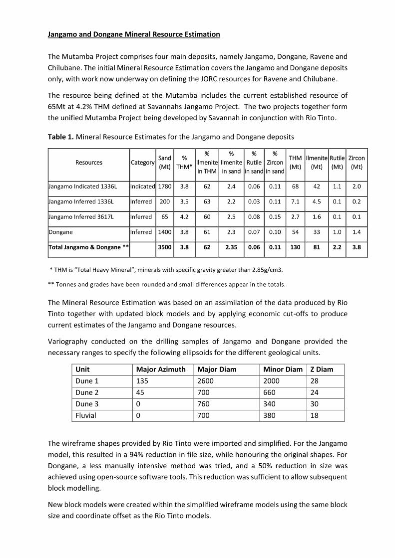
in Mozambique (the ‘Project’ or ‘Mutamba’) (Figures 1-4). Mutamba, which was previously
operated solely by Rio Tinto, forms part of the larger Mutamba/Jangamo Project currently
being developed under a Consortium Agreement between Savannah and Rio Tinto, as
announced on 11 October 2016. Savannah holds a 10% interest in the joint project with the
right to earn up to 51%, subject to key milestones being met.
HIGHLIGHTS:
Initial Indicated and Inferred Mineral Resource Estimate of 3.5 billion tonnes at 3.8%
Total Heavy Minerals (THM)
Mineral Resource Estimate contains 81 million tonnes (“Mt”) of ilmenite, 2.2Mt rutile
and 3.8Mt zircon
52% of Mineral Resource in the Indicated Category, 48% in the Inferred Category
Initial resource calculation covers the Jangamo and Dongane deposits at Mutamba –
note the Jangamo deposit includes both Rio Tinto’s Jangamo deposit and Savannahs
Jangamo deposit where an established resource of 65Mt at 4.2% THM was previously
defined
Resource compares favourably against Mozambique mineral sands producer
Kenmare Resources 31 December 2015 global resource of 6.5Bt at 2.9% THM and
mining reserve of 1.6Bt at 3.3%THM
Resource estimation in respect of the Ravene and Chilubane deposits still to be
completed
Mineral Resource Estimate of the Jangamo and Dongane deposits has defined large
areas of >5%THM, which will form the focus of the upcoming scoping study
A scoping study which is expected to take 3-4 months will commence shortly
Savannah’s CEO, David Archer said:
“The completion of our initial Mineral Resource Estimation of the Jangamo and Dongane
deposits is a major milestone for Savannah and our consortium partner, Rio Tinto. The results
underscore the fact that the Mutamba project is one of the largest ilmenite dominant, mineral
sands accumulations on the east coast of Africa.
“While we are delighted with the outcome, what it really means is that we now have an
exceptional foundation for our scoping study of the Project. The scoping study will focus on
the areas of mineral occurrence which are most prospective in terms of size and grade, with
little to no overburden factors, which should facilitate simple, low cost mining. Savannah
believes that there is an excellent opportunity to potentially define an initial phase, low capex,
long life, dry mining project of around a 200Mt well graded resource, associated with a series
of reworked coastal dunes.
“The Project is well located with easy access to a power line, the EN1 highway, the Inhambane
bay (which is naturally protected from the elements) and the Inhambane airport, providing
significant advantages to any potential development. We believe that the Inhambane and
Gaza Provinces, where the deposits are located, are an excellent investment destination
within the country.”
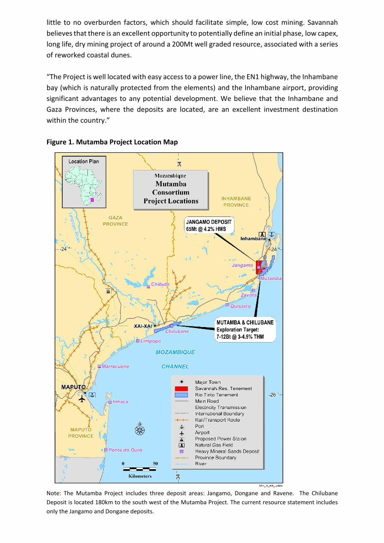
Figure 1. Mutamba Project Location Map
Note: The Mutamba Project includes three deposit areas: Jangamo, Dongane and Ravene. The Chilubane
Deposit is located 180km to the south west of the Mutamba Project. The current resource statement includes
only the Jangamo and Dongane deposits.
Jangamo and Dongane Mineral Resource Estimation
The Mutamba Project comprises four main deposits, namely Jangamo, Dongane, Ravene and
Chilubane. The initial Mineral Resource Estimation covers the Jangamo and Dongane deposits
only, with work now underway on defining the JORC resources for Ravene and Chilubane.
The resource being defined at the Mutamba includes the current established resource of
65Mt at 4.2% THM defined at Savannahs Jangamo Project. The two projects together form
the unified Mutamba Project being developed by Savannah in conjunction with Rio Tinto.
Table 1. Mineral Resource Estimates for the Jangamo and Dongane deposits
Resources Category Sand
(Mt)
%
THM*
%
Ilmenite
in THM
%
Ilmenite
in sand
%
Rutile
in sand
%
Zircon
in sand
THM
(Mt)
Ilmenite
(Mt)
Rutile
(Mt)
Zircon
(Mt)
Jangamo Indicated 1336L Indicated 1780 3.8 62 2.4 0.06 0.11 68 42 1.1 2.0
Jangamo Inferred 1336L Inferred 200 3.5 63 2.2 0.03 0.11 7.1 4.5 0.1 0.2
Jangamo Inferred 3617L Inferred 65 4.2 60 2.5 0.08 0.15 2.7 1.6 0.1 0.1
Dongane Inferred 1400 3.8 61 2.3 0.07 0.10 54 33 1.0 1.4
Total Jangamo & Dongane ** 3500 3.8 62 2.35 0.06 0.11 130 81 2.2 3.8
* THM is “Total Heavy Mineral”, minerals with specific gravity greater than 2.85g/cm3.
** Tonnes and grades have been rounded and small differences appear in the totals.
The Mineral Resource Estimation was based on an assimilation of the data produced by Rio
Tinto together with updated block models and by applying economic cut-offs to produce
current estimates of the Jangamo and Dongane resources.
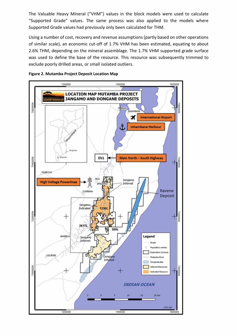
Variography conducted on the drilling samples of Jangamo and Dongane provided the
necessary ranges to specify the following ellipsoids for the different geological units.
Unit Major Azimuth Major Diam Minor Diam Z Diam
Dune 1 135 2600 2000 28
Dune 2 45 700 660 24
Dune 3 0 760 340 30
Fluvial 0 700 380 18
The wireframe shapes provided by Rio Tinto were imported and simplified. For the Jangamo
model, this resulted in a 94% reduction in file size, while honouring the original shapes. For
Dongane, a less manually intensive method was tried, and a 50% reduction in size was
achieved using open-source software tools. This reduction was sufficient to allow subsequent
block modelling.
New block models were created within the simplified wireframe models using the same block
size and coordinate offset as the Rio Tinto models.
The Valuable Heavy Mineral (“VHM”) values in the block models were used to calculate
“Supported Grade” values. The same process was also applied to the models where
Supported Grade values had previously only been calculated for THM.
Using a number of cost, recovery and revenue assumptions (partly based on other operations
of similar scale), an economic cut-off of 1.7% VHM has been estimated, equating to about
2.6% THM, depending on the mineral assemblage. The 1.7% VHM supported grade surface
was used to define the base of the resource. This resource was subsequently trimmed to
exclude poorly drilled areas, or small isolated outliers.
Figure 2. Mutamba Project Deposit Location Map
Figure 3. Drill hole location map for the Jangamo and Dongane Deposits
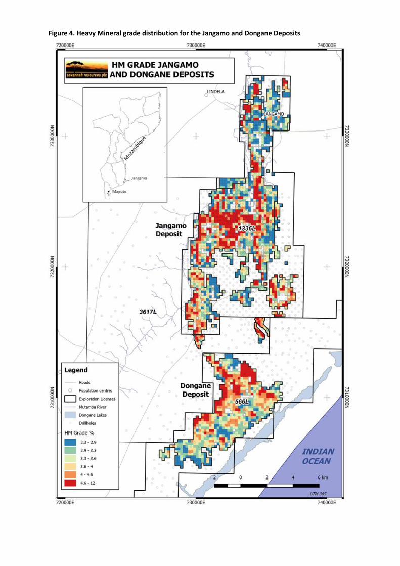
Figure 4. Heavy Mineral grade distribution for the Jangamo and Dongane Deposits

Competent Person
The information in this document that relates to exploration results is based upon information
compiled by Mr Dale Ferguson, Technical Director of Savannah Resources Limited. Mr
Ferguson is a Member of the Australian Institute of Mining and Metallurgy (AusIMM) and has
sufficient experience which is relevant to the style of mineralisation and type of deposit under
consideration and to the activity which he is undertaking to qualify as a Competent Person as
defined in the December 2012 edition of the “Australasian Code for Reporting of Exploration
Results, Mineral Resources and Ore Reserves” (JORC Code). Mr Ferguson consents to the
inclusion in the report of the matters based upon the information in the form and context in
which it appears.
The information in this document that relates to the resource estimation is based upon
information compiled by Mr Colin Rothnie, an independent consultant. Mr Rothnie is a
Member of the Australian Institute of Mining and Metallurgy (AusIMM) and has sufficient
experience which is relevant to the style of mineralisation and type of deposit under
consideration and to the activity which he is undertaking to qualify as a Competent Person as
defined in the December 2012 edition of the “Australasian Code for Reporting of Exploration
Results, Mineral Resources and Ore Reserves” (JORC Code). Mr Rothnie consents to the
inclusion in the report of the matters based upon the information in the form and context in
which it appears.
This announcement contains inside information for the purposes of Article 7 of
Regulation (EU) 596/2014.
**ENDS**
For further information please visit www.savannahresources.com or contact:
David Archer Savannah Resources plc Tel: +44 20 7117 2489
David Hignell / Gerry Beaney
(Nominated Adviser)
Northland Capital Partners
Ltd
Tel: +44 20 3861 6625
Jon Belliss / Elliot Hance
(Corporate Broker)
Beaufort Securities Ltd Tel: +44 20 7382 8300
Charlotte Page /
Lottie Brocklehurst
St Brides Partners Ltd Tel: +44 20 7236 1177
Notes
Savannah Resources Plc (AIM: SAV) is a growth oriented, multi-commodity, development
company.
Mozambique
Savannah operates combined projects with Rio Tinto, and can earn a 51% interest in heavy
mineral sands projects in Mozambique, which have a combined exploration target of 7-12Bn
tonnes at 3-4.5% THM (published in 2008). Under the terms of the agreement with Rio Tinto
Savannah must deliver the following to earn corresponding interest in the combined projects:
Scoping Study - 20%; pre-feasibility study - 35%; feasibility study – 51%. Additionally, the
Consortium Agreement includes an offtake agreement on commercial terms for the sale of
100% of production to Rio Tinto (or an affiliate).
Oman
Savannah has interests in two copper blocks in the highly prospective Semail Ophiolite Belt in
Oman. The projects, which have an Indicated and Inferred Mineral Resource of 1.7Mt @ 2.2%
copper and high grade intercepts of up to 56.35m at 6.21% Cu, with additional gold upside
potential, provide Savannah with an excellent opportunity to potentially evolve into a mid-
tier copper and gold producer in a relatively short time frame. Together with its Omani
partners, Savannah aims to outline further mineral resources to provide the critical mass for
a central operating plant to develop the deposits, and in December 2015 outlined exploration
targets of between 10,700,000 and 29,250,000 tonnes grading between 1.4% and 2.4%
copper.
Finland
Savannah has Reservation Permits over two new lithium projects, Somero and Erajarvi,
covering an area of 159km² in Finland. Savannah holds a 100% interest in these projects
through its Finnish subsidiary Finkallio Oy. Geological mapping by the Finnish Government
within the project areas has highlighted the presence of lithium minerals spodumene,
lepidolite and petalite with the Government also identifying Somero and Erajarvi as one of
the most prospective areas to discover lithium deposits in Finland. Savannah plans to initiate
an exploration programme including data compilation, geological mapping and surface
sampling with the aim of generating drill ready targets during 2016.
9
JORC Code, 2012 Edition – Table 1: Jangamo Deposit:
Indicated & Inferred Resource
Section 1 Sampling Techniques and Data
(Criteria in this section apply to all succeeding sections.)
Criteria JORC Code explanation Commentary
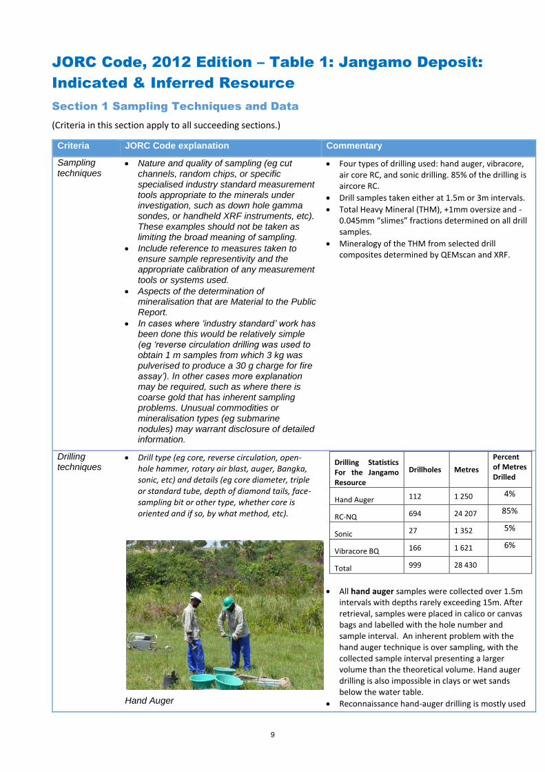
Sampling techniques
Nature and quality of sampling (eg cut channels, random chips, or specific specialised industry standard measurement tools appropriate to the minerals under investigation, such as down hole gamma sondes, or handheld XRF instruments, etc). These examples should not be taken as limiting the broad meaning of sampling.
Include reference to measures taken to ensure sample representivity and the appropriate calibration of any measurement tools or systems used.
Aspects of the determination of mineralisation that are Material to the Public Report.
In cases where ‘industry standard’ work has been done this would be relatively simple (eg ‘reverse circulation drilling was used to obtain 1 m samples from which 3 kg was pulverised to produce a 30 g charge for fire assay’). In other cases more explanation may be required, such as where there is coarse gold that has inherent sampling problems. Unusual commodities or mineralisation types (eg submarine nodules) may warrant disclosure of detailed information.
Four types of drilling used: hand auger, vibracore, air core RC, and sonic drilling. 85% of the drilling is aircore RC.
Drill samples taken either at 1.5m or 3m intervals.
Total Heavy Mineral (THM), +1mm oversize and -0.045mm “slimes” fractions determined on all drill samples.
Mineralogy of the THM from selected drill composites determined by QEMscan and XRF.
Drilling techniques
Drill type (eg core, reverse circulation, open-hole hammer, rotary air blast, auger, Bangka, sonic, etc) and details (eg core diameter, triple or standard tube, depth of diamond tails, face-sampling bit or other type, whether core is oriented and if so, by what method, etc).
Hand Auger
Drilling Statistics For the Jangamo Resource
Drillholes Metres
Percent of Metres Drilled
Hand Auger 112 1 250 4%
RC-NQ 694 24 207 85%
Sonic 27 1 352 5%
Vibracore BQ 166 1 621 6%
Total 999 28 430
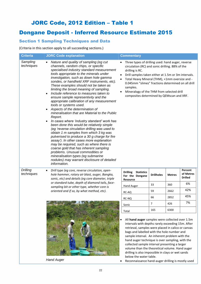
All hand auger samples were collected over 1.5m intervals with depths rarely exceeding 15m. After retrieval, samples were placed in calico or canvas bags and labelled with the hole number and sample interval. An inherent problem with the hand auger technique is over sampling, with the collected sample interval presenting a larger volume than the theoretical volume. Hand auger drilling is also impossible in clays or wet sands below the water table.
Reconnaissance hand-auger drilling is mostly used
10
Criteria JORC Code explanation Commentary
Reverse Circulation
Vibracore
to locate the major anomalous mineralised areas. Sample quality is low compared to other drilling methods and hand-auger drillholes have been superceded with later drilling of better quality. However the hand-auger drillholes contain valuable mineralogy results, so they have been retained for the final block model.
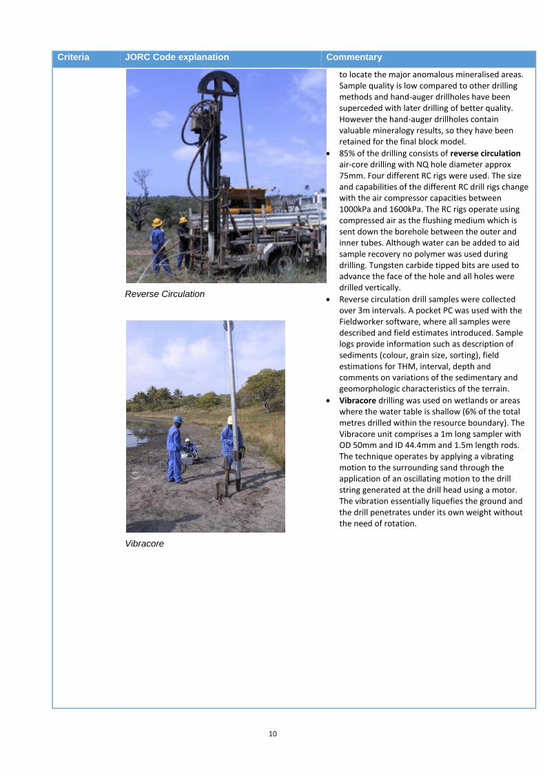
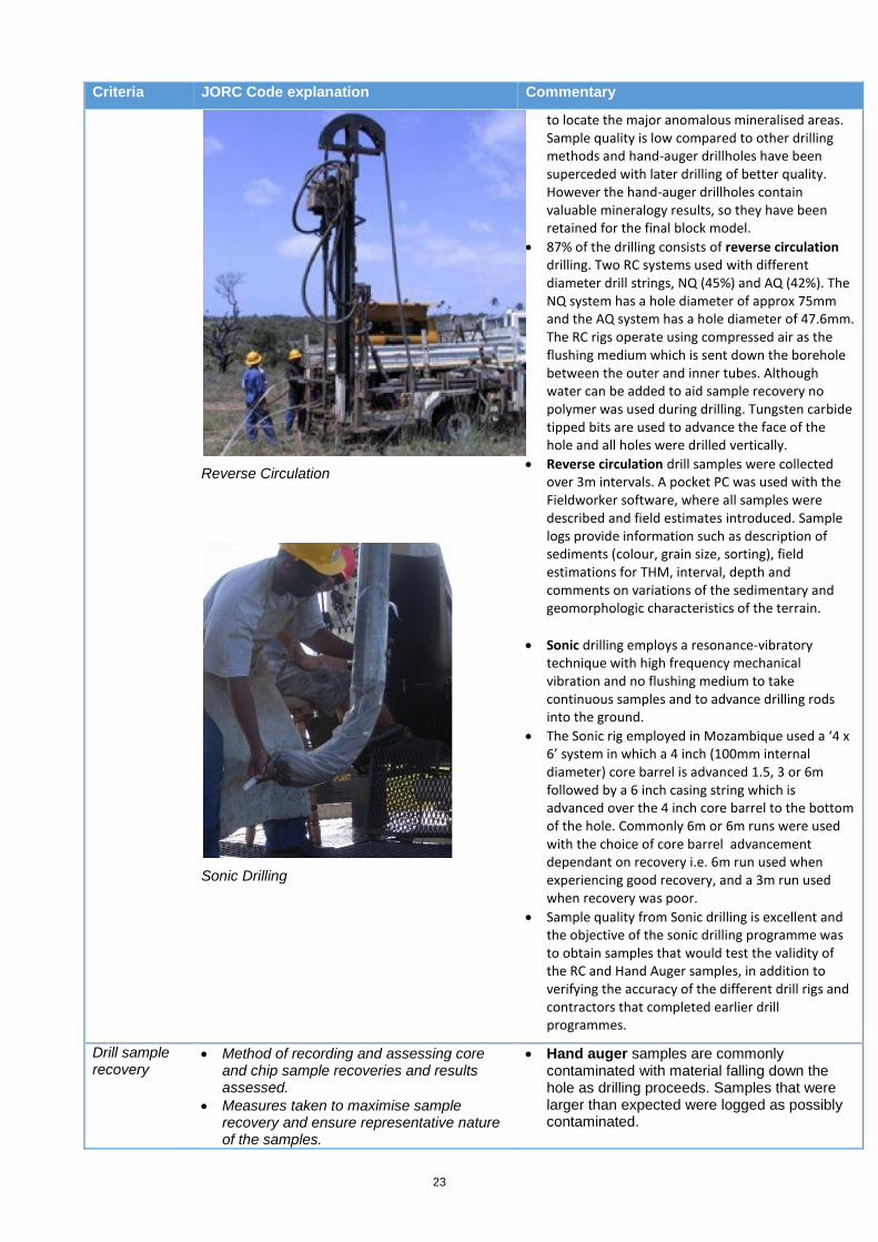
85% of the drilling consists of reverse circulation air-core drilling with NQ hole diameter approx 75mm. Four different RC rigs were used. The size and capabilities of the different RC drill rigs change with the air compressor capacities between 1000kPa and 1600kPa. The RC rigs operate using compressed air as the flushing medium which is sent down the borehole between the outer and inner tubes. Although water can be added to aid sample recovery no polymer was used during drilling. Tungsten carbide tipped bits are used to advance the face of the hole and all holes were drilled vertically.
Reverse circulation drill samples were collected over 3m intervals. A pocket PC was used with the Fieldworker software, where all samples were described and field estimates introduced. Sample logs provide information such as description of sediments (colour, grain size, sorting), field estimations for THM, interval, depth and comments on variations of the sedimentary and geomorphologic characteristics of the terrain.
Vibracore drilling was used on wetlands or areas where the water table is shallow (6% of the total metres drilled within the resource boundary). The Vibracore unit comprises a 1m long sampler with OD 50mm and ID 44.4mm and 1.5m length rods. The technique operates by applying a vibrating motion to the surrounding sand through the application of an oscillating motion to the drill string generated at the drill head using a motor. The vibration essentially liquefies the ground and the drill penetrates under its own weight without the need of rotation.
11
Criteria JORC Code explanation Commentary
Sonic Drilling
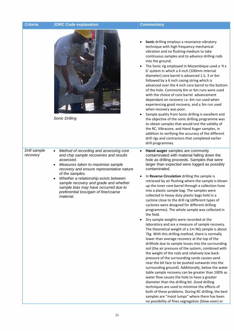
Sonic drilling employs a resonance-vibratory technique with high frequency mechanical vibration and no flushing medium to take continuous samples and to advance drilling rods into the ground.
The Sonic rig employed in Mozambique used a ‘4 x 6’ system in which a 4 inch (100mm internal diameter) core barrel is advanced 1.5, 3 or 6m followed by a 6 inch casing string which is advanced over the 4 inch core barrel to the bottom of the hole. Commonly 6m or 6m runs were used with the choice of core barrel advancement dependant on recovery i.e. 6m run used when experiencing good recovery, and a 3m run used when recovery was poor.
Sample quality from Sonic drilling is excellent and the objective of the sonic drilling programme was to obtain samples that would test the validity of the RC, Vibracore, and Hand Auger samples, in addition to verifying the accuracy of the different drill rigs and contractors that completed earlier drill programmes.
Drill sample recovery
Method of recording and assessing core and chip sample recoveries and results assessed.
Measures taken to maximise sample recovery and ensure representative nature of the samples.
Whether a relationship exists between sample recovery and grade and whether sample bias may have occurred due to preferential loss/gain of fine/coarse material.
Hand auger samples are commonly contaminated with material falling down the hole as drilling proceeds. Samples that were larger than expected were logged as possibly contaminated.
In Reverse Circulation drilling the sample is retrieved by air flushing where the sample is blown up the inner core barrel through a collection hose into a plastic sample bag. The samples were collected in heavy duty plastic bags held in a cyclone close to the drill rig (different types of cyclones were designed for different drilling programmes). The whole sample was collected in the field.
Dry sample weights were recorded at the laboratory and are a measure of sample recovery. The theoretical weight of a 1m NQ sample is about 7kg. With this drilling method, there is normally lower than average recovery at the top of the drillhole due to sample losses into the surrounding soil (the air pressure of the system, combined with the weight of the rods and relatively low back-pressure of the surrounding sands causes sand near the bit face to be pushed outwards into the surrounding ground). Additionally, below the water table sample recovery can be greater than 100% as water flow causes the hole to have a greater diameter than the drilling bit. Good drilling techniques are used to minimise the effects of both of these problems. During RC drilling, the best samples are “moist lumps” where there has been no possibility of fines segregation (blow-over) or
12
Criteria JORC Code explanation Commentary
losses of THM due to separation in water.
For the Vibracore drilling the drill string is advanced in 1.5m runs with the sample retrieved from each run using a hand pump. The hand pump has a gravity valve which is designed to allow sample to be pushed into the sampler and prevents it from being lost. The sample retrieved by the sampler is placed in buckets until the full depth of the interval is reached and then transferred to sample bags. Samples were dried and weighed at the laboratory, giving a measure of sample recovery.
Samples are retrieved from the Sonic drilling using a core barrel. Samples are vibrated out of the core barrel into a plastic sleeve, and present very much like a core sample (see the picture to the left). There is normally a small amount of sample compression with the sonic technique (associated with the wall thickness of the coring tubes), and the length of core retrieved is sometimes slightly longer than the penetration depth. Sonic drilling provides the best sample recovery and sample quality of all of the methods.
Logging Whether core and chip samples have been geologically and geotechnically logged to a level of detail to support appropriate Mineral Resource estimation, mining studies and metallurgical studies.
Whether logging is qualitative or quantitative in nature. Core (or costean, channel, etc) photography.
The total length and percentage of the relevant intersections logged.
Hand auger samples were recorded on paper field logs or electronically with Pocket PC devices.
RC samples were logged on-site using either a paper log or Pocket PC using the Fieldworker program. Sample logs provide information such as description of sediments (color, grain size, sorting), field estimates of THM, interval depth and comments on variations of the sedimentary and geomorphologic characteristics of the terrain.
Logging of the Vibracore samples was the same as for the reverse circulation and hand auger holes, all samples were logged on-site using a paper log or Pocket PC.
At the Sonic drilling sites, only small pinch was taken from the bottom of the core for description of the sample, estimation of THM% and deciding if the hole should be terminated. For each 3m or 6m interval of sample, this information was transcribed to a paper log for quick reference prior to the completion of the logging at camp.
Detailed sample logging was then completed at camp. The samples collected were logged in 3m intervals. For 6m runs, the measured length of the run was split in half producing two separate 3m samples. Each sample was logged using a paper log sheet which was later entered into the field database.
13
Criteria JORC Code explanation Commentary
Sub-sampling techniques and sample preparation
If core, whether cut or sawn and whether quarter, half or all core taken.
If non-core, whether riffled, tube sampled, rotary split, etc and whether sampled wet or dry.
For all sample types, the nature, quality and appropriateness of the sample preparation technique.
Quality control procedures adopted for all sub-sampling stages to maximise representivity of samples.
Measures taken to ensure that the sampling is representative of the in situ material collected, including for instance results for field duplicate/second-half sampling.
Whether sample sizes are appropriate to the grain size of the material being sampled.
Hand auger samples were homogenised and then reduced using “cone and quartering” splitting technique in the field.
For the RC, Vibracore and Sonic drilling methods, the whole drill samples were delivered to the laboratory.
After delivery to the Inhambane laboratory, samples were checked, dried and then riffle split down to a nominal size of 350g.
This split size is high (ie more conservative) relative to other operators globally, where heavy mineral sand sample splits of 100 to 200g are more common.
Sample duplicates were inserted at rate of 1:15 to check laboratory accuracy, with good results.
Sonic drillholes were used to “twin” earlier drilling as a check of in-situ values. The results showed good repeatability for the RC drilling, but only fair results for the hand-auger drilling. This is expected given the limitations of the method.
Quality of assay data and laboratory tests
The nature, quality and appropriateness of the assaying and laboratory procedures used and whether the technique is considered partial or total.
For geophysical tools, spectrometers, handheld XRF instruments, etc, the parameters used in determining the analysis including instrument make and model, reading times, calibrations factors applied and their derivation, etc.
Nature of quality control procedures adopted (eg standards, blanks, duplicates, external laboratory checks) and whether acceptable levels of accuracy (ie lack of bias) and precision have been established.
Sieving to determine +2mm (oversize) and -45micron (slimes).
Heavy mineral separation using heavy liquid to separate THM from other minerals (predominantly quartz).
Control procedures include laboratory duplicates, blind duplicates and standard samples.
In Rio Tinto labs, LST was used and density is monitored and kept above 2.85 Samples prepared at SGS were separated in TBE diluted with acetone to maintain a 2.85 density.
Verification of sampling and assaying
The verification of significant intersections by either independent or alternative company personnel.
The use of twinned holes.
Documentation of primary data, data entry procedures, data verification, data storage (physical and electronic) protocols.
Discuss any adjustment to assay data.
64 twinned holes completed. Sonic drillholes used to check other types of drilling show good correlation with RC and Vibracore drilling, but lower correlation with hand-auger results (this may reflect the lower survey accuracy of the hand auger holes than problems with the drilling technique itself). Twin holes of RC/RC and Vibracore/Vibracore types show good correlation.
Most of the field data is entered into computers in the field. In places where paper logs are used, the information has been transcribed and entered into databases.
Samples are delivered to the laboratory with a sample submission form.
At the laboratory, samples are checked against the submission document and entered into the laboratory systems.
Different laboratories were used. Those with the best practices used barcode control and scales linked to the computer systems (laboratory information management systems - LIMS). Other
14
Criteria JORC Code explanation Commentary
laboratories recorded results by hand and transcribed them into the database systems. These systems are inherently less reliable due to typographical and hand-writing errors, however at the time of the analyses, this was the method used at many major commercial laboratories.
Assays and other drilling data are recorded in the Acquire data management system, which includes many integrity checks.
No adjustments have been made to the laboratory data.
Location of data points
Accuracy and quality of surveys used to locate drill holes (collar and down-hole surveys), trenches, mine workings and other locations used in Mineral Resource estimation.
Specification of the grid system used.
Quality and adequacy of topographic control.
The majority of holes used in the model were surveyed using differential GPS. Hand-held GPS was used to locate drillholes in the early phases of reconnaissance and exploration. Levels for drillholes not accurately surveyed were determined using LIDAR.
Drillholes are positioned using UTM zone 36S, WGS84 datum.
Despite the highly variable dune topography across much of the region, excellent control has been established using the LIDAR survey.
Data spacing and distribution
Data spacing for reporting of Exploration Results.
Whether the data spacing and distribution is sufficient to establish the degree of geological and grade continuity appropriate for the Mineral Resource and Ore Reserve estimation procedure(s) and classifications applied.
Whether sample compositing has been applied.
Drill spacing for much of the resource is 250 x 250m, although zones along the eastern side of the resource are at 350 x 350m drill spacing and a small area in the north-eastern section of the resource is drilled at 500 x 500m. Variography shows that the bulk of the resource lies within the variogram range of at least one drill sample. Areas that required a larger ellipsoid are found along the very edge of the resource, and in the 500 x 500m drilled zone in the north-east.
Sample composites were used to determine mineralogy of the THM.
Orientation of data in relation to geological structure
Whether the orientation of sampling achieves unbiased sampling of possible structures and the extent to which this is known, considering the deposit type.
If the relationship between the drilling orientation and the orientation of key mineralised structures is considered to have introduced a sampling bias, this should be assessed and reported if material.
Three geological units host the bulk of mineralisation: Dune 2, Dune 3 and Fluvial Unit.
Dune 2 shows no preferred horizontal direction in mineralisation trend.
Dune 3 and the Fluvial unit show a north-south trend. The drilling pattern does not preferentially sample the mineralisation in any unit.
Sample security
The measures taken to ensure sample security.
The largest risks to the samples are weathering of the containing bags and damage or loss to the bags during transport.
Large resistant plastic bags were used for the vibracore and reverse circulation samples. They were locally supplied and the quality was not always the same. On several occasions they were doubled to avoid mass loss during sampling. The sample identification number was written on aluminium tags placed inside the bags, in plastic
15
Criteria JORC Code explanation Commentary
tags with cable ties closing the bags and on the external part of the plastic bag. Samples collected at drill site were transported in the same day to camp sites, and within just few weeks transported to the laboratory warehouse. In camp site they were exposed to sunlight and rain, but were protected from the weather in the laboratory warehouse. During transport, a chain of custody was followed with sample dispatch forms, and samples received were reconciled with samples shipped. Nevertheless, handling and loading/unloading sample bags onto open trucks and pick ups sometimes caused damage to the bags. This damage resulted in loss of material and sample refusal by the laboratory. Improvements of the transportation were only achieved with constant monitoring by the supervisors and foremen.
Audits or reviews
The results of any audits or reviews of sampling techniques and data.
None for this project.
Section 2 Reporting of Exploration Results
(Criteria listed in the preceding section also apply to this section.)
Criteria JORC Code explanation Commentary
Mineral tenement and land tenure status
Type, reference name/number, location and ownership including agreements or material issues with third parties such as joint ventures, partnerships, overriding royalties, native title interests, historical sites, wilderness or national park and environmental settings.
The security of the tenure held at the time of reporting along with any known impediments to obtaining a licence to operate in the area.
Exploration Licence 1336L, of area 118.8 km2, lies approximately 25km south of the regional capital Inhambane and approximately 340km north east of the national capital Maputo. The lease is held by Rio Tinto Mining and Exploration Ltd, and subject to the joint venture agreement with Savannah Resources. The lease is due to expire on the 21 January 2018.
There are no known impediments to mining development, other than the normal social issues regarding relocation - if necessary.
Exploration done by other parties
Acknowledgment and appraisal of exploration by other parties.
Rio Tinto have conducted multiple phases of exploration on the area since 2000. The area was previously known to be mineralised.
Geology Deposit type, geological setting and style of mineralisation.
The Inhambane region contains vast quantities of reworked coastal sands that were deposited by the Limpopo River further south. Mineralisation at Jangamo is hosted in dune sands 6 to 10 km inland from the current coastline. Within the Jangamo area, four major units are recognised: Dune 1, Dune 2, Dune 3 and a Fluvial Unit. Most of the mineralisation at Jangamo is hosted by Dune 3 and the Fluvial Unit.
Drill hole Information
A summary of all information material to the understanding of the exploration results including a tabulation of the following information for all Material drill holes:
See Appendix 1 - drillhole intercept listing from the resource zone.
16
Criteria JORC Code explanation Commentary
o easting and northing of the drill hole collar
o elevation or RL (Reduced Level – elevation above sea level in metres) of the drill hole collar
o dip and azimuth of the hole o down hole length and interception
depth o hole length.
If the exclusion of this information is justified on the basis that the information is not Material and this exclusion does not detract from the understanding of the report, the Competent Person should clearly explain why this is the case.
Data aggregation methods
In reporting Exploration Results, weighting averaging techniques, maximum and/or minimum grade truncations (eg cutting of high grades) and cut-off grades are usually Material and should be stated.
Where aggregate intercepts incorporate short lengths of high grade results and longer lengths of low grade results, the procedure used for such aggregation should be stated and some typical examples of such aggregations should be shown in detail.
The assumptions used for any reporting of metal equivalent values should be clearly stated.
The grades of the drillhole intercepts listed in Appendix 1 are the average grades for the drillhole intercept of the resource. The resource is defined using the JANC block model with a boundary determined by maximising revenue from the model, assuming a set of costs, recoveries and revenues for the contained ilmenite, rutile and zircon (assumptions are listed below). The boundary generally matches the 1.7% VHM supported grade boundary. VHM is the sum of in-situ ilmenite percent, zircon percent and rutile percent.
Relationship between mineralisation widths and intercept lengths
These relationships are particularly important in the reporting of Exploration Results.
If the geometry of the mineralisation with respect to the drill hole angle is known, its nature should be reported.
If it is not known and only the down hole lengths are reported, there should be a clear statement to this effect (eg ‘down hole length, true width not known’).
The drillholes are vertical and the mineralisation is generally sub-horizontal.
Diagrams Appropriate maps and sections (with scales) and tabulations of intercepts should be included for any significant discovery being reported These should include, but not be limited to a plan view of drill hole collar locations and appropriate sectional views.
See Figure 1, Plan view Figure 2 Drillhole Plan and Figure 3, Jangamo THM Grade Figures 4 – 10 representative sections.
Balanced reporting
Where comprehensive reporting of all Exploration Results is not practicable, representative reporting of both low and high grades and/or widths should be practiced to avoid misleading reporting of Exploration Results.
All drillhole intercepts are listed in Appendix 1.
Other substantive exploration data
Other exploration data, if meaningful and material, should be reported including (but not limited to): geological observations; geophysical survey results; geochemical survey results; bulk samples – size and method of treatment; metallurgical test results; bulk density, groundwater,
Airborne geophysics was used to help target drilling. Magnetic and radiometric data are useful to detect mineralised areas. Detailed SRTM elevation data and LIDAR elevation data are also used to help interpret paleo-landforms.
Mineralogy was determined using QEMScan scanning electron microscopy on composite
17
Criteria JORC Code explanation Commentary
geotechnical and rock characteristics; potential deleterious or contaminating substances.
samples from the mineralised areas.
Slimes in the resource (the “fines” fraction, of less than 0.045 mm size) averages 7%. Smectites are only present in the basement.
No significant hard layers have been intersected in the drilling within the resource. Some paleosols between the dune units have elevated slimes.
Groundwater has been measured around the resource and a groundwater model created. In some areas the level of groundwater would need to be managed if it were being dry mined.
No “potentially acid forming” soils have been documented in the main mineralised zone. There is potential for some acid-forming materials to be present in the basement or small pockets of the fluvial unit.
Monazite levels are low.
Further work The nature and scale of planned further work (eg tests for lateral extensions or depth extensions or large-scale step-out drilling).
Diagrams clearly highlighting the areas of possible extensions, including the main geological interpretations and future drilling areas, provided this information is not commercially sensitive.
The boundaries of the resource are moderately well defined, and are strongly dependant on the mineral pricing. Further drilling on the north-eastern area of the resource would probably allow this area to be upgraded.
Work is planned to complete a Scoping Study and then Pre-Feasibility and Feasibility Studies.
Section 3 Estimation and Reporting of Mineral Resources
(Criteria listed in section 1, and where relevant in section 2, also apply to this section.)
Criteria JORC Code explanation Commentary
Database integrity
Measures taken to ensure that data has not been corrupted by, for example, transcription or keying errors, between its initial collection and its use for Mineral Resource estimation purposes.
Data validation procedures used.
Samples are panned in the field and the field estimate is the first check on the final reported result. Most of the drillholes are logged in the field and many of the laboratory analyses were completed without using manually typed results.
The drilling data is loaded and held in an AcQuire database, where data integrity is checked in many ways.
Drilling results are checked on cross-section, where grade anomalies are easily spotted.
Site visits Comment on any site visits undertaken by the Competent Person and the outcome of those visits.
If no site visits have been undertaken indicate why this is the case.
The Competent Person visited the resource site during 2014 to assess regional geology and drilling work on the adjoining mineralisation on Savannah lease 3617L.
Geological interpretation
Confidence in (or conversely, the uncertainty of ) the geological interpretation of the mineral deposit.
Nature of the data used and of any assumptions made.
The effect, if any, of alternative interpretations on Mineral Resource estimation.
The use of geology in guiding and controlling Mineral Resource estimation.
The mineralised sands are windblown dune sands and reworked fluvial sands probably originally derived from beach strandline sediments where the heavy minerals were originally concentrated. At Jangamo the recent dunes are arcuate and many have long inverted U shapes. They climb up and also incorporate reworked sand from older dunes that form a prominent ridge in the area.
The heavy mineral content of the sand is one of its main distinguishing geological characteristics,
18
Criteria JORC Code explanation Commentary
The factors affecting continuity both of grade and geology.
indicating that natural concentrating mechanisms have been active at some stage during its past. Additionally, the slimes and oversize contents of the sand are indicators of previous geological environments.
Block model grades are estimated using samples only from within the same geological unit.
Dimensions
The extent and variability of the Mineral Resource expressed as length (along strike or otherwise), plan width, and depth below surface to the upper and lower limits of the Mineral Resource.
Mineralisation extends for 20km north-south and is of variable width, up to 6km wide in the centre. At the northern end, mineralisation is a linear zone of about 7.5km long and 1.5km wide. At the southern end mineralisation divides into an eastern and western portion, each approximately 2km wide. The dune topography is variable, but mineralisation averages 18m thickness, and has a maximum thickness of 54m. Mineralisation generally extends up to the surface.
Mineralisation is highest grade in the centre of the deposit (see Figure 3).
Estimation and modelling techniques
The nature and appropriateness of the estimation technique(s) applied and key assumptions, including treatment of extreme grade values, domaining, interpolation parameters and maximum distance of extrapolation from data points. If a computer assisted estimation method was chosen include a description of computer software and parameters used.
The availability of check estimates, previous estimates and/or mine production records and whether the Mineral Resource estimate takes appropriate account of such data.
The assumptions made regarding recovery of by-products.
Estimation of deleterious elements or other non-grade variables of economic significance (eg sulphur for acid mine drainage characterisation).
In the case of block model interpolation, the block size in relation to the average
sample spacing and the search employed.
Any assumptions behind modelling of selective mining units.
Any assumptions about correlation between variables.
Description of how the geological interpretation was used to control the resource estimates.
Discussion of basis for using or not using grade cutting or capping.
The process of validation, the checking process used, the comparison of model data to drill hole data, and use of reconciliation data if available.
The estimate is based on a block model that extends beyond the resource boundaries and was created using all of the available data. The block model uses anisotropic search ellipsoids based on semi-variogram ranges for each of the different geology units. Where the search ellipsoid fails to find a sample within the range, it is expanded by a factor of three. For THM, slimes and oversize assays, all blocks were allocated values. The available mineral assemblage data was used to estimate the percentage of ilmenite, zircon and rutile in the THM.
JANC Ellipsoid Details
Unit Major Azimuth
Major Diam
Minor Diam
Z Diam
Dune 1 135 2600 2000 28
Dune 2 45 700 660 24
Dune 3 0 760 340 30
Fluvial 0 700 380 18
The model is based on a detailed geological interpretation which divides the resource area into four major units Dune 1, Dune 2, Dune 3 and a Fluvial unit. The highest grade mineralisation is found within the Dune 3 unit and the Fluvial unit, but the other two units are also mineralised.
The blocks used are 200 x 200 x 3m in size. Block averages were estimated using inverse distance cubed algorithm. Earlier estimates (which gave similar overall results) used inverse distance squared algorithm.
Estimates only used drill assays from within the same geological unit.
The drilling contains a mixture of 3m and 1.5m samples, so all samples were digitally “re-sampled” at 1.5m intervals to ensure equal weighting.
19
Criteria JORC Code explanation Commentary
Grades were not cut, as there are no obvious high grade outliers in the data set.
Verification: Previous block models have been created in the same area as drilling progressed. The results are similar to the current model.
The model was checked visually to ensure the average drillhole grades were modelled correctly in the block model.
The average THM grade of the assayed drill intersections is 4.0%, compared to block model average of 3.9% THM. The small difference may be attributed to the lower drilling density in some of the lower grade peripheral zones.
Moisture Whether the tonnages are estimated on a dry basis or with natural moisture, and the method of determination of the moisture content.
Tonnages are estimated dry.
Cut-off parameters
The basis of the adopted cut-off grade(s) or quality parameters applied.
The percentage of valuable minerals (VHM) in the heavy mineral assemblage varies across the deposit from 50% to 89%, averaging 65%. The resource boundary has been determined using economic and processing factors described below. The boundary is generally close to 1.7% VHM, which equates roughly to 2.6% THM, although it varies from 1.9% THM to 3.4% THM.
The resource boundary is determined using the following major assumptions: overall wet concentrator THM recovery 75%, ilmenite, zircon and rutile spiral recoveries 92%, 90% and 80% respectively. MSP recoveries: ilmenite 85%, zircon 75%, rutile 30%. Mineral prices ilmenite $185, zircon $1200, rutile $800*. Area disturbance costs (including rehab) are assumed at $1.90 per square metre, and an expansion factor of 1.4 is applied to allow for off-orebody disturbance. Mining costs and wet concentration $1.32 per ton of ore mined, MSP treatment $25/t of HMC (Heavy Mineral Concentrate), mine & MSP fixed costs $30/t HMC, HMC and product transport costs $15/t HMC. Slimes treatment is estimated at $3/t of slimes in the ore that exceeds 5% (which is assumed to be fixed in the sand tailings).
Using these assumptions, mining 50 tonnes of ore at 2.5% THM (1.63% VHM) costs $72. After processing, transport and fixed costs are subtracted, the value of the ilmenite, zircon and rutile in that 1 tonne of HMC is also $72.
* The mineral prices used in the resource estimation are entirely based on price trend evaluations by the Competent Person. More detailed costs and revenues will be estimated during feasibility studies.
Mining factors or assumptions
Assumptions made regarding possible mining methods, minimum mining dimensions and internal (or, if applicable, external) mining dilution. It is always necessary as part of the process of determining reasonable prospects for
Dredge mining is assumed to be the most likely mining method – especially where the ore grades are marginal. High grade zones within the resource would probably support dry mining.
20
Criteria JORC Code explanation Commentary
eventual economic extraction to consider potential mining methods, but the assumptions made regarding mining methods and parameters when estimating Mineral Resources may not always be rigorous. Where this is the case, this should be reported with an explanation of the basis of the mining assumptions made.
Metallurgical factors or assumptions
The basis for assumptions or predictions regarding metallurgical amenability. It is always necessary as part of the process of determining reasonable prospects for eventual economic extraction to consider potential metallurgical methods, but the assumptions regarding metallurgical treatment processes and parameters made when reporting Mineral Resources may not always be rigorous. Where this is the case, this should be reported with an explanation of the basis of the metallurgical assumptions made.
Metallurgical assumptions are listed above in determination of economic cut-off. Basic mineralogy has been determined by QEMscan, with XRF quantitative support. Several bulk samples have been tested with small scall mineral processing and laboratory scale benchtop tests. The results show good recoveries of good quality product. Further bulk sampling work is planned as part of on-going studies.
Environmen-tal factors or assumptions
Assumptions made regarding possible waste and process residue disposal options. It is always necessary as part of the process of determining reasonable prospects for eventual economic extraction to consider the potential environmental impacts of the mining and processing operation. While at this stage the determination of potential environmental impacts, particularly for a greenfields project, may not always be well advanced, the status of early consideration of these potential environmental impacts should be reported. Where these aspects have not been considered this should be reported with an explanation of the environmental assumptions made.
Mining tailings will be initially stored in a dedicated tails storage facility until sufficient mining void has been opened up to allow in-pit tailings disposal. Slimes will probably be disposed of with the sand tails, or in slimes paddocks built in the original tails disposal facility.
Tailings from the MSP would be disposed of in the mining void near the MSP. These are benign and will be covered with sand and soil prior to hand-back to the community.
The mine will require a certain amount of ground disturbance, but this will be rehabilitated progressively as the mine advances.
Several watercourses pass near the resource and small excisions are likely when detailed drilling is completed.
Several villages lie on or near the resource and eventually a decision will be needed whether to resettle or excise these parts of the resource.
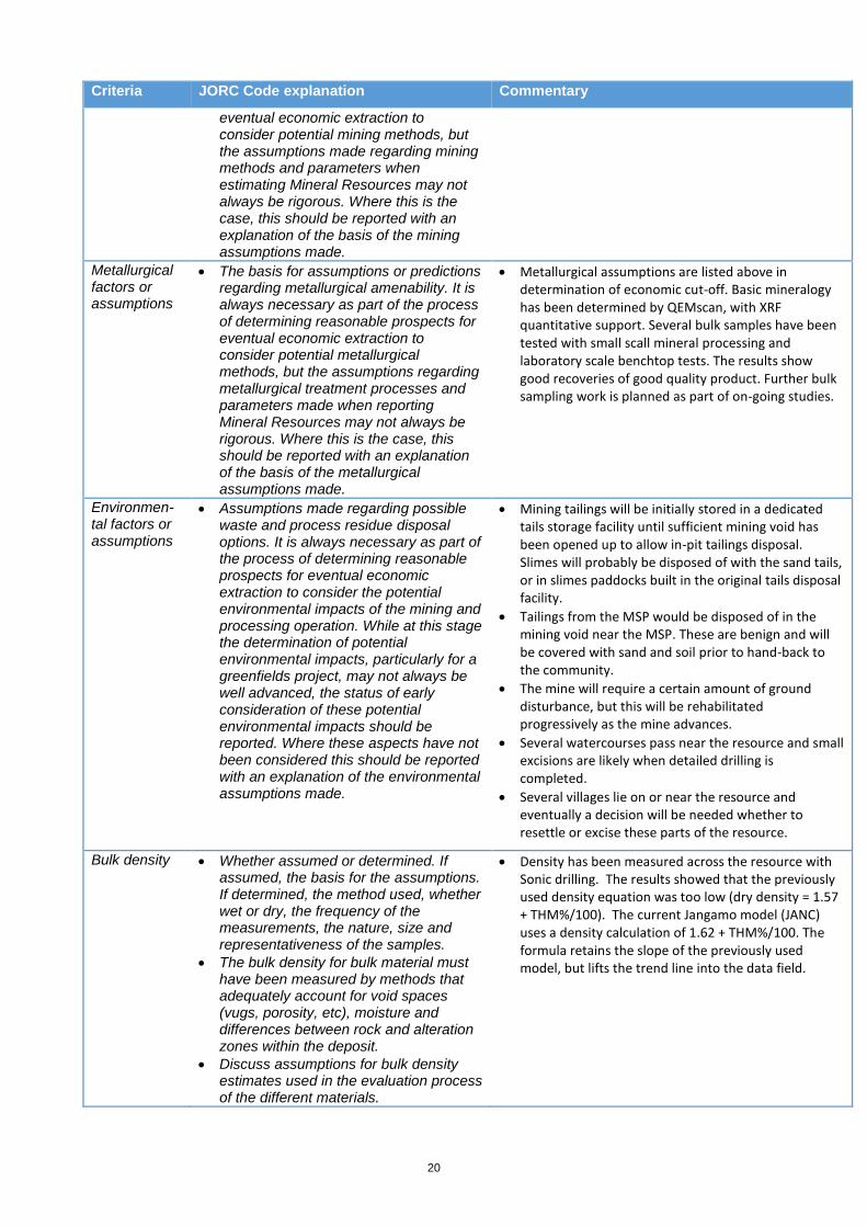
Bulk density Whether assumed or determined. If assumed, the basis for the assumptions. If determined, the method used, whether wet or dry, the frequency of the measurements, the nature, size and representativeness of the samples.
The bulk density for bulk material must have been measured by methods that adequately account for void spaces (vugs, porosity, etc), moisture and differences between rock and alteration zones within the deposit.
Discuss assumptions for bulk density estimates used in the evaluation process of the different materials.
Density has been measured across the resource with Sonic drilling. The results showed that the previously used density equation was too low (dry density = 1.57 + THM%/100). The current Jangamo model (JANC) uses a density calculation of 1.62 + THM%/100. The formula retains the slope of the previously used model, but lifts the trend line into the data field.
21
Criteria JORC Code explanation Commentary
Classification The basis for the classification of the Mineral Resources into varying confidence categories.
Whether appropriate account has been taken of all relevant factors (ie relative confidence in tonnage/grade estimations, reliability of input data, confidence in continuity of geology and metal values, quality, quantity and distribution of the data).
Whether the result appropriately reflects the Competent Person’s view of the deposit.
Areas of the resource drilled at 250 x 250m spacings or 350 x 350m spacings are classified as Indicated. Areas drilled at 500 x 500 are classified as Inferred.
The current classification was prepared by and reflects the view of the Competent Person.
Audits or reviews
The results of any audits or reviews of Mineral Resource estimates.
Previous reviews recommended further in-fill drilling, and development of a cut-off grade and mining scenario that can be supported by a marketing strategy and business development scenario.
Discussion of relative accuracy/ confidence
Where appropriate a statement of the relative accuracy and confidence level in the Mineral Resource estimate using an approach or procedure deemed appropriate by the Competent Person. For example, the application of statistical or geostatistical procedures to quantify the relative accuracy of the resource within stated confidence limits, or, if such an approach is not deemed appropriate, a qualitative discussion of the factors that could affect the relative accuracy and confidence of the estimate.
The statement should specify whether it relates to global or local estimates, and, if local, state the relevant tonnages, which should be relevant to technical and economic evaluation. Documentation should include assumptions made and the procedures used.
These statements of relative accuracy and confidence of the estimate should be compared with production data, where available.
In the view of the Competent Person the accuracy and confidence in the THM grades and mineralogy are such that with further in-fill work, the final ore grade and mineral characteristics are unlikely to be different to the current estimate than by more than 15%. The resource boundaries are more affected by mineral economics than by small scale in-ground mineral variation.
At the time of writing, the mineral prices used in the modelling are higher than the current market rates. However, current market prices are widely regarded as being unsustainable in the long term as many mineral producers are not currently profitable. In the view of the Competent Person, the assumed mineral prices are slightly conservative long-term mineral prices.
22
JORC Code, 2012 Edition – Table 1
Dongane Deposit - Inferred Resource Estimate 2015
Section 1 Sampling Techniques and Data
(Criteria in this section apply to all succeeding sections.)
Criteria JORC Code explanation Commentary
Sampling techniques
Nature and quality of sampling (eg cut channels, random chips, or specific specialised industry standard measurement tools appropriate to the minerals under investigation, such as down hole gamma sondes, or handheld XRF instruments, etc). These examples should not be taken as limiting the broad meaning of sampling.
Include reference to measures taken to ensure sample representivity and the appropriate calibration of any measurement tools or systems used.
Aspects of the determination of mineralisation that are Material to the Public Report.
In cases where ‘industry standard’ work has been done this would be relatively simple (eg ‘reverse circulation drilling was used to obtain 1 m samples from which 3 kg was pulverised to produce a 30 g charge for fire assay’). In other cases more explanation may be required, such as where there is coarse gold that has inherent sampling problems. Unusual commodities or mineralisation types (eg submarine nodules) may warrant disclosure of detailed information.
Three types of drilling used: hand auger, reverse circulation (RC) and sonic drilling. 88% of the drilling is RC.
Drill samples taken either at 1.5m or 3m intervals.
Total Heavy Mineral (THM), +1mm oversize and -0.045mm “slimes” fractions determined on all drill samples.
Mineralogy of the THM from selected drill composites determined by QEMscan and XRF.
Drilling techniques
Drill type (eg core, reverse circulation, open-hole hammer, rotary air blast, auger, Bangka, sonic, etc) and details (eg core diameter, triple or standard tube, depth of diamond tails, face-sampling bit or other type, whether core is oriented and if so, by what method, etc).
Hand Auger
Drilling Statistics For the Dongane Resource
Drillholes Metres
Percent of Metres Drilled
Hand Auger 33 360 6%
RC-AQ 59 2662 42%
RC-NQ 66 2852 45%
Sonic 7 426 7%
Total 165 6300
All hand auger samples were collected over 1.5m intervals with depths rarely exceeding 15m. After retrieval, samples were placed in calico or canvas bags and labelled with the hole number and sample interval. An inherent problem with the hand auger technique is over sampling, with the collected sample interval presenting a larger volume than the theoretical volume. Hand auger drilling is also impossible in clays or wet sands below the water table.
Reconnaissance hand-auger drilling is mostly used
23
Criteria JORC Code explanation Commentary
Reverse Circulation
Sonic Drilling
to locate the major anomalous mineralised areas. Sample quality is low compared to other drilling methods and hand-auger drillholes have been superceded with later drilling of better quality. However the hand-auger drillholes contain valuable mineralogy results, so they have been retained for the final block model.
87% of the drilling consists of reverse circulation drilling. Two RC systems used with different diameter drill strings, NQ (45%) and AQ (42%). The NQ system has a hole diameter of approx 75mm and the AQ system has a hole diameter of 47.6mm. The RC rigs operate using compressed air as the flushing medium which is sent down the borehole between the outer and inner tubes. Although water can be added to aid sample recovery no polymer was used during drilling. Tungsten carbide tipped bits are used to advance the face of the hole and all holes were drilled vertically.
Reverse circulation drill samples were collected over 3m intervals. A pocket PC was used with the Fieldworker software, where all samples were described and field estimates introduced. Sample logs provide information such as description of sediments (colour, grain size, sorting), field estimations for THM, interval, depth and comments on variations of the sedimentary and geomorphologic characteristics of the terrain.
Sonic drilling employs a resonance-vibratory technique with high frequency mechanical vibration and no flushing medium to take continuous samples and to advance drilling rods into the ground.
The Sonic rig employed in Mozambique used a ‘4 x 6’ system in which a 4 inch (100mm internal diameter) core barrel is advanced 1.5, 3 or 6m followed by a 6 inch casing string which is advanced over the 4 inch core barrel to the bottom of the hole. Commonly 6m or 6m runs were used with the choice of core barrel advancement dependant on recovery i.e. 6m run used when experiencing good recovery, and a 3m run used when recovery was poor.
Sample quality from Sonic drilling is excellent and the objective of the sonic drilling programme was to obtain samples that would test the validity of the RC and Hand Auger samples, in addition to verifying the accuracy of the different drill rigs and contractors that completed earlier drill programmes.
Drill sample recovery
Method of recording and assessing core and chip sample recoveries and results assessed.
Measures taken to maximise sample recovery and ensure representative nature of the samples.
Hand auger samples are commonly contaminated with material falling down the hole as drilling proceeds. Samples that were larger than expected were logged as possibly contaminated.
24
Criteria JORC Code explanation Commentary
Whether a relationship exists between sample recovery and grade and whether sample bias may have occurred due to preferential loss/gain of fine/coarse material.
In Reverse Circulation drilling the sample is retrieved by air flushing where the sample is blown up the inner core barrel through a collection hose into a plastic sample bag. The samples were collected in heavy duty plastic bags held in a cyclone close to the drill rig (different types of cyclones were designed for different drilling programmes). The whole sample was collected in the field.
Dry sample weights were recorded at the laboratory and are a measure of sample recovery. The theoretical weight of a 1m NQ sample is about 7kg. With this drilling method, there is normally lower than average recovery at the top of the drillhole due to sample losses into the surrounding soil (the air pressure of the system, combined with the weight of the rods and relatively low back-pressure of the surrounding sands causes sand near the bit face to be pushed outwards into the surrounding ground). Additionally, below the water table sample recovery can be greater than 100% as water flow causes the hole to have a greater diameter than the drilling bit. Good drilling techniques are used to minimise the effects of both of these problems. During RC drilling, the best samples are “moist lumps” where there has been no possibility of fines segregation (blow-over) or losses of THM due to separation in water.
Samples are retrieved from the Sonic drilling using a core barrel. Samples are vibrated out of the core barrel into a plastic sleeve, and present very much like a core sample (see the picture to the left). There is normally a small amount of sample compression with the sonic technique (associated with the wall thickness of the coring tubes), and the length of core retrieved is sometimes slightly longer than the penetration depth. Sonic drilling provides the best sample recovery and sample quality of all of the methods.
Logging Whether core and chip samples have been geologically and geotechnically logged to a level of detail to support appropriate Mineral Resource estimation, mining studies and metallurgical studies.
Whether logging is qualitative or quantitative in nature. Core (or costean, channel, etc) photography.
The total length and percentage of the relevant intersections logged.
Hand auger samples were recorded on paper field logs or electronically with Pocket PC devices.
RC samples were logged on-site using either a paper log or Pocket PC using the Fieldworker program. Sample logs provide information such as description of sediments (color, grain size, sorting), field estimates of THM, interval depth and comments on variations of the sedimentary and geomorphologic characteristics of the terrain.
At the Sonic drilling sites, only small pinch was taken from the bottom of the core for description of the sample, estimation of THM% and deciding if the hole should be terminated. For each 3m or 6m
25
Criteria JORC Code explanation Commentary
interval of sample, this information was transcribed to a paper log for quick reference prior to the completion of the logging at camp.
Detailed sample logging was then completed at camp. The samples collected were logged in 3m intervals. For 6m runs, the measured length of the run was split in half producing two separate 3m samples. Each sample was logged using a paper log sheet which was later entered into the field database.
Sub-sampling techniques and sample preparation
If core, whether cut or sawn and whether quarter, half or all core taken.
If non-core, whether riffled, tube sampled, rotary split, etc and whether sampled wet or dry.
For all sample types, the nature, quality and appropriateness of the sample preparation technique.
Quality control procedures adopted for all sub-sampling stages to maximise representivity of samples.
Measures taken to ensure that the sampling is representative of the in situ material collected, including for instance results for field duplicate/second-half sampling.
Whether sample sizes are appropriate to the grain size of the material being sampled.
Hand auger samples were homogenised and then reduced using “cone and quartering” splitting technique in the field.
For the RC and Sonic drilling methods, the whole drill samples were delivered to the laboratory.
After delivery to the Inhambane laboratory, samples were checked, dried and then riffle split down to a nominal size of 350g.
This split size is high (ie more conservative) relative to other operators globally, where heavy mineral sand sample splits of 100 to 200g are more common.
Sample duplicates were inserted at rate of 1:15 to check laboratory accuracy, with good results.
Sonic drillholes were used to “twin” earlier drilling as a check of in-situ values. The results showed good repeatability for the RC drilling, but only fair results for the hand-auger drilling. This is expected given the limitations of the method.
Quality of assay data and laboratory tests
The nature, quality and appropriateness of the assaying and laboratory procedures used and whether the technique is considered partial or total.
For geophysical tools, spectrometers, handheld XRF instruments, etc, the parameters used in determining the analysis including instrument make and model, reading times, calibrations factors applied and their derivation, etc.
Nature of quality control procedures adopted (eg standards, blanks, duplicates, external laboratory checks) and whether acceptable levels of accuracy (ie lack of bias) and precision have been established.
Sieving to determine +2mm (oversize) and -45micron (slimes).
Heavy mineral separation using heavy liquid to separate THM from other minerals (predominantly quartz).
Control procedures include laboratory duplicates, blind duplicates and standard samples.
In Rio Tinto labs, LST was used and density is monitored and kept above 2.85 Samples prepared at SGS were separated in TBE diluted with acetone to maintain a 2.85 density.
Verification of sampling and assaying
The verification of significant intersections by either independent or alternative company personnel.
The use of twinned holes.
Documentation of primary data, data entry procedures, data verification, data storage (physical and electronic) protocols.
Discuss any adjustment to assay data.
64 twinned holes were completed in Dongane and surrounding Mutamba area. Sonic drillholes used to check other types of drilling show good correlation with RC drilling, but lower correlation with hand-auger results (this may reflect the lower survey accuracy of the hand auger holes than problems with the drilling technique itself). Twin holes of RC/RC types also show good correlation.
Most of the field data is entered into computers in the field. In places where paper logs are used, the information has been transcribed and entered into databases.
26
Criteria JORC Code explanation Commentary
Samples are delivered to the laboratory with a sample submission form.
At the laboratory, samples are checked against the submission document and entered into the laboratory systems.
Different laboratories were used. Those with the best practices used barcode control and scales linked to the computer systems (laboratory information management systems - LIMS). Other laboratories recorded results by hand and transcribed them into the database systems. These systems are inherently less reliable due to typographical and hand-writing errors, however at the time of the analyses, this was the method used at many major commercial laboratories.
Assays and other drilling data are recorded in the Acquire data management system, which includes many integrity checks.
No adjustments have been made to the laboratory data.
Location of data points
Accuracy and quality of surveys used to locate drill holes (collar and down-hole surveys), trenches, mine workings and other locations used in Mineral Resource estimation.
Specification of the grid system used.
Quality and adequacy of topographic control.
The majority of holes used in the model were surveyed using differential GPS. Hand-held GPS was used to locate drillholes in the early phases of reconnaissance and exploration. Elevations of all Dongane collars have been determined using LIDAR.
Drillholes are positioned using UTM zone 36S, WGS84 datum.
Despite the highly variable dune topography across much of the region, excellent control has been established using the LIDAR survey.
Data spacing and distribution
Data spacing for reporting of Exploration Results.
Whether the data spacing and distribution is sufficient to establish the degree of geological and grade continuity appropriate for the Mineral Resource and Ore Reserve estimation procedure(s) and classifications applied.
Whether sample compositing has been applied.
Drill spacing for the resource is 500 x 500m.
Sample composites were used to determine mineralogy of the THM.
Orientation of data in relation to geological structure
Whether the orientation of sampling achieves unbiased sampling of possible structures and the extent to which this is known, considering the deposit type.
If the relationship between the drilling orientation and the orientation of key mineralised structures is considered to have introduced a sampling bias, this should be assessed and reported if material.
Two geological units host the bulk of mineralisation at Dongane: Dune 2 and Dune 3. The resource model is limited to these two units.
The drill spacing of 500 x 500m is too sparse to determine small scale mineralisation trends.
More closely spaced drilling on the adjacent Jangamo deposit demonstrated that Dune 2 shows no preferred horizontal direction in mineralisation trend and Dune 3 shows a north-south trend.
Sample security
The measures taken to ensure sample security.
The largest risks to the samples are weathering of the containing bags and damage or loss to the bags during transport.
Large resistant plastic bags were used for the vibracore and reverse circulation samples. They
27
Criteria JORC Code explanation Commentary
were locally supplied and the quality was not always the same. On several occasions they were doubled to avoid mass loss during sampling. The sample identification number was written on aluminium tags placed inside the bags, in plastic tags with cable ties closing the bags and on the external part of the plastic bag. Samples collected at drill site were transported in the same day to camp sites, and within just few weeks transported to the laboratory warehouse. In camp site they were exposed to sunlight and rain, but were protected from the weather in the laboratory warehouse. During transport, a chain of custody was followed with sample dispatch forms, and samples received were reconciled with samples shipped. Nevertheless, handling and loading/unloading sample bags onto open trucks and pick ups sometimes caused damage to the bags. This damage resulted in loss of material and sample refusal by the laboratory. Improvements of the transportation were only achieved with constant monitoring by the supervisors and foremen.
Audits or reviews
The results of any audits or reviews of sampling techniques and data.
An internal Competent Person review was conducted on the Mutamba Project. No recommendations were made to change sampling procedures.
Section 2 Reporting of Exploration Results
(Criteria listed in the preceding section also apply to this section.)
Criteria JORC Code explanation Commentary
Mineral tenement and land tenure status
Type, reference name/number, location and ownership including agreements or material issues with third parties such as joint ventures, partnerships, overriding royalties, native title interests, historical sites, wilderness or national park and environmental settings.
The security of the tenure held at the time of reporting along with any known impediments to obtaining a licence to operate in the area.
Exploration Licence 566L, of area 163.6 km2, lies approximately 25km south of the regional capital Inhambane and approximately 340km north east of the national capital Maputo. The area of the Dongane deposit lies approximately 50km south of Inhambane. The lease is held by Rio Tinto Mining and Exploration Ltd, and subject to the joint venture agreement with Savannah Resources. The lease is due to expire on the 21 January 2018.
There are no known impediments to mining development, other than the normal social issues regarding resettlement - if necessary.
Exploration done by other parties
Acknowledgment and appraisal of exploration by other parties.
Rio Tinto have conducted multiple phases of exploration on the area since 2000. The area was previously known to be mineralised.
Geology Deposit type, geological setting and style of mineralisation.
The Inhambane region contains vast quantities of reworked coastal sands that were deposited by the Limpopo River further south. Mineralisation at Dongane is hosted in dune sands 5 to 8 km inland from the current coastline. Within the Dongane area, three major units are recognised:
28
Criteria JORC Code explanation Commentary
Dune 1, Dune 2, Dune 3. Most of the mineralisation at Dongane is hosted by Dune 2 and Dune 3, and the higher slimes values for Dune 1 also make it unattractive. The resource model for Dongane is restricted to Dune 2 and Dune 3 units.
Drill hole Information
A summary of all information material to the understanding of the exploration results including a tabulation of the following information for all Material drill holes: o easting and northing of the drill hole
collar o elevation or RL (Reduced Level –
elevation above sea level in metres) of the drill hole collar
o dip and azimuth of the hole o down hole length and interception
depth o hole length.
If the exclusion of this information is justified on the basis that the information is not Material and this exclusion does not detract from the understanding of the report, the Competent Person should clearly explain why this is the case.
See Appendix 1 - drillhole intercept listing from the resource zone.
Data aggregation methods
In reporting Exploration Results, weighting averaging techniques, maximum and/or minimum grade truncations (eg cutting of high grades) and cut-off grades are usually Material and should be stated.
Where aggregate intercepts incorporate short lengths of high grade results and longer lengths of low grade results, the procedure used for such aggregation should be stated and some typical examples of such aggregations should be shown in detail.
The assumptions used for any reporting of metal equivalent values should be clearly stated.
The grades of the drillhole intercepts listed in Appendix 1 are the average grades for the drillhole intercept of the resource. The resource is defined using the DONR block model with a boundary determined by maximising revenue from the model, assuming a set of costs, recoveries and revenues for the contained ilmenite, rutile and zircon (assumptions are listed below). The boundary generally matches the 1.7% VHM supported grade boundary. VHM (Valuable Heavy Mineral) is the sum of in-situ ilmenite percent, zircon percent and rutile percent.
Relationship between mineralisation widths and intercept lengths
These relationships are particularly important in the reporting of Exploration Results.
If the geometry of the mineralisation with respect to the drill hole angle is known, its nature should be reported.
If it is not known and only the down hole lengths are reported, there should be a clear statement to this effect (eg ‘down hole length, true width not known’).
The drillholes are vertical and the mineralisation is generally sub-horizontal.
Diagrams Appropriate maps and sections (with scales) and tabulations of intercepts should be included for any significant discovery being reported These should include, but not be limited to a plan view of drill hole collar locations and appropriate sectional views.
See Figure 1, Plan view Figure 2 Drillhole Plan and Figure 3, Dongane THM Grade Figures 4 – 8 representative sections.
29
Criteria JORC Code explanation Commentary
Balanced reporting
Where comprehensive reporting of all Exploration Results is not practicable, representative reporting of both low and high grades and/or widths should be practiced to avoid misleading reporting of Exploration Results.
All drillhole intercepts are listed in Appendix 1.
Other substantive exploration data
Other exploration data, if meaningful and material, should be reported including (but not limited to): geological observations; geophysical survey results; geochemical survey results; bulk samples – size and method of treatment; metallurgical test results; bulk density, groundwater, geotechnical and rock characteristics; potential deleterious or contaminating substances.
Airborne geophysics was used to help target drilling. Magnetic and radiometric data are useful to detect mineralised areas. Detailed SRTM elevation data and LIDAR elevation data are also used to help interpret paleo-landforms.
Mineralogy was determined using QEMScan scanning electron microscopy on composite samples from the mineralised areas.
Slimes in the resource (the “fines” fraction, of less than 0.045 mm size) averages 7%. Smectites are only present in the basement.
No significant hard layers have been intersected in the drilling within the resource. Some paleosols between the dune units have elevated slimes.
Groundwater has been measured around the resource and a groundwater model created. Dongane mineralisation mostly lies above the water table.
No “potentially acid forming” soils have been documented in the main mineralised zone. There is potential for some acid-forming materials to be present in the basement or small pockets of the fluvial unit.
Monazite levels are low.
Further work The nature and scale of planned further work (eg tests for lateral extensions or depth extensions or large-scale step-out drilling).
Diagrams clearly highlighting the areas of possible extensions, including the main geological interpretations and future drilling areas, provided this information is not commercially sensitive.
Several areas near the main deposit were modelled as good mineralisation in the block model, but were excluded from the resource because of a lack of drilling (See Figure 3). These areas should be tested with further infill drilling.
Work is planned to complete a Scoping Study and then Pre-Feasibility and Feasibility Studies.
Section 3 Estimation and Reporting of Mineral Resources
(Criteria listed in section 1, and where relevant in section 2, also apply to this section.)
Criteria JORC Code explanation Commentary
Database integrity
Measures taken to ensure that data has not been corrupted by, for example, transcription or keying errors, between its initial collection and its use for Mineral Resource estimation purposes.
Data validation procedures used.
Samples are panned in the field and the field estimate is the first check on the final reported result. Most of the drillholes are logged in the field and many of the laboratory analyses were completed without using manually typed results.
The drilling data is loaded and held in an “Acquire” database, where data integrity is checked.
Drilling results are checked on cross-section, where grade anomalies are easily spotted.
Site visits Comment on any site visits undertaken by the Competent Person and the outcome of those visits.
The Competent Person visited the resource site during 2014 to assess regional geology and drilling work on the adjoining mineralisation on Savannah
30
Criteria JORC Code explanation Commentary
If no site visits have been undertaken indicate why this is the case.
lease 3617L.
Geological interpretation
Confidence in (or conversely, the uncertainty of ) the geological interpretation of the mineral deposit.
Nature of the data used and of any assumptions made.
The effect, if any, of alternative interpretations on Mineral Resource estimation.
The use of geology in guiding and controlling Mineral Resource estimation.
The factors affecting continuity both of grade and geology.
The mineralised sands are windblown dune sands probably originally derived from beach strandline sediments where the heavy minerals were originally concentrated. At Dongane the recent dunes are arcuate and many have long inverted U shapes. They climb up and also incorporate reworked sand from older dunes (Dune 1 unit) that form a prominent ridge in the area.
The heavy mineral content of the sand is one of its main distinguishing geological characteristics, indicating that natural concentrating mechanisms have been active at some stage during its past. Additionally, the slimes and oversize contents of the sand are indicators of previous geological environments.
Grades are relatively similar in the different geological units that host mineralisation, meaning that alternative geological interpretations will have little effect on the interpreted grades.
Dimensions
The extent and variability of the Mineral Resource expressed as length (along strike or otherwise), plan width, and depth below surface to the upper and lower limits of the Mineral Resource.
The currently defined resource boundary is shaped like an inverted boot with the length of the boot oriented NE-SW and the toe of the boot pointing towards the NW. The length of mineralisation is 9 km. The narrow part of the boot is 3km wide, but toe-to-heel it is 6.5km wide. The highest grade mineralisation is found in the arch of the heel and along the front “shin” section of the boot. (see Figure 3).
The dune topography is variable, but mineralisation averages 27m thickness, and has a maximum thickness of 93m. Mineralisation generally extends up to the surface. Several zones within the resource boundary are poorly mineralised and the resource boundary has been brought up to the surface in these areas.
Estimation and modelling techniques
The nature and appropriateness of the estimation technique(s) applied and key assumptions, including treatment of extreme grade values, domaining, interpolation parameters and maximum distance of extrapolation from data points. If a computer assisted estimation method was chosen include a description of computer software and parameters used.
The availability of check estimates, previous estimates and/or mine production records and whether the Mineral Resource estimate takes appropriate account of such data.
The assumptions made regarding recovery of by-products.
Estimation of deleterious elements or other non-grade variables of economic significance (eg sulphur for acid mine
The estimate is based on a block model that extends beyond the resource boundaries and was created using all of the available data. The block model uses anisotropic search ellipsoids based on semi-variogram ranges for each of the different geology units. Where the search ellipsoid fails to find a sample within the range, it is expanded by a factor of three. For THM, slimes and oversize assays, all blocks were allocated values. The available mineral assemblage data was used to estimate the percentage of ilmenite, zircon and rutile in the THM.
JANC Ellipsoid Details
Unit Major Azimuth
Major Diam
Minor Diam
Z Diam
Dune 2 45 700 660 24
Dune 3 0 760 340 30
31
Criteria JORC Code explanation Commentary
drainage characterisation).
In the case of block model interpolation, the block size in relation to the average
sample spacing and the search employed.
Any assumptions behind modelling of selective mining units.
Any assumptions about correlation between variables.
Description of how the geological interpretation was used to control the resource estimates.
Discussion of basis for using or not using grade cutting or capping.
The process of validation, the checking process used, the comparison of model data to drill hole data, and use of reconciliation data if available.
The model is based on a detailed geological interpretation which divides the resource area into three major units Dune 1, Dune 2 and Dune 3.
The blocks used are 200 x 200 x 3m in size. Block averages were estimated using inverse distance cubed algorithm. Earlier estimates (which gave similar overall results) used inverse distance squared algorithm.
Estimates only used drill assays from within the same geological unit.
The drilling contains a mixture of 3m and 1.5m samples, so all samples were digitally “resampled” at 1.5m intervals to ensure equal weighting.
Grades were not cut, as there are no obvious high grade outliers in the data set.
Verification: Previous block models have been created in the same area. The previous results are similar to the current model.
The model was checked visually to ensure the average drillhole grades were modelled correctly in the block model.
The average THM grade of the assayed drill intersections is 4.1%, compared to block model average of 3.8% THM. The difference is due to the inclusion of surrounding low-grade samples when estimating the block averages, which are excluded after the resource boundary is defined.
Moisture Whether the tonnages are estimated on a dry basis or with natural moisture, and the method of determination of the moisture content.
Tonnages are estimated dry.
Cut-off parameters
The basis of the adopted cut-off grade(s) or quality parameters applied.
The percentage of valuable minerals (VHM) in the heavy mineral assemblage varies across the deposit from 46% to 74%, averaging 66%. The resource boundary has been determined using 1.7% VHM, which equates roughly to 2.6% THM, although it varies from 2.3% THM to 3.4% THM depending on the VHM content of the area.
The resource boundary is determined using the following major assumptions: overall wet concentrator THM recovery 75%, ilmenite, zircon and rutile spiral recoveries 92%, 90% and 80% respectively. MSP recoveries: ilmenite 85%, zircon 75%, rutile 30%. Mineral prices ilmenite $185, zircon $1200, rutile $800. Area disturbance costs (including rehab) are assumed at $1.90 per square metre, and an expansion factor of 1.4 is applied to allow for off-orebody disturbance. Mining costs and wet concentration $1.32 per ton of ore mined, MSP treatment $25/t of HMC (Heavy Mineral Concentrate), mine & MSP fixed costs $30/t HMC, HMC and product transport costs $15/t HMC. Slimes treatment is estimated at $3/t of slimes in the ore that exceeds 5% (which is assumed to be fixed in the sand tailings).
Using these assumptions, mining 50 tonnes of ore at 2.5% THM (1.63% VHM) costs $72. After processing,
32
Criteria JORC Code explanation Commentary
transport and fixed costs are subtracted, the value of the ilmenite, zircon and rutile in that 1 tonne of HMC is also $72.
* The mineral prices used in the resource estimation are entirely based on price trend evaluations by the Competent Person. More detailed costs and revenues will be estimated during feasibility studies.
Mining factors or assumptions
Assumptions made regarding possible mining methods, minimum mining dimensions and internal (or, if applicable, external) mining dilution. It is always necessary as part of the process of determining reasonable prospects for eventual economic extraction to consider potential mining methods, but the assumptions made regarding mining methods and parameters when estimating Mineral Resources may not always be rigorous. Where this is the case, this should be reported with an explanation of the basis of the mining assumptions made.
Dredge mining is assumed to be the most likely mining method – especially where the ore grades are marginal. High grade zones within the resource would probably support dry mining.
Metallurgical factors or assumptions
The basis for assumptions or predictions regarding metallurgical amenability. It is always necessary as part of the process of determining reasonable prospects for eventual economic extraction to consider potential metallurgical methods, but the assumptions regarding metallurgical treatment processes and parameters made when reporting Mineral Resources may not always be rigorous. Where this is the case, this should be reported with an explanation of the basis of the metallurgical assumptions made.
Metallurgical assumptions are listed above in determination of economic cut-off. Basic mineralogy has been determined by QEMscan, with XRF quantitative support. Several bulk samples have been tested with small scall mineral processing and laboratory scale benchtop tests. The results show good recoveries of good quality product. Further bulk sampling work is planned as part of on-going studies.
Environmen-tal factors or assumptions
Assumptions made regarding possible waste and process residue disposal options. It is always necessary as part of the process of determining reasonable prospects for eventual economic extraction to consider the potential environmental impacts of the mining and processing operation. While at this stage the determination of potential environmental impacts, particularly for a greenfields project, may not always be well advanced, the status of early consideration of these potential environmental impacts should be reported. Where these aspects have not been considered this should be reported with an explanation of the environmental assumptions made.
Mining tailings will be initially stored in a dedicated tails storage facility until sufficient mining void has been opened up to allow in-pit tailings disposal. Slimes will probably be disposed of with the sand tails, or in slimes paddocks built in the original tails disposal facility.
Tailings from the MSP would be disposed of in the mining void near the MSP. These are benign and will be covered with sand and soil prior to hand-back to the community.
The mine will require a certain amount of ground disturbance, but this will be rehabilitated progressively as the mine advances.
Bulk density Whether assumed or determined. If assumed, the basis for the assumptions. If determined, the method used, whether wet or dry, the frequency of the measurements, the nature, size and
Density has been measured across the resource with Sonic drilling. The results showed that the previously used density equation was too low (dry density = 1.57 + THM%/100). The current Dongane model (DONR) uses a density calculation of 1.62 + THM%/100. The
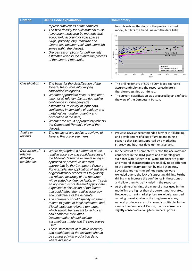
33
Criteria JORC Code explanation Commentary
representativeness of the samples.
The bulk density for bulk material must have been measured by methods that adequately account for void spaces (vugs, porosity, etc), moisture and differences between rock and alteration zones within the deposit.
Discuss assumptions for bulk density estimates used in the evaluation process of the different materials.
formula retains the slope of the previously used model, but lifts the trend line into the data field.
Classification The basis for the classification of the Mineral Resources into varying confidence categories.
Whether appropriate account has been taken of all relevant factors (ie relative confidence in tonnage/grade estimations, reliability of input data, confidence in continuity of geology and metal values, quality, quantity and distribution of the data).
Whether the result appropriately reflects the Competent Person’s view of the deposit.
The drilling density of 500 x 500m is too sparse to assure continuity and the resource estimate is therefore classified as Inferred.
The current classification was prepared by and reflects the view of the Competent Person.
Audits or reviews
The results of any audits or reviews of Mineral Resource estimates.
Previous reviews recommended further in-fill drilling, and development of a cut-off grade and mining scenario that can be supported by a marketing strategy and business development scenario.
Discussion of relative accuracy/ confidence
Where appropriate a statement of the relative accuracy and confidence level in the Mineral Resource estimate using an approach or procedure deemed appropriate by the Competent Person. For example, the application of statistical or geostatistical procedures to quantify the relative accuracy of the resource within stated confidence limits, or, if such an approach is not deemed appropriate, a qualitative discussion of the factors that could affect the relative accuracy and confidence of the estimate.
The statement should specify whether it relates to global or local estimates, and, if local, state the relevant tonnages, which should be relevant to technical and economic evaluation. Documentation should include assumptions made and the procedures used.
These statements of relative accuracy and confidence of the estimate should be compared with production data, where available.
In the view of the Competent Person the accuracy and confidence in the THM grades and mineralogy are such that with further in-fill work, the final ore grade and mineral characteristics are unlikely to be different to the current estimate than by more than 30%. Several zones near the defined resource were excluded due to the lack of supporting drilling. Further drilling may increase the confidence in these zones and allow them to be included in the resource.
At the time of writing, the mineral prices used in the modelling are higher than the current market rates. However, current market prices are widely regarded as being unsustainable in the long term as many mineral producers are not currently profitable. In the view of the Competent Person, the prices used are slightly conservative long-term mineral prices.