Embed Size (px)
Citation preview
1
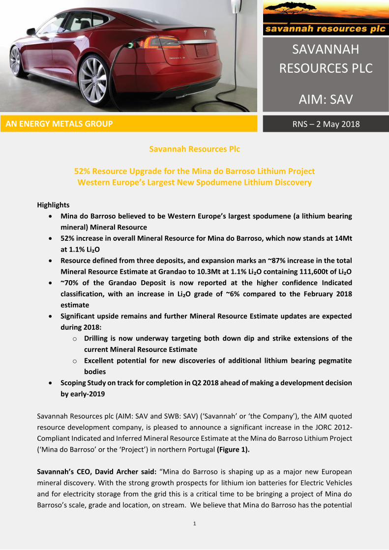
Savannah Resources Plc
52% Resource Upgrade for the Mina do Barroso Lithium Project Western Europe’s Largest New Spodumene Lithium Discovery
Highlights
• Mina do Barroso believed to be Western Europe’s largest spodumene (a lithium bearing
mineral) Mineral Resource
• 52% increase in overall Mineral Resource for Mina do Barroso, which now stands at 14Mt
at 1.1% Li₂O
• Resource defined from three deposits, and expansion marks an ~87% increase in the total
Mineral Resource Estimate at Grandao to 10.3Mt at 1.1% Li₂O containing 111,600t of Li₂O
• ~70% of the Grandao Deposit is now reported at the higher confidence Indicated
classification, with an increase in Li₂O grade of ~6% compared to the February 2018
estimate
• Significant upside remains and further Mineral Resource Estimate updates are expected
during 2018:
o Drilling is now underway targeting both down dip and strike extensions of the
current Mineral Resource Estimate
o Excellent potential for new discoveries of additional lithium bearing pegmatite
bodies
• Scoping Study on track for completion in Q2 2018 ahead of making a development decision
by early-2019
Savannah Resources plc (AIM: SAV and SWB: SAV) (‘Savannah’ or ‘the Company’), the AIM quoted
resource development company, is pleased to announce a significant increase in the JORC 2012-
Compliant Indicated and Inferred Mineral Resource Estimate at the Mina do Barroso Lithium Project
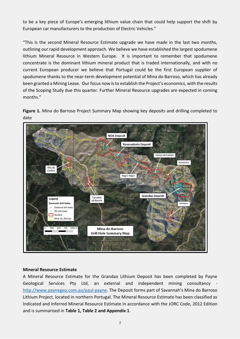
(‘Mina do Barroso’ or the ‘Project’) in northern Portugal (Figure 1).
Savannah’s CEO, David Archer said: “Mina do Barroso is shaping up as a major new European
mineral discovery. With the strong growth prospects for lithium ion batteries for Electric Vehicles
and for electricity storage from the grid this is a critical time to be bringing a project of Mina do
Barroso’s scale, grade and location, on stream. We believe that Mina do Barroso has the potential
SAVANNAH
RESOURCES PLC
AIM: SAV
AN ENERGY METALS GROUP RNS – 2 May 2018
2
to be a key piece of Europe’s emerging lithium value chain that could help support the shift by
European car manufacturers to the production of Electric Vehicles.”
“This is the second Mineral Resource Estimate upgrade we have made in the last two months,
outlining our rapid development approach. We believe we have established the largest spodumene
lithium Mineral Resource in Western Europe. It is important to remember that spodumene
concentrate is the dominant lithium mineral product that is traded internationally, and with no
current European producer we believe that Portugal could be the first European supplier of
spodumene thanks to the near-term development potential of Mina do Barroso, which has already
been granted a Mining Lease. Our focus now is to establish the Project’s economics, with the results
of the Scoping Study due this quarter. Further Mineral Resource upgrades are expected in coming
months.”
Figure 1. Mina do Barroso Project Summary Map showing key deposits and drilling completed to
date
Mineral Resource Estimate
A Mineral Resource Estimate for the Grandao Lithium Deposit has been completed by Payne
Geological Services Pty Ltd, an external and independent mining consultancy -
http://www.paynegeo.com.au/paul-payne. The Deposit forms part of Savannah’s Mina do Barroso
Lithium Project, located in northern Portugal. The Mineral Resource Estimate has been classified as
Indicated and Inferred Mineral Resource Estimate in accordance with the JORC Code, 2012 Edition
and is summarised in Table 1, Table 2 and Appendix 1.
3
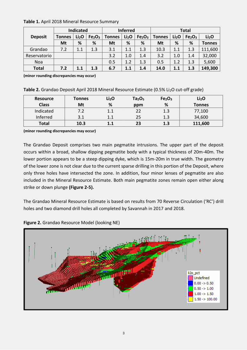
Table 1. April 2018 Mineral Resource Summary
Deposit
Indicated Inferred Total
Tonnes Li2O Fe2O3 Tonnes Li2O Fe2O3 Tonnes Li2O Fe2O3 Li2O
Mt % % Mt % % Mt % % Tonnes
Grandao 7.2 1.1 1.3 3.1 1.1 1.3 10.3 1.1 1.3 111,600
Reservatorio 3.2 1.0 1.4 3.2 1.0 1.4 32,000
Noa 0.5 1.2 1.3 0.5 1.2 1.3 5,600
Total 7.2 1.1 1.3 6.7 1.1 1.4 14.0 1.1 1.3 149,300
(minor rounding discrepancies may occur)
Table 2. Grandao Deposit April 2018 Mineral Resource Estimate (0.5% Li2O cut-off grade)
Resource Class
Tonnes Li2O Ta2O5 Fe2O3 Li2O
Mt % ppm % Tonnes
Indicated 7.2 1.1 22 1.3 77,100 Inferred 3.1 1.1 25 1.3 34,600
Total 10.3 1.1 23 1.3 111,600
(minor rounding discrepancies may occur)
The Grandao Deposit comprises two main pegmatite intrusions. The upper part of the deposit
occurs within a broad, shallow dipping pegmatite body with a typical thickness of 20m-40m. The
lower portion appears to be a steep dipping dyke, which is 15m-20m in true width. The geometry
of the lower zone is not clear due to the current sparse drilling in this portion of the Deposit, where
only three holes have intersected the zone. In addition, four minor lenses of pegmatite are also
included in the Mineral Resource Estimate. Both main pegmatite zones remain open either along
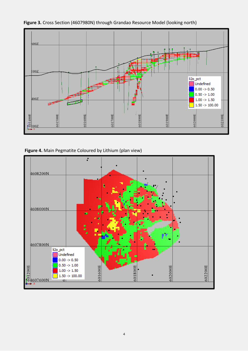
strike or down plunge (Figure 2-5).
The Grandao Mineral Resource Estimate is based on results from 70 Reverse Circulation (‘RC’) drill
holes and two diamond drill holes all completed by Savannah in 2017 and 2018.
Figure 2. Grandao Resource Model (looking NE)
4
Figure 3. Cross Section (4607980N) through Grandao Resource Model (looking north)
Figure 4. Main Pegmatite Coloured by Lithium (plan view)
5
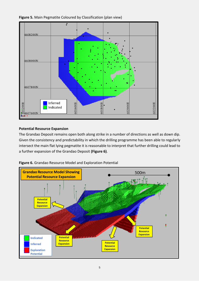
Figure 5. Main Pegmatite Coloured by Classification (plan view)
Potential Resource Expansion
The Grandao Deposit remains open both along strike in a number of directions as well as down dip.
Given the consistency and predictability in which the drilling programme has been able to regularly
intersect the main flat lying pegmatite it is reasonable to interpret that further drilling could lead to
a further expansion of the Grandao Deposit (Figure 6).
Figure 6. Grandao Resource Model and Exploration Potential
6
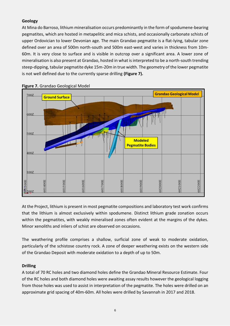
Geology
At Mina do Barroso, lithium mineralisation occurs predominantly in the form of spodumene-bearing
pegmatites, which are hosted in metapelitic and mica schists, and occasionally carbonate schists of
upper Ordovician to lower Devonian age. The main Grandao pegmatite is a flat-lying, tabular zone
defined over an area of 500m north-south and 500m east-west and varies in thickness from 10m-
60m. It is very close to surface and is visible in outcrop over a significant area. A lower zone of
mineralisation is also present at Grandao, hosted in what is interpreted to be a north-south trending
steep-dipping, tabular pegmatite dyke 15m-20m in true width. The geometry of the lower pegmatite
is not well defined due to the currently sparse drilling (Figure 7).
Figure 7. Grandao Geological Model
At the Project, lithium is present in most pegmatite compositions and laboratory test work confirms
that the lithium is almost exclusively within spodumene. Distinct lithium grade zonation occurs
within the pegmatites, with weakly mineralised zones often evident at the margins of the dykes.
Minor xenoliths and inliers of schist are observed on occasions.
The weathering profile comprises a shallow, surficial zone of weak to moderate oxidation,
particularly of the schistose country rock. A zone of deeper weathering exists on the western side
of the Grandao Deposit with moderate oxidation to a depth of up to 50m.
Drilling
A total of 70 RC holes and two diamond holes define the Grandao Mineral Resource Estimate. Four
of the RC holes and both diamond holes were awaiting assay results however the geological logging
from those holes was used to assist in interpretation of the pegmatite. The holes were drilled on an
approximate grid spacing of 40m-60m. All holes were drilled by Savannah in 2017 and 2018.
7
Drill collar locations are recorded in Universal Traverse Mercator (“UTM”) coordinates using
differential GPS. All Savannah drilling has been down-hole surveyed using a gyroscopic tool.
Sampling and Sub-Sampling Techniques
For the Savannah RC drilling, a face-sampling hammer was used with samples collected at 1m
intervals from pegmatite zones with composite sampling of typically 4m in the surrounding schists
in early drilling. In recent drilling the schist 5m either side of the pegmatite was sampled at 1m
intervals with the rest of schist remaining unsampled. The 1m samples were collected through a rig-
mounted riffle splitter and were 4kg-6kg in weight. The 4m composites were collected by spear
sampling of the 1m intervals. Samples were weighed to assess the sample recovery which was
determined to be satisfactory.
Core was PQ and HQ in size and sampled to geological boundaries. Half core was collected for
metallurgical test work, and quarter core samples were collected for assay. No assay results from
the diamond drilling were available for this update.
Sample Analysis Method
For all Savannah drilling, whole samples were crushed then riffle split to produce a 250g split for
pulverising and analysis.
The samples were analysed using ALS laboratories ME-MS89L Super Trace method which combines
a sodium peroxide fusion with ICP-MS analysis and a multi-element suite was analysed.
QAQC protocols were in place for the drilling programmes and included the used of standards and
field duplicates. The data has confirmed the quality of the sampling and assaying for use in Mineral
Resource estimation.
Estimation Methodology
For the Grandao Mineral Resource Estimate, a Surpac block model was constructed with block sizes
of 20m (EW) by 10m (NS) by 5m (elevation) with sub-celling to 5m by 2.5m by 1.25m. The typical
drill hole spacing is 40m-60m.
Interpretation of the pegmatite dykes was completed using detailed geological logging and Fe
geochemistry. Wireframes of the pegmatites were prepared and within those the sample data was
extracted and analysed. A clear break in the grade distribution occurs at 0.5% Li2O and this grade
threshold was used to prepare the internal grade domains for estimation. In addition to the two
main pegmatite bodies, several small pegmatites were also interpreted. Zones of unmineralised
schist within the pegmatite body were selectively wireframed and excluded from the estimate.
Sample data was composited into 1m intervals then block model grades estimated using ordinary
kriging (“OK”) grade interpolation for the two main pegmatites and inverse distance squared (“ID2”)
grade interpolation for the four small pegmatite zones. A first pass search range of 60m was used
and oriented to match the dip and strike of the mineralisation. A minimum of 10 samples and a
maximum of 24 samples were used to estimate each block. The majority of the Mineral Resource
8
Estimate (61%) was completed in the first pass with expanded search radii of 120m and 240m used
for the blocks not estimated in the first pass. No high-grade cuts were applied to the estimate.
Iron within the pegmatites is uniformly low, with a mean Fe2O3 grade of 1.3% at Grandao. Other
similar deposits have reported that a large proportion of the assayed iron is due to contamination
from the abrasion of steel drilling and sample preparation equipment and this will be investigated
as part of ongoing studies at the Project.
Bulk density determinations (helium pycnometer) were carried out on 87 sample pulps. Bulk density
values applied to the estimates were 2.5t/m3 for oxide lithologies, 2.7t/m3 for unoxidised pegmatite
and 2.8t/m3 for unoxidised schist.
Mineral Resource Classification
The Mineral Resource Estimate was classified in accordance with the Australasian Code for the
Reporting of Exploration Results, Mineral Resources and Ore Reserves (JORC, 2012).
The main pegmatite dyke at Grandao has generally been drilled at 40m to 60m holes spacings. The
majority of holes in the main pegmatite at Grandao have consistently intersected pegmatite, with
the majority intersecting resource grade Li2O mineralisation and the continuity of lithium
mineralisation is good. The portion of the deposit defined by 40m to 60m spaced drill holes has been
classified as an Indicated Mineral Resource Estimate. Where the main pegmatite showed good
potential for further extensions, the Indicated Mineral Resource Estimate was extrapolated up to
60m past drill hole intersections and the Inferred Mineral Resource Estimate was extrapolated a
further 60m.
All minor pegmatite bodies were classified as an Inferred Mineral Resource Estimate due to the lack
of detailed drilling or the uncertainty of geometry of the mineralisation.
The main shallow pegmatite at Grandao lies entirely above 100m vertical depth. The deep pegmatite
has been reported to a depth of 160m vertical.
Cut-off Grades
The shallow and flat lying nature of the main Grandao pegmatite suggests good potential for open
pit mining if sufficient resources can be delineated to consider a mining operation. The lower
pegmatite at Grandao has favourable geometry and thickness for low-cost underground mining as
an option in the second step. As such, the Mineral Resource Estimate has been reported at a 0.5%
Li2O lower cut-off grade to reflect assumed exploitation by low-cost mining methods.
Metallurgy
Metallurgical test work has been conducted by Savannah on representative mineralisation at Mina
do Barroso. The work was completed by Nagrom Metallurgical in Australia and confirmed that high-
grade lithium, low-grade iron concentrate can be generated from the mineralisation using
conventional processing technology. Microscopy confirmed that the concentrate was almost
entirely spodumene. A substantial metallurgical test work programme has recently commenced.
9
Modifying Factors
No modifying factors were applied to the reported Mineral Resource Estimate. Parameters
reflecting mining dilution, ore loss and metallurgical recoveries will be considered during the any
future mining evaluation of the Project.
Competent Person and Regulatory Information
The information in this announcement that relates to exploration results is based upon information
compiled by Mr Dale Ferguson, Technical Director of Savannah Resources Limited. Mr Ferguson is a
Member of the Australasian Institute of Mining and Metallurgy (AusIMM) and has sufficient
experience which is relevant to the style of mineralisation and type of deposit under consideration
and to the activity which he is undertaking to qualify as a Competent Person as defined in the
December 2012 edition of the “Australasian Code for Reporting of Exploration Results, Mineral
Resources and Ore Reserves” (JORC Code). Mr Ferguson consents to the inclusion in the report of
the matters based upon the information in the form and context in which it appears.
The Information in this report that relates to Mineral Resources is based on information compiled
by Mr Paul Payne, a Competent Person who is a Fellow of the Australasian Institute of Mining and
Metallurgy. Mr Payne is a full-time employee of Payne Geological Services. Mr Payne has sufficient
experience that is relevant to the style of mineralisation and type of deposit under consideration
and to the activity being undertaken to qualify as a Competent Person as defined in the 2012 Edition
of the “Australasian Code for Reporting of Exploration Results, Mineral Resources and Ore
Reserves”. Mr Payne consents to the inclusion in the report of the matters based on his information
in the form and context in which it appears.
This announcement contains inside information for the purposes of Article 7 of Regulation (EU)
596/2014.
**ENDS**
CONTACT US
For further information please visit www.savannahresources.com or contact:
David Archer Savannah Resources plc Tel: +44 20 7117 2489
David Hignell / Dugald J. Carlean
(Nominated Adviser)
Northland Capital Partners
Ltd
Tel: +44 20 3861 6625
Christopher Raggett / Emily Morris
(Broker)
finnCap Ltd Tel: +44 20 7220 0500
Charlotte Page / Lottie Wadham
(Financial PR)
St Brides Partners Ltd Tel: +44 20 7236 1177

10
About Savannah
We are a diversified resources group (AIM: SAV) with a portfolio of energy metals projects - lithium in
Portugal and copper in Oman - together with the world-class Mutamba Heavy Mineral Sands Project in
Mozambique, which is being developed in a consortium with the global major Rio Tinto. We are committed
to serving the interests of our shareholders and to delivering outcomes that will improve the lives of our staff
and the communities we work with.
The group is listed and regulated on AIM and the Company’s ordinary shares are also available on the Börse
Stuttgart (SWB) under the ticker “SAV”.
11
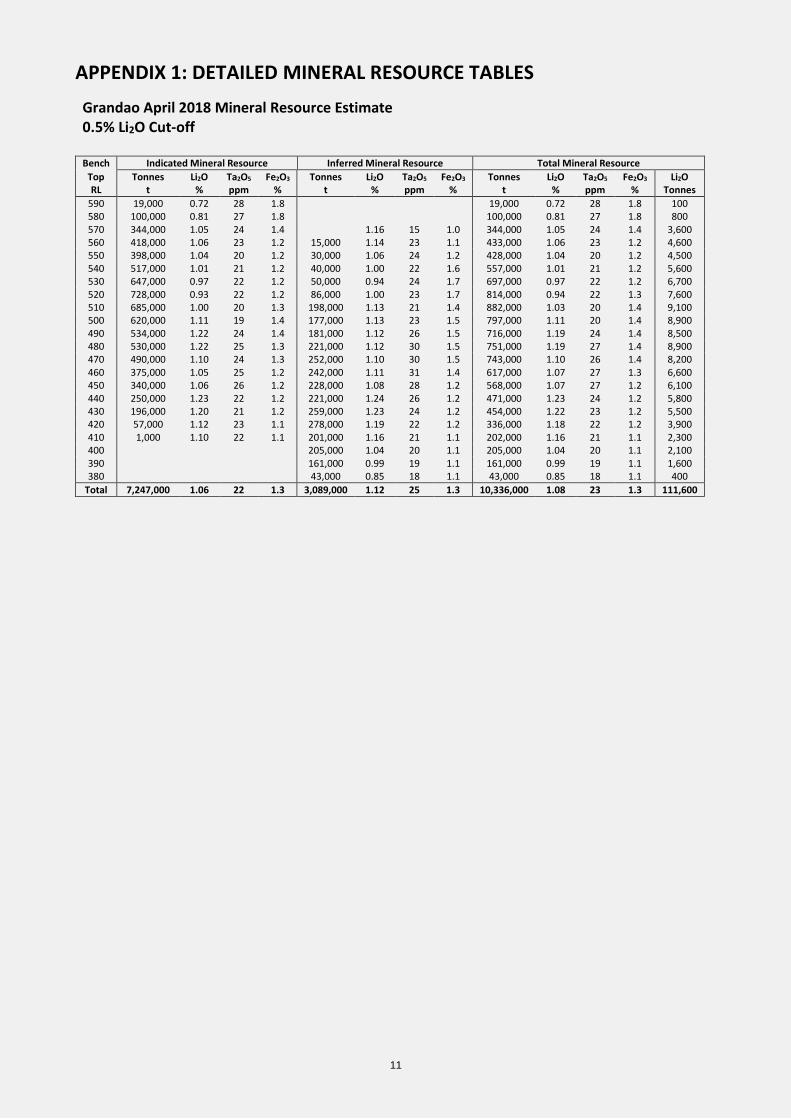
APPENDIX 1: DETAILED MINERAL RESOURCE TABLES
Grandao April 2018 Mineral Resource Estimate 0.5% Li2O Cut-off Bench Indicated Mineral Resource Inferred Mineral Resource Total Mineral Resource
Top Tonnes Li2O Ta2O5 Fe2O3 Tonnes Li2O Ta2O5 Fe2O3 Tonnes Li2O Ta2O5 Fe2O3 Li2O RL t % ppm % t % ppm % t % ppm % Tonnes
590 19,000 0.72 28 1.8 19,000 0.72 28 1.8 100 580 100,000 0.81 27 1.8 100,000 0.81 27 1.8 800 570 344,000 1.05 24 1.4 1.16 15 1.0 344,000 1.05 24 1.4 3,600 560 418,000 1.06 23 1.2 15,000 1.14 23 1.1 433,000 1.06 23 1.2 4,600 550 398,000 1.04 20 1.2 30,000 1.06 24 1.2 428,000 1.04 20 1.2 4,500 540 517,000 1.01 21 1.2 40,000 1.00 22 1.6 557,000 1.01 21 1.2 5,600 530 647,000 0.97 22 1.2 50,000 0.94 24 1.7 697,000 0.97 22 1.2 6,700 520 728,000 0.93 22 1.2 86,000 1.00 23 1.7 814,000 0.94 22 1.3 7,600 510 685,000 1.00 20 1.3 198,000 1.13 21 1.4 882,000 1.03 20 1.4 9,100 500 620,000 1.11 19 1.4 177,000 1.13 23 1.5 797,000 1.11 20 1.4 8,900 490 534,000 1.22 24 1.4 181,000 1.12 26 1.5 716,000 1.19 24 1.4 8,500 480 530,000 1.22 25 1.3 221,000 1.12 30 1.5 751,000 1.19 27 1.4 8,900 470 490,000 1.10 24 1.3 252,000 1.10 30 1.5 743,000 1.10 26 1.4 8,200 460 375,000 1.05 25 1.2 242,000 1.11 31 1.4 617,000 1.07 27 1.3 6,600 450 340,000 1.06 26 1.2 228,000 1.08 28 1.2 568,000 1.07 27 1.2 6,100 440 250,000 1.23 22 1.2 221,000 1.24 26 1.2 471,000 1.23 24 1.2 5,800 430 196,000 1.20 21 1.2 259,000 1.23 24 1.2 454,000 1.22 23 1.2 5,500 420 57,000 1.12 23 1.1 278,000 1.19 22 1.2 336,000 1.18 22 1.2 3,900 410 1,000 1.10 22 1.1 201,000 1.16 21 1.1 202,000 1.16 21 1.1 2,300 400 205,000 1.04 20 1.1 205,000 1.04 20 1.1 2,100 390 161,000 0.99 19 1.1 161,000 0.99 19 1.1 1,600 380 43,000 0.85 18 1.1 43,000 0.85 18 1.1 400
Total 7,247,000 1.06 22 1.3 3,089,000 1.12 25 1.3 10,336,000 1.08 23 1.3 111,600
12
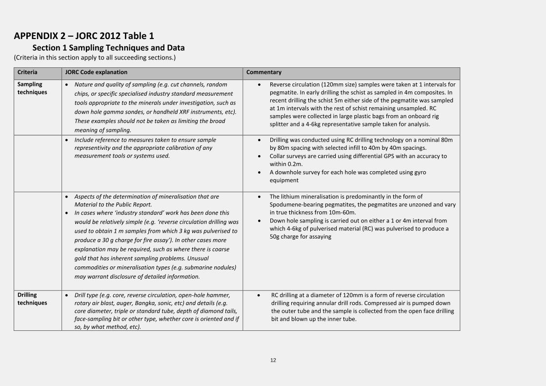
APPENDIX 2 – JORC 2012 Table 1 Section 1 Sampling Techniques and Data
(Criteria in this section apply to all succeeding sections.)
Criteria JORC Code explanation Commentary
Sampling techniques
• Nature and quality of sampling (e.g. cut channels, random
chips, or specific specialised industry standard measurement
tools appropriate to the minerals under investigation, such as
down hole gamma sondes, or handheld XRF instruments, etc).
These examples should not be taken as limiting the broad
meaning of sampling.
• Reverse circulation (120mm size) samples were taken at 1 intervals for pegmatite. In early drilling the schist as sampled in 4m composites. In recent drilling the schist 5m either side of the pegmatite was sampled at 1m intervals with the rest of schist remaining unsampled. RC samples were collected in large plastic bags from an onboard rig splitter and a 4-6kg representative sample taken for analysis.
• Include reference to measures taken to ensure sample representivity and the appropriate calibration of any measurement tools or systems used.
• Drilling was conducted using RC drilling technology on a nominal 80m by 80m spacing with selected infill to 40m by 40m spacings.
• Collar surveys are carried using differential GPS with an accuracy to within 0.2m.
• A downhole survey for each hole was completed using gyro equipment
• Aspects of the determination of mineralisation that are Material to the Public Report.
• In cases where ‘industry standard’ work has been done this
would be relatively simple (e.g. ‘reverse circulation drilling was
used to obtain 1 m samples from which 3 kg was pulverised to
produce a 30 g charge for fire assay’). In other cases more
explanation may be required, such as where there is coarse
gold that has inherent sampling problems. Unusual
commodities or mineralisation types (e.g. submarine nodules)
may warrant disclosure of detailed information.
• The lithium mineralisation is predominantly in the form of Spodumene-bearing pegmatites, the pegmatites are unzoned and vary in true thickness from 10m-60m.
• Down hole sampling is carried out on either a 1 or 4m interval from which 4-6kg of pulverised material (RC) was pulverised to produce a 50g charge for assaying
Drilling techniques
• Drill type (e.g. core, reverse circulation, open-hole hammer, rotary air blast, auger, Bangka, sonic, etc) and details (e.g. core diameter, triple or standard tube, depth of diamond tails, face-sampling bit or other type, whether core is oriented and if so, by what method, etc).
• RC drilling at a diameter of 120mm is a form of reverse circulation drilling requiring annular drill rods. Compressed air is pumped down the outer tube and the sample is collected from the open face drilling bit and blown up the inner tube.
13
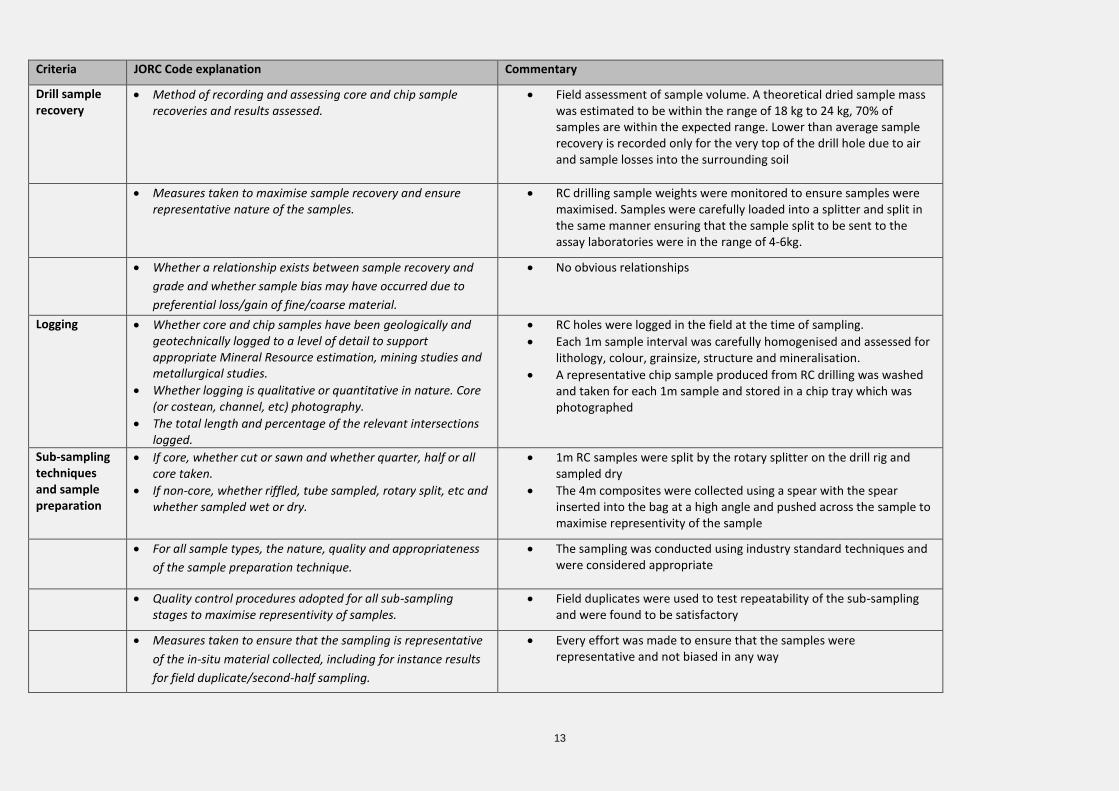
Criteria JORC Code explanation Commentary
Drill sample recovery
• Method of recording and assessing core and chip sample recoveries and results assessed.
• Field assessment of sample volume. A theoretical dried sample mass was estimated to be within the range of 18 kg to 24 kg, 70% of samples are within the expected range. Lower than average sample recovery is recorded only for the very top of the drill hole due to air and sample losses into the surrounding soil
• Measures taken to maximise sample recovery and ensure representative nature of the samples.
• RC drilling sample weights were monitored to ensure samples were maximised. Samples were carefully loaded into a splitter and split in the same manner ensuring that the sample split to be sent to the assay laboratories were in the range of 4-6kg.
• Whether a relationship exists between sample recovery and
grade and whether sample bias may have occurred due to
preferential loss/gain of fine/coarse material.
• No obvious relationships
Logging • Whether core and chip samples have been geologically and geotechnically logged to a level of detail to support appropriate Mineral Resource estimation, mining studies and metallurgical studies.
• Whether logging is qualitative or quantitative in nature. Core (or costean, channel, etc) photography.
• The total length and percentage of the relevant intersections logged.
• RC holes were logged in the field at the time of sampling.
• Each 1m sample interval was carefully homogenised and assessed for lithology, colour, grainsize, structure and mineralisation.
• A representative chip sample produced from RC drilling was washed and taken for each 1m sample and stored in a chip tray which was photographed
Sub-sampling techniques and sample preparation
• If core, whether cut or sawn and whether quarter, half or all core taken.
• If non-core, whether riffled, tube sampled, rotary split, etc and whether sampled wet or dry.
• 1m RC samples were split by the rotary splitter on the drill rig and sampled dry
• The 4m composites were collected using a spear with the spear inserted into the bag at a high angle and pushed across the sample to maximise representivity of the sample
• For all sample types, the nature, quality and appropriateness
of the sample preparation technique.
• The sampling was conducted using industry standard techniques and were considered appropriate
• Quality control procedures adopted for all sub-sampling stages to maximise representivity of samples.
• Field duplicates were used to test repeatability of the sub-sampling and were found to be satisfactory
• Measures taken to ensure that the sampling is representative
of the in-situ material collected, including for instance results
for field duplicate/second-half sampling.
• Every effort was made to ensure that the samples were representative and not biased in any way
14
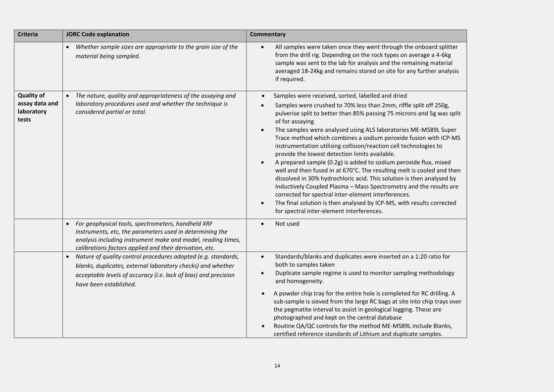
Criteria JORC Code explanation Commentary
• Whether sample sizes are appropriate to the grain size of the
material being sampled.
• All samples were taken once they went through the onboard splitter from the drill rig. Depending on the rock types on average a 4-6kg sample was sent to the lab for analysis and the remaining material averaged 18-24kg and remains stored on site for any further analysis if required.
Quality of assay data and laboratory tests
• The nature, quality and appropriateness of the assaying and laboratory procedures used and whether the technique is considered partial or total.
• Samples were received, sorted, labelled and dried
• Samples were crushed to 70% less than 2mm, riffle split off 250g, pulverise split to better than 85% passing 75 microns and 5g was split of for assaying
• The samples were analysed using ALS laboratories ME-MS89L Super Trace method which combines a sodium peroxide fusion with ICP-MS instrumentation utilising collision/reaction cell technologies to provide the lowest detection limits available.
• A prepared sample (0.2g) is added to sodium peroxide flux, mixed well and then fused in at 670°C. The resulting melt is cooled and then dissolved in 30% hydrochloric acid. This solution is then analysed by Inductively Coupled Plasma – Mass Spectrometry and the results are corrected for spectral inter-element interferences.
• The final solution is then analysed by ICP-MS, with results corrected for spectral inter-element interferences.
• For geophysical tools, spectrometers, handheld XRF instruments, etc, the parameters used in determining the analysis including instrument make and model, reading times, calibrations factors applied and their derivation, etc.
• Not used
• Nature of quality control procedures adopted (e.g. standards,
blanks, duplicates, external laboratory checks) and whether
acceptable levels of accuracy (i.e. lack of bias) and precision
have been established.
• Standards/blanks and duplicates were inserted on a 1:20 ratio for both to samples taken
• Duplicate sample regime is used to monitor sampling methodology and homogeneity.
• A powder chip tray for the entire hole is completed for RC drilling. A sub-sample is sieved from the large RC bags at site into chip trays over the pegmatite interval to assist in geological logging. These are photographed and kept on the central database
• Routine QA/QC controls for the method ME-MS89L include Blanks, certified reference standards of Lithium and duplicate samples.
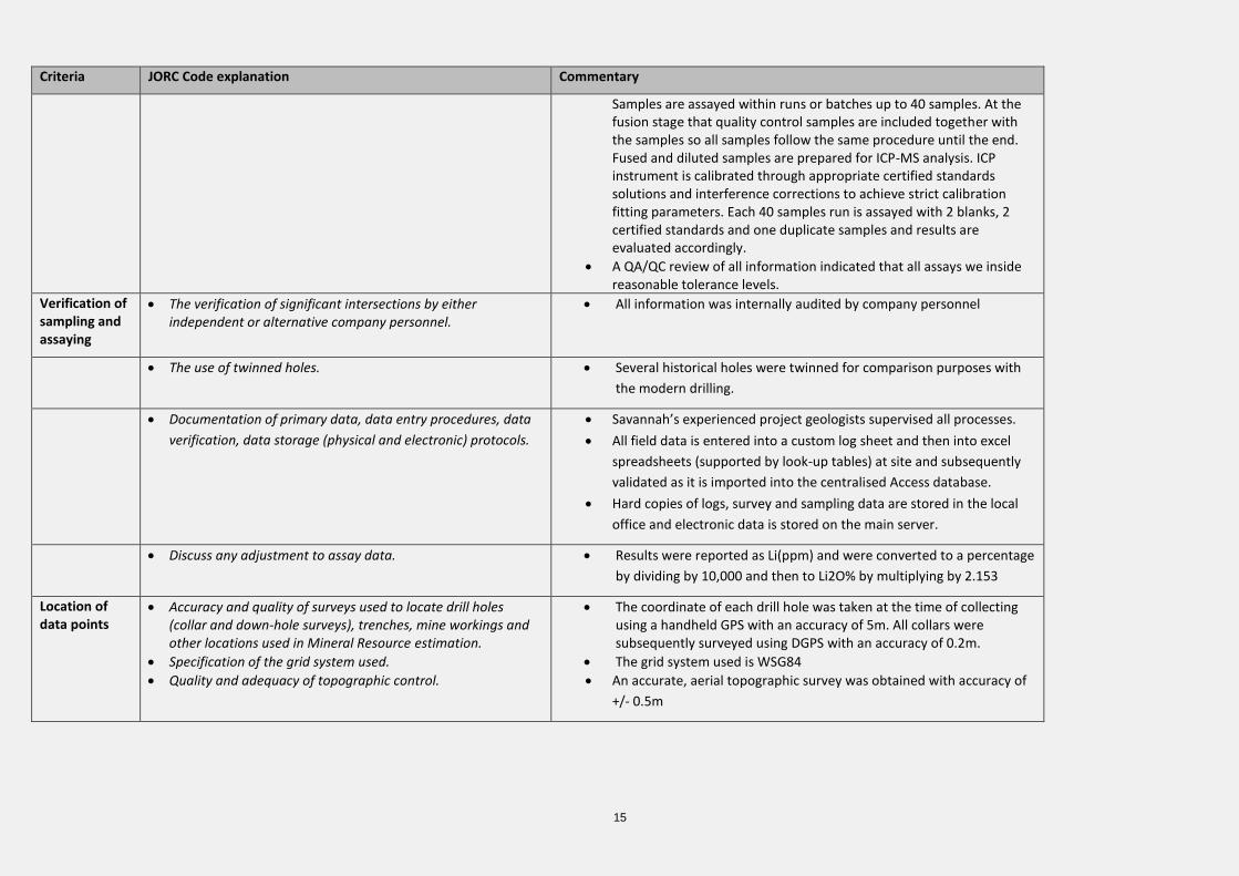
15
Criteria JORC Code explanation Commentary
Samples are assayed within runs or batches up to 40 samples. At the fusion stage that quality control samples are included together with the samples so all samples follow the same procedure until the end. Fused and diluted samples are prepared for ICP-MS analysis. ICP instrument is calibrated through appropriate certified standards solutions and interference corrections to achieve strict calibration fitting parameters. Each 40 samples run is assayed with 2 blanks, 2 certified standards and one duplicate samples and results are evaluated accordingly.
• A QA/QC review of all information indicated that all assays we inside reasonable tolerance levels.
Verification of sampling and assaying
• The verification of significant intersections by either independent or alternative company personnel.
• All information was internally audited by company personnel
• The use of twinned holes. • Several historical holes were twinned for comparison purposes with
the modern drilling.
• Documentation of primary data, data entry procedures, data
verification, data storage (physical and electronic) protocols.
• Savannah’s experienced project geologists supervised all processes.
• All field data is entered into a custom log sheet and then into excel
spreadsheets (supported by look-up tables) at site and subsequently
validated as it is imported into the centralised Access database.
• Hard copies of logs, survey and sampling data are stored in the local
office and electronic data is stored on the main server.
• Discuss any adjustment to assay data. • Results were reported as Li(ppm) and were converted to a percentage
by dividing by 10,000 and then to Li2O% by multiplying by 2.153
Location of data points
• Accuracy and quality of surveys used to locate drill holes (collar and down-hole surveys), trenches, mine workings and other locations used in Mineral Resource estimation.
• Specification of the grid system used.
• Quality and adequacy of topographic control.
• The coordinate of each drill hole was taken at the time of collecting using a handheld GPS with an accuracy of 5m. All collars were subsequently surveyed using DGPS with an accuracy of 0.2m.
• The grid system used is WSG84
• An accurate, aerial topographic survey was obtained with accuracy of
+/- 0.5m
16
Criteria JORC Code explanation Commentary
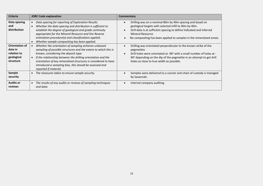
Data spacing and distribution
• Data spacing for reporting of Exploration Results.
• Whether the data spacing and distribution is sufficient to establish the degree of geological and grade continuity appropriate for the Mineral Resource and Ore Reserve estimation procedure(s) and classifications applied.
• Whether sample compositing has been applied.
• Drilling was on a nominal 80m by 40m spacing and based on geological targets with selected infill to 40m by 40m.
• Drill data is at sufficient spacing to define Indicated and Inferred Mineral Resource.
• No compositing has been applied to samples in the mineralised zones.
Orientation of data in relation to geological structure
• Whether the orientation of sampling achieves unbiased sampling of possible structures and the extent to which this is known, considering the deposit type.
• If the relationship between the drilling orientation and the orientation of key mineralised structures is considered to have introduced a sampling bias, this should be assessed and reported if material.
• Drilling was orientated perpendicular to the known strike of the pegmatites
• Drill holes were orientated at -90o with a small number of holes at -60o depending on the dip of the pegmatite in an attempt to get drill holes as close to true width as possible.
Sample security
• The measures taken to ensure sample security. • Samples were delivered to a courier and chain of custody is managed by Savannah.
Audits or reviews
• The results of any audits or reviews of sampling techniques and data.
• Internal company auditing.
17
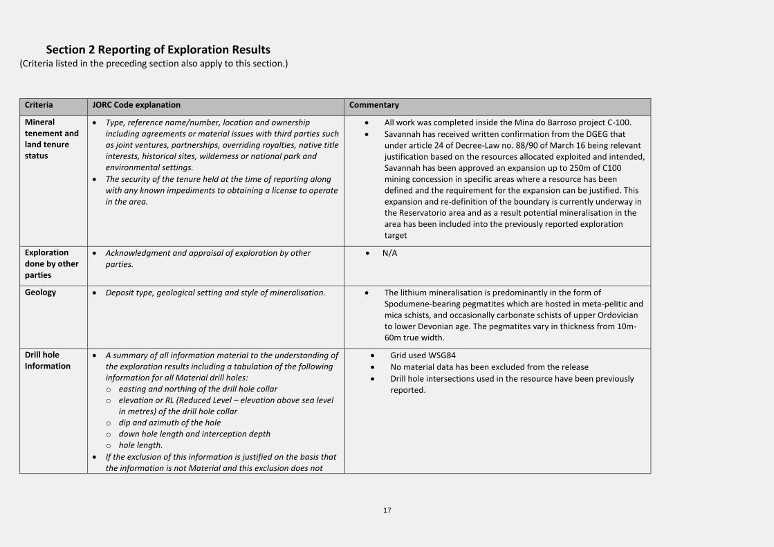
Section 2 Reporting of Exploration Results (Criteria listed in the preceding section also apply to this section.)
Criteria JORC Code explanation Commentary
Mineral tenement and land tenure status
• Type, reference name/number, location and ownership including agreements or material issues with third parties such as joint ventures, partnerships, overriding royalties, native title interests, historical sites, wilderness or national park and environmental settings.
• The security of the tenure held at the time of reporting along with any known impediments to obtaining a license to operate in the area.
• All work was completed inside the Mina do Barroso project C-100.
• Savannah has received written confirmation from the DGEG that under article 24 of Decree-Law no. 88/90 of March 16 being relevant justification based on the resources allocated exploited and intended, Savannah has been approved an expansion up to 250m of C100 mining concession in specific areas where a resource has been defined and the requirement for the expansion can be justified. This expansion and re-definition of the boundary is currently underway in the Reservatorio area and as a result potential mineralisation in the area has been included into the previously reported exploration target
Exploration done by other parties
• Acknowledgment and appraisal of exploration by other parties.
• N/A
Geology • Deposit type, geological setting and style of mineralisation. • The lithium mineralisation is predominantly in the form of Spodumene-bearing pegmatites which are hosted in meta-pelitic and mica schists, and occasionally carbonate schists of upper Ordovician to lower Devonian age. The pegmatites vary in thickness from 10m-60m true width.
Drill hole Information
• A summary of all information material to the understanding of the exploration results including a tabulation of the following information for all Material drill holes: o easting and northing of the drill hole collar o elevation or RL (Reduced Level – elevation above sea level
in metres) of the drill hole collar o dip and azimuth of the hole o down hole length and interception depth o hole length.
• If the exclusion of this information is justified on the basis that the information is not Material and this exclusion does not
• Grid used WSG84
• No material data has been excluded from the release
• Drill hole intersections used in the resource have been previously reported.
18
Criteria JORC Code explanation Commentary
detract from the understanding of the report, the Competent Person should clearly explain why this is the case.
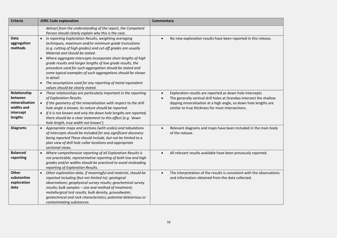
Data aggregation methods
• In reporting Exploration Results, weighting averaging techniques, maximum and/or minimum grade truncations (e.g. cutting of high grades) and cut-off grades are usually Material and should be stated.
• Where aggregate intercepts incorporate short lengths of high grade results and longer lengths of low grade results, the procedure used for such aggregation should be stated and some typical examples of such aggregations should be shown in detail.
• The assumptions used for any reporting of metal equivalent values should be clearly stated.
• No new exploration results have been reported in this release.
Relationship between mineralisation widths and intercept lengths
• These relationships are particularly important in the reporting of Exploration Results.
• If the geometry of the mineralisation with respect to the drill hole angle is known, its nature should be reported.
• If it is not known and only the down hole lengths are reported, there should be a clear statement to this effect (e.g. ‘down hole length, true width not known’).
• Exploration results are reported as down hole intercepts
• The generally vertical drill holes at Grandao intersect the shallow dipping mineralisation at a high angle, so down hole lengths are similar to true thickness for most intersections.
Diagrams • Appropriate maps and sections (with scales) and tabulations of intercepts should be included for any significant discovery being reported These should include, but not be limited to a plan view of drill hole collar locations and appropriate sectional views.
• Relevant diagrams and maps have been included in the main body of the release.
Balanced reporting
• Where comprehensive reporting of all Exploration Results is not practicable, representative reporting of both low and high grades and/or widths should be practiced to avoid misleading reporting of Exploration Results.
• All relevant results available have been previously reported.
Other substantive exploration data
• Other exploration data, if meaningful and material, should be reported including (but not limited to): geological observations; geophysical survey results; geochemical survey results; bulk samples – size and method of treatment; metallurgical test results; bulk density, groundwater, geotechnical and rock characteristics; potential deleterious or contaminating substances.
• The interpretation of the results is consistent with the observations and information obtained from the data collected.
19
Criteria JORC Code explanation Commentary
Further work • The nature and scale of planned further work (e.g. tests for lateral extensions or depth extensions or large-scale step-out drilling).
• Diagrams clearly highlighting the areas of possible extensions, including the main geological interpretations and future drilling areas, provided this information is not commercially sensitive.
• Further rock chip sampling, channel sampling and RC drilling is planned
• Ongoing technical evaluation to support a scoping study.
20
Section 3 Estimation and Reporting of Mineral Resources
Criteria JORC Code explanation Commentary
Database integrity
• Measures taken to ensure that data has not been corrupted by, for example, transcription or keying errors, between its initial collection and its use for Mineral Resource estimation purposes.
• Data validation procedures used.
• The assay data was captured electronically to prevent transcription errors.
• Validation included visual review of results.
Site visits • Comment on any site visits undertaken by the Competent Person and the outcome of those visits.
• If no site visits have been undertaken indicate why this is the case.
• Numerous site visits were undertaken by Dale Ferguson in 2017 which included an inspection of the drilling process, outcrop area and confirmation that no obvious impediments to future exploration or development were present.
• A site visit by Paul Payne was undertaken in April 2018 to confirm geological interpretations, drilling and sampling procedures and general site layout.
Geological interpretation
• Confidence in (or conversely, the uncertainty of) the geological interpretation of the mineral deposit.
• Nature of the data used and of any assumptions made.
• The effect, if any, of alternative interpretations on Mineral Resource estimation.
• The use of geology in guiding and controlling Mineral Resource estimation.
• The factors affecting continuity both of grade and geology.
• The pegmatite dykes hosting the Grandao are well defined in outcrop and in drilling and boundaries are generally very sharp and distinct.
• The shape and extent of the >0.5% Li2O mineralisation is clearly controlled by the general geometry of the pegmatites.
• Zonation of lithium within the pegmatite is evident, and typically the margins are weakly mineralised.
• Xenoliths or inliers of barren schist country rock occur within the pegmatite, and these have been excluded from the estimate where large enough to model.
Dimensions • The extent and variability of the Mineral Resource expressed as length (along strike or otherwise), plan width, and depth below surface to the upper and lower limits of the Mineral Resource.
• The Grandao upper pegmatite has a drilled extent of 500m NS and 500m EW and a maximum vertical depth of 100m. The thickness of the mineralisation ranges from 10m to 60m.
• The Grandao lower pegmatite has a modelled strike extent of 320m NS and a dip extent of 230m and a maximum vertical depth of 150m. The true thickness of the mineralisation ranges from 15m to 20m.
Estimation and modelling techniques
• The nature and appropriateness of the estimation technique(s) applied and key assumptions, including treatment of extreme grade values, domaining, interpolation parameters and maximum distance of extrapolation from data points. If a computer assisted estimation method was chosen include a description of computer software and parameters used.
• The availability of check estimates, previous estimates and/or mine production records and whether the Mineral Resource estimate takes appropriate account of such data.
• The assumptions made regarding recovery of by-products.
• Ordinary kriging (main pegmatites) and inverse distance squared (minor zones) was used to estimate average block grades within the resource.
• Surpac software was used for the estimation. • Samples were composited to 1m intervals to match the sample lengths. Due to the
extremely low CV of the data no high-grade cuts were applied to the estimate. • At Grandao the parent block dimensions were 20m EW by 10m NS by 5m vertical
with sub-cells of 5m by 2.5m by 1.25m. Cell size was based on 50% of the average drill hole spacing.
• The previous resource estimate for Grandao was reported in February 2018.
• No assumptions have been made regarding recovery of by-products.
21
Criteria JORC Code explanation Commentary
• Estimation of deleterious elements or other non-grade variables of economic significance (e.g. sulphur for acid mine drainage characterisation).
• In the case of block model interpolation, the block size in relation to the average sample spacing and the search employed.
• Any assumptions behind modelling of selective mining units.
• Any assumptions about correlation between variables.
• Description of how the geological interpretation was used to control the resource estimates.
• Discussion of basis for using or not using grade cutting or capping.
• The process of validation, the checking process used, the comparison of model data to drill hole data, and use of reconciliation data if available.
• The grade of Fe2O3 was estimated for the deposit, with a mean grade of 1.3%. • An orientated ellipsoid search was used to select data and was based on drill hole
spacing and the geometry of the pegmatite dyke. • A search of 60m was used with a minimum of 10 samples and a maximum of 24
samples which resulted in 63% of blocks being estimated. The remaining blocks were estimated with search radii of 120m and 240m.
• Selective mining units were not modelled in the Mineral Resource model. The block size used in the model was based on drill sample spacing and deposit geometry.
• The deposit mineralisation was constrained by wireframes prepared using a 0.5% Li2O grade envelope.
• For validation, quantitative spatial comparison of block grades to assay grades was carried out using swath plots;
• Global comparisons of drill hole and block model grades were also carried out.
Moisture • Whether the tonnages are estimated on a dry basis or with natural moisture, and the method of determination of the moisture content.
• Tonnages and grades were estimated on a dry in situ basis. No moisture values were reviewed.
Cut-off parameters
• The basis of the adopted cut-off grade(s) or quality parameters applied. • The shallow, outcropping nature of the deposit and in particular the flat lying, shallow geometry of the upper pegmatite suggests good potential for open pit mining if sufficient resources can be delineated to consider a mining operation. As such, the Mineral Resource has been reported at a 0.5% Li2O lower cut-off grade to reflect assumed exploitation by open pit mining.
Mining factors or assumptions
• Assumptions made regarding possible mining methods, minimum mining dimensions and internal (or, if applicable, external) mining dilution. It is always necessary as part of the process of determining reasonable prospects for eventual economic extraction to consider potential mining methods, but the assumptions made regarding mining methods and parameters when estimating Mineral Resources may not always be rigorous. Where this is the case, this should be reported with an explanation of the basis of the mining assumptions made.
• Based on comparison with other similar deposits, the Mineral Resource is considered to have sufficient grade and metallurgical characteristics for economic treatment if an operation is established at the site.
• No mining parameters or modifying factors have been applied to the Mineral Resource.
Metallurgical factors or assumptions
• The basis for assumptions or predictions regarding metallurgical amenability. It is always necessary as part of the process of determining reasonable prospects for eventual economic extraction to consider potential metallurgical methods, but the assumptions regarding metallurgical treatment processes and parameters made when reporting Mineral Resources may not always be rigorous. Where this is
• Metallurgical test work has been conducted by Savannah on representative mineralisation at the Mina do Barroso project. The work was completed by Nagrom Metallurgical in Australia and confirmed that high grade lithium, low grade iron concentrate can be generated from the mineralisation using conventional processing technology. Microscopy confirmed that the concentrate was almost entirely spodumene.
22
Criteria JORC Code explanation Commentary
the case, this should be reported with an explanation of the basis of the metallurgical assumptions made.
• Additional metallurgical test work is currently underway.
Environmental factors or assumptions
• Assumptions made regarding possible waste and process residue disposal options. It is always necessary as part of the process of determining reasonable prospects for eventual economic extraction to consider the potential environmental impacts of the mining and processing operation. While at this stage the determination of potential environmental impacts, particularly for a greenfields project, may not always be well advanced, the status of early consideration of these potential environmental impacts should be reported. Where these aspects have not been considered this should be reported with an explanation of the environmental assumptions made.
• The area is not known to be environmentally sensitive and there is no reason to think that proposals for development including the dumping of waste would not be approved if planning and permitting guidelines are followed.
Bulk density • Whether assumed or determined. If assumed, the basis for the assumptions. If determined, the method used, whether wet or dry, the frequency of the measurements, the nature, size and representativeness of the samples.
• The bulk density for bulk material must have been measured by methods that adequately account for void spaces (vugs, porosity, etc), moisture and differences between rock and alteration zones within the deposit.
• Discuss assumptions for bulk density estimates used in the evaluation process of the different materials.
• Bulk density determinations (helium pycnometer) were carried out on 87 sample pulps. Bulk density values applied to the estimates were 2.5t/m3 for transitional lithologies, 2.7t/m3 for unoxidised pegmatite and 2.8t/m3 for unoxidised schist.
Classification • The basis for the classification of the Mineral Resources into varying confidence categories.
• Whether appropriate account has been taken of all relevant factors (i.e. relative confidence in tonnage/grade estimations, reliability of input data, confidence in continuity of geology and metal values, quality, quantity and distribution of the data).
• Whether the result appropriately reflects the Competent Person’s view of the deposit.
• The Mineral Resources was classified in accordance with the Australasian Code for the Reporting of Exploration Results, Mineral Resources and Ore Reserves (JORC, 2012).
• The portion of the deposit defined by 40m by 40m to 80m by 80m drilling has been reported as Indicated Mineral Resource.
• The remainder of the Mineral Resource was classified as Inferred due the sparse drilling. Inferred Mineral Resource was extrapolated up to 120m past drill hole intersections.
• The classification has been reviewed by the Competent Person and the results reflect the view of the Competent Person.
Audits or reviews
• The results of any audits or reviews of Mineral Resource estimates. • The Mineral Resource estimate has been checked by an internal audit procedure.
Discussion of relative
• Where appropriate a statement of the relative accuracy and confidence level in the Mineral Resource estimate using an approach or procedure deemed appropriate by the Competent Person. For example, the
• The estimate utilised good estimation practices, high quality drilling, sampling and assay data. The extent and dimensions of the mineralisation are sufficiently defined by outcrop and the detailed drilling. The deposit is considered to have been estimated with a high level of accuracy.

23
Criteria JORC Code explanation Commentary
accuracy/ confidence
application of statistical or geostatistical procedures to quantify the relative accuracy of the resource within stated confidence limits, or, if such an approach is not deemed appropriate, a qualitative discussion of the factors that could affect the relative accuracy and confidence of the estimate.
• The statement should specify whether it relates to global or local estimates, and, if local, state the relevant tonnages, which should be relevant to technical and economic evaluation. Documentation should include assumptions made and the procedures used.
• These statements of relative accuracy and confidence of the estimate should be compared with production data, where available.
• The Mineral Resource statement relates to global estimates of tonnes and grade.
• There is no historic production data to compare with the Mineral Resource.