Embed Size (px)
Citation preview
prepared for
Townsville City Council
June 2011
SAUNDERS BEACH
ASSESSMENT OF COASTAL EROSION MITIGATION
OPTIONS
Saunders
Docum
Docum
First Is
Documen
Revision
code
A
B
Beach ‐ Ass
Project :
ment Title :
Client :
ent Code :
ssue Date :
nt Status Re
Date
Revised
08Jun11
14Jun11
Coastal Eng2
tel :
email : p.rie
essment of
Saunders
ecord
Cha
Initial Rele
Final Repo
ineering Solut25 Wirilda Way
Fish Creek VIC 3959 Australia
+ 61 3 5683 2
edel@coasten
Coastal Ero
Beach - A
apter/section/
plus any re
ease
ort addressing
tions Pty Ltd y
2495
ngsol.com.au
sion Mitigat
Assessmen
pages revised
emarks.
g TCC comme
Coa
ema
tion Options
Coast
nt of Coas
d,
ents
astal EngineerP.O.
59 HulcoSamford
Autel : + 61fax : + 61
ail : p.obrien@
s
tal Erosion
tal Erosion
T
Author
POB
POB
ring Solutions Box 677
ombe Road d QLD 4520 ustralia 1 7 3289 70111 7 3289 7022
@coastengsol.
n Mitigation
n Mitigation
Townsville C
11-649q
08th J
Authority
R
Pty Ltd
2 com.au
n Options
n Options
ity Council
qld-pobrpB
June 2011
Reviewed
HPR
HPR
Saunders
Table o
SUMMAR
1 INTR
1.1 G
1.2 R
1.3 L
1.4 L
2 LOCA
2.1 B
2.2 O
2.2.1
2.2.2
2.2.3
2.3 S
3 ERO
3.1 C
3.2 D
3.3 G
4 ASSE
4.1 T
4.2 S
4.2.1
4.3 C
4.3.1
4.3.2
4.3.3
4.3.4
4.3.5
4.4 N
4.4.1
Beach ‐ Ass
of Conten
RY ................
RODUCTIO
General .......
Regional Set
Local Setting
Local Foresh
AL COAST
Background .
Overview of
1 Longsh
2 Cross-s
3 Vulnera
Summary of
OSION MITI
Coastal Defe
Design Storm
Generic Eros
ESSMENT
The Saunder
Southern Pre
Recom
Central Prec
Possib
2 Beach
3 Seawa
4 Seawa
5 Recom
Northern Pre
Recom
essment of
nts
....................
N ................
....................
ting .............
g ..................
ore Land Te
TAL PROC
....................
Sand Transp
hore transpo
shore trans
ability of Sa
Coastal Proc
IGATION O
ence Line .....
m Conditions
sion Mitigatio
OF EROS
rs Beach Coa
ecinct ..........
mmended St
inct .............
le Erosion M
Nourishme
all .................
all with Beac
mmended In
ecinct ..........
mmended St
Coastal Ero
....................
....................
....................
....................
....................
nure ............
CESSES ......
....................
port Processe
ort ...............
sport ............
aunders Bea
cesses ..........
OPTIONS ...
....................
s ...................
on Options ..
SION MITIG
stal Reach ...
....................
trategy ........
....................
Mitigation S
ent ................
....................
ch Nourishm
terim Strate
....................
trategy ........
sion Mitigat
....................
....................
....................
....................
....................
....................
....................
....................
es ................
....................
....................
ach foresho
....................
....................
....................
....................
....................
GATION O
....................
....................
....................
....................
Strategies ...
....................
....................
ment ............
egy ..............
....................
....................
tion Options
....................
....................
....................
....................
....................
....................
....................
....................
....................
....................
....................
ore to storm
....................
....................
....................
....................
....................
PTIONS .....
....................
....................
....................
....................
....................
....................
....................
....................
....................
....................
....................
s
....................
....................
....................
....................
....................
....................
....................
....................
....................
....................
....................
m events ......
....................
....................
....................
....................
....................
....................
....................
....................
....................
....................
....................
....................
....................
....................
....................
....................
....................
...................
...................
...................
...................
...................
...................
...................
...................
...................
...................
...................
...................
...................
...................
...................
...................
...................
...................
...................
...................
...................
...................
...................
...................
...................
...................
...................
...................
...................
........ i
....... 1
....... 1
....... 1
....... 2
....... 3
....... 8
....... 8
....... 9
....... 9
..... 10
..... 11
..... 12
..... 14
..... 14
..... 14
..... 15
..... 18
..... 18
..... 18
..... 19
..... 19
..... 19
..... 20
..... 22
..... 23
..... 24
..... 24
..... 25
Saunders
5 REC
5.1 B
5.2 B
5.3 B
6 REFE
Appendix
Appendix
Appendix
Table o
Figure 1 :Figure 2 :Figure 3 :Figure 4 :Figure 5 :Figure 6 :Figure 7 :Figure 8 :
Beach ‐ Ass
OMMENDE
Between the
Between Sou
Between Sau
ERENCES .
x A - Resu
x B - Refe
x C - Gene
of Figure
: Location o: Saunders : Foreshore: Foreshore: Foreshore: Indicative : Evidence o: Typical init
essment of
ED EROSIO
e Black River
uthern End o
unders Beach
....................
ults of Bea
rence Docu
eric Erosion
es
of SaundersBeach coas
e Propertiese Propertiese Propertiesbuffer widthof overwashtial beach n
Coastal Ero
ON MITIGA
and Southe
of Cay Street
h Road and A
....................
ch Transec
ument .........
n Mitigation
s Beach in astal reach ... & Survey T - central se - southern
hs - Cay Strh during TCnourishment
sion Mitigat
ATION STR
rn End of Ca
and Saunde
Althaus Cree
....................
ct Surveys
....................
n Options..
a regional co....................Transects -ection of Sasection of S
reet, SaundC Yasi .........t profile ......
tion Options
RATEGY ....
y Street .......
ers Beach Ro
ek ..................
....................
....................
....................
....................
ontext .............................northern Sa
aunders BeaSaunders Bers Beach .........................................
s
....................
....................
ad ...............
....................
....................
....................
....................
....................
....................
....................aunders Beach .............
Beach ......................................................................
...................
...................
...................
...................
...................
...................
...................
...................
...................
...................each ...........................................................................................................
..... 26
..... 26
..... 26
..... 27
..... 28
....... 1
....... 1
....... 1
....... 2
....... 3
....... 4
....... 5
....... 6
....... 7
..... 12
..... 21
Saunders
SUMMA
Backgrou
• SaundTowncoastafronta
• Recenthreatearly then fSaund
• In resof Coapotencoasta
• The nconsidbetweUnallo
• The walong itself, along
Prevailin
• ThereSaund
• The pratherepisod
• The sflush swith thto swe
• Conseongoibufferin per
Beach ‐ Ass
ARY
und
ders Beachsville’s CBDal reach be
age to the se
nt erosion et of erosion.2009 and afollowed by ders Beach
ponse to thastal Erosiotially viableal communi
nature of landeration wheen private ocated Stat
width of buffthe Saundeas well as tthe norther
g Coastal
e is a net traders Beach
primary sourr than a steadic and hea
upply of sasediments ohe need to eep sand no
equently theng averagers naturally riods of eros
essment of
is a coastaD. An approtween the Bettlement.
events have. Very high
again in earlTC Yasi in foreshore.
hese conceron Mitigatione mitigation ity. This rep
nd tenure frohen assessiproperty boe Land (US
fer betweeners Beach fthe castellarn section).
Processe
ansport of a each year.
rce of sand ady annual
avily reliant
nd to the cooff the catchhave stormorthwards o
ere are ineve north-westrecharged sion on Sau
Coastal Ero
al communitoximately 1Black River
e heightened tides accoly 2010 cauFebruary 2
rns, Townsvn Options fostrategies tport presen
onting the tong appropr
oundaries aSL) for which
n the beach foreshore -
ated planfor
es
pproximate.
supply to Srate, the suon process
oast from thhment and s or sustain
off the subm
vitably perioterly sand trprior to the
unders Beac
sion Mitigat
ty located a.4km long fentrance a
d concerns mpanied by
used foresho2011 - which
ville City Coor Saundershat can be
nts the findin
ownship Saiate erosionnd the beach Council is
and privatedue to the sm of the se
ely 10,000m
Saunders Beupply of thises affecting
he Black Rivthrough the
ned periodsmerged delta
ods where aransport of onset of adch. Howeve
tion Options
approximateforeshore nend Althaus
by the locay moderatelore erosionh caused co
ouncil has cs Beach. Tconsidered
ngs of those
aunders Bean mitigation ch consists s the trustee
e property bslight crescaward prop
m3 to 14,000
each is the s sand to Sag the sand d
ver relies one lower reac of strong sa onto Saun
actual sand 10,000m3 to
dverse norther these ero
s
ely 25kms wear the nortCreek form
al community rough sea. These ero
onsiderable
ommissioneThe objectiv
for the foree investigat
ach is an imoptions. Tof an Espla
e for manag
boundaries ient shape o
perty bounda
m3 of sand
nearby Blaaunders Bedelta at the
n infrequentches of the south-eastenders Beac
supply doeo 14,000m3
herly sea coosion phase
west-north-wthern end o
ms the ocean
ty regardinga conditionsosion event damage to
ed an Asseve is to identeshore frontions.
mportant he foreshoranade on gement purp
is not constof the shorearies (partic
northwards
ack River. Heach is some
river entran
t major floodriver, in conrly wave coh.
es not match3 each year,onditions – res are typic
Page | i
west of of the n
g the s in ts were
o the
ssment tify ting the
re
poses.
tant eline cularly
s along
However ewhat nce.
ds to njunction onditions
h the , nor are resulting ally
Saunders
followmore
• Whilsprevawith sstrongyear t
• The reoverwgreat dunessubstathe intlocatio
• Whenvulnerthis foto thewash simult
• Howedama
• Duringover itquick procethat othat o
• The hincrea
Recomm
• WhendefineIn othSaundas a sprotec(ie. wi
Beach ‐ Ass
wed by perioenergetic s
t there are tiled whereb
sand at a long cycles of eto year arou
elatively lowwash. This p
that waves s - ocean wantially subtertidal beaon.
n considerinrability of thoreshore, th damage thover the be
taneous wa
ever in termsging as less
g less sevet), thereby csuccessionsses can acccur on Sauccurred in e
high rates ofased ocean
mended Ero
n considerine a “Coastaer words, itders Beachseawall. Prcted, whereithin the ero
essment of
ods of beachsouth-easter
these cycleby the shoreng-term rateerosion andund the ave
w foreshore phenomenono longer d
ater levels amerged. Och slope m
ng erosion mhe Saundershe local comhat can be ineach duringave action c
s of shorelins severe bu
re events, wcausing recn, their accuct to restoreunders Beaearly 2009 a
f shoreline rwater level
osion Mitig
ng foreshorel Defence Lt forms the l shoreline, roperty and
eas foreshorosion buffer
Coastal Ero
h recovery wrly wave ac
es of beach eline betweee that matcd accretion rage shorel
along Saunon occurs wdissipate thare such th
Once the stoay not have
mitigation ms Beach for
mmunity andnflicted by t severe cycan cause ex
ne recessiout more freq
waves can dcession of thumulating efe beach proach. The eleand early 20
recession inls and wave
gation Stra
e protectionLine” which landward boor alternativ
d infrastructure areas sers).
sion Mitigat
when greatctivity.
erosion anden the Blaches the sanmean that tline position
nders Beacwhen the stoeir energy dat the wave
orm causinge retreated
measures, it reshore to sd foreshore the elevatedclone occurrxtensive da
on, such sevquent storm
directly attahe beach faffect can be
ofiles as parevated tides010 were in
n recent yeae activity.
ategy
measures represents oundary of vely the aligure landwaraward of th
tion Options
er sand sup
d accretion,ck River andnd moved othere are apn.
ch makes it orm tide buidirectly on tes wash oveg overwash inland much
is importanstorm events
infrastructud ocean warences. Su
amage.
vere eventsevents.
ack the beacace. If suche considerabrt of the typis and simul
ndicative of
ars have co
on any shothe landwaany erosiongnment of ard of the Coe line lie wi
s
pply is initia
, over time ad Althaus Cff the shoreppreciable f
particularly lds during a
the beach ser the beachabates, theh further tha
nt to apprecs. Because
ure are partter levels a
uch storm tid
on their ow
ch itself (rat events occble before nical erosionltaneous rosuch pheno
oincided with
oreline, it is ard limit of an buffers to any protectiooastal Defenthin the act
ated during y
a steady-stareek is supp
eline. Howevfluctuations
susceptiblea cyclone toslope or on th slope sinc
e actual posan its pre-st
iate the spee of the low icularly susnd waves thde inundatio
wn are not a
ther than wacur in relativnatural beac / accretionugh sea coomena.
h a period o
necessary tacceptable e
protect the on structurence Line remtive beach s
Page | ii
years of
ate has plied ver from
e to o be so the ce it is sition of torm
ecific level of ceptible hat can on and
as
ash vely ch cycles nditions
of
to erosion.
e such main system
Saunders
• WhenSaundRiver three
o Somo
o Ceis ais a
o Noen
• This sare insince partitiintegr
• The rerequirforesh
Southern
• No dir
• Givennortheforeshshould
• The fobe es
Central P
• Two vstakehoption
Option
o inishto
o onto
Beach ‐ Ass
n considerinders Beachand Althaucoastal pre
outhern Precost end of C
entral Precinalmost the eapproximat
orthern Prectrance of A
separation i any way cothe processoning lends
rate well ove
ecommenderes considehore.
Precinct : B
rect interven
n the episoderly storm ehore and frod occur on
oreshore shtablished at
Precinct : Be
viable optionholders for ns being:
n 1 : Beach
itial placemhoreline that
4 consecut
n-going plackeep the re
essment of
ng appropria it is necesss Creek. In
ecincts, nam
cinct : from Cay Street.
nct : from tentire oceately 1.4kms
cinct : fromlthaus Cree
nto coastal ompartmenses affectins itself to theer the entire
ed erosion ration of dif
Between the
ntion, since
dic nature ofevents, thereont dune. It the foresho
hould be mot regular int
etween Sou
ns are availthe long-ter
h Nourishme
ent of approt existed in tive years;
cement of aeinstated bu
Coastal Ero
ate erosion sary to consn doing so it
mely:
the entrancIt is approx
he southernn frontage oin length.
approximaek. It is app
precincts dtalised. Th
ng each have developme Saunders
mitigation sfferent strate
e Black Riv
e this Southe
f sand suppe will invariais therefore
ore along th
onitored by tervals alon
uthern End o
lable for conrm protectio
ent only
oximately 11941. This
an average ouffer charge
sion Mitigat
mitigation osider the ent is evident
ce of the Blximately 4.2
n end of Caof the deve
ately Saundeproximately
does not impey are not i
ve significanment of viabl
Beach coa
strategy for egies for th
ver and the S
ern Precinc
ply; and thatably be per
e also recomis Southern
regular survg this south
of Cay Stree
nsideration on of this 14
20,000 m3 s initial sand
of between ed with sand
tion Options
options alonntire coastathat the sho
ack River to2kms in leng
ay Street to loped comm
ers Beach R400 metres
ply that the isolated or dnt influencesle erosion m
astal reach.
the Saundee three prec
Southern E
ct is currentl
t it does notriods of shommended thn Precinct.
veys. Apprhern precinc
et and Saun
by Townsv400 metre lo
of sand to rd placemen
5,000m3 and.
s
ng the subul reach betworeline can
o approximagth.
Saunders Bmunity of Sa
Road northws in length.
coastal prodiscrete secs on the oth
managemen
ers Beach ccincts along
End of Cay S
ly in a phas
t necessarilrt-term eroshat no future
ropriate tranct.
nders Beac
ville City Coong Central
reinstate thet could be u
nd 10,000m
P
rban foreshween the Blbe conside
ately the so
Beach Roadaunders Be
wards to the
ocesses withctions of shhers. Howent strategies
coastal reacg the entire
Street
se of accreti
ly coincide wsion of the e developm
nsect lines n
h Road
uncil and otl Precinct. T
e position oundertaken
m3 of sand p
Page | iii
hore of ack
ered as
outhern-
d, which ach. It
e ocean
hin each oreline,
ever this s that
ch
on.
with
ment
need to
ther These
of the over 3
per year

Saunders
Option 2
o se
o coeswge
o plimupshtim
o onto
Recom
o Eiapit imestrintup
• Irrespregula
Northern
• No dir
• Howebe peno int
• Continlines.
Beach ‐ Ass
: Seawall an
elect an alig
omplete a dstimated to
within the sizeotextile co
acing an inmproved beapon the chohould be at mes to serv
n-going plackeep the b
mmended in
ther of thesppropriatelyis recommeechanicallyrategy, mecto the deplepper beach
pective of thar surveys o
Precinct : B
rect interven
ever given thriods of shoensification
nue to mon
essment of
nd Beach N
gnment for t
detailed strurequire the
ze range of ntainers.
itial volumeach and fore
osen alignmleast a sane as a buffe
cement of auffer in fron
nterim strat
se long-termy designed aended that ty redistributichanical plaeted foredunarea.
e option adon previous
Between Sa
ntion, since
he dynamicort-term eron of develop
itor the fore
Coastal Ero
Nourishmen
the seawall
uctural desige placement1 tonne to 5
e of sand in eshore ame
ment of the Cd volume oer in front of
an average ont of the sea
tegy
m measuresand for the nthe strategyng sand on
ant and equne area - th
dopted, the fsly establish
aunders Bea
e this Northe
c nature of thosion of this pment shoul
eshore throu
sion Mitigat
nt
(ie. a Coas
gn of a buriet of either ap5 tonne, or
the existingenity. The vCoastal Deff 35m3 / mef the seawa
of between awall charge
s will invarianecessary a
y recently imn the beach ipment are
hereby haste
foreshore shed beach tr
ach Road a
ern Precinct
he Althaus foreshore.
ld occur in f
ugh annual
tion Options
stal Defence
ed seawall;pproximatelalternativel
g buffer in frvolume of afence Line; etre length oall.
5,000m3 aned with san
ably be expeapprovals to
mplementedprofile shouused to moening the na
should contiransect line
nd Althaus
t is currently
Creek entra It is therefo
future on th
surveys of
s
e Line).
which at thly 15,000m3
y constructe
ront of the sany importedhowever asof foreshore
nd 10,000md.
ensive and o be obtaine
d by Townsvuld be conti
ove sand upatural rehab
nue to be mes.
Creek
y in a phase
ance area, tore also recis northern
established
his stage is 3 of armoured of sand-
seawall to pd sand will s a guide the available a
m3 of sand p
require timeed. In the iville City Coinued. Undp the beach bilitation of
monitored th
e of accretio
there will incommendedforeshore p
d beach tran
Page | iv
r rocks -filled
provide depend ere at all
per year
e to be nterim,
ouncil of der this
slope the
hrough
on.
variably d that precinct.
nsect
Saunders
1 INTR
1.1 Ge
SaundersTownsvillcoastal reto the set
In recent been thre
TownsvillMitigationstrategiespresents
This repo
• This Sthe Sa
• Sectioforesh
• Then
• This isSaund
• Sectio
• Techn
• Appen
1.2 Re
As shownBay is a wfaces appGreat Bar
The gradiflat, provid
Beach ‐ Ass
RODUCT
eneral
s Beach is ae’s CBD. A
each betweettlement.
years this featening priv
e City Counn Options fos that can bthe findings
ort has been
Section 1, waunders Be
on 2 providehore and ne
in Section 3
s followed iders Beach
on 5 then su
nical referen
ndices to su
gional Se
n on Figure wide cresceproximately rrier Reef.
ient of the sding some
sessment of
TION
a coastal coAn approximen the Blac
foreshore havate and pu
ncil has theor Saunderse considere
s of those a
n structured
which consiseach foresho
es a broad oearshore reg
3, a numbe
n Section 4 coastal rea
ummarises
nces are lis
upport the te
etting
1, Saunderent-shaped e
north-east
seabed appnatural prot
Coastal Ero
ommunity lomately 1.4kmck River Ent
as been expublic assets
refore comms Beach. Thed for the fossessments
as follows:
sts of an intore.
overview ofgions of the
r of generic
4 by an asseach.
the recomm
ted in Secti
echnical co
rs Beach is embaymenonto the br
roaches ontection due
osion Mitigat
ocated approm long forestrance and A
periencing v.
missioned ahe objectiveoreshore fros.
troduction a
f the coastae Saunders
c strategies
essment of
mended ero
on 6.
ontent of the
located on t between Coad open w
nto the localto the atten
tion Options
oximately 2shore nearAlthaus Cre
variable rat
an Assessme is to identionting the co
and provides
al processesBeach coas
to mitigate
specific stra
osion mitiga
e assessme
the southerCape Pallarwaters betw
foreshoresnuating effe
s
25kms west-the norther
eek forms th
es of erosio
ment of Coaify potentialoastal comm
s some bac
s that are shstal reach.
erosion are
ategies in th
tion strateg
ent are then
rn shores orenda and Leen the ma
s of Saundect on incom
-north-westn end of the
he ocean fro
on which ha
astal Erosionlly viable mimunity. Thi
ckground re
haping the
e offered.
he context o
y.
included.
f Halifax BaLucinda Poiainland and
ers Beach aming wave e
Page | 1
t of e ontage
ave
n itigation is report
garding
of the
ay. The nt. It the
re quite energy.
Saunders
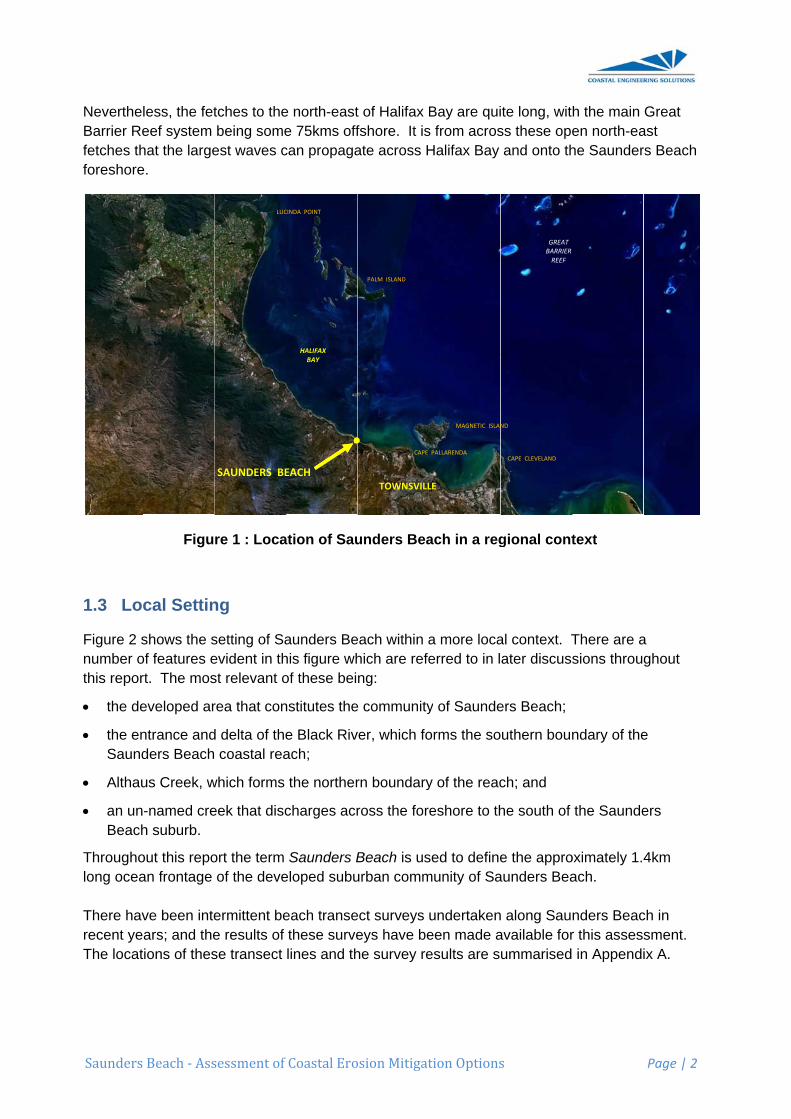
NevertheBarrier Refetches thforeshore
1.3 Lo
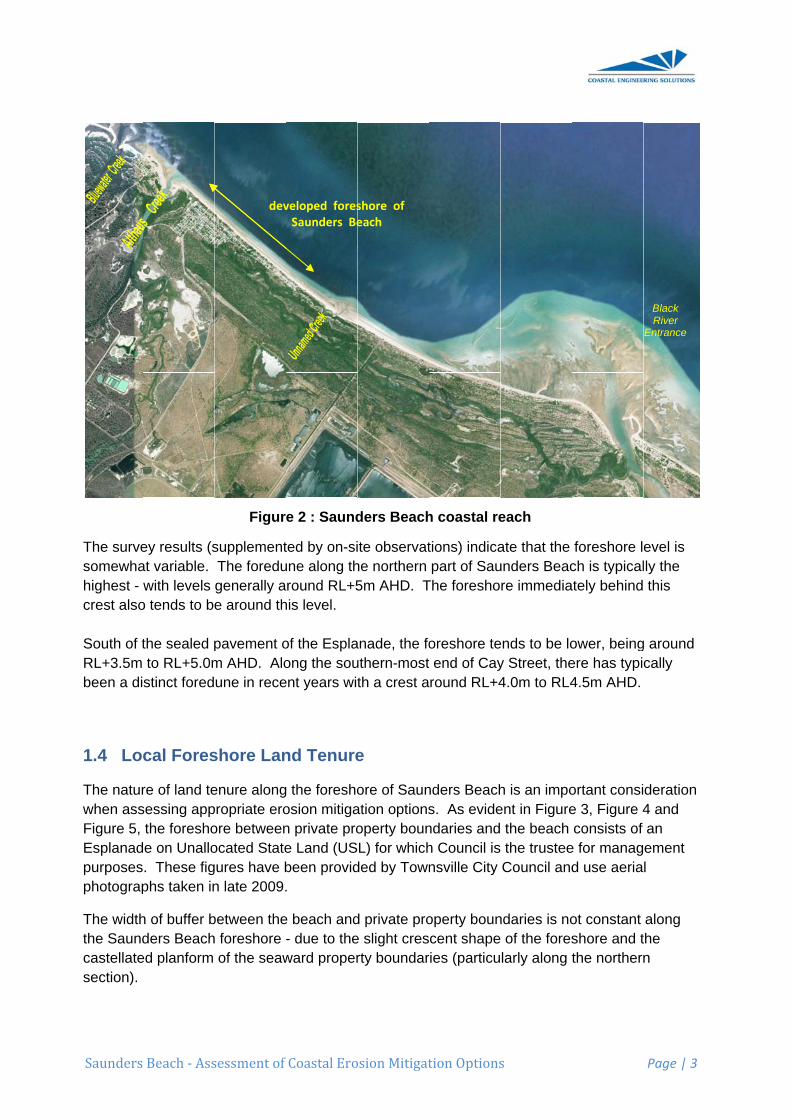
Figure 2 snumber othis repor
• the de
• the enSaund
• Althau
• an unBeach
Througholong ocea There havrecent yeThe locat
Beach ‐ Ass
less, the feteef system hat the largee.
Figu
cal Settin
shows the sof features ert. The mos
eveloped ar
ntrance andders Beach
us Creek, w
-named creh suburb.
out this repoan frontage
ve been intears; and thetions of thes
sessment of
tches to thebeing some
est waves c
re 1 : Loca
ng
setting of Saevident in thst relevant o
rea that con
d delta of the coastal rea
which forms
eek that disc
ort the term of the deve
ermittent bee results of se transect
SAUNDERS BE
LUC
Coastal Ero
e north-easte 75kms offcan propaga
ation of Sau
aunders Behis figure whof these bei
nstitutes the
e Black Rivach;
the norther
charges acr
Saunders Beloped subu
each transethese survelines and th
EACH
HALIFAX BAY
CINDA POINT
osion Mitigat
t of Halifax Bfshore. It isate across H
unders Bea
each within ahich are refeng:
e community
ver, which fo
rn boundary
ross the for
Beach is usurban comm
ect surveys eys have behe survey re
TOWNSVILL
CAPE
PALM ISLAND
tion Options
Bay are quis from acrosHalifax Bay
ach in a reg
a more locaerred to in l
y of Saunde
orms the so
y of the reac
eshore to th
sed to definemunity of Sa
undertakeneen made aesults are s
LE
MAGNETIC ISLAN
PALLARENDA
s
ite long, witss these opeand onto th
gional cont
al context. Tater discus
ers Beach;
uthern bou
ch; and
he south of
e the approaunders Bea
n along Sauavailable forummarised
CAPE CLEVELAND
GREAT BARRIER REEF
ND
h the main en north-eahe Saunder
text
There are asions throu
ndary of the
the Saunde
oximately 1.ach.
nders Beacr this asses in Appendi
Page | 2
Great ast rs Beach
a ghout
e
ers
4km
ch in sment. ix A.
Saunders
The survesomewhahighest - crest also South of tRL+3.5m been a di
1.4 Lo
The naturwhen assFigure 5, Esplanadpurposesphotograp
The widththe Saundcastellatesection).
Beach ‐ Ass
ey results (sat variable. with levels
o tends to be
the sealed pto RL+5.0mstinct fored
cal Fores
re of land tesessing appthe foreshoe on Unallo. These figphs taken in
h of buffer bders Beach
ed planform
sessment of
Figur
supplementThe foredugenerally ae around th
pavement om AHD. Aloune in rece
shore Lan
enure alongpropriate eroore betweenocated Stategures have bn late 2009.
between theh foreshore -
of the seaw
dev
Coastal Ero
e 2 : Saund
ted by on-siune along thround RL+5
his level.
of the Esplaong the souent years wit
nd Tenure
g the foreshoosion mitigan private proe Land (USbeen provid.
e beach and- due to theward proper
veloped foresSaunders Be
osion Mitigat
ders Beach
ite observathe northern 5m AHD. T
anade, the fouthern-mostth a crest a
e
ore of Saunation optionsoperty bounL) for which
ded by Town
d private proe slight cresrty boundar
shore of each
tion Options
h coastal re
tions) indicapart of Sau
The foresho
oreshore tet end of Cayround RL+4
nders Beachs. As evidendaries andh Council isnsville City
operty bouncent shape
ries (particu
s
each
ate that the unders Beacre immedia
ends to be loy Street, the4.0m to RL4
h is an impoent in Figure the beach the trusteeCouncil and
ndaries is no of the foreslarly along t
foreshore lch is typical
ately behind
ower, beingere has typi4.5m AHD.
ortant consie 3, Figure 4consists of
e for managd use aeria
ot constant shore and tthe northern
Page | 3
evel is lly the this
g around cally
deration 4 and an ement l
along the n
Black River
Entrance
Saunders
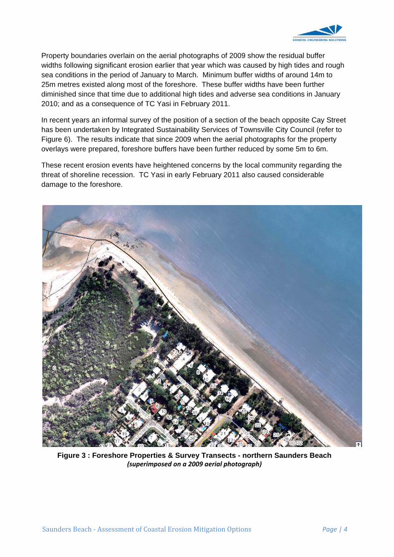
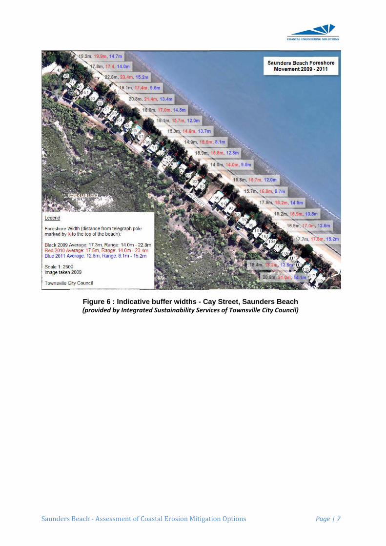
Property widths folsea cond25m metrdiminishe2010; and
In recent has beenFigure 6).overlays w
These recthreat of sdamage t
Figu
Beach ‐ Ass
boundarieslowing signitions in theres existed ed since thad as a cons
years an in undertaken. The resulwere prepa
cent erosionshoreline reto the foresh
ure 3 : Fore
sessment of
overlain onnificant erose period of Jalong most
at time due tequence of
nformal survn by Integrats indicate tred, foresho
n events haecession. Thore.
eshore Prop(supe
Coastal Ero
n the aerial sion earlier tJanuary to Mt of the foresto additionaf TC Yasi in
vey of the poated Sustainthat since 2ore buffers
ave heightenTC Yasi in e
perties & Serimposed on
osion Mitigat
photographthat year whMarch. Minshore. The
al high tidesn February 2
osition of a nability Serv2009 when thave been
ned concernearly Februa
Survey Trann a 2009 aer
tion Options
hs of 2009 shich was ca
nimum buffeese buffer w and advers
2011.
section of tvices of Towthe aerial phfurther redu
ns by the loary 2011 als
nsects - norial photogra
s
show the reaused by higer widths of widths have se sea cond
the beach ownsville Cityhotographsuced by som
ocal commuso caused c
orthern Sauaph)
esidual buffegh tides andaround 14mbeen furtheditions in Ja
opposite Cay Council (r for the prome 5m to 6
unity regardconsiderable
unders Bea
Page | 4
er d rough m to er anuary
y Street refer to perty m.
ing the e
ach
Saunders
Beach ‐ Ass
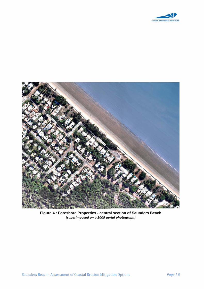
Figure 4
sessment of
: Foreshor(supe
Coastal Ero
re Propertieerimposed on
osion Mitigat
es - centran a 2009 aer
tion Options
al section orial photogra
s
of Saundersaph)
s Beach
Page | 5
Saunders
Beach ‐ Ass
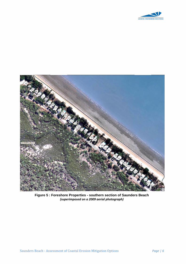
Figure 5 :
sessment of
Foreshore(supe
Coastal Ero
e Propertieerimposed on
osion Mitigat
s - southern a 2009 aer
tion Options
rn section rial photogra
s
of Saundeaph)
rs Beach
Page | 6
Saunders
Beach ‐ Ass
Figure (provide
sessment of
6 : Indicated by Integra
Coastal Ero
tive buffer wated Sustain
osion Mitigat
widths - Canability Servi
tion Options
ay Street, Sices of Town
s
Saunders Bnsville City Co
Beach ouncil)
Page | 7
Saunders
2 LOC
2.1 Ba
The coastowards tprocessesEntrance coast via waves ansandy de
Previous history of utilised m1941) to isound tecstrategy fdirect releAppendix
ParticularappreciatJanuary 2subseque
• ThereSaund
• The srapidlyconsisnorm”
• Never
o sigof
o the20
o thehase
• Althouaverabeen
Beach ‐ Ass
CAL COA
ckground
tal processhe north-wes shaping thimmediatelthe extensi
nd currents oltas indicati
detailed anerosion an
mathematicaidentify andchnical basifor this foresevance to thx B.
rly relevant te that these2010 and thent severe e
e is a net traders Beach
horeline cay during higstently show”.
rtheless sin
gnificant accSaunders B
e foreshore009) since 1
e foreshoreas accreted easonal time
ugh some sge trend ovone of sma
sessment of
ASTAL
d
es in Halifaest along thhe beach aly to the souive shoals wonto local bng their sup
nalysis of shd accretion
al modelling measure his to supporshore. Givehis assessm
findings of e findings whe devastatievents do n
ansport of a each year.
n be very dgh-energy wwn either un
ce 1941 the
cretion of thBeach;
south-east941;
north-east since 1941
eframes.
sections of Sver the entirall net accre
Coastal Ero
PROCES
x Bay resulhe foreshorere strongly uth-east. Twithin the enbeaches. Opply of sedi
horeline pos cycles sinc, surveys a
historical reart the determen the impoment of eros
that earlier were determing effects oot alter the
pproximate.
dynamic. Siwave eventsniform on-go
ere have be
he shoreline
t of Saunde
of Saunder, but is part
Saunders Bre coastal petion.
osion Mitigat
SSES
lt in the trane of Saundeinfluenced
This river sysntrance delt
Other smallements to th
sition of Sauce at least 1nd historicaalignments mination of ortance of thsion mitigati
study are smined prior tof TC Yasi iconclusion
ely 10,000m
ignificant chs. There is oing erosio
een some n
e to the sou
ers Beach R
rs Beach Roticularly dyn
Beach have recinct from
tion Options
nsport of saers Beach. by the presstem has prta - which h
er local creee coast.
unders Beac1941. That al aerial phoof the localan appropr
hat earlier wion options,
summarisedo the adverin Februarys or overall
m3 to 14,000
hanges in thno particulan or accreti
et changes
th of the de
Road has rec
oad (to the namic with s
clearly retrem the Black
s
nd from theConsequenence of therovided sed
have then beeks and stre
ch (Smithercomprehen
otographs (d shoreline. iate erosion
work by Dr. it is include
d below. It irse sea andy 2011. How
findings of
m3 of sand
he shorelinear location ton - “fluctua
to the shor
eveloped su
ceded by u
entrance ofsignificant f
eated in recRiver up to
e south-eastntly natural e Black Rivediments to theen worked
eams also h
rs, 2009) rensive earlierdating back It provides
n mitigation Smithers aned herein a
is importantd tide conditwever thesethat study.
northwards
e position octhat has ations are th
reline, name
uburban com
p to 15m (a
f Althaus Cluctuations
cent decadeo Althaus Cr
Page | 8
t
er he d by have
veals a r study
k to a
nd its s
t to tions of e
s along
ccur
he
ely
mmunity
as at
reek) over
es, the reek has
Saunders
• In recattribuThe eupper
• It is pohave high t
2.2 Ov
Waves mtransport.intensity a
2.2.1 Lo
Longshorthat contrdetermineunderstanerosion m
Waves aralongsho
The anglebe the waaccount fo
On most cproducinglocation, tduring oththere is nthe case.
Typically annual lowhere theboth longaverage n
Whilst thesand is besame ratebe no netSaundersinto Halifa
Beach ‐ Ass
cent years, tuted to highelevated ocer beach area
ostulated thbeen part oides will not
verview of
ove sand in. Both procand directio
ongshore t
re transport rol beach mes in large pnding of lon
managemen
rriving with tre current w
e at which taves themseor notable v
coasts, wavg day-to-daytransport mher times ofo net chang
longshore mngshore moe net transpshore direcnet north-we
ere may be eing lost ane as it is bet change to s Beach is tax Bay furth
sessment of
the increaseher than norean water lea.
hat since theof the 18.6 yt be as high
f Sand Tr
n two fundacesses can on in respon
transport
is the movemorphology,
part whethengshore sannt practices.
their crests which initiate
he incomingelves), nevevolumes of
ves arrive ay and seaso
may be to thef the year. ge in the be
movement iovement. Cport rate is tctions througesterly rate
a net longsnd thereforeing transpothe beach ohe nearby B
her to the so
Coastal Ero
ed erosion ermal tides oevels during
e higher anyear tidal eph or as frequ
ransport
mental wayoccur simul
nse to preva
ement of salongshore s
er shorelinesnd transport
at an anglees and main
g waves acertheless thsand to be
at the beachonal reversae left (lookinIf the volum
each positio
is greater inCertainly thiowards the ghout a typiof 10,000m
shore transpe the beach rted along tover annuaBlack Riverouth contrib
osion Mitigat
experiencedccurring in g such even
d more freqpoch, in comuent.
Processe
ys - by longsltaneously, ailing wave
and along thsand transps erode, act is essentia
e to the planntains sand
ct on the beaheir continuamoved ann
h from a numals in transpng seaward
mes of transn over annu
n one directs is the casnorth-west
ical year. Em3 to 14,000
port along Sis eroding.
the shore atl timeframe. Certainly
bute sand to
tion Options
d on Saundconjunction
nts resulted
quent tides tming years a
es
shore transbut both vaconditions.
he beach. Oport is probacrete or rem
al for the det
n alignmentd transport a
ach face maal and relennually on loc
mber of diffeport directio
d) during paport are equal timefram
tion than these for the Sat despite theEarlier inves0m3 each ye
Saunders Be So long ast any partic
es. The primother rivers
o Saunders
s
ders Beach n with rough
in substant
that occurreas the cycle
port and byary significa
Of all the vaably the momain stable.termination
t of the shoralong the be
ay only be vntless actioncal shoreline
erent offshoon. At a parrt of the yeaual in each
mes. Howe
e other – whaunders Beere being sastigations esear.
each, this ds sand is beular location
mary sources and creekBeach, but
is more direh sea condittial erosion
ed in recente wanes ext
y cross-shorntly in their
arious proceost influentia. Conseque of success
reline createeach.
very small (n is sufficienes.
ore directionrticular beacar and to thdirection thver this is n
hich resultsach shoreliand movemstimated an
does not meeing supplien, then there of sand suks that discht it is the Bla
Page | 9
ectly tions. of the
t years treme
re
esses al. It ently an sful
e an
as may nt to
ns - ch e right
hen not often
in a net ne,
ment in n
ean that ed at the re will upply to harge ack
Saunders
River whicoastal re
However episodic aThe suppsedimentsneed to hsand nort
Consequeongoing ain periodsfollowed bmore ene
Whilst theprevailed sand at areflected only a minsince 194
In other wa long-tertransport
It is pertinregion thaCungulla that sandsteadily eerosion a
2.2.2 Cr
Cross-shoonshore/ooccurs dustorms or
Strong waerosion oprofile. Tseaward eonto the bbeach co
Beach ‐ Ass
ch overwheeach of Sau
rather thanand heavily
ply of sand ts off the cat
have stormsthwards off
ently there aaverage nors of erosionby periods o
ergetic south
ere are theswhereby th long-term rin the findinnor change41.
words, whilsrm balance was match
nent to noteat are experand Bushla is now bein
eroding. Howt Saunders
ross-shore
ore transpooffshore mouring ambier cyclones th
ave action af the beach
The eroded sedge of thebeach, whendition.
sessment of
elmingly prounders Beac
n a steady ay reliant on pto the coasttchment an
s or sustainethe submer
are inevitabrth-westerly on Saundeof beach reh-easterly w
se cycles ofhe shorelinerate that mangs of Dr. S to the net v
st there werein these proed by the lo
e that this is riencing eroands Beachng suppliedwever this dBeach.
e transport
ort is the moovement. Wnt conditionhat it becom
and elevateh as sand is sand is mov
e surf zone. re waves a
Coastal Ero
ovides the gch.
annual rate, processes at by the Blacd through thed periods orged delta o
bly periods wy sand transers Beach. covery whe
wave activity
f beach erose between tatches the s
Smither’s eavolume of s
e cycles of ocesses beong-term ne
quite a diffosion probleh, the longshd to these fodiminished l
t
ovement of sWhilst this wns (ie. the nmes most ev
ed ocean waremoved fr
ved offshor Subsequend onshore
osion Mitigat
greater volu
the supply affecting theck River relhe lower reof strong soonto Saunde
where actuasport of 10,0However th
en greater sy.
sion and ache Black Risand movedarlier study, sand on the
local erosioecause the ret supply of
ferent scenaems. For exhore sand troreshores. longshore s
sand perpewashing of s
ormal day-tvident and m
ater levels drom the dune during thent milder w
e winds then
tion Options
me of sand
of sand to Se sand deltaies on infreaches of th
outh-easterlers Beach.
al sand sup000m3 to 14hese erosioand supply
ccretion, oveiver and Altd off the showhich concdowndrift S
on and accrrate of northsand from
ario to otherxample at Rransport ratConsequen
supply of sa
ndicular to and up andto-day condmost critica
during such ne system ae storm to cave condition re-work it
s
to the imm
Saunders Ba at the Blacquent majoe river, in cy wave con
pply does no4,000m3 eacn phases ais initiated
er time a stethaus Creekoreline. Thcluded that tSaunders B
retion, thereh-westerly lothe south-e
r foreshoresRowes Bay,tes are greantly these beand is not th
the beach –d down the bditions), it isal.
events canand upper recreate a sanons can retuto establish
P
mediate dow
Beach is somck River Enr floods to fonjunction w
nditions to s
ot match thech year – rere typically during year
eady-state k is suppliedis behaviouthere has beach coasta
e was neverongshore s
east.
s in the Tow Nelly Bay,
ater than theeaches hav
he primary c
– in other wbeach profi
s during sev
n cause sevegions of thnd bank neaurn this sanh the pre-sto
Page | 10
wndrift
mewhat ntrance. flush with the weep
e esulting
rs of
has d with ur is een al reach
rtheless and
wnsville
e rate ve been cause of
words, le
vere
vere he ar the nd back orm
Saunders
During paoccur in omay take
There is astorms orphenomelonger disare such
Once ovecurtailed. slope andareas sincan wash
Nevertheoverwashabates, thfurther thaearly partbreak dire
Nevertheof the prothe upper
2.2.3 Vu
The relatioverwashresponse
More thanconseque(Hopley, shoreline greater wmore receexpected
The imagoff the beThe uppesuch natu
Beach ‐ Ass
articularly seonly one or many year
another pror cyclones, tenon occursssipate theirthat the wa
erwash com Instead of
d carried insce the fores
h over the d
less since wh, the beachhe actual poan its pre-stt of the stormectly on the
less when oofile. Naturar beach prof
ulnerability
ively low forh. Recent c of the Sau
n 10 metresence of TC A1974). Howrecession a
wave energyent event refollowing s
es presenteeach face aner beach proural features
sessment of
evere stormtwo hours;
rs.
cesses affethere can b
s when the sr energy dirves wash o
mmences, fuf being movshore. The shore is notunes and p
waves are nh itself doesosition of thtorm locatiom prior to o beach) wh
overwash oal features sfile are wipe
y of Saund
reshore alocyclone evenders Beac
s erosion ofAlthea whe
wever in Fealong the C
y. It is evideesulted in shuch a seve
ed in Figurend depositeofile is seens being flatt
Coastal Ero
ms, very signwhereas re
ecting crosse considerastorm tide brectly on theover the bea
urther recesved offshore
consequent only inundenetrate inl
not actively s not retreate intertidal on. It is the overwash (wich has a g
ccurs, it flatsuch as a loed out by th
ders Beach
ng Saundernts offer tes
ch to overwa
f Saunders n it crossedbruary 2011
Cay Street oent that ovehoreline recre event.
e 7 show theed inshore bn to be devotened by ov
osion Mitigat
nificant erosecovery of th
s-shore sandable “overwbuilds duringe beach sloach slope si
sion of the e, sand in thnces of overated by stoland.
attacking tht significantlbeach slopeseverity an
when oceanreater effec
ttens the beow foredunehe overtopp
foreshore
rs Beach mstimony to tash events.
Beach is red the coast 1 the more
ocean frontaerwash of thcession bein
e extensiveby waves asoid of any foverwash.
tion Options
sion of sandhe beach by
d transport.wash” of somg a cyclone pe or on theince it is sub
foreshore she upper berwash can brm surge, b
he submergly. Once the may not h
nd nature of levels are s
ct on shoreli
each slope -e, scarp anding water le
to storm e
makes it partthis vulnera
eported to hnear Balgalsevere TC
age despite he Saundersng much les
e amount of s they washoredune, be
s
d from the uy onshore tr
During pame foreshor
to be so gre dunes - obstantially s
still occurs bach is swepbe devastatbut destruct
ged beach she storm cauhave retreatf the conditisuch that wine recessio
- particularlyd/or berm thevels and w
events
ticularly susbility and ill
ave occurrel Beach in DYasi causethe higher
s Beach forss than mig
beach sandhed over theerm or erosi
P
upper beachransport pro
articularly sees. This reat that wacean water submerged.
but is signifipt up over tting to foresive cyclonic
slope duringusing overwted inland mons during
waves actuaon.
y in the upphat are typic
wave action.
sceptible to ustrate the
ed as a December 1d much lesstorm tide aeshore duriht intuitively
d that was se crest of thon scarp du
Page | 11
h can ocesses
evere
aves no levels
.
cantly he
shore c waves
g wash much the
ally
per part cal of
1971 s and ing this y be
swept he beach. ue to
Saunders
When convulnerabiforeshoredamage tthe beach
Such storparticularforeshore
However damagingcan directbeach fac
If such evconsideratypical eroperceivedGiven theevents, thintensity oconditions
2.3 Su
The impoSaunders
• ThereSaund
SAND SW
Beach ‐ Ass
nsidering erlity of the S
e, the local cthat can be h during sev
rm tide inunrly to foreshe occurred d
in terms of g as less setly attack thce.
vents occur able before osion / accrd by local ree particular vhis increaseof such eves that occur
mmary o
ortant aspecs Beach can
e is a net traders Beach
WEPT INSHORE O
sessment of
rosion mitigaunders Becommunity inflicted by
vere cyclon
ndation and ore vegetat
during TC Y
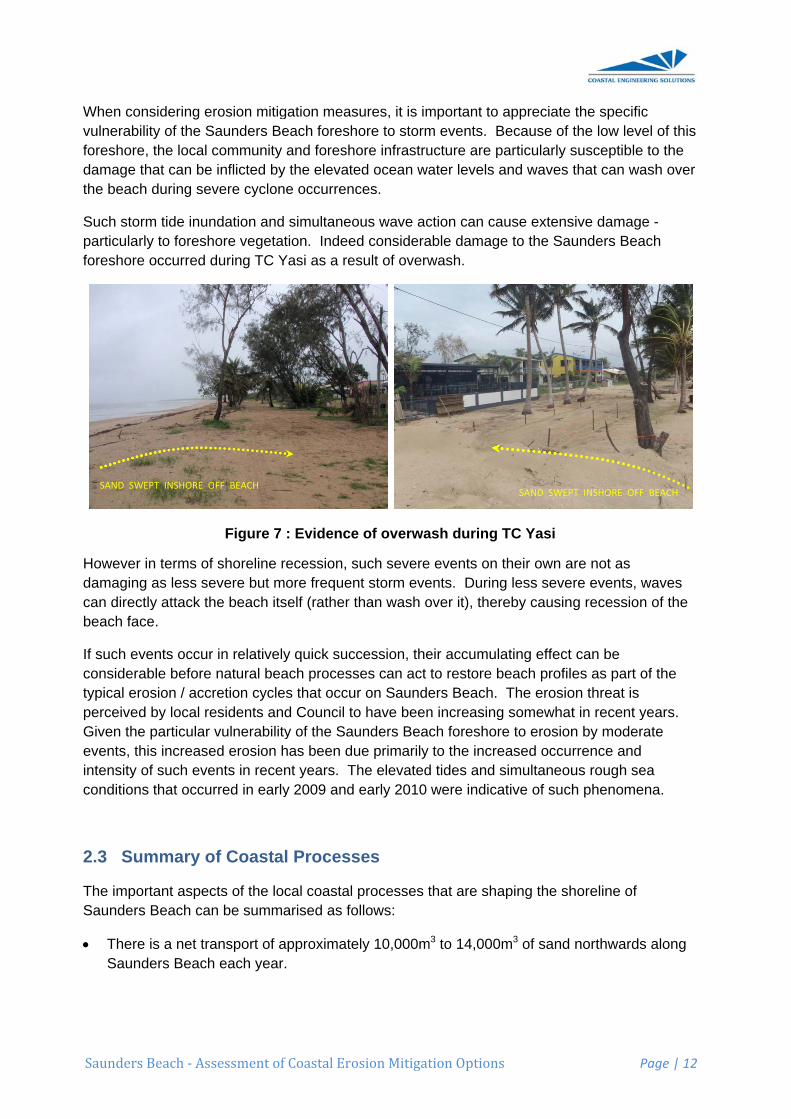
Figure 7
shoreline revere but mohe beach its
in relativelynatural bea
retion cyclesesidents andvulnerability
ed erosion hents in recenrred in early
of Coastal
cts of the locn be summa
ansport of a each year.
FF BEACH
Coastal Ero
gation measeach foreshand foreshothe elevatee occurrenc
simultaneotion. Indeed
Yasi as a res
: Evidence
ecession, sore frequen
self (rather t
y quick succach processs that occurd Council toy of the Sauhas been dunt years. Thy 2009 and
l Process
cal coastal arised as fo
pproximate.
osion Mitigat
sures, it is imore to stormore infrastrued ocean waces.
ous wave acd considerasult of overw
e of overwa
such severent storm evethan wash o
cession, theses can act r on Saundeo have beenunders Beaue primarily he elevatedearly 2010
ses
processes tollows:
ely 10,000m
tion Options
mportant to m events. Bucture are pater levels a
ction can caable damagwash.
ash during
e events on ents. Duringover it), ther
eir accumulto restore bers Beach. n increasingch foreshorto the incre
d tides and swere indica
that are sha
m3 to 14,000
s
appreciate Because of particularly sand waves
ause extense to the Sau
TC Yasi
their own ag less severeby causin
ating effect beach profil The erosio
g somewhatre to erosioneased occusimultaneouative of such
aping the sh
m3 of sand
SAND SWEP
P
the specificthe low levesusceptible that can wa
sive damageunders Bea
are not as re events, wg recession
can be es as part o
on threat is t in recent yn by moderrrence and us rough seh phenome
horeline of
northwards
PT INSHORE OFF
Page | 12
c el of this to the
ash over
e - ach
waves n of the
of the
years. ate
ea na.
s along
F BEACH
Saunders
• The pratherepisodEntran
The sflush swith thto swe
• Conseongoibufferin perfollowmore
• Whilsprevawith sstrongyear t
• The reoverwgreat dunessubstathe intlocatio
• Whenvulnerthis foto thewash simult
• Howedama
• Duringover itquick procethat othat o
• The hincrea
Beach ‐ Ass
primary sourr than a steadic and heance.
upply of sasediments ohe need to eep sand no
equently theng averagers naturally riods of eros
wed by perioenergetic s
t there are tiled whereb
sand at a long cycles of eto year arou
elatively lowwash. This p
that waves s - ocean wantially subtertidal beaon.
n considerinrability of thoreshore, th damage thover the be
taneous wa
ever in termsging as less
g less sevet), thereby csuccessionsses can acccur on Sauccurred in e
high rates ofased ocean
sessment of
rce of sand ady annual
avily reliant
nd to the cooff the catchhave stormorthwards o
ere are ineve north-westrecharged sion on Sauods of beachsouth-easter
these cycleby the shoreng-term rateerosion andund the ave
w foreshore phenomenono longer d
ater levels amerged. Och slope m
ng erosion mhe Saundershe local comhat can be ineach duringave action c
s of shorelins severe bu
re events, wcausing recn, their accuct to restoreunders Beaearly 2009 a
f shoreline rwater level
Coastal Ero
supply to Srate, the suon process
oast from thhment and s or sustain
off the subm
vitably perioterly sand trprior to the
unders Beach recovery wrly wave ac
es of beach eline betweee that matcd accretion rage shorel
along Saunon occurs wdissipate thare such th
Once the stoay not have
mitigation ms Beach for
mmunity andnflicted by t severe cycan cause ex
ne recessiout more freq
waves can dcession of thumulating efe beach proach. The eleand early 20
recession inls and wave
osion Mitigat
Saunders Beupply of thisses affecting
he Black Rivthrough the
ned periodsmerged delta
ods where aransport of onset of adch. Howevewhen great
ctivity.
erosion anden the Blaches the sanmean that tline position
nders Beacwhen the stoeir energy dat the wave
orm causinge retreated
measures, it reshore to sd foreshore the elevatedclone occurrxtensive da
on, such sevquent storm
directly attahe beach faffect can be
ofiles as parevated tides010 were in
n recent yeae activity.
tion Options
each is the s sand to Sag the sand d
ver relies one lower reacs of strong sa onto Saun
actual sand 10,000m3 to
dverse norther these eroer sand sup
d accretion,ck River andnd moved othere are apn.
ch makes it orm tide buidirectly on tes wash oveg overwash inland much
is importanstorm events
infrastructud ocean warences. Su
amage.
vere eventsevents.
ack the beacace. If suche considerabrt of the typis and simul
ndicative of
ars have co
s
nearby Blaaunders Bedelta at the
n infrequentches of the south-eastenders Beac
supply doeo 14,000m3
herly sea coosion phasepply is initia
, over time ad Althaus Cff the shoreppreciable f
particularly lds during a
the beach ser the beachabates, theh further tha
nt to apprecs. Because
ure are partter levels a
uch storm tid
on their ow
ch itself (rat events occble before nical erosionltaneous rosuch pheno
oincided with
P
ack River. Heach is some
Black Rive
t major floodriver, in conrly wave coh.
es not match3 each year,onditions – res are typic
ated during y
a steady-stareek is supp
eline. Howevfluctuations
susceptiblea cyclone toslope or on th slope sinc
e actual posan its pre-st
iate the spee of the low icularly susnd waves thde inundatio
wn are not a
ther than wacur in relativnatural beac / accretionugh sea coomena.
h a period o
Page | 13
However ewhat r
ds to njunction onditions
h the , nor are resulting ally years of
ate has plied ver from
e to o be so the ce it is sition of torm
ecific level of ceptible hat can on and
as
ash vely ch cycles nditions
of
Saunders
3 ERO
3.1 Co
When con“Coastal Dwords, it fshoreline
Property aforeshorebuffers).
Defining tto what asBeach for
• an aligbound
• an alig
• an aligon thetime).
3.2 De
When conCoastal Drequired. extreme s
However storm tideBeach sumitigationmore sev
This represtrategy -determinascope of tmitigatingstages of
Beach ‐ Ass
OSION M
oastal Def
nsidering foDefence Linforms the la, or alternat
and infrastre areas seaw
the positionssets are toreshore incl
gnment alodaries of pri
gnment alo
gnment note central se
sign Stor
nsidering foDefence Lin
The Queenstorm event
whilst the ces and wavech an even
n. As discusvere followin
esents a sig- but particuations of crithis assess
g erosion caimplementa
sessment of
MITIGATI
fence Lin
oreshore prone” which reandward botively the al
ructure landward of the
n of the Coao be defendlude:
ng the landivate proper
ng the seaw
tionally seawction of Sau
rm Condi
oreshore proe it is also nnsland Coat for such pu
characteristes (typically
nt may not bssed in the ng successi
gnificant tecularly for onetical combinment of ero
an still be evation.
Coastal Ero
ION OPT
e
otection meepresents thundary of aignment of
dward of theline lie with
astal Defencded. Option
ward boundrties); or
ward bound
ward of the unders Bea
itions
otection menecessary t
astal Plan nourposes
ics of such y by applyinbe the most
preceding Sve storms o
chnical chale that incornations of mosion mitigavaluated, w
osion Mitigat
TIONS
easures on ahe landward
any erosion any protect
e Coastal Dhin the activ
ce Line therns for a Coa
dary of the
dary of the U
existing forach (where t
easures on ato define a Dominates th
an event cang numerica
critical fromSection 2.2of moderate
lenge to anporates bea
moderate, yation optionsith their det
tion Options
any shorelind limit of acbuffers to p
tion structur
efence Lineve beach sy
refore entailastal Defenc
USL and Es
USL and Co
reshore - sathe shorelin
any shorelinDesign Evehe 100-year
an be deteral modellingm the viewp.3, shorelin
e severity ra
ny detailed dach nourishet more freqs. Neverthetailed design
s
ne, it is neccceptable erprotect the Sre such as a
e remains pystem (ie. w
ls considerace Line alon
splanade (ie
ouncil Espla
ay along thene has retre
ne, as well aent for whichr average re
mined by a g techniquesoint of prove recession
ather than a
design of anhment as anquent eventeless broadn being def
P
essary to drosion. In oSaunders Ba seawall.
protected, wwithin the ero
ation by Coung the Saun
e. on the se
anade; or
e 1941 aligneated since
as defining h immunity ecurrence in
detailed stus), for Saunviding erosion is likely to a single maj
n erosion mn element. Sts are beyo strategies
ferred to late
Page | 14
efine a other Beach
whereas osion
uncil as nders
eaward
nment that
a is nterval
udy of nders on be or event.
mitigation Such nd the for er
Saunders
3.3 Ge
In essenc“hard” str
Soft (or n
• Do noresult
• Avoidundev
• Plannfrom t
• Beachbeach
• Beachsand fthereb
• Channshore
Hard (or s
• Seaw
• Seawwhilst
• Groynthereb
• Groynmaintcause
In many loand “hard
A more deAppendixBeach copresentedsolutions)
Beach ‐ Ass
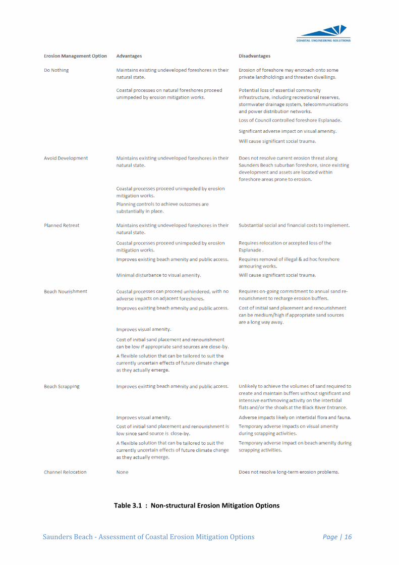
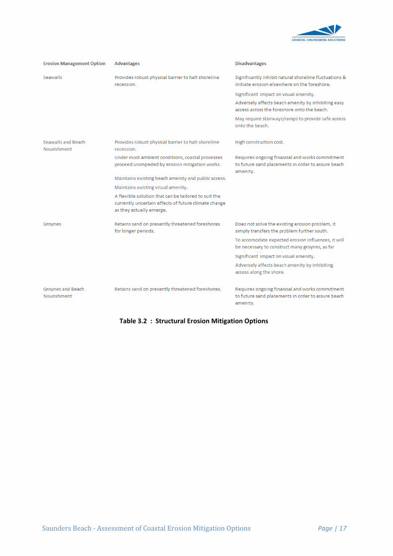
eneric Ero
ce, erosion uctural solu
on-structura
othing - allowing losses;
ing developveloped are
ned retreat -the vulnerab
h nourishmeh, thereby p
h scrappingfrom the intby improvin
nel relocatioline erosion
structural) s
walls - which
walls with bet sand is inte
nes / offshoby retaining
nes / offshoaining sand
ed by the gr
ocations thed” solutions.
etailed descx C. To assoastal reachd overleaf in).
sessment of
osion Miti
mitigation outions.
al) solutions
wing coasta
pment - by ieas;
- removing tble area;
ent - rehabiproviding an
g - by using ter-tidal zong erosion b
on - relocatn so that the
solutions tha
h act as phy
each nourishermittently p
re breakwag sand on th
re breakwad on the bearoyne’s inter
e optimum .
cription of eist in evalua
h, a summarn Table 3.1
Coastal Ero
igation O
options can
s would typ
al processe
mplementin
the erosion
litate erodinn adequate e
earthmovinne or nearshbuffers on th
e dynamic rey have a le
at can be ut
ysical barrie
hment - wheplaced in fro
ters - used he eroding f
ters with beach, and berruption to l
manageme
each generiating these ry of the adv(for non-str
osion Mitigat
Options
be conside
ically includ
s to take th
ng regulator
threat by re
ng foreshoreerosion buf
ng plant andhore sandbahe beach;
river or creeesser impac
tilised to mi
rs to preven
ere the seawont of the w
to inhibit thforeshore fo
each nouriseach nourishongshore s
ent strategy
c erosion mvarious optvantages aructural opt
tion Options
ered as “soft
de:
eir natural c
ry controls w
elocating ex
es by directffer;
d equipmenanks into th
ek entrancect.
tigate the th
nt shoreline
wall defineswall for impr
he natural loor longer pe
hment - whhment redusand supply
may includ
managementions in the nd disadvanions) and in
s
t” non-struc
course while
with regard
xisting deve
t placement
t to mechanhe upper be
es that may
hreat of ero
e recession;
s the inlandroved beach
ongshore meriods;
ere the struces the dow
y.
e a combin
nt option is pcontext of tntages of en Table 3.2
P
ctural solutio
e accepting
to building
elopment aw
t of sand on
nically relocach or dune
be contribu
sion include
extent of eh amenity;
ovement of
ucture assiswndrift eros
ation of bot
provided in the Saundeach type ar(for structu
Page | 15
ons, or
g the
in
way
nto the
cate e,
uting to
e:
erosion,
f sand,
sts in ion
th “soft”
ers re ral
Saunders
Beach ‐ Asssessment of
Table 3.1
Coastal Ero
: Non‐struc
osion Mitigat
ctural Erosio
tion Options
n Mitigation
s
n Options
P
Page | 16
Saunders
Beach ‐ Asssessment of
Table 3.
Coastal Ero
.2 : Structu
osion Mitigat
ral Erosion M
tion Options
Mitigation O
s
Options
P
Page | 17
Saunders
4 ASS
4.1 The
When conSaundersand Althacoastal pr
• Southmost
• Centralmos
• Northentran
This sepaare in anysince the partitioninintegrate
4.2 So
The Soutshoreline of Saundeexperiencdecades. the Saund
This accrebanks thaRiver durthe lower
Any matethrough Hfloods arenear the rforeshoreun-named
Beach ‐ Ass
SESSME
e Saunde
nsidering aps Beach it isaus Creek. recincts, na
hern Precincend of Cay
al Precinct st the entire
ern Precincnce of Altha
aration into y way compprocesses
ng lends itsewell over th
uthern P
hern Precinnorth of the
ers Beach ccing short-te Compariso
ders Beach
etion is predat form the ding major floreaches of
erial finer thaHalifax Bay e depositedriver mouth
es. Similar pd creek that
sessment of
NT OF
ers Beach
ppropriate es necessaryIn doing so
amely:
ct : from theStreet.
: from the se ocean fron
ct : from apaus Creek.
coastal prepartmentalisaffecting eaelf to the dehe entire Sa
recinct
nct of the Sae Black Rivecomprises aerm episodions with ae
h township h
dominantly delta of the ood events f the river.
an sand tenand beyond closer to th. Waves thprocesses dt enters Hal
Coastal Ero
EROSIO
h Coastal
erosion mitigy to consideo it is eviden
e entrance o
southern enntage of the
pproximately
cincts doessed. They aach have sievelopment aunders Bea
aunders Beer Entrancea broad ridgic erosion, t
erial photogrhas prograd
due to the Black Rivewhen subs
nds to be did. Whereashe Black Rivhen work thedeliver smalifax Bay so
osion Mitigat
ON MITIG
l Reach
gation optioer the entire nt that the s
of the Black
nd of Cay Sdeveloped
y Saunders
s not imply tare not isolagnificant infof viable er
ach coastal
ach coastae. The foresge with a vethis area haraphy of 194ded variably
onshore trar. Sand is d
stantial flow
stributed wis the coarsever entrancese sand de
aller volumeome 450 me
tion Options
GATION
ons along thcoastal reahoreline ca
k River to ap
Street to Saucommunity
Beach Roa
that the coaated or discfluences onrosion mana reach.
l reach is thshore imme
egetated primas accreted 41 suggest
y by 50m to
ansport of sdelivered ins flush the a
idely as theer sand frac
ce - resultingeposits ontos of sand o
etres south
s
OPTION
he suburbanach betweenn be consid
pproximatel
unders Beay of Saunde
ad northwar
astal procescrete sectionn the othersagement st
he 4.2kms loediately alonmary dune.substantialthat the for80m since
and from thnto Halifax Baccumulate
e flood watections that ag in substano and alongnto Saundeof Cay Stre
P
NS
n foreshore n the Black dered as thr
y the south
ach Road, wers Beach.
rds to the oc
sses within ens of shorel. However rategies tha
ong sectionngside the s Whilst ly in recent reshore southat time.
he shoals anBay by the Bed deposits
ers disperseare swept ountial sand shg adjacent ers Beach freet.
Page | 18
of River
ree
ern-
which is
cean
each ine, this
at
n of the suburb
uth of
nd sand Black from
ed ut by hoals
rom the
Saunders
These naHowever south-eas
4.2.1 Re
Given thisPrecinct, foreshore
However with northforeshoreoccur on
The foresestablishe
4.3 Ce
The Centconstituteextends fIt is the sethe foresh
The greatfrom acroof sand towave eve- which m(which typ
As discusthe presenortherly processescertainty tof a conti
4.3.1 Po
Possible e
• Beachforeshthe bu
• Seawreces
Beach ‐ Ass
atural processignificant s
st - typically
ecommend
s on-going tthere appea
e in the futur
given the eherly storm e and front dthe foresho
shore shoulded at regula
ntral Prec
tral Precinctes almost thfrom the souection of forhore Esplan
test threat ooss the openo this precinents (typicalmay not matcpically occu
ssed earlierent time it is wave energs causing into this premnuing erosi
ossible Ero
erosion mit
h Nourishmhore. This wuffer.
wall - a propesion. Shou
sessment of
sses will cosupply rates
y during nor
ded Strateg
trend of sanars little neere. A strate
episodic natevents, thedune. It is thore along th
d be monitoar intervals a
cinct
t is the apprhe entire oceuthern-mosreshore thanade, with p
of erosion ton fetches tonct from thely during thch the dem
ur during the
, this foreshin an erosi
gy both beinncreased er
mise. Any eon trend on
osion Mitig
igation strat
ent - to estawill require
erly designeuld the seaw
Coastal Ero
ontinue to sus will be therth Queensl
gy
nd supply aed to implem
egy of Do N
ture of sandre will invar
herefore alsis Southern
ored by regualong this s
roximately 1ean frontagt end of Ca
at is most atprivate prop
o this foresho the north-ee south, thise dry seasoand on locae wet seaso
hore therefoon phase, png greater trosion may
erosion mitign this foresh
gation Strat
tegies for th
ablish a widon-going be
ed structurawall be locat
osion Mitigat
upply sand e result of eand’s dry se
nd general ment any eothing is th
d supply; anriably be peso recommen Precinct.
ular surveyssouthern pre
1400 metre ge of the Saay Street not risk of eroserty bounda
hore is recueast. Whils supply is p
on) moving al foreshoreon).
ore experienprimarily as than normaldiminish so
gation stratehore.
tegies
he Central P
de natural beach re-nou
al seawall toted within th
tion Options
to the Saunepisodic higheason.
accretionarrosion proteerefore app
nd that it doeeriods of shoended that n
s. Appropriecinct.
long sectiounders Bea
orthward to asion. The saries within
urring periodst there appprovided by sand from t
e buffers du
nces cyclesa result of
l. Whilst it iomewhat in egy needs t
Precinct inc
uffer of sanurishment o
o provide a he zone of n
s
nders Beachh-energy w
ry trend on tection measpropriate.
es not neceort-term erono future de
iate transec
on of the forach suburbaaround Sau
shoreline hametres of t
ds of adversears to be ahigh energythe Black Rring north-e
of erosion high tides ais possible tcoming yea
to accommo
clude:
nd in front oon an annua
physical banatural beac
P
h coastal reaves from t
the Southersures along
essarily coinosion of the evelopment
ct lines need
reshore whian commununders Beacas encroachthe shorelin
se sea condan adequatey south-eas
River Entraneasterly eve
and accretiand coexistithat these cars, there isodate the lik
f the erodedal basis to m
arrier to shoch fluctuatio
Page | 19
each. the
rn g this
ncide
should
d to be
ch nity. It ch Road.
hed into ne.
ditions e supply sterly nce area ents
ion. At ing cyclic s no real kelihood
d maintain
oreline ons
Saunders
(remeresult transp
• Seawdesignsand ambiemaint
The overacosts, wilwill be the
As discusinundatioand accesthe erosio- not the ehazard anfloor leve
During paSaundersachieved peak of thmitigation
Some comto suppor
4.3.2 Be
This strat
• Initial sand erosio
• On-goerosioadditio
The detersubsequefuture clim
Beach ‐ Ass
embering thin the remo
port process
wall with beaned seawalto form a na
ent conditioain the bea
all and relatl be very me cost of im
ssed, the San and the pssing propeon mitigatioeffects of ovnd one that ls and the s
articularly ses Beach forethrough the
he storm tidn options.
mment on tert the recom
each Nouri
tegy basical
Nourishmebuffer in fro
on caused b
oing Renouon, it will beonal sand.
rmination ofent determinmate scena
sessment of
at this foresoval of sandses. In othe
ach nourishmll would be arrow beacns. Neverthch.
tive effectivuch dependplementatio
aunders Bepossible simerty and infrn strategiesverwash durequires dif
structural de
evere cycloeshore. Hoe provision e, and this
echnical asmmendations
ishment
lly consists
ent - throughont of the seby the nomi
rishment - g necessary
f the paramnations of forios) is beyo
Coastal Ero
shore experd from the foer words, no
ment - undeavailable duh in front ofheless, freq
eness of eadent upon thon that will i
ach foreshomultaneous drastructure cs discusseduring severefferent mitigesign of nea
nes, little caowever somof a wider fconsiderati
spects of eas presented
of:
h the placemelected Coanated Desig
given that thto recharge
meters assocoreshore reond the sco
osion Mitigat
riences erosoreshore ino sandy bea
er this scenuring severef the seawaquent sand
ach of thesehe location invariably d
ore is quite damaging eclose to the
d below relae cyclone evgation measarshore pro
an be done me mitigationforeshore buon can be a
ach of the thd in followin
ment of a suastal Defencgn Event. F
he nourishee these ero
ciated with asponse and
ope of this a
tion Options
sion and ac front of theach would f
ario the strue events. Hll offers the re-nourishm
e three optioof the prefeetermine th
low - makineffects of wae shore. It iste to the mivents. Thatsures whichperties.
to prevent n of overtopuffer to atteapplied to th
hree possiblng sections
ufficient voluce Line that Figure 8 illu
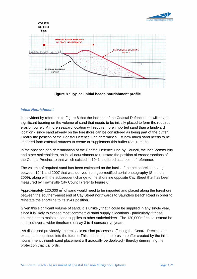
ed foreshoresion buffers
a nominated buffer reqassessment
s
ccretion cyce structure bform in fron
uctural beneHowever the
amenity of ment would
ons, as wellerred Coasthe preferred
ng it suscepaves washins important itigation of st is quite a dh relate prim
storm tide ipping wavesenuate overwhe assessm
le strategiesof this repo
ume of sancan accomstrates the
e will experis by periodi
d Design Evuirements (t of erosion
P
les) then thby natural st of the sea
efits of a proe placemenf a beach dube required
l as their indtal Defence d option.
ptible to storng over the to apprecia
shoreline redifferent coa
marily to hab
inundation os could be wash during
ment of eros
s is offered ort.
d to establismmodate the
concept.
ience cyclesc placemen
vent and th(for current mitigation o
Page | 20
is will sand awall.
operly nt of uring d to
dividual Line. It
rm tide beach
ate that ecession astal bitable
of the
g the sion
below
sh a e
s of nt of
e and options.
Saunders
Initial No
It is evidesignificanerosion blocation - Clearly thimported
In the absand otherthe Centr
The volumbetween 2009); alomeasured
Approximbetween treinstate
Given thissince it issources asupplied o
As discusexpected nourishmprotection
Beach ‐ Ass
ourishment
ent by referent bearing onuffer. A mosince sand
he position ofrom extern
sence of a dr stakeholderal Precinct
me of requir1941 and 2ong with thed by Towns
mately 120,0the southerthe shorelin
s significant likely to ex
are to maintover a wide
ssed previoto continueent throughn that it affo
EXISTINGPR
COASTAL DEFENCE LINE
sessment of
Figure 8 : T
t
ence to Figun the volumore seawardd already onof the Coasnal sources
determinatioers, an initiato that whic
red sand ha2007 that wae subsequeville City Co
000 m3 of sarn-most endne to its 194
t volume of xceed most tain sand suer timeframe
ously, the epe into the fuh sand placeords.
G SHORELINE ROFILE
EROSION BUFFERBY BEACH NOU
Coastal Ero
Typical init
ure 8 that thme of sand td location wn the foreshtal Defenceto create o
on of the Coal nourishmch existed in
as been estas derived fnt change touncil (refer
and would nd of Cay Str41 position.
sand, it is ucommercia
upplies to ote of say 3 to
pisodic erosture. This mement will g
R ENHANCED URISHMENT
osion Mitigat
tial beach
he location ohat needs t
will require more can be
e Line deterr suppleme
oastal Defeent to reinsn 1941 is of
imated on tfrom geo-reto the shorer to Figure 6
need to be ireet northwa
unlikely thatal sand suppther stakeho 4 consecu
sion procesmeans that gradually be
tion Options
nourishme
of the Coasto be initiallymore importconsidered
rmines just hent this buffe
nce Line bystate the posffered as a
the basis of ectified aeriaeline opposi6).
mported anards to Sau
t it could beply allocatioolders. The
utive years.
ses affectinthe erosion
e depleted -
RENOURISHPRO
s
ent profile
stal Defencey placed to ted sand thad as being phow much ser requirem
y Council, thsition of eropoint of refe
f the net shoal photograpite Cay Stre
nd placed alnders Beac
e supplied inons - particue 120,000m
ng the Centrn buffer crea- thereby dim
ED SHORELINE OFILE
P
e Line will hform the rean a landwapart of the bsand needsent.
he local comoded sectionerence.
oreline chanphy (Smitheeet that has
long the forch Road in o
n any singleularly if thosm3 could inst
ral Precinctated by the minishing th
Page | 21
have a quired ard uffer.
s to be
mmunity ns of
nge ers, been
reshore order to
e year, e tead be
t are initial
he
Saunders
On-goingshould nocompone
On-going
It is difficuare closeThe problthe Blacka predeteundertakecampaign
Given thelikelihoodsurveys aonset of e
For budge10,000m3
In summarequire th
• initial shoreconse
• on-gokeep
4.3.3 Se
A seawalconstructeit was locbe a veryduring se
However foreshoreprocessesWaves waany sand all) tides, strategy o
ConsequeBeach.
Beach ‐ Ass
renourishmot be constrnt of succes
g Renouris
ult to determly matchinglem of short
k River deltaermined annen through n should buf
e requireme of any cyc
at least twiceeach cyclon
eting purpo3 of sand to
ary, a beachhe following
placement line that ex
ecutive year
oing placemthe reinstat
eawall
l appropriated along th
cated such t robust struvere events
more impoe fluctuations - with the ashing direfrom in fronwaves may
on its own w
ently a seaw
sessment of
ment will therued as a “fassful beach
shment
mine the reng the rates ot-term buffe
a) is one thanual re-nourregular beaffer volume
ent to also elone erosioe yearly - a
ne season.
ses it is sugbe placed a
h nourishme:
of approximisted in 194rs;
ent of an avted buffer ch
tely designee alignmen
that it was eucture to accs, and the e
rtantly, suchns. It would
erosion proctly againstnt of the stry wash agawill inevitabl
wall option
Coastal Ero
erefore be railure” of be
h nourishme
nourishmenof longshoreer depletion at needs berishment ratach transects fall to criti
ensure that tn, it is recomnd that any
ggested thaas annual r
ent strategy
mately 120,041. This init
verage of bharged with
ed to accomt of a nomin
exposed regcommodate
expected sc
h a structurtherefore h
oblem simpt the seawaucture, loweinst the sealy lead to th
cannot be c
osion Mitigat
equired to reach nourisent strategie
nt requiremee transport o(due to onltter understte, regular mt surveys thically low le
the erosion mmended t
y renourishm
at an allowarenourishme
y for the Ce
000 m3 of stial sand pla
etween 5,0h sand.
mmodate senated Coasgularly to the the local wcour at the to
re would be have significly being trall during amering the beawall - leavihe degradat
considered
tion Options
recharge thhment, as it
es througho
ent, since naout of the bly sporadic tanding. Asmonitoring o
hat trigger a evels.
buffer is futhat the forement should
nce be madent along th
ntral Precin
and to reinsacement co
00m3 and 1
vere stormstal Defencee effects of
wave climatoe.
built withincantly advernsferred to
mbient and seach to the ng no beacion of the b
a viable mit
s
e buffer witt is typically
out the world
atural sand uffers over supply froms an alternaof buffer cosand re-no
lly rechargeeshore shoud be comple
de for betwehe Saunders
nct of Saund
state the poould be unde
10,000m3 of
s and cycloe Line on Saf wave actioe, the signif
the dynamrse effects othe downdr
storm condiextent that
ch at all in freach.
tigation stra
P
h sand. Thy an integrad.
supply prolong timefra
m the reservative to nomndition cou
ourishment
ed prior to thuld be monieted prior to
een 5,000ms Beach for
ders Beach
osition of theertaken ove
f sand per y
nes can be aunders Be
on, it would ficant overto
mic zone of non local bearift foreshoritions will reduring som
ront of it. A
ategy for Sa
Page | 22
his l
cesses ames. ves of
minating ld be
he tored by
o the
m3 and reshore.
would
e er 3 to 4
year to
each. If need to opping
natural ach re. emove me (or
seawall
aunders
Saunders
4.3.4 Se
To countecould be than that
Alternativburied weforeshoreerosion b
The purpofront of thstorm reqdirectly exby the negenerated
It is suggenecessaryDefence Lsuch a scas sacrific
Furthermoplacemen
The seawarmouringEngineerifundamentwo layersrocks with10,000m2
Alternativbe used t
In summaPrecinct o
• select
• compto req1tonn
• placinimproupon be at as a b
Beach ‐ Ass
eawall with
er the adverundertakenrequired fo
vely the seleell back frome between thuffer - or co
ose of any she buried sequired of a fxposed to wt northerly ld by waves
ested that ay in front ofLine, some
cenario, the cial and like
ore this initint of betwee
wall would ng material oing designsntal modes s of interlochin the size 2 of heavy g
vely sand fillto construct
ary, a strateof Saunders
ting an align
lete a detaiquire the plae to 5 tonne
ng an initial ved beach the chosenleast a san
buffer in fron
sessment of
h Beach No
rse effect ofn to create ar a full beac
ection of a Cm the existinhe buried seould be enh
smaller scaeawall to acull beach no
waves (eitheongshore tragainst the
a sand buffef the seawaor all of thisforeshore i
ely to be sig
ial buffer cren 5,000m3
need to be donto a foress need to incof seawall f
cking rock arange of 1t
geotextile as
led geotextit the cut-off
egy of a seas Beach wo
nment for th
led structuracement of ee, or alterna
volume of sand foresho alignment d volume ofnt of the sea
Coastal Ero
ourishment
f an exposea sand buffech nourishm
Coastal Defng shorelineeawall alignanced throu
ale beach noccommodateourishment er by a severansport) the seawall fa
er of some 3ll. Dependis might be ain front of th
gnificantly da
eation wouland 10,000
designed aphore does ncorporate stfailure. It is
armour overtonne to 5 ts the underl
ile containeseawall bu
awall and beould entail th
he seawall (
ral design ofeither approatively cons
sand in the ore amenityof the Coasf 35m3 / meawall.
osion Mitigat
t
ed seawall oer in front ofment strateg
fence Line ce (say alongnment and tugh the plac
ourishment e moderate option. Ho
ere storm sehen the turbace will very
35m3 / metring upon theavailable inhe seawall aamaged or
ld need to b0m3 to recha
ppropriatelynot constitutructural ele
s estimated rlying geotexonne wouldlying filter.
ers (such asried at the b
each nourishe following
(ie. a Coast
f a buried soximately 1structed of s
existing bufy. The volustal Defenceetre length o
tion Options
on foreshorf the seawa
gy.
could be mag the seawathe existing cement of a
would be tostorm even
owever shoueason or byulence and
y rapidly rem
re length of e selected l the exiting alignment wremoved du
be supplemarge the bu
. Simply duute a viable ements andthat the 1.4xtile fabric.
d be require
s the Elcoroback of the
hment for thg:
tal Defence
eawall; whi5,000m3 of
sand-filled g
ffer in front me of any ie Line; howof foreshore
s
e amenity, all - albeit wi
ade such thard propertyshoreline c
additional sa
o place onlynts - not theuld the seawy the gradua reflected w
move any re
foreshore wlocation of tforeshore r
would need uring a maj
ented with affer.
mping rockseawall stru
d details tha4km long se Approxima
ed, along wit
ck proprietabeach.
he 1.4km lo
Line).
ch at this stf rocks with
geotextile co
of the seawmported sa
wever as a ge available a
P
sand nourisith a width l
at the seawy boundariecould serve and.
y sufficient se 100 year Awall becomal removal o
wave energyemaining sa
would be the Coastal reserve. Unto be consior storm ev
an average
ks or other sucture. t mitigate a
eawall will reately 15,000th approxim
ary system)
ong Central
tage is estimin the size rontainers.
wall to proviand will depeguide there at all times t
Page | 23
shment ess
wall was es). The
as the
sand in ARI e of sand y and.
nder dered
vent.
annual
such
ll of the equire 0m3 of mately
could
mated range of
de end should to serve
Saunders
• on-gokeep
4.3.5 Re
Considerathe most seawall. appropria
In the inteCouncil othis stratethe deple
This optimaccommoarea.
Followingthe deposThis bermerosion eback into with this nmany yea
The currein effect h
4.4 No
The Northforeshoreentrance propertiesblock) imm
An analysand 2007of the beanatural pr
Since 200January tare typicathan has inland tha
Beach ‐ Ass
oing placemthe buffer in
ecommend
ation of the technically Both of the
ately design
erim it is recof mechanicegy, mechated foredun
mises the avodate mode
g erosion evsition of san
m establishmvent. Substhe upper b
natural rehaars.
ent practice hastening th
orthern Pr
hern Precine which exteof Althaus Cs in Reef Stmediately a
sis of geo-re7 this foreshach was higrocesses th
07 the foresto March 20al of the natoccurred in
an it is at pr
sessment of
ent of an avn front of th
ded Interim
above discviable is eitse measureed and for t
commendedcally redistribnical plant a
ne area.
vailable sanerate storm e
vents, naturnd to createment occurssequent onsbeach profilabilitation of
of mechanhis natural r
recinct
ct is the apends northwCreek. It fotreet, as we
adjacent to t
ectified aerihore had expghly variableat occur at
shore has e009, Januartural variabin recent timeesent.
Coastal Ero
verage of be seawall c
m Strategy
cussions regther beach es will invarthe necessa
d that the stbuting sandand equipm
nd resourceevents and
al recovery e a low berms relatively rshore windsle and the fof the upper
ically movinrebuilding p
proximatelywards from aorms the ocell as public the creek en
ial photograperienced ne over shortthe entranc
xperiencedry 2010 andlity that affees. Althoug
osion Mitigat
etween 5,0charged with
garding eronourishmenriably be exary approva
trategy reced on the bea
ment are use
es on the bereduce som
of the uppem in front of rapidly - typs and high tioredune arebeach and
ng sand fromrocess.
y 400 metreapproximateean frontagopen space
ntrance.
aphy (Smithnet accretiot timeframece to Althau
a number od TC Yasi inects this pregh in 1961 t
tion Options
00m3 and 1h sand.
sion mitigatnt alone, or pensive andals to be obt
ently implemach profile sed to move
each to enhmewhat the
er beach arany erosion
pically withinides graduaea. Howevforedune re
m the berm
e long sectioely Saunde
ge to the eige (with picn
hers, 2009) n. Howeves and is sig
us Creek.
of high enen February 2ecinct, albeithe shorelin
s
10,000m3 of
tion strategiin conjunctd require timtained.
mented by Tshould be csand up the
ance its cap damage to
ea typicallyn scarp cut n two to foually work saer the timesegion are qu
into the up
on of the Sars Beach R
ght northernnic facilities
indicated ther it was notgnificantly af
rgy erosion2011. Thest somewhate was some
P
f sand per y
ies indicatetion with a bme to be
Townsville Continued. Ue beach slo
pacity to o the upper
y occurs throinto the forr weeks of tnd from thisscales assouite long - ty
per beach a
aunders BeaRoad to the n-most privaand an ame
hat betweented that the ffected by t
events - inse erosion et more advee 30 metres
Page | 24
year to
s that buried
City Under ope into
beach
ough reshore. the s berm ociated ypically
area is
ach
ate enities
n 1941 position he
events ersely s further

Saunders
4.4.1 Re
Given thisimplemenDo Nothin
However periods ointensificaPrecinct.
The foresestablishe
Beach ‐ Ass
ecommend
s general acnt any erosiong is therefo
given the df short-termation of dev
shore shoulded for this p
sessment of
ded Strateg
ccretionary on protectioore appropr
dynamic natm erosion ofvelopment s
d continue tpurpose.
Coastal Ero
gy
trend on thon measureriate.
ture of the Af this foreshshould occu
to be monit
osion Mitigat
he Northern es along this
Althaus Creore. It is ther in future o
ored by reg
tion Options
Precinct, ths foreshore
ek entranceerefore alsoon the fores
gular survey
s
here appearin the futur
e area, thero recommenhore along
ys of transec
P
rs little needre. A strate
re will invarinded that nothis Northe
ct lines alre
Page | 25
d to gy of
ably be o
ern
eady
Saunders
5 REC
The recomconsideraoutlined b
5.1 Be
• No dir
• No int
• Estab
5.2 Be
• Two vstakehThese
Option
o inishto
o onto
Option
o se
o coeswge
o plimupshtim
o onto
Beach ‐ Ass
COMMEN
mmended eation of diffebelow.
tween the
rect interven
tensification
blish new tra
tween So
viable optionholders for e options be
n 1 : Beach
itial placemhoreline that
4 consecut
n-going plackeep the re
n 2 : Seawa
elect an alig
omplete a dstimated to
within the sizeotextile co
acing an inmproved beapon the chohould be at mes to serv
n-going plackeep the b
sessment of
NDED ER
erosion mitigerent strateg
e Black R
ntion.
n of develop
ansect lines
outhern E
ns are availthe long-ter
eing:
h Nourishme
ent of approt existed in tive years;
cement of aeinstated bu
all and Beac
gnment for t
detailed strurequire the
ze range of ntainers.
itial volumeach and fore
osen alignmleast a sane as a buffe
cement of auffer in fron
Coastal Ero
ROSION
gation stratgies for the
River and
pment shou
s to be surve
End of Ca
lable for conrm protectio
ent only
oximately 11941. This
an average ouffer charge
ch Nourishm
the seawall
uctural desige placement1 tonne to 5
e of sand in eshore ame
ment of the Cd volume oer in front of
an average ont of the sea
osion Mitigat
MITIGA
egy for the three preci
Southern
ld occur in f
eyed on a r
ay Street a
nsideration on of this 14
20,000 m3 s initial sand
of between ed with sand
ment
(ie. a Coas
gn of a buriet of either ap5 tonne, or
the existingenity. The vCoastal Deff 35m3 / mef the seawa
of between awall charge
tion Options
ATION S
Saunders Bncts along t
n End of
future.
regular basi
and Saun
by Townsv400 metre lo
of sand to rd placemen
5,000m3 and.
stal Defence
ed seawall;pproximatelalternativel
g buffer in frvolume of afence Line; etre length oall.
5,000m3 aned with san
s
TRATEG
Beach coasthe foresho
Cay Stre
s.
nders Bea
ville City Coong section
reinstate thet could be u
nd 10,000m
e Line).
which at thly 15,000m3
y constructe
ront of the sany importedhowever asof foreshore
nd 10,000md.
P
GY
stal reach reore. These
et
ach Road
uncil and ot of foreshor
e position oundertaken
m3 of sand p
his stage is 3 of armoured of sand-
seawall to pd sand will s a guide the available a
m3 of sand p
Page | 26
equires are
d
ther re.
of the over 3
per year
r rocks -filled
provide depend ere at all
per year
Saunders
Recom
o Eiapis mestrintup
• Irrespannua
5.3 Be
• No dir
• No int
• Monitlines.
Beach ‐ Ass
mmended in
ther of thesppropriatelyrecommendechanicallyrategy, mecto the deplepper beach
pective of thal surveys o
tween Sa
rect interven
tensification
or this fores
sessment of
nterim strat
se long-termy designed aded that the
y redistributichanical plaeted foredunarea.
e option adon previousl
aunders B
ntion.
n of develop
shore throu
Coastal Ero
tegy
m measuresand for the ne strategy reng sand on
ant and equne area - th
dopted, the fly establish
Beach Ro
pment shou
gh annual s
osion Mitigat
s will invarianecessary aecently imp
n the beach ipment are
hereby haste
foreshore sed beach tr
oad and A
ld occur in f
surveys of p
tion Options
ably be expeapprovals to
plemented bprofile shouused to moening the na
should contiransect line
Althaus C
future.
previously e
s
ensive and o be obtaine
by Townsvilluld be conti
ove sand upatural rehab
nue to be ms.
Creek
established
P
require timeed. In the ile City Couninued. Undp the beach bilitation of
monitored th
beach trans
Page | 27
e to be nterim it ncil of
der this slope the
hrough
sect
Saunders
6 REF
Hopely, DDecembe
Smither, Earth andTownsvill
Beach ‐ Ass
FERENC
D. 1974. Cer 1971. Aus
S.G. 2009d Environmee City Coun
sessment of
ES
oastal chanstralian Geo
9. Coastal Eental Sciencncil.
Coastal Ero
nges producographer, 1
Erosion at Sces, James
osion Mitigat
ced by Trop2(5): 445-4
aunders Bes Cook Univ
tion Options
pical Cyclon456.
each - Backversity, Tow
s
ne Althea in
kground Briewnsville. 200
P
Queenslan
efing. Schoo09. Prepared
Page | 28
nd;
ol of d for
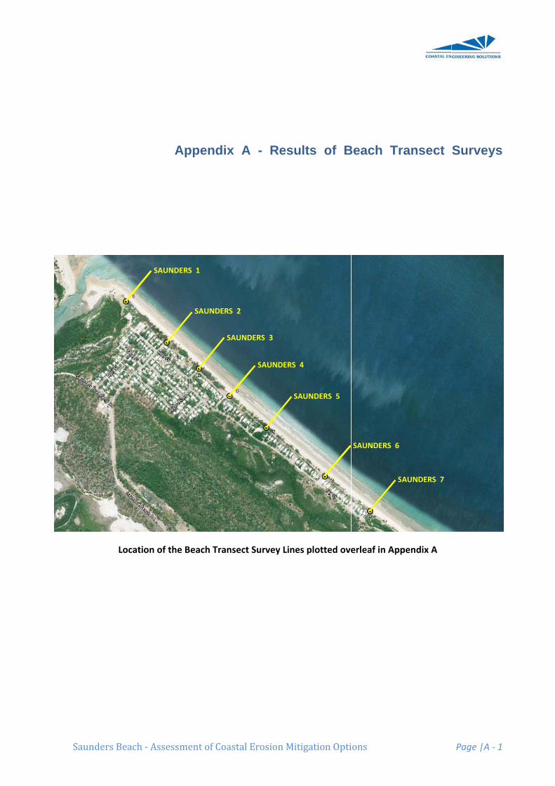
Saund
ers Beach ‐ A
Location
Assessment
Appe
n of the Bea
SAUNDERS 1
SA
t of Coastal E
endix A
ch Transect
AUNDERS 2
SAUND
Erosion Miti
- Resu
Survey Lines
DERS 3
SAUNDERS 4
SA
igation Opti
lts of B
s plotted ove
4
AUNDERS 5
ions
Beach Tr
erleaf in App
SAUNDERS 6
S
ransect
pendix A
SAUNDERS 7
Page |A ‐ 1
Surveys
1
s

SAUNDERS 1 POST 458353 7882156
6.22m AHD Brg 40
Chainage April 09 Chainage March 10 ‐0.4 5.37 ‐0.4 5.37 0.1 5.38 0 5.38 4.2 5.33 4.7 5.3 9.5 5.14 9.9 5.13 11.7 4.9 13.1 4.56 13.1 4.51 15 3.04 14.2 4.3 21.5 2.75 14.9 4.25 27.4 2.28 15.6 3.24 43.7 0.78 18.8 3.03 53.7 0.54 24.2 2.8 62.8 0.38 26.9 2.55 85.8 ‐0.03 28.2 2.27 31.3 1.8 34.8 1.45 41.8 1.16 52.5 0.71 65 0.32 72 0.25 87.4 ‐0.06
‐1
0
1
2
3
4
5
6
‐20 0 20 40 60 80 100
Saunders 1
April 09
March 10
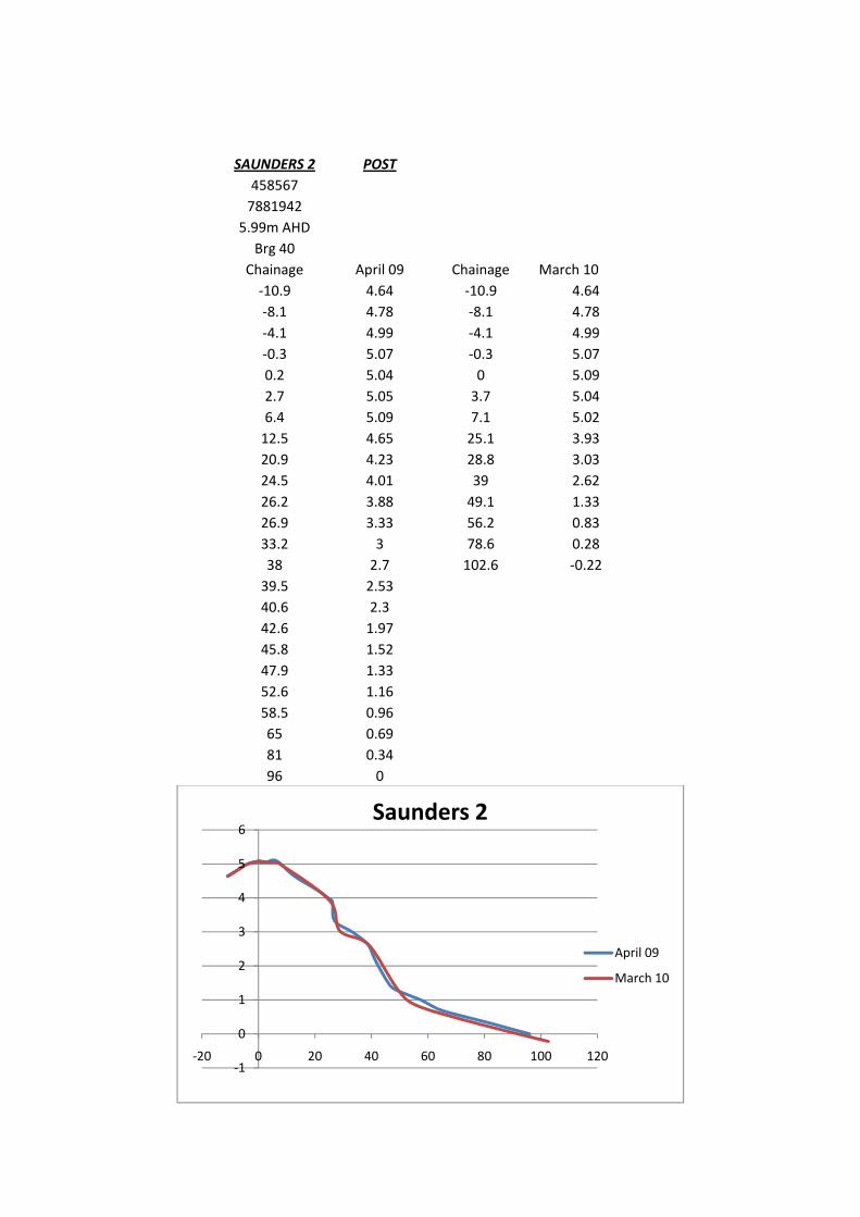
SAUNDERS 2 POST 458567 7881942
5.99m AHD Brg 40
Chainage April 09 Chainage March 10 ‐10.9 4.64 ‐10.9 4.64 ‐8.1 4.78 ‐8.1 4.78 ‐4.1 4.99 ‐4.1 4.99 ‐0.3 5.07 ‐0.3 5.07 0.2 5.04 0 5.09 2.7 5.05 3.7 5.04 6.4 5.09 7.1 5.02 12.5 4.65 25.1 3.93 20.9 4.23 28.8 3.03 24.5 4.01 39 2.62 26.2 3.88 49.1 1.33 26.9 3.33 56.2 0.83 33.2 3 78.6 0.28 38 2.7 102.6 ‐0.22 39.5 2.53 40.6 2.3 42.6 1.97 45.8 1.52 47.9 1.33 52.6 1.16 58.5 0.96 65 0.69 81 0.34 96 0
‐1
0
1
2
3
4
5
6
‐20 0 20 40 60 80 100 120
Saunders 2
April 09
March 10
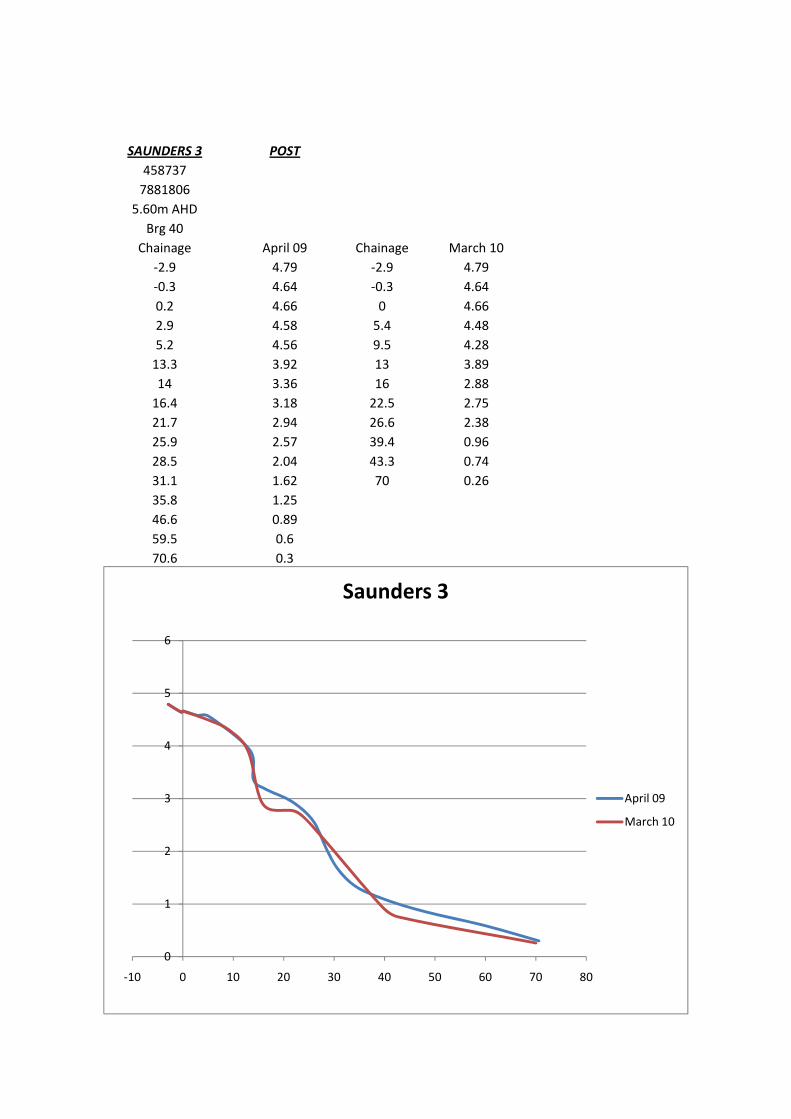
SAUNDERS 3 POST 458737 7881806
5.60m AHD Brg 40
Chainage April 09 Chainage March 10 ‐2.9 4.79 ‐2.9 4.79 ‐0.3 4.64 ‐0.3 4.64 0.2 4.66 0 4.66 2.9 4.58 5.4 4.48 5.2 4.56 9.5 4.28 13.3 3.92 13 3.89 14 3.36 16 2.88 16.4 3.18 22.5 2.75 21.7 2.94 26.6 2.38 25.9 2.57 39.4 0.96 28.5 2.04 43.3 0.74 31.1 1.62 70 0.26 35.8 1.25 46.6 0.89 59.5 0.6 70.6 0.3
0
1
2
3
4
5
6
‐10 0 10 20 30 40 50 60 70 80
Saunders 3
April 09
March 10
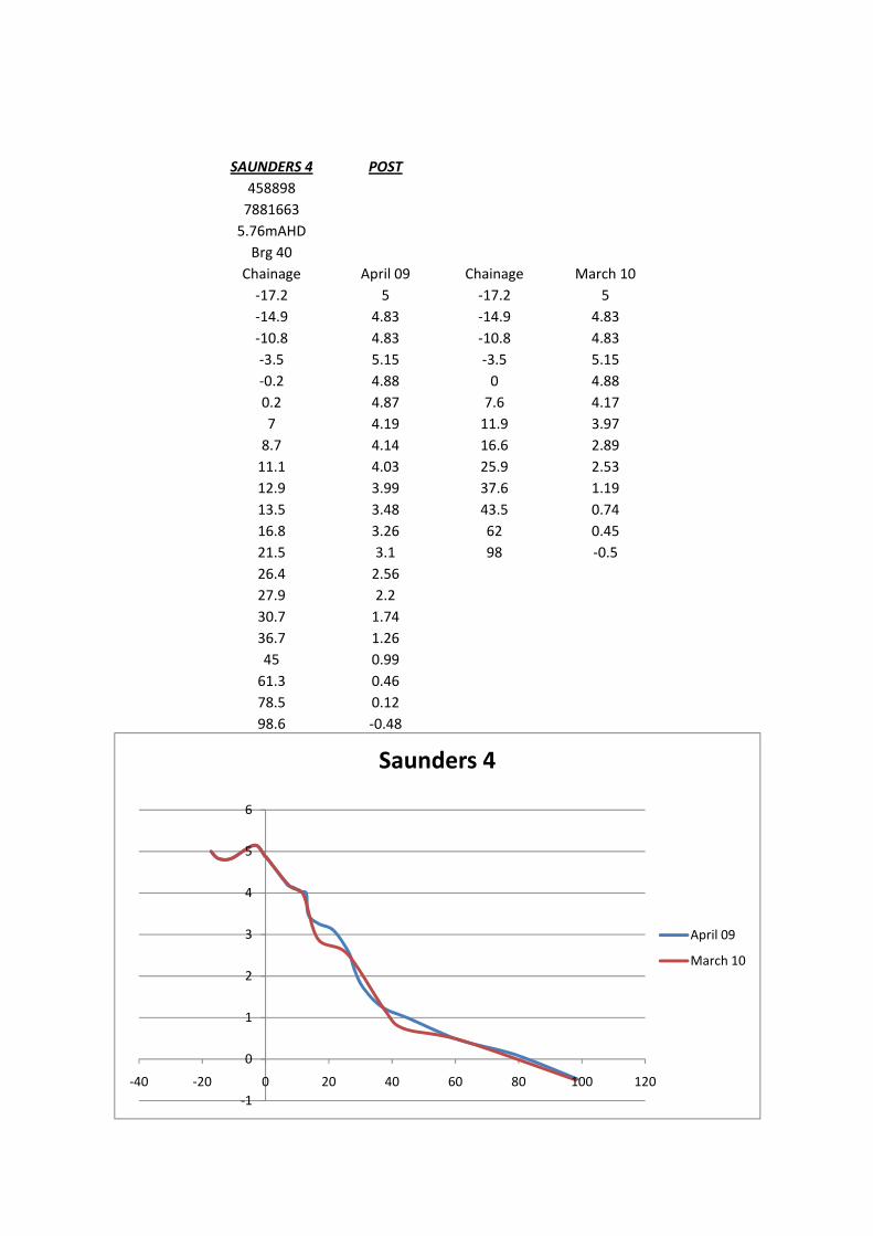
SAUNDERS 4 POST 458898 7881663 5.76mAHD Brg 40
Chainage April 09 Chainage March 10 ‐17.2 5 ‐17.2 5 ‐14.9 4.83 ‐14.9 4.83 ‐10.8 4.83 ‐10.8 4.83 ‐3.5 5.15 ‐3.5 5.15 ‐0.2 4.88 0 4.88 0.2 4.87 7.6 4.17 7 4.19 11.9 3.97 8.7 4.14 16.6 2.89 11.1 4.03 25.9 2.53 12.9 3.99 37.6 1.19 13.5 3.48 43.5 0.74 16.8 3.26 62 0.45 21.5 3.1 98 ‐0.5 26.4 2.56 27.9 2.2 30.7 1.74 36.7 1.26 45 0.99 61.3 0.46 78.5 0.12 98.6 ‐0.48
‐1
0
1
2
3
4
5
6
‐40 ‐20 0 20 40 60 80 100 120
Saunders 4
April 09
March 10
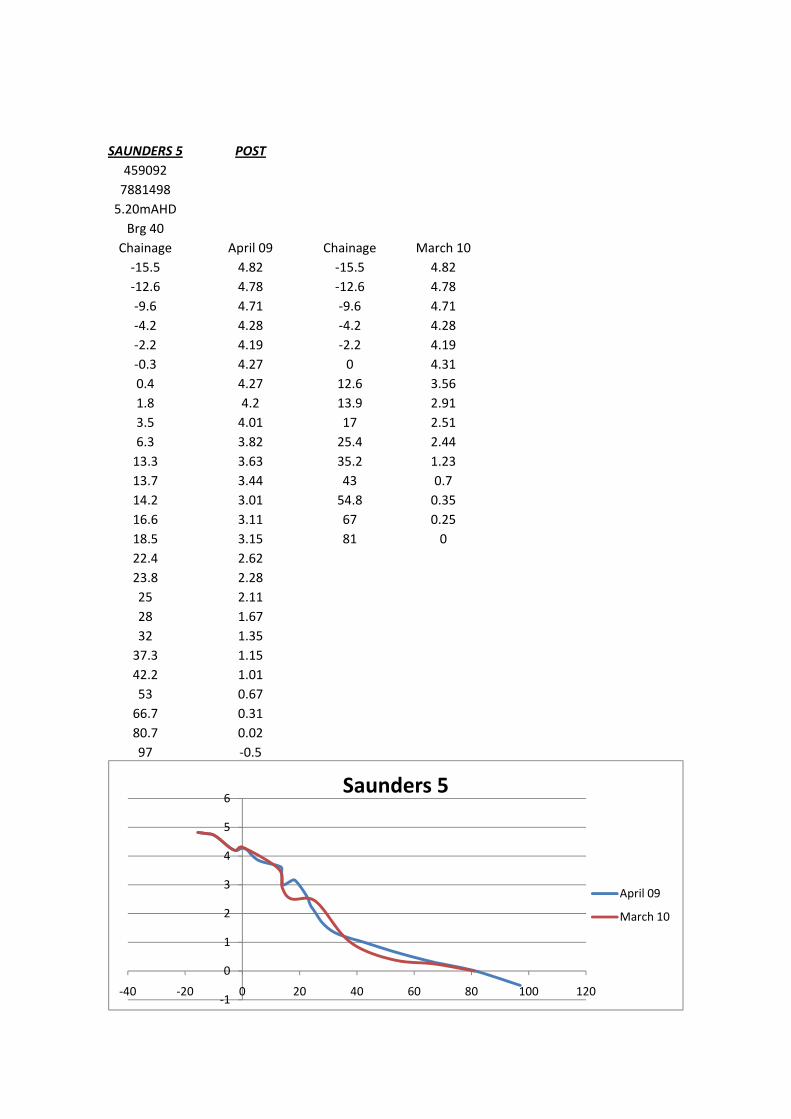
SAUNDERS 5 POST 459092 7881498 5.20mAHD Brg 40
Chainage April 09 Chainage March 10 ‐15.5 4.82 ‐15.5 4.82 ‐12.6 4.78 ‐12.6 4.78 ‐9.6 4.71 ‐9.6 4.71 ‐4.2 4.28 ‐4.2 4.28 ‐2.2 4.19 ‐2.2 4.19 ‐0.3 4.27 0 4.31 0.4 4.27 12.6 3.56 1.8 4.2 13.9 2.91 3.5 4.01 17 2.51 6.3 3.82 25.4 2.44 13.3 3.63 35.2 1.23 13.7 3.44 43 0.7 14.2 3.01 54.8 0.35 16.6 3.11 67 0.25 18.5 3.15 81 0 22.4 2.62 23.8 2.28 25 2.11 28 1.67 32 1.35 37.3 1.15 42.2 1.01 53 0.67 66.7 0.31 80.7 0.02 97 ‐0.5
‐1
0
1
2
3
4
5
6
‐40 ‐20 0 20 40 60 80 100 120
Saunders 5
April 09
March 10
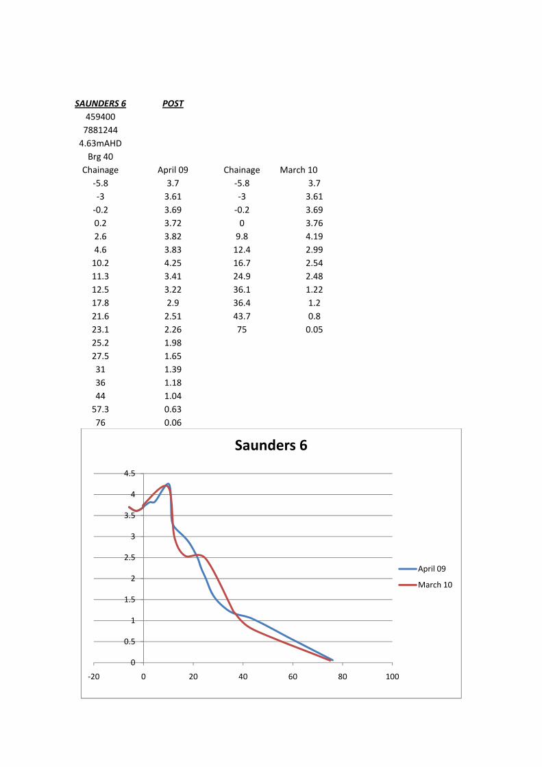
SAUNDERS 6 POST 459400 7881244 4.63mAHD Brg 40
Chainage April 09 Chainage March 10 ‐5.8 3.7 ‐5.8 3.7 ‐3 3.61 ‐3 3.61 ‐0.2 3.69 ‐0.2 3.69 0.2 3.72 0 3.76 2.6 3.82 9.8 4.19 4.6 3.83 12.4 2.99 10.2 4.25 16.7 2.54 11.3 3.41 24.9 2.48 12.5 3.22 36.1 1.22 17.8 2.9 36.4 1.2 21.6 2.51 43.7 0.8 23.1 2.26 75 0.05 25.2 1.98 27.5 1.65 31 1.39 36 1.18 44 1.04 57.3 0.63 76 0.06
0
0.5
1
1.5
2
2.5
3
3.5
4
4.5
‐20 0 20 40 60 80 100
Saunders 6
April 09
March 10
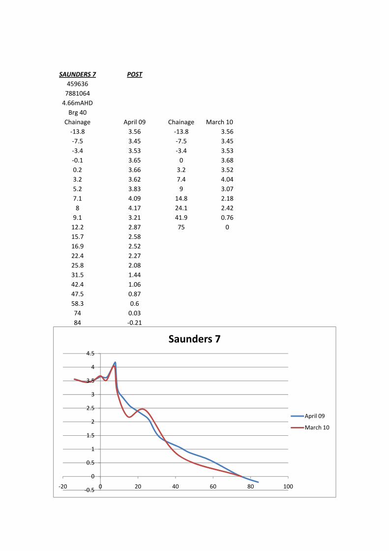
SAUNDERS 7 POST 459636 7881064 4.66mAHD Brg 40
Chainage April 09 Chainage March 10 ‐13.8 3.56 ‐13.8 3.56 ‐7.5 3.45 ‐7.5 3.45 ‐3.4 3.53 ‐3.4 3.53 ‐0.1 3.65 0 3.68 0.2 3.66 3.2 3.52 3.2 3.62 7.4 4.04 5.2 3.83 9 3.07 7.1 4.09 14.8 2.18 8 4.17 24.1 2.42 9.1 3.21 41.9 0.76 12.2 2.87 75 0 15.7 2.58 16.9 2.52 22.4 2.27 25.8 2.08 31.5 1.44 42.4 1.06 47.5 0.87 58.3 0.6 74 0.03 84 ‐0.21
‐0.5
0
0.5
1
1.5
2
2.5
3
3.5
4
4.5
‐20 0 20 40 60 80 100
Saunders 7
April 09
March 10
Saunders
COA
Beach ‐ Ass
ASTAL E
sessment of
EROSION
Coastal Ero
AT SAUN
S
osion Mitigat
Appen
NDERS BE
School of
tion Options
dix B -
EACH - B
f Earth And
s
Referen
BACKGRO
Dr
d Environ
James
Pa
nce Docu
OUND BR
r. Scott Sm
nmental Sc
Cook Uni
age |B ‐ 1
ument
RIEFING
by
mithers
ciences
iversity
COASTAL EROSION AT SAUNDERS BEACH BACKGROUND BRIEFING Dr Scott Smithers School of Earth and Environmental Sciences James Cook University
Introduction Saunders Beach is an approximately 2.4 km long beach segment located to the north of Black River at the southern end of Halifax Bay (Figure 1). Saunders Beach is characterised by a broad (>80 m wide) low-tide bench composed of fine sand that extends seaward from a relatively narrow (10-20 m) and steep upper beach composed of coarser sediments. A sharp break in slope typically separates the upper beach and the low tide terrace at a level between Mean Low Water Spring (MLWS) tide and Mean Sea Level (MSL) position. The settlement at Saunders Beach is developed over a narrow beach ridge plain composed of successive ridges and relatively low-lying swales; however at the eastern end of Saunders Beach this is reduced to just a single narrow ridge. Erosion of the upper foreshore opposite houses at the southern and central end of the settlement has reduced the distance between the upper beach and property boundaries. Recent recession of the shoreline and loss of established trees has increased concerns about possible future shifts in the shoreline and the possibility that coastal assets and environments may be damaged by any such shifts. Coastal processes and shoreline behaviour have been investigated at Saunders Beach as part of a broader coastal erosion study of the Northern Beaches. Information from this study provides important background data within which to consider the driving variables and significance of recent shoreline changes. Recent changes in shoreline position at Saunders Beach must be viewed within the context of broader patterns of sediment supply and redistribution within Halifax Bay, and natural variability in the processes that deliver sediment to the coast and onto and off the beaches.
Physical Setting and Processes The shoreline in Halifax Bay is predominately sandy, and is largely composed of coastal landforms such as beach ridges, dunes, tidal inlets, estuaries, and salt flats formed within the last 6000 years by coastal processes. These landforms typically form a narrow (up to 1.5 km wide but generally narrower) fringe of geologically recent sediment deposits and landforms at the coast (Figure 2). Because coastal processes built the landforms, their elevation is closely constrained by sea-level history since around 6000 years ago; only rocky outcrops extend more than six or so metres above the Highest Astronomical Tide (HAT) mark. Sea level was 130 m lower than now at the peak of the ice age 18000 years ago, exposing the entire continental shelf. As the ice subsequently melted, sea level rose to around 1-1.5 m above present by around 6000 years ago, before falling to its current level (Figure 3). The shoreline began to build out after sea level reached this higher level around 6000 years ago and as it fell to present. The mineralogy and sedimentology of coastal sands in Halifax Bay indicates they are mostly weathered from local rocks and delivered to the coast by local rivers and creeks. The extent to which the shoreline built out in Halifax Bay varies according to factors such as the sediment supply, exposure to waves and currents, and coastal alignment. Generally,
however, the shore prograded as an upper sandy beach ridge unit built out and over a lower unit of finer intertidal and subtidal sands (like those on the broad lower intertidal flats today). Where inlets and estuaries were sufficiently sheltered from high-energy waves, muddier deposits dominated by mangrove materials developed. These deposits are now exposed on the foreshore at several locations within Halifax Bay, indicating localised retreat of the shoreline since they were emplaced. In some locations this shoreline retreat has opened a corridor where wave action can entrain and suspend fine sediments but sedimentation is relatively low, allowing nearshore reefs, such as Paluma Shoals to establish and thrive. Larcombe et al. (2001) presented a schematic model that depicts these interactions (Figure 4). From the age of the exposed mangrove deposits and inshore reefs we know that this phase of coastal recession may have begun several thousand years ago at some locations within Halifax Bay. Following the ice age sea level rose quickly and flooded the low gradient continental shelf. As inundation progressed the shoreline retreated rapidly westward, and reworked unconsolidated sediments. Residual gravels and coarser deposits (marking earlier channel positions) now form pavements where fine sediments were winnowed away. The general shape of the coastline in Halifax Bay is a legacy of this process. The irregular occurrence of pavements of residual coarse sediments at the shore separate embayments formed where finer sediments were eroded, and define the broader scale changes in coastal alignment within Halifax Bay. Net littoral drift is to the north and sediments are exchanged between the embayments described above. A series of small to moderate size streams traverse the coastal plain to discharge at the coast, with the larger rivers (The Bohle and Black Rivers, and Bluewater Creek) occurring toward the south of the study area (Figures 1 & 5). Most of these coastal streams flow only seasonally following wet season rains, when extreme flows associated with cyclonic and monsoonal deluges can cause major flooding, significant erosion and reconfiguration of coastal morphology. Some streams have developed sandy deltas indicative of sediment delivery to the coast, where prevailing longshore currents tend to move materials progressively north. The delta at the mouth of the Black River is the most conspicuous of these features. During the dry season, or when wet season flows are not competent, coastal processes (waves and currents) may significantly modify coastal morphology at stream and inlet mouths. The shoreline can be very dynamic, with substantial changes in shoreline position and character known to occur quickly during episodic high-energy events. For example, more than 10 m of beach retreat occurred at both Saunders Beach and at the Black River settlement when Tropical Cyclone Althea (category 3: estimated central pressure 952 mb) crossed the coast near Balgal Beach in December 1971 (Hopley, 1974). Longer-term changes associated with prevailing wind and wave conditions also affect this coast; complex and truncated beach ridge sequences have been interpreted as evidence of ‘natural’ changes in coastal configuration along the northern beaches (Hopley and Murtha, 1975).
Historical and Recent Change at Saunders Beach The general pattern of shoreline change at Saunders Beach can be established through the analysis of geo-rectified aerial photographs that have been taken at the appropriate scale at an irregular interval since 1941 (1941, 1961, 1974, 1983, 1987. 1991, 1996, 2000, 2004, 2005) together with shoreline positions accurately mapped with GPS (Figure 6). These analyses indicate that:
1. Sections of Saunders Beach have shown net accretion and others have shown net erosion since 1941 – there is no universal erosion or accretion trend. This is the case along the entire Halifax Bay shoreline. These variations appear to result from variations in alongshore sediment transport, with eroded beach segments commonly updrift of sites of significant accretion. It is important to note that erosion and accretion zones on the beach can change through time (both seasonally, inter-annually, and at longer (decadal and millennial) timescales).
2. Fluctuations in shoreline position at a site – phases of accretion and erosion – are
demonstrated by the fact that changes in shoreline position to both seaward and shoreward are identified at all 18 transects along Saunders Beach from the geo-rectified photos. In summary, at no transect has the shoreline consistently either eroded or built out – fluctuations are the norm.
3. Based on the total data set of shoreline changes for all transects (including those at Bluewater) an average accretion rate for the entire shoreline for the period was calculated at 0.24 m (n = 272). This is in good accord with the longer-term rate of accretion established for this segment of Halifax Bay by looking at the age of onshore coastal sediment deposits (Holmes, 1992). In summary, although some sections of Saunders Beach have clearly retreated in recent decades, the average net trend over the entire beach is has been one of average net accretion, and is very similar to the longer term rate.
4. The shoreline to the immediate south of Saunders Beach settlement significantly
accreted and became vegetated between 1941 and 2007. This area comprises a broad vegetated ridge with a vegetated dune to seaward. The vegetated dune was eroded severely during the high tides and moderate seas of early 2009.
5. The shoreline in front of the settlement from its southern end to a point near
Saunders Beach Road has retreated by as much as 15 m from its 1941 position (transect 18 (near the turning bay at the eastern end of the Esplanade) and transect 22 (opposite 105 Cay Street)). The upper beach along this section is now markedly scarped, and held in sections by mature Casuarina trees, with scalloped embayments between. Many of these trees were lost during the erosion events of early 2009, with further retreat of the upper beach in these areas. Some recovery of the beach has occurred since, with infill of the upper beach below the scarp and progradation of a new berm.
6. Between 1941 and 2007 the beach between Saunders Beach Road and the mouth of
Deep Creek has shown net accretion, but this end of the beach is highly variable over shorter periods (including seasonal), and is significantly affected by processes near the creek mouth.
Observations of recent changes include:
7. The upper beach between the southern end of the settlement and Saunders Beach Road is now (and has been for some time) marked by a conspicuous scarp, in places exceeding 1 m high, which locally retreated several metres during the 2009 January - March high tides. Typically the eroded sediment was redeposited relatively rapidly (within two to three weeks) on the upper shoreline further north along the beach.
8. Erosion in early 2009 coincided with very high tides and moderately rough weather.
It is pertinent to note that the very high tides occurred as part of the broader 18.6 year lunar tidal cycle, which effectively meant that the high tides this year were the highest over this multi-decadal cycle, and that there were a greater number tides high enough for waves to affect the upper beach. The combination of higher tides and rough weather increased the erosion of the upper beach. As this cycle wanes over the next decade the elevation and frequency of very high tides will reduce.
9. The eroded scarp cut into an older vegetated beach ridge dominates the upper beach
long most of the settlement. As indicated above, in places the top of this scarp separates the active beach by more than a metre, and waves at high tide swirl at its base. However, elsewhere on the beach a broad berm of recently deposited sand has been deposited in front of the eroded scarp. At these locations the beach exhibits both erosionary and accretionary traits.
10. New sediment can only be added to the beach ridge on which the settlement is
located when waves swash on to it and deliver sediment from the beach below. The scarp effectively separates the active beach from the beach ridge surface, and impedes the deposition of new material on top of the ridge.
11. The Casuarina trees have been very effective at holding the upper beach position,
and mediating further retreat of the upper beach. Where they have recently failed it is likely that they would have performed better if they were located in thicker plantings and not as a single row. Many fallen trees appear to have been outflanked by erosion concentrated in bare areas.
Other points for consideration:
12. Saunders Beach is a location where coastal erosion during the last major cyclone to affect the region (TC Althea) was accurately measured. During that event the shoreline retreated by 12 m and waves broke over the first beach ridge and onto the road (Hopley 1974). This event generated a storm surge estimated to be 3.66 m at nearby Toolakea, but luckily the peak coincided with the low tide raising water levels to near the high tide level only. On the northern beaches some recovery from this erosion occurred quite rapidly, with as much as 2.5 m accretion noted within 6 months.
13. The Black River is the nearest and most significant sediment source for the Saunders
Beach. Approximately 1 million cubic metres of sand were extracted from this river between 1970 and 2001. Extractive activities have now ceased. Although the impacts of extraction would be expected to only be modest due to other contributions and the redistribution of existing delta sediments (see Figure 5), it is possible that these activities have contributed to the local erosion experienced at Saunders Beach, either directly as a result of disruption to sediment supply, or indirectly as a consequence of reconfiguration of the delta. Given the irregular nature of both events that deliver sediments and redistribute them along the coastline, the significance of these processes is hard to determine. Nonetheless, the termination of extraction removes the possibility of any ongoing negative effects.
14. Both modelling and measurement confirm the transport of sediment north along the
beach. Estimates of littoral drift indicate that around 10-14 000 m3 of sand is
transported north along this section of shoreline on average each year. Observations of sediments redistributed during high-energy events indicate that sediments can be quickly redistributed on this shoreline. The implications are that any discontinuities in alongshore sediment supply might be expected to manifest relatively quickly, and that sediment introduced to the upper beach may be redistributed relatively rapidly. Where sediments are temporarily stored in the system, such as the ridge to the south of the settlement a deficit may develop updrift and contribute to shoreline retreat. However, recent erosion on Saunders Beach can be more directly attributed to higher water levels and wave energy conditions acting on an already destabilised and upper beach.
Conclusions The shoreline at Saunders Beach is dynamic, with all sections of the beach showing phases of erosion and accretion since 1941. When the entire data set for the entire beach is examined an average rate of accretion of 0.24 m per year is calculated. The pattern of shoreline change between 1941 and 2007 is, however, spatially variable along the beach. The differences can be summarised as:
• Significant accretion to the immediate south of the settlement (where the broad vegetated ridge and dune have developed).
• Retreat of as much as 15 m and significant scarping of the upper beach in front of the settlement from Saunders Beach Road south.
• Highly variable but net accretion between Saunders Beach Road and Deep Creek.
The entire shoreline was affected by the combination of moderate seas and very high tides on several occasions in early 2009, during which the upper beach was significantly eroded (reports of several metres retreat in just a few days). The high tides that focused the wave action on the vulnerable upper beach were associated with the peak of the 18.6-year tidal cycle that is now on the wane. Although sediment extraction from the Black River may have disrupted sediment supply to Saunders Beach it is more likely that variations in sediment deposition and transfer together with wave erosion during the higher tides have been responsible for shoreline retreat along the shoreline at both decadal and event timescales. Sediment is actively transported north alongshore on this beach as indicated by modelling, measurement and observations of sediment redistribution following erosive events. If renourishment is considered as a treatment option the mobility of ‘natural’ sediments on this shoreline will need to be considered and strategies to mediate this be included in the renourishment plan (sediment size, positioning, time of emplacement and augmentative stabilisation). Casuarinas can effectively hold the shoreline position against erosion events, and more contiguous and wider plantings should be considered.
References Holmes, K.H., 1992. Townsville-Rollingstone coastal sector. MA50/2, Department of
Environment and Heritage, Brisbane.
Hopley, D., 1974. Coastal changes produced by Tropical Cyclone Althea in Queensland; December 1971. Australian Geographer, 12(5): 445-456.
Hopley, D. and Murtha, G.G., 1975. The Quaternary Deposits of the Townsville Coastal Plain. Monograph Series, 8. Department of Geography, James Cook University of North Queensland, Townsville, 30 pp.
Hopley, D., Smithers, S.G. and Parnell, K.E., 2007. Geomorphology of the Great Barrier Reef: evolution, diversity and change. Cambridge University Press, Cambridge.
Larcombe, P., Costen, A. and Woolfe, K.J., 2001. The hydrodynamic and sedimentary setting of nearshore coral reefs, central Great Barrier Reef shelf, Australia: Paluma Shoals, a case study. Sedimentology, 48(4): 811-835.
Lewis, S.E., Wust, R.A.J., Webster, J.M. and Shields, G.A., 2008. Mid-late holocene sea-level variability in eastern Australia. Terra Nova, 20: 74-81.
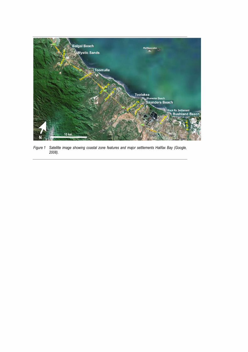
Figure 1 Satellite image showing coastal zone features and major settlements Halifax Bay (Google,
2008).
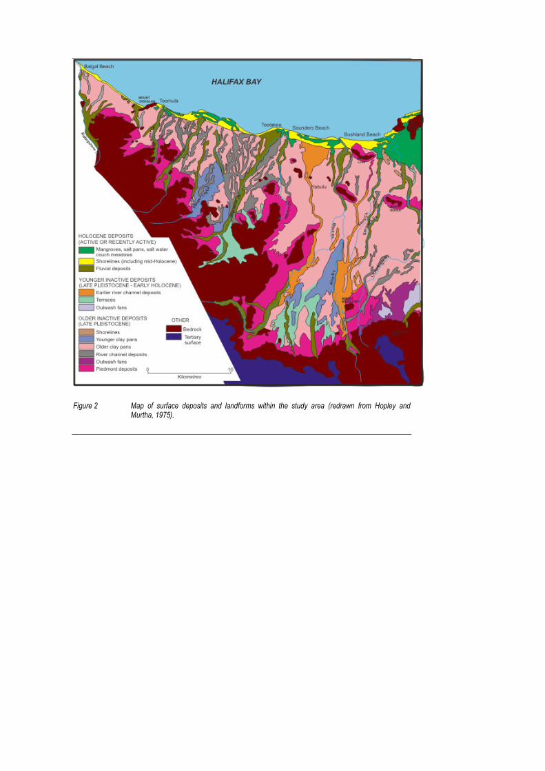
Figure 2 Map of surface deposits and landforms within the study area (redrawn from Hopley and Murtha, 1975).
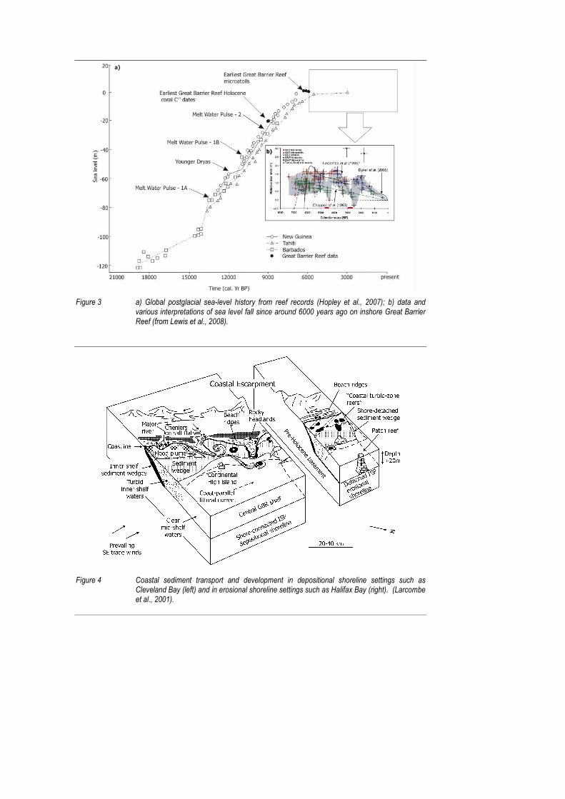
Figure 3 a) Global postglacial sea-level history from reef records (Hopley et al., 2007); b) data and various interpretations of sea level fall since around 6000 years ago on inshore Great Barrier Reef (from Lewis et al., 2008).
Figure 4 Coastal sediment transport and development in depositional shoreline settings such as Cleveland Bay (left) and in erosional shoreline settings such as Halifax Bay (right). (Larcombe et al., 2001).
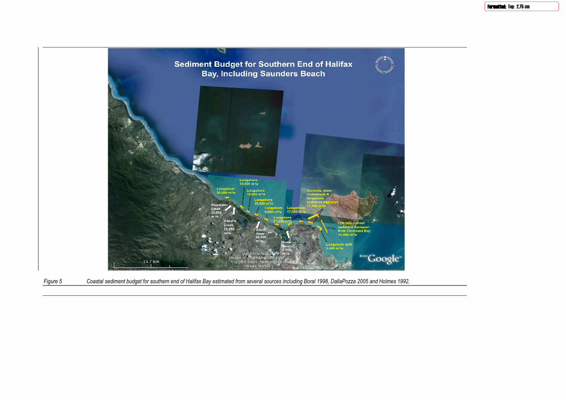
Figure 5 Coastal sediment budget for southern end of Halifax Bay estimated from several sources including Boral 1998, DallaPozza 2005 and Holmes 1992.
Formatted:Formatted:Formatted:Formatted: Top: 2.75 cm
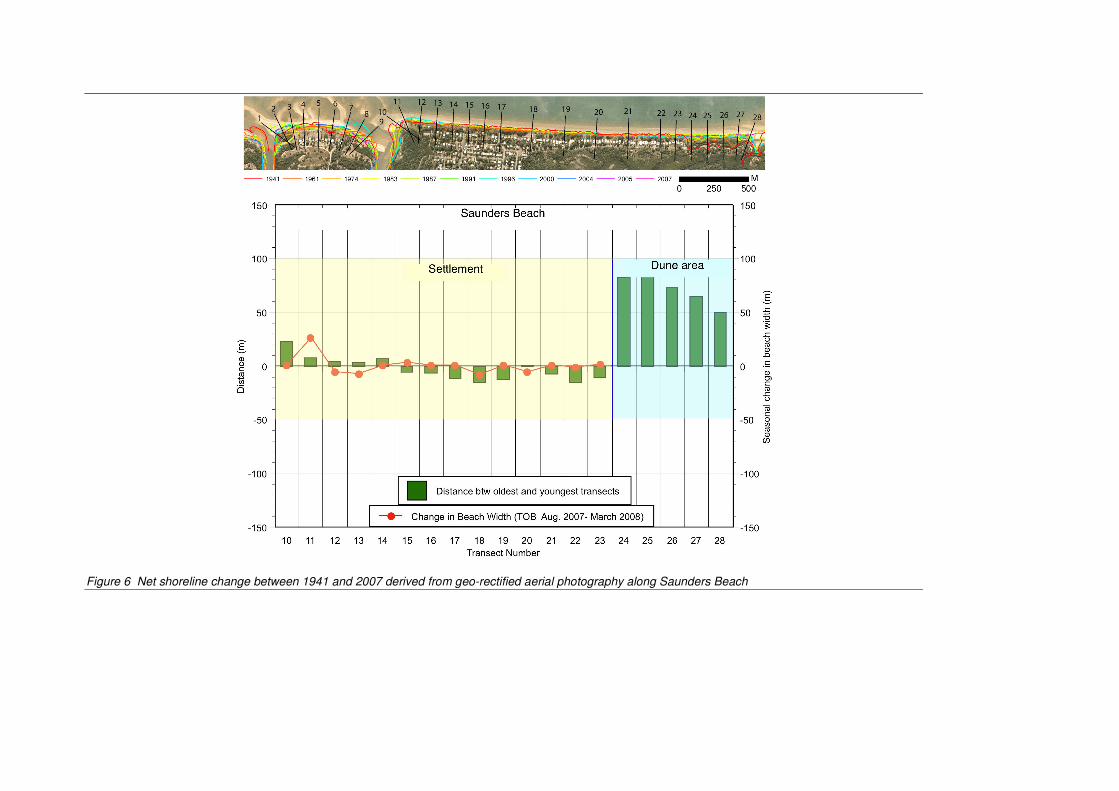
Figure 6 Net shoreline change between 1941 and 2007 derived from geo-rectified aerial photography along Saunders Beach

Saunders
Beach ‐ Asssessment of
Appen
Coastal Ero
ndix C -
osion Mitigat
- Generi
tion Options
c Erosio
s
on Mitig
Pa
ation Op
age |C ‐ 1
ptions
Saunders
Overvie
In essencestructural
Soft (or no
• Dore
• Avun
• Plath
• Bebe
• Befroim
• Chsh
Hard (or st
• Se
• Sewh
• Grth
• Grmby
Some disc
Beach ‐ Ass
w
e, erosion misolutions.
on‐structural
o nothing ‐ asulting losse
voiding devendeveloped a
anned retreae vulnerable
each nourisheach, thereby
each scrappinom the intermproving ero
hannel relocahoreline eros
tructural) so
eawalls ‐ whi
eawalls with hilst sand is i
roynes / offsereby retain
roynes / offsaintaining say the groyne’
ussion on ea
sessment of
tigation opti
l) solutions w
llowing coases;
lopment ‐ byareas;
at ‐ removinge area;
ment ‐ rehay providing a
ng ‐ by using‐tidal zone osion buffers
ation ‐ relocasion so that t
lutions that
ch act as phy
beach nourisintermittent
hore breakwning sand on
hore breakwand on the b’s interruptio
ach of these v
Coastal Ero
ions can be c
would typica
stal processe
y implement
g the erosion
bilitate erodan adequate
g earthmovinor nearshore on the beac
ate dynamic they have a l
can be utilis
ysical barrier
shment ‐ whly placed in f
waters ‐ usedthe eroding
waters with beach, and beon to longsho
various optio
osion Mitigat
considered a
lly include:
es to take the
ting regulato
n threat by r
ing foreshorerosion buff
ng plant and sandbanks ih;
river or creeesser impact
ed to mitigat
rs to prevent
here the seawfront of the w
d to inhibit thforeshore fo
beach nouriseach nourishore sand sup
ons is offere
tion Options
as “soft” non
eir natural co
ory controls w
elocating ex
res by direct fer;
equipment tnto the uppe
ek entrancest.
te the threat
t shoreline re
wall defines twall for impr
he natural loor longer per
hment ‐ whehment reducepply.
d in the follo
s
‐structural s
ourse while a
with regard t
isting develo
placement o
to mechanicer beach or d
s that may be
t of erosion i
ecession;
the inland exroved beach
ngshore movriods;
ere the struces the down
owing pages.
Pa
olutions, or
accepting the
to building in
opment away
of sand onto
ally relocatedune, thereb
e contributin
include:
xtent of eros amenity;
vement of sa
cture assists drift erosion
.
age |C ‐ 2
“hard”
e
n
y from
the
sand by
ng to
sion,
and,
in n caused
Saunders
Non‐stru
Do nothin
A “do nothundevelopavailable enominated
However ohigh socialcould therrarely a de
Avoid dev
Along sectprevent anaccretion tof the bea
The implemdevelopmeplace, throQueenslanwithin desEnvironme
Planned r
The intentconsiderederosion buthem.
This can reprivate lanassociated
However wrelocation
Beach ‐ Ass
uctural M
ng
hing” strategped, or asseterosion buffed planning pe
on foreshorel and financirefore lead toesirable man
velopment
tions of the fn erosion proto occur unimch.
mentation oent and infraough the desnd’s State Cosignated Erosent and Reso
retreat
t of a planned vulnerableuffer. This ap
equire the rend and dwelld resumption
where there can be a via
sessment of
Manageme
gy of coastal s and properers are sufficeriod.
es where exisal costs assoo considerabagement op
foreshore thaoblem from ompeded. Th
f such a straastructure ocsignation of foastal Plan. sion Prone Aource Manag
d retreat str to erosion, pproach acco
elocation of eings. The son of land can
are isolatedable and cost
Coastal Ero
ent Option
managemenrty are of oncient to acco
sting developociated with tble social tration for a sig
at remain suoccurring byis would also
tegy would rccurring in thforeshores wPresently an
Areas trigger gement.
ategy is to reallowing thisommodates
essential andocial and fina be consider
and small sct effective op
osion Mitigat
ns
nt can be apply limited vammodate lo
pment and intheir loss areuma and subgnificantly de
ubstantially uy allowing theo preserve th
require apprhese areas. within state‐wny foreshore an approval
elocate exists previously natural beac
d non‐essentancial costs inrable given c
cale public aption.
tion Options
propriate whalue. It is weng‐term and
nfrastructuree generally ubstantial ecoeveloped for
undevelopede natural beahe natural ec
ropriate planHowever sucwide Erosionprotection wrequiremen
ting developmdeveloped lach processes
tial infrastrucnvolved in suurrent prope
ssets threate
s
here foresholl suited to sd short‐term
e is threatenunacceptableonomic loss. reshore.
d, a key objecach processecosystem, am
nning controlch instrumenn Prone Areaworks or re‐znt from the D
ment outsideand to functis without att
cture and/oruch relocatioerty values a
ened by eros
Pa
ore land is ituations wherosion ove
ned by erosioe. This scenaConsequent
ctive can be tes of erosionmenity and c
ls to preventnts are alreas under zoning applicDepartment o
e of the areaion as a futuempting to i
r the resumpons and any long the coa
sion, planned
age |C ‐ 3
here r a
on, the ario tly it is
to n and character
t future dy in
cations of
a re nfluence
ption of
ast.
d
Saunders
Beach no
A strategyconventiowidth on tthat it has
It is generaa suitable
A frequentsolution tofurther renstructural costs are tthe cost/b
However tby an adeqthat there placed on
Sand usedpossibility elsewhereif such sou
The requirtransport buffers. Lobuffer so aprocesses that they a
The bufferbe removenominated
The strateuncertain nourishmeto then coannual ren
Beach ‐ Ass
ourishment
of beach nonal earthmothe foreshoreno adverse
ally regardedand econom
t communityo persistent lnourishmentnature) alsotaken into acbenefit advan
the ability toquate buffer can be sevethe beach m
for nourishmthat the ben
e. This placesurces are not
rements for aregime. Theocal cross‐shas to accommdetermine tare maintain
r characteristed by the shod as the Desi
gy is flexibleimpacts of fuent strategy ntinually monourishment
sessment of
ourishment eving techniqe. The advanimpacts on a
d as being thmic source of
y criticism oflong‐term ert. Neverthel require maiccount, the rntage of a be
o immediatelr is often a cheral storms omore than on
ment is typicnefit to the ns a constraint readily to h
an effective e objectives ohore sand tramodate a pathe average rned in the lon
tics of sand vort‐term eroign Event.
e in its implemuture climatwould be to onitor foresht campaigns
Coastal Ero
entails the plques or by puntages of beadjacent fore
he most desirsand is avai
f beach nourrosion probleess most othintenance anequirement each nourish
y replace sanhallenging issr cyclones innce in any cyc
cally sourcednourished font on promptand.
beach nourisof such a straansport procrticular cyclorate at whichng‐term.
volume and sion process
mentation ane change of initially crea
hore performas actual clim
osion Mitigat
acement of umping ‐ so aach nourishmeshores, and
rable solutiolable.
ishment projems ‐ since ither forms of nd a commitmfor future noment strateg
nd lost in a ssue under thn any one seaclone season
d from outsidreshore is act restoration
shment stratategy are to cesses dictateone ARI. On h sand needs
width are bases associate
nd is therefolocal foreshoate the buffemance ‐ incremate change
tion Options
sand directlyas to establisment as an ed it maintains
n to erosion
jects is that t requires andirect intervment to futuourishment cgy.
storm so as this strategy. ason; and men so as to be
de of the actichieved at th of buffers d
tegy are deteestablish ane the overallthe other has to be added
asically the ved with a sev
ore well suiteores. For exaers required fasing buffer e conditions m
s
y onto the besh or restoreerosion manas the beach a
problems o
it does not pn on‐going covention (eveure costs. Wcampaigns m
o provide coThis is particeans that sacompletely
ive beach syhe expense odepleted by s
ermined by td maintain a volume of sand, longshod periodicall
volumes and vere storm /
ed to accommample, an apfor present‐dvolumes/wimanifest the
Pa
each ‐ eithere an adequatagement straamenity.
n foreshores
provide a perommitment tn those of a
When all impamay not detr
ontinual protcularly the cand may needeffective.
stem to offsof beach erosstorm/cyclon
the local sedadequate erosand requireore transporty to the buff
widths that cyclone that
modating thppropriate beday conditiodths throughemselves.
age |C ‐ 4
r by using e buffer ategy are
s where
rmanent to “hard” acts and act from
tection ase given d to be
et any sion ne events
diment osion d in the t fers so
would t is
e each ns and h the
Saunders
Beach scr
The conce(typically fsystem. Insuch may experienci
Beach scraassisting amuch longslightly grereinforcing
The large vsignificantreasonableconsiderab
Channel r
In some cariver or creaffect tidasome of thentrance o
Beach ‐ Ass
rapping
pt of beach from intertidn essence it inot necessaring long‐term
apping can bnd acceleratger timeframeater wave eg the beach f
volumes of stly eroding foe timeframeble under su
relocation
ases foreshoeek entrancel currents anhose instanceor main chan
sessment of
scrapping endal flats imms simply redrily provide am recession.
e beneficial ting natural pmes. Howeveenergy to reaface and/or
sand that neeoreshores ares. Adverse ich works.
re erosion caes. The sandnd wave pattes the problennel flow.
Coastal Ero
ntails movingediately in fristributing saa net long‐te
in reinstatinprocesses ther since scrapach shore, ofdune.
ed to be initie unlikely tompacts on in
an be attribudbanks and sterns which cem can be al
osion Mitigat
g sand from ront of a beaand that is aerm benefit ‐
g or reshapiat would othpping lowersffsetting to s
ially placed b be economintertidal flor
uted in varyinhoals at the can have an lleviated som
tion Options
lower levels ach) up onto lready within particularly
ng the dune herwise rebus the seabed ome degree
by scrapping ically viable ora and fauna
ng degrees tmouth of thadverse effemewhat by th
s
of the cross‐the beach sn the active on foreshor
following a suild the erodin front of th the benefits
to form the or physicallycommunitie
o the dynamhese natural wect on nearbyhe planned r
Pa
‐shore beachlope or into beach profileres that are
storm evented dune systhe beach, it s achieved by
buffers agaiy achievable wes can also be
mic nature of waterways cy shorelines.relocation of
age |C ‐ 5
h profile the dune e and as
, thereby tem over allows y
inst within e
local can . In f the
Saunders
Structur
Seawalls
Seawalls adesigned afurther recLine.
However sfrom sandbehind thefront of th
Typically tfront of it
This lowerturbulenceseawall alscontinues washes agcycle. Theseawall to
This lowerthe structufail by undseawalls this to demo
Another tyto solve is sand resersand cannthese sam
The deficitextension
Seawalls hhigh ‐ or ifinhibit easneed to be
Along urbaThis can ad
Beach ‐ Ass
ral Manag
are commonland construccession. Typ
seawalls sign reserves stoe wall, but thhem. In fact t
he effect of to steadily lo
ring is primare in front of tso contributeuntil the levgainst the face amenity of protect the
ring of the saure. Unless adermining. Ehat have beeolish the stru
ypically advesimply relocrves in the upot be movede processes
t in sand supof the seawa
have an effecf it becomes sy public accee provided o
an foreshoredversely affe
sessment of
gement Op
ly used to prcted seawallspically seawa
nificantly inteored in beachhey do not pthey very oft
seawall consower ‐ until t
rily caused bthe structurees to these svel of the beace of the seathe beach aarea behind
and level in fappropriate Even if only den damaged cture and re
erse impact ocated furtherpper part of d downdrift bare moving
pply to these all along the
ct on the visuso as a consess across thn seawalls to
es, seawalls cect natural co
Coastal Ero
ptions
ovide a physs can be verylls are const
erfere with nh ridges and revent in anyten exacerba
struction on the beach re
by wave actioe ‐ which scoscour and beach is below wall and thend foreshored it.
ront of seawfoundation adamaged, it iby underminebuild it with
of seawalls isr along the sthe active bby longshorealong the sh
downdrift s entire down
ual amenity oequence of nhe foreshore o ensure the
can offer sheoastal flora a
osion Mitigat
sical barrier ty effective inructed on th
natural beachdunes. In oy way the erate and acce
actively erodeaches a new
on washing aours the beacach loweringprevailing tiere is no beace is therefore
walls can alsoand toe arras extremely ning. Indeedh deeper and
s that the orihore. Natureach that are sand transporeline beyo
ections initiandrift shoreli
of a shorelinnatural beaconto the be
e safety of be
eltered habitand fauna va
tion Options
to continuingn protecting fhe alignment
h processes bther words, osion proceselerate the er
ding shores iw equilibrium
against the wch material. g processes. de levels, in ch for part (oe significantl
o present prongements ardifficult andd frequently d more robus
ginal erosional beach proe behind theport processeond the end
ates greater ine in order t
e, and this cch lowering inach. Typicaleach access b
ats for vermalues.
s
g shoreline rforeshore ast of a nomina
by separatinseawalls cansses continurosion.
is for the levm profile.
wall causing a Wave energ In many caswhich case tor possibly foy degraded
oblems for thre constructe very expensthe most cost foundation
n problem thocesses can ne seawall. Coes to repleniof the seawa
erosion, ultito protect it
an be quite an front of it. lly access staby pedestrian
min such as fe
Pa
recession. Prssets by stopated Coastal
g the active n protect proing on the be
el of the bea
a high degreegy reflected ses this lowethe ocean simor all) of the in order for t
he overall staed, the seawsive to repairst effective sns.
hat they werno longer acconsequently ish the sand all.
mately requ.
adverse if th Such walls aairways or rans.
eral cats and
age |C ‐ 6
roperly ping any Defence
beach operty each in
ach in
e of from the ering mply tide the
ability of wall can r existing solution
e meant cess the this that
iring
e wall is also mps
rodents.
Saunders
Appropriatcompare fQueenslansignificantthese wallmanner reoriginal er
Despite thQueenslanattributedplant and rather tha
Such adhoprivate proassets withinadequatonly lead tcan advers
Seawalls
To mitigatcreate a beto feed the
The seawaconstructeboth wheramenity to
For exampbetween tregular sanof the initi
Groynes
The longshacross theshore. Santhis “suppthe groyne
Beach ‐ Ass
tely designefavourably wnd have beent cyclone eros may not haequire signifiosion proble
eir disadvannd for protec to their versequipment; n applying m
oc methods coperties. Thh a sense of e design andto the re‐estsely affect fo
s with beach
e some of theach amenite downdrift
all structure sed accordingre the Coastao be provide
ple, if the Coathe seawall and placemenial erosion p
hore transpo active beacnd is gradually‐side” of the and therefo
sessment of
d and constrwith the cost n built of rocosion events.ave been impcant mainteem.
ntages, rock scting foreshosatility. Theyand this is o
more approp
can be used te substantiasecurity ‐ whd constructioablishment ooreshore use
h nourishm
he disadvantty in front of foreshore w
still serves agly. The amoal Defence Lid.
astal Defencand the beacnt would be roblem along
ort of sand onh. A groyne lly trapped ahe structure.ore it erodes
Coastal Ero
ructed seawaof other alteck during or i Under suchplemented. nance to pre
seawalls are ore assets agy are relativeften accompriate constru
to not only pal and solid ahich unfortuon of these stof the originae and visual a
ment
ages of seawthe structurhich would o
s the primarount of sand ine is located
e Line was loch could be crequired to mg the shore.
n an erodingfunctions as
against the u. However ths.
osion Mitigat
alls are relaternatives. Hoimmediatelyh circumstanConsequentevent structu
probably thegainst the threly easy to coplished by simuction practi
protect long ppearance onately is freqtructures. Tal erosion pramenity.
walls, beach nre. This sandotherwise be
ry defence aginitially placed within the
ocated someonsidered asmaintain the
g shoreline cas a physical bpdrift side ofhe downdrift
tion Options
ively expensowever many following seces approprtly most of thural failure a
e most commreat of erosioonstruct usinmply dumpinses to create
sections of fof rock walls quently misgheir subsequroblem, but t
nourishmentd placement e starved of s
gainst erosioed as beach active beach
e distance inls the beach ne beach ame
an be impedbarrier by intf the structut beach is de
s
ive and theyy seawalls coevere sea coniate design ahe rock wallsnd the re‐est
monly used mon. This can ng conventiong rock on a e a robust str
oreshore, bucan provide guided given uent failure othe scatterin
t can also bealso providesand by the w
on so must benourishmenh profile and
land then thenourishmentnity, as well
ed by constrtercepting saure, resultingeprived of th
Pa
y do not alwaonstructed innditions andand construcs constructedtablishment
method in probably be
onal earthmoprepared sloructure.
ut also indiviowners of fothe often or damage cng of remove
e undertakenes a reservoirwall.
e designed ant will depenthe extent o
e existing fot. Nevertheas prevent m
ructing groynand moving ag in a wider be sand trapp
age |C ‐ 7
ays n d ction of d in this of the
e oving ope
dual oreshore
an not ed rocks
n to r of sand
and d on of the
reshore eless, migration
nes along the beach on ped by
Saunders
This proceaccumulatend. Sandthe shorel
Groynes caNeverthelehave creatthe depletbeach/buf
Consequentransfers it
The same structure bbreakwate
The reducekeep movishoreline iaccumulatshoreline d
Groynes w
The downdnourishmeimmediatethe structudowndrift
The lengthlimited. Tbuilt at int
The lengthregime; anspacing arit is possibmore wide
NevertheleStructureswalking alomarred by
Beach ‐ Ass
ess of updriftted on the upd supply is thine on its ero
annot preveess they havted a wider bted downdrifffer width.
ntly the const further alo
effect of impbuilt offshorers and funct
ed wave eneing sand alonis greater thates in the leedowndrift of
with beach
drift erosionent into the sely after it is ure by naturshoreline.
h of updrift sherefore if lotervals along
h and spacingnd in particue also somewble to achieveely spaced st
ess such intes such as groyong the beacy the differen
sessment of
t entrapmentpdrift side ofen reinstateoded alignm
nt the signifive an indirectbeach and anft side, the fo
struction of ang the beach
peding the loe of the beaction by castin
ergy landwarng the shorean that at whe of the strucf the wave sh
nourishme
caused by gstrategy. Thconstructedal processes
horeline thaong sections g the shorelin
g of such grolar the naturwhat depende a similar detructures. Su
ervention canynes that croch will entailnt beach leve
Coastal Ero
t and downdf the groyne ed to the dowent.
icant cross‐st effect in thn enhanced eoreshore is m
a groyne doeh.
ongshore trach, but not cng a “wave s
rd of the offsline is reduchich it can becture. Howehadow is dep
ent
groynes can bis is achievedd so that it is can therefo
at benefits froof shorelinene. This is ty
oynes depenrally preferredent upon eaegree of prouch issues ca
n have a signoss the shorel crossing oveels on the up
osion Mitigat
drift erosion to the extenwndrift fores
hore erosionat by havingerosion buffemore suscept
es not in itse
nsport of saconnected toshadow” ont
shore breakwed. Conseque moved outver, as is theprived of san
be compensad by placing “filled”. Anyre be carried
om such groe require proypically called
d to a large ded stable orieach other. Utection by usan only be re
nificant impae can also haer the groynpdrift and do
tion Options
continues unnt that it starhore; howev
n that typica trapped saner on that setible to cyclo
elf resolve th
nd by a groyo it. Such stro the shorel
water meansuently the sut of the wavee case with and and theref
ated to a largsand againsty additional d around the
yne and beaotection thend a groyne fi
degree on thentation of tUnder any givsing short closolved by fu
act on the visave an adveres. This expwndrift side
s
ntil such timerts to feed arver this then
lly occurs dund on their uection of foreone erosion d
e erosion pr
yne can also ructures a caine in its lee
s that the abiupply of sande shadow. Sa conventionfore erodes.
ge extent byt the updrift sand movede end of the g
ach nourishmn a number oeld.
he local longsthe beach. Tven longshorosely spacedrther detaile
sual amenityrse impact onperience is als.
Pa
e as sand haround its sea simply main
uring cyclonepdrift side, teshore. Howdue to the d
oblem, but m
be achieved lled offshore.
ility of the wd from the uand thereforal groyne, th
y incorporatin side of the g against thisgroyne to su
ment is someof groynes ca
shore sand tTheir length are transport d groynes, ored study and
y of local foren beach use so potentiall
age |C ‐ 8
s award ntains
es. they wever on epleted
merely
by a e
waves to pdrift re he
ng beach groyne side of upply the
what an be
ransport and regime, r longer design.
eshores. since ly