Embed Size (px)
Citation preview

ISO/TC 211
Workshop on Standards
in Action
Adelaide, Australia 2001-10-24
The Kingdom of Saudi Arabia
Presentation

Proposed
The Kingdom of Saudi Arabia
For
National Spatial Data
Infrastructure

SNSDI
Abdullah M. AL-Shahrani
Head of delegation, the Kingdom of
Saudi Arabia (P-Member ISO/TC211)
General Commission for Survey and
Mapping (GCSM)
Riyadh - Kingdom of Saudi Arabia
24 October 2001

Introduction
SNSDI
Maps are, without doubt among the most ancient tools
used by man as means of communication.
1. Drew lines on sand
showing his travel routes
and movements in his
limited world.
Since the beginning of his early activities on the face
of the earth, man has tried to know more about his
immediate surroundings so he:

SNSDI
Introduction (Continue)
2. Carved stones, bones, woods and cave walls to show
sketches and shapes representing the locations of natural
resources, shelters, foods, water sources, hunting area,
enemies, etc.

SNSDI
Those lines and sketches,
which were known before
the discovery of alphabetic
writing represent a record
of geographic information
and makes maps the oldest
form of communication
before language, which
mankind has invented.
Introduction (Continue)
3. Drew lines on clay plates
In due time symbols were
used instead of sketches to
identify natural and man-
made features on papers,
plates and other media

SNSDI
Al Idrisi
Map (1154)


SNSDI
4. Scientific and technological developments enabled the
use of aerial photography to portray such features more
easily and accurately.
Introduction (Continue)

SNSDI
5. The use of computers in the late 1960s led to the
introduction of digital maps.
Introduction (Continue)
However different
organisations used
different:
• Hardware
• Software
• Standards
• Procedures
• Human resources
HARDWARE SOFTWARE
SPATIAL DATA
PROCEDURES HUMAN Resources
STANDARDS

SNSDI
Introduction (Continue)
Therefore, Significant initiatives and developments have
taken placed in recent years to overcome spatial data
sharing problems and ensure efficient spatial data:
• Collection
• Processing
• Manipulation
• Integration
• Visualisation
• Distribution
This resulted in varying internal contents, formats,
structures and other differences.
HARDWARE SOFTWARE
SPATIAL
DATA
PROCEDURES HUMAN Resources
Integration Visualisation
STANDARDS
Manipulation Processing Collection Distribution

SNSDI
Introduction (Continue)
This presentation presents a very brief summary of a
research project that aims to develop a theoretical
strategy for national spatial data infrastructure (NSDI)
for the Kingdom of Saudi Arabia, called the:
Those efforts resulted in the introduction of many
national, regional and international spatial data
infrastructure initiatives throughout the world.
Saudi National Spatial Data Infrastructure (SNSDI).

SNSDI
What Is a Spatial Data Infrastructure?
The study of spatial data infrastructures is a new subject
that has emerged in many industrial and technologically
advanced countries.
Various writers, researchers, officials and others have
defined spatial data infrastructure rather differently.
For example
The former USA president Bill Clinton (1994) defined it
as a:
Technology, policies, standards and human resources
necessary to acquire, process, store, distribute and improve
utilisation of geospatial data.
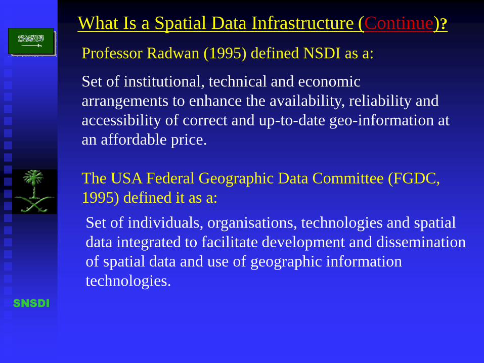
SNSDI
Professor Radwan (1995) defined NSDI as a:
The USA Federal Geographic Data Committee (FGDC,
1995) defined it as a:
Set of institutional, technical and economic
arrangements to enhance the availability, reliability and
accessibility of correct and up-to-date geo-information at
an affordable price.
Set of individuals, organisations, technologies and spatial
data integrated to facilitate development and dissemination
of spatial data and use of geographic information
technologies.
What Is a Spatial Data Infrastructure (Continue)?

The Components of Spatial Data Infrastructure
SNSDI
Therefore a number of components for spatial data
infrastructure were defined.
In the beginning a spatial data infrastructure was seen
as entirely a technical issue and comprising standards
for data definition, coding and exchange.
However it became clear that standardisation would not
be feasible without resolving:
• Institutional issue.
• Fundamental data set.

The Main Components of Spatial Data Infrastructure
SNSDI
1. Clearinghouse
2. Directories
3. Computer
network
4. Internet
5. Users
6. Data
distributors
7. Services
8. Etc.
1. Core Spatial Datasets,
including maps at
different scales, aerial
photography, satellite
imagery, cadastre,
census, land use, land
cover, place names, road
network, utilities,
elevation, soils,
vegetations, geology,
climate, pollution,
hazardous sites,
environments, etc.
2. Spatial data
Integration
1. National mapping
organisation
2. Committees and
working groups
3. Funding
4. Managements
5. Data custodianship
6. Data distribution
7. Education and
training
8. Application
9. Policies and
procedures
10. Partnership
11. Etc.
-Group of spatial data
standards, such as reference
system, data model, data
dictionary, data quality, data
transfer, terminology,
conceptual schema, metadata,
language, Spatial schema,
temporal schema, quality,
portrayal, encoding, imagery
and girded data, web map
server interface, profile,
feature cataloguing
methodology, simple feature
access, services
FUNDAMENTAL
DATA SETS
TECHNICAL
FRAMEWOR
K
INSTITUTIONAL
FRAMEWORK
TECHNICAL
STANDARDS
NATIONAL SPATIAL DATA INFRASTRUCTURE
COMPONENTS

SNSDI
A SAUDI NATIONAL SPTIAL DATA INFRASTRACTURE
Before discussing the development of a Saudi National Spatial Data
Infrastructure, allow me to give you a brief history background of
Saudi Arabia.
1. The first Saudi Arabian State emerged in 1744 as a result of an
alliance between Imam Mohammed bin Saud, the ruler of Al-Dirriya,
with the Islamic reformer Sheikh Mohammed bin Abdul Wahab.
The Growth of a Kingdom
However the first Saudi Arabian state ended in 1817.
During this phase most of the Arabian Peninsula was unified.

SNSDI
The Growth of a Kingdom
2. the second Saudi Arabian state started in 1824 under the leadership
of Prince Torki bin Abdullah Al Saud.
However the second Saudi state brought to an end in 1891 and Imam
Abdulrahman Al-Saud withdrew from Riyadh to Kuwait with his
family, including young son Abdulaziz.
But young Abdulaziz was determined to return to his family’s land
and restore Saudi power once again.

SNSDI
The Kingdom of Saudi Arabia
On January 15th, 1902 (Shawwal 5th, 1319H), Abdulaziz Al-Saud
reclaimed Riyadh, after a long and hard trip from Kuwait to Riyadh
with about 60 fighters of his relatives and followers and very little in
the way of food and weapons.
3. The third and present Saudi state “ The Kingdom of Saudi Arabia”

SNSDI
Distance=1,000 KM
Time about 4 months
Kuwait
King Abdulaziz trip from Kuwait to Riyadh
This trip formed a milestone
in the foundation of the third
Saudi state, the modern
Kingdom of Saudi Arabia.

SNSDI
The Founder of the Modern Kingdom of Saudi Arabia

SNSDI
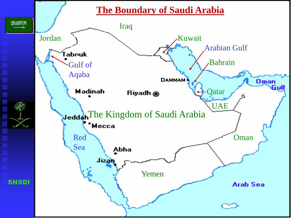
The Location of Saudi Arabia
The Kingdom of Saudi Arabia occupies four-fifths (4/5) of the
Arabian Peninsula, with an area of over 2 million square Km,
making it the largest country in the Middle East.
It is located at the crossroads
of three continents:
Europe.Asia.
Africa. Saudi Arabia
AsiaEurope
Africa
SNSDI
Jordan
Iraq
Kuwait
Bahrain
Qatar
UAE
Oman
Yemen
Dammam
Arabian Gulf
Red
Sea
Gulf of
Aqaba
The Kingdom of Saudi Arabia
The Boundary of Saudi Arabia

SNSDI
During the 100 years of building and unity the Kingdom of Saudi
Arabia has progressed from a tribal country of isolated mud-walled
towns to become one of the world’s most modern and industrialised
countries.
The Kingdom’s Centennial
On January 22nd, 1999, the Kingdom of Saudi Arabia celebrated
its centennial.
The first Photos show the old Saudi Arabia.

Old photo


SNSDI
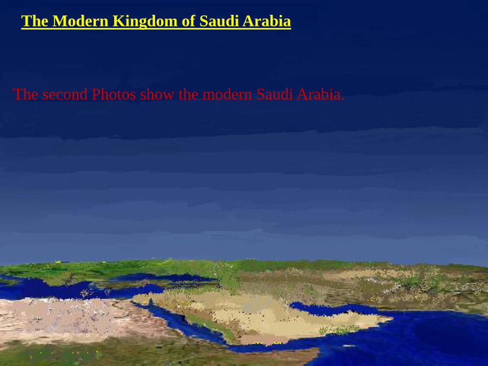
The Modern Kingdom of Saudi Arabia
The second Photos show the modern Saudi Arabia.


SNSDI

SNSDI


SNSDI
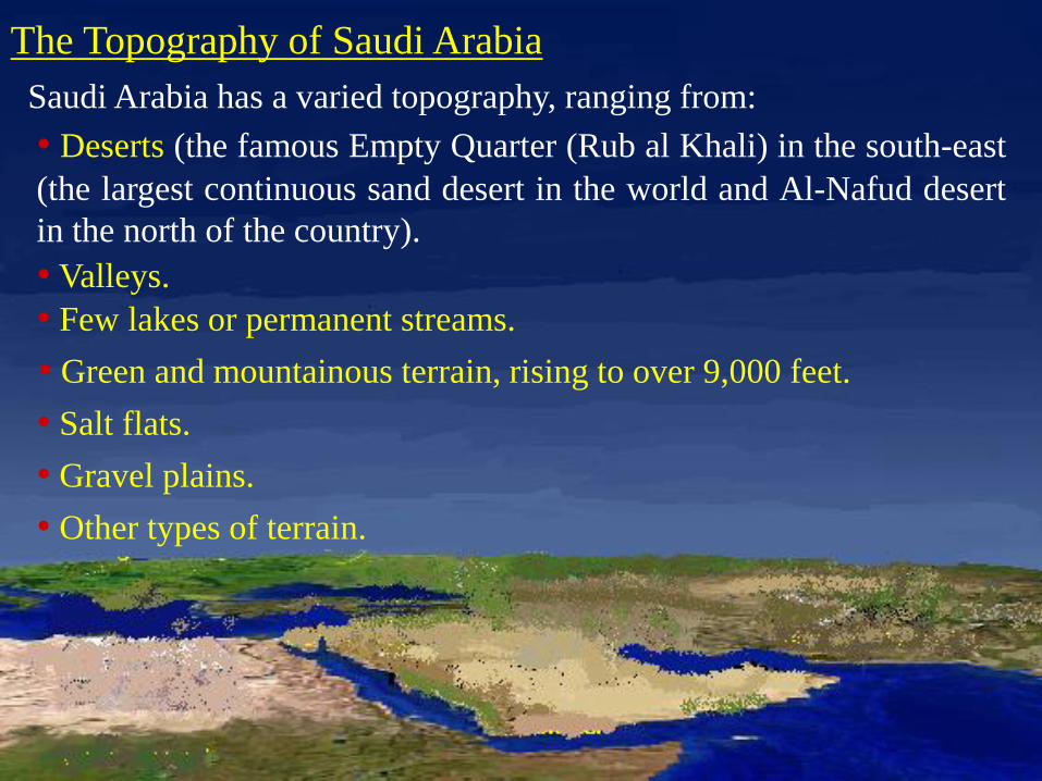
Saudi Arabia has a varied topography, ranging from:
The Topography of Saudi Arabia
• Deserts (the famous Empty Quarter (Rub al Khali) in the south-east
(the largest continuous sand desert in the world and Al-Nafud desert
in the north of the country).
• Valleys.
• Few lakes or permanent streams.
• Green and mountainous terrain, rising to over 9,000 feet.
• Salt flats.
• Gravel plains.
• Other types of terrain.

SNSDI

SNSDI

SNSDI

SNSDI

SNSDI

SNSDI
A country with such:
The Importance of NSDI for Saudi Arabia
Spatial data in the Kingdom of Saudi Arabia constitutes a valuable
national resource that contributes to:
• Long borders (About 5,800 Km).
• Unique topography.
• A regular pace of development
and progress
needs to pay close attention to the developing fields of SDI.
1. Economic growth.
2. National security.
3. The development and management of the Kingdom’s strategic
plans, such as:
• Vast area.

SNSDI
• Healthcare.
• Education
• Human resources development.
• Communications and telecommunications.
• Transportation.
• Environmental.
• Agriculture.
• Industries.
• Tourism.
• Many other vital aspects of national planning and services.

SNSDI
The Importance of NSDI for Saudi Arabia (Continue)
The Saudi NSDI will be the ultimate solution to:
• Spatial data collection.
• Processing.
• Integration.
• Storage.
• Distribution
1. The consolidation and sharing of isolated activities.
2. The avoidance of wasteful duplication of effort, time and money.
3. The simplification of:

SNSDI
The Main Components for the Saudi NSDI
The proposed components are:
1. Institutional Framework.
2. Fundamental Data sets.
3. Spatial Data Standards.
4. Technical Framework.
SNSDI
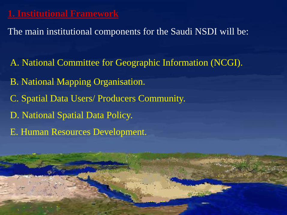
The main institutional components for the Saudi NSDI will be:
1. Institutional Framework
A. National Committee for Geographic Information (NCGI).
B. National Mapping Organisation.
C. Spatial Data Users/ Producers Community.
D. National Spatial Data Policy.
E. Human Resources Development.

SNSDI
A. National Committee for Geographic Information (NCGI)
The most important step to implement the Saudi national spatial data
infrastructure is the formation of this committee from ministries and
organisations that produce and use spatial data.
NCGI will provide leadership, policies development and authority
at national level.
It will also promote spatial data accessing and sharing among all
users and produces.
SNSDI
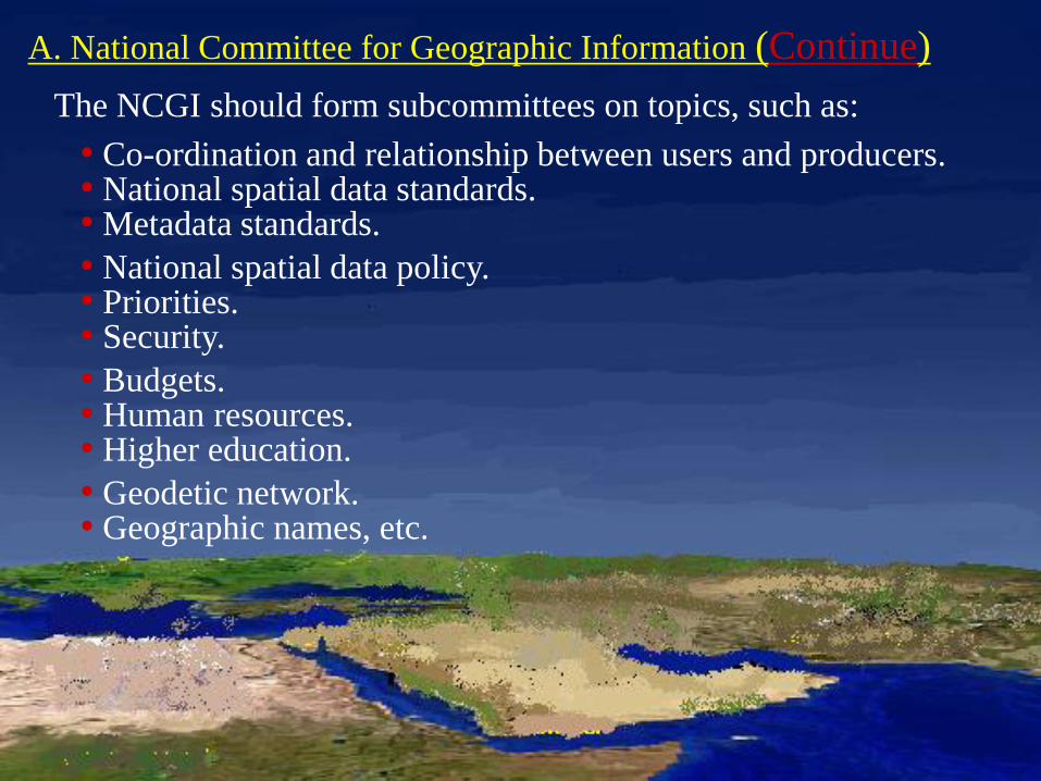
A. National Committee for Geographic Information (Continue)
The NCGI should form subcommittees on topics, such as:
• Co-ordination and relationship between users and producers.• National spatial data standards.• Metadata standards.
• National spatial data policy. • Priorities. • Security.
• Budgets. • Human resources. • Higher education.
• Geodetic network. • Geographic names, etc.

SNSDI
B. National Mapping Organisation
In this way the large and varied amounts of spatial data, much
existing already in different organisations in the Kingdom, may be
widely accessed and shared.
A national mapping organisation should be designated as the
leading organisation for the Saudi NSDI.

SNSDI
C. National Spatial Data Policy
The building of Saudi NSDI requires a national spatial data policy
in a number of subject areas, such as:
• Spatial data collection.
• Production.
• Data donation.
• Access and sharing procedures.
• Copyright.
• Updating.
• Funding.
• Security.
• Privacy.
• Education and training.
• Other issues needed to
achieve a fully functional
Saudi NSDI.

SNSDI
D. Spatial Data User/Producer Community
Spatial data users and producers in the Kingdom of Saudi Arabia
form a very large community consisting of many disciplines and
the numbers are certain to increase in line with economic growth.
It is therefore, essential that effective planning, co-operation and
mutual understanding be put in place so that both users and
producers benefit from the national spatial data infrastructure.
All ministries, organisations and private sector that produce and use
spatial data should be involved.

SNSDI
E. Human Resource Development
The success of the Saudi national spatial data infrastructure depends
directly upon the abilities and capabilities of the people who:
• Develop.• Implement.
• Manage.
• Supervise.
• Maintain.
• Operate the systems.
To develop the needed human resources, special training and
education should be put in place:
SNSDI
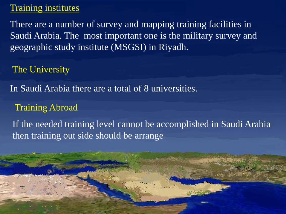
Training institutes
There are a number of survey and mapping training facilities in
Saudi Arabia. The most important one is the military survey and
geographic study institute (MSGSI) in Riyadh.
In Saudi Arabia there are a total of 8 universities.
The University
Training Abroad
If the needed training level cannot be accomplished in Saudi Arabia
then training out side should be arrange

SNSDI
2. Fundamental Spatial Data Sets
Large volumes of digital spatial data in the Kingdom of Saudi
Arabia have been collected or are about to be collected from
different sources by different ministries and organisations, as
shown in the following slide.
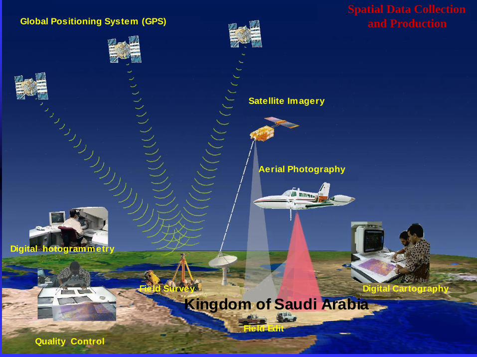
SNSDI
Global Positioning System (GPS)
Field Survey
Field Edit
Digital hotogrammetry
Aerial Photography
Satellite Imagery
Kingdom of Saudi Arabia
Digital Cartography
Quality Control
Spatial Data Collection
and Production

SNSDI
2. Fundamental Spatial Data Set (Continue)
A common core spatial database framework with broad geographic
coverage should be created and made available to all users in the
Kingdom, through the proposed NSDI.

SNSDI
Model for Interoperable Spatial Data Environment
SNSDI
3. Spatial Data Standards
The development and implementation of spatial data standards and
metadata standards are key elements in the success of the Saudi
NSDI.
In this Research, a number of existing and emerging spatial data
standards and metadata standards, worldwide, were examined and
evaluated for their potential use in the Kingdom of Saudi Arabia.
Also in 1998, the Kingdom of Saudi Arabia became a permanent
member in this technical committee (ISO/TC 211).

SNSDI
3. Spatial Data Standards ( Continue)
Therefore, rather than inventing new spatial data standards and
metadata standards, the Kingdom of Saudi Arabia should adopt the
ISO/TC 211 broad band standards and modify them as necessary to
its specific needs.
This standard should be announced and enforced by the Saudi
Arabian Standards Organisation (SASO) and used by all spatial data
producers in the Kingdom.

SNSDI
4. Technical Framework
The Saudi NSDI will provide a fundamental framework for the
development and implementation of technologies and technical
capabilities.
The main parts of the technical framework will be a Saudi national
spatial data clearinghouse (SNSDC) that enable distributed network
system to link all potential spatial data users and producers using:
• Common network.
• Standards.
• Procedures.
• Policies, etc.

SNSDI
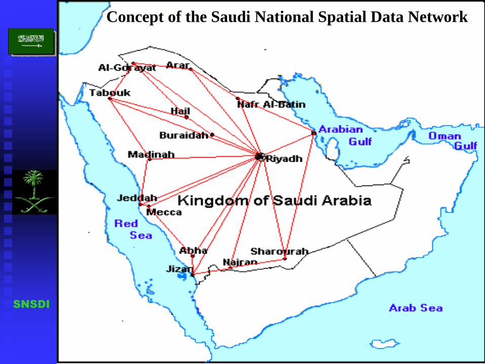
The Clearinghouse Architecture
The proposed Saudi national spatial data clearinghouse (SNSDC)
assumes a distributed spatial data network to share and make known
what spatial data exist in the Kingdom of Saudi Arabia and its:
The physical links between all spatial data users and servers will be
achieved using the Internet and other local and wide area networks,
with high-speed connectivity, available in the Kingdom.
• Condition.
• Structure.
• Accuracy.
• Contents.
• Quality.
SNSDI
Concept of the Saudi National Spatial Data Network
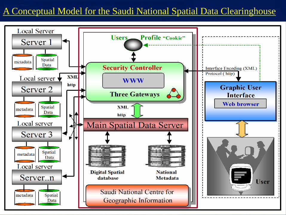
A Conceptual Model for the Saudi National Spatial Data Clearinghouse

SNSDISNSDI
1. Institutional
Framework
ISO/TC 211 GI
StandardsISO/TC 211
Metadata
Standards
Other
Standards
National Committee for
Geographic Information
National Mapping
Organisation
National Spatial
Data Policy
Spatial Data User
Producer Community
Human Resources
Development
Geographic
Names Database
Statistical Data
EnvironmentAviation
4. Technical
Framework
2. Fundamental
Datasets
Hydro-Marine Data
Transportation
Network
Biodiversity
Utilities
Education
Facilities Data
Soil Classification
Economical Data
Elevation Data
Tourism
Vegetation Cover
Cadastral
Data
Geological Data
Topographic
Data
Geodetic
Network
3.Spatial
Data
Standards
National Spatial
Data
Clearinghouse
Technology
Internet
Other
Networks
Summary of the Saudi NSDI Components

SNSDI
FINAL CONCLUDING REMARKS
• Many organisations in Saudi Arabia collect, produce, maintain
and use valuable digital and non digital spatial data.
• However, the Kingdom lacks a national spatial data infrastructure
a problem common to almost every country in the world.
• Without a national spatial data infrastructure, individual organisations
are forced to create isolated paths of development, technology and
effort in collecting and producing spatial data that may already exist in
other organisations, but not be known externally or cannot be accessed
or shared.

FINAL CONCLUDING REMARKS (Continue)
Therefore, it is necessary to co-ordinate all the Saudi efforts being
made for spatial data:
However, the building of a NSDI for a country as large and
extensive as the Kingdom of Saudi Arabia is not an easy task.
It is, rather, a task that requires a lot of work, co-ordination, co-
operation, funds, human resources and a positive partnership
involving all spatial data users and producers in the Kingdom.
•Collection.
• Production.
• Maintenance.
• Dissemination.
Through the development of a national spatial data infrastructure.

THE END
I hope you Enjoyed this presentation and please ask any question