Embed Size (px)
Citation preview
Reprinted with permission from July 2017 QST ARRL, the national association for Amateur Radio® www.arrl.org
A young ham braves rough, snowy terrain to
activate rare grids.
Gabriel Zeifman, NJ7H/VE6NJHI wanted to take this trip because the Northwest Territories (NT) had not been active on satellites for several years, and nearly all of the grids in the Slave/Yellowknife region had never been active on satellites, except for DP20. I had ventured to the Western Arctic region the previous year, and with my love of the territory, and the opportunity to activate rare Canadian grids on satellite, I knew I had to return and explore this region.
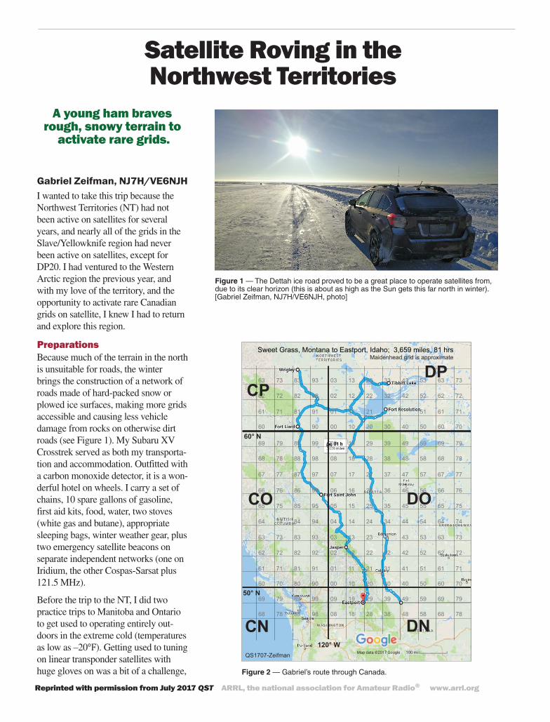
PreparationsBecause much of the terrain in the north is unsuitable for roads, the winter brings the construction of a network of roads made of hard-packed snow or plowed ice surfaces, making more grids accessible and causing less vehicle damage from rocks on otherwise dirt roads (see Figure 1). My Subaru XV Crosstrek served as both my transporta-tion and accommodation. Outfitted with a carbon monoxide detector, it is a won-derful hotel on wheels. I carry a set of chains, 10 spare gallons of gasoline, first aid kits, food, water, two stoves (white gas and butane), appropriate sleeping bags, winter weather gear, plus two emergency satellite beacons on separate independent networks (one on Iridium, the other Cospas-Sarsat plus 121.5 MHz).
Before the trip to the NT, I did two practice trips to Manitoba and Ontario to get used to operating entirely out-doors in the extreme cold (temperatures as low as –20℉). Getting used to tuning on linear transponder satellites with huge gloves on was a bit of a challenge,
Figure 1 — The Dettah ice road proved to be a great place to operate satellites from, due to its clear horizon (this is about as high as the Sun gets this far north in winter). [Gabriel Zeifman, NJ7H/VE6NJH, photo]
Satellite Roving in the Northwest Territories
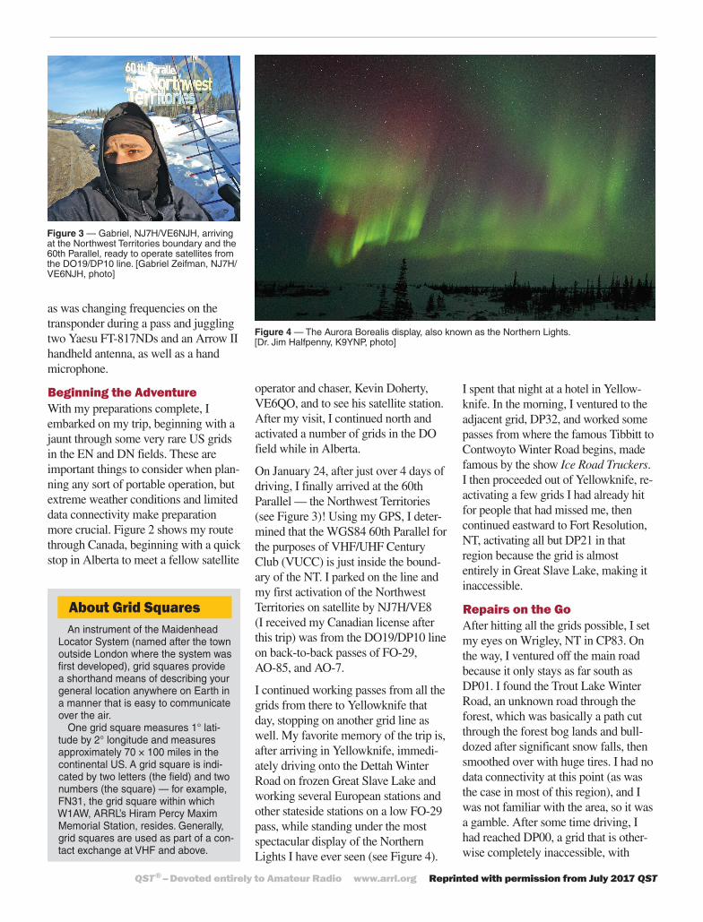
Figure 2 — Gabriel’s route through Canada.
Sweet Grass, Montana to Eastport, Idaho; 3,659 miles, 81 hrs
00 10 20 30 4080 90 50 60 70
01 11 21 31 4181 91 51 61 71
02 12 22 32 4282 92 52 62 72
03 13 23 4383 93 53 63 73
04 14 24 34 4484 94 54 64 74
05 15 25 35 4585 95 55 65 75
06 16 26 36 4686 96 56 66 76
09 19 29 39 4989 99 59 69 79
07 17 27 37 4787 97 57 67 77
08 18 28 38 4888 98 58 68 78
60 70
61 71
62 72
63 73
00 10 20 30 4090 50 60 70
01 11 2181 91 51 61 71
02 12 22 32 4282 92 52 62 72
03 13 23 33 4383 93 53 63 73
60
61 71
62 72
63 73
64 74
65 75
66 76
69 79
67 77
68 78
09 19 29 39 4989 99 59 69 79
08 18 28 38 4888 98 58 68 78
69 79
68 78
DO
DNCN
CO
CPDP
QS1707-Zeifman
Maidenhead grid is approximate
60° N
50° N
120° W
QST® – Devoted entirely to Amateur Radio www.arrl.org Reprinted with permission from July 2017 QST
as was changing frequencies on the transponder during a pass and juggling two Yaesu FT-817NDs and an Arrow II handheld antenna, as well as a hand microphone.
Beginning the AdventureWith my preparations complete, I embarked on my trip, beginning with a jaunt through some very rare US grids in the EN and DN fields. These are important things to consider when plan-ning any sort of portable operation, but extreme weather conditions and limited data connectivity make preparation more crucial. Figure 2 shows my route through Canada, beginning with a quick stop in Alberta to meet a fellow satellite
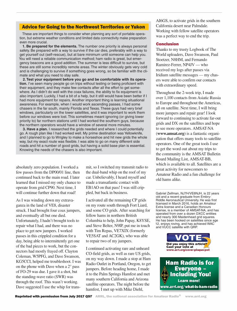
Figure 3 — Gabriel, NJ7H/VE6NJH, arriving at the Northwest Territories boundary and the 60th Parallel, ready to operate satellites from the DO19/DP10 line. [Gabriel Zeifman, NJ7H/VE6NJH, photo]
Figure 4 — The Aurora Borealis display, also known as the Northern Lights. [Dr. Jim Halfpenny, K9YNP, photo]
operator and chaser, Kevin Doherty, VE6QO, and to see his satellite station. After my visit, I continued north and activated a number of grids in the DO field while in Alberta.
On January 24, after just over 4 days of driving, I finally arrived at the 60th Parallel — the Northwest Territories (see Figure 3)! Using my GPS, I deter-mined that the WGS84 60th Parallel for the purposes of VHF/UHF Century Club (VUCC) is just inside the bound-ary of the NT. I parked on the line and my first activation of the Northwest Territories on satellite by NJ7H/VE8 (I received my Canadian license after this trip) was from the DO19/DP10 line on back-to-back passes of FO-29, AO-85, and AO-7.
I continued working passes from all the grids from there to Yellowknife that day, stopping on another grid line as well. My favorite memory of the trip is, after arriving in Yellowknife, immedi-ately driving onto the Dettah Winter Road on frozen Great Slave Lake and working several European stations and other stateside stations on a low FO-29 pass, while standing under the most spectacular display of the Northern Lights I have ever seen (see Figure 4).
I spent that night at a hotel in Yellow-knife. In the morning, I ventured to the adjacent grid, DP32, and worked some passes from where the famous Tibbitt to Contwoyto Winter Road begins, made famous by the show Ice Road Truckers. I then proceeded out of Yellowknife, re-activating a few grids I had already hit for people that had missed me, then continued eastward to Fort Resolution, NT, activating all but DP21 in that region because the grid is almost entirely in Great Slave Lake, making it inaccessible.
Repairs on the GoAfter hitting all the grids possible, I set my eyes on Wrigley, NT in CP83. On the way, I ventured off the main road because it only stays as far south as DP01. I found the Trout Lake Winter Road, an unknown road through the forest, which was basically a path cut through the forest bog lands and bull-dozed after significant snow falls, then smoothed over with huge tires. I had no data connectivity at this point (as was the case in most of this region), and I was not familiar with the area, so it was a gamble. After some time driving, I had reached DP00, a grid that is other-wise completely inaccessible, with
About Grid SquaresAn instrument of the Maidenhead
Locator System (named after the town outside London where the system was first developed), grid squares provide a shorthand means of describing your general location anywhere on Earth in a manner that is easy to communicate over the air.
One grid square measures 1° lati-tude by 2° longitude and measures approximately 70 × 100 miles in the continental US. A grid square is indi-cated by two letters (the field) and two numbers (the square) — for example, FN31, the grid square within which W1AW, ARRL’s Hiram Percy Maxim Memorial Station, resides. Generally, grid squares are used as part of a con-tact exchange at VHF and above.
Reprinted with permission from July 2017 QST ARRL, the national association for Amateur Radio® www.arrl.org
Gabriel Zeifman, NJ7H/VE6NJH, is 22 years old and a recent graduate from Embry- Riddle Aeronautical University. He was first licensed in March 2016, holds an Amateur Extra license and a Canadian Honours license, is a member of AMSAT-NA, and has operated from over a dozen DXCC entities and nearly 300 Maidenhead grid squares. He has been hooked on satellites since age 12, enjoys roving, and has achieved WAC and VUCC satellite with QRP.
Advice for Going to the Northwest Territories or YukonThese are important things to consider when planning any sort of portable opera-
tion, but extreme weather conditions and limited data connectivity make preparation even more crucial.
1. Be prepared for the elements. The number one priority is always personal safety. Be prepared with a way to survive if the car dies, preferably with a way to get yourself out (self-rescue), but at bare minimum until someone can help you. You will need a reliable communication method; ham radio is great, but emer-gency beacons are a good addition. The summer is less difficult to survive, but these are still some incredibly remote areas. The winter obviously gets very cold and is challenging to survive if something goes wrong, so be familiar with the cli-mate and what you need to stay safe.
2. Test your equipment before you go and be comfortable with its opera-tion. I’ve seen many people go on trips without testing or being proficient with their equipment, and they make few contacts after all the effort to get some-where. As I didn’t do well with the coax failures, the ability to fix equipment is also important. Luckily, I had a bit of a help, but it still would have been better if I had more equipment for repairs. Another important thing is learning situational awareness. For example, when I would work ascending passes, I had some chasers in the far south, mainly Florida and Texas. These guys had very brief windows, particularly on the lower satellites, and it was important to work them before our windows were lost. This sometimes meant ignoring (or giving lower priority to) far northern stations until I had worked the southern guys, because the northern operators would have a window of several more minutes.
3. Have a plan. I researched the grids needed and where I could potentially go. A rough plan like I had worked well. My prime destination was Yellowknife, and I planned to go to Wrigley to make a horseshoe and hit new grids the whole way, but my exact route was flexible. I was able to go on many different side roads and hit a number of good grids, but having a solid base plan is essential. Knowing the needs of the chasers is also important.
absolutely zero population. I worked a few passes from the DP00/01 line, then continued back to the main road. I later learned that I missed my only chance to operate from grid CP90. Next time, I will continue further down that road!
As I was winding down my extrava-ganza in the land of VE8, disaster struck. I had brought four coax jumpers, and eventually all but one died. Unfortunately, I hadn’t brought tools to repair what I had, and there was no place to get new jumpers. I worked passes in this crippled condition for a day, being able to intermittently get one of the bad pieces to work, but the con-nectors had mostly frayed off. Clayton Coleman, W5PFG, and Dave Swanson, KG5CCI, helped me troubleshoot. I was on the phone with Dave when a 2° pass of FO-29 was due. I gave it a shot, but the standing-wave ratio (SWR) was through the roof. This wasn’t working. Dave suggested I use the whip for trans-
mit, so I switched my transmit radio to the dual-band whip on the roof of my car. Unbelievably, I heard myself and made a transatlantic contact with EB1AO on that pass! I was still crip-pled, but back in business.
I activated all the remaining CP grids on my route south through Fort Liard, and some CO grids. After searching for fellow hams in northern British Columbia to help, John Papay, K8YSE, and Steve Belter, N9IP, put me in touch with Tim Repas, VE7XIX (formerly VE5SAT and AC2GK), who was able to repair two of my jumpers.
I continued activating rare and unheard CO-field grids, as well as rare US grids, on my way down. I made a stop at Ham Radio Outlet in Portland, Oregon, to get jumpers. Before heading home, I made it to the Palm Springs Hamfest and met many southern California and Arizona satellite operators. The night before the hamfest, I met up with Mike Diehl,
AI6GS, to activate grids in the southern California desert near Palmdale. Working with fellow satellite operators was a perfect way to end the trip.
ConclusionThanks to my trusty Logbook of The World uploaders, Dave Swanson, Paul Stoetzer, N8HM, and Fernando Ramirez-Ferrer, NP4JV — who received my logs after passes via Iridium satellite messages — my chas-ers were able to confirm our contacts with extraordinary speed.
Throughout the 2-week trip, I made over 1,100 contacts from Asiatic Russia to Europe and throughout the Americas, all on satellite. Next time, I will bring more jumpers and repair gear! I look forward to continuing to activate far-out grids and DX on the satellites and hope to see more operators. AMSAT-NA (www.amsat.org) is a fantastic organi-zation that offers many tools to satellite operators. One of the great tools I use to get the word out about my trips to the community is the AMSAT Bulletin Board Mailing List, AMSAT-BB, which is available to all. Satellites are a great activity for newcomers to Amateur Radio and a fun challenge for old hams alike.


![[Type text] Doing Research in the Northwest Territories Scientific Training Program (NSTP) ... Doing Research in the Northwest Territories. Doing Research in the Northwest Territories](https://img.pdfslide.us/doc/110x75/5add27847f8b9a213e8c7cb5/type-text-doing-research-in-the-northwest-scientific-training-program-nstp-.jpg)