Embed Size (px)
Citation preview

4.0 sec
4.2 sec
EARS BasinMap
Contiguous geology for frontier explorationThe EARS BasinMap delivers a unified view of the structural and sedimentary evolution of East Africa’s rift basins, for exploration de-risking from regional-to-prospect or play scale, enabling Exploration and New Ventures teams to make informed decisions about where to focus.
What is EARS BasinMap?•The first contiguous, unified 1:200,000 scale geological map and
database of East Africa (covering Kenya, Uganda, Tanzania, Rwanda, Burundi, Malawi and parts of Ethiopia, Mozambique, Zambia and the Democratic Republic of Congo)
•Compiled through expert interpretation of optical satellite imagery and topographic data
•Integrated overview of structural history and drainage analysis (source-to-sink)
Benefits•Provides a consistent overview of the geology of the East African
Rift System, a region where exploration data consistency, quality and quantity are a significant challenge
•Enables regional screening by New Ventures and Exploration teams to rapidly gauge and understand structural dynamics of ongoing rifting
•Supports efforts to identify locations of favourable sediment sequences with high reservoir potential
•When coupled with Seep Explorer, CGG’s highly rated on- and offshore seepage database, clients can decrease structural, reservoir and source risk in this developing hydrocarbon province
The EARS BasinMap builds on a thorough geological understanding of East Africa gained by our team of structural geologists after a decade of working in the region (including field campaigns and integration of satellite data with seismic and potential field data).
Area currently covered by the EARS BasinMap.
Mapped structures on Landsat imagery and SRTM shading.
Study Area
Satellite Data
Satellite Mapping - Onshore Services
CGG Worldwide Headquarters - Tour Maine-Montparnasse - 33, avenue du Maine - B.P. 191 - 75755 Paris Cedex 15, FRANCE +33 1 64 47 45 00
16FY
-NP-
292-
V1
EARS BasinMap
General Contact Mike King – Oil and Gas Manager [email protected] Tel: +44 (0)1732 865023
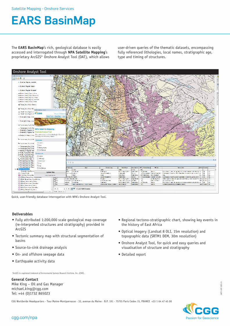
The EARS BasinMap’s rich, geological database is easily accessed and interrogated through NPA Satellite Mapping’s proprietary ArcGIS* Onshore Analyst Tool (OAT), which allows
Quick, user-friendly database interrogation with NPA’s Onshore Analyst Tool.
Onshore Analyst Tool
user-driven queries of the thematic datasets, encompassing fully referenced lithologies, local names, stratigraphic age, type and timing of structures.
Deliverables•Fully attributed 1:200,000 scale geological map coverage
(re-interpreted structures and stratigraphy) provided in ArcGIS
•Tectonic summary map with structural segmentation of basins
•Source-to-sink drainage analysis
•On- and offshore seepage data
•Earthquake activity data
*ArcGIS is a registered trademark of Environmental Systems Research Institute, Inc. (ESRI).
•Regional tectono-stratigraphic chart, showing key events in the history of East Africa
•Optical imagery (Landsat 8 OLI, 15m resolution) and topographic data (SRTM1 DEM, 30m resolution)
•Onshore Analyst Tool, for quick and easy queries and visualisation of structure and stratigraphy
•Detailed report
Satellite Mapping - Onshore Services
cgg.com/npa