Embed Size (px)
Citation preview
LE CENTRE FRANÇAIS SUR LES ÉTATS-UNIS
(CFE)
SATELLITE IMAGERY CONTROL:AN AMERICAN DILEMMA
SATELLITE IMAGERY CONTROL:AN AMERICAN DILEMMA
Laurence Nardon
Foreword by Gordon Adams
i n s t i t u t
f r a n ç a i s
d e s r e l a t i o n s
internationales
ifri
March 2002

SATELLITE IMAGERY CONTROL:
AN AMERICAN DILEMMA
Laurence Nardon
Research Associate at CFE/Ifri
Foreword by Gordon Adams
Prepared for The Centre français sur les Etats-Unis (CFE)
March 2002
2
Ifri is a research centre and a forum for debate on the major international political and economic issues.
Headed by Thierry de Montbrial since its founding in 1979, Ifri is a non-profit-organization.
The opinions expressed in this text are the responsibility of the author only.
© Copyright Ifri, Paris 2002 ISBN
Cover picture: spaceimaging.com
Diffusion: la documentation Française 29-31, quai Voltaire – 75340 Paris Cedex 07 - France Tel.: 33 (0)1 40 15 70 00 – Fax: 33 (0)1 40 15 72 30
www.ladocfrancaise.gouv.fr
Ifri – 27, rue de la Procession – 75740 Paris Cedex 15 – France Tel.: 33 (0)1 40 61 60 33 – Fax: 33 (0)1 40 61 60 60
[email protected] – Email: [email protected]
3
Foreword
By Gordon Adams1
Space is no longer a frontier, used and occupied solely by governments. From an
environment in which only governments operated, largely for exploration and military
purposes, space has rapidly filled with assets used for intelligence and military
operations to civilian communications, to observation and commerce. Today, more
launches are dedicated to commercial purposes than to military ones.
The evolution of space from a frontier to an operating environment shared by multiple
users from many nations has raised an entire new agenda of issues for policy makers.
One of the most striking space developments of the past decade has been the growth
of private sector developers and users of imagery from space, once the exclusive
preserve of governments and their intelligence arms. DigitalGlobe launched its high-
resolution satellite in the fall of 2001, and there is now nearly half a dozen commercial
imagery systems circling the earth.
It is not easy to separate out the government and private sector policy issues
concerning the environment or space, either for the United States or for others nation
developing their own space activities. The appearance of commercial observation
systems has ended government monopoly on such information and broadened the
options for government and private users around the world. In 1994, the Clinton
administration issued a presidential directive seeking to exercise some control over the
expanding private sector activity in observation and imagery. Few of the Clinton
policies have been tested, and some, such as shutter control, have raised strong
criticism. The Bush administration is reexamining this area of policy today, a
reexamination that has also provoked concern.
The concern grows from the realization by the U.S. government that space is an
increasingly important operating environment for military operations. The military has
come to rely intensely on space-based assets for imagery, target identification, missile
1 Gordon Adams is Director of Security Policy Studies and Professor of the Practice of International Affairs at the Elliott School of International Affairs (George Washington University).

4
guidance, location and weather information for military operations, and, above all,
secure communications. It uses both dedicated military and commercial capabilities for
many of these purposes. As the Space Commission, chaired by now Secretary of
Defense Donald Rumsfeld, recognized, space is no longer marginal to the military; it is
integral to their operations. This focus on the military utility of space will grow over the
next few years as the conclusions of the Space Commission report are implemented,
and as the administration's commitment to ballistic missile defense comes to include
space-based sensors and, conceivably, space-based intercept capabilities.
The military is concerned about force protection, ensuring its increasingly critical assets
can be defended. A defensive capability inevitably brings in its train an offensive
capability. Hence the concern: how to ensure adequate protection without provoking an
arms race in space. The growing commercial presence in space is drawn, inexorably,
into this argument; for commerce and the military share the operating environment,
even some of the tasks.
The question of public and private imagery is a microcosm of this broader debate. Here
too the issues are not simple. For example, even private imagery developers cannot
currently survive without public subsidy - through demand for their product and support
for research and development of interpretation software. Are such subsidies
appropriate; should the government rely solely on its own dedicated assets; should
subsidization give government users special access, privileges and control? Given the
growing sophistication of such imagery, should the government rely on private
providers? Should the government then protect private providers as part of a space
defense system, or does this interdependence run risks for the private providers, as
their assets come to be seen by potential adversaries as targets in space?
These broad policy issues involve the public's access to information, the use of public
funds to subsidize private purposes, and the risks to private operators of the growing
reliance of the U.S. military on space operations. There remains precious little debate
in the United States or internationally about these issues; they tend to remain in the
hands of specialists. As both private and military users of space expand their activity, it

5
is critical to have resources in hand that inform the broader debate. Laurence Nardon's
paper makes an important first step in this direction, and provides a valuable tool for
policy-makers grappling with these issues.
6
Abstract
What happens when an information technology moves from being used exclusively by
government intelligence agencies to being made widely available?
Satellite imagery, which has been kept secret since the time of the cold war, is now
being marketed by companies with orbit observation systems. Though the economic
success of these companies is still unconfirmed, the emergence of imagery on the
international scene is already causing problems. Imagery allows for richer and more
precise information to be distributed. The relations among states are developing in a
more transparent environment, which would have both stabilizing and destabilizing
effects.
What consequences should be feared in particular? The United States, because of the
important role its companies play in developing this market and because of their great
involvement in international affairs, is facing a dilemma: it wants to control this source of
information for security reasons, while allowing its companies to become dominant in the
new market.
How much leeway should it give the image suppliers? What financial support should it
provide to the companies?
Very diverse mechanisms for control of satellite imagery have been considered to
address the possibility of destabilizing or aggressive use of the imagery. At the
beginning of October 2001, the government replaced them on short notice with a very
innovative measure. By buying on an exclusive basis all of the satellite photos of
Afghanistan taken by the only company that currently produces high-resolution
commercial imagery, the Pentagon is preventing other parties from gaining access to
this source of information, while providing considerable financial support to the
company. An agreement similar to a buyout will be proposed, and undoubtedly
accepted, by US companies entering this market in the future.
This kind of action confirms the importance of the connection between the US
commercial imagery companies and the federal authorities. It does not appear to favor
7
the emergence of mass private demand, which is the only thing able to ensure market
operation according to the private sector rules. This action does not settle the question
of foreign imagery companies, which will definitely not accept the exclusivity contracts
proposed by the US Department of Defense.
In a working group formed last spring, the new Administration continues to consider how
to control the distribution of images in times of international crisis. It is now facing such a
case on a major scale.

8
Table of Contents
Introduction: Transparency, a New Component of International Relations – The Case of Space Observation ------------------------------------------------------------------------------ 9
a- Transparency -------------------------------------------------------------------------------------------------------- 9
b- Space Observation ----------------------------------------------------------------------------------------------- 10
1- Risks of Marketing High Resolution Images --------------------------------------------- 13
a- A Potential Danger for United States Security------------------------------------------------------------- 14
Table 1 - Resolutions Needed to Observe Military Targets ------------------------------------------------ 16
b- Loss of Control over Information ------------------------------------------------------------------------------ 17
c- Problems Using Imagery ---------------------------------------------------------------------------------------- 20
2- Emergence of a Commercial Market --------------------------------------------------------- 23
a- Operational Systems in 2002 ---------------------------------------------------------------------------------- 23
Table 2 – Commercial Systems with a Resolution Less than or Equal to 10 meters and Operational in the Spring of 2002 -------------------------------------------------------------------------------------------------------- 24
Table 3 – Launches Scheduled for 2002-2003 --------------------------------------------------------------- 25
b- Problems Encountered by Operators ------------------------------------------------------------------------ 25
Table 4 – Cost of Several Current High Resolution System Projects ----------------------------------- 26
Table 5 – Estimated Evolution of Global Space and Air Observation Markets------------------------ 27
c- Conditions for Loosening the Market------------------------------------------------------------------------- 28
Table 6 – Commercial Observation Revenues: Optimistic but Increasingly Conservative Forecasts---------------------------------------------------------------------------------------------------------------------------- 30
3- US Government Options For the Control of Imagery------------------------------ 32
Control of US Imagery -------------------------------------------------------------------------------------------- 32
a- The Strict Operating License Environment ----------------------------------------------------------------- 33
A Specific Policy Towards Israel --------------------------------------------------------------------------------- 34
Shutter Control-------------------------------------------------------------------------------------------------------- 35
b- The October 2001 Agreement --------------------------------------------------------------------------------- 36
Long-Term Dialogue------------------------------------------------------------------------------------------------- 38
Control of Foreign Imagery-------------------------------------------------------------------------------------- 39
a- Non-Military Resources ----------------------------------------------------------------------------------------- 40
The End of Technological Dependency------------------------------------------------------------------------- 40
Diplomatic Channels------------------------------------------------------------------------------------------------- 40
International Rules of Law ----------------------------------------------------------------------------------------- 41
Promote Market Domination by American Companies------------------------------------------------------ 42
b- Anti-Satellite Weapons Programs: Different Levels of Aggression ----------------------------------- 43
Conclusion: A Developing Control Architecture -------------------------------------------- 46

9
Introduction
Transparency,
a New Component of International Relations.
The Case of Space Observation
a- Transparency
For decades now, information gathering and communication systems have been
spreading throughout society. With faxes, cell phones, video cameras, and computers
with Internet and e-mail access, our daily life has been transformed by devices allowing
us to know and to make known, instantly and permanently. Less visibly, observation,
data relay or telecommunications satellites support this transformation and participate in
it actively.
In the information world, privacy and confidentiality are harder to maintain. Successful
concealment of nuclear test sites, of violation of the rights of man or simply the dumping
of oil into the ocean has become unpredictable. An incriminating image may be
broadcast on the Internet and seen by the whole world in minutes. News circulates with
no regard for borders and to a great extent escapes traditional state control. Several
years ago, the Gilles Perrault book Our Friend the King [Notre ami le Roi], which
denounced the regime of King Hassan II in Morocco, had been banned in that country. It
was widely distributed in Morocco by fax from France.
The effect of this information transparency on the distribution of power in individual
societies and more broadly throughout the world has just begun to be analyzed1 and its
impact will continue to be felt in the years to come.
The conduct of international relations is affected by this evolution. Some positive effects
may be expected: a state will hesitate to adopt an objectionable position if it cannot
remain hidden. More available information also means less uncertainty and more
confidence in relationships between states.
10
In a recent work, the American author David Brin explains how a permanent system of
surveillance of the citizens of a society can act as an instrument of liberation and as the
way to exercise true direct democracy, giving the citizens control of the surveillance
system.2
Brin counters the theses of Michel Foucault, for whom organized surveillance in a
society can only be an instrument for oppression of the individual.3 The dissemination of
information could indeed have negative consequences. In relations between states,
transparency could destabilize the governments and trigger conflict.4 This is the kind of
risk the United States now wishes to address. The country needs to find ways to adapt
to the new risks caused by the ongoing availability of information.
b- Space Observation
Among the various information technologies transforming society today, space
observation is special from several different perspectives.5
Because it comes in the form of an image, showing real objects, this information
technology seems to be directly comprehensible and has an immediate impact on those
seeing it. For example, the images of the city of Grozny taken before and after the
Russian military campaign in the winter of 2000 immediately strike us with the violence
of the destruction that took place in the intervening time.6 The images are thus more
meaningful than a series of numbers, more indicative than a text or a speech.
This impression that the image has an evident meaning is not without its problems. It is
hard not to interpret an image by relying on preconceived ideas, which could lead to
mistakes. This tendency to project assumptions led an expert to compare interpretation
of space imagery with Rorschach tests which, in psychoanalysis, help patients express
their unconscious ideas through the use of random inkblots.7 So, because during the
cold war US intelligence officers believed the Soviets were engaged in the arms race,
they tended to read into images from Russian territory the general and continued growth
of military installations.
11
This risk is all the greater because one would naturally give credence to information that
seems visually evident. Images have a powerful and complex psychological impact on
those seeing them.
These psychological components add to the real technical difficulty in processing and
interpreting properly the images taken from space.
On the other hand, this technology, more than others, remains under the control of the
US military leaders or intelligence officers.
Most information technologies have always existed in the public domain. Telephones,
cameras, photographic equipment and faxes have always been used by civilians.
Created under DARPA (Defense Advanced Research Projects Agency), computers and
e-mail quickly became available to the general public. On the other hand, high-resolution
space observation was developed by the intelligence services of the US and the USSR
and for a long time remained exclusively in their hands.
Until the 1980s, this technology was a way to monitor the whole world, to the benefit of
some. Space observation seemed to be a perfect control system, since the monitored
states did not know the timing or the precision of the surveillance, and thus could not
avoid it. Beyond its intelligence role, it had become a central instrument for the two
superpowers to control information and allowed for various kinds of political pressure to
be brought to bear against the countries observed.
Today, this technology is becoming freely available and, theoretically, the current system
already allows for the observation of everyone by everyone. But space observation is
not yet completely commonplace and has not yet entered mass use. The operators
expect market development in the years to come.
During this transition phase, high resolution imagery is an especially sensitive subject for
the American intelligence and military services. This attitude undoubtedly reveals a
significant disinclination to abandon their control of this instrument of power. Officially,
the American leaders cite the US security risks that could arise from broadcasting space
imagery.
12
The United States is vitally concerned about the growing dissemination of space
imagery. Considering itself the major power in the post-cold war world, it is trying to
maintain stability and is monitoring, among other things, the dissemination of
technologies that could affect it negatively. In the framework of a redefinition of the US
defense policy, the Bush administration is intensely interested in this question.
Additionally, the United States played a key role both in conquering space and in
developing civilian and military information technologies. It now has uncontested
industrial power and technological advantage in the aeronautics and space sector.
Controlling the dissemination of the imagery is important for security reasons, but also
for the maintenance of the dominance of US industries in this sector.
After analyzing the potential risks and listing the existing commercial systems, the
various possibilities for control developed by the US will be evaluated.
13
1- Risks of Marketing High Resolution Images
There are different kinds of direct sensor inputs for space observation satellites.
Panchromatic sensors obtain images that resemble true black and white photographs.
They are generally more precise in terms of ground resolution. Multispectral or
hyperspectral sensors film the Earth in different spectral bands, thus revealing
indications of the nature of the ground in different colors (cement or asphalt, vegetation,
minerals, water tables, etc.). Sensors working in the thermal infrared band more closely
monitor heat sources, allowing, for example, an indication of missiles taking off. Finally,
radar sensors can see at night or through clouds, and this function is very useful in
monitoring regions with an oceanic climate.
These images, analyzed by a photo interpreter using complex software, provide
concrete information to military and political leaders and to members of civilian society.
They are used for different purposes.
For about fifteen years, a number of very specific studies on what could happen in terms
of international affairs as a result of the acquisition and interpretation of commercial
space imagery were done at research institutes, NGOs or government agencies.
In view of the dissemination of this new source of information, starting in the 1980s, it
was of interest to see what the non-state players could utilize in their activities, most
often connected to disarmament issues. The studies done address such issues as the
description of military installations in countries not sharing information, the functioning of
confidence- and security-building measures in a given area, or compliance with
commitments in disarmament treaties.
The authors used the first available images, with very low resolution, then used more
and more precise resolutions offered on the market.
One of the first research projects done on the basis of commercial imagery provided a
rather complete view of Soviet military and nuclear facilities on the Kola peninsula that
had until then remained unknown to the public. This study, conducted in 1987 by a
14
Norwegian institute, is innovative. It is supported by low resolution Landsat images, and
by the first Spot images available (Spot 1, between 10 and 20 meters of resolution).8
The numbers of this kind of project snowballed, showing the ever greater usefulness,
with increasing image resolution, of commercial satellite imagery for security purposes.9
For example, a study was done in 1996 on the Indian nuclear testing site at Rajasthan. It
confirmed the usefulness of commercial space imagery for the verification, outside of
any official national or international structure, of compliance with the nuclear test ban
treaty.10
Official US agencies also financed this kind of research. In 1999, at Sandia National
Laboratory, a study was conducted about the possibility of running a security system
from the South China Sea, from Indian satellite IRS-1C images, with a resolution of 5
meters in panchromatic mode.11
But other players have also been able to use space imagery, this time for purposes
perceived as hostile or at least problematic by the United States.
From the US perspective, using this source of information for directly aggressive
purposes would be an indication that terrorist groups or States were pursuing goals
openly opposed to western interests. It has also been noted that players such as the
press and NGOs have made much use of space imagery. The publication of information
derived by the latter from space imagery could, to a certain extent, be destabilizing for
the Washington authorities.
a- A Potential Danger for United States Security
For the United States, the players who could use satellite images for directly military
purposes fall into two categories:
• Enemy states, whether known as rogue states12 or as countries of concern.
Among the latter13, China seemed to be especially prominent during the first months of
the second Bush administration. As for Russia, “it is not an enemy, but it could be a
threat,” said President Bush ambiguously;14
15
• Non-state players such as terrorist organizations obviously took priority among
American concerns after September 2001.
One of these states or organizations could use satellite imagery to locate targets in an
enemy country during the preparation phase of a military attack.
It is probable that the Iraqi military bought Spot images with a resolution of 10 to 20
meters to prepare bomb attacks and to evaluate the results during the war against Iran
in the 1980s.15 It is also possible that they used images from the same source to prepare
the Kuwait invasion in the summer of 1990.
The more precise the available images, the greater their value in terms of military
intelligence. The most precise imagery now available on the commercial market has a
resolution of one or two meters. It is made by the American system Ikonos, the Russian
Spin-2 and the Israeli Eros 1A. The US satellite QuickBird 2, which was launched in the
autumn of 2001, was to offer images with a resolution of 70 cm as of the spring of 2002.
In December 2000, Space Imaging obtained a license from the Commerce Department
to manufacture a satellite with a panchromatic observation sensor with a resolution of 50
cm. The company announced the launch of this satellite in 2004.
Space imagery can be integrated into a pre-existing aggression project initiated by a
government or an organization.
Alternatively, it can also, by itself, lead to an outbreak of hostilities. The images can
disclose to a government the military vulnerabilities of an enemy state and make the
option of a surprise attack tempting. They can also signal troop movements or other
military actions in a neighboring country. These, wrongly interpreted as threatening by a
state, would lead to a preemptive strike, which may not have taken place otherwise. The
imagery could be the direct cause of military operations.
Countries located in very unstable regions fear this possibility and it is this argument that
the Israeli government is using to try to slow down the sale of satellite images in its
territory. Neighboring states with poor relations, such as India and Pakistan, are also
suspicious of the sale of images from their territory. India, which has a high resolution

16
commercial observation system (IRS system), has developed a fairly restrictive sales
policy.
Table 1
Resolutions Needed to Observe Military Targets In light gray, what can be conserved using imagery with a one-meter resolution (currently available)? In dark gray, what else can be seen using imagery with 50 cm of resolution (license obtained in December 2000, operational 2004?)?
Target Detection Identification Precise identification
Description Technical analysis
Troops 6 m. 2 m. 1.20 m. 30 cm. 15 cm. Vehicles 1.50 m. 60 cm. 30 cm. 6 cm. 4.5 cm. Airplanes 4.50 m. 1.50 m. 1 m. 15 cm. 4.5 cm. Airports 6 m. 4.50 m. 3 m. 30 cm. 15 cm. Nuclear arms components
2.50 m. 1.50 m. 30 cm. 3 cm. 1.5 cm.
Missile bases (surface-to-surface and surface-to-air)
3 m. 1.50 m. 60 cm. 30 cm. 4.5 cm.
Rockets and artillery
1 m. 60 cm. 15 cm. 5 cm. 4.5 cm.
Surface vessels
7.50-15 m. 4.50 m. 60 cm. 30 cm. 4.5 cm.
Surfaced submarines
7.50-30 m. 4.50-6 m. 1.50 m. 1 m. 3 cm.
Roads 6-9 m. 6 m. 1.80 m. 60 cm. 40 cm. Bridges 6 m. 4.50 m. 1.50 m. 1 m. 30 cm. Radar facilities 3 m. 1 m. 30 cm. 15 cm. 1.5 cm. Radio equipment
3 m. 1.50 m. 30 cm. 15 cm. 1.5 cm.
Command and control centers
3 m. 1.50 m. 1 m. 15 cm. 9 cm.
Equipment storage
1.50-3 m. 60 cm. 30 cm. 3 cm. 3 cm.
Minefields 3-9 m. 6 m. 1 m. 3 cm. -- Urban areas 60 m. 30 m. 3 m. 3 m. 75 cm. Coasts, landing beaches
15-30m. 4.50 m. 3 m. 1.50 m. 15 cm
Ports 30 m. 15 m. 6 m. 3 m. 30 cm. Railroad facilities
15-30 m. 15 m. 6 m. 1.50 m. 40 cm.
Terrain -- 90 m. 4.50 m. 1.50 m. 75 cm. Source: Ann Florini, “The Opening Skies: Third Party Imaging Satellites and U.S. Security,” International Security, vol. 13, no 2, autumn 1988, p.98. Definitions: Detection: location of a kind of component, of objects or of activities of military interest. Identification: determination of a certain type of target. Precise Identification: distinction among several kinds of targets within the same category of targets. Description: size/dimension, configuration/organization, construction of components, itemization of units, etc. Technical Analysis: detailed analysis of specific components. Note: The sources do not specify whether the resolution is expressed in pixels or in points.
17
A terrorist organization could also use commercial images to learn exactly where the
troops of a target state are and how their facilities (embassies, military bases, etc.) are
laid out. A terrorist attack on the model of the attack of the American vessel USS Cole in
the port of Aden in October 2000 could be organized using space imagery.
The events of September 2001 showed the unthinkable reality of the terrorist threat to
the United States. Although it is not certain that space imagery was used by the
organizers of the attacks on New York and Washington, it is clear that the US authorities
would like to have even better control in the future over use of imagery.
b- Loss of Control over Information
Commercial imagery could also be put to destabilizing use by a government beyond the
military or terrorist context. For many years US leaders have seen such images
disseminated to general information sources. In fact, newspapers television and NGOs
can now buy their own images and present their own interpretation of issues and events.
The examples known as of today involve the western media or NGOs in particular,
which have been able to launch a more or less direct challenge to the US government.
The press began to use space images in 1980 to support information provided. Four
days after the Chernobyl nuclear plant accident in April 1986, the US television network
ABC showed Landsat images of the area, soon replaced by Spot images, which are
more precise. Not only could the Soviet government not deny the facts, but the western
governments could not either.
Some newspapers tried to use commercial imagery during the Gulf War in 1991,
presenting images of oil wells on fire at the end of the conflict. They could use Meteosat
images, with a very coarse resolution (around several kilometers). The much better
Landsat 4 images were not accessible to the media during that time. Landsat 4 has an
infrared thermal sensor, which picks up heat sources, with a resolution of approximately
120 meters.16
Since then, the precision of commercial images has improved a great deal and the
consequences of this evolution have begun to be felt. Ikonos, the satellite of the US
18
company Space Imaging, takes images with a resolution of one meter in panchromatic
mode. In March 2000, the New York Times published two Ikonos images of the city of
Grozny,17 one dating from December 16, 1999 showing the city intact, and the other
dated March 16, 2000 showing the city destroyed. During the Russian army offensive,
neither journalists not the humanitarian organizations were authorized by Russian
authorities to enter the area. The US State Department, for its part, said it would not
intervene in this Russian domestic issue.
These satellites images were used during a US Senate hearing, which was
unprecedented.18 Faced with questions from the committee members, the US
government was forced to adopt stronger language with the Russian authorities.
This is a battle over the power of information that some NGOs want to initiate. Parallel to
the media’s action, NGOs also used space imagery to produce their own analyses and
to make them public.
The Federation of American Scientists (FAS), an American pacifist organization, led an
initiative between 1996 and 2000 called Public Eye. Its objective was to show certain
contradictions in the US government’s foreign policy and security positions, based on a
study of satellite images of specific sites. Images and analyses were then published in
the press and on the FAS web site.19 The year 2000 saw an especially large number of
revelations, mainly based on images taken by the US commercial satellite Ikonos:
1) In January 2000, FAS presented the image of a ballistic missile test site in North
Korea, concluding that its infrastructures are much more primitive than had been
thought by the US proliferation experts;
2) In March 2000, FAS presented the image of a nuclear missile site in Pakistan,
showing, on the contrary, that these facilities were much more developed than had
been thought. This revelation coincided with a visit by President Clinton to India and
Pakistan and required that he answer questions from the press about non-
proliferation on the Indian subcontinent;20
3) In May 2000, images of civilian and military air facilities along the coast in the south
of China allowed FAS to confirm that the Chinese defenses against Taiwan were not
as powerful as the US government indicated.21 Undoubtedly for FAS it was a matter

19
of presenting different views at the time the US Congress was voting on the law on
resuming trade with China. John Pike, in charge of the Public Eye project at FAS,
had conducted a fairly technical and very detailed study using several types of
satellite images: Images taken by the US military systems in the nineteen sixties and
later declassified, Russian images taken in the 1990s, and Ikonos images;
4) In August 2000, a study on the Israeli nuclear reactor Dimona was finally conducted.
For the first time, it provided public proof of the existence of Israeli nuclear arms.22
The policy of denial in Israel and the US since the nineteen seventies is no longer
possible.
The quality of the interpretations of these images given by FAS is generally highly
debated by other space observation experts. This organization is not an intelligence
agency and does not have a rich, multisource network to help it interpret the images it
can obtain.
But the goal of the Public Eye project, according to John Pike, is just to show the powers
that be that they have no exclusive right to know and that they have lost some of their
power. This is a challenge through possession of information. The reactions of the
government authorities can continue to be watched with interest in the years to come;
the Public Eye initiative will continue with a new organization, GlobalSecurity.Com,
founded by John Pike upon his departure from FAS in the fall of 2000.
The upheavals tied to commercial space imagery could be considered a new phase in
the public access to information. Similar reactions occurred after the birth of the mass
press in the nineteenth century, of photography and cinema around 1900, and of
electronic communications in the second half of the twentieth century.
Imagery, a new information tool available to the media, allows them to put a great deal
of pressure on the government, making it react quickly, probably in line with public
opinion, which can rarely be reconciled with the discretion and the slow pace of
diplomatic efforts. This effect is especially felt in the United States, where the right to
information is guaranteed by the first amendment to the Constitution and where the
media traditionally play a very important role in public life. Information there is even more
of an instrument of power than it is elsewhere.

20
When there is a regional crisis, for example, the presentation of information by the press
that is contradictory to the government’s information could hinder the government’s
actions. The United States would have a very high political price to pay for committing
troops in battle when public opinion opposed it. Conversely, it could be pushed into an
intervention they never wanted to start with.
In the fall of 2001, it appears that the US government was able to learn a lesson from
the publication of images of Grozny or the FAS campaign. In order to manage its military
operations well in Afghanistan, the government did not want to run the risk of
unfavorable images being published by the press, even though it is known that the press
and the media themselves limit their criticism during difficult international situations.23
The Department of Defense bought exclusive rights to all of the images of Afghanistan
produced by Space Imaging, the only company currently producing high resolution
imagery. Thus, no other players could obtain any of them.
c- Problems Using Imagery
The risks in disseminating space imagery to hostile or destabilizing players are still
limited by problems obtaining and interpreting the images, and the need to integrate the
information received into more extensive systems.
Whereas the media and NGOs had few problems so far when they wanted to acquire a
satellite image, the states and organizations considered hostile by the United States do
not necessarily have access to this imagery.
Few countries have deployed their own observation systems to date, but some projects
have been announced. China is developing a radar satellite project, and, in cooperation
with Brazil, a series of four Spot-type satellites is being deployed. Long delays should be
expected for such high tech projects, but some of these countries will undoubtedly
eventually deploy operational systems. Pakistan launched a multispectral satellite with a
resolution of 250 meters on December 10th, 2001. India deployed one of the most
precise systems to date, which has a resolution of 5 meters in panchromatic mode and
23 meters in multispectral mode. In October 2001 it launched an experimental TES
satellite (Technology Experiment Satellite) that tests a sensor with a resolution of one
21
meter. Taiwan has just bought an observation satellite from Astrium allowing for a
resolution of 2 meters. This Rocsat satellite will be launched in 2002 or 2003.
The greatest number of “at risk” players identified by the United States will not have
independent space observation systems in the foreseeable future. If North Korea, Iraq
and other rogue states or terrorist organizations had the enormous financial and
technological resources needed to manufacture a system, they still would need access
to a launch vehicle, so this prospect seems relatively unrealistic.
Another scenario assumes they could hijack an operational observation satellite. They
would need to take control of the satellite from the ground, manage and decode
communications, probably by taking possession of a ground control station.24
Alternatively, these hostile players could buy imagery from a commercial operator.
American companies cannot sell imagery to persons listed as dangerous by the State
Department. They will therefore need to use a front man or find an operator in a neutral
or friendly country. This is the most credible scenario at present.
After the image is obtained, it should be analyzed. Satellite imagery interpretation is an
extremely difficult technology and numerous interpretation errors are made. Photo
interpreters should receive extensive training in reading images. It is currently thought
that if the type of radar or optic sensor evolves, even toward greater precision, or if the
type of object sought is no longer the same, the best analysts make glaring mistakes.
Ongoing training is essential. Next, it is essential to be able to correlate information
deduced from the images with intelligence coming from other sources.
It is hard to know whether the states and organizations acknowledged as hostile by the
United States have competent photo interpreters. It can be said with more certainty that
journalists are rarely trained in this technology. Even if they use a photo interpreter, they
do not have the ability to check whether the information provided by the images is
plausible. Indeed, in recent years a certain number of mistakes have been noted in the
explanations provided by the media about satellite images, some of which appear on
page one.
In May 1998, for example, Newsweek magazine published a satellite image of the Indian
nuclear test site north of the state of Rajasthan, where India had just conducted five
22
nuclear tests. The image was presented as dating from a week before the tests and the
various components present in the photograph were itemized. The magazine later
admitted that the photograph had been taken five years earlier and that none of the
explanations provided were accurate. The excavation in which the tests were thought to
have been done was really just a cattle yard.25
The non-governmental players should gain credibility over the long term so that public
opinion can rely on the interpretations of space imagery they present. Journalistic ethics
require, for example, that they verify all information from two different sources. This rule
could be expanded to include satellite information. This would mean that each image
would be presented to two different photo analysts to confirm the nature of the
components contained in the image.
Finally, for players pursuing precise military or terrorist objectives, obtaining and
analyzing the image will not be enough. It is necessary to integrate the space
information into a more extensive system.26 To launch a missile, for example, the
weapon and the vector must be known, of course, to build a flight plan. The information
on the target obtained from the satellite image must be integrated into a navigation
system. The action itself will involve elaborate telecommunications networks. A military
operation assumes the presence and control of various complex components, which are
not within everyone’s reach.
The recent attacks on the United States show that the resourcefulness of the terrorist
networks is unlimited. They can bypass high tech resources–missiles, for example–and
use unexpected but equally effective resources, such as airliners. In this context, and
from the perspective of the United States, space imagery is not a crucial security issue,
but its dissemination should remain closely monitored.
23
2- Emergence of a Commercial Market
a- Operational Systems in 2002
The expansion of commercial observation systems has been taking place since the
1980s. During the 1960s, space observation technology was strictly classified and
reserved for the military or the highest Soviet and American political leaders. Civilian
access to satellite imagery began in 1972, when NASA put Landsat 1, a low resolution
observation satellite (approximately 75 meters) into orbit. The Landsat images were
intended for research on the Earth and oceans by the global scientific community.
Throughout a first period, these images remained free of charge. They were not
intended for commercial use, but for research. Some meteorological satellites, with even
lower resolution (several kilometers), also started to operate at this time.
The question of public access to imagery that could potentially be used for purposes
related to security began to arise in 1986, when France launched its first space
observation satellite, Spot. Programmed for specifically commercial use, its resolution is
10 meters in panchromatic mode and 20 meters in multispectral mode (for the currently
operational Spot 1, 2 and 4). In 1990-1991, the Gulf War attracted attention to the
specific possibilities of these civilian systems. The use of Spot images by the Pentagon
to create precise maps of the Gulf region elicited a good deal of publicity.
Several commercial operators and systems followed. After the fall of the USSR in 1991,
the company Sovinformsputnik obtained the right to sell images from the KVR
intelligence system, downgrading it to a resolution of two meters. In 1995, the Indian
system IRS became operational. The IRS images were firmly presented as the
equivalent of Spot images, but less expensive. The companies are in a highly
competitive commercial situation.
American companies wanted to be able to enter this market and, in 1994, the Clinton
administration adopted the Presidential Decision Directive 23 (PPD 23), authorizing the
marketing of images and observation systems with a resolution comparable to that
available on the global market. Several consortia of American companies quickly filed

24
applications for operating licenses. Space Imaging has had an operational satellite with
a resolution of one meter since the end of 1999. In September 2001, DigitalGlobe
(formerly EarthWatch) launched an observation satellite with a resolution of 70 cm that
will be operational in the spring of 2002. After losing OrbView 4 in the fall of 2001,
OrbImage should soon be launching the satellite OrbView 3.
In the summer of 2000, the Russian company Sovinformsputnik responded by
decreasing the resolution of some of its images to one meter. It has had an operational
system with a resolution of two meters, and an archive of very high precision images
since 1992. Until now it was required to downgrade these archive images to two meters
to sell them. To compete with the Space Imaging system, it can now downgrade them to
only one meter of resolution.27 It does not seem that the Russian company currently has
a sensor with resolution of one meter to fill recent image orders.
In December 2000, the company ImageSat International,28 an Israeli-American
consortium, launched its first satellite, Eros 1A, with images providing a resolution of 1.8
meters in panchromatic mode. On the same date, Space Imaging received the license
needed to launch and operate a sensor with a resolution of 50 centimeters.29
The evolution towards increasingly higher commercial resolutions seems to be
continuing.
Table 2 Commercial Systems with a Resolution Less than or Equal
to 10 meters and Operational in the Spring of 2002
System Operational Resolution Operator (country)
Ikonos-2 End of 1999 Panchro.: 1m
MS: 4m Space Imaging (United States)
IRS-1C et IRS-1D
1995 1997
Panchro.: 5m MS: 23.5m, 70.5m, 188m
Indian Remote Sensing Agency (India)
Radarsat 1995 Microwave: 8-100m Canadian Space Agency (Canada) Kometa 1981 (public: 1992) Panchro.: 1-2 (?), 10 Sovinformsputnik (Russia)
Resurs-F 1974 (public: 1992) MS: 4-7, 15-30 Sovinformsputnik (Russia) Spot 1, 2
and 4 1986 1998
Panchro.: 10m MS: 20m
Spot Image (France)
Eros 1A December 2000 Panchro.: 1.8m ImageSat International (Israel and United States)
QuickBird 2 October 2001 (operational
February 2002)
Panchr: 70cm MS: 2.8 m.
DigitalGlobe (United States)
Notes: in bold, the finest resolutions available today (panchromatic mode) Panchro: panchromatic (black and white) MS: multispectral (spectral bands, color recreated)
25
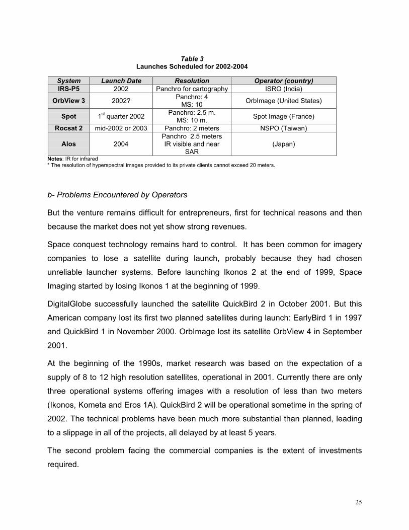
Table 3
Launches Scheduled for 2002-2004
System Launch Date Resolution Operator (country) IRS-P5 2002 Panchro for cartography ISRO (India)
OrbView 3 2002? Panchro: 4
MS: 10 OrbImage (United States)
Spot 1st quarter 2002 Panchro: 2.5 m.
MS: 10 m. Spot Image (France)
Rocsat 2 mid-2002 or 2003 Panchro: 2 meters NSPO (Taiwan)
Alos 2004 Panchro 2.5 meters IR visible and near
SAR (Japan)
Notes: IR for infrared * The resolution of hyperspectral images provided to its private clients cannot exceed 20 meters.
b- Problems Encountered by Operators
But the venture remains difficult for entrepreneurs, first for technical reasons and then
because the market does not yet show strong revenues.
Space conquest technology remains hard to control. It has been common for imagery
companies to lose a satellite during launch, probably because they had chosen
unreliable launcher systems. Before launching Ikonos 2 at the end of 1999, Space
Imaging started by losing Ikonos 1 at the beginning of 1999.
DigitalGlobe successfully launched the satellite QuickBird 2 in October 2001. But this
American company lost its first two planned satellites during launch: EarlyBird 1 in 1997
and QuickBird 1 in November 2000. OrbImage lost its satellite OrbView 4 in September
2001.
At the beginning of the 1990s, market research was based on the expectation of a
supply of 8 to 12 high resolution satellites, operational in 2001. Currently there are only
three operational systems offering images with a resolution of less than two meters
(Ikonos, Kometa and Eros 1A). QuickBird 2 will be operational sometime in the spring of
2002. The technical problems have been much more substantial than planned, leading
to a slippage in all of the projects, all delayed by at least 5 years.
The second problem facing the commercial companies is the extent of investments
required.

26
Table 4 Cost of Several Current High Resolution System Projects
Company Satellites Planned Investment
Space Imaging Ikonos 1and 2 750 M$
OrbImage OrbView 3 and 4 250 M$
EarthWatch QuickBird 1 and 2 186 M$
ImageSat International Eros 1A, 1B, 1C 300 M$
Source: The Economist, May 6, 2000, p.72.
For the US companies Space Imaging, OrbImage and DigitalGlobe and for the Israeli
company with American participation ImageSat International, the average investment
per satellite is approximately 160 million dollars, with the understanding that
constellations of two or three satellites are most common.
The global commercial satellite imagery market has not yet fulfilled its promise. At the
beginning of the 1990s, several analyses projected substantial, rapid profitability of
investments.30 But the annual revenues from the space observation market are currently
estimated at 200 million dollars.31 The projects are not at all profitable at this point!
The slow development of this market is due in part to the intense competition in air
imagery. For 2001, commercial revenues from air observation are estimated at 2.85
billion dollars compared to under 200 million for space imagery. Commercial air
observation is older than space imagery. It has had time to become habitual with a
broad clientele and to perfect a very satisfactory product. Air imagery is more flexible to
use, that is, more quickly delivered. The finished products are less expensive because
the production costs for an image, even the marginal costs, are much lower.32
The quality of the products is also excellent. Airplanes fly much lower than satellites.
Although this constitutes a geographic limitation to their operating radius and prevents
them from quickly imaging vast zones (because their orbit track is very narrow), their
resolution is quite fine, between 10 and 15 cm or 1-2 meters.
Having long established productive relationships with a stable clientele, the
manufacturers in this sector were able to adapt their products to demand and are
relatively advanced in processing the imagery. The processing software and the

27
integration of air data with information from other sources are constantly being improved.
Ron Stearns, aerospace and defense analyst with Frost & Sullivan, estimates that
revenues from the air observation market should double between 2001 and 2005 (from
2.85 to 4.1 billion dollars), not so much because the demand is going to increase, but
more because the quality and prices for the products available should be much higher.
The estimated growth rates for the air observation market vary from 7.8 and 11% a year
between 1998 and 2005. If the growth rate is indeed less than that projected for the
space imagery market, the gross revenues from air imagery will be ten times greater
than those from space imagery in 2005.
Table 5 Estimated Evolution of Global Space and Air Observation Markets
Air Imagery Market33 Space Imagery Market
Revenue in M$ % Market growth
Revenue in M$ % Market growth
1998 2170 139.3 16.1
1999 2410 11 153.6 10.3
2000 2620 8.7 172.9 12.5
2001 2850 8.7 197.1 14.0
2002 3190 8.4 231.1 17.3
22003 3510 10 275.1 19.0
2004 3830 9 343.8 25.0
2005 4130 7.8 419.5 22.0
In the absence of a real market for space imagery, the private companies cannot
develop with their own resources. The satellites launched by the French company Spot
Image were financed with public funds (French, Belgian and Swedish). To date, the
company has been content with seeking profitability with respect to the operational
costs, not reimbursement of front-end investments. But the private companies cannot
function on a sustainable basis without reimbursing these investments. They are
counting on strong growth in demand.
28
c- Conditions for Loosening the Market
Only the emergence of mass demand would be capable of ensuring the profitability of
the existing or planned commercial satellite systems.
Until now, imagery buyers have remained mainly the institutional clients, such as military
clients for security uses, but also environmental planning, agricultural and fishing
authorities.
In the United States, local administrations such as counties are becoming accustomed
to regular mapping of their territory in order to follow environmental and urban
developments.34 Spot Image has already established space mapping of eighteen US
states and has orders to image the other states. The European Union is buying imagery
to monitor issues related to the common agricultural policy.
It would appear that in addition to these traditional clients, there are beginning to be
private and industrial clients as well. These latter parties would have realized the
potential of space imagery to meet specific needs. Mobile phone companies need up-to-
date geographic information to decide to install telecommunication relay stations (Istar).
Water or gas distribution companies can also use them to manage their pipeline
networks (Vivendi), and petroleum companies wishing to cross vast desert areas with
their pipelines can use such maps as well.
Companies selling chemical fertilizer can look for potential customer areas using
multispectral imagery, which will show them soil composition and crop conditions.
More precise cartography could be useful for insurance companies wanting to verify that
their clients properly met their obligations, such as clearing their property to prevent
forest fires; and tax administrations would use the same images to assess the value of
the property.
But imagery companies must also be able to count on the renewal of orders over a
number of years. Will clients likely to order imagery in enormous quantities need to
update their inventory of maps every year? For telephone companies, for example, the
ground to be covered with communication relays will always be the same. But they will
need to update their satellite data inventory to take construction in the zone into
29
account. Similarly, it is essential to renew the images when monitoring urban or
agricultural development.
But the interest of public and private customers in imagery in general cannot really open
up until the images and their byproducts can make themselves useful, even essential.
The companies need to be able to present easily read images, so the information
provided to the client is immediately comprehensible. There needs to be added value
given to the raw images, using more efficient processing software. Investing in these
services has a dual advantage for the companies since, in addition to attracting private
clients, it is also the most profitable segment of the market. It is in processing and
interpretation that the companies can gain significant benefits. The raw images are sold
at an artificial price in relation to their production cost. The companies keep this price
low for marketing reasons. On the other hand, the prices for extra services could
correspond to their real cost and include a significant margin.
Up to now, companies have neglected these investments. At OrbImage, for example,
the two main clients as of now are the US government clients (representing 7 to 8 million
dollars in orders for geodetic products each year) and foreign clients, mainly institutional.
These two kinds of clients are not interested in imagery processing by OrbImage.35 They
have their own software and their own photo interpreters.36
Private clients are in third place at OrbImage. This kind of client does not know how to
interpret the imagery alone. But rather than developing this service internally, OrbImage
sends its clients to partner companies.
US imagery companies depend on government clients and are now taking their time
developing processing capacities that could attract civilian private clients. It is a vicious
circle: The companies do not develop this sphere of activity because the volume of sales
does not justify it, but the clients from the private sector will never come until they
develop an adequate supply of value added products.
Operators not in the public domain, such as Space Imaging, do not provide figures for
their forecasts and results. Outside analysts do not agree on the observation satellite
market outlook. They themselves do not make any forecasts for development of the
market share between space and air imagery, the emergence of new imagery clients,
30
the number of operational satellites as of a certain date, or even the price for future
proposed products.
This last point is especially hard to determine. Even if companies release price lists,
clients may negotiate deeply reduced prices, depending on the size and regularity of
their purchases, the kind of area being imaged, and the system for obtaining the images
(purchase of the images from the company or a concession holder, creation of a direct
reception station for the client). The price reductions can go up to 40% of the list price,
for Space Imaging.
It is also hard to compare the prices for images proposed by the various companies,
because the products are not equivalent. The resolution and size of the scenes are not
the same, and the types and levels of processing proposed are not the same.
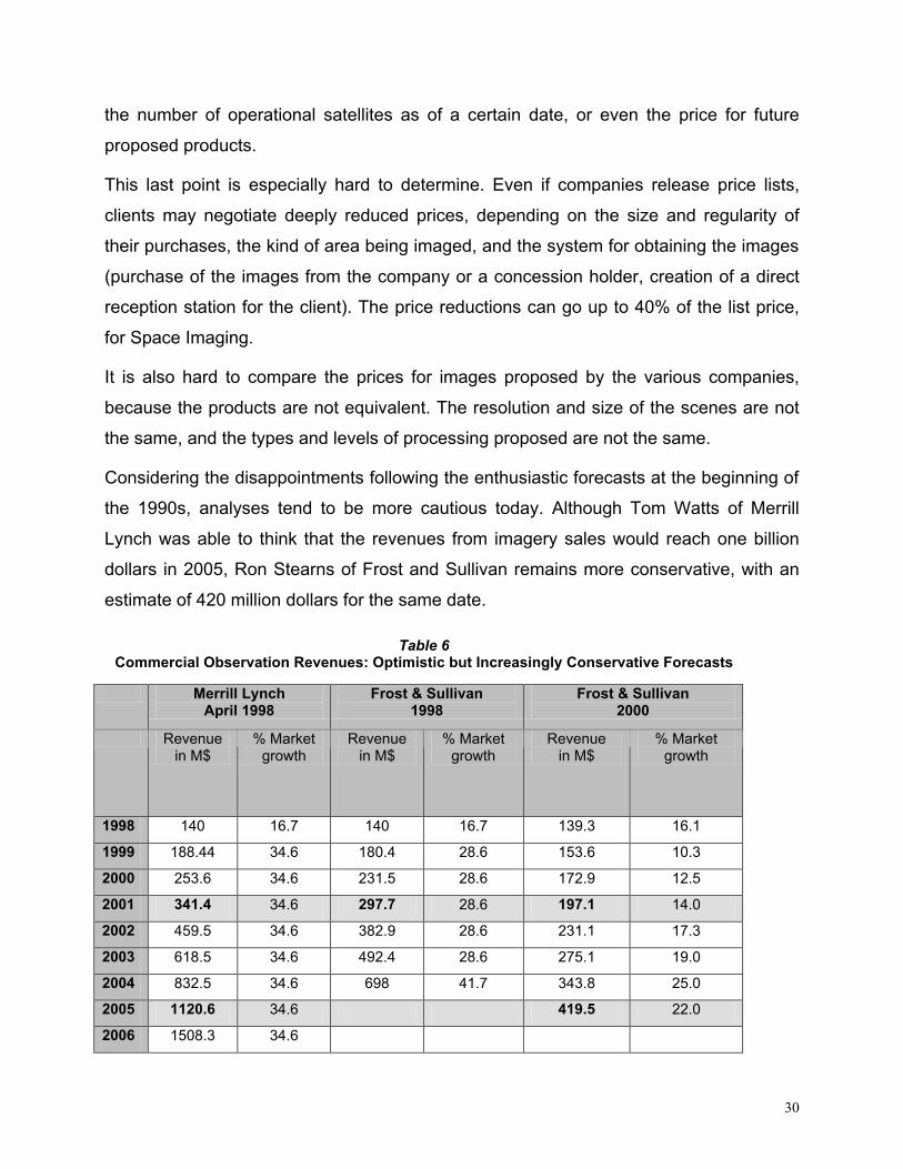
Considering the disappointments following the enthusiastic forecasts at the beginning of
the 1990s, analyses tend to be more cautious today. Although Tom Watts of Merrill
Lynch was able to think that the revenues from imagery sales would reach one billion
dollars in 2005, Ron Stearns of Frost and Sullivan remains more conservative, with an
estimate of 420 million dollars for the same date.
Table 6
Commercial Observation Revenues: Optimistic but Increasingly Conservative Forecasts
Merrill Lynch April 1998
Frost & Sullivan 1998
Frost & Sullivan 2000
Revenue in M$
% Market growth
Revenue in M$
% Market growth
Revenue in M$
% Market growth
1998 140 16.7 140 16.7 139.3 16.1
1999 188.44 34.6 180.4 28.6 153.6 10.3
2000 253.6 34.6 231.5 28.6 172.9 12.5
2001 341.4 34.6 297.7 28.6 197.1 14.0
2002 459.5 34.6 382.9 28.6 231.1 17.3
2003 618.5 34.6 492.4 28.6 275.1 19.0
2004 832.5 34.6 698 41.7 343.8 25.0
2005 1120.6 34.6 419.5 22.0
2006 1508.3 34.6
31
The path to be followed seems clear for companies wishing to develop beyond
government image contracts. They have to create a need for imagery among industrial
clients, the only ones who might buy large quantities of images. To do this, it is
necessary to develop software that is capable of transforming the raw data into
information that is easily used by non-specialists.
This step is not necessarily incompatible with meeting US government security
requirements. It is likely that the areas of interest to future private clients will not be
those being looked at by the military and the intelligence agencies. Federal authorities
may limit access to images in war zones without affecting the commercial activities of
imagery companies.
But as things stand now, it is probable that the imagery companies will continue to exist
thanks to orders from federal agencies, without looking to extend their market reach.
32
3- US Government Options For the Control of Imagery
In the summer of 2001, it was noticed that the US government had set up a fairly
extensive group of mechanisms for the control of imagery dissemination, but that these
mechanisms had not yet faced reality. A truly large test remained to be seen. This
happened with the unexpected violence against the United States.
The administration reacted by adapting the planned control mechanisms to the
circumstances. It also considered imagery control and it is possible that it will reshape
the entire system in the coming months.
The control resources available to the US government should be able to serve the whole
range of American reactions in international relations, from diplomacy to direct
confrontation. Certain resources, such as shutter control, are a legal constraint and can
only be applied to national enterprises. Military resources, such as anti-satellite
weapons, would be aimed at the systems of enemy countries. Beyond these coercive
resources, the cooperation of the federal authorities with domestic companies and a
dialogue with foreign companies are the first recourse, and probably the most effective.
In the first place, these control resources should be able to prevent the photographing of
certain geographic areas or the broadcast of images gathered. But imagery companies
may also broadcast archive images. Although the tactical utility of the images is
generally linked to their timeliness, older images can also provide important information
in some cases. Control resources also need to address this particular risk.
Control of US Imagery
The US government can control the sale of imagery produced by domestic companies in
two ways. It can exercise the law against them, which includes a sales restriction system
for security reasons, and it can develop a less aggressive system of agreements and
cooperation.
33
a- The Strict Operating License Environment
Presidential Decision Directive 23 (PDD-23) dated March 10, 1994, authorizing the
marketing of high resolution imagery, sets the boundaries for US regulatory activity.
The license to manufacture observation satellites is issued by the Commerce
Department, and more specifically by the National Oceanic and Atmospheric
Administration (NOAA). Before issuing a ruling, NOAA hears the opinion of the State
Department’s Bureau of Political-Military Affairs and of the Assistant Secretary of
Defense (Command, Control, Communications, and Intelligence) (ASD/C3I). A MOU
dated February 2000 added the Department of the Interior (in charge of environment
issues) and the Intelligence community to this list. Five federal authorities are thus
involved in the decision-making process.
The maximum resolution authorized for the images is not stated in the text of 1994. The
PDD-23 only says that the systems will offer competitive resolution compared to other
systems existing on the global market. With the licensing for the next Space Imaging
satellite last December, this official limit is changing from one meter to 50 centimeters.
When it receives its license, the company agrees to comply with commercial embargoes
imposed by the United States or the United Nations. The country affected by this action
cannot buy images from the company.
Each license may also include specific restrictions. The license given to OrbImage to
launch the OrbView 4 satellite (the launch of which in September 2001 failed) provided
that its hyperspectral images with a resolution of 8 meters would be reserved for US
government clients. The other clients had to accept images lowered to a resolution of 20
meters. However, the company had negotiated the right to sell byproducts of the initial
products at high resolution.37
The recent license issued to Space Imaging provides an additional security measure, in
the form of a mandatory delivery time of 24 hours, which will apply to all future buyers of
50 cm images. About 22 hours are needed between the time the image is taken by the
Ikonos satellite and the final product delivery to the client. Acceptance, processing,

34
interpretation and sending of the images could be shortened in the future, but for now,
the security time imposed by the administration is not really a hardship.38 At this point,
the company is not planning to award contracts for the direct acceptance of images by
the clients.
Although this has not yet happened, the US observation systems could also be sold on a
turnkey basis to foreign clients. The orders will then be examined on a case by case
basis by the State Department’s Bureau of Political-Military Affairs. All encryption
software must be approved and monitored by the US government.
Other permanent or contingency conditions also apply.
A Specific Policy Towards Israel
Because of the US commitments to the security of Israel, it was possible for the leaders
of Israel to get a special sales restriction from the United States on images of their
territory.
The amendment to the National Defense Authorization Act dated 1997, known as the
Kyl-Bingaman amendment, prohibits US companies from gathering or selling images of
Israeli territory if they are more detailed or precise than the space imagery generally
available from foreign commercial sources.39
In the summer of 1998, the government determined that the images of Israel available at
that time from non-American sources had a maximum resolution of two meters.
American companies then received an order from the Commerce Department not to sell
images of Israel with a resolution under two meters.
The statutory instrument of 1994 appears to authorize US companies only to follow the
developments of the global market, awarding licenses for resolutions “already available
commercially or with availability projected on the international market.” But the
Department of Commerce has already awarded two licenses projecting more precise
resolutions than those already in existence.
35
In 1994, Sovinformsputnik was offering images with a resolution of two meters and this
was the basis for the US administration’s decision. Shortly afterwards, Space Imaging
obtained a license to build a satellite with a resolution of one meter.
The Russian company responded and, since June 2000, has offered a similar resolution
on its web site. The US Commerce Department has now awarded a license for 50 cm. It
is likely that foreign companies will follow up on this new development if they can.
The United States itself thus seems to be initiating the evolution of imagery supply
towards increasingly fine resolutions. This causes foreign companies to adapt their
products and directly threatens the balance projected by the Kyl-Bingaman amendment.
The government and Congress should undoubtedly review the system of restricting
sales of images from Israeli territory soon. They will need to choose between
harmonizing US law with the resolutions available in the rest of the world, and the desire
not to affect Israel’s security adversely.
Shutter Control
During the ground phase of Operation Desert Storm in 1991, the coalition led by General
Schwarzkopf operated the “Left Hook” to surprise the Iraqi army. This important action
precipitated the defeat of Saddam Hussein’s forces. It would never have been so
successful if commercial satellite images had disclosed Allied troop movements in
advance.
The presidential directive of 1994 took this kind of risk into consideration. It gives the
Commerce Secretary the power to limit the operations of a commercial satellite, “either
when the Defense Secretary believes the national security is at risk, or when the
Secretary of State believes that international and/or foreign policy obligations could be
compromised.”40
This is what is called shutter control. The satellite operator must limit the shots over the
territory in question or limit distribution of the images. What is more, communications
between the satellite and its receiving stations must be accessible to the government.
This procedure has never been invoked.41
36
Shutter control, as it has been known since 1994, has been the subject of criticism. By
seeking to prevent hostile players from gaining access to the imagery, it also prevents
the media from gaining access to this information. This undoubtedly serves a secondary
purpose of the government, which does not want politically embarrassing images to be
published. But the press depends on obtaining the images.
There are known, specific limits in American law to the freedom of expression of the
press in times of crisis. According to the jurisprudence concerning the first amendment
to the Constitution of 1788, a “clear and present danger” or “a serious and imminent
threat to national security” must be proven for the government to be able to prevent the
freedom of information. In some cases, the government can be taken to court; the courts
then will decide on the reality of these risks.42
The restrictions contained in PDD-23, as they are set forth, are much more vague. The
directive contains the following phrasing: “When foreign policies may be compromised,”
which seems quite broad and does not necessarily correspond to a real danger to the
country’s security. It could lead to abuses that are incompatible with the spirit of the first
amendment.
Some journalists have publicly expressed their intention to take the government to court
upon first application of shutter control, in order to have it reworded.43
Under these conditions, and facing a serious international crisis in the fall of 2001, the
government preferred to find an alternative solution to shutter control.
b- The October 2001 Agreement
On October 7, 2001, the National Imagery and Mapping Agency (NIMA, the intelligence
agency providing imagery and analysis to the US military and politicians) entered into an
unexpected and innovative agreement with the US company Space Imaging.44 Under
this agreement, the Thornton (Colorado) company agrees to sell its images of
Afghanistan only to the Pentagon. This exclusive agreement will cost the Department of
Defense 1.9 million dollars a month. The images will be billed at 20 dollars per square
37
meter, and each order will cover at least 10,000 km2. The agreement is renewed
monthly.
In the fall of 2001, Space Imaging was the only company that could offer images with a
resolution of one meter on the commercial market. When the satellite QuickBird 2 is
operational, around February 2002, if circumstances warrant, a similar contract may be
entered into with DigitalGlobe, the company operating it.
This agreement serves multiple purposes. First, there is no need to run the risk that a
hostile player can obtain sensitive images of the war zone, however improbable the sale
of images of Afghanistan to private parties seems now.
Above all, the agreement aims to prevent newspapers and television from obtaining the
images. During normal times, Space Imaging does not hesitate to fill orders from
newspapers and network television. The company was about to enter into a major
contract to supply images to CNN at the time of the NIMA proposals.45 If the media
published images of destroyed villages or of lines of refugees, this would place the US
government in a very delicate position regarding Arab, and even western, public opinion.
The lesson from publication of the Groszny images in the New York Times, and from the
Congressional inquiries they triggered, has not been forgotten.
Officially, the buy out contract should also serve more concrete purposes. The images
will be used first by analysts and cartographers from NIMA. They may also allow the US
military to show unclassified images to prepare for joint operations with allied soldiers.
During the Gulf War, in 1990-1991, US images, all classified, could not be shown during
military briefings, which caused problems in the Coalition.
Finally, the agreement provides massive financial aid to the company. When PDD-23
was adopted in 1994, helping US companies become significant in the commercial
market was a strategic objective. In the Commercial Imagery Initiative of 1996, the
National Reconnaissance Office (NRO, which builds military space observation systems)
and NIMA agreed to pay 40 million dollars a year for satellite images from the private
sector from 2001 to 2003, then to double this amount starting in 2004.46 In fact, this level
of expenditure was never reached: NRO was hostile to a measure that could diminish
38
the utility of its own observation systems. The NIMA analysts for their part needed time
to get used to using commercial images.
US imagery companies, which have not learned how to develop a sufficient private
clientele, are finding their livelihood in contracts received from federal authorities. The
question was asked at the beginning of the George W. Bush administration whether
companies should continue to receive aid in the form of orders for imagery.
Circumstances provided an affirmative reply.
The connection between imagery companies and intelligence agencies is underscored
by the new agreement.
But this connection between imagery companies and the intelligence community already
existed during normal times. If the agreement of October 2001 shows the great creativity
of the US secret services, this is expressed within a more global context of dialogue
among the players involved.
Long-Term Dialogue
The commercial imagery companies are private companies and loudly proclaim their
complete independence from federal authorities. But this independence seems at least
partially fictitious. In normal times, there is a certain dialogue between the federal
authorities and commercial companies to prevent the companies from selling sensitive
imagery to parties fronting for a terrorist organization or a state with aggressive intent.
Space Imaging, the US company operating the Ikonos satellite, displays on its web site
a list of all of the images ordered from it, without specifying the client. It is thus possible,
for an outside observer, to follow the imagery orders and make assumptions regarding
the party ordering the imagery. The US intelligence services can monitor orders to the
company from its web site.
If the services deem it necessary, they could ask the company’s management to give
them information on the client who ordered an image. The creation of Space Imaging
was conceived by, among others, leaders of the US intelligence community in the
1980s.47 Jeffrey Harris, former director of NRO from1994 to 1996, was then president of
39
Space Imaging until 1999. The CEOs of several US imagery companies hold regular
meetings with the NIMA and NRO directors. Even if, since 1999, the company’s ranks
have been filled more and more by people from the areas of marketing and sales, it has
retained a definite sensitivity to security risks. The questions asked by former colleagues
undoubtedly are answered by the founders of Space Imaging.
From this information, US agencies can conduct investigations into dubious clients and
find out who may be hiding behind their identity. If a player considered as truly
dangerous (that is, a state or organization hostile to the United States) is suspected of
being the ultimate client for the image, it is imaginable that the company would be
alerted and, under some pretext, the order would not be filled.
Perhaps there is a natural reaction among the company’s teams to call the intelligence
services immediately to ask them to verify who a client really is. This habit could exist
outside of any rigid, regulated procedure.
The existence of informal work agreements between a private company of this kind and
the US intelligence services is not public and would be hard to prove. The award of a
license to build an observation satellite with a resolution of 50 cm proves in any event
that good relations exist between the Denver company and the federal authorities.
These good relations have just been reinforced by the new administration.
Control of Foreign Imagery
The US government does not have the legal authority to interrupt sales of imagery by
foreign companies. It is working on developing control methods outside of the use of
force, but is also working on developing military resources.
40
a- Non-Military Resources
The End of Technological Dependency
In the 1990s, the control of foreign satellite systems could rest on the fact that these
systems most often used components manufactured in the United States. Because of
the insufficiency of the industrial base (in Europe, for example) or supply problems (in
the former USSR), no company could build an entire system at that time without using
US components.48
This situation gave the United States extensive maneuvering room. The impossibility of
importing a major part from the United States could prevent a foreign company from
completing construction of a satellite. But the tightening of control on US exports since
1998 led foreign aeronautic and space companies to find alternative sources of supplies.
Control through technological exports is now greatly reduced and the government can
no longer take it into consideration.49
Diplomatic Channels
First, the United States can put diplomatic pressure on friendly governments to impose
the equivalent of shutter control on their companies in the event of serious international
crisis. These allied governments should agree easily if their political objectives agree
with those of the United States. During the Gulf War, then during the events in Kosovo,
Spot Image did not sell images of the Kuwait region to clients other than the French and
US militaries.
The United States also wants to ensure the attitude of its allies in a preventive way, by
exporting its model of shutter control. The US pressured Canada so that Ottawa would
adopt a legislative provision covering the possibility of interrupting Radarsat imagery
sales in times of crisis.50
But if a party hostile to the interests of the United States were to deploy a commercial
system, it would undoubtedly refuse to bow to US diplomatic pressure. The United
States could then be inclined to use direct military resources.
41
The most complicated situation would be that in which the satellite system broadcasting
images posing a risk to the United States security was operated by an international
consortium. Steve Cambone51 proposes the example of a consortium of Israel, Australia
and the USA.52 The United States could not use force to impose its point of view on
these friendly countries. They could adopt very complex attitudes in the event of crisis.
They could also join together to oppose United States choices or they might not be in
agreement with each other. The United States would then be forced to engage in a very
delicate diplomatic struggle.
International Rules of Law
International law provides a certain legal framework for the activity of imagery
companies. At the instigation of the United States, The United Nations General
Assembly recognized the evolution of space observation towards a commercial function
and adopted a significant text in 1987.
The current principle of international law provides that any country observed by a
commercial system must have access to the images taken of its territory on a non-
discriminatory basis, for the standard price and within a reasonable period of time.53
Where remote observation is authorized by the 1967 Outer Space Treaty, the states
observed must be able to learn what images are taken of their territory.
But the commercial interest of the companies involved includes respecting their clients,
and the interpretation of the 1987 policy has remained fairly restrictive. If a government
expressly requests it, a commercial observation company must disclose what portions of
its territory was photographed and offer to sell the government these images at the
normal rate. But the company is not required to disclose the names of the original
buyers ordering the images.
Also, the companies themselves do not have to warn foreign countries about images
taken of their territory. Many countries are not sufficiently familiar with this method of
intelligence to contact the imagery company themselves.
42
No doubt it would be impossible at this point to require companies to warn the countries
where satellite images have been ordered. The companies would not want to disclose
the identity of their client, and it would be easy for them to remember that many
countries do not yet have an administration that is clearly in charge of these matters for
them to contact.
Space Imaging displays on its web site a list of the geographic coordinates of images
taken by its Ikonos satellite and even displays a small downgraded version of the
image.54 So it can be seen, on this company’s web site, that many images of South
China have been ordered in recent years, including all of the civilian and military
airports, the port facilities and military installations in general (these images were used
by the Federation of American Scientists for its study of May 2000, but this group is not
behind the initial order). It can be assumed that these images were bought by Taiwan,
which wanted to keep up to date on Chinese military activities in the area. The Chinese
authorities, if they visit this web site, can reach the same conclusions. The spirit of the
policy of 1987 is being respected in this case.
The US company is in line with international law by making all the information accessible
on its web site, without having to warn the leaders of the states involved.
From the point of view of the United States, it would be useful for this practice to expand
gradually throughout the world. It would allow the US to follow foreign companies’
activities easily. The evolution of the practice of companies in this domain is not
complete.
Promote Market Domination by American Companies
From the provision of financial aid to US imagery companies, an indirect but effective
impact is expected on the dissemination of foreign imagery.
Great discussion preceded the adoption of PDD-23 in 1994, and of the Commercial
Imagery Initiative in 1996. The Clinton administration finally decided that US companies
had to have a presence in the new commercial imagery market, which already included
43
foreign companies. What is more, it was necessary to ensure US domination of this
market in order to be able to control the flow of trade.
In fact, if the market could be dominated by American companies, they would have the
resources to develop a more competitive supply in terms of quality and speed of
processing the information. An intense effort to develop the processing software could
follow and the US companies would be in a position to develop and to impose on the
rest of the world standard computer processing modes. They could then have a captive
international clientele.
International competition would not necessarily disappear, but its market share would be
reduced and the quality of their products would be surpassed by the US product. In the
event of crisis, an interruption of activity by US companies would dry up the market.
Foreign supply would not necessarily be able to meet the demand on it.
Despite their diversity, none of these peaceful means comes with an absolute guarantee
for the US government. Development of military resources seems appropriate today.
b- Anti-Satellite Weapons Programs: Different Levels of Aggression
If the national security is at risk, the United States could finally end up using force to
prevent dissemination of foreign imagery. The military resources first seek to interrupt
the gathering of imagery by the space systems, but they could also prevent transmission
of archive images.
The Department of Defense laboratories began research and development programs for
anti-satellite weapons (ASAT) by the end of the 1950s, but without ever reaching
deployment. The Eisenhower administration and subsequent administrations did not
want to risk expanding into space the arms race with the Soviet Union.55 Later, Congress
was quite reticent when the Reagan administration wanted to conduct tests of the
technologies developed.56
These programs were first aimed at the capabilities of the Soviet Union. Within the
current strategic context, they would be deployed against all of the new enemies of the
United States.
44
Both imagined actions technologies already developed and their deployment site
(ground, orbit, etc.), all of the parameters remain quite diverse in a domain of the art of
war that still remains to be invented. A typology of the various types of offensive actions
considered by the Defense Department was made public.57
1) Disruption is a temporary dysfunction of the satellite system, such as, for example,
the electronic jamming of communications (command and transfer of data) between
the satellite and the ground station;
2) Denial is a temporary breakdown in the system, for example disabling the sensor;
3) Degradation consists of inflicting a permanent dysfunction on the system, such as,
for example, the destruction of ground stations, which is very easy to accomplish with
conventional resources;
4) Finally, destruction is the permanent breakdown, that is, the destruction of the
satellite in orbit.
This typology classifies the possible actions in increasing order of the level of violence. If
action is necessary, the Department of Defense should choose on the basis of political
considerations. The degradation or destruction of systems would be a very aggressive
signal, unthinkable outside of declared hostilities, and would create a serious precedent
for military action in space. Using them would be significantly weighted with political
meaning.
On the other hand, the disruption or interruption of systems is easier. Such actions can
serve specific tactical interests in the course of a conflict and would not necessarily have
political significance. In fact, they could be considered as accidental by the satellite
operators: It frequently happens that a satellite experiences technical difficulties where it
is impossible to determine the exact causes from Earth. These two forms of action, the
use of which is more credible than the overly aggressive options, are being actively
explored by Pentagon laboratories.
The various laboratories of the US military are pursuing R&D programs for anti-satellite
weapons covering diverse, very innovative technologies. Chemical and kinetic
interceptors and low-energy lasers are considered by the US Department of Defense to
45
be the easiest. Nuclear arms and radio frequency weapons are more complex and high-
energy and particle ray lasers are the hardest to develop. The Air Force is working on an
orbit laser system (SBL, or Space Based Laser) and, more recently, on a system to jam
ground-based satellites (Space Control Technology); the Army is developing a ground-
based satellite interceptor (KEAsat, or Kinetic Energy Asat); and a ground-based laser,
named Miracl for Mid-Infrared Advanced Chemical Laser, was tested in 1997.58
It can be assumed that these programs will be reinforced in the future. On May 8, 2001,
the Secretary of Defense Donald Rumsfeld announced his intentions regarding military
space policy. Along the lines of the conclusions from the report he oversaw, in the fall of
2000, he emphasized the “inevitable expansion to space of acts of war”59 and the need
for the United States to prepare for it.
Some experts see in these projects the seed of an arms race in space, which it has
been possible to be avoid so far.60 They stress that although protection of US space
stations should now be reinforced, the creation of aggressive systems is more
debatable, since currently there are no adverse systems. The launch of these programs
by the United States could trigger similar programs abroad, which would be completely
contrary to American security interests.
Despite the criticisms this attitude has already received, the Department of Defense
should see its defensive and offensive space programs considerably strengthened. But
taking into account the war operations undertaken in the fall of 2001 and the priority
given to the anti-missile defense system, it will doubtless be necessary to wait for the
2004 budget to see the effect of these developments.
46
Conclusion
A Developing Control Architecture
The risks run by the United States because of dissemination of space imagery will be
doubled. There is the threat of use by hostile players for military purposes and the use
by the media, which could be politically destabilizing.
The credibility of a military threat is poorly covered, because the countries or
organizations likely to make dangerous use of satellite imagery rarely have access to
this technology. Most operators up to now are aware of the security motivations of
western countries. It could be said that they avoided selling imagery to clients hostile to
the US interests in times of international crisis.
The peaceful use by the media and NGOs is a development that is further under way. It
asks the question of the effects of increasing circulation of information on management
of international and domestic events by US authorities.
The severity of the attacks on American soil in September 2001 is causing leaders to re-
tighten controls on any components likely to be detrimental to national interests. To do
this, the government decided not to use shutter control, addressed by a directive from
1994, but to enter into a buy out agreement with the only company that can currently
bring to market precise images of Afghanistan.
Shutter control threatened to be attacked by the media for not respecting the principle of
freedom of the press, contained in the first amendment to the US Constitution. A buy out
is a less aggressive measure: Instead of prohibiting the production of imagery, the
government buys all of it. The company in question is satisfied with the financial
transaction; and the media cannot really denounce the action.
But this new agreement has its limits. First, the media will attack it as much as possible,
even if the legal basis for the action is limited now.

47
Second, this new agreement will underscore the connection between the US intelligence
community and the private imagery companies. The financial contribution to the
company will not motivate it to develop its private clientele, but will increasingly maintain
it in a semi-public status. It can also be asked whether the US government will have the
resources to finance such agreements with the other two US companies that are joining
the high resolution market. The QuickBird 2 satellite from DigitalGlobe will be operational
in February 2002 and NIMA has already announced its intention to enter into a buy out
agreement with this company if the international situation warrants it. OrbImage could
launch OrbView 3 in 2002.
But the main flaw of the buy out system is in the fact that foreign companies will not
necessarily accept it. An agreement could probably be reached with companies in an
allied country, such as Spot Image in France. But there are greater uncertainties
concerning the position of Indian or Chinese space agencies, which have high resolution
systems deployed or projected.
It is to ward off this kind of risk that the anti-satellite arms systems are proposed. The
principle of reinforcing military resources in space aimed at the foreign systems,
however controversial, seems to have been adopted by the new Administration. Efforts
in this area could focus on the development of tactical disruption or interruption
resources, representing the least aggressive anti-satellite weapons category
In the spring of 2001, a policy group began to work for the NSC on the means of
controlling satellite imagery. The events of September 2001 underscore the importance
of this work. The coming months should lead to adjustments in the US control system.
48
Notes
1 See the Manuel Castells trilogy on the Information Age: The Rise of the Network Society (1996), The Power of Identity (1997) and End of Millenium (1999), Oxford, Blackwell. 2 David Brin, The Transparent Society: Will Technology Force Us to Choose Between Privacy and Freedom?, Cambridge, Perseus, 1999. 3 Michel Foucault, Discipline and Punishment: The Birth of Prison [Surveiller et Punir, naissance de la prison], Paris, Gallimard, 1975. 4 Bernard Finel and Kristin Lord (eds), Power and Conflict in the Age of Transparency, New York, St Martin Press, 2000. 5 See, for example, Yahya Dehqanzada and Ann Florini, Secrets for Sale, How Commercial Imagery Will Change the World, Carnegie Endowment for International Peace, 2000; and John Baker, Kevin O’Connel and Ray Williamson (eds), Commercial Observation Satellites, at the Leading Edge of Global Transparency, Rand and ASPRS, May 2001. 6 New York Times, March 26, 2000, p. 1. 7 John Pike, Federation of American Scientists, interview July 22, 1997. 8 Johnny Skorve and Tomas Ries, Investigating Kola, a Study of Military Bases Using Satellite Photography, Norwegian Institute of International Affairs, Brassey’s, 1987; Johnny Skorve, The Kola Satellite Images Atlas, Perspectives on Arms Control and Environmental Protection, Norwegian Atlantic Committee, 1991. 9 Other authors having worked on these questions are Bhupendra Jasani and Peter Zimmerman. 10 Vipin Gupta and Frank Pabian, “Investigating the Allegations of Indian Nuclear Test Preparations in the Rajasthan Desert, a Comprehensive Test-Ban Verification Exercise Using Commercial Satellite Imagery,” Science & Global Security, vol.6, no. 2, July 1996. 11 Adams Bernstein and Vipin Gupta, Keeping an Eye on the Islands, Remote Monitoring in the South China Sea, Sandia National Laboratory, May 1999. 12 This term, abandoned by the former Secretary of State, Madeleine Albright, is being used again by the Bush administration. 13 The State Department is examining applications for export to the following countries: Afghanistan, Angola (UNITA), Armenia, Azerbaijan, Belarus, Burma (Myanmar), China, Cuba, Haiti, Indonesia, India, Iran, Iraq, Lieberia, Libya, North Korea, Pakistan, Rwanda, Serbia-Montenegro, Somalia, Sudan, Syria, Tadjikistan, Ukraine, Vietnam, Zaire. 14 Reuters, March 14, 2001. 15 Peter Zimmerman, “From the Spot Files, Evidence of Spying,” Bulletin of the Atomic Scientist, vol. 45, no. 7, September 1989, p. 24. 16 Peter Zimmerman, “The Use of Civil Remote-Sensing Satellites During and After the 1990-1991 Gulf War,” Verification Report, VERTIC, 1992, p. 239. 17 New York Times, March 26, 2000, p. 1. 18 US Senate, Subcommittee on Appropriations, Foreign Operations, Export Financing and Related Programs Appropriations for Fiscal Year 2001, April 4, 2000. 19 <www.fas.org/eye/project.htm>. 20 Alexander Colhoun, “Top-Secret Kodak Moment in Space Shakes Global Security,” Christian Science Monitor, March 21, 2000, p.2. 21 Neil King Jr, “Activists Use Satellite to Challenge View that China’s Air Force Menaces Taiwan,” The Wall Street Journal, May 12, 2000, A20. 22 Cameron Barr, “Israel’s Worst-Kept Secret, on Web,” The Christian Science Monitor, August 24, 2000, pp. 1 and 7. 23 During the Gulf War, it was rare for Western press not to support their government. The few images that could be used at the time illustrated information according to that provided by the Coalition staff. The same attitude was seen xuring the Kosovo crisis in March 1999. 24 Ray Williamson, Space Policy Institute, interviews, November 2000. 25 “Correction,” Newsweek, August 31, 1998. 26 Ray Williamson, Space Policy Institute, op.cit. 27 “Russian Agency Sells Close-Up Images from Far Away,” New York Times, June 20, 2000. 28 The company ImageSat International was called West Indian Space Ltd. until recently.
49
29 Vernon Loeb, “US is Relaxing Rules on Sale of Satellite Photos,” Washington Post, December 16, 2000, p.A3. 30 The experts from the consulting firm KPGM, quoted by Defense Daily on February 10, 1994, estimate that the market should reach 15 billion dollars in annual sales by the end of the 1990s. More conservatively, an estimate from Orbital Science on the same date indicated 5 billion in sales annuality by the end of the 1990s. But in any event, this firm projected having reached the profitability threshold before the end of the 1990s. Finally, for the Department of Commerce, sales in this market, estimated at 400 million dollars for 1994, should reach 2 billion dollars in 2000. 31 Ron Stearns, aerospace and defense analyst with Frost & Sullivan, interview, February 14, 2001. 32 Ron Stearns, op. cit. 33 Commercial Aerial Imaging Data Market, Revenue Forecast, World, Report 5807, Frost and Sullivan, 2001. 34 Ron Stearns, aerospace and defense analyst with Frost & Sullivan, op. cit. 35 Joe Dodd, Orbimage, interview, August 24, 2001. 36 This leads to the assumption that these foreign clients must themselves be intelligence agencies (probably from allied countries), because who else would have the capacity to interpret imagery today? 37 Joe Dodd, Orbimage, op. cit. 38 Mark Brender, Space Imaging, interview, December 18, 2001. 39 “(…) Routinely available from foreign commercial sources”, “Prohibition on Collection and Release of Detailed Satellite Imagery Relating to Israel,” National Defense Authorization Act for Fiscal Year 1997, P.L. 104-201, Sec. 1064 (a), Washington, DC, 1996. 40 Application to Operate a Commercial Land Observation System, section B, part 1, US Department of Commerce, National Oceanic and Atmospheric Administration, Washington, DC, March 10, 1994. 41 Timothy Stryker, NOAA/NESDIS, interview August 29, 2001. 42 Mark Brender, “Age of Transparency,” Communicator, September 1995, pp. 164-65. 43 Dan Dubno, CBS News Producer and Technologist, Online News Hour, August 2, 1999. 44 Michael Gordon, “Pentagon Corners Output of Special Afghan Images,” New York Times, October 19, 2001, p.B2. 45 Ibid. 46 The years indicated are the fiscal years, from October to the end of September. Defense Daily, September 8, 2000. 47 Ann Florini, Carnegie Endowment for International Peace, interview February 14, 2001. 48 Marcia Smith, Space Launch Vehicles: Government Activities, Commercial Competition, and Satellite Exports, CRS Issue Brief IB93062, updated version, July 3, 2001. 49 John Hamre, President of CSIS, August 21, 2001. 50 Brian Berger and David Pugliese, “Canada Plans to Control Radarsat-2 Data Access,” Space News, June 21, 1999, p.1. 51 Steve Cambone was Secretary of the the Commission on the Management and Organization of US Space Agencies (January 2001). He is now Undersecretary of Defense for Policy. Interview November 20, 2000. 52 ImageSat International already grouped together Israeli companies and an American company. It launched the satellite Eros 1A. 53 “Principles Relating to Remote Sensing of the Earth from Space,” United Nations General Assembly A/RES/41/65, January 22, 1987. 54 Mark Brender, “Age of Transparency,” op.cit. 55 Statement of Preliminary Policy on Outer Space, NSC report 5814/1, August 18, 1958. 56 Laurence Nardon, “American Anti-Satellite Programs,” Le Débat Stratégique, no. 23, November 1995. 57 Tom Wilson, “Threats to United States Space Capabilities,” Report of the Commission to Assess United States National Security Space Management and Organization, Appendices: Staff Background Papers. 58 Marcia Smith, U.S. Space Programs: Civilian, Military and Commercial, CRS Issue Brief IB92011, May 2, 2001. 59 Report of the Commission to Assess United States National Security Space Management and Organization, pursuant to Public Law 106-65, January 11, 2001. 60 John Logsdon, “Just Say Wait to Space Power,” Issues in Sciences and Technologies, Spring 2001.
Centre Français sur les États-Unis (CFE)
Ifri - 27, rue de la Procession75740 Paris Cedex 15
Tél : 33 (0)1 40 61 60 33Fax : 33 (0)1 40 61 60 60
www.cfe-ifri.org Email : [email protected]
What happens when an information technology moves from being used exclusively by government intelligence agencies to being made widely available? Satellite imagery is now being marketed by companies with space observationsystems. What consequences should be feared in particular? The United States, because of the important role its companies play in developing this market, and because of their great involvement in internationalaffairs, is facing a dilemma: it wants to control this source of information forsecurity reasons, while allowing its companies to become dominant in the newmarket. How much leeway should it give the image suppliers? What financialsupport should it provide to the companies?Very diverse mechanisms for control of satellite imagery have been consideredto address the possibility of destabilizing or aggressive use of the imagery. At thebeginning of October 2001, the government replaced them on short noticewith a very innovative measure. By buying on an exclusive basis all of the satellite photos of Afghanistan taken by the only company that currently produces high-resolution commercial imagery, the Pentagon is preventingother parties from gaining access to this source of information, while providingconsiderable financial support to the company. An agreement similar to a buyout will be proposed, and undoubtedly accepted,by US companies entering this market in the future. This kind of action confirms the importance of the connection between the US commercialimagery companies and the federal authorities. It does not settle the question offoreign imagery companies, which will definitely not accept the exclusivitycontracts proposed by the US Department of Defense. This CFE’s policy report addresses the U.S. government’s response to the current issues in commercial space imagery.
Laurence Nardon is a Research Associate at CFE/Ifri in Paris. She currentlyserves as a Visiting Fellow at the Center for Strategic and International Studies(CSIS) in Washington, D.C., where she examines U.S. space policy issues.Her Ph.D. dissertation (Université Paris I, 1999) addressed “SpaceObservation as a Tool of Power in International Relations.”The French Center on United States (Centre français sur les Etats-Unis, CFE),created in September 1, 1999, at the French Institute for International Relations(Institut français des relations internationales, Ifri), jointly with the Center on theUnited States and France (CUSF) at the Brookings Institution in WashingtonD.C., has as its goal the amelioration of the mutual understanding of the publicpolicies of France and the United States. This is to allow their respective leaders tobetter understand the functioning of the system in the other country, throughresearch on concrete subjects concerning their current relationship. A think tank serves as the best mode through which to accomplish this work: it isindependent in its research and conclusions, but is in permanent and direct touchwith the preoccupations of the political and economic leaderships.
Prix : 10 € (65,60 FF)ISBN : 2-86592-109-3

![Satellite Imagery Product Specificationslps16.esa.int/posterfiles/paper1213/[RD16]_RE_Product... · 2016-04-22 · Satellite Imagery Product Specifications 6 2 RAPIDEYE SATELLITE](https://img.pdfslide.us/doc/110x75/5eba16697328255ddd5746a8/satellite-imagery-product-rd16reproduct-2016-04-22-satellite-imagery-product.jpg)