Embed Size (px)
Citation preview
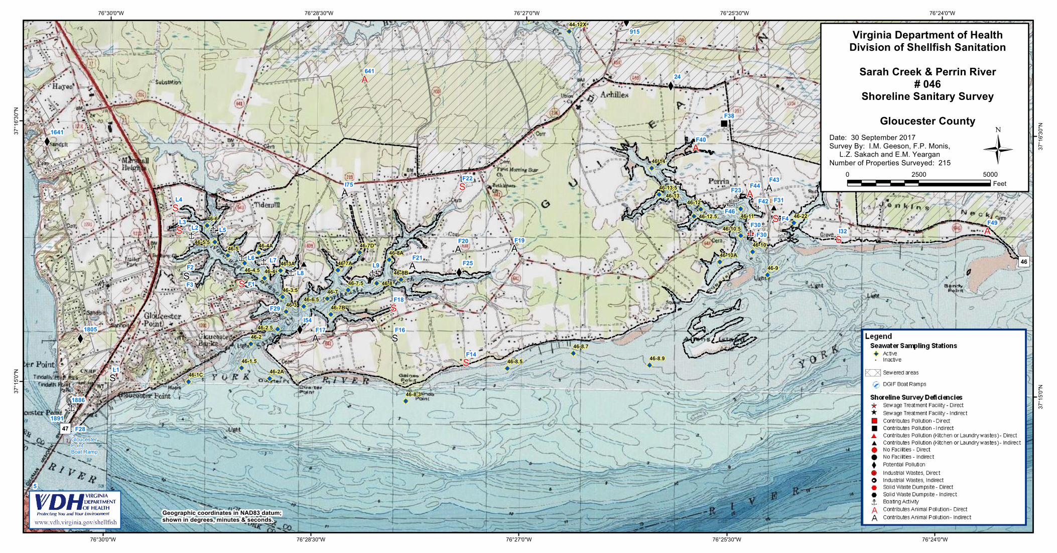
SARAH CREEK AND PERRIN RIVER Growing Area # 046 Gloucester County
Shoreline Sanitary Survey Date: 30 September 2017 Survey Period: March 1 – July 24, 2017 Total Number of Properties Surveyed: 215 Surveyed By: I.M. Geeson, L.Z. Sakach, F.P. Monis, E.M. Yeargan
SECTION A: GENERAL This survey area extends from Reference Point 46, the southernmost point of Jenkins Neck on the York River to Reference Point 47 at the northern end of the George F. Coleman Memorial Bridge at Gloucester Point, including the York River shoreline between these two points, Perrin River, Sarah Creek and their tributaries. The topography of the area varies in elevations from 5’ or less along the shoreline to a maximum of 25’ near the western edge of the survey boundary. Gloucester Point, Bena, and most of the shoreline are divided into suburban parcels. Achilles and the surrounding area are semirural with some marsh and forested land. The economy is based on local service businesses, the seafood industry, surrounding military installations and the Virginia Institute of Marine Science (VIMS). Both Sarah Creek and Perrin River have large marinas that serve recreational and small commercial vessels. Several neighborhoods in the survey area are connected to municipal drinking water. Portions of the survey area are served by Hampton Roads Sanitation District (HRSD). These areas include commercial shopping centers and service businesses located along Route 17, the VIMS campus and surrounding properties. Meteorological data indicated that the area received a total rainfall of 16.98” for the survey period. A monthly breakdown is as follows: March 2017 4.08” April 3.31” May 5.05” June 3.42” July 1-24 1.12“ At the beginning of the survey, inspectors reviewed the available literature from prior reports, public works and online resources to characterize land use, drainage patterns, and establish nearshore seawater stations. Properties identified in the previous survey as having sanitary deficiencies or other environmental significance were revisited to evaluate their current status. All roadways and navigable shoreline within the survey boundary were visually inspected to identify potential pollution sources requiring further investigation. Nearshore seawater stations were established to survey the full extent of waters beyond routine classification stations. Stations were created in closer proximity to the shoreline and farther
Shoreline Survey # 046 Page 2
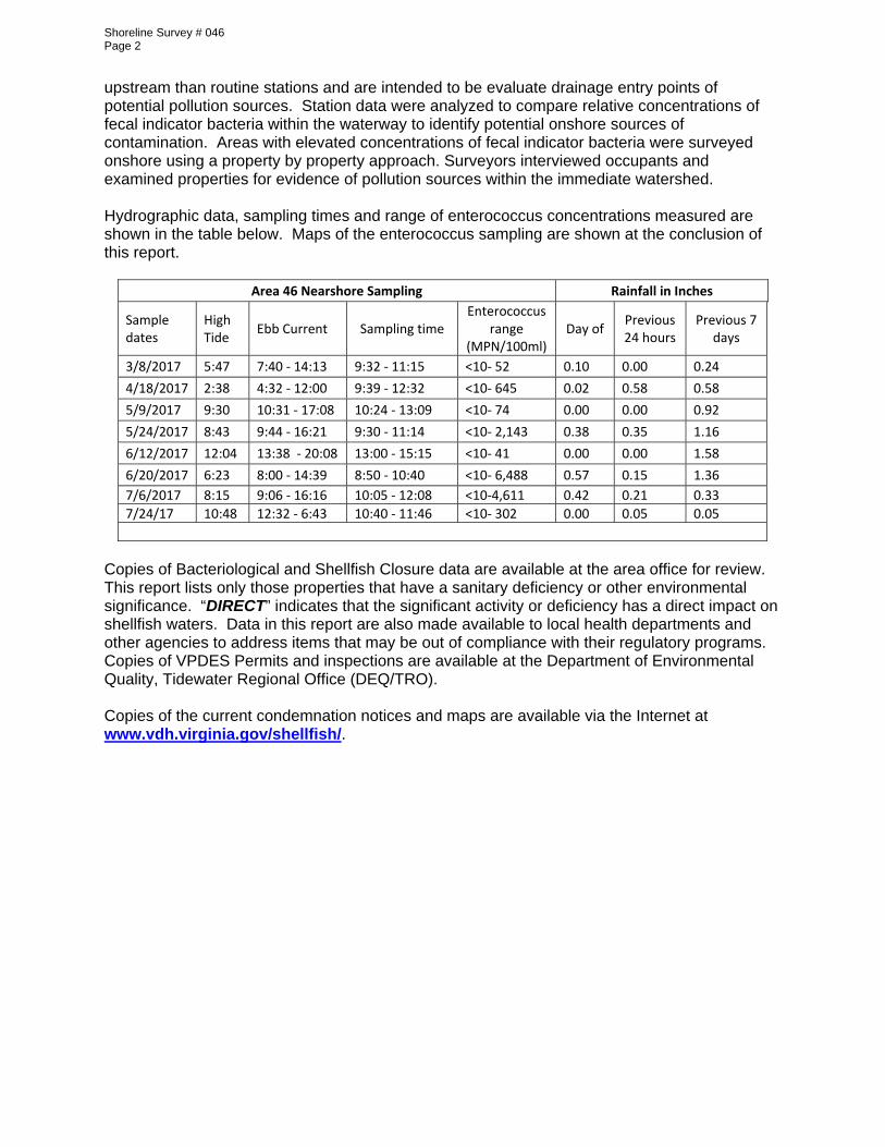
upstream than routine stations and are intended to be evaluate drainage entry points of potential pollution sources. Station data were analyzed to compare relative concentrations of fecal indicator bacteria within the waterway to identify potential onshore sources of contamination. Areas with elevated concentrations of fecal indicator bacteria were surveyed onshore using a property by property approach. Surveyors interviewed occupants and examined properties for evidence of pollution sources within the immediate watershed. Hydrographic data, sampling times and range of enterococcus concentrations measured are shown in the table below. Maps of the enterococcus sampling are shown at the conclusion of this report.
Area 46 Nearshore Sampling Rainfall in Inches
Sample dates
High Tide
Ebb Current Sampling time Enterococcus
range (MPN/100ml)
Day of Previous 24 hours
Previous 7 days
3/8/2017 5:47 7:40 ‐ 14:13 9:32 ‐ 11:15 <10‐ 52 0.10 0.00 0.24
4/18/2017 2:38 4:32 ‐ 12:00 9:39 ‐ 12:32 <10‐ 645 0.02 0.58 0.58
5/9/2017 9:30 10:31 ‐ 17:08 10:24 ‐ 13:09 <10‐ 74 0.00 0.00 0.92
5/24/2017 8:43 9:44 ‐ 16:21 9:30 ‐ 11:14 <10‐ 2,143 0.38 0.35 1.16
6/12/2017 12:04 13:38 ‐ 20:08 13:00 ‐ 15:15 <10‐ 41 0.00 0.00 1.58
6/20/2017 6:23 8:00 ‐ 14:39 8:50 ‐ 10:40 <10‐ 6,488 0.57 0.15 1.36
7/6/2017 8:15 9:06 ‐ 16:16 10:05 ‐ 12:08 <10‐4,611 0.42 0.21 0.33
7/24/17 10:48 12:32 ‐ 6:43 10:40 ‐ 11:46 <10‐ 302 0.00 0.05 0.05
Copies of Bacteriological and Shellfish Closure data are available at the area office for review. This report lists only those properties that have a sanitary deficiency or other environmental significance. “DIRECT” indicates that the significant activity or deficiency has a direct impact on shellfish waters. Data in this report are also made available to local health departments and other agencies to address items that may be out of compliance with their regulatory programs. Copies of VPDES Permits and inspections are available at the Department of Environmental Quality, Tidewater Regional Office (DEQ/TRO). Copies of the current condemnation notices and maps are available via the Internet at www.vdh.virginia.gov/shellfish/.
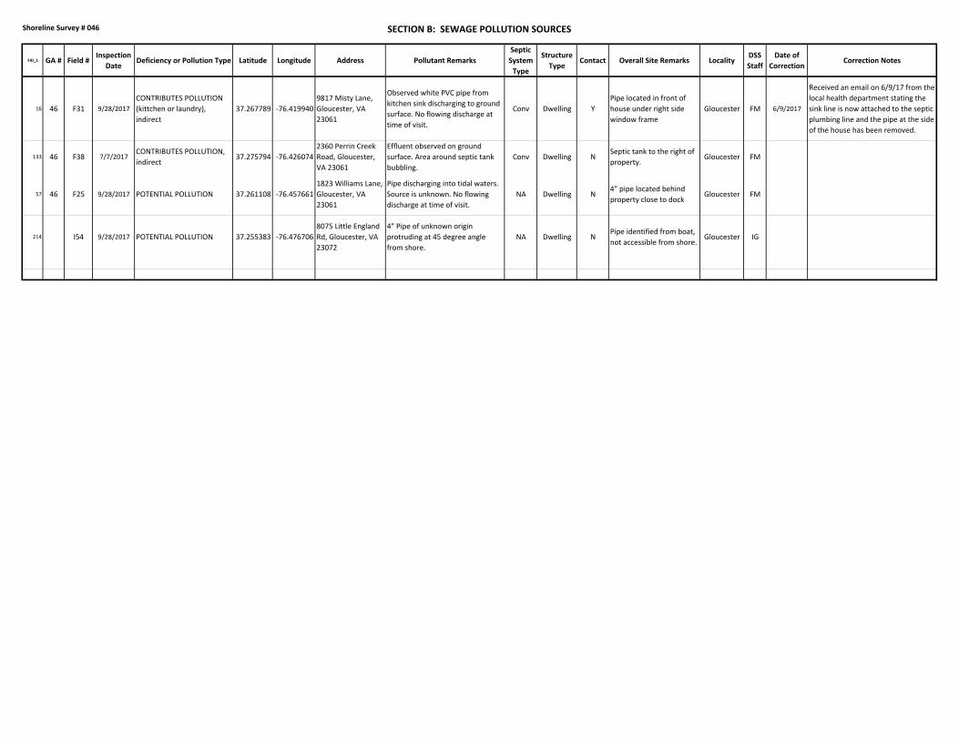
Shoreline Survey # 046 SECTION B: SEWAGE POLLUTION SOURCES
FID_1 GA # Field #Inspection
DateDeficiency or Pollution Type Latitude Longitude Address Pollutant Remarks
Septic
System
Type
Structure
TypeContact Overall Site Remarks Locality
DSS
Staff
Date of
CorrectionCorrection Notes
16 46 F31 9/28/2017
CONTRIBUTES POLLUTION
(kittchen or laundry),
indirect
37.267789 ‐76.419940
9817 Misty Lane,
Gloucester, VA
23061
Observed white PVC pipe from
kitchen sink discharging to ground
surface. No flowing discharge at
time of visit.
Conv Dwelling Y
Pipe located in front of
house under right side
window frame
Gloucester FM 6/9/2017
Received an email on 6/9/17 from the
local health department stating the
sink line is now attached to the septic
plumbing line and the pipe at the side
of the house has been removed.
133 46 F38 7/7/2017CONTRIBUTES POLLUTION,
indirect37.275794 ‐76.426074
2360 Perrin Creek
Road, Gloucester,
VA 23061
Effluent observed on ground
surface. Area around septic tank
bubbling.
Conv Dwelling NSeptic tank to the right of
property.Gloucester FM
57 46 F25 9/28/2017 POTENTIAL POLLUTION 37.261108 ‐76.457661
1823 Williams Lane,
Gloucester, VA
23061
Pipe discharging into tidal waters.
Source is unknown. No flowing
discharge at time of visit.
NA Dwelling N4" pipe located behind
property close to dockGloucester FM
214 I54 9/28/2017 POTENTIAL POLLUTION 37.255383 ‐76.476706
8075 Little England
Rd, Gloucester, VA
23072
4" Pipe of unknown origin
protruding at 45 degree angle
from shore.
NA Dwelling NPipe identified from boat,
not accessible from shore.Gloucester IG
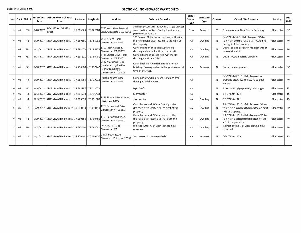
Shoreline Survey # 046 SECTION C: NONSEWAGE WASTE SITES
FID_1 GA # Field #Inspection
Date
Deficiency or Pollution
TypeLatitude Longitude Address Pollutant Remarks
Septic
System
Type
Structure
TypeContact Overall Site Remarks Locality
DSS
Staff
15 46 F30 9/28/2017INDUSTRIAL WASTES,
direct37.265324 ‐76.422689
9725 York River Seafood
Lane, Gloucester, VA 23061
Shellfish processing facility discharges process
water to tidal waters. Facility has discharge
permit VAG#524025.
Conv Business Y Rappahannock River Oyster Company Gloucester FM
91 46 F1 9/29/2017 STORMWATER, direct 37.259681 ‐76.4837887556 Killdee Road,
Gloucester, VA 23061
12" Cement Outfall observed. Water flowing
in the drainage ditch located to the right of
the property.
NA Dwelling N
5‐9‐17 Ent=52:Outfall observed. Water
flowing in the drainage ditch located to
the right of the property.
Gloucester FM
32 46 F14 9/28/2017 STORMWATER, direct 37.252472 ‐76.4566781497 Fleming Road,
Gloucester, VA 23072
Outfall from ditch to tidal waters. No
discharge observed at time of site visit.NA Dwelling N
Outfall behind property. No discharge at
time of site visit.Gloucester FM
36 46 F18 9/28/2017 STORMWATER, direct 37.257611 ‐76.4654818438 Oyster Cove Road,
Gloucester, VA 23072
Outfall discharging into tidal waters. No
discharge at time of visit.NA Dwelling N Outfall located behind property. Gloucester FM
39 46 F22 9/28/2017 STORMWATER, direct 37.269360 ‐76.457442
2146 Mark Pine Road
(behind Abingdon Fire
Rescue buildings),
Gloucester, VA 23072
Outfall behind Abingdon Fire and Rescue
building. Flowing water discharge observed at
time of site visit.
NA Business N Outfall behind property. Gloucester FM
94 46 F4 9/29/2017 STORMWATER, direct 37.266755 ‐76.419718Dolphin Watch Road,
Gloucester, VA 23061
Outfall observed in drainage ditch. Water
flowing to tidal waters.NA N
6‐8‐17 Ent=805: Outfall observed in
drainage ditch. Water flowing to tidal
waters.
Gloucester FM
100 46 I32 6/16/2017 STORMWATER, direct 37.264837 ‐76.412078 Pipe Outfall NA N Storm water pipe partially submerged Gloucester IG
96 46 L3 10/3/2017 STORMWATER, direct 37.264738 ‐76.491434 Stormwater NA N 6‐8‐17 Ent=1124: Gloucester LS
97 46 L4 10/3/2017 STORMWATER, direct 37.266898 ‐76.4919081971 Tidemill Haven Lane,
Hayes, VA 23072stormwater NA Dwelling N 6‐8‐17 Ent=1421: Gloucester LS
92 46 F2 9/29/2017 STORMWATER, indirect 37.260410 ‐76.4904101768 Farmwood Drive,
Gloucester, VA 23061
Outfall observed. Water flowing in the
drainage ditch located to the right of the
property.
NA Dwelling N
6‐1‐17 Ent=122: Outfall observed. Water
flowing in drainage ditch located on right
side of property.
Gloucester FM
93 46 F3 9/29/2017 STORMWATER, indirect 37.260356 ‐76.4904601753 Farmwood Road,
Gloucester, VA 23061
Outfall observed. Water flowing in the
drainage ditch located to the left of the
property.
NA Dwelling N
6‐1‐17 Ent=191: Outfall observed. Water
flowing in drainage ditch located on the
left of the property.
Gloucester FM
34 46 F16 9/28/2017 STORMWATER, indirect 37.254708 ‐76.465281, Victory Hill Road,
Gloucester, VA
Indirect outfall 6‐8" Diameter. No flow
observedNA Dwelling N
Indirect outfall 6‐8" Diameter. No flow
observedGloucester FM
95 46 L1 10/2/2017 STORMWATER, indirect 37.250461 ‐76.499137VIMS, Roper Road,
Gloucester Point, VA 23062Stormwater in drainage ditch NA Business N 6‐8‐17 Ent=1439: Gloucester LS
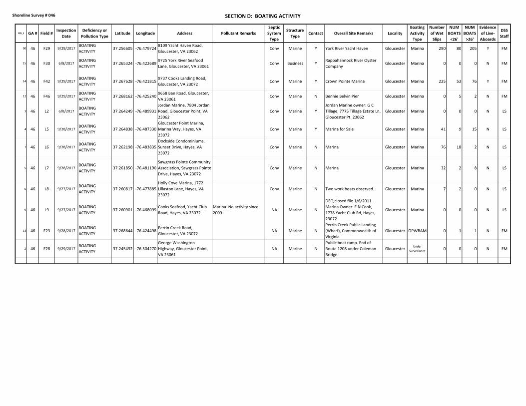
Shoreline Survey # 046 SECTION D: BOATING ACTIVITY
FID_1 GA # Field #Inspection
Date
Deficiency or
Pollution TypeLatitude Longitude Address Pollutant Remarks
Septic
System
Type
Structure
TypeContact Overall Site Remarks Locality
Boating
Activity
Type
Number
of Wet
Slips
NUM
BOATS
<26'
NUM
BOATS
>26'
Evidence
of Live‐
Aboards
DSS
Staff
90 46 F29 9/29/2017BOATING
ACTIVITY37.256605 ‐76.479724
8109 Yacht Haven Road,
Gloucester, VA 23062Conv Marine Y York River Yacht Haven Gloucester Marina 290 80 205 Y FM
15 46 F30 6/8/2017BOATING
ACTIVITY37.265324 ‐76.422689
9725 York River Seafood
Lane, Gloucester, VA 23061Conv Business Y
Rappahannock River Oyster
CompanyGloucester Marina 0 0 0 N FM
14 46 F42 9/29/2017BOATING
ACTIVITY37.267628 ‐76.421815
9737 Cooks Landing Road,
Gloucester, VA 23072Conv Marine Y Crown Pointe Marina Gloucester Marina 225 53 76 Y FM
12 46 F46 9/29/2017BOATING
ACTIVITY37.268162 ‐76.425240
9658 Ban Road, Gloucester,
VA 23061Conv Marine N Bennie Belvin Pier Gloucester Marina 0 5 2 N FM
3 46 L2 6/8/2017BOATING
ACTIVITY37.264249 ‐76.489931
Jordan Marine, 7804 Jordan
Road, Gloucester Point, VA
23062
Conv Marine Y
Jordan Marine owner: G C
Tillage, 7775 Tillage Estate Ln,
Gloucester Pt. 23062
Gloucester Marina 0 0 0 N LS
4 46 L5 9/28/2017BOATING
ACTIVITY37.264838 ‐76.487330
Gloucester Point Marina,
Marina Way, Hayes, VA
23072
Conv Marine Y Marina for Sale Gloucester Marina 41 9 15 N LS
7 46 L6 9/28/2017BOATING
ACTIVITY37.262198 ‐76.483835
Dockside Condominiums,
Sunset Drive, Hayes, VA
23072
Conv Marine N Marina Gloucester Marina 76 18 2 N LS
5 46 L7 9/28/2017BOATING
ACTIVITY37.261850 ‐76.481190
Sawgrass Pointe Community
Association, Sawgrass Pointe
Drive, Hayes, VA 23072
Conv Marine N Marina Gloucester Marina 32 2 8 N LS
6 46 L8 9/27/2017BOATING
ACTIVITY37.260817 ‐76.477885
Holly Cove Marina, 1772
Lillaston Lane, Hayes, VA
23072
Conv Marine N Two work boats observed. Gloucester Marina 7 2 0 N LS
9 46 L9 9/27/2017BOATING
ACTIVITY37.260901 ‐76.468099
Cooks Seafood, Yacht Club
Road, Hayes, VA 23072
Marina. No activity since
2009.NA Marine N
DEQ closed file 1/6/2011.
Marina Owner: E N Cook,
1778 Yacht Club Rd, Hayes,
23072
Gloucester Marina 0 0 0 N LS
13 46 F23 9/28/2017BOATING
ACTIVITY37.268644 ‐76.424498
Perrin Creek Road,
Gloucester, VA 23072NA Marine N
Perrin Creek Public Landing
(Wharf), Commonwealth of
Virginia
Gloucester OPWBAM 0 1 1 N FM
2 46 F28 9/29/2017BOATING
ACTIVITY37.245492 ‐76.504270
George Washington
Highway, Gloucester Point,
VA 23061
NA Marine N
Public boat ramp. End of
Route 1208 under Coleman
Bridge.
GloucesterUnder
Surveillance0 0 0 N FM
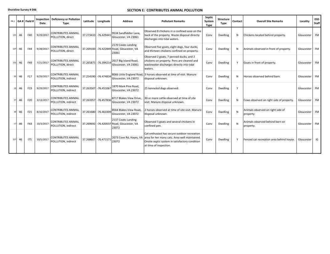
Shoreline Survey # 046 SECTION E: CONTRIBUTES ANIMAL POLLUTION
FID_1 GA # Field #Inspection
Date
Deficiency or Pollution
TypeLatitude Longitude Address Pollutant Remarks
Septic
System
Type
Structure
TypeContact Overall Site Remarks Locality
DSS
Staff
135 46 F40 9/29/2017CONTRIBUTES ANIMAL
POLLUTION, direct37.273433 ‐76.429441
9534 Sandfiddler Lane,
Gloucester, VA 23061
Observed 8 chickens in a confined area on the
back of the property. Waste disposal directly
discharges into tidal waters.
Conv Dwelling N Chickens located behind property. Gloucester FM
137 46 F44 9/28/2017CONTRIBUTES ANIMAL
POLLUTION, direct37.269100 ‐76.422849
2170 Cooks Landing
Road, Gloucester, VA
23061
Observed five goats, eight dogs, four ducks,
and thirteen chickens confined on property.Conv Dwelling N Animals observed in front of property. Gloucester FM
155 46 F49 7/21/2017CONTRIBUTES ANIMAL
POLLUTION, direct37.265875 ‐76.394214
2017 Big Island Road,
Gloucester, VA 23061
Observed 2 goats, 7 penned ducks, and 2
chickens on property. Pens are cleaned and
wastewater discharges directly into tidal
waters.
Conv Dwelling Y Goats in front of property. Gloucester FM
35 46 F17 9/29/2017CONTRIBUTES ANIMAL
POLLUTION, indirect37.254590 ‐76.474834
8066 Little England Road,
Gloucester, VA 23072
3 horses observed at time of visit. Manure
disposal unknown.Conv Dwelling N Horses observed behind barn. Gloucester FM
10 46 F19 9/29/2017CONTRIBUTES ANIMAL
POLLUTION, indirect37.263507 ‐76.451067
1870 Mark Pine Road,
Gloucester, VA 2307225 kenneled dogs observed. Conv Dwelling Y Gloucester FM
37 46 F20 3/13/2017CONTRIBUTES ANIMAL
POLLUTION, indirect37.263357 ‐76.457836
8717 Blakes View Drive,
Gloucester, VA 23072
30 or more cattle observed at time of site
visit. Manure disposal unknown.Conv Dwelling N Cows observed on right side of property. Gloucester FM
38 46 F21 8/16/2017CONTRIBUTES ANIMAL
POLLUTION, indirect37.261680 ‐76.463309
8564 Blakes View Road,
Gloucester, VA 23072
2 horses observed at time of site visit. Manure
disposal unknown.Conv Dwelling N
Animals observed on right side of
propertyGloucester FM
17 46 F43 10/3/2017CONTRIBUTES ANIMAL
POLLUTION, indirect37.269692 ‐76.420537
2137 Cooks Landing
Road, Gloucester, VA
23072
Observed 5 goats and several chickens in
confined pen.Conv Dwelling N
Animals observed behind barn on
property.Gloucester FM
157 46 I75 10/5/2017CONTRIBUTES ANIMAL
POLLUTION, indirect37.268607 ‐76.471571
2073 Cove Rd, Hayes, VA
23072
Cat enthusiast has secure outdoor recreation
area for her many cats. Area well maintained.
Onsite septic system in satisfactory condition
at time of inspection.
Conv Dwelling Y Fenced cat recreation area behind house. Gloucester IG
Shoreline Survey # 046 Page 7
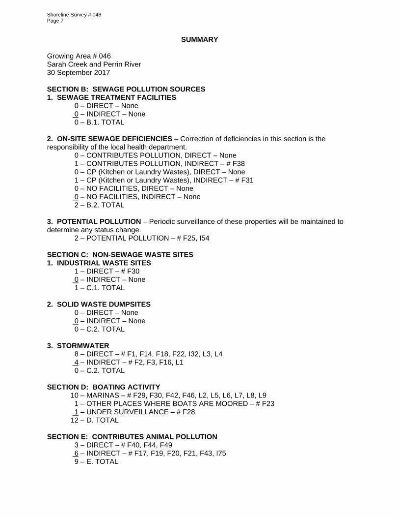
SUMMARY Growing Area # 046 Sarah Creek and Perrin River 30 September 2017 SECTION B: SEWAGE POLLUTION SOURCES 1. SEWAGE TREATMENT FACILITIES
0 – DIRECT – None 0 – INDIRECT – None 0 – B.1. TOTAL 2. ON-SITE SEWAGE DEFICIENCIES – Correction of deficiencies in this section is the responsibility of the local health department.
0 – CONTRIBUTES POLLUTION, DIRECT – None 1 – CONTRIBUTES POLLUTION, INDIRECT – # F38 0 – CP (Kitchen or Laundry Wastes), DIRECT – None 1 – CP (Kitchen or Laundry Wastes), INDIRECT – # F31 0 – NO FACILITIES, DIRECT – None 0 – NO FACILITIES, INDIRECT – None 2 – B.2. TOTAL
3. POTENTIAL POLLUTION – Periodic surveillance of these properties will be maintained to determine any status change.
2 – POTENTIAL POLLUTION – # F25, I54 SECTION C: NON-SEWAGE WASTE SITES 1. INDUSTRIAL WASTE SITES
1 – DIRECT – # F30 0 – INDIRECT – None 1 – C.1. TOTAL 2. SOLID WASTE DUMPSITES 0 – DIRECT – None 0 – INDIRECT – None 0 – C.2. TOTAL 3. STORMWATER 8 – DIRECT – # F1, F14, F18, F22, I32, L3, L4 4 – INDIRECT – # F2, F3, F16, L1 0 – C.2. TOTAL SECTION D: BOATING ACTIVITY
10 – MARINAS – # F29, F30, F42, F46, L2, L5, L6, L7, L8, L9 1 – OTHER PLACES WHERE BOATS ARE MOORED – # F23 1 – UNDER SURVEILLANCE – # F28
12 – D. TOTAL SECTION E: CONTRIBUTES ANIMAL POLLUTION 3 – DIRECT – # F40, F44, F49 6 – INDIRECT – # F17, F19, F20, F21, F43, I75 9 – E. TOTAL
d
Î
A
"
X
"""Î
X
X
Î
Î
Î
#
X
!.!.
A
ÎÎ
X
Î
A
Î
X#
Î
AXX
A
A
Î
X
AA
X
X
#
X
"
X
AA
X
Î
ÎÎ
ÎÎ
!.
_̂
"
Î
Î
Î
A
ÎÎ
Î
!.
#
A
Î
S
A
S
AA
S
S
XSSS
S
S
SS
S
X
"
A
A
A
A
Î
Î Î
Î Î#
!A
!A!A
!A
!A
!A
!A
!A
!A
!A
!A
!A
!A
!A
!A
!A
!A
!A
!A
!A
!A
!A
!A
!A
!A
!A!A
!A
!A
!A
!A
!A
!A
!A
!A
!A
!A
!A
!A
!A
!A
!A
!A
!A
!A
!A!A
!A
!A
!A
!A
!A
!A
!A
!A
!A
!A
!A
!A
!A
!A!A
!A
!A
!A
!A
!A
!A
!A
!A
!A
!A
!A
!A
!A
!A
")
")GloucesterPointBoat Ramp
46
47
1641
1805
1886
1891
24
217219
221
641
915
45
F28
F29
L2F19
F46
F23F42
F30
F31
F43
F30
F14
F17
F18
F20
F21
F22
F16
F25
F1
F2
F3
F4
L1
L3
L4
I32
I54
F38
F40
F44
F49
I75
L5
L6 L7L8
L946-10A
46-12.5
46-13.5
46-8.946-8.7
46-8.5
46-8.3
46-7A
46-7B
46-8B
46-8A46-3A
46-4A
46-1C
46-1.546-2A
46-246-2.5
46-3
46-3.5
46-446-4.5
46-546-5.5
46-6
46-6.546-7
46-7.5 46-8
46-9
46-10
46-10.546-11
46-13
46-14
46-12
45-1245-13
44-12X
46-22
46-7D
76°24'0"W
76°24'0"W
76°25'30"W
76°25'30"W
76°27'0"W
76°27'0"W
76°28'30"W
76°28'30"W
76°30'0"W
76°30'0"W37
°16'3
0"N
37°1
6'30"N
37°1
5'0"N
37°1
5'0"N
Date: 30 September 2017Survey By: I.M. Geeson, F.P. Monis, L.Z. Sakach and E.M. YearganNumber of Properties Surveyed: 215
Virginia Department of HealthDivision of Shellfish Sanitation
Sarah Creek & Perrin River# 046
Shoreline Sanitary SurveyGloucester County
0 2500 5000Feet
Geographic coordinates in NAD83 datum;shown in degrees, minutes & seconds.
# E1 3/8/2017# E2 3/8/2017 # E3 3/8/2017
# E4 3/8/2017# E5 3/8/2017
# E6 3/8/2017
# E7 3/8/2017
# E8 3/8/2017# E9 3/8/2017
# E103/8/2017
# E113/8/2017# E12
3/8/2017
# E133/8/2017
# E143/8/2017
# E153/8/2017
# E163/8/2017
# E173/8/2017
# I14/18/2017
# I24/18/2017
# I34/18/2017
# I44/18/2017
# I54/18/2017# I6
4/18/2017
# I94/18/2017# I10
4/18/2017
# I134/18/2017# I14
4/18/2017
# I154/18/2017
# I164/18/2017
# I174/18/2017
# I184/18/2017
# I194/18/2017
# I204/18/2017
# I214/18/2017
# I224/18/2017
# I124/18/2017
# I234/18/2017
# I244/18/2017
# I254/18/2017
# I264/18/2017
# I274/18/2017
# I284/18/2017
# I294/18/2017
# I304/18/2017
# NSF15/9/2017
# NSF26/1/2017# NSF36/1/2017
# NSL016/8/2017
# NSL036/8/2017
# NSL046/8/2017
# I74/18/2017
# I567/6/2017
# I114/18/2017
# I84/18/2017
Sample 1 of 5
GA # 046 Sarah CreekEnterococcus Near-Shore Sampling
March 8 - July 24, 2017
0 2000 4000Feet
LegendEnterococcus spp. (MPN/100ml) Sample # 1
9 - 3132 - 7475 - 218219 - 805806 - 1439
# E1 7/6/2017# E2 7/6/2017 # E3 7/6/2017
# E4 7/6/2017# E5 7/6/2017
# E6 7/6/2017
# E7 7/6/2017
# E8 7/6/2017# E9 7/6/2017
# E107/6/2017
# E117/6/2017# E12
7/6/2017
# E137/6/2017
# E147/6/2017
# E157/6/2017
# E167/6/2017
# E177/6/2017
# I1 5/9/2017
# I2 5/9/2017
# I3 5/9/2017# I4 5/9/2017
# I5 5/9/2017
# I6 5/9/2017
# I9 5/9/2017# I105/9/2017
# I135/9/2017
# I145/9/2017
# I155/9/2017
# I165/9/2017
# I175/9/2017
# I185/9/2017
# I195/9/2017
# I205/9/2017
# I215/9/2017
# I225/9/2017
# I125/9/2017
# I235/9/2017
# I245/9/2017
# I255/9/2017
# I265/9/2017
# I275/9/2017
# I285/9/2017
# I295/9/2017
# I305/9/2017
# I75/24/2017
# I115/9/2017
# I8 5/9/2017
Sample 2 of 5
GA # 046 Sarah CreekEnterococcus Near-Shore Sampling
March 8 - July 24, 2017
0 2000 4000Feet
LegendEnterococcus spp. (MPN/100ml) Sample # 2
9 - 3132 - 8687 - 644645 - 13341335 - 6488
# E147/6/2017
# E157/6/2017
# E167/6/2017
# I1 5/9/2017
# I2 5/9/2017
# I3 5/9/2017# I4 5/9/2017
# I5 5/9/2017
# I6 5/9/2017
# I9 5/9/2017# I105/9/2017
# I135/9/2017
# I145/9/2017
# I155/9/2017
# I215/9/2017
# I225/9/2017
# I125/9/2017
# I235/9/2017
# I245/9/2017
# I255/9/2017
# I265/9/2017
# I275/9/2017
# I285/9/2017
# I295/9/2017
# I305/9/2017
# I115/9/2017
# I8 5/9/2017
Sample 3 of 5
GA # 046 Sarah CreekEnterococcus Near-Shore Sampling
March 8 - July 24, 2017
0 2000 4000Feet
LegendEnterococcus spp. (MPN/100ml) Sample # 3
9 - 3132 - 7475 - 218219 - 805806 - 1439

# NSF46/8/2017
# I316/12/2017
# I336/12/2017
# I346/12/2017
# I356/12/2017
# I366/12/2017
# I376/12/2017
# I386/12/2017
# I396/12/2017
# I406/12/2017
# I416/12/2017
# I426/12/2017# I43
6/12/2017# I446/12/2017
# I456/12/2017
# I466/12/2017# I476/12/2017
# I486/12/2017
# I496/12/2017
# I506/12/2017
# I516/12/2017
# I536/12/2017
# I526/12/2017
Sample 4 of 5
GA # 046 Perrin RiverEnterococcus Near-Shore Sampling
March 8 - July 24, 2017
0 2000 4000Feet
LegendEnterococcus spp. (MPN/100ml) Sample # 1
9 - 3132 - 7475 - 218219 - 805806 - 1439
# I316/20/2017
# I337/24/2017
# I347/24/2017
# I357/24/2017
# I367/24/2017
# I377/24/2017
# I386/20/2017
# I396/20/2017
# I406/20/2017
# I416/20/2017
# I426/20/2017# I43
6/20/2017# I446/20/2017
# I456/20/2017
# I466/20/2017# I476/20/2017
# I486/20/2017
# I496/20/2017
# I506/20/2017
# I516/20/2017
# I536/20/2017
# I526/20/2017
Sample 5 of 5
GA # 046 Perrin RiverEnterococcus Near-Shore Sampling
March 8 - July 24, 2017
0 2000 4000Feet
LegendEnterococcus spp. (MPN/100ml) Sample # 2
9 - 3132 - 8687 - 644645 - 13341335 - 6488