Embed Size (px)
Citation preview

SANS 1936 and related standards
Development on dolomite land
Peter Day PrEngChair SABS TC98 and SC59P
Jones & Wagener Consultants

Overview
• Dolomite related standards• Perspective on risks involved• Assessment of hazard• Performance based standard• Overview of requirements• Some problem areas• Where to from here?• Conclusions

Dolomite related standards
SANS 1936 Development of dolomite landPart 1 General principles and requirementsPart 2 Geotechnical investigations and requirementsPart 3 Design and construction, buildings and infrastructurePart 4 Risk management
SANS 633 Soil profiling and ... borehole logging on dolomite land
SANS 634 Geotechnical investigations for township development
SANS 2001‐BE3 Repair of sinkholes and dolines
Changed from general to dolomite‐specific guidelines
Minor amendments only – largely unchanged
Corrected, simplified and harmonized with other standards

Perspective on risks involved

Gauteng Province

Gauteng Province Pretoria
Johannesburg
• 1,4% of area of RSA• 22% of population• 33% of GDP• 25% on dolomite
Prohibiting development is not and option!

West Driefontein, 1962
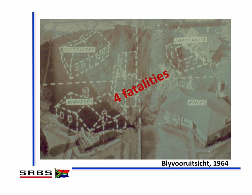
Blyvooruitsicht, 1964

Venterspost, 1971

Bank Compartment, 1975

Orkney, 1986

Centurion 2002

Bapsfontein 2004

N14: Centurion 2012
Total recorded fatalities to date = 38

13 967 road deaths in South Africa in 2010 alone!

Problems with pre‐2009 drafts.... or why all the delays?
• Not written by geotechnical fraternity• No consensus (i.e. sustained opposition)• Requirements out of proportion to risk• Prohibited development on high risk land• Failed to recognise engineers’ ability to find solutions.

X
Gautrain Route
Hazard Assessment


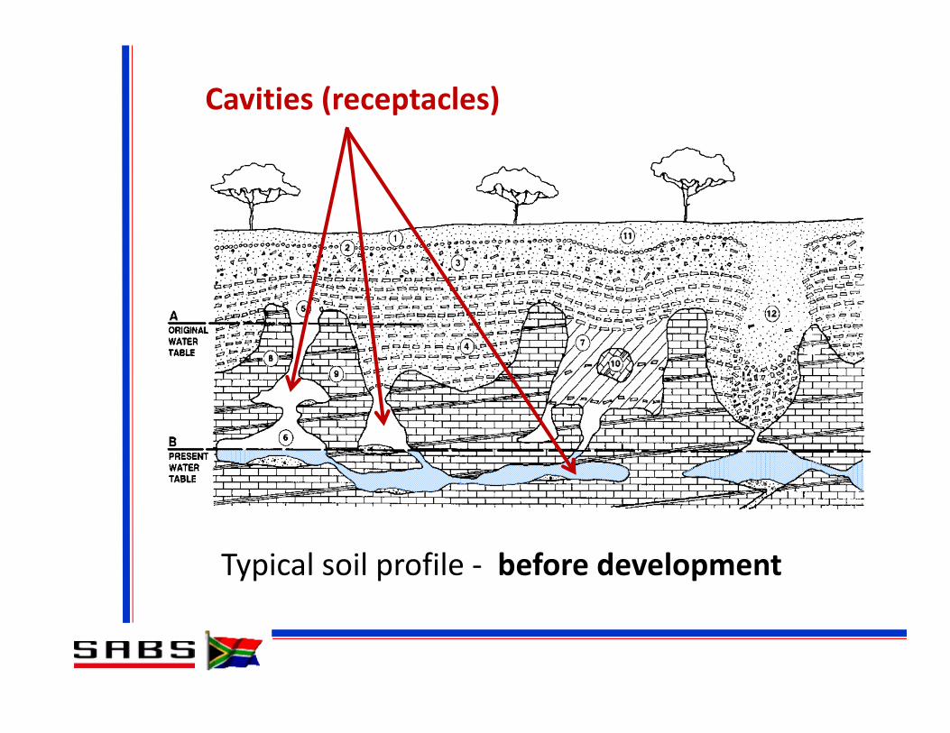
Typical soil profile ‐ before development
Transported sand and gravelsResiduum

Typical soil profile ‐ before development
Floaters Pinnacles
Typical soil profile ‐ before development
Cavities (receptacles)

Subsidence caused WT drawdown or water ingress
SinkholeSinkhole Doline
Wad

96% of sinkholes caused by water ingress

Buttrick’s “Scenario Supposition” method
• Looks at various scenarios:– Static water table– Uncontrolled drawdown of WT.
• Factors considered:– Receptacle development– Mobilising agency– Mobilization potential– Potential development space
Likelihood of sinkhole development
Potential size of sinkholes
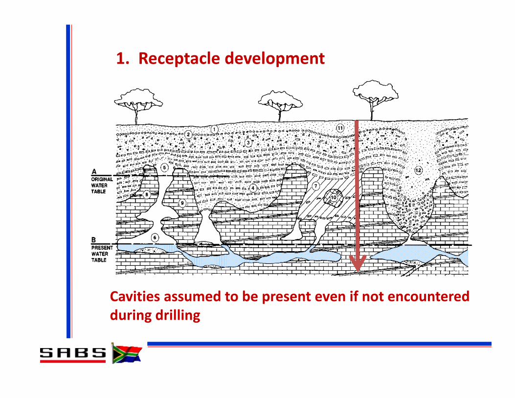
1. Receptacle development
Cavities assumed to be present even if not encountered during drilling

2. Mobilising agency
• Typically water ingress or water table lowering• Generally assumed water ingress will occur
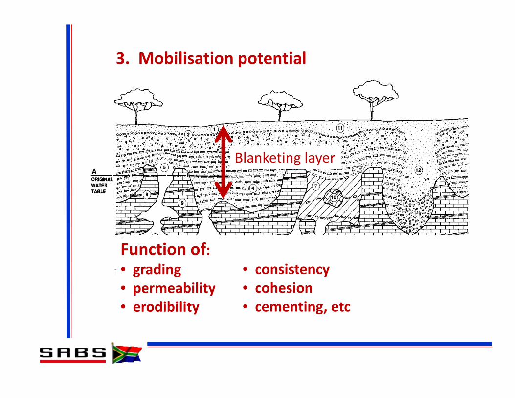
3. Mobilisation potential
Function of:• grading• permeability• erodibility
Blanketing layer
• consistency• cohesion• cementing, etc

4. Potential development space
• Based on assumed angles of draw in various horizons• Determines maximum potential sinkhole size


Performance based standard

Performance based regulatory system:
Level 1 Goal / objective
Broad statement of intent that reflects societal expectations
Level 2 Functional Requirement
Functunal or qualitative requirements to be met without specifying procedures, etc
Level 3Performance Requirements
Quantitative requirements that will ensure functional requirements are satisfied
Level 4 EvaluationConfirmation that the nominated performance is achieved
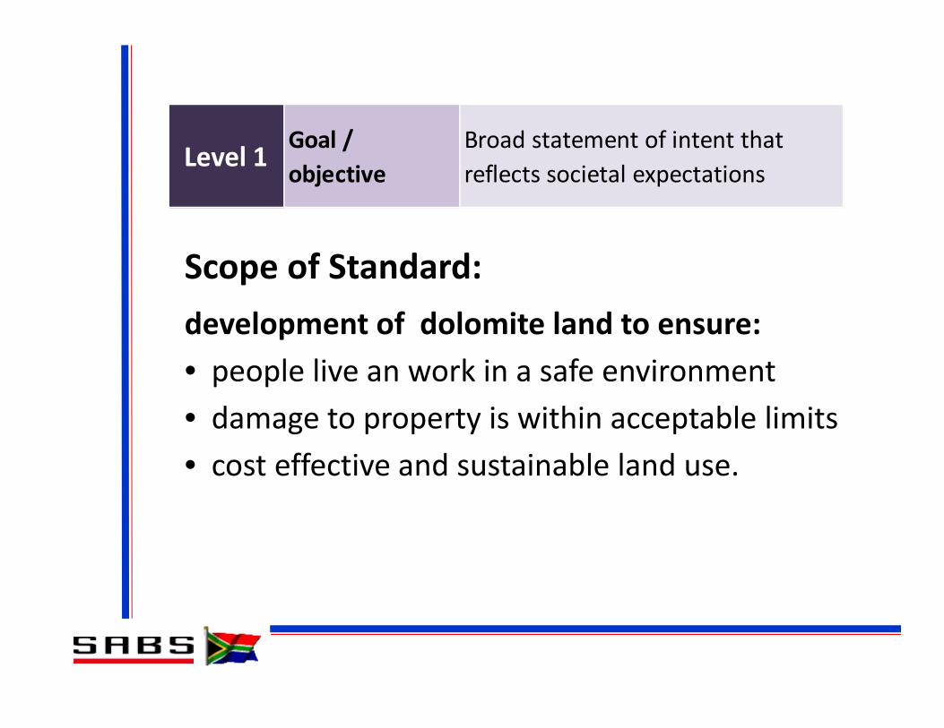
Level 1 Goal / objective
Broad statement of intent that reflects societal expectations
Scope of Standard:development of dolomite land to ensure:• people live an work in a safe environment• damage to property is within acceptable limits• cost effective and sustainable land use.

Land that is underlain by dolomite shall present an acceptable risk of sinkhole and subsidence formation over time.
Level 2 Functional Requirement
Functunal or qualitative requirements to be met without specifying procedures, etc

Level 3Performance Requirements
Quantitative requirements that will ensure functional requirements are satisfied
Performance requirement:Less than 1 event per hectarein a 200 year period
achieved by:• Establish inherent hazard class• Determine precautions required for various categories of development
• Ongoing risk management procedures
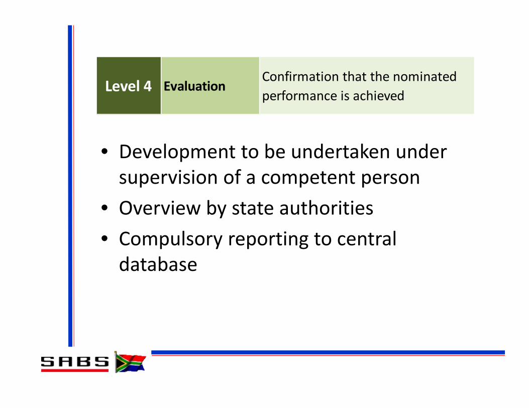
Level 4 EvaluationConfirmation that the nominated performance is achieved
• Development to be undertaken under supervision of a competent person
• Overview by state authorities• Compulsory reporting to central database

Overview of requirementsInvestigate SiteSANS 1936‐2
Classify SiteSANS 1936‐2
Permissible Land UseSANS 1936‐1
Dolomite Area DesignationSANS 1936‐1
Design and other requirementsSANS 1936‐3
Risk managementSANS 1936‐4

Overview of requirements
Classify SiteSANS 1936‐2
Permissible Land UseSANS 1936‐1
Dolomite Area DesignationSANS 1936‐1
Design and other requirementsSANS 1936‐3
Risk managementSANS 1936‐4
Investigate SiteSANS 1936‐2

Investigation requirements
• Appropriate investigation methods• Minimum requirements• Phased approach
– Feasibility level investigations– Design level investigations– Investigation during construction

Overview of requirements .... (cont)Investigate SiteSANS 1936‐2
Permissible Land UseSANS 1936‐1
Dolomite Area DesignationSANS 1936‐1
Design and other requirementsSANS 1936‐3
Risk managementSANS 1936‐4
Classify SiteSANS 1936‐2

Classification criteria:
• Sinkhole size:Diameter: Small <2m
Medium 2m – 5mLarge 5m – 15mV. large >15m
• Likelihood of occurrence (per hectare): Return period: low >200y
med 20y – 200yhigh <2y

Small <2m
Medium 2m ‐ 5m
Large 5m ‐ 15m
V. large >15m
1 Low Low Low Low2 Med Low Low Low3 Med Med Low Low4 Med Med Med Med5 High Low Low Low6 High High Low Low7 High High High Low8 High High High High
Inherent Hazard Class
Size of sinkhole

Overview of requirements .... (cont)Investigate SiteSANS 1936‐2
Classify SiteSANS 1936‐2
Dolomite Area DesignationSANS 1936‐1
Design and other requirementsSANS 1936‐3
Risk managementSANS 1936‐4
Permissible Land UseSANS 1936‐1
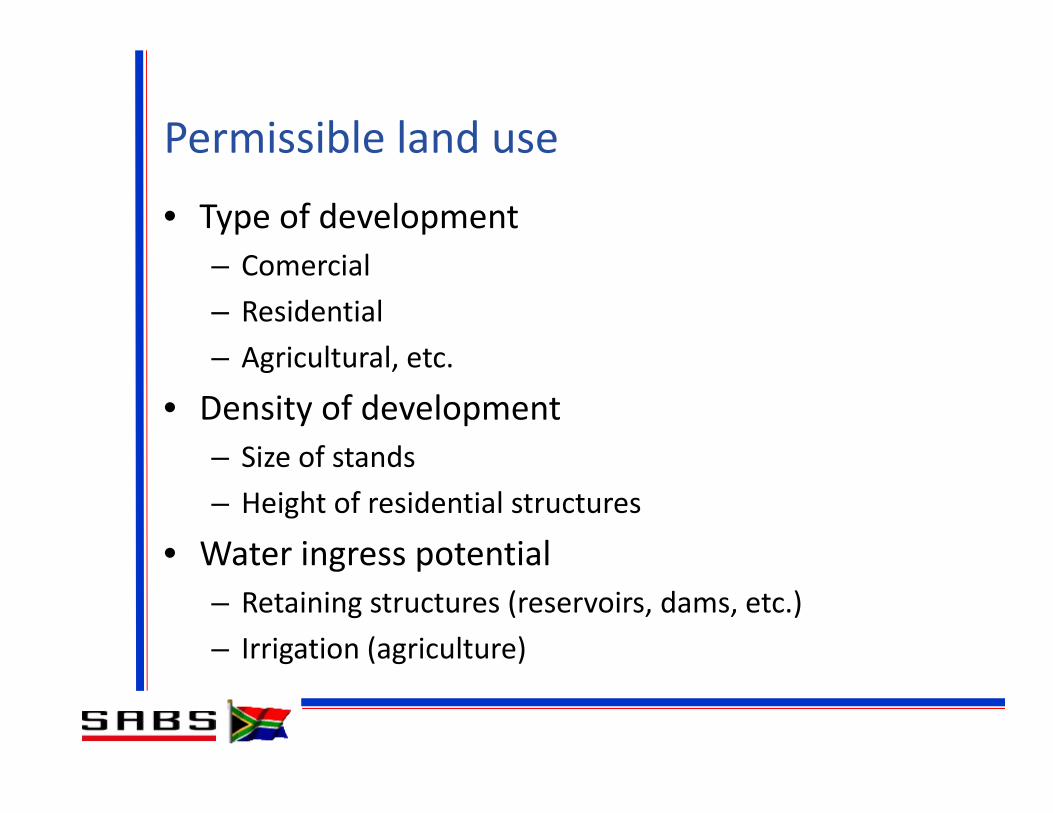
Permissible land use
• Type of development– Comercial– Residential– Agricultural, etc.
• Density of development– Size of stands– Height of residential structures
• Water ingress potential– Retaining structures (reservoirs, dams, etc.)– Irrigation (agriculture)

Overview of requirements .... (cont)Investigate SiteSANS 1936‐2
Classify SiteSANS 1936‐2
Permissible Land UseSANS 1936‐1
Design and other requirementsSANS 1936‐3
Risk managementSANS 1936‐4
Dolomite Area DesignationSANS 1936‐1

Dolomite area designation
• Determines precautionary measures required
D1 No precautions required
D2 General measures, water ingress
D3 Additional measures
D4 Site specific – rational assessment

Overview of requirements .... (cont)Investigate SiteSANS 1936‐2
Classify SiteSANS 1936‐2
Permissible Land UseSANS 1936‐1
Dolomite Area DesignationSANS 1936‐1
Design and other requirementsSANS 1936‐3
Risk managementSANS 1936‐4
Dealt with in next presentation

Problem Areas
• Method of hazard classification• Prohibition of development on D4 land• Definition of a competent person• Practicality of requirements

• Problem:– Draft code specified Scenario Supposition method to exclusion of other approaches
• Solution:– Specified classification parameters – not method of classification
– Opened the door for rational assessment– Made Scenario Supposition a “deemed‐to‐satisfy” method in an informative annex.
HAZARD CLASSIFICATION
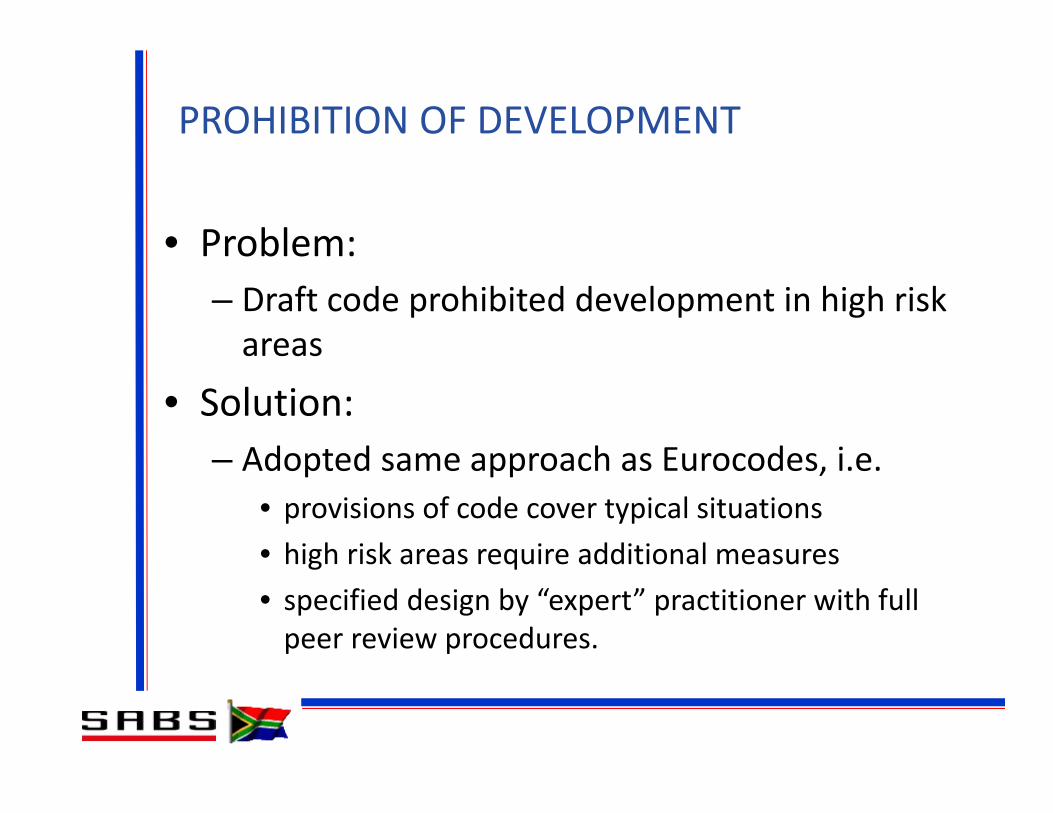
• Problem:– Draft code prohibited development in high risk areas
• Solution:– Adopted same approach as Eurocodes, i.e.
• provisions of code cover typical situations• high risk areas require additional measures• specified design by “expert” practitioner with full peer review procedures.
PROHIBITION OF DEVELOPMENT

• Problem:– No yardstick for judging competence
• Solution:– Adopted approach from ICE Site Investigation Steering Group
DEFINITION OF COMPETENT PERSON

Competence levels:
Candidate
Registeredprofessional
Experiencedprofessional
ExpertprofessionalRecognition
Experience
Registration
Education
Engine
er
Geo
logist
Techno
logist
Technician
Required competence for high risk sites

Precedent: Gautrain Project• Rational assessment of risk• Targeted precautionary measures• Expert analysis and review
See Sartain et al.


Large diameter shafts to solid rock – up to 70m deep


• Problem:– Requirements not always achievable
• Solution:– Adopted “reasonably practicable” approach from OHS Act
– Rational assessment alternative
PRACTICALITY OF REQUIREMENTS

Where to from here?
• Implement current requirements• Continue to develop sinkhole database• Rigorous analysis database• Develop “geotechnical model” concept• Revise code within 5 years
Standards are living documents!

Conclusion
Standards should not stifle initiative but:
• encourage further research / improvement
• provide a framework within which competent professionals can exercise their skills in a responsible manner.
Thank you


![DOLOMITE - CatalogoSummer 2011 - [EN]](https://img.pdfslide.us/doc/110x75/568bd6621a28ab20349be1fa/dolomite-catalogosummer-2011-en.jpg)