Embed Size (px)
Citation preview

SAND MINE NEAR
ROBERTSON, WESTERN
CAPE PROVINCE
BOTANICAL STUDY
AND
ASSESSMENT
Version: 1.0
Date: 06 April 2020
Authors: Gerhard Botha &
Dr. Jan -Hendrik Keet

PROPOSED EXPANSION OF THE SAND MINE AREA ON
PORTION4 OF THE FARM ZANDBERG FONTEIN 97, SOUTH
OF ROBERTSON, WESTERN CAPE PROVINCE
Report Title: Botanical Study and Assessment
Authors: Mr. Gerhard Botha and Dr. Jan-Hendrik Keet
Project Name: Proposed expansion of the sand mine area on Portion 4 of the far
Zandberg Fontein 97 south of Robertson, Western Cape Province
Status of report: Version 1.0
Date: 6th April 2020
Prepared for: Greenmined Environmental
Postnet Suite 62, Private Bag X15
Somerset West
7129
Cell: 082 734 5113
Email: [email protected]
Prepared by Nkurenkuru Ecology and Biodiversity
3 Jock Meiring Street
Park West
Bloemfontein
9301
Cell: 083 412 1705
Email: gabotha11@gmail com
Suggested report citation
Nkurenkuru Ecology and Biodiversity, 2020. Section 102 Application (Expansion of mining footprint) and Final Basic
Assessment & Environmental Management Plan for the proposed expansion of the sand mine on Portion 4 of the
Farm Zandberg Fontein 97, Western Cape Province. Botanical Study and Assessment Report. Unpublished report
prepared by Nkurenkuru Ecology and Biodiversity for GreenMined Environmental. Version 1.0, 6 April 2020.

Proposed expansion of the zandberg sand mine
botanical STUDY AND ASSESSMENT
April 2020
I | P a g e
I. DECLARATION OF CONSULTANTS INDEPENDENCE
» act/ed as the independent specialist in this application;
» regard the information contained in this report as it relates to my specialist input/study
to be true and correct, and
» do not have and will not have any financial interest in the undertaking of the activity,
other than remuneration for work performed in terms of the NEMA, the Environmental
Impact Assessment Regulations, 2014 and any specific environmental management
Act;
» have and will not have any vested interest in the proposed activity proceeding;
» have disclosed, to the applicant, EAP and competent authority, any material
information that have or may have the potential to influence the decision of the
competent authority or the objectivity of any report, plan or document required in
terms of the NEMA, the Environmental Impact Assessment Regulations, 2014 and any
specific environmental management Act;
» am fully aware of and meet the responsibilities in terms of NEMA, the Environmental
Impact Assessment Regulations, 2014 (specifically in terms of regulation 13 of GN No.
R. 326) and any specific environmental management Act, and that failure to comply
with these requirements may constitute and result in disqualification;
» have provided the competent authority with access to all information at my disposal
regarding the application, whether such information is favourable to the applicant or
not; and
» am aware that a false declaration is an offense in terms of regulation 48 of GN No. R.
326.
REPORT AUTHORS
Gerhard Botha Pr.Sci.Nat 400502/14 (Botanical and Ecological Science)
Field of expertise: Fauna & flora, terrestrial biodiversity, wetland ecology, aquatic and wetland, aquatic
biomonitoring, and wetland habitat evaluations. BSc (Hons) Zoology and Botany, MSc Botany
(Phytosociology) from 2011 to present.
April 2020

Proposed expansion of the zandberg sand mine
botanical STUDY AND ASSESSMENT
April 2020
I I | P a g e
Jan-Hendrik Keet
Field of expertise: Fauna & flora, terrestrial biodiversity, invasive alien plant management and
monitoring. BSc (Hons) Botany, MSc Botany, PhD Botany.
April 2020

Proposed expansion of the zandberg sand mine
botanical STUDY AND ASSESSMENT
April 2020
I I I | P a g e
II. REQUIREMENTS REGARDING A SPECIALIST ASSESSMENT
Requirements of Appendix 6 – GN R326 EIA Regulations of 7 April
2017
Sections where this is
addressed in the Specialist
Report
1. (1) A specialist report prepared in terms of these Regulations must contain- a) details of-
i. the specialist who prepared the report; and ii. the expertise of that specialist to compile a specialist report
including a curriculum vitae;
Page I, II and Appendix 3 &
b) a declaration that the specialist is independent in a form as may be specified by the competent authority;
Page I, II
c) an indication of the scope of, and the purpose for which, the report was prepared;
Section 1 (1.4, 1.5)
(cA) an indication of the quality and age of base data used for the specialist
report;
Section 2 (2.1, 2.2)
(cB) a description of existing impacts on the site, cumulative impacts of the
proposed development and levels of acceptable change;
Section 6
d) the duration, date and season of the site investigation and the relevance of the season to the outcome of the assessment;
Section 2.3 and 2.8
e) a description of the methodology adopted in preparing the report or carrying out the specialised process inclusive of equipment and modelling used;
Section 2
f) details of an assessment of the specifically identified sensitivity of the site related to the proposed activity or activities and its associated structures and infrastructure, inclusive of a site plan identifying site alternatives;
Section 5.1
g) an identification of any areas to be avoided, including buffers; Section 5.1
h) a map superimposing the activity including the associated structures and infrastructure on the environmental sensitivities of the site including areas to be avoided, including buffers;
Section 5.1
i) a description of any assumptions made and any uncertainties or gaps in knowledge;
Section 2.8
j) a description of the findings and potential implications of such findings on the impact of the proposed activity, including identified alternatives on the environment or activities;
Section 5 and 6
k) any mitigation measures for inclusion in the EMPr; Section 6 and 7
l) any conditions for inclusion in the environmental authorisation; Section 6 and 7
m) any monitoring requirements for inclusion in the EMPr or environmental authorisation;
Section 6 and 7
n) a reasoned opinion- i. as to whether the proposed activity, activities or portions
thereof should be authorised;
(iA) regarding the acceptability of the proposed activity or activities; and ii. if the opinion is that the proposed activity, activities or portions
thereof should be authorised, any avoidance, management and mitigation measures that should be included in the EMPr, and where applicable, the closure plan;
Section 7
o) a description of any consultation process that was undertaken during the course of preparing the specialist report;
N/A
p) a summary and copies of any comments received during any consultation process and where applicable all responses thereto; and
N/A
Proposed expansion of the zandberg sand mine
botanical STUDY AND ASSESSMENT
April 2020
I V | P a g e
q) any other information requested by the competent authority. N/A
2) Where a government notice gazetted by the Minister provides for any
protocol or minimum information requirement to be applied to a specialist
report, the requirements as indicated in such notice will apply.
N/A
III. LIST OF ABBREVIATIONS:
CARA: Conservation of Agricultural Resources Act 43 of 1983
CBA: Critical Biodiversity Area
CITES: Convention on International Trade in Endangered Species of Wild Fauna and
Flora
CR: Critically Endangered (threat status)
DAFF: Department of Agriculture, Forestry and Fisheries
DEA: Department of Environmental Affairs
DEADP:WC: Department of Environmental Affairs and Development Planning: Western Cape
Province.
WCNCO: Western Cape Nature Conservation Ordinance (No. 19 of 1974)
WCBB: Draft Western Cape Biodiversity Bill, 2019 (No. 8094 of 2019)
DDD: Data Deficient – Insufficient Information (threat status)
DDT: Data Deficient – Taxonomically Problematic (threat status)
NFA: National Forest Act 1998; No 84 of 1998
DEA: Department of Environmental Affairs
EA: Environmental Authorisation
ECO: Environmental Control Officer
EIA: Environmental Impact Assessment: EIA regulations promulgated under section
24(5) of NEMA and published in Government Notice R. 543 in Government
Gazette 33306 of 18 June 2010
EMPr: Environmental Management Programme
EN: Endangered (threat status)
ESA: Ecological Support Areas
EX: Extinct (threat status)
EW: Extinct in the Wild
FEPA: Freshwater Ecosystem Priority Area
CIS: Conservation Important Species (species listed within IUCN and South African
Red Data Lists or that are protected within relevant international, national and
provincial legislation
IAPs: Invasive Alien Plants
IP: Invasive Plant (indigenous or alien)
LC: Least Concern

Proposed expansion of the zandberg sand mine
botanical STUDY AND ASSESSMENT
April 2020
V | P a g e
LC: Least threatened
NFA: National Forest Act 84 of 1998
NE: Not Evaluated (threat status)
NEMA: National Environmental Management Act 107 of 1998
NEM:BA National Environmental: Biodiversity Act (Act No. 10 of 2004)
NFEPA: National Freshwater Ecosystem Priority Areas, identified to meet national
freshwater conservation targets (CSIR, 2011)
NT: Near Threatened (threat status)
PES: Present Ecological State, referring to the current state or condition of an
environmental resource in terms of its characteristics and reflecting a change
from its reference condition
RE: Regionally Extinct
SANBI: South African National Biodiversity Institute
TOPS: Threatened and Protected Species in terms of section 56 of the National
Environment: Biodiversity Act (NEM:BA) of 2004 (Species list as published
within Gazette No. 30568, 14 December 2007)
VU: Vulnerable (threat status)
IV. LIST OF DEFINITIONS:
Accelerated soil erosion: Soil erosion induced by human activities.
Acceptable cover: An acceptable cover shall mean that not less than 40% (in regions
receiving less than 400 mm rain per annum), of the area rehabilitated and/or planted,
shall be covered with grass and other species and that there shall be no bare patches
of more than 500 cm in maximum dimension.
Asteraceous: Pertaining to vegetation dominated by members of the daisy family
(Asteraceae or Compositae) e.g. asteraceous fynbos.
Alien: originating from another country or continent and originally different environment,
commonly used to describe plants that are not indigenous to South Africa and have
become problematic (spreading rapidly, threatening existing biodiversity).
Bare soil: Un-vegetated soil surface, unaltered by humans.
Biodiversity: The diversity (richness and abundance) of plant and animal species occurring
in their natural environment (habitats). The term encompasses different ecosystems,
landscapes, communities, populations, and genes as well as the ecological and
evolutionary processes that allow these elements of biodiversity to persist over time.
Biome: A broad ecological spatial unit representing major life zones of large natural areas,
and defined mainly by vegetation structure, climate as well as major large-scale
disturbance factors (such as fire) (Mucina and Rutherford, 2006).
Cape Floristic Region (CFR): One of 37 global floristic regions (phytochoria) as defined by
Takhtajan (1986), often referred to as the Cape Floristic Kingdom (CFK) which is one

Proposed expansion of the zandberg sand mine
botanical STUDY AND ASSESSMENT
April 2020
V I | P a g e
of six global floristic kingdoms. Please take not that there have been some changes
in the classification of this area as a Floristic Region. The CFR is now referred to as
the Core Cape Subregion (CCR) which forms part of the Greater Cape Floristic Region
(GCFR) which now includes parts of the succulent karroo.
Cupressoid: Pertaining to plants with small, awl-shaped leaves which clasp the stem,
resembling those of a cypress.
Climax: That vegetation type or plant community structure that occurs at the end of the seral
cycle. The climax communities may not be the final endpoint of the succession:
frequent or even rare events, such as fire, frost, harvesting, or hurricanes, may hold
the communities in a stable subclimax indefinitely (Low & Rebelo, 1998).
Compacted soil surface: A soil surface that has been hardened by an outside source,
causing the soil to be more compacted than the surrounding area.
Conservation: The safeguarding of biodiversity and its processes (often referred to as
Biodiversity Conservation).
Conservation Important Plant: Any plant species that is protected within relevant
international, national and/or provincial legislation and any species that is listed within
the Red List of South African plants (version 2017.1).
Desirable end state: the future condition or target on which the rehabilitation is designed
and that will serve later as a basis for rehabilitation success evaluation. This can be
based on a reference site or modelled according to available information on historic
vegetation.
Ecotone: A zone in which two or more vegetation types or ecosystems merge. These areas
may be rich in species from both systems or may occur as species-poor fringes.
Ecosystem Goods and Services: The goods and benefits people obtain from natural
ecosystems. Various different types of ecosystems provide a range of ecosystem goods
and services. Aquatic ecosystems such as rivers and wetlands provide goods such as
forage for livestock grazing or sedges for craft production and services such as
pollutant trapping and flood attenuation. They also provide habitat for a range of
aquatic biota.
Ecological rehabilitation: The process of assisting the recovery of a degraded or damaged
ecosystem in a trajectory that renders the ecosystem fully functional, stable, and able
to develop further, but not necessarily returning to the original historic state.
Ecological restoration: The process of assisting the recovery of an ecosystem that has
been degraded damaged or destroyed, in a trajectory that ultimately returns the
ecosystem to its natural successional stage.
Ecosystem: The combination of biota within a given area, together with a suitable
environment that sustains the biota and the interactions between biota. It can have
a spatial unit of any size but shows some degree homogeneity as far as structure,
function and species composition is concerned. Small-scale ecosystems typically link

Proposed expansion of the zandberg sand mine
botanical STUDY AND ASSESSMENT
April 2020
V I I | P a g e
up to larger-scale ecosystems and all contribute to the ecosystem function and services
at the landscape-scale.
Endemic: Refers to a plant, animal species or a specific vegetation type that is naturally
restricted to a particular defined region (not to be confused with indigenous). A species
of animal may, for example, be endemic to South Africa in which case it occurs
naturally anywhere in the country, or endemic only to a specific geographical area
within the country, which means it is restricted to this area and grows naturally
nowhere else in the country.
Ephemeroid: Referring to the life-form of a perennial plant that makes occasional
appearances above-ground and maintains perennating organs underground (e.g.
bulbous plants).
Establishment of grass: All procedures necessary to produce an acceptable cover of grass
on an area.
Floristic Classification: Referring to the use of plant species composition (flora) as a
criterion for characterising or classifying vegetation.
Forb: A plant without secondary thickening (i.e. non-woody or herbaceous), usually living for
only one or two seasons.
Function/functioning/functional: Used here to describe natural systems working or
operating in a healthy way, as opposed to dysfunctional, which means working poorly
or in an unhealthy way.
Fynbos: The fynbos biome takes its name from the dominant vegetation of the region,
namely fynbos, which is characterised by small-leaved, evergreen shrubs whose
regeneration is intimately linked to fire. The word Fynbos is derived from the Dutch
‘fijn-bosch’ and roughly translates to ‘fine bush’. Fynbos is characterised by the
presence of the following three elements; a restoid-, ericoid or (heath), or proteoid
component.
Geophyte/-ic: Pertaining to a plant with underground storage organs such as bulbs, corms,
tubers or rhizomes, and that resprouts during the growing season while dying back
completely during unfavourable seasons.
Geoxylic Suffrutex: A plant with annual or short-lived woody above-ground shoots sprouting
from a massive or extensive, perennial, underground stem.
Graminoid: Pertaining to an herbaceous growth form characterised by a ‘grass-like’
appearance (tufted growth, usually long and narrow leaves, secondary root system)
and including plants such as grasses, restios, sedges, and rushes.
Habitat: The general features of an area inhabited by animal or plant which are essential to
its survival (i.e. the natural “home” of a plant or animal species).
Indigenous: Refers to a plant or animal that occurs naturally in the place in which it is
currently found.

Proposed expansion of the zandberg sand mine
botanical STUDY AND ASSESSMENT
April 2020
V I I I | P a g e
Invasive plant: A plant which has been declared as invasive under NEM:BA, and includes
all propagules of the plant (seeds and any vegetative parts capable of reproducing
asexually, i.e. clonally).
Intact: Used here to describe a natural environment that is not badly damaged, and is still
operating healthily.
Landscape: Consists of a mosaic of two or more ecosystems that exchange organisms,
energy, water, and nutrients.
Land Type: Map unit denoting land, mappable at 1:250 000 scale, over which there is a
marked uniformity of climate, terrain form and soil pattern.
Mitigate/Mitigation: Mitigating impacts refers to reactive practical actions that minimize
or reduce in situ impacts. Examples of mitigation include “changes to the scale, design,
location, siting, process, sequencing, phasing, and management and/or monitoring of
the proposed activity, as well as restoration or rehabilitation of sites”. Mitigation
actions can take place anywhere, as long as it reduces the effect on the site where a
change in ecological character is likely, or the values of the site are affected by those
changes (Ramsar Convention, 2012).
Period of Maintaining: The Period of Maintaining is defined as the period following directly
after the Establishment Period until the end of the Period of Maintenance for the whole
Contract as defined in the General Conditions of Contract unless otherwise specified.
Regic Soils: Pertaining to a blanket of soil, usually sand, which has been deposited over
another soil or rock, and which has not yet had time to develop profiles or layers.
Proteoid: Vegetation-structural term used to designate fynbos shrublands dominated by the
members of the family Proteaceae (such as the genera Protea, Leucadendron and
Leucospermum).
Revegetation: The process of establishing a vegetative cover on exposed soils, regardless
of species composition or structure, as long as the species are non-invasive and their
presence will not impede the gradual process of ecological rehabilitation
or -restoration.
Renosterveld: Renosterveld or renosterbosveld, literally translates as ‘rhinoceros
vegetation’. There is confusion as to whether this refers to the historical presence of
the hook-lipped rhinoceros (Diceros bicornis) in this veld type or, more likely, whether
it is derived from ‘renosterbos-veld’. Renosterbos refers to the shrub Elytropappus
rhinocerotis, the dominant plant in the vegetation. Renosterveld is an evergreen, fire-
prone shrubland or grassland dominated by small, cupressoid-leaved, evergreen
asteraceous shrubs (principally renosterbos) with an understorey of grasses and a high
biomass and diversity of geophytes. Renosterveld is characterised by fertile soils, in
contrast to the nutrient poor soils of fynbos, which has led to its large scale
transformation as a result of agriculture.
Risk: A prediction of the likelihood and impact of an outcome; usually referring to the
likelihood of a variation from the intended outcome.

Proposed expansion of the zandberg sand mine
botanical STUDY AND ASSESSMENT
April 2020
I X | P a g e
Soil Erosion: is a natural process whereby the ground level is lowered by wind or water
action and may occur as a result of inter alia chemical processes and or physical
transport on the land surface.
Succession: A series of stages in which different plants and animals colonise an area
following some kind of disturbance. The final stage of the succession is called the
‘climax’, but various disturbances may prevent the vegetation from attaining its
potential climax.
Threatened Ecosystem: In the context of this document, refers to Critically Endangered,
Endangered and Vulnerable ecosystems.
Threat Status: Threat status (of a species or community type) is a simple but highly
integrated indicator of vulnerability. It contains information about past loss (of
numbers and/or habitat), the number and intensity of threats, and current prospects
as indicated by recent population growth or decline. Anyone of these metrics could be
used to measure vulnerability. One much-used example of a threat status classification
system is the IUCN Red List of Threatened Species (BBOP, 2009).
Vegetation structure: The horizontal, vertical and temporal arrangement of vegetation, i.e.
spatially explicit, e.g. layers, patches, etc.
Vegetation texture: The composition of the vegetation in terms of species, growth forms,
life forms, leaf morphological types, etc.
Watercourse: Means a river or spring; a natural channel in which water flows regularly or
intermittently: a wetland, lake or dam into which, or from which, water flows: und any
collection of water which the Minister may, by notice in the Gazette, declare to be a
watercourse, and a reference to a watercourse includes, where relevant, its bed and
banks (National Water Act, 1998).
Wetland: Refers to land which is transitional between terrestrial and aquatic systems where
the water table is usually at or near the surface, or the land is periodically covered
with shallow water, and which land in normal circumstances supports or would support
vegetation typically adapted to life in water saturated soil (National Water Act, 1998).
Transformation: The conversion of an ecosystem to a different ecosystem or land use type.
Topsoil: uppermost layer of soil, in natural vegetation maximally 30 cm deep, in cultivated
landscapes the total depth of cultivation, containing the layer with humus, seeds, and
nutrients. Topsoils that are applied to landscapes to be rehabilitated must be free of
refuse, large roots and branches, stones, alien weeds and/or any other agents that
would adversely affect the topsoils suitability for re-vegetation.
Weed: a plant that grows where it is not wanted, and can, therefore, be an indigenous or
alien species. An unwanted plant growing in a garden is just called a weed, but the
315 listed IPs are called “declared weeds and invaders”.
(Coetzee 2005, Clewell et al. 2005, SER 2004)

Proposed expansion of the zandberg sand mine
botanical STUDY AND ASSESSMENT
April 2020
X | P a g e

Proposed expansion of the zandberg sand mine
botanical STUDY AND ASSESSMENT
April 2020
X I | P a g e
TABLE OF CONTENTS
SAND MINE NEAR ROBERTSON, WESTERN CAPE PROVINCE ................................... 0
I. DECLARATION OF CONSULTANTS INDEPENDENCE ........................................ I
II. REQUIREMENTS REGARDING A SPECIALIST ASSESSMENT ......................... III
III. LIST OF ABBREVIATIONS: ........................................................................... IV
IV. LIST OF DEFINITIONS: ................................................................................. V
1. INTRODUCTION............................................................................................ 1
1.1 Applicant ............................................................................................... 1
1.2 Project .................................................................................................. 1
1.3 Proposed Activity ................................................................................... 1
1.4 Terms of reference ................................................................................. 2
1.5 Conditions of this report .......................................................................... 2
1.6 Relevant legislation ................................................................................ 5
2. METHODOLOGY ............................................................................................ 6
2.1 Assessment Approach and Philosophy ....................................................... 6
2.2 Data scouring and review ........................................................................ 8
2.3 BOTANY: Methods to be followed during Field Sampling and Assessment .... 10
2.4 Assessing species of conservation concern: ............................................. 11
2.5 Ecological Mapping ............................................................................... 13
2.6 Sensitivity Analysis and Criteria ............................................................. 13
2.7 Impact Assessment Methodology ........................................................... 15
2.8 Assumptions and Limitations ................................................................. 16
3. THE IMPORTANCE OF BIODIVERSITY AND CONSERVATION ....................... 17

Proposed expansion of the zandberg sand mine
botanical STUDY AND ASSESSMENT
April 2020
X I I | P a g e
4. DESCRIPTION OF THE AFFECTED ENVIRONMENT - BASELINE .................... 18
4.1 Broad-Scale Vegetation Patterns ............................................................ 18
4.2 Species of Conservation Concern ............................................................ 23
4.3 Conservation Planning / Context ............................................................ 25
4.3.1 National Protected Areas Expansion Strategy ......................................... 25
4.3.2 National Level of Conservation Priorities (Threatened Ecosystems) ............ 26
4.3.3 Critical Biodiversity Areas and Broad Scale Ecological Processes ............... 30
5. FINDINGS OF THE BOTANICAL ASSESSMENT ............................................. 33
5.1 Site Specific Vegetation Description – Fine Scale Vegetation Patterns ......... 33
5.2 Species of Conservation Concern ............................................................ 50
5.2.1 Flora of conservation significance .......................................................... 50
6. ASSESSMENT OF PROPOSED IMPACTS ....................................................... 51
6.1 Assumptions ........................................................................................ 51
6.2 Localised vs. cumulative impacts: some explanatory notes ........................ 51
6.3 Identification of Potential Impacts and Associated Activities ....................... 53
6.3.1 Site-establishment and Operational Phase ............................................. 53
6.3.2 Cumulative Impacts ............................................................................ 54
6.4 Assessment of Impacts ......................................................................... 54
6.4.1 Assessment of impacts associated with Site-establishment and Operational
Phases 54
6.4.2 Assessment of Cumulative Impacts ....................................................... 59
6.5 Impact Mitigation and Management ........................................................ 61
7. CONCLUSION .............................................................................................. 65
8. REFERENCES .............................................................................................. 72
9. APPENDICES .............................................................................................. 75

Proposed expansion of the zandberg sand mine
botanical STUDY AND ASSESSMENT
April 2020
X I I I | P a g e
Appendix 1: Plant Species List of confirmed within the proposed mining footpring .. 75
Appendix 2: Plant Species List of the region (POSA Generated List) ...................... 76
Appendix 3. Specialist CV. ............................................................................... 89
Appendix 4. Specialist’s Work Experience and References.................................... 94
LIST OF FIGURES
Figure 1: Location map of the proposed Zandberg S102 Mining Extension Area illustrating the
location of the footprint between the towns of Roberson and McGregor within the
Western Cape Province. .................................................................................. 3 Figure 2: Location map 2 of the proposed Zandberg S102 Mining Extension Area within Portion
4 of the Farm Zanberg Fontein 97. ................................................................... 4 Figure 3: Extracted areas from POSA and site locality. Extracted data was used to compile a
list of plant species that may potentially occur within the project site and provide an
indication of potential species of conservation concern that may be found within the
area. .......................................................................................................... 10 Figure 4: Map illustrating the different vegetation units found within the region. .............. 18 Figure 5: Map illustrating the various conservation priority areas found within the greater
surroundings. .............................................................................................. 29 Figure 6: Map illustrating the various provincial conservation priority areas found within the
project area as well as the surrounding landscape. .......................................... 32 Figure 7 (A-F): Representative photos of the proposed mining site. A) and B) vegetation of
semi-mobile dunes showing prominent Leucadendron salignum (light green in A), as
well as moderate to sparse vegetation cover, C) dense vegetation cover of stabilised
sands/dunes with dominant Aspalathus and Thamnochortus, D) patch of Protea
laurifolia growing together with Leucadendron salignum and Willdenowia incurvata
on the lower foot slopes of the site near the south-eastern border, E) view upstream
of a drainage showing exposed sandstone lithology, and F) north-east facing slope
of North Sonderend Sandstone Fynbos bordering a drainage line in the south-western
part of the site. ........................................................................................... 35 Figure 8: Map illustrating the habitat units identified within the survey site. .................... 47 Figure 9: Map illustrating the ground truth (actual) extent of the vegetation types within the
proposed mining area. .................................................................................. 48 Figure 10: Map illustrating the ecological sensitivity of the project site. ........................... 49

Proposed expansion of the zandberg sand mine
botanical STUDY AND ASSESSMENT
April 2020
X I V | P a g e
LIST OF TABLES
Table 1: Information and data coverages used to inform the ecological assessment. .......... 9 Table 2: Summary of the different aspects of biodiversity considered in the assessment of the
study site. ................................................................................................. 11 Table 3: South African Red List Categories for species of conservation significance (adapted
from SANBI, on-line at http://redlist.sanbi.org/redcat.php). ............................ 12 Table 4: Key species associated with the Breede Sand Fynbos according to Mucina and
Rutherford (2006). ..................................................................................... 19 Table 5: Red List Flora species that have been listed within the SANBI database and have
been recorded within the region surrounding the study site. ............................ 23 Table 6: Determining ecosystem status (from Driver et al. 2005). *BT = biodiversity target
(the minimum conservation requirement. ...................................................... 26 Table 7: Conservation status of the vegetation type occurring in and around the study area.
................................................................................................................ 28 Table 8: Relationship between Critical Biodiversity Areas categories (CBAs) and land
management objectives .............................................................................. 30 Table 9: Summary of results for the fynbos habitat occupying the stabilised dune plume. . 36 Table 10: Summary of results for the fynbos habitat occupying the semi-mobile and mobile
sections of the dune plume. ......................................................................... 39 Table 11: Summary of results for the fynbos habitat occupying sandstone slopes and outcrops.
................................................................................................................ 41 Table 12: Summary of results for the drainage lines. .................................................... 43 Table 13: Conservation Important Flora Species recorded within the surveyed site. .......... 50

Proposed expansion of the zandberg sand mine
botanical STUDY AND ASSESSMENT
April 2020
1 | P a g e
Proposed expansion of the sand mine area on Portion 4 of
the far Zandberg Fontein 97 south of Robertson, Western
Cape Province
BOTANICAL STUDY AND ASSESSMENT
1. INTRODUCTION
1.1 Applicant
Greenmined Environmental (Pty) Ltd. on behalf of Zandberg Sandput (Pty)
1.2 Project
The project will be known as Zandberg sand mine.
1.3 Proposed Activity
Zandberg Sandput (Pty) currently holds a Mine Right for an approved area of
17.6826 ha within Portion 4 of the Farm Zandberg Fontein No 97, south of
Robertson (Langeberg Local Municipality) within the Western Cape Province
(Figures 1 and 2).
The Zandberg mining method entails strip mining that is representative of the
small-scale mining industry where the sand is loaded with one front-end-loader
(FEL) directly onto the trucks of clients that transports if from site. Little to no
stockpiling is required and no washing of sand is needed. The Mining Right (MR)
holder removes the topsoil of a strip of ± 1 ha within which the sand is mined in
blocks of approximately 50 x 50 m. Topsoil is replaced over every mined-out strip
prior to the opening of the consecutive strip.
The MR holder intends on extending the mining footprint with ± 108.39 ha and are
in the process of applying for an extension of the mining right in terms of Section
102 of the MPRDA, 2002. Should the S102 application be approved mining will
progress into the expansion area as the current mining footprint is mined-out. The
mining method will remain the same as the method currently implemented by the
MR holder. No infrastructure will be established in the extension area.

Proposed expansion of the zandberg sand mine
botanical STUDY AND ASSESSMENT
April 2020
2 | P a g e
The proposed mining extension area will be reached via the existing access road
from the Nuwehoogte Road to the existing mining area.
1.4 Terms of reference
To conduct a botanical study for a basic assessment of the proposed target area
that will be set aside for mining purposes and provide a professional opinion on
botanical issues pertaining to the target area to aid in future decisions regarding
the proposed project.
1.5 Conditions of this report
Findings, recommendations, and conclusions provided in this report are based on
the authors best scientific and professional knowledge and information available at
the time of compilation. No form of this report may be amended or extended
without the prior written consent of the author. Any recommendations, statements
or conclusions drawn from or based on this report must clearly cite or make
reference to this report. Whenever such recommendations, statements or
conclusions form part of the main report relating to the current investigation, this
report must be included in its entirety.

Proposed expansion of the zandberg sand mine
botanical STUDY AND ASSESSMENT
April 2020
3 | P a g e
Figure 1: Location map 1 of the proposed Zandberg S102 Mining Extension Area illustrating the location of the footprint between the towns of Roberson and McGregor within the Western Cape Province.

Proposed expansion of the zandberg sand mine
botanical STUDY AND ASSESSMENT
April 2020
4 | P a g e
Figure 2: Location map 2 of the proposed Zandberg S102 Mining Extension Area within Portion 4 of the Farm Zandberg Fontein 97.

Proposed expansion of the zandberg sand mine
botanical STUDY AND ASSESSMENT
April 2020
5 | P a g e
1.6 Relevant legislation
The following legislation was taken into account whilst compiling this report:
Provincial
» Western Cape Nature Conservation Ordinance (No. 19 of 1974) in its entirety,
with special reference to:
Schedule 1: Endangered Wild Animals
Schedule 2: Protected Wild Animals
Schedule 3: Endangered Flora
Schedule 4: Protected Flora
The above-mentioned Nature Conservation Ordinance accompanied by all
amendments is regarded by the Department of Environmental Affairs and
Development Planning – Western Cape Province (DEADP) as the legally binding,
provincial documents, providing regulations, guidelines and procedures with the
aim of protecting game and fish, the conservation of flora and fauna and the
destruction of problematic (vermin and invasive) species.
National
» National Environmental Management Act / NEMA (Act No 107 of 1998), and all
amendments and supplementary listings and/or regulations
» Environment Conservation Act (ECA) (No 73 of 1989) and amendments
» National Environmental Management Act: Biodiversity Act / NEMA:BA (Act No.
10 of 2004) and amendments
» National Forest Act 1998 / NFA (No 84 of 1998)
» National Veld and Forest Fire Act (Act No. 101 of 1998)
» Conservation of Agricultural Resources Act / CARA (Act No. 43 of 1983) and
amendments
International
» Convention on International Trade in Endangered Species of Fauna and Flora
(CITES)
» The Convention on Biological Diversity
» The Convention on the Conservation of Migratory Species of Wild Animals

Proposed expansion of the zandberg sand mine
botanical STUDY AND ASSESSMENT
April 2020
6 | P a g e
2. METHODOLOGY
2.1 Assessment Approach and Philosophy
The assessment was conducted according to the 2014 EIA Regulations, as amended
7 April 2017, as well as within the best-practice guidelines and principles for
biodiversity assessment as outlined by Brownlie (2005) and De Villiers et al.
(2005).
This includes adherence to the following broad principles:
» That a precautionary and risk-averse approach be adopted towards projects
which may result in substantial detrimental impacts on biodiversity and
ecosystems, especially the irreversible loss of habitat and ecological functioning
in threatened ecosystems or designated sensitive areas: i.e. Critical Biodiversity
Areas (as identified by systematic conservation plans, Biodiversity Sector Plans
or Bioregional Plans) and Freshwater Ecosystem Priority Areas.
» Demonstrate how the proponent intends complying with the principles
contained in section 2 of the National Environmental Management Act, 1998
(Act No. 107 of 1998), as amended (NEMA), which, amongst other things,
indicates that environmental management should, in order of priority aim to:
Avoid, minimise or remedy disturbance of ecosystems and loss of
biodiversity;
Avoid degradation of the environment;
Avoid jeopardising ecosystem integrity;
Pursue the best practicable environmental option by means of integrated
environmental management;
Protect the environment as the people’s common heritage;
Control and minimise environmental damage; and
Pay specific attention to management and planning procedures
pertaining to sensitive, vulnerable, highly dynamic or stressed
ecosystems.
These principles serve as guidelines for all decision-making concerning matters that
may affect the environment. As such, it is incumbent upon the proponent to show
how proposed activities would comply with these principles and thereby contribute
towards the achievement of sustainable development as defined by the NEMA.
In order to adhere to the above principles and best-practice guidelines, the
following forms the basis for the study approach and assessment philosophy:

Proposed expansion of the zandberg sand mine
botanical STUDY AND ASSESSMENT
April 2020
7 | P a g e
The study included data searches, desktop studies, site walkovers/field survey of
the property and baseline data collection, describing:
» A description of the broad botanical characteristics of the site and its surrounds
in terms of any mapped spatial components of ecological processes and/or
patchiness, patch size, relative isolation of patches, connectivity, corridors,
disturbance regimes, ecotones, buffering, viability, etc.
In terms of pattern, the following was identified or described:
Community and ecosystem level
» The main vegetation type, its aerial extent, and interaction with neighbouring
types, soils or topography;
» Threatened or vulnerable ecosystems (cf. new SA vegetation map/National
Spatial Biodiversity Assessment1, fine-scale systematic conservation plans,
etc).
Species-level
» Red Data Book (RDB) species (giving location if possible, using GPS)
» The viability of an estimated population size of the RDB species that are present
(including the degree of confidence in prediction based on availability of
information and specialist knowledge, i.e. High=70-100% confident, Medium
40-70% confident, Low 0-40% confident). The likelihood of other RDB species,
or species of conservation concern, occurring in the vicinity (include degree of
confidence).
Other pattern issues
» Any significant landscape features or rare or important vegetation associations
such as seasonal wetlands, alluvium, seeps, sandstone outcroppings, steep
southern aspects, drainage lines etc. in the vicinity.
» The extent of alien plant cover of the site, and whether the infestation is the
result of prior soil disturbance such as ploughing or quarrying (alien cover
resulting from disturbance is generally more difficult to restore than an
infestation of undisturbed sites).
» The condition of the site in terms of current or previous land uses.
In terms of process, the following was identified or described:
» The key ecological “drivers” of ecosystems on the site and in the vicinity, such
as fire.
» Any mapped spatial component of an ecological process that may occur at the
site or in its vicinity (i.e. corridors such as watercourses, upland-lowland
gradients, migration routes, coastal linkages or inland-trending dunes, and
Proposed expansion of the zandberg sand mine
botanical STUDY AND ASSESSMENT
April 2020
8 | P a g e
vegetation boundaries such as edaphic interfaces, upland-lowland interfaces or
biome boundaries)
» Any possible changes in key processes e.g. increased fire frequency or
drainage/artificial recharge of aquatic systems.
» Furthermore, any further studies that may be required during or after the EIA
process will be outlined.
» All relevant legislation, permits, and standards that would apply to the
development will be identified.
» The opportunities and constraints for development will be described and shown
graphically on an aerial photograph, satellite image or map delineated at an
appropriate level of spatial accuracy.
2.2 Data scouring and review
Data sources from the literature and GIS spatial information was consulted and
used where necessary in the study and include the following (also refer to Table
1):
Vegetation:
» Vegetation types and their conservation status were extracted from the South
African National Vegetation Map (Mucina and Rutherford 2006 and 2012) as
well as the National List of Threatened Ecosystems (2011), where relevant.
» The IUCN conservation status of the species in the list was also extracted from
the database and is based on the Threatened Species Programme, Red List of
South African Plants (Version 2017.1).
Ecosystem:
» Freshwater and wetland information was extracted from the National
Freshwater Ecosystem Priority Areas assessment, NFEPA (Nel et al. 2011). This
includes rivers, wetlands, and catchments defined under the study.
» Important catchments and protected areas expansion areas were extracted
from the National Protected Areas Expansion Strategy 2008 (NPAES).
» Critical Biodiversity Areas were extracted from the Western Cape Biodiversity
Spatial Plan (Cape Nature, 2017), available from the SANBI BGIS web portal.

Proposed expansion of the zandberg sand mine
botanical STUDY AND ASSESSMENT
April 2020
9 | P a g e
Table 1: Information and data coverages used to inform the ecological assessment.
Data/Coverage Type Relevance Source
Bio
ph
ysic
al C
on
text
Colour Aerial Photography Desktop mapping of
habitat/ecological features
National Geo-Spatial
Information (NGI)
Latest Google EarthTM
imagery
To supplement available aerial
photography
Google EarthTM On-
line
1:50 000 River Line (GIS
Coverage)
Highlight potential on-site and
local rivers and wetlands and
map local drainage network.
CSIR (2011)
National Land-Cover
Shows the land-use and
disturbances/transformations
within and around the impacted
zone.
DEA (2015)
South African Vegetation Map
(GIS Coverage)
Classify vegetation types and
determination of reference
primary vegetation
Mucina & Rutherford
(2012)
NFEPA: river and wetland
inventories (GIS Coverage)
Highlight potential on-site and
local rivers and wetlands
CSIR (2011)
Co
nservati
on
an
d D
istr
ibu
tio
n
Co
nte
xt
National Biodiversity
Assessment – Threatened
Ecosystems (GIS Coverage)
Determination of national
threat status of local vegetation
types
SANBI (2011)
Western Cape Biodiversity
Spatial Plan (GIS Coverage)
Determination of provincial
terrestrial/freshwater
conservation priorities and
biodiversity buffers
SANBI (2017)
SANBI’s PRECIS (National
Herbarium Pretoria
Computerized Information
System) electronic database
Determination of plant species
composition within the region
as well as potential
conservation important plants.
http://posa.sanbi.org
2020-01-
20_181608464-
BRAHMSOnlineData
Red Data Books (Red Data
Lists of Plants)
Determination of endangered
and threatened plants,
Red List of South
African Plants (2011)

Proposed expansion of the zandberg sand mine
botanical STUDY AND ASSESSMENT
April 2020
1 0 | P a g e
Figure 3: Site locality and areas (rectangles) indicating the extent of data extraction from POSA (red squares represent individual records). Extracted data was used to compile a list of plant species that may potentially occur within the project site and provide an indication of potential species of conservation concern that may be found within the area.
2.3 BOTANY: Methods to be followed during Field Sampling and
Assessment
As part of the BA process, a detailed field survey of the vegetation of the proposed
mining footprint was undertaken (on 31 January 2020) with the main purpose of:
» Inspecting the various habitat, vegetation and landscape units that are present
at the mining site and to correlate such observations with the results of the
desktop study.
» Identifying all observed species that were recorded within the development
footprint.
» Providing a list of protected and redlist species.
» Noting the presence of sensitive habitats, for example drainage lines and unique
edaphic environments.
Proposed expansion of the zandberg sand mine
botanical STUDY AND ASSESSMENT
April 2020
1 1 | P a g e
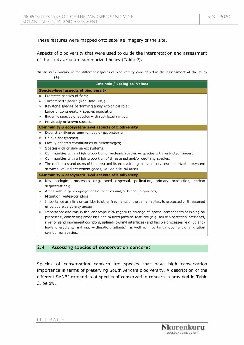
These features were mapped onto satellite imagery of the site.
Aspects of biodiversity that were used to guide the interpretation and assessment
of the study area are summarized below (Table 2).
Table 2: Summary of the different aspects of biodiversity considered in the assessment of the study
site.
Intrinsic / Ecological Values
Species-level aspects of biodiversity
» Protected species of flora;
» Threatened Species (Red Data List);
» Keystone species performing a key ecological role;
» Large or congregatory species population;
» Endemic species or species with restricted ranges;
» Previously unknown species.
Community & ecosystem-level aspects of biodiversity
» Distinct or diverse communities or ecosystems;
» Unique ecosystems;
» Locally adapted communities or assemblages;
» Species-rich or diverse ecosystems;
» Communities with a high proportion of endemic species or species with restricted ranges;
» Communities with a high proportion of threatened and/or declining species;
» The main uses and users of the area and its ecosystem goods and services: important ecosystem
services, valued ecosystem goods, valued cultural areas.
Community & ecosystem-level aspects of biodiversity
» Key ecological processes (e.g. seed dispersal, pollination, primary production, carbon
sequestration);
» Areas with large congregations or species and/or breeding grounds;
» Migration routes/corridors;
» Importance as a link or corridor to other fragments of the same habitat, to protected or threatened
or valued biodiversity areas;
» Importance and role in the landscape with regard to arrange of ‘spatial components of ecological
processes’, comprising processes tied to fixed physical features (e.g. soil or vegetation interfaces,
river or sand movement corridors, upland-lowland interfaces) and flexible processes (e.g. upland-
lowland gradients and macro-climatic gradients), as well as important movement or migration
corridor for species.
2.4 Assessing species of conservation concern:
Species of conservation concern are species that have high conservation
importance in terms of preserving South Africa's biodiversity. A description of the
different SANBI categories of species of conservation concern is provided in Table
3, below.

Proposed expansion of the zandberg sand mine
botanical STUDY AND ASSESSMENT
April 2020
1 2 | P a g e
Table 3: South African Red List Categories for species of conservation significance (adapted from
SANBI, on-line at http://redlist.sanbi.org/redcat.php).
Present State
Sp
ecie
s o
f C
on
serv
ati
on
Con
cern
Extinct (EX)
A species is Extinct when there is no reasonable doubt that the last individual
has died. Species should be classified as Extinct only once exhaustive surveys
throughout the species' known range have failed to record an individual.
Extinct in the Wild
(EW)
A species is Extinct in the Wild when it is known to survive only in cultivation or
as a naturalized population (or populations) well outside the past range.
Regionally Extinct
(RE)
A species is Regionally Extinct when it is extinct within the region assessed (in
this case South Africa), but wild populations can still be found in areas outside
the region.
Th
reate
ned
Sp
ecie
s
Critically
Endangered,
Possibly Extinct
(CR PE)
Possibly Extinct is a special tag associated with the category Critically
Endangered, indicating species that are highly likely to be extinct, but the
exhaustive surveys required for classifying the species as Extinct has not yet
been completed. A small chance remains that such species may still be
rediscovered.
Critically
Endangered (CR)
A species is Critically Endangered when the best available evidence indicates that
it meets at least one of the five IUCN criteria for Critically Endangered, indicating
that the species is facing an extremely high risk of extinction.
Endangered (EN) A species is Endangered when the best available evidence indicates that it meets
at least one of the five IUCN criteria for Endangered, indicating that the species
is facing a very high risk of extinction.
Vulnerable (VU) A species is Vulnerable when the best available evidence indicates that it meets
at least one of the five IUCN criteria for Vulnerable, indicating that the species is
facing a high risk of extinction.
Near Threatened
(NT)
A species is Near Threatened when available evidence indicates that it nearly
meets any of the IUCN criteria for Vulnerable, and is, therefore, likely to become
at risk of extinction in the near future.
Critically Rare A species is Critically Rare when it is known to occur at a single site, but is not
exposed to any direct or plausible potential threat and does not otherwise qualify
for a category of threat according to one of the five IUCN criteria.
Rare A species is Rare when it meets at least one of four South African criteria for
rarity, but is not exposed to any direct or plausible potential threat and does not
qualify for a category of threat according to one of the five IUCN criteria.
Declining A species is Declining when it does not meet or nearly meet any of the five IUCN
criteria and does not qualify for Critically Endangered, Endangered, Vulnerable
or Near Threatened, but there are threatening processes causing a continuing
decline of the species.
Data Deficient –
Insufficient
Information
(DDD)
A species is DDD when there is inadequate information to make an assessment
of its risk of extinction, but the species is well defined. Listing of species in this
category indicates that more information is required and that future research
could show that a threatened classification is appropriate.
Oth
er
Data Deficient –
Taxonomically
Problematic (DDT)
A species is DDT when taxonomic problems hinder the distribution range and
habitat from being well defined so that an assessment of risk of extinction is not
possible.
Least Concern
(LC)
A species is Least Concern when it has been evaluated against the IUCN criteria
and does not qualify for any of the above categories. Species classified as Least
Concern are considered at low risk of extinction. Widespread and abundant
species are typically classified in this category.

Proposed expansion of the zandberg sand mine
botanical STUDY AND ASSESSMENT
April 2020
1 3 | P a g e
Not Evaluated
(NE)
A species is Not Evaluated when it has not been evaluated against the criteria.
The national Red List of South African plants is a comprehensive assessment of
all South African indigenous plants, and therefore all species are assessed and
given a national Red List status. However, some species included in Plants of
southern Africa: an online checklist are species that do not qualify for national
listing because they are naturalized exotics, hybrids (natural or cultivated), or
synonyms. These species are given the status Not Evaluated and the reasons
why they have not been assessed are included in the assessment justification.
As mentioned, flora of conservation significance (including threatened, protected
and rare species) likely to occur in the various habitats of the study area were
assessed at a desktop level using the outputs of SANBI’s PRECIS (National
Herbarium Pretoria Computerized Information System) electronic database. This
information was used to identify potential habitats in the project area that could
support these species. Special attention was given to the identification of any Red
Data species as well as the identification of suitable habitat for Red Data species
observed during field investigations.
2.5 Ecological Mapping
Mapping has been done by comparing georeferenced ground survey data to the
visual inspection of available Google-Earth Imagery (which is a generalised colour
composite image without any actual reflectance data attached to it) and in that way
extrapolating survey reference points to the entire study area. Delineations are
therefore approximate, and due to the intricate mosaics and often gradual mergers
of vegetation units, generalisations had to be made. Mapped units will thus show
where a certain vegetation unit is predominant, but smaller inclusions of another
vegetation type in this area do exist but have not been mapped separately. The
latter would require a supervised classification of georeferenced raw SPOT or
similar satellite imagery (with all reflectance data), which has not been available to
this project due to the high cost of such imagery. Maps were created with QGIS
(version 3.4.13).
2.6 Sensitivity Analysis and Criteria
The determination of specific ecosystem services and the sensitivity of ecosystem
components, both biotic and abiotic, is rather complex and no single overarching
criterion will apply to all habitats studied. The main aspects of an ecosystem that
need to be incorporated in a sensitivity analysis, however, include the following:
» Describing the nature and number of species present, taking into consideration
their conservation value as well as the probability of such species to survive or

Proposed expansion of the zandberg sand mine
botanical STUDY AND ASSESSMENT
April 2020
1 4 | P a g e
re-establish itself following disturbances, and alterations to their specific
habitats, of various magnitudes
» Identifying the species or habitat features that are ‘key ecosystem providers’
and characterising their functional relationships (Kremen 2005)
» Determining the aspects of community structure that influence function,
especially aspects influencing stability or rapid decline of communities (Kremen
2005)
» Assessing key environmental factors that influence the provision of services
(Kremen 2005)
» Gaining knowledge about the spatial-temporal scales over which these aspects
operate (Kremen 2005).
This implies that in the sensitivity analysis not only aspects that currently prevail
on the area should be taken into consideration, but also if there is a possibility of
a full restoration of the original environment and its biota, or at least the
rehabilitation of ecosystem services resembling the original state after an area has
been significantly disturbed.
According to the above, sensitivity classes have been summarised as follows:
» Very High Sensitivity: Areas that contain critical and/or unique habitats have
a very high sensitivity; such areas usually serve as habitats for rare/endangered
species or perform critical and irreplaceable ecological roles. Very high sensitivity
areas are no-go areas and developments in such areas should be avoided at all
costs.
» High Sensitivity: High sensitivity areas are those that usually have a high
biodiversity value or important ecological roles, and it is expected that impacts
on such areas will likely be high; these areas include natural or transformed
land. It might be difficult to mitigate all impacts appropriately in high sensitivity
areas, and thus development within these areas is undesirable and should
proceed with caution.
» Medium Sensitivity: The impacts on medium sensitivity areas are likely to be
mostly local with the risk of secondary impacts (such as erosion) being low;
these areas include natural or previously transformed land. On the condition that
appropriate mitigation measures are implemented, development within medium
sensitivity areas will have relatively little ecological impact.
» Low Sensitivity: The impact on ecological processes and plant diversity in a
low sensitivity area is likely to be negligible. Areas of low sensitivity are those
areas where natural vegetation has already been transformed, for example as a
result of intensive agricultural practices such as crop production. The majority
of developments would have little ecological impact in low sensitivity areas.

Proposed expansion of the zandberg sand mine
botanical STUDY AND ASSESSMENT
April 2020
1 5 | P a g e
2.7 Impact Assessment Methodology
The assessment methodology is in accordance with the recently revised 2014 EIA
regulations. The significance of environmental impacts is a function of the
environmental aspects that are present and to be impacted on, the probability of
an impact occurring and the consequence of such an impact occurring before and
after implementation of proposed mitigation measures.
The significance of environmental impacts is to be assessed by means of the criteria
of extent (scale), duration, magnitude (severity), probability (certainty) and
direction (negative, neutral or positive).
» The nature, which includes a description of what causes the effect, what will
be affected and how it will be affected.
» The extent, wherein it is indicated whether the impact will be local (limited to
the immediate area or site of development) or regional, and a value between 1
and 5 is assigned as appropriate (with 1 being low and 5 being high).
» The duration, wherein it was indicated whether:
the lifetime of the impact will be of a very short duration (0 – 1 year) –
assigned a score of 1;
the lifetime of the impact will be of short duration (2 – 5 years) – assigned
a score of 2;
medium-term (5 -15 years) – assigned a score of 3;
long term (> 15 years) – assigned a score of 4; or
permanent – assigned a score of 5.
» The magnitude, quantified on a scale from 0 – 10, where 0 is small and will
have no effect on the environment, 2 is minor and will not result in an impact
on processes, 4 is low and will cause a slight impact on processes, 6 is moderate
and will result in processes continuing but in a modified way, 8 is high
(processes are altered to the extent that they temporarily cease), and 10 is
very high and results in complete destruction of patterns and permanent
cessation of processes.
» The probability of occurrence, which describes the likelihood of the impact
actually occurring. Probability is estimated on a scale of 1 – 5, where 1 is very
improbable (probably will not happen), 2 is improbable (some possibility, but
low likelihood), 3 is probable (distinct possibility), 4 is highly probable (most
likely) and 5 is definite (impact will occur regardless of any prevention
measures).
» The significance is determined through a synthesis of the characteristics
described above and can be assessed as LOW, MEDIUM or HIGH; and
» the status, which was described as either positive, negative or neutral;

Proposed expansion of the zandberg sand mine
botanical STUDY AND ASSESSMENT
April 2020
1 6 | P a g e
» the degree of which the impact can be reversed;
» the degree to which the impact may cause irreplaceable loss of resources; and
» the degree to which the impact can be mitigated.
The significance is calculated by combining the criteria in the following formula:
S=(E+D+M)P where;
» S = Significance weighting
» E = Extent
» D = Duration
» M = Magnitude
» P = Probability
The significance weightings for each potential impact are as follows;
» < 30 points: LOW (i.e. where the impact would not have a direct influence on
the decision to develop in the area),
» 30 – 60 points: MEDIUM (i.e. where the impact could influence the decision to
develop in the area unless it is effectively mitigated),
» > 60 points: HIGH (i.e. where the impact must have an influence on the
decision process to develop in the area).
2.8 Assumptions and Limitations
This report deals exclusively with a defined area and the impacts upon flora
biodiversity and natural ecosystems in that area.
» All relevant project information provided by the applicant and engineering
design team to the ecological specialist was correct and valid at the time that it
was provided.
» Probably the most significant potential limitation associated with such a
sampling approach is the narrow temporal window of sampling.
Temporal variation plays an important role in the structure and patterns of
plant biodiversity, plant communities, and plant species occurrences. As
such, a single site visit may therefore not fully catalogue all plant species
diversity in an area, for example due to seasonal variation of vegetation,
since the temporal window of sampling is narrow. Thus, the ideal situation
would be to visit a site several times during different seasons, which would
ensure that most, if not all, plant species present are observed and
recorded. However, time and cost constraints make multiple site visits
nearly impossible, and the species observed and recorded at the time of the

Proposed expansion of the zandberg sand mine
botanical STUDY AND ASSESSMENT
April 2020
1 7 | P a g e
site visit should therefore be critically evaluated as they might not fully
represent the complete plant community.
Indeed, the site was surveyed during one of the driest months of the year,
namely January. This, together with the fact that the area has experienced
a prolonged drought with below average rainfall for the past seven years,
means that some annual, short-lived, ephemeral (plants surviving
unfavourable conditions as seeds), geophytic (species with underground
storage organs), or other cryptic species may not have been
observed/detected, especially those that completely die back during
dormancy. Furthermore, flowers and fruits are crucial for the complete and
accurate identification of plant species and any absence of such flowers and
fruits might therefore prevent the complete and accurate identification of
such plant species (for example species of the family Aizoaceae). Flowering
and fruiting times are both species specific and conditional on certain
environmental cues being met (for example adequate rainfall), and there
were thus invariably some plant species that were not flowering and/or
fruiting during the period in which the site visit was conducted. Due to the
aforementioned potential limitations, a list of protected or endangered
species known to occur in the area was used to supplement the list of species
observed and recorded during the site visit. This combined list is sufficiently
conservative and cautious to account for the study limitations.
3. THE IMPORTANCE OF BIODIVERSITY AND
CONSERVATION
The term ‘Biodiversity’ is used to describe the wide variety (richness and
abundance) of plant and animal species occurring in their natural environment or
‘habitat’. Biodiversity encompasses not only all living things but also the series of
interactions that sustain them, which are termed ‘ecological processes. South
Africa’s biodiversity provides an important basis for economic growth and
development; and keeping our biodiversity intact is vital for ensuring the on-going
provision of ecosystem services, such as the production of clean water through
good catchment management. The role of biodiversity in combating climate change
is also well recognised and further emphasises the key role that biodiversity
management plays on a global scale (Driver et al., 2012). Typical pressures that
natural ecosystems face from human activities include the loss and degradation of
natural habitat, invasive alien species, pollution and waste and climate change
(Driver et al.,2012). High levels of infrastructural and agricultural development
typically restrict the connectivity of natural ecosystems, and maintaining

Proposed expansion of the zandberg sand mine
botanical STUDY AND ASSESSMENT
April 2020
1 8 | P a g e
connectivity is considered critical for the long-term persistence both ecosystems
and species, in the face of human development and global climatic change. Loss of
biodiversity puts aspects of our economy and quality of life at risk and reduces
socioeconomic options for future generations as well. In essence, then, sustainable
development is not possible without biodiversity.
4. DESCRIPTION OF THE AFFECTED ENVIRONMENT -
BASELINE
4.1 Broad-Scale Vegetation Patterns
The majority of the site is mapped as Breede Sand Fynbos (FFd 8), with a smaller
section of North Sonderend Sandstone Fynbos (FFs 13) towards the western- and
south-western boundary (Mucina & Rutherford, 2006) (Figure 4). Units are
described separately below.
Figure 4: Map illustrating the different vegetation units found within the region.

Proposed expansion of the zandberg sand mine
botanical STUDY AND ASSESSMENT
April 2020
1 9 | P a g e
Breede Sand Fynbos (FFd 8):
The unit overall is very fragmented and occurs as dune plumes and dune seas in
the valley bottoms primarily south of the Breede River, and extends up the sides
of adjacent hills. The vegetation characteristic of this consists of open proteoid tall
shrubland combined with an open to medium dense restioid herbland in
undergrowth. The dominant components are proteoid and restioid fynbos. Soils are
of recent aeolian sand accumulations of riverine origin (Breede River).
The unit comprises only about 97 km2 of land area and is classified as Vulnerable,
since its conservation target is 30%, but none of the unit is conserved in statutory
conservation areas, while only 2% is protected in the Hawequas and Quaggas Berg
Private Nature Reserves. Furthermore, some 45% of the area has been
transformed, mainly for agriculture and by building of the Brandviei and
Kwaggaskloof Dams. In fact, the largest patch of this unit is now almost entirely
under water of these reservoirs. Low levels of infestation by alien Eucalyptus,
Acacia saligna and Hakea sericea have been recorded.
Breede Sand Fynbos is a poorly studied vegetation unit. This, together with high
levels of fragmentation, the non-existence of statutory conserved areas of the unit,
and the moderate level of transformation of the unit, makes it a conservation
priority.
Table 4: Key species associated with the Breede Sand Fynbos according to Mucina and Rutherford (2006).
DOMINANT SPECIES
Growth Form Key Species
Tall shrubs Leucospermum rodolentum (dominant), Metalasia densa, Protea
laurifolia
Low shrubs
Afrolimon longifolium, Aspalathus heterophylla, Euchaetis pungens,
Lachnospermum fasciculatum, Leucadendron brunioides var.
brunioides, L. salignum, Wiborgia fusca
Succulent shrub Ruschia caroli
Herbs Pelargonium senecioides
Geophytic Herb Romulea setifolia
Graminoids Cynodon dactylon, Ehrharta villosa var. villosa, Ficinia lateralis,
Willdenowia incurvata
ENDEMIC SPECIES
Growth Form Key Species

Proposed expansion of the zandberg sand mine
botanical STUDY AND ASSESSMENT
April 2020
2 0 | P a g e
Geophytic herb Ixia pumilio
North Sonderend Sandstone Fynbos (FFs 13):
This unit is distributed from the northern slopes of the Riviersonderend Mountains
from Villiersdorp to Bromberg and Luiperdsberg east of Stormsvlei, including
Klipberg and Sandberg towards Robertson. Its altitudinal range is from 150 m to
peaks exceeding 1 600 m (Jonaskop, Pilaarkop and an unnamed peak).
The unit consists of gentle to steep north-facing slopes, highly dissected in a few
places, with a midslope sandy plateau and extensive gentle lower slopes. The
vegetation is an open, tall, proteoid-leaved evergreen shrubland with a dense
moderately tall, ericoid-leaved shrubland as understorey. While extensive proteoid
and restioid fynbos dominate the middle slopes, the unit is mainly comprised of
asteraceous fynbos on the western and lower slopes. Ericaceous fynbos is restricted
to the highest peaks. The deep sand habitat of the northern plateau is a distinctive
feature associated with many endemic species. Lithosol soils in this unit are derived
from Ordovician sandstones of the Table Mountain Group (Cape Supergroup).
The unit comprises only about 531 km2 of land area and is classified Least
Threatened. The conservation target is 30%, and 21% of the unit is statutorily
conserved in the Riviersonderend Nature Reserve, with an additional 51% mainly
in a private conservation area of the same name. The unit thus enjoys a high level
of conservation. Furthermore, about 2% has been transformed by cultivation for
protea nurseries and fruit orchards, specifically occurring on the deep sand habitat
of the northern plateau which supports many threatened taxa. Alien Pinus pinaster
and Hakea sericea occasionally occur over about half of the area.
The northern slopes of the Riviersonderend Mountains are a poorly explored area.
Data suggest that this unit, together with South Sonderend Sandstone Fynbos (FFs
14), form the centre of specific diversity in Proteaceae, especially for the genus
Serruria, which may also be the case for other genera and families after further
exploration. The genus Endonema (Penaeaceae) is endemic to the Riviersonderend.
Key species associated with the North Sonderend Sandstone Fynbos according to Mucina and Rutherford (2006).
DOMINANT SPECIES
Growth Form Key Species
Small trees Acacia karroo, Cunonia capensis, Metrosideros angustifolia, Protea
nitida

Proposed expansion of the zandberg sand mine
botanical STUDY AND ASSESSMENT
April 2020
2 1 | P a g e
Tall shrubs Protea neriifolia, P. repens, Polygala fruticosa, Protea laurifolia, Searsia
pyroides
Low shrubs
Agathosma leptospermoides, Athanasia oocephala, Cliffortia ruscifolia,
Elytropappus glandulosus, Erica denticulata, E. globiceps subsp.
zeyheri, E. jonasiana, E. lateralis, E. modesta, E. plukenetii subsp.
plukenetii, E. serrata, E. taxifolia, E. vestita, Leucadendron laureolum,
L. microcephalum, L. salignum, Leucospermum calligerum, Muraltia
ferox, Paranomus adiantifolius, P. capitatus, Passerina burchelii,
Phaenocoma prolifera, Prismatocarpus lycioides, Protea amplexicaulis,
P. cynaroides, P. humiflora, P lorifolia, P. scabra, P. subulifolia,
Serurria gremialis, S. viridifolia, Stoebe spiralis
Succulent shrubs Drosanthemum leptum, Ruschia acutangula
Herbs Edmondia sesamoides, Ursinia oreogena
Geophytic herb Gladiolus atropictus
Graminoids
Ehrharta ramosa subsp. aphylla, Hypodiscus squamosus, H. striatus,
Ischyrolepis capensis, I. distracta, I. gaudichaudiana, Pentaschistis
eriostoma, Restio filiformis, Thamnochortus cinereus
ENDEMIC SPECIES
Growth Form Key Species
Low shrubs Leucadendron burchellii, L. immoderatum, L. nervosum, Leucospermum
harpagonatum, Serruria stellata, S. williamsii, Spatalla argentea
BODATSA species observations
A species list from the SANBI database (POSA) containing the species that have
been recorded to date within the surroundings of the study area was compiled.
POSA generated species lists also contain updated Red Data species status
according to the Red List of South African Plants published by SANBI in Strelitzia
25 (Raimondo et al. 2009, updated 2013). Only protected and red data species
that may potentially occur in the study area have been listed within the baseline
study section of this report. The actual field survey confirmed which of the species
recorded in the region actually occurs within the study area, and also indicates the
presence of additional species that may not yet have been recorded in official
databases.
A total of 1866 species have been recorded within the broader area based on the
online plant search. Due to the fact that the impacted habitat type (sand dune)
occurs as relatively small, scattered geographical patches within the region, plant
species from two similar locations were extracted.
Ground truthing of the site confirmed a total of 63 plant species present.

Proposed expansion of the zandberg sand mine
botanical STUDY AND ASSESSMENT
April 2020
2 2 | P a g e
From online data, the shrub and dwarf shrub layers were well represented with a
high species diversity (dwarf shrubs = 426 species; shrubs = 504 species), similarly
the lower herb/forb layer was also high in diversity with 397 species recorded in
the broad region. As would be expected for this type of fynbos the graminoid layer
was lower in species diversity and is primarily represented by restioids (it is
expected that even though restioids are lower in species diversity, these species
would be relatively high in cover abundance). Geophytic and succulent growth
forms are also a prominent feature within the broader areas (geophytes = 246
species recorded; succulents = 213 species recorded).
Prominent families, in terms of species diversity, recorded within the extracted
areas includes:
» Asteraceae: 252 species;
» Ericaceae: 162 species;
» Fabaceae: 141 species;
» Iridaceae: 111 species;
» Proteaceae: 90 species;
» Aizoaceae: 89 species;
» Scrophulariaceae: 62 species; and
» Restionaceae: 54 species
Another unique feature of these areas is the high number of South African endemics
with a total of 1365 (73%) SA endemics recorded. High numbers of endemics were
observed with the plant families Aizoaceae, Asphodelaceae, Asteraceae, Ericaceae,
Iridaceae, Gerinaceae, Restionaceae and Proteaceae.
Furthermore, only 39 non-indigenous plant species were recorded within the
extracted areas with 19 species being invasive. Of these 19 species, 10 species
are listed within NEM:BA Act No. 10 of 2004 (Alien and Invasive Species List, 2016)
namely;
» Acacia saligna (Fabaceae): Category 1b
» Echium plantagineum (Borainaceae): Category 1b;
» Eucalyptus camaldulensis (Myrtaceae): Category 1b within fynbos;
» Leptospermum laevigatum (Myrtaceae): Category 1b;
» Orobanche ramosa (Orobanchaceae): Category 1b;
» Ricinus communis (Euphorbiaceae): Category 2;
» Salsola kali (Amaranthaceae): Category 1b
» Schinus molle (Anacardiaceae): Category 3;
» Sesbania punicea (Fabaceae): Category 1b;
» Xanthium strumarium (Asteraceae): Category 1b
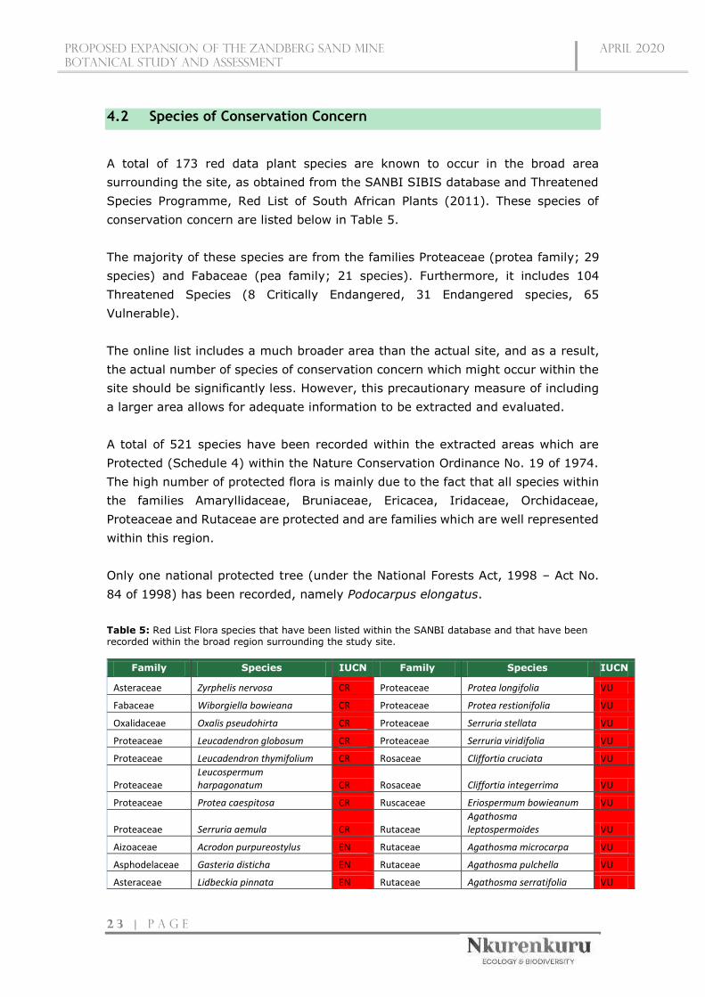
Proposed expansion of the zandberg sand mine
botanical STUDY AND ASSESSMENT
April 2020
2 3 | P a g e
4.2 Species of Conservation Concern
A total of 173 red data plant species are known to occur in the broad area
surrounding the site, as obtained from the SANBI SIBIS database and Threatened
Species Programme, Red List of South African Plants (2011). These species of
conservation concern are listed below in Table 5.
The majority of these species are from the families Proteaceae (protea family; 29
species) and Fabaceae (pea family; 21 species). Furthermore, it includes 104
Threatened Species (8 Critically Endangered, 31 Endangered species, 65
Vulnerable).
The online list includes a much broader area than the actual site, and as a result,
the actual number of species of conservation concern which might occur within the
site should be significantly less. However, this precautionary measure of including
a larger area allows for adequate information to be extracted and evaluated.
A total of 521 species have been recorded within the extracted areas which are
Protected (Schedule 4) within the Nature Conservation Ordinance No. 19 of 1974.
The high number of protected flora is mainly due to the fact that all species within
the families Amaryllidaceae, Bruniaceae, Ericacea, Iridaceae, Orchidaceae,
Proteaceae and Rutaceae are protected and are families which are well represented
within this region.
Only one national protected tree (under the National Forests Act, 1998 – Act No.
84 of 1998) has been recorded, namely Podocarpus elongatus.
Table 5: Red List Flora species that have been listed within the SANBI database and that have been recorded within the broad region surrounding the study site.
Family Species IUCN Family Species IUCN
Asteraceae Zyrphelis nervosa CR Proteaceae Protea longifolia VU
Fabaceae Wiborgiella bowieana CR Proteaceae Protea restionifolia VU
Oxalidaceae Oxalis pseudohirta CR Proteaceae Serruria stellata VU
Proteaceae Leucadendron globosum CR Proteaceae Serruria viridifolia VU
Proteaceae Leucadendron thymifolium CR Rosaceae Cliffortia cruciata VU
Proteaceae Leucospermum harpagonatum CR Rosaceae Cliffortia integerrima VU
Proteaceae Protea caespitosa CR Ruscaceae Eriospermum bowieanum VU
Proteaceae Serruria aemula CR Rutaceae Agathosma leptospermoides VU
Aizoaceae Acrodon purpureostylus EN Rutaceae Agathosma microcarpa VU
Asphodelaceae Gasteria disticha EN Rutaceae Agathosma pulchella VU
Asteraceae Lidbeckia pinnata EN Rutaceae Agathosma serratifolia VU

Proposed expansion of the zandberg sand mine
botanical STUDY AND ASSESSMENT
April 2020
2 4 | P a g e
Asteraceae Stoebe rugulosa EN Rutaceae Agathosma trichocarpa VU
Bruniaceae Brunia esterhuyseniae EN Rutaceae Diosma passerinoides VU
Campanulaceae Merciera brevifolia EN Rutaceae Diosma pilosa VU
Ericaceae Erica modesta EN Rutaceae Euchaetis pungens VU
Ericaceae Erica oakesiorum EN Stilbaceae Stilbe serrulata VU
Fabaceae Aspalathus candicans EN Thymelaeaceae Lachnaea grandiflora VU
Fabaceae Aspalathus wurmbeana EN Aizoaceae Brianhuntleya intrusa NT
Geraniaceae Pelargonium violiflorum EN Aizoaceae Drosanthemum calycinum NT
Hyacinthaceae Lachenalia physocaulos EN Asphodelaceae Trachyandra filiformis NT
Hyacinthaceae Lachenalia stayneri EN Asteraceae Lachnospermum neglectum NT
Iridaceae Freesia marginata EN Asteraceae Metalasia adunca NT
Iridaceae Geissorhiza geminata EN Boraginaceae Lobostemon gracilis NT
Iridaceae Ixia atrandra EN Euphorbiaceae Euphorbia nesemannii NT
Iridaceae Ixia collina EN Fabaceae Aspalathus lactea NT
Iridaceae Ixia pumilio EN Fabaceae Cyclopia genistoides NT
Iridaceae Moraea radians EN Fabaceae Lotononis prostrata NT
Orchidaceae Disa hallackii EN Fabaceae Wiborgia tenuifolia NT
Penaeaceae Endonema lateriflora EN Geraniaceae Pelargonium divisifolium NT
Plumbaginaceae Limonium purpuratum EN Hyacinthaceae Lachenalia contaminata NT
Polygalaceae Muraltia gillettiae EN Iridaceae Babiana fragrans NT
Proteaceae Leucospermum formosum EN Iridaceae Babiana stricta NT
Proteaceae Mimetes argenteus EN Iridaceae Freesia caryophyllacea NT
Proteaceae Protea lacticolor EN Iridaceae Watsonia aletroides NT
Proteaceae Serruria incrassata EN Polygalaceae Muraltia concava NT
Proteaceae Serruria williamsii EN Polygalaceae Muraltia trinervia NT
Proteaceae Spatalla argentea EN Proteaceae Aulax pallasia NT
Ruscaceae Eriospermum vermiforme EN Proteaceae Aulax umbellata NT
Rutaceae Diosma parvula EN Proteaceae Leucadendron burchellii NT
Aizoaceae Antimima leipoldtii VU Proteaceae Leucadendron nervosum NT
Aizoaceae Drosanthemum giffenii VU Proteaceae Leucadendron teretifolium NT
Aizoaceae Drosanthemum striatum VU Proteaceae Protea coronata NT
Aizoaceae Erepsia oxysepala VU Proteaceae Protea cryophila NT
Aizoaceae Stayneria neilii VU Proteaceae Protea effusa NT
Apiaceae Centella thesioides VU Proteaceae Protea scabra NT
Apocynaceae Duvalia elegans VU Proteaceae Serruria elongata NT
Apocynaceae Stapelia paniculata VU Proteaceae Serruria fasciflora NT
Apocynaceae Stapeliopsis breviloba VU Proteaceae Spatalla curvifolia NT
Asphodelaceae Astroloba rubriflora VU Rhamnaceae Phylica nigrita NT
Asteraceae Anaxeton brevipes VU Rutaceae Agathosma foetidissima NT
Asteraceae Anaxeton hirsutum VU Rutaceae Diosma pedicellata NT
Asteraceae Berkheya angusta VU Thymelaeaceae Lachnaea filicaulis NT
Asteraceae Metalasia tenuis VU Aizoaceae Antimima microphylla DD
Bruniaceae Brunia latebracteata VU Aizoaceae Drosanthemum albiflorum DD
Colchicaceae Colchicum hughocymbion VU Aizoaceae Drosanthemum collinum DD
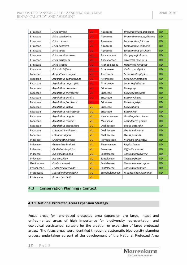
Proposed expansion of the zandberg sand mine
botanical STUDY AND ASSESSMENT
April 2020
2 5 | P a g e
Ericaceae Erica alfredii VU Aizoaceae Drosanthemum globosum DD
Ericaceae Erica caledonica VU Aizoaceae Drosanthemum papillatum DD
Ericaceae Erica colorans VU Aizoaceae Lampranthus falcatus DD
Ericaceae Erica floccifera VU Aizoaceae Lampranthus leipoldtii DD
Ericaceae Erica ignita VU Aizoaceae Lampranthus occultans DD
Ericaceae Erica insolitanthera VU Apocynaceae Ceropegia fimbriata DD
Ericaceae Erica pilosiflora VU Apocynaceae Tavaresia meintjesii DD
Ericaceae Erica sicifolia VU Asphodelaceae Haworthia herbacea DD
Ericaceae Erica viscidiflora VU Asteraceae Curio crassulifolius DD
Fabaceae Amphithalea pageae VU Asteraceae Senecio coleophyllus DD
Fabaceae Aspalathus acanthoclada VU Asteraceae Senecio erysimoides DD
Fabaceae Aspalathus angustifolia VU Asteraceae Senecio glutinarius DD
Fabaceae Aspalathus araneosa VU Ericaceae Erica greyi DD
Fabaceae Aspalathus chrysantha VU Ericaceae Erica haemastoma DD
Fabaceae Aspalathus excelsa VU Ericaceae Erica involvens DD
Fabaceae Aspalathus florulenta VU Ericaceae Erica longistyla DD
Fabaceae Aspalathus lactea VU Ericaceae Erica ostiaria DD
Fabaceae Aspalathus macrocarpa VU Ericaceae Erica ovina DD
Fabaceae Aspalathus pinguis VU Hyacinthaceae Ornithogalum niveum DD
Fabaceae Aspalathus recurva VU Malvaceae Anisodontea gracilis DD
Fabaceae Aspalathus steudeliana VU Oxalidaceae Oxalis leptocalyx DD
Fabaceae Lotononis involucrata VU Oxalidaceae Oxalis lindaviana DD
Fabaceae Lotononis rigida VU Oxalidaceae Oxalis pardalis DD
Iridaceae Chasmanthe bicolor VU Polygalaceae Muraltia schlechteri DD
Iridaceae Geissorhiza brehmii VU Rhamnaceae Phylica lucens DD
Iridaceae Gladiolus atropictus VU Rosaceae Cliffortia varians DD
Iridaceae Ixia dolichosiphon VU Santalaceae Thesium brachygyne DD
Iridaceae Ixia vanzijliae VU Santalaceae Thesium frisea DD
Oxalidaceae Oxalis meisneri VU Santalaceae Thesium microcarpum DD
Penaeaceae Endonema retzioides VU Santalaceae Thesium repandum DD
Proteaceae Leucadendron galpinii VU Scrophulariaceae Pseudoselago burmannii DD
Proteaceae Protea burchellii VU
4.3 Conservation Planning / Context
4.3.1 National Protected Areas Expansion Strategy
Focus areas for land-based protected area expansion are large, intact and
unfragmented areas of high importance for biodiversity representation and
ecological persistence, suitable for the creation or expansion of large protected
areas. The focus areas were identified through a systematic biodiversity planning
process undertaken as part of the development of the National Protected Area

Proposed expansion of the zandberg sand mine
botanical STUDY AND ASSESSMENT
April 2020
2 6 | P a g e
Expansion Strategy 2008 (NPAES). They present the best opportunities for meeting
the ecosystem-specific protected area targets set in the NPAES and were designed
with a strong emphasis on climate change resilience and requirements for
protecting freshwater ecosystems. These areas should not be seen as future
boundaries of protected areas, since in many cases only a portion of a particular
focus area would be required to meet the protected area targets set in the NPAES.
They are also not a replacement for fine-scale planning which may identify a range
of different priority sites based on local requirements, constraints, and
opportunities.
The proposed expansion is located outside of any NPAES Areas (Figure 5) as well
as any Formal Protected, and Informal Protected Areas. The nearest NPAES Area
is located approximately 1.03 km south-east (Vrolijkheid), whilst the nearest
Informal Protected Area is located ±7.8 km south-west (Skuilkrans Private Nature
Reserve). The nearest Formal Protected Area, the Langeberg-Wes Mountain
Catchment Area, is located 7.6 km north of the project site.
Subsequently this development will not have an impact on the national ecosystem-
specific protected area targets.
4.3.2 National Level of Conservation Priorities (Threatened Ecosystems)
The vegetation types of South Africa have been categorized according to their
conservation status which is, in turn, assessed according to the degree of
transformation and rates of conservation. The status of a habitat or vegetation
type is based on how much of its original area still remains intact relative to various
thresholds. On a national scale, these thresholds are as depicted in the table below,
as determined by the best available scientific approaches (Driver et al. 2005). The
level at which an ecosystem becomes Critically Endangered differs from one
ecosystem to another and varies from 16% to 36% (Driver et al. 2005).
Table 6: Determining ecosystem status (from Driver et al. 2005). *BT = biodiversity target (the
minimum conservation requirement).
A national process has been undertaken to identify and list threatened ecosystems
that are currently under threat of being transformed by other land uses. The first
national list of threatened terrestrial ecosystems for South Africa was gazetted on
9 December 2011 (National Environmental Management: Biodiversity Act or

Proposed expansion of the zandberg sand mine
botanical STUDY AND ASSESSMENT
April 2020
2 7 | P a g e
NEMBA: National list of ecosystems that are threatened and in need of protection,
G 34809, GoN 1002, 9 December 2011). The purpose of listing threatened
ecosystems is primarily to reduce the rate of ecosystem and species extinction by
preventing further degradation and loss of structure, function, and composition of
threatened ecosystems (SANBI, 2011). The NEMBA provides for listing of
threatened or protected ecosystems, in one of four categories: critically
endangered (CR), endangered (EN), vulnerable (VU) or protected. There are four
main types of implications of listing ecosystems:
» Planning related implications which are linked to the requirement in the
Biodiversity Act (Act 10 of 2004) for listed ecosystems to be taken into account
in municipal IDPs and SDFs;
» Environmental authorisation implications in terms of NEMA and the EIA
regulations;
» Proactive management implications in terms of the National Biodiversity Act;
» Monitoring and reporting implications in terms of the Biodiversity Act.
The proposed mining site is located within two vegetation units according to Mucina
and Rutherford (2006), namely Breede Sand Fynbos and North Sonderend
Sandstone Fynbos. Currently, the first unit, namely Breede Sand Fynbos, is
classified as Vulnerable (Figure 5), since only 2% is protected in the Hawequas and
Quaggas Berg Private Nature Reserves, while none of the unit is conserved in
statutory conservation areas, and some 45% of the area has been transformed.
Thus, the conservation target of 30% is likely attainable, but will probably not be
realized since only 2% is currently protected. The second unit, namely North
Sonderend Sandstone Fynbos, is classified as Least Threatened, since 21% of the
30% conservation target is statutorily conserved in the Riviersonderend Nature
Reserve, with an additional 51% mainly in a private conservation area of the same
name, while only low levels of transformation has occurred.
Furthermore, this site falls within a broader area which is also listed (Figures 5)
within the Threatened Ecosystem List, 2012 (NEMA:BA) as a Vulnerable Ecosystem
(Breede Sand Fynbos Ecosystem) and correlates with the Breede Sand Fynbos
Vegetation Type as classified by Mucina and Rutherford, 2012. This ecosystem is
very fragmented, occurring as dune plumes and dune seas in the valley bottoms
primarily south of the Breed River and cover a total combined area of approximately
9 000 ha.
The project site is located on a dune plume (Breede Sand Fynbos) that covers an
area of approximately 597ha. Due to the low agricultural and developmental
potential of this dune plume most of this ecosystem is largely intact with minimal
disturbance and transformation (mostly associated with the foot of the dune in the

Proposed expansion of the zandberg sand mine
botanical STUDY AND ASSESSMENT
April 2020
2 8 | P a g e
form of roads, small farm dams and the existing mining area), mostly containing a
stable climatic vegetation cover providing stability to the highly dispersive sand
plume. Small isolated patches of this sand plume / dune contain unstable areas
with a sparse vegetation cover.
Due to the high impact nature of the proposed mining activities, which essentially
removes all vegetation as well as the majority of topsoil, leaving an area with
minimal rehabilitation potential (in terms of rehabilitation of a vegetation cover that
resembles the original natural vegetation cover that was removed), this
development will result in the local loss of some functions and services. However,
the area that will be transformed will only cover 2.92% of total area of this sand
plume. Furthermore, when taking into account the total combined size of all such
dune plumes and dune seas that are covered by the Breede Sand Fynbos
Vegetation Type / Ecosystem an area of less than 1% (0.19% of 9277 ha) of this
vegetation type / ecosystem will be impacted. Subsequently it is unlikely that this
development will influence the status of this vegetation type / ecosystem.
Table 7: Conservation status of the vegetation type occurring in and around the study area.
Vegetation Type Target
(%)
Transformed
(%)
Conserved
(Statutorily
& other
reserves)
Conservation Status
Driver et al.,
2005; Mucina &
Rutherford, 2006
National
Ecosystem
List
(NEMA:BA)
Breede Sand Fynbos 30% 45% 2% Vulnerable Vulnerable
North Sonderend
Sandstone Fynbos
30% 2% 72% Least Threatened Not Listed

Proposed expansion of the zandberg sand mine
botanical STUDY AND ASSESSMENT
April 2020
2 9 | P a g e
Figure 5: Map illustrating the various conservation priority areas found within the greater surroundings of the proposed mining site.

Proposed expansion of the zandberg sand mine
botanical STUDY AND ASSESSMENT
April 2020
3 0 | P a g e
4.3.3 Critical Biodiversity Areas and Broad Scale Ecological Processes
Critical Biodiversity Areas have been identified for all municipal areas of the
Western Cape Province (CapeNature, 2017) and are published on the SANBI
website (bgis.sanbi.org). This biodiversity assessment identifies CBAs which
represent biodiversity priority areas that should be maintained in a natural to near-
natural state. The CBA maps indicate the most efficient selection and classification
of land portions requiring safeguarding in order to maintain ecosystem functioning
and meet national biodiversity objectives (refer to Table 8 for the different land
management objectives set out for each CBA category). According to these maps,
large tracks of land within the region falls either within Critical Biodiversity Areas 2
(CBA2) or Ecological Support Areas (ESA).
The entire mining footprint is located almost entirely within a CBA1, together with
some randomly scattered pixels of CBA2, and a small unclassified portion (Figure
6). The insignificant and random nature of the CBA2 pixels are likely a side-effect
of the algorithm used to generate the CBA spatial layers, and ground-truthing
confirmed the entire site to conform to CBA1 criteria, including the portion not
originally classified. Areas classified as CBA1 are regarded as "areas in a natural
condition that are required to meet biodiversity targets, for species, ecosystems or
ecological processes and infrastructure" (WCSBP 2017). Thus, CBA1 areas are in a
natural condition (or nearly so), with little to no transformation and no secondary
vegetation. The desired outcome for such areas is to maintain them "in a natural
or near natural state, with no further loss of habitat", and only "low-impact,
biodiversity-sensitive land uses" are appropriate.
Table 8: Relationship between Critical Biodiversity Areas categories (CBAs) and land management
objectives
CBA
category Land Management Objective
Protected
Areas (PA)
& CBA 1
Natural landscapes:
» Ecosystems and species are fully intact and undisturbed.
» These are areas with high irreplaceability or low flexibility in terms of meeting
biodiversity pattern targets. If the biodiversity features targeted in these areas
are lost then targets will not be met.
» These are landscapes that are at or past their limits of acceptable change.
CBA 2 Near-natural landscapes:
» Ecosystems and species largely intact and undisturbed.
» Areas with intermediate irreplaceability or some flexibility in terms of the area
required to meet biodiversity targets. There are options for loss of some
components of biodiversity in these landscapes without compromising the
ability to achieve targets.
» These are landscapes that are approaching but have not passed their limits of
acceptable change.

Proposed expansion of the zandberg sand mine
botanical STUDY AND ASSESSMENT
April 2020
3 1 | P a g e
ESA Functional landscapes:
» Ecosystem moderately to significantly disturbed but still able to maintain basic
functionality.
» Individual species or other biodiversity indicators may be severely disturbed or
reduced.
» These are areas with low irreplaceability with respect to biodiversity pattern
targets only.
ONA (Other
Natural
Areas) and
Transformed
Production landscapes:
Manage land to optimise sustainable utilisation of natural resources.

Proposed expansion of the zandberg sand mine
bOTANICAL STUDY AND ASSESSMENT
april 2020
3 2 | P a g e
Figure 6: Map illustrating the various provincial conservation priority areas found within the project area as well as the surrounding landscape.

Proposed expansion of the zandberg sand mine
botanical STUDY AND ASSESSMENT
April 2020
3 3 | P a g e
5. FINDINGS OF THE BOTANICAL ASSESSMENT
5.1 Site Specific Vegetation Description – Fine Scale Vegetation Patterns
In this section, the different habitats and vegetation patterns observed within the
study site are described. As these are field-based observations taken directly from
the site, they are of greater reliability and pertinence than the results of the
National Vegetation Map which represents a coarse scale and does not represent
the detail of the site adequately. The habitat map derived for the study site is
provided in Figure 8 and their sensitivity ratings are provided in Figure 10.
The vegetation of the study site resembles pristine forms of Breede Sand Fynbos
throughout the majority of the site, together with pristine North Sonderend
Sandstone Fynbos in the Western and southwestern corner, adjacent to drainage
lines (Figure 9).
In terms of Breede Sand Fynbos, there was some variability in habitat types (Figure
8), mostly related to vegetation cover, for example the existence of mobile dunes
with sparse vegetation cover, progressing towards semi-mobile dunes with
moderate cover, to stabilised sands/dunes with high vegetation cover.
The majority of the vegetation was relatively uniform. The tall shrub layer had
Proteaceae species alternating in dominance, such as Protea laurifolia,
Leucospermum calligerum, and Leucadendron salignum, together with scattered
individuals of Wiborgia obcordata. The medium to small shrub layer was dominated
by Aspalathus lactea, A. quinquefolia, and Euchaetis pungens. Although the site
was relatively absent of forb species, smaller shrubs and plants that were abundant
included Aristea dichotoma, Prismatocarpus brevilobus, Wahlenbergia nodosa, and
Polpoda capensis. Finally, the graminoid layer was dominated by Thamnochortus
lucens and Willdenowia incurvata, with less dominant Pentameris pallida and
Stipagrostis zeyheri. The vegetation unit in its entirety was pristine, with no signs
of previous transformation or secondary vegetation. Also, no invasive alien plant
species were observed.
In terms of North Sonderend Sandstone Fynbos, the extent of the vegetation unit
was less than what has been mapped according to the Vegetation Map of South
Africa (Mucina & Rutherford 2006). This is to be expected, since the latter
represents mapping conducted at coarse spatial scales. The true extent of the North
Sonderend Sandstone Fynbos vegetation unit was limited to a southwestern slope
adjacent to a drainage line in the western part of the site, together with the slopes

Proposed expansion of the zandberg sand mine
botanical STUDY AND ASSESSMENT
April 2020
3 4 | P a g e
of the southwestern corner of the site, which is characterised by an increased
elevation. The vegetation type is thus confined to the steep mountainous slopes
bordering the proposed mining area, and that intrudes partly into the site in the
western and southwestern sections. The tall shrub layer again included species
from the Proteaceae, such as Protea laurifolium and Leucadendron salignum,
together with Serruria gremialis, and the rock-loving species Maytenus oleoides
was observed growing in between many of the exposed sandstone crevices. A few
scattered individuals of P. nitida were observed, although they were not within the
boundaries of the site. The medium height shrub layer was dominated by
Aspalathus burchelliana and A. hirta. The graminoid layer was dominated by the
grass Capeochloa cincta. The vegetation bordering the drainage lines was mostly
similar to that of the North Sonderend Sandstone Fynbos vegetation, i.e. being
mostly characterised by A. burchelliana and A. hirta, S. gremialis, Maytenus
oleoides, and C. cincta, but also included Podalyria rotundifolia and Cliffortia
ruscifolia as semi co-dominants.
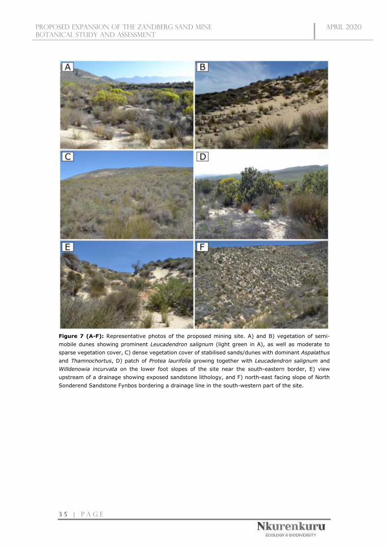
Proposed expansion of the zandberg sand mine
botanical STUDY AND ASSESSMENT
April 2020
3 5 | P a g e
Figure 7 (A-F): Representative photos of the proposed mining site. A) and B) vegetation of semi-
mobile dunes showing prominent Leucadendron salignum (light green in A), as well as moderate to
sparse vegetation cover, C) dense vegetation cover of stabilised sands/dunes with dominant Aspalathus
and Thamnochortus, D) patch of Protea laurifolia growing together with Leucadendron salignum and
Willdenowia incurvata on the lower foot slopes of the site near the south-eastern border, E) view
upstream of a drainage showing exposed sandstone lithology, and F) north-east facing slope of North
Sonderend Sandstone Fynbos bordering a drainage line in the south-western part of the site.
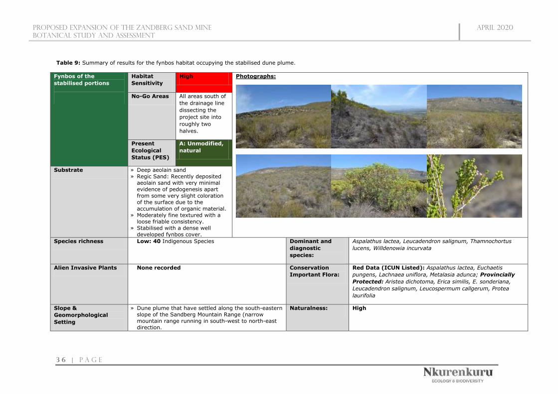
Proposed Expansion of the zandberg sand mine
BOTANICAL STUDY AND ASSESSMENT
april 2020
3 6 | P a g e
Table 9: Summary of results for the fynbos habitat occupying the stabilised dune plume.
Fynbos of the
stabilised portions
Habitat
Sensitivity
High Photographs:
No-Go Areas All areas south of
the drainage line
dissecting the
project site into
roughly two
halves.
Present
Ecological
Status (PES)
A: Unmodified,
natural
Substrate » Deep aeolain sand » Regic Sand: Recently deposited
aeolain sand with very minimal evidence of pedogenesis apart from some very slight coloration of the surface due to the
accumulation of organic material. » Moderately fine textured with a
loose friable consistency. » Stabilised with a dense well
developed fynbos cover.
Species richness Low: 40 Indigenous Species Dominant and
diagnostic
species:
Aspalathus lactea, Leucadendron salignum, Thamnochortus
lucens, Willdenowia incurvata
Alien Invasive Plants None recorded Conservation
Important Flora:
Red Data (ICUN Listed): Aspalathus lactea, Euchaetis
pungens, Lachnaea uniflora, Metalasia adunca; Provincially
Protected: Aristea dichotoma, Erica similis, E. sonderiana,
Leucadendron salignum, Leucospermum callgerum, Protea
laurifolia
Slope &
Geomorphological
Setting
» Dune plume that have settled along the south-eastern slope of the Sandberg Mountain Range (narrow mountain range running in south-west to north-east direction.
Naturalness: High

Proposed expansion of the zandberg sand mine
botanical STUDY AND ASSESSMENT
April 2020
3 7 | P a g e
» Steep slopes are associated with incised drainage valleys running parallel to the mountain range.
» Moderate-steep to steep slopes
Mostly natural and undisturbed area covered by a well
developed, dense, climax fynbos type providing stability to the
dune plume.
Disturbance » Minimal to no disturbance
Anthropogenic
importance and
potential
Agricultural Potential: Low » Game Farming: Some grazing potential for scarce game /
wildlife such as Cape Mountain Zebra (Equus zebra zebra), Grey Rhebok (Pelea capreolus), Bontebok (Damaliscus pygargus dorcas) and Cape Grysbok (Raphicerus melanotis)
Habitat & Biotic
Integrity:
Very-High
» The majority of the mountain range and associated dune plumes are in a natural to near-natural condition with minimal disturbance.
» Sand plumes can be regarded as unique complex habitats inhabited by habitat specialists, subsequently these habitats contribute to habitat and niche diversity within the region.
» Dense fynbos vegetation helps slow down surface runoff and stabilise sand plumes.
» Potential/suitable habitat for rare / conservation important faunal species such as Cape Mountain Zebra (Equus zebra zebra), Grey Rhebok (Pelea capreolus), Bontebok (Damaliscus pygargus dorcas), Cape Grysbok (Raphicerus melanotis), Cape Golden Mole (Chrysochloris asiatica), White-tailed Mouse (Mystromys albicaudatus), Cape Spiny Mouse (Acomys subspinosus)
» A permanent vegetation cover is necessary to maintain the functionality and stability of this ecosystem
Conservation
value
High
» Listed as Vulnerable within the National Threatened Ecosystem List (2011)
» Listed as a Vulnerable Vegetation Type by Mucina & Rutherford (2012)
» Located within a CBA1 area which is vital for meeting provincial conservation targets.
» Recorded Red Data flora species » Recorded Provincially Protected (Schedule 4) flora » Natural to near natural habitat. » Potential / suitable habitat for conservation important faunal
species.

Proposed expansion of the zandberg sand mine
botanical STUDY AND ASSESSMENT
April 2020
3 8 | P a g e
Conclusion and
Mitigation
Requirements
» This area is of a high ecological sensitivity and high conservation value. » It is recommended that this habitat located south of the drainage system, dissecting the project site into two halves, should be excluded from
the development and should henceforth be regarded as a No-Go Area. » The portion north of the drainage line, which is approximately 33 ha in size, is regarded as acceptable loss, furthermore, due to the small extent,
and the location adjacent to the existing mining area, is highly unlikely to have an impact on the status of the vegetation type / ecosystem as well as meeting the conservation targets set out by the province.
» Development activities within this allowed area are unlikely to have a significant impact on regional ecological functionality if strict mitigation measures are implemented, especially in terms of the establishment of a stable vegetation cover post-mining and the management and eradication of potential Invasive Alien Plants (IAPs).
» Operational activities should only be restricted to the development footprint as indicated within this study. » Pre-construction/operation Botanical walk-through should occur in order to GPS tag all conservation important species that may be at risk of
being disturbed / destroyed by the mining activities. » No conservation important species may be re-located / disturbed or destroyed without the necessary Permits in place (obtained from the relevant
nature conservation authorities) » A vegetation rehabilitation and management plan is also vital for the stabilisation of soils and the prevention of potential erosion from occurring
or becoming exacerbated.
» An invasive alien plant management plan should be compiled and address the mitigation and management of such species throughout the operational phase as well as post-operational phase.
» Phased development / mining should occur were small strips are mined at a time and as a strip becomes exhausted (in terms of the mined resource), immediate rehabilitation should be initiated, whilst mining of a new strip commence.
» Rehabilitation progress, erosion and IAP monitoring can occur simultaneously post-operational phase and should occur bi-annually for a minimum of two years.

Proposed expansion of the zandberg sand mine
botanical STUDY AND ASSESSMENT
April 2020
3 9 | P a g e
Table 10: Summary of results for the fynbos habitat occupying the semi-mobile and mobile sections of the dune plume.
Fynbos of the mobile
and semi-mobile dune
plumes
Habitat
Sensitivity
Moderate-High Photographs:
No-Go Areas All areas south of
the drainage line
dissecting the
project site into
roughly two
halves.
Present
Ecological
Status (PES)
A: Unmodified,
natural
Substrate » Active portions of the dune plume with sparse to moderate vegetation cover
» Deep aeolain sand » Regic Sand: Recently deposited
aeolain sand with almost no
evidence of pedogenesis. » Fine textured with a loose friable
consistency.
Species richness Low: 40 Indigenous Species Dominant and
diagnostic
species:
Aspalathus lactea, Aspalathus quinquefolia, Leucadendron
salignum, Metalasia adunca, Polpoda capensis, Willdenowia
incurvata, Willdenowia sulcata
Alien Invasive Plants None recorded Conservation
Important Flora:
Red Data (ICUN Listed): Aspalathus lactea, Euchaetis
pungens, Metalasia adunca; Provincially Protected: Aristea
dichotoma, Erica similis, E. sonderiana, Euchaetis pungens,
Leucadendron salignum
Slope &
Geomorphological
Setting
» Typically these mobile to semi-mobile portions of the dune plume (that have settled along the south-eastern slope of the Sandberg Mountain Range) are
Naturalness: High These are natural active portions of the dune plume and even
though vegetation cover may be sparse or even absent, the

Proposed expansion of the zandberg sand mine
botanical STUDY AND ASSESSMENT
April 2020
4 0 | P a g e
associated with the lower- and footslope sections of the north-facing aspect of this dune plume.
» Moderate slopes
vegetation that is present is completely natural and
characteristic of such areas.
Disturbance » No anthropogenic or artificial disturbances » This is a dynamic, active portion of the dune exposed
to natural disturbances such as sand deposition and removal.
Anthropogenic
importance and
potential
Agricultural Potential: Very Low
Habitat & Biotic
Integrity:
Moderate-Low
» Natural to near-natural condition with minimal disturbance.
» Low floral diversity. » Unique, dynamic and complex habitat, inhabited by
habitat specialists (however diversity is expected to be low), subsequently this habitat type contributes to somewhat to habitat and niche diversity within the region.
» Fynbos vegetation within semi-mobile areas provide some stabilisation to these areas, preventing the mobile areas from encroaching into the natural dense vegetated portions surrounding these areas.
» Ecosystem functions and services are minimal.
Conservation
value
Moderate-High
» Listed as Vulnerable within the National Threatened Ecosystem List (2011)
» Listed as a Vulnerable Vegetation Type by Mucina & Rutherford (2012)
» Located within a CBA1 area which is vital for meeting provincial conservation targets.
» Recorded Red Data flora species » Recorded Provincially Protected (Schedule 4) flora » Natural to near natural habitat. » Natural vegetation within semi-mobile areas provide some
stabilisation to these areas and provide a valuable function / service in preventing the mobile areas from encroaching into the natural dense vegetated portions surrounding these areas which have a high conservation value.
Conclusion and
Mitigation
Requirements
» This area is of a Moderate-High ecological sensitivity and a Moderate-High conservation value.
» The presence and maintenance of a vegetation cover within the semi-mobile areas is extremely important in preventing the potential encroachment of the mobile areas into the densely vegetated, stable areas, resulting in the destabilisation of these areas.
» It is recommended that these habitats located south of the drainage system, dissecting the project site into two halves, should be excluded from the development and should henceforth be regarded as a No-Go Area.
» These habitats located north of the drainage line, are regarded as acceptable loss, and furthermore, due to the small extent, and the location adjacent to the existing mining area, is highly unlikely to have an impact on the status of the vegetation type / ecosystem as well as meeting the conservation targets set out by the province.
» Development activities within this allowed area are unlikely to have a significant impact on regional ecological functionality if strict mitigation measures are implemented, especially in terms of the establishment of a stable vegetation cover post-mining and the management and eradication of potential Invasive Alien Plants (IAPs).
» Operational activities should only be restricted to the development footprint as indicated within this study. » Pre-construction/operation Botanical walk-through should occur in order to GPS tag all conservation important species that may be at risk of
being disturbed / destroyed by the mining activities. » No conservation important species may be re-located / disturbed or destroyed without the necessary Permits in place (obtained from the relevant
nature conservation authorities)

Proposed expansion of the zandberg sand mine
botanical STUDY AND ASSESSMENT
April 2020
4 1 | P a g e
» A vegetation rehabilitation and management plan are also vital for the stabilisation of soils and the prevention of potential erosion from occurring or becoming exacerbated.
» An invasive alien plant management plan should be compiled and address the mitigation and management of such species throughout the operational phase as well as post-operational phase.
» Phased development / mining should occur were small strips are mined at a time and as a strip becomes exhausted (in terms of the mined resource), immediate rehabilitation should be initiated, whilst mining of a new strip commence.
Rehabilitation progress, erosion and IAP monitoring can occur simultaneously post-operational phase and should occur bi-annually for a minimum
of two years.
Table 11: Summary of results for the fynbos habitat occupying sandstone slopes and outcrops.
Fynbos occurring on
sandstone
Habitat
Sensitivity
Moderate-High Photographs:
No-Go Areas As the resource that will be mined
(sand) is absent from these habitats
it is recommended that these
habitats are regarded as No-Go
Areas
Present
Ecological
Status (PES)
A: Unmodified, natural
Substrate » Poorly developed soils, shallow to absent. » Exposed bedrock, boulders and larger stones. » Deeper soil pockets exist between rock crevices
Slope &
Geomorphological
Setting
» Steep slopes of the crest and upper slopes of the Sandberg Mountain Range as well as exposed outcrops fringing some of the drainage lines.
» These sandstones are as mentioned, either exposed as outcrops, or occur where the regic sand thins out or have been eroded (wind and water erosion) along the upper portions of the mountain range

Proposed expansion of the zandberg sand mine
botanical STUDY AND ASSESSMENT
April 2020
4 2 | P a g e
Species richness Low: 25 Indigenous Species in the small section that was surveyed
Dominant and
diagnostic
species:
Aspalathus burchelliana, Aspalathus hirta, Capeochloa cincta,
Maytenus oleoides, Protea laurifolia, Serruria gremialis,
Stayneria neilii
Alien Invasive Plants None recorded Conservation
Important Flora:
Red Data (ICUN Listed): Aspalathus burchelliana, Stayneria
neilii; Provincially Protected: Agathosma stipitata, Erica
imbricata, Leucadendron salignum, Paranomus dispersus,
Protea laruifolia, Serruria gremialis
Disturbance » Minimal to no disturbance Naturalness: High Mostly natural and undisturbed area covered by a well-
developed, dense, climax fynbos type typical of this vegetation
type.
Habitat & Biotic
Integrity:
High
» The majority of the mountain range is in a natural condition with minimal disturbance.
» This area is characterised by unique complex micro-habitats inhabited by habitat specialists, subsequently these micro-habitats contribute to habitat and niche diversity within the region. Such micro-habitats include: Rocky outcrops, steep crests and slopes as well as cool south facing slopes, deeper soil pockets that have filled up in rock crevices etc.
» The shade effect created by some of the larger boulders and outcrops result in higher moisture retention and usually provide protection against fire and high levels of solar radiation. Subsequently these areas usually comprise of unique vegetation, including larger shrubs, trees and geophytes that are not
present within the surrounding habitats. » Steep south-facing slopes and kloofs are known to be
important sites for biodiversity and provide refuges in the face of potential climate change.
» Micro habitats created by deep sandy pockets » Dense fynbos vegetation helps slow down surface
runoff and moisture retention and contribute to the stability of the downslope sand plumes.
» Potential/suitable habitat for rare / conservation important faunal species such as Cape Mountain
Anthropogenic
importance and
potential
Agricultural Potential: Low » Game Farming: Some habitat potential for scarce game /
wildlife such as Cape Mountain Zebra (Equus zebra zebra), Grey Rhebok (Pelea capreolus), Bontebok (Damaliscus pygargus dorcas), Cape Grysbok (Raphicerus melanotis) and Klipspringer (Oreotragus oreotragus)
Conservation
value
High
» Located within a CBA1 area which is vital for meeting
provincial conservation targets. » Recorded Red Data flora species » Recorded Provincially Protected (Schedule 4) flora » Natural habitat. » Steep south-facing slopes and kloofs are known to be
important sites for biodiversity and provide refuges in the face of potential climate change.
» Contribution to species diversity within the region. » Potential / suitable habitat for conservation important faunal
species.

Proposed expansion of the zandberg sand mine
botanical STUDY AND ASSESSMENT
April 2020
4 3 | P a g e
Zebra (Equus zebra zebra), Grey Rhebok (Pelea capreolus), Bontebok (Damaliscus pygargus dorcas), Cape Grysbok (Raphicerus melanotis), Klipspringer (Oreotragus oreotragus)White-tailed Mouse (Mystromys albicaudatus), Cape Spiny Mouse (Acomys subspinosus), Cape Rock Sengi (Elephantulus edwardii), Hewitt’s Red Rock Rabbit (Pronolagus saundersiae) and Namaqua and Grant’s Rock Mouse (Micaelamys namaquensis & M. granti).
» The presence and maintenance of the population of smaller mammals including Rock Hyrax (Procavia capensis), which have been confirmed on site, are vital for sustaining the local carnivores and raptors of the area which may include, Cape leopard (Panthera pardus pardus) and Verreaux’s eagle (Aquila verreauxii)
» A permanent vegetation cover is necessary to maintain the functionality and stability of this ecosystem
Conclusion and
Mitigation
Requirements
» This area is of a high ecological sensitivity and high conservation value. » Due to the fact that the resource proposed to be mined (sand) is largely absent from this area it is proposed that these habitats are excluded
from the mining footprint and are regarded as No-Go Areas.
Table 12: Summary of results for the drainage lines.
Fynbos occurring on
sandstone bordering
drainage lines
Habitat
Sensitivity
High Photographs:
No-Go Areas All drainage lines should be regarded
as No-Go Areas
Present
Ecological
Status (PES)
A: Unmodified, natural
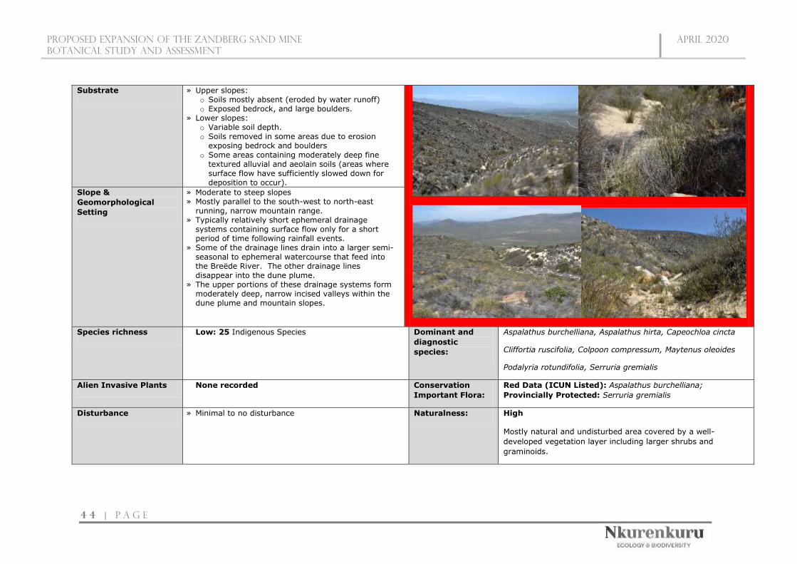
Proposed expansion of the zandberg sand mine
botanical STUDY AND ASSESSMENT
April 2020
4 4 | P a g e
Substrate » Upper slopes: o Soils mostly absent (eroded by water runoff) o Exposed bedrock, and large boulders.
» Lower slopes: o Variable soil depth. o Soils removed in some areas due to erosion
exposing bedrock and boulders o Some areas containing moderately deep fine
textured alluvial and aeolain soils (areas where surface flow have sufficiently slowed down for deposition to occur).
Slope &
Geomorphological
Setting
» Moderate to steep slopes » Mostly parallel to the south-west to north-east
running, narrow mountain range. » Typically relatively short ephemeral drainage
systems containing surface flow only for a short period of time following rainfall events.
» Some of the drainage lines drain into a larger semi-seasonal to ephemeral watercourse that feed into the Breëde River. The other drainage lines disappear into the dune plume.
» The upper portions of these drainage systems form moderately deep, narrow incised valleys within the dune plume and mountain slopes.
Species richness Low: 25 Indigenous Species Dominant and
diagnostic
species:
Aspalathus burchelliana, Aspalathus hirta, Capeochloa cincta
Cliffortia ruscifolia, Colpoon compressum, Maytenus oleoides
Podalyria rotundifolia, Serruria gremialis
Alien Invasive Plants None recorded Conservation
Important Flora:
Red Data (ICUN Listed): Aspalathus burchelliana;
Provincially Protected: Serruria gremialis
Disturbance » Minimal to no disturbance Naturalness: High Mostly natural and undisturbed area covered by a well-
developed vegetation layer including larger shrubs and
graminoids.
Proposed expansion of the zandberg sand mine
botanical STUDY AND ASSESSMENT
April 2020
4 5 | P a g e
Habitat & Biotic
Integrity:
High
» Most of the drainage lines are natural and undisturbed within the surveyed area.
» The prominent drainage line traversing the central portion of the project study have been intercepted by the sand mine.
» This habitat is characterised by unique complex micro-habitats which contribute to habitat and niche diversity within the region.
» The shade effect created by some of the larger boulders stones result in higher moisture retention.
» Vegetation helps slow down surface runoff and
moisture retention. » A permanent vegetation cover is necessary to maintain
the functionality and stability of this ecosystem. » Ecosystem functions and services includes:
o Absorption and reduction of occasional flash floods. o Important corridor for abiotic and biotic material
transfer, as well as for wildlife. o Keystone species maintain habitat and create
specific microhabitats for a multitude of organisms. o Dense herbaceous vegetation helps slow down
floods, ‘catch’ sediments, and retain nutrients. o Vegetation filters out possible pollutants to prevent
their discharge into the lower lying freshwater resources.
Anthropogenic
importance and
potential
Agricultural Potential: Low » Due to the sporadic nature of these drainage lines none of
them contain farm dams for storing surface runoff. » Most of the surface runoff within these drainage lines simply
dissipate into the sand plume feeding the aquifers which are an important source of water for livestock.
Conservation
value
High
» Located within a CBA1 area which is vital for meeting provincial conservation targets.
» Recorded Red Data flora species » Recorded Provincially Protected (Schedule 4) flora » Natural habitat. » Biotic and abiotic corridor for material and wildlife movement. » Absorption and retention of runoff and source of water input
for aquifers. » Niche habitats, » Some species restricted to these areas
Conclusion and
Mitigation
Requirements
» This area is of a high ecological sensitivity and high conservation value. » Due to the fact that the resource proposed to be mined (sand) is largely absent from this area it is proposed that these habitats are excluded
from the mining footprint and are regarded as No-Go Areas. » It is expected that the obliteration of these upper tributaries may gradually lead to a die-off of larger trees and shrubs and other species depending
on higher soil moisture levels in downstream drainage lines beyond the development due to the reduction of occasional floods as upper tributaries are obliterated.

Proposed Expansion of the zandberg sand mine
BOTANICAL STUDY AND ASSESSMENT
april 2020
4 6 | P a g e
In terms of ecological sensitivity and conservation value / importance, the pristine
nature of the vegetation (no invasive aliens, no transformation, no secondary
vegetation), the numerous unique micro-habitats present, and the various
important functions and services provided by these habitats and their vegetation
cover, as well as the fact that the majority of the area is located within a CBA1,
regarded as important for meeting the provincial conservation targets, means that
the entire site can be classified as highly sensitive (Figure 10). However, the
northern section of the site can be regarded as acceptable loss to the development
as this area (north of the prominent drainage line) covers a very small portion of
the dune plume with no exposed sandstone outcrops or drainage lines and is
furthermore located adjacent to the existing mining area. Subsequently this area
is largely a uniform habitat type, and development within this section will not
impact the status of the vegetation / ecosystem type, red data species or influence
the conservation targets set out for this CBA1 area. Furthermore, by restricting
mining activities to this area adjacent to the existing mining area, potential impacts
are “compressed” in a confined area avoiding further habitat fracturing as well as
influencing important biological corridors.
Due to high habitat (micro-habitat), fine scale vegetation pattern and plant species
turnover associated with the southern half of the project site as well as the
functions and services associated with some of these habitat type, it is
recommended that this southern portion is excluded from the proposed mining
footprint. Also, this area is regarded as an important portion of the CBA1. All
drainage lines are regarded as high sensitivity, No-Go features.
The northern portion of the dune plume regarded as acceptable for the proposed
activity covers approximately 30% of the original extent that is being proposed.
The remaining area should be set aside to function as a biodiversity offset area.

Proposed Expansion of the zandberg sand mine
BOTANICAL STUDY AND ASSESSMENT
april 2020
4 7 | P a g e
Figure 8: Map illustrating the habitat units identified within the survey site.

Proposed expansion of the zandberg sand mine
botanical STUDY AND ASSESSMENT
April 2020
4 8 | P a g e
Figure 9: Map illustrating the ground truth (actual) extent of the vegetation types within the proposed mining area.

Proposed expansion of the zandberg sand mine
botanical STUDY AND ASSESSMENT
April 2020
4 9 | P a g e
Figure 10: Map illustrating the ecological sensitivity of the project site.

Proposed expansion of the zandberg sand mine
botanical STUDY AND ASSESSMENT
April 2020
5 0 | P a g e
5.2 Species of Conservation Concern
Species of conservation concern are species of flora (plants) and fauna (animals)
that have a high conservation importance in terms of preserving South Africa's high
biological diversity and include not only threatened species that have been
classified as ‘at high risk of extinction in the wild’ (i.e. Critically Endangered CR,
Endangered EN, Vulnerable VU), but also those classified in the categories Near
Threatened (NT), Critically Rare, Rare, Declining and Data Deficient. Protected
species are listed in international conventions, national acts and provincial
ordinances that regulate activities such as the hunting, collection, and trade of
species. If a subpopulation of a species of conservation concern is found to occur
on a proposed development site, it would be one indicator that development
activities could result in significant loss of biodiversity, bearing in mind that loss of
subpopulations of these species will either increase their extinction risk or may, in
fact, contribute to their extinction
5.2.1 Flora of conservation significance
As previously mentioned, a species list was obtained from the SANBI database
(POSA) for the study area and surrounding environment. According to this list a
total of about 104 plant Species of Conservation Concern is known to occur in the
broad area surrounding the site.
Ground truthing confirmed a total of 7 Species of Conservation Concern to be
present on site, 5 of which are Threated Species (listed below). Furthermore, two
of these species, namely Aspalathus burchelliana (EN) and Lachnaea uniflora (VU),
were not present in the list obtained online (POSA) during the desktop phase, which
proves the value of ground-truthing sites to validate such online species lists.
Furthermore, a total of 12 provincially protected (Schedule 4) floral species have
been recorded within the project site.
Table 13: Conservation Important Flora Species recorded within the surveyed site.
Family Species
Conservation Status
IUCN
Red List
WCNCO
(Schedule 4)
Fabaceae Aspalathus burchelliana EN
Aizoaceae Stayneria neilii VU
Fabaceae Aspalathus lactea VU
Rutaceae Euchaetis pungens VU Protected
Thymelaeaceae Lachnaea uniflora VU

Proposed expansion of the zandberg sand mine
botanical STUDY AND ASSESSMENT
April 2020
5 1 | P a g e
Asteraceae Metalasia adunca NT
Aizoaceae Ruschia pungens DD
Asphodelaceae Aloe perfoliata LC Protected
Ericaceae Erica imbricata LC Protected
Ericaceae Erica similis LC Protected
Ericaceae Erica sonderiana LC Protected
Iridaceae Aristea dichotoma LC Protected
Proteaceae Leucadendron salignum LC Protected
Proteaceae Leucospermum calligerum LC Protected
Proteaceae Paranomus dispersus LC Protected
Proteaceae Protea laurifolia LC Protected
Proteaceae Serruria gremialis LC Protected
Rutaceae Agathosma stipitata LC Protected
6. ASSESSMENT OF PROPOSED IMPACTS
6.1 Assumptions
The following is assumed and/or known:
» A thorough botanical walkthrough of all footprint areas will be conducted
to detect and relocate, where possible, all plant species of conservation
concern by a suitably qualified botanist prior to commencement of
activities.
» Throughout the duration of the mining activities, the footprint will be
routinely cleared of all alien invasive plants if detected.
» The site establishment itself will be associated with clearing of
vegetation within the footprint only.
» After decommissioning, a continuous vegetation layer will be the most
important aspect of ecosystem functionality within and beyond the
project site.
A weakened or absent vegetation layer not only exposes the soil surface but
also lacks the binding and absorption capacity that creates the buffering
functionality of vegetation to prevent or lessen erosion as a result of floods.
6.2 Localised vs. cumulative impacts: some explanatory notes
Ecosystems consist of a mosaic of many different patches. The size of natural
patches affects the number, type, and abundance of species they contain. At the
periphery of patches, influences of neighbouring patches become apparent, known

Proposed expansion of the zandberg sand mine
botanical STUDY AND ASSESSMENT
April 2020
5 2 | P a g e
as the ‘edge effect’. Patch edges may be subjected to increased levels of heat,
dust, desiccation, disturbance, invasion of exotic species and other factors. Edges
seldom contain species that are rare, habitat specialists or species that require
larger tracts of undisturbed core habitat. Fragmentation due to development
reduces core habitat and greatly extends edge habitat, which causes a shift in the
species composition, which in turn puts great pressure on the dynamics and
functionality of ecosystems (Perlman & Milder 2005).
Cumulative impacts of developments on population viability of species can be
reduced significantly if new developments are kept as close as possible to existing
developed and/or transformed areas or, where such is not possible, different
sections of development be kept as close together as possible.
If the entire proposed footprint of 108.3851ha is approved it is highly likely that
this development will contribute to the cumulative impacts of the area:
» Affecting the conservation targets set out by the province for this region;
» Impact the conservation targets set out for the vegetation type and
ecosystem (at national level).
» Compromise the ecological functioning of the larger “natural”
environment; and
» Disrupt the connectivity of the landscape for fauna and flora and impair
their ability to respond to environmental fluctuations.
However, a loss of only the 30% (of the proposed footprint) located to the north
will not contribute to the cumulative impacts as described above and as such this
area is regarded as acceptable for the development.
Excessive clearing of vegetation can and will influence runoff and stormwater flow
patterns and dynamics, which could cause excessive accelerated erosion of plains
and intermittent drainage lines, and this could also have detrimental effects on the
lower-lying areas.
All drainage lines are regarded as No-Go Areas
Rehabilitation and revegetation of all surfaces disturbed or
altered during the operational phase is desirable.
Disturbance of indigenous vegetation creates a major opportunity for the
establishment of invasive species and their uncontrolled spread into adjacent
natural habitats.
» A regular monitoring and eradication protocol must be part of all the
developments’ long-term management plans.
Proposed expansion of the zandberg sand mine
botanical STUDY AND ASSESSMENT
April 2020
5 3 | P a g e
After decommissioning, a continuous vegetation layer will be the most important
aspect of ecosystem functionality within and beyond the project site.
A weakened or absent vegetation layer not only exposes the soil surface but
also lacks the binding and absorption capacity that creates the buffering
functionality of vegetation to prevent or lessen erosion and the
destabilization of the dune plume as a result of floods and wind.
6.3 Identification of Potential Impacts and Associated Activities
Potential impacts resulting from the proposed project would stem from a variety of
different activities and risk factors associated with the site-establishment and
operation phases of the project including the following:
6.3.1 Site-establishment and Operational Phase
» Human presence and uncontrolled access to the site may result in
negative impacts on fauna and flora through poaching of fauna and
uncontrolled collection of plants for traditional medicine or other
purposes.
» Site clearing and exploration activities for site establishment.
» Vegetation clearing could impact locally listed plant species. Vegetation
clearing would also lead to the loss of vegetation communities and
habitats for fauna and potentially the loss of faunal species, habitats,
and ecosystems. On a larger and cumulative scale (if numerous and
uncontrolled developments are allowed to occur in the future) the loss
of these vegetation communities and habitats may potentially lead to a
change in the conservation status of the affected vegetation type as well
as the ability of this vegetation type and associated features to fulfil its
ecological responsibilities (functions).
» Soil compaction and increased erosion risk would occur due to the loss
of plant cover and soil disturbance created during the construction
phase. This may potentially impact the downstream watercourses and
aquatic habitats. These potential impacts may result in a reduction in
the buffering capacities of the landscape during extreme weather
events.
» Invasion by alien plants may be attributed to excessive disturbance to
vegetation, creating a window of opportunity for the establishment of
these alien invasive species. In addition, regenerative material of alien
invasive species may be introduced to the project site by machinery

Proposed expansion of the zandberg sand mine
botanical STUDY AND ASSESSMENT
April 2020
5 4 | P a g e
traversing through areas with such plants or materials that may contain
regenerative materials of such species.
» Presence and operation of mining vehicles and machinery on the project
site. This will create a physical impact as well as generate noise,
potential pollution and other forms of disturbances at the site.
» The facility will require management and if this is not done effectively,
it could impact adjacent intact areas through impacts such as erosion
and the invasion of alien plant species.
6.3.2 Cumulative Impacts
» The loss of unprotected vegetation types on a cumulative basis from the
broad area may impact the country’s ability to meet its conservation targets.
» Transformation of intact habitat would contribute to the fragmentation of
the landscape and would potentially disrupt the connectivity of the
landscape for fauna, avifauna, and flora and impair their ability to respond
to environmental fluctuations.
6.4 Assessment of Impacts
The impacts identified above are assessed below, during the site-establishment and
operation phases of the facility as well as before and after mitigation.
6.4.1 Assessment of impacts associated with Site-establishment and Operational
Phases
Impact 1: Potential Impacts on vegetation and listed and protected plant species
Impact Nature: Vegetation clearing will lead to the loss of current habitat within the proposed
mining footprint and is an inevitable consequence of this type of activity.
This will lead to localised or more extensive reduction in the overall extent of vegetation. There are
factors that may aggravate this potential impact. For example, where this vegetation has already
been stressed due to degradation and transformation at a regional level, or has a very restricted
distribution, the loss may lead to increased vulnerability (susceptibility to future damage) of the
habitat and a change in the conservation status (current conservation situation). Consequences of
the potential impact of loss of indigenous natural vegetation occurring may include:
» negative change in conservation status of habitat (Driver et al. 2005);
» increased vulnerability of remaining portions to future disturbance;
» general loss of habitat for sensitive species;
» loss in variation within sensitive habitats due to loss of portions of it;
» general reduction in biodiversity;
» increased fragmentation (depending on location of impact);

Proposed expansion of the zandberg sand mine
botanical STUDY AND ASSESSMENT
April 2020
5 5 | P a g e
» disturbance to processes maintaining biodiversity and ecosystem goods and services; and
» loss of ecosystem goods and services.
Plant species are especially vulnerable to mining development due to the fact that they cannot move
out of the path of the construction activities, but are also affected by overall loss of habitat.
Threatened species include those classified as critically endangered, endangered or vulnerable. For
any other species a loss of individuals or localised populations is unlikely to lead to a change in the
conservation status of the species. However, in the case of threatened plant species, loss of a
population or individuals could lead to a direct change in the conservation status of the species,
possibly extinction. This may arise if the proposed infrastructure is located where it will impact on
such individuals or populations. Consequences may include:
» fragmentation of populations of affected species;
» reduction in area of occupancy of affected species; and
» loss of genetic variation within affected species.
These may all lead to a negative change in conservation status of the affected species, which implies
a reduction in the chance of survival of the species.
Without Mitigation With Mitigation
Extent Local (2) Local (1)
Duration Permanent (5) Permanent (5)
Magnitude High (7) Moderate (5)
Probability Definite (5) Highly Probable (4)
Significance High (70) Medium (44)
Status Negative Negative
Reversibility Low Low
Irreplaceable loss of
resources
Some loss of resources Very limited loss of resources
Can impacts be mitigated? To a limited extent. Even though a stable vegetation cover will
allow for some functionality to return, an establishment of a natural
fynbos cover representative of the region is near impossible. As
such the most appropriate mitigation measure will be to minimize
the extent of the footprint to a level where the loss can be regarded
as acceptable without impacting the status of the vegetation type
as well as potential individual listed plant species
Residual Impacts » A permanent altered vegetation cover.
Impact 2: Potential impacts on local fauna especially threatened animals due to
disturbance and a loss of available habitat and migration routes
Impact Nature: Threatened animal species are indirectly affected primarily by the overall loss of
habitat, since direct construction impacts can often be avoided due to movement of individuals from
the path of construction. Animals are generally mobile and, in most cases, can move away from a
potential threat.

Proposed expansion of the zandberg sand mine
botanical STUDY AND ASSESSMENT
April 2020
5 6 | P a g e
Threatened species include those classified as critically endangered, endangered or vulnerable. For
any other species a loss of individuals or localised populations is unlikely to lead to a change in the
conservation status of the species. However, in the case of threatened animal species, loss of a
population or individuals could lead to a direct change in the conservation status of the species. This
may arise if the proposed infrastructure is located where it will impact on such individuals or
populations or the habitat that they depend on. Consequences may include:
» fragmentation of populations of affected species;
» reduction in area of occupancy of affected species; and
» loss of genetic variation within affected species.
These may all lead to a negative change in conservation status of the affected species, which implies
a reduction in the chances of the species overall survival chances.
Without Mitigation With Mitigation
Extent Local (2) Local (1)
Duration Long-term (4) Long-term (4)
Magnitude High (7) Low (4)
Probability Highly Probable (4) Probable (3)
Significance Medium (52) Low (27)
Status Negative Negative
Reversibility Limited extent with effective
rehabilitation
Relative high reversibility with
effective rehabilitation
Irreplaceable loss of
resources
Some loss of resources Very limited loss of resources
Can impacts be mitigated? To a limited extent. Even though, with effective rehabilitation of a
stable vegetation cover will allow for some faunal species to return
to the area, most of these species will be generalists and
opportunistic species. Habitat (fynbos) specialists will likely not
return to the area. As such the most appropriate mitigation
measure will be to minimize the extent of the footprint to a level
where the loss of habitat will not impact the local faunal community
structure, allowing for most of the species to persist outside of the
mining area.
Residual Impacts » A permanent altered habitat that will be inhabited by some of
the more adaptable and generalist species, with a likelihood of
the fynbos habitat specialists not returning to the area.
Impact 3: Impact on drainage areas.
Impact Nature: There are no wetlands within the proposed mining footprint, but there are a number
of ephemeral drainage lines. At their headwater/upper portions these drainage lines tend to be steep-
sided mini valleys. Mining will lead to direct, local loss of or damage to these areas and their
catchments and may impact the replenishment of downslope aquifers as most of these drainage lines
dissipate into the sand dune with runoff seeping down into aquifers. These drainage lines are an

Proposed expansion of the zandberg sand mine
botanical STUDY AND ASSESSMENT
April 2020
5 7 | P a g e
important habitat for a number of species in the study area, including those with a restricted
distribution or species with an elevated conservation status.
Without Mitigation With Mitigation
Extent Local and downstream habitats
including downslope aquifers
(3)
Local (1)
Duration Permanent (5) Long-term (4)
Magnitude High (7) Low (4)
Probability Definite (5) Improbable (2)
Significance High (75) Low (18)
Status Negative Negative
Reversibility Low Low
Irreplaceable loss of
resources
Some loss of resources Avoid loss of resources
Can impacts be mitigated? The only possible mitigation measure will be avoidance of these
habitat types.
Residual Impacts » Without mitigation these drainage systems will be lost resulting
in an altered surface hydrology as well as the contribution the
area made to the replenishment of downslope aquifers.
» With mitigation measures implemented (avoidance of these
features), there will be no residual impact on these drainage
lines.
Impact 4: Potential increased erosion risk and destabilisation of the dune plume
during and post-operational phase
Impact Nature: During the operational phase, there will be a lot of disturbed and loose soil at the
site which will render the area vulnerable to erosion. It is critically important that proper erosion
control measures and structures are put in place and maintained over the lifespan of the project.
Without Mitigation With Mitigation
Extent Local and immediate
surroundings (3)
Local (1)
Duration Long-term (4) Short-term (1)
Magnitude High (8) Minor (2)
Probability Highly Probable (4) Highly Probable (4)
Significance High (60) Low (16)
Status Negative Negative
Reversibility Moderate High

Proposed expansion of the zandberg sand mine
botanical STUDY AND ASSESSMENT
April 2020
5 8 | P a g e
Irreplaceable loss of
resources
Some loss of resources Unlikely
Can impacts be mitigated? Yes, to a large extent
Residual Impacts With appropriate avoidance and mitigation, residual impacts will be
very low avoiding any residual impacts outside of the
mining footprint.
Impact 5: Increased alien plant invasion during the operational phase
Impact Nature: Increased alien plant invasion is one of the greatest risk factors associated with
this activity. The disturbed and bare ground that is likely to be present at the site during and after
the operational phase would leave the site vulnerable to alien plant invasion during the operation
phase if not managed. Furthermore, the National Environmental Management Biodiversity Act (Act
No. 10 of 2004), as well as the Conservation of Agricultural Resources Act, (Act No. 43 of 1983)
requires that listed alien species are controlled in accordance with the Act.
Major factors contributing to invasion by alien invader plants includes inter alia high disturbance
(such as clearing for construction activities) and negative grazing practices (Zachariades et al. 2005).
Exotic species are often more prominent near infrastructural disturbances than further away (Gelbard
& Belnap 2003, Watkins et al. 2003). Consequences of this may include:
» loss of indigenous vegetation;
» change in vegetation structure leading to change in various habitat characteristics;
» change in plant species composition;
» change in soil chemical properties;
» loss of sensitive habitats;
» loss or disturbance to individuals of rare, endangered, endemic and/or protected species;
» fragmentation of sensitive habitats;
» change in flammability of vegetation, depending on alien species;
» hydrological impacts due to increased transpiration and runoff; and
» impairment of watercourse function.
Without Mitigation With Mitigation
Extent Local and immediate
surroundings (3)
Local (1)
Duration Permanent (5) Short-term (1)
Magnitude Moderate (6) Minor (2)
Probability Highly Probable (4) Probable (3)
Significance Medium (56) Low (12)
Status Negative Negative
Reversibility Moderate High
Irreplaceable loss of
resources
Potential loss of resources Unlikely
Can impacts be mitigated? Yes, to a large extent
Proposed expansion of the zandberg sand mine
botanical STUDY AND ASSESSMENT
April 2020
5 9 | P a g e
Residual Impacts With appropriate mitigation such as regular monitoring and
eradication residual impacts will be very low and will likely
comprise of few alien plants establishing for short periods of time
between monitoring and eradication phases.
6.4.2 Assessment of Cumulative Impacts
Cumulative Impact 1: Reduced ability to meet conservation obligations and
targets
Impact Nature: The loss of unprotected vegetation types on a cumulative basis from the broader
area impacts the Province’s ability to meet its conservation targets.
Overall impact of the proposed
project considered in isolation
Cumulative impact of the project
and other projects within the area
If the entire
proposed footprint
is to be mined
If the
recommended
±30% of the
original footprint
area is approved
to be mined
If the entire
proposed
footprint is to be
mined
If the
recommended
±30% of the
original footprint
area is approved to
be mined
Extent Regional (2) Local (1) Regional (5) Regional (3)
Duration Permanent (5) Permanent (5) Permanent (5) Permanent (5)
Magnitude Moderate (6) Minor (3) High (8) Moderate (6)
Probability Highly Probable
(4)
Improbable (2) Highly Probable
(4)
Probable (3)
Significance Medium (52) Low (18) High (72) Medium (42)
Status Negative Negative Negative Negative
Reversibility Low Low Low Low
Irreplaceable
loss of
resources
Some loss of
resources
Unlikely Loss of local
resources
Limited loss of
resources
Can impacts
be mitigated?
To a limited extent. Even though a stable vegetation cover will allow for some
functionality to return, an establishment of a natural fynbos cover representative
of the region is near impossible. As such the most appropriate mitigation measure
will be to minimize the extent of the footprint to a level where the loss can be
regarded as acceptable without impacting the status of the vegetation type as well
as potential individual listed plant species
Cumulative Impact 2: Impacts on Broad-Scale Ecological Processes
Impact Nature: Transformation of intact habitat could potentially compromise ecological processes
as well as ecological functioning of important habitats and would contribute to the fragmentation of

Proposed expansion of the zandberg sand mine
botanical STUDY AND ASSESSMENT
April 2020
6 0 | P a g e
the landscape and would potentially disrupt the connectivity of the landscape for fauna and flora and
impair their ability to respond to environmental fluctuations.
Overall impact of the proposed
project considered in isolation
Cumulative impact of the project
and other projects within the area
If the entire
proposed footprint
is to be mined
If the
recommended
±30% of the
original footprint
area is approved
to be mined
If the entire
proposed
footprint is to be
mined
If the
recommended
±30% of the
original footprint
area is approved to
be mined
Extent Regional (2) Local (1) Regional (3) Regional (2)
Duration Permanent (5) Permanent (5) Permanent (5) Permanent (5)
Magnitude Moderate (5) Small (1) High (7) Moderate (5)
Probability Highly Probable
(4)
Improbable (2) Highly Probable
(4)
Probable (3)
Significance Medium (48) Low (18) High (60) Medium (36)
Status Negative Negative Negative Negative
Reversibility Low Low Low Low
Irreplaceable
loss of
resources
Some loss of
resources
Unlikely Loss of local
resources
Limited loss of
resources
Can impacts
be mitigated?
To a limited extent. Even though a stable vegetation cover will allow for some
functionality to return, an establishment of a natural fynbos cover representative
of the region is near impossible. As such the most appropriate mitigation measure
will be to minimize the extent of the footprint to a level where the loss can be
regarded as acceptable without impacting the status of the vegetation type as well
as potential individual listed plant species

Proposed expansion of the zandberg sand mine
BOTANICAL STUDY AND ASSESSMENT
april 2020
6 1 | P a g e
6.5 Impact Mitigation and Management
IMPACT MITIGATION
Site-Establishment and Operation Phase
Impact 1: Potential Impacts on
vegetation and listed and
protected plant species
» The southern portion of the proposed mining footprint should be excluded from the final layout and should be regarded as
a No-Go area (as indicated in the sensitivity map) and treated as a Biodiversity Offset Area.
» A pre-construction walk-through of the final mining footprint, by a suitably qualified botanist, for species of conservation
concern that would be affected (also to comply with the Western Cape Nature Conservation Ordinance and DEADP permit
conditions).
» Permits must be kept on-site and in the possession of the flora search and rescue team at all times.
» Pre-construction environmental induction for all staff on site must be provided to ensure that basic environmental principles
are adhered to. This includes awareness of no littering, appropriate handling of pollution and chemical spills, avoiding fire
hazards, minimising wildlife interactions, remaining within demarcated construction areas, etc.
» Contractor’s EO must provide supervision and oversight of vegetation clearing activities and other activities which may
cause damage to the environment, especially at the initiation of the project, when the majority of vegetation clearing is
taking place.
» Blanket clearing of vegetation must be limited to the proposed mining footprint and associated infrastructure. No clearing
outside of the minimum required footprint to take place.
» Phased mining and vegetation clearance should be done, wherein small strips are mined at a time. All vegetation outside
of the active strips should not be disturbed until it is time for that specific area to be mined. Furthermore, upon finishing
a strip , immediate rehabilitation should occur wherein a stable vegetation cover is established with a grass cover.
» Topsoil must be stripped and stockpiled separately during site preparation and replaced over disturbed areas on completion
» All vehicles to remain on demarcated roads and no unnecessary driving in the veld outside these areas should be allowed.
» Regular dust suppression during operation.
» No plants may be translocated or otherwise uprooted or disturbed for rehabilitation or other purposes without express
permission from the Contractor’s EO and without the relevant permits.
» No fires must be allowed on-site.

Proposed expansion of the zandberg sand mine
BOTANICAL STUDY AND ASSESSMENT
april 2020
6 2 | P a g e
Impact 2: Potential impacts on
local fauna especially threatened
animals due to disturbance and a
loss of available habitat and
migration routes
» The southern portion of the proposed mining footprint should be excluded from the final layout and should be regarded as
a No-Go area (as indicated in the sensitivity map) and treated as a Biodiversity Offset Area.
» Any fauna directly threatened by the operational activities should be removed to a safe location by the ECO or other suitably
qualified person, e.g. the Contractor’s EO.
» All personnel should undergo environmental induction with regards to fauna and in particular awareness about not harming
or collecting species such as snakes, tortoises and owls which are often persecuted out of superstition.
» All hazardous materials used should be stored in the appropriate manner to prevent contamination of the site. Any
accidental chemical, fuel and oil spills that occur at the site should be cleaned up in the appropriate manner as related to
the nature of the spill.
» All vehicles should adhere to a low speed limit (30km/h is recommended) to avoid collisions with susceptible species such
as snakes and tortoises.
» When possible, no activity should be undertaken at the site between sunset and sunrise, except for security personnel
guarding the development.
» No litter, food or other foreign material should be thrown or left around the site and should be placed in demarcated and
fenced rubbish and litter areas that are animal proof.
Impact 3: Impact on drainage
areas.
» The southern portion of the proposed mining footprint, including all drainage areas, should be excluded from the final layout
and should be regarded as a No-Go area (as indicated in the sensitivity map) and treated as a Biodiversity Offset Area.
Impact 4: Potential increased
erosion risk and destabilisation of
the dune plume during and post-
operational phase
» Any erosion problems within the mining area as a result of the mining activities observed should be rectified immediately
and monitored thereafter to ensure that they do not re-occur.
» Mining within steep slopes will need to ensure that adequate slope protection is provided.
» Blanket clearing of vegetation must be limited to the proposed mining footprint and associated infrastructure. No clearing
outside of the minimum required footprint to take place.
» Phased mining and vegetation clearance should be done, wherein small strips are mined at a time. All vegetation outside
of the active strips should not be disturbed until it is time for that specific area to be mined. Furthermore, upon finishing
a strip , immediate rehabilitation should occur wherein a stable vegetation cover is established with a grass cover.
» Roads and other disturbed areas within the project area should be regularly monitored for erosion problems and problem
areas should receive follow-up monitoring to assess the success of the remediation.

Proposed expansion of the zandberg sand mine
BOTANICAL STUDY AND ASSESSMENT
april 2020
6 3 | P a g e
» Silt/sediment traps/barriers should be used where there is a danger of topsoil or material stockpiles eroding and entering
downstream drainage lines and other sensitive areas.
» These sediment/silt barriers should be regularly maintained and cleared so as to ensure effective drainage of the areas
» Topsoil should be removed and stored separately from subsoil. Topsoil should be reapplied where appropriate as soon as
possible in order to encourage and facilitate rapid regeneration of the natural vegetation on cleared areas.
» Stockpiles must be protected from erosion, stored on flat areas where possible, and be surrounded by appropriate berms.
» Any erosion points created during construction should be filled and stabilized immediately.
» Practical phased development and vegetation clearing should be practiced so that cleared areas are not left un-vegetated
and vulnerable to erosion for extended periods of time.
» Construction of gabions and other stabilisation features must be undertaken to prevent erosion, where deemed necessary.
Impact 5: Increased alien plant
invasion during the operational
phase
» Alien species must be removed from the site as per NEMBA requirements.
» A suitable weed management strategy to be implemented in the construction and operation phases.
» Regular monitoring for alien plants at the site should occur and could be conducted simultaneously with erosion monitoring.
» When alien plants are detected, these should be controlled and cleared using the recommended control measures for each
species to ensure that the problem is not exacerbated or does not re-occur and increase to problematic levels.
» Clearing methods should aim to keep disturbance to a minimum and must be undertaken in accordance with relevant
guidelines.
» No planting or importing of any alien species to the site for landscaping, rehabilitation or any other purpose should be
allowed.
Cumulative Impacts

Proposed expansion of the zandberg sand mine
BOTANICAL STUDY AND ASSESSMENT
april 2020
6 4 | P a g e
Cumulative Impact 1: Reduced
ability to meet conservation
obligations and targets
» The southern portion of the proposed mining footprint should be excluded from the final layout and should be regarded as
a No-Go area (as indicated in the sensitivity map) and treated as a Biodiversity Offset Area.
» The activity footprints of various proposed mining locations and other development proposals in the area must be kept to
a minimum and a stable vegetation should be encouraged to return during the post-operational phase.
» Reduce the footprint of mining areas within sensitive habitat types as much as possible.
Cumulative Impact 2: Impacts
on Broad-Scale Ecological
Processes
» The southern portion of the proposed mining footprint should be excluded from the final layout and should be regarded as
a No-Go area (as indicated in the sensitivity map) and treated as a Biodiversity Offset Area.
» The activity footprints of various proposed mining locations and other development proposals in the area must be kept to
a minimum and a stable vegetation should be encouraged to return during the post-operational phase.
» Reduce the footprint of mining areas within sensitive habitat types as much as possible.

Proposed expansion of the zandberg sand mine
botanical STUDY AND ASSESSMENT
April 2020
6 5 | P a g e
7. CONCLUSION
The existing Zandberg Sand Mine is located within Portion 4 of the Farm Zandberg
Fontein 97 located approximately 7 km south-west of the town of Robertson. The
Mining Right Holder (Zandberg Sandput (Pty) Ltd) intends on expanding the MR
footprint with an additional 108.3251ha. Subsequently a Section 102 is being
applied for.
Nkurenkuru Ecology and Biodiversity (Pty) Ltd has been appointed by the
GreenMined Environmental (Pty) Ltd to conduct a botanical assessment of the
proposed target area for the expansion in order to provide a professional opinion
on botanical issues pertaining to the target area to aid in future decisions regarding
the proposed project. This report sets out the findings of the botanical study and
assessment.
From a botanical and ecological perspective, it was found that the entire
project site is located within a near-natural to natural area with minimal
disturbance. The bulk of the proposed footprint is located within a
Vegetation Type listed as Vulnerable. Furthermore, the entire site is
located within a CBA1, with the area being confirmed, during the site visit,
to comply with the criteria classifying this area as a CBA1. A development
of this nature and to this proposed extent would not be acceptable within
a CBA1 and furthermore do not comply with the land use practices allowed
for within such CBAs.
However, during this assessment an area of approximately ±30% of the
original proposed footprint was identified as acceptable for this
development, as this area (north of the prominent drainage line) covers a
very small portion of the dune plume which is covered by a relative uniform
vegetation cover. Subsequently this area is largely a uniform habitat type,
and development within this section will not impact the status of the
vegetation / ecosystem type, red data species or influence the
conservation targets set out for this CBA1 area. Furthermore, by
restricting mining activities to this area adjacent to the existing mining
area, potential impacts are “compressed” in a confined area avoiding
further habitat fracturing as well as avoiding any important biological
corridors.
Subsequently from an ecological perspective no objective or motives were
identified which would hinder the establishment of the mine within this
recommended northern section of the original proposed mining footprint.

Proposed expansion of the zandberg sand mine
botanical STUDY AND ASSESSMENT April 2020
6 6 | P a g e
The southern portion (including all drainage lines and sandstone
outcrops) should be regarded as a No-Go area (excluded from the
footprint) and should furthermore be treated as a Biodiversity Offset Area.
Therefore, it is the opinion of the specialist that the development may be
authorised within the specified area, subject to the implementation of the
recommended mitigation measures.
As part of this Assessment a detailed field survey of the vegetation was undertaken
on the 31st of January 2020.
Specific outcomes required from this report include the following:
» To define the Present Ecological State (PES) of the terrestrial ecological
resources in the vicinity of the study site;
» To conduct a floral Species of Conservation Concern (SCC) assessment;
» To identify and consider all sensitive landscape and ecologically important
features;
» To determine the environmental impacts that the proposed mine might have
on the terrestrial ecology associated with the footprint area; and
» To develop mitigation and management measures for all phases of the
development.
General Results
» The project site is located on a dune plume that covers an area of
approximately 597ha. This dune plume has settled along the south-eastern
slope of the Sandberg Mountain Range, which is a narrow range running in
a south-west to north-east direction.
» This dune plume is dissected (mostly within the southern portion of the
dune) by short, narrow ephemeral drainage lines running perpendicular to
the mountain range and either draining into the large drainage system to
the east, or merely dissipate into the sand plume to eventually seep into
the underlying aquifers.
» Where the dune plume thins out along the upper slopes of the Sandberg
Mountain sandstone outcrops become exposed. Sandstone outcrops also
occur lower down as isolated features where erosion has exposed them,
especially along the steeper slopes associated with some of the drainage
lines.
» Five habitat types have been identified namely;
Dense, well developed fynbos occurring on the stabilised portions of the
dune plume;
Sparse Fynbos occurring on the semi-mobile portions of the dune plume;

Proposed expansion of the zandberg sand mine
botanical STUDY AND ASSESSMENT April 2020
6 7 | P a g e
Active, mobile portions of the dune plume largely devoid of vegetation;
Drainage lines; and
Fynbos associated with sandstone
National and regional conservation context:
» The vegetation of the study site resembles pristine forms of Breede Sand
Fynbos throughout the majority of the site, together with pristine North
Sonderend Sandstone Fynbos in the Western and southwestern corner,
adjacent to drainage lines. Breede Sand Fynbos has been classified as
Vulnerable by Mucina and Rutherford (2006) with 45% being already
transformed and a conservation target of 30%. Furthermore, this area is
also listed as Vulnerable within the Threatened Ecosystem List (NEMA:BA).
» From a provincial conservation perspective, the entire mining footprint is
located almost entirely within a CBA1, with randomly scattered pixels of
CBA2, and a small portion not having been classified. The insignificant and
random nature of the CBA2 pixels are likely a side-effect of the algorithm
used to generate the CBA spatial layers, and ground-truthing confirmed the
entire site to conform to CBA1 criteria, including the portion not originally
classified. Areas classified as CBA1 are regarded as "areas in a natural
condition that are required to meet biodiversity targets, for species,
ecosystems or ecological processes and infrastructure" (WCSBP 2017).
Flora specific results
» Ground truthing of the site confirmed a total of 63 species present.
» Of the 63 species recorded 7 species where listed as Red Data Species (4
species as vulnerable, whilst the remaining 3 species were listed as
Endangered, Near Threatened and Data Deficient).
» Furthermore, a total of 12 species were recorded which are provincially
protected.
» In terms of ecological sensitivity and conservation value / importance, the
pristine nature of the vegetation (no invasive aliens, no transformation, no
secondary vegetation), the numerous unique micro-habitats present, and
the various important functions and services provided by these habitats and
their vegetation cover, means that the entire site can be classified as highly
sensitive.
» The conservation value and associated functions and services of the
identified habitat units can be summarized as follow:
Dense, well developed fynbos occurring on the stabilised portions of the
dune plume;
- Listed as Vulnerable within the National Threatened Ecosystem List
(2011)

Proposed expansion of the zandberg sand mine
botanical STUDY AND ASSESSMENT April 2020
6 8 | P a g e
- Listed as a Vulnerable Vegetation Type by Mucina & Rutherford
(2012)
- Located within a CBA1 area which is vital for meeting provincial
conservation targets.
- Recorded Red Data flora species
- Recorded Provincially Protected (Schedule 4) flora
- Natural to near natural habitat.
- Potential / suitable habitat for conservation important faunal
species.
Semi-mobile and mobile portions of the dune plume;
- Listed as Vulnerable within the National Threatened Ecosystem List
(2011)
- Listed as a Vulnerable Vegetation Type by Mucina & Rutherford
(2012)
- Located within a CBA1 area which is vital for meeting provincial
conservation targets.
- Recorded Red Data flora species
- Recorded Provincially Protected (Schedule 4) flora
- Natural to near natural habitat.
- Unique, dynamic and complex habitat, inhabited by habitat
specialists (however diversity is expected to be low), subsequently
this habitat type contributes to somewhat to habitat and niche
diversity within the region.
- Natural vegetation within semi-mobile areas provide some
stabilization to these areas and provide a valuable function / service
in preventing the mobile areas from encroaching into the natural
dense vegetated portions surrounding these areas which have a
high conservation value.
Fynbos associated with sandstone
- Located within a CBA1 area which is vital for meeting provincial
conservation targets.
- Recorded Red Data flora species
- Recorded Provincially Protected (Schedule 4) flora
- Natural habitat.
- Steep south-facing slopes and kloofs are known to be important
sites for biodiversity and provide refuges in the face of potential
climate change.
- Contribution to species diversity within the region.
- Potential / suitable habitat for conservation important faunal
species.

Proposed expansion of the zandberg sand mine
botanical STUDY AND ASSESSMENT April 2020
6 9 | P a g e
- Dense fynbos vegetation helps slow down surface runoff and
moisture retention and contribute to the stability of the downslope
sand plumes.
Drainage lines;
- Located within a CBA1 area which is vital for meeting provincial
conservation targets.
- Listed as Vulnerable within the National Threatened Ecosystem List
(2011)
- Listed as a Vulnerable Vegetation Type by Mucina & Rutherford
(2012)
- Natural habitat.
- Biotic and abiotic corridor for material and wildlife movement.
- Absorption and retention of runoff and source of water input for
aquifers.
Sensitivity and associated development recommendations
» As already described the entire project area is regarded as highly sensitive.
» The northern section of the site can be regarded as acceptable for the
development as this area (north of the prominent drainage line) covers a
very small portion of the dune plume with no exposed sandstone outcrops
or drainage lines and is furthermore located adjacent to the existing mining
area. Subsequently this area is largely a uniform habitat type, and
development within this section will not impact the status of the vegetation
/ ecosystem type, red data species or influence the conservation targets set
out for this CBA1 area.
» Furthermore, by restricting mining activities to this area adjacent to the
existing mining area, potential impacts are “compressed” in a confined area
avoiding further habitat fracturing as well as influencing important biological
corridors.
» Due to high habitat (micro-habitat), fine scale vegetation pattern and plant
species turnover associated with the southern half of the project site as well
as the functions and services associated with some of these habitat type, it
is recommended that this southern portion is excluded from the proposed
mining footprint. Also, this area is regarded as an important portion of the
CBA1. All drainage lines are regarded as high sensitivity, No-Go features.
» The northern portion of the dune plume regarded as acceptable for the
proposed activity covers approximately 30% of the original extent that is
being proposed. The remaining area should be treated as a biodiversity
offset area.

Proposed expansion of the zandberg sand mine
botanical STUDY AND ASSESSMENT April 2020
7 0 | P a g e
Cumulative Impacts
» If the entire proposed footprint of 108.3851ha is approved it is highly likely
that this development will contribute to the cumulative impacts of the area:
Affecting the conservation targets set out by the province for this
region;
Impact the conservation targets set out for the vegetation type and
ecosystem (at national level).
Compromise the ecological functioning of the larger “natural”
environment; and
Disrupt the connectivity of the landscape for fauna and flora and impair
their ability to respond to environmental fluctuations.
» However, loss of only the 30% (of the proposed footprint) located to the
north will not contribute significantly to the cumulative impacts as described
above and as such this area is regarded as acceptable for the development.
Terrestrial Impact Assessment
» The most significant impacts associated with the development will be
vegetation destruction and disturbance, some local habitat loss and
potential temporary faunal disturbance. Furthermore, these disturbed areas
may become potentially prone to erosion and invasion with invasive alien
plants.
» A summary of pre- and post-mitigation impact significance ratings for the
different impacts and risks factors identified for the proposed development
are provided below.
Phase Impact Significance
Without Mitigation
Significance
With Mitigation
Sit
e E
sta
blish
men
t &
Op
era
tio
n
Potential Impacts on vegetation and listed
and protected plant species High (70) Medium (44)
Potential impacts on local fauna especially
threatened animals due to disturbance and a
loss of available habitat and migration routes
Medium (52) Low (27)
Impact on drainage areas High (75) Low (18)
Potential increased erosion risk and
destabilisation of the dune plume during and
post-operational phase
High (60) Low (16)
Increased alien plant invasion Medium (56) Low (12)

Proposed expansion of the zandberg sand mine
botanical STUDY AND ASSESSMENT April 2020
7 1 | P a g e
Cu
mu
lati
ve
Overall impact of the
proposed project considered
in isolation
Cumulative impact of the
project and other projects
within the area
If the entire
proposed
footprint is to
be mined
If the
recommended
±30% of the
original
footprint area
is approved to
be mined
If the entire
proposed
footprint is
to be mined
If the
recommended
±30% of the
original
footprint area
is approved to
be mined
Reduced ability to meet
conservation obligations and
targets
Medium (52) Low (18) High (72) Medium (42)
Impacts on Ecological Support
Areas and Broad-Scale Ecological
Processes
Medium (48) Low (18) High (60) Medium (36)
Important recommendations and mitigation measures
» The southern portion of the proposed mining footprint should be excluded
from the final layout and should be regarded as a No-Go area (as indicated
in the sensitivity map) and treated as a Biodiversity Offset Area.
» However, the northern section of the site can be regarded as acceptable loss
to the development as this area (north of the prominent drainage line)
covers a very small portion of the dune plume with no exposed sandstone
outcrops or drainage lines and is furthermore located adjacent to the
existing mining area. Subsequently this area is largely a uniform habitat
type, and development within this section will not impact the status of the
vegetation / ecosystem type, red data species or influence the conservation
targets set out for this CBA1 area. Furthermore, by restricting mining
activities to this area adjacent to the existing mining area, potential impacts
are “compressed” in a confined area avoiding further habitat fracturing as
well as influencing important biological corridors
» Phased mining and vegetation clearance should be done, wherein small
strips are mined at a time. All vegetation outside of the active strips should
not be disturbed until it is time for that specific area to be mined.
Furthermore, upon finishing a strip , immediate rehabilitation should occur
wherein a stable vegetation cover is established with a grass cover.
» Even though a stable vegetation cover will allow for some functionality to
return, an establishment of a natural fynbos cover representative of the
region is near impossible.
» The following aspects should be noted regarding the rehabilitation of sand
fynbos:
Sand Fynbos occurs on acidic, deep, loose, sandy soils which are easily
destabilized and prone to wind erosion.

Proposed expansion of the zandberg sand mine
botanical STUDY AND ASSESSMENT April 2020
7 2 | P a g e
Wind-blown sand damages vegetation and makes it difficult to establish
vegetation cover, therefore anti-soil erosion measures may be required.
Disturbed areas are slow to self-repair, therefore active restoration
(e.g. sowing and planting) will be required.
Ecological restoration does not substitute for sustainably managing and
protecting intact native ecosystems.
Fynbos ecosystems are prone to invasion by alien species and alien
plant invasion is the second biggest cause of biodiversity loss after
direct habitat loss. The management and eradication of Invasive Alien
Plants (IAPs) are therefore a critical portion of the rehabilitation process
and a detailed IAP Management Plan is should be in place.
» It is recommended to use a mix of commercial seed and native seed,
including both annuals and perennials to diversify rooting depths. For
dryland areas, the commercial seed mix should be less than half the
standard sowing rate and include annuals (e.g. wheat or rye) and perennials
e.g. Kweek (Cynodon dactylon). Add commonly available fynbos seeds
(collected from as near to the site as possible), including annuals (e.g.
Arctotis arctotoides, Dimorphotheca chrysanthemifolia, D. nudiaulis,
Helichrysum cymosum, Osteospermum oppositifolium), grasses (Ehrharta
villosa, E. calycina, Festuca scabra and Stipagrostis zeyheri, ), succulents
(Carpobrotus edulus, Ruschia pungens) and shrubs (e.g. Athanasia
quinquedentata, Chrysocoma ciliata, Elytropappus rhinocerotis, Metalasia
adunca, Stoebe nervigera, Eriocephalus africanus, Helichrysum
odoratissimum and Agatoshma stipitata). The collection of local fynbos
seed, if possible, is preferable for establishing fynbos species in favour of
introducing Kweek, as Kweek may supress fynbos establishment,
particularly in wetter areas.
8. REFERENCES
Apps, P. (ed.). 2012. Smither’s Mammals of Southern Africa. A field guide. Random
House Struik, Cape Town, RSA
Alexander, G. & Marais, J. 2007. A Guide to the Reptiles of Southern Africa. Struik
Nature, Cape Town.
Bates, M.F., Branch, W.R., Bauer, A.M., Burger, M., Marais, J., Alexander, G.J. &
de Villiers, M. S. 2014. Atlas and Red List of the Reptiles of South Africa, Lesotho,
and Swaziland. Strelitzia 32. SANBI, Pretoria.

Proposed expansion of the zandberg sand mine
botanical STUDY AND ASSESSMENT April 2020
7 3 | P a g e
Branch W.R. 1998. Field guide to snakes and other reptiles of southern Africa.
Struik, Cape Town.
CapeNature. 2017 WCBSP Langeberg [Vector] 2017. Available from the Biodiversity
GIS website, downloaded on 07 April 2020
CapeNature. 2016 WCBSP Ecosystem Threat Status [Vector] 2016. Available from
the Biodiversity GIS website, downloaded on 07 April 2020
CRITICAL BIODIVERSITY AREAS MAPS (PER MUNICIPALITY) AND GIS DATA
AVAILABLE FROM: Biodiversity GIS (BGIS), South African National Biodiversity
Institute, Tel. +27 21 799 8739 or CapeNature, Tel. +27 21 866 8000. Or on the
web at: http://bgis.sanbi.org/fsp/project.asp
Department of Environmental Affairs and Tourism, 2007. National Environmental
Management: Biodiversity Act, 2004 (Act 10 of 2004): Publication of lists of
Critically Endangered, Endangered, Vulnerable and Protected Species. Government
Gazette, Republic of South Africa
Department of Water and Sanitation. 2014. A Desktop Assessment of the Present
Ecological State, Ecological Importance and Ecological Sensitivity per Sub
Quaternary Reaches for Secondary Catchments in South Africa. Secondary: [W5
(for example)]. Compiled by RQIS DM:
https://www.dwa.gov.za/iwqs/rhp/eco/peseismodel.aspx accessed on 7/10/2018.
Du Preez, L. & Carruthers, V. 2009. A Complete Guide to the Frogs of Southern
Africa. Struik Nature., Cape Town.
Friedmann, Y. & Daly, B. 2004. Red data book of the mammals of South Africa, a
conservation assessment. Johannesburg, Endangered Wildlife Trust.
Manning, J. and P. Goldblatt. 2012. Plants of the Greater Cape Floristic Region 1:
The Core Cape flora. Strelitzia 29. South African National Biodiversity Institute,
Pretoria.
Marais, J. 2004. Complete Guide to the Snakes of Southern Africa. Struik Nature,
Cape Town.
Mucina L. & Rutherford M.C. (eds) 2006. The Vegetation of South Africa, Lesotho
and Swaziland. Strelitzia 19. South African National Biodiversity Institute, Pretoria

Proposed expansion of the zandberg sand mine
botanical STUDY AND ASSESSMENT April 2020
7 4 | P a g e
Mucina, L. and M. Rutherford. Eds. 2012 Update. Vegetation map of South Africa,
Lesotho, and Swaziland. Strelitzia 19. South African National Biodiversity Institute,
Pretoria.
Minter LR, Burger M, Harrison JA, Braack HH, Bishop PJ & Kloepfer D (eds). 2004.
Atlas and Red Data book of the frogs of South Africa, Lesotho and Swaziland.
SI/MAB Series no. 9. Smithsonian Institution, Washington, D.C.
Pence, Genevieve Q.K. 2017. Western Cape Spatial Biodiversity Plan. Unpublished CapeNature
project report. Cape Town, South Africa.
Raimondo, D., Von Staden, L., Foden, W., Victor, J.E., Helme, N.A., Turner, R.C.
Kamundi, D.A. & Manyama, P.A. (Eds.). 2009. Red list of South African plants 2009.
Strelitzia 25:1-668
Rouget, M., Reyers, B., Jonas, Z., Desmet, P., Driver, A., Maze, K., Egoh, B. &
Cowling, R.M. 2004. South African National Spatial Biodiversity Assessment
2004: Technical Report. Volume 1: Terrestrial Component. Pretoria: South
African National Biodiversity Institute.
Skinner, J.D. & Chimimba, C.T. 2005. The mammals of the Southern African
Subregion. Cambridge University Press, Cambridge.
Websites:
AGIS, 2007. Agricultural Geo-Referenced Information System, accessed from
www.agis.agric.za
ADU, 2012. Animal Demography Unit, Department of Zoology, University of Cape
Town. http://www.adu.org.za
BGIS: http://bgis.sanbi.org/website.asp
SANBI databases:
South African National Biodiversity Institute. 2016. Botanical Database of Southern Africa
(BODATSA) [2018-07-13_235408064-BRAHMSOnlineData].

Proposed expansion of the zandberg sand mine
botanical STUDY AND ASSESSMENT April 2020
7 5 | P a g e
9. APPENDICES
Appendix 1: Plant Species List of confirmed within the proposed mining
footpring
Family Species Family Species
Aizoaceae Carpobrotus edulis Fabaceae Lebeckia sepiaria
Aizoaceae Ruschia pungens Fabaceae Podalyria rotundifolia
Aizoaceae Stayneria neilii Fabaceae Rafnia capensis
Anacardiaceae Searsia dissecta Fabaceae Wiborgia obcordata
Apiaceae Anginon difforme Geraniaceae Pelargonium hermanniifolium
Asphodelaceae Aloe perfoliata Geraniaceae Pelargonium ovale
Asphodelaceae Trachyandra revoluta Iridaceae Aristea dichotoma
Asteraceae Athanasia quinquedentata Molluginaceae Polpoda capensis
Asteraceae Chrysocoma ciliata Poaceae Capeochloa cincta
Asteraceae Disparago ericoides Poaceae Ehrharta villosa
Asteraceae Elytropappus rhinocerotis Poaceae Pentameris pallida
Asteraceae Lachnospermum fasciculatum Poaceae Stipagrostis zeyheri
Asteraceae Metalasia acuta Proteaceae Leucadendron salignum
Asteraceae Metalasia adunca Proteaceae Leucospermum calligerum
Asteraceae Oedera squarrosa Proteaceae Paranomus dispersus
Asteraceae Osteospermum junceum Proteaceae Protea laurifolia
Asteraceae Pteronia incana Proteaceae Serruria gremialis
Asteraceae Stoebe nervigera Restionaceae Elegia filacea
Campanulaceae Prismatocarpus brevilobus Restionaceae Restio sieberi
Campanulaceae Wahlenbergia nodosa Restionaceae Thamnochortus lucens
Celastraceae Maytenus oleoides Restionaceae Willdenowia incurvata
Cyperaceae Ficinia deusta Restionaceae Willdenowia sulcata
Cyperaceae Scirpoides thunbergii Rosaceae Cliffortia ruscifolia
Ebenaceae Diospyros glabra Rubiaceae Anthospermum galioides
Ericaceae Erica imbricata Rutaceae Agathosma stipitata
Ericaceae Erica similis Rutaceae Euchaetis pungens
Ericaceae Erica sonderiana Santalaceae Colpoon compressum
Fabaceae Aspalathus burchelliana Santalaceae Thesium euphrasioides
Fabaceae Aspalathus hirta Sapindaceae Dodonaea viscosa
Fabaceae Aspalathus juniperina Scrophulariaceae Selago fruticosa
Fabaceae Aspalathus lactea Thymelaeaceae Lachnaea uniflora
Fabaceae Aspalathus quinquefolia

Proposed expansion of the zandberg sand mine
botanical STUDY AND ASSESSMENT April 2020
7 6 | P a g e
Appendix 2: Plant Species List of the region (POSA Generated List)
Family Species Family Species Family Species
Achariaceae Kiggelaria africana Crassulaceae Crassula tetragona Malvaceae Hermannia holosericea
Aizoaceae Acrodon purpureostylus Crassulaceae Crassula vaillantii Malvaceae Hermannia hyssopifolia
Aizoaceae Acrosanthes humifusa Crassulaceae Tylecodon paniculatus Malvaceae Hermannia incana
Aizoaceae Aizoon karooicum Crassulaceae Tylecodon sp. Malvaceae Hermannia linearifolia
Aizoaceae Antimima leipoldtii Crassulaceae Tylecodon ventricosus Malvaceae Hermannia pinnata
Aizoaceae Antimima microphylla Cucurbitaceae Citrullus lanatus Malvaceae Hermannia pulverata
Aizoaceae Antimima sp. Cucurbitaceae Cucumis myriocarpus Malvaceae Hermannia rigida
Aizoaceae Antimima stokoei Cucurbitaceae Kedrostis capensis Malvaceae Hermannia sp.
Aizoaceae Antimima turneriana Cucurbitaceae Kedrostis nana Malvaceae Malva arborea
Aizoaceae Arenifera sp. Cyperaceae Carex spartea Menispermaceae Cissampelos capensis
Aizoaceae Brianhuntleya intrusa Cyperaceae Chrysitrix capensis Molluginaceae Pharnaceum aurantium
Aizoaceae Carpobrotus mellei Cyperaceae Chrysitrix capensis Molluginaceae Psammotropha anguina
Aizoaceae Cephalophyllum purpureo-album Cyperaceae Chrysitrix junciformis Molluginaceae
Psammotropha quadrangularis
Aizoaceae Cephalophyllum sp. Cyperaceae Cyperus longus Montiniaceae Montinia caryophyllacea
Aizoaceae Cephalophyllum subulatoides Cyperaceae Cyperus marginatus Moraceae Ficus cordata
Aizoaceae Conophytum ficiforme Cyperaceae Epischoenus sp. Myricaceae Morella integra
Aizoaceae Conophytum truncatum Cyperaceae Ficinia deusta Myrsinaceae Myrsine africana
Aizoaceae Delosperma pageanum Cyperaceae Ficinia dunensis Myrtaceae Eucalyptus camaldulensis
Aizoaceae Delosperma sp. Cyperaceae Ficinia ecklonea Myrtaceae Eucalyptus longifolia
Aizoaceae Delosperma subincanum Cyperaceae Ficinia levynsiae Myrtaceae Leptospermum laevigatum
Aizoaceae Drosanthemum albiflorum Cyperaceae Ficinia nigrescens Myrtaceae Metrosideros angustifolia
Aizoaceae Drosanthemum ambiguum Cyperaceae Ficinia oligantha Oleaceae Olea europaea
Aizoaceae Drosanthemum asperulum Cyperaceae Ficinia polystachya Onagraceae Epilobium hirsutum
Aizoaceae Drosanthemum brevifolium Cyperaceae Ficinia ramosissima Orchidaceae Acrolophia capensis
Aizoaceae Drosanthemum calycinum Cyperaceae Ficinia sp. Orchidaceae Bartholina burmanniana
Aizoaceae Drosanthemum collinum Cyperaceae Ficinia stolonifera Orchidaceae Ceratandra atrata
Aizoaceae Drosanthemum giffenii Cyperaceae Ficinia zeyheri Orchidaceae Ceratandra bicolor
Aizoaceae Drosanthemum globosum Cyperaceae Fuirena hirsuta Orchidaceae Ceratandra globosa
Aizoaceae Drosanthemum hispidum Cyperaceae Isolepis hystrix Orchidaceae Disa bifida
Aizoaceae Drosanthemum lique Cyperaceae Isolepis trachysperma Orchidaceae Disa bivalvata
Aizoaceae Drosanthemum papillatum Cyperaceae Neesenbeckia punctoria Orchidaceae Disa comosa
Aizoaceae Drosanthemum parvifolium Cyperaceae Schoenoxiphium sp. Orchidaceae Disa cornuta
Aizoaceae Drosanthemum praecultum Cyperaceae Schoenus compar Orchidaceae Disa ferruginea
Aizoaceae Drosanthemum sp. Cyperaceae Schoenus complanatus Orchidaceae Disa filicornis
Aizoaceae Drosanthemum speciosum Cyperaceae Schoenus exilis Orchidaceae Disa hallackii
Aizoaceae Drosanthemum striatum Cyperaceae Schoenus gracillimus Orchidaceae Disa inflexa
Aizoaceae Erepsia anceps Cyperaceae Schoenus pictus Orchidaceae Disa maculata
Aizoaceae Erepsia gracilis Cyperaceae Schoenus pseudoloreus Orchidaceae Disa micropetala
Aizoaceae Erepsia oxysepala Cyperaceae Schoenus quadrangularis Orchidaceae Disa obliqua
Aizoaceae Galenia africana Cyperaceae Tetraria bromoides Orchidaceae Disa ocellata
Aizoaceae Galenia cymosa Cyperaceae Tetraria capillacea Orchidaceae Disa racemosa
Aizoaceae Galenia filiformis Cyperaceae Tetraria fimbriolata Orchidaceae Disa rosea
Aizoaceae Galenia fruticosa Cyperaceae Tetraria fourcadei Orchidaceae Disa tenuicornis

Proposed expansion of the zandberg sand mine
botanical STUDY AND ASSESSMENT April 2020
7 7 | P a g e
Family Species Family Species Family Species
Aizoaceae Galenia pubescens Cyperaceae Tetraria involucrata Orchidaceae Disa tenuifolia
Aizoaceae Galenia secunda Cyperaceae Tetraria sp. Orchidaceae Disa tripetaloides
Aizoaceae Glottiphyllum difforme Cyperaceae Tetraria triangularis Orchidaceae Disa uncinata
Aizoaceae Lampranthus coralliflorus Cyperaceae Tetraria ustulata Orchidaceae Disperis bolusiana
Aizoaceae Lampranthus emarginatus Cytinaceae Cytinus sanguineus Orchidaceae Disperis bolusiana
Aizoaceae Lampranthus falcatus Ditrichaceae Ceratodon purpureus Orchidaceae Disperis capensis
Aizoaceae Lampranthus haworthii Ditrichaceae Ditrichum difficile Orchidaceae Disperis circumflexa
Aizoaceae Lampranthus leipoldtii Ditrichaceae Pleuridium ecklonii Orchidaceae Disperis paludosa
Aizoaceae Lampranthus occultans Droseraceae Drosera ramentacea Orchidaceae Holothrix secunda
Aizoaceae Lampranthus sp. Ebenaceae Diospyros austro-africana Orchidaceae Holothrix villosa
Aizoaceae Leipoldtia schultzei Ebenaceae Diospyros glabra Orchidaceae Pterygodium catholicum
Aizoaceae Leipoldtia sp. Ebenaceae Euclea undulata Orchidaceae Pterygodium orobanchoides
Aizoaceae Malephora crocea Ericaceae Erica abietina Orchidaceae Pterygodium platypetalum
Aizoaceae Malephora thunbergii Ericaceae Erica accommodata Orchidaceae Pterygodium volucris
Aizoaceae Mesembryanthemum articulatum Ericaceae Erica accommodata Orchidaceae Satyrium bicallosum
Aizoaceae Mesembryanthemum bicorne Ericaceae Erica adnata Orchidaceae Satyrium bicorne
Aizoaceae Mesembryanthemum coriarium Ericaceae Erica alfredii Orchidaceae Satyrium coriifolium
Aizoaceae Mesembryanthemum englishiae Ericaceae Erica alopecurus Orchidaceae Satyrium erectum
Aizoaceae Mesembryanthemum grossum Ericaceae Erica altevivens Orchidaceae Satyrium humile
Aizoaceae Mesembryanthemum junceum Ericaceae Erica altiphila Orobanchaceae Harveya bodkinii
Aizoaceae Mesembryanthemum longistylum Ericaceae Erica anemodes Orobanchaceae Harveya purpurea
Aizoaceae Mesembryanthemum nitidum Ericaceae Erica anguliger Orobanchaceae Harveya squamosa
Aizoaceae Mesembryanthemum nodiflorum Ericaceae Erica arachnocalyx Orobanchaceae Hyobanche rubra
Aizoaceae Mesembryanthemum pallens Ericaceae Erica arcuata Orobanchaceae Hyobanche sanguinea
Aizoaceae Mesembryanthemum sp. Ericaceae Erica articularis Orobanchaceae Melasma scabrum
Aizoaceae Mesembryanthemum tetragonum Ericaceae Erica axillaris Orobanchaceae Orobanche ramosa
Aizoaceae Mesembryanthemum varians Ericaceae Erica benthamiana Orthodontiaceae Leptotheca gaudichaudii
Aizoaceae Roosia grahambeckii Ericaceae Erica bergiana Oxalidaceae Oxalis eckloniana
Aizoaceae Ruschia caroli Ericaceae Erica bicolor Oxalidaceae Oxalis eckloniana
Aizoaceae Ruschia extensa Ericaceae Erica binaria Oxalidaceae Oxalis leptocalyx
Aizoaceae Ruschia lineolata Ericaceae Erica borboniifolia Oxalidaceae Oxalis lindaviana
Aizoaceae Ruschia multiflora Ericaceae Erica boucheri Oxalidaceae Oxalis livida
Aizoaceae Ruschia orientalis Ericaceae Erica brevifolia Oxalidaceae Oxalis meisneri
Aizoaceae Ruschia sp. Ericaceae Erica bruniades Oxalidaceae Oxalis obtusa
Aizoaceae Ruschia subpaniculata Ericaceae Erica caffra Oxalidaceae Oxalis pardalis
Aizoaceae Scopelogena verruculata Ericaceae Erica caffra Oxalidaceae Oxalis pes-caprae
Aizoaceae Stayneria neilii Ericaceae Erica caledonica Oxalidaceae Oxalis polyphylla
Aizoaceae Tetragonia fruticosa Ericaceae Erica calycina Oxalidaceae Oxalis pseudohirta
Aizoaceae Tetragonia nigrescens Ericaceae Erica calycina Oxalidaceae Oxalis sp.
Aizoaceae Tetragonia robusta Ericaceae Erica calycina Oxalidaceae Oxalis zeyheri
Aizoaceae Tetragonia saligna Ericaceae Erica calycina Penaeaceae Endonema lateriflora
Aizoaceae Tetragonia sarcophylla Ericaceae Erica carduifolia Penaeaceae Endonema retzioides
Aizoaceae Tetragonia spicata Ericaceae Erica cerinthoides Peraceae Clutia alaternoides
Aizoaceae Tetragonia verrucosa Ericaceae Erica cerinthoides Peraceae Clutia laxa
Aizoaceae Trichodiadema calvatum Ericaceae Erica cernua Peraceae Clutia marginata
Proposed expansion of the zandberg sand mine
botanical STUDY AND ASSESSMENT April 2020
7 8 | P a g e
Family Species Family Species Family Species
Aizoaceae Trichodiadema densum Ericaceae Erica coarctata Peraceae Clutia polifolia
Aizoaceae Vlokia montana Ericaceae Erica coccinea Peraceae Clutia pubescens
Alliaceae Tulbaghia capensis Ericaceae Erica colorans Peraceae Clutia rubricaulis
Amaranthaceae Amaranthus muricatus Ericaceae Erica conspicua Peraceae Clutia sp.
Amaranthaceae Amaranthus thunbergii Ericaceae Erica corifolia Plantaginaceae Plantago afra
Amaranthaceae Atriplex lindleyi Ericaceae Erica cristata Plumbaginaceae Limonium longifolium
Amaranthaceae Atriplex semibaccata Ericaceae Erica cristiflora Plumbaginaceae Limonium purpuratum
Amaranthaceae Atriplex vestita Ericaceae Erica cristiflora Plumbaginaceae Limonium sp.
Amaranthaceae Chenopodium album Ericaceae Erica curvifolia Poaceae Agrostis avenacea
Amaranthaceae Chenopodium mucronatum Ericaceae Erica cymosa Poaceae
Andropogon appendiculatus
Amaranthaceae Chenopodium murale Ericaceae Erica daphniflora Poaceae Anthoxanthum dregeanum
Amaranthaceae Manochlamys albicans Ericaceae Erica daphniflora Poaceae Anthoxanthum ecklonii
Amaranthaceae Salsola adversariifolia Ericaceae Erica denticulata Poaceae Aristida junciformis
Amaranthaceae Salsola aphylla Ericaceae Erica denticulata Poaceae Brachypodium distachyon
Amaranthaceae Salsola kali Ericaceae Erica distorta Poaceae Bromus pectinatus
Amaranthaceae Salsola sp. Ericaceae Erica dodii Poaceae Capeochloa arundinacea
Amaranthaceae Sarcocornia natalensis Ericaceae Erica embothriifolia Poaceae Capeochloa cincta
Amaranthaceae Sarcocornia pillansii Ericaceae Erica embothriifolia Poaceae Cenchrus ciliaris
Amaranthaceae Sarcocornia sp. Ericaceae Erica embothriifolia Poaceae Chloris truncata
Amaryllidaceae Boophone disticha Ericaceae Erica equisetifolia Poaceae Cymbopogon marginatus
Amaryllidaceae Brunsvigia orientalis Ericaceae Erica erasmia Poaceae Cynodon dactylon
Amaryllidaceae Brunsvigia striata Ericaceae Erica eremioides Poaceae Cynodon incompletus
Amaryllidaceae Crossyne guttata Ericaceae Erica eriocephala Poaceae Digitaria eriantha
Amaryllidaceae Gethyllis spiralis Ericaceae Erica esteriana Poaceae Ehrharta calycina
Amaryllidaceae Gethyllis transkarooica Ericaceae Erica exleeana Poaceae Ehrharta capensis
Amaryllidaceae Gethyllis villosa Ericaceae Erica floccifera Poaceae Ehrharta delicatula
Amaryllidaceae Haemanthus coccineus Ericaceae Erica glauca Poaceae Ehrharta erecta
Amaryllidaceae Haemanthus sanguineus Ericaceae Erica globiceps Poaceae Ehrharta longiflora
Amaryllidaceae Hessea breviflora Ericaceae Erica globiceps Poaceae Ehrharta ramosa
Amaryllidaceae Hessea stellaris Ericaceae Erica glutinosa Poaceae Ehrharta rupestris
Amaryllidaceae Nerine humilis Ericaceae Erica goatcheriana Poaceae Ehrharta rupestris
Amaryllidaceae Nerine sarniensis Ericaceae Erica greyi Poaceae Ehrharta thunbergii
Amaryllidaceae Nerine sp. Ericaceae Erica haemastoma Poaceae Ehrharta triandra
Anacampserotaceae Anacampseros telephiastrum Ericaceae Erica hispidula Poaceae Ehrharta villosa
Anacardiaceae Schinus molle Ericaceae Erica hispiduloides Poaceae Eragrostis curvula
Anacardiaceae Searsia burchellii Ericaceae Erica humifusa Poaceae Eragrostis obtusa
Anacardiaceae Searsia dissecta Ericaceae Erica ignita Poaceae Eragrostis rotifer
Anacardiaceae Searsia glauca Ericaceae Erica imbricata Poaceae Eustachys paspaloides
Anacardiaceae Searsia laevigata Ericaceae Erica inaequalis Poaceae Festuca arundinacea
Anacardiaceae Searsia lancea Ericaceae Erica inflata Poaceae Festuca scabra
Anacardiaceae Searsia lucida Ericaceae Erica insolitanthera Poaceae Geochloa rufa
Anacardiaceae Searsia pallens Ericaceae Erica intervallaris Poaceae Hemarthria altissima
Anacardiaceae Searsia rehmanniana Ericaceae Erica involvens Poaceae Hordeum murinum
Anacardiaceae Searsia rosmarinifolia Ericaceae Erica jonasiana Poaceae Hordeum murinum
Anacardiaceae Searsia scytophylla Ericaceae Erica karooica Poaceae Hyparrhenia hirta
Anacardiaceae Searsia tomentosa Ericaceae Erica labialis Poaceae Koeleria capensis
Anacardiaceae Searsia undulata Ericaceae Erica lachnaeifolia Poaceae Lamarckia aurea
Andreaeaceae Andreaea subulata Ericaceae Erica lateralis Poaceae Leptochloa fusca
Anemiaceae Mohria caffrorum Ericaceae Erica lawsonii Poaceae Melinis repens
Apiaceae Anginon difforme Ericaceae Erica leptopus Poaceae Parapholis incurva
Apiaceae Anginon fruticosum Ericaceae Erica leucantha Poaceae Pentameris acinosa
Apiaceae Anginon swellendamensis Ericaceae Erica leucanthera Poaceae Pentameris airoides
Apiaceae Annesorhiza macrocarpa Ericaceae Erica leucodesmia Poaceae Pentameris aristidoides

Proposed expansion of the zandberg sand mine
botanical STUDY AND ASSESSMENT April 2020
7 9 | P a g e
Family Species Family Species Family Species
Apiaceae Annesorhiza triternata Ericaceae Erica longistyla Poaceae Pentameris colorata
Apiaceae Centella dolichocarpa Ericaceae Erica longistyla Poaceae Pentameris curvifolia
Apiaceae Centella glabrata Ericaceae Erica lucida Poaceae Pentameris densifolia
Apiaceae Centella linifolia Ericaceae Erica lutea Poaceae Pentameris distichophylla
Apiaceae Centella macrocarpa Ericaceae Erica melanthera Poaceae Pentameris ellisii
Apiaceae Centella restioides Ericaceae Erica mitchellensis Poaceae Pentameris eriostoma
Apiaceae Centella sp. Ericaceae Erica modesta Poaceae Pentameris macrocalycina
Apiaceae Centella thesioides Ericaceae Erica monsoniana Poaceae Pentameris malouinensis
Apiaceae Chamarea sp. Ericaceae Erica multumbellifera Poaceae Pentameris obtusifolia
Apiaceae Lichtensteinia obscura Ericaceae Erica nudiflora Poaceae Pentameris oreophila
Apiaceae Lichtensteinia trifida Ericaceae Erica oakesiorum Poaceae Pentameris pallida
Apiaceae Notobubon ferulaceum Ericaceae Erica obtusata Poaceae Pentameris patula
Apiaceae Torilis arvensis Ericaceae Erica odorata Poaceae Pentameris pusilla
Apocynaceae Astephanus triflorus Ericaceae Erica orculiflora Poaceae Pentameris pyrophila
Apocynaceae Carissa bispinosa Ericaceae Erica ostiaria Poaceae Pentameris reflexa
Apocynaceae Ceropegia fimbriata Ericaceae Erica ovina Poaceae Pentameris rigidissima
Apocynaceae Duvalia elegans Ericaceae Erica ovina Poaceae Pentameris rosea
Apocynaceae Gomphocarpus cancellatus Ericaceae Erica paniculata Poaceae Pentameris veneta
Apocynaceae Gomphocarpus fruticosus Ericaceae Erica pannosa Poaceae Pentaschistis sp.
Apocynaceae Microloma sagittatum Ericaceae Erica parilis Poaceae Phalaris minor
Apocynaceae Secamone alpini Ericaceae Erica perlata Poaceae Phragmites australis
Apocynaceae Stapelia hirsuta Ericaceae Erica petricola Poaceae Poa bulbosa
Apocynaceae Stapelia hirsuta Ericaceae Erica petrophila Poaceae Polypogon monspeliensis
Apocynaceae Stapelia paniculata Ericaceae Erica peziza Poaceae Puccinellia angusta
Apocynaceae Stapeliopsis breviloba Ericaceae Erica phacelanthera Poaceae Schismus barbatus
Apocynaceae Tavaresia meintjesii Ericaceae Erica phillipsii Poaceae Setaria verticillata
Aquifoliaceae Ilex mitis Ericaceae Erica pilosiflora Poaceae Stipagrostis obtusa
Araceae Zantedeschia aethiopica Ericaceae Erica pinea Poaceae Stipagrostis zeyheri
Araliaceae Cussonia paniculata Ericaceae Erica plukenetii Poaceae Tenaxia disticha
Archidiaceae Archidium capense Ericaceae Erica plukenetii Poaceae Tenaxia stricta
Arnelliaceae Gongylanthus renifolius Ericaceae Erica plukenetii Poaceae Themeda triandra
Asparagaceae Asparagus aethiopicus Ericaceae Erica plumosa Poaceae Tribolium brachystachyum
Asparagaceae Asparagus burchellii Ericaceae Erica polifolia Poaceae Tribolium curvum
Asparagaceae Asparagus capensis Ericaceae Erica pumila Poaceae Tribolium echinatum
Asparagaceae Asparagus confertus Ericaceae Erica quadrangularis Poaceae Tribolium hispidum
Asparagaceae Asparagus declinatus Ericaceae Erica racemosa Poaceae Tribolium obtusifolium
Asparagaceae Asparagus exuvialis Ericaceae Erica rigidula Poaceae Tribolium sp.
Asparagaceae Asparagus kraussianus Ericaceae Erica rosacea Poaceae Vulpia bromoides
Asparagaceae Asparagus mucronatus Ericaceae Erica rubens Podocarpaceae Afrocarpus falcatus
Asparagaceae Asparagus retrofractus Ericaceae Erica rufescens Podocarpaceae Podocarpus elongatus
Asparagaceae Asparagus sp. Ericaceae Erica savilea Polygalaceae Muraltia alopecuroides
Asparagaceae Asparagus undulatus Ericaceae Erica selaginifolia Polygalaceae Muraltia concava
Asphodelaceae Astroloba rubriflora Ericaceae Erica senilis Polygalaceae Muraltia dumosa
Asphodelaceae Bulbine alooides Ericaceae Erica serrata Polygalaceae Muraltia ericaefolia
Asphodelaceae Bulbine asphodeloides Ericaceae Erica sessiliflora Polygalaceae Muraltia gillettiae
Asphodelaceae Bulbine cepacea Ericaceae Erica setacea Polygalaceae Muraltia heisteria
Asphodelaceae Bulbine favosa Ericaceae Erica setociliata Polygalaceae Muraltia horrida
Asphodelaceae Bulbine foleyi Ericaceae Erica setosa Polygalaceae Muraltia macrocarpa
Asphodelaceae Bulbine frutescens Ericaceae Erica sicifolia Polygalaceae Muraltia muraltioides
Asphodelaceae Bulbine lagopus Ericaceae Erica similis Polygalaceae Muraltia ononidifolia
Asphodelaceae Bulbine mesembryanthoides Ericaceae Erica sonderiana Polygalaceae Muraltia rhamnoides

Proposed expansion of the zandberg sand mine
botanical STUDY AND ASSESSMENT April 2020
8 0 | P a g e
Family Species Family Species Family Species
Asphodelaceae Bulbine mesembryanthoides Ericaceae Erica sp. Polygalaceae Muraltia schlechteri
Asphodelaceae Bulbine praemorsa Ericaceae Erica sphaerocephala Polygalaceae Muraltia sp.
Asphodelaceae Bulbinella chartacea Ericaceae Erica spumosa Polygalaceae Muraltia spinosa
Asphodelaceae Bulbinella nutans Ericaceae Erica steinbergiana Polygalaceae Muraltia trinervia
Asphodelaceae Bulbinella nutans Ericaceae Erica strigosa Polygalaceae Polygala bracteolata
Asphodelaceae Bulbinella trinervis Ericaceae Erica subulata Polygalaceae Polygala erioptera
Asphodelaceae Bulbinella triquetra Ericaceae Erica taxifolia Polygalaceae Polygala fruticosa
Asphodelaceae Gasteria carinata Ericaceae Erica tenuifolia Polygalaceae Polygala scabra
Asphodelaceae Gasteria carinata Ericaceae Erica tenuis Polygalaceae Polygala umbellata
Asphodelaceae Gasteria disticha Ericaceae Erica terniflora Polygalaceae Polygala wittebergensis
Asphodelaceae Gasteria disticha Ericaceae Erica tomentosa Polygonaceae Oxygonum alatum
Asphodelaceae Gasteria pillansii Ericaceae Erica totta Polygonaceae Persicaria madagascariensis
Asphodelaceae Gasteria retusa Ericaceae Erica transparens Polygonaceae Rumex cordatus
Asphodelaceae Gasteria sp. Ericaceae Erica trichadenia Polygonaceae Rumex sagittatus
Asphodelaceae Haworthia arachnoidea Ericaceae Erica tumida Polytrichaceae Polytrichum commune
Asphodelaceae Haworthia arachnoidea Ericaceae Erica urceolata Polytrichaceae Polytrichum juniperinum
Asphodelaceae Haworthia cooperi Ericaceae Erica vallis-gratiae Polytrichaceae Polytrichum piliferum
Asphodelaceae Haworthia herbacea Ericaceae Erica vanheurckii Potamogetonaceae Potamogeton pectinatus
Asphodelaceae Haworthia herbacea Ericaceae Erica verecunda Pottiaceae Acaulon recurvatum
Asphodelaceae Haworthia maculata Ericaceae Erica versicolor Pottiaceae Didymodon xanthocarpus
Asphodelaceae Haworthia maculata Ericaceae Erica vestita Pottiaceae Pseudocrossidium crinitum
Asphodelaceae Haworthia mirabilis Ericaceae Erica villosa Pottiaceae Syntrichia antarctica
Asphodelaceae Haworthia mirabilis Ericaceae Erica viscaria Pottiaceae Syntrichia ruralis
Asphodelaceae Haworthia mirabilis Ericaceae Erica viscidiflora Pottiaceae Tortella xanthocarpa
Asphodelaceae Haworthia mirabilis Ericaceae Erica walkeria Pottiaceae Tortula atrovirens
Asphodelaceae Haworthia mirabilis Euphorbiaceae Euphorbia burmannii Proteaceae Aulax cancellata
Asphodelaceae Haworthia reticulata Euphorbiaceae Euphorbia clandestina Proteaceae Aulax pallasia
Asphodelaceae Haworthia reticulata Euphorbiaceae Euphorbia inaequilatera Proteaceae Aulax umbellata
Asphodelaceae Haworthia reticulata Euphorbiaceae Euphorbia mauritanica Proteaceae Leucadendron arcuatum
Asphodelaceae Haworthia reticulata Euphorbiaceae Euphorbia nesemannii Proteaceae Leucadendron barkerae
Asphodelaceae Haworthia sp. Euphorbiaceae Euphorbia serpens Proteaceae Leucadendron brunioides
Asphodelaceae Kniphofia uvaria Euphorbiaceae Ricinus communis Proteaceae Leucadendron brunioides
Asphodelaceae Trachyandra falcata Fabaceae Acacia cultriformis Proteaceae Leucadendron burchellii
Asphodelaceae Trachyandra filiformis Fabaceae Acacia saligna Proteaceae Leucadendron comosum
Asphodelaceae Trachyandra flexifolia Fabaceae Amphithalea ciliaris Proteaceae Leucadendron comosum
Asphodelaceae Trachyandra hirsutiflora Fabaceae Amphithalea ericifolia Proteaceae Leucadendron cordatum
Asphodelaceae Trachyandra montana Fabaceae Amphithalea monticola Proteaceae Leucadendron eucalyptifolium
Asphodelaceae Trachyandra revoluta Fabaceae Amphithalea ornata Proteaceae Leucadendron galpinii
Asphodelaceae Tulista pumila Fabaceae Amphithalea pageae Proteaceae Leucadendron glaberrimum
Aspleniaceae Asplenium cordatum Fabaceae Argyrolobium collinum Proteaceae Leucadendron globosum
Aspleniaceae Asplenium trichomanes Fabaceae Aspalathus acanthoclada Proteaceae
Leucadendron laureolum
Asteraceae Amellus strigosus Fabaceae Aspalathus acuminata Proteaceae Leucadendron microcephalum
Asteraceae Amphiglossa tomentosa Fabaceae Aspalathus angustifolia Proteaceae Leucadendron nervosum
Asteraceae Anaxeton asperum Fabaceae Aspalathus araneosa Proteaceae Leucadendron pubescens
Asteraceae Anaxeton brevipes Fabaceae Aspalathus astroites Proteaceae Leucadendron rubrum
Asteraceae Anaxeton hirsutum Fabaceae Aspalathus biflora Proteaceae Leucadendron salicifolium
Asteraceae Arctotheca calendula Fabaceae Aspalathus bodkinii Proteaceae Leucadendron salignum

Proposed expansion of the zandberg sand mine
botanical STUDY AND ASSESSMENT April 2020
8 1 | P a g e
Family Species Family Species Family Species
Asteraceae Arctotis acuminata Fabaceae Aspalathus bracteata Proteaceae Leucadendron spissifolium
Asteraceae Arctotis arctotoides Fabaceae Aspalathus candicans Proteaceae Leucadendron spissifolium
Asteraceae Arctotis dregei Fabaceae Aspalathus cephalotes Proteaceae Leucadendron teretifolium
Asteraceae Arctotis revoluta Fabaceae Aspalathus chrysantha Proteaceae Leucadendron thymifolium
Asteraceae Arctotis sp. Fabaceae Aspalathus ciliaris Proteaceae Leucospermum calligerum
Asteraceae Arctotis sulcocarpa Fabaceae Aspalathus cliffortioides Proteaceae Leucospermum cuneiforme
Asteraceae Athanasia crithmifolia Fabaceae Aspalathus cordata Proteaceae Leucospermum formosum
Asteraceae Athanasia humilis Fabaceae Aspalathus corrudifolia Proteaceae Leucospermum harpagonatum
Asteraceae Athanasia pachycephala Fabaceae Aspalathus crenata Proteaceae Leucospermum oleifolium
Asteraceae Athanasia quinquedentata Fabaceae Aspalathus cymbiformis Proteaceae
Leucospermum royenifolium
Asteraceae Athanasia trifurcata Fabaceae Aspalathus dianthopora Proteaceae Leucospermum utriculosum
Asteraceae Berkheya angusta Fabaceae Aspalathus divaricata Proteaceae Leucospermum wittebergense
Asteraceae Berkheya armata Fabaceae Aspalathus excelsa Proteaceae Mimetes argenteus
Asteraceae Berkheya coriacea Fabaceae Aspalathus florulenta Proteaceae Mimetes cucullatus
Asteraceae Berkheya heterophylla Fabaceae Aspalathus fusca Proteaceae Paranomus candicans
Asteraceae Berkheya heterophylla Fabaceae Aspalathus grandiflora Proteaceae Paranomus capitatus
Asteraceae Berkheya onobromoides Fabaceae Aspalathus hirta Proteaceae Paranomus dispersus
Asteraceae Berkheya rigida Fabaceae Aspalathus hispida Proteaceae Paranomus sp.
Asteraceae Chrysocoma acicularis Fabaceae Aspalathus incurva Proteaceae Protea acaulos
Asteraceae Chrysocoma ciliata Fabaceae Aspalathus juniperina Proteaceae Protea amplexicaulis
Asteraceae Chrysocoma longifolia Fabaceae Aspalathus keeromsbergensis Proteaceae Protea aurea
Asteraceae Chrysocoma valida Fabaceae Aspalathus lactea Proteaceae Protea aurea
Asteraceae Cineraria lobata Fabaceae Aspalathus lactea Proteaceae Protea burchellii
Asteraceae Cineraria lobata Fabaceae Aspalathus laricifolia Proteaceae Protea caespitosa
Asteraceae Cineraria platycarpa Fabaceae Aspalathus laricifolia Proteaceae Protea canaliculata
Asteraceae Cineraria sp. Fabaceae Aspalathus longipes Proteaceae Protea coronata
Asteraceae Conyza scabrida Fabaceae Aspalathus macrocarpa Proteaceae Protea cryophila
Asteraceae Corymbium africanum Fabaceae Aspalathus microphylla Proteaceae Protea cynaroides
Asteraceae Corymbium africanum Fabaceae Aspalathus nigra Proteaceae Protea effusa
Asteraceae Corymbium cymosum Fabaceae Aspalathus pachyloba Proteaceae Protea eximia
Asteraceae Corymbium sp. Fabaceae Aspalathus pachyloba Proteaceae Protea humiflora
Asteraceae Corymbium villosum Fabaceae Aspalathus pachyloba Proteaceae Protea lacticolor
Asteraceae Cotula australis Fabaceae Aspalathus pachyloba Proteaceae Protea laevis
Asteraceae Cotula coronopifolia Fabaceae Aspalathus parviflora Proteaceae Protea laurifolia
Asteraceae Crassothonna cacalioides Fabaceae Aspalathus pinguis Proteaceae Protea longifolia
Asteraceae Crassothonna cylindrica Fabaceae Aspalathus quinquefolia Proteaceae Protea lorifolia
Asteraceae Crassothonna protecta Fabaceae Aspalathus radiata Proteaceae Protea magnifica
Asteraceae Cullumia patula Fabaceae Aspalathus recurva Proteaceae Protea neriifolia
Asteraceae Cullumia patula Fabaceae Aspalathus rugosa Proteaceae Protea nitida
Asteraceae Cullumia sulcata Fabaceae Aspalathus sp. Proteaceae Protea punctata
Asteraceae Cullumia sulcata Fabaceae Aspalathus spectabilis Proteaceae Protea repens
Asteraceae Curio crassulifolius Fabaceae Aspalathus spicata Proteaceae Protea restionifolia
Asteraceae Curio talinoides Fabaceae Aspalathus spinescens Proteaceae Protea scabra
Asteraceae Cymbopappus adenosolen Fabaceae Aspalathus spinosa Proteaceae Protea scolopendriifolia
Asteraceae Dicerothamnus adpressus Fabaceae Aspalathus spinosa Proteaceae Protea speciosa

Proposed expansion of the zandberg sand mine
botanical STUDY AND ASSESSMENT April 2020
8 2 | P a g e
Family Species Family Species Family Species
Asteraceae Dicerothamnus rhinocerotis Fabaceae Aspalathus spinosa Proteaceae Protea subulifolia
Asteraceae Dicoma fruticosa Fabaceae Aspalathus spinosissima Proteaceae Protea sulphurea
Asteraceae Dimorphotheca chrysanthemifolia Fabaceae Aspalathus stenophylla Proteaceae Protea witzenbergiana
Asteraceae Dimorphotheca montana Fabaceae Aspalathus steudeliana Proteaceae Serruria acrocarpa
Asteraceae Dimorphotheca nudicaulis Fabaceae Aspalathus stokoei Proteaceae Serruria aemula
Asteraceae Dimorphotheca tragus Fabaceae Aspalathus submissa Proteaceae Serruria dodii
Asteraceae Dimorphotheca zeyheri Fabaceae Aspalathus tridentata Proteaceae Serruria elongata
Asteraceae Disparago ericoides Fabaceae Aspalathus triquetra Proteaceae Serruria fasciflora
Asteraceae Dolichothrix ericoides Fabaceae Aspalathus tuberculata Proteaceae Serruria gremialis
Asteraceae Edmondia fasciculata Fabaceae Aspalathus wurmbeana Proteaceae Serruria incrassata
Asteraceae Edmondia pinifolia Fabaceae Calobota cytisoides Proteaceae Serruria phylicoides
Asteraceae Edmondia sesamoides Fabaceae Crotalaria excisa Proteaceae Serruria sp.
Asteraceae Erigeron canadensis Fabaceae Crotalaria excisa Proteaceae Serruria stellata
Asteraceae Eriocephalus africanus Fabaceae Cyamopsis sp. Proteaceae Serruria viridifolia
Asteraceae Eriocephalus ericoides Fabaceae Cyclopia genistoides Proteaceae Serruria williamsii
Asteraceae Euryops abrotanifolius Fabaceae Cyclopia meyeriana Proteaceae Sorocephalus lanatus
Asteraceae Euryops longipes Fabaceae Desmodium repandum Proteaceae Spatalla argentea
Asteraceae Euryops montanus Fabaceae Hypocalyptus coluteoides Proteaceae Spatalla confusa
Asteraceae Euryops othonnoides Fabaceae Hypocalyptus sophoroides Proteaceae Spatalla curvifolia
Asteraceae Euryops rehmannii Fabaceae Indigofera amoena Proteaceae Spatalla incurva
Asteraceae Euryops sp. Fabaceae Indigofera candicans Proteaceae Spatalla parilis
Asteraceae Euryops tenuissimus Fabaceae Indigofera depressa Proteaceae Spatalla sp.
Asteraceae Felicia amoena Fabaceae Indigofera heterophylla Proteaceae Vexatorella obtusata
Asteraceae Felicia bellidioides Fabaceae Indigofera incana Pteridaceae Cheilanthes capensis
Asteraceae Felicia bellidioides Fabaceae Indigofera jucunda Pteridaceae Cheilanthes contracta
Asteraceae Felicia cymbalarioides Fabaceae Indigofera ovata Pteridaceae Cheilanthes hastata
Asteraceae Felicia denticulata Fabaceae Indigofera sp. Pteridaceae Cheilanthes induta
Asteraceae Felicia fascicularis Fabaceae Indigofera verrucosa Pteridaceae Cheilanthes parviloba
Asteraceae Felicia filifolia Fabaceae Lebeckia pauciflora Ptychomitriaceae Ptychomitrium crispatum
Asteraceae Felicia minima Fabaceae Lebeckia sepiaria Ranunculaceae Anemone knowltonia
Asteraceae Felicia sp. Fabaceae Lessertia frutescens Ranunculaceae Clematis brachiata
Asteraceae Felicia venusta Fabaceae Lessertia pauciflora Restionaceae Anthochortus crinalis
Asteraceae Gazania krebsiana Fabaceae Lessertia rigida Restionaceae Anthochortus ecklonii
Asteraceae Gerbera crocea Fabaceae Liparia capitata Restionaceae Askidiosperma paniculatum
Asteraceae Gnaphalium confine Fabaceae Liparia umbellifera Restionaceae Cannomois aristata
Asteraceae Gorteria diffusa Fabaceae Lotononis caerulescens Restionaceae Cannomois nitida
Asteraceae Gorteria integrifolia Fabaceae Lotononis involucrata Restionaceae Cannomois parviflora
Asteraceae Helichrysum acrophilum Fabaceae Lotononis prostrata Restionaceae Cannomois robusta
Asteraceae Helichrysum asperum Fabaceae Lotononis rigida Restionaceae Cannomois scirpoides
Asteraceae Helichrysum asperum Fabaceae Lotononis sp. Restionaceae Cannomois sp.
Asteraceae Helichrysum asperum Fabaceae Melolobium exudans Restionaceae Cannomois spicata
Asteraceae Helichrysum asperum Fabaceae Melolobium lampolobum Restionaceae Cannomois virgata
Asteraceae Helichrysum cymosum Fabaceae Melolobium sp. Restionaceae Elegia aggregata
Asteraceae Helichrysum excisum Fabaceae Otholobium candicans Restionaceae Elegia ebracteata
Asteraceae Helichrysum felinum Fabaceae Otholobium mundianum Restionaceae Elegia esterhuyseniae
Asteraceae Helichrysum foetidum Fabaceae Otholobium nitens Restionaceae Elegia fucata
Asteraceae Helichrysum hamulosum Fabaceae Otholobium spicatum Restionaceae Elegia galpinii
Asteraceae Helichrysum hebelepis Fabaceae Otholobium striatum Restionaceae Elegia grandis
Asteraceae Helichrysum lancifolium Fabaceae Otholobium virgatum Restionaceae Elegia hookeriana
Asteraceae Helichrysum leontonyx Fabaceae Podalyria biflora Restionaceae Elegia juncea
Asteraceae Helichrysum litorale Fabaceae Podalyria burchellii Restionaceae Elegia marlothii

Proposed expansion of the zandberg sand mine
botanical STUDY AND ASSESSMENT April 2020
8 3 | P a g e
Family Species Family Species Family Species
Asteraceae Helichrysum marifolium Fabaceae Podalyria calyptrata Restionaceae Elegia neesii
Asteraceae Helichrysum moeserianum Fabaceae Podalyria leipoldtii Restionaceae Elegia persistens
Asteraceae Helichrysum odoratissimum Fabaceae Podalyria myrtillifolia Restionaceae Elegia racemosa
Asteraceae Helichrysum odoratissimum Fabaceae Podalyria rotundifolia Restionaceae Elegia spathacea
Asteraceae Helichrysum patulum Fabaceae Podalyria variabilis Restionaceae Elegia stokoei
Asteraceae Helichrysum pulchellum Fabaceae Psoralea oligophylla Restionaceae Hydrophilus rattrayi
Asteraceae Helichrysum revolutum Fabaceae Psoralea oreophila Restionaceae Hypodiscus albo-aristatus
Asteraceae Helichrysum rosum Fabaceae Psoralea restioides Restionaceae Hypodiscus aristatus
Asteraceae Helichrysum rotundatum Fabaceae Psoralea sp. Restionaceae Hypodiscus laevigatus
Asteraceae Helichrysum rotundifolium Fabaceae Psoralea usitata Restionaceae Hypodiscus striatus
Asteraceae Helichrysum rutilans Fabaceae Psoralea verrucosa Restionaceae Platycaulos major
Asteraceae Helichrysum sp. Fabaceae Rafnia acuminata Restionaceae Restio bifurcus
Asteraceae Helichrysum sphaeroideum Fabaceae Rafnia amplexicaulis Restionaceae Restio bolusii
Asteraceae Helichrysum spiralepis Fabaceae Rafnia capensis Restionaceae Restio brachiatus
Asteraceae Helichrysum stellatum Fabaceae Rafnia capensis Restionaceae Restio capensis
Asteraceae Helichrysum stoloniferum Fabaceae Rafnia capensis Restionaceae Restio curviramis
Asteraceae Helichrysum tinctum Fabaceae Rafnia elliptica Restionaceae Restio debilis
Asteraceae Helichrysum zwartbergense Fabaceae Rafnia rostrata Restionaceae Restio distractus
Asteraceae Heterolepis aliena Fabaceae Rhynchosia adenodes Restionaceae Restio distylis
Asteraceae Heterolepis peduncularis Fabaceae Rhynchosia capensis Restionaceae Restio filiformis
Asteraceae Hippia pilosa Fabaceae Sesbania punicea Restionaceae Restio gaudichaudianus
Asteraceae Hippia sp. Fabaceae Trifolium repens Restionaceae Restio laniger
Asteraceae Hymenolepis dentata Fabaceae Vachellia karroo Restionaceae Restio nanus
Asteraceae Hymenolepis gnidioides Fabaceae Wiborgia fusca Restionaceae Restio ocreatus
Asteraceae Hymenolepis incisa Fabaceae Wiborgia mucronata Restionaceae Restio paniculatus
Asteraceae Hypochaeris glabra Fabaceae Wiborgia obcordata Restionaceae Restio patens
Asteraceae Ifloga anomala Fabaceae Wiborgia sericea Restionaceae Restio pumilis
Asteraceae Lachnospermum fasciculatum Fabaceae Wiborgia tenuifolia Restionaceae Restio pygmaeus
Asteraceae Lachnospermum neglectum Fabaceae Wiborgiella bowieana Restionaceae Restio quadratus
Asteraceae Lactuca inermis Fabaceae Wiborgiella sp. Restionaceae Restio rigidus
Asteraceae Lasiopogon brachypterus Fabroniaceae Ischyrodon lepturus Restionaceae Restio rudolfii
Asteraceae Lasiospermum bipinnatum Fissidentaceae Fissidens megalotis Restionaceae Restio scaberulus
Asteraceae Lasiospermum pedunculare Fissidentaceae Fissidens palmifolius Restionaceae Restio sejunctus
Asteraceae Leysera gnaphalodes Fissidentaceae Fissidens pygmaeus Restionaceae Restio sieberi
Asteraceae Lidbeckia pinnata Fissidentaceae Fissidens rufescens Restionaceae Restio sp.
Asteraceae Macledium spinosum Fumariaceae Cysticapnos vesicaria Restionaceae Restio stereocaulis
Asteraceae Mairia crenata Funariaceae Funaria hygrometrica Restionaceae Restio stokoei
Asteraceae Metalasia acuta Gentianaceae Chironia baccifera Restionaceae Restio strictus
Asteraceae Metalasia adunca Gentianaceae Chironia jasminoides Restionaceae Restio strobolifer
Asteraceae Metalasia brevifolia Gentianaceae Chironia linoides Restionaceae Restio triticeus
Asteraceae Metalasia densa Gentianaceae Orphium frutescens Restionaceae Restio unispicatus
Asteraceae Metalasia fastigiata Gentianaceae Sebaea exacoides Restionaceae Restio venustulus
Asteraceae Metalasia massonii Geraniaceae Pelargonium abrotanifolium Restionaceae Restio virgeus
Asteraceae Metalasia montana Geraniaceae Pelargonium alternans Restionaceae Staberoha aemula
Asteraceae Metalasia phillipsii Geraniaceae Pelargonium alternans Restionaceae Staberoha cernua
Asteraceae Metalasia pulcherrima Geraniaceae Pelargonium auritum Restionaceae Staberoha vaginata

Proposed expansion of the zandberg sand mine
botanical STUDY AND ASSESSMENT April 2020
8 4 | P a g e
Family Species Family Species Family Species
Asteraceae Metalasia tenuis Geraniaceae Pelargonium burgerianum Restionaceae Thamnochortus cinereus
Asteraceae Myrovernix longifolius Geraniaceae Pelargonium conradieae Restionaceae Thamnochortus lucens
Asteraceae Myrovernix scaber Geraniaceae Pelargonium crispum Restionaceae Thamnochortus obtusus
Asteraceae Oedera genistifolia Geraniaceae Pelargonium divisifolium Restionaceae Thamnochortus sp.
Asteraceae Oedera imbricata Geraniaceae Pelargonium elegans Restionaceae Thamnochortus stokoei
Asteraceae Oedera relhanioides Geraniaceae Pelargonium elongatum Restionaceae Willdenowia bolusii
Asteraceae Oedera sp. Geraniaceae Pelargonium glutinosum Restionaceae Willdenowia glomerata
Asteraceae Oedera squarrosa Geraniaceae Pelargonium grossularioides Restionaceae Willdenowia incurvata
Asteraceae Oldenburgia papionum Geraniaceae Pelargonium hermanniifolium Rhacocarpaceae
Rhacocarpus purpurascens
Asteraceae Oncosiphon piluliferus Geraniaceae Pelargonium hirtum Rhamnaceae Noltea africana
Asteraceae Osteospermum calendulaceum Geraniaceae Pelargonium hispidum Rhamnaceae Phylica aemula
Asteraceae Osteospermum junceum Geraniaceae Pelargonium incarnatum Rhamnaceae Phylica axillaris
Asteraceae Osteospermum monstrosum Geraniaceae Pelargonium iocastum Rhamnaceae Phylica callosa
Asteraceae Osteospermum oppositifolium Geraniaceae Pelargonium karooicum Rhamnaceae Phylica constricta
Asteraceae Osteospermum polygaloides Geraniaceae Pelargonium laevigatum Rhamnaceae Phylica excelsa
Asteraceae Osteospermum rigidum Geraniaceae Pelargonium lanceolatum Rhamnaceae Phylica insignis
Asteraceae Osteospermum scariosum Geraniaceae Pelargonium lobatum Rhamnaceae Phylica litoralis
Asteraceae Osteospermum sp. Geraniaceae Pelargonium longifolium Rhamnaceae Phylica lucens
Asteraceae Osteospermum spinosum Geraniaceae Pelargonium luteolum Rhamnaceae Phylica nigrita
Asteraceae Othonna arborescens Geraniaceae Pelargonium myrrhifolium Rhamnaceae Phylica oleifolia
Asteraceae Othonna auriculifolia Geraniaceae Pelargonium ocellatum Rhamnaceae Phylica parviflora
Asteraceae Othonna bulbosa Geraniaceae Pelargonium ovale Rhamnaceae Phylica plumosa
Asteraceae Othonna chromochaeta Geraniaceae Pelargonium papilionaceum Rhamnaceae Phylica rogersii
Asteraceae Othonna gymnodiscus Geraniaceae Pelargonium patulum Rhamnaceae Phylica selaginoides
Asteraceae Othonna lobata Geraniaceae Pelargonium peltatum Rhamnaceae Phylica sp.
Asteraceae Othonna parviflora Geraniaceae Pelargonium proliferum Rhamnaceae Phylica spicata
Asteraceae Othonna quinquedentata Geraniaceae Pelargonium pseudofumarioides Rhamnaceae Phylica stenantha
Asteraceae Othonna ramulosa Geraniaceae Pelargonium radiatum Rhamnaceae Phylica vulgaris
Asteraceae Othonna sp. Geraniaceae Pelargonium scabrum Rhamnaceae Phylica vulgaris
Asteraceae Pentzia incana Geraniaceae Pelargonium senecioides Rhamnaceae Trichocephalus stipularis
Asteraceae Phaenocoma prolifera Geraniaceae Pelargonium setulosum Ricciaceae Riccia albornata
Asteraceae Phymaspermum trifidum Geraniaceae Pelargonium sp. Ricciaceae Riccia concava
Asteraceae Plecostachys polifolia Geraniaceae Pelargonium tetragonum Ricciaceae Riccia limbata
Asteraceae Polyarrhena imbricata Geraniaceae Pelargonium trifoliolatum Ricciaceae Riccia purpurascens
Asteraceae Printzia aromatica Geraniaceae Pelargonium triste Ricciaceae Riccia sorocarpa
Asteraceae Printzia polifolia Geraniaceae Pelargonium undulatum Roridulaceae Roridula dentata
Asteraceae Pseudognaphalium luteoalbum Geraniaceae Pelargonium violiflorum Rosaceae Cliffortia atrata
Asteraceae Pteronia camphorata Gleicheniaceae Gleichenia polypodioides Rosaceae Cliffortia burchellii
Asteraceae Pteronia camphorata Grimmiaceae Grimmia laevigata Rosaceae Cliffortia crenata
Asteraceae Pteronia camphorata Grimmiaceae Grimmia pulvinata Rosaceae Cliffortia cruciata
Asteraceae Pteronia fasciculata Grimmiaceae Racomitrium lanuginosum Rosaceae Cliffortia dregeana
Asteraceae Pteronia fastigiata Grubbiaceae Grubbia rosmarinifolia Rosaceae Cliffortia dregeana
Asteraceae Pteronia flexicaulis Grubbiaceae Grubbia rourkei Rosaceae Cliffortia erectisepala
Asteraceae Pteronia hirsuta Haemodoraceae Dilatris corymbosa Rosaceae Cliffortia exilifolia
Asteraceae Pteronia incana Haemodoraceae Dilatris ixioides Rosaceae Cliffortia integerrima

Proposed expansion of the zandberg sand mine
botanical STUDY AND ASSESSMENT April 2020
8 5 | P a g e
Family Species Family Species Family Species
Asteraceae Pteronia oblanceolata Haemodoraceae Dilatris viscosa Rosaceae Cliffortia obovata
Asteraceae Pteronia pallens Haemodoraceae Wachendorfia multiflora Rosaceae Cliffortia odorata
Asteraceae Pteronia paniculata Hemerocallidaceae Caesia contorta Rosaceae Cliffortia pungens
Asteraceae Pteronia sp. Hyacinthaceae Albuca acuminata Rosaceae Cliffortia repens
Asteraceae Pulicaria scabra Hyacinthaceae Albuca canadensis Rosaceae Cliffortia ruscifolia
Asteraceae Rhynchopsidium pumilum Hyacinthaceae Albuca goswinii Rosaceae Cliffortia sericea
Asteraceae Rhynchopsidium sessiliflorum Hyacinthaceae Albuca sp. Rosaceae Cliffortia theodori-friesii
Asteraceae Senecio abbreviatus Hyacinthaceae Albuca virens Rosaceae Cliffortia tricuspidata
Asteraceae Senecio agapetes Hyacinthaceae Albuca viscosa Rosaceae Cliffortia tuberculata
Asteraceae Senecio aloides Hyacinthaceae Drimia exuviata Rosaceae Cliffortia varians
Asteraceae Senecio bipinnatus Hyacinthaceae Drimia intricata Rubiaceae Anthospermum aethiopicum
Asteraceae Senecio coleophyllus Hyacinthaceae Drimia karooica Rubiaceae Anthospermum galioides
Asteraceae Senecio erosus Hyacinthaceae Drimia media Rubiaceae Anthospermum sp.
Asteraceae Senecio erysimoides Hyacinthaceae Eucomis regia Rubiaceae Anthospermum spathulatum
Asteraceae Senecio glutinarius Hyacinthaceae Lachenalia campanulata Rubiaceae Anthospermum spathulatum
Asteraceae Senecio hastatus Hyacinthaceae Lachenalia contaminata Rubiaceae Carpacoce vaginellata
Asteraceae Senecio lanceus Hyacinthaceae Lachenalia juncifolia Rubiaceae Galium capense
Asteraceae Senecio lineatus Hyacinthaceae Lachenalia perryae Rubiaceae Galium spurium
Asteraceae Senecio littoreus Hyacinthaceae Lachenalia physocaulos Rubiaceae Galium tomentosum
Asteraceae Senecio paarlensis Hyacinthaceae Lachenalia pusilla Rubiaceae Nenax sp.
Asteraceae Senecio paniculatus Hyacinthaceae Lachenalia sp. Ruscaceae Eriospermum bowieanum
Asteraceae Senecio pinifolius Hyacinthaceae Lachenalia stayneri Ruscaceae Eriospermum breviscapum
Asteraceae Senecio purpureus Hyacinthaceae Massonia depressa Ruscaceae Eriospermum capense
Asteraceae Senecio rigidus Hyacinthaceae Massonia echinata Ruscaceae Eriospermum cernuum
Asteraceae Senecio rosmarinifolius Hyacinthaceae Ornithogalum capillare Ruscaceae Eriospermum dielsianum
Asteraceae Senecio sarcoides Hyacinthaceae Ornithogalum dubium Ruscaceae Eriospermum paradoxum
Asteraceae Senecio sophioides Hyacinthaceae Ornithogalum hispidum Ruscaceae Eriospermum proliferum
Asteraceae Senecio sp. Hyacinthaceae Ornithogalum neopatersonia Ruscaceae Eriospermum sp.
Asteraceae Senecio striatifolius Hyacinthaceae Ornithogalum niveum Ruscaceae Eriospermum vermiforme
Asteraceae Seriphium plumosum Hyacinthaceae Ornithogalum pilosum Ruscaceae Eriospermum zeyheri
Asteraceae Seriphium spirale Hyacinthaceae Ornithogalum sp. Rutaceae Acmadenia sp.
Asteraceae Stoebe aethiopica Hyacinthaceae Veltheimia capensis Rutaceae Adenandra uniflora
Asteraceae Stoebe capitata Hypoxidaceae Empodium gloriosum Rutaceae Adenandra villosa
Asteraceae Stoebe muricata Hypoxidaceae Empodium plicatum Rutaceae Agathosma alticola
Asteraceae Stoebe prostrata Hypoxidaceae Pauridia aquatica Rutaceae Agathosma bifida
Asteraceae Stoebe rugulosa Hypoxidaceae Pauridia capensis Rutaceae Agathosma capensis
Asteraceae Syncarpha affinis Hypoxidaceae Pauridia flaccida Rutaceae Agathosma cerefolium
Asteraceae Syncarpha canescens Hypoxidaceae Pauridia serrata Rutaceae Agathosma foetidissima
Asteraceae Syncarpha flava Iridaceae Aristea bakeri Rutaceae Agathosma leptospermoides
Asteraceae Syncarpha gnaphaloides Iridaceae Aristea cuspidata Rutaceae Agathosma microcarpa
Asteraceae Syncarpha paniculata Iridaceae Aristea juncifolia Rutaceae Agathosma odoratissima
Asteraceae Syncarpha staehelina Iridaceae Aristea racemosa Rutaceae Agathosma ovata
Asteraceae Syncarpha variegata Iridaceae Aristea recisa Rutaceae Agathosma pulchella
Asteraceae Syncarpha vestita Iridaceae Aristea spiralis Rutaceae Agathosma serpyllacea
Asteraceae Tarchonanthus camphoratus Iridaceae Babiana fragrans Rutaceae Agathosma serratifolia
Asteraceae Troglophyton capillaceum Iridaceae Babiana patula Rutaceae Agathosma sp.

Proposed expansion of the zandberg sand mine
botanical STUDY AND ASSESSMENT April 2020
8 6 | P a g e
Family Species Family Species Family Species
Asteraceae Ursinia anethoides Iridaceae Babiana stricta Rutaceae Agathosma stipitata
Asteraceae Ursinia anthemoides Iridaceae Bobartia filiformis Rutaceae Agathosma tabularis
Asteraceae Ursinia cakilefolia Iridaceae Bobartia indica Rutaceae Agathosma trichocarpa
Asteraceae Ursinia nana Iridaceae Bobartia orientalis Rutaceae Agathosma virgata
Asteraceae Ursinia nudicaulis Iridaceae Chasmanthe bicolor Rutaceae Coleonema juniperinum
Asteraceae Ursinia oreogena Iridaceae Ferraria variabilis Rutaceae Diosma apetala
Asteraceae Ursinia paleacea Iridaceae Freesia caryophyllacea Rutaceae Diosma hirsuta
Asteraceae Ursinia pilifera Iridaceae Freesia marginata Rutaceae Diosma parvula
Asteraceae Ursinia punctata Iridaceae Freesia refracta Rutaceae Diosma passerinoides
Asteraceae Xanthium strumarium Iridaceae Geissorhiza aspera Rutaceae Diosma pedicellata
Asteraceae Zyrphelis lasiocarpa Iridaceae Geissorhiza bolusii Rutaceae Diosma pilosa
Asteraceae Zyrphelis microcephala Iridaceae Geissorhiza brehmii Rutaceae Diosma ramosissima
Asteraceae Zyrphelis nervosa Iridaceae Geissorhiza confusa Rutaceae Diosma recurva
Aytoniaceae Asterella marginata Iridaceae Geissorhiza geminata Rutaceae Diosma rourkei
Aytoniaceae Asterella sp. Iridaceae Geissorhiza heterostyla Rutaceae Diosma sp.
Balanophoraceae Mystropetalon thomii Iridaceae Geissorhiza heterostyla Rutaceae Empleurum unicapsulare
Bartramiaceae Anacolia breutelii Iridaceae Geissorhiza longifolia Rutaceae Euchaetis esterhuyseniae
Bartramiaceae Bartramia capensis Iridaceae Geissorhiza ornithogaloides Rutaceae Euchaetis flexilis
Bartramiaceae Breutelia substricta Iridaceae Geissorhiza ovata Rutaceae Euchaetis pungens
Bartramiaceae Philonotis dregeana Iridaceae Geissorhiza pusilla Rutaceae Macrostylis sp.
Blechnaceae Blechnum australe Iridaceae Geissorhiza scillaris Salicaceae Salix mucronata
Blechnaceae Blechnum punctulatum Iridaceae Geissorhiza similis Salicaceae Salix mucronata
Boraginaceae Echium plantagineum Iridaceae Gladiolus alatus Santalaceae Thesium brachygyne
Boraginaceae Heliotropium supinum Iridaceae Gladiolus atropictus Santalaceae Thesium capitatum
Boraginaceae Lobostemon echioides Iridaceae Gladiolus blommesteinii Santalaceae Thesium carinatum
Boraginaceae Lobostemon gracilis Iridaceae Gladiolus brevitubus Santalaceae Thesium euphorbioides
Boraginaceae Lobostemon laevigatus Iridaceae Gladiolus carinatus Santalaceae Thesium flexuosum
Boraginaceae Lobostemon sp. Iridaceae Gladiolus carneus Santalaceae Thesium fragile
Boraginaceae Lobostemon strigosus Iridaceae Gladiolus debilis Santalaceae Thesium frisea
Boraginaceae Lobostemon trigonus Iridaceae Gladiolus floribundus Santalaceae Thesium imbricatum
Boraginaceae Trichodesma africanum Iridaceae Gladiolus grandiflorus Santalaceae Thesium juncifolium
Brassicaceae Brassica sp. Iridaceae Gladiolus guthriei Santalaceae Thesium microcarpum
Brassicaceae Heliophila acuminata Iridaceae Gladiolus hirsutus Santalaceae Thesium nigromontanum
Brassicaceae Heliophila africana Iridaceae Gladiolus inflatus Santalaceae Thesium occidentale
Brassicaceae Heliophila bulbostyla Iridaceae Gladiolus inflexus Santalaceae Thesium patulum
Brassicaceae Heliophila carnosa Iridaceae Gladiolus patersoniae Santalaceae Thesium pinifolium
Brassicaceae Heliophila cornuta Iridaceae Gladiolus permeabilis Santalaceae Thesium prostratum
Brassicaceae Heliophila crithmifolia Iridaceae Gladiolus permeabilis Santalaceae Thesium repandum
Brassicaceae Heliophila elata Iridaceae Gladiolus rhodanthus Santalaceae Thesium scabrum
Brassicaceae Heliophila meyeri Iridaceae Gladiolus uysiae Santalaceae Thesium sp.
Brassicaceae Heliophila meyeri Iridaceae Gladiolus venustus Santalaceae Thesium strictum
Brassicaceae Heliophila nubigena Iridaceae Hesperantha acuta Santalaceae Viscum continuum
Brassicaceae Heliophila pectinata Iridaceae Hesperantha acuta Santalaceae Viscum rotundifolium
Brassicaceae Heliophila pendula Iridaceae Hesperantha falcata Sapindaceae Dodonaea viscosa
Brassicaceae Heliophila pinnata Iridaceae Hesperantha pilosa Scrophulariaceae Buddleja glomerata
Brassicaceae Heliophila scoparia Iridaceae Hesperantha radiata Scrophulariaceae Buddleja saligna
Brassicaceae Heliophila scoparia Iridaceae Ixia atrandra Scrophulariaceae Buddleja salviifolia
Brassicaceae Heliophila sp. Iridaceae Ixia bellendenii Scrophulariaceae Chaenostoma aethiopicum
Brassicaceae Heliophila suavissima Iridaceae Ixia collina Scrophulariaceae Chaenostoma caeruleum
Brassicaceae Heliophila subulata Iridaceae Ixia confusa Scrophulariaceae Chaenostoma decipiens
Brassicaceae Heliophila thunbergii Iridaceae Ixia dolichosiphon Scrophulariaceae Chaenostoma revolutum
Brassicaceae Heliophila tricuspidata Iridaceae Ixia flexuosa Scrophulariaceae Chaenostoma subnudum

Proposed expansion of the zandberg sand mine
botanical STUDY AND ASSESSMENT April 2020
8 7 | P a g e
Family Species Family Species Family Species
Brassicaceae Heliophila tulbaghensis Iridaceae Ixia latifolia Scrophulariaceae Chaenostoma uncinatum
Brassicaceae Lepidium africanum Iridaceae Ixia pumilio Scrophulariaceae Cromidon gracile
Brassicaceae Lepidium capense Iridaceae Ixia sp. Scrophulariaceae Diascia parviflora
Brassicaceae Lepidium desertorum Iridaceae Ixia stenophylla Scrophulariaceae Diascia sacculata
Brassicaceae Lepidium pinnatum Iridaceae Ixia vanzijliae Scrophulariaceae Freylinia lanceolata
Brassicaceae Sisymbrium capense Iridaceae Lapeirousia jacquinii Scrophulariaceae Freylinia undulata
Bruniaceae Audouinia laxa Iridaceae Lapeirousia plicata Scrophulariaceae Gosela eckloniana
Bruniaceae Berzelia lanuginosa Iridaceae Lapeirousia pyramidalis Scrophulariaceae Hebenstretia sp.
Bruniaceae Berzelia squarrosa Iridaceae Moraea alticola Scrophulariaceae Hemimeris gracilis
Bruniaceae Brunia angulata Iridaceae Moraea amabilis Scrophulariaceae Hemimeris racemosa
Bruniaceae Brunia cordata Iridaceae Moraea angusta Scrophulariaceae Jamesbrittenia atropurpurea
Bruniaceae Brunia esterhuyseniae Iridaceae Moraea bellendenii Scrophulariaceae Limosella sp.
Bruniaceae Brunia latebracteata Iridaceae Moraea bipartita Scrophulariaceae Lyperia antirrhinoides
Bruniaceae Brunia macrocephala Iridaceae Moraea fugax Scrophulariaceae Manulea sp.
Bruniaceae Brunia microphylla Iridaceae Moraea gawleri Scrophulariaceae Microdon dubius
Bruniaceae Brunia monogyna Iridaceae Moraea helicoidea Scrophulariaceae Microdon parviflorus
Bruniaceae Brunia monostyla Iridaceae Moraea longistyla Scrophulariaceae Microdon polygaloides
Bruniaceae Brunia noduliflora Iridaceae Moraea ochroleuca Scrophulariaceae Nemesia bodkinii
Bruniaceae Brunia paleacea Iridaceae Moraea polyanthos Scrophulariaceae Nemesia brevicalcarata
Bruniaceae Brunia palustris Iridaceae Moraea pyrophila Scrophulariaceae Nemesia calcarata
Bruniaceae Brunia phylicoides Iridaceae Moraea radians Scrophulariaceae Nemesia pageae
Bruniaceae Brunia variabilis Iridaceae Moraea ramosissima Scrophulariaceae Nemesia sp.
Bruniaceae Brunia villosa Iridaceae Moraea setifolia Scrophulariaceae Nemesia versicolor
Bruniaceae Brunia virgata Iridaceae Moraea sp. Scrophulariaceae Oftia africana
Bruniaceae Staavia capitella Iridaceae Moraea thomasiae Scrophulariaceae Phyllopodium alpinum
Bruniaceae Staavia pinifolia Iridaceae Moraea tripetala Scrophulariaceae Polycarena rariflora
Bryaceae Brachymenium acuminatum Iridaceae Moraea tripetala Scrophulariaceae Pseudoselago ascendens
Campanulaceae Merciera brevifolia Iridaceae Moraea unguiculata Scrophulariaceae Pseudoselago bella
Campanulaceae Merciera eckloniana Iridaceae Romulea atrandra Scrophulariaceae Pseudoselago burmannii
Campanulaceae Prismatocarpus campanuloides Iridaceae Romulea dichotoma Scrophulariaceae Pseudoselago gracilis
Campanulaceae Prismatocarpus debilis Iridaceae Romulea tetragona Scrophulariaceae Pseudoselago humilis
Campanulaceae Prismatocarpus diffusus Iridaceae Romulea tortuosa Scrophulariaceae Pseudoselago langebergensis
Campanulaceae Prismatocarpus fruticosus Iridaceae Sparaxis bulbifera Scrophulariaceae Pseudoselago parvifolia
Campanulaceae Prismatocarpus lycopodioides Iridaceae Sparaxis sp. Scrophulariaceae
Pseudoselago quadrangularis
Campanulaceae Prismatocarpus pedunculatus Iridaceae Syringodea sp. Scrophulariaceae Pseudoselago sp.
Campanulaceae Prismatocarpus tenellus Iridaceae Thereianthus juncifolius Scrophulariaceae Pseudoselago spuria
Campanulaceae Roella ciliata Iridaceae Tritonia flabellifolia Scrophulariaceae Selago albida
Campanulaceae Siphocodon spartioides Iridaceae Tritonia flabellifolia Scrophulariaceae Selago bilacunosa
Campanulaceae Theilera guthriei Iridaceae Tritonia pallida Scrophulariaceae Selago brevifolia
Campanulaceae Wahlenbergia albens Iridaceae Tritonia pallida Scrophulariaceae Selago canescens
Campanulaceae Wahlenbergia androsacea Iridaceae Tritoniopsis antholyza Scrophulariaceae Selago corymbosa
Campanulaceae Wahlenbergia exilis Iridaceae Tritoniopsis lata Scrophulariaceae Selago eckloniana
Campanulaceae Wahlenbergia neorigida Iridaceae Tritoniopsis pulchella Scrophulariaceae Selago glabrata
Campanulaceae Wahlenbergia nodosa Iridaceae Watsonia aletroides Scrophulariaceae Selago gracilis
Campanulaceae Wahlenbergia paniculata Iridaceae Watsonia angusta Scrophulariaceae Selago levynsiae
Campanulaceae Wahlenbergia parvifolia Iridaceae Watsonia marginata Scrophulariaceae Selago nigrescens
Campanulaceae Wahlenbergia procumbens Iridaceae Watsonia meriana Scrophulariaceae Selago seticaulis
Campanulaceae Wahlenbergia sp. Iridaceae Watsonia paucifolia Scrophulariaceae Selago sp.
Campanulaceae Wahlenbergia thunbergiana Iridaceae Watsonia schlechteri Scrophulariaceae Selago thomii

Proposed expansion of the zandberg sand mine
botanical STUDY AND ASSESSMENT April 2020
8 8 | P a g e
Family Species Family Species Family Species
Caryophyllaceae Dianthus albens Iridaceae Watsonia spectabilis Scrophulariaceae Selago triquetra
Caryophyllaceae Dianthus caespitosus Iridaceae Xenoscapa fistulosa Scrophulariaceae Teedia lucida
Caryophyllaceae Dianthus caespitosus Juncaceae Juncus bufonius Scrophulariaceae Teedia pubescens
Caryophyllaceae Dianthus micropetalus Juncaceae Juncus effusus Scrophulariaceae Zaluzianskya isanthera
Caryophyllaceae Silene undulata Juncaceae Juncus kraussii Scrophulariaceae Zaluzianskya synaptica
Caryophyllaceae Silene undulata Juncaceae Juncus lomatophyllus Solanaceae Lycium ferocissimum
Caryophyllaceae Spergularia sp. Lamiaceae Ballota africana Solanaceae Lycium oxycarpum
Celastraceae Cassine parvifolia Lamiaceae Leonotis leonurus Solanaceae Physalis viscosa
Celastraceae Gloveria integrifolia Lamiaceae Leonotis ocymifolia Solanaceae Solanum guineense
Celastraceae Gymnosporia buxifolia Lamiaceae Mentha longifolia Solanaceae Solanum linnaeanum
Celastraceae Maytenus acuminata Lamiaceae Salvia africana Stilbaceae Halleria elliptica
Celastraceae Maytenus oleoides Lamiaceae Salvia aurea Stilbaceae Stilbe albiflora
Colchicaceae Colchicum capense Lamiaceae Salvia chamelaeagnea Stilbaceae Stilbe serrulata
Colchicaceae Colchicum hughocymbion Lamiaceae Stachys aethiopica Targioniaceae Targionia hypophylla
Colchicaceae Ornithoglossum undulatum Lauraceae Cassytha filiformis Tecophilaeaceae Cyanella lutea
Colchicaceae Wurmbea marginata Lentibulariaceae Utricularia bisquamata Thymelaeaceae Gnidia laxa
Colchicaceae Wurmbea spicata Lepicoleaceae Lepicolea ochroleuca Thymelaeaceae Gnidia linoides
Colchicaceae Wurmbea variabilis Leucobryaceae Campylopus atroluteus Thymelaeaceae Gnidia nitida
Convolvulaceae Convolvulus sagittatus Leucobryaceae Campylopus catarractilis Thymelaeaceae Gnidia oppositifolia
Crassulaceae Adromischus caryophyllaceus Leucobryaceae Campylopus introflexus Thymelaeaceae Gnidia sericea
Crassulaceae Adromischus filicaulis Leucobryaceae Campylopus pilifer Thymelaeaceae Gnidia setosa
Crassulaceae Adromischus maculatus Leucobryaceae Campylopus pyriformis Thymelaeaceae Gnidia sp.
Crassulaceae Adromischus sp. Limeaceae Limeum dinteri Thymelaeaceae Gnidia tenella
Crassulaceae Adromischus triflorus Limeaceae Limeum telephioides Thymelaeaceae Lachnaea filamentosa
Crassulaceae Cotyledon orbiculata Lobeliaceae Lobelia capillifolia Thymelaeaceae Lachnaea filicaulis
Crassulaceae Cotyledon orbiculata Lobeliaceae Lobelia coronopifolia Thymelaeaceae Lachnaea grandiflora
Crassulaceae Cotyledon sp. Lobeliaceae Lobelia linearis Thymelaeaceae Lachnaea macrantha
Crassulaceae Crassula atropurpurea Lobeliaceae Lobelia pinifolia Thymelaeaceae Lachnaea pomposa
Crassulaceae Crassula atropurpurea Lobeliaceae Lobelia setacea Thymelaeaceae Lachnaea pudens
Crassulaceae Crassula atropurpurea Lobeliaceae Monopsis scabra Thymelaeaceae Lachnaea sp.
Crassulaceae Crassula biplanata Lobeliaceae Wimmerella pygmaea Thymelaeaceae Passerina burchellii
Crassulaceae Crassula capitella Lophocoleaceae Clasmatocolea vermicularis Thymelaeaceae Passerina obtusifolia
Crassulaceae Crassula decumbens Lycopodiaceae Lycopodium zanclophyllum Thymelaeaceae Passerina truncata
Crassulaceae Crassula dejecta Lycopodiaceae Pseudolycopodiella caroliniana Thymelaeaceae Struthiola argentea
Crassulaceae Crassula inanis Malvaceae Abutilon dinteri Thymelaeaceae Struthiola ciliata
Crassulaceae Crassula multiflora Malvaceae Anisodontea fruticosa Thymelaeaceae Struthiola eckloniana
Crassulaceae Crassula muscosa Malvaceae Anisodontea gracilis Thymelaeaceae Struthiola leptantha
Crassulaceae Crassula natans Malvaceae Anisodontea scabrosa Thymelaeaceae Struthiola myrsinites
Crassulaceae Crassula nemorosa Malvaceae Anisodontea sp. Thymelaeaceae Struthiola rigida
Crassulaceae Crassula papillosa Malvaceae Anisodontea triloba Verbenaceae Chascanum cuneifolium
Crassulaceae Crassula pellucida Malvaceae Hermannia alnifolia Violaceae Viola decumbens
Crassulaceae Crassula pubescens Malvaceae Hermannia althaeifolia Violaceae Viola sp.
Crassulaceae Crassula pubescens Malvaceae Hermannia burkei Zygophyllaceae Roepera divaricata
Crassulaceae Crassula rupestris Malvaceae Hermannia comosa Zygophyllaceae Roepera flexuosa
Crassulaceae Crassula saxifraga Malvaceae Hermannia confusa Zygophyllaceae Roepera foetida
Crassulaceae Crassula sp. Malvaceae Hermannia cuneifolia Zygophyllaceae Roepera fulva
Crassulaceae Crassula strigosa Malvaceae Hermannia filifolia Zygophyllaceae Roepera spinosa
Crassulaceae Crassula subulata Malvaceae Hermannia filifolia Zygophyllaceae Tribulus terrestris
Crassulaceae Crassula tetragona Malvaceae Hermannia flammula Zygophyllaceae Zygophyllum sp.

Proposed expansion of the zandberg sand mine
botanical STUDY AND ASSESSMENT
April 2020
89 | P a g e
Appendix 3. Specialist CV.
CURRICULUM VITAE:
Gerhard Botha
Name: : Gerhardus Alfred Botha
Date of Birth : 11 April 1986
Identity Number : 860411 5136 088
Postal Address : PO Box 12500
Brandhof
9324
Residential Address : 3 Jock Meiring Street
Park West
Bloemfontein
9301
Cell Phone Number : 084 207 3454
Email Address : [email protected]
Profession/Specialisation : Ecological and Biodiversity Consultant
Nationality: : South African
Years Experience: : 8
Bilingualism : Very good – English and Afrikaans
Professional Profile:
Gerhard is a Managing Director of Nkurenkuru Ecology and Biodiversity (Pty) Ltd. He has a BSc Honours degree in
Botany from the University of the Free State Province and is currently completing a MSc Degree in Botany. He
began working as an environmental specialist in 2010 and has since gained extensive experience in conducting
ecological and biodiversity assessments in various development field, especially in the fields of conventional as
well as renewable energy generation, mining and infrastructure development. Gerhard is a registered Professional
Natural Scientist (Pr. Sci. Nat.)
Key Responsibilities:

Proposed expansion of the zandberg sand mine
botanical STUDY AND ASSESSMENT April 2020
9 0 | P a g e
Specific responsibilities as an Ecological and Biodiversity Specialist include, inter alia, professional execution of
specialist consulting services (including flora, wetland and fauna studies, where required), impact assessment
reporting, walk through surveys/ground-truthing to inform final design, compilation of management plans,
compliance monitoring and audit reporting, in-house ecological awareness training to on-site personnel, and the
development of project proposals for procuring new work/projects.
Skills Base and Core Competencies
Research Project Management
Botanical researcher in projects involving the description of terrestrial and coastal ecosystems.
Broad expertise in the ecology and conservation of grasslands, savannahs, karroid wetland, and aquatic
ecosystems.
Ecological and Biodiversity assessments for developmental purposes (BAR, EIA), with extensive knowledge
and experience in the renewable energy field (Refer to Work Experiences and References)
Over 3 years of avifaunal monitoring and assessment experience.
Mapping and Infield delineation of wetlands, riparian zones and aquatic habitats (according to methods
stipulated by DWA, 2008) within various South African provinces of KwaZulu-Natal, Mpumalanga, Free
State, Gauteng and Northern Cape Province for inventory and management purposes.
Wetland and aquatic buffer allocations according to industry best practice guidelines.
Working knowledge of environmental planning policies, regulatory frameworks, and legislation
Identification and assessment of potential environmental impacts and benefits.
Assessment of various wetland ecosystems to highlight potential impacts, within current and proposed
landscape settings, and recommend appropriate mitigation and offsets based on assessing wetland
ecosystem service delivery (functions) and ecological health/integrity.
Development of practical and achievable mitigation measures and management plans and evaluation of
risk to execution
Qualitative and Quantitative Research
Experienced in field research and monitoring
Working knowledge of GIS applications and analysis of satellite imagery data
Completed projects in several Provinces of South Africa and include a number of projects located in
sensitive and ecological unique regions.
Education and Professional Status
Degrees:
2015: Currently completing a M.Sc. degree in Botany (Vegetation Ecology), University of the Free State,
Bloemfontein, RSA.
2009: B.Sc. Hons in Botany (Vegetation Ecology), University of the Free State, Bloemfontein, RSA.
2008: B.Sc. in Zoology and Botany, University of the Free State, University of the Free State, Bloemfontein,

Proposed expansion of the zandberg sand mine
botanical STUDY AND ASSESSMENT April 2020
9 1 | P a g e
RSA.
Courses:
2013: Wetland Management (ecology, hydrology, biodiversity, and delineation) – University of the Free
State accredited course.
2014: Introduction to GIS and GPS (Code: GISA 1500S) – University of the Free State accredited course.
Professional Society Affiliations:
The South African Council of Natural Scientific Professions: Pr. Sci. Nat. Reg. No. 400502/14 (Botany and
Ecology).
Employment History
December 2017 – Current: Nkurenkuru Ecology and Biodiversity (Pty) Ltd
2016 – November 2017: ECO-CARE Consultancy
2015 - 2016: Ecologist, Savannah Environmental (Pty) Ltd
2013 – 2014: Working as ecologist on a freelance basis, involved in part-time and contractual positions
for the following companies
Enviroworks (Pty) Ltd
GreenMined (Pty) Ltd
Eco-Care Consultancy (Pty) Ltd
Enviro-Niche Consulting (Pty) Ltd
Savannah Environmental (Pty) Ltd
Esicongweni Environmental Services (EES) cc
2010 - 2012: Enviroworks (Pty) Ltd
Publications
Publications:
Botha, G.A. & Du Preez, P.J. 2015. A description of the wetland and riparian vegetation of the Nxamasere
palaeo-river’s backflooded section, Okavango Delta, Botswana. S. Afr. J. Bot., 98: 172-173.
Congress papers/posters/presentations:
Botha, G.A. 2015. A description of the wetland and riparian vegetation of the Nxamasere palaeo-river’s
backflooded section, Okavango Delta, Botswana. 41st Annual Congress of South African Association of
Botanists (SAAB). Tshipise, 11-15 Jan. 2015.
Botha, G.A. 2014. A description of the vegetation of the Nxamasere floodplain, Okavango Delta,
Botswana. 10st Annual University of Johannesburg (UJ) Postgraduate Botany Symposium. Johannesburg,
28 Oct. 2014.
Other
Guest speaker at IAIAsa Free State Branch Event (29 March 2017)

Proposed expansion of the zandberg sand mine
botanical STUDY AND ASSESSMENT April 2020
9 2 | P a g e
Guest speaker at the University of the Free State Province: Department of Plant Sciences (3 March 2017):
References:
Christine Fouché
Manager: GreenMined (Pty) LTD
Cell: 084 663 2399
Professor J du Preez
Senior lecturer: Department of Plant Sciences
University of the Free State
Cell: 082 376 4404
CURRICULUM VITAE:
Jan-Hendrik Keet, PhD
Address: Unit 29 Avignon, Hillcrest Road
Land en Zeezicht, Somerset West
South Africa
7130
Email: [email protected]
Phone: +27 71 451 4853
Expertise and experience
Current profession: Post Doctoral Researcher – Centre for Invasion Biology (Department of Botany and
Zoology), Stellenbosch University
Specialisation: Botany, ecology, invasive plant species, and invasion biology
Years of experience: 7 years
Published in various national and international scientific journals
Skills and competencies
Invasive species biology
Plant biogeography and ecology
Plant identification and taxonomy
Vegetation surveys and mapping
Soil microbiomes, function, and chemistry

Proposed expansion of the zandberg sand mine
botanical STUDY AND ASSESSMENT April 2020
9 3 | P a g e
Geographic Information Systems
Data analysis and Statistics in R Statistical Software
Tertiary education
2015 – 2019: Stellenbosch University, Stellenbosch, South Africa. Doctor of Philosophy (Botany)
2013 – 2014: University of the Free State, Bloemfontein, South Africa. Magister Scientiae (Botany)
2012: University of the Free State, Bloemfontein, South Africa. Bachelor of Science Honours (Botany) - cum
laude
2009 – 2011: University of the Free State, Bloemfontein, South Africa. Bachelor of Science (Chemistry with
Physics and Biology) - cum laude
Employment history
2011: Part-time demonstrator. Department of Plant Sciences, University of the Free State, Bloemfontein,
South Africa
2010: Part-time lab assistant. Department of Chemistry, University of the Free State, Bloemfontein, South
Africa
2007 – 2009: Shop Manager. Christian Tees, Brandwag Centre, Bloemfontein
Certifications
SAGIC Invasive Species Consultant (Cape Town, South Africa), March 2016
GIS Intermediate (NQF level 5): Hydrological modelling and terrain analysis using digital elevation models
(University of the Free State, South Africa), 2014
Good Laboratory Practice seminar presented by Merck Millipore South Africa, 2012
Laboratory Safety seminar presented by Merck Millipore South Africa, 2012

Proposed expansion of the zandberg sand mine
botanical STUDY AND ASSESSMENT April 2020
9 4 | P a g e
Appendix 4. Specialist’s Work Experience and References
WORK EXPERIENCES
&
References
Gerhard Botha
ECOLOGICAL RELATED STUDIES AND SURVEYS
Date
Completed Project Description Type of Assessment/Study Client
2019 Sirius Three Solar PV Facility near Upington,
Northern Cape
Ecological Assessment (Basic
Assessment)
Aurora Power Solutions
2019 Sirius Four Solar PV Facility near Upington, Northern
Cape
Ecological Assessment (Basic
Assessment)
Aurora Power Solutions
2019 Lichtenburg 1 100MW Solar PV Facility, Lichtenburg,
North-West Province
Ecological Assessment
(Scoping and EIA Phase
Assessments)
Atlantic Renewable
Energy Partners
2019 Lichtenburg 2 100MW Solar PV Facility, Lichtenburg,
North-West Province
Ecological Assessment
(Scoping and EIA Phase
Assessments)
Atlantic Renewable
Energy Partners

Proposed expansion of the zandberg sand mine
botanical STUDY AND ASSESSMENT April 2020
9 5 | P a g e
2019 Lichtenburg 3 100MW Solar PV Facility, Lichtenburg,
North-West Province
Ecological Assessment
(Scoping and EIA Phase
Assessments)
Atlantic Renewable
Energy Partners
2019 Moeding Solar PV Facility near Vryburg, North-West
Province
Ecological Assessment (Basic
Assessment)
Moeding Solar
2019 Expansion of the Raumix Aliwal North Quarry,
Eastern Cape Province
Fauna and Flora Pre-
Construction Walk-Through
Assessment
GreenMined
2018 Kruisvallei Hydroelectric 22kV Overhead Power Line,
Clarens, Free State Province
Faunal and Flora Rescue and
Protection Plan
Zevobuzz
2018 Kruisvallei Hydroelectric 22kV Overhead Power Line,
Clarens, Free State Province
Fauna and Flora Pre-
Construction Walk-Through
Assessment
Zevobuzz
2018 Proposed Kruisvallei Hydroelectric Power Generation
Scheme in the Ash River, Free State Province
Ecological Assessment (Basic
Assessment)
Zevobuzz
2018 Proposed Zonnebloem Switching Station (132/22kV)
and 2X Loop-in Loop-out Power Lines (132kV),
Mpumalanga Province
Ecological Assessment (Basic
Assessment)
Eskom
2018 Clayville Thermal Plant within the Clayville
Industrial Area, Gauteng Province
Ecological Comments Letter Savannah Environmental
2018 Iziduli Emoyeni Wind Farm near Bedford, Eastern
Cape Province
Ecological Assessment (Re-
assessment)
Emoyeni Wid Farm
Renewable Energy
2018 Msenge Wind Farm near Bedford, Eastern Cape
Province
Ecological Assessment (Re-
assessment)
Amakhala Emoyeni
Renewable Energy
2017 H2 Energy Power Station near Kwamhlanga,
Mpumalanga Province
Ecological Assessment
(Scoping and EIA phase
assessments)
Eskom
2017 Karusa Wind Farm (Phase 1 of the Hidden Valley
Wind Energy Facility near Sutherland, Northern
Cape Province)
Ecological Assessment (Re-
assessment)
ACED Renewables
Hidden Valley
2017 Soetwater Wind Farm (Phase 2 of the Hidden Valley
Wind Energy Facility near Sutherland, Northern
Cape Province)
Ecological Assessment (Re-
assessment)
ACED Renewables
Hidden Valley
2017 S24G for the unlawful commencement or
continuation of activities within a watercourse,
Honeydew, Gauteng Province
Ecological Assessment Savannah Environmental
2016 - 2017 Noupoort CSP Facility near Noupoort, Northern Cape
Province
Ecological Assessment
(Scoping and EIA phase
assessments)
Cresco
2016 Buffels Solar 2 PV Facility near Orkney, North West
Province
Ecological Assessment
(Scoping and EIA phase
assessments)
Kabi Solar
2016 Buffels Solar 1 PV Facility near Orkney, North West
Province
Ecological Assessment
(Scoping and EIA phase
assessments)
Kabi Solar
2016 132kV Power Line and On-Site Substation for the
Authorised Golden Valley II Wind Energy Facility
near Bedford, Eastern Cape Province
Ecological Assessment (Basic
Assessment)
Terra Wind Energy
2016 Kalahari CSP Facility: 132kV Ferrum–Kalahari–UNTU
& 132kV Kathu IPP–Kathu 1 Overhead Power Lines,
Kathu, Northern Cape Province
Fauna and Flora Pre-
Construction Walk-Through
Assessment
Kathu Solar Park
2016 Kalahari CSP Facility: Access Roads, Kathu,
Northern Cape Province
Fauna and Flora Pre-
Construction Walk-Through
Assessment
Kathu Solar Park
2016 Karoshoek Solar Valley Development – Additional
CSP Facility including tower infrastructure
associated with authorised CSP Site 2 near
Upington, Northern Cape Province
Ecological Assessment
(Scoping Assessment)
Emvelo

Proposed expansion of the zandberg sand mine
botanical STUDY AND ASSESSMENT April 2020
9 6 | P a g e
2016 Karoshoek Solar Valley Development –Ilanga CSP 7
and 8 Facilities near Upington, Northern Cape
Province
Ecological Assessment
(Scoping Assessment)
Emvelo
2016 Karoshoek Solar Valley Development –Ilanga CSP 9
Facility near Upington, Northern Cape Province
Ecological Assessment
(Scoping Assessment)
Emvelo
2016 Lehae Training Academy and Fire Station, Gauteng
Province
Ecological Assessment Savannah Environmental
2016 Metal Industrial Cluster and Associated
Infrastructure near Kuruman, Northern Cape
Province
Ecological Assessment
(Scoping Assessment)
Northern Cape
Department of Economic
Development and
Tourism
2016 Semonkong Wind Energy Facility near Semonkong,
Maseru District, Lesotho
Ecological Pre-Feasibility Study Savannah Environmental
2015 - 2016 Orkney Solar PV Facility near Orkney, North West
Province
Ecological Assessment
(Scoping and EIA phase
assessments)
Genesis Eco-Energy
2015 - 2016 Woodhouse 1 and Woodhouse 2 PV Facilities near
Vryburg, North West Province
Ecological Assessment
(Scoping and EIA phase
assessments)
Genesis Eco-Energy
2015 CAMCO Clean Energy 100kW PV Solar Facility,
Thaba Eco Lodge near Johannesburg, Gauteng
Province
Ecological Assessment (Basic
Assessment)
CAMCO Clean Energy
2015 CAMCO Clean Energy 100kW PV Solar Facility,
Thaba Eco Lodge near Johannesburg, Gauteng
Province
Ecological Assessment
(Basic Assessment)
CAMCO Clean Energy
2015 Sirius 1 Solar PV Project near Upington, Northern
Cape Province
Fauna and Flora Pre-
Construction Walk-Through
Assessment
Aurora Power Solutions
2015 Sirius 2 Solar PV Project near Upington, Northern
Cape Province
Fauna and Flora Pre-
Construction Walk-Through
Assessment
Aurora Power Solutions
2015 Sirius 1 Solar PV Project near Upington, Northern
Cape Province
Invasive Plant Management
Plan
Aurora Power Solutions
2015 Sirius 2 Solar PV Project near Upington, Northern
Cape Province
Invasive Plant Management
Plan
Aurora Power Solutions
2015 Sirius 1 Solar PV Project near Upington, Northern
Cape Province
Plant Rehabilitation
Management Plan
Aurora Power Solutions
2015 Sirius Phase 2 Solar PV Project near Upington,
Northern Cape Province
Plant Rehabilitation
Management Plan
Aurora Power Solutions
2015 Sirius 1 Solar PV Project near Upington, Northern
Cape Province
Plant Rescue and Protection
Plan
Aurora Power Solutions
2015 Sirius Phase 2 Solar PV Project near Upington,
Northern Cape Province
Plant Rescue and Protection
Plan
Aurora Power Solutions
2015 Expansion of the existing Komsberg Main
Transmission Substation near Sutherland, Northern
Cape Province
Ecological Assessment (Basic
Assessment)
ESKOM
2015 Karusa Wind Farm near Sutherland, Northern Cape
Province)
Invasive Plant Management
Plan
ACED Renewables
Hidden Valley
2015 Proposed Karusa Facility Substation and Ancillaries
near Sutherland, Northern Cape Province
Ecological Assessment (Basic
Assessment)
ACED Renewables
Hidden Valley
2015 Eskom Karusa Switching Station and 132kV Double
Circuit Overhead Power Line near Sutherland,
Northern Cape Province
Ecological Assessment (Basic
Assessment)
ESKOM
2015 Karusa Wind Farm near Sutherland, Northern Cape
Province)
Plant Search and Rescue and
Rehabilitation Management
Plan
ACED Renewables
Hidden Valley
2015 Karusa Wind Energy Facility near Sutherland,
Northern Cape Province
Fauna and Flora Pre-
Construction Walk-Through
Assessment
ACED Renewables
Hidden Valley
Proposed expansion of the zandberg sand mine
botanical STUDY AND ASSESSMENT April 2020
9 7 | P a g e
2015 Soetwater Facility Substation, 132kV Overhead
Power Line and Ancillaries, near Sutherland,
Northern Cape Province
Ecological Assessment (Basic
Assessment)
ACED Renewables
Hidden Valley
2015 Soetwater Wind Farm near Sutherland, Northern
Cape Province)
Invasive Plant Management
Plan
ACED Renewables
Hidden Valley
2015 Soetwater Wind Energy Facility near Sutherland,
Northern Cape Province
Fauna and Flora Pre-
Construction Walk-Through
Assessment
ACED Renewables
Hidden Valley
2015 Soetwater Wind Farm near Sutherland, Northern
Cape Province
Plant Search and Rescue and
Rehabilitation Management
Plan
ACED Renewables
Hidden Valley
2015 Expansion of the existing Scottburgh quarry near Amandawe, KwaZulu-Natal
Botanical Assessment (for EIA) GreenMined Environmental
2015 Expansion of the existing AFRIMAT quarry near
Hluhluwe, KwaZulu-Natal
Botanical Assessment (for EIA) GreenMined
Environmental
2014 Tshepong 5MW PV facility within Harmony Gold’s
mining rights areas, Odendaalsrus
Ecological Assessment (Basic
Assessment)
BBEnergy
2014 Nyala 5MW PV facility within Harmony Gold’s mining
rights areas, Odendaalsrus
Ecological Assessment (Basic
Assessment)
BBEnergy
2014 Eland 5MW PV facility within Harmony Gold’s mining
rights areas, Odendaalsrus
Ecological Assessment (Basic
Assessment)
BBEnergy
2014 Transalloys circulating fluidised bed power station
near Emalahleni, Mpumalanga Province
Ecological Assessment (for
EIA)
Trans-Alloys
2014 Umbani circulating fluidised bed power station near
Kriel, Mpumalanga Province
Ecological Assessment
(Scoping and EIA)
Eskom
2014 Gihon 75MW Solar Farm: Bela-Bela, Limpopo
Province
Ecological Assessment (for
EIA)
NETWORX Renewables
2014 Steelpoort Integration Project & Steelpoort to
Wolwekraal 400kV Power Line Fauna and Flora Pre-
Construction Walk-Through
Assessment
Eskom
2014 Audit of protected Acacia erioloba trees within the
Assmang Wrenchville housing development footprint
area
Botanical Audit Eco-Care Consultancy
2014 Rehabilitation of the N1 National Road between
Sydenham and Glen Lyon Peer review of the ecological
report
EKO Environmental
2014 Rehabilitation of the N6 National Road between
Onze Rust and Bloemfontein Peer review of the ecological
report
EKO Environmental
2011 Illegally ploughed land on the Farm Wolwekop
2353, Bloemfontein
Vegetation Rehabilitation Plan EnviroWorks
2011 Rocks Farm chicken broiler houses Botanical Assessment (for EIA) EnviroWorks
2011 Botshabelo 132 kV line Ecological Assessment (for
EIA)
CENTLEC
2011 De Aar Freight Transport Hub Ecological Scoping and
Feasibility Study
EnviroWorks
2011 The proposed establishment of the Tugela Ridge Eco
Estate on the farm Kruisfontein, Bergville
Ecological Assessment (for
EIA)
EnviroWorks
2010 - 2011 National long-haul optic fibre infrastructure network
project, Bloemfontein to Beaufort West
Vegetation Rehabilitation Plan
for illegally cleared areas
NEOTEL
2010 - 2011 National long-haul optic fibre infrastructure network
project, Bloemfontein to Beaufort West
Invasive Plant Management
Plan
NEOTEL
2010 - 2011 National long-haul optic fibre infrastructure network
project, Bloemfontein to Beaufort West
Protected and Endangered
Species Walk-Through Survey
NEOTEL
2011 Optic Fibre Infrastructure Network, Swartland
Municipality
Botanical Assessment (for EIA)
- Assisted Dr. Dave
McDonald
Dark Fibre Africa
2011 Optic Fibre Infrastructure Network, City of Cape
Town Municipality
Botanical Assessment (for EIA)
- Assisted Dr. Dave
McDonald
Dark Fibre Africa
2010 Construction of an icon at the southernmost tip of
Africa, Agulhas National Park
Botanical Assessment (for EIA) SANPARKS
2010 New boardwalk from Suiderstrand Gravel Road to
Rasperpunt, Agulhas National Park
Botanical Assessment (for EIA) SANPARKS
2010 Farm development for academic purposes (Maluti
FET College) on the Farm Rosedale 107, Harrismith
Ecological Assessment
(Screening and Feasibility Study)
Agri Development
Solutions
2010 Basic Assessment: Barcelona 88/11kV substation
and 88kV loop-in lines
Botanical Assessment (for EIA) Eskom Distribution
2011 Illegally ploughed land on the Farm Wolwekop
2353, Bloemfontein
Vegetation Rehabilitation Plan EnviroWorks

Proposed expansion of the zandberg sand mine
botanical STUDY AND ASSESSMENT April 2020
9 8 | P a g e
WETLAND DELINEATION AND HYDROLOGICAL ASSESSMENTS
Date
Completed Project Description Type of Assessment/Study Client
In progress Steynsrus PV 1 & 2 Solar Energy Facilities near
Steynsrus, Free State Province
Wetland Assessment Cronimet Mining Power
Solutions
2019 Lichtenburg 1 100MW Solar PV Facility, Lichtenburg,
North-West Province
Surface Hydrological
Assessment (Scoping and EIA
Phase)
Atlantic Renewable
Energy Partners
2019 Lichtenburg 2 100MW Solar PV Facility, Lichtenburg,
North-West Province
Surface Hydrological
Assessment (Scoping and EIA
Phase)
Atlantic Renewable
Energy Partners
2019 Lichtenburg 3 100MW Solar PV Facility, Lichtenburg,
North-West Province
Surface Hydrological
Assessment (Scoping and EIA
Phase)
Atlantic Renewable
Energy Partners
2019 Moeding Solar PV Facility near Vryburg, North-West
Province
Wetland Assessment (Basic
Assessment)
Moeding Solar
2018 Kruisvallei Hydroelectric 22kV Overhead Power Line,
Clarens, Free State Province
Wetland Assessment
(Basic Assessment
Zevobuzz
2017 Nyala 5MW PV facility within Harmony Gold’s mining
rights areas, Odendaalsrus
Wetland Assessment BBEnergy
2017 Eland 5MW PV facility within Harmony Gold’s mining
rights areas, Odendaalsrus
Wetland Assessment BBEnergy
2017 Olifantshoek 10MVA 132/11kV Substation and 31km
Power Line
Surface Hydrological
Assessment (Basic
Assessment)
Eskom
2017 Expansion of the Elandspruit Quarry near
Ladysmith, KwaZulu-Natal Province
Wetland Assessment Raumix
2017 S24G for the unlawful commencement or
continuation of activities within a watercourse,
Honeydew, Gauteng Province
Aquatic Assessment & Flood
Plain Delineation
Savannah Environmental
2017 Noupoort CSP Facility near Noupoort, Northern Cape
Province
Surface Hydrological
Assessment (EIA phase)
Cresco
2016 Wolmaransstad Municipality 75MW PV Solar Energy
Facility in the North West Province
Wetland Assessment (Basic
Assessment)
BlueWave Capital
2016 BlueWave 75MW PV Plant near Welkom Free State
Province
Wetland Delineation BlueWave Capital
2016 Harmony Solar Energy Facilities: Amendment of
Pipeline and Overhead Power Line Route
Wetland Assessment (Basic
Assessment)
BBEnergy
AVIFAUNAL ASSESSMENTS
Date
Completed Project Description Type of Assessment/Study Client
2019 Sirius Three Solar PV Facility near Upington,
Northern Cape
Avifauna Assessment (Basic
Assessment)
Aurora Power Solutions

Proposed expansion of the zandberg sand mine
botanical STUDY AND ASSESSMENT April 2020
9 9 | P a g e
2019 Sirius Four Solar PV Facility near Upington, Northern
Cape
Avifauna Assessment (Basic
Assessment)
Aurora Power Solutions
2019 Moeding Solar PV Facility near Vryburg, North-West
Province
Avifauna Assessment (Basic
Assessment)
Moeding Solar
2018 Proposed Zonnebloem Switching Station (132/22kV)
and 2X Loop-in Loop-out Power Lines (132kV),
Mpumalanga Province
Avifauna Assessment (Basic
Assessment)
Eskom
2017 Olifantshoek 10MVA 132/11kV Substation and 31km
Power Line
Avifauna Assessment (Basic
Assessment)
Eskom
2016 TEWA Solar 1 Facility, east of Upington, Northern
Cape Province
Wetland Assessment
(Basic Assessment
Tewa Isitha Solar 1
2016 TEWA Solar 2 Facility, east of Upington, Northern
Cape Province
Wetland Assessment Tewa Isitha Solar 2
ENVIRONMENTAL IMPACT ASSESSMENT
Barcelona 88/11kV substation and 88kV loop-in lines – BA (for Eskom).
Thabong Bulk 132kV sub-transmission inter-connector line – EIA (for Eskom).
Groenwater 45 000 unit chicken broiler farm – BA (for Areemeng Mmogo Cooperative).
Optic Fibre Infrastructure Network, City of Cape Town Municipality – BA (for Dark Fibre Africa (Pty)
Ltd).
Optic Fibre Infrastructure Network, Swartland Municipality – BA (for Dark Fibre Africa).
Construction and refurbishment of the existing 66kV network between Ruigtevallei Substation and
Reddersburg Substation – EMP (for Eskom).
Lower Kruisvallei Hydroelectric Power Scheme (Ash river) – EIA (for Kruisvallei Hydro (Pty) Ltd).
Construction of egg hatchery and associated infrastructure – BA (For Supreme Poultry).
Construction of the Klipplaatdrif flow gauging (Vaal river) – EMP (DWAF).
ENVIRONMENTAL COMPLIANCE AUDITING AND ECO
National long haul optic fibre infrastructure network project, Bloemfontein to Laingsburg – ECO
(for Enviroworks (Pty) Ltd.).
National long haul optic fibre infrastructure network project, Wolmaransstad to Klerksdorp – ECO
(for Enviroworks (Pty) Ltd.).
Construction and refurbishment of the existing 66kV network between Ruigtevallei Substation and
Reddersburg Substation – ECO (for Enviroworks (Pty) Ltd.).
Construction and refurbishment of the Vredefort/Nooitgedacht 11kV power line – ECO (for
Enviroworks (Pty) Ltd.).
Mining of Dolerite (Stone Aggregate) by Raumix (Pty) Ltd. on a portion of Portion 0 of the farm
Hillside 2830, Bloemfontein – ECO (for GreenMined Environmental (Pty) Ltd.).
Construction of an Egg Production Facility by Bainsvlei Poultry (Pty) Ltd on Portions 9 & 10 of the
farm, Mooivlakte, Bloemfontein – ECO (for Enviro-Niche Consulting (Pty) Ltd.).

Proposed expansion of the zandberg sand mine
botanical STUDY AND ASSESSMENT April 2020
1 0 0 | P a g e
Environmental compliance audit and botanical account of Afrisam’s premises in Bloemfontein –
Environmental Compliance Auditing (for Enviroworks (Pty) Ltd.).
OTHER PROJECTS:
Keeping and breeding of lions (Panthera leo) on the farm Maxico 135, Ficksburg – Management
and Business Plan (for Enviroworks (Pty) Ltd.)
Keeping and breeding of lions (Panthera leo) on the farm Mooihoek 292, Theunissen –
Management and Business Plan (for Enviroworks (Pty) Ltd.)
Keeping and breeding of wild dogs (Lycaon pictus) on the farm Mooihoek 292, Theunissen –
Management and Business Plan (for Enviroworks (Pty) Ltd.)
Existing underground and aboveground fuel storage tanks, TWK AGRI: Pongola – Environmental
Management Plan (for TWK Agricultural Ltd).
Existing underground fuel storage tanks on Erf 171, TWK AGRI: Amsterdam – Environmental
Management Plan (for TWK Agricultural Ltd).
Proposed storage of 14 000 L of fuel (diesel) aboveground on Erf 32, TWK AGRI: Carolina –
Environmental Management Plan (for TWK Agricultural Ltd).
Proposed storage of 23 000 L of fuel (diesel) above ground on Portion 10 of the Farm Oude Bosch,
Humansdorp – Environmental Management Plan (for TWK Agricultural Ltd).
Proposed storage of 16 000 L of fuel (diesel) aboveground at Panbult Depot – Environmental
Management Plan (for TWK Agricultural Ltd).
Existing underground fuel storage tanks, TWK AGRI: Mechanisation and Engineering, Piet Retief –
Environmental Management Plan (for TWK Agricultural Ltd).
Existing underground fuel storage tanks on Portion 38 of the Farm Lothair, TWK AGRI: Lothair –
Environmental Management Plan (for TWK Agricultural Ltd).

Proposed expansion of the zandberg sand mine
botanical STUDY AND ASSESSMENT April 2020
1 0 1 | P a g e
WORK EXPERIENCES
&
References
Jan-Hendrik Keet, PhD
Publications
Hirsch H, Allsopp MH, Canavan S, Cheek M, Geerts S, Geldenhuys CJ, Harding G,
Hurley BP, Jones W, Keet J-H, Klein H, Ruwanza S, van Wilgen BW, Wingfield MJ,
Richardson DM (2019) Eucalyptus camaldulensis in South Africa – past, present,
future, Transactions of the Royal Society of South Africa,
https://doi.org/10.1080/0035919X.2019.1669732.
Le Roux JJ, Hui C, Castillo ML, Iriondo, JM, Keet J-H, Khapugin, AA, Médail F,
Rejmánek M, Theron G, Yannelli FA, Hirsch H (2019) Recent anthropogenic plant
extinctions differ in biodiversity hotspots and coldspots. Current
Biology, https://doi.org/10.1016/j.cub.2019.07.063.

Proposed expansion of the zandberg sand mine
botanical STUDY AND ASSESSMENT April 2020
1 0 2 | P a g e
Keet J-H, Ellis A G, Hui C, Le Roux JJ (2019) Strong spatial and temporal turnover of
soil bacterial communities in South Africa's hyperdiverse fynbos biome. Soil Biology
and Biochemistry 136: 107541, https://doi.org/10.1016/j.soilbio.2019.107541.
Le Roux JJ, Ellis AG, Van Zyl L-M, Hosking ND, Keet J-H, Yannelli F (2018) Importance
of soil legacy effects and successful mutualistic interactions during Australian acacia
invasions in nutrient-poor environments. Journal of Ecology 105(6): 2071-2081,
https://doi.org/10.1111/1365-2745.1296.
Keet J-H, Ellis A G, Hui C, Le Roux JJ (2017) Legume–rhizobium symbiotic promiscuity
and effectiveness do not affect plant invasiveness. Annals of Botany 119(8): 1319-
1331, https://doi.org/10.1093/aob/mcx028.
Le Roux JJ, Keet J-H, Mutiti B, Ellis AG (2017) Cultivation may not dramatically alter
rhizobial community diversity or structure associated with rooibos tea (Aspalathus
linearis Burm.f.) in South Africa. South African Journal of Botany 110: 87-96,
https://doi.org/10.1016/j.sajb.2017.01.014.
Le Roux JJ, Hui C, Keet J-H, Ellis AG (2017) Co-introduction vs ecological fitting as
pathways to the establishment of effective mutualisms during biological invasions.
New Phytologist 215:1354–1360. https://doi.org/10.1111/nph.14593.
Nsikani M, Novoa A, Van Wilgen B, Keet J-H, Gaertner M (2017) Acacia saligna’s soil
legacy effects persist up to ten years after clearing: Implications for ecological
restoration. Austral Ecology 42(8): 880-889, https://doi.org/10.1111/aec.12515.
Keet J-H, Cindi D, Du Preez PJ (2016) Assessing the invasiveness of Berberis aristata
and B. julianae (Berberidaceae) in South Africa: management options and legal
recommendations. South African Journal of Botany 105: 299-28,
https://doi.org/10.1016/j.sajb.2016.04.012.
Conferences
46th South African Association of Botanists conference (Qwa-Qwa, South Africa),
January 2020, Alnus glutinosa (L.) Gaertn. [Black Alder]: an emerging invader in
South Africa
International Association for Food Protection (IAFP; Louisville, Kentucky, USA), July
2019.
Ecological Society of America Conference, (New Orleans, Louisiana, USA), August
2018 Invasive legumes dramatically impact soil bacterial community structures but
not function
Legumes for Life Workshop (Stellenbosch, South Africa), May 2018 Legume-
rhizobium symbiotic promiscuity and effectiveness do not affect plant invasiveness
Fynbos Forum Conference (Swellendam, South Africa), July 2017 Assessing the
impacts of invasive legumes on soil conditions and microbial community
composition in a biodiversity hotspot
43rd South African Association of Botanists Conference (Cape Town, South Africa),
January 2017, Legume-rhizobium symbiotic promiscuity and effectiveness do not
affect plant invasiveness Best PhD presentation

Proposed expansion of the zandberg sand mine
botanical STUDY AND ASSESSMENT April 2020
1 0 3 | P a g e
43rd Annual Research Symposium on the Management of Biological Invasions
Conference (Worscester, South Africa), May 2016, Legume-rhizobium symbiotic
promiscuity does not determine plant invasiveness
Evolutionary dynamics of tree invasions: drivers, dimensions, and implications for
management (Stellenbosch, South Africa), November 2015
Neobiota: 8th International Conference on Biological Invasions (Antalya, Turkey),
November 2014, Assessing the threat and potential for management of Berberis
spp. (Berberidaceae) in South Africa
42nd Annual Symposium on the Management of Invasive Alien Plants (Karridene
Beach Hotel, Durban, South Africa)
XXth Association for the Taxonomic Study of the Flora of Tropical Africa International
Conference (Stellenbosch, South Africa), January 2014
41st Annual Symposium on the Management of Invasive Alien Plants (Cape St.
Francis, South Africa), May 2013
EIA and other surveys
Specialist Invasive Alien Plant Species Report: Prepared for: Mpact Corrugated, Kuils
River (Western Cape), July 2019
Proposed Township development, Country view, Gauteng: Biodiversity Impact
Assessment (Flora) – Specialist Report prepared for Zone Land Solutions (PTY) Ltd,
July 2015
Colenso Anthracite Coal Mining and Power Station Project: Biodiversity Impact
Assessment (Flora) – Specialist Report prepared for Zone Land Solutions (PTY) Ltd,
July 2015

Proposed expansion of the zandberg sand mine
botanical STUDY AND ASSESSMENT April 2020
1 0 4 | P a g e