Embed Size (px)
Citation preview

Common Standards Monitoring Guidance
for
Sand dune Habitats
Version August 2004 Updated from (February 2004)
ISSN 1743-8160 (online)

Issue date: August 2004
1
Common Standards Monitoring guidance for sand dune habitats Contents 1 Introduction ....................................................................................................................... 2
1.1 Definitions..................................................................................................................... 2 1.2 Descriptions of United Kingdom sand dune habitats .................................................... 2 Table 1 Correspondence between classifications and listings for sand dune habitats/vegetation, and CSM guidance tables.......................................................................... 3 1.3 Regional variations in sand dune community and species distribution......................... 6
2 Dynamics........................................................................................................................... 6 3 Threats............................................................................................................................... 7 4 Attributes and targets ........................................................................................................ 7
4.1 Extent ............................................................................................................................ 8 4.2 Physical structure: functionality and sediment supply .................................................. 8 4.3 Vegetation structure: range of zones ............................................................................. 8 4.4 Vegetation structure: sward height................................................................................ 8 4.5 Vegetation structure: bare ground ................................................................................. 8 4.6 Vegetation composition: typical species ....................................................................... 9 4.7 Vegetation composition: growth form of foredune grasses .......................................... 9 4.8 Vegetation composition: species indicators of negative trends..................................... 9 4.9 Other negative indicators .............................................................................................. 9 4.10 Indicators of local distinctiveness ................................................................................. 9
5 Management and other issues ......................................................................................... 10 5.1 Grazing........................................................................................................................ 10 5.2 Nutrient inputs............................................................................................................. 10
6 Recommended visiting period and frequency of visits. .................................................. 10 7 Methods of assessment.................................................................................................... 10
7.1 Data collation .............................................................................................................. 10 7.2 Assessing habitat extent .............................................................................................. 11 7.3 Field Survey ................................................................................................................ 11 7.3.1 Structured walk .............................................................................................................. 11 7.3.2 Transects (for assessing zonation).................................................................................. 12 7.4 Other aspects of recording........................................................................................... 12
8 Skills required ................................................................................................................. 13 9 Field recording forms ...................................................................................................... 13 10 Sources of information .................................................................................................... 13 11 GENERIC COMMON STANDARDS TABLES ................................................................. 13
Table 2.1 Strandline, embryo and mobile dunes ................................................................. 14 Table 2.2 Fixed dune grassland.............................................................................................. 17 Table 2.3 Humid dune slacks .................................................................................................. 20 Table 2.4 Dunes with Salix repens ......................................................................................... 23 Table 2.5 Machair .................................................................................................................. 26
12 REFERENCES.................................................................................................................... 30

Issue date: August 2004
2
1 Introduction Sand dunes are formed where sandy shores dry out and sand grains are blown inland. Sand dunes support specialised plant species and some communities are confined to this habitat. Dunes are dynamic systems and rely on a continued supply of sand for survival. This is particularly true of embryonic and mobile dunes. An appreciation of sediment behaviour is essential to the understanding of the dune habitat. Most dune systems provide good examples of the ecological principal of succession. 1.1 Definitions Frontshore systems project seawards and are generally prograding i.e. the shoreline builds seaward. Barrier islands Offshore island dunes may be built on shingle bars, which will be long and thin and tend to grow in the dominant direction of longshore drift. Saltmarsh and mudflat may form to landward. This is not a common formation; Scolt head (Norfolk) and Morrich Mhor (Ross and Cromarty) are good examples. Spit dunes These form where sediment is deposited at the mouth of an estuary, and may form a fan-like series of dune ridges and slacks, with the handle of the fan linked to the mainland. Examples include Eskmeals Dunes (Cumbria) and Sands of Forvie (Gordon) Ness dunes These build out from an open coast where there is a super-abundance of sediment or where an area receives longshore drift from two directions at once. They are also found where sea level is rising relative to the land, as in NE Scotland. Examples are Romney Warren (Kent) and Barry Links (Angus). Hindshore systems are progressively more terrestrial in position. Bay dunes These are the most common type of dune found in England (Radley, 1994) and consist of a single band of dunes. These form where a limited supply of sand is trapped within the shelter of two headlands. Examples include Druridge Bay (Northumberland), Hough Bay (Argyll and Bute) and Tenby Burrows (South Pembrokeshire). Hindshore dunes Where there is an abundant supply of sediment, a shallow offshore system and strong onshore winds, large quantities of sand can be driven landwards. In addition, the ongoing inward passage of sand can leave behind areas eroded down to the water table, which form dune slacks. Good examples are the Sefton Coast (Merseyside), Bay of Quendale (Shetland) and Newborough Warren (Ynys Mon). Where sand is blown over rising ground, climbing dunes are formed as at Killinallin (Islay), Stackpole Warren (South Pembrokeshire) and along the Northumberland coast. 1.2 Descriptions of United Kingdom sand dune habitats In the United Kingdom several distinct classifications for coastal sand dunes have been used. These and their relationships are shown in Table One. The Habitats Directive Annex I categories are compared with those used for site selection by the NCC (1989) and for reference with those used for the NCC Phase 1 habitat survey (NCC, 1990). The corresponding National

Issue date: August 2004
3
Vegetation Classification (Rodwell, 2000) categories and generic common standards tables (Section 11) are also shown. Table 1 Correspondence between classifications and listings for sand dune habitats/vegetation, and CSM guidance tables * Note that the Annex I types may not include all the NVC types listed. For additional types described by Dargie (2000) see CSM tables. SSSI selection unit
Phase 1 type Annex I type Main NVC types* CSM summary table
1. Strandline H5 Strandline vegetation
H1210 Annual vegetation of drift lines (but usually included with H2110 on dune systems)
SD2 Honkenya peploides-Cakile maritima strandline community SD3 Matricaria maritima-Galium aparine strandline community MC6 Atriplex prostrata-Beta vulgaris ssp. Maritima sea-bird cliff community
2.1 Strandline, embryo and mobile dunes
2. Yellow dune H6.8 Open dune pp
H2110 Embryonic shifting dunes
SD4 Elymus farctus ssp. boreo-atlanticus foredune community SD5 Leymus arenarius mobile dune community (part)
H6.8 Open dune pp
H2120 Shifting dunes along the shoreline with Ammophila arenaria ("white dunes")
SD5 Leymus arenarius mobile dune community (part) SD6 Ammophila arenaria mobile dune community
3. Dune grassland
H6.5 Dune grassland pp
H2130 Fixed dunes with herbaceous vegetation ("grey dunes") pp
SD7 Ammophila arenaria–Festuca rubra semi-fixed dune community SD8 Festuca rubra–Galium verum fixed dune grassland (part) SD9 Ammophila arenaria–Arrhenatherum elatius dune grassland CG10 Festuca ovina-Agrostis capillaris-Thymus praecox grassland) (climbing dunes)
2.2 Fixed dune grassland
H6.5 Dune grassland pp J1.1 Arable pp
H21A0 Machairs SD8 Festuca rubra–Galium verum fixed dune grassland (machair subtypes) MG11 Festuca rubra-Agrostis stolonifera-Potentilla anserina grassland pp Fallows of SD8 & MG11 e.g. OV4 Chrysanthemum segetum-Spergula arvensis community
2.5 Machair grassland
4. Acid dry dune grassland
H6.5 Dune grassland pp
H2130 Fixed dunes with herbaceous vegetation ("grey dunes") pp
SD10 Carex arenaria dune community SD11 Carex arenaria–Cornicularia aculeata dune community SD12 Carex arenaria–Festuca ovina–Agrostis capillaris dune grassland SD19 Phleum arenarium–Arenaria serpyllifolia dune annual community
2.2 Fixed dune grassland

Issue date: August 2004
4
SSSI selection unit
Phase 1 type Annex I type Main NVC types* CSM summary table
5. Dune heath H6.6 Dune heath pp
H2150 Atlantic decalcified fixed dunes (Calluno-Ulicetea)
H11a Calluna vulgaris-Carex arenaria heath, Erica cinerea sub-community H11c Calluna vulgaris-Carex arenaria heath, species-poor sub-community H1a Calluna vulgaris-Festuca ovina heath, Hypnum cupressiforme sub-community Various other types
See Lowland Heathland guidance section
H6.6 Dune heath pp
H2140 Decalcified fixed dunes with Empetrum nigrum
H11b Calluna vulgaris-Carex arenaria heath, Empetrum nigrum nigrum sub-community
6. Dune slack H6.4 Dune slack pp
H2190 Humid dune slacks
SD13 Sagina nodosa –Bryum pseudotriquetrum dune-slack community SD14 Salix repens–Campylium stellatum dune-slack community SD15 Salix repens–Calliergon cuspidatum dune-slack community SD16 (part) Salix repens–Holcus lanatus dune-slack community SD17 Potentilla anserina–Carex nigra dune-slack community Various M and MG communities on sand
2.3 Humid dune slacks
H6.4 Dune slack pp
H2170 Dunes with Salix repens ssp. argentea (Salicion arenariae)
SD16 Salix repens–Holcus lanatus dune-slack community (with Salix repens dominant)
2.4 Dunes with Salix repens
7. Dune scrub H6.7 Dune scrub pp
H2160 Dunes with Hippophae rhamnoides
SD18 Hippophae rhamnoides dune scrub
N/A
H6.7 Dune scrub pp
H2250 Coastal dunes with Juniperus spp.
No specific types N/A
H6.7 Dune scrub pp
N/A W21-W25 See Woodland guidance section
The coastal sand dune ecosystem has a range of natural features representing different stages of succession. This document provides guidance on sand dune features grouped broadly according to European Annex I habitats; and summarised in five tables (Section 11). Strandline, embryo and mobile dunes Strandline, embryo and mobile dunes includes Annex I types H2110 embryonic shifting dunes and H2120 shifting dunes along the shoreline with Ammophila arenaria (‘white dunes’) as well as strandline vegetation. In the United Kingdom, drift lines on essentially sandy beaches are normally assessed as part of the adjacent sand dune communities and are included in H2110 Embryonic shifting dunes (not usually under H1210 Annual vegetation of driftlines). Strandline vegetation on detritus deposited at the tidal limit is commonly of the Atriplex-Beta type (with Beta vulgaris ssp. maritima and Atriplex spp. - not described in the NVC) which grades to the SD2 Honckenya-Cakile community (with Honckenya peploides, Cakile maritima and Salsola kali) in areas beyond the reach of all but the most extreme high tide. This assemblage forms a narrow band between the tidal limit and the stable or accreting hinterland of the shore. It is prone to invasion by Elytrigia juncea, Leymus arenarius or Ammophila arenaria forming

Issue date: August 2004
5
embryo and mobile dunes. Eryngium maritimum and Euphorbia paralias may come to colonise with Elytrigia juncea and will subsist along with other survivors of the strandline assemblages, such as Honckenya peploides, Salsola kali, Cakile maritima and Atriplex spp. Fixed dune grassland This category includes semi-fixed and fixed dune grasslands, except machair, and includes Annex I type H2130. Semi-fixed dune grasslands are characterised by Ammophila arenaria and Festuca rubra and represent a zone inland where sand deposition decreases. This zone is often found on the lee slopes of dunes. Other typical plants include Hypochoeris radicata and Poa pratensis. Further inland, where sand accretion is no longer significant and there is some soil development, Ammophila arenaria is no longer a constant part of the community and the fixed dune grassland contains species such as Galium verum, Cerastium fontanum, Trifolium campestre, Achillea millefolium, Viola spp, Rhinanthus minor, along with mosses (e.g. Brachythecium albicans, Homalothecium lutescens). Where older leached sands have been grazed, grassland will include Agrostis capillaris, Galium aparine, Festuca ovina or Dicranum scoparium. Communities with Carex arenaria are typical on blowouts or areas revegetating after secondary disturbance. Machair grasslands Machair is a distinctive sand dune formation found in the north and west of Scotland and western Ireland, and includes Annex I type H21A0. The vegetation is typical of calcareous to neutral sandy grassland. Typical species of machair grassland include: Festuca rubra, Agrostis stolonifera and Potentilla anserine with Galium verum, Trifolium repens, Lotus corniculatus and Thymus polytrichus on fixed dune grassland. Fallow species include Chrysanthemum segetum, Spergula arvensis, Anchusa arvensis, Myosotis arvensis, Sinapis arvensis, Viola tricolor, Ranunculus acris, Achillea millefolium, Veronica arvensis, Arenaria serpyllifolia, Fumaria sp., Polygonum aviculare, Euphorbia helioscopia and Atriplex patula. It is believed that machair grassland has been modified by man throughout its development. Traditionally, machair supports extensive grazing regimes and unique forms of cultivation that rely on low-intensity systems of rotational cropping. This traditional agriculture sustains a rich and varied dune and arable weed flora. Some of the arable weed species are now largely restricted in the UK to these traditionally managed areas. Humid dune slacks This category includes Annex I type H2190. Early stages in dune slack formation are characterised by communities with the mosses Bryum pseudotriquetrum, Aneura pinguis and Campylium stellatum. Other common dune slack plants are Carex flacca, Sagina nodosa, Equisetum variegatum, Hydrocotyle vulgaris, Juncus articulatus, and Mentha aquatica. Salix repens is constant in all communities but becomes more abundant as succession proceeds. Dune slacks are home to nationally rare species such as Epipactis dunensis, Carex maritima and Teucrium scordium. Dunes with Salix repens This category describes dune slacks where Salix repens is dominant and forms a bushy canopy (SD16 in part). Common associates include Holcus lanatus, Carex flacca, Agrostis stolonifera and Ononis repens. It corresponds with the Annex I category H2170 Dunes with Salix repens ssp. argentea (Salicion arenariae). Dune Heaths Dune heaths including H2140 Decalcified fixed dunes with Empetrum nigrum and H2150 Atlantic decalcified fixed dunes (Calluno-Ulicetea), are covered in the Lowland heathland monitoring guidance. Dune Scrub

Issue date: August 2004
6
H2160 Dunes with Hippophae rhamnoides are a qualifying feature on two sites in eastern England, where Hippophae rhamnoides, generally an introduced species, is native. Another two sites have been proposed for Annex I type. H2250 Coastal dunes with Juniperus spp. For both these rate types, attributes and targets should be developed on a site-by-site basis. Where other scrub/woodland is a notified habitat feature, the woodland monitoring guidance should also be consulted. Standing waters and fen/swamp on dunes are covered in the freshwater and lowland wetland guidance sections. 1.3 Regional variations in sand dune community and species distribution. Geographical differences in dune vegetation are complex and several axes of variation exist: there is at least as much variation east-west as north-south. Community distribution reflects differences in species distribution. Portland spurge Euphorbia portlandica and sea-holly Eryngium maritimum are mainly confined to the south of the UK, while lyme grass Leymus arenarius has mainly a north-eastern distribution, reaching as far south as the Wash. SD3 (Matricaria maritima-Galium aparine strandline community) is typical of cooler, wetter strandlines from Northumberland and Merseyside northwards. This is largely a reflection of oysterplant Mertensia maritima distribution. The dune slack communities SD13 (Sagina nodosa – Bryum pseudotriquetrum dune-slack community), SD14 (Salix repens – Campylium stellatum dune-slack community), SD15 (Salix repens – Calliergon cuspidatum dune-slack community) and SD16 (Salix repens – Holcus lanatus dune-slack community) were previously unknown in Scotland (Dargie, 1993) but have recently been recorded (Dargie, 2000). 2 Dynamics Sediment supply comes from eroding coastlines, particularly cliffs, and from the seabed through reworking of glacial deposits. Material is washed up on the shore and is redistributed by the wind when the surface dries out between tides. A breeze of just over 4.5m/s will start moving dry sand. Some seeds can germinate and grow on the strandline. Such species include Atriplex spp. or, beyond the reach of all but the most extreme tide, Honckenya peploides or Cakile maritima. Around these strandline plants and detritus small patches of sand can accumulate, which are prone to invasion by Elytrigia juncea, Leymus arenarius or Ammophila arenaria, thereby initiating foredune formation. Embryonic dunes are transient and will either be replaced by marram-dominated vegetation or washed away by storms. A supply of new sand is vital for the continued existence of the embryonic community and the long-term survival of the dune ecosystem. Out of the reach of the highest tide, but where there is still active sand movement, the sand-binding Ammophila arenaria is usually dominant. This community is also maintained by constant change and will disappear if the sand stabilises. Where the dune stabilises and the organic content of the soil increases, fixed dune grassland develops. Accretion as a result of succession can lead to a rise in soil levels and the establishment of Salix repens, which may lead to scrub or maybe woodland. Dune slacks form by erosion of dunes down to the water table; wet sand is not moved by wind. In some areas where there is damaged plant cover, natural processes or wind erosion can lead to ‘blow-outs’. These rarely exceed 30m in length before natural stabilising factors come into force. Cycles of erosion followed by stability are part of the natural development of dunes and are essential to the maintenance of diversity. If there is severe, localised erosion from anthropogenic activity, such as that adjacent to car parks, traditional management techniques could be considered, such as fencing off areas or, ideally, building a boardwalk through the dunes.

Issue date: August 2004
7
3 Threats The construction of sea defences can affect sediment supply; cliff defences will halt cliff erosion and groynes can interrupt longshore drift, which transports sediment in a prevailing direction. Offshore dredging can also affect sediment supply. Hard sea defences can lead to fossilisation of dunes behind sea walls. Dunes are still threatened from developments such as holiday homes and houses or factories. The traditional agriculture that shaped our dune vegetation has largely disappeared. Low-intensity pastoral systems have intensified, leading to drastic changes in vegetation through practices such as reseeding and the use of herbicides and pesticides. Relict dunes are still being lost to arable fields. Lack of grazing has caused rapid successional changes on systems, leading to loss of diversity. Recreation is a further significant factor affecting most dune systems today. Although localised destabilisation from trampling can to some extent mimic grazing, massive destabilisation from heavy usage (e.g. at Camber Sands, Sussex) has a chronic adverse effect on diversity. Golf courses may have protected sand dunes from development but fairways and greens are usually improved grassland and represent fragmentation of the habitat. In addition, the absence of stock and strict control of rabbit populations on golf courses has led to rapid successional change and widespread loss of dune grassland to mesotrophic swards. 4 Attributes and targets A series of broad habitat attributes has been defined, which should normally be part of the conservation objectives or the management plan for all sites where sand dune is an interest feature. There should normally be at least one target specified for each of the attributes. The targets set out here are for guidance only. They should be interpreted in terms of local knowledge of the site, its history and its surroundings. When a target is not applicable to a particular site it should be ignored, but a record of why the decision was taken should be made. For sand dune the mandatory attributes to be assessed are: • Habitat extent • Physical structure: functionality and sediment supply (strandline, embryo and mobile dune,
machair) • Vegetation structure: range of zones of vegetation • Vegetation structure
• sward height (dune grassland, machair) • flowering and fruiting (dune grassland, machair) • bare ground (dune grassland, humid dune slacks, dunes with Salix
repens, machair) • cultivation pattern (machair) • condition of Salix repens (dunes with Salix repens)
• Vegetation composition: • typical species • bryophytes (machair) • grass:forbs ratio (humid dune slacks) or cover of broad-leaved
grasses (dunes with Salix repens) • growth form of dune grasses (strandline, embryo, mobile dune) • indicators of negative trends (including scrub/tree cover)
• Other negative indicators (negative indicator species and signs of disturbance).

Issue date: August 2004
8
The presence of notable species of vascular plant or other important features (e.g. transitions to other habitats) is considered to be a discretionary attribute (indicators of local distinctiveness). It will not be appropriate to use these ‘quality indicators’ on every sand dune site, but where they are part of the reason for notification of the feature they should form an integral (mandatory) part of the condition assessment. Guidance is given in the following sections as to what needs to be considered for certain of the above attributes to supplement the guidance in Tables 2.1-2.5 (Section 11). Where appropriate, some examples are provided of the sorts of targets that should be set. 4.1 Extent Extent is the most important attribute and must always be assessed. Extent will be subject to natural change, as dune systems are dynamic. Monitoring should identify trends on sites that can then be investigated further to identify causes, or be used to check the effectiveness of current management. The requirement is that net extent of all designated habitats should be maintained, but not at the expense of other designated categories (see Section 7.2). 4.2 Physical structure: functionality and sediment supply The construction of sea defences can affect sediment supply: cliff defences will halt cliff erosion and groynes can interrupt longshore drift that transports sediment in a prevailing direction. Offshore dredging can also affect sediment supply. Hard sea defences can lead to fossilisation of dunes behind sea walls. 4.3 Vegetation structure: range of zones Zonation is a fundamental attribute of a dynamic sand-dune ecosystem. The range of vegetation zones and the transitions between them should be maintained. In most cases there will be several distinct sand dune zones, typically strandline (with Cakile maritima, Honckenya peploides, Atriplex spp.), embryonic dune (sparse cover of Elytrigia juncea, Leymus arenarius), mobile dune (more stable dune dominated by Ammophila arenaria) and fixed dune grassland (with grasses such as Festuca rubra, Festuca ovina and herbs such as Galium verum, Rhinanthus minor, Galium saxatile). The hindshore may have dune slacks (with Hydrocotyle vulgaris or Salix repens) or areas of dune heath (considered under separate guidance). In practical terms, assessing zonation may also allow a reliable estimate of the extent of each sand dune feature to be made. Assessing embryonic to mobile dune transitions may be relatively straightforward. However, the transition to fixed dune grassland may be more difficult on large, complex hindshore systems, where semi-fixed dune grassland can cover large areas and form a mosaic, and where dune slacks can be a significant feature. 4.4 Vegetation structure: sward height The target is 30 - 70% of sward to comprise species-rich short turf, 2-10 cm tall. The vegetation structure should be assessed using a structured walk or transects. Target ration between short turf and marram dominated vegetation should be set on a site-specific basis. Grazing has an important influence on dune vegetation, both under and overgrazing can lead to loss of species diversity. See Section 5.1. 4.5 Vegetation structure: bare ground

Issue date: August 2004
9
Fixed dune does not mean ‘static’ dune and an element of instability is a positive attribute: bare surfaces are essential for invertebrates and a cycle of small-scale erosion and recolonisation imparts greater diversity to the system. Bare areas should not exceed 15 %, however. On individual machair sites a site-specific target for location/proportion of cultivated ground, fallow and permanent pasture should be set. A baseline should be established and targets based on the historical pattern of cultivation. The distribution of cultivated land will change but the proportion in relation to fallow and permanent pasture should remain roughly constant. 4.6 Vegetation composition: typical species Targets for typical species for each dune type are given in the relevant guidance tables. These are expressed in terms of frequency using DAFOR scale, and are intended to cover the range of variation across the UK. In some cases it may be appropriate to substitute other typical species, or increase the number of species for especially rich variants. 4.7 Vegetation composition: growth form of foredune grasses All foredune grasses require blown sand to thrive. In particular, Ammophila arenaria will begin to die back and reduce its flowering if sheltered from further sand accumulation, this plant attribute is a good indicator of the sediment supply to the system. The target is that fruiting heads of foredune grasses should be frequent. The best time for observing this is probably July. However, this target will need to be applied with care; for example in 2002 most of the marram grass in the NW Scottish mainland did not set seed, with no evidence of any decrease in sand mobility. 4.8 Vegetation composition: species indicators of negative trends The most common negative indicators on sand dunes are scrub species and nitrophilous species: Hippophae rhamnoides (except where native on the east coast of England), Rubus fruticosus, Rosa rugosa, Senecio jacobaea, Cirsium arvense, C. vulgare, Urtica dioica, Lolium perenne Arrhenatherum elatius (except in SD9) and Pteridium aquilinum 4.9 Other negative indicators The presence of litter on the strandline or in the dunes is not necessarily a negative attribute, as it will usually have come from the sea, and with it will have come seaweed and seeds. Burning and physical damage to vegetation (e.g. cutting of marram grass for thatch) could be regarded as damaging if it prevents natural regeneration. Burning - from deliberate setting of grass fires to barbecues on apparently bare sand in a sheltered depression - may kill seeds and seedlings within the soil. If the strandline is lost to beach cleaning, this is a loss of condition. Winter feeding of stock may lead to severe trampling damage and nitriphication around feeding stations. Stock feeding should, if possible, be transferred to a different part of the agricultural unit, such as adjacent improved grassland. 4.10 Indicators of local distinctiveness Quality indicators are features of a sand dune that make it ‘special’ but which are not covered by the attributes already described. They should be apparent from the SSSI citations or past surveys. This is a discretionary attribute in that it may not be applicable to every site; but where local distinctiveness has contributed to the selection of a site for sand dune it should be mandatory. The target(s) should be tailored to each site. Quality indicators may include the following:

Issue date: August 2004
10
notable species which are not notified features in their own right structural attributes associations between sand dune and other habitats (e.g. mosaics of vegetation types,
transitions to saltmarsh). 5 Management and other issues 5.1 Grazing Grazing by domestic stock, rabbits and other herbivores has had a major influence on European sand dune vegetation. Grazing regime is critical. Undergrazing can lead to a rapid loss of species rich grassland (e.g. the loss of 104 species in eight years at Voorne Dunes in Holland (van der Laan, 1985)). Overgrazing can also lead to loss of sensitive species, damage to vegetation through trampling and in feeding areas, and dominance of nitrophiles such as Urtica spp. Rabbit grazing, in particular, has played a major role in shaping sand dune community structure since the arrival of this animal with the Romans. Myxomatosis reduced the species in the 1950s and has contributed to a general over-stabilisation. On most sand dune sites there has been a trend towards over-stabilisation in the last 30 years, with reduced grazing pressure and the reduction of the rabbit population, combined with introduction of species such as Hippophae rhamnoides. Rabbit grazing is not a managed activity and cannot create swards from longer vegetation. In certain circumstances rabbits can overgraze and threaten the habitat by large-scale destabilisation. 5.2 Nutrient inputs A recent review investigated the likely effect of enhanced nutrient (N) inputs to sand dunes (Jones et al., 2002). The report indicated lichens and bryophytes and associated communities (e.g. lichen rich and acidic grasslands SD11, SD12 and dune slacks SD13-17) to be most sensitive. At a broader level, enhanced N inputs may lead to an increase in later successional stages at the expense of earlier stages. Management practices that remove nutrients from the system can mitigate the effects of N inputs but may damage fragile components. Management should focus on creating new successional cycles to provide habitat for early successional species and replace that lost by accelerated succession. Most sand dune sites in England and Wales exceed a critical nitrogen load of 10 kg N ha-1 y-1 and this may therefore be a factor influencing species and community composition. A general trend around England and Wales of loss of fixed dune grassland to more mesotrophic grassland (particularly invasion by Arrhenatherum elatius) has been observed (e.g. Dargie, 2001) This may be a combination of increased stabilisation, increased nutrient input and/or wetter summers (e.g. Dargie, 2001). (See also sections on grazing and threats.) These trends will be identified by monitoring, and management plans will need to address the issues. 6 Recommended visiting period and frequency of visits. The suggested visiting period is May to October. In addition to the basic six year monitoring cycle, we recommend the site be checked more frequently if possible. 7 Methods of assessment 7.1 Data collation

Issue date: August 2004
11
Prior to going out in the field, collate existing information on your site. Aerial photographs are particularly useful. Some NVC information should be available for most sites. Each local team should have a copy of the Sand Dune Survey of Great Britain (Radley, 1994), which has original maps for all sites surveyed. In many cases, more recent survey information should be available. The guidance should be read prior to the field visit and the assessment forms need to be tailored to your site. If contractors are used, consultation with local conservation agency staff is essential for selecting routes and stopping places. 7.2 Assessing habitat extent Habitat extent should be assessed using any previous information available, preferably aerial photographs. If none is available this first reporting round must form the baseline. The source of the baseline must be clearly identified - aerial photography should include source, date (at least month and year) and scale. Field trials have shown that failure to provide some of this information may mean change cannot be measured with respect to the first round. Habitat extent can be traced over aerial photos, followed by ground-truthing to ensure correct interpretation. This can then be compared to recent surveys (e.g. Dargie, 2000) that may form a previous baseline. Strictly speaking, the separate habitat categories require monitoring for extent individually, but this may require specialist input on large, complex sites. However, the transects used to monitor zonation (see Section 7.3.2 - where the width of each sand dune feature is estimated) in conjunction with aerial photography, should give a reliable estimate of extent of the individual features. If extent of the habitat categories is considered separately, it is not essential to assess the extent of strandline vegetation, as this is by nature ephemeral and may vanish completely in a summer storm. However, if the strandline has vegetation covering 10% or more this should be recorded (less than this is indicative of exposed sites and it is thus more likely to disappear). Loss of a large proportion of strandline for several years in succession might suggest a negative trend, possibly induced by changes on adjacent coastlines, such as coastal protection works. Embryonic and mobile dunes are relatively straightforward to identify from aerial photography; inland however, the extent of fixed dune grassland may be more difficult to estimate on large, complex sites. Extent of dune heath should be measured separately. This is usually easily done from aerial photographs, as the heath areas are very dark against the paler grassland. Ground-truthing of aerial photography is always desirable, even if the photography is recent. If shifting dune is lost to such a degree that fixed dune becomes the most seaward part of any site, this would be assessed as a loss of condition. Any change in extent must be quantified, either with a fixed transect or by mapping, in order to inform and facilitate the next round of monitoring. 7.3 Field Survey 7.3.1 Structured walk
It is recommended that vegetation structure, vegetation composition and negative indicators for each sand dune feature should be assessed using a structured walk (e.g. a W shaped walk) with at least ten stops within each assessment unit (block, management unit etc.) to avoid excessively variable results. The number of stops should be enough to allow the assessor to have an overview of the site and judge the condition of the feature. To avoid subjectivity in selecting stops and to ensure that as wide an area as possible is covered, general routes with stops based on a map or aerial photograph should be selected before the field visit. This also allows the number of stops per unit area to be determined more consistently. The exact stopping locations

Issue date: August 2004
12
will be recorded in the field, using GPS if possible. If contractors are using the guidance, then consultation with local staff on route selection and stopping points is mandatory. At each stop, the appropriate measures (e.g. percentage cover and/or presence of relevant species) should be assessed within approximate 4 m2 sampling units. There is no need to measure cover values precisely – simple visual estimates will suffice. It should not take very long (no more than five minutes) to collect all the relevant records at each stop. The recommended method of selecting the number and location of the stops is not intended to have statistical value, and the final condition of the interest feature is not simply the average of the condition of each stop. On the contrary, each stop should improve the assessor’s overview of the state of the site. The following is a quantitative definition of frequency, intended to assist with the assessment of several of the sand dune attributes. This is a version of the well-known DAFOR scale which has been adapted to the particular characteristics of sand dune:
• Dominant: the species appears at most (>60%) stops and it covers more than 50% of each sampling unit.
• Abundant: species occurs regularly throughout a stand, at most (>60%) stops and its cover is less than 50% of each sampling unit.
• Frequent: species recorded from 41-60% of stops.
• Occasional: species recorded from 21-40% of stops.
• Rare: species recorded from up to 1-20% of stops.
Sward structure can be assessed by taking the average sward height recorded from the structured walk stops. 7.3.2 Transects (for assessing zonation)
This technique can be used primarily for assessing sand dune zonation, but will also provide an estimate of the width of each sand dune feature and, in conjunction with aerial photography, could be used to give a reliable estimate of extent of the individual features. It is an assessment of where one feature ends and another begins. Transects allow the width of the dune zones to be estimated at a minimum of five locations. Ideally, transects should be based on a map or aerial photograph and selected before the field visit, with locations fixed by GPS. Transects, which should be repeatable, will extend from the strandline, through mobile, semi-fixed and fixed dune, to the transition to a landward feature such as a cropped field. Fence posts are not recommended for use as reference markers unless this is unavoidable, as fences are not permanent features. The idea is to pick up trends in the dune edge - is it advancing or retreating? Note, however, that losses, which tend to be sudden, are noticed more easily than the slower return of sediment. 7.4 Other aspects of recording The routes followed for the structured walk and the start and finish points of the transects should be marked on a map for future use. Ideally, these should be traced over aerial photos of the site using GIS, to facilitate comparisons on future visits. Photographs are essential to the condition assessment and should be taken as an accompanying record wherever possible. These should be archived with the assessment file. In some countries photography is a mandatory part of the condition assessment.

Issue date: August 2004
13
There are several new technologies being trialled to aid the condition assessment process, such as CASI (Compact Airborne Spectrographic Imager) and LIDAR (Light Detection and Ranging). These may provide a very useful tool for assessing zonation as well as extent. 8 Skills required It is important that the person carrying out the assessment be capable of identifying those species most likely to be encountered on sand dunes. Fixed dune grassland and dune slacks are particularly diverse habitats and require a high level of plant identification skills. It is helpful if he/she has some understanding of the management and other factors likely to affect sand dunes. Knowledge of the site would also be helpful. Equipment required includes: baseline maps, aerial photographs, hand lens and plant identification keys, field forms, SSSI citations. A hand-held GPS is extremely desirable for accurate location of sample points. 9 Field recording forms The agencies may supply separate field recording forms that fit within the objectives detailed in this guidance. The Generic Common Standards Tables provided are for guidance only, and lists of species for example should be produced on a site-specific basis. 10 Sources of information Useful sources of information include the Habitat Action Plan for Coastal Sand Dunes (DETR, 1999). The Sand Dune Vegetation Survey of Great Britain (Dargie, 1993, Dargie, 2000) should always be used as the primary source of ecological information. The Regional reports give site maps (including 1:10,000 land cover and vegetation) and descriptions of all blown sand sites, while the National Reports give a wider overview. (Note that in Scotland a more recent survey was carried out in 2000 (Dargie, 2000). Further information may be available from the country agencies either through national offices or local offices. 11 GENERIC COMMON STANDARDS TABLES The following five tables give guidance on setting monitoring targets for sand dune habitats on designated sites.: For dune heath the lowland heathland guidance should be used in conjunction with these tables. Where dune scrub/woodland is a notified habitat feature the woodland guidance section should also be consulted.

Issue date: August 2004
14
Table 2.1 Strandline, embryo and mobile dunes Includes the following:
Strandline Equivalent NVC communities: SD1 (sandy shores only), SD2 (sandy shores only), SD3 (sandy shores only) Annex I type: Annual vegetation of drift lines (H1210) (see Section 1.2) Phase I category: H5 Strandline vegetation (sandy shores only) Embryonic shifting dune Equivalent NVC communities: SD4, SD5. Annex I type: Embryonic shifting dunes (H2110) Phase 1 category: H6.8 Open dune (part excluding grey dunes) Mobile dune Equivalent NVC communities: SD5, SD6. Plus provisional new types SDx, SDy, SDz, SDxx and SD12z (Dargie 2000) Annex I type: Shifting dunes along the shoreline with Ammophila arenaria (H2120) Phase 1 category: H6.8 Open dune (part excluding grey dunes)
Reporting category: Supralittoral sediment NB All attributes listed are mandatory, unless indicated as discretionary or site-specific by *. Some attributes are not applicable to every sub-division. A single failure to achieve a target leads to unfavourable condition for the whole monitoring unit.
Attributes Targets
Methods of assessment Comments
Extent of feature No net decrease in extent from the established baseline, subject to natural change.
A baseline map should be prepared to show the distribution of sand dune vegetation and bare dune, using aerial photography or existing NVC survey data. A comparison with the baseline should be made through maps and/or photographs, checked during the structured walk.
Give sources and dates of maps or photographs. If loss (or gain) of area is due to natural causes this is not a decline in condition, but any significant loss due to human interference (e.g. sand extraction, visitor impacts, ploughing or conversion to improved grassland) is to be regarded as unfavourable. Increase in area is favourable unless related to coast protection. Strandline may be absent in some years as a result of natural causes, but continued absence over the six year period would cause condition to be unfavourable. Extent, particularly of embryonic dunes, may be subject to periodic and seasonal variation

Issue date: August 2004
15
Attributes Targets
Methods of assessment Comments
Physical structure: functionality and sediment supply
No further anthropogenic increase in factors leading to the decrease of natural mobility of the system. The natural circulation of sand and organic matter should be retained.
Aerial photographs can be used, combined with information gathered from the site visit
Natural processes, particularly sediment supply, may be interrupted or prevented by coastal protection or artificial stabilisation (other than porous breach repair), by sediment extraction or tree planting. Accumulation of driftline organic material (seaweed etc.) is essential for trapping sand and initiating dune formation. Mechanical beach cleaning can adversely affect this process.
Vegetation structure: range of zones
Zonation from beach to fixed dune should be intact over at least 95 % of coastal frontage
Visual assessment, e.g. using transects (extending from beach to fixed dune) may be used to estimate the width of the strandline, embryonic dune and mobile dune at points described by GPS and marked on a map.
Points may change because of natural dynamism, but the overall diversity should not diminish. The target will be site- and feature-specific, dependent on the dune features present. If strandline is absent this may be acceptable if due to natural causes (see comment under Extent). The dune front may be vulnerable to heavy trampling/grazing by stock.
Vegetation composition: typical species Vegetation composition: condition and flowering/fruiting of foredune grasses Vegetation composition: negative indicator species ,
Maintain frequency of characteristic species (see list at the end of the table) of the main sand dune zones as follows: Strandline: At least one species frequent and another occasional. Embryonic dunes: At least one species frequent. Mobile dunes: At least one species frequent. Healthy Ammophila arenaria, Leymus arenarius or Elytrigia juncea with abundant fruiting heads at least frequent. 1. Sea buckthorn Hippophae rhamnoides should be
absent from sites where it is not native. 2. Other non-native species no more than rare. 3. Any one of the following negative indicators no more
than frequent throughout the sward, or singly or together the cover of negative indicator species no more than 5%.
Negative indicator species: Senecio jacobaea, Cirsium arvense, Cirsium vulgare, Urtica dioica, Lolium perenne, Arrhenatherum elatius.
Visual assessment of cover (modified DAFOR scale), using structured walk and transects. Visual assessment of cover (modified DAFOR scale), using structured walk Aerial photographs, together with visual assessment of cover (modified DAFOR scale), using structured walk. % cover measured is cover of the entire feature.
Communities may be dynamic in their distribution and are linked to the physical processes operating at the site. Embryo and mobile dunes a typically species-poor and monospecific stands are common. Additional species may be included in the target on a site-specific basis. If flowering is not frequent, dunes are no longer mobile and condition is unfavourable (see text for details). Where Hippophae rhamnoides is native (in some sites in eastern England) this species is not counted as a negative indicator. It has been widely introduced elsewhere and has proved very invasive. Urtica dioica and Cirsium species are indicative of poor condition because of enrichment. Abundance of Senecio jacobaea indicates overgrazing in summer.

Issue date: August 2004
16
Attributes Targets
Methods of assessment Comments
Other negative indicators
Vehicle damage or visitor damage at vulnerable locations (e.g. tracks, access points) should be absent or rare
Visual assessment during site visit Impact of human activities will depend on the site. Notes should be made of the type of damaging activity, location and extent for future further assessment.
*Indicators of local distinctiveness
Maintain distinctive elements at current extent/levels and/or in current locations (e.g. maintain existing populations of notable plant or animal species or transitions to non-dune habitats).
Presence confirmed during site visit at appropriate season. List species, add DAFOR score, mark locations on map(s) in file. List to be tailored to each site.
This attribute is intended to cover any site-specific aspects of this habitat feature (forming part of the reason for notification) which are not adequately covered by the previous attributes, or by separate guidance (e.g. for notified species features). For notable species (e.g. vascular plants) it is not intended to set a target for detailed species monitoring, rather to provide a rapid indication of presence/absence and/or approximate extent, allowing for natural fluctuations in population size. *If the indicators of local distinctiveness form part of the reason for the notification of the site, this is a mandatory attribute.
Table 2.2.1 Typical species for strandline, embryonic dunes and mobile dunes Typical species Strandline Cakile maritima, Honckenya peploides, Salsola kali, Atriplex spp. Scotland: Matricaria maritima Embryonic dunes Elytrigia juncea, Leymus arenarius Mobile dunes Ammophila arenaria, Leymus arenarius

Issue date: August 2004
17
Table 2.2 Fixed dune grassland Equivalent NVC communities: SD7, SD8 (except machair), SD9, SD10, SD11, SD12, SD19, CG10, plus Dargie’s provisional new SD12y (Dargie, 2000). Annex I type: Fixed dunes with herbaceous vegetation (‘grey dunes’) (H2130) Phase I categories: H6.8 Open dune (grey dunes only); H6.5 Dune grassland Reporting category: Supralittoral sediment NB All attributes listed are mandatory, unless indicated as discretionary or site-specific by *. A single failure to achieve a target leads to unfavourable condition for the whole monitoring unit.
Attributes Targets
Methods of assessment Comments
Extent of feature No net decrease in extent from the established baseline, subject to natural change.
A baseline map should be prepared to show the distribution of sand dune vegetation, using aerial photography or existing NVC survey data. A comparison with the baseline should be made through maps and/or photographs, checked during the structured walk.
Give sources and dates of maps or photographs. If loss (or gain) of area is from natural causes this is not a decline in condition, but any significant loss due to human interference (e.g. sand extraction, visitor impacts, ploughing or conversion to improved grassland) is to be regarded as unfavourable. Increase in area is favourable unless related to coast protection or at the expense of other sand dune features.
Vegetation structure: range of zones
Zonation from beach to fixed dune intact over at least 95% of coastal frontage.
The width of zones could be estimated using one or more transects extending from strandline to landward features. Aerial photographs should be used as an aid, where available.
Points may change due to natural dynamism but the overall diversity should not diminish. Mosaics on hindshore systems may make the width of the fixed dune grassland difficult to assess
Vegetation structure: bare ground Vegetation structure: sward height
Bare ground or sand present, but no more than 10 % total area. 30-70% of sward to comprise species-rich short turf, 2-10 cm tall.
Visual assessment of cover during structured walk or transects. Aerial photographs should be used as an aid, where available. Assessment during structured walk or transects.
Patches of bare sand are essential for a wide range of dune invertebrates. Areas of bare sand created by human induced disturbance should not increase. Target for ratio of short turf to taller marram-dominated vegetation should be set on a site-specific basis.

Issue date: August 2004
18
Attributes Targets
Methods of assessment Comments
Vegetation structure: flowering/fruiting
Flowering and fruiting of dune grassland to at least frequent level – depending on the time of year visited (May-Oct).
Visual assessment (modified DAFOR scale) during structured walk or transects.
Level and timing of stock grazing should be sufficient to allow adequate seed production. Flowering is also important for many invertebrates (e.g. for nectar).
Vegetation composition: typical species
For calcareous dune grasslands (SD7, SD8, SD9, SD19), at least eight typical species (see list at end of table) present at more than occasional level. For acidic dune grasslands (SD12), at least six typical species (see list at end of table) present at more than rare level.
Visual assessment of cover (modified DAFOR scale), using structured walk or transects.
Other species may be included on a site specific basis (see also Indicators of local distinctiveness).
Vegetation composition: negative indicator species Vegetation composition: scrub/trees
1. Non-native species, including sea buckthorn Hippophae rhamnoides where introduced, no more than rare.
2. Other non-native species no more than rare.
3. Any one of the other negative indicators no more than frequent throughout the sward, or singly or together the cover of negative indicator species no more than 5%.
Negative indicator species: Senecio jacobaea, Rosa spp., Cirsium arvense, Cirsium vulgare, Urtica dioica, Lolium perenne, Arrhenatherum elatius (not SD9), Pteridium aquilinum, Rubus fruticosus. Scrub/trees no more than occasional, or less than 5% cover (except Juniperus spp in Scotland). Tree invasion from adjacent plantations absent or rare.
Visual assessment of cover (modified DAFOR scale), using structured walk or transects. % cover measured is cover of the entire feature. Visual assessment of cover (modified DAFOR scale), using structured walk or transects. % cover measured is cover of the entire feature.
Where Hippophae rhamnoides is native (in some sites in eastern England) this species is not counted as a negative indicator. It has been widely introduced elsewhere and has proved very invasive. Urtica dioica and Cirsium spp. are indicative of poor condition Abundance of Senecio jacobaea indicates overgrazing in summer. Lolium perenne is indicative of agricultural improvement. See comments above about Hippophae rhamnoides. Where scrub or woodland is a notified habitat feature, the woodland monitoring guidance should be consulted.
Other negative indicators
Vehicle damage or trampling at vulnerable locations (tracks, access points) should be absent or rare.
Visual assessment during site visit

Issue date: August 2004
19
Attributes Targets
Methods of assessment Comments
*Indicators of local distinctiveness
Maintain distinctive elements at current extent/levels and/or in current locations (e.g. maintain existing populations of notable plant or animal species or transitions between habitats).
Presence confirmed during site visit at appropriate season. (List species, add DAFOR score, mark locations on map(s) in file.) List to be tailored to each site.
This attribute is intended to cover any site-specific aspects of this habitat feature (forming part of the reason for notification) which are not adequately covered by the previous attributes , or by separate guidance e.g. for notified species features.For notable species (e.g. vascular plants) it is not intended to set a target for detailed species monitoring, rather to provide a rapid indication of presence/absence and/or approximate extent, allowing for natural fluctuations in population size. *If part of the reason for the notification of the site, this is a mandatory attribute.
Table 2.2.1 Typical Species for fixed dune grassland Calcareous dune grasslands (SD7, 8, 9, 19) Acidic dune grasslands (SD12) Aira praecox Arrhenatherum elatius (SD 9 only) Astragalus danicus Carex arenaria Carex flacca Cerastium fontanum Crepis capillaris Cladonia spp. Erodium cicutarium Euphrasia officinalis Festuca rubra Galium verum
Geranium molle Hypnum cupressiforme Hypochaeris radicata Linum catharticum Lotus corniculatus Luzula campestris Odontites verna Ononis repens Peltigera spp. Pilosella officinarum Plantago lanceolata Prunella vulgaris
Rhinanthus minor Rhytidiadelphus squarrosus Rhytidiadelphus triquetrus Thymus praecox Tortula muralis Trifolium repens Sedum acre Veronica chamaedrys Viola canina Viola riviniana Viola tricolor
Aira praecox Agrostis capillaris Astragalus danicus Carex arenaria Carex pilulifera Cladonia spp Deschampsia flexuosa Dicranum scoparium Festuca ovina Galium saxatile Hylocomium splendens Hypochaeris radicata
Lotus corniculatus Luzula campestris Pilosella officinarum Polygala serpyllifolia Plantago lanceolata Pleurozium schreberi Potentilla erecta Scleropodium purum Thymus praecox Trifolium repens Veronica chamaedrys Viola canina

Issue date: August 2004
20
Table 2.3 Humid dune slacks Equivalent NVC communities: SD13, SD14, SD15, SD16 (part), SD17 Annex I type: Humid dune slacks (H2190) Phase I category: H6.4 Dune slacks Reporting category: Supralittoral sediment NB All attributes listed are mandatory, unless indicated as discretionary or site-specific by *. A single achieve a target leads to unfavourable condition for the whole monitoring unit.
Attributes
Targets
Methods of assessment Comments
Extent of feature No net loss of area. A baseline map should be prepared to show the distribution of the dune slacks, using aerial photography or existing NVC survey data. A comparison with the baseline should be made through maps and/or photographs, checked during the structured walk.
Give sources and dates of maps or photographs. If loss (or gain) of area is from natural causes this is not a decline in condition, but any significant loss due to human interference (e.g. sand extraction, visitor impacts, ploughing or conversion to improved grassland) is to be regarded as unfavourable. Increase in area is favourable unless related to coast protection or at the expense of other sand dune features.
Vegetation structure: range of zones
All humid dune slack communities should be present – from embryonic dune slacks with a high percentage of bare ground to those with more closed vegetation and up to 33% cover of Salix repens .Early dune slack successional stages at least occasional.
Visual assessment during structured walk and transects.
Further research is required to define the attributes of early dune slack successional stages
Vegetation structure: bare ground
Bare ground or sand present, but less than 5% of the total dune slack area.
Visual assessment of cover during structured walk and transects. Aerial photographs should be used as an aid, where available.
Bare ground target may need to be revised in view of the need for the presence of early dune slack successional stages. There is also a link across to lower plant condition assessment.
Vegetation composition: forb/grass ratio
The sward should contain >30% cover of forbs and <70% cover of grasses.
Visual assessment of cover during structured walk and transects.
Drying and eutrophication of the slack can be indicated by increase in ‘grassiness’.

Issue date: August 2004
21
Vegetation composition: typical species
Four or more typical species (see list at end of table) at least frequent and two or more others at least occasional. Bryophytes (e.g. Calliergon cuspidatum, Campylium stellatum) at least occasional.
Visual assessment of cover (modified DAFOR scale) during structured walk and transects.
Further research is required, as these indicators relate to fairly stable closed humid slack swards and not to the more open type. Other species may be included on a site specific basis (see also Indicators of local distinctiveness).
Vegetation composition: negative indicator species
Non-native species no more than rare. No more than one other negative indicator species more than frequent or singly or together the cover of negative indicator species no more than 5%. Negative indicator species: Cirsium arvense, Cirsium vulgare, Cirsium palustre, Lolium perenne, Senecio jacobaea, Urtica dioica, Pteridium aquilinum, Arrhenatherum elatius
Visual assessment of cover (modified DAFOR scale), using structured walk or transects. % cover measured is cover of the entire feature.
Urtica dioica and Cirsium spp. are indicative of poor condition
Abundance of Senecio jacobaea indicates overgrazing in summer. Lolium perenne is indicative of agricultural improvement.
Vegetation composition: cover of Salix repens
Cover of Salix repens not more than 33%. Visual assessment of cover during structured walk and transects. Aerial photographs should be used as an aid, where available.
If Salix repens covers more than 33% it is likely to become a problem if grazing levels are not sufficient or if scrub control is not being carried out.
Vegetation composition: scrub/trees
Scrub/trees in addition to Salix repens no more than occasional, or less than 5% cover.
Visual assessment of cover (modified DAFOR scale), using structured walk or transects. Aerial photographs should be used as an aid, where available.
If scrub/tree species are more than occasional throughout the sward, they are soon likely to become a problem if grazing levels are not sufficient or if scrub control is not being carried out. Where scrub or woodland is a notified habitat feature, the woodland monitoring guidance should be consulted.

Issue date: August 2004
22
*Indicators of local distinctiveness
Maintain distinctive elements at current extent/levels and/or in current locations (e.g. maintain existing populations of notable plant or animal species or transitions between habitats).
Presence confirmed during site visit at appropriate season. (List species, add DAFOR score, mark locations on map(s) in file.) List to be tailored to each site.
This attribute is intended to cover any site-specific aspects of this habitat feature (forming part of the reason for notification) which are not adequately covered by the previous attributes , or by separate guidance e.g. for notified species features. For notable species (e.g. vascular plants) it is not intended to set a target for detailed species monitoring, rather to provide a rapid indication of presence/absence and/or approximate extent, allowing for natural fluctuations in population size. *If part of the reason for the notification of the site, this is a mandatory attribute. Rare or scarce plant species specific to the site may include Epipactis palustris, Dactylorhiza incarnata, Parnassia palustris, D. purpurella, Selaginella selaginoides, Equisetum variegatum.
Table 2.3.1 Typical species for humid dune slacks Salix repens
Mentha aquatica
Carex flacca
Carex arenaria
Ononis repens
Lotus corniculatus
Ranunculus flammula
Potentilla anserina
Hydrocotyle vulgaris
Calliergon cuspidatum
Galium palustre
Campylium stellatum
Equisetum variegatum
Lotus corniculatus
Prunella vulgaris
Anagallis tenella
Issue date: August 2004
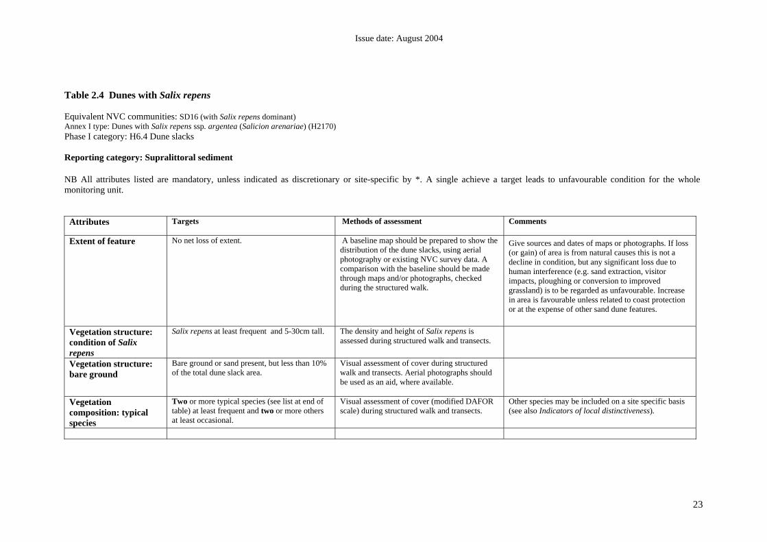
23
Table 2.4 Dunes with Salix repens Equivalent NVC communities: SD16 (with Salix repens dominant) Annex I type: Dunes with Salix repens ssp. argentea (Salicion arenariae) (H2170) Phase I category: H6.4 Dune slacks Reporting category: Supralittoral sediment NB All attributes listed are mandatory, unless indicated as discretionary or site-specific by *. A single achieve a target leads to unfavourable condition for the whole monitoring unit.
Attributes Targets
Methods of assessment Comments
Extent of feature No net loss of extent.
A baseline map should be prepared to show the distribution of the dune slacks, using aerial photography or existing NVC survey data. A comparison with the baseline should be made through maps and/or photographs, checked during the structured walk.
Give sources and dates of maps or photographs. If loss (or gain) of area is from natural causes this is not a decline in condition, but any significant loss due to human interference (e.g. sand extraction, visitor impacts, ploughing or conversion to improved grassland) is to be regarded as unfavourable. Increase in area is favourable unless related to coast protection or at the expense of other sand dune features.
Vegetation structure: condition of Salix repens
Salix repens at least frequent and 5-30cm tall. The density and height of Salix repens is assessed during structured walk and transects.
Vegetation structure: bare ground
Bare ground or sand present, but less than 10% of the total dune slack area.
Visual assessment of cover during structured walk and transects. Aerial photographs should be used as an aid, where available.
Vegetation composition: typical species
Two or more typical species (see list at end of table) at least frequent and two or more others at least occasional.
Visual assessment of cover (modified DAFOR scale) during structured walk and transects.
Other species may be included on a site specific basis (see also Indicators of local distinctiveness).

Issue date: August 2004
24
Vegetation composition: negative indicator species
Non-native species no more than rare. No more than one other negative indicator species more than frequent, or singly or together the cover of negative indicator species no more than 5%. Negative indicator species: Cirsium arvense, Cirsium vulgare, Cirsium palustre, Lolium perenne, Senecio jacobaea, Urtica dioica, Pteridium aquilinum, Arrhenatherum elatius
Visual assessment of cover (modified DAFOR scale), using structured walk or transects. % cover measured is cover of the dune slack area.
Urtica dioica and Cirsium spp. are indicative of poor condition.
Abundance of Senecio jacobaea indicates overgrazing in summer. Lolium perenne is indicative of agricultural improvement.
Vegetation composition: cover of broad-leaved grasses
Combined cover of broad-leaved grasses (Holcus spp., Dactylis glomerata, Arrhenatherum elatius) <10%.
Visual assessment of cover (modified DAFOR scale), using structured walk or transects. % cover measured is cover of the dune slack area.
Dactylis glomerata and Arrhenatherum elatius are not typical species of this community and would indicate a shift towards an ungrazed tussocky sward of MG1 grassland.
Vegetation composition: scrub/trees
Scrub/trees no more than occasional, or less than 5% cover.
Visual assessment of cover (modified DAFOR scale), using structured walk or transects. Aerial photographs should be used as an aid, where available.
If scrub/tree species are more than occasional, they are soon likely to become a problem if grazing levels are not sufficient or if scrub control is not being carried out. Where scrub or woodland is a notified habitat feature, the woodland monitoring guidance should be consulted.

Issue date: August 2004
25
*Indicators of local distinctiveness
Maintain distinctive elements at current extent/levels and/or in current locations (e.g. maintain existing populations of notable plant or animal species or transitions between habitats).
Presence confirmed during site visit at appropriate season. (List species, add DAFOR score, mark locations on map(s) in file.) List to be tailored to each site.
This attribute is intended to cover any site-specific aspects of this habitat feature (forming part of the reason for notification) which are not adequately covered by the previous attributes , or by separate guidance e.g. for notified species features. For notable species (e.g. vascular plants) it is not intended to set a target for detailed species monitoring, rather to provide a rapid indication of presence/absence and/or approximate extent, allowing for natural fluctuations in population size. *If part of the reason for the notification of the site, this is a mandatory attribute. Rare or scarce plant species specific to the site may include Equisetum variegatum, Epipactis palustris, Dactylorhiza incarnata
Table 2.4.1 Typical species for dunes with Salix repens Festuca rubra
Carex flacca
Carex arenaria
Ononis repens
Lotus corniculatus
Pilosella officinarum
Euphrasia officinalis

Issue date: August 2004
26
Table 2.5 Machair Note: This table refers only to machair grassland and arable land. Guidance tables for Strandline, embryo and mobile dune and Dune slacks should be used for those elements of machair systems. Equivalent NVC types: machair cannot be defined exclusively in NVC terms but for this table machair grassland refers mainly to SD8d, SD8e, SD8a, SD8c, plus provisional new type SD8x (Dargie 2000). Refer to internal SNH report on distribution. Cultivated areas may have weed communities referable to OV4 Chrysanthemum segetum-Spergula arvensis community. Annex 1 type: Machairs (H21A0) Equivalent Phase 1 categories: H6.5 Dune grassland (part), J1.1 Arable (part). Reporting category: Supralittoral sediment NB All attributes are mandatory except where indicated as optional or site-specific by *. A single failure to achieve a target leads to unfavourable condition for the whole monitoring unit. Attributes Targets Methods of assessment Comments Extent of feature No net loss of area of machair grassland. A baseline map should be prepared to show the
distribution of machair vegetation, using aerial photography or existing NVC survey data. A comparison with the baseline should be made through maps and/or photographs, checked during the structure walk.
Give sources and dates of maps or photographs. If loss or gain of area from natural causes this is not a loss of condition, but any significant loss due to human interference (e.g. dumping) is to be regarded as unfavourable. Natural loss to other machair habitats is acceptable.
Physical structure: functionality and sediment supply
1. Sediment circulation should be unimpeded.
2. Dune system intact or with only very small corridors through from beach to machair grassland.
Aerial photographs can be used, combined with information gathered from the site visit
Natural processes, particularly sediment supply, may be interrupted or prevented by artificial stabilisation or by sediment extraction. A continuing supply of sand from the beach to the machair grassland is especially important.
Areas should not increase in extent through human disturbance.
Vegetation structure: range of zones
Zonation from dune and to blackland/sliabh and marshes should remain intact over at least 95% of coastal frontage.
Visual assessment during structured walk and transects.
The target will be site- and feature-specific, dependent on the features present Distribution may change because of natural dynamism, but the overall diversity should not diminish.

Issue date: August 2004
27
Attributes Targets Methods of assessment Comments Vegetation structure: bare ground
Bare areas present but making up no more than 5% of the uncultivated area.
Visual assessment of cover during structured walk and transects. Aerial photographs should be used as an aid, where available.
Patches of bare sand are essential for a wide range of invertebrate species.
Vegetation structure: sward height
Sward height of machair grassland (SD8d, SD8e, SD8x, SD8a, SD8c) >8cm in July or August.
Record using structured walk or transects, during July/August
The main objective is to identify overgrazing and the height should be that of the grasses and associated herb, excluding prominent ruderals.
Vegetation structure: flowering
Most machair flowers able to set seed – to at least frequent level – depending on time of year visited.
Visual assessment (modified DAFOR scale) during structured walks or transects.
Indicator for overgrazing.
Vegetation structure: pattern of cultivation Uists only
Site-specific target for location/proportion of cultivated ground, fallow and permanent pasture.
A baseline map should be prepared to show the distribution of cultivated land, using aerial photography or existing NVC survey data. A comparison with the baseline should be made through maps and/or photographs, together with information gathered during site visit. GPS readings highly desirable.
Target should be set based on historical pattern of rotational cultivation. General guideline: arable plus recent (3 year) fallow <20% of machair grassland.
The distribution of cultivated ground will change, but the proportion in relation to other habitat types should remain roughly constant. The extent of habitat edge is important and any increase in field size should be noted. Fencing should also be noted.
Vegetation composition: typical species
1. On machair grassland (SD8d, SD8e, SD8x, SD8a, SD8c) at least six typical species (see list at end of table) should be present at a level of occasional or more.
2. If machair cultivation present, at least seven typical species should be present at a level of occasional or more in crop – see list at end of table – this is discretionary see comments.
3. If fallows are part of the machair cultivation rotation, at least seven typical species should be present at a level of occasional or more in fallow – see list at end of table.
Visual assessment of cover (modified DAFOR scale) during structured walk or transects
Target (2): if the cultivated area fails to meet this target, herbicides are almost certainly in use, with consequent impact on insects and seed-feeding species. This is indicative of overall loss of biodiversity. However failure to meet this target would not normally lead to an assessment of unfavourable condition.
Vegetation composition: bryophytes
Bryophytes always at least occasional.
Visual assessment of cover (modified DAFOR scale) during structured walk or transects

Issue date: August 2004
28
Attributes Targets Methods of assessment Comments Vegetation composition: negative indicator species
1. Non-native species no more than rare.
2. Ruderals no more than occasional in uncultivated areas (e.g. Cirsium spp., Senecio jacobaea, Urtica dioica).
3. Invasive species (e.g. butterbur Petasites) no more than rare or occasional but highly localised.
4. Phleum pratense and Lolium spp. absent or rare.
Visual assessment of cover (modified DAFOR scale) during structured walk or transects
Frequent Urtica dioica and Cirsium species are indicative of poor condition.
Abundance of Senecio jacobaea indicates overgrazing by cattle in summer.
Phleum pratense and Lolium spp are indicative of agricultural improvement.
*Indicators of local distinctiveness
Targets to be set to maintain distinctive elements at current extent/levels and/or in current locations (e.g. to maintain transitions between habitats, or to maintain existing populations of notable plant or animal species).
Presence confirmed during site visit at appropriate season. (List species, add DAFOR score, mark locations on map(s) in file.) List to be tailored to each site.
This attribute is intended to cover any site-specific aspects of this habitat feature (forming part of the reason for notification) which are not covered adequately by the previous attributes, or by separate guidance (e.g. for notified species features).
For notable species (e.g. vascular plants) it is not intended to set a target for detailed species monitoring, rather to provide a rapid indication of presence/absence and/or approximate extent, allowing for natural fluctuations in population size.
*If the indicators of local distinctiveness form part of the reason for the notification of the site, this is a mandatory attribute.

Issue date: August 2004
29
Table 2.5.1 Typical spp. for machair grassland Grassland Galium verum
Carex arenaria
Plantago lanceolata
Trifolium repens
Lotus corniculatus
Thymus polytrichus
Cerastium fontanum
Erodium cicutarium
Sedum acre
Euphrasia officinalis
Rhinanthus minor
Linum catharticum
Prunella vulgaris
Viola canina
Viola tricolor
Viola riviniana
Crepis capillaris
Odontites verna
Aira praecox
Heracleum sphondylium
orchid sp.
Crop Achillea millefolium
Anagallis arvensis
Anchusa arvensis
Arenaria serpyllifolia
Atriplex patula
Chrysanthemum segetum
Euphorbia helioscopia
Fumaria sp.
Lamium purpureum
Myosotis arvensis
Sinapis arvensis
Ranunculus acris
Papaver rhoeas
Polygonum aviculare
Viola tricolor
Fallow Achillea millefolium
Anchusa arvensis
Arenaria serpyllifolia
Atriplex patula
Chrysanthemum segetum
Euphrasia sp
Fumaria sp.
Lamium purpureum
Myosotis arvensis
Sinapis arvensis
Ranunculus acris
Papaver rhoeas
Polygonum aviculare
Veronica arvensis
Viola tricolor

Issue date: August 2004
30
12 REFERENCES Dargie, T. 1993. Sand dune survey of Great Britain, Part 2, Scotland. JNCC, Peterborough. Dargie, T. 1995. Sand dune survey of Great Britain, Part 2, Scotland. JNCC, Peterborough. Dargie, T. 2000. Sand dune vegetation survey of Scotland: national report. Scottish Natural Heritage, Commissioned Report, No. F97AA401. www.snh.org.uk/pdfs/strategy/commreports/F97AA401.pdf
Dargie, T. 2001. Sandwich Bay Dunes, Kent. NVC Survey 2001. A report to English Nature (Kent Team). Dargie, T. 2002. Sandwich Bay Dunes, Kent NVC Survey 2001. English Nature, Kent Team DETR. 1999. UK Biodiversity Group Tranche Two Action Plans. Vol 5 – Maritime species and habitats. DETR, London. J. Jones, M.L.M. Reynolds, B. Stevens. P. Norris, D. & B. Emmett. 2002. Changing nutrient budget of sand dunes: Consequences for the nature conservation interest and dune management. Centre for Ecology and Hydrology: CCW contract No: FC 73-01-347 JNCC, 1998. Guidelines for selection of biological SSSIs, JNCC, Peterborough JNCC, 2003, Handbook for Phase 1 habitat survey – a technique for environmental audit, JNCC, Peterborough van der Laan, D. 1985. Changes in the flora and vegetation of the coastal dunes of Voorne (The Netherlands) in relation to environmental changes. In: Ecology of Coastal Vegetation, eds., W.G.Beeftink, J. Rozema & A.H.L. Huiskes, Vegetatio, 61, 67-95. Radley, G.P. 1994 Sand dune vegetation survey of Great Britain: a national inventory: Part 1: England, JNCC Peterborough Rodwell, J.S. (Ed) 2000. British Plant Communities, Vol.5 Maritime communities and vegetation of open habitats, CUP, Cambridge