Embed Size (px)
DESCRIPTION
A preview of The Best Telluride Hikes, climbing Mount Sneffels, a trip to Cho Oyu
Citation preview

Trail & Timberline 1
The BesT Telluride hikes 22 • ClimBing The Queen of The san Juans 26 • an expediTion To Cho oyu 30
Trail &Timberline
The Colorado Mountain Club • Spring 2014 • Issue 1022 • www.cmc.org
Splendor
San Juan

Trail & Timberline 2

Trail & Timberline 1
Letter from the CEOThe San Juans Beckon from Afar
Katie BlackettChief Executive Officer
On Saturday, November 23, Matt and I welcomed our son, Kian Schneider, to the world. Thank you
for all the well-wishes, cards, and diapers! If he’s anything like his parents, he will de-velop a fondness for Telluride and the San Juans. The spring issue of Trail & Timber-line takes a peek at this part of our beautiful state, through the eyes and words of some of our members, both past and present. With spring just around the corner, there are countless adventures that await in the San Juans. Whether it’s a trip up the verdant and wildflower-laden Yankee Boy Basin to climb the Queen of the San Juans, Mount Sneffels (see Helen Huntley’s story on page 26), or a backpacking trip to the picturesque Ice Lakes, west of Silverton (see Rod Marti-nez’s Therm-a-Rest® piece on page 18), the San Juans are ready to be explored.
To aid in your exploration of the San Juans, CMC Press will be releasing a new pack guide, The Best Telluride Hikes, at the beginning of April. The fit-in-your pocket guidebook not only provides hikers with options in and near Telluride, but also in-cludes trails within an hour or so of the town limits. Combine this with The Best Durango Hikes, and you will have access to 40 classic southwestern Colorado trails, all of which are CMC member favorites. For a preview of The Best Telluride Hikes, check out page 22.
In addition to the aforementioned ar-ticles, High Altitude Mountaineering Sec-tion instructor John Martersteck regales us with the story of his and Debbie Markham’s trip to the enchanting Himalayas and their attempt to climb the world’s sixth-highest peak, Cho Oyu. Finally, 2015 is the Year of
the Mountaineer, which will be a celebra-tion of the importance of mountaineering in the history and the future of the Club. Please see the ad on page 9, and during the coming months check our Web page (https://www.cmc.org/yearofthemoun-taineer) for details on our World Summit Series and Rocky Mountain National Park top-100 peak climbs. △

Trail & Timberline 2
Spring 2014Trail & Timberline • issue 1022 • www.cmc.org
18 Becoming a Therm-a-resT® “Dreamer”Safety, comfort, and quality go a long way in making a backpacking trip successfulBy Rod Martinez
26 mounT sneffelsEnjoying a picturesque and historic hike up the ultimate amphitheaterBy Helen Huntley
30 The PaTh To The himalayasThe challenge of Cho Oyu AwaitsBy John Martersteck
36 The roaD To chicago BasinWhat led up to the creation of Needle Creek Trail?By Woody Smith
18 26

Trail & Timberline 3
30on The cover
Waterfalls in Yankee Boy Basin, with Mount Sneffels in the background. Photo by Rod Martinez
36
01 Letter from the CEO
06 On the Outside 08 Mission Accomplishments
learn the latest from the conservation andyouth education departments, as well as newson the Year of the mountaineer.
14 Around Colorado What’s happening in your group?
16 Safety First The power of four. BySandiBianchi
22 Pathfinder a preview of TheBestTellurideHikes. ByChristianGreen
38 End of the Trailremembering those who have passed.
40 CMC Adventure TravelWant to get away? Wander the world with yourfriends at the CmC on these classic trips.
Departments
Trail & Timberline 4
www.cmc.org
The official publication of the Colorado Mountain Club since 1918.
Trail &Timberline
eDiTor Christian [email protected]
Designer
Jessica D'Amato
aDverTising sales
Robin [email protected]
The coloraDo mounTain cluB710 10th Street, Suite 200Golden, Colorado 80401
303-279-3080The CMC is a 501 (c)(3) charitable organization.
The Colorado Mountain Club is organized to▶ unite the energy, interest, and knowledge of the students, explorers, and lovers of the mountains of Colorado;
▶ collect and disseminate information regarding the Rocky Mountains on behalf of science, literature, art, and recreation;
▶ stimulate public interest in our mountain areas;
▶ encourage the preservation of forests, flowers, fauna, and natural scenery; and
▶ render readily accessible the alpine attractions of this region.
Trail & Timberline (iSSn 0041-0756) is published quarterly by the Colorado mountain Club located at 710 10th Street, Suite 200, Golden, Colorado 80401. Periodicals postage paid at Golden, Colorado, and additional offices. Subscriptions are $20 per year; single copies are $5. POSTmaSTer: Please send address changes to
Trail & Timberline, 710 10th Street, Suite 200, Golden, Colorado 80401. advertisements in Trail & Timberline do not constitute an endorsement by the Colorado mountain Club.
Please recycle this magazine.Printed on 10% post-consumer waste recycled paper.
© 2014 coloraDo mounTain cluB all rights reserved
Thank You, and Happy Trails!Although hiking was one of my favorite pastimes when I moved to Colorado in July 2007, I hadn’t spent much time in the real mountains. The Appalachians are charming in their own right, but when the clouds finally lifted on that hazy late July afternoon, revealing the Front Range peaks in all their grandeur, I couldn’t avert my gaze. I was captivated. Thanks in part to the Colorado Mountain Club, I have had the opportu-nity to experience the beauty and sublimity of this great state’s mountains, both firsthand and through the people I have been fortunate to meet dur-ing my time as a member of the Club and then as director of publishing. Thank you to the many Club members and staff, whom I had the pleasure to work with during the past two years. I would like to introduce Sarah Gorecki, who will be taking over as director of publishing for CMC Press and editor of Trail & Timberline. Many of you are well acquainted with Sarah, who has spent the past four and a half years as CMC’s development director, and most recently served as interim CEO during Katie Blackett’s maternity leave. You may also have read about Sarah’s Colorado Trail through-hike in the fall 2013 issue of T&T. Please join me in welcoming Sarah to her new position. I wish you all the best, and I look forward to hearing about all of the Club’s endeavors during the coming years. Sincerely,
Christian Green

Trail & Timberline 5
The Colorado Mountain Club thanks the Scientific and Cultural Facilities District and its citizens for
their continuing support. www.scfd.org
The Colorado Mountain Club is a proud member of Community Shares of Colorado.
For Membersmember benefits
→ Join us on over 3,000 annual trips, hikes, and activities in the state’s premiere mountain-adventure organization.
→ Expand your knowledge and learn new skills with our schools, seminars, and events.
→ Support our award-winning Youth Education Program for mountain leadership.
→ Protect Colorado’s wild lands and backcountry recreation experiences.
→ Enjoy exclusive discounts to the American Mountaineering Museum.
→ Travel the world with your friends through CMC Adventure Travel.
→ Receive a 20% discount on all CMC Press purchases and start your next adventure today.
→ It pays to be a member. Enjoy discounts of up to 30% from retailers and corporate partners. See www.cmc.org/benefits for details.
→ Receive the Shared Member Rates of other regional mountaineering clubs and a host of their perks and benefits, including lodging. Visit cmc.org/Alpine6 for details.
opportunities to get more involvedCharitable Donations
Join our select donors who give back to the club every month by using electronic funds transfer (EFT). It is easy and convenient, you can discontinue anytime, and you’ll provide support for critical programs. Sign up at www.cmc.org/support.
By naming the Colorado Mountain Club in your will, you will be able to count yourself among the proud members of the 21st Century Circle. Read more at www.cmc.org/legacy. Please consult your financial advisor about gift language.
By donating $1,000 or more to the Annual Campaign, you'll enjoy the exclusive benefits of the Summit Society, including hikes to places that the CMC's conservation department is working to protect, an annual appreciation event, and a complimentary copy of a new CMC Press book.
If you have any questions about donations, please contact Sarah Gorecki, Development Director, at 303.996.2752 or [email protected].
Volunteer EffortsIf you want to share your time and expertise, give back to the club by volunteering on a variety of projects, from trail restoration to stuffing envelopes. Visit www.cmc.org/volunteer for a complete listing.
Contact UsOur Membership Services team can answer general questions every weekday at 303.279.3080, or by email at [email protected].
▶ 40% off admission at the American Mountaineering Museum
▶ 20% off titles from The Mountaineers Books
▶ 10% at Neptune Mountaineering, Boulder
▶ 10% at Bent Gate Mountaineering, Golden
▶ 10% at Wilderness Exchange Unlimited, Denver
▶ 10% at Mountain Chalet, Colorado Springs
▶ 10% at The Trailhead, Buena Vista
▶ 10% at Rock'n and Jam'n, Thornton
it pays to be a member!
not a member? Visit www.cmc.org/join

Trail & Timberline 6

Trail & Timberline 7
On the OutsideSunlight and Windom peaks seen from Mount Eolus. Kevin McCartney

Trail & Timberline 8
Mission Accomplishments
Youth Education Program Uses Collaboration to Reach Underserved StudentsBy Melanie Leggett
PART OF THE COLORADO Moun-tain Club’s mission is to “ensure that cur-rent and future generations have the access and ability to enjoy Colorado’s open spaces and outdoor activities.” In the case of the Youth Education Program (YEP), this is sometimes easier said than done. Each year YEP has a goal that 40 percent of the stu-dents we reach will be either ethnically di-verse or from low income families, in order to truly reach a population that represents all Colorado youth. Finding ways to fund low-income schools is an ongoing chal-lenge for YEP, and the CMC development office works tirelessly to find new and cre-ative options for helping youth experience our programs.
This fall, YEP was fortunate to receive a new grant from the Millennium Trust in Boulder, to assist us in providing program-
ming to Title I Schools in the Boulder Valley School District. Title I is a Federal designation given to schools with a high population of students from low-income families, of which there are eight in the Boulder Valley School District. Upon re-ceiving the grant, YEP was challenged to come up with a program that would meet several objectives. First, we wanted to reach at least 500 students through whatever proj-ect we came up with, and second, we want-ed to offer a program that would not only meet state science standards, but would also highlight physical education and outdoor adventure. To accomplish both goals it was determined that our best option would be to provide outreach programs, which means we would be teaching at the schools, allow-ing us to reach a greater number of students by avoiding the need to pay for bussing.
In order to bring in the adventurous aspect that we typi-cally get from the AMC climbing wall or sites out in the field, we turned to a partnership with the Women’s Wil-derness Institute, another outdoor nonprofit based in Boulder.
The Women’s Wilderness Institute (TWWI) is an or-ganization with the mission of strength-ening the courage, confidence, and leadership qualities of girls and women, through the sup-port and challenge of wilderness- and community-based experiences. TWWI recently acquired an exciting addition to
their program—a retired school bus that has been converted into a mobile boulder-ing gym! The Women’s Wilderness Insti-tute and YEP have a history of collabora-tion, so it was a natural fit to team up for this exciting project. Ultimately, YEP cre-ated a proposal to Boulder Title I schools to bring our Science of Climbing class to their 4th and 5th grade students. The Science of Climbing uses rock climbing as a lens to teach science concepts, including phys-ics (by looking at the friction of climbing shoes), biology (through comparing our-selves to expert climbers from the animal world), and geology. Starting in February, YEP began travelling to Title I schools in Boulder and teaching Science of Climbing to students. As part of the class, groups will also get to head out to their school parking lot and take a turn on the bouldering bus, applying concepts that they learned in class.
YEP is excited about this collaborative effort between Boulder Valley Schools, the Millennium Trust, the Women’s Wilder-ness Institute, and the CMC. Sometimes it takes a village to accomplish the work of bringing the mountains to Colorado kids, and through this unique collaboration YEP is already halfway to its goal of reaching 500 new Boulder students by October 2014. △
The Women’s Wilderness Institute mobile boul-dering gym. Photo courtesy Lori Mathews

Trail & Timberline 9

Trail & Timberline 10
CMC Conservation Issues Survey Results and Discussion
By Heather MacSlarrow
PRIORITY ISSUES FOR CONSERVATION DEPARTMENT WORKVoting: 101 Total Respondents: 61 at the Backcountry Bash, 40 online. 303 Total Votes (each participant cast three votes on their top issues).Methodology: Consolidated votes for first, second, and third place to give final rankings per issue.
We recognize that conservation covers many ecological and social components, and that separating one from another in terms of impor-tance is extremely difficult. If we had the resources, we would work toward solution creation for each item on the list represented in this question. For now, we are going to focus on the first five voted priorities, each of which represents 10 percent or more of the vote per issue.
The CMC has long worked for the preservation of wild places, and we were pleased to see that this issue ranked so high. We are current-ly working toward wilderness designation for the Rampart Range Wildlands Area, and are partnering with organizations across Colorado to support other wilderness projects. We participate in the Colorado Wilderness Network and together with the coalition are planning a full slate of events to honor the 50th Anniversary of the Wilderness Act. In addition, we are working with other partner organizations to design alternative avenues for public land preservation.
Water is a precious resource everywhere, especially in Colorado. It touches everything we do as people, recreationists, and stewards of the land. Although we have not traditionally worked with water conservation, it’s ranking in this question, and the statewide urgency of this issue have catalyzed us into action. We are currently in discussions with a number of organizations and communities about projects to increase in-stream flow in important waterways across the state.
Protection of wildlife is another issue that we have not worked with historically. However, it is a key component of protecting wild
This fall, the Conservation Department distributed a Conservation Issues Survey in the Rucksack e-newsletter, Trail & Timberline, and at the Backcountry Bash. Our goal with this survey was to better understand the conservation priorities of our membership and stakeholders, and to use that infor-mation to drive our work. Thank you to everyone who participated in this survey. We highly value your contribution and are excited to utilize this information. Below are the survey results, description of voting turnout and methodology, and a discussion of the results for each question.
Trail & Timberline 11
places, one of our four primary directives. As of this writing, we are involved in the Sage Grouse and Canadian Lynx advocacy campaigns, and are delving more deeply into other wildlife campaigns.
The promotion of quiet recreation and management of motorized use is one of our capstone issues. We work with a plethora of partner organizations on a multitude of motorized issues, such as winter and summer travel management planning on state and federal lands; legislation to increase accountability, visibility, and enforcement; advocacy to the State Trails Committee and OHV Subcommittee; rep-resentation on motorized management task forces; and statewide trail analysis to ascertain use and sustainability.
Climate Change was identified by this vote as the fifth-most important issue for the Conservation Department. We have virtually no prior involvement in this issue, but recognize the tremendous value. We are currently in discussions with partner organizations to build a program that would marry regional climate change and air quality education with revegetation stewardship projects in disaster (flood and fire) areas where loss of vegetation has greatly impacted carbon sequestration and release.
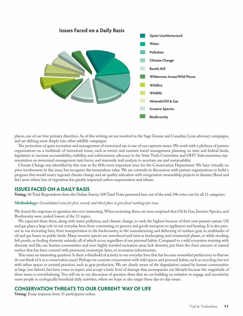
ISSUES FACED ON A DAILY BASISVoting: 36 Total Respondents from the Online Survey. 108 Total Votes presented here out of the total 396 votes cast for all 11 categories.
Methodology: Consolidated votes for first, second, and third place to give final rankings per issue.
We found the responses to question two very interesting. When reviewing them, we were surprised that Oil & Gas, Invasive Species, and Biodiversity were ranked lowest of the 11 topics.
We expected these three, along with water, pollution, and climate change, to rank the highest because of their ever-present nature. Oil and gas plays a large role in our everyday lives, from commuting, to grocery and goods transport, to appliances and heating. It is also pres-ent in our recreating lives, from transportation to the backcountry, to the manufacturing and delivering of outdoor gear, to multitudes of oil and gas leases on public lands. Many invasive species are introduced and exist as landscaping and ornamental plants, or while stocking fish ponds, or feeding domestic animals; all of which occur, regardless of our personal habits. Compared to a wild ecosystem teeming with diversity and life, our human communities and even highly traveled recreation areas lack diversity, just from the sheer amount of natural surface that has been covered with pavement, monotypic lawn, or recreation infrastructure.
This raises an interesting question: Is there a threshold of activity in our everyday lives that has become somewhat perfunctory so that we do not think of it as a conservation issue? Perhaps we connote conservation with wild spaces and personal habits, such as recycling, but not with urban spaces or societal practices, such as gear production. We are clearly aware of the degradation caused by human communities at large (see below), but have come to expect and accept a basic level of damage that accompanies our lifestyle because the magnitude of these issues is overwhelming. You will see in our discussion of question three that we are building an initiative to engage and incentivize more people in ecologically beneficial daily activities, where we hope to also target these day-to-day issues.
CONSERVATION THREATS TO OUR CURRENT WAY OF LIFEVoting: Essay response from 31 participants online.

Trail & Timberline 12
Methodology: We grouped together comments about the same issues and tallied the number of comments per issue. There are more than 33 “com-ments” tallied because some people mentioned more than one issue in their response.What we found in this question was that there were many commonalities amongst answers, which is why we grouped and calculated responses according to issues. Almost one quarter of the comments were regarding ecological degradation caused by human action, from reckless and unsustainable use of limited resources, to desecration of habitat due to development, to lack of respect for nature and other humans.
We concur that much of our own behavior leads to substantial conservation problems. The downside is that with the human popula-tion growing daily (and exponentially), humans being led by vastly different governments across the globe, and many societies being entrenched in damaging practices, finding a solution to this issue is daunting. The upside is that while we can’t immediately arrest all potentially negative behavior across the globe, we can change our own habits and choices.
And while many of us do routinely consider the environment when making decisions, our actions can easily feel small in the face of the problem. We are working on an initiative that will engage more people in environmentally friendly daily activities, quantifying those activities, and building a living database of positive actions happening simultaneously statewide. Our hope is that an up-to-date quantifi-cation of action will both empower individuals in their current activities and entice them into doing more.
GENERAL THOUGHTS ON CONSERVATION IN COLORADOVoting: Short answer response from 16 online participants and 9 Bash attendees.Methodology: Question four was also open ended. However, the responses differed in character from question three. Rather than consensus group-ings, we found a number of contradictory comments. We amalgamated like comments and drew up a “point/counterpoint” diagram that showed opposing views. We also included four stand-alone comments that did not have counterpoints.
Point CounterpointPollution and water conservation should be addressed at a local level as a starting point. The CMC should gather together with
national organizations to leverage our conservation impact.
I don’t know how a hiking club can address larger issues such as pollution, water, climate, or beetle kill. The CMC should focus on
more local issues, things that directly affect us.I love both CMC and off-roading. I do not want to see the exclu-
sion or closure of either sport.It is sad to see people enjoy desecrating sports such as riding
ATVs or monster trucks. There is a land grab by motorized groups that has/is leading to increased noise pollution and environmental
degradation.The USFS is ineffective at protecting public lands and they should
be held accountable.We need to support the USFS so they can increase enforcement
on public lands.Wildlife is key. Living creatures should come first, and we need to
find a way to co-exist.Water is of chief importance, it takes care of all the rest.

Trail & Timberline 13
There is too little wilderness, (specifically in the Fruita/Grand Junc-tion area).
We need alternative ways to protect land other than wilderness designation, it takes too long. More lands must be preserved
rapidly to stop private encroachment.Wildland fire is our largest threat. Population growth is our largest threat.
Conservation should be a more central theme in CMC. What are we leaving behind for the next generation of CMCers? Perhaps stew-ardship should be a membership requirement for CMC. Federal lands need more help, especially as budgets continue to tighten.
More lands should be closed to dogs, as owners are irresponsible.
We should shut down all oil and gas production.
We should have an increased presence in the press for both group and state conservation and stewardship efforts.
We loved the differences of opinions shown here for a few reasons. First, seeing our differences even within one organization of relatively like-minded people reminds us of the vast number of valid viewpoints that surround us. Second, the concepts brought up in this question show the complexities and unanswered questions in the conservation sector and catalyze conversation that can deepen our understanding of the issues at hand and help us find solutions.
We will leave you with the encouragement to use the topics posed by these questions as a basis for conversations with friends, family, and peers; and an inspiring quote from one of our online survey participants: “We need to focus on obtainable, maintainable, and objective goals that serve many interests. There is too much emphasis on drawing lines in the sand and identifying the ‘enemy’ and less and less on actually finding out how to protect our environment and wild places. Recreation can do just as much damage to our land as other activities. We need objectivity and inclusiveness in keeping up good conversation and preservation efforts in Colorado.”Please send any comments, questions, or ideas to Heather MacSlarrow at: [email protected]. You can continue to get up-to-date information on the department by checking www.cmc.org/conservation (we launched more interactive pages in late February), reading future editions of Trail & Timberline, signing up for our Conservation E-News (www.cmc.org), or by looking for the conservation section in the Rucksack e-newsletter. △

Trail & Timberline 14
Around ColoradoOur groups across the State
DENVERWho Are We? Our website—www.hikingdenver.net—is where you’ll find everything about the Colorado Mountain Club’s Denver Group. With over 3,200 members, we offer something for everyone 18 years or older who loves the outdoors. The CMC leads over 3,000 trips a year into the mountains. Would you like to meet folks in your age range? Check out the Trailblazers (21–40) or the very popular Over the Hill Gang (50+). For more information, take a look at the e-version of our monthly newsletter, Mile High Mountaineer, at www.hikingdenver.net
Get InvolvedGet involved with hiking, including wildflower and photography hikes; fly fishing; rock climbing; and snowshoeing and backcountry skiing. Learn new skills at our competitively priced schools, or work on a conservation project. It’s all possible because of our dedicated volunteer trip leaders, school directors, and instructors.
Learn MoreSend an e-mail to [email protected] for specific questions. Or attend one of our New and Pro-spective Member Orientations, which are of-fered most months. Programs start at 6:30 pm at the American Mountaineering Center in Golden. Please confirm dates and details by searching for “New and Prospective Member Orientation” on the schedule www.cmc.org/Calendar/Events.aspx
Upcoming Schools and Programs All classes start with lectures held at the American Mountaineering Center in Golden, then you’ll go to the mountains and practice what you learned! Please check out the links below:
Fly Fishing SchoolStarts April 2. For more details go to http://www.hikingdenver.net/schools/flyfishing
Wilderness Trekking SchoolStarts April 8. For more details go to http://www.hikingdenver.net/schools/wts
Basic Mountaineering School Starts March 10. For more details go to http://www.hikingdenver.net/schools/bms
Ski Mountaineering School Starts March 13. For more details go tohttp://www.hikingdenver.net/schools/skimoun-taineeringschool
Wilderness First Aid Classes start March 5 or April 6. For more de-tails go to www.hikingdenver.net/schools/wil-derness-first-aid
Open Climbs Indoor climbing at the American Mountaineer-ing Center. Members must know how to belay. Bring your own helmet and harness. For more dates and details search for “CMC Wall Climbs” or “Open Climbs” on the schedule www.cmc.org/Calendar/Trips
Fly Fishing Monthly Program For more details go to http://www.hikingdenver.net/schools/flyfishing
BOULDERWho Are We?The Boulder Group came into existence in 1920, eight years after the Colorado Mountain Club was founded. Today, the group’s 1,100-plus members enjoy a variety of climbing, hiking, backpacking, running, and skiing activities. Boul-der Group outings range from casual after-work hikes to leisurely flower photography walks to high mountain meadows. With our proxim-ity to the Flatirons and Eldorado Canyon, it’s no surprise that rock climbing is a favorite activity. Details about Boulder Group Outings may be found at http://www.cmcboulder.org/trips/
Get EducatedOne of the hallmarks of the Boulder Group is the robust set of classes and clinics it offers. During the spring/summer, the Boulder Group offers Basic Rock School (BRS), Rock Leading School (RLS), Top Roping Clinic, Sport Leading Clinic, Basic Snow Travel, Intermediate Snow Travel, Backpacking School, Hiking Navigation, and more. Registration for these courses opened in late February and fills up quickly, so if you are in-terested, please sign up as soon as possible. For details about these courses, go online to: http://www.cmcboulder.org/bms/index.html
Get InvolvedThere are many ways to become involved with the Boulder Group, by participating in outings, taking courses, volunteering, working on conser-vation projects, and leading trips. New trip lead-ers and co-leaders are always welcome; inter-ested persons should contact the Outings Chair and/or view the information at www.cmcboulder.org/trips/#TripCoLeaders.
A great way for new and prospective CMC members to learn more about the Boulder Group and its many classes, trips, and activities is to at-tend one of the Open Houses that take place at 7–8:30 pm on the 3rd Wednesday of every odd-numbered month. The next Open Houses are on March 19 and May 21. Experienced members will be on hand to share their enthusiasm and knowledge about hiking, camping, peak bag-
ging, rock climbing, snow shoeing, cross-country skiing, and more. The Open Houses take place at the Boulder Group club room, in the Table Mesa Shopping Center, on the southwest corner of Broadway and Table Mesa Road, between Nep-tune Mountaineering and H&R Block. We hope to see you and a friend there!
FORT COLLINSThe Fort Collins Group is the fourth-largest group in the CMC with nearly 400 members from the north Front Range area. We offer year-round activities, from monthly programs, to hik-ing, climbing, snowshoeing, cross-country skiing, various schools, and more. Refer to the calendar at www.cmc.org/Calendar for up-to-date infor-mation and check out our Web site at http://www.fortcmc.org/. Below are some upcoming schools/classes:
Mountain Hiking SchoolThis popular offering starts late winter/spring and features knot tying; map, compass, and ori-enteering; some first aid; and travel on snow. For a graduation hike, usually in July, the students plan the route using their skills gained during the course. School Director is David Wasson.
Alpine Scrambling CourseNew to the Fort Collins Group this year this course fits nicely between the Mountain Hiking School and the Basic Mountaineering Course. It will include two lectures, as well as four days of field work. Field work will include basic skills, snow climb, and alpine scrambling. Upon con-clusion students should be comfortable with at least moderate class 3 terrain and tolerant of moderate exposure. Course coordinator is Ward Whicker.
Wilderness First AidWe recently qualified two Fort Collins members, Tom Chapel and Sharon Lowe, to teach Wilder-ness First Aid and will be offering the two-day course in late spring/early summer. Trip leaders as well as prospective trip leaders are especially encouraged to take the course, but it is open to all members.
Young AdventurersThis continues to be a popular group in Fort Col-lins, catering to the younger members, 20 to 50 years of age with an occasional young at heart (over 50), space permitting. Activities vary from off-trail hikes, peak climbs, backpacking, snow-shoeing, and backcountry skiing.
Adopt-a-TrailMany of our trails in the Big Thompson and Pou-dre Canyons have been impacted by either fires, floods, or both in the past two years. In coordina-tion with the U.S. Forest Service the Fort Collins

Trail & Timberline 15
Group has adopted the Greyrock Trail near the mouth of the Poudre Canyon. Watch our calen-dar for trail days this summer to help in restoring our trails. Our Trails Coordinator is Kevin Mc-Cartney.
PIKES PEAKWho Are We? The Pikes Peak Group is based out of Colorado Springs. We are a diverse group of approxi-mately 600 members with a variety of activities and challenge levels that include: hiking, back-packing, rock climbing, biking, ice climbing, ski-ing, snow climbing, conservation activities, and snowshoeing. In addition, we offer courses in basic moun-taineering, which includes wilderness fundamen-tals, land navigation, rock climbing, alpine snow mountaineering, ice climbing, and backpacking; high altitude mountaineering, which includes glacier travel; backcountry skiing; anchor build-ing; lead climbing (rock and ice); introduction to avalanches; snowshoeing; wilderness first aid; hut to hut clinic; scrambling clinic; lightweight and ul-tralight backpacking clinic; winter wilderness sur-vival; and GPS training. Please check www.cmc.org for more events hosted by the PPG.
Advanced Backcountry Skiing,March 5–March 15So you have taken the introduction to backcoun-try skiing and you have been out for the past few winters honing your skills. Where do you go next? Have you thought about kicking and glid-ing into a bowl then playing around there or ski-ing to a hut to play for several days? Have you thought your entry-level skills prevented you from attempting such a task? This class will pick up where the Introduction to Backcountry Skiing class left off. The classroom date is March 5; the first field session is March 8; and the second field session is March 15. All field sessions are sched-uled as CMC trips. For class details, please con-tact Bill Luttrell at [email protected].
Backcountry Film Fest, March 7PPG will host the first Backcountry Film Festival in the Springs. Check www.cmc.org for details.
Learn More Attend the monthly Pikes Peak Group meeting the third Tuesday of each month (except May, November, and December) at 7:30 pm, at our new venue, the All Souls Unitarian Church, 730 N. Tejon Street, or connect with members of the
Pikes Peak Group by joining us on one of our many trips or classes
WESTERN SLOPEThe Western Slope Group is 100 members strong, from all professions and states in the country, each with a keen interest in hiking, backpacking, cross-country skiing, alpine skiing, cycling, geology, wildflowers, stewardship, and conservation. The group has adopted Flume Canyon in the McInnis Canyons National Conser-vation Area for trail monitoring and restoration. It is monitored monthly by our members.
Our members contribute stories and photos to our monthly E-magazine, Canyon Call. In ad-dition, CMC Press recently published our own member written The Best Grand Junction Hikes pack guide, which is available in many outlets, in-cluding online at http://www.cmc.org/Store DiversityWe may be small, but our activities are diverse, from hikes in McInnis Canyons and Horsethief Bench to the Colorado National Monument, Dominguez Canyon, The Lunch Loop area to Fisher Towers and Upheaval Dome in Utah’s Can-yonlands; hikes to the Kebler Pass area, including the Dyke Trail and Scarp Ridge above Lake Irwin and cross-country skiing on the Grand Mesa, the world’s largest flattop mountain at 11,000 feet, where there are many classic and cross-country skiing and snowshoeing opportunities; plus downhill at Powderhorn and nearby Snowmass and Telluride. This summer we featured climbs in the San Juans, including Senator Beck Mine Basin, Mount Wilson, Highland Mary, and Verde Lakes in the Grenadiers, and Redcloud and Sunshine
peaks outside Lake City. Our cycling group took to the highways west of the Fruita Desert, rode the Colorado National Monument, as well as cycled the Glenwood Canyon Trail and the Rio Grande Trail from Carbondale to Woody Creek.
Come Hike or Cross-Country Ski with Us Interested in learning more about the Western Slope Group? Meetings are held on the first Wednesday of every month at the Masonic Lodge at 2400 Consistory Court, just off First Street in Grand Junction. Meetings generally feature a prominent naturalist or climber and a Power Point presentation and refreshments. For more information, contact Western Slope Chair Stanley Nunnally at (970) 640-4160 or [email protected] GORE RANGEAlong with enjoying our “passion for the moun-tains,” the Gore Range Group has been exploring the ancient history and geology of Colorado and surrounding states. From geological excursions to the Fiery Furnace and the Wave in Utah, to the cliff dwellings, pictographs, and petroglyphs of the ancient pueblo people at Comb Ridge, Utah, and New Mexico, we have begun a trend of edu-cational as well as adventure trips. Our next such trip will happen March 20–April 4, as we hike and camp at Chaco Canyon, New Mexico, and the Ute Tribal Park in southern Colorado. Visit http://www.cmc.org/Calendar/Trips and click “Gore Range” under “Group” for a list of trips and more information. Meanwhile, we have lots of backcountry and telemark skiing, moonlight adventures, hut trips, and snow picnics in the lineup. Check us out. △
Members of the Western Slope Group atop Redcloud Peak. Photo courtesy Carolyn Emanuel. ▶

Trail & Timberline 16
ThePoweroffourwhenItComestoSafety,It’saPrimeNumberBy Sandi Bianchi
In February 2013, my partner, Ralph, and I were skiing the Ward Lake trail system on Grand Mesa with our friends Fred and Bar-bara. It had been a gorgeous day with a hefty snow dump a few days prior. The air was crisp, the sun was warm, and the snow was sticky. Around 2:30 in the afternoon, I caught my right ski in a foot of new snow while my left ski zoomed ahead in the ski track. My legs did the splits and I heard my left knee holler, “Pop! Pop!”, as I fell to the ground.
We were about 1.5 miles from the west trailhead. I could not put weight on my knee, so Fred stayed with me while Ralph and Barbara skied out for help. The duo had two rescue plans in mind. ■ PlanA: have a snowmobile come in for me. Grand Mesa has two large snowmobile areas very close to the Ward Lake trail sys-tem. ■ PlanB: retrieve the snowshoes from the car and somehow use them to help me hobble out.
When Ralph and Barbara arrived at the trailhead, they noticed a park ranger in the parking area. Relieved to see her, they asked if she would help them get a snowmobile. She said, “Absolutely not—snowmobiles are not allowed on the Ward trail system.” She offered to call search and rescue in Delta, but told them it would take an hour for a team to arrive.
Sensing the imminent time crunch, Barbara saw a family with two kids and a blue plastic sled. She nearly ripped the sled out of the children’s hands while offering their dad the only money she had on her—a $20 bill. Dad took the money without hesitation and surrendered the sled, never offering to help.
Seeing the sled, the ranger contributed 20 feet of nylon rope to the project. Trading their skies for snowshoes, Ralph and Barbara scampered back up the hill, sled in hand.
Meanwhile, Fred and I remained hopeful that a snowmobile would arrive. Every time we heard the roar of an engine, we were sure that help was on the way, only to have our hopes dashed as the sound faded in the distance. Sitting on my insulated foam pad and warming myself with Fred’s jacket, I quietly took inventory of my backpack and reprimanded myself for not carrying more food and warm clothing.
haveyoueverwonderedwhytheColoradoMountainClubrequiresatleastfourparticipantsinordertohaveanofficialClubhike?Itisnotjustforthecompanyandconversationoftheparticipants.withagroupoffourpeople,intheeventofinjury,thereissomeonetostaywiththeinjuredpersonandtwopeopletogoforhelp.Irecentlyexperiencedthepoweroffouronacross-countryskitrip.
Fred entertained me by telling stories and jokes. In between, he skied up and down the hill behind me to stay warm. I could see my solar heater would soon move behind the nearby tree tops.
At 4 pm we heard Ralph and Barbara’s voices coming up the trail. After transferring me to the sled, they tied the rope to the sled front. I held my ski poles together out the right rear side of the sled, and we used them to anchor the rear. One person pulled the sled with the rope while the other person held the ends of my ski poles. This action centered the sled between the frontrunner and the anchor person, and kept the sled off the heels of the frontrunner on the downhill.
They trudged for three quarters of a mile, up and down hills, trading places every 100 feet. Taking off his skis and letting Barbara carry them, Fred took a few turns too. Every rotation took its toll on their bodies.
Suddenly, a monster snowmobile thundered to a stop behind us. The driver said the ranger called him. She must have looked at her watch and decided that besides enforcing rules, she was also re-sponsible for the safety of others.
The driver was Mark Stewart, owner of Thunder Mountain Lodge, located at the north trailhead of the Ward Lake trail system. Since he didn’t know exactly where we were, he’d taken a number of wrong trails and ran his snowmobile into a metal gate, slightly injuring his leg, before he found us.
We arrived at the trailhead parking lot about 5 pm. When the sun slid behind the mountain, the temperature dropped dramatically. I was thankful I didn’t have to spend the night outdoors. Ralph of-fered Mark money as a thank you for his time and effort, but unlike sled dad, he refused.
Still unable to put weight on my left leg the next day, we cut our cross-country ski vacation short and returned to Denver. An MRI three weeks later revealed a torn MCL (Pop!) and a ruptured PCL (Pop!). I didn’t need surgery. Instead I would have three months of intense physical therapy ahead of me. The good news is that, due to my physical therapy diligence, I was ready to lead hikes for the first week of the CMC In-State Outing in Ridgway in July.
Had it not been for my group of four, I would have never made it out of the woods before dark, and worse, I might have spent a
Safety first

Trail & Timberline 17
frigid night on the trail before I was rescued in the morning. If I had been alone, I would have had to crawl out 1.5 miles to the road and hope that a car came along to pick me up. Or hole up under a big pine tree with my Ten Essentials and hope to survive the night. Temperatures were around zero degrees on the mesa that evening.
Ralph and Barbara could consult each other on trail conditions and routes as they went for help. With the two of them working to-gether, they were able to think creatively when the ranger quashed Plan A. If it hadn’t been for Barbara, Ralph might not have seen the sled. Her quick thinking immediately took them to PlanC.
I spent almost two hours sitting on the cold trail, and while I wasn’t talkative or in pain, I was very grateful to have Fred there to comfort and console me. I can’t imagine spending those two hours alone.
We were fortunate that we had snowshoes in the back of our car, because skies provide too little traction to pull 120 pounds of
weight on a sled uphill. More fortune could be found in the sled that showed up at the right moment and the $20 bill to pay for it. How many of us carry money in our pockets when we’re in the backcountry? Twenty feet of nylon rope did not hurt either, nor did the ranger’s decision to call for help. I now carry nylon rope in my backpack. Finally, good Samaritans are always appreciated, especially when they come with a monster snowmobile.
All in all, luck was on my side that day and four was the perfect number.
Sandi Bianchi, Ralph, Fred, and Barbara are all members of the Denver Group of the Colorado Mountain Club. Sandi has been a trip leader since 2003.

Trail & Timberline 18
All CMCers recognize that we live in a great state where there is an abun-
dance of terrific hiking and backpacking opportunities. Because I have submitted numerous photos, written an article on fall hikes for Trail & Timberline, and served as project manager and an author for The Best Grand Junction Hikes and the soon-to-be published The Best Telluride Hikes pack guides, I was nominated late last spring “as a friend” of the Colorado Mountain Club to be a Therm-a-Rest® “Dreamer”. To be-come a Dreamer I was asked by Therm-a-Rest® to submit a short biography, along with four short articles and photos within a year describing some of my backpacking/
camping experiences using Therm-a-Rest® equipment. In the articles I had to describe the trip and give an evaluation of the equip-ment. For my efforts I would receive an Antares™ sleeping bag and a NeoAir™ All Season mattress. On paper these were two great looking pieces of equipment. They certainly didn’t disappoint, once I received them. I was amazed at how lightweight and compact both pieces of equipment were. The Antares™ 15 sleeping bag weighs 2 pounds and compresses down to a size as small as a football. The NeoAir™ All Sea-son mattress weighs 1 pound, 2 ounces and compresses down to a size smaller than a football. The gear certainly passed the looks
test, but how would they perform during my first backpacking trip?
***The southwestern part of Colorado is my
favorite area to hike and backpack. Con-sequently, I thought: “What better way to test out the Therm-a-Rest® gear than to take an overnight trip to that part of the state.” You can enjoy relative solitude with unbound beauty in any of the 8 to 10 wil-derness areas, depending on how you define the southwest. If you want to hike at lower elevations there are some challenging trails located in the Black Canyon of the Gun-nison National Park and Gunnison Gorge
By Rod Martinez
Safety, Comfort, and Quality Go a lonG Way in makinG a BaCkpaCkinG trip SuCCeSSful
Trail & Timberline 19
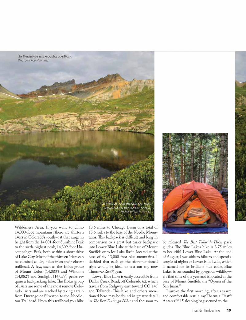
Wilderness Area. If you want to climb 14,000-foot mountains, there are thirteen 14ers in Colorado’s southwest that range in height from the 14,001-foot Sunshine Peak to the sixth-highest peak, 14,309-foot Un-compahgre Peak, both within a short drive of Lake City. Most of the thirteen 14ers can be climbed as day hikes from their closest trailhead. A few, such as the Eolus group of Mount Eolus (14,083’) and Windom (14,082’) and Sunlight (14,059’) peaks re-quire a backpacking hike. The Eolus group of 14ers are some of the most remote Colo-rado 14ers and are reached by taking a train from Durango or Silverton to the Needle-ton Trailhead. From this trailhead you hike
13.6 miles to Chicago Basin or a total of 15.6 miles to the base of the Needle Moun-tains. This backpack is difficult and long in comparison to a great but easier backpack into Lower Blue Lake at the base of Mount Sneffels or to Ice Lake Basin, located at the base of six 13,000-foot-plus mountains. I decided that each of the aforementioned trips would be ideal to test out my new Therm-a-Rest® gear.
Lower Blue Lake is easily accessible from Dallas Creek Road, off Colorado 62, which travels from Ridgway east toward CO 145 and Telluride. This hike and others men-tioned here may be found in greater detail in The Best Durango Hikes and the soon to
be released The Best Telluride Hikes pack guides. The Blue Lakes hike is 3.75 miles to beautiful Lower Blue Lake. At the end of August, I was able to hike to and spend a couple of nights at Lower Blue Lake, which is named for its brilliant blue color. Blue Lakes is surrounded by gorgeous wildflow-ers that time of the year and is located at the base of Mount Sneffels, the “Queen of the San Juans.”
I awoke the first morning, after a warm and comfortable rest in my Therm-a-Rest® Antares™ 15 sleeping bag secured to the
Six Thirteeners rise above Ice lake Basin. Photo by Rod Martinez
Lightweight camping gear can make a backpacking trip more enjoyable.
Photo by Rod Martinez

Trail & Timberline 20
Therm-a-Rest® NeoAir™ All Season mat-tress, to two deer dining on grass and wild-flowers. I lay on my side and simply watched for a few minutes before they moved on. I was extremely satisfied with the comfort and warmth of the Antares™ 15 sleeping bag. The 750+ fill goose down provided am-ple warmth where it was needed and gave me room to move about without creating cold spots. The SynergyLink Connectors secured the bag to the NeoAir™ mattress, which allowed for uninterrupted sleep, be-cause I was not turning over and falling off the mattress. The mattress inflates to 2.5 inches, and with the pad’s Triangular Core Matrix and reflective ThermaCapture tech-nology it offered greater heat retention and comfort than any pad I have used before.
After strolling around the lake and pho-tographing the wildflowers, I hiked up to the Middle and Upper Blue Lakes, 1.5 ad-ditional round-trip miles. From Upper Blue Lake it is approximately 2.5 miles to the top of 14,150-foot Mount Sneffels. From
the Blue Lakes Trailhead, you can also hike up to Blaine Basin and the north face of Mount Sneffels.
At approximately 5.0 miles round trip, another short, steep hike is Ice Lake Basin, which provides an opportunity to camp by the lake and have access to Upper Ice Lake Basin, Fuller Lake, and six 13ers. The easi-est of these 13ers to climb is 13,761-foot Fuller Peak, while the most difficult is 13,767-foot US Grant Peak. Once again the abundance and variety of wildflowers is incredible in this area. The trailhead is lo-cated across from the South Mineral Creek Campground, just west of Silverton. Travel north about 2.0 miles on Highway 550 from Silverton to Forest Road 585, which turns into FR 815. Once on FR 815, head west 4.5 miles to the trailhead. There are a few camping spots in the beautiful Lower Ice Lake Basin, located in the few trees that can provide cover. Hiking to Ice Lakes was much easier with my Antares™ 15 sleeping bag and NeoAir™ All Season mattress than with my older and much heavier sleeping bag and pad that I used two years ago. The Antares™ sleeping bag and NeoAir™ mat-tress made my pack lighter and helped me get a great night’s sleep. Despite overnight temperatures in the low 30s, I was warm and comfortable in my sleeping bag. With a good night’s sleep I was able to climb
Wildflower Garden at Lower Blue Lake on the shoulder of Mount Sneffels. Photo by Rod Martinez
Therma-a-rest Antares sleeping bag and NeoAir All-Season sleeping mattress. Photo by Rod Martinez

Trail & Timberline 21
13,761-foot Fuller Peak before returning to camp and spending the rest of the day pho-tographing thousands of wildflowers.
Another enjoyable backpack is to the base of Centennial Peak (13,062’), which is located north and west of Durango in the La Plata Mountains. To reach Kenne-bec Pass, the trailhead to Centennial Peak, travel from Durango west on CO 550 to County Road 124, where it changes to FR 571 and ends at the trailhead. Hike left on trail #622 for 2.0 miles, where it intersects with Sharkstooth Trail (#620). Follow this trail for 3.0 miles to the intersection with trail #520, Indian Ridge Trail, which is part to The Colorado Trail. This is also a good spot to camp. Trail #620 turns into #612 and leads you to the relatively easy to climb Centennial Peak and then to the more dif-ficult and steeper 12,462-foot Sharkstooth
Peak. The trail to these peaks takes you through verdant meadows full of wildflow-ers and by a small but picturesque lake.
If you have a desire to climb a moder-ate 14er, then 14,048-foot Handies Peak, located about 20 miles northeast of Silver-ton over Cinnamon Pass, is a nice choice. You follow a creek through a lush meadow of wildflowers before the trail heads up through a large rock field past Sloan Lake to the summit, 4.6 miles from the trailhead. In the many hikes I have done in the past 50 years, this is the only one in which I have encountered a bear. Luckily he/she was busy looking for something rather than a hiker to eat.
In preparation for your own hiking or backpacking trip to the southwestern part of the state you should make a list of some of the key items to bring along. In addi-
tion to the Ten Essentials, it’s a good idea to carry an emergency locating device, such as SPOT; a good map, one from Trails Il-lustrated, for example; and some extra food and water. If you are backpacking, take all the aforementioned things, as well as light-weight and compact camping gear. I’ve found that the Therm-a-Rest Antares™ 15 sleeping bag; the Therm-a-Rest NeoAir™ All Season mattress; an extremely light-weight two-person tent; CamelBak All Clear™ Water Purifier; a small compact Brunton stove; freeze-dried food; and other assorted lightweight gear, such as revers-ible fork/spoon, aluminum pan, and light-weight clothes and down jacket work best for me. If I use less energy backpacking in lightweight gear, I don’t get as tired, so I can safely hike and climb. With a comfortable warm night’s sleep, I’m physically ready to take on most hiking/climbing challenges. My Therm-a-Rest Antares™ 15 sleeping bag and NeoAir™ All Season mattress now make it easier for me to do more and longer backpacking trips. One last essential item is a good camera, so you can photograph and record the beauty you encounter during your hikes. Be safe and enjoy your travels through southwestern Colorado. △
Wildflowers surround “blue” Upper Ice Lake. Photo by Rod Martinez
Mount Sneffels, “Queen of The San Juans.” Photo by Rod Martinez

Trail & Timberline 22
◉Pathfinder
◉
Since The Best Fort Collins Hikes was pub-lished in 2008, CMC Press has produced a dozen regional pack guides for the state of Colorado. The newest, The Best Tellu-ride Hikes, which will be published in early April, includes 20 hikes within an hour or so drive of Telluride. The trails range from the wheelchair-accessible Uncompahgre Riverway Trail, near Ridgway, and the easy San Miguel River Trail, in the heart of Tel-luride, to the challenging Bilk Creek Basin Trail, known for its picturesque waterfalls, and the steep Silver Lake Trail, which climbs high above Telluride, where you can take in the panoramic views of town.
Each hike offers a glimpse into what many consider the most beautiful part of Colorado, taking you to the base of the in-comparable rock spire Lizard Head (perhaps the most difficult summit to ascend in Colo-rado), and to Bridal Veil Falls, Colorado’s tallest free falling waterfall, cascading 365 feet to the base of the box canyon below.
In addition to detailed comments, route descriptions, and directions, each of the 20 hikes contains a map segment, elevation gain, difficulty rating, estimated time of the hike, round-trip distance, and nearest landmark. Like all of CMC Press’s pack guides, The Best Telluride Hikes is light enough and small enough to fit in your pocket or daypack.
Rod Martinez, project manager for The
Best Grand Junction Hikes, and Jeff Eisele, project manager for The Best Durango Hikes, and contributors from the San Juan Group of the Colorado Mountain Club teamed up to share some of their favorite Telluride area hikes. CMC members selected, hiked, photographed, and wrote about the trails in the pack guide. ***
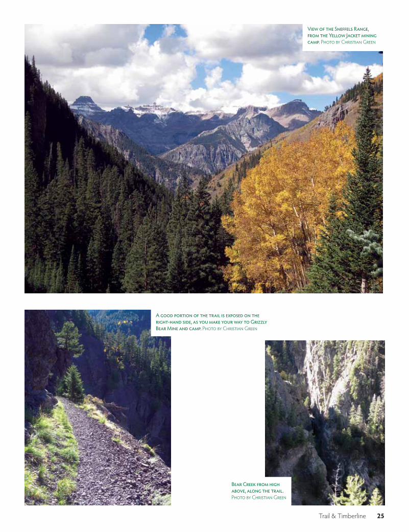
One of the trails I had the pleasure of hik-ing and writing about for The Best Telluride Hikes was Bear Creek National Recreation Trail. One of 39 National Recreation Trails in Colorado and one of more than 1,200 in the nation, Bear Creek provides a win-dow into the area’s rich mining history. The trail, which is less than three miles south of Ouray, takes you to two abandoned min-ing camps: Grizzly Bear and Yellow Jacket. Although the better-known Red Mountain Mining District, between Ouray and Sil-verton, had some of the most prolific and richest veins in the world during the late 1800s, the area around Ouray was also very bountiful during the same period. Prior to the repeal of the Sherman Silver Purchase Act in 1893, which made the price of silver plummet, the town had 30 active mines.
What strikes you when you make your way up Bear Creek National Recreation Trail is the effort the miners and their mules had to make in carrying the equipment and materials they needed to excavate and then
work the mines. The trail makes its way up the steep slopes that rise high above Bear Creek, which cuts through the narrow val-ley below. Although the trail is not overly taxing, it hangs precariously above the val-ley below for a sizeable stretch, making your pulse quicken each time you happen to glance toward the foreboding drop-off on the right, or southern, side of the trail. Dur-ing the hike, you can’t help thinking about how many mules and men lost their footing and careened down the mountainside to an unfortunate fate.
When you finally reach the first camp, Grizzly Bear, the drop-off is seemingly less precipitous, as the side of the mountain be-comes more wooded. For some reason, trees give you a sense of security, which does not present itself when the only thing between you and the creek below is several hundred feet of rocky slope.
Established in 1875, a year before Ouray was incorporated, Grizzly Bear Mine was actually located on the other side of the canyon and was connected to the mining camp by a bridge, which is long gone. Pri-marily known for producing gold and silver, the mine was also recognized for generating copious amounts of rhodochrosite, a pink/red colored manganese carbonate mineral that is Argentina’s national gemstone. Al-
The Best Telluride HikesBy Christian Green
New CMC Pack Guide Takes You to the Heart of the San Juans
A panoramic view of the Wilson Group. From left to right, El Diente, Mount Wilson, Gladstone Peak, Cross Mountain, and Lizard Head Peak. Photo by Rod Martinez.

Trail & Timberline 23
By Christian Green
Bridal Veil Falls, as seen from the San Miguel River Trail in Telluride. Photo by Rod Martinez
though the mine closed during the first decade of the 1900s, remnants of mining equipment and the camp itself are scattered just off the trail.
A bit farther up, where Bear Creek rises out of the valley, and gradually begins to ap-proach and then parallel the trail, is the Yel-low Jacket mining camp. Not to be confused with the mine of the same name in Nevada, which was the site of the worst mining ac-cident in that state’s history, Yellow Jacket Mine and camp were smaller than Grizzly Bear Mine and camp; however, the rem-nants of the camp are in considerably better shape. In fact, a cabin that served as quar-ters for the miners still stands and contains several cots and other items left behind by the miners. Yellow Jacket Mine is located on the north side of the creek, above the remnants of a stamp mill. Unlike Grizzly Bear Mine, Yellow Jacket Mine primarily produced lead and zinc and reached its peak production around 1915.
The open area around the abandoned miners’ cabin and camp is a great place to grab lunch or a snack, while enjoying stun-ning views of the Sneffels Range to the west. What follows on page 24 is a description of the hike, from The Best Telluride Hikes.△
Miners’ cabin, near Yellow Jacket Mine. Photo by Christian Green
Bear Creek rises out of the valley and begins to parallel the trail, as one gets closer to Yellow Jacket Mine. Photo by Christian Green

Trail & Timberline 24
Remnants of part of the Grizzly Bear Mine and camp. Photo by Christian Green
Bear Creek National Recreation Trail
Maps:
Elevation Gain: 2,640 Feet
Rating: Moderate
Round-Trip Distance: 8.4 miles
Round-Trip Time: 6-7 hours
Nearest Landmark: Ouray
Comment: Bear Creek Trail is not the most challenging hike, but if you are acrophobic or plan to bring your adventurous children or dogs with you, you should consider another excursion. A good por-tion of the trail is bounded on one side by a steep drop-off of sev-eral hundred feet with little between you and Bear Creek below. In addition, the first part of the trail is composed of crushed slate and quartzite, which could become slippery during wet weather.
That said, there’s a reason Bear Creek Trail is one of only 39 trails in Colorado to be designated a National Recreation Trail. Not only do you experience breathtaking views, but you also are transported back in time. Miners detonated dynamite to construct this trail be-cause it was too rugged to build a trail along the creek bottom below, where ample gold and silver could be found. Today, the trail pass-es the abandoned Grizzly Bear mining camp and ends near Yellow Jacket Mine, where visitors can peer into an old cabin to see cots the miners slept on.
Getting There: From Ouray, drive 2.3 miles south on U.S. 550 until you reach a small tunnel. Once you pass through the tunnel, abun-dant parking is available on the right, next to the trailhead, and also on the left. From Telluride, head west on Colorado 145 (stay straight, rather than turning left toward Rico) for a little more than 15 miles. Turn right on Colorado 62 and drive just more than 23 miles to the town of Ridgway, where you will make a right on U.S. 550 south. Drive approximately 10 miles to Ouray and follow the directions above.
The Route: At the trailhead, take a moment to enjoy the view of Ouray a couple of miles to the north, and then cross above the tun-nel. On the other side of U.S. 550, the trail gains 1,000 feet of eleva-tion in the first 1.25 miles. There are several switchbacks in this section
Trails Illustrated Telluride/Silverton/Ouray/Lake City, Number 141; USGS, 7.5 minute Ouray; Latitude 40, Tellu-ride/Silverton/Ouray Trails
of the trail, which, again, can be slippery because the trail is covered in loose fragments of slate and quartzite. Although the trail levels off after traversing the switchbacks, it becomes precarious at this point, especially for those who are afraid of heights. For the next mile, the trail is bordered on the right by a very steep cliff, which drops down to Bear Creek below. Stay on the left side of the trail if you have any concerns. It’s along this stretch of trail where the views really begin to open up.
At the 2.4-mile mark, you will come across the first of two mining camps along the trail—Grizzly Bear. The remnants of the camp, which was active from 1875 to around 1900, are still littered around the trail. This is a good place to grab a quick snack and take a break.
From there to Yellow Jacket mining camp, 1.8 miles away, the trail alternates between open stretches and stands of aspens and conifers as Bear Creek rises closer to the trail on the right. Around 0.3 mile past Grizzly Bear mining camp, you will cross over a small tributary of Bear Creek and enter a beautiful meadow. To your left is a pictur-esque hillside, framed by striking aspens.
As you gradually ascend to Yellow Jacket mining camp, Mount Sneffels (14,150 feet) rises majestically behind you. Once you reach the camp, take some time to enjoy the panoramic view of the Sneffels Range, which includes the Centennials Teakettle Mountain (13,819) and Dallas Peak (13,809), and explore the miners’ quarters.
Make sure you are well rested before heading back the way you came to ensure your legs aren’t wobbly when you traverse the ledge section of the trail.
104 pages, 4 x 7, rounded corners, 60 color photos, 21 color maps, paperbound, $12.95, ISBN 978-1-937052-07-2.
GUIDEBOOK/COLORADO.
AVAILABLE IN APRIL
Trail & Timberline 25
A good portion of the trail is exposed on the right-hand side, as you make your way to Grizzly Bear Mine and camp. Photo by Christian Green
View of the Sneffels Range, from the Yellow Jacket mining camp. Photo by Christian Green
Bear Creek from high above, along the trail. Photo by Christian Green

Trail & Timberline 26
My quest had started back at the Camp Bird mill site, about six miles off Colorado 550, just south of Ouray in the San Juan Mountains. My husband, Bob, had driven our two-wheel-drive car up the Camp Bird Mine Road (#361). Uncertain about how rough the road ahead might become, we agreed this was a good place for me to start. The elevation was 9,750 feet—I had
4,400 feet of elevation gain ahead of me. Not a hiker, Bob headed back to Ouray with hopes of finding a golf course or, at the least, watching a golf tournament on TV. The air was cool and the sun still low at 6 am and I was able to keep a good pace from the Camp Bird mill site. After about two miles, the road became rougher. Four-wheel-drive vehicles are needed to reach
the parking area at 11,800 feet. To reach the parking area at 12,400 feet, however, requires not only four-wheel drive and high clearance, but also the experience necessary to handle the rugged and rutted road. From the first parking spot, I could tell that I was gaining altitude as my breathing quickened and I could feel a pull in my calves. Yankee Boy Basin was a symphony of sound with
I was trekking on a rocky road in the Uncompahgre National For-est with the single-minded goal of adding Mount Sneffels to my list of Fourteeners when I began to notice my surroundings—imposing peaks rimming a lush green valley accented with wildflowers. I was in Yankee Boy Basin—the ultimate amphitheater, the Rockies in Tech-nicolor, the Colorado of posters and postcards. This was the back-drop of the day’s adventure.
M o u nt S n ef f e l sHistory, Geology, and a Breathtaking Backdrop Make
This San Juan Fourteener Unforgettable
By Helen Huntley View from near the summit. Photo by Helen Huntley

Trail & Timberline 27
Sneffels Creek cruising through, a cornu-copia of color with wildflowers blooming. Mother Nature had opened her art gallery here. The variety of wildflower species in-cludes monument plant, columbine, lark-spur, chiming bluebells, orange sneezeweed, cow parsnip, wild iris, dwarf sunflowers, and varying colors of paintbrush. John Bregar, CMC San Juan Group member and native plant enthusiast, said, “Basically, most of the common alpine and subalpine wildflowers that grow elsewhere in the San Juans also grow in Yankee Boy Basin; they just grow especially lush in Yankee Boy.”
By the time I arrived at the upper park-ing area, it was midmorning and time to refuel. I found a spot looking down at the road and sat down. I knew that a steeper climb lay ahead, so I reached for my wa-ter bottle filled with tea. Not black tea or green tea, but coca tea. The tea, served to me in the Andes of Peru, is a folk remedy given to visitors to the Andean regions of South America to prevent altitude sick-ness. I sipped the tea, munched on a Luna bar, and enjoyed basking in the beauty of this setting, staring at the jagged peaks that rimmed this basin, and wondering how this landscape was created. ***
Both magma and glaciers have contrib-uted to forming Yankee Boy Basin and the surrounding mountains. Dr. David Gonza-les, professor and chair of the Department of Geosciences at Fort Lewis College in Durango, explains that magma in the area about 30 million years ago cooled to form the igneous rock that composes Mount Sneffels. This cooled magma makes up a geologic feature known as a stock. Al-though younger volcanic rocks were depos-ited in the area and nearby Gilpin Peak is capped by volcanic rock, Mount Sneffels itself is not composed of volcanic rock. Carving the basin and mountains into their present picturesque form took the sculp-tural power of glaciers. Periods of glaciation occurred in the region during the past few million years, the last of the glaciers retreat-ing about 12,000 years ago. Yankee Boy Ba-sin was chiseled by a cirque glacier that cut Mount Sneffels on its south flank. Gonzales points out that the peak of Mount Sneffels is a glacial horn—an isolated high point cre-ated by glacial erosion.
Although you see numerous high, craggy peaks surrounding Yankee Boy Basin, the
summit of Mount Sneffels is not one of them. To really see this poster peak, take CO 550 north to Ridgway and turn west on CO 62. Within a few miles, you’ll find the classic views of the summit, spires, and pin-nacles that attract so many photographers. How did this peak get such an unusual name? There are several explanations, “some of them downright silly,” says Don Paul-son, curator of the Ouray County Museum. Geologist Frederic Endlich, cartographer
Allen D. Wilson, and assistant cartogra-pher Franklin Rhoda gave the mountain its name when they performed the official sur-vey of Mount Sneffels in 1874. Upon seeing the mountain from Blue Lakes Basin, one of the three pointed at it and said, “There’s Snaefell,” referring to the peak “Snaefell” in Jules Verne’s novel, Journey to the Center of the Earth. Paulson noted that Endlich was quoted about naming Mount Sneffels in an article published in 1890 in the Appala-
Sneffels Creek in Yankee Boy Basin. Photo by Helen Huntley

Trail & Timberline 28
chian Mountain Club’s journal, Appalachia.The Sneffels range cuts east to west across
Ouray County and all mining occurs to the south of the range, said Paulson. The region is one of the richest silver and gold mining areas of the United States. When the na-tion went off the silver standard and on the gold standard in 1893, it led to a depres-sion throughout the West. But in the mid-1890s, Tom Walsh discovered gold eight miles west of Ouray and revived this quaint little town. Walsh also discovered Camp Bird Mine, where gold was mined until af-ter World War I. Following the war, lead, zinc, and copper were mined at Camp Bird for their commercial and industrial applica-tions. The mine is now closed. I had noticed no birds were camped at the mill site. I later learned that the birds used to show up at lunchtime. The mine got its name from the “camp robber birds”—gray jays—that stole pieces of the miners’ lunches as they ate. Numerous mines still exist in Yankee Boy Basin, Paulson said, including the fa-mous and profitable Revenue Mine. Albert E. Reynolds and John H. Maugham pur-
chased the Revenue in 1880 for the large sum of $100,000. Within a few years, they made $7 million. ***
Re-energized by my break, I continued on a defined, but rocky, trail. The terrain be-came steeper and my heart rate increased. It wasn’t long before the trail disappeared among loose scree and rocks on the south slope leading to Lavender Col. I was at about 13,000 feet when I began my trudge up the tippy talus to Lavender Col at 13,500 feet. The col is the result of a cirque glacier whittling on the north flank. The glacier eroded the peak to create the sharp, low ridge between Mount Sneffels and the peak to the east (13694). This stunning—almost moonscape—terrain demands re-spect. I could see a few people ahead of me. None of us were scampering along. My calves felt like they were unraveling and my thighs were in knots, but I felt strong and kept going. “Could the coca tea be kicking in?” I wondered. Most likely, my determina-tion to keep going was due to a combina-tion of “peak fever” and the many Saturdays
I spent hiking in the mountains. When I reached the col, another slow slog lay ahead. Turning left (northwest), I saw an almost vertical and narrow rock filled couloir. I used the rock wall of this gully for balance as I ascended in the ever-thinning air. The climb up the slope and couloir had intensi-fied with each step like the beat in Ravel’s “Bolero.” At the top of the gully, I met my final challenge: a large rock slab on the right side of the couloir wedged against the rock rib on the left. I scrambled up through the notch created by the rocks and found my-self on stable rock. Despite the exposure on this final stretch to the summit, it felt like a cakewalk compared to the previous thou-sand feet. I could almost stride to the top, but altitude put the brakes on me.
It was 11:15 am and I was on top. The mood was festive with climbers exchang-ing “Congratulations” and high fives and snapping photos. But, it wasn’t long before clouds were clustering around nearby peaks and the party on top broke up as we began our descent. Most of us hesitated a moment before down-climbing the notch, making
Clouds begin to gather. Photo by Helen Huntley

Trail & Timberline 29
sure our grip on the rocks was solid and then looking down to see where to place our feet. Those who descended first stood by to offer a hand to the rest.
I picked my way back down the ball-bear-ing rocks in the gully and on the slope. My ankles and knees took a beating as I con-centrated on staying in an upright position. Since there were no handrails to cling to, I held onto my trekking poles like a predator holds onto its prey. Finally, I was back on dirt trail. I had survived the plunge! I re-laxed and turned my attention to the basin. I was now hiking alongside a woman who also summited and we shared our impres-
The author amongst the wildflowers. Photo courtesy Helen Huntley
Near the summit of Mount Sneffels. The rock is solid with good footing. Photo by Helen Huntley
Atop the summit. Photo by Helen Huntley
sions of the mountain and the breathtaking scenery. I marveled at the alpine garden sur-rounding us. She offered to take my photo, so I plopped down among the flowers and smiled. I will always remember Mount Sneffels and Yankee Boy Basin as a place where adventure and the beauty of nature are woven into one unforgettable day.
A little while later, a four-wheel-drive vehicle pulled over and the driver offered us a ride down to the lower parking area, saving us a mile or so of walking. At 4 pm, I was back at the Camp Bird mill site. Bob sat in the car. I couldn’t tell whether he was dozing or listening to a golf tournament
on satellite radio. I tapped on the window, lifted my arms, and announced, “I did it!” I got in the car, and he said, “I expected that pose.”△
Helen Huntley is a CMC member living in Albuquerque, New Mexico. She has an MA in writing and is interested in natural history, the environment, and, of course, moun-tains and mountaineering. She is now looking forward to climbing Mount Sneffels via the southwest ridge.

Trail & Timberline 30
My wife, Debbie, and I honey-mooned in Peru six years ago with a trek through the Cordil-
lero Blanca, where we made a brief attempt to climb Mount Pisco (a 19er). This was my first experience on a glacier—wear-ing rented double boots and crampons, no less—and despite the difficult conditions (the summit attempt ended at 4 am during a whiteout), I loved it! I decided to “learn the ropes” by taking Basic Mountaineering School (BMS) in 2009, and then Deb and I became High Altitude Mountaineering Section (HAMS) students in 2010, where
we learned about glacier travel, crevasse res-cue, winter camping, and where we got our first taste of ice climbing. Mount Rainier was a long-held dream for each of us, and we were thrilled to climb the Emmons Gla-cier route to the summit of that amazing mountain with fellow HAMSters on our rope team.
Honestly, our mountaineering aspira-tions did not extend past Rainier, but be-cause that climb was so much fun, we be-gan to consider possibilities for climbing higher mountains. The massive wilderness of Alaska beckoned, and we joined fellow
HAMS instructors Dave Covill and Greg Long to take a crack at Mount Fairweath-er, the high point of Glacier Bay National Park, in May 2011. Mount Fairweather was named by Captain James Cook, who hap-pened to visit Glacier Bay on a rare clear day and who then gave the mountain an ex-ceedingly optimistic moniker. In reality, the mountain has a reputation for guarding its summit stingily by assailing climbers with notoriously foul weather. Nevertheless, we happened to luck into a rare high-pressure window only a few days after flying onto the Fairweather Glacier and were fortunate
The Path to theHimalayas
The World’s Sixth-highest Peak, Cho Oyu, Beckons from Afar
Tengi Sherpa prepares for the Puja, to ask for the blessing of the Turquoise Goddess, who abides on Cho Oyu’s summit. Photo by John martersteck
By John Martersteck

Trail & Timberline 31
John and Debbie rope up at Base Camp on Fairweather Glacier, below Mount Fairweather. Photo by John martersteck ▶
to be able to achieve the summit on our first attempt. We were joined there by Jerry Roach and Chris Kopczynski, the second and tenth climbers to achieve the Seven Summits, who were on the mountain for 12 days before we arrived, waiting for better weather conditions.
After Fairweather, Denali became the next goal; however, not having climbed above 15,000’ we decided to head to South America first, to see how we dealt with a similar altitude challenge that Denali would throw at us in more forgiving climbing con-ditions. Ecuador happens to be a tropical country with a wonderful string of 15,000- to 20,000-foot snow-capped Andean vol-canoes sticking up across it—a climber’s dream! In only 10 days, in December 2011, we attempted five peaks, culminating with the summit of Chimborazo, which rises to an altitude a bit higher than Denali (We climbed Hua Hua Pichincha, Sincholagua, Illiniza Sur, Antisana, and Chimborazo; we elected to pass on Cotopaxi due to its over-whelming popularity, and we’ll have to go back for Antisana, because we were weath-ered off that challenging peak.)
***Our success in Ecuador proved to us
that Denali was a feasible goal, especially given the training opportunities that we are fortunate to have in Colorado. We began planning and training for an attempt on Denali in June 2012, and we were once again fortunate to be able to summit after waiting a week at 14 Camp for a favorable weather window.
At that point in our climbing careers, although we had no clear goals, we had achieved enough high-altitude mountain-eering experience—simply by setting our sights on the “next harder” mountain, one mountain at a time—that we managed to qualify to climb an 8,000-meter peak in the Himalayas. Moreover, it had been a lifelong dream of Debbie’s to visit the Himalayas and to view the lofty summit of Everest firsthand. Rather than merely catching a glimpse of Everest, why not go ahead and consider climbing the highest mountain in the world?! Hmmm, it could happen . . .
Since we had not slept in a tent higher than 17 Camp on Denali and because 8,000-meter peaks are a huge step up from what we had climbed previously, we decid-ed to join a guided expedition for our first trip to the Himalayas and rely on Sherpa support to establish our high camps. As it
turns out, the guided ex-peditions prefer that their clients gain experience on an easier 8,000-meter peak prior to tackling Everest, so we decided on Cho Oyu or Gasherbrum II, the two 8,000-meter peaks reputed to be the least technical. Since the Chinese had stopped issuing permits for Cho Oyu, G-II became our target. It is located in one of the most spectacular corners of the planet, with a long approach through the incomparable beauty of The Concordia, across which one travels along the Baltoro Glacier in the Karakoram Range.
However, when the Chinese resumed issuing permits for Cho Oyu, we switched back for several reasons, mainly because we would have to take less time off work (six weeks, instead of eight) to climb Cho Oyu due to the shorter approach. Also, we want-ed to visit Nepal and trek to Namche Ba-zaar along the famous approach to Everest Base Camp. Another consideration was the increased security risk of traveling through the capital (Islamabad, Pakistan) of a nation whose citizens include Taliban soldiers who are on the receiving end of drone-launched Hellfire missiles that carry “Made in the USA” labels on them. Enough said.
Because the climbing season for Cho Oyu is the same as that for nearby Ever-est in May and June, rather than the July timeframe for G-II, we had to accelerate our training schedule. Despite the sacrifice of several of our 4-pack ski passes, we were grateful to have a plethora of 13ers and 14ers readily available for training, and we left for Kathmandu feeling strong. We first flew to Lukla and trekked above 14,000 feet as we visited Namche Bazaar and Thame, the Sherpa heartland in the Nepalese Khumbu region. We then embarked on our expedition to Cho Oyu through Tibet.
But first, a fabulous side trip! We decided to take advantage of our proximity to Chi-na on this possibly once-in-a-lifetime trip
to visit the ancient heart of Tibetan Bud-dhism, centered in Lhasa. So, while the rest of our expedition traveled by bus to head for the Friendship Bridge to make a long and tedious border crossing, we flew to Lhasa, in western Tibet. Lhasa features the incom-parable Potala Palace, which contains the living quarters, throne rooms, and tombs of the Dalai Lamas. It is difficult to describe the fabulous tapestries, numerous huge Buddhas, and lavish gold tombs that are on display in the massive palace. The devotion of the thousands of Buddhist pilgrims who flock to the sacred temples was humbling.
Despite an altitude of 3,490 meters (11,450 feet), Lhasa is nevertheless a fast-growing city with construction cranes vis-ible across its breadth, because the Chinese government is intent on increasing the population of Han Chinese in the city, to counterbalance the native Tibetan popu-lation and thereby reduce the influence of Buddhism on the lives of the residents in this region. Although the Chinese de-stroyed many Buddhist temples in Tibet, they fortunately spared the world-famous Potala Palace and Jokhang Temple.
We then traveled west to the border, ac-companied by our Chinese liaison officer, a

Trail & Timberline 32
fashion-conscious, college grad who under-standably appeared to be more interested in her iPhone than escorting a group of older Western tourists across Tibet. We presented our papers at numerous official checkpoints and enjoyed viewing the desolate scenery, high mountains, and sparse housing of the population on the high Tibetan Plateau.
***We rejoined the rest of our expedition in
the border town of Tingri, which features expansive views of Cho Oyu and Ever-est across the western edge of the Tibetan Plateau. It is the last civilized outpost be-fore heading to the Cho Oyu and Everest base camps. Our expedition brought along a one-piece 8,000-meter down suit for a less-than-careful climber who discovered at Everest Base Camp that he had left his down suit at home. Our team also brought along a rabies vaccine for another Everest climber who happened to get bit by a dog in Tingri.
We were excited to leave Tingri and head to Chinese Base Camp, with the glori-ous massif of Cho Oyu beckoning us. We spent some time acclimatizing at Chinese Base Camp, and then spent a couple of days trekking the 14 miles or so up to Advanced Base Camp (ABC), accompanied by the
yaks that carried all the group’s gear. When we finally arrived at ABC—at 19,000 feet it is higher than Everest Base Camp, but also much more scenic!—our hearts sank because of the lack of snow on much of the route. Cho Oyu is supposed to be a relatively easy ascent mostly on snow, and climbers often follow the steps kicked by the lead climbing Sherpas, but the dearth of snow during the spring season made for a much more difficult and technical ascent. The conditions also explained the lack of company at ABC. Although ABC featured dozens of camping areas, only three or four other expeditions joined us during our climb (and half of those began their expe-ditions too early and never ascended higher than Camp 2). It turns out that the post-monsoon climbing season in September has much more favorable snow conditions, but we were happy to have the mountain mostly to ourselves.
We began the long acclimatization pro-gram, which is the focus of most Himala-yan expeditions. The program is composed typically of the following schedule:
1. Spend about a week at ABC. The time is broken up by the welcome performance of the important Puja ceremony, which is required by the Sherpas to appeal for the blessing of the Turquoise goddess who rules
the summit of Cho Oyu. The Puja ceremo-ny must be conducted before the Sherpas will leave ABC and set foot on the moun-tain to begin fixing rope and to establish the higher camps. During this period, we also performed fixed rope and rappel training on local ice seracs that abound on the glacier below ABC (Note that an old figure eight rappel device is required in the Himalayas due to the prevalence of icy fixed ropes.)
2. Hike two miles along piles of glacially deposited rubble, then climb 1,000 meters up the hellacious scree hill to Camp 1. De-scend to ABC immediately.
3. Spend a few more days at ABC, then ascend to Camp 1 and spend a night before returning to ABC.
4. Spend a few more days at ABC; then ascend to Camp 1 and enjoy its ambience overnight; then ascend the icefall to Camp 2; stay overnight, and return to Camp 1 and ABC.
5. Finally, wait for a favorable weather window and make a summit bid, which entails spending a night at Camp 1, then ascending the icefall and spending a night or two at Camp 2, then hiking up to Camp 3 and leaving soon for the summit (after midnight). Climbers not using supplemen-tal oxygen can generally tolerate summit winds up to 10 mph before frostbite be-
Advanced Base Camp below Cho Oyu. Photo by John martersteck

Trail & Timberline 33
comes a high-risk concern; climbers using supplemental O2, which includes a warm face mask, can safely tolerate winds up to 20 mph or so.
We found that the real challenge of 8,000-meter expeditions is that climbers continuously lose strength while they accli-matize at ABC. As HAMS instructors, we teach the importance of maintaining one’s strength by “eating one’s way up the moun-tain”, but despite that knowledge, we found it impossible to achieve in practice for two reasons: the Chinese food was adequate, but not very appetizing to us Westerners; moreover, it is very difficult to maintain one’s appetite at altitude, regardless of how appealing the food. Fortunately, we brought some “side food”, including a jar of peanut butter, candy bars, and packages of tuna, but we nevertheless lost weight and strength each day we were on the mountain. As it turned out, I lost about 10 percent of my body weight during the expedition. In fact, I was a bit concerned going through airport security on the way home. After I removed my belt and lifted my arms for the security scan, I feared that my pants would fall to the floor in the scanner!
We also had a difficult time on our ac-
climatization ascent to Camp 2, which features a technically challenging segment to surmount the icefall. Above the icefall, a thunder snowstorm overtook us, accom-panied by high winds, bitter cold, and near whiteout conditions. One of our ascend-ers froze and hampered the ascent of the steeper sections above the icefall, and we arrived at camp at dusk, cold and exhausted. We summoned the energy to melt water for
a single package of Ramen noodles, which was all we could muster for dinner that night. Welcome to Camp 2 at over 7,000 meters—higher than Aconcagua!
Due to our weakening conditions, half the team, including Debbie, reluc-tantly decided to head back down to Kathmandu. Although Debbie wasn’t able to summit, primarily due to the difficulty she has keeping her hands and feet warm, but also moving at a sufficiently fast pace that high up af-ter weeks of losing strength, she was more than happy to experience first-hand both the grueling demands but also the personal rewards of participat-ing in an expedition to an 8,000-meter peak. Certainly she might have done better with supplemental oxygen, but we both decided that was not how we wanted to climb the mountain. I am
proud of the efforts she made in her prepa-ration, training, and execution, and con-gratulate her for a 7,000+meter altitude PR.
Debbie had a great time exploring the jungle near Pokhara, while Wayne Herrick (our climbing partner and an-other HAMS instructor) and I managed to reach the summit after a low-wind weather window at the very end of our climbing schedule. Summit Day for me was the most physically taxing climbing I have ever experienced, given my weak-ened condition and the seemingly endless rock bands to cross in the hypoxic heights of "the Death Zone." But the glorious views of Mounts Everest and Lhotse, which appeared almost close enough to touch, are an eloquent answer to the elu-sive question of "Why we climb!"
***So, what’s next for Debbie and me?
Now that we have gained experience on an 8,000-meter peak, are we going to take a crack at Everest? For now, the answer is “no”. For us, climbing an 8,000-meter peak turned out to be as much of an ordeal as it was fun to climb. It is more about ac-climatizing and simply trying to maintain strength than about actually climbing. We completed the difficult acclimatization program and then, as is typical, had to wait weeks for a low-wind window in order to move up and make a summit attempt. Meanwhile, we lounged about ABC, con-tinually losing strength (and interest in the
◀ Debbie approaches Camp 1 after ascending the thousand feet of scree on “Hell Hill.” Photo by John martersteck
Normally a relatively easy snow climb, the route proves to be more rocky and difficult than usual, thanks to the lack of snow during the pre-mon-soon climbing season. Photo by John martersteck ▶

Trail & Timberline 34
food). We all felt relatively weak by Sum-mit Day, and had to stretch to our limits to complete the climb.
The bottom line is that we have both con-cluded that there are many more reasonable investments of time and money that pro-vide much better and more fun (and safer) climbing opportunities than joining the annual zoo on Everest. Debbie and I agree that our next objective, for example, may likely be to fly to La Paz and climb some fun mountains in Bolivia (highly recommended by many of our climbing friends). We are also interested in attempting more technical routes on Rainier (e.g., Liberty Ridge, Ptar-migan Ridge) and returning to the beautiful and massive mountain wilderness in Alaska, which contains a treasure trove of amazing climbs. In the meantime, we are thoroughly enjoying the wealth of fun rock, snow, and ice climbs that abound in our own backyard playground here in Colorado!
I’ll end with a few parting thoughts:There is nothing like traveling abroad,
especially in a third-world country, to help one appreciate one’s home country. Some things we have come to appreciate more:
* American food and grocery stores!* Clean air (wildfires notwithstanding)* Freedom to travel unrestricted across
our country (with no regular police or mili-tary checkpoints, as in China)
* Universality of the English language* Modern roads, a reasonable traffic con-
trol system, and citizens who (mostly) abide by the traffic rules
* A stable source of electrical power and air-conditioning
* The accessibility of a host of great climbs right here in Colorado
* Did I mention the food?Mental cleansing and general decom-
pression are quite important. Can you imagine having six weeks abstinence from e-mail, Internet, television, nightly news, cell phone, Facebook, etc.?!? We didn’t see an airplane or a car for more than a month! Taking a retreat from the electronic on-slaught of our everyday lives reminds us how non-essential it all truly is, leaving time simply to hang out with some climbing friends and good books, with a panorama of ice-covered peaks, a starful sky, and a few yaks. As with climbing, it’s good for the soul to experience such liberation! We eventu-ally had to wade through a ton of e-mail upon our return, but that is a small price to pay for the total shift of focus as we left civ-ilization behind and immersed ourselves in the beauty and raw power of the Himalayas.
Despite teaching our High Altitude Mountaineering students that one must “eat one’s way up the mountain”, that is eas-ier said than done at altitude, where climb-ers burn a lot of calories just keeping warm, where one’s appetite is greatly diminished, and where the food is not always appetizing. Although we knew better, we continuously lost strength while acclimatizing at ABC, and should we ever decide to return to the Himalayas or the Karakoram, we will have to figure out how to consume more calories.
We found out firsthand how blood dop-ing helped Lance Armstrong; it can make a difference in physical performance. More than a couple of weeks after leaving the
mountain, and despite my having spent the better part of the previous week recovering from a stomach virus and still feeling weak, we climbed a Colorado snow couloir and easily summited a 14er—Mount Evans. For me, driving up to 11,000 or 12,000 feet and then climbing 2,000 or 3,000 feet to 14,000 feet often induces mild AMS (i.e., headache) and invariably has me breath-ing hard. This time, however, I was hardly breathing—it was truly remarkable! My climbing partners Debbie and Wayne had the same experience.
Finally, one of the benefits of climbing is that it teaches important life lessons. I learned an important one during our Cho Oyu expedition. We happened to meet elite climber Don Bowie, who joined Ueli Steck on his recent famous climb of Annapurna, at the airport in Kathmandu. Don was en route to making a solo attempt of Makalu, a difficult, technical 8,000-meter peak. I had previously heard the story of Don’s incred-ible ordeal on K2, where, after summiting that iconic, most difficult and dangerous peak, his crampons were stolen by a des-perate climber who had lost his own pair. Don had to survive the long, steep, icy descent by downclimbing the entire way, relying primarily on his ice tools and up-per body strength—and he had to prevail even after suffering a broken leg from a fall during the descent!
Don was kind enough to share with us some information and tips about climbing Cho Oyu, and he left us with some won-derful advice: Don told us that even elite climbers feel wasted when trying to sum-mit 8,000-meter peaks, and the key to their success is simply “to take the next step.” I kept that advice in mind—even making it a mantra—after I began to struggle on summit day and entertained serious doubts about whether or not I could summit. I was feeling weak even at the start of the climb, and then I got hit by a rock prior to the Yellow Band and the steep, technical sec-tion. Although, fortunately, the rock hit me squarely in the headlamp, the impact still left me with some cuts on my forehead and bridge of the nose. I was able to stem the bleeding, and a Sherpa happened to have some duct tape that he used to tape up my face so I could continue on. I then had to climb the steep chute across the Yellow Band in the dark (all that remained of my headlamp was the strap and the baseplate). And then came the seemingly never-end-ing series of rock sections, which required
John ascends the Ice Fall on his way to Camp 2. Photo by John martersteck

Trail & Timberline 35
about three breaths for each step. I kept tell-ing myself, “Just take the next step!”
Fortunately, the weather held. Although I was seriously beginning to consider turn-ing back, I was able to get additional wa-ter from Wayne and Tengi Sherpa as they were descending, and they encouraged me by saying I wasn’t too far from the summit snow cap, which was easier going. I finally made the summit after nine hours of con-tinually just taking that next step. I’m sure you see the application of this advice to life in general. Whenever you find yourself ex-periencing one of life’s many difficult trials, just take the next step, and then the next one, and eventually you will get through it. Don’t think about the summit, or the next camp, or even the top of the next pitch—just take the next step!△
John Martersteck moved to Colorado from the East Coast 20 years ago, and since then, he is “from Colo-rado.” He has three children, who are now in their 20s. He works at IBM as a software development project manager, but his passion is being a weekend warrior and spending as much time as he can in the mountains—hiking; trail running; skiing; and es-pecially rock, snow, and ice climbing. Although John has always been afraid of heights—or rather afraid of falling, as he prefers to say—he was able to desen-sitize that phobia gradually by climbing the Colo-rado 14ers. After meeting Debbie and subsequently
spending eight straight days in a tent together dur-ing a tour of southern Colorado to finish up most of the 14ers remaining on Debbie’s list, he decided to ask his climbing partner to become his life partner (they became engaged on a winter ascent to Heart Lake). Since then he has taken several classes with the CMC, including Ski Mountaineering, BMS, TLCS, and HAMS, which have laid the foun-dation of skills he needed to tackle more technical routes in the alpine environment. Currently he and Debbie are Co-Directors of the HAMS.For more information and prerequisites for the High
Altitude Mountaineering Section and school,check out the HAMS Web site at http://www.cmchams.org/school/ or contact John at [email protected] or Debbie at [email protected].
Prayer flags fly on the summit of Cho Oyu, with Mount Everest and Lhotse dominating the background. Photo by John martersteck
John’s selfie on the summit of Cho Oyu. John was the last climber of the season and alone on the sum-mit. Photo by John martersteck

Trail & Timberline 36
THE ROAD TO CHICAGO BASINBy Woody Smith
For Colorado’s mountain climbers Needleton (elev. 8,200’), a stop on the Durango & Silverton Railroad,
has a magical ring. It can be the threshold that divides casual and serious peak bag-gers. If you’re at Needleton with three days’ vacation, a 40-pound pack, and the whistle of the narrow gauge train receding in the distance—it may be a mistake—but it’s cer-tainly no accident you’re there.
What lies ahead on the hike to Chicago Basin is 3,000 feet of elevation packed into six miles of trail. It is work necessary to get yourself to a base camp and hopefully climb Mounts Windom, Eolus, or Sunlight Peak the next day. But how many of these breath-less backpackers stop to consider how the trail got there?
The Needle Creek Trail has its roots in the Animas Canyon Toll Road, which was built between 1876–1878 to connect the newly settled towns of Durango and Silver-ton. When the road was finished, prospect-ing and mining in adjacent areas became easier, including Chicago Basin.
On March 7, 1878, Pueblo’s Colorado Weekly Chieftain wrote: “The Needle Moun-tain Silver mining district . . . was recently discovered, and a large number of claims have been made in and several hundred miners will test the value of the leads in this locality the coming season. . . . Gold has been found, in greater or lesser quantities on all the large streams running through [La Pla-ta] county, and on their tributaries.”
While Needle Mountain mines showed promise, shipping materials, both in and out, was expensive. It was about this time that James H. Pinkerton, a local business-man, entered the scene. In 1875 he had lo-cated what became Pinkerton’s Hot Spring at the southern end of the Animas River Canyon. He was also La Plata County’s first judge.
By 1878 Pinkerton was prospering and intended to build an “enclosed plunge bath and several small bathrooms, which will put these springs, in point of accommoda-tion, on a par with any in the state” (Colo-rado Weekly Chieftain, 8/7/1878). While details are elusive, Pinkerton became in-volved with the construction of the road up Needle Creek.
In 2007 descendent Frank Pinkerton wrote:
The Chicago Basin trail was later im-proved and became a wagon road from the new railroad in early 1880’s. A community called “Needleton,” twelve miles south of Silverton, developed near the mouth of the creek.
James Pinkerton’s interest in the “Pinkerton Trail” toll road had been ebbing when in the summer of 1880 he became involved in the feverish prospecting activity in Chicago Basin. Just the year before, assays from one property were running 253 feet (and as high as 2300) ounces of silver per ton. James bought into some recently staked claims, these included for $1500 one sixth interest in the Savage Lode . . .
Meanwhile Needleton was doing well enough as a town and supply point that a US Post Office opened on May 26, 1882.
Barely three weeks later, on June 14, 1882, the tracks of the Denver & Rio Grande, which had been building north from Durango since the previous year, fi-nally reached Needleton. Now the min-ers of Chicago Basin had a relatively easy method of shipping ore out of the Needles. On June 28, 1882, the Durango Herald re-ported activity at dozens of area mines, including Webb’s mining camp in Chicago Basin. Also mentioned were the holdings of U.S. Treasury Secretary William Windom, which were located on Silver Mesa, just south of Chicago Basin. Windom would later have a nearby mountain named for him. ***Meanwhile, work on the road continued.
“The La Plata Miner reported in July 1883 that the ‘toll road from Needleton is com-pleted to within one mile of Webb’s camp . . . a distance of seven miles; work still contin-ues’” (Pinkerton).
But winter made rough conditions nearly impossible. The winter of 1883–1884 was notably snowy, with “twenty-six feet of snow in the Needle mountains” by March (Denver Times). Miners toughed it out: “A snowslide came down over Mr. List’s cabin, above Needleton last week but did no dam-
age.” The storm also produced four other snow slides, which closed the railroad to Silverton. A common winter occurrence. In summer the tracks were often washed out by floods or blocked by rock fall (Silverton Standard, 3/7/1891).
Also in warm weather the railroad stop was a popular picnic destination: “Several young ladies went to Needleton and picked berries until the special came back, which arrived in Silverton at 6 o’clock” (Silverton Standard, 8/26/1893). During this time ac-tivity throughout the San Juans was slowed by the devaluation of silver. Nonetheless, the business of mining continued—mixed with some politics: “S.E. Herr was up from Durango yesterday to look after his mining properties and to see that none of the Popu-lists in the Needle mountains are registered in La Plata county” (Silverton Standard, 8/25/1894).
Among the area’s more notable claims were the Bluff and Waterfall, located a few miles up Needle Creek on the ridge to the south. In November 1899 the Silverton Standard reported the “tunnel being driven on the Waterfall to intersect the Bluff is now 60 feet underground with about 50 feet further to drive. Two shifts of two men each are being worked and the progress made is four feet daily.”
E.H. Blunt, co-owner of the Bluff and Waterfall claims, was prospering. Wrote the Silverton Standard: “. . . A very promi-nent mining man of the Needle mountain district, never for one moment forgets ‘auld acquaintance.’ During a recent flying trip to this city Mr. Blunt presented the Stan-dard office crew with three opals, which put even the roseate hues of sunset into the shade. Beauts and no mistake. Thanks” (5/11/1901).
Encouraged by the renewed activity, La Plata county commissioners “ . . . are going to work in a commendable way to give the county good roads. The Needle mountain road gets $250, which will materially bene-fit that route, as the supplies for the Needle district are all purchased in Durango” (Du-rango Democrat, 4/6/1900).
Mine owners kept up the pressure, with an incentive: They would pay half the cost. Wrote the Durango Democrat: “ . . . We think their generous offer should be met. . . . The

Trail & Timberline 37
Needleton folks are spending thousands in our county, and one and all are pushing and progressive men” (7/7/1901).
The Aztec Mine, also co-owned by E.H. Blunt, put the road to good use with “ . . . twenty burros being engaged continuously in packing the output to the railroad” (Sil-verton Standard, 10/5/1901). The Aztec also needed workers: “Miners and Men Wanted at Needleton by A.G. & C. M. Co” (Du-rango Democrat, 9/23/1900). In 1902 the Aztec constructed buildings adequate for a 10-man workforce (Silverton Standard, 10/25/1902).
But the San Juans’ isolation continued to drain mine owners. “What’s the matter with the railroad freight service of Yankee-land anyway? From a shipment of 6,145 pounds of hubernite to Germany we find the following: Railroad freight from Need-leton to New York, $216.32; ocean freight, insurance and brokerage $17.92. The rail-road charges were paid under protest” (Sil-verton Standard, 3/12/1904).
Still, some made gains.In July 1907 prospector Zeb Demah,
who was working claims two and a half miles up Needle Creek, came to town with 224 ounces of gold and 125 ounces of sil-ver. Demah, a San Juan prospector for 28 years “considered that his reward for years past had come at last” (Silverton Stan-dard, 7/13/1907). As late as September 1913 came the announced discovery of a “remarkably uniform” vein of brown gold quartz, 5 miles up Needle Creek (Silverton Standard, 9/6/1913).
Along with increased mining, small improvements came too. On October 28, 1905, Needleton celebrated a milestone when the tiny town finally got electricity, wired up from Durango. By 1906 Needle-ton had an “earthquake proof hotel.” In Oc-tober 1906 a small stamp mill was erected two miles up Needle Creek (Durango Dem-ocrat, 4/25/1906). In July 1908 Needleton’s postmaster, Ira G. “Goody” True, opened a grocery store at Needleton. True was truly colorful: He was a Chicago Zouave during the Civil War.
On the grimmer side, there was at least one shooting in Needleton, occurring in 1901. The victim survived the initial wound—in the knee—but bled to death two weeks later when a Durango surgeon burst an artery.
On December 30, 1905, it was reported that a D&RG fireman lost the first joint of his forefinger, caused by the “big metal water pipe dropping too soon” at the Need-leton water tank (Silverton Standard).
In early September 1909 rain pounded southwest Colorado: “Raging Streams Do Untold Damage . . . Bridges and Railroad Tracks Washed Out; the Damage Cannot Be Estimated . . . Needleton is flooded and Goody True’s post office and justice shop is under water, it crossing the track to the houses on the opposite side of the river” (Durango Democrat, 9/7/1909).
Goody True took the flood hard. Just over a month later he was found dead of a self-inflicted shotgun wound. He was buried in Colorado Springs with members of his Civil War unit. A sad end considering just 6 months before Goody had visited friends in Silverton to “rejoice the arrival of spring” (Silverton Standard, 4/17/1909). That same month La Plata County commissioners authorized $100 to replace the Needleton bridge. The Needleton post office closed for good on January 31, 1910. ***
The decline in Needle Mountain min-ing had begun, and a different type of land use was also beginning: tourism and rec-reation. Meanwhile, about 1915-1916 the newly formed Colorado Mountain Club began soliciting information from the For-est Service on access to the state’s 14,000-foot peaks, including the three in Chicago Basin. A reply came in January 1917 from William R. Fraser, the Acting District For-ester in Durango. He reported:
No accommodations for the securing of saddle or pack stock at Needleton, aside from the possibility of making arrange-ments in advance of the trip for securing animals and equipment from prospectors and mine operators. This, however, is very uncertain since the mining activities have been very limited and erratic, and no as-surance can be given as to the future op-erations in the Needle Mountain district.. . . Owing to the absence of accommoda-tions . . . it would be advisable that the tourist make ample provision for camp-ing equipment and supplies at Durango, Colorado, which could be transported to Needleton by rail and packed from that point by back-pack or pack animal.
. . . Needle Creek, which flows into the Animas at this point from the east, of-fers the nearest approach by trail from the canyon to the peaks covered by this report. Prior to disastrous floods which occurred during 1909 and 1911 an excel-lent wagon road paralleled Needle Creek, extending to Chicago Basin, a distance of approximately 6 miles from Needleton; but in many places this road was washed out and through lack of maintenance, due principally to the closing down of pros-pects and mines of the district, it has be-come impassable to wagon travel and can now only be used as a trail. During the past two years the mining activities have been renewed and a strong effort has been made by those interested to secure the cooperation of the County Commis-sioners of La Plata County to repair the road. Should activities continue it is quite favorable that action will be taken. Ow-ing, however, to the present inaccessabili-ty, the rugged and formidable character of the country, together with climatic con-dition prevailing in the Needle Mountain territory, permanent settlement has been discouraged and for this reason it is ques-tionable whether there is another section of the State which is less explored.The Mountain Club made its first official
visit to Chicago Basin in 1919—reconnais-sance for the now legendary Needle Moun-tain Outing of August 1920 (See T&T, Fall 2010).
Credits and thanks to: The La Plata County Histori-cal Society; Anne Bond and Ruth Lambert of the San Juan National Forest; Bruce Hanson and Coi Gehrig of the Denver Public Library Western History De-partment; and David Hite.
SourcesHungerford, John B. Narrow Gauge to Silverton. Hun-gerford Press, 1976.
Nossaman, Allen. Many More Mountains: Rails into Silverton. Denver: Sundance Publications, 1998.
Osterwald, Doris B. Cinders and Smoke: A Mile by Mile Guide for the Durango and Silverton Narrow Gauge Railroad. Silverthorne, CO: Western Guideways, 1998.
Pinkerton, Frank. Pioneering in the San Juan Basin: The Pinkertons of Pinkerton Springs. Denver: L&M Press-works, 2007.
Smith, David P. The Road That Silver Built. Lake City, CO: Western Reflections Publishing Company, 2009.

Trail & Timberline 38
End of the TrailAlbert A. Bartlett ▶ 1923–2013
Boulder Group member and University of Colorado professor emeritus Albert A. Bartlett passed away on September 7 in Boulder. Born in Shanghai, China, on March 21, 1923, Al would go on to earn a BA in Physics from Colgate University in 1944 and an MA (1948) and PhD (1951) in Nuclear Physics from Harvard University. Prior to completing his MA and PhD work, he spent time at Los Alamos Na-tional Laboratory, where he was involved with the Manhattan Proj-ect, analyzing the properties of the plutonium used in the atomic bomb. He was also one of two technicians who were tasked with developing the photographs of the first atomic bomb, and he pho-tographed the atomic bomb tests at Bikini Atoll in the South Pacific.
In 1950, prior to completing his PhD work, he joined the faculty at the University of Colorado, Boulder. During his time at CU, he was a proponent of zero population growth and supported oth-er environmental causes. He presented his lecture on “Arithmetic, Population and Energy: Sustainability 101” more than 1,700 times in 49 states and 7 foreign countries. In it, he urged his audiences to be aware of the repercussions of “ordinary, steady growth” of population and the link between it and energy consumption. The reverberating message in his lecture was that “The greatest short-coming of the human race is our inability to understand the expo-nential function.”
His many accomplishments at CU included serving as a fellow of the American Physical Society and of the American Association for the Advancement of Science, serving as president of the American Association of Physics Teachers in 1978, and earning the AAPT’s Robert A. Millikan Award for distinguished scholarly contributions to physics education in 1981. In the classroom, he taught introduc-tory physics for decades and was honored with the Boulder Faculty Assembly Excellence in Teaching Awards, the President’s University Service Award, and the Presidential Citation, to name a few. Outside the classroom, he was an advocate for preserving Boulder’s open space, including helping to push for the “Blue Line” Amendment to curb growth in the town’s foothills in the late 1950s, and was a found-ing member of PLAN-Boulder County, which works to promote envi-ronmental sustainability in the city and county.
Al was preceded in death by his wife, Eleanor Francis Roberts Bartlett, and is survived by their four daughters: Carol, Jane, Lois, and Nancy.
Richard James Stenmark ▶ 1931–2013
Longtime National Park Service employee and CMC member Dick Stenmark passed away on December 23, at Hope West Hospice Care Center in Grand Junction. A member of the Club since high school, Dick was the 36th known person to summit all of Colora-do’s 14ers, finishing in 1951. In addition, he climbed many peaks in the West, including Denali, which he summited via the West Buttress Route, in 1961.
Born in South Denver, on June 5, 1931, Dick attended Colorado A&M (Colorado State University), where he earned a degree in Forest Management. After graduating, he served in the U.S. Army’s 27th Infantry Regiment, from 1954 to 1956, and then began a 30+-
year career with the National Park Service. During his time with the NPS, he worked at Rocky Mountain, Grand Teton, Sequoia, Kings Canyon, Yosemite, and Mount McKinley (Denali) national parks. He served as Deputy Regional Director of the Alaska Region NPS for the final 19 years of his career, retiring in 1989. He played a large role in helping to shape Alaska’s national parks, heading an advisory committee to preserve the state’s federally protected lands after the Alaska Native Claims Settlement Act (ANCSA) was signed into law in 1971. He was also an advocate for the expansion of Mount McKinley National Park; during his tenure as deputy regional direc-tor, nearly four million acres were added to the park. In addition, he favored the renaming of the park to Denali during the early 1980s.
Larry Beal, who was a colleague of Dick’s with the National Park Service in Alaska, said this about Dick, who at the time was respon-sible for setting the park boundaries in the state: “Dick was the key man who was detailed to the Washington, DC, NPS headquarters during the days prior to the passing of the 1978 AK monuments. Dick was the man who drew the lines for all the park boundaries. As planner in the region, I remember that there were always ques-tions of why a specific park boundary segment was drawn at that location. We would always ask Dick. Dick would very methodically explain the rationale for every line on the map. He was always very patient . . . He was a very impressive character.”
Dick is survived by his wife, Helen, whom he met in the Club; three daughters, Kristen Baker, of California; Karina Simmers, of Anchorage, Alaska; and Maren Stenmark, of Washington; three sisters, Coral Loy, Thelma Perkin, and Linda Horowitz; and four grandchildren.
Richard Stenmark sort-ing food before his climb of Denali. Photo cour-tesy Helen Stenmark.

Trail & Timberline 39

Trail & Timberline 40
For your benefit and enjoyment, the following trips have been reviewed and approved by the Adventure Travel Committee and are officially sanctioned by the Colorado Mountain Club.
Visit www.cmc.org/AdventureTravel for more detailed itineraries and registration forms.
CMC Adventure Travel
Na Pali Backpack and Kaua'i Adventure (offered through our partner Mountain-eers Global Adventures)April 16–23, 2014$1,500
The Na Pali Coast is one of the most beau-tiful and remote areas on Kaua'i. The cen-terpiece of our eight-day Kaua'i adventure will be a 3-day/2-night backpack along the 11-mile Kalalau Trail, which winds along this rugged coastline, providing the only land access to legendary Kalalau Valley. We will meet in Lihue, Kaua'i, and spend our first two nights at a beautiful resort right on the beach in Hanalei to unwind and pre-pare for our Na Pali backpack. Then, after the backpack we will spend our next three nights at upscale lodgings near the ocean in Poipu, in the drier southern part of Kaua'i, where we can snorkel or just lie on the beach. A Waimea Canyon hike is planned for our seventh day prior to departure on the eighth day. Group dinners will be included during our town stays, at great local restau-rants. April is a great time to visit Kaua'i; it begins to dry out a bit (though rain can fall any day on the wet side of the island) with daytime temperatures around 80 and night-time around 70, and airfares lower than the peak winter season. Participants are expected to bring, and carry, their own backpack gear and food (we’ll shop for some backpack food after we arrive.) However, since we’ll be in the tropics, we can pack light! Gear sharing options will be discussed as we get closer to departure. For more details con-tact Lisa Bernsten at [email protected] or visit http://www.mountaineers.org/source/aTrips/global_outings.cfm?#kauai.
Grand Canyon BackpackApril 17–24, 2014 SOLD OUT!
This is an eight-day adventure in Grand Canyon National Park, one of the world’s great natural wonders. Drive to the park from Golden in a rental van, explore the south rim for one day, spend 5-days/4-nights backpacking in the backcountry, then return home. The first two nights will be spent at a hotel in Grand Canyon Vil-lage, night three through six backpacking, and the final night at a hotel in Moab, Utah. All hotel nights will be shared lodging (two to a room). Participants must be experi-enced backpackers and able to hike up to 10 miles per day at a moderate pace. Most days will average eight miles. The climb out of the one-mile deep canyon will be done over two days, with an ascent of about 3,000 feet on the last day. All hiking is on trail. Participants are responsible for preparing their own meals during the backpack. There is a required pre-trip meeting a couple weeks before departure. Organized condi-tioning hikes will start in March. Included: transportation between Golden and Grand Canyon National Park, three nights lodg-ing, park entrance fee, backcountry permit fee. Meals (restaurant and camping meals), pay showers, and souvenirs are not includ-ed. ITINERARY: Day 1: Depart early in the morning from Golden. A full-size van will be rented. Lunch at a restaurant along the way. Arrive at Maswik Lodge in Grand Canyon Village in late afternoon. Dinner at a nearby cafeteria or restaurant. Day 2: Explore the South Rim area and Grand Canyon Village. Participants may go on their own today or join the group for a day-hike on the rim. Days 3 through 7: Back-pack for 5 days/4 nights. The Park Service has approved the backcountry permit for a route that uses the main corridor trails of South Kaibab, North Kaibab, and Bright Angel. The hiking route will begin and end on the South Rim. To ease the climb out of the canyon, the return to the rim will be done over two days. All hiking will be on trail, and designated campgrounds will be used. Optional opportunities for additional exploration after reaching each day’s camp-
ground. Day 7: After completing the back-pack and hiking out of the canyon, visit the public shower facility inside Grand Canyon Village. Then begin the drive home. Spend the night at a hotel along the way, probably in Moab, Utah. Dinner at a restaurant. Day 8: Finish the drive home, arriving in Gold-en in the afternoon. Lunch at a restaurant along the way. For more information and to get on waiting list, contact Tim Musil at 303-384-3521 or [email protected]. Tim has led more than 20 Adventure Trav-el Trips for CMC and has completed over 10 backpacks in the Grand Canyon with 8 of these done as CMC Adventure Travel Trips. The planned route covers trails Tim has hiked before.
Best of the Grand Canyon—Colorado River Raft and Hike, 2014April 26–May 8, 2014 SOLD OUT!
This unique trip to the Grand Canyon of-fers participants the opportunity to expe-rience this World Heritage Site on a mo-torized raft for 188 miles through the best of the canyon, departing from the historic Lee’s Ferry and ending with a helicopter ride from Whitmore Wash and a plane flight back to the start. It is especially ideal for those who would like to hike in areas that can be reached only from the river, and those who have always wanted to ex-perience the canyon but who do not wish to make the 7-mile, 4,500’-trek in and out. Our outfitter, Hatch River Expeditions, has been guiding river trips through the canyon for over 70 years. We will have 4 guides and 20 participants on two 35’ S-rig boats run-ning 30 hp 4stroke outboard engines (fuel efficient and quiet). Each boat holds 18, so for this trip we will have plenty of room. An average motorized raft trip through the Grand Canyon is for 7 days with short daily hikes. Hatch is adding 5 days to the trip with over 100 possible hikes, depend-ing on the group’s interest and the weather.

Trail & Timberline 41
They offer us daily-guided hikes at differ-ent hiking levels, or one may choose to rest in camp. There are several opportunities for point-to-point hikes where we may hike from one drainage to the next and the raft will pick us up later in the day. WHAT IS PROVIDEDHatch provides all meals, snacks, eating utensils, life jackets, tents, camp chairs, and the helicopter and plane rides back to the put-in. A free sleeping kit is available for those who need camp gear—a sleeping bag, pillow, sleeping pad, ground cloth, and waterproof bag. The park entrance fee is in-cluded. The cost of the trip also includes all tips and one night (double occupancy) at the Cliff Dweller’s Lodge near the put-in on Saturday (4/26/14). The cost does NOT include: carpooling to and from Lee’s Ferry, any meals other than those on the raft trip, and extra beverages for the raft trip (water, lemonade, and sports drink are provided by Hatch).DATESWe will carpool or meet at the lodge in Marble Canyon, Arizona, near the put-in on Saturday evening, April 26, and begin our raft trip on Sunday, April 27. The trip ends on Thursday, May 8, when we heli-copter out of the canyon and fly back to put-in area. TRAINING AND PHYSICAL CON-DITIONING REQUIREMENTSFor maximum enjoyment, a person may wish to participate in several hikes prior to the trip. The hikes will vary in difficulty in the range of our CMC levels B and C. In general, a couple hiking levels will be avail-able for most days. There is always the op-tion to take the day off and rest in camp. All of our hiking will take place below the alti-tude of Denver (the river is at about 2,500 feet). Because this is the desert, one must be able to adapt to the heat and cold. Some of the hikes offered will be full day hikes of significant distance and altitude gain. Many hikes follow a social trail or are off trail. Please contact leaders for availability and/or wait list at 303-871-0379 or [email protected]
Wolverine Canyon-Escalante Llama TrekMay 5–9, 2014 SOLD OUT!
This trip will be in the beautiful desert can-yons outside of Boulder, Utah. We will have
a base camp using llamas to carry all of the cooking and camping gear. The guides will prepare all of our meals. The trip will be-gin in Boulder, Utah, where we will have an orientation of loading llamas and then drive about 1 hour to our trailhead. We will hike down Little Death Hollow narrows and slot canyons and arrive at camp after a moderately difficult hike. The llamas will take a different route, going the way that we will exit on the last day with the llamas. This hike begins in an open canyon in the Chinle formation. The colorful mudstone has purple tones contrasting with the red rock towers above and the Utah sky. As the hike progresses, the canyon walls constrict, and by 4 miles in we are using our bodies to negotiate the slot canyon. The slots and nar-rows continue for about 2 miles before the canyon opens again at its confluence with Horse Canyon. At camp, Horse Canyon is a bit wider with large cottonwood trees and a small spring-fed stream. The llamas and all the gear will be waiting when we arrive. On days 2–4, we will have options depending on the weather and hiking abilities of the group. We can hike out of Horse Canyon overland above the river canyon and drop into the next canyon over, then hike along the Escalante River returning to the mouth of Horse Canyon and back to camp. This is a roughly 6-to-7 mile loop with some steep climbs, river crossings, and bush whacking. We can also hike up to a bench above camp on an old sheep trail. Vast slick rock terrain follows the canyon below offering amazing views and a profusion of wildflowers. This hike is about 4 to 6 miles long. If we want a more relaxing day, we can hike to the river and side canyon, about 4 to 6 miles. On day 5 we will pack up the gear and load the llamas, then hike out Wolverine Canyon through great narrows just wide enough for the llamas. The canyon begins to open up after the first 4 miles, and the total hike to the trailhead is 7.5 miles. On this trip you will enjoy learning how to travel with llama support and exploring the hiking options in the remote Wolverine Canyon area, a great wilderness experience! You should be in good shape and able to hike 8 miles per day with a day pack. You must be comfortable hiking in narrow slot canyons and walking through water (pools of water and/or small streams). The cost of the trip covers all meals from lunch on May 5 through lunch on May 9, llamas carrying all the gear, the guides, cooks, camp chairs and tables, tips for the guides, and a portion of the leader’s
trip. There is a charge for use of the outfit-ter’s tent, sleeping bag, and pad. It is best to bring your own equipment. Not covered by the trip cost is travel to and from Boul-der, Utah, and the hotel for the nights be-fore and after the trip. Contact trip leader Carol Kurt at [email protected] or 970-925-6648 to get on waiting list.
The Way to Santiago (Walking the Camino de Santiago)May 10–24, 2014 SOLD OUT!
The Camino de Santiago is an ancient pilgrimage route that follows many tracks throughout Europe to arrive at the Cathe-dral in Santiago de Compostela, where the remains of the apostle St. James are said to be buried. People have been walking The Way to Santiago for thousands of years and for many reasons: religious or spiritual pil-grimage, cultural experiences, or maybe just for the adventure of it. In fact, the route has seen a huge surge in popularity in the last couple of years. In 2013, for example, the number of people walking the Camino is projected to be the highest ever recorded, even more than walked in the last holy year of 2010. Our Camino adventure starts from the small town of Ponferrada, Spain, 11 days’ walk from Santiago on the Cami-no Frances (French Route). We will walk across a variety of terrains—from vineyards to fields and forests—and on a variety of road/trail surfaces. From Ponferrada there is an optional tour of a Roman gold mine. Our first day’s walk warms us up for the following two days—when we’ll climb two lovely mountains—and then it’s smooth sailing through the beautiful rolling hills of Galicia to arrive at Santiago de Compos-tela. Along the way we’ll have opportuni-ties to meet and talk with people from all over the world. Our accommodation will be a mix of small private albergues (shared, co-ed dorms generally with bunk beds) or small family-owned pensions with single or double private rooms. We will have our backpacks transported each day to our ac-commodation. A local continental breakfast is included each morning, which is usually coffee, bread, and orange juice. Lunch is not included so you are free to choose what you like while you are walking. Each place we stop will have evening meals available; the most popular is the pilgrim’s menu which includes three courses, wine, and water. A

Trail & Timberline 42
pre-trip meeting and hike is mandatory, and will be planned for approximately 6 weeks prior to the start date of the trip. The meeting will include a slide presen-tation depicting the parts of the Camino we will walk. Leader will assist with travel planning. Activity level: 80% at CMC B hiking classification, 20% at CMC C hik-ing classification. Participants should be in good health and able to walk between 7–15 miles per day. There is one 15-mile day (the first day; gentle rolling terrain). Participants must be willing and able to walk for up to 6 hours a day (most days are less), for 11 days in a row. Contact trip leader Kris Ashton at [email protected] to get on waiting list. No phone calls please.
Iceland 2014: Landmannalauger to SkogarJuly 7–18, 2014CMC members: $2,968
Welcome to the land of the early Vikings, also known as the land of ice and fire! This Iceland trip is your opportunity to step into a totally different world of breathtaking, sometimes surreal-looking scenery; cultural diversity; Icelandic peoples, language, and settlement history; and at times, a sense of contented remoteness from the rest of the civilized world! Join us for seven days hik-ing hut-to-hut with our experienced Ice-landic mountain guide through multi-col-ored hills and gullies containing hundreds of steaming hot springs and mud pools; the black deserts of Maelifellssandur; a magnif-icent canyon cut 600 feet down; arctic birch forests; a climb up and through a high pass dividing two glaciers. Descend the last day along the Skogaa River, enjoying the gorges and 29 waterfalls along the way to the sea-coast town of Skogar. Also explore Iceland’s crown city, Reykjavik, and its surrounding attractions. It’s your once-in-a-lifetime trip! This 7-day trek requires that you be in good physical condition for hiking 6–10 miles/day with 1,000–3,000’ elevation gain/loss. Denver Group B hiking level or equiva-lent ability is required. The first two and last two nights in Reykjavik will be spent in a guesthouse close to the town center and within short walking distance of the bus terminal. Included are breakfasts and double-room accommodations with shared facilities (bath, shower). We are staying in mountain huts during the seven days that
we hike. Our guide and another staff person will cook breakfast and dinner for us each day on the trek. You’ll prepare your own lunch with provisions laid out each morn-ing. The trip will have 10 to 12 participants plus the CMC leader, guide, and guide’s as-sistant. The cost of trip for CMC members includes transport to and from airport, 4 nights’ lodging with breakfasts in Reykja-vik, and all outfitter’s services. Not covered: airfare (approx. $1,200), lunches/dinners in Reykjavik, guide tips, travel insurance (rec-ommended), and personal expenses. Con-tact trip leader Peter Hunkar at [email protected] or by phone at 303-323-5775.
Peru: Ausangate (20,945’)July 12–25, 2014CMC members: $1,130
Climb the highest peak in southern Peru. The trip will feature a climb of 20,945’ Au-sangate, a technically challenging moun-tain in the Cordillera Vilcanota of south-ern Peru. The climb includes roped glacier travel, and a spectacular 200-meter, 60–70- degree snow climb at 19,000’. Before and after the climb, there will be time to explore the ancient Incan capitol of Cuzco, with its many archaeological sites and muse-ums. Accommodations include hotels in town and tents on the climb. Participants should be HAMS graduates and have pre-vious experience with glacier travel at high altitude. Preference will be given to those with advanced ice and snow climbing skills. There is a mandatory pre-trip meeting (date TBD) and at least four training climbs, two of which will be mandatory rope travel/cre-vasse rescue practice. Round-trip air from Lima to Cuzco, hotels, airport transfers, transfers to and from trailhead, cook, food (climbers will bring own food on sum-mit bid), horses, and arierro on climb are included, along with group kitchen tent, leader reimbursement. International airfare Denver to Lima, excess baggage fees, taxes, gratuities, meals while in Cuzco, tickets to tourist attractions are not included, along with personal tents on climbing portion of trip; personal meals, stoves, and fuel on summit day; personal snacks, souvenirs, medications/shots, travel, and/or evacua-tion insurance. ITINERARY: Day 1: De-part Denver. Day 2: Arrive Cuzco. Day 3: In Cuzco—hike to ruins above town. Day 4: In Cuzco—tour museums, churches, etc.
Pack and organize. Day 5: Transfer to Tin-qui/Pacchanta—Hot Springs! Day 6: Trek from Pacchanta to base camp (15,750’). Day 7: Carry load to high camp. Day 8: Transfer to high camp (18,000’). Day 9: Summit—option to remain at high camp or return to base camp. Day 10: Alternate summit/rest at Base camp. Possibly trek halfway to Upis. Day 11: base camp to Upis. For more information, contact trip leader Greg Long at [email protected]. Greg is a HAMS instructor and has multiple international climbs up to 8,000 meter, including previ-ous experience on this peak.
Mount Kilimanjaro and SafariJuly 21–August 4, 2014CMC members: $3,738
Climb one of the Seven Summits and best known mountains in the world during a 6-day climb of Kilimanjaro (9,340’) on the normal Machame Route. Then Safari to one of the prime wildlife viewing areas of Africa during a 4-day budget safari to Lake Manyara, the Serengeti National Parks, and the Ngorongoro Crater. Accommoda-tions will be tents during trek, double hotel rooms. Prior to the trip, participants should submit a trip application and signed liability statement. Optional training outings began in February and climbers not known to the trip leader will be asked to attend a mini-mum of one pre-trip outing for evaluation of their physical conditioning. The trip in-cludes climb package, Kili park fees, double occupancy lodging, safari, all ground trans-portation and airport transfers, most meals (half board at hotel and on safari, all meals on mountain), Tanzanian visa & service fee, contingency, gratuities, leader expenses. The trip does not include a few meals, interna-tional air fare, indicated shots and medica-tions, travel insurance, bar tab, souvenirs, airport transfers, and gratuities not within the trip package, baggage fees of any kind, single supplement for lodging. Depend-ing on flight arrangements, an overnight in Amsterdam or London may be needed on the return. ITINERARY: Day 1: Leave Denver. Day 2: Arrive in Tanzania. Day 3: Rest day—organize gear and prepare for climb. Day 4–9: 6-day climb of Kiliman-jaro via Machame Route. Day 10–14: 4-day budget safari. Day 15: Transport to airport for late evening flight to Amsterdam. Day

Trail & Timberline 43
16: Return to Denver. For more informa-tion contact trip leader Vernon E. Bass at [email protected] or 303-458-5250, 303-902-2905. Vern is a current CMC Leader and has held a number of leadership positions in CMC schools, including: director of HAMS School, 2008 and 2009; director of HAMS Advanced Crevasse Rescue Semi-nar (ACRS), 2002 to 2006; organizer and co-director of the CMC Ski Mountaineer-ing School.
Wind Rivers Wyoming Llama TrekAugust 4–10, 2014CMC members: $2,300
This trip is a classic Wind River Range trip and covers a large portion of the northern Popo Agie Wilderness, with glacial cirques and many high alpine lakes with plentiful trout fishing. Typical wildlife seen is moose, deer, and elk. We will move camps each day except for two layover days. Participants will carry day packs and the llamas will car-ry all of the camp gear. Our guides will do all of the cooking. We will see the remote Wind River Range and learn how to travel with llama support. We will explore hiking in this range and feel the wilderness experi-ence. Participants can even do some fishing if they wish. The trip begins at the North Fork Trailhead. Starting at approximately 9,300 feet elevation, we will hike down to the North Fork of the Popo Agie River and follow the river to an open, meandering high alpine meadow just below tree-line (7 miles hiking distance). On days 2 and 3 we will hike to the Cirque of the Towers area in Lizard Head meadows, gaining about 600 feet elevation and camping at approximate-ly 10,100 feet. Here we will lay over for 2 nights. On the layover day we may split the group, if we choose, to take various day hikes at different levels of difficulty. Participants may enjoy the Cirque of Towers scrambling up Jack Ass Pass or Texas Pass, or simply fishing the headwaters of the North Fork out of Lonesome Lake, enjoying some of the best views of the Wind River Range. On day 4 we will hike up Lizard Head Trail and merge with Bears Ears Trail, climbing a steep 6 miles and traversing past Cathedral Peak at 11,800 feet with grand views. Then we will descend and merge with Moss Lake Trail, a distance of 4 miles, to Ranger Park at the confluence of Little Wind River at 10,200 feet, for a total day’s hiking distance
of approximately 10 miles. On days 5 and 6 we will day-hike to Washakie and/or South Fork Lakes, viewing spectacular cirque walls and experiencing the remote solitude. Day 7 has us hiking back up to Bears Ears and descending to Adams Pass to Bears Ears trailhead, a distance of 12 miles. You should be in good shape and able to hike in elevations between 9,000 and 11,800 feet, covering distances of up to 12 miles per day. Tent camping with tent, sleeping bag, and pad provided. Llamas will carry camp gear, so hiking will be with a day pack. The cost covers all meals from lunch on August 4 through lunch on August 10, llamas to car-ry the gear guides, cooks, camp gear, tips for the guides, tents, sleeping bag, and pad. Not included are travel expenses to and from Lander, Wyoming; a $55 required fishing permit for Wind River Indian Reserva-tion access (purchased over-the-counter in Lander); and hotel costs for the nights before and after the trip. Contact trip lead-er Carol Kurt at [email protected] or 970-925-6648
Trek the Haute Route in SwitzerlandAugust 8–24, 2014CMC members: $2,409
Hike the famous Swiss Haute Route and witness one of the greatest collection of 4,000-meter peaks in all of the Swiss alps, visit some of the area’s most spectacular val-leys, wander through tiny villages and ham-lets, skirt hanging glaciers, traverse lonely passes and fill your days with wonder. Hik-ing is ingrained in the Swiss culture and you will trek for 11 days from Champex, near the French border, to the Matterhorn re-gion without carrying a tent, sleeping bag, or stove because all nights will be spent in Swiss Alpine Club huts, private mountain refuges or small hotels, mainly in remote locations, and most with hot showers. Par-ticipants should have excellent physical conditioning, experience hiking in an al-pine environment, and the ability to hike 11 consecutive days with an average of 2,400 feet of vertical gain per day and one day of 5,366 feet. Participants should also be com-fortable with a certain amount of exposed hiking using chains, rungs, or ladders as aids. All accommodations will be a shared room or dormitory. There will be a limited opportunity for private accommodations
at the participant’s expense. Cost depends on number of participants sharing rooms, 2014 prices, and exchange rate. This cov-ers transport to and from Geneva, cable-car fare on the last day of the trek, transport to and from Zermatt, all lodging and break-fast, and all dinners except the last night in Geneva. Participants should expect to spend several hundred dollars for all lunch-es and snacks, showers with fees, dinner the last night in Geneva, bar tabs, souvenirs, and any museum entrance fees. Estimated air fare to Geneva is $1,600. Contact trip leader Denise Snow at [email protected] or phone 719-687-9576.
Mount Ararat, Turkey, 16,854’/Mount Musala, Bulgaria, 9,596’August 15–26, 2014CMC members: $2,420
This is the first CMC trip to Turkey in many years and our first ever CMC trip to beautiful Bulgaria. The trip will offer a com-bination of hiking, cultural experiences, and a limited amount of technical mountaineer-ing. The outing will offer the opportunity to climb the highest peak in both Turkey (Ar-arat) and Bulgaria (Musala), which is also the highest peak in the Balkans. The edu-cational value of the trip is immense, with numerous historic sites from pre-Roman times; through the empires of Byzantium, Bulgaria, the Ottomans; to modern times. Mount Ararat is comparable to a “D” hike. The top of Ararat is a snow climb requir-ing ice axe, crampons, roped travel skills; however, trekkers can skip the peak and enjoy the views from the high camp hut while the climbers do the summit. Musala is a difficult Class “B.” Note: the Denver Group hiker classification system does not apply to this trip. Prospective participants will be asked to provide a hiking resume. Accommodations range from 3-star ho-tels to tent camping on Ararat. All ground transport, including airport transfers, in both countries is included, as well as lodg-ing in Turkey, including hotels, camping; tents provided on Ararat. Also included: all meals on Turkey part of trip, excepting a lunch or two; guiding and mule transport on Ararat; all lodging and ground transport in Bulgaria; breakfasts at hotels and one dinner; also gratuities, some CMC leader reimbursement, contingency, CMC fee. All

Trail & Timberline 44
lodging is double occupancy. Not covered: International airfare (coach fare approx. $1,250 to $1,850); bag fees; travel/evacu-ation insurance; cost for any medical ex-ams or medications; bar tab, including soft drinks; souvenir purchases; technical climb-ing gear; sleeping gear on Ararat; snacks; three lunches and two dinners in Bulgaria; museum entry fees in both countries; gon-dola cost on Musala; single supplement at any hotel. Ararat summit climbers must have ice axe, crampons, and roped travel skills. All participants must have excellent physical conditioning with screening by the trip leader. Required attendance at pre-trip meeting in March. Attendance at a major-ity of training hikes and climbs beginning in April (exception may be made for out-of-state participants at the discretion of the trip leader). Note: Leader must forward copies of participant passports in early June to the Turkish outfitter in order to secure Ararat climbing permits. Contact trip leader Steve Bonowski at [email protected]. He will send a participant packet with detailed information and a trip application. The trip leader will provide approval in writ-ing, after receiving the completed and signed trip application and personal risk statement.
Tour of Mont BlancAugust 31– September 15, 2014 SOLD OUT!
The TMB is one of the classic world hikes with the perfect mix of awe-inspiring mountain views and vibrant influence of three distinct European cultures. Our jour-ney begins in Milan, Italy, but the trek starts and ends in Courmayeur, Italy, and circum-navigates Mont Blanc, the highest peak in Western Europe at over 15,770 feet. We will cross the Alps in Italy, Switzerland, and France enjoying the views, interactions with locals, and hearty foods. The trek covers ap-proximately 105 miles over 11 days plus a rest day in Chamonix, France. On most days, we carry only a day pack with our lug-gage transported from hotel to hotel. For our three nights in mountain huts, we will carry only slightly more weight, because the huts provide food and bedding. Excellent physical conditioning is required. We will hike at a moderate pace up to 12 miles per day on consecutive days with daily elevation gain of approximately 4,000 feet per day. Lodging includes 10 nights in small hotels
or inns and 3 in mountain huts. Gener-ally, accommodations are double occupancy rooms, although huts are dormitory style. Most meals are provided at the accommo-dations and sack lunches will be provided on hiking days. A few meals are not in-cluded (i.e., on travel days and the rest day). The trip price is $3,600, excluding airfare (estimated to be $1,000 to $1,200), trip and personal insurance, souvenirs, personal ex-penses, some meals, bar tab. Non-members pay an additional 3% administrative fee. To get on waiting list, contact trip leader Cyn-thia Saer at [email protected].
Best Hikes of ItalySeptember 14–26, 2014 SOLD OUT!
Explore three distinctly different areas of Italy as we hike in the Italian Dolomites, trek in the hills above Lake Garda, and ex-perience the trails connecting the Cinque Terre, five beautiful villages on the Italian Riviera. Starting in Milan, Italy, we transfer to Balzano to tour the (Reinhold) Messner Museum, followed by three days of hiking in the towering Dolomites. Next, we trans-fer to beautiful Riva del Garda on Lake Garda. In addition to two day hikes, there will be opportunities for recreation, includ-ing beautiful beaches, boat rides, formal gardens, and more. One evening we will en-joy an Italian cooking class. We will trans-fer by train to Cinque Terre and stay at a charming 4-star inn. We will hike the trails that connect these villages. On our return to Milan, we will visit Leonardo da Vinci’s The Last Supper. Throughout the trip, we will enjoy the delights of Italian cuisine in charming restaurants and pubs. Hiking level will be B and C level over 6–7 days. The trip includes 12 nights’ accommodation in small elegant hotels in Bolzano, Lake Garda, and Monterosso, Italy. The maximum number of participants is 12, plus leaders Terri Mor-row and Linda Ditchkus, for a total of 14. Trip cost covers all ground transportation, guided hiking in the Dolomites, 12 nights’ accommodation, 11 breakfasts and 11 din-ners, and lunch on hiking days, along with cultural events—Messner Museum, cook-ing class, and The Last Supper. Internation-al airfare (estimated at $1,000–1,200) is not included. Also, expect to spend a few hun-dred dollars on trip insurance, souvenirs, bar tabs. Non-members pay an additional
3% administrative fee. The trip is currently full, but please inquire with Terri at [email protected] about being added to the wait list.
Great Smoky Mountains National ParkOctober 18–26, 2014CMC members: $1,000
Please join us for another epic adventure in the Southern Appalachians! Experience one of the most biodiverse regions in the United States and discover its incredible beauty. If your bucket list includes visiting Great Smoky Mountain National Park, then wait no longer! Your trip leader has lived and hiked in these mountains for over a decade and will take you to some of the coolest places in the park at one of the prettiest times of the year: Mid-October is prime fall foliage season in the South-ern Appalachians. The planned itinerary is to spend six or seven days exploring Great Smoky Mountains Park, including touring, a lot of hiking, and an optional bicycle tour around Cades Cove one morning. We will do day hikes throughout the western half of the park (some hikes will be on the Ap-palachian Trail) and will take the weather into consideration to try to pick a good des-tination every day. While participants are expected to be in shape to participate in all hikes, the trip is designed to allow individu-als to stay at the cabin for a leisure day if needed or desired. If possible, we will spend our last night at Charit Creek Lodge in Big South Fork National Recreation Area near the Kentucky border. Charit Creek is a historic and very rustic hike-in lodge with one-room log cabins that sleep 12, a solar-powered bathhouse, and a historic dining room for dinner and breakfast (included). Charit Creek Lodge requires full pay-ment up front and does not offer refunds. Whether we will be able to get a reserva-tion depends on how soon this trip fills up! From the lodge, we will do an afternoon loop hike to the impressive twin arches (6 miles, 450 feet). Our base in the Smokies is a cabin in Townsend, Tennessee, just yards from the national park boundary. Townsend touts itself as the quiet side of the Smokies. As the old timers continue to turn over the reins to the younger generation, Townsend is becoming less “quiet” and more commer-cial every year. But, as you will see when we

Trail & Timberline 45
visit Gatlinburg one evening, Townsend still is a fabulously quiet place! Our cabin has five bedrooms and three bathrooms, a screened-in porch overlooking the creek, a deck with a hot tub, a wood stove, a full kitchen, washer and dryer, etc. While at the cabin, we will be responsible for preparing ALL our meals—breakfast, sack lunches and dinners—unless we decide to go out to eat. The trip fee includes funds for the group meals. Every participant will be required to actively participate in meal planning, gro-cery shopping, cooking, and cleaning up. If we can get a reservation for Charit Creek Lodge for our last night, we will say good-bye to our luxurious cabin on day eight and drive about 150 miles to the trailhead for our 1-mile hike to the lodge. Otherwise, we will stay at our cabin one more night and find something fun to do in the Smokies. The trip starts and ends at the airport in Nashville. Airfare to and from Nashville is not included in the trip cost. Your trip cost includes all ground transportation in Ten-nessee, all overnight stays, as well as group meals at the cabin and Charit Creek Lodge. Any meals we choose to eat out are on your own. If interested, contact Chris Dohmen at [email protected]
Grand Canyon Raft and Hike, 2015April 25–May 7, 2015 CMC members: $4,465
This unique trip to the Grand Canyon of-fers participants the opportunity to expe-rience this World Heritage Site on a mo-torized raft for 188 miles through the best of the canyon, departing from the historic Lee’s Ferry and ending with a helicopter ride from Whitmore Wash and a plane flight back to the start. It is especially ideal for those who would like to hike in areas that can be reached only from the river, and those who have always wanted to ex-perience the canyon but who do not wish to make the 7 mile, 4,500’ trek in and out. The Grand Canyon, designated a World Heritage Site by the United Nations in 1979, is among the Earth’s greatest ongo-ing geological spectacles. About 65 million years ago in Earth’s shifting, a huge area of land was lifted a mile and a half above sea level, forming what is now the Colorado Plateau. For the last 6 to 10 million years, the Colorado River has been slowly carving its way down through the center, exposing
2 billion years of geological history. There are also prehistoric traces of human adap-tation to a particularly harsh environment. Our outfitter, Hatch River Expeditions, has been guiding river trips through the canyon for over 75 years. We will have 4 guides and 20 participants on two 35’ S-rig boats run-ning 30 hp 4stroke outboard engines (fuel efficient and quiet). Each boat holds 18, so for this trip we will have plenty of room. An average motorized raft trip through the Grand Canyon is for 7 days with short daily hikes. Hatch is adding 5 days to the trip with over 100 possible hikes, depend-ing on the group’s interest and the weather. They offer us daily guided hikes at differ-ent hiking levels, or one may choose to rest in camp. There are several opportunities for point-to-point hikes where we may hike from one drainage to the next and the raft will pick us up later in the day. For maxi-mum enjoyment, one may wish to partici-pate in several CMC hikes prior to the trip. The hikes will vary in difficulty from levels B and C. In general, a couple hiking levels will be available on most days. There is al-ways the option to take the day off and rest in camp or at the river. All of our hiking will take place below the altitude of Denver (the
river is at about 2,500 feet). Because this is the desert, one must be able to adapt to the heat and cold. Some of the hikes offered will be full day hikes of significant distance and altitude gain. Many hikes may follow a social trail or are off trail. Hatch provides all meals, snacks, eating utensils, life jackets, tents, cots, camp kit, camp chairs, and ar-ranges the helicopter and plane rides back to the put-in. The camp kit includes a sleep-ing bag, pillow, sleeping pad, ground cloth, and waterproof bag. The park entrance fee is included. The cost of the trip also includes all tips and one night (double occupancy) at the Cliff Dweller’s Lodge near the put-in on Saturday (4/25/15). Trip deposit of $500 is payable to the CMC at time of registra-tion ($300 of this deposit is non-refund-able). Final payment is due November 14, 2014. For cancellation on or before Novem-ber 14, 2014, there will be a refund of $200 ($500 less the $300 non-refundable fee). Any refunds for cancellations after Novem-ber 14, 2014, will be made only if a qualified replacement is accepted. Travel insurance is recommended. Please contact leaders for availability and/or wait list at 303-871-0379 or [email protected]

Trail & Timberline 46
Photo: Glenn Randall Photography
TIMELESSTimeless
Join the 21st Century Circle today. Contact our Development Director at 303-996-2752 to learn more about planned giving.
Colorado's
areMOUNTAINS
By designating the CMC or the CMC Foundation in your will, your investment in them lives on.