Embed Size (px)
Citation preview

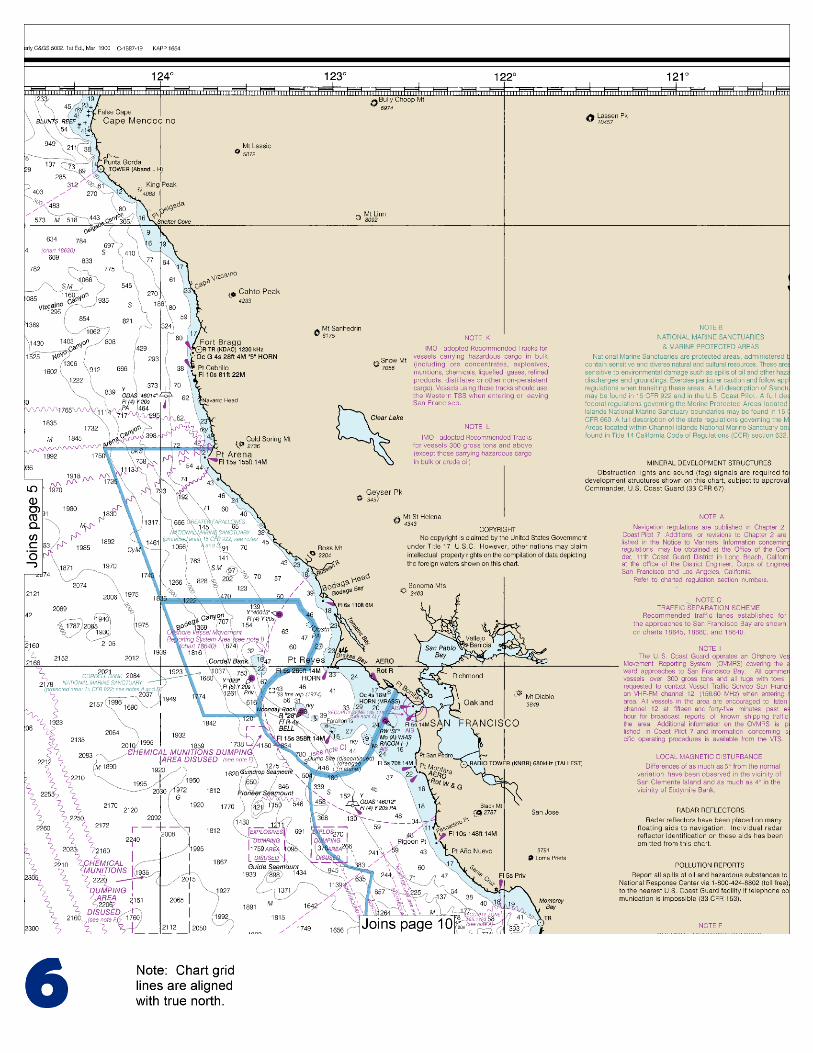
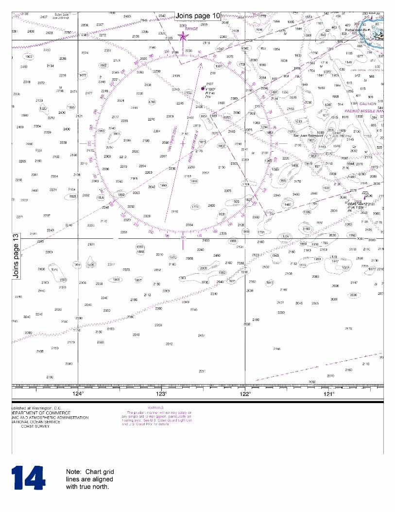
BookletChart™ San Diego to Cape Mendocino NOAA Chart 18020
A reduced-scale NOAA nautical chart for small boaters When possible, use the full-size NOAA chart for navigation.
Included Area

2
Published by the National Oceanic and Atmospheric Administration
National Ocean Service Office of Coast Survey
www.NauticalCharts.NOAA.gov 888-990-NOAA
What are Nautical Charts?
Nautical charts are a fundamental tool of marine navigation. They show water depths, obstructions, buoys, other aids to navigation, and much more. The information is shown in a way that promotes safe and efficient navigation. Chart carriage is mandatory on the commercial ships that carry America’s commerce. They are also used on every Navy and Coast Guard ship, fishing and passenger vessels, and are widely carried by recreational boaters.
What is a BookletChart?
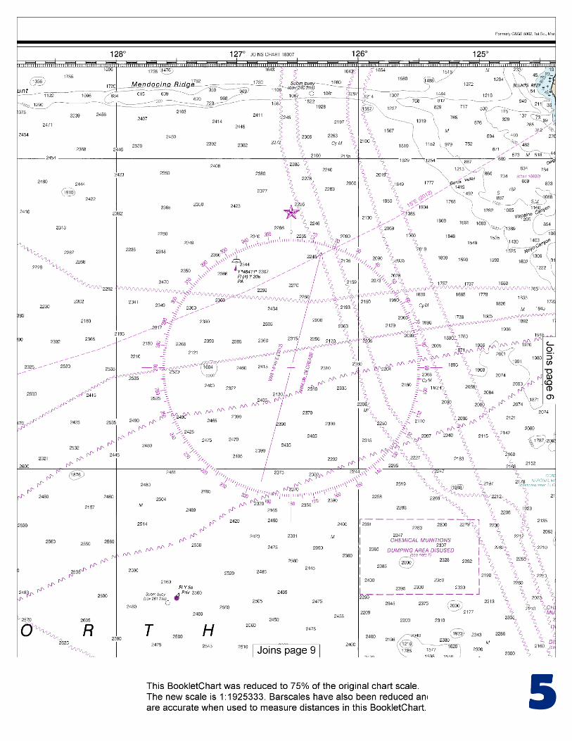
This BookletChart is made to help recreational boaters locate themselves on the water. It has been reduced in scale for convenience, but otherwise contains all the information of the full-scale nautical chart. The bar scales have also been reduced, and are accurate when used to measure distances in this BookletChart. See the Note at the bottom of page 5 for the reduction in scale applied to this chart.
Whenever possible, use the official, full scale NOAA nautical chart for navigation. Nautical chart sales agents are listed on the Internet at http://www.NauticalCharts.NOAA.gov.
This BookletChart does NOT fulfill chart carriage requirements for regulated commercial vessels under Titles 33 and 44 of the Code of Federal Regulations.
Notice to Mariners Correction Status
This BookletChart has been updated for chart corrections published in the U.S. Coast Guard Local Notice to Mariners, the National Geospatial Intelligence Agency Weekly Notice to Mariners, and, where applicable, the Canadian Coast Guard Notice to Mariners. Additional chart corrections have been made by NOAA in advance of their publication in a Notice to Mariners. The last Notices to Mariners applied to this chart are listed in the Note at the bottom of page 7. Coast Pilot excerpts are not being corrected.
For latest Coast Pilot excerpt visit the Office of Coast Survey website at http://www.nauticalcharts.noaa.gov/nsd/coastpilot_w.php?book=7.
(Selected Excerpts from Coast Pilot) San Diego Bay is 10 miles NW of the Mexican boundary. In September of that year, Juan Rodriquez Cabrillo, the Spanish explorer, sailed his frail bark into the bay. The bay is considered one of the finest natural harbors in the world, and affords excellent protection in any weather; it is free of excessive tidal current movements. A low, narrow sandspit, which expands to a width of 1.6 miles at North Island on its NW end, separates the bay from the ocean.
The city of San Diego is on the NE shore of the bay. Coronado is on the sandspit opposite San Diego. National City and Chula Vista are S of San
Diego on the SE shore of the bay. The principal wharves are at San Diego and National City. Coronado, connected to San Diego by a highway bridge, is a residential and resort area of little commercial importance. Anchorages.–General anchorages, special anchorages, and anchorages for Government vessels have been established in San Diego Bay. (See 110.1, 110.90, and 110.210, chapter 2, for limits and regulations.) The Port of San Diego has temporarily prohibited anchoring or mooring in Special Anchorage A-8 (Sweetwater Anchorage), in South San Diego Bay, through the end of 2011. The anchorage is currently undergoing environmental restoration and clean-up. Permission to use anchorage berths 212 through 216 and Mooring Buoy 19, S of Harbor Island, must be obtained from Navy Afloat Training Group Pacific at 619–556–0900. Regulated Navigation Areas.–Restricted areas are: in the waters off the entrance to San Diego Bay; in the lee of Point Loma and S of Ballast Point; between Ballast Point and Zuñiga Point (degaussing station); adjacent to the W side of North Island; 0.4 mile N of Ballast Point, W of the dredged channel; off the NE side of North Island surrounding the Navy Pier; adjacent to and extending SE from the entrance channel to Glorietta Bay. (See 33 CFR 334.860, 334.865, 334.870, 334.880 and 334.890, chapter 2, for limits and regulations.) Regulated navigation areas have been established in all waters of San Diego Bay, Mission Bay, and their approaches, and adjacent to the Naval Submarine Base just N of Ballast Point, extending E across the channel to the W shore of North Island. (See 33 CFR 165.1122 and 165.1107, chapter 2, for limits and regulations.) A safety zone is E of Harbor Island on the N side of the bay. (See 33 CFR 165.1106, chapter 2, for limits and regulations.) Pilotage, San Diego.–All foreign vessels and vessels from a foreign port or bound thereto, and all vessels over 300 gross tons sailing under register between the port of San Diego and any other U.S. port, are subject to pilotage. Further information regarding pilotage requirements are detailed in the Pilotage section of the Port of San Diego Tariff, available through the ship’s agent or directly from the Port District at (619) 686–6343. San Pedro Bay, between Seal Beach on the E and Point Fermin on the W, is 82 miles NW of San Diego. On the shores of the bay are the cities and port areas of Long Beach and Los Angeles. Terminal Island, in the NW part of San Pedro Bay, separates the outer bay from Los Angeles and Long Beach inner harbors. The bay is protected by breakwaters and is a safe harbor in any weather. Long Beach Harbor, in the E part of San Pedro Bay, includes the City of Long Beach and part of Terminal Island. Los Angeles Harbor, at the W end of San Pedro Bay, includes the districts of San Pedro, Wilmington, and a major part of Terminal Island. Long Beach and Los Angeles Harbors are connected by Cerritos Channel. The distance between the seaward entrance to the two harbors is about 4 miles. The Port of Long Beach, one of the largest ports on the Pacific coast, has the reputation of being America’s most modern port. It has extensive foreign and domestic traffic with modern facilities for the largest vessels. It is a major container cargo port with several of the largest and most efficient container terminals on the Pacific coast. The Port of Los Angeles, also one of the largest ports on the Pacific coast, has a history of leading the Pacific coast ports in terms of tonnage handled. It has extensive facilities to accommodate all types of traffic.
U.S. Coast Guard Rescue Coordination Center 24 hour Regional Contact for Emergencies
RCC Alameda Commander
11th CG District (510) 437-3700 Alameda, CA

G
NOAA’s navigation managers serve as ambassadors to the maritime community. They help identify navigational challenges facing professional and recreational mariners, and provide NOAA resources and information for safe navigation. For additional information, please visit nauticalcharts.noaa.gov/service/navmanagers
To make suggestions or ask questions online, go to nauticalcharts.noaa.gov/inquiry. To report a chart discrepancy, please use ocsdata.ncd.noaa.gov/idrs/discrepancy.aspx.
Lateral System As Seen Entering From Seaward on navigable waters except Western Rivers
PORT SIDE
ODD NUMBERED AIDS
GREEN LIGHT ONLY
FLASHING (2)
PREFERRED CHANNEL
NO NUMBERS – MAY BE LETTERED
PREFERRED CHANNEL TO
STARBOARD
TOPMOST BAND GREEN
PREFERRED CHANNEL
NO NUMBERS – MAY BE LETTERED
PREFERRED CHANNEL
TO PORT
TOPMOST BAND RED
STARBOARD SIDE
EVEN NUMBERED AIDS
RED LIGHT ONLY
FLASHING (2)
FLASHING FLASHING
OCCULTING GREEN LIGHT ONLY RED LIGHT ONLY OCCULTING QUICK FLASHING QUICK FLASHING
ISO COMPOSITE GROUP FLASHING (2+1) COMPOSITE GROUP FLASHING (2+1) ISO
"1"
Fl G 6s
G "9"
Fl G 4s
GR "A"
Fl (2+1) G 6s
RG "B"
Fl (2+1) R 6s
"2"
Fl R 6s
8
R "8"
Fl R 4s
LIGHT
G
C "1"
LIGHTED BUOY
G
"5"
GR
"U"
GR
C "S"
RG
N "C"
RG
"G"
LIGHT
6
R
N "6"
LIGHTED BUOY
R
"2
"
CAN DAYBEACON
CAN NUN NUN
DAYBEACON
For more information on aids to navigation, including those on Western Rivers, please consult the latest USCG Light List for your area.
These volumes are available online at http://www.navcen.uscg.gov
Navigation Managers Area of Responsibility
Northeast
Lt. Meghan McGovern
Northwest and
Pacific Islands
Crescent Moegling
Great Lakes Region
Tom Loeper
Chesapeake and
Delaware Bay
Steve Soherr
California
Jeff Ferguson
[email protected] Mid-Atlantic
Lt. Ryan Wartick
Alaska
Lt. Timothy M. Smith
Western Gulf Coast
Alan Bunn
Central Gulf Coast
Tim Osborn
[email protected] South Florida
Puerto Rico
U.S. Virgin Islands
Michael Henderson
Southeast
Kyle Ward
2
2 C U 5
1


VHF Marine Radio channels for use on the waterways:Channel 6 – Inter-ship safety communications.Channel 9 – Communications between boats and ship-to-coast.Channel 13 – Navigation purposes at bridges, locks, and harbors.Channel 16 – Emergency, distress and safety calls to Coast Guard and others, and to initiate calls to other
vessels. Contact the other vessel, agree to another channel, and then switch.Channel 22A – Calls between the Coast Guard and the public. Severe weather warnings, hazards to navigation and safety warnings are broadcast here.Channels 68, 69, 71, 72 and 78A – Recreational boat channels.
Getting and Giving Help — Signal other boaters using visual distress signals (flares, orange flag, lights, arm signals); whistles; horns; and on your VHF radio. You are required by law to help boaters in trouble. Respond to distress signals, but do not endanger yourself.
EMERGENCY INFORMATION
Distress Call Procedures
• Make sure radio is on.• Select Channel 16.• Press/Hold the transmit button.• Clearly say: “MAYDAY, MAYDAY, MAYDAY.”• Also give: Vessel Name and/or Description;Position and/or Location; Nature of Emergency; Number of People on Board.• Release transmit button.• Wait for 10 seconds — If no responseRepeat MAYDAY call.
HAVE ALL PERSONS PUT ON LIFE JACKETS!
This Booklet chart has been designed for duplex printing (printed on front and back of one sheet). If a duplex option is not available on your printer, you may print each sheet and arrange them back-to-back to allow for the proper layout when viewing.
QR
Quick ReferencesNautical chart related products and information - http://www.nauticalcharts.noaa.gov
Interactive chart catalog - http://www.charts.noaa.gov/InteractiveCatalog/nrnc.shtmlReport a chart discrepancy - http://ocsdata.ncd.noaa.gov/idrs/discrepancy.aspx
Chart and chart related inquiries and comments - http://ocsdata.ncd.noaa.gov/idrs/inquiry.aspx?frompage=ContactUs
Chart updates (LNM and NM corrections) - http://www.nauticalcharts.noaa.gov/mcd/updates/LNM_NM.html
Coast Pilot online - http://www.nauticalcharts.noaa.gov/nsd/cpdownload.htm
Tides and Currents - http://tidesandcurrents.noaa.gov
Marine Forecasts - http://www.nws.noaa.gov/om/marine/home.htm
National Data Buoy Center - http://www.ndbc.noaa.gov/
NowCoast web portal for coastal conditions - http://www.nowcoast.noaa.gov/
National Weather Service - http://www.weather.gov/
National Hurrican Center - http://www.nhc.noaa.gov/
Pacific Tsunami Warning Center - http://ptwc.weather.gov/
Contact Us - http://www.nauticalcharts.noaa.gov/staff/contact.htm
NOAA’s Office of Coast Survey The Nation’s Chartmaker
For the latest news from Coast Survey, follow @NOAAcharts
NOAA Weather Radio All Hazards (NWR) is a nationwide network of radio stations broadcasting continuous weather information directly from the nearest National Weather Service office. NWR broadcasts official Weather Service warnings, watches, forecasts and other hazard information 24 hours a day, 7 days a week. http://www.nws.noaa.gov/nwr/


![SHEET 50 ZONING DISPLAY MAP - Mendocino County, CA · MRR MSR M TR GPD GVMU GHMU GI RR_ [RR_] Mendocino Commercial Mendocino Forestland M en doc ix -Us Mendocino Open Space Mendocino](https://img.pdfslide.us/doc/110x75/5f0ffb107e708231d446d8b9/sheet-50-zoning-display-map-mendocino-county-ca-mrr-msr-m-tr-gpd-gvmu-ghmu-gi.jpg)