Embed Size (px)
Citation preview

SAN DIEGO GAS & ELECTRIC COMPANY
CLEVELAND NATIONAL FOREST
POWER LINE REPLACEMENT PROJECTS
PALEONTOLOGICAL MONITORING & TREATMENT PLAN
Prepared for:
INSIGNIA ENVIRONMENTAL
904 SECOND STREET
ENCINITAS, CA 92024
Prepared by:
DEPARTMENT OF PALEOSERVICES
SAN DIEGO NATURAL HISTORY MUSEUM
P.O. Box 121390
SAN DIEGO, CA 92112
Shelly L. Donohue, M.S., Paleontological Report Writer
Thomas A. Deméré, Ph.D., Director
Revised October 2016
Paleontological Monitoring and Treatment Plan
Cleveland National Forest Power Line Replacement Projects i
EXECUTIVE SUMMARY
This Paleontological Monitoring and Treatment Plan (PMTP) was prepared for the San Diego Gas &
Electric Company’s (SDG&E) Cleveland National Forest Power Line Replacement Projects (Project)
located in east-central San Diego County, California. The Project is part of a coordinated fire safety and
service reliability plan proposed by SDG&E, which aims to update and fire-harden its network of electric
lines and facilities in certain areas of Cleveland National Forest (CNF), federal lands, and non-federal
lands. The Project includes the following components:
Replacement of approximately 2,200 existing wood poles with fire-resistant, weathered steel
poles;
undergrounding of approximately 26 miles of existing 12 kilovolt (kV) distribution lines;
removal of approximately 30 miles of existing 12 kV and 19 miles of existing 69 kV overhead
facilities; and
closure of approximately 23 miles of access roads.
Certain project-related excavations will encounter sedimentary and metasedimentary rocks that may
contain nonrenewable paleontological resources.
The PMTP provides an overview of geological rock units found within the Project area, discusses the
potential of these rock units for containing paleontological resources (following the Potential Fossil Yield
Classification system developed by the United States Forest Service and Bureau of Land Management),
and outlines the specific Project components that may impact potentially fossil-bearing rock units. In
addition, the PMTP presents a detailed monitoring plan containing specific steps to be implemented prior
to the start of construction, during the ground disturbance phase of construction, and following
completion of ground disturbance in the event that fossils either are, or are not, discovered and salvaged
from the Project.
All potentially fossil-bearing rock units underlying the Project have been assigned a PFYC of 3B
(unknown paleontological potential) and include Pliocene and Pleistocene nonmarine sedimentary rocks,
and an undivided unit of Mesozoic-aged metasedimentary & metavolcanic rocks. Project components that
may impact these rock units and their contained paleontological resources and that are recommended for
paleontological monitoring during construction include: 1.) 69kV power line and 12kV distribution line
wood-to-steel proposed pole replacement using the direct bury method (pole removal and pole
replacement using the micropile method are not recommended for paleontological monitoring); and 2.)
trenching for line undergrounding and installation of splice vaults. The project components, as currently
proposed, that occur in areas underlain by potentially fossil-bearing rock units include 135 poles to be
replaced using the direct bury method (primarily along TL682), and 1.25 miles of trenching and
associated splice vault installation for undergrounding along C440. The specific number of poles and
method of construction may change as final project design is completed.
Recommended paleontological monitoring and treatment guidelines are divided into three phases and
include:
Preconstruction: retention of Qualified Project Paleontologist; designation of professional repository
to receive any salvaged fossils; attendance of Project Paleontologist at pre-construction meetings as
appropriate; completion of worker environmental awareness program for all excavation personnel;
development of research design.
During Construction: excavation monitoring in areas of concern by a paleontological monitor;
salvage of unearthed, significant fossil remains.
Post Construction: fossil preparation, curation, and storage of salvaged fossils (if any); completion of
final paleontological monitoring report.
Paleontological Monitoring and Treatment Plan
Cleveland National Forest Power Line Replacement Projects ii
TABLE OF CONTENTS EXECUTIVE SUMMARY ........................................................................................................................................................... i 1.0. INTRODUCTION ......................................................................................................................................................... 1
1.1 PROJECT DESCRIPTION ............................................................................................................................................... 1 2.0 OBJECTIVES ................................................................................................................................................................. 2 3.0 APPLICANT PROPOSED MITIGATION MEASURES .......................................................................................... 2 4.0 PALEONTOLOGICAL RESOURCES ....................................................................................................................... 2
4.1 DEFINITION OF PALEONTOLOGICAL RESOURCES ...................................................................................................... 2 4.2 REGULATORY FRAMEWORK ....................................................................................................................................... 3
4.2.1 FEDERAL .............................................................................................................................................................. 3 4.2.2 STATE ................................................................................................................................................................... 4 4.2.3 LOCAL .................................................................................................................................................................. 4
4.3 RESOURCE ASSESSMENT CRITERIA: POTENTIAL FOSSIL YIELD CLASSIFICATION .................................................... 5 4.3.1 PFYC CLASS 5 – VERY HIGH ............................................................................................................................... 5 4.3.2 PFYC CLASS 4 –HIGH .......................................................................................................................................... 5 4.3.3 PFYC CLASS 3A –MODERATE .............................................................................................................................. 5 4.3.4 PFYC CLASS 3B –UNKNOWN ............................................................................................................................... 5 4.3.5 PFYC CLASS 2 –LOW ........................................................................................................................................... 6 4.3.6 PFYC CLASS 1 –VERY LOW ................................................................................................................................. 6
4.4 SUMMARY OF PALEONTOLOGICAL RESOURCE ASSESSMENT .................................................................................... 6 4.4.1 SUMMARY OF PROJECT GEOLOGY AND PFYC ...................................................................................................... 6 4.4.2 ANALYSIS OF PROJECT COMPONENTS ................................................................................................................... 8 4.4.3 PROJECT COMPONENTS RECOMMENDED FOR MONITORING AND TREATMENT....................................................... 9
5.0 PLAN IMPLEMENTATION ...................................................................................................................................... 13 5.1 PRECONSTRUCTION................................................................................................................................................... 13
5.1.1 RETENTION OF QUALIFIED PROJECT PALEONTOLOGIST ....................................................................................... 13 5.1.1.1 Qualifications ...................................................................................................................................................... 13
5.1.2 DESIGNATION OF REPOSITORY ............................................................................................................................ 13 5.1.3 ATTENDANCE AT PRE-CONSTRUCTION MEETING ................................................................................................ 13 5.1.4 WORKER ENVIRONMENTAL AWARENESS PROGRAM (WEAP) ............................................................................ 13 5.1.5 RESEARCH DESIGN ............................................................................................................................................. 14
5.2 DURING CONSTRUCTION ........................................................................................................................................... 14 5.2.1 EXCAVATION MONITORING: DUTIES AND AREAS TO BE MONITORED ................................................................. 14
5.2.1.1 Data Recovery (stratigraphy) .............................................................................................................................. 15 5.2.1.2 Safety Procedures ............................................................................................................................................... 15
5.2.2 PROCEDURES FOR PALEONTOLOGICAL DISCOVERIES .......................................................................................... 15 5.2.2.1 Discovery process and work stoppage: ............................................................................................................... 16 5.2.2.2 Determination of significance: ............................................................................................................................ 16 5.2.2.3 Macrofossil recovery ........................................................................................................................................... 16 5.2.2.4 Microfossil recovery............................................................................................................................................ 17 5.2.2.5 Paleobotanical fossil recovery ............................................................................................................................ 18 5.2.2.6 Time required for fossil recovery ........................................................................................................................ 18
5.3 POST CONSTRUCTION ............................................................................................................................................... 18 5.3.1 FOSSIL PREPARATION ......................................................................................................................................... 18
5.3.1.1 Specimen preparation ......................................................................................................................................... 18 5.3.1.2 Screenwashing .................................................................................................................................................... 19 5.3.1.3 Heavy liquid floatation ........................................................................................................................................ 19 5.3.1.4 Paleobotanical preparation ................................................................................................................................ 19
5.3.2 FOSSIL CURATION .............................................................................................................................................. 19 5.3.2.1 Sorting/picking .................................................................................................................................................... 19 5.3.2.2 Identification ....................................................................................................................................................... 19 5.3.2.3 Cataloguing ......................................................................................................................................................... 20 5.3.2.4 Locality data ....................................................................................................................................................... 20
5.3.3 FOSSIL STORAGE ................................................................................................................................................ 20 5.3.4 FINAL PALEONTOLOGICAL MONITORING REPORT ............................................................................................... 20
6.0 REFERENCES ............................................................................................................................................................. 21 APPENDIX 1 ...................................................................................................................................................................... 22
Paleontological Monitoring and Treatment Plan
Cleveland National Forest Power Line Replacement Projects 1
1.0. INTRODUCTION
This Paleontological Monitoring and Treatment Plan (PMTP) was prepared for the San Diego
Gas & Electric Company’s (SDG&E) Cleveland National Forest Power Line Replacement
Projects (Project) located in east-central San Diego County, California. The PMTP is divided
into a series of steps to be implemented prior to the start of construction, during the ground
disturbance phase of construction, and following completion of ground disturbance in the event
that fossils either are, or are not, discovered and salvaged from the Project. The PMTP will be
updated throughout the course of the Project as needed based on the final engineering designs for
different phases and components of the Project.
The PMTP was prepared in accordance with Applicant Proposed Mitigation Measure (APM)
CUL-08 from the Project’s Final Environmental Impact Report/Environmental Impact
Statement’s Mitigation Monitoring, Compliance, and Reporting Program (MMCRP) and the
United States (U.S.) Forest Service (USFS) Record of Decision, which includes minimum
requirements for development of this Plan and implementation of the procedures to be followed
in the field. All steps taken in the mitigation program are in accordance with industry standards
(e.g., United States Department of Agriculture, Forest Service [USFS], 1996; Bureau of Land
Management [BLM], 2007; Society of Vertebrate Paleontology [SVP], 2010; Murphey et al.,
2014), as well as San Diego County guidelines (Stephenson et al., 2009) and City of San Diego
Guidelines (City of San Diego, 2011). This PMTP will pertain to areas of the Project where
excavation activities will be conducted at locations underlain by geologic units with a Potential
Fossil Yield Classification (PFYC) Class 3.
1.1 PROJECT DESCRIPTION
As part of a coordinated fire safety and service reliability plan SDG&E proposes to update and
fire-harden its network of electric lines and facilities in certain areas of CNF, other federal lands,
and non-federal lands, as depicted in Figure 1. The Project not only traverses USFS lands, but
due to the patchwork of land ownership in the Project study area, also traverses lands managed
by the BLM; tribal lands held in trust by the Bureau of Indian Affairs (BIA); Cuyamaca Rancho
State Park lands managed by California State Parks (CSP); lands under the jurisdiction of the
City of San Diego, and private holdings within unincorporated San Diego County.
The Project includes the following components:
Replacement of approximately 2,200 existing wood poles with fire-resistant, weathered
steel poles;
undergrounding of approximately 26 miles of existing 12 kilovolt (kV) distribution lines;
removal of approximately 30 miles of existing 12 kV and 19 miles of existing 69 kV
overhead facilities; and
closure of approximately 23 miles of access roads.
Paleontological Monitoring and Treatment Plan
Cleveland National Forest Power Line Replacement Projects 2
2.0 OBJECTIVES
The purpose of this PMTP is to provide a description of measures that will be implemented to
address monitoring and treatment of paleontological resources. This PMTP provides specific
information regarding pre-construction field surveys, construction personnel training, necessary
permits, research design, monitoring methodology, fossil discovery and recovery protocols,
fossil preparation and curation procedures, and the preparation of a final monitoring report. The
management practices and activities in this Plan are intended to accomplish the following
objectives:
minimize the impact to paleontological resources due to ground disturbance during
construction; and
provide for the proper treatment of fossils, if discovered, during construction of the
Project.
3.0 APPLICANT PROPOSED MITIGATION MEASURES
Applicant proposed mitigation measure, APM CUL-08 provides for the protection of
paleontological resources. This mitigation measure states:
“A paleontological monitor will be present for excavation activities conducted at locations with
underlying PFYC Class 3 geologic deposits where new steel poles are unable to be installed in
the same location as of that of the existing wood pole. In the event that fossils are unexpectedly
encountered during construction, a qualified paleontologist will have the authority to divert or
temporarily halt construction activities in the area of discovery to allow the recovery of fossil
remains in a timely fashion. When significant fossils are discovered, the paleontologist will
recover them in accordance with professional standards. Fossil remains collected during
monitoring and salvage will be cleaned, repaired, sorted, cataloged, and curated in a scientific
institution with permanent paleontological collections. The paleontological monitor will follow
the procedures outlined in the Paleontological Monitoring and Treatment Plan, which will be
prepared and will include information regarding pre-construction field surveys, construction
personnel training, necessary permits, research design, monitoring methodology, fossil discovery
and recovery protocols, fossil preparation and curation procedures, and the preparation of a final
monitoring report.”
4.0 PALEONTOLOGICAL RESOURCES
4.1 DEFINITION OF PALEONTOLOGICAL RESOURCES
Paleontological resources (i.e., fossils) are the remains and/or traces of prehistoric plant and
animal life. Although typically it is assumed that fossils must be older than ~10,000 years (i.e.,
the generally accepted end of the last glacial interval of the Pleistocene Epoch), organic remains
of early Holocene age can also be considered to represent fossils because they are part of the
Paleontological Monitoring and Treatment Plan
Cleveland National Forest Power Line Replacement Projects 3
record of past life. Fossil remains such as bones, teeth, shells, leaves, and wood are found in the
geologic deposits (rock formations) within which they were originally buried. For the purposes
of this report, paleontological resources can be thought of as including not only the actual fossil
remains but also the collecting localities and the geologic formations containing those localities.
Direct impacts to paleontological resources occur when excavation activities cut into the
geologic deposits (formations) within which fossils are buried. These direct impacts are in the
form of physical destruction of fossil remains. Since fossils are the remains of prehistoric animal
and plant life they are considered to be nonrenewable.
4.2 REGULATORY FRAMEWORK
As discussed above, paleontological resources are scientifically and educationally significant
nonrenewable resources and as such are protected under federal, state, and local laws,
regulations, and ordinances. Pertinent laws, regulations, and ordinances are summarized below.
4.2.1 FEDERAL
Notable Federal legislative protection for paleontological resources includes the Antiquities Act
of 1906, the National Environmental Policy Act of 1969, the Federal Land Policy Management
Act of 1976, and the Paleontological Resources Preservation Act of 2009.
The American Antiquities Act of 1906 (6 U.S.C. 431-433). Establishes a penalty for disturbing
or excavating any historic or prehistoric ruin or monument or object of antiquity on federal lands.
The act also establishes a permit requirement for collection of antiquities on federal lands.
Although not specifically addressing paleontological resources, the act is considered relevant to
such resources by number of federal agencies that consider fossils to be objects of antiquity.
The National Environmental Policy Act (NEPA) of 1969, (P.L. 91-190; 42 U.S.C. 4321-4347),
recognizes the continuing responsibility of the Federal Government to “preserve important
historic, cultural, and natural aspects of our national heritage . . .” (Sec. 101 [42 U.S.C. § 4321])
(#382). As with the American Antiquities Act, NEPA does not specifically address
paleontological resources but is interpreted by many federal agencies to be applicable to such
resources. For example, the BLM and the USFS both view NEPA as one of the major laws
protecting paleontological resources on public lands.
The Federal Land Policy and Management Act (FLPMA) of 1976 (P.L. 94-579; 43 U.S.C. 1701-
1782) defines significant fossils as: unique, rare or particularly well-preserved; an unusual
assemblage of common fossils; being of high scientific interest; or providing important new data
concerning [1] evolutionary trends, [2] development of biological communities, [3] interaction
between or among organisms, [4] unusual or spectacular circumstances in the history of life, [5]
or anatomical structure.
The Paleontological Resources Preservation Act (PRPA) of March 2009 (P.L. 111-011) is the
first statute to directly address management and protection of paleontological resources on
USFS, BLM, and U.S Department of the Interior, Bureau of Reclamation (BOR) lands. This law
essentially codifies collecting polices of federal land management agencies. It allows reasonable
amounts of common invertebrate and plant fossils to be casually collected with negligible
disturbance. In addition, it requires protection and preservation of uncommon invertebrate and
plants and all vertebrate fossils, including imprints, molds, casts, etc. The PRPA further
describes requirements for permitting collection on federal lands, stipulations regarding the use
of paleontological resources in education, continued federal ownership of recovered
Paleontological Monitoring and Treatment Plan
Cleveland National Forest Power Line Replacement Projects 4
paleontological resources, and standards for acceptable repositories of collected specimens and
associated data. The PRPA also provides for criminal and civil penalties for unauthorized
removal of paleontological resources from federal lands.
To implement the policies of the PRPA, the Department of Agriculture adopted regulations (Title
36 C.F.R. Part 291) in April 2015 to manage, protect, and preserve paleontological resources on
National Forest System lands. These regulations provide for management of paleontological
resources by establishing fossil collection permitting procedures, setting curation standards,
establishing civil and criminal penalties, prohibiting fossil collection for commercial purposes,
and developing procedures for allowing the casual collection of some of these resources on
certain lands and under specific conditions.
The Bureau of Indian Affairs provides guidance (Indian Affairs Manual Part 59, Chapter 7)
regarding the protection and management of paleontological resources on tribal lands. Specific
requirements are given under this policy for the excavation and removal of imbedded fossils that
includes obtaining a permit from the BIA operating under the authority of the Secretary of the
Interior.
4.2.2 STATE
Notable State legislative protection includes the California Environmental Quality Act and the
Public Resources Code.
The California Environmental Quality Act (CEQA, Public Resources Code Section 21000 et
seq.) protects paleontological resources on both state and private lands in California. This act
requires the identification of environmental impacts of a proposed project, the determination of
significance of the impacts, and the identification of alternative and/or mitigation measures to
reduce adverse environmental impacts. The Guidelines for the Implementation of CEQA (Title
14, Chapter 3, California Code of Regulations: 15000 et seq.) outlines these necessary
procedures for complying with CEQA. Paleontological resources are specifically included as a
question in the CEQA Environmental Checklist (Section 15023, Appendix G): “Will the
proposed project directly or indirectly destroy a unique paleontological resource or site or unique
geologic feature.” Also applicable to paleontological resources is the checklist question: “Does
the project have the potential to… eliminate important examples of major periods of California
history or pre-history.” For the proposed project, implementation of APM CUL-08 protects
paleontological resources in compliance with CEQA.
Other state requirements for paleontological resource management are included in the Public
Resources Code (Chapter 1.7), Section 5097.5 and 30244. These statutes prohibit the removal of
any paleontological site or feature on public lands without permission of the jurisdictional
agency, defines the removal of paleontological sites or features as a misdemeanor, and requires
reasonable mitigation of adverse impacts to paleontological resources from developments on
public (state) lands.
4.2.3 LOCAL
The County of San Diego primarily addresses management of paleontological resources through
CEQA. In addition, Section 87.430 of the County’s Grading Ordinance specifically establishes
procedures for the mitigation of potential impacts to paleontological resources during earthwork
operations. Detailed guidelines for determining significance and mitigation procedures for
Paleontological Monitoring and Treatment Plan
Cleveland National Forest Power Line Replacement Projects 5
paleontological resources are provided by the County’s Department of Public Works
(Stephenson et al., 2009).
The City of San Diego has developed specific guidelines for the implementation of CEQA
regarding the management of paleontological resources within the City’s boundaries (City of San
Diego, 2011). Specifically, the City provides Initial Study Questions and Significance
Thresholds to determine whether a proposed project will significantly impact paleontological
resources. If it is determined that a project may impact paleontological resources, the City
provides guidelines for the mitigation of these impacts, most commonly through implementation
of a monitoring program.
4.3 RESOURCE ASSESSMENT CRITERIA: POTENTIAL FOSSIL YIELD CLASSIFICATION (PFYC)
In recognizing the fact that paleontological resources are considered to include not only actual
fossil remains and traces, but also the fossil collecting localities and the geologic formations
containing those fossils and localities, the Forest Service and the BLM have developed a
procedure for evaluating the paleontological resource potential of individual geologic rock units.
This procedure utilizes the Potential Fossil Yield Classification (PFYC) system to assign ranks to
rock units based on the relative abundance of vertebrate fossils or scientifically significant
invertebrate or plant fossils (USFS, 1996; BLM, 2007). Under the PFYC system, geologic
formations with a higher potential are assigned a higher class number. The PFYC system, as
originally defined by the Forest Service (USFS, 1996), and later refined by the BLM (2007), is
outlined below.
The PFYC system is required for assessment of paleontological resources located on all federal
lands (e.g., Department of Agriculture and Department of Interior managed lands), and is readily
applicable to resources on state, county, tribal, and private lands. Thus, the PFYC system will be
used to assess the entirety of the Project.
4.3.1 PFYC CLASS 5 – VERY HIGH
Very high potential (PFYC Class 5) is assigned to geologic formations that consistently and
predictably produce vertebrate fossils or scientifically significant invertebrate or plant fossils.
4.3.2 PFYC CLASS 4 –HIGH
High potential (PFYC Class 4) is assigned to geologic formations containing a high occurrence
of significant fossils. Vertebrate fossils or scientifically significant invertebrate or plant fossils
are known to occur and have been documented within these deposits, but may vary in occurrence
and predictability.
4.3.3 PFYC CLASS 3A –MODERATE
Moderate potential (PFYC Class 3a) is assigned to geologic formations that are known to contain
vertebrate fossils or scientifically significant non-vertebrate fossils, but these occurrences are
widely scattered. These formations may contain common invertebrate or plant fossils.
4.3.4 PFYC CLASS 3B –UNKNOWN
Unknown potential (PFYC Class 3b) is assigned to geologic formations that exhibit geologic
features and preservational conditions that suggest significant fossils could be present, but little
information about the paleontological resources of the unit or the area is known. This may
indicate the unit or area is poorly studied, and field surveys may uncover significant finds. The
Paleontological Monitoring and Treatment Plan
Cleveland National Forest Power Line Replacement Projects 6
units in this Class may eventually be placed in another Class when sufficient survey and research
is performed.
4.3.5 PFYC CLASS 2 –LOW
Low potential (PFYC Class 2) is assigned to geologic formations that are not likely to contain
vertebrate fossils or scientifically significant non-vertebrate fossils.
4.3.6 PFYC CLASS 1 –VERY LOW
Very Low potential (PFYC Class 1) is assigned to geologic formations that are not likely to
contain recognizable fossil remains.
4.4 SUMMARY OF PALEONTOLOGICAL RESOURCE ASSESSMENT
A paleontological resource assessment of the Project area was completed in March 2012
(PaleoServices, 2012). Since completion of this assessment, more detailed descriptions of project
components (e.g., depth of trenching for undergrounding duct banks) and new information
concerning paleontological resources for the Project have become available. As such, the PFYC
Classifications of one geologic rock unit has been updated for this report (Table 1). This unit, as
mapped by Todd (2004), is described as Jurassic–Cretaceous aged metavolcanic and
metasedimentary rocks (KJvs), and was previously thought to be of a metamorphic grade too
high to preserve intact fossil remains. However, more recent assessments of this rock unit
suggest the degree of metamorphism is similar to that of the Julian Schist, indicating an
increased potential for the preservation of fossils. Consequently, this rock unit has been
reassigned a PFYC rank of Class 3b (Unknown Potential) from the former PFYC rank of Class 1
(Very Low). With this reassignment, additional portions of the Project are recommended for
paleontological monitoring, and the list of poles, vaults, and areas of trenching have been
updated accordingly as outlined in Table 2 and Appendix 1.
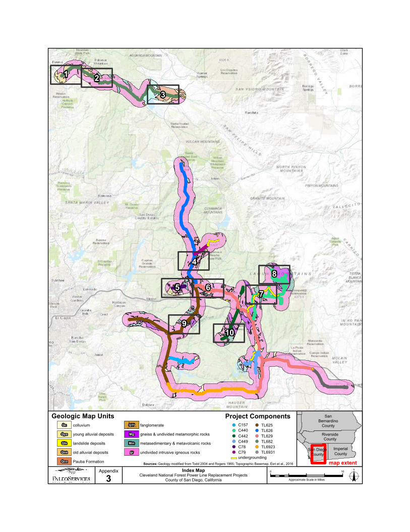
4.4.1 SUMMARY OF PROJECT GEOLOGY AND PFYC
The paleontological resource assessment determined that the project alignment, which traverses a
series of mountain ranges and their western foothills, as well as intervening alluvial valleys, is
primarily underlain by crystalline basement rocks, with screens of Mesozoic metamorphic rocks,
and accumulations of alluvial deposits ranging in age from Pleistocene to Recent (Rogers, 1965;
Todd, 2004). For simplification purposes, geologic rock units of similar age, composition, and
method of formation have been grouped together in this report. For example, all intrusive
(plutonic) igneous rocks (e.g., Tonalite of La Posta, Chiquito Peak Monzogranite, Cuyamaca
Gabbro) have been grouped together. Table 1 summarizes these groupings, as well as a
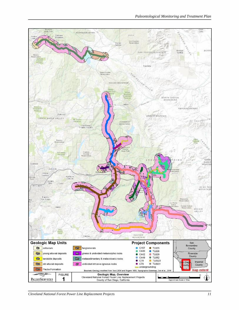
description of the group and its PFYC ranking. A geologic map of the proposed alignment, using
these rock unit groups, is presented in Figure 1 and Appendix 1, and a paleontological resource
potential map is presented in Figure 2.
In summary, all intrusive igneous rocks (gr) and high grade metamorphic rocks (Mg) are
assigned PFYC Class 1 (very low paleontological potential), all Holocene-aged sedimentary
rocks (Qc, Qya, Qls) are assigned PFYC Class 2 (low paleontological potential), and Pliocene to
Pleistocene-aged sedimentary rocks (Qoa, Qco, QTf) are assigned PFYC Class 3b (unknown
paleontological potential). Additionally, metamorphic rock units believed to contain screens of
potentially fossil-bearing metasedimentary rocks (Mm) are assigned PFYC Class 3b (unknown
paleontological potential). However, it should be emphasized that only portions of this rock unit
are potentially fossil-bearing (i.e., the metasedimentary rocks and not the metavolcanic rocks).
Paleontological Monitoring and Treatment Plan
Cleveland National Forest Power Line Replacement Projects 7
Because precise geologic mapping of the metasedimentary portion of this rock unit has not been
completed, the entire rock unit has been assigned PFYC Class 3b. As discussed below in Section
6.1, paleontological monitoring requirements for this rock unit may be augmented (e.g., reduced
or eliminated in areas containing only metavolcanic rocks) as more is learned about this rock unit
over the course of the monitoring and treatment program.
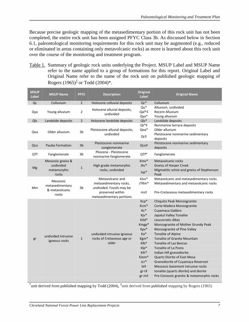
Table 1. Summary of geologic rock units underlying the Project. MSUP Label and MSUP Name
refer to the name applied to a group of formations for this report. Original Label and
Original Name refer to the name of the rock unit on published geologic mapping of
Rogers (1965)‡ or Todd (2004)*.
MSUP Label
MSUP Name PFYC Description Original
Label Original Name
Qc Colluvium 2 Holocene colluvial deposits Qc* Colluvium
Qya Young alluvium 2 Holocene alluvial deposits,
undivided
Qu* Alluvium, undivided Qal*‡ Recent Alluvium Qya* Young alluvium
Qls Landslide deposits 2 Holocene landslide deposits Qls* Landslide deposits
Qoa Older alluvium 3b Pleistocene alluvial deposits,
undivided
Qt*‡ Nonmarine terrace deposits Qoa* Older alluvium
Qc‡ Pleistocene nonmarine sedimentary deposits
Qco Pauba Formation 3b Pleistocene nonmarine
conglomerate Qco‡
Pleistocene nonmarine sedimentary deposits
QTf Fanglomerate 3b Pliocene - Pleistocene
nonmarine fanglomerate QTf* Fanglomerate
Mg
Mesozoic gneiss & undivided
metamorphic rocks
1 High grade metamorphic
rocks, undivided
Kmv* Metavolcanic rocks Jhc* Gneiss of Harper Creek
Jsp* Migmatitic schist and gneiss of Stephenson Peak
Mm
Mesozoic metasedimentary & metavolcanic
rocks
3b
Metavolcanic and metasedimentary rocks,
undivided. Fossils may be preserved within
metasedimentary portions
KJvs* Metavolcanic and metasedimentary rocks JTRm* Metasedimentary and metavolcanic rocks
ms‡ Pre-Cretaceous metasedimentary rocks
gr undivided intrusive
igneous rocks 1
undivided intrusive igneous rocks of Cretaceous age or
older
Kcp* Chiquito Peak Monzogranite
Kcm* Corte Madera Monzogranite
Kc* Cuyamaca Gabbro
Kjv* Japatul Valley Tonalite
KJld* Leucocratic dikes
Kmgp* Monzogranite of Mother Grundy Peak
Kpv* Monzogranite of Pine Valley
Ka* Tonalite of Alpine
Kgm* Tonalite of Granite Mountain
Klb* Tonalite of Las Bancas
Klp* Tonalite of La Posta
Kih* KJem*
Indian Hill granodiorite Quartz Diorite of East Mesa
Jcr* Granodiorite of Cuyamaca Reservoir
bi‡ Mesozoic basement intrusive rocks
gr-t‡ tonalite (quartz diorite) and diorite
gr-m‡ Pre-Cenozoic granitic & metamorphic rocks
*unit derived from published mapping by Todd (2004), ‡unit derived from published mapping by Rogers (1965)
Paleontological Monitoring and Treatment Plan
Cleveland National Forest Power Line Replacement Projects 8
4.4.2 ANALYSIS OF PROJECT COMPONENTS
Only project components that will involve earthwork into previously undisturbed rock units have
the potential to impact paleontological resources. Thus, those project components that will not
involve earthwork (e.g., access road maintenance, single to double circuit conversion) will not
impact paleontological resources, and thus will not require paleontological monitoring.
The project components that will involve earthwork activities, and thus may potentially require
paleontological monitoring and treatment, are described below:
- Wood-to-Steel Pole Replacement, 69kV tie-lines (TL) and 12kV circuits (C): This project
component will involve removal of wood poles with an average diameter of 20 inches,
and replacement with steel poles with an average diameter of 30 inches for TL 682, 36 to
60 inches for all other tie-lines (TL 626, TL 625, TL 629, TL 6923, and TL 6931), and 14
inches for all circuits.
o Direct Bury Method – This activity will involve drilling using augers anticipated
to be between 4 to 8 feet in diameter for tie-lines, and between 2 to 4 feet in
diameter for circuits. Depth below ground surface can be 15 feet or deeper
depending upon the height of the pole. Such augering typically brings up
fragmented pieces of bedrock that are large enough to contain any preserved
paleontological resources.
Paleontological monitoring and treatment is recommended in areas
underlain by rock units assigned a rank of PFYC Class 3b.
o Pier Foundation Method – This activity will involve drilling using augers
anticipated to be up to 8 feet in diameter. Depth below ground surface can be 20
feet or deeper depending upon the height of the pole. Such augering typically
brings up fragmented pieces of bedrock that are large enough to contain any
preserved paleontological resources.
Paleontological monitoring and treatment is recommended in areas
underlain by rock units assigned a rank of PFYC Class 3b.
o Micropile Method – This activity will involve drilling a grid pattern of small
diameter (<1 foot) holes. Augers with diameters less than about 18 inches
pulverize bedrock, and thus will destroy any contained paleontological resources.
As a consequence, it is not possible to mitigate micropile foundation drilling for
paleontological resources.
Paleontological monitoring and treatment is not recommended
o Removal – This activity will not involve excavation into native rock units.
Paleontological monitoring and treatment is not recommended
- Undergrounding:
o This activity will involve trenching for installation of duct banks in existing
roadways. Anticipated trench dimensions are approximately 2.5 feet wide by 5
feet deep.
Paleontological Monitoring and Treatment Plan
Cleveland National Forest Power Line Replacement Projects 9
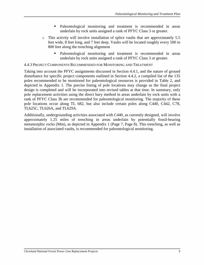
Paleontological monitoring and treatment is recommended in areas underlain by rock units assigned a rank of PFYC Class 3 or greater.
o This activity will involve installation of splice vaults that are approximately 5.5 feet wide, 8 feet long, and 7 feet deep. Vaults will be located roughly every 500 to 800 feet along the trenching alignment
Paleontological monitoring and treatment is recommended in areas underlain by rock units assigned a rank of PFYC Class 3 or greater.
4.4.3 PROJECT COMPONENTS RECOMMENDED FOR MONITORING AND TREATMENT
Taking into account the PFYC assignments discussed in Section 4.4.1, and the nature of ground disturbance for specific project components outlined in Section 4.4.2, a compiled list of the 135 poles recommended to be monitored for paleontological resources is provided in Table 2, and depicted in Appendix 1. The precise listing of pole locations may change as the final project design is completed and will be incorporated into revised tables at that time. In summary, only pole replacement activities using the direct bury method in areas underlain by rock units with a rank of PFYC Class 3b are recommended for paleontological monitoring. The majority of these pole locations occur along TL 682, but also include certain poles along C440, C442, C78, TL625C, TL626A, and TL629A.
Additionally, undergrounding activities associated with C440, as currently designed, will involve approximately 1.25 miles of trenching in areas underlain by potentially fossil-bearing metamorphic rocks (Mm), as depicted in Appendix 1 (Page 7, Page 8). This trenching, as well as installation of associated vaults, is recommended for paleontological monitoring.
Paleontological Monitoring and Treatment Plan
Cleveland National Forest Power Line Replacement Projects 10
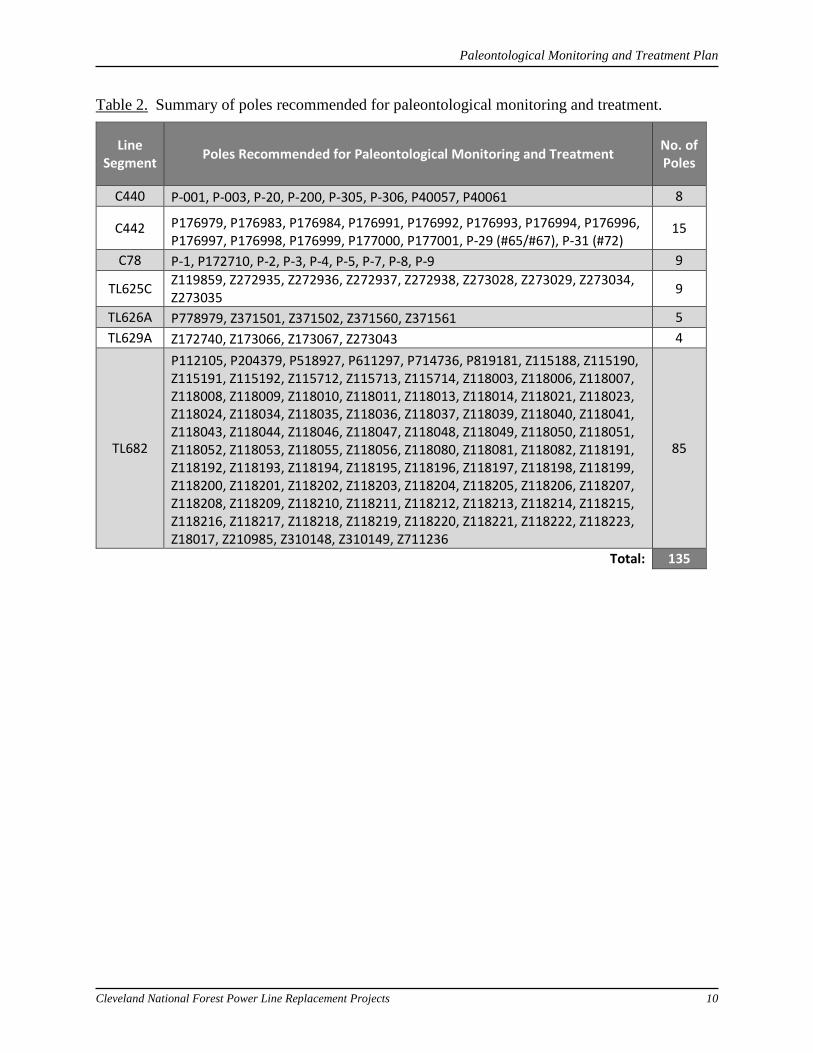
Table 2. Summary of poles recommended for paleontological monitoring and treatment.
Line Segment Poles Recommended for Paleontological Monitoring and Treatment No. of
Poles
C440 P-001, P-003, P-20, P-200, P-305, P-306, P40057, P40061 8
C442 P176979, P176983, P176984, P176991, P176992, P176993, P176994, P176996, P176997, P176998, P176999, P177000, P177001, P-29 (#65/#67), P-31 (#72)
15
C78 P-1, P172710, P-2, P-3, P-4, P-5, P-7, P-8, P-9 9
TL625C Z119859, Z272935, Z272936, Z272937, Z272938, Z273028, Z273029, Z273034, Z273035 9
TL626A P778979, Z371501, Z371502, Z371560, Z371561 5 TL629A Z172740, Z173066, Z173067, Z273043 4
TL682
P112105, P204379, P518927, P611297, P714736, P819181, Z115188, Z115190, Z115191, Z115192, Z115712, Z115713, Z115714, Z118003, Z118006, Z118007, Z118008, Z118009, Z118010, Z118011, Z118013, Z118014, Z118021, Z118023, Z118024, Z118034, Z118035, Z118036, Z118037, Z118039, Z118040, Z118041, Z118043, Z118044, Z118046, Z118047, Z118048, Z118049, Z118050, Z118051, Z118052, Z118053, Z118055, Z118056, Z118080, Z118081, Z118082, Z118191, Z118192, Z118193, Z118194, Z118195, Z118196, Z118197, Z118198, Z118199, Z118200, Z118201, Z118202, Z118203, Z118204, Z118205, Z118206, Z118207, Z118208, Z118209, Z118210, Z118211, Z118212, Z118213, Z118214, Z118215, Z118216, Z118217, Z118218, Z118219, Z118220, Z118221, Z118222, Z118223, Z18017, Z210985, Z310148, Z310149, Z711236
85
Total: 135
Paleontological Monitoring and Treatment Plan
Cleveland National Forest Power Line Replacement Projects 11
Paleontological Monitoring and Treatment Plan
Cleveland National Forest Power Line Replacement Projects 12
Paleontological Monitoring and Treatment Plan
Cleveland National Forest Power Line Replacement Projects 13
5.0 PLAN IMPLEMENTATION
5.1 PRECONSTRUCTION
Prior to commencement of construction activities, some or all of the following actions are
recommended.
5.1.1 RETENTION OF QUALIFIED PROJECT PALEONTOLOGIST
Prior to the start of construction, a qualified Project Paleontologist (as defined below) shall be
retained to implement the PMTP, including serving as supervisor to any retained qualified
paleontological monitors (as defined below). The Project Paleontologist shall be in possession of
all necessary agency permits.
5.1.1.1 Qualifications
The qualified Project Paleontologist must have a Master’s Degree or Ph.D. in paleontology or
related subject area, knowledge of the local paleontology, and professional expertise with
paleontological procedures and techniques. In turn, the qualified paleontological monitor(s) will
have a BA or BS in geology or paleontology and a minimum of 1 year of monitoring experience
in local sedimentary rocks. Demonstrated experience may be substituted for academic training.
5.1.2 DESIGNATION OF REPOSITORY
A professional repository shall be contracted with prior to the start of construction to curate and
store any fossils that may be recovered during construction. Such an institution should be a
recognized paleontological specimen repository with a permanent curator, such as an AAM-
accredited museum or university (e.g., San Diego Natural History Museum, Natural History
Museum of Los Angeles County, or University of California Museum of Paleontology). The
repository shall be capable of storing fossils in a facility with adequate security against theft,
loss, damage, fire, pests, and adverse climate conditions.
5.1.3 ATTENDANCE AT PRE-CONSTRUCTION MEETING
The Project Paleontologist shall attend appropriate pre-construction meetings or daily tailboards
to consult with the grading and excavation contractors concerning excavation schedules,
paleontological field techniques, and safety issues.
5.1.4 WORKER ENVIRONMENTAL AWARENESS PROGRAM (WEAP)
Prior to the start of construction, the Project Paleontologist shall coordinate and help to develop
the worker environmental awareness program (WEAP) section on paleontological resources to
ensure that all construction personnel understand paleontological monitoring requirements, the
roles and responsibilities of paleontological monitors, and the appropriate action to be taken in
the event of a discovery of paleontological resources. The penalties associated with the
unauthorized collection of or intentional disturbance of any paleontological resources, as well as
the penalties for noncompliance with paleontological monitoring and treatment requirements
shall be clearly communicated. Training shall include a definition of paleontological resources
and an overview of potential paleontological resources that may be encountered during ground
disturbing activities. Such information is designed to help facilitate worker recognition of
paleontological resources, resource avoidance, and immediate notification to the Project
Paleontological Monitoring and Treatment Plan
Cleveland National Forest Power Line Replacement Projects 14
Paleontologist, or paleontological monitor. All construction personnel will be required to attend
the WEAP prior to conducting work on the project.
5.1.5 RESEARCH DESIGN
There are specific research themes associated with the sedimentary rock units present within the
Project area. These research themes should be considered when determining the types of data to
be collected during implementation of the PMTP.
Research themes that apply to the Pliocene-Pleistocene and Pleistocene-aged sedimentary rocks
found in the Project area include the following:
Plio-Pleistocene land mammal diversity, evolution, and systematics
Plio-Pleistocene non-marine paleoenvironments in upland valleys of eastern San Diego
County
Plio-Pleistocene paleoecologic structure of land mammal assemblages
Plio-Pleistocene biostratigraphic age assignments of nonmarine sedimentary rocks in
upland valleys of eastern San Diego County
Research themes that apply to the Mesozoic-aged metasedimentary rocks found in the Project
area include the following:
Mesozoic marine biodiversity and taxonomy
Mesozoic marine paleoenvironments of eastern San Diego County
Mesozoic biostratigraphic age assignments of metasedimentary rocks of eastern San
Diego County
5.2 DURING CONSTRUCTION
Commencement of construction related excavation activities marks the time when potential
impacts to paleontological resources could occur. To mitigate these potential impacts, some or
all of the following actions are required:
5.2.1 EXCAVATION MONITORING: DUTIES AND AREAS TO BE MONITORED
A qualified paleontological monitor(s) working under the direction of the Project Paleontologist
shall be present full-time during all ground disturbance activities in areas underlain by geologic
rock units/formations assigned a rank of PFYC Class 3b (Figure 1, Figure 2, Appendix 1), as
outlined in Section 4.4.3. The specific pole numbers for each tie-line and circuit that will need to
be monitored are outlined in Table 2. The trenching and vault locations to be monitored are
depicted in Appendix 1.
The SDG&E Cultural Resource Specialist and the Lead Environmental Inspector will ensure the
Project Paleontologist and paleontological monitor(s) are informed about current plans and any
construction or scheduling changes. The monitor(s) will coordinate with the Project
Paleontologist to determine the timing for monitoring in the identified areas of concern. It will be
the responsibility of the Project Paleontologist and paleontological monitor(s) to maintain
communication and coordination with the construction team.
A paleontological monitor will observe and inspect any temporarily exposed outcrops (e.g.,
trench and auger spoils, vault walls) for paleontological remains. Ideally, inspection would
Paleontological Monitoring and Treatment Plan
Cleveland National Forest Power Line Replacement Projects 15
involve examination of every newly exposed surface, but operationally this is often impossible.
The pace and quantity of equipment in the cut may determine how often and where
paleontological monitors can inspect. When active excavations are too dangerous to enter
because of a narrow cut, heavy equipment traffic, or other reason, monitoring may be conducted
from an elevated vantage point.
Based on conditions in the field, paleontological monitoring may be reduced or increased at the
discretion of the Project Paleontologist. For the Project, this is particularly relevant for areas
underlain by geologic rock units/formations mapped as Mesozoic metasedimentary &
metavolcanic rocks (Mm), as only the metasedimentary portions of this rock unit are potentially
fossil-bearing. If it is determined by the Project Paleontologist that an area to be impacted by
construction is underlain by the metavolcanic portion of this unit, paleontological monitoring
may be reduced to spot-checking or discontinued in this area.
Paleontological monitors will work as efficiently as possible in order to minimize any delay to
construction operations.
5.2.1.1 Data Recovery (stratigraphy)
Recording of stratigraphic data will be an on-going aspect of excavation monitoring to provide
context for any subsequent fossil discoveries. Spoils piles and any temporary outcrops should be
examined and observed geologic features recorded on project plans and field notes. The goal of
this work is to delimit the nature of potentially fossiliferous sedimentary and metasedimentary
rock units in the Project area, determine their areal distribution and depositional contacts, and
record any evidence of structural deformation. Standard geologic and stratigraphic data collected
include lithologic descriptions (color, sorting, texture, structures, and grain size), stratigraphic
relationships (bedding type, thickness, and contacts), and topographic position. Measurement of
stratigraphic sections will be routinely done and areas containing exposures of fossiliferous
sedimentary or metasedimentary deposits will be studied in detail and fossil localities recorded
on measured stratigraphic sections.
5.2.1.2 Safety Procedures
Safety of paleontological field personnel is a critical concern during the construction phase.
Safety procedures to be followed by field personnel may include wearing appropriate clothing
(high-visibility safety vests, hard hats, steel toed boots), carrying large handheld orange flags,
securing equipment operators attention before observing spoils piles, or other temporary
exposures, notifying grading personnel before beginning a salvage excavation, marking fossil
discovery sites with surveyor’s flagging, and using caution while driving on haul roads.
Attendance of the preconstruction meeting (section 5.3) and daily or weekly tailgate meetings at
the Project area are important for discussing mutual safety issues between paleontological field
personnel and construction personnel.
5.2.2 PROCEDURES FOR PALEONTOLOGICAL DISCOVERIES
The goal of paleontological monitoring is to observe excavation activities, to evaluate and
recover unearthed paleontological resources, and to ensure Project compliance with relevant
environmental requirements. When fossils are discovered, the following procedures will be
followed. Recovery methods may vary to some degree depending on the types of fossils
discovered (e.g., macrofossils, microfossils, or plant fossils) and the nature of the enclosing
sedimentary deposits.
Paleontological Monitoring and Treatment Plan
Cleveland National Forest Power Line Replacement Projects 16
5.2.2.1 Discovery process and work stoppage:
In general, when a fossil discovery occurs, the qualified paleontological monitor will
immediately contact the Project Paleontologist and notify appropriate construction personnel.
The monitor, under direction of the Project Paleontologist, will have the authority to divert,
direct, or temporarily halt ground disturbing activities in the area of discovery to allow for
preliminary evaluation of potentially significant paleontological resources and to determine if
additional measures (i.e., collection and curation) are required. In certain cases (e.g., discovery of
a single, isolated fossil specimen), the qualified paleontological monitor may choose to recover
the fossil before contacting the Project Paleontologist to avoid unnecessary construction delays
(see Section 6.2.3).
5.2.2.2 Determination of significance:
The resource significance of the discovered paleontological resources will be determined by the
Project Paleontologist. For significant paleontological resources, a data recovery program will be
initiated that will follow the general steps outlined below with some refinements based on the
type and nature of the specific discovery.
The data recovery program will largely be driven by the research themes (see section 5.6) and
will incorporate appropriate field methods for data collection to answer specific questions, as
well as plans for the preparation, curation, and storage of recovered fossils, and data collection
and post-collection phases of fossil recovery.
5.2.2.3 Macrofossil recovery
Many fossil specimens discovered during excavation monitoring are readily visible to the naked
eye and large enough to be easily recognized and removed. Upon discovery of such macrofossils,
the qualified paleontological monitor will temporarily flag the discovery site for avoidance and
evaluation as described above. Actual recovery of unearthed macrofossils can involve several
techniques including “pluck-and-run,” hand quarrying, plaster-jacketing, and/or large-scale
quarrying. The “pluck-and-run” technique typically is used for single, isolated fossil specimens
and when equipment activity in the vicinity of the discovery area is heavy and immediate action
is required to remove the specimen so as not to slow the progress of construction operations.
“Pluck-and-run” recovery involves exploratory probing around a partially exposed fossil
specimen to determine its dimensions, the application of consolidants (Acryloid, Butvar, or
Vinac) to stabilize any damaged or weakened areas of the fossil, and removal of the specimen in
a block of matrix. Hand quarrying typically consists of site specific “mining” of fossil-rich
sedimentary rock layers without establishment of a geographic grid framework. Fragile fossils
are stabilized as described above. Hand quarrying and the “pluck-and-run” techniques can
typically be carried out in several minutes, to an hour, thus minimizing the duration of any work
stoppage.
Particularly large and/or articulated vertebrate fossils require special handling because of their
size and/or fragility and are typically recovered in a process called plaster-jacketing. The process
begins by isolating a partially exposed specimen from the temporary exposure in a matrix-
supported sedimentary pedestal. The pedestal is then slightly undercut at its base to form an
overhanging lip and a layer of damp newsprint or tissue paper is placed on the upper surface of
the block. Strips of burlap fabric are then soaked in a mixture of Plaster-of-Paris and laid across
the matrix block to dry. Depending upon the volume of the block, one, two, or more layers of
Paleontological Monitoring and Treatment Plan
Cleveland National Forest Power Line Replacement Projects 17
plaster-soaked burlap strips are formed on the block. Especially large blocks (over two feet in
length) are reinforced with wooden or metal splints. Once the plaster hardens, the supporting
pedestal is undercut and the block turned over. Hand tools are then used to remove any excess
matrix from the bottom of the block and a plaster and burlap cap is constructed on the inverted
side using the same methods described above. When all layers of plaster are dry and hard, the
completed plaster jacket is then labeled with a field number and north arrow and removed from
the field. Depending on the size, complexity, and number of plaster jackets, recovery may
require several hours to several days to complete. The discovery of a concentration of large
vertebrate fossils (e.g., a bone bed) would require more time (e.g., several days) for recovery.
5.2.2.4 Microfossil recovery
Many significant fossils often are too small to be readily visible in the field (e.g., small mammal
teeth, fish otoliths, lizard limb bones), but are nonetheless significant and worthy of attention
because of their potential to provide important information concerning past biodiversity,
environments, and climates. Such fossils are also useful in determining the geologic age of the
enclosing strata. If sedimentary horizons are observed that either contain micro-vertebrate
fossils, or appear to have high potential to contain such fossils, these horizons shall be sampled
by collecting bulk quantities of sedimentary matrix. These bulk matrix samples then undergo
laboratory processing in order to isolate the microfossils, as outlined in Sections 7.1.2 and 7.1.3.
Specific procedures for recovery of microfossils are described below. It should be emphasized
that once a bulk matrix sample has been collected and removed from the Project area,
construction activities can resume.
For micro-vertebrate fossils (e.g., small mammal, bird, reptile, amphibian, or fish remains)
guidelines developed by the Society of Vertebrate Paleontology (SVP, 2010) define an adequate
sample as comprising “…4.0 cubic meters (6,000 lbs. or 2,500 kg) of matrix for each site,
horizon or paleosol." However, the uniqueness of the micro-vertebrate fossils recovered may
justify screen washing even larger amounts… as determined by the Project Paleontologist.” It is
understood that conditions in the field may be such that recovery of 6,000 lbs. matrix samples is
not possible, and a smaller matrix sample may be warranted at the discretion of the Project
Paleontologist. Ideally, micro-vertebrate fossil sites will occur within a layered sequence of strata
from which several successive strata may yield individual micro-vertebrate fossil horizons. A
maximum of one bulk matrix sample per fossil horizon shall be collected. This sample shall be
assumed to contain a representative assemblage of fossils preserved in that fossil horizon. For
each sample collected, it is recommended that a 200 lb. (90 kg) subsample be initially processed
to determine the fossil productivity of the larger sample. Generally, if five or more complete
mammal teeth are recovered from the subsample, the remainder of the sample should be
processed. If fewer teeth are recovered, processing should cease.
There is also the possibility that sites may be discovered that preserve the fossil remains of
micro-invertebrate organisms (e.g., ostracods, diatoms, micro-gastropods, and micro-bivalves).
When micro-invertebrate sites are discovered they initially should be evaluated in terms of fossil
preservation, specimen abundance, and taxonomic diversity to determine the level of sampling.
For sites with good preservation and high abundance and diversity, an adequate sample would
comprise 0.1 cubic meters (50 lbs. or 23 kg) of matrix from each fossil horizon. For micro-
invertebrate sites with less than good preservation and relatively low abundance and diversity, an
adequate sample would comprise 0.2 cubic meters (100 lbs. or 45 kg) of matrix from each fossil
horizon. As with micro-vertebrate sites, micro-invertebrate sites ideally should occur within a
Paleontological Monitoring and Treatment Plan
Cleveland National Forest Power Line Replacement Projects 18
layered sequence of strata from which several successive strata may yield individual micro-
invertebrate fossil horizons. A maximum of one matrix sample per fossil horizon shall be
collected.
5.2.2.5 Paleobotanical fossil recovery
Paleobotanical specimens typically occur in fine-grained, laminated strata and will require
special recovery techniques. When fossil plant sites are discovered, they initially should be
evaluated in terms of fossil preservation, specimen abundance, and taxonomic diversity to
determine the level of sampling. For sites with well-preserved and relatively complete leaves, an
adequate sample would aim to recover at least 20 specimens of each recognized leaf type
(species or morphotypes). Large blocks (>2 feet in diameter) of sedimentary rock typically can
be hand quarried from the temporary outcrop and then split along bedding planes to reveal
compressed fossil plant material (e.g., leaves, stems, and flowers). Individual slabs are then
wrapped in tissue paper or newsprint to minimize destruction of the fossils during desiccation. In
some cases, specimens that are delaminating or flaking may need to be coated with special
consolidants (e.g., Vinac or Butvar). It should be emphasized that once an adequate sample has
been collected and removed from a paleobotanical discovery site, construction activities can
resume. Suggested procedures for laboratory processing of fossil plant material are described
below in Section 7.1.4.
5.2.2.6 Time required for fossil recovery
As discussed elsewhere in Section 6.2, the vast majority of fossil salvages can be accomplished
relatively quickly, requiring a few minutes to a few hours of focused recovery work to complete.
However, recovery of large vertebrate fossils or concentrations of vertebrate fossils may require
several days to weeks to complete. In many cases, fossil recovery may be expedited through the
temporary use of on-site heavy equipment to remove sedimentary overburden, collect bulk
matrix samples, and/or lift plaster jackets. It should also be emphasized that avoiding or
minimizing construction delays can be achieved by diverting earthwork operations to other areas
of the Project while fossil recovery work is under way.
5.3 POST CONSTRUCTION
In the event fossils are discovered and salvaged, the fossils will be prepared, identified,
catalogued, and stored in a recognized professional repository and a Final Paleontological
Monitoring report written that summarizes the results of pre-construction, during-construction,
and post-construction activities (if applicable) and findings. If no fossils are salvaged over the
course of monitoring, an abbreviated Final Paleontological Monitoring report shall be prepared.
5.3.1 FOSSIL PREPARATION
Fossil remains collected during the monitoring and salvage portion of the monitoring and
treatment program will be cleaned, repaired, and/or screenwashed as described below. Fossil
preparation shall follow the standards of the designated repository. Prior to commencement of
work, an estimate of fossil preparation costs should be developed based on number and type of
specimens, preparation labor rates, and preparation supply needs.
5.3.1.1 Specimen preparation
Preparation of fossil specimens will involve removal of extraneous and concealing sedimentary
matrix from specimens using various mechanical methods including pneumatic air scribes,
Paleontological Monitoring and Treatment Plan
Cleveland National Forest Power Line Replacement Projects 19
micro-sandblasters, and simple hand tools (hammers, chisels, X-acto knives, brushes, dental
picks, and pin vises). Fossil preparation will also involve consolidation of weak or porous
specimens by the application of specialized media including polyvinyl acetate resins (e.g.,
Vinac), acrylic resins (e.g., Acryloid), or polyvinyl butyral resins (e.g., Butvar). Repair of
broken/damaged specimens will require the use of various adhesives including cyanoacrylate
glues (e.g., Zap) polyvinyl acetate emulsions (e.g., carpenter’s glue), and polyvinyl butyral resins
(e.g., Butvar).
5.3.1.2 Screenwashing
Recovery of micro-vertebrate fossils will be accomplished by screenwashing bulk samples of
fossil-bearing sedimentary matrix. The process begins by breaking large blocks into 2-3 cm
cubes to facilitate air-drying of the matrix. Once dry, the matrix is placed into water-filled 5
gallon plastic buckets to soak for no less than 15 minutes with stirring. The slurry is then poured
onto nested 20 (0.84 mm openings) and 30 (0.59 mm) mesh stainless steel screens placed in
water-filled troughs. Manual agitation of the screens forces the fine clays and silts through the
mesh and concentrates the coarser sand and fossil material on the screens. The screens are then
placed at a tilt facing the sun to dry. Once dry, the coarse concentrate is transferred into plastic
sample bags and labeled with all pertinent site locality data.
5.3.1.3 Heavy liquid floatation
Screenwashed concentrates can be further concentrated by the use of heavy liquids (e.g., zinc
bromide and/or tetrabromoethane) to concentrate particles of equal density. Generally, fossil
bones and teeth sink along with heavy mineral grains (e.g., magnetite) while lighter quartz and
feldspar mineral grains float. This separation process produces a very rich concentration of fossil
remains, typically isolated teeth of small mammals (e.g., rodents).
5.3.1.4 Paleobotanical preparation
Preparation of plant fossils will involve first splitting slabs of mudstone/siltstone matrix along
laminations to reveal individual or composite leaf impressions. Any remaining matrix still
obscuring the impressions will then be removed with X-acto knives. The exposed impressions
may require stabilization with specialized media (e.g., Vinac or Butvar).
5.3.2 FOSSIL CURATION
Following preparation of salvaged fossil remains the specimens will be sorted/picked, identified,
and catalogued as described below. Fossil curation shall follow the standards of the designated
repository. Prior to commencement of work, an estimate of fossil curation costs should be
developed based on number and type of specimens, curation labor rates, and supply needs.
5.3.2.1 Sorting/picking
Fossils require sorting/picking to group together specimens of the same taxon (e.g., species
and/or genus) into individual taxon lots.
5.3.2.2 Identification
Once sorted, individual taxon lots will then be identified to the lowest taxonomic level practical
(e.g., family, genus, and/or species).
Paleontological Monitoring and Treatment Plan
Cleveland National Forest Power Line Replacement Projects 20
5.3.2.3 Cataloguing
Sorted and identified specimens are then assigned unique specimen catalogue numbers and
entered into an electronic catalogue database. A specimen number may represent a single fossil
specimen or a batch of specimens belonging to a single species. Catalogue numbers are written
on individual specimens using India ink on a patch of white acrylic paint. Curation also involves
placement of taxon lots into archival specimen trays with labels containing relevant taxonomic,
geologic, and geographic information.
5.3.2.4 Locality data
Formal descriptions of fossil collection locality records, including geographic, geologic,
taphonomic, and collection data, need to be compiled and stored electronically with the specimen
catalogue data.
5.3.3 FOSSIL STORAGE
Prepared fossils will be professionally curated and adequately stored in the designated
repository. Adequate storage shall include conservation of specimens in a stable environment
away from flammable liquids, corrosive chemicals, organic materials subject to mildew, and
sources of potential water damage. Typically, this is accomplished by placing curated specimens
in archival quality, steel drawers and cabinets, which are housed in climate-controlled collection
rooms. Specimens shall be available for study by future researchers, students, and citizen
scientists, and thus shall be stored in a fashion that allows for retrieval of individual specimens
and associated collection data. Specimen storage should be accompanied by supporting data
(e.g., field notes, GPS data, photographs, geologic maps, stratigraphic reports), and fossil
preparation data (e.g., description of preparation techniques and materials used for individual
specimens).
The contracted repository may charge reasonable costs associated with curation and specimen
storage. Such costs may include necessary curatorial supplies (e.g., archival specimen trays,
glass vials, foam), as well as a one-time fee for initial specimen storage, which is generally
calculated based on the actual or prorated purchase price of steel drawers and cabinets, and a
prorated cubic foot volume charge for the collection room.
5.3.4 FINAL PALEONTOLOGICAL MONITORING REPORT
A final paleontological monitoring report will be completed that presents the results of the
implementation of this PMTP. If fossils are discovered and salvaged, the report will include
discussions of the methods used, stratigraphic section(s) exposed, fossils collected, and
significance of the recovered fossils relative to the research themes and questions. A complete
inventory of salvaged, prepared, and curated fossils will be included. If no fossils are salvaged,
an abbreviated technical report that summarizes the field methods used and stratigraphy exposed
should be completed. All final paleontological monitoring reports will be submitted to SDG&E
for review and approval. A copy of the final reports will be provided to agency representatives
upon request.
Paleontological Monitoring and Treatment Plan
Cleveland National Forest Power Line Replacement Projects 21
6.0 REFERENCES
Bureau of Land Management (BLM). 2007. Potential Fossil Yield Classification (PFYC) System
for Paleontological Resources on Public Lands. Instruction Memorandum No. 2008-009,
released October 15, 2007.
City of San Diego. 2011. California Environmental Quality Act, Significance Determination
Thresholds. Development Services Department, 84 p.
Deméré, T.A., and S.L. Walsh. 1993. Paleontological Resources, County of San Diego. Prepared
for the Department of Public Works, County of San Diego, 68 p.
Murphey, P.C., G.E. Knauss, L.H. Fisk, T.A. Deméré, R.E. Reynolds, K.C. Trujillo, and J.J.
Strauss. 2014. A Foundation for Best Practices in Mitigation Paleontology. Dakoterra 6:
243–285.
PaleoServices. 2012. Paleontological Resources in the Cleveland National Forest, San Diego Gas
and Electric Company, Transmission and Distribution Line Electric Safety and
Reliability Plan Project. Prepared for Insignia Environmental by T.A. Deméré, S.A.
Siren, and K.A. Randall, March 15, 2012.
Rogers, T.H. compiler. 1965. Geologic map of California—Santa Ana Sheet, California Division
of Mines and Geology, scale 1:250,000.
Society of Vertebrate Paleontology (SVP). 2010. Standard Procedures for the Assessment and
Mitigation of Adverse Impacts to Paleontological Resources. Society of Vertebrate
Paleontology, p. 1-11.
Stephenson, B., and seven others. 2009. County of San Diego Guidelines for determining
significance, paleontological resources. Land Use and Environment Group, Department
of Planning and Land Use, Department of Public Works, 46 p.
Todd, V.R. 2004. Preliminary Geologic Map of the El Cajon 30’ x 60’ Quadrangle, Southern
California. 1:100,000. U.S. Geologic Survey. Open File Report 2004-1361.
United Stated Department of Agriculture, Forest Service (USFS). 1996. Appendix J. Probable
Fossil Yield Classification (PFYC). Developed by the Forest Service’s Paleontologic
Center of Excellence and the R-2 Paleontology Initiative. J1-J9.

Paleontological Monitoring and Treatment Plan
Cleveland National Forest Power Line Replacement Projects 22
APPENDIX 1
Sources: Esri, HERE, DeLorme, TomTom, Intermap, increment PCorp., GEBCO, USGS, FAO, NPS, NRCAN, GeoBase, IGN,Kadaster NL, Ordnance Survey, Esri Japan, METI, Esri China(Hong Kong), swisstopo, MapmyIndia, © OpenStreetMapcontributors, and the GIS User Community
!!!!!!!!!!!!!!!!!!!!!!!!!!!!!!!!!!!!!!!!!!!!!!!!!!!!!!!!!!!!!!!!!!!!!!!!!!!!!!!
!!!
!!!!!!!!!!! !!!!!!!!!!
!!!!!! !!!!
!!!!!!!!!!!!!!!!!!!!
!!!!!!!!!!!!!!!!!!!!!!!!!!!!!!!!!!!!!!!!!!!!!!!!!!!!!!!!!!!!!!!!!!!!!!!!!!!!!!!!!!!!!!!!!!!!!!!!!!!!!!!!!!!!!!!!!!!!!!
!!!!!!!!!!!!!!!!!!!!!!!!!!!!!!!!!!!!!!!!!!!!!!!!!!!!!!!!!!!!!!!!!!!!!!!!!!!!!!!!!!!!!!!!!!!!!!!!!!!!!!!!!!!!!!!!!!!!!!!!!!!!!!!!!!!!!!!!!!!!!!
!!!!!!!!!!!!!!!!!!!!!! !!! !! !!! !! !! !! !!!!!! !!! !! !!!! !!! !!! !!! !! !! !! !!!! !! !! !! !!!!!!!! !!!!!!!!! !!! !!!!! !!! !!! !!! !! ! !! !! !!! !! ! !!! ! !!!!!!! !!! !!! !!!!! !!!! !!!! !!!! !!!! !!!!!!!!! !!!!!!!!! !!! !!! !!! !! !!!!! !!! !!!!!! !!! !!!!!!!! !!!! !!!! !!! !!!! !!! !! !! !! !!!! !!!!! !!! !!! !! !!! !! !!! !! !!! !!! !!! !!!!!!!!!! !! ! !! !!! !! !! !!!!! ! !!!!!! ! !! !! !! !! ! !! !! !!! !! !!! !!! !! !! !!! !!!! !!! !! !! !! ! !!! !! !! ! !! ! !! !! !!!! ! !!! ! !!! !! !!!! ! !! ! !!!!! !!!!!! !! !!!! !!!!! !!!!!! !! !!!!!!!!
!!!!!!!!!!!!!!!!!!!!!!!!!!!!!!!!!!!!!!!!!!!!!!!!!!!!!!!!!!!!!!!!!!!!!!!!!!!!!!!!!!!
!!!!!!!!!!!! !! !! !!!!!!!!!!!!!!!! !!! !!! !!!!!!!! !!!!!!!! ! !!!! !!!!! !!!!! !! ! !!!!!!! ! !!! !!! ! !! ! !!! !! !!! !!!!!!!!!!!!!!!!!!!!!!!!!!!!!!!!!!!!!!
!!!!!!!!!!!!!!!!!!!!!!!!
!!!! !!!!!!!!!!!!! !!! !! !! !!! !! !!!!!! !!! !!!!!!!!!!!!!!!!!!!!!!!!!!!!!!!!
!!!! !!!!!!!!!!!!!!!!
!!!!!!!!! !! !! !! !!! !! !!!!!!!!!!!! !!! !! !!!!! !! !!! ! !!!!! !! !! !!!! !!!!! !! !!! !!!! !! !!!! !!!!!! ! !! !! ! !!! !!! !! !! !! ! !!! !!!! !! !!!! !! !! !!! !!!!!!!!!!!! ! !! !! !!! !!!! !!! !! !!!! !!!! !!!! !!!!!!!!!
!!!!!!!!!!!! !! !! !!! !! !! !! !!! !! !! !!! !!! !! !!! !!!! !!! !! !! !! !!! !! !! !!! !!! !! !! !!!!!!!
!!!!!!!
!!!
!!! !! !! !!!!!!!!!!!!!!!!!!!!!!!!!!!
!!!!!!!!!!!!!!!!!!!!!!!!!!!!!!!!!!!!!!!!!!!!!!!!!!!!!!!!!!!
!!!!!!!!!!!!!!!!!!!!!!!!!
!!!!!!!!!!!!!
!
!!!!!!!!!!!!!!!!!!!!!!!!!!!!!!!!!!!!!! !!!!!!!!!!!!!! !! !!!! !!!!!!!! ! !! ! !!!!! !! !! !! !!!!!! !!! !!! !!!!! !!!! !!! ! !! !!! ! !!!!! !! !!!!!! !!! !!!!! !! !!! !!! !!!! !!! !!!!!! !!!!!!!!!!!!!!!!!!!!!!!!!!!!!!!!!!!!!!!!!!!! !!!!
!!!!!!!!!!!!!!!!!!!!!!!!!!!!!!!!!!!!!!!!!!!!!!!!!!!!!!!!!!!!!! !! !!! !! !! !! !!! !!!! !!! !! !! !!! !! !!! !!! !!! !! !!!!
!!!!!!
!! !!!!!!!!!! !!!!!!!!!! !!! !!! !!!!!! !!!!!!!! !!!!!! !!!!!!! !!! !!!!!!!!! !!!!!!!!!!!!! !!!!!! !!! !!!!! !!! !!!!!! !! !!! ! !!! !! ! !! !!!!!! ! !!!!! ! !!!!!! !! !!!!!! !!! !! !!! !!! !! !!! ! !! ! !! !! !! !!!! ! !!! !!!!! !!! !!! !!!! !! ! !!!!!!!!! !!! !!! !!!! !! ! !!! !!! !!! !!! !!! !!!! !! ! ! !! !!!!!!!!!!!!!!!!! !!!!!! ! !!! !! !! !! !!!! ! !!!!!! !!! !! !! !! ! !!!! !!!! !!!!!! !!!!!!!!!!! !!!! !!!! !! !!! !!! !!!!!!!!!!!!!!!!!!!!!!!!!!!!!!!!!!!!!!!!!!!!!!!!!!!!!!!!!!!!!!!!!!!!!!!!!!!!!!!!!!!!!!!!!!!!!!!!!!!!!!!!!!!!!!!!!!!!!!!!!!!!!!!!!!!!!!!!!!!!!!! !!! !!!!!!!!!!!!!!!!!!!!!!! !!! !!!!!!! !!! !!!!!!!! !!! !!!!!! !! !!! !! !!!!! !!!!!!! !!!!! !!!!! !!!!!! !!!!! !! !!! !!! !! !!!!!!!!!!
!!!!!!!!!!!!!!!!!!!!!!!
!!!!!!!!!!!!!!!!!!!!!!!!!!!!!!!!!!!!!!!!!!!!!!!!!!!!!!!!!!!!!!!!
!!!!!!!!!!!!!!!!!!!!!!!!!!!!!
Sources: Esri, HERE, DeLorme, TomTom, Intermap, increment PCorp., GEBCO, USGS, FAO, NPS, NRCAN, GeoBase, IGN,Kadaster NL, Ordnance Survey, Esri Japan, METI, Esri China(Hong Kong), swisstopo, MapmyIndia, © OpenStreetMapcontributors, and the GIS User Community
3
1 2
657
9
48
10
3
1 2
657
9
48
10
SanBernardino
County
RiversideCounty
ImperialCounty
San DiegoCounty
Appendix
3Index Map
Cleveland National Forest Power Line Replacement ProjectsCounty of San Diego, California
0 10
Approximate Scale in Miles
map extent
Project ComponentsGeologic Map Units
gr undivided intrusive igneous rocks
Mm metasedimentary & metavolcanic rocks
Mg gneiss & undivided metamorphic rocks
undergrounding
TL6923TL682TL629TL626
C79
TL625
C78C449C442C440C157
TL6931
QTf fanglomerate
Qco Pauba Formation
Qoa old alluvial deposits
Qls landslide deposits
Qya young alluvial deposits
Qc colluvium
Geology modified from Todd 2004 and Rogers 1965; Topographic Basemap, Esri et al., 2016Sources:
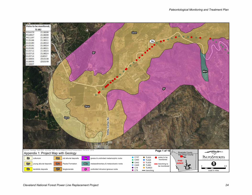
Service Layer Credits: Source: Esri,DigitalGlobe, GeoEye, Earthstar Geographics,
Qya
gr
Mm
gr
Qoa
Qoa
Val le
y C
e nt e
r Rd
76
Sources: Geology, Todd 2004, Jennings 1965; World Imagery & WorldTransportation, Esri et al., 2016
0 0.5
scale in miles
Appendix 1: Project Map with Geology
mapextent
gr undivided intrusive igneous rocks
Mm metasedimentary & metavolcanic rocks
Mg gneiss & undivided metamorphic rocks
QTf fanglomerate
Qco Pauba Formation
Qoa old alluvial deposits
Qls landslide deposits
Qya young alluvial deposits
Qc colluvium
San Diego County
Riverside CountyPage 1 of 10
poles to be
monitored
trenching
trenching to
be monitoredTL6923
TL682
TL629
TL626
C79
TL625
C78
C449
C442
C440
C157
Paleontological Monitoring and Treatment Plan
Cleveland National Forest Power Line Replacement Project 24
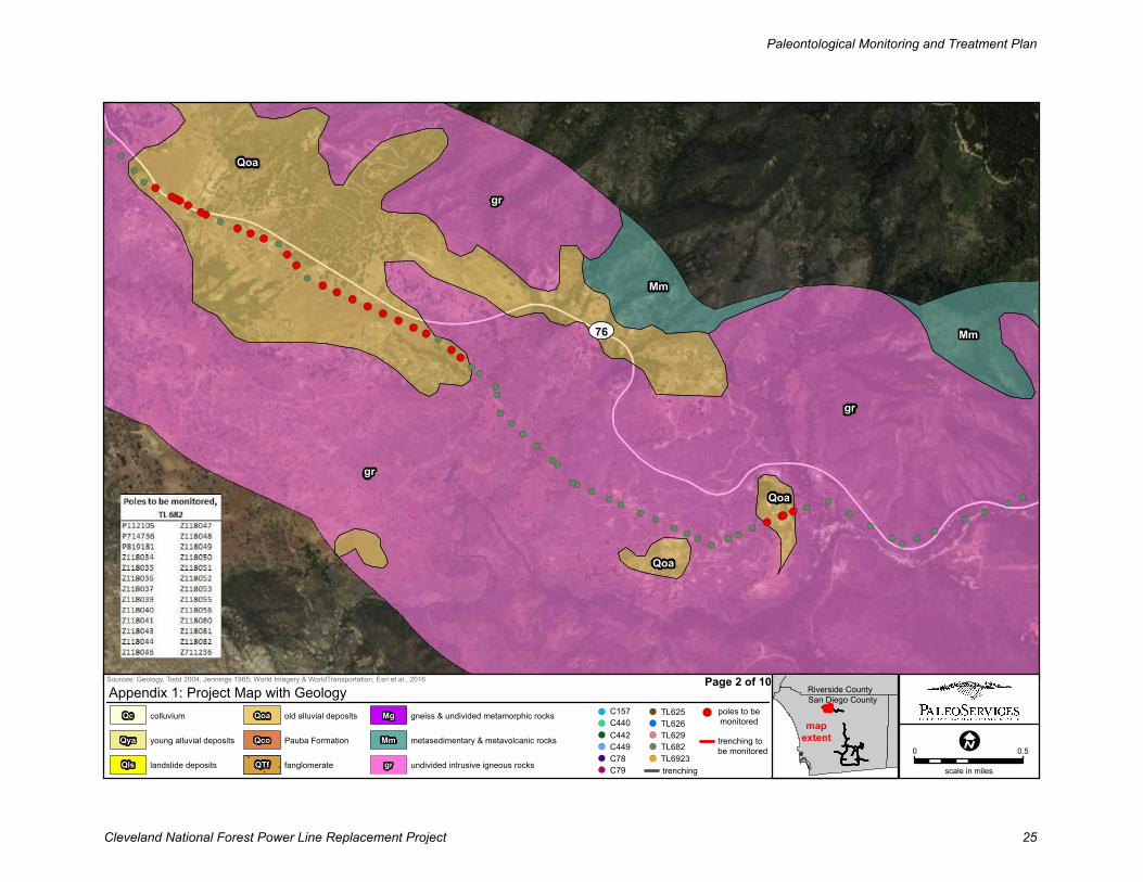
Service Layer Credits: Source: Esri,DigitalGlobe, GeoEye, Earthstar Geographics,
Qoa
gr
Mm
Qoa
Qoa
Mm
gr
gr
76
Sources: Geology, Todd 2004, Jennings 1965; World Imagery & WorldTransportation, Esri et al., 2016
0 0.5
scale in miles
Appendix 1: Project Map with Geology
mapextent
gr undivided intrusive igneous rocks
Mm metasedimentary & metavolcanic rocks
Mg gneiss & undivided metamorphic rocks
QTf fanglomerate
Qco Pauba Formation
Qoa old alluvial deposits
Qls landslide deposits
Qya young alluvial deposits
Qc colluvium
San Diego County
Riverside CountyPage 2 of 10
poles to be
monitored
trenching
trenching to
be monitoredTL6923
TL682
TL629
TL626
C79
TL625
C78
C449
C442
C440
C157
Paleontological Monitoring and Treatment Plan
Cleveland National Forest Power Line Replacement Project 25
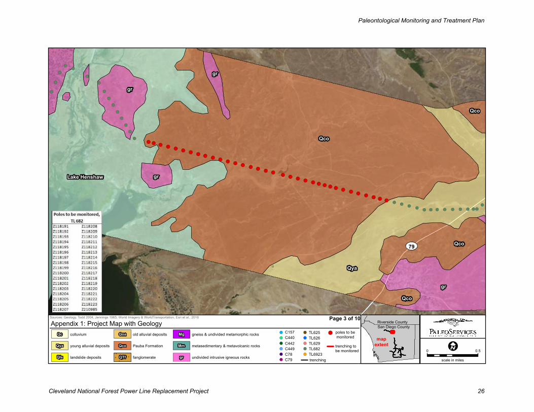
Service Layer Credits: Source: Esri,DigitalGlobe, GeoEye, Earthstar Geographics,
gr
gr
gr
Qco
Qco
Qco
gr
Qya
Qco
Lake Henshaw
79
Sources: Geology, Todd 2004, Jennings 1965; World Imagery & WorldTransportation, Esri et al., 2016
0 0.5
scale in miles
Appendix 1: Project Map with Geology
mapextent
gr undivided intrusive igneous rocks
Mm metasedimentary & metavolcanic rocks
Mg gneiss & undivided metamorphic rocks
QTf fanglomerate
Qco Pauba Formation
Qoa old alluvial deposits
Qls landslide deposits
Qya young alluvial deposits
Qc colluvium
San Diego County
Riverside CountyPage 3 of 10
poles to be
monitored
trenching
trenching to
be monitoredTL6923
TL682
TL629
TL626
C79
TL625
C78
C449
C442
C440
C157
Paleontological Monitoring and Treatment Plan
Cleveland National Forest Power Line Replacement Project 26
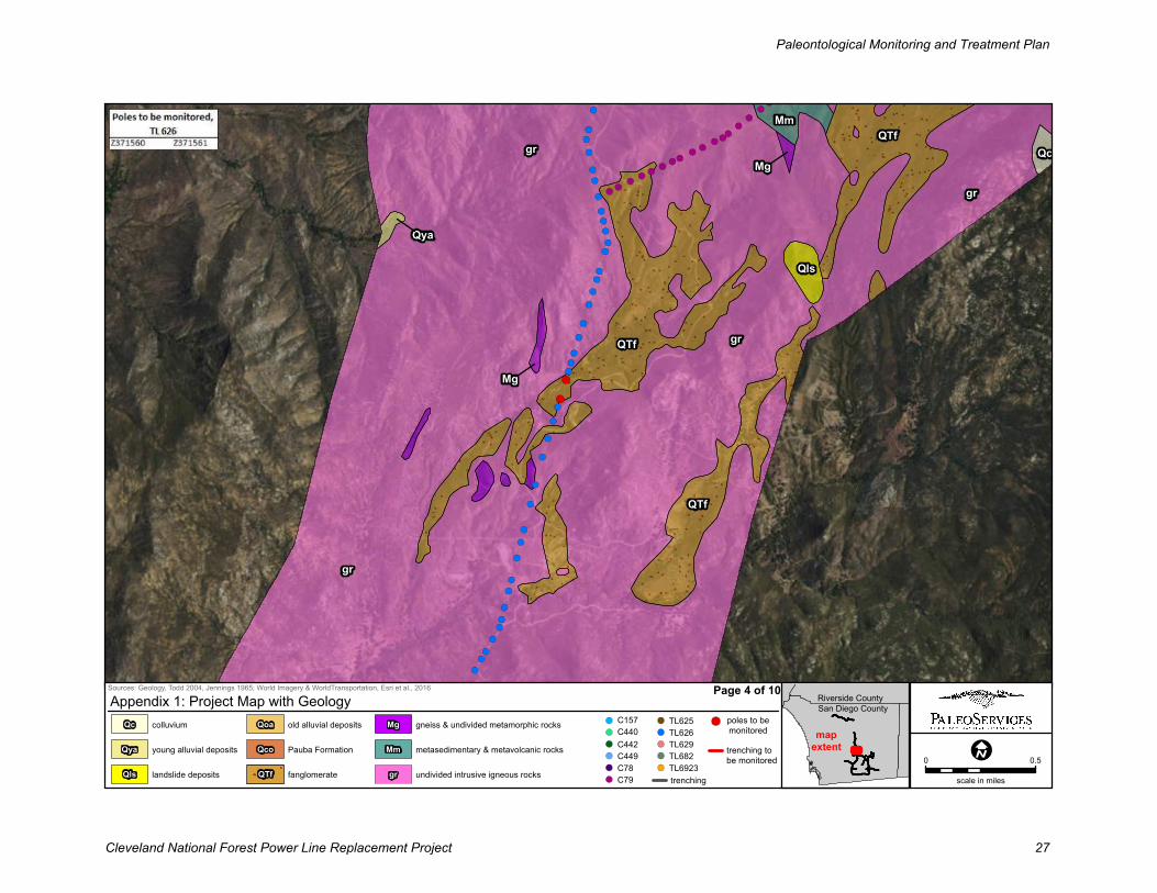
Service Layer Credits: Source: Esri,DigitalGlobe, GeoEye, Earthstar Geographics,
MmQTf
gr QcMg
gr
QTf
Qya
Qls
gr
Mg
QTf
gr
Sources: Geology, Todd 2004, Jennings 1965; World Imagery & WorldTransportation, Esri et al., 2016
0 0.5
scale in miles
Appendix 1: Project Map with Geology
mapextent
gr undivided intrusive igneous rocks
Mm metasedimentary & metavolcanic rocks
Mg gneiss & undivided metamorphic rocks
QTf fanglomerate
Qco Pauba Formation
Qoa old alluvial deposits
Qls landslide deposits
Qya young alluvial deposits
Qc colluvium
San Diego County
Riverside CountyPage 4 of 10
poles to be
monitored
trenching
trenching to
be monitoredTL6923
TL682
TL629
TL626
C79
TL625
C78
C449
C442
C440
C157
Paleontological Monitoring and Treatment Plan
Cleveland National Forest Power Line Replacement Project 27
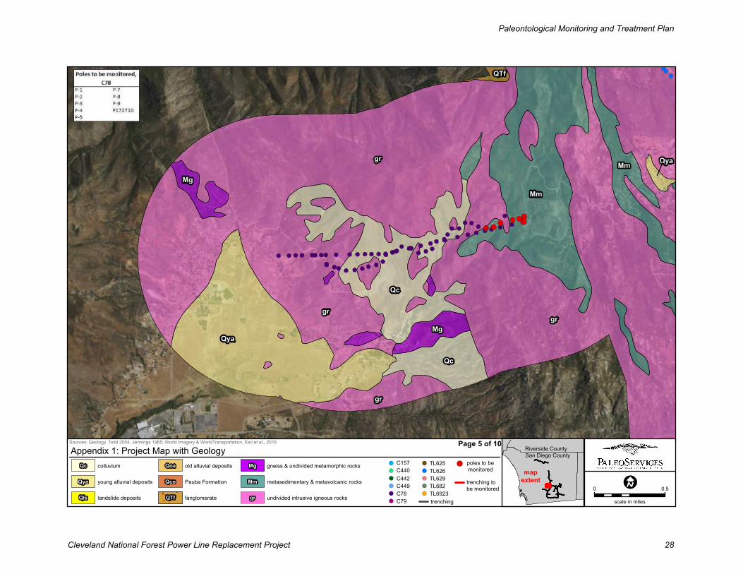
Service Layer Credits: Source: Esri,DigitalGlobe, GeoEye, Earthstar Geographics,
gr
gr
Mm
QTf
Mg
Qya
Qc
gr
Qya
gr
Mm
Mg
Qc
Sources: Geology, Todd 2004, Jennings 1965; World Imagery & WorldTransportation, Esri et al., 2016
0 0.5
scale in miles
Appendix 1: Project Map with Geology
mapextent
gr undivided intrusive igneous rocks
Mm metasedimentary & metavolcanic rocks
Mg gneiss & undivided metamorphic rocks
QTf fanglomerate
Qco Pauba Formation
Qoa old alluvial deposits
Qls landslide deposits
Qya young alluvial deposits
Qc colluvium
San Diego County
Riverside CountyPage 5 of 10
poles to be
monitored
trenching
trenching to
be monitoredTL6923
TL682
TL629
TL626
C79
TL625
C78
C449
C442
C440
C157
Paleontological Monitoring and Treatment Plan
Cleveland National Forest Power Line Replacement Project 28
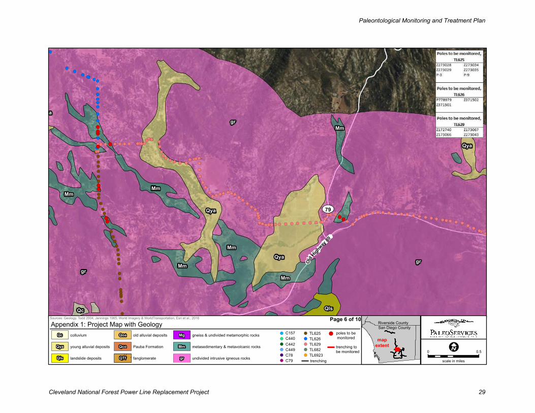
Service Layer Credits: Source: Esri,DigitalGlobe, GeoEye, Earthstar Geographics,
Mm
gr
Qya
Mm
Qyagr
grQya
Mm
Mm
Mm
Mm
QlsQc
Qya
Old H
ighway
80
79
Sources: Geology, Todd 2004, Jennings 1965; World Imagery & WorldTransportation, Esri et al., 2016
0 0.5
scale in miles
Appendix 1: Project Map with Geology
mapextent
gr undivided intrusive igneous rocks
Mm metasedimentary & metavolcanic rocks
Mg gneiss & undivided metamorphic rocks
QTf fanglomerate
Qco Pauba Formation
Qoa old alluvial deposits
Qls landslide deposits
Qya young alluvial deposits
Qc colluvium
San Diego County
Riverside CountyPage 6 of 10
poles to be
monitored
trenching
trenching to
be monitoredTL6923
TL682
TL629
TL626
C79
TL625
C78
C449
C442
C440
C157
Paleontological Monitoring and Treatment Plan
Cleveland National Forest Power Line Replacement Project 29
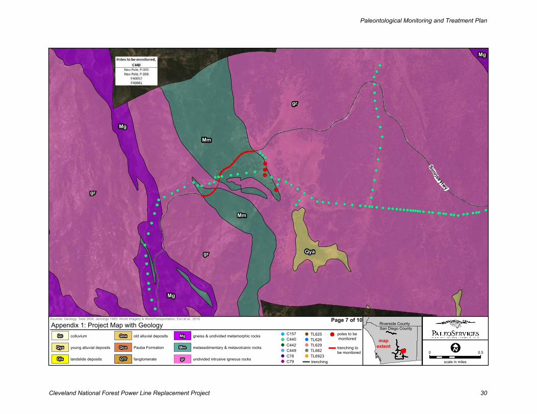
Service Layer Credits: Source: Esri,DigitalGlobe, GeoEye, Earthstar Geographics,
gr
Mm
Qya
gr
Mm
gr
Mg
Mg
Mg
Sunrise Hwy
Sources: Geology, Todd 2004, Jennings 1965; World Imagery & WorldTransportation, Esri et al., 2016
0 0.5
scale in miles
Appendix 1: Project Map with Geology
mapextent
gr undivided intrusive igneous rocks
Mm metasedimentary & metavolcanic rocks
Mg gneiss & undivided metamorphic rocks
QTf fanglomerate
Qco Pauba Formation
Qoa old alluvial deposits
Qls landslide deposits
Qya young alluvial deposits
Qc colluvium
San Diego County
Riverside CountyPage 7 of 10
poles to be
monitored
trenching
trenching to
be monitoredTL6923
TL682
TL629
TL626
C79
TL625
C78
C449
C442
C440
C157
Paleontological Monitoring and Treatment Plan
Cleveland National Forest Power Line Replacement Project 30
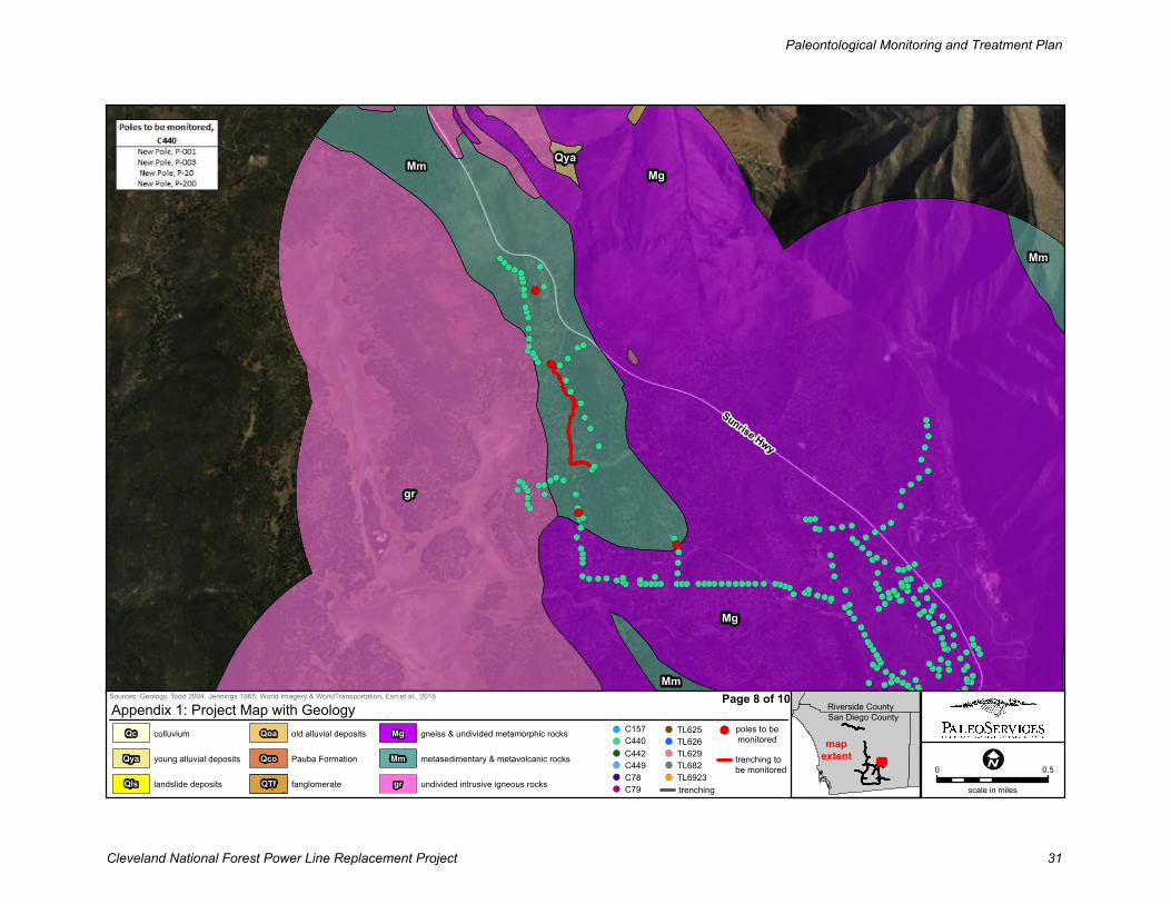
Service Layer Credits: Source: Esri,DigitalGlobe, GeoEye, Earthstar Geographics,
Mg
gr
MmMg
Qya
Mm
Mm
Sunrise Hwy
Sources: Geology, Todd 2004, Jennings 1965; World Imagery & WorldTransportation, Esri et al., 2016
0 0.5
scale in miles
Appendix 1: Project Map with Geology
mapextent
gr undivided intrusive igneous rocks
Mm metasedimentary & metavolcanic rocks
Mg gneiss & undivided metamorphic rocks
QTf fanglomerate
Qco Pauba Formation
Qoa old alluvial deposits
Qls landslide deposits
Qya young alluvial deposits
Qc colluvium
San Diego County
Riverside CountyPage 8 of 10
poles to be
monitored
trenching
trenching to
be monitoredTL6923
TL682
TL629
TL626
C79
TL625
C78
C449
C442
C440
C157
Paleontological Monitoring and Treatment Plan
Cleveland National Forest Power Line Replacement Project 31
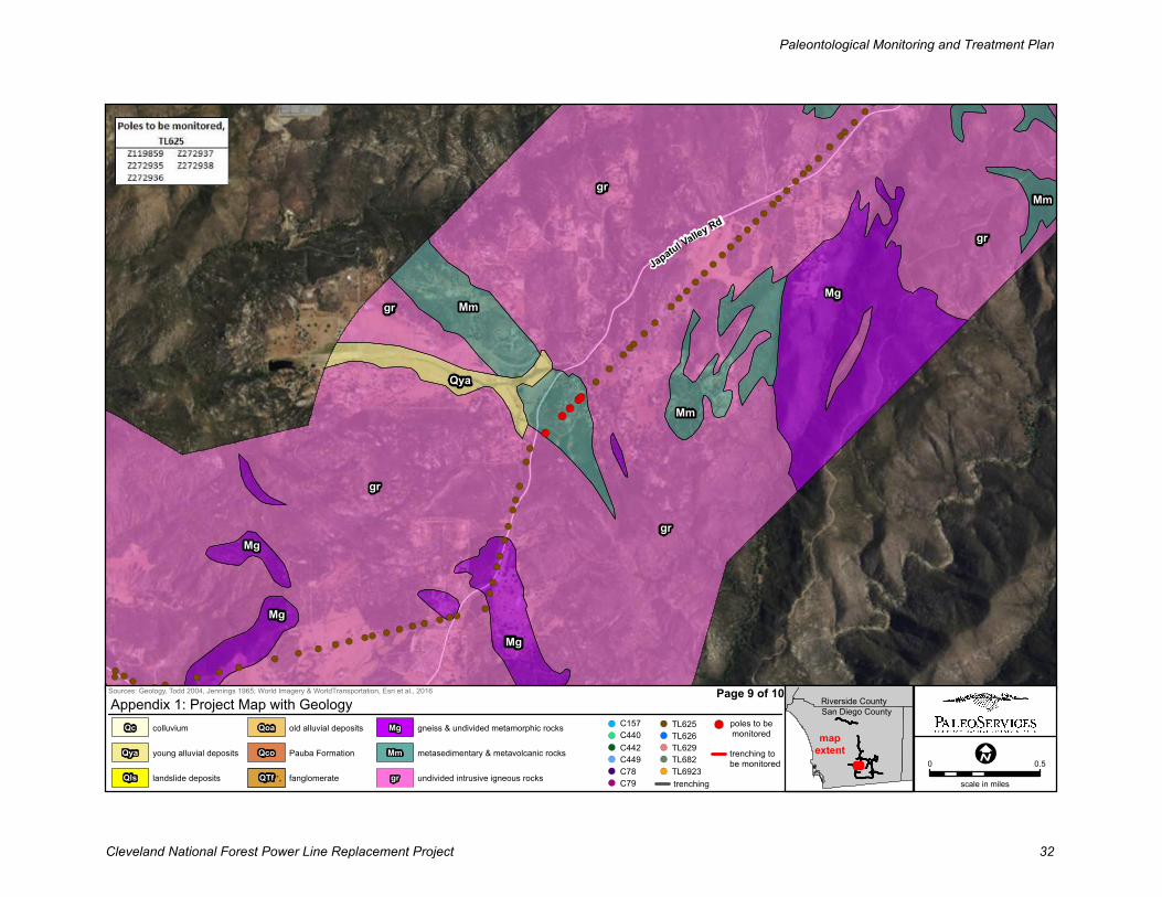
Service Layer Credits: Source: Esri,DigitalGlobe, GeoEye, Earthstar Geographics,
gr
grMm
gr
MgMm
gr
Qya
Mm
Mg
Mg
Mg
gr
Japatul Valley Rd
Sources: Geology, Todd 2004, Jennings 1965; World Imagery & WorldTransportation, Esri et al., 2016
0 0.5
scale in miles
Appendix 1: Project Map with Geology
mapextent
gr undivided intrusive igneous rocks
Mm metasedimentary & metavolcanic rocks
Mg gneiss & undivided metamorphic rocks
QTf fanglomerate
Qco Pauba Formation
Qoa old alluvial deposits
Qls landslide deposits
Qya young alluvial deposits
Qc colluvium
San Diego County
Riverside CountyPage 9 of 10
poles to be
monitored
trenching
trenching to
be monitoredTL6923
TL682
TL629
TL626
C79
TL625
C78
C449
C442
C440
C157
Paleontological Monitoring and Treatment Plan
Cleveland National Forest Power Line Replacement Project 32
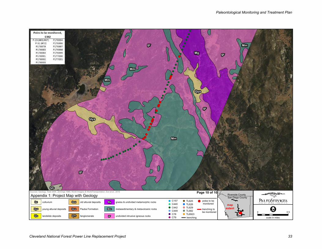
Service Layer Credits: Source: Esri,DigitalGlobe, GeoEye, Earthstar Geographics,
gr
gr Mm
Qya
Qya
Mm
Mm
gr
Mm
gr
Qc
Mg
Sources: Geology, Todd 2004, Jennings 1965; World Imagery & WorldTransportation, Esri et al., 2016
0 0.5
scale in miles
Appendix 1: Project Map with Geology
mapextent
gr undivided intrusive igneous rocks
Mm metasedimentary & metavolcanic rocks
Mg gneiss & undivided metamorphic rocks
QTf fanglomerate
Qco Pauba Formation
Qoa old alluvial deposits
Qls landslide deposits
Qya young alluvial deposits
Qc colluvium
San Diego County
Riverside CountyPage 10 of 10
poles to be
monitored
trenching
trenching to
be monitoredTL6923
TL682
TL629
TL626
C79
TL625
C78
C449
C442
C440
C157
Paleontological Monitoring and Treatment Plan
Cleveland National Forest Power Line Replacement Project 33