Embed Size (px)
Citation preview
BookletChart™ San Diego Bay NOAA Chart 18773
A reduced-scale NOAA nautical chart for small boaters When possible, use the full-size NOAA chart for navigation.
Included Area

2
Published by the National Oceanic and Atmospheric Administration
National Ocean Service Office of Coast Survey
www.NauticalCharts.NOAA.gov 888-990-NOAA
What are Nautical Charts?
Nautical charts are a fundamental tool of marine navigation. They show water depths, obstructions, buoys, other aids to navigation, and much more. The information is shown in a way that promotes safe and efficient navigation. Chart carriage is mandatory on the commercial ships that carry America’s commerce. They are also used on every Navy and Coast Guard ship, fishing and passenger vessels, and are widely carried by recreational boaters.
What is a BookletChart?
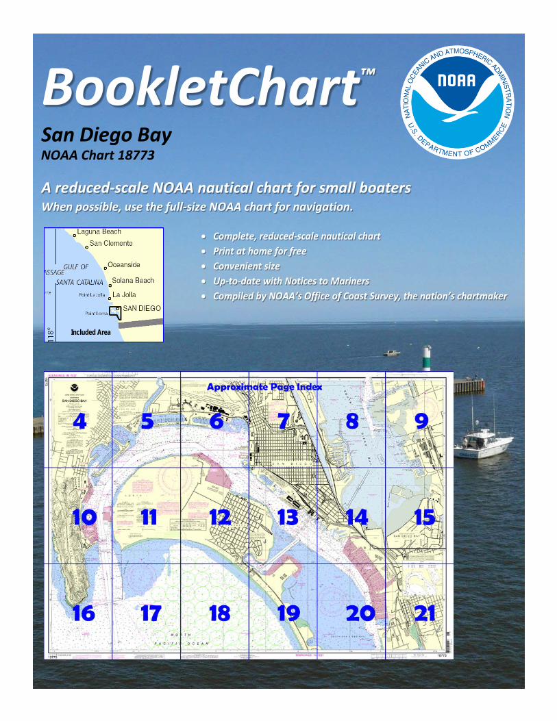
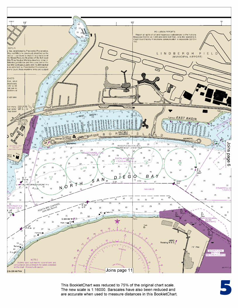
This BookletChart is made to help recreational boaters locate themselves on the water. It has been reduced in scale for convenience, but otherwise contains all the information of the full-scale nautical chart. The bar scales have also been reduced, and are accurate when used to measure distances in this BookletChart. See the Note at the bottom of page 5 for the reduction in scale applied to this chart.
Whenever possible, use the official, full scale NOAA nautical chart for navigation. Nautical chart sales agents are listed on the Internet at http://www.NauticalCharts.NOAA.gov.
This BookletChart does NOT fulfill chart carriage requirements for regulated commercial vessels under Titles 33 and 44 of the Code of Federal Regulations.
Notice to Mariners Correction Status
This BookletChart has been updated for chart corrections published in the U.S. Coast Guard Local Notice to Mariners, the National Geospatial Intelligence Agency Weekly Notice to Mariners, and, where applicable, the Canadian Coast Guard Notice to Mariners. Additional chart corrections have been made by NOAA in advance of their publication in a Notice to Mariners. The last Notices to Mariners applied to this chart are listed in the Note at the bottom of page 7. Coast Pilot excerpts are not being corrected.
For latest Coast Pilot excerpt visit the Office of Coast Survey website at http://www.nauticalcharts.noaa.gov/nsd/searchbychart.php?chart=18773.
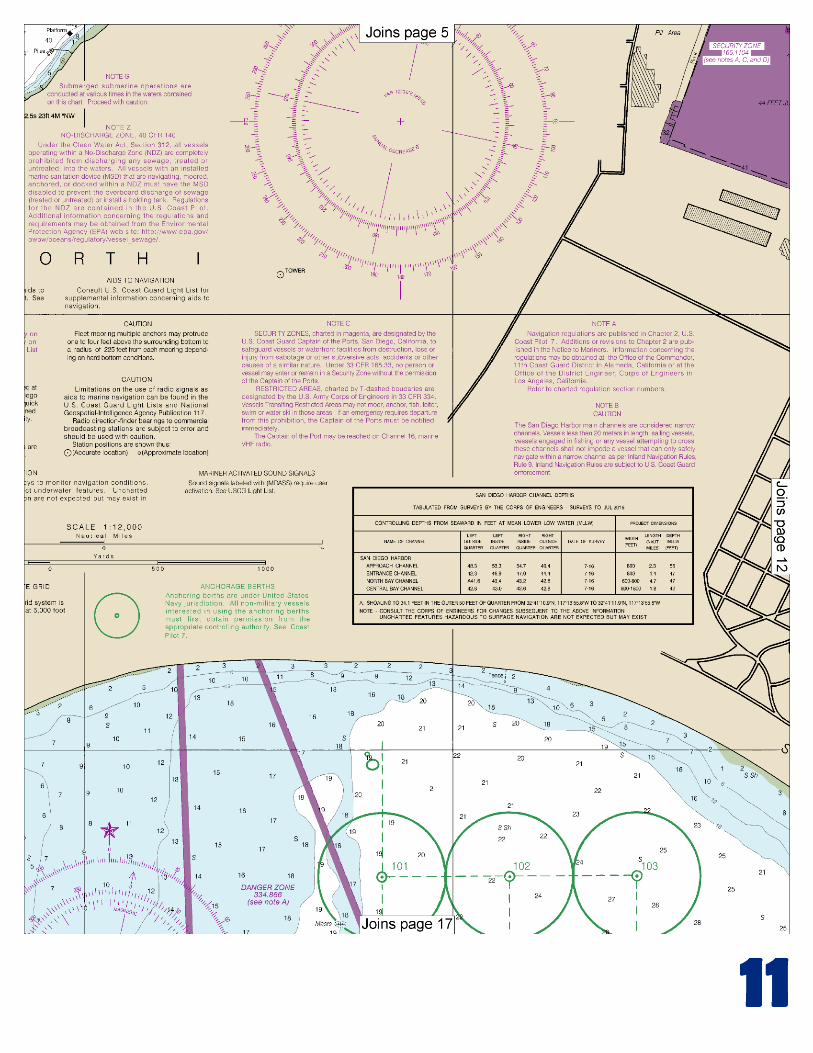
(Selected Excerpts from Coast Pilot) Vessels waiting outside the entrance for a pilot will find good anchorage in 36 feet or more SE of the entrance to the channel, although permission to anchor in the restricted area must be obtained from the local naval authorities. For permission to use anchorage berths 125, 126, 147, 158, and 171, contact Navy Afloat Training Group Pacific at 619-556-0900. For permission to use anchorage berths 124, 135, 146, and 170, contact Navy Region Southwest Port Operations at
619-556-1433. For permission to use all other anchorage berths off Silver Strand, contact COMNVBEACHGRU at 619-437-2476. The area in
the lee of Point Loma, S of Ballast Point and W of the E line of the project channel, is reserved for pilot boats and harbor patrol or U.S. Government craft. (See 334.880, chapter 2, for limits and regulations.) Dangers.–A submerged jetty, marked with lights and daymarks that read “DANGER SUBMERGED JETTY,” extends about 220 yards W from Zuniga Point. There are numerous wrecks and obstructions in the shallow area of SE San Diego Bay. Caution should be exercised when navigating outside the marked channels. Restricted areas are: in the waters off the entrance to San Diego Bay; in the lee of Point Loma and S of Ballast Point; between Ballast Point and Zuniga Point (degaussing station); adjacent to the W side of North Island; 0.4 mile N of Ballast Point, W of the dredged channel; off the NE side of North Island surrounding the Navy Pier; adjacent to and extending SE from the entrance channel to Glorietta Bay. (See 33 CFR 334.860, 334.865, 334.870, 334.880 and 334.890, chapter 2, for limits and regulations.) Security zones are: on the W side of the entrance to San Diego Bay surrounding the Naval Base, extending from Ballast Point to just S of the entrance to Shelter Island Yacht Basin (165.1102, chapter 2); adjacent to the W and NE sides of North Island (165.1105 and 165.1104); around the Navy Pier adjacent to Broadway Pier (165.1121); surrounding the Naval Amphibious Base just S of the entrance channel to Glorietta Bay (135.1120); surrounding the Naval Station along the waterfront of National City from Chollas Creek to Pier 14 (165.1101); within 25 yards of all piers, abutments, fenders, and pilings of the Coronado Bay Bridge (165.1110). (See 33 CFR 165.1101, 165.1102, 165.1104, 165.1105, 165.1110, 165.1120, and 165.1121, chapter 2, for limits/regulations.) A series of floating protection barriers, anchored by lighted buoys, surrounds the Naval facilities within the security zones: on the W side of the entrance to San Diego Bay; just N of Ballast Point, on the NE side of North Island; and off the Naval Station along the waterfront of National City. A safety zone is E of Harbor Island on the N side of the bay. (See 33 CFR 165.1106, chapter 2, for limits and regulations.) Currents.–The currents set generally in the direction of the channels. In the vicinity of the entrance the usual velocity varies from 0.5 to 5 knots depending upon the stage of the tide. S of the end of the jetty there is a slight set toward Zuniga Shoal on the ebb. Great care should be taken while passing Ballast Point as a vessel may take a sudden sheer because of a crosscurrent deflected from Ballast point. The eddy usually encountered along the ends of the municipal piers makes docking difficult. The velocity and direction of the eddy are irregular, and the greatest care must be exercised by even the most experienced. Strangers should not attempt to dock large vessels without a pilot. (See the Tidal Current Tables for daily predictions.) Pilotage, San Diego.–All foreign vessels and vessels from a foreign port or bound thereto, and all vessels over 300 gross tons sailing under register between the port of San Diego and any other U.S. port, are subject to pilotage. Further information regarding pilotage requirements are detailed in the Pilotage section of the Port of San Diego Tariff, available through the ship’s agent or directly from the Port District at 619-686-6343. The Coast Guard Captain of the Port, San Diego, has designated the ship channels in San Diego Harbor as “narrow channels” for the purposes of enforcing Rule 9 of the Navigation Rules
U.S. Coast Guard Rescue Coordination Center 24 hour Regional Contact for Emergencies
RCC Alameda Commander 11th CG District (510) 437-3700
Alameda, CA

G
NOAA’s navigation managers serve as ambassadors to the maritime community. They help identify navigational challenges facing professional and recreational mariners, and provide NOAA resources and information for safe navigation. For additional information, please visit nauticalcharts.noaa.gov/service/navmanagers
To make suggestions or ask questions online, go to nauticalcharts.noaa.gov/inquiry. To report a chart discrepancy, please use ocsdata.ncd.noaa.gov/idrs/discrepancy.aspx.
Lateral System As Seen Entering From Seaward on navigable waters except Western Rivers
PORT SIDE
ODD NUMBERED AIDS
GREEN LIGHT ONLY
FLASHING (2)
PREFERRED CHANNEL
NO NUMBERS – MAY BE LETTERED
PREFERRED CHANNEL TO
STARBOARD
TOPMOST BAND GREEN
PREFERRED CHANNEL
NO NUMBERS – MAY BE LETTERED
PREFERRED CHANNEL
TO PORT
TOPMOST BAND RED
STARBOARD SIDE
EVEN NUMBERED AIDS
RED LIGHT ONLY
FLASHING (2)
FLASHING FLASHING
OCCULTING GREEN LIGHT ONLY RED LIGHT ONLY OCCULTING QUICK FLASHING QUICK FLASHING
ISO COMPOSITE GROUP FLASHING (2+1) COMPOSITE GROUP FLASHING (2+1) ISO
"1"
Fl G 6s
G "9"
Fl G 4s
GR "A"
Fl (2+1) G 6s
RG "B"
Fl (2+1) R 6s
"2"
Fl R 6s
8
R "8"
Fl R 4s
LIGHT
G
C "1"
LIGHTED BUOY
G
"5"
GR
"U"
GR
C "S"
RG
N "C"
RG
"G"
LIGHT
6
R
N "6"
LIGHTED BUOY
R
"2
"
CAN DAYBEACON
CAN NUN NUN
DAYBEACON
For more information on aids to navigation, including those on Western Rivers, please consult the latest USCG Light List for your area.
These volumes are available online at http://www.navcen.uscg.gov
Navigation Managers Area of Responsibility
Northeast
Lt. Meghan McGovern
Northwest and
Pacific Islands
Crescent Moegling
Great Lakes Region
Tom Loeper
Chesapeake and
Delaware Bay
Steve Soherr
California
Jeff Ferguson
[email protected] Mid-Atlantic
Lt. Ryan Wartick
Alaska
Lt. Timothy M. Smith
Western Gulf Coast
Alan Bunn
Central Gulf Coast
Tim Osborn
[email protected] South Florida
Puerto Rico
U.S. Virgin Islands
Michael Henderson
Southeast
Kyle Ward
2
2 C U 5
1


VHF Marine Radio channels for use on the waterways:Channel 6 – Inter-ship safety communications.Channel 9 – Communications between boats and ship-to-coast.Channel 13 – Navigation purposes at bridges, locks, and harbors.Channel 16 – Emergency, distress and safety calls to Coast Guard and others, and to initiate calls to other
vessels. Contact the other vessel, agree to another channel, and then switch.Channel 22A – Calls between the Coast Guard and the public. Severe weather warnings, hazards to navigation and safety warnings are broadcast here.Channels 68, 69, 71, 72 and 78A – Recreational boat channels.
Getting and Giving Help — Signal other boaters using visual distress signals (flares, orange flag, lights, arm signals); whistles; horns; and on your VHF radio. You are required by law to help boaters in trouble. Respond to distress signals, but do not endanger yourself.
EMERGENCY INFORMATION
Distress Call Procedures
• Make sure radio is on.• Select Channel 16.• Press/Hold the transmit button.• Clearly say: “MAYDAY, MAYDAY, MAYDAY.”• Also give: Vessel Name and/or Description;Position and/or Location; Nature of Emergency; Number of People on Board.• Release transmit button.• Wait for 10 seconds — If no responseRepeat MAYDAY call.
HAVE ALL PERSONS PUT ON LIFE JACKETS!
This Booklet chart has been designed for duplex printing (printed on front and back of one sheet). If a duplex option is not available on your printer, you may print each sheet and arrange them back-to-back to allow for the proper layout when viewing.
QR
Quick ReferencesNautical chart related products and information - http://www.nauticalcharts.noaa.gov
Interactive chart catalog - http://www.charts.noaa.gov/InteractiveCatalog/nrnc.shtmlReport a chart discrepancy - http://ocsdata.ncd.noaa.gov/idrs/discrepancy.aspx
Chart and chart related inquiries and comments - http://ocsdata.ncd.noaa.gov/idrs/inquiry.aspx?frompage=ContactUs
Chart updates (LNM and NM corrections) - http://www.nauticalcharts.noaa.gov/mcd/updates/LNM_NM.html
Coast Pilot online - http://www.nauticalcharts.noaa.gov/nsd/cpdownload.htm
Tides and Currents - http://tidesandcurrents.noaa.gov
Marine Forecasts - http://www.nws.noaa.gov/om/marine/home.htm
National Data Buoy Center - http://www.ndbc.noaa.gov/
NowCoast web portal for coastal conditions - http://www.nowcoast.noaa.gov/
National Weather Service - http://www.weather.gov/
National Hurrican Center - http://www.nhc.noaa.gov/
Pacific Tsunami Warning Center - http://ptwc.weather.gov/
Contact Us - http://www.nauticalcharts.noaa.gov/staff/contact.htm
NOAA’s Office of Coast Survey The Nation’s Chartmaker
For the latest news from Coast Survey, follow @NOAAcharts
NOAA Weather Radio All Hazards (NWR) is a nationwide network of radio stations broadcasting continuous weather information directly from the nearest National Weather Service office. NWR broadcasts official Weather Service warnings, watches, forecasts and other hazard information 24 hours a day, 7 days a week. http://www.nws.noaa.gov/nwr/