Embed Size (px)
Citation preview

Salty Lagoon P o s t C l o s u r e M o n i t o r i n g
Project Management and Ecosystem Health Report August 2018
PO Box 119 Lennox Head NSW 2478
T 02 6687 7666
PO Box 1446 Coffs Harbour NSW 2450
T 02 6651 7666
Prepared for: Richmond Valley Council © GeoLINK, 2018
UPR Description Date Issued Issued By 1731-1308 First issue 3/10/2018 David Andrighetto
Salty Lagoon Project Management & Ecosystem Health Report, August 2018 i 1731-1308
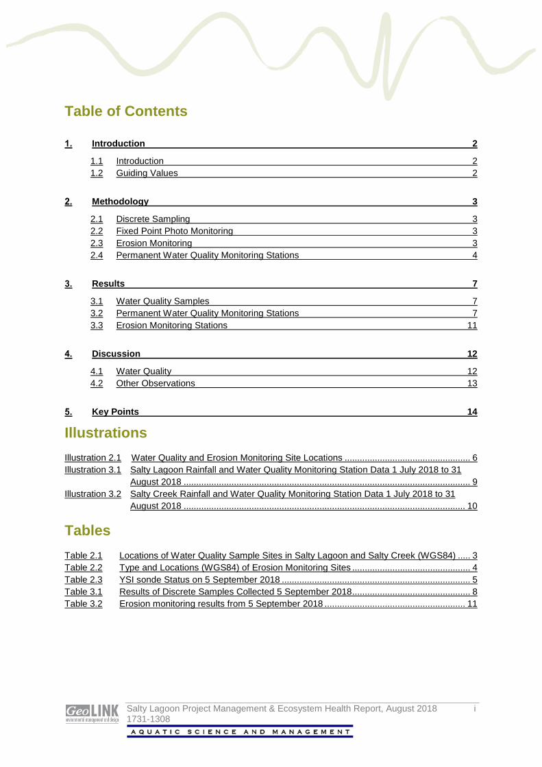
Table of Contents
Introduction 2
1.1 Introduction 2 1.2 Guiding Values 2
Methodology 3
2.1 Discrete Sampling 3 2.2 Fixed Point Photo Monitoring 3 2.3 Erosion Monitoring 3 2.4 Permanent Water Quality Monitoring Stations 4
Results 7
3.1 Water Quality Samples 7 3.2 Permanent Water Quality Monitoring Stations 7 3.3 Erosion Monitoring Stations 11
Discussion 12
4.1 Water Quality 12 4.2 Other Observations 13
Key Points 14
Illustrations Illustration 2.1 Water Quality and Erosion Monitoring Site Locations .................................................. 6 Illustration 3.1 Salty Lagoon Rainfall and Water Quality Monitoring Station Data 1 July 2018 to 31
August 2018 .................................................................................................................. 9 Illustration 3.2 Salty Creek Rainfall and Water Quality Monitoring Station Data 1 July 2018 to 31
August 2018 ................................................................................................................ 10
Tables Table 2.1 Locations of Water Quality Sample Sites in Salty Lagoon and Salty Creek (WGS84) ..... 3 Table 2.2 Type and Locations (WGS84) of Erosion Monitoring Sites ............................................... 4 Table 2.3 YSI sonde Status on 5 September 2018 ........................................................................... 5 Table 3.1 Results of Discrete Samples Collected 5 September 2018 ............................................... 8 Table 3.2 Erosion monitoring results from 5 September 2018 ........................................................ 11

Salty Lagoon Project Management & Ecosystem Health Report, August 2018 2 1731-1308
Introduction
1.1 Introduction
This document comprises the first bi-monthly monitoring report for year 7 of Salty Lagoon Post-Closure monitoring year’s 6-10 program (GeoLINK 2017). The monitoring program is as described in Final Evaluation Report - Salty Lagoon Monitoring: Pre-Post Closure of Artificial Channel – Project Finalisation Report, which forms an extension of the monitoring undertaken as part of the Salty Lagoon Ecosystem Recovery Monitoring Program; Pre-Post Closure of Artificial Channel (MPPC) (Hydrosphere Consulting 2010).
This report is for the monitoring period 1 July 2018 until 31 August 2018.
1.2 Guiding Values
Guiding values were developed for Salty Lagoon and Salty Creek as part of the MPPC program (GeoLINK 2012) to assist with the contextualisation of monthly water monitoring results, rather than as a measure of the health of the waterway. These values are used as part of the current post-closure monitoring and provide a yardstick around which the adaptive management of Salty Lagoon can be discussed.

Salty Lagoon Project Management & Ecosystem Health Report, August 2018 3 1731-1308
Methodology 2.1 Discrete Sampling
This was the first bi-monthly site visit for year 7 post-closure monitoring at Salty Lagoon. It included routine maintenance of permanent water quality monitoring stations and discrete water quality sampling. The site visit was undertaken on 5 September 2018. Water quality samples were collected between the hours of 8:00 am and 12:30 pm on that day. A low tide of 0.54 metres was forecast for 9.35 am.
Discrete water quality samples were taken from surface water (approximately 0.2 metre depth) at four sites in Salty Lagoon and a single site (S5) in Salty Creek. An additional quality assurance (QA) replicate sample was collected at S1. The specific locations of all sites sampled are presented in Table 2.1 and Illustration 2.1. They are the same sites previously used for the MPPC (GeoLINK 2017).
Table 2.1 Locations of Water Quality Sample Sites in Salty Lagoon and Salty Creek (WGS84)
Site S 1 S 2 S 3 S 4 S 5 Eastings 0542064 0541799 0542037 0541738 0542187 Northings 6782801 6782669 6783013 6783033 6783665 Site Description
Lagoon monitoring station
SE of Drainage Channel
NE area of lagoon
NW area of lagoon
Creek monitoring station
Physico-chemical water quality parameters were measured with a calibrated HORIBA U-52 hand held water quality meter. Samples were collected from the surface, and at depth intervals of one metre where water levels allowed.
Samples were collected in jars for analysis of chemical and biological parameters at the Coffs Harbour Laboratory (CHL). Sterile jars were used for collection of samples for bacteriological analysis and brown glass jars were used for collection of samples for analysis of chlorophyll-a and blue green algal (BGA) content. Samples were placed upon ice in an esky and delivered to CHL on the same day.
2.2 Fixed Point Photo Monitoring
In addition to water quality samples, photos were taken showing the environment to the north, east, south and west of each water quality sample site. An additional photo monitoring site is located on the in-filled artificial channel.
2.3 Erosion Monitoring
A series of stations have been set up around the active head cut to the east of the infilled channel and some nearby control sites to assess the progression of erosion between Salty Lagoon and Salty Creek. The specific locations of all sites sampled are presented in Table 2.2 and Illustration 2.1.

Salty Lagoon Project Management & Ecosystem Health Report, August 2018 4 1731-1308
The stations were set up in July 2017 at the head cut (Stations 4, 5 and 6), with control sites at points where lateral tributaries from Salty Creek lead towards Salty Lagoon (Stations 1, 2 and 3). At each site the monitoring involves a fixed-point photo and a measurement from a fixed peg to the nearest point of the head cut.
Table 2.2 Type and Locations (WGS84) of Erosion Monitoring Sites
Site Control/Impact Peg Location Easting Northing
ER1 Control 541961 6783356 ER2 Control 541934 6783355 ER3 Control 541978 6783342 ER4 Impact 542112 6783277 ER5 Impact 542129 6783262 ER6 Impact 542121 6783272
2.4 Permanent Water Quality Monitoring Stations
There are two permanent water quality monitoring stations (PWQMS) in place with YSI EXO3 series water quality sondes measuring temperature, pH, conductivity, turbidity and dissolved oxygen (DO) concentrations at 30-minute intervals. One PWQMS is located in Salty Lagoon at S1 and one in Salty Creek at S5. The data from these sites will be downloaded at bi-monthly intervals for reporting purposes.
HOBO U20 water level loggers were installed at each PWQMS and a third HOBO was installed at S1 to collect barometric pressure data for offsetting atmospheric changes.
The temperature, pH, conductivity, turbidity and DO sensors on the EXO3 sondes installed at the Salty Lagoon PWQMS were removed and replaced by a calibrated set.
The status of the two YSI EXO3 sondes on 5 September 2018 is displayed in Table 2.3.

Salty Lagoon Project Management & Ecosystem Health Report, August 2018 5 1731-1308
Table 2.3 YSI sonde Status on 5 September 2018
Sonde SN17F104100 SN 17H104488 Spare Probes
pH (cap life expectancy 18 months)
EXO pH 17H105048 Manufactured 08/2017
EXO pH 17H105047 Manufactured 08/2017
EXO pH 17H105049 Manufactured 08/2017
Temp/ cond (life expectancy 7-10 years)
EXO Wiped CT 17F103252 Manufactured 06/2017
EXO Wiped CT 17F102047 Manufactured 06/2017
EXO Wiped CT 17F102685 Manufactured 06/2017
DO (cap life expectancy 18 months)
EXO Optical DO 17H103495 Manufactured 08/2017
EXO Optical DO 17H103493 Manufactured 08/2017
EXO Optical DO 17H103494 Manufactured 08/2017
Turbidity (life expectancy 7-10 years)
YSI EXO Turbidity 17H101468 Manufactured 08/2017
YSI EXO Turbidity 17H101465 Manufactured 08/2017
YSI EXO Turbidity 17H103513 Manufactured 08/2017
Wiper No Spare wiper YSI Exo Wiper 17G101954
YSI Exo Wiper 17G101952
Status Serviced probes installed in Salty Lagoon 05/09/2018
Serviced probes installed in Salty Creek 02/07/2018
Probes being calibrated for redeployment
Notes - Batteries changed – 217.9 days estimated battery life
- Memory cleared – 50045.3 days logging available
- Batteries changed – 217.9 days estimated battery life
- Memory cleared – 50045.3 days logging available
- Probes Removed 05/09/2018
Climate information was sourced from the Evans Head bombing range weather station on the Bureau of Meteorology website (BoM 2018). Evans Head Sewage Treatment Plant (STP) facility routine sampling information was provided by Richmond Valley Council (RVC).

#*#*#*
#*#*#*
!(
!(
!(
!(
!(
SaltyLagoon
Closed artificial channel(closed June 2012)
Salty Creek entrance
Salty Creek
Broadwater Road
Drainageline
Evans Head Transfer Station
ER6ER5ER4
ER3ER2ER1
S5
S4
S2
S1
S3
0 200
Salty Lagoon Project Management & Ecosystem Health Report, August 2018 1731-1297
IllustrationWater Quality and Erosion Monitoring Site Locations
North 2.1
Drawn by: GJM Checked by: RE Reviewed by: DSA Date: 9/01/2018Source of base data: Richmond Valley CouncilInformation shown is for il lustrative purposes only
L E G E N D Water quality site!( S1!( S2!( S3!( S4!( S5
Erosion monitoring site#* ER1#* ER2#* ER3#* ER4#* ER5#* ER6
Salty Lagoon Project Management & Ecosystem Health Report, August 2018 7 1731-1308
Results 3.1 Water Quality Samples
Results of the water quality monitoring undertaken on 5 September 2018 are reported in Table 3.1.
3.2 Permanent Water Quality Monitoring Stations
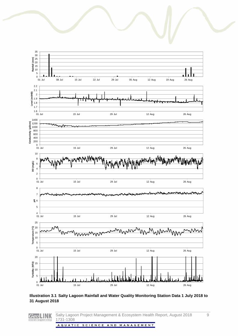
The data collected at the PWQMS, and rainfall data correlating to the reporting period are presented in Illustration 3.1 and Illustration 3.2.

Salty Lagoon Project Management & Ecosystem Health Report, August 2018 8 1731-1308
Table 3.1 Results of Discrete Samples Collected 5 September 2018
Parameter Salty Lagoon Salty Creek
Guiding Value
S1 S1 (1m)
S2 S3 S3 (1m)
S3* (QA)
S4 Guiding Value
S5 S5 (1m)
Blue Green Algae ID (cells/mL) 0 Nil ns Nil Nil ns Nil Nil 0 Nil ns
Nitrite Nitrogen (mg/L) 0.01 <0.010 ns <0.010 <0.010 ns <0.010 <0.010 0.01 <0.010 ns Nitrate Nitrogen (mg/L) 0.01 0.015 ns <0.010 0.01 ns 0.011 <0.010 0.01 <0.010 ns Oxidized Nitrogen (mg/L) - 0.015 ns <0.010 0.01 ns 0.011 <0.010 - <0.010 ns Ammonia Nitrogen (mg/L) 0.05 0.01 ns <0.010 0.012 ns 0.01 <0.010 0.11 <0.010 ns Total Kjeldahl Nitrogen (mg/L) 1.6 1.36 ns 1.13 1.5 ns 1.5 1.55 1.63 1.09 ns Total Nitrogen (mg/L) 1.6 1.37 ns 1.13 1.51 ns 1.51 1.55 1.63 1.09 ns Total Phosphorus(mg/L) 0.14 0.11 ns 0.11 0.14 ns 0.12 0.03 0.04 <0.03 ns Orthophosphate (mg/L) 0.11 0.066 ns 0.082 0.059 ns 0.063 <0.010 0.01 <0.010 ns Chlorophyll-a (µg/L) 5 <1 ns 3 2 ns 2 <1 3 <1 ns Enterococcus (CFU/100mL) 170 10 ns 135 15 ns 15 50 40 150 ns Faecal Coliforms (CFU/100mL) 135 25 ns 565 55 ns 8 15 150 TNTC*
>1000 ns
Temp (˚C) 25.9 17.1 16.89 16.25 16.99 16.62 ns 15.73 13.1 - 28.8 17.88 18.89 pH 6.9 7.21 6.99 6.3 7.24 7.11 ns 5.47 4.3 - 6.8 5.66 7.18 ORP (mV) - 184 196 188 243 250 ns 207 - 238 208 Cond (mS/cm) 8.0 1.17 1.16 0.409 1.12 1.12 ns 0.882 0.3 - 21.5 12.3 42.9 Turbidity (NTU) 13 0 2.1 0 0.1 0.7 ns 0.9 11 2.1 0 DO (mg/L) 4.09 7.89 7.66 1.88 8.46 8.38 ns 4.14 5.52 6.29 4.9 DO (% sat) - 84.6 81.8 19.8 90.5 89.1 ns 43.1 - 70.9 63.8 TDS (mg/L) - 0.746 0.746 0.266 0.714 0.715 ns 0.564 - 7.72 26.1 Sal (ppt) - 0.6 0.6 0.2 0.6 0.6 ns 0.4 - 6.8 27.4 Depth (m) - Surface 1m Surface Surface 1m Surface Surface - Surface 1m
Note: * = randomly selected quality assurance sample. red text = not compliant with MPPC guiding values (see GeoLINK 2012). levels below detection limits will be incorporated into databases as 0 for the purpose of statistical analyses
Salty Lagoon Project Management & Ecosystem Health Report, August 2018 9 1731-1308
05
101520253035
01 Jul 08 Jul 15 Jul 22 Jul 29 Jul 05 Aug 12 Aug 19 Aug 26 Aug
Rain
fall
(mm
)
1.6
1.7
1.8
1.9
2
2.1
2.2
01 Jul 15 Jul 29 Jul 12 Aug 26 Aug
Leve
l (m
AHD)
0200400600800
100012001400
01 Jul 15 Jul 29 Jul 12 Aug 26 Aug
Cond
uctiv
ity (
µS/c
m)
0
2
4
6
8
10
01 Jul 15 Jul 29 Jul 12 Aug 26 Aug
DO (m
g/L)
4
5
6
7
8
01 Jul 15 Jul 29 Jul 12 Aug 26 Aug
pH
0
5
10
15
20
25
01 Jul 15 Jul 29 Jul 12 Aug 26 Aug
Tem
pera
ture
(°C)
0
5
10
15
20
01 Jul 15 Jul 29 Jul 12 Aug 26 Aug
Turb
idity
(NT
U)
Illustration 3.1 Salty Lagoon Rainfall and Water Quality Monitoring Station Data 1 July 2018 to 31 August 2018

Salty Lagoon Project Management & Ecosystem Health Report, August 2018 10 1731-1308
05
101520253035
01 Jul 08 Jul 15 Jul 22 Jul 29 Jul 05 Aug 12 Aug 19 Aug 26 Aug
Rain
fall
(mm
)
1
1.2
1.4
1.6
1.8
2
01 Jul 15 Jul 29 Jul 12 Aug 26 Aug
Leve
l (m
AHD)
0
10000
20000
30000
40000
50000
60000
01 Jul 15 Jul 29 Jul 12 Aug 26 Aug
Cond
uctiv
ity (
mS/
cm)
0
2
4
6
8
10
01 Jul 15 Jul 29 Jul 12 Aug 26 Aug
DO (m
g/L)
4
5
6
7
8
9
01 Jul 15 Jul 29 Jul 12 Aug 26 Aug
pH
0
5
10
15
20
25
01 Jul 15 Jul 29 Jul 12 Aug 26 Aug
Tem
pera
ture
(°C)
0
10
20
30
40
50
01 Jul 15 Jul 29 Jul 12 Aug 26 Aug
Turb
idity
(NT
U)
Illustration 3.2 Salty Creek Rainfall and Water Quality Monitoring Station Data 1 July 2018 to 31 August 2018
Salty Lagoon Project Management & Ecosystem Health Report, August 2018 11 1731-1308
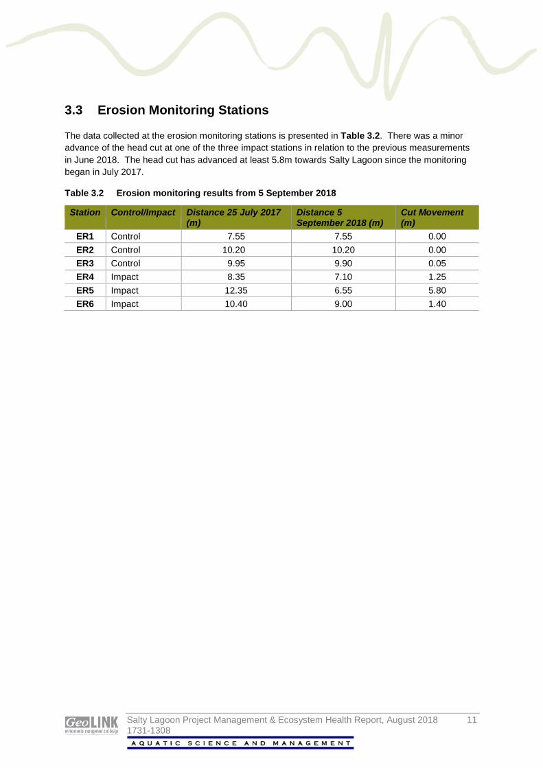
3.3 Erosion Monitoring Stations
The data collected at the erosion monitoring stations is presented in Table 3.2. There was a minor advance of the head cut at one of the three impact stations in relation to the previous measurements in June 2018. The head cut has advanced at least 5.8m towards Salty Lagoon since the monitoring began in July 2017.
Table 3.2 Erosion monitoring results from 5 September 2018
Station Control/Impact Distance 25 July 2017 (m)
Distance 5 September 2018 (m)
Cut Movement (m)
ER1 Control 7.55 7.55 0.00 ER2 Control 10.20 10.20 0.00 ER3 Control 9.95 9.90 0.05 ER4 Impact 8.35 7.10 1.25 ER5 Impact 12.35 6.55 5.80 ER6 Impact 10.40 9.00 1.40

Salty Lagoon Project Management & Ecosystem Health Report, August 2018 12 1731-1308
Discussion 4.1 Water Quality
There were two distinct periods of rainfall during this reporting period, one in the first week and one in the final week. The conductivity and level data from the Salty Creek PWQMS indicates that the entrance to Salty Creek opened in response to moderate rainfall on 3 July 2018 but that subsequent water level fluctuations were associated with tidal movements and seawater ingress. The water level in Salty Lagoon was very high at the beginning of the reporting period, increased slightly in response to rainfall in the first week of the reporting period and then steadily declined. Water level measurements from the Salty Lagoon PWQMS indicate that water drained from Salty Lagoon into Salty Creek for the entire monitoring period.
Erosion monitoring indicated that the head cut has advanced between 1.25 m and 5.8 m since July 2017 in three distinct locations. There has been little or no measured advance of the head cuts at the three control sites. However, the advance of the head cut during this reporting period was minor or negligible at the three impact sites. This would indicate that the majority of the head cut advances occur in response to large fluctuations in the water level, such as those caused by heavy rainfall events, as opposed to consistent low-level drainage from Salty Lagoon into Salty Creek.
Conductivity measurements from the PWQMS show the impact of both rainfall and seawater ingress on Salty Creek and the impact of both dilution from rainfall runoff and evaporation on Salty Lagoon. Conductivity measurements from the Salty Creek PWQMS indicate that seawater ingress was the dominant factor with respect to water quality during this reporting period. The conductivity measured in Salty Creek was greater than 80% seawater for almost all of the reporting period. The conductivity measurements from the Salty Lagoon PWQMS remained low but indicated that evaporation had a greater impact than rainfall runoff over the course of the reporting period. At the time of the site inspection the conductivity measurements in Salty Lagoon showed that the water column was well mixed at all sites. The measurements from Salty Creek indicated that the water was distinctly stratified into a heavy, saline bottom layer and a lighter, brackish surface layer.
The DO concentrations in discrete samples collected on 5 September 2018 were typical at all sites and mostly complied with guiding values. The DO concentrations complied with guiding values in the open water sites of Salty Lagoon but not at one of the two westernmost sites in Salty Lagoon, which are usually oxygen poor. The surface water measurement from Salty Creek complied with guiding values. The measurements from the Salty Lagoon PWQMS indicate that the diurnal fluctuations in light availability were the major source of variation.
The nutrient concentrations from samples collected on 5 September 2018 all complied with guiding values with the exception of the nitrate concentrations from S1 and S3 and the total phosphorus concentration from S3. The chlorophyll-a concentrations complied with the guiding value at all sites. There were no blue-green algae detected in any samples. Nutrient and chlorophyll-a concentrations measured during the MPPC and post-closure monitoring programs have typically been lowest during the colder months.
Other results that did not comply with guiding values included the pH measurements from S1, S3 and deeper water at S5, the faecal coliform concentrations from S2 and S5, the enterococcus concentration from S5 and the conductivity measurement from deeper water at S5. All other measurements complied with guiding values. The high pH measurements from S5 is a result of

Salty Lagoon Project Management & Ecosystem Health Report, August 2018 13 1731-1308
seawater ingress. The high pH measurements from S1 and S3 are further indication that a buffering mechanism persists in Salty Lagoon that neutralises the low pH runoff from the catchment. The high faecal indicator organism concentrations at S2 and S5 are likely to be associated with waterbird use of those areas. Waterbirds are often disturbed from those two sites during site inspections. The high conductivity measurement from deeper water at S5 results from seawater ingress and shows the stratification of the water column that is typical of Salty Creek following a combination of rainfall runoff and seawater ingress.
4.2 Other Observations
The entrance to Salty Creek was closed on 5 September 2018. A variety of birds were observed incidentally during the site inspection including Pacific Black Duck, White-eyed Duck, Eurasian Coot, Pelican, Great Egret, Darter, Pied Cormorant, Little Black Cormorant, Little Pied Cormorant, Brahminy Kite and White-bellied Sea Eagle.
Salty Lagoon Project Management & Ecosystem Health Report, August 2018 14 1731-1308
Key Points 1. Conditions in Salty Lagoon were relatively stable during this reporting period with respect to water
levels and conductivity. 2. Most results complied with the guiding values. 3. Total nutrient concentrations were low and there was no indication of algal blooms. 4. Chlorophyll-a concentrations complied with guiding values at all sites. 5. The erosive headcut to the east of the old channel between Salty Lagoon and Salty Creek did not
advance substantially during this reporting period.

Salty Lagoon Project Management & Ecosystem Health Report, August 2018 15 1731-1308
References Bureau of Meteorology (2018). http://www.bom.gov.au/. Accessed 28/10/2018.
GeoLINK (2012). Salty Lagoon Monitoring: Pre-Post Closure of Artificial Channel – Project Management and Ecosystem Health Monthly Report – September 2012. Report to Richmond Valley Council.
GeoLINK (2017). Final Evaluation Report - Salty Lagoon Monitoring: Pre-Post Closure of Artificial Channel – Project Finalisation Report. Report to Richmond Valley Council.
Hydrosphere (2010). Salty Lagoon Monitoring Program Pre/Post Closure of the Artificial Channel. Unpublished report to Richmond Valley Council. Hydrosphere Consulting, Ballina.

Salty Lagoon Project Management & Ecosystem Health Report, August 2018 16 1731-1308
Copyright and Usage GeoLINK, 2018
This document, including associated illustrations and drawings, was prepared for the exclusive use of Richmond Valley Council. It is not to be used for any other purpose or by any other person, corporation or organisation without the prior consent of GeoLINK. GeoLINK accepts no responsibility for any loss or damage suffered howsoever arising to any person or corporation who may use or rely on this document for a purpose other than that described above.
This document, including associated illustrations and drawings, may not be reproduced, stored, or transmitted in any form without the prior consent of GeoLINK. This includes extracts of texts or parts of illustrations and drawings.

Salty Lagoon Project Management & Ecosystem Health Report, August 2018 1 1731-1308